
Deschutes County Unincorporated
City Zoning Code
City Zoning Code
CHAPTER 18
84 LANDSCAPE MANAGEMENT COMBINING ZONE; LM
Introductory Paragraph Eliminated Ord. 2001-016, §2, 2001
18.84.010 Purpose
The purposes of the Landscape Management Combining Zone are to maintain scenic and natural resources of the designated areas and to maintain and enhance scenic vistas and natural landscapes as seen from designated roads, rivers, or streams.
Adopted by Ord. PL-15 on 11/1/1979
Amended by Ord. 90-020 §1 on 6/6/1990
Amended by Ord. 91-020 §1 on 5/29/1991
Amended by Ord. 92-034 §2 on 4/8/1992
Amended by Ord. 95-075 §3 on 11/29/1995
Amended by Ord. 2001-016 §2 on 3/28/2001
Amended by Ord. 2021-013 §11 on 4/5/2022
18.84.020 Application Of Provisions
The provisions of DCC 18.84 shall apply to all areas within one-fourth mile of roads identified as landscape management corridors in the Comprehensive Plan and the County Zoning Map. The provisions of DCC 18.84 shall also apply to all areas identified as landscape management corridors in the comprehensive plan and the County Zoning Map. The distance specified above shall be measured horizontally from the center line of designated landscape management roadways or from the nearest ordinary high water mark of a designated landscape management river or stream. The limitations in DCC 18.84.20 shall not unduly restrict accepted agricultural practices.
Adopted by Ord. PL-15 on 11/1/1979
Amended by Ord. 90-020 §1 on 6/6/1990
Amended by Ord. 91-020 §1 on 5/29/1991
Amended by Ord. 92-034 §2 on 4/8/1992
Amended by Ord. 95-075 §3 on 11/29/1995
Amended by Ord. 2001-016 §2 on 3/28/2001
Amended by Ord. 2025-009 §6 on 7/1/2025
18.84.030 Uses Permitted Outright
Uses permitted in the underlying zone with which an LM Zone is combined shall be permitted in an LM Zone, subject to the provisions in DCC 18.84.
Adopted by Ord. PL-15 on 11/1/1979
Amended by Ord. 90-020 §1 on 6/6/1990
Amended by Ord. 91-020 §1 on 5/29/1991
Amended by Ord. 92-034 §2 on 4/8/1992
Amended by Ord. 95-075 §3 on 11/29/1995
Amended by Ord. 2001-016 §2 on 3/28/2001
Amended by Ord. 2025-009 §6 on 7/1/2025
18.84.040 Uses Permitted Conditionally
Uses permitted conditionally in the underlying zone with which an LM Zone is combined shall be permitted as conditional uses in an LM Zone, subject to the provisions in DCC 18.84.
Adopted by Ord. PL-15 on 11/1/1979
Amended by Ord. 90-020 §1 on 6/6/1990
Amended by Ord. 91-020 §1 on 5/29/1991
Amended by Ord. 92-034 §2 on 4/8/1992
Amended by Ord. 95-075 §3 on 11/29/1995
Amended by Ord. 2001-016 §2 on 3/28/2001
Amended by Ord. 2025-009 §6 on 7/1/2025
18.84.050 Use Limitations
- Any new structure or substantial exterior alteration of a structure requiring a building permit or an agricultural building or equine facility within an LM Zone shall obtain site plan approval in accordance with DCC 18.84 prior to construction. As used in DCC 18.84 substantial exterior alteration consists of an alteration which exceeds 25 percent in the floor area or 25 percent of the assessed value of the structure.
- General/Discretionary Standards. Structures and/or lots or parcels which are not visible from the designated roadway, river, or stream and which are assured of remaining not visible because of vegetation, topography, or existing development are exempt from the provisions of DCC 18.84.080 (Design Review Standards) and DCC 18.84.090 (Setbacks). An applicant for site plan review in the LM Zone shall conform with the provisions of DCC 18.84, or may submit evidence that the proposed structure and/or lot or parcel will not be visible from the designated road, river, or stream. Structures not visible from the designated road, river, or stream must meet setback standards of the underlying zone(s).
- Clear and Objective Standards pursuant to DCC 22.08.040. All structures located in an LM Zone shall comply with the provisions of DCC 18.84.080 (Design Review Standards) and DCC 18.84.090 (Setbacks).
Adopted by Ord. PL-15 on 11/1/1979
Amended by Ord. 90-020 §1 on 6/6/1990
Amended by Ord. 91-020 §1 on 5/29/1991
Amended by Ord. 92-034 §2 on 4/8/1992
Amended by Ord. 95-075 §3 on 11/29/1995
Amended by Ord. 2001-016 §2 on 3/28/2001
Amended by Ord. 2015-016 §5 on 3/28/2016
Amended by Ord. 2025-002 §20 on 3/28/2025
Amended by Ord. 2025-009 §6 on 7/1/2025
18.84.060 Dimensional Standards
In an LM Zone, the minimum lot area shall be as established in the underlying zone(s) with which the LM Zone is combined.
Adopted by Ord. PL-15 on 11/1/1979
Amended by Ord. 90-020 §1 on 6/6/1990
Amended by Ord. 91-020 §1 on 5/29/1991
Amended by Ord. 92-034 §2 on 4/8/1992
Amended by Ord. 95-075 §3 on 11/29/1995
Amended by Ord. 2001-016 §2 on 3/28/2001
Amended by Ord. 2025-002 §20 on 3/28/2025
Amended by Ord. 2025-009 §6 on 7/1/2025
18.84.070 Application
An application for site plan approval for development in an LM Zone shall be submitted to the Planning Division. The site plan application shall include the following:
- A plot plan, drawn to scale, showing:
- Location and dimensions of existing and proposed structures.
- Setbacks from lot lines (and the ordinary high water line and rimrock, if present).
- Existing and proposed access.
- Existing and proposed exterior lighting.
- A drawing of the proposed structure elevations showing:
- Exterior appearance.
- Average natural grade.
- Height dimensions measured from average natural grade.
- Siding and roofing material and color.
- Location and size of windows, including skylights.
- A landscape plan drawn to scale, showing:
- Location, size, and species of existing trees six inches in diameter or greater, or existing shrub vegetation higher than four feet, between the proposed development and the designated landscape management road, river, or stream.
- For applications reviewed under General/Discretionary Standards pursuant to DCC 22.08.040, where a significant amount of vegetation exists, the applicant may submit a landscape plan that generalizes and explains how the existing trees and shrubs provide screening. This option is not available for applications reviewed under Clear and Objective Standards.
- Proposed location and species of introduced vegetation which will screen the proposed development from the designated landscape management road, river, or stream.
- Location, size, and species of existing trees six inches in diameter or greater, or existing shrub vegetation higher than four feet, between the proposed development and the designated landscape management road, river, or stream.
- A minimum of two color photographs taken from documented locations, oriented between the protected resource (river, stream, and/or road) and the proposed development, showing the extent of existing vegetation or other screening.
Adopted by Ord. PL-15 on 11/1/1979
Repealed & Reenacted by Ord. 91-020 §1 on 5/29/1991
Amended by Ord. 92-034 §2 on 4/8/1992
Amended by Ord. 93-043 §12 on 8/25/1993
Amended by Ord. 95-075 §3 on 11/29/1995
Amended by Ord. 2001-016 §2 on 3/28/2001
Amended by Ord. 2003-034 §1 on 10/29/2003
Amended by Ord. 2025-002 §20 on 3/28/2025
Amended by Ord. 2025-009 §6 on 7/1/2025
18.84.080 Design Review Standards - General/Discretionary Standards
The following standards will be used to evaluate the proposed site plan:
- Except as necessary for construction of access roads, building pads, septic drainfields, public utility easements, parking areas, etc., the existing tree and shrub cover screening the development from a designated road, river, or stream shall be retained. This provision does not prohibit maintenance of existing lawns, removal of dead, diseased, or hazardous vegetation; the commercial harvest of forest products in accordance with the Oregon Forest Practices Act, or agricultural use of the land.
- It is recommended new structures and additions to existing structures be finished in muted earth tones that blend with and reduce contrast with the surrounding vegetation and landscape of the building site.
- No large areas, including roofs, shall be finished with white, bright, or reflective materials. Roofing, including metal roofing, shall be non-reflective and of a color which blends with the surrounding vegetation and landscape. DCC 18.84.080(C) shall not apply to attached additions to structures lawfully in existence on April 8, 1992, unless substantial improvement to the roof of the existing structure occurs.
- Subject to applicable rimrock setback requirements or rimrock setback exception standards in DCC 18.84.090(E), all structures shall be sited to take advantage of existing vegetation, trees, and topographic features in order to reduce visual impact as seen from a designated road, river, or stream. When more than one nonagricultural structure is to exist and no vegetation, trees, or topographic features exist which can reduce visual impact of the subject structure, such structure shall be clustered in a manner which reduces their visual impact as seen from the designated road, river, or stream.
- Structures shall not exceed 30 feet in height measured from average natural grade . For the purposes of this measurement, “average natural grade” shall be the average of natural ground elevations prior to development, for the wall closest to and facing the road, river, or stream. Within the LM Zone along a state scenic waterway or federal wild and scenic river, the height of a structure shall include chimneys, antennas, flag poles or other projections from the roof of the structure. DCC 18.84.080(E) shall not apply to agricultural buildings or equine facilities located at least 50 feet from a rimrock.
- New residential or commercial driveway access to designated landscape management roads shall be consolidated wherever possible.
- New exterior lighting, including security lighting, shall be sited and shielded so that it is directed downward and is not directly visible from a designated road, river, or stream.
- The Planning Director or Hearings Body may require the establishment of introduced landscape material to screen the new structure or substantial exterior alteration, assure compatibility with existing vegetation, reduce glare, direct automobile and pedestrian circulation, or enhance the overall appearance of the development while not interfering with the views of oncoming traffic at access points, or views of mountains, forests, and other open and scenic areas as seen from a designated road, river, or stream. Use of native species shall be encouraged.
- No signs or other forms of outdoor advertising that are visible from a designated road, river, or stream shall be permitted. Property protection signs (No Trespassing, No Hunting, etc.,) are permitted.
- A conservation easement as defined in DCC 18.04.030 "Conservation Easement" and specified in DCC 18.116.220 shall be required as a condition of approval for all landscape management site plans involving property adjacent to the Deschutes River, Crooked River, Fall River, Little Deschutes River, Spring River, Whychus Creek, and Tumalo Creek. Conservation easements required as a condition of landscape management site plans shall not require public access.
Adopted by Ord. PL-15 on 11/1/1979
Amended by Ord. 90-020 §1 on 6/6/1990
Amended by Ord. 91-020 §1 on 5/29/1991
Amended by Ord. 92-034 §2 on 4/8/1992
Amended by Ord. 93-043 §12A and 12B on 8/25/1993
Amended by Ord. 95-075 §3 on 11/29/1995
Amended by Ord. 97-068 §1 on 11/26/1997
Amended by Ord. 2001-016 §2 on 3/28/2001
Amended by Ord. 2015-016 §5 on 3/28/2016
Amended by Ord. 2018-006 §11 on 11/20/2018
Amended by Ord. 2020-007 §13 on 10/27/2020
Amended by Ord. 2025-002 §20 on 3/28/2025
Amended by Ord. 2025-009 §6 on 7/1/2025
18.84.081 Design Review Standards - Clear And Objective Standards Pursuant To DCC 22.08.040
- All existing tree and shrub cover between the development and the designated road, river, or stream shall be retained. This provision does not prohibit maintenance of existing lawns, or removal of dead, diseased, or hazardous vegetation as part of a housing application.
- For the purposes of this provision, “hazardous” means either:
- A tree or branch that has been identified by arborist as an imminent danger to people or property; or
- Vegetation that is subject to mandatory fire break, fuel break, or defensible space requirements under the ORS, OAR, DCC Chapter 8.21, and/or DCC Title 18.
- For the purposes of this provision, “hazardous” means either:
- New structures and additions to existing structures, provided that they add one or more dwelling units, shall be finished in a color listed in Appendix A (DCC 18.18A) or with natural unpainted wood or stone.
- Roofing, including metal roofing, shall be non-reflective and shall have a light reflectance value (LRV) of 40 or less.
- Subject to applicable rimrock setback requirements or rimrock setback exception standards in DCC 18.84.090(E), when there are existing topographic features, such as rocky outcrops, knolls, hills, or ridges, that have the ability to obscure any portion of the proposed structure, as viewed from the designated road, river or stream, the proposed structure shall be located such that the topographic feature(s) is situated between the structure and the designated road, river, or stream.
- Structures shall not exceed 30 feet in height measured from lowest adjacent natural grade. For the purposes of this measurement, “lowest adjacent natural grade” shall be the lowest natural ground elevation adjacent to the structure prior to development. Within an LM Zone along a state scenic waterway or federal wild and scenic river, the height of a structure shall include chimneys, antennas, flag poles, or other projections from the roof of the structure.
- Residential or commercial driveway access to designated landscape management roads shall be consolidated to a single access driveway.
- New exterior lighting, including security lighting, shall be sited and shielded so that it is directed downward and is not directly visible from a designated road, river, or stream.
- Screening shall be provided between a proposed dwelling unit and any designated road, river, or stream. At least one non-deciduous tree that will reach a mature diameter of 10 inches or greater as measured four feet above the ground (known as DBH, “diameter at breast height”) shall be planted for every 15 horizontal feet of wall facing or visible from any point along a designated road, river, or stream. Required non-deciduous trees at planting must be a minimum six feet in height measured from the soil to the top of the tree. Existing, retained, non-deciduous trees may count toward the required tree planting. Use of native species is encouraged, but not required. Plantings shall conform with the defensible space standards of DCC Chapter 8.21.
- No signs or other forms of outdoor advertising that are visible from a designated road, river, or stream shall be permitted. Property protection signs (No Trespassing, No Hunting, etc.,) are permitted.
- A conservation easement as defined in DCC 18.04.030 "Conservation Easement" and specified in DCC 18.116.220 shall be required as a condition of approval for all landscape management site plans involving a lot or parcel adjacent to the Deschutes River, Crooked River, Fall River, Little Deschutes River, Spring River, Whychus Creek, and Tumalo Creek. Conservation easements required as a condition of landscape management site plans shall not require public access.
Adopted by Ord. 2025-009 §6 on 7/1/2025
18.84.085 Imposition Of Conditions
The standards of DCC 18.84 may be met by the imposition of conditions drawn to ensure that the standards will be met.
Adopted by Ord. 92-034 §2 on 4/8/1992
Amended by Ord. 95-075 §3 on 11/29/1995
Amended by Ord. 2001-016 §2 on 3/28/2001
18.84.090 Setbacks - General/Discretionary Standards
- Except as provided in DCC 18.84.090, the minimum setbacks shall be those established in the underlying zone(s) with which a LM Zone is combined. The more restrictive setback requirement shall govern in all cases.
- Road Setbacks. All new structures or additions to existing structures on lots or parcels with street frontage on a designated landscape management road shall have a minimum setback of 100 feet from the edge of the designated road right-of-way unless the Planning Director or Hearings Body finds that:
- A location closer to a designated road would more effectively screen the structure from the road; or protect a distant vista; or
- The lot dimensions make a 100-foot setback not feasible; or
- Buildings on both lots or parcels abutting the subject lot or parcel have front setbacks of less than 100 feet and the abutting buildings are within 100 feet of the lot lines of the subject property, and the depth of the front setback area is not less than the average depth of the front setback areas of the abutting lots or parcels.
- If the above findings are made, the Planning Director or Hearings Body may approve a less restrictive front setback which will be appropriate to carry out the purpose of the zone.
- River and Stream Setbacks. All new structures or additions to existing structures shall have a minimum setback of at least 100 feet from the ordinary high water line of designated streams and rivers or obtain a setback exception in accordance with DCC 18.120.030. For the purpose of DCC 18.84.090(C), decks are considered part of a structure and must conform with the setback requirement. The placement of onsite wastewater systems shall be subject to joint review by the Planning Director or Hearings Body and the Deschutes County Onsite Wastewater Division. The placement of such systems shall minimize the impact on the vegetation along the river or stream and shall allow a dwelling unit to be constructed on the site as far from the river, stream, or lake as possible. Sand filter or alternative treatment technology systems may be required as replacement systems when this will allow a dwelling unit to be set back further from the river or stream, or to meet the 100-foot setback requirement.
- Rimrock Setbacks. New structures (including decks or additions to existing structures) shall have a minimum setback of 50 feet from the rimrock in an LM Zone. An exception to this setback may be granted pursuant to the provisions of DCC 18.84.090(E).
- Rimrock Setback Exceptions. An exception to the 50-foot rimrock setback may be granted by the Planning Director or Hearings Body, subject to the following standards and criteria.
- An exception shall be granted when the Planning Director or Hearings Body finds one of the following is met:
- A lesser setback will make the structure less visible or completely screened from the river or stream;
- The subject lot or parcel was a lot of record prior to the adoption of this ordinance;
- Dwelling units (including decks) on both lots or parcels abutting the subject lot or parcel are within 50 feet of the rimrock and the buildings on the abutting lots or parcels are within 100 feet of the lot lines of the subject lot or parcel; or
- Adherence to the 50-foot setback would prevent the structure from being sited on the lot or parcel.
- A dwelling unit qualifying for a rimrock setback exception under the criteria set forth in the above shall comply with all of the following standards:
- The structure shall be designed and sited to minimize the visual impact when viewed from the ordinary high water line on the far side of the river or stream. This shall be determined by viewing the lot or parcel from the ordinary high water line immediately across from the center of the river frontage on which the structure is proposed with like evaluations being made 300 feet upstream and downstream on either side of that point over the entire length of river frontage on which the structure is proposed.
- Existing trees and shrubs which reduce the visibility of the proposed structure shall be retained.
- The height of the structure shall not exceed the setback from the edge of the rimrock, except as described in the exception section (f), below.
- No structure (including decks) shall be located closer than 20 feet from the edge of the rimrock unless the Planning Director or Hearings Body finds that the lesser setback will make the structure less visible or the structure is completely screened from the river or stream except as described in the exception section (f), below.
- Where multiple nonagricultural structures are proposed on a lot or parcel, the structures shall be grouped or clustered so as to maintain a general appearance of open landscape for the affected area. This shall require maintenance of at least 65 percent open space along the rimrock on the subject lot or parcel.
- Exception: For vacant lots or parcels less than one-half acre, existing prior to the adoption of Ordinance 92-034, with undulating rimrock, and where there are lawfully established dwelling units within 100 feet of the abutting lot lines on the subject property on both of the abutting lots or parcels with rimrock setbacks less than the depth required in section (d) above, the dwelling unit setback shall meet the following criteria:
- The setback shall be the average distance between the dwelling units on each abutting lot or parcel, as measured from each subject lot or parcel’s front lot line to the furthest point of the dwelling unit facing the river or stream.
- The height of the structure shall not exceed the height of the tallest dwelling unit on an abutting lot or parcel and in no case shall exceed 24 feet, except for chimneys.
- The highest ridgeline shall slope up and away from, and run parallel with, the river or stream.
- Dormers are prohibited on the riverside or streamside of the dwelling unit and are allowed on the street-side of the dwelling unit with the height not exceeding the height of the ridgeline.
- The setback for decks on the rimrock side of the dwelling unit shall be the average of the decks on the abutting lots or parcels as measured from the front lot line of the subject property and in no case shall extend and protrude over the rimrock.
- An exception shall be granted when the Planning Director or Hearings Body finds one of the following is met:
Adopted by Ord. PL-15 on 11/1/1979
Repealed & Reenacted by Ord. 91-020 on 5/29/1991
Amended by Ord. 92-034 §2 on 4/8/1992
Amended by Ord. 95-075 §3 on 11/29/1995
Amended by Ord. 2000-033 §3 on 12/6/2000
Amended by Ord. 2001-016 §2 on 3/28/2001
Amended by Ord. 2005-002 §1 on 1/5/2005
Amended by Ord. 2007-020 §5 on 2/6/2008
Amended by Ord. 2025-002 §20 on 3/28/2025
Amended by Ord. 2025-009 §6 on 7/1/2025
18.84.091 Setbacks - Clear And Objective Standards Pursuant To DCC 22.08.040
- Except as provided in DCC 18.84.091, the minimum setbacks shall be those established in the underlying zone(s) with which an LM Zone is combined. The more restrictive setback requirement shall govern in all cases.
- Road Setbacks. All new structures or additions to existing structures on a lot or parcel with street frontage on a designated landscape management road shall be set back at least 100 feet from the front lot line with street frontage on a designated landscape management road.
- River and Stream Setbacks. All new structures, onsite wastewater systems, and additions to existing structures shall be setback at least 100 feet from the ordinary high water line of designated streams, rivers, and lakes. For the purpose of DCC 18.84.091(C), decks are considered part of a structure and must conform with this setback requirement. An exception to this setback may be granted for additions to existing dwelling unit, pursuant to the provisions of DCC 18.120.030(D).
- Rimrock Setback. New structures (including decks or additions to existing structures) shall be 50 feet from the rimrock in an LM Zone.
Adopted by Ord. 2025-009 §6 on 7/1/2025
18.84.095 Scenic Waterways
Approval of all structures in a State Scenic Waterway shall be conditioned upon receipt of approval of the Oregon Department of Parks and Recreation.
Adopted by Ord. 2000-033 §4 on 12/6/2000
Amended by Ord. 2001-016 §2 on 3/28/2001
18.84.100 Septic Permits (Repealed)
Repealed by Ord. 98-066 §1 on 10/14/1998
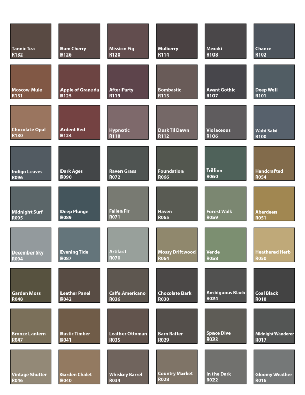
CHAPTER 18.84A Appendix A LM Zone: Approved Clear And Objective Color Palette
Pursuant to DCC 18.84.081, exterior siding for development reviewed under Clear and Objective Design Review Standards in an LM zone must conform to the approved color palette. The following approved palette of swatches is selected from the Miller Paint Northwest Color Collection. Proposed exterior finish colors are required to match colors in the approved palette but do not need to be Miller Paint brand.
Adopted by Ord. 2025-009 §6 on 7/1/2025