
Dothan City Zoning Code
ARTICLE VII
CLASSIFICATION AND ESTABLISHMENT OF USES
Sec. 114-115.- Purpose.
The City of Dothan, Alabama is hereby divided into zoning districts as established by this article. The purpose of this article is to achieve compatibility among land uses within the various districts, to implement the city's official zoning map, and to serve the citizens of Dothan by providing for the implementation and administration of the regulations of this code.
(Ord. No. 2015-336, § 1, 12-1-15)
Sec. 114-116. - Establishment of zoning districts.
For the purpose of this zoning ordinance, all land and water areas within jurisdiction of the City of Dothan are hereby divided into zoning districts, which shall be designated as follows:
(Ord. No. 2015-336, § 1, 12-1-15; Ord. No. 2016-246, § 1, 9-6-16; Ord. No. 2025-278, § 1, 10-20-25)
Sec. 114-117. - Statement of purpose and intent of zoning districts.
The following is intended to specify the purpose and intent of the zoning districts established by this article. Illustrations are provided to assist reader understanding of the concept.
(a)
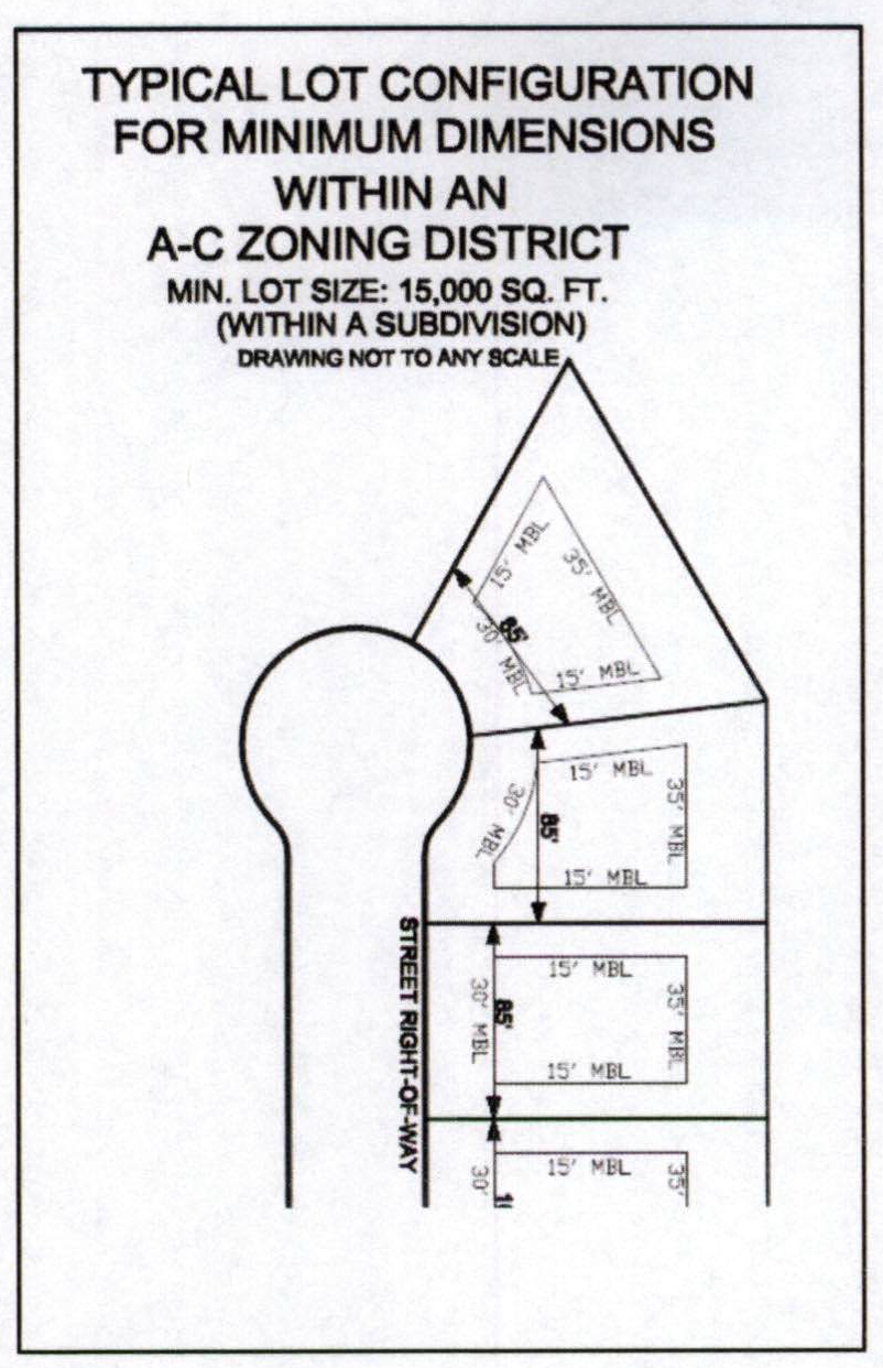
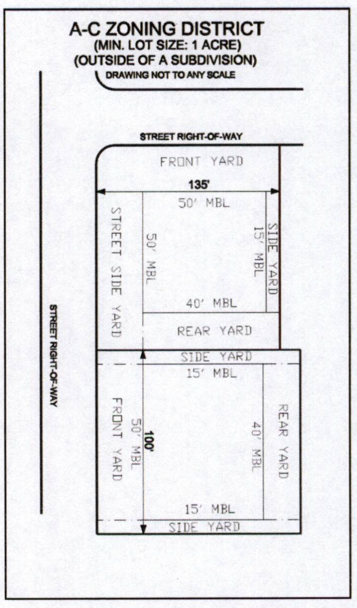
Agricultural-conservation (A-C) district. Regulations for the agricultural district are intended to provide for development on land situated in urban areas that is intended primarily for agricultural uses. Very low density residential uses are also permitted. District dimensional regulations require a minimum of one acre lots for site-built, stand-alone residential uses in this district. Structures not built in a subdivision must comply with the dimensional requirements outlined in the Table of District Dimensional Regulations (article VIII, section 114-132). However, if located in an approved subdivision, lot sizes shall be a minimum of 15,000 square feet and shall comply with R-1 district dimensional regulations other than lot size.
The types and intensity of uses and required areas permitted in this district are designed for both rural character and very low density residential development. In certain cases, agricultural activities, which may not be considered as compatible uses when adjacent to residential uses, are permitted as a "use by-right" in this district. It is not the intention of this chapter to restrict agricultural activities because of residential uses in the immediate area.
(b)
Residential districts. Regulations for residential districts are designed to protect the residential character of areas so designated from the noise, congestion, and heavy traffic that is typically associated with commercial, industrial and other non-residential activities. These regulations are also designed to encourage a suitable environment for family life by providing for open space and associated yet compatible neighborhood facilities. Permitted uses are designed to stabilize and protect the essential characteristics of each district and permit certain home occupations as set forth in this chapter.
(1)
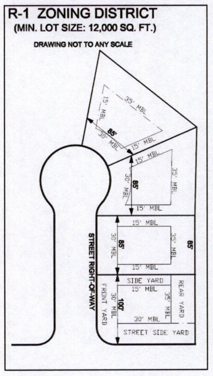
R-1, Residential single-family, low density. This district is intended to provide for low density urban residential development, which is designed to provide quiet, low density areas for single-family living with related recreational facilities protected from intrusion of non-residential activity. Lot sizes in R-1 districts are 12,000 square feet or greater.
(2)
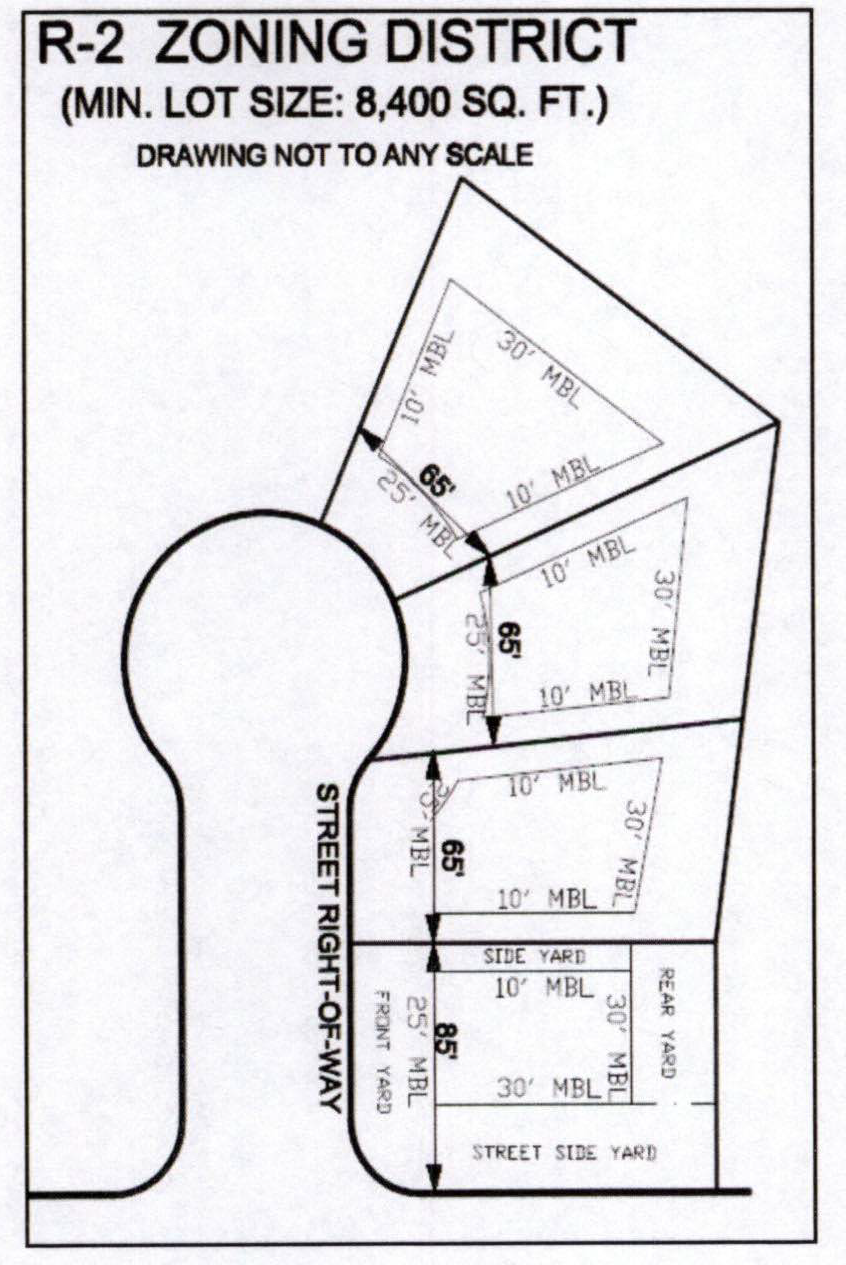
R-2, Residential single-family, medium density. This district is intended to provide for medium density urban residential development, containing single-family dwellings along with related recreational facilities protected from intrusion of commercial and industrial activity. Lots sizes in R-2 districts range from 8,400 square feet to 11,999 square feet.
(3)
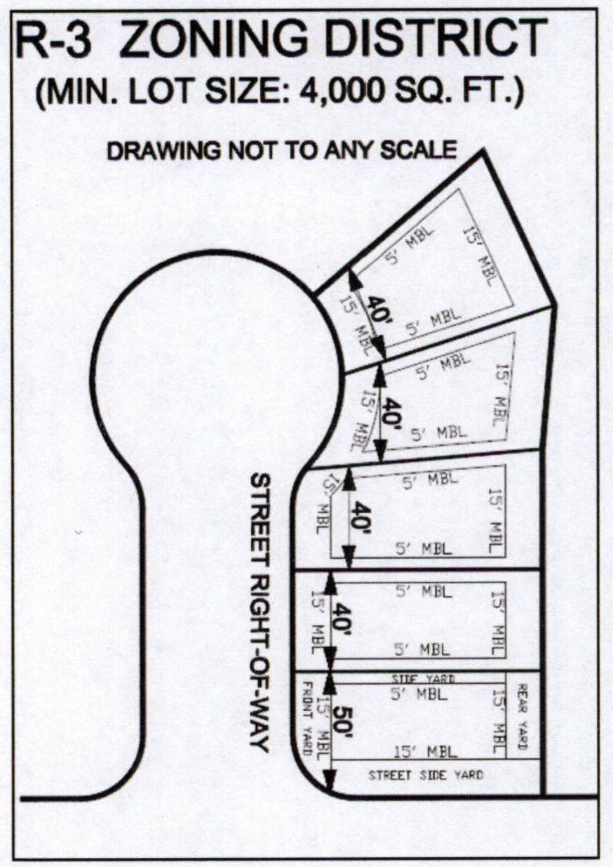
R-3, Residential single-family, high density. This district is intended to provide for high density urban residential development, containing single-family dwellings along with related recreational facilities protected from intrusion of non-residential activity. Lots sizes in R-3 districts range from 4,000 square feet to 8,399 square feet.
(4)
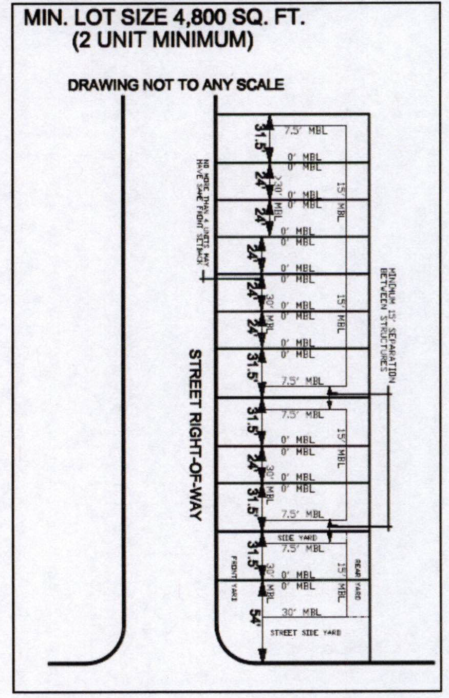
R-4, Residential, attached multi-family, 2-7 dwelling units, high density. This district is intended to provide for high density urban residential development, containing at least two attached dwelling units but not more than seven attached dwelling units, along with related recreational facilities protected from the intrusion of non-residential activity. Single-family dwellings are permitted in R-4 districts utilizing R-3 dimensional regulations as part of the overall mix of housing uses but not independently. Lot sizes in R-4 districts range from 4,800 square feet to 16,800 square feet, but lots can be larger if so desired. The chart below illustrates the minimum and maximum number of dwelling units as well as the minimum lot area for developments in R-4 district. When approved by the building official and the planning commission, zero lot lines are permitted along common walls of attached dwelling units. However, a minimum separation is required between all unattached buildings and/or structures; see the Table of District Dimensional Regulations for standards. This definition is intended to include townhouses as modified by this chapter.
(5)
R-A, Residential, apartments, 8+ dwelling units, high density. This district is intended to provide for high density multi-family urban residential development, as illustrated in the following table, with related recreational facilities protected from intrusion of non-residential activity. The minimum number of dwelling units in R-A districts is eight; there is no maximum number of dwelling units. Single-family dwellings existing at the time of adoption of this chapter are permitted uses. New single-family dwelling units are not permitted in R-A districts. Minimum lot size in R-A districts is 29,200 square feet. This number is based on the methodology of requiring 7,200 square feet for the first unit plus 4,000 square feet for the next four units and 2,000 square feet for each additional unit. Larger lots are permitted if so desired. As the Table of District Dimensional Regulations illustrates, zero lot lines are permitted along common walls, when approved by the building official and the planning commission. Setbacks are required between buildings; see the Table of District Dimensional Regulations (article VIII, section 114-132) for standards. Permitted uses are designed to stabilize and protect the essential characteristics of the area and permit certain home occupations as set forth in this chapter.
(6)
MH-1, Manufactured home community. This district is intended to provide for lower cost housing units in a medium density urban residential development, which is designed for individual manufactured homes, located in an approved mobile home park and additional areas where similar residential development will be a viable land use, with related recreational areas protected from intrusion of non-residential activity. The minimum size of the tract of land for the park shall be three acres. Sites may contain buildings and/or structures owned by the property owner or by tenants. Permitted uses are designed to stabilize and protect the essential characteristics of the area and permit certain home occupations as set forth in this code. Development and/or redevelopment of these areas are subject to the development plan regulations and review by the planning commission. See article X, section 114-158 for specific standards.
(7)
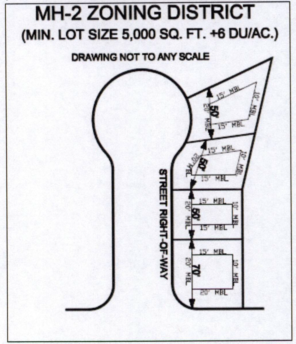
MH-2, Manufactured home subdivisions. This district is intended to provide for urban residential development, which is designed for medium residential density for manufactured homes, located in an approved subdivision and areas where similar residential development will be a viable land use, with related recreational areas protected from intrusion of non-residential activity. This district is further intended to provide lower cost housing units for residents desiring to live in an urban subdivision with permanent manufactured housing units. Lot sizes shall be a minimum of 5,000 square feet and shall meet the minimum dimensional regulations as required by this chapter. Permitted uses are designed to stabilize and protect the essential characteristics of the area and permit certain home occupations as set forth in this code. Development and/or redevelopment of these areas are subject to the development plan regulations and review by the planning commission.
(c)
Office districts. Regulations for office districts are intended to provide areas for business offices and professional offices as well as related activities. These districts are also designed to meet the community's needs for professional services and related activities.
(1)
O & I, Office/institutional. This district is intended to provide areas for business and professional offices as well as more intensive office uses such as public buildings, banks, pharmacies (when adjunct to medical facilities), and television and radio station offices (without towers or aerials). It is further intended to provide appropriate land use regulations for major public and private nonprofit institutions serving the public, such as universities, colleges, public schools, hospitals, parks, fairgrounds, and large state, federal and municipal facilities. Since these institutions operate in the public interest and are generally inoffensive in character, this chapter places principal reliance upon the voluntary cooperation of institutional authorities with municipal officials rather than upon detailed land use regulations. It is intended that the conversion of excess institutional land to non-institutional purposes should be preceded by cooperative planning between the planning and development department and the planning commission and should take place under appropriate controls to ensure that the future use of the excess land conforms to the long range development plan. Development and/or redevelopment of these areas are subject to the development plan regulations.
(2)
O-2, Office park. This district is intended to provide areas for groups of offices for uses such as offices for business and professional services, public buildings, banks, pharmacies (when adjunct to medical facilities), and television and radio station offices (without towers or aerials.) Development and/or redevelopment of these areas are subject to the development plan regulations.
(3)
O-3, Neighborhood office. This district is intended to serve as a transitional district between residential districts and/or uses and more intensive non-residential activities. This district is further intended to avoid traffic onto residential streets or become an intrusion into a residential district. Development and/or redevelopment of these areas are subject to the development plan regulations.
(d)
Business (commercial) districts. Regulations for the business districts are designed to encourage stable and efficient commercial areas to meet the needs of various trade areas for commercial goods and services. The regulations are also designed to minimize the adverse effects of commercial uses on other land uses and provide opportunities for investment.
(1)
B-1, Central business district (CBD). The CBD is intended for personal and business services and general retail trade of the core business center of the community. It is designed to accommodate a wide variety of commercial uses in the traditional downtown business area and related areas of mixed commercial enterprises. It is designed to maintain, support and facilitate compatible redevelopment of existing and new uses with the core area. Residential uses may be appropriate above the ground floor of commercial or other uses within the CBD district. Development or redevelopment of the CBD is subject to all regulations as established in article V, development plans.
(2)
B-2, Highway commercial. The B-2 district is intended for major retail and service activities removed from the CBD, with major thoroughfare access and with adequate open space and parking. Landscaping and aesthetic considerations are important to this area with regional significance. The district is intended to serve residents, non-residents and transient traffic using major thoroughfares that run through and around the city. Development or redevelopment of these areas is subject to all regulations as established in article V, development plans.
(3)
B-3, Local shopping. The B-3 district is intended to serve as a transitional district between commercial districts and residential districts. It is designed for local retail and personal services of limited size and service that provide for the regular needs and convenience of those residing in the adjacent residential neighborhoods. These are generally small in area and contain businesses that deal in "convenience goods" such as groceries, prescription drugs, and household supplies, and the furnishing of personal services. It is intended that local shopping uses be developed as a unit with adequate off-street parking for customers and employees and with appropriate landscaping and screening. Development or redevelopment of these areas is subject to all regulations as established in article V, development plans.
(e)
Manufacturing (industrial) districts. Regulations for the manufacturing districts are designed to make available a range of suitable sites for all types of manufacturing and related activities while protecting residential areas by separating them from manufacturing activities and prohibiting the use of industrial space for new residential development. Industrial parks may be either light or heavy industrial in nature, and therefore shall be permitted in either district.
(1)
L-I, Light industry. The L-I district is designed to provide a location for industries that do not, by their nature, create any public nuisance. It is intended to preserve land for industry in a location beneficial to industries. Single-family residential uses are prohibited. Due to the traffic generated and other potentially objectionable influences created by the nature of the L-I district, special buffer and/or setback considerations may be required. The environmentally protective nature of this district is designed to limit uses to those that produce a minimum of gaseous emissions, noise and objectionable external effects. Development or redevelopment of these areas is subject to all regulations as established in article V, development plans.
(2)
H-I, Heavy industry. The H-I district is intended to provide for the competitive location for manufacturing and related industries that may, by nature, create nuisances. The intent is to preserve land for such industry in locations with access to major streets as designed on the thoroughfare plan, as well as locations generally accessible to railroad transportation and to prohibit residential uses. Due to the objectionable impacts that may be created in this district, special buffer requirements and/or setback areas will be required. Development or redevelopment of these areas is subject to all regulations as established in article V, development plans.
(f)
Special districts. Regulations for special districts are intended to be applied to an area that is rezoned to include a special district. Special districts generally require further development standards within a zoning district. Development in a special district must conform to the base district as well as the overlay zoning requirements.
(1)
Planned unit development (PUD). The PUD district is established to allow for the planned and unified development of a tract of land that is three acres of land or larger. Said land shall be described by ordinance and rezoned as required by this chapter. Areas zoned PUD shall allow for design flexibility of development as the PUD district is intended to encourage efficient use of the land and public services and to promote high quality design that will provide a variant of dwelling types as well as support services and open space for residents of the development. These regulations are intended to permit integration with adjacent non-residential uses and to promote compatibility with existing and emerging patterns of development. Development and/or redevelopment of these areas are subject to the development plan regulations and review by the planning commission. Rezoning's to PUD are subject to all regulations established in article IV, amendment and rezoning procedure.
(2)
Manufactured home community district. The purpose of these regulations is to provide supplemental standards and procedures specifically relevant to the development of a manufactured home community in a MH-1 district. The standards contained in this section allow the development of this housing type while providing adequate public facilities and support services, protection of natural resources; provision of parks and open space, establishes spacing of structures for purposes of privacy and fire protection, provides adequate off-street parking and allows for safe and effective traffic circulation.
(Ord. No. 2015-336, § 1, 12-1-15; Ord. No. 2025-278, § 1, 10-20-25)
Sec. 114-118. - District boundaries.
(a)
The boundaries of the districts listed in section 114-116 are established as shown on the official zoning map of the city, as described in section 114-1 of this chapter. Unless otherwise shown on the zoning map, the boundaries of districts are lot lines, the centerlines of streets or alleys or such lines extended, the centerlines of bodies of water or such lines extended, railroad right-of-way lines, or the corporate limit lines as they existed at the time of enactment of the ordinance from which this chapter is derived. Questions concerning the exact location of district boundary lines shall be decided by the administrative official. Appeals to boundary determination decisions shall be forwarded to the board of zoning adjustment as provided in this chapter.
(b)
If a drafting error is made in the location of a district boundary line of the official zoning map of the city, as adopted in section 114-1, the administrative official shall research the origin of the error and make necessary corrections. Requests for interpretation or appeal of the administrative official's interpretation shall be heard by the board of zoning adjustment at a public hearing and shall follow the same administrative process as other appeals to the board. After a public hearing, the board of zoning adjustment is authorized to direct the correction of the error in order to show the correct location of the district boundary line as established by the ordinance in question. Any corrections to previously adopted zoning maps shall be made in accordance with procedures established prior to adoption of this chapter.
(Ord. No. 2015-336, § 1, 12-1-15)