
Douglas City Zoning Code
CHAPTER 4
ZONING
4.1 - General
4.1.1
Intent
The following provisions are intended to create a comprehensive set of zoning regulations for all land located within the incorporated boundaries of the City of Douglas pursuant to the City's authority under Wyoming State Statutes, as outlined in Chapter 1, General Provisions, of this Code. These regulations are adopted for the purpose of promoting the health, safety, prosperity, and general welfare of the present and future inhabitants of the City. The regulations are also intended to accomplish the following:
• Protect the value and enjoyment of land and buildings;
• Provide adequate light and air to all uses;
• Secure safety from fire, floods, and other hazards;
• Prevent the overcrowding of land;
• Lessen the congestion of traffic on City streets;
• Ensure the adequate provision of necessary services;
• Ensure that land is suitable for the intended use; and
• Create land use classifications to ensure that new development is compatible with the uses and character of the existing neighborhood.
4.1.2
Compliance
Installation, construction, initiation, or operation of any building or land use within the City of Douglas shall be pursuant to the use, density, and dimensional standards of this Chapter and shall also comply with the review and approval procedures, general and use-specific development standards, subdivision regulations, and construction and public improvement requirements of this Code.
4.1.3
Property Not Zoned
Property within the City of Douglas that has not been specifically included within a zoning district shall hereby be zoned as R-1 (Residential) unless the following exist:
i.
The land is surrounded by properties zoned pursuant to a different zoning other than R-1 (Residential), then the subject land shall be zoned the same as the zoning of the surrounding properties;
ii.
The land is located between or adjacent to two (2) or more zoning classifications, then the subject land shall be zoned pursuant to the more restrictive adjoining zoning classification; or
iii.
The land is clearly designated in the City of Douglas Master Plan as a specific land use, then the subject land shall be zoned consistent with the Master Plan designation.
(Ord. No. 967, § 42, 8-10-2015)
4.2 - Zoning Map
4.2.1
Adoption
The boundaries of the zoning districts established by this Code are depicted on a map or series of maps designated the "City of Douglas Zoning Map." The zoning map and all notations, references, data, and other information shown on the map is hereby adopted and made a part of this Code as fully as if it were included within the text of this Code. The Zoning Map and zoning ordinance are maintained in the records of the City of Douglas. In the case of a dispute concerning the zoning designation of a specific property, the zoning ordinances will govern. It shall be the responsibility of the Community Development Director, or his or her designee, to produce updates to the Zoning Map.
4.2.2
Intent
The City of Douglas Zoning Map is intended to reflect the zoning designation for all properties within the incorporated boundaries of the City of Douglas. All City Council resolutions approving the rezoning of a property shall cause the Zoning Map to be amended to reflect the approved zoning district designation. The zoning of property or properties that are brought into the incorporated boundaries of the City as a result of an approved annexation petition or an approved addition by subdivision shall cause the Zoning Map to be amended to include the property or properties within the incorporated boundaries of the City and to depict the approved zoning district designation for each property.
4.2.3
Interpretation of Zoning District Boundaries
Unless otherwise indicated on the zoning map or in the zoning resolution, zoning district boundaries generally follow one of the following: lot lines, roadway or alley centerlines, railroad right-of-way lines, property lines, and/or the incorporated boundaries of the City of Douglas. In the event of a dispute regarding the boundaries of a zoning district, the Planning Director shall be authorized to determine the location of the district boundary.
4.2.4
Zoning Map Amendments (Rezonings)
Amendments to the Zoning Map shall be required to comply with the application, review, and approval procedures for Rezonings (Map Amendments) pursuant to the requirements in Section 3.13 of this Code.
(Ord. No. 967, § 42, 8-10-2015; Ord. No. 1000, § 9, 6-10-2019)
4.3 - Nonconforming Uses, Structures, and Lots
4.3.1
Intent
This section is intended to regulate legally existing uses, structures, and lots that do not comply with one or more of the requirements of this Code. Uses, structures, and lots that are legally existing but that do not comply with one or more of the requirements of this Code shall be referred to as nonconforming uses, structures, and lots. The City seeks to allow nonconforming uses, structures, and lots to continue to exist while encouraging such nonconformities to be brought into conformance with this Code to the greatest extent practical. The following regulations shall be interpreted to recognize the interests of a property owner in continuing a legally existing nonconformity while also ensuring that any extension, expansion, or change in the nonconformity is in compliance with the requirements of this Code.
4.3.2
General Provisions
A.
Continuation of Use
A nonconforming use may be continued and a nonconforming building may continue to
be occupied, except as otherwise restricted in this Section. A pre-existing, nonconforming
use which would otherwise require approval of a conditional use permit shall be presumed
to have the required conditional use permit.
B.
Change of Building or Use
A nonconforming building or use may be changed to a conforming building or use. Upon
establishing a conforming building or use, the owner of land or operator of a use
may not be allowed to later change the use back to a nonconforming building or use.
A legal nonconforming use shall not be changed to a different nonconforming use. Any
change of a nonconforming use to another use shall immediately terminate the right
to continue the nonconforming use.
C.
Interruption and Abandonment
If a nonconforming use is interrupted for a period of one (1) year or more, the nonconforming
use shall be considered abandoned and the structure and land where the nonconforming
use existed shall then only be used for conforming uses. Any nonconforming use may
be deemed abandoned after a period of less than one (1) year if the property owner
submits a request for a determination of abandonment to the Planning Department or
if the owner engages in action which unambiguously expresses an intent to abandon.
D.
Burden of Proof
The owner of land or operator of the use shall have the burden of proving the legal
status of a nonconforming structure or use. This requirement shall also apply to the
owner of land or operator of a use in proving that a nonconforming use has been continuously
maintained.
E.
Construction Approved Prior to Enactment of Regulations
Nothing contained in this chapter shall require any change in plans, construction,
or designated use of a building or structure for which a building permit has been
issued and the construction of which shall have been diligently pursued within three
(3) months of the date of such permit.
4.3.3
Restoration
A.
Damage to Structure or Use
A nonconforming structure damaged or partially destroyed by fire, explosion, or as
a result of natural events may be restored to the exact same size, location, and layout
as it existed immediately prior to the damaging event so long as the restoration complies
with the following:
i.
The value of the damage is less than fifty percent (50%) of the Converse County Assessor's assessed value of the damaged structure;
ii.
The restoration or reconstruction does not extend beyond the original limits of the structure in setback, lot area coverage, height, and floor area; and
iii.
All restoration is started within one (1) year from the date of the damaging event and is completed within two years.
B.
Damage to Structure by an Intentional Act of the Property Owner or Agent
The right to continue a nonconforming use or restore a nonconforming structure shall
immediately terminate if the structure is destroyed by an intentional act of the property
owner or their agent.
C.
Requirement for Development Plan or Site Plan Application
Restoration activities meeting the requirements of this Section shall not proceed
until and unless a Development Plan or Site Plan application is reviewed and approved
by the Planning Department. The type of application and associated review fee shall
be determined by the Planning Director based upon the nature and extent of the restoration.
4.3.4
Enlargement or Expansion of a Nonconforming Use
A.
Within an Existing Building
A nonconforming use, when located within a structure, may be extended throughout the
existing structure so long as any structural alterations of the structure to allow
for the extension of the use throughout the structure are in compliance with the requirements
of this Section.
B.
Expansion of Use by Conditional Use Permit
A nonconforming use shall not be extended or enlarged unless the use is a conditional
use in the respective zoning district and the owner of the land or the operator of
the use has obtained approval of a conditional use permit application to extend or
enlarge the nonconforming use on the same property.
4.3.5
Alteration of a Nonconforming Structure
A.
Limitations of Structure Alterations
A nonconforming building or structure may be altered, improved, or reconstructed provided
that the aggregate cost of such work does not exceed fifty (50) percent of the actual
value of the building or structure, unless the building or structure is changed to
a conforming use. Under no circumstances shall the alteration, improvement, or reconstruction
of a nonconforming structure result in an increase in the degree of nonconformity
of the structure. Additions and extensions to the nonconforming structure shall be
allowed provided that such additions and extensions conform to the dimensional standards
of the respective zoning district.
B.
Maintenance
Normal repairs and maintenance of a nonconforming structure are encouraged and shall
not result in termination of nonconforming status of the structure. Under no circumstances
shall a repair to or maintenance of a nonconforming structure result in an increase
in the nonconformity of the structure.
C.
Unsafe Buildings
Any structure wherein a nonconforming use is operated or any nonconforming structure
declared as unsafe by the City Building Official may be strengthened or restored to
a safe condition without resulting in termination of the legal nonconforming status
of the use or structure.
D.
Movement or Relocation of a Nonconforming Structure
Any nonconforming structure that is moved or otherwise relocated shall be required
to conform to the zoning requirements of the receiving property.
E.
Mobile Homes
A mobile home may be replaced within a nonconforming mobile home park, on a unit by
unit basis, or on a legally existing nonconforming lot if the replacement mobile home
complies with the maximum height and setback requirements of the respective zoning
district. Mobile homes may be replaced by right if such replacement can be accomplished
in compliance with the applicable setback standards. Replacement of a mobile home
with a stick-built home shall be allowed. The Community Development Director shall
have the authority to administratively approve dimensional relief of the applicable
setback requirements for the replacement of the mobile home with a stick-built home
up to twenty percent (20%) of a side or rear setback requirement. Under no circumstances
shall the Director approve relief of a setback requirement if such relief would result
in a minimum setback less than five (5) feet from a side lot line and ten (10) feet
from a rear lot line. The Director shall not have the authority to approve relief
from the applicable front lot setback requirements for replacement of a mobile home
with a stick-built home.
4.3.6
Nonconforming Signs
Nonconforming signs shall be regulated pursuant to the restrictions and provisions in Chapter 5, General Development Standards, of this Code.
(Ord. No. 967, § 42, 8-10-2015)
4.4 - Standard Zoning Districts
4.4.1
General
Adoption of this Code hereby establishes the following standard zoning districts: A (Agricultural), R-1 (Residential), R-2 (Multiple Residence), R-3 (Multiple Residence), R-4 (Multiple Residence), RE (Residential Estate), RR (Rural Residential), MH-1 (Manufactured Home), MH-2 (Mobile Home Park), CB-1 (Downtown Business), B-1 (Local Business), B-2 (General Business), and I (Industrial). The following provisions are intended to identify and characterize each of the standard zoning districts and are established for the purpose of providing specific use, density, and dimensional standards therefor.
4.4.2
Zoning Map Symbols for Standard Zoning Districts
Table 4-1 below identifies the Zoning Map symbols for each of the standard zoning districts. Note: the Zoning Map symbols for each of the special purpose zoning districts is outlined below in Section 4.6 of this Chapter.
4.4.3
A, Agricultural Zoning District
The A (Agricultural) zoning district is a 20-acre minimum lot area district intended to accommodate the rural community and lifestyle, including the conservation of farming, ranching, and agricultural resources. The district is characterized by agricultural uses of land and is meant to provide an adequate amount of space for livestock and poultry keeping. Properties within this district may not be served by central water and wastewater service.
4.4.4
Residential Zoning Districts
A.
R-1, Neighborhood Residential Zoning District
The R-1 (Residential) zoning district is intended to provide for low-density, single-family
residential development and to provide for such community facilities and services
as will serve the area residents while protecting the residential character and quality
of the area.
B.
R-2, Medium Density Residential Zoning District
The R-2 (Multiple Residence) zoning district is intended to provide for the development
of single-family and duplex or townhouse dwellings.
C.
R-3, Limited Mixed Residential Zoning District
The R-3 (Multiple Residence) zoning district is intended to provide for the development
of medium-density and high-density apartments. The district also provides a variety
of housing types to serve the housing needs of the area residents.
D.
R-4, Mixed Residential Zoning District
The R-4 (Multiple Residence) zoning district is intended to provide for the development
of high-density apartments mixed with non-retail office and professional service space.
E.
RE, Residential Estate Zoning District
The RE (Residential Estate) zoning district is to establish and maintain a quiet,
single-family dwelling residential neighborhood, preserving and promoting the existence
of large areas of passive open space, light, play areas for children, and recreational
sites.
F.
RR, Rural Residential Zoning District
The RR (Rural Residential) zoning district is intended to establish and preserve areas
for semi-rural, low-density residential and compatible low-intensity agricultural,
commercial, and light industrial uses. Areas within the district may or may not be
served by central sewer.
4.4.5
Manufactured and Mobile Home Zoning Districts
A.
MH-1, Single Residence Manufactured Home Zoning District
The MH (Manufactured Home) zoning district is intended to provide for manufactured
and site/stick-built homes with single-family uses and lot ownership.
B.
MH-2, Mobile Home Park Zoning District
The MH-2 (Mobile Home Park) zoning district is intended to provide for mobile home
parks and recreational vehicle parks.
4.4.6
Business and Industrial Zoning Districts
A.
CB-1, Downtown Business Zoning District
The CB-1 (Downtown Business) zoning district is intended to provide a central area
for business, government services, and community and cultural activities. This district
is included in the downtown area designation due to its historic architecture and
character.
B.
B-1, Local Business Zoning District
The B-1 (Local Business) zoning district is intended to provide for a broad range
of retail and service functions.
C.
B-2, General Business Zoning District
The B-2 (General Business) zoning district is intended to provide for commercial uses
that create a use intensity transition between residential neighborhoods and light
industrial uses.
D.
I, Industrial Zoning District
The I (Industrial) zoning district is intended to provide for wholesale trade, storage
and warehousing, trucking and transportation terminals, light and heavy manufacturing
uses and similar activities.
4.4.7
Overlay Districts
A.
O-LDH, Local Downtown Historic Overlay District
i.
General
The Downtown Douglas Historic District is an overlay district within the CB-1 Downtown Business zoning district. The overlay district is established to acknowledge and preserve the character of the area as it has progressed in the community's history. Douglas' downtown has evolved from a frontier community to a turn-of-the-century railroad shipping point serving the outlying agricultural interests, as well as serving as the county seat and commercial center of Converse County. As automobile traffic and tourism increased, the downtown became an important stop on the Yellowstone Highway. More recently, the changing architecture of the downtown has reflected the on again-off again energy boom community of the last half century.
ii.
District Boundaries
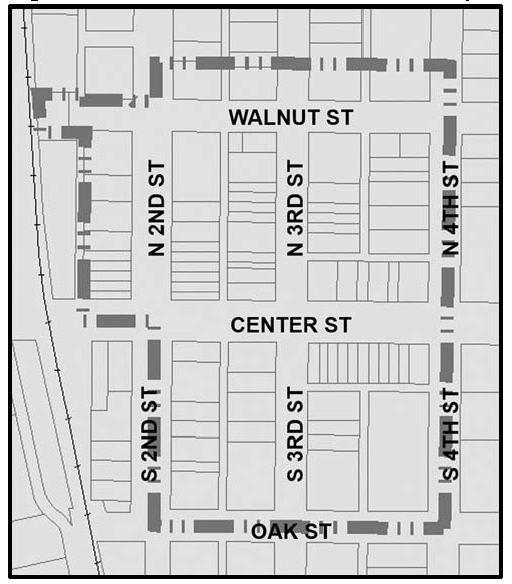
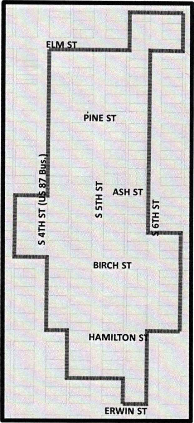
The overlay district boundaries are the west side of North 4th Street from E. Walnut Street to Oak Street, turning west and continuing down the north side of Oak Street to South 2nd Street, turning north and continuing down the east side of South 2nd Street to East Center Street, continuing north on East 2nd Street including both sides of the street to East Walnut Street, including the property located at 100 East Walnut Street, and continuing east on East Walnut Street including both sides of the street to the point of commencement at the corner of North 4th Street and East Walnut Street; and inclusive of all property within or facing those boundaries. The Local Downtown Historic Overlay District boundaries are shown below in Figure 4.4-1.
Figure 4.4-1: Local Downtown Historic Overlay District Boundaries.
iii.
Regulations Designated
Within the overlay district all new construction, building additions, and exterior modifications shall comply with the rehabilitation standards for the Downtown Douglas Historic District and the Douglas Downtown Design Guidelines. Repairs due to any unforeseen damages to any building, such as those occurring as a result of severe weather, are excluded from these requirements strictly to the extent required to repair said damage. All such construction and modifications of buildings and/or structures within the overlay zoning district of Downtown Douglas Historic District within the CB-1 Downtown Business zoning district shall be subject to a compliance review by a panel consisting of two (2) members of the City of Douglas Planning and Zoning Commission, two (2) members of the Douglas Historic Preservation Commission, and one (1) member of Douglas Main Street, those members to be named by the respective entities and appointed on an annual basis. The panel shall review each application for compliance with the rehabilitation standards for the Downtown Douglas Historic District and the downtown area design guidelines subject to additional existing required review processes.
iv.
Actions by the Panel and Appeals
The panel shall make written recommendations and findings to the building official within ten (10) days of filing the building permit application. The building official shall modify the permit application to incorporate such recommendations and findings. An applicant may appeal any decision of the building official in compliance with Chapter 2.64 of the Douglas Municipal Code.
B.
O-DD, Designated Downtown Overlay District
i.
General
The Designated Downtown Overlay District is an overlay district comprised of a number of zoning districts. The overlay district is established to help provide a strong setting for commerce, provide a degree of visual continuity, extend the life of the included buildings, improve the market image of businesses and enhance the overall character of Downtown Douglas. Appropriately designed new, restored, and renovated buildings can enhance the visual quality of the area, help preserve community heritage, and retain historic integrity while also strengthening economic vitality.
ii.
District Boundaries
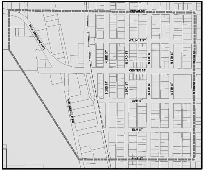
The Designated Downtown District boundaries are shown below in Figure 4.4-2.
Figure 4.4-2: Designated Downtown Overlay District Boundaries.
iii.
Regulations Designated
The City of Douglas Downtown Design Guidelines shall apply to commercial and mixed-use properties within the Designated Downtown Overlay District.
iv.
Actions by the Community Development Department and Appeals
The Community Development Department Director shall make written recommendations and findings to the building official within ten (10) days of filing the building permit application. The building official shall modify the permit application to incorporate such recommendations and findings. An applicant may appeal any decision of the building official in compliance with Chapter 2.64 of this Code.
C.
O-DMS, Designated Main Street Overlay District
i.
General
The Designated Main Street Overlay District is established to assemble human and financial resources to implement a Main Street revitalization program as the Main Street Program works to generate pride of ownership and community by preserving and enhancing the appeal and vitality of Downtown.
• The promotion and marketing to create a positive image of a commercial district that encourages consumers and investors to live, work, shop, play, and invest in the Main Street District.
• Design activities to enhance the physical appearance of the Downtown commercial district by rehabilitation of historic buildings, encouraging appropriate new construction, and developing sensitive design management systems and long term planning.
• Assist with economic restructuring to strengthen the existing economic assets while expanding and diversifying the economic base of the Downtown commercial district.
• Work with existing business owners and recruit compatible new businesses and new economic uses to build a Downtown commercial district that responds to today's consumer needs.
• Work to convert unused or underused downtown commercial space into economically productive property to boost the profitability of the district.
ii.
District Boundaries
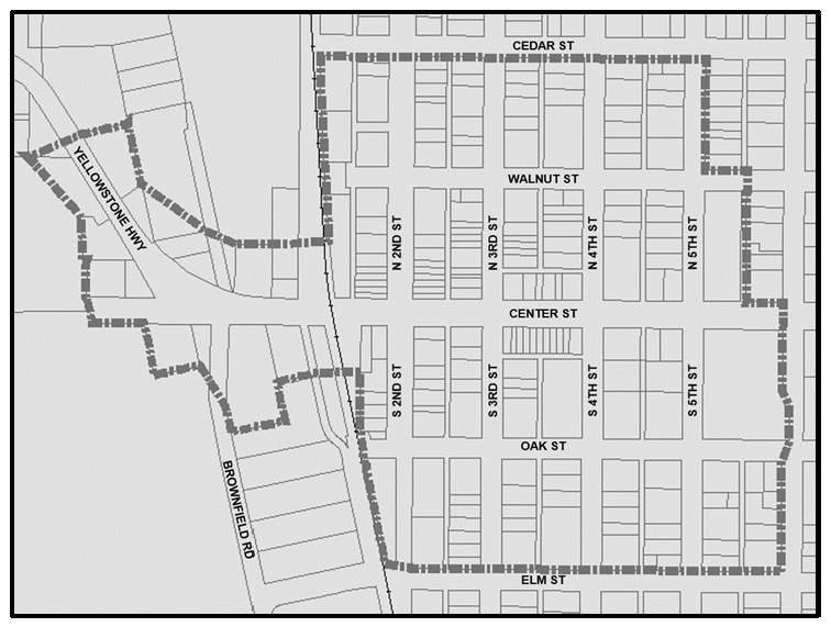
The Designated Main Street Overlay District boundaries are shown below in Figure 4.4-3.
Figure 4.4-3: Designated Main Street Overlay District Boundaries.
D.
O-NDH, North Douglas Historic Overlay District
i.
General
The north Douglas Historic District was established as a National Register of Historic Places District in 2002 as a distinct and cohesive residential area associated with and representative of the significant trends that contributed to the settlement and development of Douglas from 1886 through the 1950's. It contains a large concentration of homes of the "working class" citizens from the late 19th and early 20th centuries, as well as homes of a number of the historically important and wealthier residents of early Douglas who played key roles in its economic, political and social growth.
ii.
District Boundaries
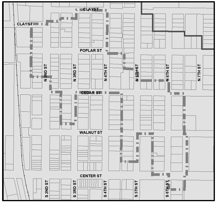
The North Douglas Historic Overlay District boundaries are shown below in Figure 4.4-4.
Figure 4.4-4: North Douglas Historic Overlay District Boundaries.
iii.
Regulations Designated
The City of Douglas recognizes the importance of protecting the integrity and maintaining the historic character of the North Douglas Historic Overlay District and encourages all reasonable preservation efforts.
E.
O-LPC, Local Pioneer Cemetery Historic Overlay District
i.
General
The Pioneer Cemetery Historic District is an overlay district encompassing the Pioneer Cemetery Subdivision. The overlay district is established to acknowledge and preserve the character of the area as elemental in its role as a transportation corridor in bringing the early settlers west on the Child's Route of the Emigrant Trail, as denoted by the existing deep wagon ruts still bisecting this parcel 170 years later; and for the part it played as the location for the first graveyard for the town of Douglas and its predecessor, the community of Antelope. The Pioneer Cemetery located on "Poverty Flats", an undisturbed patch of prairie that was originally within the boundaries of the Fort Fetterman Military Reservation, served both communities from 1886 to 1902; and is still the burial site of many of the earliest pioneers who labored to create enterprises and homes on this wind-swept grassland.
ii.
District Boundaries
The overlay district boundaries are the designated boundaries of the Pioneer Cemetery Subdivision and inclusive of all property within those boundaries. The Pioneer Cemetery Historic Overlay District boundaries are shown below in Figure 4.4-5.
Figure 4.4-5: Local Pioneer Cemetery Historic Overlay District Boundaries.
iii.
Regulations Designated
Within the overlay district all proposed development shall serve as enhancements or interpretations to the recognized historic sites. Mowing shall be confined to within the boundaries of the Pioneer Cemetery and any designated parking areas or walking paths, as preserving the natural surroundings is an integral part of the district's historic experience. All construction, interpretive signage, or other development shall be subject to review by the Douglas Historic Preservation Commission, as the City's designated body to identify, designate, propose, and advise on all preservation matters on behalf of the City as enacted by its endorsement and agreement to participate in the State's Certified Local Government program. Particular attention shall be paid to efforts in protecting the district from negative impacts from surrounding development.
iv.
Actions by the Historic Preservation Commission and Review
The Commission shall make written recommendations and findings on all proposed development or construction to the Community Development Director in a timely manner. The Community Development Director shall approve all recommendations which are in keeping with the nature of the district and the existing zoning regulations.
F.
O-SDH, South Douglas Residential Historic Overlay District
i.
General
The South Douglas Historic District was established as a National Register of Historic Places District in 2023 as a distinct and cohesive residential area associated with and representative of the significant trends that contributed to the settlement and development of Douglas from 1886 through the 1960s. It contains a large concentration of homes of the "working class" citizens from the late 19th and early 20th centuries, as well as homes of a number of the historically important residents of early Douglas who played key roles in its economic, political, and social growth.
ii.
District Boundaries
The South Douglas Historic Overlay District boundaries are shown below in Figure 4.4-6.
Figure 4.4-6: South Douglas Historic Overlay District Boundaries.
iii.
Regulations Designated
The City of Douglas recognizes the importance of protecting the integrity and maintaining the historic character of the South Douglas Historic Overlay District and encourages all reasonable preservation efforts.
(Ord. No. 967, § 42, 8-10-2015; Ord. No. 990, § 30, 5-22-2017; Ord. No. 1006, § 1, 1-25-2021; Ord. No. 1028, §§ 1, 2, 8-28-2023)
4.5 - Density and Dimensional Standards
4.5.1
General
Tables 4-2 and 4-3 below identify the density and dimensional requirements for each of the standard zoning districts. The methods for calculating and interpreting dimensional measurements and the definition of terms used in this section shall be pursuant to the provisions of Chapter 1, General Provisions, and Chapter 2, Definitions and Acronyms, of this Code, respectively.
4.5.2
Exceptions to Dimensional Standards
A.
Setback Exceptions
Steps, uncovered porches, and covered but unenclosed porches, on the first story which
do not extend more than ten (10) feet beyond the front wall of the building are not
considered in the front or side yard requirements. The methods for calculating and
interpreting dimensional measurements and the definition of terms used in this section
shall be pursuant to the provisions of Chapter 1, General Provisions, and Chapter 2, Definitions and Acronyms, of this Code, respectively.
B.
Exceptions for Lots of Record
The phrase "lot of record" is defined in Chapter 2, Definitions and Acronyms, of this Code. The following exceptions to the density
and dimensional standards apply to all lots of record:
i.
Any lot of record may be used as a building site if such building complies with the minimum setback and maximum height requirements of this Code. No permit shall be issued for more than one (1) dwelling unit on any lot having less than the minimum area per dwelling unit of the zone in which the lot is located;
ii.
Each minimum setback requirement (front, rear, and side) may be reduced by two (2) inches for each one (1) foot by which such lot is narrower than fifty-five (55) feet, provided that no side yard setback shall be reduced to less than five (5) feet from the lot line and/or utility easement; and
iii.
In any residential zone where a lot of record adjoins lots having existing front yards less than the minimum required by this title, the minimum front yard setback for the lot of record shall be the average of the existing front yard setbacks for the two (2) adjoining lots, or if only one (1) of the adjoining lots is built upon, the front yard setback for the lot of record shall be the average of the following: 1) the existing front yard setback for the lot that is built upon and 2) the minimum front yard setback required in the respective zoning district.
Table 4-2. Density and Dimensional Standards for all Agricultural, Residential, Manufactured Home, and Mobile Home Standard Zoning Districts.
1.
Accessory structures are only allowed in the side or rear yards and if in compliance with the accessory structure setbacks. Accessory structures are not allowed in the front yard. One-story detached accessory buildings used as storage sheds, playhouses, and similar uses are not required to comply with the accessory building setback requirements if the building complies with each of the following: a) the building is two hundred (200) square feet or less, b) the building is located in the side or rear yard, and c) the building is not constructed on a permanent foundation.
2.
If a side yard fronts a street (e.g., a corner lot), then the side yard setback for the side adjacent to the street shall be fifteen (15) feet.
3.
The height limits in this section shall not apply to: a) chimneys, conveyors, derricks, flagpoles, radio or television towers, masts and aerials, silos, smokestacks, transmission towers, or power transmission line poles; b) churches, hospitals, sanitariums, schools, or other public buildings provided that the minimum side and rear yard setbacks are increased by an additional foot for each additional foot of height in excess of the maximum height in the respective zoning district; no building shall exceed fifty (50) feet in height; and c) no man-made edifice shall protrude into the minimum requirements for the Converse County Airport approach zones; such minimum requirements shall be delineated by the adopted Converse County Airport obstruction and approach zone map.
Table 4-3. Density and Dimensional Standards for all Business and Industrial Standard Zoning Districts.
1.
Accessory structures are only allowed in the rear yard and if in compliance with the accessory structure setbacks. Accessory structures are not allowed in the front or side yards. Accessory buildings shall not occupy more than 25% of the rear yard area.
2.
If a side yard fronts a street (e.g., a corner lot), then the side yard setback for the side adjacent to the street shall be 15 feet.
3.
If a side yard fronts a street (e.g., a corner lot), then the side yard setback for the side adjacent to the street shall be 20 feet. A portion of the twenty-foot street side yard setback may be used to site and comply with off-street parking requirements if in compliance with the landscaping requirements of Chapter 5 of this Code.
4.
If a side yard fronts a street (e.g., a corner lot), then the side yard setback for the side adjacent to the street shall be 20 feet.
5.
The height limits in this Section shall not apply to : a) chimneys, conveyors, derricks, flagpoles, radio or television towers, masts and aerials, silos, smokestacks, transmission towers, or power transmission line poles; b) churches, hospitals, sanitariums, schools, or other public buildings provided that the minimum side and rear yard setbacks are increased by an additional foot for each additional foot of height in excess of the maximum height in the respective zoning district; no building shall exceed fifty (50) feet in height; and c) no man-made edifice shall protrude into the minimum requirements for the Converse County Airport approach zones; such minimum requirements shall be delineated by the adopted Converse County Airport obstruction and approach zone map.
(Ord. No. 967, § 42, 8-10-2015; Ord. No. 995, § 1, 6-11-2018; Ord. No. 1000, § 10, 6-10-2019; Ord. No. 1013, § 1, 8-22-2022)
4.6 - Special Purpose Zoning Districts
4.6.1
General
Adoption of this Code hereby establishes the following special purpose zoning districts: GRN (Green Space), MU-PUD (Mixed-Use Planned Unit Development), and PLI (Planned Industrial). The dimensional standards for each special purpose zoning district are included in Table 4-5 below.
4.6.2
Zoning Map Symbols for Special Purpose Zoning Districts
Table 4-4 below identifies the Zoning Map symbols for each of the standard zoning districts.
Table 4-4. List of Special Purpose Zoning Districts
4.6.3
GRN, Green Space Zoning District
The GRN (Green Space) zoning district is intended to promote open vegetated areas capable of maintaining natural wildlife habitat and to protect the scenic and ecological qualities of environmentally sensitive areas. The district is commonly applied to publicly owned property or property for which scenic or greenspace easements have been dedicated or purchased for the use and/or enjoyment of the public.
4.6.4
MU-PUD, Mixed-Use Planned Unit Development Zoning District
A.
Intent
The Mixed Use Planned Unit Development (MU-PUD) zoning district is intended to accommodate
high-quality commercial, office, residential, commercial mixed-use, and residential
mixed-use development. The purpose of the following regulations is to allow for increased
flexibility in the siting and design of land uses and zoning standards within a comprehensively
planned area. The MU-PUD zoning district allows for the vertical and horizontal mixture
and siting of commercial and residential uses and the establishment of development-specific
standards, including:
• Residential density ranges;
• Maximum commercial and office square footages;
• Vertical and horizontal dimensional standards;
• Maximum lot area coverages;
• Open space siting and design;
• Building setbacks;
• Acceptable building types;
• On and off-street parking;
• Street layout and design; and
• Signage.
In exchange for the flexibility and design benefits gained through the use of the MU-PUD zoning district, proposed MU-PUD developments shall demonstrate and provide a combination of the following:
• Innovative and exceptional building design, including the use of higher quality building materials and architectural features;
• A mixture of permitted and conditional land uses that are appropriately sited to ensure use-to-use compatibility within the proposed development and in relation to existing and approved adjacent land uses;
• A mixture of housing types and styles;
• A comprehensive plan for integrating landscaping, screening, and buffering in a manner that creates safe and attractive pedestrian spaces while preserving and enhancing the character of the area;
• Preserving areas as usable open space;
• Providing pedestrian amenities;
• Developing community amenities and public gathering spaces; and
• Designing and constructing public improvements that meet or exceed the standards of this Code.
B.
Enforcement
The City Council shall have exclusive enforcement authority over all use, density,
dimensional, and development standards, and engineering criteria, including modifications
of the same, within a MU-PUD zoning district.
C.
Phasing
Large scale MU-PUD zoning district development should include a comprehensive phasing
plan for the construction of buildings, roads, necessary drainage facilities, and
the extension of utilities. The phasing plan shall present a logical progression for
cost effective extensions of project-dependent infrastructure.
D.
Restrictions
A MU-PUD rezoning shall not be approved if the purpose of the proposed MU-PUD zoning
district is to circumvent the zoning variance process in Section 3.15 of this Code or to otherwise circumvent or undermine the intent of this Code. Use
of the MU-PUD zoning district shall not be used for the development or redevelopment
of a single use on a single property or to rezone a parcel to allow for mixed-use
development where there is no intent to subdivide the subject parcel.
E.
General Standards
i.
Uses
The allowed, conditional, temporary, and accessory uses within a specific MU-PUD zoning district shall be established by the City Council in approving a MU-PUD rezoning. In establishing the use allowances in the MU-PUD, reference shall not be made to existing zone districts otherwise established by this Code.
ii.
Restrictions
• Industrial and light industrial land uses shall be prohibited in the MU-PUD zone district. Such uses shall only occur in the I (Industrial) and PLI (Planned Light Industrial) zone districts.
• The mixture of residential uses shall only occur on the second floor or higher of any residential and commercial or office mixed-use building within the MU-PUD zone district.
iii.
Additional Standards
• All buildings, structures, and land uses in the MU-PUD district shall be located, designed, and operated in accordance with the standards established by the specific MU-PUD development plan and development guide, if a development guide is included in support of the MU-PUD rezoning request.
• Specific use and development standards shall be established within the specific MU-PUD zoning district for certain unique land use relationships such as vertical and horizontal mixed-use scenarios, use-to-use transitional areas, and the siting and use of open space, community amenities, and public gathering spaces.
• All MU-PUD zoning district regulations should be designed so as to encourage neighborhood and pedestrian-scale commercial and office uses and appropriate live-work scenarios. Large-scale retail and regional commercial uses should be designed and sited in a logical manner based upon the existing and proposed roadway network and upon the existing land use pattern adjacent to the perimeter of the MU-PUD zoning district.
• The provisions of this Code, as amended from time to time, shall apply where a specific MU-PUD zoning district is silent, contradictory, or unclear on a particular issue.
F.
Architectural Standards
i.
At a minimum, the architectural design standards of Section 5.2, Architectural Design Standards, of this Code shall apply to the development of structures and uses within a MU-PUD zoning district.
ii.
A clearly identifiable and uniform architectural theme shall be required within a MU-PUD zoning district.
iii.
The same exterior building height and/or elevation shall not be repeated within a 200-foot block length or upon four (4) consecutive lots within the MU-PUD zoning district.
iv.
Residential structures with attached garages shall be designed in a manner that front-loaded garages are not the dominant visual features of the street-side elevation and shall be recessed toward the back of the lot at a minimum of five (5) feet from the front of the residential structure. The Community Development Department Director shall have the authority to determine the front elevation of a proposed residential structure for the purposes of administering these regulations.
v.
Exterior building façades and frontages shall incorporate alternating recesses for individual tenant units within the same building.
vi.
The siting and construction of buildings shall be street and pedestrian orientated. The Community Development Department Director shall have the authority to approve an alternative siting plan where site-specific circumstances or restrictions inhibit an applicant's ability to comply with this requirement.
G.
Density, Bulk, and Dimensional Standards
i.
The MU-PUD development plan and development guide, if included within a specific MU-PUD zoning district, shall establish the minimum and maximum density and dimensional standards for land uses authorized within the district, including, but not limited to, minimum lot sizes, maximum densities, minimum lot widths, setbacks, maximum building coverage, maximum building height, and minimum separation distances between specific uses.
ii.
In establishing the density and dimensional standards in a MU-PUD zoning district, reference shall not be made to existing zoning districts established by this Code.
iii.
Density and dimensional standards that do not meet the minimum or maximum limits, as applicable, for similar zoning districts and land uses established by this Code shall be supported by trade-offs in the form of increased design and development standards that support vertical and horizontal mixed-use scenarios and include increased architectural design standards, compatible building siting, bulk, and orientation, and additional landscaping, buffering, and screening.
iv.
Any MU-PUD zoning district that allows for a maximum building height that exceeds the maximum building height of a comparable standard zoning district, as outlined in this Chapter, shall be required to incorporate a combination of building step-backs, decreased building widths, balconies, or other architectural design elements for any portion of a building extending above the second floor.
v.
Additional landscaping, buffering, and screening shall not be considered acceptable tradeoffs as a means of mitigating increases to the maximum building height.
H.
Landscape, Buffering and Screening
i.
The requirements in Section 5.5, Landscaping, Buffering, and Screening, shall be considered the minimum standards for landscaping, buffering, and screening within a MU-PUD zoning district.
ii.
The MU-PUD zoning district shall establish uniform landscape, buffering, and screening requirements for land uses and transitions between different land uses and areas, including but not limited to, street trees and roadway landscaping buffers, internal landscaping, parking lot landscaping and screening, and buffering and screening for differing or sensitive uses within and adjacent to the MU-PUD zoning district.
iii.
Uniform standards shall be established for landscaping, buffering, and screening along the MU-PUD zoning district boundary to improve and ensure use-to-use and zoning-district-to-zoning-district compatibility.
iv.
Standards for use, density, and intensity transitions between distinct use areas shall be established by the MU-PUD development plan and/or development guide.
v.
Reduced screening and buffering between uses may be approved as a trade-off in exchange for increased design features, such as building massing and orientation, areas dedicated to outdoor seating, public plazas, parks, and other open space and pedestrian amenities.
I.
Open Space
i.
A minimum of fifteen percent (15%) of the gross land area within a MU-PUD zone district planning area shall be set aside as open space. Individual phases within the MU-PUD are not required to provide fifteen percent (15%) open space if a master open space plan, depicting compliance with the required fifteen (15%) open space standard, is provided with the overall MU-PUD development plan. Each phase, if phasing is proposed, of a MU-PUD development plan shall include some portion of the required open space and shall have immediate access to an area of usable open space.
ii.
No less than 25% of required open space of a MU-PUD zoning district shall be contiguous and usable for active or passive recreational use. Open space for active or passive use shall not include drainage facilities or areas that include natural hazards. Examples of active or passive open space uses include trails, parks, interpretative parks, outdoor recreational facilities, athletic fields, wildlife viewing areas, and other similar uses.
iii.
Usable open space in the form of community, neighborhood, or pocket parks shall be located within a one-quarter (¼) mile distance from all single-family, two-family, and multi-family residential dwellings.
iv.
Required landscaping, buffering, and screening for uses within a MU-PUD zoning district shall not be counted toward the provision of the required open space.
v.
Uses allowed in open space areas within a MU-PUD zoning district shall include, but may not be limited to, the following:
• Pedestrian and bicycle trails for non-motorized use;
• Decorative fences and walls;
• Signs necessary for identification of and navigation through open space areas;
• Restrooms;
• Picnic shelters, pavilions, gazebos, and other similar open-air structures;
• Maintenance storage facilities;
• Playgrounds;
• Recreation-related parking facilities; and
• Athletic courts and fields.
vi.
The City Council shall consider the following when evaluating the quality of the proposed open space within a MU-PUD rezoning request:
• Whether the proposed open space area(s) is consistent with the goals and policies of the City of Douglas Master Plan;
• The environmental characteristics and significance of the proposed open space area(s);
• Whether the location, use, and relationship of the proposed open space areas is compatible with the distinct planning areas within the MU-PUD zoning district.
• Whether public or private common use open space area(s) will be available to and accessible by residents of any distinct residential area(s);
• Whether the plan for usable open space includes the provision of adequate bicycle and pedestrian trails;
• Whether the plan for open space will improve buffering and screening between the MU-PUD development and adjacent existing and planned land uses;
• Whether the open space will provide neighborhood, community, and regional recreational opportunities for future residents in the proposed MU-PUD zoning district and for the existing and future residents of the City of Douglas;
• Whether the applicable school district standards for the number, type and location of public school recreational facilities can be met if the proposed open space area(s) are anticipated to allow joint school-public use; and
• Whether the proposed open space area(s) will help preserve view corridors both within and through the property and protect and/or enhance other scenic assets.
• The design and construction, as appropriate, of open space within a MU-PUD zoning district shall be considered a public improvement similar to the design and construction of other public improvements such as roads, drainage facilities, sidewalks, etc. All open space areas within a specific phase of a MU-PUD planning area, if phasing is proposed, or for the entire MU-PUD planning area, if phasing is not proposed, shall be installed concurrent with the other public improvements with the initial Final Plat or Development Plan in the MU-PUD zoning district. The design and installation of all open space, pursuant to the procedures outlined immediately above, shall be completed prior to issuance of a certificate of occupancy for any building within the applicable phase or within the MU-PUD planning area, as applicable.
• Financial assurance in the form of cash, letter of credit, or bond in an amount necessary to ensure that the City will have the ability to develop the subject open space and common areas in the event that the developer defaults on the requirement to do the same. The requirement of the developer to develop the subject open space shall be included in the associated subdivision improvement agreement for the initial final plat application or as part of the development improvement agreement for the initial development plan application. The determination for inclusion of the construction of open space areas into either a subdivision improvement agreement or a development improvement agreement shall be made by the City Council in response to a request from the developer at the time of taking final action on the respective application.
• Open space and common areas, unless otherwise dedicated to the City, shall be protected from commercial or residential redevelopment by covenants, deed restrictions, plat restrictions, conditions of approval, or any other mechanisms approved by the City Council.
• Provisions for continuous maintenance of open space within a MU-PUD zoning district shall be established as part of the MU-PUD rezoning request and shall be memorialized by notation on the face of the MU-PUD development plan cover sheet, unless such open space is otherwise dedicated to the City for ownership and maintenance.
vii.
The City Council may allow transfer of up to 33% of the required open space acreage and 33% of the usable open space acreage from a proposed MU-PUD zoning district area to another location within the City in exchange for increased residential density or commercial intensity within the MU-PUD planning area. Any request to transfer open space acreage shall comply with the following:
• The owner of land within the proposed MU-PUD zoning district is also the owner of record of the property that is proposed to receive the transferred open space;
• The preservation and/or development of open space on the receiving property will provide a greater benefit to the current and future residents of the City of Douglas than would be provided as a result of full compliance with the open space requirements within the MU-PUD planning area;
• The quality of usable open space on the receiving property will be more regional in nature and will represent and provide a logical connection or extension of existing usable open space and/or pedestrian pathways;
• The owner of both properties has provided a plan for construction of the transferred open space and financial assurance sufficient to secure performance of such construction; and
• The owner of both properties has provided a plan for maintenance of the transferred open space and financial plan for ensuring the performance of such plan.
J.
Streets, Alleys, and Sidewalks
i.
The requirements of Section 5.10, Streets, Alleys, and Sidewalks, of this Code shall be the minimum standards for development within a MU-PUD zoning district. The standard cross-sections and dimensional details may be modified by recommendation of the City Engineer and may be approved by the City Council as a trade-off in exchange for the provision of public improvements in excess of those improvements necessary to facilitate and mitigate the impacts of the proposed development.
ii.
Streets and transportation networks within a MU-PUD zoning district shall be laid out and designed to ensure connectivity in a grid-like hierarchy. The use of cul-de-sacs is discouraged within a MU-PUD zoning district. The use of the cul-de-sac shall be limited to instances where connectivity with an adjacent street is not logical or is physically impossible due to existing development on the adjacent property or due to the presence of a physiographic, geographic, or environmental constraint. Pedestrian and bicycle access to an adjacent street, pedestrian trail, or open space amenity shall be required from all cul-de-sacs within a MU-PUD zoning district.
iii.
Local residential street cross-sections within a MU-PUD zoning district may be reduced as a trade-off in exchange for: 1) rear-loaded garages that are accessed from alleys and 2) increased architectural design requirements for single-family residential buildings and structures.
iv.
Modifications to the standard street or roadway cross-sections may be approved in all distinct planning areas within a MU-PUD zoning district in exchange for implementation of pedestrian-scale traffic calming devices, increased attached and detached sidewalk widths, and pedestrian-oriented intersection design elements, including but not limited to the following:
• Raised pedestrian crossings;
• Pedestrian islands and refuges;
• Bicycle lanes;
• Increased pedestrian amenities;
• Reduced block lengths;
• Increased pedestrian level landscaping, streetscape, and/or street trees;
• On-street parking; or
• Allowing zero building line setbacks in combination with providing parking in the rear of the commercial or mixed-use development(s) adjacent to the modified street or roadway cross-section.
K.
Parking, Loading, Maneuvering
i.
Section 5.8 Parking, Loading, Maneuvering, and Snow Removal, of this Code shall be the minimum standards for development within a MU-PUD zoning district.
ii.
On-street parking within a MU-PUD zoning district shall be allowed where a zero building setback line is required for buildings and where additional off-street parking is provided in the rear of buildings is required by the MU-PUD. The requirement for off-street parking can satisfied via on or off-site shared parking scenarios that provide adequate parking for multiple land uses on two (2) or more adjacent properties.
iii.
All on-street parking within a MU-PUD zoning district shall be parallel and shall be provided on both sides of the street.
iv.
Loading areas for buildings and uses within a MU-PUD zoning district shall be located at the rear or side of buildings and shall be screened from view from existing, approved, or planned residential uses and from view from public or private streets.
L.
Signage
i.
A master sign program shall be required for each phase of a MU-PUD planning area, if phasing is proposed, or for the entire MU-PUD planning area, if phasing is not proposed. The master sign program shall provide a comprehensive set of development-specific standards for signage pertaining to the following: allowed sign types and sizes, construction materials, color and design scheme, acceptable siting locations, and maximum total sign area of the respective phase or MU-PUD planning area, as applicable.
ii.
The requirements of Section 5.9, Signs, of this Code, shall be the minimum standards for design, siting, and construction of signs within a MU-PUD zoning district.
iii.
Pole mounted and monument signs shall be prohibited where a zero building setback line is required in the MU-PUD zone district.
iv.
Monument signs within a MU-PUD zoning district shall be designed to incorporate the same architectural design of the associated building and shall be sited in coordination with landscaping treatments in the form of native grasses, shrubs, rocks and boulders, and/or acceptable xeriscaping materials.
v.
Increased allowances in sign area may be approved as a trade-off in exchange for increased architectural design and construction standards for proposed buildings and signage.
M.
Drainage
Development within a MU-PUD zone district shall comply with the requirements of Section
5.3, Drainage, Grading, and Erosion Control, of this Code.
N.
Housing
i.
The development of residential land uses in a MU-PUD zoning district shall be substantially consistent with the goals and policies for housing in the City of Douglas Master Plan.
ii.
All proposed MU-PUD zoning districts that include large-scale residential development (200 or more dwelling units) shall be designed to incorporate a variety of housing types, lot sizes, and densities.
iii.
Single-family and multi-family residential developments within a MU-PUD zoning district are encouraged to provide adequate and affordable housing for residents of all income categories.
iv.
A minimum of ten percent (10%)of the total number of residential dwelling units of a large-scale residential development (200 or more dwelling units) within a MU-PUD zoning district shall be set aside for affordable housing in accordance with the current U.S. Department of Housing and Urban Development (HUD) standards, as amended from time to time.
4.6.5
PLI, Planned Light Industrial Zoning District
A.
Intent
The Planned Light Industrial (PLI) zoning district is intended to accommodate master
planned light industrial and commercial mixed-use development. The purpose of the
following regulations is to allow for increased flexibility in the siting and design
of land uses and development standards within a comprehensively planned PLI zoning
district. The PLI zoning district allows for the horizontal mixture and siting of
industrial and commercial uses, and associated and accessory residential uses limited
to 1,200 square feet per unit, and the establishment of development-specific standards,
including:
• Maximum light industrial and commercial square footages;
• Vertical and horizontal dimensional standards;
• Maximum lot area coverages;
• Open space, buffering, and screening siting and design;
• Building setbacks;
• Acceptable building types;
• Off-street parking;
• Equipment and materials storage;
• Street layout and design; and
• Signage.
In exchange for the flexibility and design benefits gained through the use of the PLI zoning district, proposed PLI developments shall demonstrate and provide a combination of the following:
• Innovative and exceptional building design, including the use of higher quality building materials and architectural features;
• A mixture of permitted and conditional land uses that are appropriately sited to ensure use-to-use compatibility within the proposed development and in relation to existing and approved adjacent land uses;
• Innovative techniques for mitigating and managing adverse impacts associated with the operation of light industrial and commercial uses and the screening and buffering of equipment and materials storage;
• A comprehensive plan for integrating landscaping, screening, buffering, and site security measures in a manner that ensures that development within a PLI zoning district is not creating an attractive nuisance or nuisances;
• Preserving areas as usable open space; and
• Designing and constructing public improvements that meet or exceed the standards of this Code.
B.
Enforcement
The City Council shall have exclusive enforcement authority over all use, density,
dimensional, and development standards, and engineering criteria, including modifications
of the same, within a PLI zoning district.
C.
Phasing
Large scale PLI zoning district development should include a comprehensive phasing
plan for the construction of buildings, roads, necessary drainage facilities, and
the extension of utilities. The phasing plan shall present a logical progression for
cost-effective extensions of project-dependent infrastructure.
D.
Restrictions
A PLI rezoning shall not be approved if the purpose of the proposed PLI zoning district
is to circumvent the zoning variance process in Section 3.15 of this Code or to otherwise circumvent or undermine the intent of this Code. The
PLI zoning district shall not be used for the development or redevelopment of a single
use on a single property or to rezone a parcel to allow for mixed-use development
where there is no intent to subdivide the subject parcel.
E.
General Standards
i.
Uses
The allowed, conditional, temporary, and accessory uses within a specific PLI zoning district shall be established by the City Council in approving a PLI rezoning. In establishing the use allowances in the PLI, reference shall not be made to existing zone districts otherwise established by this Code.
ii.
Restriction
Residential land uses shall be prohibited in the PLI zoning district.
iii.
Additional Standards
• All buildings, structures, and land uses in the PLI district shall be located, designed, and operated in accordance with the standards established by the specific PLI development plan and development guide, if a development guide is included in support of the PLI rezoning request.
• Specific use and development standards shall be established within the specific PLI zoning district for certain unique land use relationships such as horizontal mixed-use scenarios, use-to-use transitional areas, and the siting and use of open space.
• Large-scale light industrial and commercial uses should be designed and sited in a logical manner based upon the existing and proposed roadway network and upon the existing land use pattern adjacent to the perimeter of the PLI zoning district.
• The provisions of this Code, as amended from time to time, shall apply where a specific PLI zoning district is silent, contradictory, or unclear on a particular issue.
F.
Architectural Standards
i.
At a minimum, the architectural design standards of Section 5.2, Architectural Design Standards, of this Code shall apply to the development of structures and uses within a PLI zoning district.
ii.
A clearly identifiable and uniform architectural theme is recommended within a PLI zoning district.
iii.
Exterior building façades and frontages shall incorporate alternating recesses for individual tenant units within the same building.
iv.
The siting and construction of buildings shall be oriented toward the street serving the building. The Community Development Department Director shall have the authority to approve an alternative siting plan where site-specific circumstances or restrictions inhibit an applicant's ability to comply with this requirement.
G.
Density, Bulk, and Dimensional Standards
i.
The PLI development plan and development guide, if included within a specific PLI zoning district, shall establish the use and dimensional standards for land uses authorized within the district, including, but not limited to, minimum lot sizes, minimum and maximum square footages or acreages, minimum lot widths, setbacks, maximum building coverage, maximum building height, and minimum separation distances between specific uses.
ii.
In establishing the intensity and dimensional standards in a PLI zoning district, reference shall not be made to existing zoning districts established by this Code.
iii.
Intensity and dimensional standards that do not meet the minimum or maximum limits, as applicable, for similar zoning districts and land uses established by this Code shall be supported by trade-offs in the form of increased design and development standards that support horizontal mixed-use scenarios and include increased architectural design standards, compatible building siting, bulk, and orientation, and additional landscaping, buffering, and screening.
iv.
Any PLI zoning district that allows for a maximum building height that exceeds the maximum building height of a comparable standard zoning district, as outlined in this Chapter, shall be required to incorporate a combination of building step-backs, decreased building widths, or other architectural design elements for any portion of a building extending above twenty-five (25) feet from finished grade.
v.
Additional landscaping, buffering, and screening shall not be considered acceptable tradeoffs as a means of mitigating increases to the maximum building height.
H.
Landscape, Buffering and Screening
i.
The requirements in Section 5.5, Landscaping, Buffering, and Screening, shall be considered the minimum standards for landscaping, buffering, and screening within a PLI zoning district.
ii.
The PLI zoning district shall establish uniform landscaping, buffering, and screening requirements for land uses and transitions between different land uses and areas, including but not limited to, street trees and roadway landscaping buffers, internal landscaping, parking lot landscaping and screening, and buffering and screening for differing or sensitive uses adjacent to the PLI zoning district.
iii.
Uniform standards shall be established for landscaping, buffering, and screening along the PLI zoning district boundary to improve and ensure use-to-use and zoning-district-to-zoning-district compatibility. Increased buffering and screening shall be incorporated along any PLI zoning district boundary adjacent to a residential zoning district or an approved or existing residential use.
iv.
Standards for use and intensity transitions between distinct use areas shall be established by the PLI development plan and/or development guide.
I.
Open Space
i.
A minimum of ten percent (10%) of the gross land area within a PLI zone district planning area shall be set aside as open space. Individual phases within the PLI are not required to provide ten percent (10%) open space if a master open space plan, depicting compliance with the required ten (10%) open space standard, is provided with the overall PLI development plan. Each phase, if phasing is proposed, of a PLI development plan that includes a commercial component shall include some portion of the required open space and shall have immediate access to an area of usable open space.
ii.
No less than 25% of required open space of a PLI zoning district shall be contiguous and usable for active or passive recreational use. Open space for active or passive use shall not include drainage facilities or areas that include natural hazards. Examples of active or passive open space uses include trails, parks, interpretative parks, outdoor recreational facilities, athletic fields, wildlife viewing areas, and other similar uses.
iii.
Required landscaping, buffering, and screening for uses within a PLI zoning district shall not be counted toward the provision of the required open space.
iv.
Uses allowed in open space areas within a PLI zoning district shall include, but may not be limited to, the following:
• Pedestrian and bicycle trails for non-motorized use;
• Decorative fences and walls;
• Signs necessary for identification of and navigation through open space areas;
• Restrooms;
• Picnic shelters, pavilions, gazebos, and other similar open-air structures;
• Maintenance storage facilities;
• Playgrounds;
• Recreation-related parking facilities; and
• Athletic courts and fields.
v.
The City Council shall consider the following when evaluating the quality of the proposed open space within a PLI rezoning request:
• Whether the proposed open space area(s) is consistent with the goals and policies of the City of Douglas Master Plan;
• The environmental characteristics and significance of the proposed open space area(s);
• Whether the location, use, and relationship of the proposed open space areas is appropriate within the distinct planning areas within the PLI zoning district;
• Whether the plan for open space will improve buffering and screening between the PLI development and adjacent existing and planned land uses; and
• Whether the proposed open space area(s) will help preserve view corridors both within and through the property and protect and/or enhance other scenic assets.
• The design and construction, as appropriate, of open space within a PLI zoning district shall be considered a public improvement similar to the design and construction of other public improvements such as roads, drainage facilities, sidewalks, etc. All open space areas within a specific phase of a PLI planning area, if phasing is proposed, or for the entire PLI planning area, if phasing is not proposed, shall be installed concurrent with the other public improvements with the initial Final Plat or Development Plan in the PLI zoning district. The design and installation of all open space, pursuant to the procedures outlined immediately above, shall be completed prior to issuance of a certificate of occupancy for any building within the applicable phase or within the PLI planning area, as applicable.
• Financial assurance in the form of cash, letter of credit, or bond in an amount necessary to ensure that the City will have the ability to develop the subject open space and common areas in the event that the developer defaults on the requirement to do the same. The requirement of the developer to develop the subject open space shall be included in the associated subdivision improvement agreement for the initial final plat application or as part of the development improvement agreement for the initial development plan application. The determination for inclusion of the construction of open space areas into either a subdivision improvement agreement or a development improvement agreement shall be made by the City Council in response to a request from the developer at the time of taking final action on the respective application.
• Open space and common areas, unless otherwise dedicated to the City, shall be protected from industrial or commercial redevelopment by covenants, deed restrictions, plat restrictions, conditions of approval, or any other mechanisms approved by the City Council.
• Provisions for continuous maintenance of open space within a PLI zoning district shall be established as part of the PLI rezoning request and shall be memorialized by notation on the face of the PLI development plan cover sheet, unless such open space is otherwise dedicated to the City for ownership and maintenance.
vi.
The City Council may allow transfer of up to twenty-five (25) percent of the required open space acreage and twenty-five (25) percent of the usable open space acreage from a proposed PLI zoning district area to another location within the City in exchange for increased light industrial or commercial intensity within the PLI planning area. Any request to transfer open space acreage shall comply with the following:
• The owner of land within the proposed PLI zoning district is also the owner of record of the property that is proposed to receive the transferred open space;
• The preservation and/or development of open space on the receiving property will provide a greater benefit to the current and future residents of the City of Douglas than would be provided as a result of full compliance with the open space requirements within the PLI planning area;
• The quality of usable open space on the receiving property will be more regional in nature and will represent and provide a logical connection or extension of existing usable open space and/or pedestrian pathways;
• The owner of both properties has provided a plan for construction of the transferred open space and financial assurance sufficient to secure performance of such construction; and
• The owner of both properties has provided a plan for maintenance of the transferred open space and financial plan for ensuring the performance of such plan.
J.
Streets, Alleys, and Sidewalks
i.
The requirements of Section 5.10, Streets, Alleys, and Sidewalks, of this Code shall be the minimum standards for development within a PLI zoning district.
ii.
The standard cross-sections and dimensional details may be modified by recommendation of the City Engineer and may be approved by the City Council as a trade-off in exchange for the provision of public improvements in excess of those improvements necessary to facilitate and mitigate the impacts of the proposed development. Modifications to the standard street or roadway cross-sections shall not be approved unless such modifications are found by the City Council to be in the best interest of the current and future residents and occupants of the City of Douglas.
iii.
The streets and internal transportation network within a PLI zoning district shall be laid out and designed to ensure connectivity to the existing and planned transportation network. The use of cul-de-sacs is discouraged within a PLI zoning district. The use of the cul-de-sac shall be limited to instances where connectivity with an adjacent street is not logical or is physically impossible due to existing development on the adjacent property or due to the presence of a physiographic, geographic, or environmental constraint.
K.
Parking, Loading, Maneuvering
i.
Section 5.8, Parking, Loading, Maneuvering, and Snow Removal, of this Code shall be the minimum standards for development within a PLI zoning district.
ii.
On-street parking within a PLI zoning district shall be strictly prohibited.
iii.
Loading areas for buildings and uses within a PLI zoning district are encouraged to be located at the rear or side of buildings and shall be screened from view from existing, approved, or planned residential uses and from view from public or private streets.
L.
Equipment and Materials Storage
i.
The requirements of Section 6.16, Construction Equipment Storage, and Section 6.25, Outdoor Storage, of this Code, as applicable, shall be the minimum standards for equipment and materials storage within a PLI zoning district.
ii.
Increased allowances in outdoor storage may be approved as a trade-off in exchange for increased use-to-use buffering and screening. All areas of outdoor storage shall be sited a minimum of one hundred (100) feet from the property line shared with a residential zoning district or an existing or approved residential use. All areas of outdoor storage shall be screened from view from any residential zoning district or existing or approved residential use and from any public street. Screening of outdoor storage areas shall, at a minimum, include a six (6) foot one hundred (100) percent opaque fence or decorative screening wall, or a combination of fences, walls and berms all together totaling not less than six (6) feet in height. All decorative walls exceeding six (6) feet in height and/or twenty (20) feet in length shall be designed and certified by a licensed engineer in the State of Wyoming.
M.
Signage
i.
A master sign program shall be required for each phase of a PLI planning area, if phasing is proposed, or for the entire PLI planning area, if phasing is not proposed. The master sign program shall provide a comprehensive set of development-specific standards for signage pertaining to the following: allowed sign types and sizes, construction materials, color and design scheme, acceptable siting locations, and maximum total sign area of the respective phase or PLI planning area, as applicable.
ii.
The requirements of Section 5.9, Signs, of this Code, shall be the minimum standards for design, siting, and construction of signs within a PLI zoning district.
iii.
Increased allowances in sign area may be approved as a trade-off in exchange for increased architectural design and construction standards for proposed buildings and signage or for the provision of increased use-to-use buffering and screening.
N.
Drainage
Development within a PLI zone district shall comply with the requirements of Section
5.3, Drainage, Grading, and Erosion Control, of this Code.
Table 4-5. Density and Dimensional Standards for all Special Purpose Zoning Districts.
(Ord. No. 967, § 42, 8-10-2015; Ord. No. 1000, § 8, 6-10-2019)
4.7 - Use Standards
4.7.1
General
Table 4-6 below identifies the allowed (A), conditional (C), and temporary (T) principal use allowances for all of the standard and special purpose zoning districts, except for the MU-PUD and PLI zoning districts with development plans. Any blank cell within the table shall be interpreted as a prohibited use in the respective zoning district. The allowed, conditional, and temporary principal uses for properties zoned under the MU-PUD and PLI zoning districts shall be pursuant to the specific MU-PUD or PLI development plan. + Properties in the MU-PUD or PLI zone districts without development plans shall comply with Tables 4-6 and 4-7. Table 4-7 below identifies the allowed and conditional accessory use allowances for all of the standard and special purpose zoning districts. The tables also provide for additional requirements on a use-by-use basis. Many of the additional requirements refer to use-specific development standards, which are included within Chapter 6 of this Code.
Table 4-6: Principal Uses Table—Allowed, conditional, and temporary principal uses in all zoning districts, except the MU-PUD and PLI zoning districts with development plans. The allowed, conditional, and temporary principal uses for properties zoned under the MU-PUD or PLI zoning district shall be pursuant to the specific MU-PUD or PLI development plan. + Properties in MU-PUD or PLI zone districts without development plans shall comply with this use table.
4.7.2
Accessory Uses and Structures
A.
Conformance with Zoning District Standards
Unless otherwise indicated in this Code, accessory structures and uses shall conform
to the use and dimensional standards specified in this Chapter for the respective
zoning district within which the building or use is proposed. The area of accessory
structures shall be included in the lot coverage calculation.
B.
Conformance with General and Use-Specific Development Standards
All accessory structures and uses shall comply with the general and use-specific development
standards in Chapters 5 and 6 of this Code.
C.
Principal Structure Required
No zoning certificate or building permit for construction of an accessory structure,
where a building permit is required, shall be authorized prior to construction of
the principal structure except in the A (Agricultural) zoning district.
D.
Prohibited Storage Buildings
Semi-trailers, mobile storage containers, and mobile homes shall not be used as accessory
storage buildings except, as allowed by Section 6.3 or Section 6.7. Existing semi-trailer, mobile storage containers, and mobile homes being used as
accessory storage buildings on the effective date of this Code shall be considered
legal nonconforming uses.
E.
Violations
Any building, structure, or use that does not qualify as an accessory structure or
use and is not identified as an allowed use or approved conditional use is a violation
of this Code and shall be subject to zoning enforcement pursuant to the provisions
of Chapter 9 of this Code.
Table 4-7: Accessory Uses Table - Allowed, conditional, and temporary accessory uses in all zoning districts, except the MU-PUD and PLI zoning districts with development plans. The allowed, conditional, and temporary accessory uses for properties zoned under the MU-PUD or PLI zoning districts shall be pursuant to the specific MU-PUD or PLI development plan.+Properties in MU-PUD or PLI zone districts without development plans shall comply with this use table.
(Ord. No. 967, § 42, 8-10-2015; Ord. No. 990, §§ 31—33, 5-22-2017; Ord. No. 1000, § 11, 6-10-2019; Ord. No. 1011, §§ 25, 26, 12-13-2021; Ord. No. 1054, § 3, 5-27-2025; Ord. No. 1062, §§ 1, 2, 10-13-2025)