
Douglas City Zoning Code
CHAPTER 5
GENERAL DEVELOPMENT STANDARDS
5.1 - General
The provisions of this Chapter are intended to promote the health, safety, convenience, and welfare of the general public and to establish standards for design and operation of uses and structures. These standards are adopted to encourage the construction of sound, economical, stable developments and to create a healthy environment for the present and future inhabitants of the City of Douglas. All development within the City of Douglas shall be subject, to varying degrees as described herein, to the requirements of this chapter.
(Ord. No. 967, § 42, 8-10-2015)
5.2 - Architectural Design Standards
5.2.1
Intent
The intent of this Section is to establish general development standards to guide developers in the architectural design and construction of residential, commercial, and industrial developments in the City. These standards are intended and designed to accomplish the following:
• Protect the character of new and existing neighborhoods from intrusive surrounding development;
• To ensure compatibility of adjacent land uses;
• To prevent urban blight, deterioration, and decay;
• To provide minimum standards for enhanced architectural character of the community;
• Promote higher quality of structural design and development within the City;
• Create a diversity of design within commercial corridors, industrial developments, and residential subdivisions; and
• Promote the creation of place within the Community.
5.2.2
Applicability
i.
New Development
The architectural design requirements of this Section shall apply to developments in all zoning districts except for the construction or installation of single-family residential dwellings, manufactured homes, and mobile homes. Offices and community buildings in any manufactured and mobile home parks and in any travel trailer and RV parks shall comply with this Section. Additional use-specific standards may be applicable pursuant to the requirements of Chapter 6 of this Code.
ii.
Substantial Expansion of Existing Structure or Use
The architectural design requirements of this Section shall apply to any substantial alteration or expansion of an existing structure or use in any zone district. For the purpose of applying the requirements of this Section, "substantial expansion" shall include any development or construction activity that requires approval of a Residential Site Plan or Type A, B, or B-LSR Development Plan as outlined in Chapter 3 of this Code. Additional use-specific standards may be applicable.
5.2.3
Exceptions
Developments requiring approval of a Type B-LSR Development Plan shall be subject to the use-specific development requirements which include specific architectural standards located in Chapter 6 of this Code.
5.2.4
Accessory Structures
Accessory structures for any use in any zone district shall be consistent with the character of the principal structure on the site with similar design and constructed with similar materials, architectural finishes, and colors.
5.2.5
General Architectural Design Requirements for Small Scale Commercial, Multi-family Residential, and Industrial Developments
In addition to the requirements of this Section, the City Council, in approving a conditional use permit, A, Type B, or Type B-LSR Development Plan, may require the use of additional architectural standards to ensure a higher level of development and compatibility with adjacent and surrounding land uses and to improve compatibility with surrounding residential neighborhoods.
A.
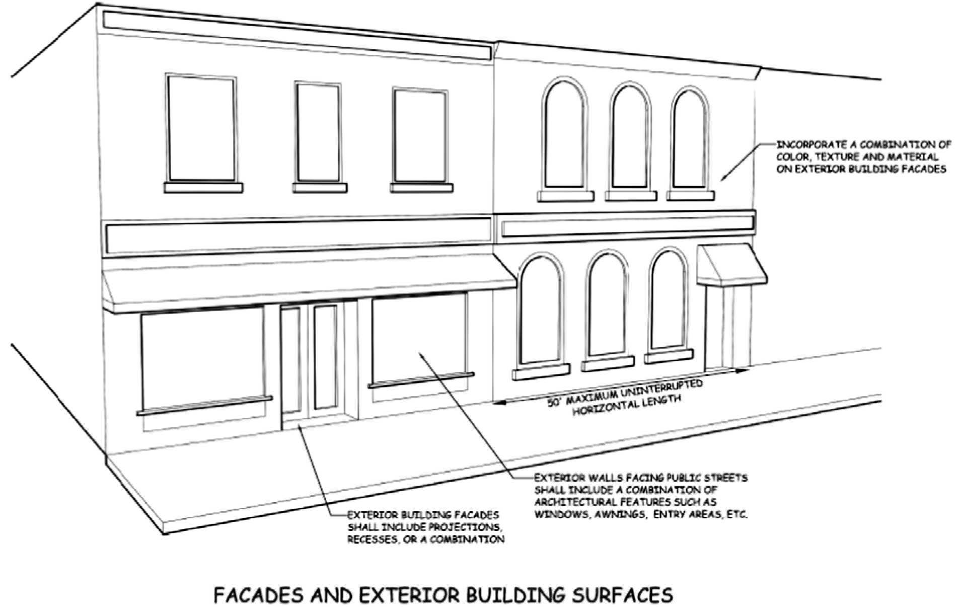
Façades and Exterior Building Surfaces
Building façades shall be articulated to reduce the massive scale and uniform, impersonal,
and monolithic appearances associated with large buildings and shall be constructed
so as to provide visual interest consistent with the character and scale of the community
(see Figure 5.2-1 below for an example of acceptable building façades).
i.
Projections and Recesses
The horizontal wall plane of all exterior building façades shall incorporate wall plane projections, recesses, or a combination of the two, having a depth of at least 3% of the length of the façade and extending at least 20% of the length of the façade. No uninterrupted length of any façade shall exceed 50 horizontal feet.
ii.
Street-Facing Façades
The exterior wall plan facing public streets shall be interrupted by any combination of display windows, entry areas, awnings or other architectural features along a minimum of 60% of its horizontal length.
iii.
Change in Architectural Detail and Finishes
All structures shall be designed to incorporate alternate or repeating changes in any combination of color, façade texture, or construction materials.
Figure 5.2-1: Example of acceptable building façades.
B.
Materials
Predominant exterior building materials shall be high-quality materials, including,
but not limited to, brick, stucco, wood, aggregate, glass, sandstone, native stone,
manufactured stone and tinted/textured concrete masonry units, or other material approved
by the city. Exterior building materials shall not include smooth faced concrete block
or any other material not otherwise approved by the City. Concrete panels or prefabricated
metal panels visible on building façades must be textured or colored or otherwise
incorporated in a manner consistent with the intent of this Section. Metal panels
may be used on roofs, awnings or similar features when incorporated into an architectural
design in a manner consistent with the intent of this Section. The use of visible
corrugated or ribbed profile metal siding shall be prohibited on any building façade
visible from an adjacent residential property or public street or right-of-way.
C.
Colors
Façade colors shall be low-reflectance, subtle, neutral or earth tone colors. The
use of high-intensity colors, metallic colors, black or fluorescent colors shall be
prohibited. Building trim and accent areas may feature brighter colors, including
primary colors, and metallic accents. The use of florescent or neon tubing shall be
prohibited.
D.
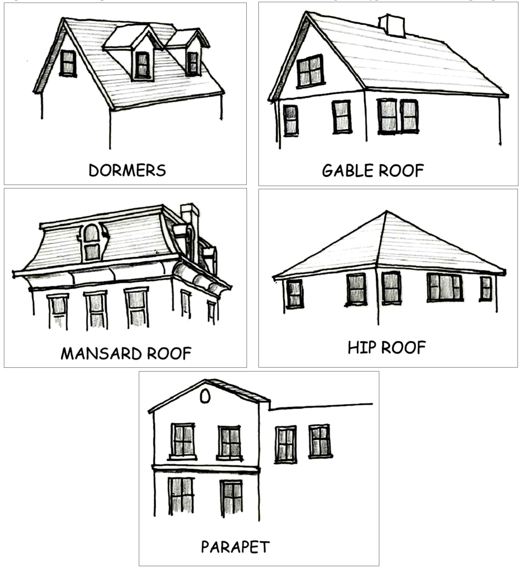
Roofs
Roofs along any primary façade shall provide breaks in the roof line by adding parapets,
mansard roofs, gable roofs, hip roofs, dormers, or other architectural features as
approved by the city. Roof line breaks should be located in consideration of the potential
for future adaptive reuse of the subject building. See Figure 5.2-2 below for examples
of various roof types and dormers.
Figure 5.2-2: Examples of various architectural features, including roof types, dormers, and parapets.
E.
Building Entrances
Buildings shall have clearly defined, highly visible entrances and shall be designed
to incorporate a minimum of two (2) of the following architectural features:
• Canopies or porticos;
• Overhangs;
• Recesses/projections;
• Arcades;
• Raised corniced parapets over the door;
• Arches;
• Outdoor patios;
• Display windows;
• Architectural details such as tile work and moldings which are integrated into the building structure and design; and
• Outdoor planters or wing walls that incorporate landscaped areas and/or places for sitting.
5.2.6
General Single-Family Residential Architectural Design Requirements
A.
Change in Architectural Detail and Finishes
All single-family residential structures shall be designed to incorporate alternating
or repeating changes in any combination of color, façade texture, or construction
materials including but not limited to wood, brick, sandstone, native stone, manufactured
stone and tinted/textured concrete masonry units, or other materials approved by the
City as part of the Residential Site Plan review process in Section 3.18 of this Code.
B.
Colors
Single-family residential structures shall be painted colors that are non-reflective,
subtle, neutral or earth tone colors. The use of high-intensity colors, metallic colors,
black or fluorescent colors shall be prohibited. Building trim and accent areas may
feature brighter colors, including primary colors. The use of florescent or neon tubing
shall be prohibited.
5.2.7
Maintenance
The exterior façades, surfaces, and architectural design features of all structures shall be regularly maintained, repainted, replaced, or otherwise maintained to meet the intent of this Section and to prevent deterioration or similar blighted conditions.
5.2.8
Enforcement
Upon recommendation by the Community Development Director, the City Council may find that properties and/or structures subject to the provisions of this Section are not in compliance with the provisions of this Section nor meet the intent of the requirements of this Section. Any violation of the architectural design standards of this Section shall be subject to the enforcement provisions of Chapter 9 of this Code.
(Ord. No. 967, § 42, 8-10-2015)
5.3 - Drainage, Grading, and Erosion Control
5.3.1
Intent
This Section is intended to provide uniform standards for diverting and conveying storm water away from buildings, structures, and other sensitive areas and for ensuring that erosion resulting from surface water run-off is appropriately controlled.
5.3.2
Applicability
The requirements of this Section shall apply to any new construction or development and to any substantial alteration, or expansion of an existing building requiring the approval of a development plan pursuant to standards in Chapter 3 of this Code. Any Type A, B, or B-LSR Development Plan that proposes to change the use of a building or structure from residential use to a non-residential use shall comply with the requirements of this Section.
5.3.3
Drainage
A.
General Requirements
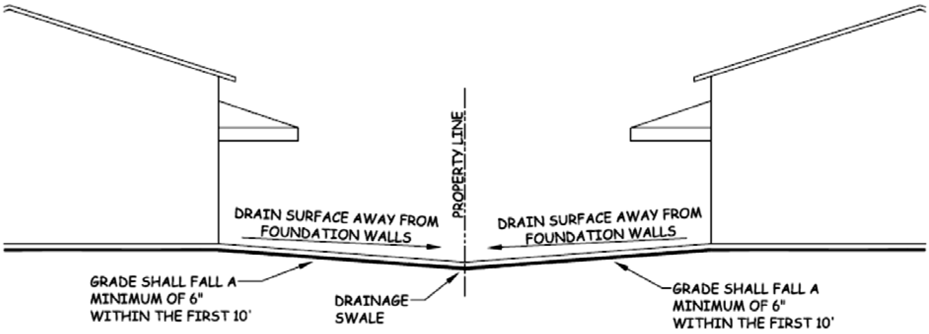
All developments shall provide a drainage system that is designed to deposit runoff
into either the municipal drainage system or into an acceptable natural drainage.
Surface drainage shall be diverted to a storm sewer conveyance or other approved point
of collection that does not create a hazard. Lots shall be graded to drain surface
water away from foundation walls. The grade shall fall a minimum of 6 inches within
the first 10 feet. Lots shall be graded to drain surface water away from foundation
walls (see Figure 5.3-1 below for an example of acceptable drainage between buildings).
Figure 5.3-1: Example of acceptable drainage between buildings.
B.
Exception
Where lot lines, walls, slopes or other physical barriers prohibit six (6) inches
of fall within ten (10) feet, drains or swales shall be constructed to ensure drainage
away from the structure. Impervious surfaces within ten (10) feet of the building
foundation shall be sloped a minimum of two (2) percent away from the building.
C.
Capacity
i.
Downstream Systems and Improvements
The drainage system internal to a development shall be so designed that the carrying and retention capacities of all downstream systems are preserved, or that the rate, flow, location, and size of the natural drainage systems downstream are unaffected. Any necessary downstream improvements are the responsibility of the developer.
ii.
Drainage Improvements Considered
Drainage improvements shall be planned and designed in such a manner as to maintain reasonable historic patterns of flow and runoff amounts. Any radical departures or solutions which adversely affect the natural amenities of the land will not be allowed. The following drainage improvements shall be considered and, if actually required, shall be designed, constructed and inspected in conformance with the Douglas Floodplain Ordinance and/or the particular specifications as required by the City Engineer. Improvements include, but are not limited to:
a.
Curb, gutter and sidewalks;
b.
Valley gutter and cross-pans;
c.
Ditching, channelization or construction of other surface drainage structures;
d.
Inlets, drop boxes, piping, or construction of other underground drainage structures; and
e.
Construction of underdrains, groundwater piping and other structures.
iii.
Drainage Improvement Standards
Drainage improvements shall be planned and designed to meet the following basic standards:
a.
Surface drainage structures and features (curbing, pans, inlet ponds, etc.) shall be oriented and designed to direct or channel the anticipated runoff for the total build-out of the project; and
b.
All significant channels and piping shall be designed to handle the anticipated flows for the twenty-five (25) year storm and runoff event.
If the above design parameters indicate a substantial increase in runoff over those historic patterns and concentrations, additional water detention basins and increased channel protection may be required.
iv.
Drainage Easements.
When a subdivision is traversed by a natural or human-made watercourse, water body, drainage channel, or subsurface storm drain, there shall be provided a drainage easement conforming substantially with the direction of such a drainage way. The minimum easement shall be adequately sized to accommodate channels and piping designed to handle the anticipated flows for the twenty-five (25) year storm and runoff event. Additional easement width may be required for floodway designations, and/or flood-control measures.
D.
Drainage Studies and Drawings
The City of Douglas requires the planning and construction of adequate drainage facilities.
This Section sets forth the requirements for the studies and drawings submitted to
the City for review. The applicant for each proposed land development project shall
make submittals in accordance with Table 5.3-1 below depending on the type of application
or level of development.
Table 5.3-1: Drainage Study Submittal Requirements
i.
Conceptual Drainage Study
The purpose of the conceptual drainage study is to identify and define conceptual solutions to the problems which may occur on-site and off-site as a result of the development. Such problems that exist on-site prior to development must be addressed during the conceptual development phase. A conceptual drainage study shall, at a minimum, include the information designated in Table 5.3-2 below.
ii.
Preliminary Drainage Study
The purpose of the preliminary drainage study is to identify and define solutions to the problems which may occur on-site and off-site as a result of the development. Such problems that exist on-site prior to development must be addressed during the preliminary development phase. Where a conceptual drainage study was previously approved, the preliminary drainage study shall update the information in the conceptual drainage study. The preliminary drainage study shall, at a minimum, include the information designated in Table 5.3-2 below.
iii.
Final Drainage Study
The purpose of the final drainage study is to identify and define solutions and to present the design details for drainage facilities. The final drainage design, erosion control measures, non-point source pollution control measures, and wetland and floodplain preservation, avoidance, and mitigation measures shall be included. Where a conceptual or preliminary drainage study was previously approved, the final drainage study shall update the information in the conceptual and preliminary drainage studies. A final drainage study shall, at a minimum, include the information designated in Table 5.3-2 below.
iv.
Drainage Memorandum
The purpose of the drainage memorandum is to provide general statements regarding existing and proposed on-site drainage patterns and specifications for ensuring that erosional control best management practices will be implemented. The requirements for a drainage memorandum shall be as requested by the City Engineer on a case-by-case basis.
Table 5.3-2: Drainage Study Checklist ("X" indicates required)
5.3.4
Grading
A.
General
The ground immediately adjacent to the foundation of a building or structure shall
be sloped away from the building or structure at a slope of not less than one (1)
unit vertical in twenty (20) units horizontal (five (5) percent slope) for a minimum
distance of ten (10) feet (3048 mm) measured perpendicular to the face of the wall.
If physical obstructions or lot lines prohibit ten (10) feet (3048 mm) of horizontal
distance, a five (5) percent slope shall be provided as part of an approved alternative
method of diverting water away from the foundation. Swales used as part of an alternative
water diversion method shall be sloped a minimum of two (2) percent where located
within ten (10) feet (3048 mm) of the building foundation. Impervious surfaces within
ten (10) feet (3048 mm) of the building foundation shall be sloped a minimum of two
(2) percent away from the building. Surface drainage, including drainage from roof
down spouts, shall be diverted to a storm sewer conveyance or other approved point
of collection so as to not create a hazard. Lots shall be graded to drain surface
water away from foundation walls, but not onto a neighboring property unless an easement
or other legally binding agreement exists between the two property owners that allows
for the diversion of surface water drainage onto a neighboring property.
B.
Alternate Grading Plan
The City Engineer shall be authorized to review and approve an alternate grading plan
in association with a Type A, B, or B-LSR Development Plan. In approving the alternate
grading plan, the City Engineer shall find that the plan is consistent with the intent
of this Section and is in the best interests of the City of Douglas. All alternate
grading plans shall be designed and certified by a registered engineer in the State
of Wyoming.
5.3.5
Erosion Control
A.
General
All ground-disturbing activities shall comply with the Wyoming Department of Environmental
Quality storm water management and permitting requirements. A separate storm water
permit from the City of Douglas is not required.
B.
Erosion Hazards
Erosion control practices are required for all developments. An erosion control plan
shall be prepared and implemented for areas in excess of fifteen (15) percent slope
and for areas shown to have a "severe" erosion potential. Erosion control plans shall
address all relevant erosion control issues, including, but not limited to, the following:
• Methods of minimizing surface disturbance;
• Grading and re-contouring of disturbed areas;
• Conservation and stabilization of topsoil;
• Conservation of existing vegetation;
• Re-vegetation procedures for areas of disturbance;
• Control and disposition of surface discharge;
• Protection of watercourses and water bodies;
• Stabilization of all disturbed areas, particularly slopes and unstable areas; and
• Recommendations of a licensed professional engineer for structural foundations, retaining walls, road construction, and any other matter involving the alteration or reduction of natural support of slopes in excess of fifteen (15) percent.
(Ord. No. 967, § 42, 8-10-2015)
5.4 - Fences and Walls
5.4.1
General
A.
Walls Considered Fences
Freestanding stone, brick, stucco, concrete, wood, composite, vinyl, chain link, etc.,
or other walls not required as retaining structures are considered fences.
B.
Permit Required
A fence permit shall be obtained from the Community Development Department prior to
the construction of a fence or wall in association with any non-residential or multi-family
residential use. Permitting of a fence or wall in association with the concurrent
permitting of any single-family residential use may be accomplished as part of the
required Residential Site Plan. Any fence or wall that is not proposed for permitting
concurrent with the permitting of a single-family residential use shall require approval
of a separate fence permit.
C.
Property Lines Verified
Applicants shall provide verification of physical location of property pins; survey
and setting of property corners by a licensed land surveyor; or a convenience fence
agreement with adjoining property owner(s).
D.
Walls Requiring Engineered Design
Walls, including retaining walls, that are proposed to exceed four (4) feet in height
shall be designed and certified by a registered engineer in the State of Wyoming.
Walls exceeding six (6) feet in height shall comply with the principal structure setbacks
of the applicable zoning district.
E.
Security Features
i.
Barbed Wire
Barbed wire or other sharp objects are not allowed on residential fences or walls.
ii.
Electrical Fencing
Electric fencing shall only be allowed in the A (Agricultural), I (Industrial), and PLI (Planned Light Industrial) zoning districts. Only low-voltage electrical fencing shall be used with a maximum of twelve (12) volts primary voltage.
iii.
Height Measurement
Security features shall not be included in the height measurement of a fence or wall.
F.
Industrial Fencing and Walls
Fencing and walls around the perimeter of an industrial use that is adjacent to a
residential zoning district, existing residential use, or state highway shall be a
minimum of six (6) feet in height and shall be one hundred (100) percent opaque.
5.4.2
Placement and Location
A.
Front Yard
Fences located within the front yard of a residential lot or parcel shall be limited
to four (4) feet in maximum height from the front property line back to the minimum
set-back of the zone in which the property sits. The Community Development Director
may approve minor deviations to this requirement where the front of the residential
dwelling is located behind the midpoint of the lot or parcel as measured from the
midpoint of the front property line to the midpoint of the rear property line.
B.
Side and Rear Yard
Fences and walls not considered retaining walls located within the side and rear yards
of a residential lot or parcel shall be limited to six (6) feet in maximum height
from the front façade of the residential dwelling on either side of the house to the
rear property line. The Community Development Director may approve minor deviations
to this requirement where the front of the residential dwelling is located behind
the midpoint of the lot or parcel as measured from the midpoint of the front property
line to the midpoint of the rear property line.
C.
Walls on Non-Residential Lots
The Community Development Director shall review and approve walls not considered retaining
walls on non-residential lots on a case by case basis. In determining approval, the
Community Development Director shall consider neighborhood character, surrounding
land uses, materials, heights, and setbacks.
D.
Setbacks
a.
Setback from Property Lines
Fences and walls not considered retaining walls higher than six (6) feet shall meet the principal structure setback requirements of the applicable zoning district.
Exception: The Community Development Director shall review and approve walls considered retaining walls proposed to be built within the setback area or on the property line. The Community Development Director shall consider neighborhood character, surrounding land uses, materials, heights, and setback requirements of the applicable zoning district.
b.
Setback from Fire Hydrants
Fences and walls, including retaining walls, shall not encroach within a three (3) foot radius of any existing or approved fire hydrant location.
E.
Located Outside of Rights-of-way
All fences and walls shall be placed outside public rights-of-way unless otherwise
approved by the City Administrator or his/her designee.
F.
Located outside of sight line triangle
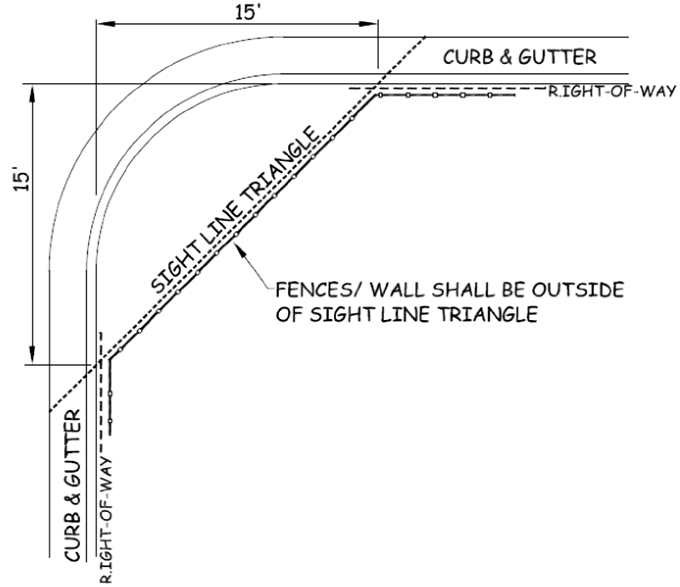
Fences and walls shall not obstruct the view of pedestrian or vehicular traffic within
a fifteen (15) foot sight line triangle at any existing driveway and at right-of-way
intersections adjacent to corner lots (see Figure 5.4-1 below).
Figure 5.4-1: Example of the fifteen (15) foot sight line triangle.
G.
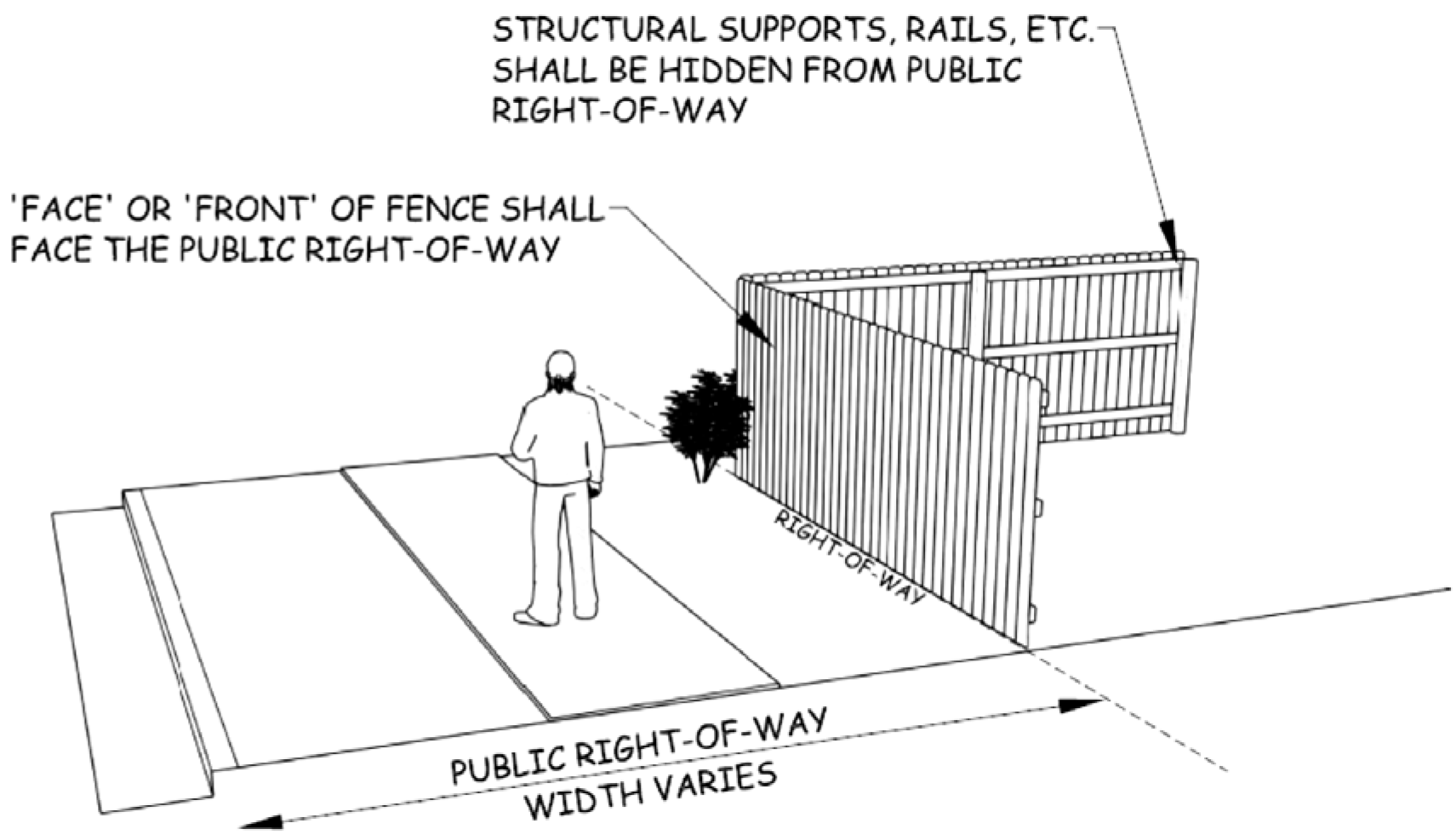
Finished Surface to Face Rights-of-Way
The side of any fence considered to be its "face" (finished side having no structural
supports) shall face the public right-of-way (see Figure 5.4-2 below).
Figure 5.4-2: Example of the "face" of a fence facing the public right-of-way.
5.4.3
Maintenance
Fences and walls shall be maintained in a condition of good repair and appearance and shall not create a nuisance or safety or health risk. The City may require removal, maintenance, or repair of any fence deemed to be a nuisance or safety or health hazard. Failure to comply with the maintenance requirements of this Section shall be subject to the enforcement provisions in Chapter 9 of this Code.
5.4.4
Non-Conforming Fences and Walls
A.
Intent
This Section is intended to regulate legally existing fences and walls that do not
comply with one or more of the requirements of this Code. Fences and walls that are
legally existing but that do not comply with one or more of the requirements of this
Code shall be referred to as nonconforming fences or walls. The goal of the City is
to allow nonconforming fences and walls to continue to exist while encouraging such
nonconformities to be brought into conformance with the requirements of this Code
to the greatest extent practical. The following regulations shall be interpreted to
recognize the interests of a property owner in continuing a legally existing nonconforming
fence or wall while also ensuring that any change to the nonconforming fence or wall
is in compliance with the requirements of this Code.
B.
Alteration of Non-conforming Fences and Walls
An existing fence or wall not previously permitted pursuant to this Section shall
not be enlarged, extended, reconstructed, or structurally altered unless such fence
or wall is in compliance with the requirements of this Section. This provision shall
not apply to fences or walls, or alterations thereto, that are required by law or
ordinance.
C.
Maintenance and Repair
Maintenance of a nonconforming fence or wall shall be allowed where such maintenance
is necessary and incidental to the normal upkeep of a fence or wall and where such
maintenance will not result in an expansion of the fence or an increase in the nonconformity
of the fence or wall.
(Ord. No. 967, § 42, 8-10-2015; Ord. No. 1000, § 12, 6-10-2019; Ord. No. 1048, § 1, 3-10-2025; Ord. No. 1063, § 1, 10-27-2025)
5.5 - Landscaping, Buffering, and Screening
5.5.1
General
A.
Intent
This Section is intended to provide uniform standards for the installation and maintenance
of landscaping, buffering, and screening. Application of these standards during the
site development planning process shall be based upon the following:
• The provision of adequate visual screening between differing or incompatible uses;
• Promoting higher quality developments in terms of design and visual relief; and
• Enhancing the visual character of development by planning for inclusion of natural surface treatments in a manner that is consistent with the goals, principles, and policies of the City of Douglas Master Plan.
B.
Applicability
The landscaping requirements of this section shall apply to any new construction or
development and to any substantial alteration, expansion, or change in use of an existing
building requiring the approval of a development plan pursuant to the requirements
of Chapter 3 of this Code. Any Type A, B, or B-LSR Development Plan that includes a plan to change
the use of a building or structure from a residential use to a non-residential use
shall include a landscaping plan that complies with the requirements of this section.
Section 5.5.3K, Irrigation and Maintenance, shall apply to all commercial, industrial,
multi-family, manufactured and/or mobile home park, and travel trailer and RV park
landscaping. Additional landscaping standards are required for specific uses pursuant
to Chapter 6 of this Code.
C.
Exceptions/Exemptions
Development within the CB-1 (Downtown Business) zoning district and the Douglas Downtown
Historic District is exempt from the standard landscaping requirements in this Section,
but shall comply with the landscape requirements for the Downtown Douglas Historic
District, the downtown area design guidelines, and Downtown Revitalization Plan, 2015,
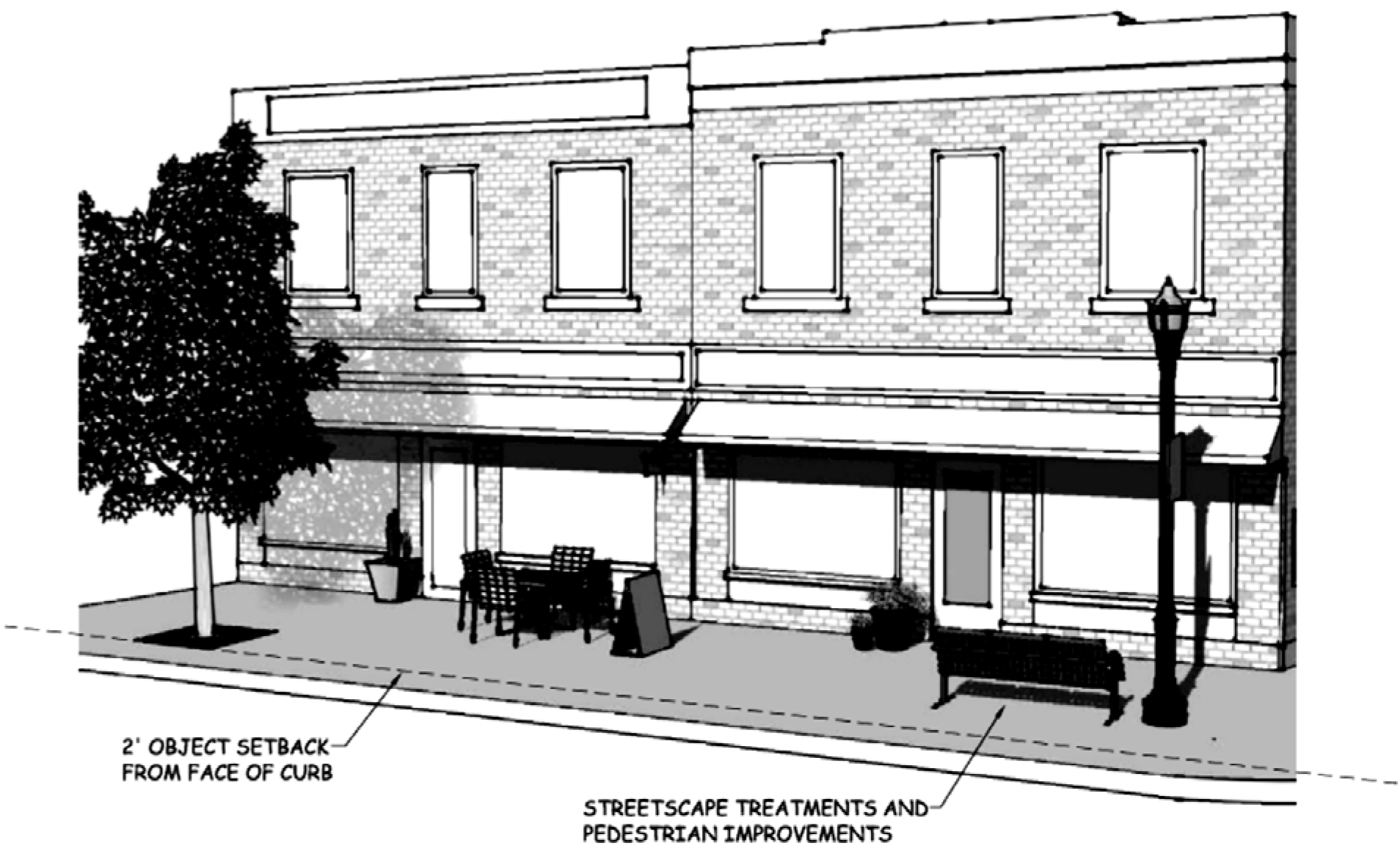
as amended. A plan for landscaping treatments shall be provided with a Type A, Type
B, and Type B-LSR Development Plan for developments within the CB-1 (Downtown Business)
zoning district. The plan for landscaping treatments shall provide for a combination
of two (2) or more of the following treatments and pedestrian improvements: outdoor
tree boxes, vegetative planting boxes, hanging potted planters, wall planters, outdoor
seating and/or dining areas, street furniture, and outdoor art approved by the Community
Development Director or City Council, as applicable (see Figure 5-2 below for an example
of acceptable landscaping treatments).
Figure 5.5-1: Example of acceptable landscaping treatments and streetscape within the CB-1 (Downtown Business) Zoning District
D.
Landscape Materials
i.
Authorized Landscaping Materials
All plant materials proposed in the landscaping plan of a Type A, B, or B-LSR Development Plan for multifamily, industrial, or commercial developments shall be specified according to the American Standard for Nursery Stock.
ii.
Combination of Plant Materials and Types
Landscape plans shall provide a mix of shrubs, trees, green space and/or acceptable xeriscape landscaping.
iii.
Outdoor Amenities
Development within character districts or where a zero building setback line exists may propose the use of outdoor amenities, including, but not limited to, outdoor dining and/or seating areas, public art, and/or street furniture, and may be substituted for internal landscape requirements.
E.
Completion of Required Landscaping
i.
Completed Prior to Certificate of Occupancy
Required landscaping shall be completed prior to issuance of a certificate of occupancy.
ii.
Landscape Completion Agreement
A temporary certificate of occupancy may be issued after approval of a landscape completion agreement. The landscape completion agreement shall include the time necessary to complete the required landscaping on the approved Type A, Type B, or Type B-LSR Development Plan, a detailed cost estimate prepared by a licensed landscaping contractor or landscaping professional with itemized material and installation costs necessary to complete the approved landscaping, and financial assurance. Financial assurance for the completion of landscaping shall be in the form acceptable by the City Attorney and shall be in the amount identified on the cost estimate approved by the City and shall be for use by the City to install the required landscaping in the event the developer fails to meet the terms of the agreement. The Community Development Director shall have the authority to review and approve all landscape completion agreements and associated financial assurance estimates and may accept financial assurance securing performance of a landscape completion agreement.
5.5.2
Alternate Landscape Plan
An applicant proposing to develop within the City of Douglas may choose to develop an alternate landscape plan in lieu of providing a landscaping plan that directly complies with the requirements of this Chapter. The Community Development Director, in reviewing an alternate landscape plan for a Type A Development Plan, and the City Council, in reviewing an alternate landscape plan for a Type B or B-LSR Development Plan, shall find that the plan is consistent with the intent of this Section and with the policies and recommendations of the City of Douglas Master Plan. The Community Development Director and City Council shall consider the following in reviewing an alternate landscape plan:
• Whether the benefit to the community and natural environment of the proposed plan will be equivalent to the benefit that would have been provided with strict adherence to the requirements of this Section;
• Whether the plan meets or exceeds the buffering and screening requirements of this Section;
• Whether the plan is consistent with the intent of the applicable Character District guidelines in the City of Douglas Master Plan, and
• Whether the plan demonstrates innovative design and use of landscape materials and/or other natural landscaping elements.
Under no circumstances shall an alternate landscape plan be approved if the plan would result in a reduction to any of the required landscape buffers or if the plan would eliminate a required landscape category.
5.5.3
Landscape Requirements
A.
Street Trees/Roadway Landscaping
Landscape plans required as a component of Type A, B, or B-LSR Development Plans shall
include the placement of street trees meeting the requirements of this Section.
i.
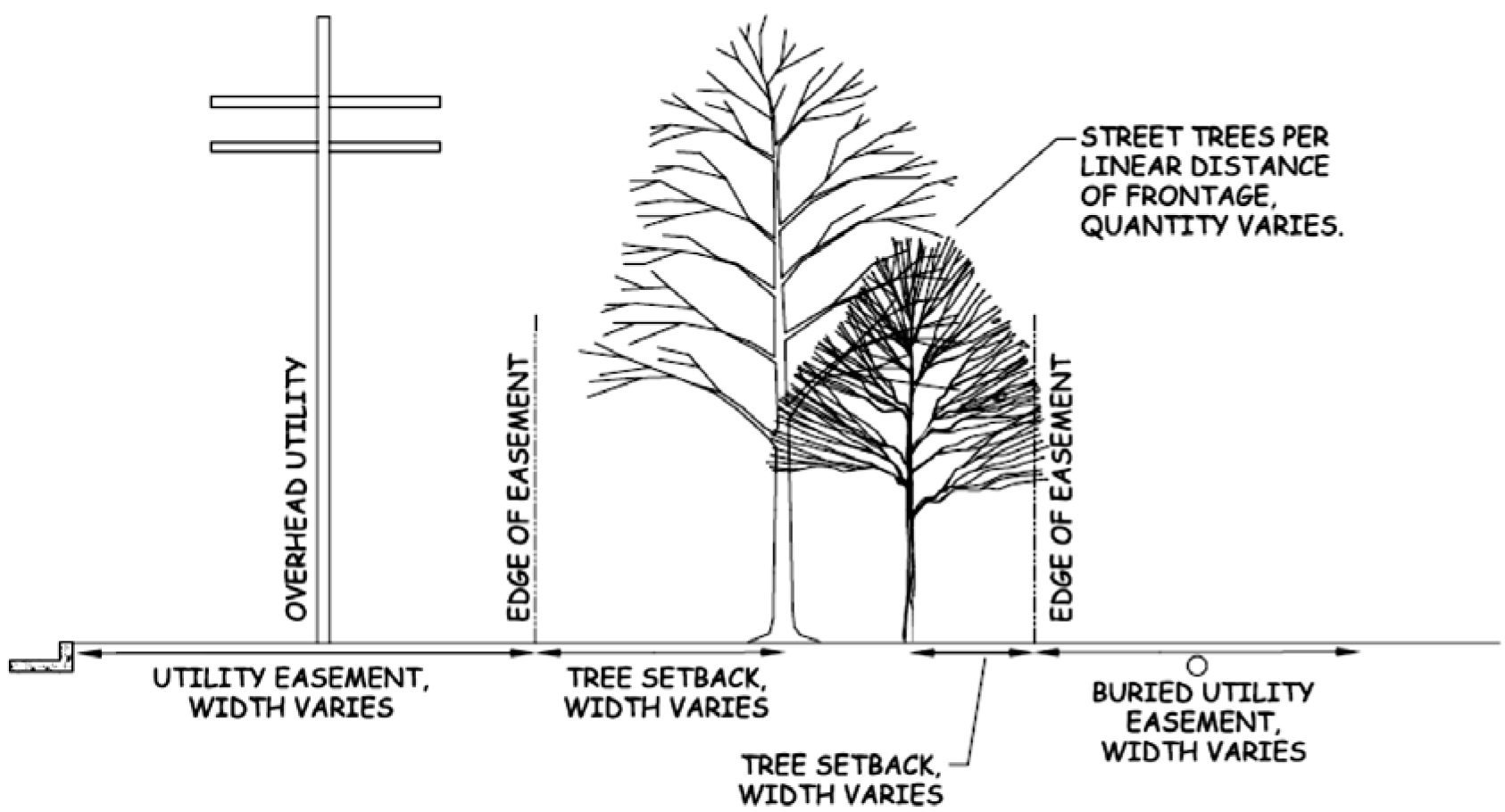
Street Tree Spacing and Setbacks
Small, medium, and large street trees shall meet spacing and setback requirements from easements, public improvements, and other street trees as detailed below in Table 5.5-1 (see also Figure 5.5-2 below for an example of street tree setbacks).
Table 5.5-1 Street Tree Requirements
Figure 5.5-2: Example of street tree setbacks.
ii.
Approved Street Tree Species
The use of any tree species not identified in Table 5.5-2 below shall require prior approval of the Community Development Director in consultation with the City of Douglas Public Works and Utilities Department. Specific justification shall be provided by the applicant to receive approval to plant any tree that is not compatible with the United States Department of Agriculture (USDA) plant hardiness zone 4, including 4a and 4b, or the equivalent as approved by the Community Development Director.
Table 5.5-2 Authorized Street Tree Species
iii.
Restricted Species
The following tree species shall be prohibited from use as street trees:
• Boxelders (Acer negundo)
• Siberian elms (Ulmus pumila)
• Any of the poplar (Populus) species including cottonwoods, poplars, and aspens
• Any willow (Salix) species
• Any weeping and pendulous trees
• Any multi-stemmed trees
• Ash (Fraxinus) species
• Walnut (Juglans) species
• Silver maple (Acer saccharinum),
• Freeman maple (Acer x freemannii)
• Sunburst honeylocust (Gleditsia triacanthos inermis 'Sunburst')
• Bradford pear (Pyrus calleryana 'Bradford')
• Mulberry (Morus) species
• Russian-olive (Elaeagnus angustifolia)
• Tree-of-heaven (Ailanthus altissima).
B.
Internal Landscaping
Commercial, industrial, and multi-family residential developments shall provide a
minimum combination of shrubs, trees, green space and/or acceptable xeriscaping treatments
in the form of internal landscaping on the subject property pursuant to the requirements
of Table 5.2-3 below. Internal landscaping requirements shall be in addition to the
requirements for street trees, buffering, and screening.
Table 5.5-3 Internal Landscaping Calculations
i.
Internal Landscaping Requirements
One (1) tree shall be provided within the internal landscape area for every 500 square feet of required internal landscape area. A minimum of 75% required internal landscape area shall be vegetated with live ground cover.
ii.
Internal Landscaping Shall Not Create An Obstruction
Trees, shrubs, or other landscaping treatments that are installed, planted, or otherwise located in the front or side yard of a lot or parcel shall not create any of the following obstructions:
• The view of vehicular traffic within the sight line triangle at any street or alley intersection;
• The view of pedestrian or vehicular traffic within a fifteen (15) foot sight line triangle at any existing or proposed driveway; or
• Access to any fire hydrant or which encroaches within a three (3) foot radius of any existing or approved fire hydrant location.
iii.
Exceptions to Internal Landscaping Requirements
Manufactured and mobile home parks and travel trailer and RV parks shall be subject to the specific internal landscape requirements in Subsections 5.5.2.G and H below. Single-family residential lots shall only be required to comply with the landscaping requirements in Subsection 5.5.2.F.i. below
C.
General Buffering and Screening Requirements
Landscape buffers are intended to provide a visually attractive separation and transition
between differing and/or incompatible uses. All Type A, B, and B-LSR Development Plans
shall incorporate landscape buffering meeting the requirements of this Section. Additional
buffering requirements may also be required for certain land uses pursuant to the
requirements of Chapter 6 of this Code. The Community Development Director, in approving a Type A Development
Plan, and the City Council, in approving a Type B or B-LSR Development Plan, may impose
additional project-specific landscape setbacks and/or buffering and screening requirements
in order to mitigate any abnormal or exceptional adverse impacts.
i.
Landscape Setbacks
Landscaping shall be located and installed within the landscape setback between differing uses and differing zoning districts. Landscape setbacks shall be located outside of existing or proposed easements and existing or proposed public rights-of-way.
ii.
Obstructions Prohibited
No tree, shrub, or other landscaping treatment installed for the purposes of buffering or screening shall be located in the front or side yard of a lot or parcel in a manner that could create an obstruction interfering with any of the following:
• The view of vehicular traffic within the sight line triangle at any street or alley intersection;
• The view of pedestrian or vehicular traffic within a fifteen (15) foot sight line triangle at any existing or proposed driveway; or
• Access to any fire hydrant or which encroaches within a three (3) foot radius of any existing or approved fire hydrant location.
iii.
Clustering of Trees
Trees required for visual screening are encouraged to be clustered in areas subject to increased visual impacts in order to achieve maximum effectiveness. The Community Development Director, in approving a Type A Development Plan, and the City Council, in approving a Type B or B-LSR Development Plan, may require clustering to increase the effectiveness of screening in visually sensitive areas.
iv.
Parking Lot Buffering and Screening
a.
Required Parking Lot Buffer
Parking lots and loading areas shall provide a minimum five (5) foot landscape buffer around the perimeter of the parking lot or loading area except in areas necessary to provide vehicular access to the site.
b.
Screened from Rights-of-Way
Parking lots shall be screened from adjacent public rights-of-way with a combination of plantings, xeriscaping materials, and landscaped berms. Any landscaping or xeriscaping treatments installed for the purpose of screening a parking lot shall be at least three (3) feet in height at the time of installation.
c.
Adjacent to Residential Uses
Any commercial or industrial site adjacent to a residential use or across right-of-way from a residential use shall be required to screen all parking lots and loading docks with a combination of plantings, xeriscaping materials, landscaped berms, and 100 % opaque fences or decorative walls. Any landscaping or xeriscaping treatments installed to screen parking lots from residential uses shall be at least three (3) feet in height at the time of installation.
d.
Required Screening
Any parking lot buffer area within which a decorative screening wall is proposed shall also include live ground cover over a minimum of 75% of the buffer area.
D.
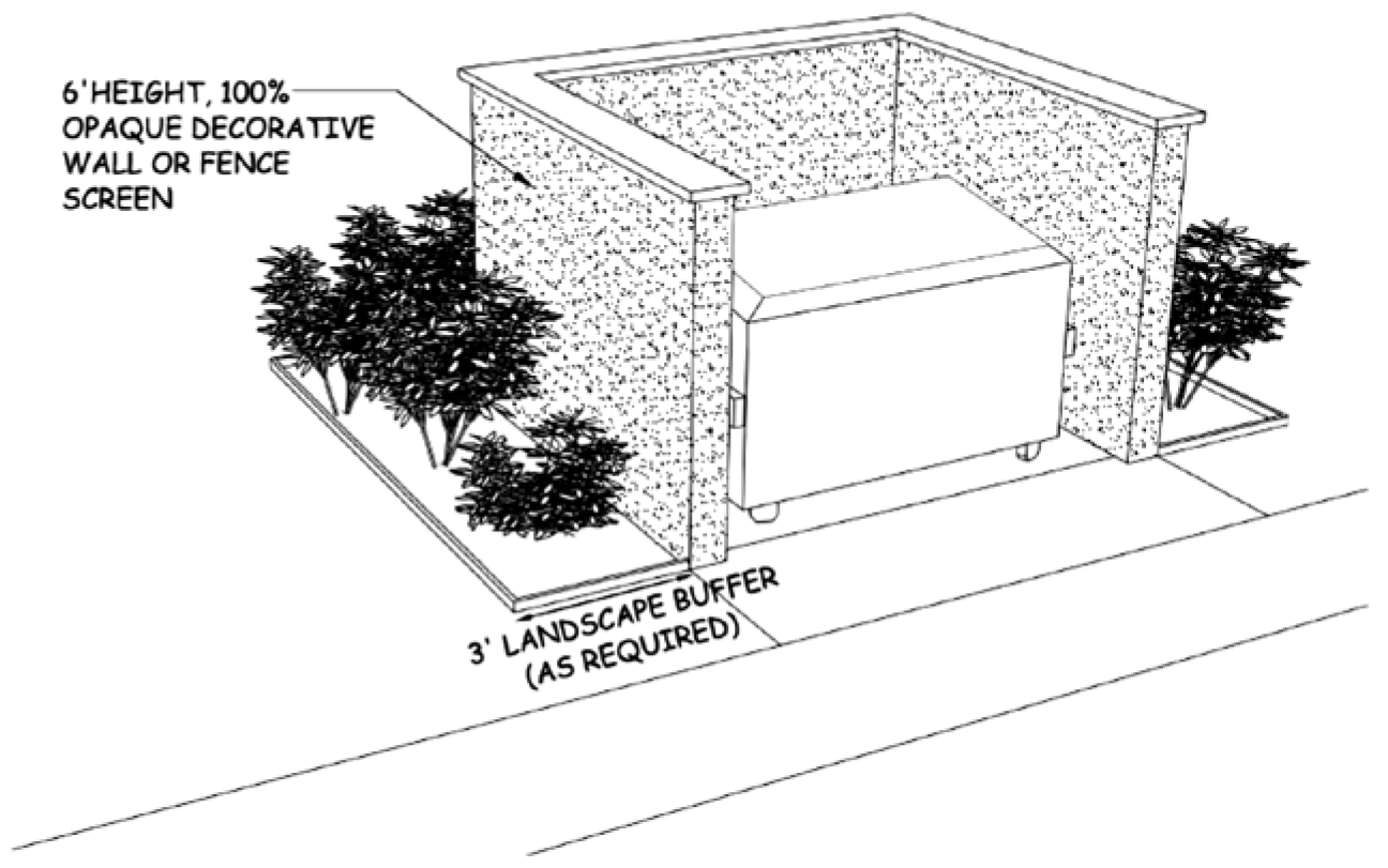
Refuse Storage Screening
Refuse storage containers (e.g., dumpsters) serving all non-residential and multi-family
residential uses shall be screened from the view of the general public and adjacent
properties (see Figure 5.5-2 below for an example of refuse storage screening).
i.
Refuse Containers
Refuse container enclosures shall be surrounded on three (3) sides by a 100% opaque fence or decorative wall and shall be located on the left hand side of the service access drive aisle. Fences and decorative walls used to screen refuse storage containers shall be a minimum of six (6) feet in height. All decorative screening walls exceeding 20 feet in length or six (6) feet in height that are used to screen refuse storage containers shall be designed and certified by a registered engineer in the State of Wyoming.
ii.
Screening Requirements
The non-access sides of the enclosure shall also have an additional three (3) foot landscape buffer around the perimeter of the enclosure and shall be screened with a minimum of 75% ground live ground cover, additional landscape plantings, or xeriscaping materials if the enclosure will be visible from a residential zoning district or an existing residential use.
Figure 5.5-3: Example of refuse storage screening.
E.
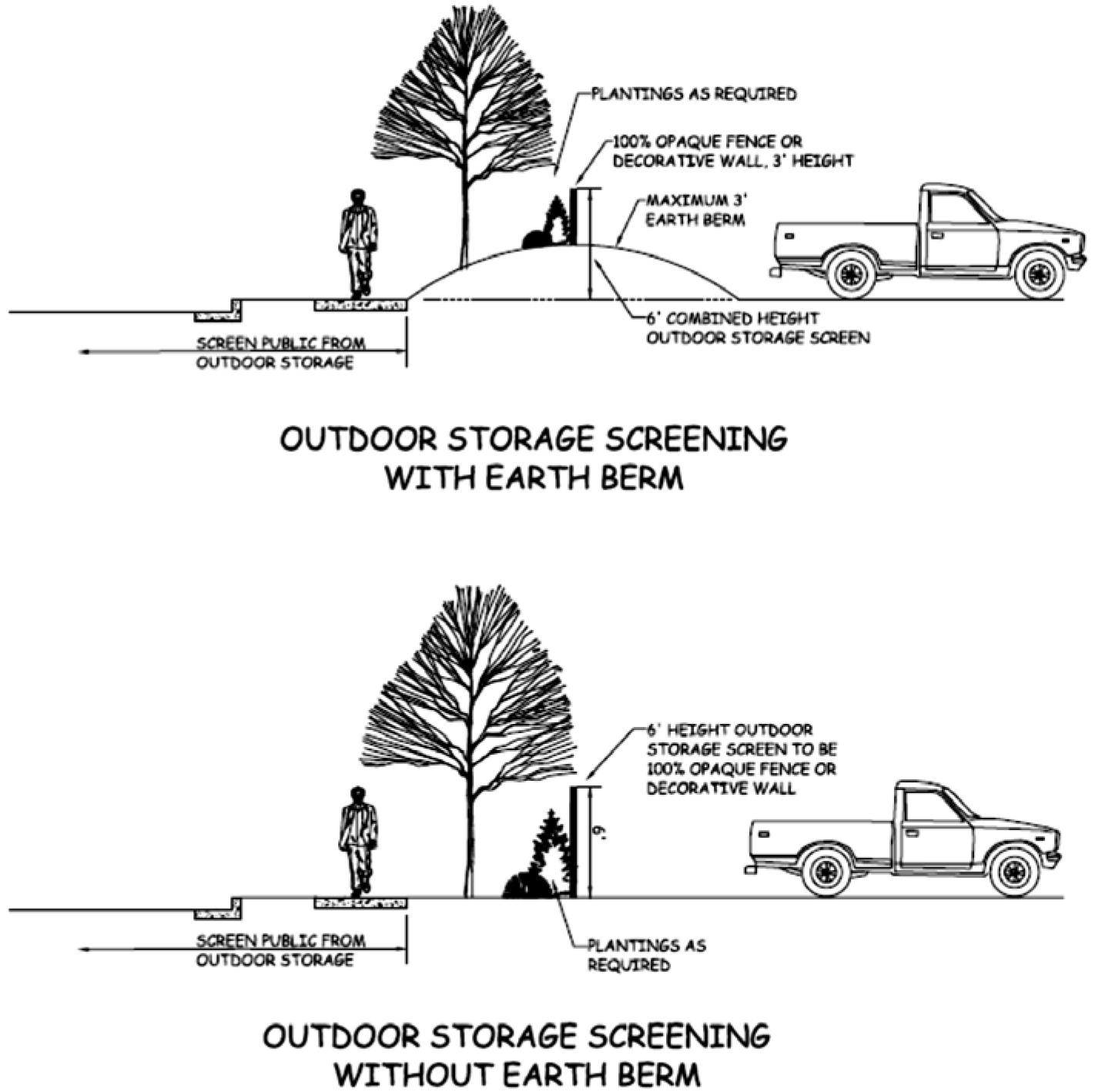
Outdoor Storage Screening
Outdoor storage accessory to any non-residential or multi-family residential use shall
be screened from the view of the public and adjacent properties with a combination
of plantings, xeriscaping materials, landscaped berms, and 100% opaque fence or decorative
wall. Fences and decorative walls used to screen outdoor storage shall be a minimum
of six (6) feet in height. Any request to construct a decorative screening wall to
screen outdoor storage shall be designed and certified by a registered engineer in
the State of Wyoming. The height of an opaque fence or decorative screening wall may
be reduced by one (1) foot for every one (1) foot of earthen berm constructed immediately
below the fence or wall up to a maximum reduction of the fence or wall height resulting
in a three (3) foot fence or decorative screening wall on top of a three (3) foot
earthen berm.
Figure 5.5-4: Examples of outside storage screening.
F.
Commercial Buffering and Screening Requirements
All commercial buildings, parking lots, outdoor storage areas, and refuse containers
shall be screened from adjacent residential zoning districts with a combination of
plantings, xeriscaping materials, landscaped earthen berms, and 100% opaque fences
and decorative walls.
i.
Required Landscape Buffer
Commercial uses adjacent to a residential zoning district shall provide a minimum 20-foot landscape buffer around the perimeter of the subject property. Landscape buffers shall include a minimum of 75% live ground cover including shrubs, live landscape materials, decorative and native grasses, and xeriscaping materials. A minimum of 30% of the landscape buffer area shall be covered with natural turf or native grasses.
ii.
Required Screening
A minimum of one (1) tree shall be provided for every twenty (20) feet of common property line separating a commercial use from an adjacent residential use. A minimum of ten (10) shrubs may be substituted for each required tree. One-third (⅓) of the required trees shall not be substituted with shrubs and shall be evergreen trees with a minimum height at maturity of six (6) feet to provide year-round visual screening. The minimum height of landscaped earthen berms or decorative screening walls, or combination thereof, shall be six (6) feet. Under no circumstances shall an earthen berm exceed three (3) feet in height when combined with a decorative screening wall. Any request to construct a decorative screening wall in excess of six (6) feet in height or twenty (20) feet in length shall require design and certification by a registered engineer in the State of Wyoming. Any decorative screening wall in excess of six (6) feet in height shall comply with the principal structure setbacks of the respective zoning district.
G.
Industrial Buffering and Screening Requirements
All industrial buildings, offices, parking, outdoor storage, and refuse containers
shall be screened from adjacent non-industrial zone districts with a combination of
plantings, xeriscaping materials, landscaped berms, and one hundred (100) percent
opaque decorative screening walls.
i.
Required Landscape Buffer
Where an industrial use abuts a non-industrial zone district or public right-of-way, the industrial use shall provide a minimum of twenty-five-foot-foot landscape buffer. Required landscape buffers shall include a minimum of seventy-five (75) percent live ground cover including shrubs, live landscape materials, decorative and native grasses and xeriscaping materials. A minimum of thirty (30) percent of the landscape buffer area shall be natural turf or native grasses.
ii.
Required Screening
Industrial uses adjacent to a non-industrial use shall be screened with a combination of landscaped berms and decorative walls. A minimum of one (1) tree for every thirty (30) feet of common property line with a non-industrial use shall be provided along the outside face of the wall to reduce a negative visual massing effect. A maximum of thirty (30) percent of the required wall trees may be substituted at a rate of fifteen (15) shrubs for each required tree. One-third (⅓) of the required trees shall be evergreen with a minimum height at maturity of six (6) feet to provide a year-round visual screening effect. The Community Development Director, in approving a Type A Development Plan, or the City Council, in approving a Type B or Type B-LSR Development Plan, may authorize an alternate screening plan to meet the industrial screening requirements.
iii.
Industrial Screening Walls
Screening walls shall be at least six (6) feet in height including when used in combination with landscaped berms. The Community Development Director may permit an opaque fence to meet the required screening. The minimum height of landscaped earthen berms or decorative screening walls, or combination thereof, shall be six (6) feet. Under no circumstances shall an earthen berm exceed three (3) feet in height when combined with a decorative screening wall. Any request to construct a decorative screening wall in excess of six (6) feet in height or twenty (20) feet in length shall require design and certification by a registered engineer in the State of Wyoming. Any decorative screening wall in excess of six (6) feet in height shall comply with the principal structure setbacks of the respective zoning district.
H.
Residential Landscaping Requirements
i.
Single-Family Residential Landscaping Requirements
With the exception of driveways, sidewalks and permitted parking areas, residential yards shall be used exclusively for the planting and growing of trees, shrubs, lawns, gardens, xeriscaping, and other ground covering or landscaping material approved by the City. Each single-family residential site plan shall provide for the planting of a minimum of one (1) street tree, pursuant to the street tree requirements of this Chapter. No other landscaping requirements shall apply to single-family residential uses.
ii.
Multi-Family Residential Buffering Requirements
Multi-family uses abutting a single-family residential or non-residential use shall provide a minimum fifteen-foot landscape buffer along the shared property line. Required landscape buffers shall include a minimum of seventy-five (75) percent live ground cover including shrubs, live landscape materials, decorative and native grasses and xeriscaping materials. A minimum of thirty (30) percent of the landscape buffer area shall be natural turf or native grasses.
iii.
Multi-Family Residential Screening Requirements
A minimum of one (1) tree shall be provided for every twenty (20) feet of common property line separating a multi-family residential use from an adjacent single-family residential use. A minimum of ten (10) shrubs may be substituted for each required tree. One-third (⅓) of the required trees shall not be substituted with shrubs and shall be evergreen trees with a minimum height at maturity of six (6) feet to provide year-round visual screening. The minimum height of landscaped earthen berms or one hundred (100) percent opaque fences or decorative screening walls, or combination thereof, shall be six (6) feet. Under no circumstances shall an earthen berm exceed three (3) feet in height when combined with a one hundred (100) percent opaque fence or decorative screening wall. Any request to construct a decorative screening wall in excess of four (4) feet in height shall require design and certification by a registered engineer in the State of Wyoming. Any decorative screening wall in excess of six (6) feet in height shall comply with the principal structure setbacks of the respective zoning district. A one hundred (100) percent opaque fence shall not be the single method of screening used to screen multi-family residential uses from single-family residential uses. One hundred (100) percent opaque fences used for screening shall be a maximum of six (6) feet in height and shall incorporate breaks of masonry columns, and/or shrubs or small evergreen trees with a maximum height at maturity of six (6) feet in height. Landscape plantings used in combination with screening fences shall not count toward satisfying any other landscaping requirement.
I.
Manufactured and Mobile Home Parks
All manufactured and mobile home parks, including individual manufactured and mobile
home units, parking areas, outdoor recreation areas, community buildings, leasing
offices and outside storage areas, refuse containers, and maintenance facilities shall
be screened from adjacent residential and non-residential zone districts with a combination
of plantings, xeriscaping materials, landscaped earthen berms, and one hundred (100)
percent opaque fences and decorative screening walls. The City Council, in approving
a Type B Development Plan for a manufactured or mobile home park, may require increased
landscape buffers and screening between the proposed Park and adjacent uses or zoning
districts.
i.
Landscaping Plan Required
All manufactured and/or mobile home park development plans shall include a landscaping plan for the entire plan area.
ii.
Compliance with General Landscape Requirements of this Section
Manufactured and mobile home parks shall comply with the general landscape requirements of this Chapter.
iii.
Internal Landscape Requirements
A minimum of ten (10) percent of the gross site area of a manufactured and/or mobile home park shall be reserved for a park and recreational area. A minimum of one (1) tree shall be planted within the park and recreation area for every six hundred (600) square feet of the total park and recreation area.
iv.
Required Landscape Buffer
Manufactured and/or mobile home parks abutting a residential, commercial, or industrial zoning district shall provide a landscape buffer pursuant to the requirements in Table 5.5-4 below. Landscape buffers shall include a minimum of seventy-five (75) percent live ground cover including shrubs, live landscape materials, decorative and native grasses, and xeriscaping materials. A minimum of thirty (30) percent of the landscape buffer area shall be turf or native grasses.
Table 5.5-4 Minimum Manufactured/Mobile Home Park Landscape Buffers
* NOTE: Where a manufactured and/or mobile home park is located across a street from a residential or non-residential use, only the twenty-foot street buffer shall be required.
v.
Required Landscape Screening
A minimum of one (1) tree shall be required for every twenty-five (25) linear feet of buffer area. A maximum of thirty (30) percent of the required trees may be substituted with shrubs at a rate of ten (10) shrubs per tree. One-third (⅓) of the required trees shall be evergreen trees with a minimum height at maturity of six (6) feet to provide year-round visual screening.
vi.
Screening Requirements When Adjacent to Public Streets or Rights-of-Way
Manufactured and/or mobile home parks shall provide a minimum six (6) foot one hundred (100) percent opaque fence or decorative screening wall or landscaped earthen berms, or combination thereof, along the perimeter of the park adjacent to any public street or right-of-way. Under no circumstances shall an earthen berm exceed three (3) feet in height when combined with a one hundred (100) percent opaque fence or decorative screening wall. Any request to construct a decorative screening wall in excess of four (4) feet in height shall require design and certification by a registered engineer in the State of Wyoming. Any decorative screening wall in excess of six (6) feet in height shall comply with the principal structure setbacks of the respective zoning district. A one hundred (100) percent opaque fence shall not be the single method of screening used to screen manufactured and/or mobile home parks from an adjacent public street or right-of-way. One hundred (100) percent opaque fences used for screening shall be a maximum of six (6) feet in height and shall incorporate breaks of masonry columns, and/or shrubs or small evergreen trees with a maximum height at maturity of six (6) feet in height. Landscape plantings used in combination with screening fences shall not count toward satisfying any other landscaping requirement.
J.
Travel Trailer and RV Parks
All travel trailer and RV parks, including individual units, parking areas, outdoor
recreation areas, community buildings, leasing offices, refuse containers, and maintenance
facilities, shall be screened from adjacent residential and non-residential zone districts
with a combination of plantings, xeriscaping materials, landscaped berms, and decorative
walls. The City Council, in approving a Type B Development Plan for a travel trailer
or RV park, may require increased landscape buffers and screening between the proposed
travel trailer and RV park site and the adjacent use if such park is adjacent to a
visually-sensitive existing land use.
i.
Landscaping Plan Required
All travel trailer or RV park development plans shall include a landscaping plan for the entire plan area.
ii.
Compliance with General Landscape Requirements of this Section
Travel trailer and RV parks shall comply with the general landscape requirements in Section 5.5.1 above.
iii.
Internal Landscape Requirements
A minimum of ten (10) percent of the gross site area of a travel trailer and RV park shall be reserved for a park and recreational area. A minimum of one (1) tree shall be planted for every six hundred (600) square feet of designated park and recreation area.
iv.
Required Landscape Buffer
Travel trailer or RV parks abutting a residential, commercial, or industrial zoning district shall provide landscape buffers pursuant to the requirements in Table 5.5-5 below. Required landscape buffers shall include a minimum of seventy-five (75) percent live ground cover including shrubs, live landscape materials, decorative and native grasses, and xeriscaping materials. A minimum of thirty (30) percent of the landscape buffer area shall be turf or native grasses.
Table 5.5-5 Minimum Travel Trailer/RV Park Landscape Buffers
* NOTE: Where a travel trailer and RV park is located across a street from a residential or non-residential use, only the twenty-foot street buffer shall be required.
v.
Required Landscape Screening
A minimum of one (1) tree shall be required for every thirty (30) linear feet of buffer area. A maximum of thirty (30) perent of the required trees for may be substituted with shrubs at a rate of ten (10) shrubs per tree. One-third (⅓) of the required trees shall be evergreen trees with a minimum height at maturity of six (6) feet to provide year-round visual screening.
vi.
Screening Requirements When Adjacent to Public Streets or Rights-of-Way
Travel trailer and RV parks shall provide a minimum six-foot one hundred (100) percent opaque fence or decorative screening wall or landscaped earthen berms, or combination thereof, along the perimeter of the park adjacent to any public street or right-of-way. Under no circumstances shall an earthen berm exceed three (3) feet in height when combined with a one hundred (100) percent opaque fence or decorative screening wall. Any request to construct a decorative screening wall in excess of four (4) feet in height shall require design and certification by a registered engineer in the State of Wyoming. Any decorative screening wall in excess of six (6) feet in height shall comply with the principal structure setbacks of the respective zoning district. A one hundred (100) percent opaque fence shall not be the single method of screening used to screen manufactured and/or mobile home parks from an adjacent public street or right-of-way. One hundred (100) percent opaque fences used for screening shall be a maximum of six (6) feet in height and shall incorporate breaks of masonry columns, and/or shrubs or small evergreen trees with a maximum height at maturity of six (6) feet in height. Landscape plantings used in combination with screening fences shall not count toward satisfying any other landscaping requirement.
K.
Irrigation and Maintenance
i.
Irrigation Plan Required
An irrigation plan shall be submitted with all landscape plans in support of a Type B or Type B-LSR Development Plan. The irrigation plan shall include irrigation guidelines and/or system specifications to ensure the proper installation, growth, and maintenance of all plant materials identified on the landscape plan.
ii.
Maintenance Required
Commercial, industrial, multi-family, manufactured and/or mobile home park, and travel trailer and RV park landscaping shall be regularly maintained, watered, trimmed and cared for at the expense of the property owner. All landscaping must be living and in good health unless otherwise approved as a xeriscaping alternative. Dead or unhealthy vegetation must be replaced at the owner's expense within sixty (60) days. Landscaping not replaced within sixty (60) days of the date of a determination of non-compliance shall be subject to the enforcement provisions of Chapter 9 of this Code.
(Ord. No. 967, § 42, 8-10-2015; Ord. No. 990, § 34, 5-22-2017; Ord. No. 1000, § 13, 6-10-2019)
5.6 - Lighting
5.6.1
General
A.
Intent
This Section is intended to provide uniform regulations pertaining to exterior lighting
to help ensure the health, safety, and welfare of the residents of the City and to
achieve the following goals:
• Promote safety and security;
• Preserve the City's small town character;
• Protect night skies and adjacent uses from light pollution; and
• Promote safe and attractive pedestrian environments.
B.
Applicability
The lighting requirements of this Section shall apply to the construction or substantial
expansion of any single or multi-family residential use, manufactured and/or mobile
home park, travel trailer and RV park, commercial, or industrial use in any zoning
district within the City. For the purpose of applying the requirements of this Section,
"substantial expansion" shall include any development or construction activity that
requires approval of a Residential Site Plan or Type A, B, or B-LSR Development Plan
as outlined in Chapter 3 of this Code. Additional use-specific standards may be applicable pursuant to the
requirements of Chapter 6 of this Code.
5.6.2
Lighting Design
A.
Lighting Levels
i.
Minimize Light Pollution
All on-site lighting shall be designed to minimize light pollution and shall be arranged and shielded to prevent glare, reflection, the creation of a nuisance, or inconvenience on an adjoining street or property.
ii.
Maximum Level at Property Lines
Lighting produced from all fixtures on-site shall not exceed two-tenths (0.2) foot-candles at any property boundary.
iii.
Lighting During Non-Operating Hours
Exterior lighting, including but not limited to floodlights, which is used to light a building façade, shall be reduced, activated by motion sensor devices, or turned off during non-operating hours of the principal use. Lighting necessary for security shall be excluded from compliance with this provision.
B.
Light Fixtures
i.
Shielded Light Fixtures
Freestanding or building-mounted fixtures shall be shielded with a maximum ninety-degree cut-off angle. All light fixtures shall be arranged and positioned such that the light sources are concealed and fully shielded so that no light or reflection creates a nuisance or hazard to any adjacent property or right-of-way and that up-light, spill-light, and glare are minimized.
ii.
Canopies and Awnings
Light fixtures shall be fully recessed when used with awnings, canopies, and overhangs (e.g., gas station pump canopies, drive-thru bank canopies, drive-thru restaurant overhands, etc.).
C.
Height
i.
Freestanding Lights
Freestanding or pole-mounted lights shall not exceed thirty (30) feet or the height of the principal building on the same lot or parcel, whichever is less.
ii.
Building-Mounted Lights
Building-mounted lights shall not extend above the height of the building or above thirty (30) feet as measured from the finished grade at the average base elevation, whichever is less.
D.
Parking and Pedestrian Access
Lighting for off-street parking areas shall be sufficient to provide safe pedestrian
circulation and shall be limited to a maximum height of thirty (30) feet as measured
from finished grade. Lighting shall be shielded and directed downward so that it does
not disturb residents of adjacent residential buildings, interfere or otherwise inhibit
the safe operation of vehicles along public or private roadways, or directly shine
or spill over onto adjacent properties. Under no circumstances shall lighting for
off-street parking result in light spillover in excess of two-tenths (0.2) foot candles
onto a property with an existing residential use or a property that is zoned to allow
for residential uses.
E.
Outdoor Athletic and Recreational Facilities
Approval from the City Council of a master lighting plan shall be required for any
outdoor athletic or recreational facility if the lighting is proposed to exceed the
height and shielding requirements of this Code. Under no circumstances shall the City
Council approve a master lighting plan for an outdoor athletic and recreational facility
if the associated photometric plan demonstrates that adjacent residential properties
will not be adequately protected from glare and/or light trespass.
(Ord. No. 967, § 42, 8-10-2015)
5.7 - Natural Hazards
5.7.1
Floodplains
A.
Intent
This Section is intended to promote the public health, safety, and general welfare
of the existing and future residents of the City, and to minimize public and private
losses due to flood conditions in specific areas by provisions designed to:
• Protect human life and health;
• Minimize expenditure of public money for costly flood-control projects;
• Minimize the need for rescue and relief efforts associated with flooding and generally undertaken at the expense of the general public;
• Minimize prolonged business interruptions;
• Minimize damage to public facilities and utilities such as water and gas mains, electric, telephone and sewer lines, streets and bridges located in areas of special flood hazard;
• Help maintain a stable tax base by providing for the second use and development of areas of special flood hazard so as to minimize future flood-blight areas;
• Ensure that potential buyers are notified that property is in an area of special flood hazard; and
• Ensure that those who occupy the areas of special flood hazard assume responsibility for their actions.
B.
Applicability
This Section shall apply to all areas of special flood hazards within the City of
Douglas.
C.
Interpretation
In interpreting and applying the requirements of this Section, all provisions shall
be:
i.
Considered as the minimum requirements;
ii.
Liberally construed in favor of the City of Douglas; and
iii.
Deemed neither to limit nor repeal any other powers granted under State statutes.
D.
Establishment of Flood Hazard Areas and Adoption of Flood Hazard Map
To establish flood hazard areas, the City of Douglas has adopted a flood hazard map
and supporting data. The flood hazard map includes, at a minimum, areas of special
flood hazard as identified by the Federal Emergency Management Agency in an engineering
report titled "The Flood Insurance Study for City of Douglas, Wyoming," dated 2009,
as amended or revised with the accompanying Flood Insurance Rate Map (FIRM) and Flood
Boundary and Floodway Map (FBFM) and related supporting data along with any revisions
thereto. The adopted flood hazard map and supporting data are hereby adopted by reference
and declared to be part of this Section.
E.
Statutory Authority
Wyo. Stat. § 15-1-103(xxxi) and (xli) delegates to local governments the responsibility
of adopting regulations designed to regulate the channels of streams and water courses,
and promote the public health, safety, and general welfare of its citizenry. Therefore,
the City Council of the City of Douglas hereby adopts the following floodplain management
regulations.
F.
Findings of Fact and Basis for Establishing Areas of Special Flood Hazard
i.
Flood hazard areas within the City of Douglas are subject to periodic inundation which may result in the following impacts: loss of life; damage to property, health, and safety; disruption of commerce and governmental services; extraordinary public expenditures for flood protection and relief; and impairment of the tax base. Each of these impacts has the potential for adversely affecting the public health, safety and general welfare.
ii.
These flood losses are caused by the cumulative effect of obstructions in areas of special flood hazards which increase flood heights and velocities, and when inadequately anchored, damage uses in other areas. Uses that are inadequately floodproofed, elevated or otherwise protected from flood damage also contribute to the flood loss.
iii.
Relief is available in the form of flood insurance as authorized by the National Flood Insurance Act of 1968. Therefore, the City of Douglas, Wyoming has chosen to become a participating community in the National Flood Insurance Program, and agrees to comply with the requirements of the National Flood Insurance Act of 1968 (P.L. 90-488, as amended) as detailed in this Floodplain Management Ordinance.
iv.
The areas of special flood hazard identified by the Federal Insurance Administration in a scientific and engineering report titled "The Flood Insurance Study for the Town of Douglas, Wyoming," dated April 1978/Revised: 3/15/83, with an accompanying flood insurance rate map (FIRM), and the flood insurance study and flood insurance rate map effective on November 04, 2009, are adopted by reference and declared to be part of this chapter. The flood insurance study and attendant mapping is the minimum area of applicability of this Section and may be supplemented by studies for other areas which allow implementation of this ordinance and which are recommended to the governing body by the floodplain administrator. A copy of the flood insurance study and the flood insurance rate map shall be on file in the Community Development Department.
v.
Regulations within this Section shall apply to zones A, AE, AO, AH, and zone A1-A30 as indicated on the flood insurance rate map.
G.
Methods of Reducing Flood Losses
In order to accomplish its purpose, this Section includes methods and provisions for:
i.
Restricting or prohibiting uses which are dangerous to health, safety and property due to water or erosion hazards, or which result in damaging increases in erosion or in flood heights and velocities;
ii.
Requiring that uses vulnerable to flood, including facilities which serve such uses, be protected against flood damage at the time of initial construction;
iii.
Controlling the alteration of natural floodplains, alluvial fans, stream channels, and natural protective barriers, which help accommodate or channel floodwaters;
iv.
Controlling filling, grading, dredging, and other development which may increase flood damage; and
v.
Preventing or regulating the construction of flood barriers which will unnaturally divert floodwaters or which may increase flood hazards in other areas.
H.
Designation and Duties of the Floodplain Administrator
i.
Designation
The Community Development Director or his/her designated representative is appointed
to administer and implement this Section by granting or denying development permit
applications in accordance with its provisions.
ii.
Duties and Responsibilities of the Floodplain Administrator
Duties of the floodplain administrator shall include, but not be limited to:
a.
Permit Review
• Review all development permits to determine that the permit requirements of this chapter have been satisfied;
• Review all development permits to determine that all necessary permits have been obtained from those federal, state, or local governmental agencies from which prior approval is required;
• Review all development permits to determine if the proposed development is located in the floodway. If located in the floodway, ensure that the encroachment provisions of this Section are met.
b.
Use of Other Base Flood Data
When base flood elevation data has not been provided, the floodplain administrator
shall obtain, review and reasonably utilize any base flood elevation and floodway
data available from a federal, state, or other authoritative source, in order to administer
the requirements of this Section.
c.
Information to be Obtained and Maintained.
The floodplain administrator shall obtain and retain for public inspection and have
available for the National Flood Insurance Program coordinator or the Federal Emergency
Management Agency representative conducting a community assistance visit, the following:
• Floodplain development permits and certificates of compliance;
• Elevation certificate of the lowest floor elevations (including basement or crawlspace) of all new or substantially improved structures, and whether or not the structure contains a basement;
• Floodproofing certifications;
• Elevation certificates for proposed subdivisions;
• Certifications required for floodway encroachments;
• Variances issued pursuant to this Section; and
• Notices required pursuant to this Section (Alteration of Watercourses).
d.
Alteration of Watercourses
Prior to issuing a permit for any alteration or relocation of watercourse the floodplain
administrator must:
• Have processed a letter of map revision (LOMR);
• Notify adjacent communities and the State Coordinating Agency (Wyoming Office of Homeland Security) and/or the Natural Resources Conservation Service prior to any alteration or relocation of a watercourse, and submit evidence of such notification to the Federal Emergency Management Agency; and
• Require that maintenance is provided within the altered or relocated portion of the watercourse so that the flood-carrying capacity is not diminished.
e.
Interpretation of FIRM Boundaries
Make interpretations where needed, as to the exact location of the boundaries of the
areas of special flood hazards (for example, where there appears to be a conflict
between a mapped boundary and actual field conditions). The person contesting the
location of the boundary shall be given a reasonable opportunity to appeal the interpretation.
f.
Inspections
The floodplain administrator or his designee shall make periodic inspections throughout
the period of construction to monitor compliance with the requirements of the floodplain
development permit and this chapter.
g.
Issuance of Stop Work Order
The floodplain administrator shall issue, or cause to be issued, a stop work order
for any floodplain development found to be non-compliant with the provisions of this
chapter or conditions of the development permit, and all development found ongoing
without a floodplain development permit. Disregard of a stop work order shall subject
the violator to the penalties described in this Section.
I.
Establishment of Development Permit
A floodplain development permit shall be required for all construction and other development
(including the placement of manufactured homes) undertaken in special flood hazard
areas within the City of Douglas, for the purpose of protecting its citizens from
increased flood hazards and ensuring new development is constructed in a manner that
minimizes its exposure to flooding.
i.
Permit Timing
A floodplain development permit shall be obtained prior to construction or development
begins within any area of special flood hazard established.
ii.
Permit Application
Application for a development permit shall be made on forms furnished by the floodplain
administrator, and may include, but not be limited to:
a.
Plans in duplicate, drawn to scale showing the nature, location, dimensions and elevations of the area in question; existing or proposed structures, fill, storage of materials, drainage, facilities; and the location of the foregoing.
b.
Elevation in relation to mean sea level, of the lowest floor (including basement or crawlspace) of all structures;
c.
Elevation in relation to mean sea level to which any non-residential structure has been floodproofed;
d.
Certification by a registered professional engineer or architect that the floodproofing methods for any nonresidential structure meet the floodproofing criteria of this Section; and
e.
Description of the extent to which any watercourse will be altered or relocated as a result of proposed development.
J.
Unlawful Acts, Enforcement, and Penalties for Noncompliance
No structure or land shall hereafter be constructed, located, extended, converted,
or altered without full compliance with the terms of this Section and other applicable
regulations. The following restrictions shall also apply:
i.
Unlawful Violations
• It shall be unlawful for any person to divert, retard or obstruct the flow of waters in any watercourse without first securing the written authorization from the floodplain administrator.
• Where the watercourse is a delineated floodplain, it shall be unlawful to excavate or build any structure affecting the flow of waters without securing written authorization from the floodplain administrator.
• It shall also be unlawful to dispose of grass clippings, ashes, brush, fill, trash, debris, obstructions, unwanted materials, or any materials other than storm water into storm sewers, or within or along banks of man-made or natural watercourses, streams, ditches or drainages, or in adjacent floodplain areas which may wash into streams and sewers.
ii.
Notice of Violation
Any person found to be in violation of this Section shall be served with written notice stating the nature of the violation, and providing ten (10) days for the satisfactory correction thereof. The violator shall, within the period of time stated in such notice, permanently cease all violations.
iii.
Unresolved Violation as Separate Offenses
After notification has been received, each day that the structure or land remains in noncompliance, beyond the ten (10) days provided, shall constitute a separate offense. Nothing contained in this Section shall prevent the city from taking such other lawful action as is necessary to prevent or remedy any violation.
iv.
Misdemeanor Offense
Violation of the provisions of this Section, by failure to comply with any of its requirements, including violations of conditions and safeguards established in connection with conditions, shall constitute a misdemeanor.
v.
Penalty
Any person who violates this Section or fails to comply with any of its requirements shall, upon conviction thereof, be fined not more than seven hundred fifty dollars ($750.00) for each violation.
K.
Abatement of Violations
Every new structure, building, fill, excavation, development, or condition(s) located
or maintained within any special flood hazard area in violation of this chapter is
a public nuisance and may be abated, prevented or restrained by action of the City
of Douglas. The floodplain administrator or his designee is authorized to:
i.
Enter upon all properties for the purpose of inspection, observation and measurement;
ii.
Take necessary action to effect the abatement of violations;
iii.
Order the owner of the property upon which the violation exists to provide whatever additional information may be required;
iv.
Obtain whatever documentation is necessary, including, but not limited to, elevation certificates, letter of map amendment or revision, etc.;
v.
Submit to the administrator of the Federal Insurance Administration a declaration for denial of insurance, stating that the property is in violation of a cited statute, local law, regulation or ordinance, pursuant to Section 1316 of the National Flood Insurance Act of 1968 as amended.
L.
Abrogation and Conflicting Regulations
This chapter is not intended to repeal, abrogate or impair any existing easements,
covenants, or deed restrictions. However, where this chapter and other ordinances,
easements, covenants, or deed restrictions conflict or overlap, whichever imposes
the more stringent restrictions shall prevail.
M.
Warning and Disclaimer of Liability
The degree of flood protection required by this chapter is considered reasonable for
regulatory purposes and is based on scientific and engineering considerations. Larger
floods can and will occur on rare occasions. Flood heights may be increased by manmade
or natural causes. This chapter does not imply that land outside the areas of special
flood hazards or uses permitted within such areas will be free from flooding or flood
damages. This chapter shall not create liability on the part of the city, any officer
or employee thereof, the state of Wyoming, the Federal Insurance Administration, or
the Federal Emergency Management Agency for any flood damages that result from reliance
on this chapter or any administrative decision lawfully made thereunder.
N.
Construction Standards
i.
Anchoring of Construction
All new construction and substantial improvements shall be anchored to prevent flotation, collapse, or lateral movement of the structure resulting from hydrodynamic and hydrostatic loads, including the effects of buoyancy.
ii.
Construction Materials and Methods
a.
All new construction and substantial improvements shall be constructed with materials and utility equipment resistant to flood damage.
b.
All new construction and substantial improvements shall be constructed using methods and practices that minimize flood damage.
c.
All new construction and substantial improvements shall be constructed with all equipment, including, but not limited to, electrical, heating, ventilation, plumbing and air conditioning equipment and other service facilities that are designed and/or located so as to prevent water from entering or accumulating within the components during conditions of flooding, or shall be floodproofed when required by other parts of this chapter, and shall be a minimum of twelve (12) inches above base flood elevation ("freeboard").
d.
All new construction shall have adequate drainage paths around structures on slopes to guide floodwaters around and away from proposed structures.
iii.
Construction of Utilities
a.
All new and replacement water supply systems shall be designed to minimize or eliminate infiltration of floodwaters into the system.
b.
New and replacement sanitary sewage systems shall be designed to minimize or eliminate infiltration of floodwaters into the systems and discharge from the systems into floodwaters. Sanitary sewer and storm drainage systems for buildings that have openings below the base flood elevation shall be provided with automatic backflow valves or other automatic backflow devices that are installed in each discharge line passing through a building's exterior wall.
c.
On-site waste disposal systems shall be located to avoid impairment to them or contamination from them during flooding.
iv.
Subdivision Standards
a.
All subdivision proposals and other proposed developments, including proposals for manufactured home parks and subdivisions, shall:
• Be consistent with the need to minimize flood damage;
• Have public utilities and facilities such as sewer, gas, electrical, and water systems located and constructed to minimize flood damage; and
• Have adequate drainage provided to reduce exposure to flood damage.
b.
Base flood elevation data, including elevation certificate(s), shall be provided for all subdivision proposals and other proposed developments that include land located within a special flood hazard area.
c.
Both preliminary and final subdivision plats shall include delineation of any land located in the one hundred-year floodplain. Such land shall be set aside as open space, drainage or flowage easements, back yards, or otherwise kept free from development.
d.
All subdivision proposals and other proposed developments, including proposals for manufactured home parks and subdivisions that include any land located within the one hundred-year floodplain will demonstrate, by providing detailed hydrologic and hydraulic analyses, that the proposed development, when combined with all other existing and anticipated development, will not increase the water surface elevation of the base flood.
v.
Standards for Critical Structures
Critical structures are not authorized in a special flood hazard area, unless all alternative locations have been considered and rejected. If the floodplain manager determines the only practical location for the development of a new or substantially improved critical structure is in a special flood hazard area, the floodplain administrator must give public notice of the decision and reasons for the elimination of all alternative locations.
vi.
Residential Construction
New construction and substantial improvement of any residential structure shall have the lowest floor, including basement, elevated a minimum of twelve (12) inches above base flood elevation ("freeboard"), or elevated at least two (2) feet above the highest adjacent grade if no base flood elevation is specified. Crawl spaces shall be considered basements, unless constructed as "below-grade crawlspaces" to the specifications listed below. New construction and substantial improvement of any below-grade crawlspace shall meet the following criteria:
a.
Interior grade elevation below base flood elevation shall be no lower than two (2) feet below the lowest adjacent grade;
b.
Height of the below-grade crawlspace, measured from the interior grade of the crawlspace to the top of the foundation wall, shall not exceed four (4) feet at any point;
c.
Have an adequate drainage system to permit flood waters to drain from the interior area of the crawlspace within a reasonable time following the flood;
d.
The velocity of floodwaters at the site should not exceed five (5) feet per second for any crawlspace. For velocities in excess of five (5) feet per second, other foundation types should be used.
e.
Be anchored to prevent flotation, collapse, or lateral movement of the structure, and be capable of resisting hydrostatic and hydrodynamic loads;
f.
Be constructed with materials and utility equipment resistant to flood damage using methods and practices that minimize flood damage;
g.
Be constructed with all equipment, including, but not limited to, electrical heating, ventilation, plumbing, and air conditioning equipment and other service facilities designed and/or located to prevent water from entering or accumulating within the components during conditions of flooding and shall be a minimum of twelve (12) inches above base flood elevation ("freeboard").
h.
Be designed to automatically equalize hydrostatic flood forces on exterior walls by allowing for the entry and exit of floodwaters. Designs for meeting this requirement must either be certified by a registered professional engineer or architect, or must meet or exceed the following minimum criteria:
• A minimum of two (2) openings having a total net area of not less than one (1) square inch for every square foot of enclosed area subject to flooding shall be provided;
• The bottom of all openings shall be no higher than one (1) foot above grade;
• Openings may be equipped with screens, louvers, or other coverings or devices, provided they permit the automatic entry and exit of floodwaters;
• Any other applicable criteria listed in Technical Bulletin 11-01 (Crawlspace Construction for Buildings Located in Special Flood Hazard Areas) as published by the Federal Emergency Management Agency—Federal Insurance and Mitigation Administration.
i.
Upon completion of the structure, the elevation of the lowest floor, including basement or crawlspace, shall be certified by a registered professional engineer or surveyor and verified by the building official to be properly elevated. The certification shall be provided to the floodplain administrator using the current FEMA elevation certificate.
vii.
Nonresidential Construction
New construction and substantial improvement of any commercial, industrial or other nonresidential structure shall either have the lowest floor, including basement, elevated a minimum of twelve (12) inches above base flood elevation ("freeboard"); or, together with attendant utility and sanitary facilities, shall:
a.
Have the lowest floor, including basement, elevated at least two (2) feet above highest adjacent grade if no base flood elevation is available;
b.
Be floodproofed so that below the base flood level the structure is watertight with walls substantially impermeable to the passage of water;
c.
Have structural components capable of resisting hydrostatic and hydrodynamic loads and effects of buoyancy; and
d.
Be certified by a registered professional engineer or architect that the standards of this Section are satisfied. Such certifications shall be provided to the floodplain administrator.
viii.
Standards for Manufactured Homes
Any request to locate, place, or otherwise establish a manufactured home on a lot or parcel shall meet the following criteria:
a.
All manufactured homes to be placed or those to be substantially improved shall be elevated on a permanent foundation such that the lowest floor of the manufactured home (including basement or crawlspace) and all equipment, including, but not limited to, electrical heating, ventilation, plumbing, and air conditioning equipment and other service facilities designed and/or located to prevent water from entering or accumulating within the components during conditions of flood shall be a minimum of twelve (12) inches above the base flood elevation (freeboard) and is securely anchored to an adequately anchored foundation system to resist floatation, collapse, and lateral movement.
b.
Manufactured homes located in areas designated in this Code as mobile home park zones (MH-2), or that have been grandfathered to allow manufactured (mobile) home use, shall be elevated so that the bottom of the structural frame or the lowest point of the manufactured home and all equipment, including, but not limited to, electrical heating, ventilation, plumbing, and air conditioning equipment and other service facilities designed and/or located to prevent water from entering or accumulating within the components during conditions of flood shall will be a minimum of twelve (12) inches above base flood elevation (freeboard), or at least three (3) feet above highest adjacent grade when no base flood elevation is available, and be securely anchored to resist flotation, collapse, and lateral movement. Methods of anchoring may include, but are not limited to, reinforced piers or other foundation elements of at least equivalent strength, over-the-top or frame ties to ground anchors. (See FEMA publication "Manufactured Home Installation In Flood Hazard Areas.") This requirement is in addition to applicable state and local anchoring requirements for resisting wind forces.
ix.
Recreational Vehicles Prohibited
The siting or stationary occupation of a recreational vehicle within any special flood hazard area, as indicated on the flood insurance rate map, shall be prohibited.
x.
Standards for Areas Below the Lowest Floor
All new construction and substantial improvements with fully enclosed areas below the lowest floor (excluding basements) that are usable solely for parking of vehicles, building access or storage, and which are subject to flooding, shall be designed to automatically equalize hydrostatic flood forces on exterior walls by allowing for the entry and exit of floodwaters. Designs for meeting this requirement shall follow the guidelines in FEMA Technical Bulletins TB 1-93 (Openings in Foundation Walls for Buildings Located in Special Flood Hazard Areas) and TB 7-93 (Wet Floodproofing Requirements for Structures Located in Special Flood Hazard Areas), and must either be certified by a licensed professional engineer or architect to meet or exceed the following minimum criteria:
a.
Must have a minimum of two (2) openings having a total net area of not less than one (1) square inch for every square foot of enclosed area subject to flooding; and
b.
The bottom of all such openings will be no higher than one (1) foot above the lowest adjacent finished grade. Openings may be equipped with louvers, valves, screens or other coverings or devices provided they permit the automatic entry and exit of floodwaters.
5.7.2
Floodways
Located within areas of special flood hazards are areas designated as floodways. Since the floodway is an extremely hazardous area due to the velocity of floodwaters which carry debris, potential projectiles, and erosion potential, the following provisions apply:
i.
Prohibit encroachments, including fill, new construction, substantial improvements, storage of equipment or supplies, and other development unless it has been demonstrated through hydrologic and hydraulic analyses, performed in accordance with standard engineering practice that encroachments shall not result in any increase in flood levels during the occurrence of the base flood discharge, and the Federal Emergency Management Agency has issued a conditional letter of map revision (CLOMR);
ii.
If Subsection i. of this Section is satisfied, all new construction and substantial improvements shall comply with all applicable flood-hazard reduction provisions of Subsection 5.7.1 above.
5.7.3
Geological Hazards
Geologic hazards shall include but not be limited to avalanches, landslides, rockfalls, mudflows, debris fans, unstable or potentially unstable slopes, ground subsidence, faulting, expansive soil or rock and mining-related modifications or other human-made modifications of the natural geology which may pose some geologic hazard. No development shall occur in any area of, or affected by, a geologic hazard unless the application for such development is supported by an engineered design for the development. The engineered design shall be prepared and certified by a licensed engineer in the State of Wyoming. Any area identified in a geology and soils report in support of an application for approval of a final plat shall be depicted on the subject final plat as a "No Build Area." Any request to construct within an identified "No Build Area" shall require prior submittal of an updated geology and soils report for the property, which shall specifically address the hazard area and the mitigation of the subject hazard, and approval by the City Council of a Major Final Plat Amendment pursuant to the requirements of Chapter 3 of this Code in order to remove the "No Build Area" restriction on the final plat.
5.7.4
Additional Provisions
A.
Danger to Life or Property
No development shall increase danger to life or property from flood hazard within
the city. This shall include but not be limited to prohibition of actions which might
decrease the size of the floodway, reduce flood channel capacity, constrict the size
or flow of the flood channel, create a significant backflow condition, increase the
potential for debris in the floodway or increase the volume or velocity of floodwaters.
B.
Floodplains
No land shall be platted for occupancy unless suitable hazard protection and mitigation
can be shown according to the provisions of the Douglas Floodplain Ordinance.
C.
Floodway and Floodplain Improvements
Improvements to the floodway, floodplain, or any part thereof which will result in
an overall reduction of flood hazard areas are encouraged.
(Ord. No. 967, § 42, 8-10-2015; Ord. No. 1044, §§ 1—3, 8-12-2024)
5.8 - Parking, Loading, Maneuvering, Snow Removal and Storage
5.8.1
General
A.
Intent
The purpose of this Section is to establish uniform parking, loading, maneuvering,
and snow removal storage standards for uses allowed or otherwise authorized in accordance
with the provisions of this Code. These standards are intended to accomplish the following:
• Improve vehicular, pedestrian, bicycle, and service access and maneuvering in parking areas for on-site and adjacent land uses;
• Reduce the visual impact of parking lots on the community;
• Ensure that the storage of snow does not inhibit or otherwise restrict vehicular parking or maneuvering or pedestrian access to a site; and
• Reduce the potential for negative impacts to surrounding land uses and roads due to insufficient parking or deficient parking lot design.
B.
Applicability
The parking and loading requirements of this Section shall apply to the construction
or substantial expansion of any single or multi-family residential use, manufactured
and/or mobile home park, travel trailer and RV park, commercial, or industrial use
in any zoning district within the City. For the purpose of applying the requirements
of this Section, "substantial expansion" shall include any development or construction
activity that requires approval of a Residential Site Plan or Type A, B, or B-LSR
Development Plan as outlined in Chapter 3 of this Code. Additional use-specific standards may be applicable pursuant to the
requirements of Chapter 6 of this Code.
C.
Exceptions/Exemptions
New and existing uses within the CB-1 (Downtown Business) zoning district are exempt
from the off-street parking requirements of this Section. The City Council may exempt
or modify requirements of this Section for existing or proposed uses upon written
request by the applicant and recommendation by City staff and the Planning and Zoning
Commission.
D.
Alternate Parking Plan
An applicant proposing to develop within the City of Douglas may choose to develop
an alternate parking plan in lieu of providing a parking plan that directly complies
with the requirements of this Chapter. The Community Development Director, in reviewing
an alternate parking plan for a Type A Development Plan, and the City Council, in
reviewing an alternate parking plan for a Type B or B-LSR Development Plan, shall
find that the plan is in compliance with the intent of this Section and is consistent
with policies and recommendations of the City of Douglas Master Plan. The Community
Development Director and City Council shall consider the following in reviewing an
alternate parking plan:
• The extent to which the proposed plan accomplishes the intent of this Section equally well or better than a parking plan that meets the strict application of this Section;
• The specific nature and type of the proposed use, the proposed number of employees, the projected number of expected customers or clients, the availability of joint or mixed-use parking, and other relevant factors that may be unique to the applicant's specific request;
• A traffic impact study, prepared by the applicant, containing a trip generation analysis, parking analysis study, or other relevant data describing the projected traffic impacts and clearly discussing the modifications and alternatives proposed;
• Whether the plan detracts from the continuity, connectivity, and convenient proximity of vehicular and pedestrian access to the site or adjacent land uses in the vicinity;
• Whether the plan minimizes visual impacts along public roads by placing parking and loading areas in the rear or along the side of existing or proposed buildings;
• Whether the plan accomplishes the intent of any Character District guidelines in the Douglas Master Plan;
• Whether the plan minimizes the visual and aesthetic impacts to surrounding residential neighborhoods and uses; and
• Whether the plan is in compliance with all applicable ADA requirements.
The burden of proof shall be on the applicant to provide adequate information supporting the request for approval of an alternate parking plan.
5.8.2
On-Street Parking and Loading
A.
On-Street Parking and Loading Limitations
The ability to utilize on-street parking and loading shall be limited to uses within
the CB-1 (Central Business) District (except as outlined above in Section 5.81.C),
Downtown Douglas Historic District, and each of the single-family residential zoning
districts. On-street parking shall be allowed along roads that are not restricted
from on-street parking and may also be allowed within areas and districts specifically
authorized by the City Council.
B.
On-Street Parking and Loading Not Included in Required Off-Street Parking and Loading
Calculations
The availability of on-street parking shall not be counted toward the number of required
off-street parking and loading spaces unless otherwise authorized by the Community
Development Director in approving a Type A Development Plan or by the City Council
in approving a Type B or B-LSR Development Plan.
5.8.3
Off-Street Parking Requirements
A.
General Standards/Requirements
The following standards shall apply to all land uses and may be expanded for specific
uses pursuant to the requirements of Chapter 6 of this Code.
i.
Location of Off-Street Parking
Parking spaces for new developments or for the substantial expansion of an existing use requiring approval of a Development Plan and for proposed uses shall be located on the same property as the existing or proposed use. For the purpose of applying the requirements of this Section, "substantial expansion" shall include any development or construction activity that requires approval of a Residential Site Plan or Type A, B, or B-LSR Development Plan as outlined in Chapter 3 of this Code. The Community Development Director, in approving a Type A Development Plan, and the City Council, in approving a Type B or B-LSR Development Plan, may approve an off-street parking plan that includes off-site parking if the applicant can provide evidence that he or she has a legal right to use the property or properties and that such property or properties are immediately adjacent to the property upon which the expanded or proposed use is to be conducted.
ii.
Parking Lot Landscape Buffer
Developments proposing to locate a parking lot adjacent to public right-of-way, open space, or another parking lot on an abutting property shall provide a landscaping area between the proposed parking lot and the adjacent use unless otherwise approved with an alternate landscaping plan. The landscaping area shall be depicted on the landscaping plan for the site and shall be a minimum of ten (10) feet in width and shall include tree planting at a quantity of one medium-sized tree for every 40 linear feet of parking lot landscape buffer area (see Figures 5.8-1 and 5.8-2 below). The landscaping area shall be required to extend for the length of the subject property line in the area in which it is adjoining the public right-of-way, open space, or abutting parking lot. Gaps in the landscaping area shall be allowed to accommodate vehicular and pedestrian ingress and egress to and from the site.
Figure 5.8-1: Example of a landscaping area between two parking lots.
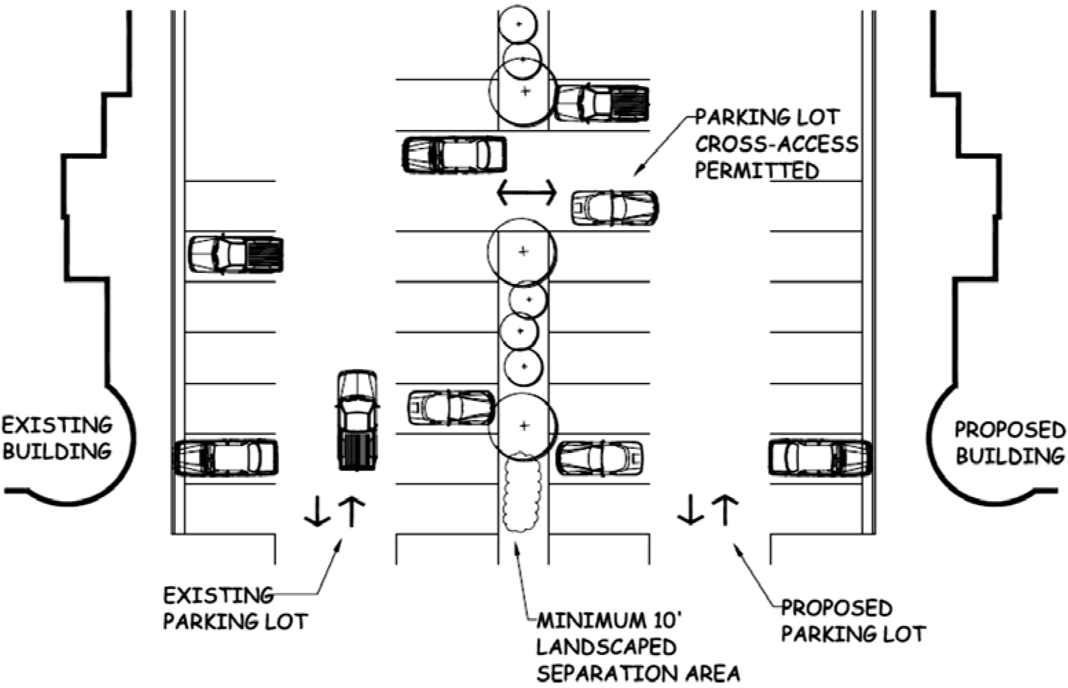
Figure 5.8-2: Example of parking lot landscape buffering with tree plantings adjacent to public right-of-way.
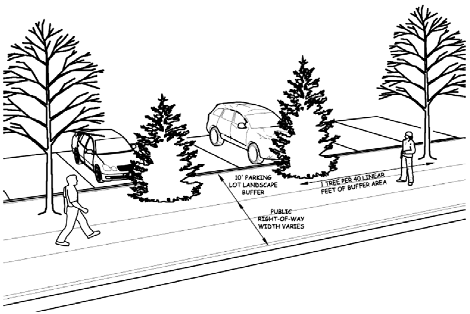
iii.
Joint and Mixed-Use Scenarios
Nothing in this Section shall be construed to prevent the joint use of off-street parking spaces for two (2) or more buildings or two (2) or more uses in the same building so long as the total number of spaces provided for both uses meets or exceeds the requirements for each individual use. The cumulative requirements for off-street parking for mixed-use occupancies may be reduced if the applicant can demonstrate that the peak requirements of the occupancies occur at different times. If the peak parking usage for the various uses is not simultaneous, the Community Development Director, in approving a Type A Development Plan, and the City Council, in approving a Type B or B-LSR Development Plan, may permit any portion of the off-street parking area to satisfy all or part of the parking requirements for more than a single building or use.
iv.
Pedestrian Access
Pedestrian access shall be provided to all land uses except where pedestrian access is not practical due to the location of the use along a public or private road in which pedestrian travel is prohibited.
v.
Americans with Disabilities Act (ADA) Compliance
All development, including new development and the substantial expansion of an existing use, shall comply with ADA parking and access requirements. For the purpose of applying the requirements of this Section, "substantial expansion" shall include any development or construction activity that requires approval of a Residential Site Plan or Type A, B, or B-LSR Development Plan as outlined in Chapter 3 of this Code. ADA required spaces, as outlined in Table 5.8-3 below, shall be in addition to the required guest, employee, and loading spaces.
vi.
Public Safety Review
All parking plans shall be submitted with the associated Type A, B, or B-LSR Development Plan and shall be subject to review by the City Fire Chief.
B.
Parking Space Design Standards
i.
Access and Circulation
All parking and loading spaces shall be accessed from an internal, on-site circulation aisle or a shared on-site circulation aisle and shall not be directly accessed from any public street or right-of-way.
ii.
Lighting
Parking lot lighting shall be in conformance with the lighting provisions of this Code. The location of all parking lot lighting shall be depicted on both the parking plan and the lighting plan unless the two plans are otherwise combined into a single plan set. Parking lot light shall only be shown on the single combined plan, if such plan sheets are combined into a single exhibit.
iii.
Parking Lot Surfacing
Off-street parking shall be surfaced with asphalt or concrete and shall be clearly marked or striped.
iv.
Parking Space Design
The design and layout of all parking spaces shall comply with the requirement of Table 5.8-1, Parking Space Dimensions, below.
Table 5.8-1 Parking Space Dimensions
Figure 5.8-3: Depiction of zero degree (0°) parking angle configuration.
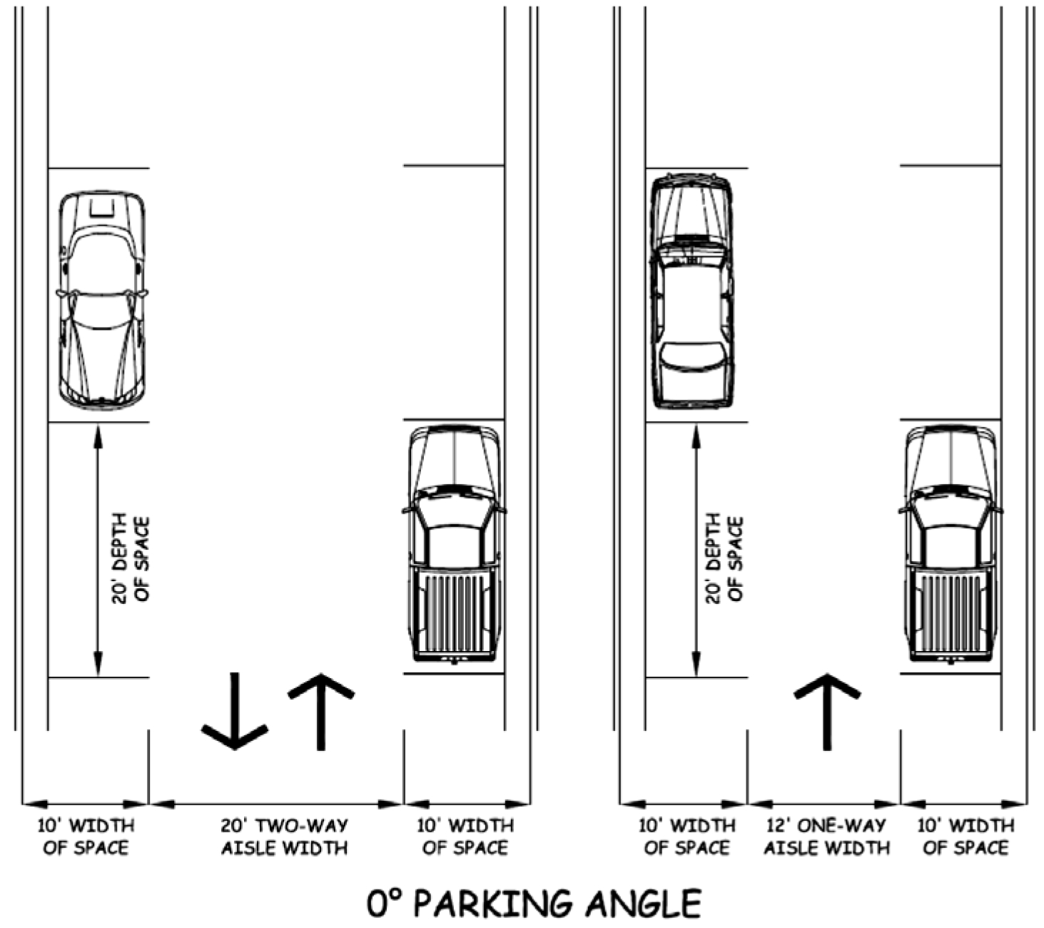
Figure 5.8-4: Depiction of thirty degree (30°) parking angle configuration.
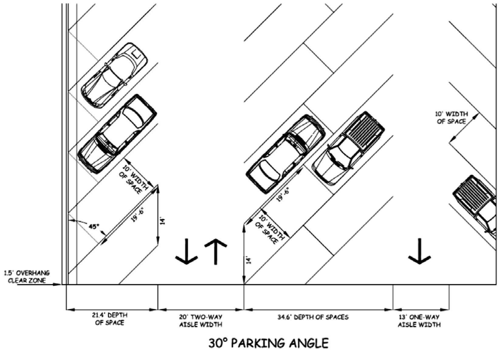
Figure 5.8-5: Depiction of sixty degree (60°) parking angle configuration.
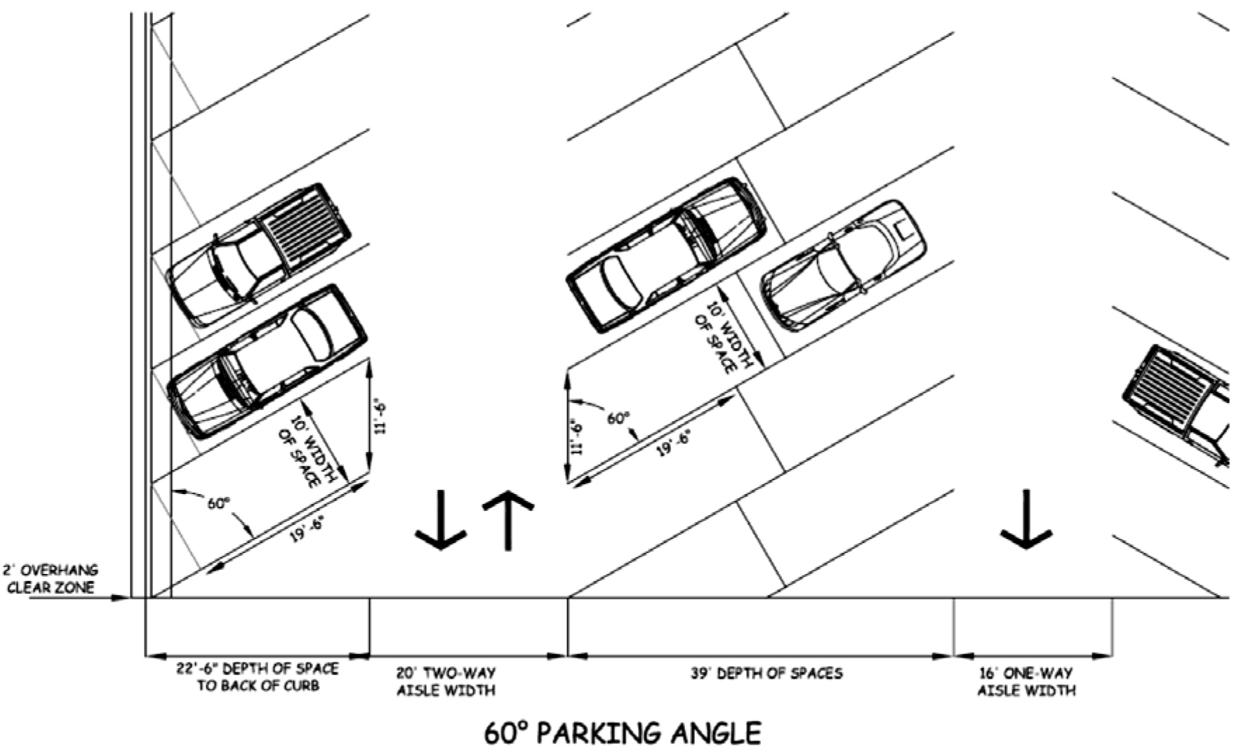
Figure 5.8-6: Depiction of ninety degree (90°) parking angle configuration.
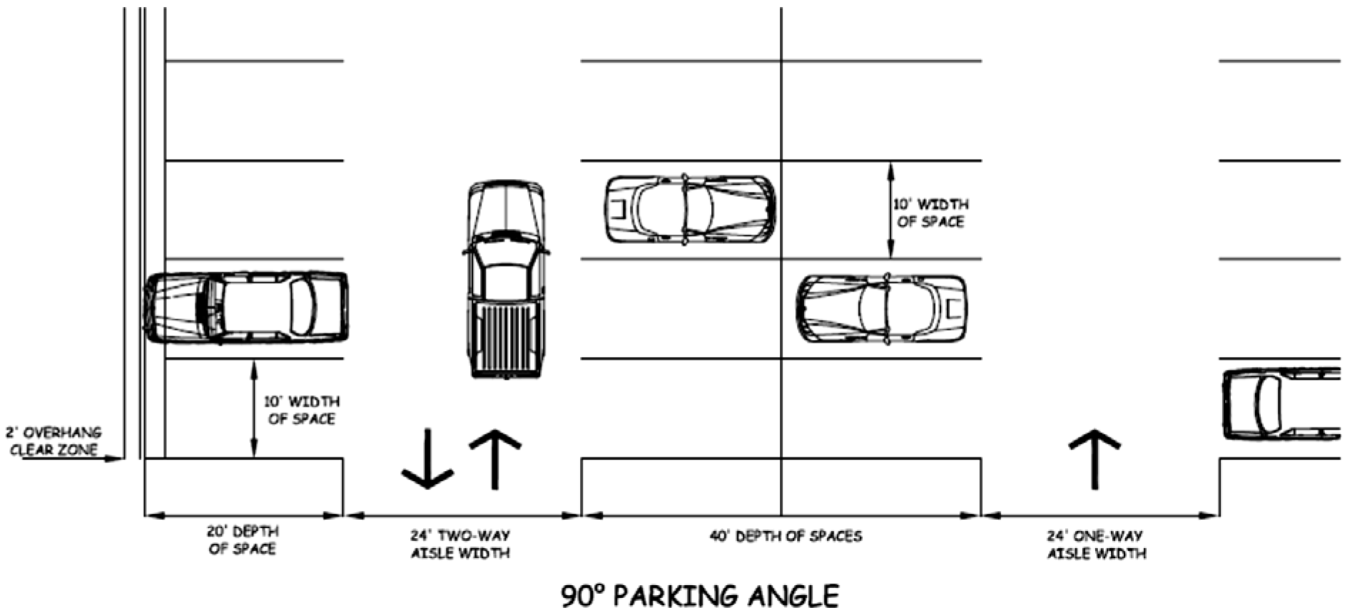
C.
Off-Street Parking Requirements
i.
Number of Parking Spaces Required
The total number of parking spaces required for each use on a lot shall be equal to the total number of standard spaces plus the number of required ADA-required spaces. Fractions of calculations shall be rounded to the nearest whole number (e.g., 5.01 to 5.49 = 5 spaces and 5.50 to 5.99 = 6 spaces).
ii.
Employee Parking
In addition to the requirements of any other section of this title, one (1) off-street parking space for each employee shall be provided. The number of employees used in computing parking space requirements shall be the greatest number of persons working at any time of the day or night.
iii.
Parking for Unlisted Uses
The parking requirements for any use not listed in the parking table or Code shall be determined by the Community Development Director based upon an evaluation of the use in comparison to other similar uses.
iv.
Uses with Drive-Thru Windows
Drive-thru lanes shall be designed and striped in order to provide adequate off-street stacking and shall not impede pedestrian access or impede vehicular access or circulation within the site. Stacking shall be based on traffic generation and shall be reviewed by the City Engineering Department as part of the associated Type A, B, or B-LSR Development Plan.
v.
Parking requirements shall be calculated using the Institute of Transportation Engineers Parking Generation latest edition. Parking requirements may be revised with appropriate research by the Community Development Director.
Table 5.8-3 Minimum Required ADA Compliant/Disabled Spaces
NOTE: ADA parking standards are subject to change independent of the standards in this Code. All applicants are encouraged to consult with the ADA to ensure full compliance with the applicable requirements.
D.
Maintenance of Parking Facilities
The owner or operator of a specific use shall be responsible for the maintenance and
general upkeep of his or her parking area. All parking areas shall be kept in a good
operating condition, free of potholes and other surface defects and free of weeds,
dust, trash and other debris. Standard parking area maintenance shall also include
routine striping of all parking spaces and loading areas. Failure to perform appropriate
maintenance of parking areas, as determined by the Community Development Director
at his or her discretion, shall be considered a violation of this Code and shall be
subject to the enforcement provisions in Chapter 9 of this Code.
E.
Truck and Semi Parking
The parking of commercial trucks over ten thousand (10,000) pounds gross vehicle weight
(GVW) shall only be allowed on streets or alleys specifically designated for commercial
truck parking in commercial and industrial zoning districts or in specifically designated
areas not located within a commercial or industrial zoning district. Nothing in this
Section shall be interpreted to preclude commercial trucks from conducting business
at specific destination points during normal business hours.
F.
Parking in Residential Zone Districts
Vehicle parking in the front yard of residential properties shall be allowed in designated
parking areas only. Parking areas shall be surfaced with an all-season material such
as concrete, brick, asphalt, gravel or other similar material. This Section does not
apply to any special family event or social gatherings.
i.
Vehicle parking in the front yard of residential properties shall be allowed in designated parking areas only. Parking areas shall be surfaced with an all-season material such as concrete, brick, asphalt, gravel or other similar material. This Section does not apply to any special family event or social gatherings.
ii.
The total area in the front yard setback of residential properties improved for parking or driveway purposes shall not exceed fifty (50) percent of the front yard setback area.
5.8.4
Off-Street Loading Requirements
A.
General Standards and Requirements
i.
Location of Off-Street Loading
Loading spaces for any new development or for the substantial expansion of an existing use requiring approval of a Development Plan and for proposed uses shall be located on the same property as the associated use. For the purpose of applying the requirements of this Section, "substantial expansion" shall include any development or construction activity that requires approval of a Residential Site Plan or Type A, B, or B-LSR Development Plan as outlined in Chapter 3 of this Code. The Community Development Director, in approving a Type A Development Plan, and the City Council, in approving a Type B or B-LSR Development Plan, may approve an off-street parking plan that includes off-site parking if the applicant can provide evidence that he or she has a legal right to use such property or properties and if the property or properties are immediately adjacent to the property upon which the expanded or proposed use is to be conducted.
ii.
Joint and Mixed-Use Scenarios
Nothing in this Section shall be construed to prevent the joint use of off-street loading spaces for two (2) or more buildings or two (2) more uses in the same building so long as the total number of spaces provided for both uses meets or exceeds the requirements for each individual use. Cumulative off-street loading space requirements for mixed-use occupancies may be reduced where it can be demonstrated that the loading requirements of the occupancies occur at different times. Where such loading usage is not simultaneous, the Community Development Director, in approving a Type A Development Plan, and the City Council, in approving a Type B or B-LSR Development Plan, may allow an off-street loading area to satisfy all or part of the off-street loading requirements for more than one (1) building or structure.
iii.
Public Safety Review
The layout and design of all proposed loading spaces shall be included with an associated Type A, Type B, or B-LSR Development Plan and shall be subject to review by the State Fire Marshal.
B.
Loading Space Design Standards
i.
Access and Circulation
All loading spaces shall be accessed from a circulation aisle and shall not, for any reason, be directly from a public street or right-of-way. Under no circumstances shall loading operations result in obstruction of any public street or right-of-way.
ii.
Loading Space Design and Requirements
The Community Development Director, in approving a Type A Development Plan, and the City Council, in approving a Type B or Type B-LSR Development Plan, may grant relief of the loading space requirements if, after review and consideration of adequate documentation, the reviewing body determines that the applicant has demonstrated that the use will not require loading areas to facilitate the delivery of materials, merchandise, or supplies.
Table 5.8-4 Loading Space Dimensions
Table 5.8-5 Minimum Loading Space Requirements
5.8.5
Snow Removal and Storage
The owner and/or operator(s) of parking lots and loading areas shall be required to remove snow in a reasonable time and manner in order to keep parking, loading, and maneuvering areas safe for vehicular and pedestrian access and circulation. Storage of snow removed from parking, loading, maneuvering, and pedestrian areas shall not result in the temporary decrease or loss of required parking and loading spaces or impeded pedestrian or vehicular access or maneuvering into or through the site. All Type A, B, and B-LSR Development Plans shall depict locations for snow removal storage on-site that will not reduce the number of required parking spaces and will not impede vehicular or pedestrian traffic from entering or exiting the site.
(Ord. No. 967, § 42, 8-10-2015; Ord. No. 990, § 35, 5-22-2017; Ord. No. 1000, § 14, 6-10-2019; Ord. No. 1013, § 2, 8-22-2022; Ord. No. 1019, §§ 1, 2, 12-12-2022)
5.9 - Signs
5.9.1
General
A.
Intent
This section is intended to provide uniform regulations pertaining to the use of signs
as advertising devices to help ensure the health, safety, and welfare of the current
and future residents of the City and to achieve the following goals:
• Allow the reasonable display of signage to identify and advertise products, services and business establishments for the information and convenience of the general public;
• Aid in the development and promotion of business and industry by providing sign regulations which encourage aesthetic creativity, effectiveness and flexibility in the display and use of signs;
• Preserve and enhance the City's small town character;
• Promote safe and attractive pedestrian environments; and
• Limit the aesthetic impact of signs on properties to prevent clutter and protect streetscapes thereby preserving property values and protecting traffic safety. The accumulation of signs creates clutter and adversely affects these goals, property values and public safety.
B.
Applicability
The signage requirements of this section shall apply to the construction or substantial
expansion of any single or multi-family residential use, manufactured and/or mobile
home park, travel trailer and RV park, commercial, or industrial use in any zoning
district within the City. For the purpose of applying the requirements of this Section,
"substantial expansion" shall include any development or construction activity that
requires approval of a Residential Site Plan or Type A, B, or B-LSR Development Plan
as outlined in Chapter 3 of this Code. Additional use-specific standards may be applicable pursuant to the
requirements of Chapter 6 of this Code.
C.
Alternate Sign Plan
In approving an alternate sign plan, the Community Development Director, in reviewing
a Type A Development Plan, and the City Council, in reviewing a Type B or B-LSR Development
Plan, shall find that the plan is consistent with the intent of this Section and with
policies and recommendations of the City of Douglas Master Plan. The Community Development
Director and City Council shall consider the following in reviewing an alternate sign
plan:
• Whether the plan accomplishes the intent of the Character District guidelines in the City of Douglas Master Plan; and
• Whether the plan demonstrates innovative design and use of signage and advertising elements.
Under no circumstances shall an alternate sign plan be approved that exceeds the square footage or development standards for signs allowed by this Section.
D.
Measurement of Sign Area
The measurement of sign area shall be as follows:
• The surface area of all signs shall be counted and considered a part of the maximum total sign area allowed.
• Sign area shall be measured by determining the sum of the area within a continuous perimeter enclosing the extreme limits of sign display.
• Sign area for a building site is the total area of all signs located on the site and shall include any directional signs for off-premise businesses, but shall not include temporary signs.
• The area of double-faced signs (message displayed on two (2) sides of a single sign) shall be calculated on the basis of one (1) face only.
• The area of triple-faced signs (message displayed on three (3) sides of a single sign) shall be calculated on the basis of one and one-half (1½) face only.
• The area of quadruple-faced signs (message displayed on four (4) sides of a single sign) shall be calculated on the basis of two (2) faces only.
E.
Density
Signs shall be limited to a maximum of one (1) sign per street frontage in all zones
and districts. This shall not include signage posted by a governmental entity.
F.
Rights-of-Way Permanent Signs
Placement of permanent signs in rights-of-way shall be as follows:
• Signs shall not be placed in the City right-of-way. This shall not include signage posted by a governmental entity.
• Written permission shall be obtained from the property owner and provided to the Community Development Department to place signs in the County right-of-way or State right-of-way. These signs will count against the total square footage allotted to signage allowed in the zone.
G.
Abandoned and Ghost Signs
i. Definitions
Abandoned sign means a sign or sign where:
• The sign is no longer used by the person who constructed the sign structure that has ceased to be used. Discontinuation of sign use may be shown by cessation of use of the property where the sign is located.
• The sign has been damaged, and repairs and restoration are not started within ninety (90) days of the date the sign was damaged, or are not diligently pursued, once started.
Ghost sign means historic or old, faded, often hand-painted signs, on the exterior wall of a building which remains visible long after the subject matter it promoted has closed or changed. Often found in historic districts and downtowns revealing hints of forgotten brands and products from a past era.
ii. Abandoned Signs
Abandoned signs shall be prohibited and removed within sixty (60) days after the premises have been vacated unless the sign is determined to have historical significance by the Douglas Historic Preservation Commission or unless the sign is located in the Local Downtown Historic District (O-LDH). If notice by the City is required due to lack of compliance with this section, the Community Development Department shall send a certified letter to the owner and give ten (10) days for the sign to be removed and/or repaired. In the event of continued non-compliance, the City may issue citation or cause abandoned signs to be removed at the expense of the owner.
iii. Ghost Signs
Ghost signs shall be reviewed by the Downtown Historic District Review Board if located in the Local Downtown Historic District (O-LDH) or by the Historic Preservation Commission if located outside the Local Downtown Historic District (O-LDH).
Criteria for preservation of ghost signs shall include, but not be limited to:
• Hand-painted: Ghost signs were not modern printed materials but were laboriously hand-painted by skilled sign painters known as "wall dogs."
• Fading & Ephemeral: Over decades or even centuries, the paint on these signs wears away, making them appear as fading "ghosts" of their former selves.
• Historic Buildings: They are typically found on older commercial buildings, often on brick walls, serving as remnants of the building's past life.
• Time Capsules: Ghost signs act as historical markers, offering insights into long-forgotten products, local businesses, and even societal messages from the past.
• Historical Preservation: Many ghost signs are preserved for their sentimental appeal or historical value, offering a tangible link to a city's past and the evolution of its streetscapes.
• Community History: They reveal the history of local commerce and documenting forgotten products or businesses, such as Coca-Cola signs or advertisements for patent medicines.
• Aesthetic Interest: The art and weathering of ghost signs are appreciated for their unique aesthetic, which can sometimes be highlighted or even digitally reconstructed by artists.
H.
Maintenance
All signs (excepting ghost signs) shall be maintained in good repair and any damaged
sign shall be repaired, except as otherwise limited by this Section, within thirty
(30) days. If notice by the City is required due to lack of compliance with this section,
the Community Development Department shall send a certified letter to the owner and
give ten (10) days for the sign to be removed and/or repaired. In the event of continued
non-compliance, the City may issue citation or cause corrective action at the expense
of the owner
I.
Enforcement
Any violation of the signage standards of this section shall be subject to the enforcement
provisions of Chapter 9 of this Code.
5.9.2
Permit and Construction Requirements
A.
Sign Permit Required
Signs shall not be installed or erected so as to create a safety hazard and shall
be constructed in a workmanlike manner, using industry-accepted structural design
and meeting the requirements of all building, fire, safety, traffic, commercial wind
loading, and electrical codes and ordinances.
B.
Exemptions
All temporary signs that comply with the respective time, place, and manner requirements
of Section 5.9.3 are exempt for the sign permit requirements of this Section.
• Temporary sign(s) means a sign made of temporary materials affixed, erected, or maintained sign on the premise or lot for a short duration.
C.
Engineered Plans Required
i.
Freestanding Signs
Engineered plans shall be submitted for all freestanding signs in excess of twelve (12) feet in height. Signs shall be measured from finished grade to the top of the sign.
ii.
Freestanding and Pole Signs
All freestanding and pole signs must be a minimum of eight (8) feet from finished grade to the bottom of the sign in areas of pedestrian traffic and fifteen (15) feet in areas of potential vehicular traffic. Freestanding signs shall not be allowed within public right-of-way.
iii.
Projecting Signs
Projecting signs over public sidewalks shall be a minimum of eight (8) feet from finished grade. Projecting signs over alley rights-of-way shall be a minimum of fifteen (15) feet above the alley surface and shall not extend out from the building so as to create a safety hazard to passing vehicular traffic. Under no circumstances shall signs be allowed within or to project into a public street, which for the purposes of this Section shall include the area between the front curb on each side of the street where curb is existing or approved and from edge of pavement to edge of pavement where no curb exists or no curb is required.
5.9.3
Sign Allowances by Zone District
A.
Signage in the Agricultural Zoning District
Agricultural signs shall be a maximum of thirty-two (32) square feet.
B.
Signage in Residential Zoning Districts
In addition to the allowance of temporary signs under Section 5.9.4(C), properties
with approved commercial or conditional uses are permitted one (1) sign not to exceed
twenty (20) square feet. Subdivisions, apartments, multi-family dwellings and condominium
complexes are permitted one (1) sign not to exceed twenty (20) square feet, and further
provided that one (1) such sign shall be permitted for each separate street and/or
separate building frontage occupied by the subdivision, apartment, or condominium
complex and/or for each means of entrance to or exit from the subdivision, apartment,
or condominium complex. Wall signs are also permitted not to exceed five (5) percent
of the area of the facade in elevation view upon which they are placed.
C.
Signage in the Manufactured/Mobile Home Park and Travel Trailer/RV Park Zoning Districts
Manufactured and mobile home parks and travel trailer and RV parks are permitted a
monument sign not to exceed sixty-four (64) square feet, and further provided that
one (1) such sign shall be permitted for each separate street and/or separate building
frontage occupied by the manufactures/mobile home park and/or travel trailer/RV park
for each means of entrance to or exit from the subdivision, apartment, or condominium
complex. Wall signs are also permitted not to exceed five (5) percent of the area
of the facade in elevation view upon which they are placed.
D.
Signage in the CB-1 Zoning District
The total combined sign area in the Downtown Business zone shall be limited to two
hundred (200) square feet per building site area. All signs, including directional
signs for off-site businesses and portable signs, shall be included in calculating
the total combined sign area. Signs in this zone shall be subject to the City of Douglas
Downtown Historic District Review Panel and approval for time, manner, and place restrictions.
E.
Signage in the B-1 and B-2 Zoning Districts
The total combined sign area of local business and general business shall not exceed
four hundred (400) square feet. All signs, including directional signs for off-site
businesses and portable signs, shall be included in calculating the total combined
sign area.
F.
Signage in the MU-PUD Zoning District with No Adopted Master Plan
The total combined sign area in mixed use planned unit development zone districts
with no adopted master plan shall not exceed four hundred (400) square feet. All signs,
including directional signs for off-site businesses and portable signs, shall be included
in calculating the total combined sign area.
G.
Signage in the PLI Zoning District with No Adopted Master Plan
The total combined sign area in planned light industrial zone districts with no adopted
master plan shall not exceed four hundred (400) square feet. All signs, including
directional signs for off-site businesses and portable signs, shall be included in
calculating the total combined sign area.
H.
Signage in the I (Industrial) Zoning District
The total sign area in industrial zone districts shall not exceed seven hundred (700)
square feet. All signs, including directional signs for off-site businesses and portable
signs, shall be included in calculating the total combined sign area. The Community
Development Director, in approving a Type A Development Plan, and the City Council,
in approving a Type B or B-LSR Development Plan, may require a reduction in the total
combined sign area or may allow limited increases in the total combined sign area.
All increases in the total combined sign area shall be limited to developments providing
a comprehensive sign program for the entire development that incorporates higher quality
and more aesthetic construction materials and design.
I.
Signage in the Overlay Districts
i.
O-LDH
The total combined sign area in the Local Downtown Historic Overlay District shall be limited to two hundred (200) square feet per building site area. All signs, including directional signs for off-site businesses and portable signs, shall be included in calculating the total combined sign area. Signs in this overlay district shall be subject to the City of Douglas Downtown Design Guidelines, the Downtown Douglas Historic District Rehabilitation Standards, and to the review and approval of the Downtown Douglas Historic District Review Panel.
ii.
O-DD
The total combined sign area in the Designated Downtown Overlay District shall be limited to three hundred (300) square feet per building site area; unless the property is within the Local Downtown Historic Overlay District (O-LDH). All signs, including directional signs for off-site businesses and portable signs, shall be included in calculating the total combined sign area. Signs in this overlay district on commercial or mixed-use properties shall be subject to the City of Douglas Downtown Design Guidelines and to the review and approval of the Community Development Department Director.
iii.
O-NDH
The total combined sign area in the North Douglas Historic Overlay District zone shall be limited to fifty (50) square feet per building site area. All signs, including directional signs for off-site businesses and portable signs, shall be included in calculating the total combined sign area. Signs in this overlay district which are also in either the Local Downtown Historic Overlay District or the Designated Downtown Overlay District shall additionally be subject to the City of Douglas Downtown Design Guidelines, the Downtown Douglas Historic District Rehabilitation Standards, and to the review and approval of the Downtown Douglas Historic District Review Panel as outlined previously.
J.
Community Entryways
Signage along the West Yellowstone, Center Street, 4th Street and East Richards Street
corridors shall be sited and constructed in a manner that is compatible with indigenous
land forms, native plants, or other landscaping approved by the City. The Community
Development Director, in approving a Type A Development Plan, or the City Council
in approving a Type B or B-LSR Development Plan, may exempt some signs from this standard
if the applicant can adequately demonstrate that the associated landscaping would
interfere with pedestrian or vehicular traffic or traffic visibility.
Table 5.9-1 Allowed Sign Types by Zone Districts
Note: A = Allowed sign in the identified zoning district. T = Temporary sign in the identified zoning district. C = Allowed sign in the identified zoning district if the respective site includes an approved or legally existing conditional or commercial use. All blank cells/boxes represent a sign that is not allowed in the identified zoning district. + = This table only applies to PLI and MU-PUD zones without Master Plans.
5.9.4
General Sign Standards
A.
Compatible with Site Architecture
Signs requiring a building permit shall be designed and constructed with materials
that are compatible with the architectural design of the buildings located on the
same site.
B.
Location and Setbacks
i.
All Signs Located On-Site
Signs shall be located on the premises in which the events, products, or services are being offered, unless otherwise approved as an off-premise sign pursuant to the requirements in Section 5.9.5 below. Temporary signs may be displayed on municipal property in conjunction with an approved special event so long as the display is confined to the booth/table/display at the event and limited to the event duration. Temporary signs may also be displayed in the parkway or City right-of-way if done so with the permission of the property owner fronting the parkway where a temporary sign would be erected.
ii.
Setbacks
Unless otherwise approved by the Community Development Director after reviewing a Type A Development Plan or by the City Council after reviewing a master sign plan for a Type B or B-LSR Development Plan as part of a master sign plan or by the Board of Adjustment in approving a variance, all signs shall be located a minimum of ten (10) feet from all of the property lines.
iii.
Freestanding and Pole Signs Adjacent to Residential Zone District
Freestanding and pole signs shall not be allowed within 100 feet of any residential, manufactured or mobile home park, or travel trailer or RV park zoning district. The distance shall be measured from the center of the right-of-way dividing the zoning districts or from the property line dividing the subject property and zoning district.
iv.
Location Restrictions
• No portion of any sign shall project within two (2) feet of the back of curb line of any public or private right-of-way as defined by this Code or provision of the Douglas Municipal Code.
• Signs shall be not less than six (6) feet horizontally and twelve (12) feet vertically from overhead electrical conductors that are energized in excess of 750 volts.
• Signs and associated structures shall not be designed or constructed in a manner that interferes with the free use of any fire escape, fire exit, fire hydrant or standpipe used for fire suppression.
• Signs shall not be designed or constructed in a manner that obstructs or otherwise reduces light or ventilation.
• The design and construction of signs shall comply with all applicable federal, state, or local requirements.
C.
Temporary Signs
i.
Temporary sign(s) means a sign made of temporary materials affixed, erected, or maintained sign on the premise or lot for an erected for a minimum number of days except as provided below.
ii.
Residential properties—All single-family residential properties that are located in Residential Zoning Districts are permitted temporary signs not to exceed three (3) square feet in total sign area per road frontage. Corner lots and lots with frontage on more than one (1) street are entitled to three (3) square feet per frontage. This sign area allowance covers, but is not limited to: address signs, home occupation signs, lawn signs, real estate signs, contractor signs, and political signs. Signs may be freestanding, mounted to a permanent building structure or displayed in a window. Trees, rocks or other naturally occurring landscape features may not be used to support a residential sign.
iii.
Signs not exceeding eight (8) square feet per frontage shall be allowed during a period from ninety (90) days before a public election or the time the election is called, whichever is earlier, to five (5) days after the public election.
iv.
A sign not exceeding six (6) square feet in area and five (5) feet in height during the time of sale, lease or rental of the premises, provided that the sign is removed within thirty (30) days of the sale, lease or rental of the premises.
v.
Temporary signs shall not be placed on trees, rocks or other naturally occurring landscape features in any zone or district.
vi.
Temporary signs in the right-of-way shall not exceed three (3) feet in height.
vii.
The City may cause any temporary signage violating this section to be removed.
D.
Directional Signs
i.
Area
Directional signs shall be a maximum area of ten (10) square feet.
ii.
Height
Directional signs shall not exceed five (5) feet in height.
iii.
Number
No more than two (2) directional signs shall be permitted per use.
iv.
Placement
Directional signs may be located off-premise with the written permission of the property owner upon which the directional sign is located
v.
Lighting
Lighting for directional signs is prohibited.
E.
Portable Signs
i.
Portable Signs Temporary
Portable signs shall be considered temporary in nature. Any portable signs in use for more than 30 days shall be counted toward the overall sign area allowance for the subject property.
ii.
Area
Portable signs shall not exceed 40 square feet.
iii.
Number
No more than one (1) portable sign shall be permitted per use.
iv.
Placement
Portable signs may only be located on the property in which the advertised products are sold or where the advertised services or events are performed or occur.
v.
Lighting
Lighting of portable signs shall not exceed 60 watts. Any property owner using a portable sign shall obtain a sign permit which shall include documentation verifying compliance with this requirement.
F.
Sidewalk Signs (see Figure 5.9-1 below for an example of a sidewalk sign)
i.
Sidewalk Signs Temporary
Sidewalk signs shall be considered temporary in nature. Any sidewalk sign in use for more than 30 days shall be counted toward the total sign area allowance for the property.
ii.
Area
Sidewalk signs shall not exceed 20 square feet in total sign area. Double-sided sidewalk signs shall not exceed 20 square feet on either side.
iii.
Number
No more than one (1) sidewalk sign shall be permitted per use.
iv.
Placement
Sidewalk signs may only be located on the property in which the advertised products are sold or where the advertised services or events are performed or occur. Sidewalk signs shall not obstruct pedestrian use of the sidewalk upon which they are located or obstruct pedestrian access to on-street parking, or access to adjacent buildings or uses.
v.
Lighting
Lighting of sidewalk signs shall be prohibited.
Figure 5.9-1: Example of a sidewalk sign.
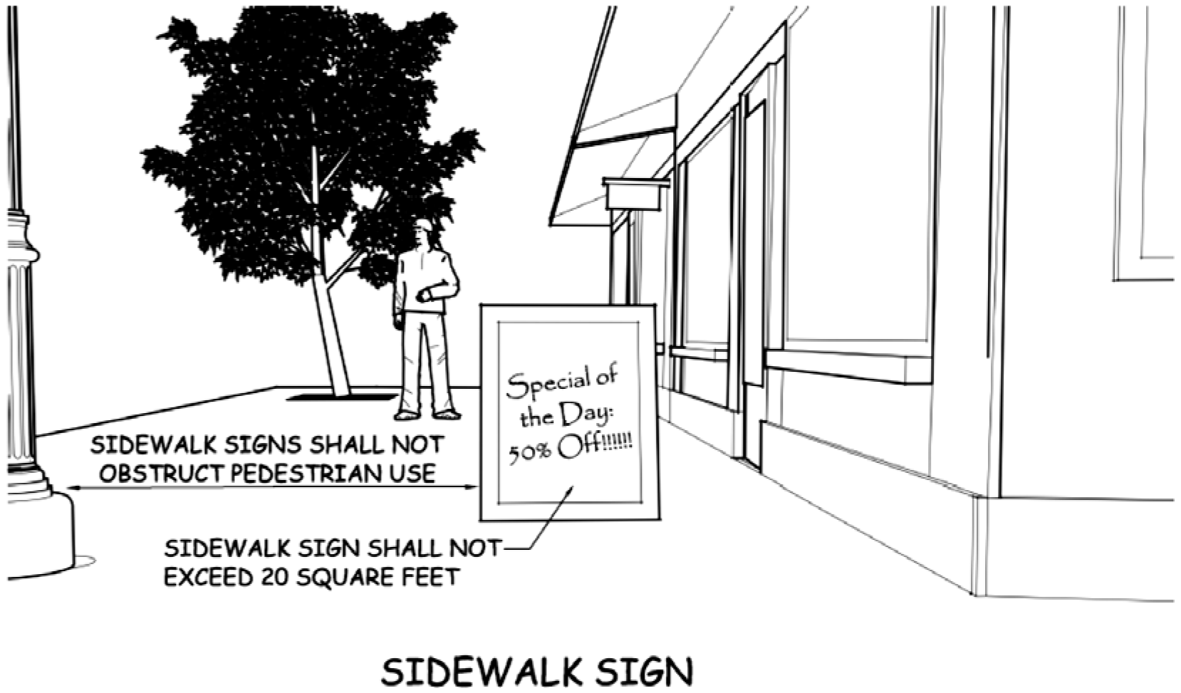
G.
Wall, Canopy, Projecting Signs (see Figure 5.9-2 below for an example of wall and canopy signs)
Wall, canopy, or signs projecting from a building facade shall be located on the building face adjacent to the space occupied by the use.
i.
Area
Wall, canopy, or signs projecting from building facades shall be limited to a maximum of fifty (50) square feet each in the R-3, R-4, MH-1, MH-2 and CB-1 zoning districts and two hundred (200) square feet in the B-1, B-2, MU-PUD, PLI and I zoning districts. Projecting signs shall not exceed twelve (12) square feet each. Building facades shall not be combined to increase the allowed square footage.
ii.
Projections from Building Facades
Wall, canopy, or signs projecting from building facades shall comply with the following requirements:
• Wall, canopy, or signs projecting from building facades shall not extend over windows or architectural features (pilasters, reveals, etc.).
• Wall, canopy, or signs projecting from building facades shall not have any characters or logos that exceed ten (10) feet in height.
• Wall signs projecting from building facades shall not project more than eighteen (18) inches from the wall or surface upon which it is mounted.
• Canopy or signs projecting from building facades shall have a minimum clearance of eight (8) feet.
iii.
Projection of Attached Signs Above Building Restricted
Attached signs shall not project above the highest point of the building, excluding rooftop mechanical structures, chimneys, elevator shafts, ventilators, and all other facilities which may project above that area of the building commonly known as the roof.
Figure 5.9-2: Example of wall and canopy signs.
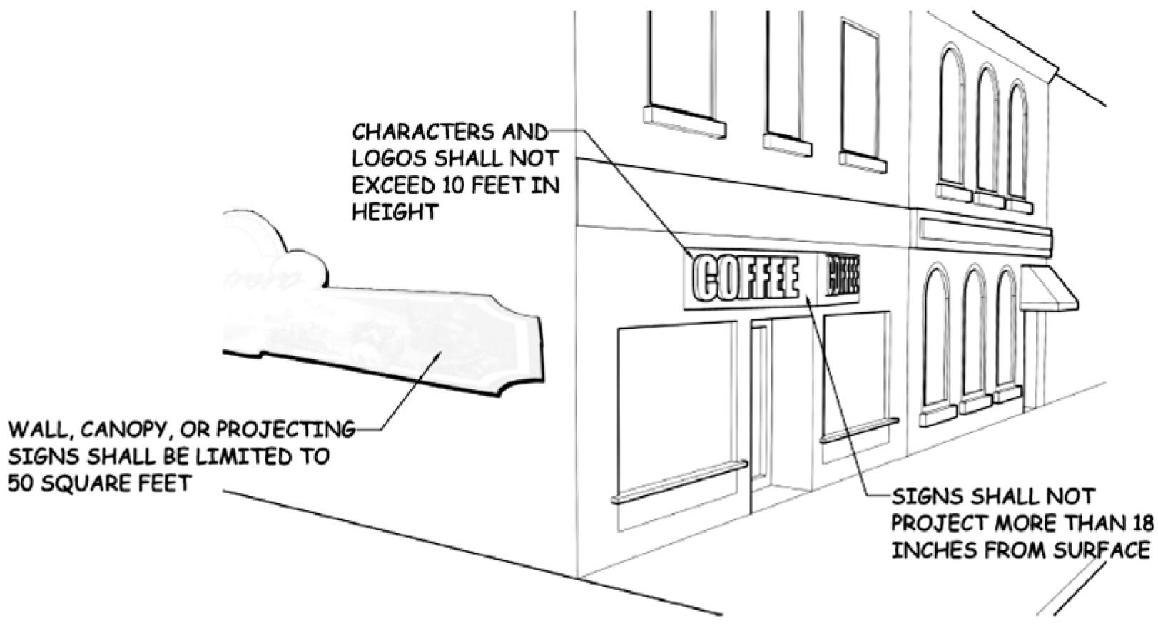
H.
Freestanding and Pole Signs (see Figure 5.9-3 below for an example of a freestanding sign)
i.
Height
Freestanding sign and pole signs shall be a minimum height of eight (8) feet as measured from finished grade to the bottom of the sign and shall not exceed a maximum height of fifteen (15) feet as measured from finished grade to the top of the sign in vehicular travel and maneuvering areas. All other freestanding signs shall not exceed the maximum building height of applicable zoning district.
ii.
Area
The total area of freestanding signs and pole signs shall not exceed two (2) square feet for each linear foot of the building wall closest to the freestanding sign or fifty (50) square feet in a R-3, R-4, MH-1, MH-2, CB-1 or GRN zone, or one hundred (100) square feet in a B-1, B-2, MU-PUD, PLI or I zone, whichever is less. The maximum area of a freestanding sign where no building exists shall be fifty (50) square feet.
iii.
Number of Freestanding Signs and Pole Signs Permitted on a Site
One (1) freestanding sign or pole sign shall be allowed per frontage. Multiple tenants may be advertised on a single freestanding sign.
iv.
Landscaping
Freestanding and pole signs shall be landscaped with water-wise vegetation (i.e. plants that naturally require little supplemental water, having evolved in low-precipitation environments and thus adapted to aridity, creating vibrant, low-water consumption landscapes) at their base in a way harmonious with the landscape concept for the whole site. Landscaping shall form an attractive, dense cluster at the base of the sign that is equally attractive in winter and summer (see Figure 5.9-4). Appropriate multidimensional rock-scape or art may be exchanged for landscaping.
v.
Limited
The primary entryways to the City provide a valuable first impression of the community. Development should exemplify the nature of the community and provide insight into the character of the City. Traditional Pole Signs, defined as a sign sitting atop a single narrow pole, shall be limited on a case-by-case basis and shall be located on the primary commercial and industrial streets including the following:
• East Richards Street
• West Richards Street
• West Yellowstone Highway
• Riverbend Drive
• Highway 59
• Highway 93
• Highway 94
vi.
Redesigned
Acceptable freestanding signs shall include signs with a wide decorative base, unique shapes, or other decorative elements including natural elements such as wood and stone.
Figure 5.9-3: Example of a freestanding pole sign.
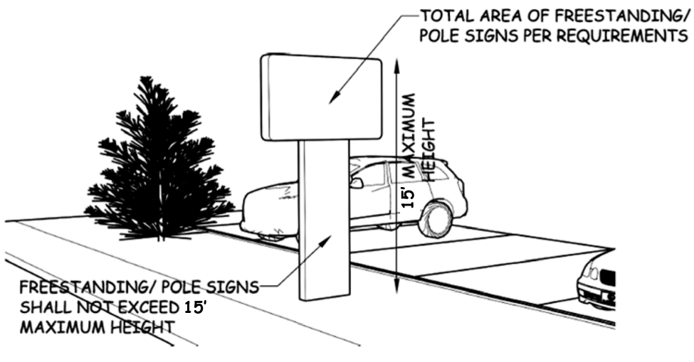
Figure 5.9-4: Freestanding and pole sign landscaping.

I.
Monument Signs (see Figure 5.9-4 below for an example of a monument sign)
i.
Monument Signs Incorporated with Landscape Plan
Monument signs shall be depicted on the landscape plan associated with a Type A, Type B, or Type B-LSR Development Plan.
ii.
Height
The maximum height of a monument sign shall be six (6) feet.
iii.
Area
The total area of a monument sign shall not exceed two (2) square feet for each linear foot of the building wall closest to the monument sign or fifty (50) square feet, whichever is less. Monument signs shall only be allowed on lots or parcels in which a building exists.
iv.
Number of Monument Signs Permitted on a Site
a.
One (1) monument sign shall be allowed on a single lot or parcel. Multiple tenants may be advertised on the same monument sign.
b.
Subdivision Monument Signs. For residential subdivisions consisting of more than twenty (20) residential units, one (1) monument subdivision sign per development entrance shall be permitted. Each sign shall not exceed twenty-four (24) square feet in sign display area and shall not exceed five (5) feet in sign height. The sign shall be set back a minimum of five (5) feet from any property line, unless designed and constructed as part of an entranceway architectural feature, such as a gate, decorative wall, archway, or similar element.
c.
Non Single-Family Use Residential Monument Signs. For properties used for multi-family residential buildings or townhouse structures, one (1) monument or wall sign per street frontage shall be permitted. Each sign shall not exceed twenty-four (24) square feet in sign display area. The monument sign shall not exceed five (5) feet in sign height and shall be set back a minimum of five (5) feet from both the front and side property lines. For properties used for multi-family residential buildings or townhouse structures that have more than one (1) street frontage, one (1) two-faced monument sign oriented so as to be visible from either right-of-way (such as a diagonal sign on a corner lot) shall be allowed in accordance with the standards in this chapter and other requirements of this Code.
Figure 5.9-4: Example of a monument sign.
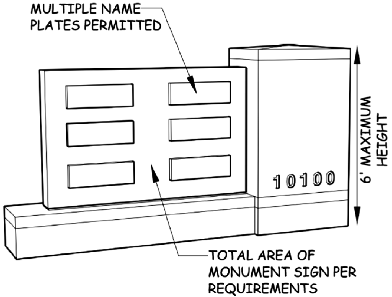
J.
Mechanical Message Display (MMD)
The following criteria shall apply to mechanical message display signs or billboards:
i.
Use of an MMD shall require prior approval of a conditional use permit. Conversion of existing static display to MMD shall require prior approval from the City Council. New signs or billboards proposing MMD shall require prior approval from the City Council.
ii.
Each message on an electronic message display shall be displayed for at least four (4) to eight (8) seconds.
iii.
The transition between messages shall be instantaneous. Transitional effects and other transitional schemes are prohibited.
iv.
Lighting on all mechanical message displays shall adhere to the lighting standards of the Code.
v.
In the event a malfunction occurs, all mechanical message displays shall shut down any lights and terminate movement of panels or hold panels in one position until all repair work has been completed.
vi.
Section 5.9.5 Off-Premise Sign Standards (Billboards) shall also apply when proposed MMD is off-premise.
K.
Electronic Message Display (EMD)
The following criteria shall apply to electronic message display signs or billboards:
i.
Use of an EMD shall require prior approval of a conditional use permit. Conversion of existing static display to EMD shall require prior approval from the City Council. New signs or billboards proposing EMD shall require prior approval from the City Council.
ii.
Animated or other video messaging shall require prior City Council authorization as part of the conditional use permit review and approval process. Animation may not be approved administratively by the Community Development Director.
iii.
Each message on an electronic message display shall be displayed for at least four (4) to eight (8) seconds.
iv.
The transition between messages display shall be instantaneous. Transitional effects shall be limited to instant (slideshow), fade, dissolve, circle out, diamond out, jaws, zoom, wipe left, wipe right, scroll, and travel.
v.
Unless otherwise varied by the conditional use, all electronic message displays shall be equipped with technology that automatically dims the electronic message displays according to ambient light conditions to a luminance or nighttime brightness level of up to five hundred (500) NIT, which will result in a reduction of display brightness between five (5) percent and twenty-five (25) percent, depending on the resolution of the sign. Documentation shall be provided from the sign manufacturer which verifies compliance with auto dimming and brightness requirements.
vi.
All electronic message displays shall be equipped with the ability to be shut off within twenty-four (24) hours of malfunctioning. Signs under repair shall be shut off.
vii.
Section 5.9.5 Off-Premise Sign Standards (Billboards) shall also apply when proposed EMD is off-premise.
5.9.5
Off-Premise Sign Standards (Billboards)
The purposes of this Section include the following:
• Limiting the impact of billboards on the community;
• Improving the appearance of gateways into and out of the community;
• Ensuring compatibility of billboards with adjacent land uses;
• Limiting the impact of billboard clutter within the community;
• Geographically and strategically dispersing billboards;
• Promoting transportation safety; and
• Preserving the visual enjoyment of the community's natural setting.
The City of Douglas recognizes that billboards are a necessary and appropriate advertising medium and that there are acceptable and viable locations for billboards within the community.
A.
General
i.
Sign Permit Required
No off-premise sign shall be erected, re-erected, relocated, replaced, expanded or altered, without first securing a sign permit and a building permit.
ii.
Placement Limited
Off-premise signs proposed in community entry ways or Character Districts shall require conditional use approval from the City Council prior to construction. The City Council may impose additional time, place, and manner restrictions on the placement and sign area of off-premise signs located in Character Districts or Entry Corridors.
iii.
Conditional Use Required for Mechanical or Electronic Message Display
Any change in display type from a static poster display to mechanical or electronic message display shall require prior approval of a conditional use permit.
iv.
Alteration of Existing Signs without Required Permits
No off-premise sign may be altered, except for minor alterations that do not affect the location, face area, height, or display type of the sign, without obtaining prior approval of a conditional use permit and building permit. Failure to comply with this requirement shall result in the loss of any existing non-conforming status.
v.
Increase in Sign Area
Any expansion of sign size, area, or square footage shall require prior approval of a conditional use permit and building permit.
vi.
Sign Area
No billboard, except for any legally existing non-conforming billboard, shall exceed 245 square feet in area.
vii.
Height
The height of a billboard shall not exceed the maximum building or structure height of the applicable zoning district.
B.
Setbacks and Location Standards
i.
Setbacks
All billboards shall comply with the minimum setback requirements of the applicable zoning district within which the billboard is proposed to be located. The setback requirement for a billboard in any zoning district that allows a zero lot line setback shall be ten (10) feet.
ii.
Location Standards
a.
No billboard shall be placed on the roof of any building or structure.
b.
No billboard shall cantilever over an existing building or structure.
c.
The following spacing criteria shall apply to billboards:
• Billboards shall be spaced at least 1,000 feet from all other billboards, except in the I (Industrial) and PLI (Planned Light Industrial) zoning districts, where the spacing shall be at least 400 feet. Spacing between billboards shall be measured in a straight line regardless of physical obstructions.
• Only one (1) billboard shall be placed within a 250-foot radius of the center point of a roadway intersection.
• Billboards shall not be placed within five hundred (500) feet of any residential zoning district. Spacing between a billboard and a residential zoning district shall be measured in a straight line regardless of physical obstructions.
5.9.6
Nonconforming Signs
A.
Termination of Right to Maintain Nonconforming Sign
The right to maintain a nonconforming sign shall terminate upon occurrence of one
or more of the following events or activities:
• Abandonment of the nonconforming sign for a continuous period of one (1) year;
• An increase of any sign dimension;
• Damage to or destruction of the nonconforming sign from any cause whatsoever if the cost of repairing the damage or destruction exceeds fifty (50) percent of the replacement cost of the sign. In determining the replacement cost of a nonconforming sign, the cost of the land, the cost of renting land, or any factor other than the cost of the sign itself shall not be considered; or
• Failure of the nonconforming sign to comply with this Code at the time of construction.
B.
Change of Copy, Orientation or Trim
The copy, orientation, or trim on a non-conforming sign and supporting structure may
be changed.
C.
Maintenance
Nonconforming signs shall be maintained in good repair and any damaged sign shall
be repaired, except as otherwise limited by this Section.
(Ord. No. 967, § 42, 8-10-2015; Ord. No. 990, §§ 6, 36—38, 5-22-2017; Ord. No. 1000, §§ 15, 16, 6-10-2019; Ord. No. 1011, §§ 27—29, 12-13-2021; Ord. No. 1053, § 1—7, 11-10-2025)
5.10 - Streets, Alleys, and Sidewalks
5.10.1
Intent
This Section is intended to provide uniform standards for the size, design, and construction of public streets, alleys, and sidewalks.
5.10.2
Applicability
The requirements of this Section shall apply to the construction of any new streets, alleys, or sidewalk within or necessary to provide access to a proposed development. These requirements shall also apply to the construction and reconstruction of streets, alleys, and sidewalks necessary to mitigate the adverse off-site transportation impacts of a proposed development. Standards for construction of public streets and related improvements are included in Chapter 8, Construction of Public Improvements and Utilities, of this Code.
5.10.3
Streets and Alleys
A.
General Requirements
All developments and redevelopments shall be served by properly sized and constructed
public roadways.
B.
Dimensional Standards
The required dimensional cross-sections for the construction of streets within the
City shall be as depicted below in Figures 5.10-1 through 5.10-4. At a minimum, the
following requirements shall be met:
i.
Minimum Right-of-Way Widths
The following shall be the minimum width of right-of-way required for each street classification:
• Arterial, one hundred (100) feet;
• Collectors, eighty (80) feet;
• Local, sixty (60) feet where on-street parking is allowed; and
• Local, fifty (50) feet where on-street parking is not allowed.
Wider right-of-way may be required based upon topography, grade separations, residential densities, commercial development, or for other similar functional considerations.
ii.
Pavement Widths Where On-Street Parking is Allowed.
The minimum width of the paved surface, including curb and gutter, where on-street parking is allowed, shall be as follows:
• Arterial, seventy-two (72) feet;
• Collector, sixty (60) feet;
• Local, forty-four (44) feet; or
• Local, in residential zones where the subdivision design also includes platted alleys, thirty-eight (38) feet.
iii.
Pavement Widths Where On-Street Parking is Not Allowed
The minimum width of the paved surface, including curb and gutter, where on-street parking is not allowed, shall be as follows:
• Arterial, sixty (60) feet;
• Collector, forty-eight (48) feet;
• Local, twenty-four (24) feet.
iv.
Curb and Gutter.
To preserve the rural character of neighborhoods in the RR (Rural Residential), A (Agricultural), and RE (Residential Estate) zoning districts, curb and gutter shall not be required so long as on-street parking is not allowed and a drainage study for the development verifies that drainage needs can be met without installation of curb and gutter. Open ditches requiring City maintenance are not allowed.
Figure 5.10-1: Cross-section for Local Streets with no on-street parking.
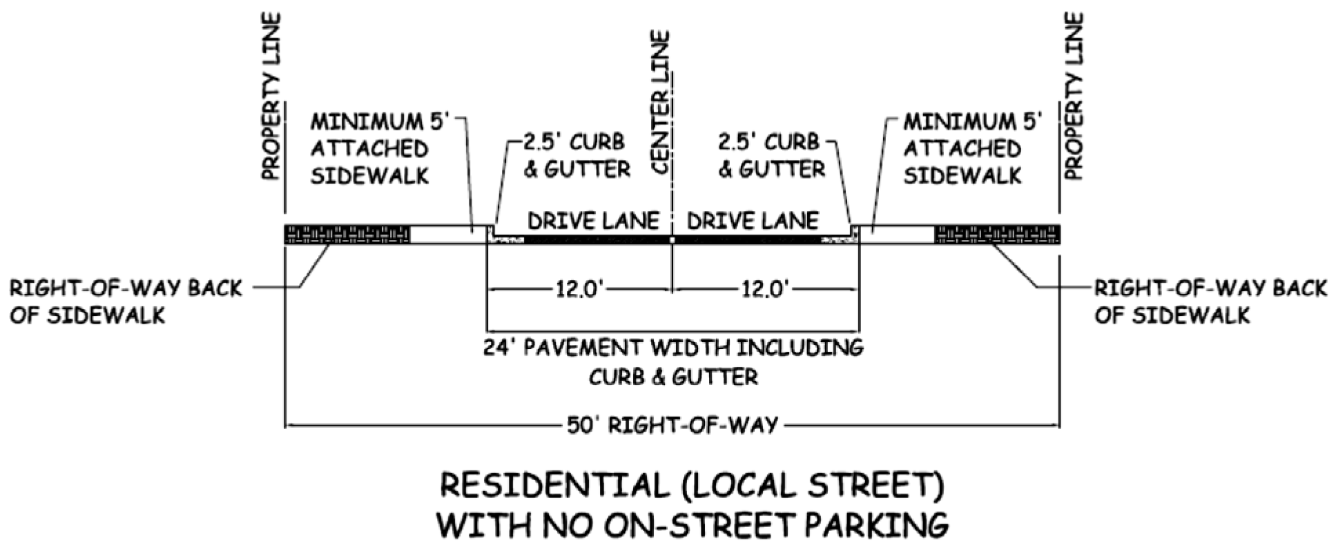
Figure 5.10-2: Cross-section for Local Streets with on-street parking.
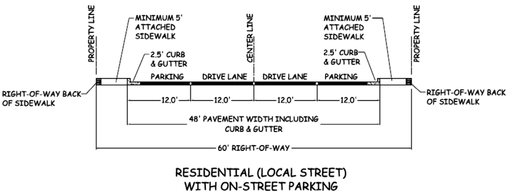
Figure 5.10-3: Cross-section for Collector Streets with on-street parking.
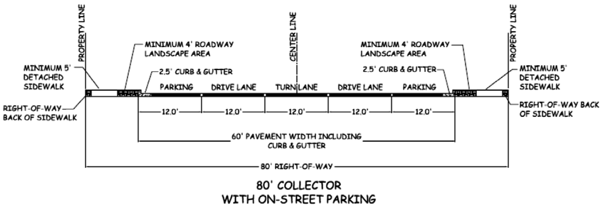
Figure 5.10-4: Cross-section for Arterial Streets with on-street parking.
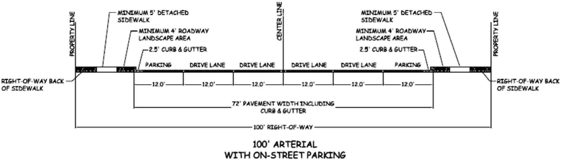
C.
Alley Cross-section
The required dimensional cross-sections for the construction of alleys within the
City shall be as depicted below in Figure 5.10-5. The minimum width of graveled or
paved alleys used for secondary access to property shall be twenty (20) feet in width.
Figure 5.10-5: Cross-section for Alleys with no on-street parking.
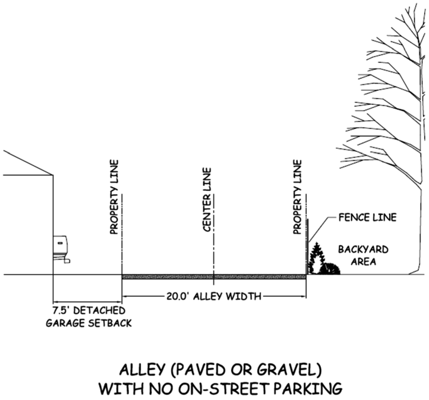
5.10.4
Emergency Access and Vehicular Circulation
All developments shall provide for a minimum of two (2) access locations to public streets to ensure adequate emergency access and vehicular circulation. Any requests to reduce the number of access locations shall be specifically requested in conjunction with a MU-PUD or PLI rezoning, Preliminary Plat, Final Plat, or Type A, B, or B-LSR Development Plan application and shall be reviewed and acted upon by the respective reviewing body.
5.10.5
Street Lights
A.
General Requirement
All street lights shall be comprised of a metal material, except as provided for in
Subsection B below.
B.
Exception to General Requirement
Agriculture, Rural Residential and Residential Estate zones may utilize wooden street
lights to preserve the rural character of the neighborhood.
C.
Installation
Street lights shall be installed according to the recommended lighting plan of the
local electric service provider.
5.10.6
Sidewalks
A.
Location and Dimensional Standards
The location and dimensional standards for construction of sidewalks shall be as identified
in the roadway cross-sections in Section 5.10.3 above. Sidewalks shall be installed
in all developed neighborhoods except as noted below. Detached concrete sidewalks
shall be a minimum of five (5) feet in width and attached concrete sidewalks shall
be a minimum of five (5) feet in width, unless otherwise required to be wider pursuant
to the roadway cross-sections in Section 5.10.3 above. Sidewalks may be attached to
curb and gutter or offset by a minimum four (4) foot wide roadway landscape area if
allowed pursuant to the respective street classification cross-section. All roadway
landscape areas shall comply with the requirements of Section 5.5.3, Street Trees/Roadway
Landscaping.
B.
Construction Requirements
The developer of a property shall be required to construct curb, gutter, and sidewalks
to comply with the standard City specifications, including approved curb profile,
curb cut requirements, concrete depth, and mix specifications and with the Wyoming
Barrier Free standards.
C.
Exceptions to Sidewalk Construction Requirement
In order to preserve the rural character of the A (Agricultural), RR (Rural Residential),
and RE (Residential Estate) zoning districts, sidewalks shall not be required unless
pedestrian access into and through such districts is necessary to provide connectivity
to a commercial development or residential neighborhood.
D.
Construction of Sidewalks in the CB-1 (Downtown Business) Zoning District
Sidewalks in the CB-1 (Downtown Business) zoning district shall be a minimum of twelve
(12) feet in width unless otherwise approved as part of a Type B or B-LSR Development
Plan. A reduction in the width of a sidewalk in the CB-1 zoning district shall only
be approved where necessary to facilitate the compatible renovation or redevelopment
of a property or when appropriate to ensure proper alignment of the sidewalk with
existing sidewalks or other existing pedestrian pathways in the area.
E.
Requirement to Continue Existing Sidewalks
New development or redevelopment that is proposed to occur adjacent to an existing
sidewalk(s) shall be required to match and continue the alignment and width of the
existing sidewalk through the site unless specifically permitted to do otherwise by
the City Council in approving a Type B or B-LSR Development Plan. The Community Development
Director shall not have the authority to allow a deviation of this requirement in
approving a Type A Development Plan. Any request for a deviation to the requirement
to match and continue the alignment and width of any existing sidewalk as part of
a Type A Development Plan shall be elevated directly to the City Council for review
and final action in the form of an appeal of a decision made by the Community Development
Director.
(Ord. No. 967, § 42, 8-10-2015)