
Eagle Lake City Zoning Code
DIVISION IV
REQUIREMENTS OF DEVELOPMENT
CHAPTER 1: - SITE PLAN REVIEW REQUIREMENTS[1]
Note— Please see division VIII, chapter 1 for definitions relating to this chapter.
CHAPTER 2: - SUBDIVISIONS[2]
Note— Please see division VIII, chapter 1 for definitions relating to this chapter.
CHAPTER 3: - SIGNS[3]
Note— Please see division VIII, chapter 1 for definitions relating to this chapter.
CHAPTER 4: - LANDSCAPING, IRRIGATION, AND TREE PROTECTION[4]
Note— Please see division VIII, chapter 1 for definitions relating to this chapter.
CHAPTER 5: - TRANSPORTATION[5]
Note— Please see division VIII, chapter 1 for definitions relating to this chapter.
CHAPTER 6: - OFF-STREET PARKING, LOADING, AND STORAGE[6]
Note— Please see division VIII, chapter 1 for definitions relating to this chapter.
CHAPTER 7: - IMPACT STATEMENT[7]
Note— Please see division VIII, chapter 1 for definitions relating to this chapter.
ARTICLE 12: - ILLUSTRATIONS
TABLE 4.4.12.1(A)
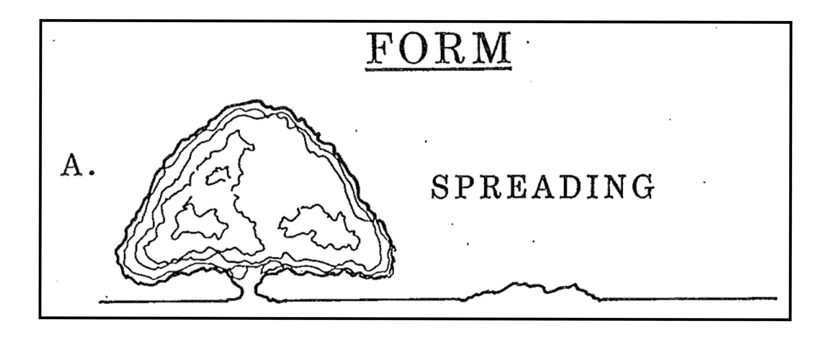
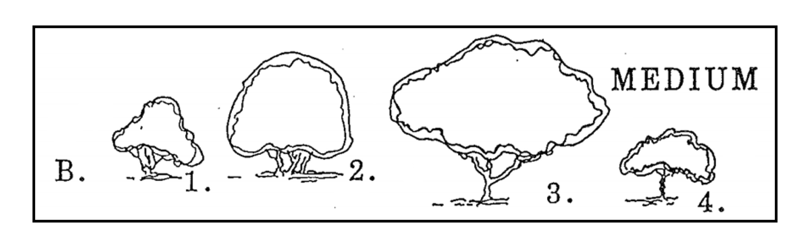
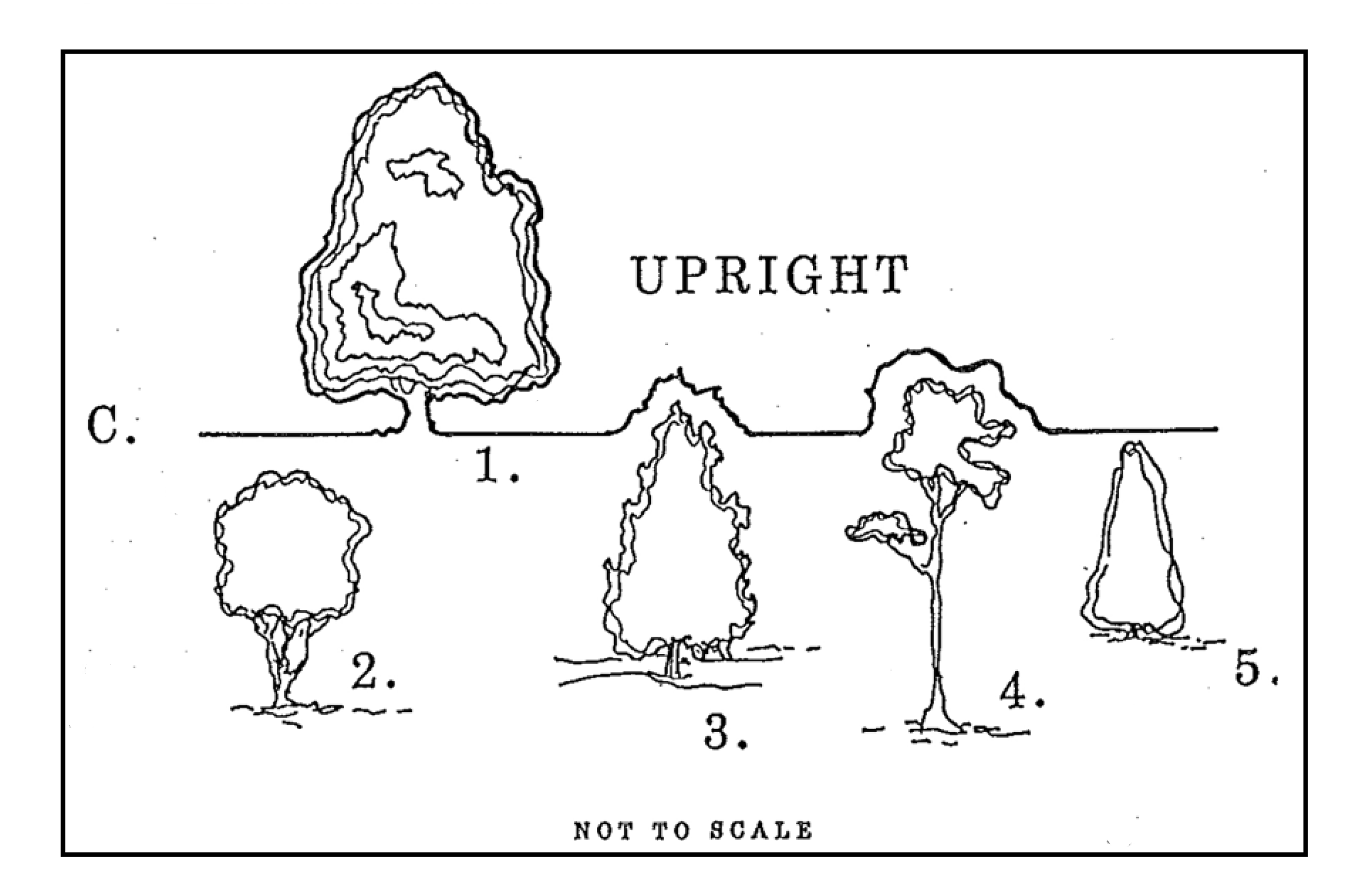
TREE SPECIES AND USE CHARACTERISTICS
Sec. 4.1.1.10. - Purpose and intent.
In order to promote safe and efficient traffic circulation, on-site parking, to prevent potential adverse effects on adjoining properties, ensure compliance with applicable zoning and development regulations, mitigate impacts to wetlands, provide for adequate buffers, and promote the orderly and efficient development of the city, all applicants for any development or redevelopment of property, including petitions for special exceptions and zoning amendments, except as may be provided for hereinafter below, shall submit a site plan as a part of the development application and review process. The level of detail required shall be determined by the category of development activity as stated below.
Sec. 4.1.1.20. - Information requirements by development activity.
The information required according to the category of development activity shall be based upon the information listed in section 4.1.1.30.
1.
Individually owned single-family detached dwelling; as per [section] 4.1.1.30(2)(A), (2)(F), (2)(N), and (2)(R).
2.
Zoning amendments not requiring an impact statement; as per [section] 4.11.30(2)(A) through (2)(M).
3.
Special exceptions not requiring an impact statement; as per [section] 4.11.30(2)(A) through (2)(T).
4.
All other new development not requiring an impact statement; as per [section] 4.11.30(2)(A) through (2)(T).
5.
Planned unit developments; as per division III, chapter 1 of the land development regulations.
Sec. 4.1.1.30. - Required site plan information.
1.
In addition to other requirements contained elsewhere in the land development regulations for all new construction, reconstruction, development, and redevelopment, a site development plan shall be submitted to the administrative official for review. All materials shall be of sufficient scale and size as to be discernible and clearly depict the site alteration and construction activity as proposed. Six sets of all documentation, plans, and materials shall be submitted for city review. When the recommendation and or approval of a city or commission is required precedent to the start of site alteration activities, the administrative official shall require additional copies of all materials in sufficient quantity for the planning commission or city commission.
2.
At a minimum, the following is required for site plan review and approval. The administrative official may require such additional information as will facilitate the determination of approval for the site plan.
A.
Location map showing the relationship of the proposed project to adjacent and area streets, parks and open spaces, lakes, utilities, adjoining properties and similar features of the city.
B.
A map showing the current land use and zoning of the site and all contiguous properties, including the names and address of all property owners within 300 feet of the site and their most current mailing address.
C.
A topographic map with contour intervals of no greater than five feet, and the delineation of the 100-year and 25-year flood plains as shown on the flood insurance rate maps, issued by the Federal Emergency Management Agency (FEMA) for the city.
D.
Name of the proposed development and name, address, and telephone number of the developer or owner and similarly those of all professionals or consultants involved in the preparation of the site plan.
E.
Scale, north arrow, and date of preparation of the plan.
F.
A dimensioned site plan at a scale of one inch equals 100 feet or less showing the proposed locations and arrangements of buildings, streets, off-street parking, required yards, open spaces, service areas, setbacks, and buffers for the development.
G.
A legal survey at a scale of one inch equals 100 feet or less prepared by a surveyor licensed by the State of Florida, indicating property boundaries and ownership of all properties included in the petition.
H.
A soils map, indicating all soils and subsoil conditions, using at a minimum Soil Conservation Service (SCS) maps and surveys; define property drainage problems.
I.
Demonstrate the methods to be used by the petitioner to protect any environmentally sensitive qualities and/or areas of the site and immediate surrounding area; describe methods to be used to protect water, air, noise, view, and related environmental considerations.
J.
Describe the general community facilities that will be used or required as a result of the proposed development.
K.
A traffic analysis, prepared by a licensed Florida professional engineer, clearly showing the project's circulation on all existing roads on or adjacent to the proposed development and containing the name of the roads, 24-hour traffic counts (where available from the county or FDOT), maintenance jurisdiction, pavement and right-of-way widths. Estimate the amount and types of vehicular traffic to be generated that will result from the proposed development and what thoroughfares will be used by the anticipated traffic.
L.
The site plan shall indicate the total floor area of each building and proposed occupancy for the total development.
M.
Describe how the proposed development is consistent with the comprehensive plan.
N.
A dimensioned site plan at a scale of 1:100 or less, except for an individually owned single-family detached dwellings which shall be at a scale of one-quarter inch to one foot or less, showing the locations and arrangements of buildings, open space, required yards, setbacks, buffers, signs as applicable and related features of the development. The site plan shall indicate the approximate total floor area of each building and for the total development.
O.
A topographic survey at a maximum of two-foot contour intervals and at a corresponding scale to the boundary survey.
P.
Show lot arrangements, typical lot sizes and dimensions, streets, ingress and egress and sizes, parking and off-street loading facilities, and sign locations.
Q.
The gross density in dwelling units per acre for each type of residential use and/or the size and type of commercial, industrial, or other proposed land uses.
R.
A drainage plan, prepared by a Florida licensed professional engineer, which provides a solution for retaining the first one inch of rainfall, based on a 25-year frequency storm on site and where and how the excess rainfall will be disposed.
S.
Estimate the potable water and waste water requirements necessary for the proposed development and methods to be utilized to meet these needs.
T.
A phasing plan, if the project is to be built in more than one phase of development.
Sec. 4.2.1.10. - Purpose.
The purpose of this chapter is to promote and protect the public safety, comfort, economy, order, appearance, convenience, morals, and general welfare of the city residents which requires the harmonious, orderly, and progressive development of land within the corporate limits of the city. The regulation of the subdivision of land is intended to accomplish the following:
1.
To provide coordination of land development within the city in accordance with orderly physical patterns;
2.
To require fiscal responsibility and stable land development by avoiding haphazard, premature, uneconomic, or scattered land development;
3.
To ensure the adequate provision of safe and convenient traffic access and circulation, including motorized, non-motorized, and pedestrian traffic within new development;
4.
To ensure the adequate provision of streets, utilities, and other facilities and services to development at the level of service adopted by the city;
5.
To prevent periodic and seasonal flooding by requiring protective flood control and stormwater management facilities;
6.
To provide public open spaces for recreation and building sites in new developments through the dedication or reservation of land for recreational, educational, and other established public purposes;
7.
To ensure that the residents and taxpayers of the city will not have to bear the costs resulting from haphazard subdivision of land and the lack of authority to require installation by the developer of adequate and necessary physical improvements;
8.
To ensure to the consumer that necessary site improvements meeting uniform quality standards have been installed;
9.
To assure equitable processing of all subdivision plans and plats by providing uniform procedures and standards to be utilized by the developer and the city; and
10.
To serve as one of the several instruments utilized by the city to implement the provisions of the adopted comprehensive plan.
Sec. 4.2.2.10. - Procedures for resubdivision of four or less platted lots.
Where it is proposed to resubdivide four or less lots which have been previously platted and recorded, where no new street is required, and which have a total combined area of less than 60,000 square feet, the procedures shall be as follows:
1.
The petitioner shall submit to the administrative official six copies of a preliminary sketch plat prepared by a Florida registered engineer or surveyor at a scale of one inch equals not less than 50 feet, indicating the nature of the proposed resubdivision, and submit ten copies of the preliminary sketch plat to the administrative official at least 14 days prior to the city commission meeting, at which time the proposed resubdivision is to be considered. The following information shall be clearly shown on the sketch plat:
A.
Identification of present lots, including lot numbers, and subdivision designation.
B.
Names of streets abutting or running through the proposed resubdivision.
C.
Existing and proposed lot pattern, including dimensions.
D.
Existing alleys and easements, dedications for street widening, alley or street closing, and similar conditions.
E.
Methods to be used to meet FDEP and water management district drainage requirements.
2.
City staff shall review the preliminary sketch plat prior to submittal to the city commission for adequacy in meeting applicable requirements of this chapter and any applicable provisions of the land development regulations. Such preliminary sketch plat shall not be submitted to the city commission until all applicable requirements are met.
3.
Within ten days after the meeting at which the proposal is considered, the city commission shall indicate on all copies of the preliminary sketch plat (1) approval as submitted; (2) conditional approval, stating conditions recommended; or (3) disapproval, with reasons therefor; and shall transmit two copies to the petitioner while retaining four copies for the city files.
4.
Final plats shall be submitted to the administrative official 14 days prior to the next regularly scheduled city commission meeting following preliminary sketch plat approval. Final plats shall be reviewed by the city staff for recommendations of approval, approval with modifications, or denial prior to submittal to the city commission.
5.
After the city commission has approved the final plat, the following actions shall be taken:
A.
The original drawing sheets of the final plat(s), drawn on vellum or Mylar materials, shall be signed immediately following the conclusion of the city commission meeting by the mayor, developer, and any other applicable parties to platting.
B.
The signed original drawing sheets of the final plat(s), any other instruments to be recorded in connection with the plat(s) and the required filing fee shall then be turned over to the city clerk.
C.
The city clerk shall be responsible for seeing that the signed original drawing sheets of the final plat(s) and other instruments to be recorded in connection with the plat are recorded with the clerk of the court of Polk County.
D.
Written notice of recording of the final plat(s) and other instruments by the city clerk shall be made to the building official prior to the building department issuing any permits for the development.
E.
All filing fees and related cost for the city to record the plat(s) and other instruments shall be at the expense of the developer.
6.
The engineer or surveyor for the project shall provide, in addition to the Mylar and blueline record documents, a complete set of record plat documents, in computerized form to the city. This documentation shall be DOS-compatible, in the most current version of AutoCAD or DXF format. The diskettes may be either 5¼ or 3½ inches. In addition, the engineer or surveyor shall provide a document listing the layers and colors/line types utilized in preparation of the drawings.
Sec. 4.2.2.20. - Procedures for small lot subdivisions with existing improvements.
Where it is proposed to subdivide four or less lots that will front on an existing public street which is served by existing water and sewer, solid waste disposal, and related public services, all at a level of service sufficient to accommodate the proposed land uses without any enlargement or expansion, the provisions of section 4.2.2.10 above shall apply.
Sec. 4.2.2.30. - Procedures for other subdivision or resubdivision.
1.
Pre-application procedure.
A.
Prior to filing of an application for conditional approval of the preliminary plat, the developer shall submit to the administrative official six sets of the concept plans and data as specified in this chapter. Application fees shall be paid to the city with this submittal.
B.
Within 15 days, the administrative official shall inform the developer, based upon city staff review that the concept plans and data as submitted or as modified do or do not meet the objectives of this chapter. When the administrative official finds the concept plans and data do not meet the objectives of the regulations, he shall express his reasons in writing, retaining four copies for city records and submitting two copies to the developer or his agent(s).
C.
If concept plans and data are determined not to meet the objectives of this chapter and the developer wishes to proceed, then revised concept plans and data shall be submitted to the administrative official for review and recommendations. Then the provisions of [section] 4.2.2.30(1)(B) above shall apply.
2.
Procedure for conditional approval of preliminary plat.
A.
On reaching conclusions on concept plans, as required in [section] 4.2.2.30(1) above, regarding the general program and objectives, the developer shall cause to be prepared by a Florida registered engineer or surveyor a preliminary plat, together with improvement plans and other supplementary material as specified in article 5 of this chapter.
B.
Six copies of the preliminary plat and specified supplementary material shall be submitted to the administrative official with written application for conditional approval at least 20 days prior to the meeting at which it is to be considered.
C.
One copy of the preliminary plat shall be forwarded to the city commission and five copies to the city staff for review with each to be returned to the administrative official 15 days after receipt, showing comments, revisions, and recommendations.
D.
Following a review of the preliminary plat by city staff and the appropriate agencies and other material submitted for conformity thereof with the regulations of this chapter, and negotiations with the developer on changes required and the kind and extent of improvements to be made, if necessary, the planning commission shall, within 30 days, act thereon as submitted, or modified, and if approved, the planning commission shall express in writing, its approval as conditional approval and state the conditions of such approval, if any, or if disapproved, shall express its disapproval and its reasons. Plans shall not be submitted for planning commission review until all required data and conditions have been met by city staff. This recommendation shall be forwarded to the city commission for their review and action. The city commission shall, within 30 days, act upon the petition.
E.
The action of the city commission shall be noted on all copies of the preliminary plat, referenced, and attached to any conditions established. Two copies shall be returned to the developer, his agent or agents, and the others retained by the administrative official.
F.
Conditional approval of the preliminary plat shall not be binding on the city and shall not constitute approval of the final plat. Rather, it shall be deemed an approval of the concept to the layout submitted on the preliminary plat and serve as a guide to the preparation of the final plat. The final plat will be submitted for approval of and acceptance by the city commission and for recording upon fulfillment of the requirements of these regulations and the stipulations contained in the conditional approval, if any.
G.
If it is determined to be necessary to hold an advertised public hearing on any subdivision development plan and plats submitted to the planning commission and city commission for consideration, the parties in interest shall be notified by due public notice with the petitioner paying the necessary fees for public hearing notices and related cost.
3.
Construction plans.
A.
Following conditional approval of the preliminary plat, the developer shall prepare the necessary construction plans and specifications for all proposed subdivision improvements as specified in article 4 of this chapter. These construction plans shall be prepared by a Florida registered engineer and in conformity with these regulations. Approvals for water supply, sanitary waste disposal, and surface and stormwater management systems shall be received in writing from the appropriate state and local agencies and made a part of the submission.
B.
To secure formal action on construction plans and specifications prior to obtaining final approval of the plat, the developer shall submit to the administrative official six sets of prints of the construction plans and specifications and written approval of the appropriate state and local agencies. The city staff shall review the construction plans, specifications, and approval of other applicable agencies and notify the administrative official of their findings. The administrative official shall notify the developer in writing of the approval or disapproval within 30 days of the action taken.
C.
Approval shall mean the developer is now authorized to proceed with the construction of the physical site improvements in the subdivision after securing required construction permits and to submit the final plat for processing and recording. The developer shall be provided two copies of the approved construction plans, signed by the administrative official, with the city retaining four copies of such approved and signed plans.
D.
Conditional approval means the developer may proceed as outlined in the preceding paragraphs, but only after he has submitted six copies of the revised construction plans to the administrative official with changes as recommended by the city staff.
E.
Disapproval means that the developer must revise his plans to conform to the changes as recommended by the city staff and resubmit them for approval as provided for in this section.
4.
Procedure for approval of final plat.
A.
The final plat shall conform substantially to the preliminary plat as approved, and, if desired by the developer, it may constitute only that portion of the approved preliminary plat which he proposes to record and develop at the time, provided however, that such portion conforms to all requirements of these regulations.
B.
Application for approval of the final plat shall be submitted in writing to the administrative official at least 14 days prior to the meeting at which it is to be considered by the city commission.
C.
Six copies of the final plat and other exhibits required for approval shall be submitted as specified to be reviewed by the city staff to determine if all applicable requirements contained in this chapter are met. Such plats shall be submitted to the administrative official within 12 months after approval of the preliminary plat. Otherwise, such approval shall become null and void unless an extension of time is applied for and granted by the city commission.
D.
Accompanying the final plat shall be: final plat application fee, final approval construction plans, required documents, exhibits, legal instruments to guarantee performance, attorney's opinion or title insurance regarding the title of the property subdivided, properly executed certificates from the Department of Health, Florida Department of Environmental Protection, and other required agencies and parties as required by these regulations, along with a written request from the developer for final approval of the plat.
5.
Actions taken after approval. After the city commission has approved the final plat, the following actions shall be taken:
A.
The original drawing sheets of the final plat(s), drawn on vellum or Mylar materials, shall be signed immediately following the conclusion of the city commission meeting by the mayor, developer, and any other applicable parties to platting.
B.
The signed original drawing sheets of the final plat(s), any other instruments to be recorded in connection with the plat(s) and the required filing fee shall then be turned over to the city clerk.
C.
The city clerk shall be responsible for seeing that the signed original drawing sheets of the final plat(s) and other instruments to be recorded in connection with the plat are recorded with the clerk of the court of Polk County.
D.
Written notice of recording of the final plat(s) and other instruments by the city clerk shall be made to the building official prior to the building department issuing any permits for the development.
E.
All filing fees and related cost for the city to record the plat(s) and other instruments shall be at the expense of the developer.
6.
Proof of recordation. Building permits shall not be issued until proof of plat recording is furnished to the administrative official.
Sec. 4.2.3.10. - General provisions.
The goals, objectives, and policies adopted as a part of the traffic circulation element of the comprehensive plan shall serve as the guiding principles for the sections herein with regard to street network function, layout, and safety features.
Sec. 4.2.3.20. - Streets and alleys.
For streets and alleys, see division IX, appendix F of these land development regulations.
Sec. 4.2.3.30. - Easements.
1.
In general, easements shall be prohibited. However where no other solution is available, easements across lots or centered on rear or side lot lines shall be at least 15 feet wide. Such variation shall be reviewed by the city (consulting) engineer and approved only if conditions warrant such easement. Where utility and/or drainage easements are planned adjacent to a subdivision boundary or development phase line, the full easement width necessary shall be platted within the proposed subdivision or development phase.
2.
Where a subdivision is traversed by a water course, drainage way, channel, or stream, there shall be provided a storm water easement or drainage right-of-way conforming substantially with the lines of such water course, and such further width or construction, or both, as will be adequate for the purpose. Parallel streets or parkways may be required in connection therewith.
3.
Where indicated in the future land use and traffic circulation elements, and in such other areas as the city commission and developers may agree, pedestrian and service easements shall be provided. Such pedestrian and service easements may include, or be included in, easements as required above.
4.
Where utilities are placed in easements, no fences, planting, or structures of a permanent nature shall be located on or within such easement.
Sec. 4.2.3.40. - Blocks.
As used in this chapter, a block is a group of lots entirely surrounded by streets, railroad right-of-way, water courses, subdivision boundaries, or any combination thereof.
1.
The lengths, widths, and shapes of blocks shall be determined with due regard to:
A.
Provision of adequate building sites suitable to the special needs of the type of use contemplated;
B.
Zoning requirements as to lot sizes and dimensions;
C.
Needs for convenient access, circulation, control, and safety of street traffic; fire protection;
D.
Limitations and opportunities of topography, natural resources, and features.
2.
Block lengths shall not exceed 1,000 feet, or be less than 500 feet, except where substantial public purposes can be demonstrated for modifications of these lengths and as may be approved by the city commission. In blocks over 1,000 feet in length, the city commission may require one or more public crosswalks with a right-of-way not less than ten feet and to extend entirely across the block and at locations deemed necessary. Cul-de-sac or "T" block arrangements may be less than 500 feet in length.
Sec. 4.2.3.50. - Lots.
1.
As used in this chapter a lot is a portion of a subdivision intended for transfer of ownership as a unit, or for development as a unit or both, the boundaries of which have been clearly designated upon the plat. This definition is deemed to be in furtherance of the lot definition in division VIII, chapter 1 of the land development regulations.
2.
The lot size, width, depth, shape, and orientation, and the minimum building setback lines shall be appropriate for the location of the subdivision and for the type of development and use contemplated.
3.
Lot dimensions shall conform to the requirements of the zoning requirements and:
A.
Residential lots, where not served by public sewer, shall be of a size and dimension approved by the Department of Health but in no case less than as specified in the zoning requirements.
B.
Depth and width of properties reserved or designated for commercial and industrial purposes shall be adequate to provide for the off-street service and parking facilities required by the type of use and development contemplated.
4.
Corner lots for residential use shall have extra width meeting zoning requirements to permit minimum building setback from and orientation to both streets.
5.
The subdividing of the land shall be such as to provide by means of a public street or an approved private street, each lot with satisfactory access to an existing public street. In no case shall a lot be less than 24 feet in width at the front property line.
6.
Double frontage, and reverse frontage lots, shall be avoided except where essential to provide separation of residential development from arterial streets or to overcome specific disadvantages of topography and development orientation. A planting buffer easement of at least ten feet and across which there shall be no right of access shall be provided along the line of lots abutting such an arterial street or other incompatible use, and as may be required in the zoning regulations.
7.
Side lot lines shall be substantially at right angles or radial to street lines. Unless otherwise approved, no lot shall have an interior angle less than 30 degrees.
Sec. 4.2.3.60. - Public sites and open spaces.
1.
Where a proposed park, playground, school, or other public use shown in the comprehensive plan is located in whole or in part in a proposed subdivision site, the city commission shall require the dedication or reservation of such areas within the subdivision. All sites designated in subdivision plats for public use shall be dedicated in the plat and deeded to the city for this purpose.
2.
In order to provide adequate recreation sites and facilities for the residents of the city, in accordance with the goals, standards, policies, and plans of the recreation and open space element, a recreation impact fee shall be charged for each new dwelling constructed after adoption of this chapter. The recreation impact fee shall be established by the city commission and collected at the time of building permit application. Such fees shall be held in escrow and used by the city only for the purpose of acquiring lands for parks and recreation and improvements thereon. Such lands and improvements shall be as near as practical to the fee payers, depending upon needs as established in the recreation and open space element.
3.
When required by the comprehensive plan or deemed essential by the city commission, upon consideration of the particular type of development proposed in the subdivision and especially in large-scale planned developments, the city commission may require the dedication or reservation of such other areas or sites of character, extent, and location suitable to the needs created by such development for schools, parks, and other neighborhood purposes. Such sites shall be made available by the developer to the governmental agency responsible for such facilities for their acceptance for a period of two years. If the applicable governmental agency fails to purchase or make arrangements for the acquisition of the site within the two-year period, the city commission shall be required to review the continued need of the reserved sites and may extend the reservation for another two-year period. Subsequent reviews on a two-year time basis shall be required until a determination is made by the city commission that the reserved sites are no longer required or necessary. If it is determined by the city commission that the reserved sites are no longer required or necessary then the developer may replat the reserved site for uses compatible with the development and in accordance with the comprehensive plan.
4.
If a significant surface drainage course or water body is located in an area being considered for subdividing, the city commission may require the dedication of lands or easements along each side of the drainage course or water body for the purpose of widening, deepening, sloping, ponding, improving, or protecting the drainage course or water body for drainage, parkway, or recreational purposes.
Sec. 4.2.4.10. - Monuments.
1.
Monuments shall be placed in all block corners, angle points, points of curves in street rights-of-way, and intermediate points but not to exceed 1,400 feet apart. At least one permanent bench mark shall be set in each subdivision, properly referenced, for both construction use and future city use. The location of all monuments shall be indicated on the final plat. On public lands, a cross mark cut in a concrete structure will suffice. On other lands the monuments shall be four inches by four inches concrete, at least 24 inches long, said monuments having the reference point marked thereon. The name of the surveyor shall be placed on all monuments.
2.
All original land corner monuments shall be protected throughout the development. Should any monuments, iron pipes, or iron pins serving as monuments fall within pavements, driveways, or sidewalks, they shall be secured to proposed grades by eight inch concrete pipes and a cast iron cap for access to the original monument. Any and all land monuments disturbed or destroyed in the process of construction shall be accurately witnessed and replaced upon completion of construction.
Sec. 4.2.4.20. - Street markers.
The developer will furnish and install street markers at all intersections. Such street markers will be of the quality and design approved by the city.
Sec. 4.2.4.30. - Utility and street improvements.
See division IX, appendix F of these land development regulations.
Sec. 4.2.4.40. - Sidewalks.
See division IV, chapter 5, article 7 of these land development regulations.
Sec. 4.2.5.10. - Pre-application plans and data.
In connection with subdivision or resubdivision other than resubdivision of four or less lots and as provided otherwise in this chapter, the following regulations apply:
1.
General subdivision information shall describe or outline the existing conditions of the site and the proposed development as necessary to supplement the drawings required below. This information shall include data on existing covenants, land characteristics, and available community facilities and utilities; and information describing the subdivision proposal such as number of residential or nonresidential lots, typical lot width and depth, land uses, playgrounds, park areas, and other public areas, proposed protective covenants, and proposed utilities and street improvements.
2.
The location map shall show the relationship of the proposed subdivision to existing community facilities which serve or impact it. Included shall be the development name and location, main traffic arteries, public transportation lines, shopping centers, elementary and high school, parks and playgrounds, principal places of employment, other community features such as railroad stations, airports, hospital and churches, title, scale, north arrow, and date.
3.
The sketch plan on topographic survey shall show in simple form the proposed layout of streets, lots, and other features in relation to existing conditions. The sketch shall include approximate locations of proposed stormwater management facilities and outfall points, nearest point of connection to city sanitary sewer and water facilities and approximate location of lift stations, if required. Additional data may be required if city staff decides that such information is required for a conceptual review. The sketch may be a free-hand sketch made directly on a copy of the topographic survey. In any event, the sketch plan shall include as a minimum the information listed in section 4.2.5.20(1) below.
Sec. 4.2.5.20. - Plats and data for conditional approval.
A topographic map and data is required as a basis for the preliminary plat, and shall include existing conditions as follows except when otherwise specified by the planning commission:
1.
Key plan showing location of the tract in relation to the total community.
2.
Boundary lines: Bearings and distances of present property and/or section lines.
3.
Easements: Existing location, width, and purpose.
4.
Streets on and adjacent to the tract: Name and right-of-way width and location; type, width and elevation of surfacing; and legally established centerline elevations; walks, curbs, gutters, culverts, and related information.
5.
Utilities on and adjacent to the tract: Location, size, and invert elevation of sanitary, storm, and combined sewers; location and size of water mains; location of gas lines, fire hydrants, overhead and underground electric and telephone systems, and street lights; if water mains and sewers are not on or adjacent to the tract, the direction and distance to, and size of nearest such systems, showing invert elevation of sewers. Provide plans and sections showing extension of lines to proposed subdivision.
6.
Proposed and existing ground elevations on the tract: Based on U.S.G.S. datum level shall be shown at one-foot contour intervals.
7.
Other conditions on the tract: Water courses, marshes, wetlands, wooded areas, preservable trees with four inch caliper measured four feet above ground, houses, structures, and other significant features.
8.
Other conditions on adjacent land: Approximate direction and gradient of ground slope, including any embankments or retaining walls; character and location of buildings, railroads, power lines, towers, and other nearby nonresidential land uses or incompatible influences; owners of adjacent unplatted land; for adjacent platted land refer to subdivision plat by name, recording date, and number, and show approximate percent built-up, typical lot size, and dwelling type.
9.
Subsurface conditions on the tract: Location and results of tests made to ascertain subsurface soil, rock, and groundwater conditions; depth of ground water unless test pits are dry at a depth of five feet; location and results of soil percolation tests if individual sewage disposal systems are proposed. If on-site percolation of stormwater is proposed, a double ring infiltrometer test shall be provided at each proposed retention pond.
10.
Photographs: If required, show camera locations, directions of views, and key numbers.
11.
Zoning: On and adjacent to the tract.
12.
Proposed public improvements: Highways or other major improvements planned by public authorities for future construction on or near the tract.
13.
Title and certificates: Legal description of proposed development; title under which proposed subdivision is to be recorded, with names and addresses of owners, notation stating acreage, scale, north arrow, datum, bench marks, certification of registered surveyor of compliance with minimum technical standards according to Florida laws regulating practice and date of survey. Developer shall also submit a title certification as required by chapter 177, Florida Statutes.
Sec. 4.2.5.30. - Preliminary construction plans and preliminary plat.
1.
Preliminary construction plans shall be submitted and approved prior to submittal of the preliminary plat. The preliminary construction plans shall show, in preliminary form, all improvements to be installed on the tract. The plans shall be reviewed by the city staff for compliance with these regulations and with all applicable city, county, and state regulations. Preliminary construction plans shall include as a separate sheet, a topographic survey including all information required in section 4.2.5.20 above. In addition, the preliminary construction plans shall indicate:
A.
Boundary lines.
B.
Proposed easements: Location, width, and purposes.
C.
Proposed streets: Right-of-way width and location; type and width of construction; sidewalks; curbs; and related information. A cross section of the proposed right-of-way indicating the roadway construction and the location of utilities in relationship to the roadway and rights-of-way shall be supplied.
D.
Proposed utilities: Location of proposed water, sanitary sewer, and force main lines; location and approximate size of lift station; required off-site lines for connection to existing utilities.
E.
Proposed stormwater management facilities: Drainage map at a scale of no less than one inch equals 50 feet [unless previously approved by city (consulting) engineer] indicating watershed boundaries, including off-site contributing areas; approximate area and volume of each stormwater management facility; total area draining to each facility; approximate percentage impervious in each basin; SCS mapping of the site with soils survey classification; and infiltration rate determined by double-ring infiltrometer testing for those projects having no positive outfall. On construction plans, indicate approximate locations of stormwater management facilities; drainage paths to outfall points, if any; any required off-site improvements and approximate locations of stormwater conveyance facilities. Identify the legal entity which will be responsible for maintaining the stormwater management facilities.
2.
Preliminary plat (general subdivision plan) shall be at a scale of no less than one inch equals 50 feet. It shall show all existing conditions required above in section 4.2.5.20, topographic data, and shall show all proposals including the following:
A.
Streets: names; right-of-way and roadway widths; approximate grades and gradients; similar data for alleys, if any.
B.
Other rights-of-way or easements: locations, width, and purpose.
C.
Location of utilities: if not shown on other exhibits.
D.
Lot lines, lot numbers and block numbers.
E.
Sites, if any, to be reserved or dedicated for parks, play grounds, or other public uses.
F.
Sites, if any, for multifamily dwellings, commercial areas, shopping centers, churches, industry, or other non-public land uses, exclusive of single-family dwellings.
G.
Minimum building setback lines.
H.
Site data: include number of residential and nonresidential lots, typical lot size, and acres in parks.
I.
Title, scale, north arrow, and date.
3.
When required by the city (consulting) engineer, the preliminary plat shall be accompanied by profiles showing existing ground surface and proposed street grades, including extensions for a reasonable distance beyond the limits of the proposed subdivision; typical cross sections of the proposed grading, roadway, and sidewalk; pedestrian and service easement and preliminary plan for proposed sanitary and storm water sewers with grades and sizes indicated. All elevations shall be based on a U.S.G.S datum plane.
4.
The developer shall provide traffic impact and environmental reports regarding the land to be subdivided and the development impact on adjoining properties with regard to natural resources and features.
5.
Protective covenants, in draft form, whereby the developer proposes to regulate structural and other improvements in the subdivision to protect the proposed development, shall be provided the city for city staff review.
Sec. 4.2.5.40. - Final construction plans and specifications.
Final construction plans and specifications shall be submitted and approved before submittal of the final plat. These plans shall indicate in final form all proposed construction on the project site and all required off-site improvements. The final plan sheets shall be drawn at a scale no less than one inch equals 50 feet, on more than one sheet when necessary and shall consist of the below material and data.
1.
A topographic map conforming to section 4.2.5.20 above.
2.
Plan sheets indicating all proposed boundaries, phase lines, rights-of-way, easements, including purpose and size; lot sizes and location and proposed streets.
3.
Proposed streets: Plan and profile sheets for all proposed roads showing right-of-way width and location; proposed elevations; return curve profiles; connections to existing streets; type and width of construction; sidewalks; curbs; a cross-section of the proposed right-of-way indicating the roadway construction and the location of utilities in relationship to the roadway and rights-of-way.
4.
Proposed utilities: Plan and profile sheets showing elevations and location of proposed water, storm sewer, sanitary sewer, and force main lines; location and size of lift station(s), including construction details; required off-site lines for connection to existing utilities; location and handling of any water/sanitary sewer conflicts; location of proposed electrical, gas, telephone, and CATV underground cables and equipment.
5.
Proposed stormwater management facilities: Drainage map indicating watershed boundaries, including off-site contributing areas; area and volume of each stormwater management facility, including stage-storage-discharge information; total area draining to each facility; approximate percentage impervious in each basin; SCS soils mapping with soils survey classification; depth to water table, and infiltration rate determined by double-ring infiltrometer testing for those projects having no positive outfall. On construction plans, indicate locations of stormwater management facilities; drainage paths; and locations of stormwater conveyance facilities; provide legal documents establishing entity to maintain stormwater management facilities and remedies for non-performance.
6.
Proposed ground elevations on the tract, based on U.S.G.S. datum, shown at one-foot contour intervals.
7.
Title and certificates as described in section 4.2.5.20 above.
8.
Technical specifications: A complete set of all technical specifications applicable to the work to be performed including a list of estimated quantities of construction items.
Sec. 4.2.5.50. - Plats and data for final approval.
1.
Final plats shall be drawn or plotted in ink on tracing materials on sheets as required for filing for record in the county, and in accordance with design standards and provisions of chapter 177, Florida Statutes (platting). Where necessary, the plat may be on several sheets accompanied by an index sheet showing the entire subdivision. For large subdivisions, the final plat may be submitted for approval progressively in contiguous sections satisfactory to the city commission. The final plat shall show the following:
A.
Primary control points, approved by the city (consulting) engineer or descriptions and "ties" to such control points, to which all dimensions, angles, bearings, and similar data on the plat shall be referred.
B.
Tract boundary lines, right-of-way lines of streets, easements and other rights-of-way, and property lines of residential and nonresidential lots and other sites; with accurate dimensions, bearings or reflection angles, and radii, arcs, and central angles of all curves.
C.
Name and right-of-way width of each street or other right-of-way.
D.
Location, dimensions, and purpose of any easement(s).
E.
Number to identify each lot or site.
F.
Purpose for which sites are dedicated or reserved.
G.
Minimum building setback line on all lots and other sites.
H.
Location and description of monuments.
I.
Names of record owners of adjoining unplatted land.
J.
Reference to recorded subdivision plats of adjoining platted land by record name, date, and number.
K.
Certification by surveyor or engineer certifying to accuracy of survey and plat.
L.
Certification of title showing that applicant is the land owner.
M.
Statement by owner dedicating streets, rights-of-way and any sites for public uses.
N.
Title, scale, north arrow, and date.
2.
Cross sections and profiles of streets showing grades approved by the city (consulting) engineer. The profiles shall be drawn to city standard scales and elevations shall be based on a U.S.G.S. datum plane.
3.
A certificate by the city (consulting) engineer certifying that the developer has complied with one of the following alternatives:
A.
All improvements have been installed in accord with the requirements of these regulations and with the action of the city commission giving conditional approval of the preliminary plat; or
B.
A surety bond or letter of credit executed by a corporation authorized to do business in the state that is satisfactory to the city, or a certified check has been posted, which is available to the city, in an amount of 120 percent of the estimated completed construction cost as determined by the city (consulting) engineer. This estimate shall be based upon recent construction costs to assure such completion of all required improvements. A construction beginning and completion time period shall be required by the city commission and expressed in the bond agreement to secure to the public the actual construction and installation of improvements as required by these regulations.
4.
Developer's agreements. The developer shall have entered into an agreement, in form for recording, with the city specifying the following:
A.
The work to be done and the time specified therefor by the developer.
B.
The alternatives, if any, accepted by the city commission but meeting city standards.
C.
The participation in the development, if any, by the city and the time for completion of such work.
D.
The lien, if any, imposed upon the land being developed for any work performed by the city.
E.
The conditions under which building permits will be allowed within the subdivision by the city.
F.
The conveyance by the developer to the city of all water, sewer, and storm sewer lines installed within dedicated public rights-of-way and/or easements.
G.
The agreement of the developer to maintain and repair all public streets constructed by the developer in the subdivision for a period of one year after completion of the same, and prior to acceptance of maintenance thereof by the city.
5.
Protective covenants in form for recording.
6.
Other data: Such other certificates, affidavits, endorsements, or deductions as may be required by the city commission in the enforcement of the regulations including the following:
A.
Maintenance agreement: The developer shall have provided the city evidence of establishment of a property owners association or other legal entity acceptable to the city commission and an agreement, in form for recording, between said association (or entity) and the city specifying the following:
1.
The legal establishment of the property owners association or other entity.
2.
The responsibility and ability of the property owners association or other entity to raise monies necessary for agreed upon common maintenance and operations.
3.
The agreement of the property owners association or other entity to maintain in working order all utilities, fire hydrants, and roadways not dedicated to the city.
4.
The agreement of the property owners association or other entity to maintain stormwater retention/detention facilities, if any.
B.
Said agreement between the city and property owners association or other entity shall be recorded upon approval of final plat and proof thereof provided to the city.
Sec. 4.2.5.60. - Computer documentation.
The engineer or surveyor for the project shall provide, in addition to the Mylar and blueline record documents, a complete set of record plan documents, in computerized form to the city. This documentation shall be on DOS-compatible diskettes, in AutoCAD 11 or DXF format. The diskettes may be either 5¼ or 3½ inches. In addition to the diskette(s), the engineer or surveyor shall provide a document listing the layers and colors/line types utilized in preparation of the drawings.
Sec. 4.2.6.10. - Requirements.
No building shall be erected on a lot or parcel of land within the city, nor shall any building permit be issued thereto unless the street giving access to the lot or parcel on which such building is proposed to be placed has been accepted and opened as a public street or has otherwise received the legal status of a public street or such street has been accepted by the city and is shown on a recorded subdivision plat or is a private street dedicated for the use of certain lots or parcels but not accepted for maintenance by the city or available for use by the public.
Sec. 4.2.7.10. - Owner applicant.
The owner of any land subdivided into lots may file to record a plat for the purpose of showing such land as acreage. Such plat and the procedure in connection therewith shall conform to the requirements of these regulations and chapter 177, Florida Statutes, except that:
1.
No survey or certificate of any surveyor or engineer shall be required; provided, however, that the city commission may require a survey of the exterior boundaries of the land and the placing of suitable monuments along such boundaries if the city staff finds that the last preceding survey of record is faulty or inadequate or that insufficient monuments are in position along such boundaries and recommends such action be taken.
2.
No improvements shall be required, except such as may be necessary to provide equivalent access, as provided hereafter in this chapter and the applicable provisions of the land development regulations.
3.
No findings need to be made as to the suitability of the land or as to the provision of public facilities and services therefor.
Sec. 4.2.7.20. - City initiation.
The city commission may, on its own motion, order the vacation and revision to acreage all or any part of a subdivision within its jurisdiction. This action may include the vacation of streets or other parcels of land dedicated for public purposes or any of such streets or other parcels if the plat of such subdivision was recorded as provided by law not less than five years before the date of such action. Such steps may only be taken when the subdivision or part thereof has not had more than ten percent of the total subdivision area sold as lots by the original subdivider or their successor in title. Such action shall be based on findings by the city staff that the proposed vacation and revision to acreage of subdivided land conforms to the comprehensive plan and that the public health, safety, economy, comfort, order, convenience, and welfare will be promoted thereby. Before action on a proposal for vacation and revision of subdivided land to acreage, the city commission shall hold a public hearing thereon, with due public notice with all affected parties so notified in writing of the contemplated action.
Sec. 4.2.7.30. - Effect on zoning.
1.
If land in a subdivision or part thereof is proposed for revision to acreage, either at the initiation by the city or by filing a plat by the owner, the city shall, upon recommendation of the city staff and concurrently with the proceedings for vacation and revision to acreage, or for consideration of an action on such plat, conduct proceedings for amendment of the zoning map as may be deemed advisable in view of the conditions that will exist subsequent to such revision to acreage.
2.
No owner of any parcel of land in a subdivision shall be deprived, by the revision to acreage of all or any part of the subdivision, of reasonable access to such parcel nor of reasonable access there from to existing facilities to which such parcel has theretofore had access; provided that such access remaining or provided after such vacation need not be the same as that theretofore existing, but shall be reasonably equivalent thereto.
Sec. 4.2.8.10. - Hardships.
Where the city commission finds that extraordinary hardships may result from strict compliance with the requirements of this chapter, or where topographic or other conditions peculiar to the site exist, it may vary the requirements of this chapter so that substantial justice may be done and the public interest secured; provided that such variation will not have the effect of nullifying the intent and purpose of the comprehensive plan or the land development regulations.
Sec. 4.2.8.20. - Large scale development.
The standards and requirements of these regulations may be modified by the city commission in the case of a plan and program for a large scale community, a neighborhood unit, or a planned development, which in the judgment of the city staff provides adequate public spaces and improvements for the circulation, recreation, light, air, and service needs of the tract when fully developed and populated, and which also provides such covenants or other legal provisions as will assure compliance with and achievement of the comprehensive plan.
Sec. 4.2.8.30. - Conditions for variance.
In granting variances and modifications, the city commission may require such conditions as will, in its judgment, secure substantially the objectives of the standards or requirements so varied or modified.
Sec. 4.2.9.10. - Necessity for fees.
1.
The city commission shall, upon recommendation by the city staff, establish a schedule of fees and charges for the cost incurred in plan reviews, legal advertising, consultant review time and expenses, and other services and activities necessary to the administration of this chapter. The fee schedule for subdivisions shall be on the basis of a minimum fee plus a per lot fee. Other cost incurred shall be established according to costs of advertising and municipal expenses incurred in the review process.
2.
If the developer elects to challenge or deviate from the minimum requirements of this chapter, the extra cost incurred by the city as a result of additional plan reviews, meetings, inspections, and related activities shall be reimbursed by the developer. The reimbursements shall take place prior to any building permits being issued or in the event of bonding, prior to final inspection and subdivision approvals. If the developer does not reimburse the city within 60 days of billing, the city shall file liens as provided by law.
Sec. 4.2.10.10. - Acceptance of dedications—Planning commission and city commission.
1.
Approval of subdivision plans and plats by the planning commission shall not constitute or affect an acceptance of the dedication of any street or any other ground shown upon the plat. The authority to accept dedications of land for whatsoever purpose shall be exercised exclusively by the city commission to which the dedication is deemed to be made, and such authority shall not be delegated.
2.
The city commission, acting as the administrative body, shall have the power of final determination on all matters relating to administration of this chapter.
3.
The city commission shall not take administrative action with respect to this chapter unless and until the planning commission has acted thereon. If the planning commission is unable to act, or fails to act, as required herein, the city commission shall then do so.
4.
In its administrative actions with regard to this chapter, the city commission shall be bound by the standards and procedures set forth herein, in the applicable land development regulations.
Sec. 4.2.11.10. - Penalties for unlawful transaction; recourse.
It shall be unlawful for anyone who is the owner or agent of the owner of any land to transfer, sell, agree to sell, or negotiate to sell such land by reference to or exhibition of or by other use of a plat of subdivision of such land without having submitted a plan and plat of such subdivision for approval as required by these regulations and recorded the approved subdivision plat as required. If such unlawful use be made of a plat before it is properly approved and recorded, the owner or agent of the owner of such land shall be deemed guilty of a violation and shall be punishable as provided by law. The city commission through its legal representative may enjoin such transfer, sale, or agreement. Failure to comply with the provisions of this chapter shall not impair the title of land so transferred or affect the validity of the title conveyed. However, a purchaser of land sold in violation of this chapter shall, within one year from the date of purchase thereof, be entitled to bring an appropriate action to void such sale or to bring action against the seller for any damages which he suffers as a result of the seller's unlawful act or both.
Sec. 4.2.12.10. - Violations.
Violation of the provisions of this chapter or failure to comply with any of its requirements, including violations of conditions and safeguards established in connection with grants of variances, shall constitute a violation. The owner of any land or part thereof, any builder, contractor, agent, or other person who commits, participates in, assists in, or maintains such violation may each be found guilty of a separate offense and suffer in the penalties herein provided. Each day such violation continues shall be considered a separate offense.
Sec. 4.2.12.20. - Penalties.
Any person who violates this chapter or fails to comply with any of its requirements shall upon conviction thereof be fined not more than $500.00 or imprisoned for not more than 60 days, or both, and in addition shall pay all costs and expenses involved in the case.
Sec. 4.2.12.30. - Enforcement; right of access.
The administrative official shall be responsible for enforcing the provisions of this chapter and he or his duly authorized representative(s), may enter upon any premises or land to perform any duty imposed upon him by this chapter.
Sec. 4.2.13.10. - Description.
As a result of the adoption of this chapter by the city commission, certain responsibilities shall be assigned to the administrative official, city staff, the planning commission, and the city commission in order to properly serve the public and to administer and enforce these regulations. These responsibilities are described as follows:
1.
Administrative official (city manager). The administrative official (city manager) is charged with the duty of administering the provisions of this chapter. As used herein the term shall be construed to include the words "or their designated representative."
2.
Building and zoning director. The building and zoning director shall be responsible for reviewing all phases of plats for compliance with the zoning requirements, i.e. lot sizes, setbacks, street rights-of-way, and related provisions, issuing building permits and processing of applications. All recommendations shall be made to the administrative official on necessary actions to be taken by the city.
3.
City commission. The city commission shall be responsible for reviewing and approving, approving with conditions, or denying all sketch plats, preliminary plats, and final plats after review and recommendation by city staff and the planning commission. The city commission may amend the subdivision regulations, grant variances for hardship, and shall be the only body to accept streets and/or other lands for public use.
4.
City staff. City staff shall review plats and construction drawings for compliance with design standards of this chapter, requirements of the comprehensive plan and the implementation of construction plans.
5.
City (consulting) engineer. The city (consulting) engineer shall be responsible for reviewing all phases of plat applications for conformance with the engineering requirements of this chapter, certain elements of the comprehensive plan, and making recommendations to the planning commission and city commission as to the appropriateness of plats and plans submitted. All construction plans shall be reviewed by the city (consulting) engineer and recommendations as to adequateness of plans shall be made to the administrative official.
6.
Consulting planners. Consulting planners shall be responsible for reviewing all phases of plat applications for conformance with the comprehensive plan and applicable land development regulations. All recommendations are to be made to the administrative official, the planning commission, and/or the city commission as required.
7.
Fire chief. The fire chief shall be responsible for reviewing all phases of plats and constructions plans and making recommendations to the administrative official with respect to fire protection, fire code enforcement, and fire safety equipment inspection as required by these and other city regulations.
8.
Planning commission. The planning commission shall be responsible for reviews and recommendations on preliminary plats as such developments relate to the comprehensive plan and zoning regulations. The planning commission shall not become involved in construction plan reviews.
9.
Public utilities director. The public utilities director shall be responsible for reviewing all phases of plats and construction plans and making recommendations to the administrative official with respect to water and sewer facilities as required by the applicable comprehensive plan elements and the land development regulations.
10.
Public works director. The public works director shall be responsible for reviewing all phases of plats and construction plans and making recommendations to the administrative official with respect to streets, sidewalks, storm sewers, and easements as required by the applicable comprehensive plan elements and the land development regulations.
Sec. 4.3.1.10. - Exempt from regulations.
A sign is any device located on the exterior of a building or buildings, whether permanent or temporary, or when composed of letters or pictures attached or painted on a wall, facade or marquee, affixed to or set on the ground, or structure; designed to inform or attract attention of persons not on the premises on which the sign is located including balloons, streamers, or other devices. The following shall not be included in the application of the regulations herein:
1.
Signs not exceeding one square foot in area and bearing only property numbers, postal box numbers, names of occupants or premises or other identification of premises not having commercial connotations;
2.
Flags and insignia of any government except when displayed in connection with commercial promotion;
3.
Legal notices; identification, informational or directional signs erected or required by governmental bodies;
4.
Signs or advertisements physically located inside a building;
5.
Integral decorative architectural features of buildings except letters, trademarks, moving parts or moving lights;
6.
Directional signs utilized only for the purpose of indicating the location or direction of any object, place, area or places of assembly, whether public or non-profit but bearing no advertising matter and not greater than three square feet in surface area per surface side and not of a greater height than local street signs and not closer than 25-foot radius to such street sign;
7.
Temporary construction signs which are to be removed when such construction is completed.
Sec. 4.3.2.10. - General requirements.
1.
Intent.
A.
It is the intent of these regulations to permit, under reasonable control, signs in certain areas of the city where such uses are compatible with the activities, services, or products being advertised or promoted. The provisions of these regulations shall govern the number, sizes, location, and character of all signs which may be permitted as a principal or accessory use. No sign shall be permitted on any lot or site except in conformance with these provisions. Signs or other advertising structures shall be constructed and maintained in accordance with the building and other applicable codes of the city. Engineered plans may be required at the discretion of the administrative official or designee for any sign. Except as provided herein, no sign shall be erected, constructed or altered until a permit has been issued by the building official.
B.
Any dimension, area, setback or other information contained in the definitions are enforceable and are considered a requirement in this code. Wherever there is inconsistency between these regulations and the building or electrical code, the more stringent requirements shall apply.
2.
Number of signs and surface area.
A.
For purposes of determining number of signs, a sign shall be considered to be a single display surface or display device containing elements organized, related and composed to form a unit. Where matter is displayed in a random manner without organized relationship of elements, or where there is reasonable doubt about the relationship of elements, each element shall be considered to be a single sign.
B.
The surface area of a sign shall be computed as including the entire area within a regular geometric form comprising all of the display area of the sign and including all of the elements of the matter displayed. In the case of a balloon sign, the entire surface of such device shall be used in calculating the area considered to be a sign surface. Frames and structural members not bearing advertising matter shall not be included in computation of surface area. Where a sign has two or more faces, the area of all faces shall be combined in determining the area of the sign.
C.
Drive-thru restaurant menu signs. Drive-thru restaurants are permitted one outdoor menu board per drive-thru lane. The maximum sign face area shall not exceed 30 square feet nor shall the sign structure exceed six feet in height. The information shall not contain letters greater than two inches in height. The menu board shall not be legible from a public street. Said menu board(s) shall be set back at least as far as the front of the restaurant. If located a minimum distance of 25 feet from a public street shall not be required to be counted as part of the total sign area permitted, according to the requirements of the district in which it is located.
D.
Entrance/exit/private parking signs. Small entrance and exit and private parking signs are permitted on commercial and industrial development sites. Such signs must include the words "entrance", "exit", "private parking", and arrows, or both. Corporate/business name and/or logos may be included as part of this sign and shall not be included in the overall square footage of allowable signage for the business. The sign face shall be limited to four square feet in area, shall be less than two feet in height and shall be located only on private property.
E.
Grand opening signs. The following displays and related paraphernalia are permitted on a temporary basis in connection with a grand opening of a new business or a relocated business in a new area. Displays consisting of one or more banners, flags, pennants, ribbons, spinners, streamer, or captive balloons, or other objects or material fastened in such a manner as to move in the wind; and searchlights, lasers, skyjectors, equipment and paraphernalia used to advertise or promote a business or to attract customers to a property, are all included in grand opening signs. Grand opening displays are by special permit only issued by the building official. Such permit shall be valid for a specified period not to exceed 30 days, and must be permitted within 30 days of the certificate of occupancy. After the expiration of the 30-day period, all signs, displays, and related paraphernalia shall be removed. One grand opening allowed per new business.
F.
Special event signs. One yearly permit will be required for regularly scheduled special events, held monthly, quarterly, semi-annually, or annually, involving the use of flags, pennants, ribbons, streamers, or other objects or material fastened in such a manner as to move in the wind. All displays must be on private property and must not block or interfere with the public right of way. The devices cannot emit any noise, odor, or interfere with any traffic control device. The time period for each event must not exceed seven continuous days. For fee purposes, each seven-day period shall be considered a new sign requiring the payment of a fee, as may be applicable. Special events include, but are not limited to, any product or activity promotions legally conducted by the business.
G.
Yard or garage sale signs. Yard or garage sale signs are permitted for the legal length of the garage or yard sale as per city Code. Yard or garage sales signs shall not exceed four square feet in size and shall not exceed four feet in height. Yard or garage sales are permitted for a period of not more than two consecutive days and not more than twice per year.
H.
Measurement of sign area.
1.
The area of a sign shall be the area within the smallest square, rectangle, parallelogram, triangle, circle or semicircle, the sides of which touch the extreme points or edges of the sign face.
2.
Where two signs faces are placed back to back on a single structure, and the faces are at no point more than four feet apart, the area of the sign shall be counted as the area of one of the faces. Where four sign faces on a single structure are arranged in a square, rectangle, or diamond, the area of the sign shall be the area of the two largest faces.
3.
Where a sign is in a form of a three-dimensional object, the area shall be determined by drawing a square, rectangle, parallelogram, triangle, circle or semicircle, the sides of which touch the extreme points or edges of the projected image of the sign and multiplying that area by two. The "projected image" is that image created by tracing the largest possible two-dimensional outline of the sign.
4.
When a sign is composed of letters or pictures attached to or painted on a wall, a facade or marquee, the letters or pictures are not enclosed by a border or trimming, the sign shall be the sum of areas within the smallest square, rectangle, parallelogram, triangle, circle or semicircle, the sides of which touch the extreme points of each letter or picture.
I.
Maintenance. All signs, including their supports, braces, guys and anchors, electrical parts and lighting fixtures, and all painted and display areas, shall be maintained in accordance with the building and electrical coeds adopted by the City of Eagle Lake, and shall present a neat and clean appearance. The vegetation around, in front of, behind, and underneath the base of all ground-mounted or pole signs for a distance of ten feet shall be neatly trimmed and free of unsightly weeds, and no rubbish or debris that would constitute a fire or health hazard shall be permitted under or near the sign.
J.
The surface area of a sign shall be computed as including the entire area within a regular geometric form comprising all of the display area of the sign and including all of the elements of the matter displayed. In the case of a balloon sign, the entire surface of such device shall be used in calculating the area considered to be a sign surface. Frames and structural members not bearing advertising matter shall not be included in computation of surface area. Where a sign has two or more faces, the area of all faces shall be combined in determining the area of the sign.
Sec. 4.3.2.20. - Signs in planned development districts.
Signs in planned development districts shall be a part of the plan and subject to the approval thereof.
Sec. 4.3.2.30. - Political signs.
Nothing in the land development regulations shall be deemed to prohibit the following:
1.
One temporary sign per candidate per lot or parcel, without requirement for permit, announcing the candidacy of any person or persons for elective public office, provided that:
A.
The total area of any such sign proposed to be located in a residential district shall not exceed eight square feet in surface area and shall be located at least five feet from all property lines;
B.
The total area of any such sign proposed to be located in all other nonresidential zoning districts shall not exceed 32 square feet in surface area, and shall be located at least five feet from all property lines.
2.
All temporary signs announcing the candidacy of a person or persons for elective public office shall be removed within 30 days after withdrawal of his or her candidacy; having been eliminated as a candidate; or being elected to office.
3.
Political signs for candidates qualified for office shall be permitted from the date the candidates qualifies until the primary election date or if the candidate is successful or until the date of a runoff or the general election. Political signs are permitted on private property only and shall be removed within ten days following the primary election if the candidate is unsuccessful or within ten days following a runoff or the general election.
4.
All other political signs, the removal of which is not specifically addressed hereby, shall be removed as provided by Florida Statutes.
Sec. 4.3.2.40. - Yard and garage sale signs.
Yard and garage sale signs are permitted for the legal length of the garage or yard sale as per city Code, not to exceed two consecutive days, and provided that such signs are posted no earlier than 24 hours before the sale and removed within 24 hours before the sale and removed within 24 [hours] after the sale. Yard and garage sale signs shall not exceed four square feet in area and four feet in height, and located at least ten feet from all property lines, and shall include the address and dates of the sale. Yard and garage sales shall not exceed twice per year.
Sec. 4.3.2.50. - Signs in right-of-ways.
No sign, other than those authorized by the city commission or by the land development regulations shall be placed within the right-of-way of any street or highway.
1.
The city commission may authorize certain signs within a street right-of-way, providing such signs are clearly related to the provision of public purposes. For the purposes of this chapter, such signs may include, but shall not be limited to:
A.
Neighborhood Crime Watch Area;
B.
Season's Greetings;
C.
Public notice signs posted by the city to give notice of pending hearings by the city commission, the planning commission, or the code enforcement board.
Sec. 4.3.2.60. - Signs, conforming status.
All permanent signs, except off-site signs, conforming to the requirements effective as of the date of adoption of these land development regulations shall be declared conforming signs.
Sec. 4.3.2.70. - Exempted signs.
The following signs are exempt from the operation of these sign regulations, and from the requirement that a permit be obtained for the erection of permanent signs, provided they are not placed or constructed so as to create a hazard of any kind.
1.
Signs necessary to promote health, safety and welfare and other regulatory, statutory, traffic control or directional signs erected on public property;
2.
Legal notices;
3.
Holiday lights and decorations;
4.
Memorial signs or tablets containing names of buildings, dates or erection and other information when inscribed in a masonry surface or metal plaque and permanently affixed to a side of a building;
5.
Public warning signs to indicate dangers of trespassing, swimming, animals or similar hazards;
6.
Signs carried by a person;
7.
Property displays for recognized holidays;
8.
Construction signs not exceeding 16 square feet in size;
9.
Real estate yard signs not exceeding six square feet in size and six feet in height, to advertise that the premises are for sale, rent or lease. Sign may be located on the front property line, but shall not be within the visibility triangle [specified in] division IV, chapter 5, section 4.5.4.10.
10.
Signs indicating yard sales or garage sales, provided that such signs are posted no earlier than 24 hours before the sale and removed within 24 hours after the sale; and provided that the sign includes the address and dates of the sale;
11.
Political signs: All such signs shall meet the requirements in section 4.3.2.30, political signs;
12.
The American, state, or city flag when displayed properly, is not a sign under these regulations, regardless of number;
13.
Water towers.
Sec. 4.3.2.80. - Prohibited signs.
Except as otherwise permitted, the following types of signs are prohibited in all districts:
1.
Abandoned signs;
2.
Signs that are in violation of the adopted building or electrical codes;
3.
Any sign that, in the opinion of the city administration, constitutes a safety hazard;
4.
Signs imitating or resembling official traffic or government signs or signals;
5.
Signs attached to trees, telephone poles, power poles, public benches unless properly permitted, streetlights or signs placed on any public property or public right-of-way;
6.
Signs placed on vehicles or trailers that advertise and are permanently parked or located off premises for the primary purpose of displaying said sign (this does not apply to lettering on public buses, taxis, or vehicles operating during the normal course of business);
7.
Signs with the optical illusion of movement by means of a design that presents a pattern capable of giving the illusion of motion or changing of copy;
8.
Any sign obstructing traffic visibility;
9.
Signs with moving, revolving or rotating parts;
10.
Signs with lights or illuminations that flash, move, rotate, blink, flicker or vary in intensity or color, except on theater marquees and electronic message boards that display community messages and time-temperature-date information;
11.
Illuminated signs of such intensity or brilliance as to cause glare or impair the vision of motorists, cyclist, or pedestrians using or entering a public right-of-way, or that a hazard or nuisance to occupants of any property because of glare or other characteristics;
12.
Signs emitting sound, odors, smoke or steam;
13.
Billboards and all other off-premises signs;
14.
Temporary signs, except grand opening and special event;
15.
Portable signs, except grand opening and special event;
16.
Inflatable signs and advertising balloons, except grand opening and special event;
17.
Roof-mounted signs;
18.
Pendant signs;
19.
Bench signs.
Sec. 4.3.2.90. - Signs generally by zoning districts.
1.
Agricultural district. Within the OUA (Open Use Agricultural) District, citrus groves, plant nurseries, greenhouse operations and plant cultivation, and cattle or dairy farming shall be allowed one identification sign, not exceeding 32 square feet in aggregate area. No such sign shall be erected within ten feet of any property line and shall not extend into the corner visibility triangle of intersecting streets.
2.
Residential Suburban (RS), Residential General (RG), and Residential/Institutional/Office (RIO) Districts, Suburban Estates (SE), Suburban Transitional (ST).
A.
One monument entrance sign which shall not exceed 48 square feet in area and four feet in height is allowed for residential developments of more than ten acres of residentially subdivided land for individual home sites. One such sign is allowed for each principal point of vehicular entry or access to the development. Such sign shall contain the name of the development only and shall not advertise real estate for sale or indicated the availability of units for rent. No such signs shall be erected within ten feet of any property line and shall not extend into the corner visibility triangle of intersecting streets. Any lighting used in connection with such sign shall be located and installed in such a manner that it will not result in undue glare upon public streets or any adjacent property.
B.
Churches are permitted one ground-mounted sign in any district a total of 64 square feet, with a maximum height of eight feet. Ground-mounted signs that are two feet or less in height may be constructed at the property line, all others must be set back far enough to be out of any visibility triangle formed by public or private ingress/egress to the property as determined by the city's building official. Neon lighting is not permitted. Reader boards are permitted and shall be included in the total square footage of this sign. In addition, one sign not to exceed four square feet mounted flat against the wall of the structure is permitted and may incorporate a reader board.
3.
Commercial General (CG), Commercial Neighborhood (CN) and Industrial, Light Warehousing (ILW), CRA.
A.
One monument entrance sign which shall not exceed 48 square feet in area and four feet in height is allowed for commercial general, commercial neighborhood, industrial and light warehousing developments. One such sign is allowed for each principal point of vehicular entry or access to the development. Such sign shall contain the name of the development only and shall not advertise real estate for sale or indicated the availability of units for rent. No such development entrance signs shall be erected within ten feet of nay property line and shall not extend into the corner visibility triangle of intersecting streets. Any lighting used in connection with such sign shall be located and installed in such a manner that it will not result in undue glare upon public streets or any adjacent property.
B.
Total signage. A total of 120 square feet of signage is permitted for each development site, which may be used to construct or erect any permitted sign, except that each development site may construct or erect one freestanding sign. When the freestanding sign is a pole-mounted sign, the maximum area of the sign face/structure shall not be greater than 48 square feet. As an incentive to encourage ground-mounted signs, a ground-mounted sign with a sign face/structure no greater than 64 square feet is allowed. When more than one business or activities exist in a building the total signage still applies to the site.
C.
One freestanding sign is permitted for each development site. When an individual development site fronts both 4th and 5th Streets or when an individual development site has 200 feet of more of frontage on either of these streets, one additional freestanding sign meeting these requirements is allowed.
1.
Pole sign. A pole-mounted sign shall not be greater than 16 feet in height, with a sign face of not more than 48 square feet, and a ten-foot clear area between the ground and the bottom of the sign. The sign may be constructed or erected on one or more poles, and requires no setback from the property line, so long as no pole, sign face, support or other structural member extends beyond the property line. Such sign shall not extend into the corner visibility triangle formed by public or private ingress/egress to the property.
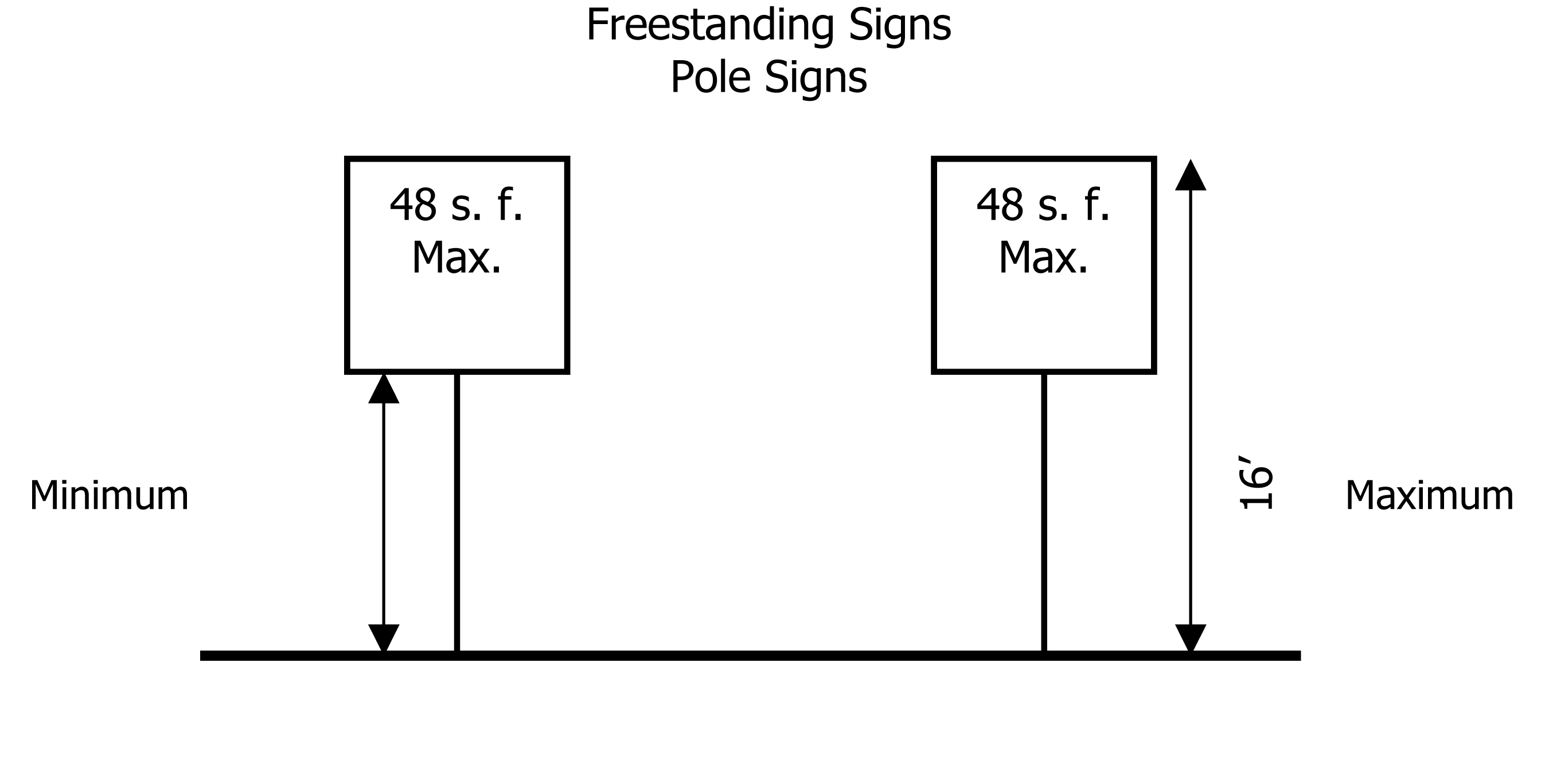
Figure 1a
2.
Ground-mounted sign. When the freestanding sign is a ground-mounted sign, the maximum area of the sign face and structure shall not be greater than 64 square feet as seen from one side. The maximum height of a ground-mounted sign structure shall not exceed eight feet. Ground-mounted signs that are two feet or less in height may be constructed at the property line, all others must be set back far enough to be out of any visibility triangle formed by public or private ingress/egress to the property as determined by the city's building official.
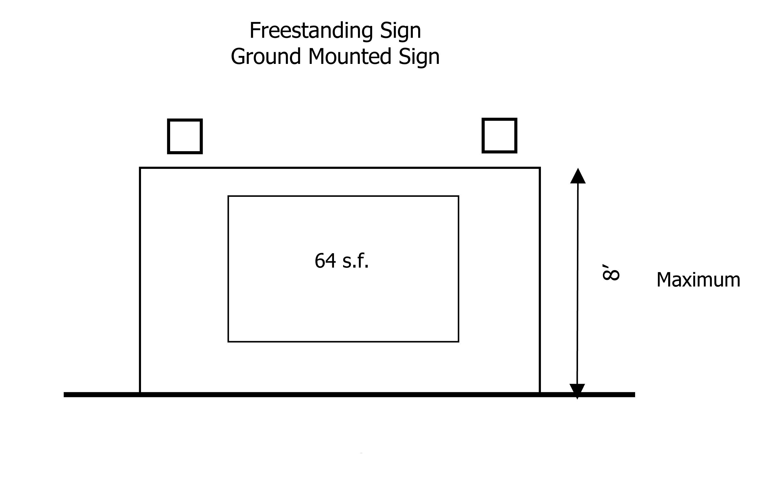
Figure 1b
3.
Building-mounted signs. Building-mounted signs are not limited in number and are permitted in the total signage area for the development site. Canopies that are 500 square feet or more that cover fuel pump islands are allowed an additional 32 square feet of signage on the canopy.
4.
Window advertising. Window advertising of the kind described in this paragraph shall not count against the total signage for a development site, but is regulated in the following manner. Not more than 25 percent of glass surfaces of windows facing a public street or right-of-way in any commercial or industrial building may be utilized for signage or any other opaque items that block glass. This includes, but is not limited to, posters, fliers, advertisements, display racks, other interior furnishings and similar materials or objects.
5.
The following diagram and example are provided to clarify the manner in which signage may be applied to commercial and industrial development sites. Generally, the total signage of 120 square feet, less the 48 square feet for the freestanding sign, allows 72 square feet to be utilized for the other signage. In the case of a ground-mounted sign, as an incentive, the allowable sign face is 16 square feet greater than a pole sign. This additional square footage is a bonus. As an example, if a freestanding pole sign of less than 48 square feet is used, then the 72 square feet available for all other signage may be increased by the difference between 48 square feet and the actual area of the sign face. For example, a site with a 32-square-foot freestanding pole sign, would be allowed 72 square feet, plus an additional 16 square feet, for a total of 88 square feet for all other permitted signage.
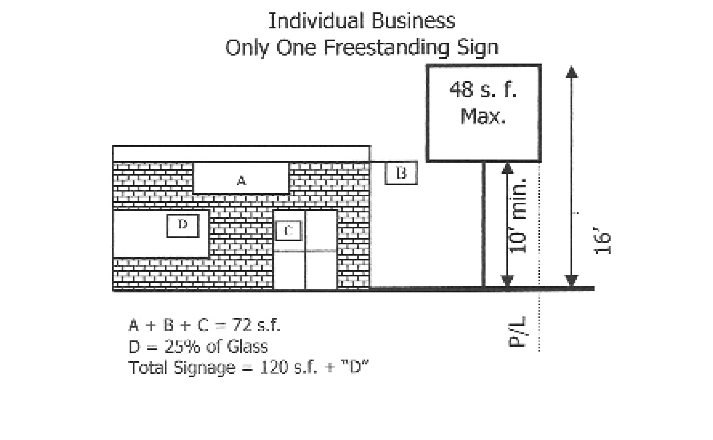
Figure 2
4.
Business/strip centers.
Individual business within a center are permitted building-mounted signs only, which include signs mounted flat to the front of the building, right angle signs, awning signs and swinging signs. All building-mounted signs are limited to 32 square feet of signage for an individual business in a center.
Window advertising as specified above in [subsection] (4) commercial and industrial districts applies. Each center may have one free standing sign or monument sign as specified in sections 4.3.2.90.3.C.1 and C.2 for commercial or industrial sites. Individual signage may be used for each business located at the center on the freestanding sign provided that the total signage allowed for the freestanding sign is maintained.
Sec. 4.3.3.10. - Nonconforming on-site and off-site signs.
1.
Where a portable sign legally existed at the time of annexation into the city, such sign shall be permitted to continue in use for a period not to exceed 30 days from the annexation. This provision shall no longer be in effect when a sign has been removed, destroyed or its business ceases operation or transfers ownership.
2.
Nonconforming permanent on-site signs existing prior to adoption of the land development regulations shall not be expanded or altered. If destroyed or deteriorated more than 50 percent of the replacement value or removal for any reason whatsoever, it shall not be replaced except in conformity with the provisions of the land development regulations.
3.
Where off-site signs existed at the time of passage or amendment of the zoning ordinance in effect prior to the adoption of these land development regulations, or have been annexed into the city, such signs shall be permitted to continue in use for a period not to exceed five years from the date of adoption of these land development regulations but shall thereafter be removed from the premises. The provisions for violations contained in the land development regulations shall apply.
4.
Damage requiring compliance. Nonconforming signs shall be maintained in the same good appearance and safe condition as required by this chapter and the city's building and electrical code. Nonconforming sign structure that becomes damaged from any cause and are deemed by the administrative official or designee to not longer comply with the building code shall be removed within 30 days and may be replaced with a sign structure that is in compliance with these regulations.
5.
Alterations and modifications requiring compliance. Alterations, modifications and other changes can result in the loss of the nonconforming status of a sign and/or sign structure. The following activities or circumstances constitute alterations, modifications, changes and actions that result in the loss of nonconforming status and the requirement that the sign and/or structure be brought into full compliance with this article or removed entirely.
A.
A change in the land use conducted on the development site. A change of land use shall mean from one land use to another.
B.
A change in ownership and the name of a business and which involves the voluntary replacement of the face of a nonconforming sign, even though the business and other structures on the development site are not otherwise altered. Individual business directory boards for nonconforming center signs may be changed without requiring the entire nonconforming sign to be brought into compliance.
C.
Relocation, alteration, renovation or replacement of a nonconforming sign structure whether voluntarily by the owner of the business, or because of the required relocation of the nonconforming sign structure because of an acquisition or taking associated with a public improvement.
D.
Movement, in whole or in part, of a nonconforming sign structure to another location on the same parcel or lot that it occupies, or transportation of it to any other parcel of land in the city, unless such movement or transportation shall render the sign and/or structure fully conforming with this article.
Sec. 4.3.3.20. - Abandoned signs.
Any abandoned sign shall be taken down and removed by the property owner, agent, or person having the beneficial use of the building, structure or property upon which such sign is located. A sign shall be determined to have been abandoned if the business associated with the sign has ceased to operate for 45 consecutive days and the sign has not been otherwise removed. The administrative official shall provide written notice to the person or entity last known to have beneficial use of the sign seeking compliance with these regulations. Upon failure to comply with such notice within the time specified by such order, but not less than 15 calendar days, the administrative official is hereby authorized to cause the removal of such sign. Any expense incurred thereto shall be paid by the owner of the building, structure or property upon which the sign is erected or attached. In making a determination that a sign no longer advertises a bona fide activity as described herein, the administrative official shall consider among other factors, the existence or absence of a current occupational license, utilities service deposit at the location, use of the premises, and relocation of the business.
Sec. 4.3.4.10. - Permits and fees.
All signs except "For Sale" and "For Rent" normally associated with real estate shall require a permit prior to placement. Such permits shall require a fee to be prescribed by the city commission.
Sec. 4.4.1.10. - General.
It is the intent of the city commission to improve the overall appearance of the city, preserve existing vegetation where and when desirable, conserve water used for irrigation of plant material, to protect natural plant communities, and provide for the installation and continuing maintenance of landscaping for residents and visitors to the city by establishing minimum standards for such for within the city in order to:
1.
Promote the conservation of potable and non-potable water by encouraging the preservation of existing plant communities, encouraging the planting of natural or uncultivated areas, encouraging the use of site specific plant materials, and establishing techniques for the installation and maintenance of landscape materials and irrigation systems.
2.
Improve the aesthetic appearance of residential, commercial, and industrial areas through the incorporation of open space into development in ways to harmonize and enhance the natural and built environment.
3.
Improve environmental quality by recognizing the numerous beneficial effects of landscaping upon the environment, including:
A.
Improving air and water quality through such natural processes as photosynthesis and mineral intake;
B.
Maintaining permeable land areas essential to surface water management and aquifer recharge;
C.
Reducing and reversing air, noise, heat, and chemical pollution through the biological filtering capacities of trees and other vegetation;
D.
Promoting energy conservation through the creation of shade, reducing heat gain in or on building or paved areas;
E.
Reducing the temperature of the microclimate through the process of evapotranspiration; and
F.
Encouraging the conservation of limited fresh water resources through the use of site specific plants and various planting and maintenance techniques.
4.
Maintain and provide opportunity for increasing the value of land by requiring a minimum amount of landscaping to be incorporated into development.
5.
Preserve existing native vegetation and incorporate native plants, plant communities, and ecosystems into landscape design, where possible.
6.
Eradicate or control certain exotic plant species which have become nuisances due to their tendency to damage public and private works, to have a negative effect upon public health, or to disrupt or destroy native ecosystems.
7.
Promote innovative and cost-conscious approaches to design, installation, and maintenance of landscaping, encouraging water and energy conservation.
Sec. 4.4.2.10. - Applicability.
These regulations shall apply to any new development or redevelopment of property or to the expansion of existing development, except as may be provided for elsewhere herein. Individually, owner-occupied single-family detached dwelling units, or individual units proposed for new construction, but not proposed developments containing four or more such units, where the owner meets the "low to moderate income" definition requirements of the Florida Statutes are declared to be exempt from the provisions of these requirements pertaining to new planting.
Sec. 4.4.3.10. - Provisions.
1.
Restrictions of land clearing activities. It is declared to be the intent of the city commission to restrict land clearing activities so as to:
A.
Limit the use of irrigation water in open space areas by promoting the preservation of existing plant communities;
B.
Limit the removal of valuable existing native vegetation in advance of the approval of land development plans; and
C.
Limit the removal of valuable existing native vegetation when no comparable vegetation plan has been prepared for the site.
2.
Preservation of existing native vegetation. Existing native vegetation and plant communities shall be protected and incorporated into the site plan wherever feasible.
3.
Vegetation removal permits.
A.
General. Unless otherwise provided for in this chapter, no person, corporation, association, public agency, or agent or employee thereof, shall effectively destroy or remove native vegetation from any property within the city without first obtaining a vegetation removal permit from the city.
B.
Vegetation removal permits and fees. Permits for the removal, relocation, or replacement of native vegetation covered herein shall be obtained by submitting an application to the building department of the city. Permit fees for the removal of vegetation shall be established by the city commission.
Sec. 4.4.3.20. - Application procedure and requirements for a vegetation removal permit.
1.
Preliminary review. The preliminary review procedures shall assure that the applicant has taken all steps reasonably necessary to preserve existing native vegetation and to otherwise enhance the aesthetic appearance of the development by the incorporation of existing native vegetation into the site design process.
2.
Native vegetation inventory. Each application for a vegetation removal permit shall be accompanied by three copies of a generalized native vegetation inventory which shall consist of the following:
A.
A generalized vegetation inventory showing the approximate location and extent of native vegetation upon the site. The inventory shall be based upon the most current available information. For nonresidential, duplex, and multifamily development, the inventory may be in the form of an aerial or a field survey, and shall be accompanied by photographs illustrating typical areas of vegetation. For an individual single-family detached unit, the inventory may be in the form of hand drawn sketches accompanied by photographs of existing site conditions.
B.
The generalized vegetation inventory shall be prepared at the same scale as the site development plans or in some other manner which clearly illustrates the relationships between the areas of vegetation and the proposed site improvements.
3.
Preliminary approval.
A.
Issuance for lots or parcels with minimal native vegetation disruption. Where the city has verified that no significant native vegetation removal activity is involved in a proposed development, a preliminary approval shall be issued forthwith.
B.
Issuance for lots or parcels with significant native vegetation disruption. Preliminary approval for an application involving native vegetation removal activity shall be issued only under the following circumstances:
1.
Where a tree or other native vegetation, due to natural circumstances, is no longer viable, is in danger of falling, is too close to existing structures so as to endanger such structures, interferes with utility services, creates unsafe vision clearance, or constitutes a health hazard; or
2.
Where the affected native vegetation will be relocated, replaced with suitable substitutes, or otherwise preserved; or
3.
Where in consideration of the factors set out in this chapter, the city determines that the issuance of the permit is justified.
C.
Relocation and replacement. As a condition to the granting of a vegetation removal permit under this section, the applicant shall be required to:
1.
Relocate vegetation which would otherwise be destroyed to another location upon the site; or
2.
Replace vegetation which will be destroyed with suitable replacements elsewhere within the site. In determining the required relocation, replacement, or root pruning of vegetation, the city shall consider the needs of the intended use of the property, including all lands dedicated to public use, together with an evaluation of the following:
a.
Existing vegetative coverage on the site and in the immediate surrounding area.
b.
Quantity of vegetation to be removed on the entire site.
c.
The type, size, and condition of the vegetation to be removed.
d.
The feasibility of relocating the particular vegetation.
e.
Topography and drainage of the site.
f.
The nature of the existing and intended use of the property.
Sec. 4.4.3.30. - Native vegetation protection.
1.
General. During construction, all reasonable steps necessary to prevent the destruction or damage of native vegetation shall be employed. Native vegetation destroyed or suffering major damage, unless approval for their removal has been granted under permit, shall be replaced by vegetation of like kind and size or equal environmental value, as determined by the city. Such replacement shall occur prior to the issuance of a certificate of occupancy; in lieu thereof, the developer may post a bond with the city guaranteeing the replacement within six months.
2.
Filling and construction debris. During construction, unless otherwise authorized pursuant to a vegetation removal permit, no excess soil, fill material, equipment, liquids, or construction debris, shall be placed within the drip line of any vegetation that is required to be preserved in its present location.
3.
Attachments. No attachments or wires other than those of a protective or non-damaging nature shall be attached to any vegetation during construction.
4.
Excavation. Unless otherwise authorized by a vegetation removal permit, no soil shall be removed from within the drip line of any tree that is to remain at its original location.
5.
Protective barriers.
A.
Installation of protective barriers. All protection barriers shall be installed and maintained for the period of time beginning with the commencement of any land clearing or building operations and ending with the completion of the permitted clearing or building construction work on the site.
B.
On-site representative required. The applicant for a vegetation removal permit shall, at the time of application, designate an on-site representative who will be responsible for the installation and the maintenance of all tree protection barriers. The representative shall be responsible for supervising the removal of all existing vegetation permitted to be removed. The representative shall be on-site at all times during the vegetation clearing operations.
C.
Protection of large areas of native vegetation. When the circumference of an area of vegetation to be preserved is more than 200 linear feet, the area shall be protected during land alteration and construction activities by placing two by two wood stakes a maximum of 20 feet apart around the perimeter of the area of vegetation, and tying ribbon, survey flagging, rope, or similar material at a minimum height of three feet from stake to stake along the perimeter of such areas to be preserved.
D.
Protection of small areas of native vegetation. When the circumference of an area of protected vegetation is less than 200 linear feet, a protective barrier shall be placed around the groups of trees and understory planting that is indicated to remain. The barrier shall be not less than three feet in height, shall limit access to the protected area, and shall be composed of wood, metal, or other suitable materials which ensures compliance with the intent of protecting the plant material and trees. The barrier shall be highlighted with strips of survey flagging placed no more than five feet on center. The provided barrier shall not harm the protected vegetation through construction or any other means.
E.
Protection of individual trees. When the retention of single trees is required by this chapter, a protective barrier, similar to that required in subsection 5.C of this section, shall be placed around the tree at a minimum distance from the trunk of six feet or two-thirds of the drip line, whichever is greater of a hardwood tree, and six feet or the drip line, whichever is greater for a softwood tree, or as otherwise determined by the city.
Sec. 4.4.3.40. - Exceptions for native vegetation protection.
1.
Vegetation endangering health, safety, or property. In the event that any vegetation shall place health, safety, or property, in immediate peril and danger, and require removal without delay, verbal authorization may be given by the administrative official and the vegetation removed without obtaining a permit as herein required. Such verbal authorization shall later be confirmed in writing within ten days of the removal by the administrative official.
2.
Citrus groves. All groves in active agriculture operation shall be exempt.
3.
Fee exceptions. The following types of trees shall be exempt from the provisions of this chapter relating to permit fees, and no fees shall be charged for the removal of this vegetation. The building department shall provide guidance to any individual in doubts as to the identity of any particular vegetation:
A.
Melaleuca quinquenervia (Cajaput or Paperbark tree).
B.
Casuarina species (Australian Pine, Beefwood).
C.
Schinus terbinthifolius (Brazilian Pepper).
D.
Trees which are no longer living or are dying.
E.
Trees which are required to be removed by law.
Sec. 4.4.5.10. - Site development for water conservation.
Water needs and requirements may be reduced by providing for:
1.
The preservation of existing plant communities;
2.
The reestablishment of native plant communities;
3.
Limited amount of lawn grass areas;
4.
The use of site-specific plant material (See definitions in division VIII, chapter 1);
5.
The use of shade trees to reduce transpiration rates of lower story plant materials;
6.
Site development that retains stormwater runoff on site;
7.
The use of pervious paving/surfacing materials;
8.
Site development that minimizes alteration of the land in its present form.
Sec. 4.4.5.20. - Preservation of existing native plant communities.
1.
General. All existing native plant communities on sites proposed for development shall be preserved in as much as they can be incorporated into the required open space. Existing plant communities that are specified to remain shall be preserved in their entirety, with all trees, understory, and ground covers left intact and undisturbed. The purpose of the preservation of existing plant communities is to decrease the initial costs of site development, decrease future water and maintenance requirements, and benefit the aesthetic appearance of the property.
2.
Existing native plant communities required to remain. When existing native plant communities occur on a parcel of land to be developed, at least 25 percent of the required open space shall be in the form of preserved native plant communities.
3.
Open space credit for the preservation of existing native plant communities. Portions of existing viable, healthy native plant communities over and above the minimum required to be preserved by subsection 1 above, that are preserved in a natural state, and are capable of sustaining life with adjoining site development, shall be credited as open space at 1½ times the actual area of the protected plant community. The minimum size of a preserved plant community eligible for the open space credit shall be one-eighth acre.
4.
Required management plan.
A.
General. For all areas of preserved native plant communities larger than one-half acre in area, the owner shall submit, for the approval of the building department, a management plan indicating the manner in which the owner will preserve the native plant communities. The plan shall include at a minimum:
1.
Whether or not the existing vegetation is to be preserved in the existing species composition;
2.
If applicable, the manner in which the composition of existing plant material is to be preserved (hand removal of invasion species, prescribed burning, etc.);
3.
The schedule for the removal of exotic species;
4.
The schedule for the removal of debris; and
5.
Other information that may be required by the building department that is reasonable and necessary to make a determination that the management plan meets the requirements of this chapter.
B.
Requirement for owner's covenant with the city for the maintenance of preserved native plant communities receiving open space credit. In order to receive open space credit for areas of preserved native vegetation, the owner shall covenant with the city, in a form acceptable to the city, that the preserved plant community will be maintained as per the accepted management plan.
Sec. 4.4.6.10. - Design requirements.
These standards shall be considered the minimum requirements for the installation of all plant materials within the city.
1.
Trees shall not be placed where they interfere with site drainage or where they shall require frequent pruning in order to avoid interference with overhead power lines. Unless otherwise provided in this section, a minimum number of trees shall be planted or preserved upon each site, as follows:
A.
Single-family or duplex residential unit lots. Tree planting requirements for residential lots. One tree shall be planted or preserved for every 2,000 square feet of area of a residential lot or fraction thereof, excluding only areas of native vegetation to be preserved by law. A minimum of 50 percent of all required trees shall be shade trees. No more than 15 new trees shall be required to be planted upon any lot which is actually used or intended to be used for one single-family detached residence or one duplex residence.
B.
Nonresidential lots or parcels. Minimum tree planting requirements for nonresidential sites. One tree shall be planted or preserved for every 3,000 square feet of area of nonresidential lot or fraction thereof, excluding only areas of native vegetation required to be preserved by law. A minimum of 60 percent of all required trees shall be shade trees.
Sec. 4.4.6.20. - Standards for landscape materials.
1.
Quality of plants. All plant materials shall be a minimum of Florida Number One as defined in Grades and Standards Revised, Part II, as published by the Florida Department of Agriculture and Consumer Services (as updated). Exceptions and substitutions from this regulation may be reviewed and approved by the building department in order to promote the use of slow growing or native plant materials.
2.
Tree planting standards. Immediately upon planting, trees shall be a minimum of eight feet in height and shall have a minimum caliper of 1½ inches.
3.
Shrub and hedge planting standards. When required, shrubs shall be a minimum of 24 inches in height and hedges shall be a minimum of 48 inches in height above the surface root system at the time of planting, and spaced 18 to 36 inches on center. Spacing of individual plants shall depend upon the type of plant material used. Hedges, where required, shall form a solid continuous visual screen of at least six feet in height within two years after the time of planting. Exceptions and substitutions from this requirement may be reviewed and approved by the city in order to promote the use of slow growing or native plant materials.
Sec. 4.4.6.30. - Landscaping the interior of off-street parking areas.
The interior of all off-street parking areas shall be landscaped in accordance with either Design Alternative One or Design Alternative Two.
1.
Design Alternative One.
A.
Applicability. A minimum of 15 square feet of landscaping for each parking space shall be provided within the interior of an off-street parking area.
B.
Design of mandatory terminal islands. Each row of parking spaces shall be terminated by landscaped islands which measure not less than five feet in width and not less than 18 feet in length. At least one tree shall be planted in each terminal island.
C.
Design of interior islands. Interior landscape islands may be provided within each row of parking spaces. If interior islands are provided, one interior island shall be provided for each 16 parking spaces or fraction thereof.
D.
Design of divider medians. Landscaped divider medians may be used to meet interior landscape requirements. If divider medians are used, they shall form a continuous landscaped strip between abutting rows of parking spaces. The minimum width of a divider median shall be five feet. One tree shall be planted for each 40 linear feet of divider median, or fraction thereof. Trees in a divider median may be planted singly or in clusters. The maximum spacing of trees shall be 60 feet.
E.
Additional landscape treatment. All interior landscaped areas not dedicated to trees or to preservation of existing vegetation shall be landscaped with grass, ground cover, shrubs, or other appropriate landscape treatment. Sand or other pavement shall not be considered appropriate landscape treatment.
F.
Curbing requirements. Mandatory terminal islands shall be surrounded with a continuous, raised curb. Interior islands and divider medians shall be protected from encroachment of motor vehicles as provided in section 4.4.6.70 below.
2.
Design Alternative Two.
A.
Applicability. Design Alternative Two shall be available only in off-street parking areas in which parking spaces intersect. The parking spaces need not intersect at right angles. If the off-street parking area is designed to have staggered parking spaces, the developer shall use Design Alternative One.
B.
Calculation of the number of trees to be planted. One tree shall be planted or preserved for each nine parking spaces in a vehicular use area for off-street parking.
C.
Design of mandatory terminal islands. Each row of parking spaces shall be terminated by landscaped islands which measure not less than five feet in width and not less than 18 feet in length. At least one tree shall be planted in each terminal island.
D.
Design of interior grade-level tree planting areas. Trees required to be planted by this section may be distributed throughout the interior of an off-street parking area in any way that encourages adequate shading of parked motor vehicles and visual access. Grade-level tree planting areas shall be located at the common intersection of four parking spaces. The minimum area of a tree planting area shall be 20 square feet. The minimum dimensions shall be four feet by five feet. Trees shall be planted on center at the point of intersection of the four parking spaces. The ground within the tree planting area shall receive appropriate landscape treatment, including mulch or ground cover.
E.
Additional landscape treatment. All interior landscaped areas not dedicated to trees or to preservation of existing vegetation shall be landscaped with grass, ground cover, shrubs, or other appropriate landscape treatment. Sand or other pavement shall not be considered appropriate landscape treatment.
F.
Curbing requirements. Mandatory terminal islands shall be surrounded with a continuous, raised curb. Interior islands and divider medians shall be protected from encroachment of motor vehicles as provided in section 4.4.6.70 below.
Sec. 4.4.6.40. - Landscaping other types of vehicular use areas open to the public.
1.
A minimum of eight percent of the gross paved area of vehicular use areas which are open to the public but which are not used for off-street parking shall be devoted to interior landscaping. Such vehicular use areas include access roads in planned developments, service stations, stacking lanes at drive-in banks or fast food restaurants, or outdoor retail sales and display areas for new or used motor vehicles.
2.
A minimum of ten percent of the gross paved area of vehicular use areas which are open to the public but which are not used for off-street parking shall be devoted to interior landscaping. Landscaping required by this section may be installed in any manner that provides adequate buffering of vehicular uses. If the landscaped area is moved to the perimeter of the lot, it shall be designed as an integral part of perimeter landscaping. The landscaped area may be designed as a divider median strip. If so, the linear strip shall be designed to accommodate one tree for each 40 linear feet of divider median, or fraction thereof.
Sec. 4.4.6.50. - Landscaping the perimeter of lots.
Landscape strips shall be created around the perimeter of lots as provided in this section.
1.
Perimeter landscape strips separating vehicular use areas from abutting rights-of-way.
A.
General requirements. Wherever a vehicular use area abuts a dedicated right-of-way, a perimeter landscape strip shall be created which extends along the length of the boundary between the right-of-way and the vehicular use area. A perimeter landscape strip may be crossed by access ways to the extent necessary to afford access to the site. A perimeter landscape strip shall not be required if: the vehicular use area is entirely screened from the view from the right-of-way by buildings or structures; or when the vehicular use area abuts a dedicated alley.
B.
Minimum dimensions of perimeter landscape strip.
1.
Minimum width. Unless otherwise provided for elsewhere, the minimum width of the perimeter landscape strip separating a vehicular use area from abutting rights-of-way shall be ten feet width for rights-of-way whose ultimate width is 99 feet and 15 feet for rights-of-way whose ultimate width is 100 feet or greater.
2.
Minimum planting requirements. One tree shall be planted for each 30 linear feet (or fraction thereof) of a perimeter landscape strip separating a vehicular use area from an abutting right-of-way and may be planted singly or in clusters. The width of access ways which pierce the strip shall be included in the calculation of linear dimensions.
3.
Landscape barrier.
a.
General. A hedge, wall, fence, berm, or other landscape barrier shall be located within the perimeter landscape strip. Unless otherwise provided for in this chapter in the case of planted material, the barrier shall be not less than three feet and no more than 12 feet in height within a maximum of two years after installation.
b.
Living and non-living barriers. If walls, fences, or other non-living barriers are used as elements of the landscape barrier, shrubs or vines shall be planted as follows:
(1)
One shrub or vine shall be planted for each ten square feet of landscaped barrier;
(2)
If, upon planting, shrubs or vines are not of sufficient height to be clearly visible above the top of the landscape barrier, the shrubs or vines shall be planted on the street side of the barrier;
(3)
If, upon planting, shrubs or vines are clearly visible above the top of the barrier, they may be planted inside the barrier.
c.
Earth berms. Earth berms may be used only when installed in conjunction with sufficient plant materials to satisfy the provisions of the chapter. The slope of a berm shall not exceed a ratio of 3:1 unless used in conjunction with a retaining wall.
2.
Perimeter landscaping strips separating vehicular use area from the interior lot line of an abutting property. Every vehicular use area shall be screened from view from abutting properties. Unless this chapter specifies some other perimeter landscape treatment, a perimeter landscape strip shall be created which meets the following minimum standards:
A.
Minimum width. The minimum width of the perimeter landscape strip shall be five feet.
B.
Minimum length. The perimeter landscape strip shall extend along the length of the boundary between the vehicular use area and the abutting property. The landscape strip may be pierced by access ways as necessary to comply with the requirements of this chapter or other applicable provisions.
C.
Minimum planting requirements. One tree shall be planted for each 30 linear feet (or fraction thereof) of the perimeter landscape strip.
Sec. 4.4.6.60. - Streets and landscaping in the rights-of-way.
1.
Installation standards and requirements.
A.
Planting standards. Unless otherwise provided in the chapter, plant material to be utilized shall comply with section 4.4.6.20.
B.
Maintaining safe sight distance at intersections and points of access. Landscaping shall comply with division IV, chapter 5 of the land development regulations.
C.
Placement of plants and planting material. The administrative official shall have the final authority to approve or disapprove the location of plants and landscaping with respect to safe and proper engineering practices. Plants may be permitted within the rights-of-way of streets provided that they comply with the roadside recovery area provision of the State of Florida Department of Transportation's Manual of Uniform Minimum Standards for Design, Construction, and Maintenance of Streets and Highways (commonly known as the "DOT Green Book"), as amended.
D.
Maintenance. The developer/permittee or its successor in interest shall be responsible for the proper maintenance of all landscaping and shall keep the area free from any refuse or debris.
Sec. 4.4.6.70. - Curbing and encroachment of vehicles into landscape areas.
1.
Curbing requirements. All landscape areas shall be separated from vehicular use areas by non-mountable, reinforced concrete curbing of the type characterized as Type D in the current edition of the Roadway and Traffic Design Standards Manual prepared by the State of Florida Department of Transportation, or curbing of comparable durability.
2.
Use of wheel stop. All landscaped areas adjacent to off-street parking areas shall be protected from encroachment or intrusion of vehicles through the use of wheel stops. Wheel stops shall be a minimum height of six inches above finished grade of the parking area. Wheel stops shall be properly anchored and shall be continuously maintained in good condition. Where wheel stops are located three feet from the front of a parking space, that three feet need not be paved. However, the area between the wheel stop and the landscape area shall receive appropriate landscape treatment, including planting of grass or ground cover.
3.
Calculation and curbing. The width of curb shall be excluded from the calculation of the minimum dimensions of all required landscape areas.
Sec. 4.4.6.80. - Use of site specific planting materials.
Trees and other vegetation shall be planted in soil and climatic conditions which are appropriate for their growth habits. Plants used in the landscape design pursuant to this chapter shall to the greatest extent be:
1.
Appropriate to the conditions in which they are to be planted;
2.
Have non-invasive growth habits;
3.
Encourage low maintenance, high quality design; and
4.
Be otherwise consistent with the intent of this section.
Sec. 4.4.6.90. - Replacement requirements.
Vegetation which is required to be planted or preserved by this chapter shall be replaced with equivalent vegetation if it is not living within one year of issuance of a certificate of occupancy. Preserved trees for which credit was awarded, which subsequently die, shall be replaced by the requisite number of living trees.
Sec. 4.4.6.100. - Prohibited plant species.
The following plant species shall not be planted in the city:
1.
Melaleuca quinquenervia (commonly known as Punk tree, Cajeput, Paper Bark, Melaleuca); or
2.
Schinus terebinthifolius (commonly known as Brazilian Pepper or Florida Holly); or
3.
Casuarina species (commonly known as Australian Pine); or
4.
Rhodomyrtus tomentosa (commonly known as Downy Rose Myrtle).
Sec. 4.4.7.10. - General.
1.
For purposes of these guidelines, "permanent irrigation system" shall be defined as an assembly of component parts, above ground, underground or surface-mounted, supplied with water under pressure through a system of permanently placed irrigation piping, installed with and for the controlled distribution and conservation of water for irrigating any type of landscape vegetation in any location within the city.
2.
Water conservation methods are generally basic in nature but require that attention be paid to the irrigation system, its operation, and maintenance. These conservation methods are not served when water is allowed to run down streets or sidewalks during the irrigation process. A system that is turned on in the morning and allowed to operate all day is completely wasteful of a most precious resource since most soil conditions will not absorb a continuous application of water.
3.
For greater efficiency, all systems should be operated only at night or during early morning hours. Systems that are operated during the heat of the day are totally ineffective as the evapotranspiration rate is so high that the plant materials receive no benefit. This same principle applies to windy days when an effective spray pattern cannot be achieved. Systems operated just prior to sundown provide a condition under which molds and other disease can be developed on all vegetation.
4.
Drip irrigation systems are extremely effective in selected areas for water conservation. These systems are generally effective in planter beds, parking islands, and boulevard medians, large areas of ground cover, and similar planting areas. These systems require special consideration since they cannot be operated on the same zone as other types of sprinkler heads because they drip water on the basis of gallons per hour as opposed to gallons per minute. These systems do require some monitoring to assure that emitters and flow tubes are clean and undamaged.
5.
Automatic rain shut off devices should be considered as a method of conserving water. These devices allow continuation of the irrigation process during short, intermittent showers but will shut down an irrigation system or prevent it from coming on if a predetermined amount of rain falls.
6.
The only water supply for the system design other than potable or community water supply shall be an irrigation well or an approved on-site lake or pond. The owner is responsible for the water supply and its protection.
Sec. 4.4.7.20. - Design elements and criteria.
Irrigation systems installed within the city shall be designed in a manner which will use sound water conservation principles and techniques and will include the following:
1.
The system shall be designed so as not to water any impervious surfaces, i.e. sidewalks, streets, driveways, or patios with a finished design plan to show all manufactured components of the working system and site features relevant to proper installation.
2.
Automatic controls should be a part of the total irrigation system and set with a watering schedule that will not exceed a precipitation rate of 1½ to two inches per week.
3.
The system should be regulated and operated in such a manner as to prohibit any surface runoff from excessive watering.
4.
Sprinkler selection shall be compatible with site conditions, water source, and water quality. The system should be designed to not exceed a spacing of 55 percent of the specified radius of any given head (i.e., 30-foot radius head should be spaced no farther than every 16½ feet) and be based on established industry practices and plant water requirements.
5.
In turf or areas of low ground cover the system should use underground pop-up sprinklers.
6.
The system should contain separate watering zones based on the types of sprinkler heads used and areas to be watered. For example turf zones should not be on the same zone as shrubs or planters, as turf requires more water. Likewise heads should not be mixed (i.e., spray heads and impacts, impacts and rotors, sprays and bubblers), due to the effectiveness and amounts of water that are used by each type of head.
7.
Main line and circuit line pipe shall conform to acceptable ASAE hydraulic standards in regard to friction pressure loss and velocity of flow. The design water velocity in a pipeline, when operating at system capacity, should not exceed five feet per second unless special considerations are given to the control of surge or water hammer and adequate protection from these pressures is provided.
8.
Pressure reducing valves shall be placed on lines where sprinkler heads are installed with higher than factory specified pressures. Sprinkler heads operated on higher than recommended pressure usually mist and are ineffective.
9.
A backflow prevention device shall be installed on all irrigation systems connected to potable water sources as required by the land development code and state law.
10.
Cross connections.
A.
Because of the danger of contaminating potable water supplies, the design and installation of irrigation systems and yard sprinkler systems which incorporate connections to alternate potable and nonpotable water supplies are not recommended and are discouraged unless absolutely necessary.
B.
Schedule 40 pipe between the water meter and backflow preventer is required.
C.
Where an irrigation or yard sprinkler system is designed to have alternate water supplies, a potable and nonpotable water supply, an installer shall comply with one of the following:
1.
Provide for a complete absence of pipe between the two water supplies (i.e., air gap);
2.
Make no connection of the two water supplies to each other; and
3.
Make impossible the simultaneous connection of both water supplies to the irrigation system or yard sprinkler.
D.
Any type of injector system requires a reduced pressure backflow preventer.
E.
Installation.
1.
Pipe installation.
a.
The manufacturer's specifications covering installation of its material underground shall be followed. This shall apply to thrust blocking, handling, storage, minimum depth of cover, and testing.
b.
Piping under constant pressure must be Schedule 40.
2.
Depth.
a.
Minimum depth of cover over all piping shall be six inches or three times the nominal pipe size or a sufficient depth to accommodate valves and other equipment, whichever is greater. All work shall be performed in accordance with established industry standards for all materials and methods employed.
b.
Backfill. The compaction of backfill shall be sufficient to eliminate any settlement of the trench or pipe.
c.
Backfill material. Shall be clean soil or sand free from large stones or other unsuitable material (i.e. vegetation or acidic materials).
3.
Piping shall be thoroughly flushed and tested before the installation of sprinkler equipment.
4.
Automatic control valves installed underground shall be installed with a valve box. Valves shall be installed in accordance with the manufacturer's recommendations and with enough clearance for proper operation and maintenance. Manual control valves shall be installed, with access for proper use, maintenance and repair.
5.
Where pipes are installed under roads sleeves must be installed. Any damage to improvements on public right-of-way must be repaired prior to final approval and signed off by the city utility department.
6.
Control lines shall be at least the minimum size recommended by the automatic equipment manufacturer and shall be ULS listed for underground direct burial use. All connections and splices shall be by an approved method for underground use. Allowance shall be made for thermal contraction of the control lines. Control tubing shall be flushed prior to connection to the valve and/or automatic controller. Control wire shall have minimum cover of six inches and a 12-inch loop at the valve to facilitate servicing.
a.
The automatic controller shall be mounted in a manner recommended by the manufacturer and at the location called for on the plans as approved by the owner. The owner shall provide electrical power to the controller location in accordance with the manufacturer's specifications unless noted otherwise on the plans.
b.
All electrical wire and components shall comply with the city electrical code.
Sec. 4.4.8.10. - General.
1.
Minimum requirements. The following standards shall be considered the minimum requirements for the installation of all landscaping within the city.
2.
Standards and inspections. All landscaping shall be installed in a sound workmanlike manner and according to accepted and proper planting procedures with the quality of plant materials as hereinafter described.
Sec. 4.4.8.20. - Plant quality sizes.
Unless otherwise provided for in the chapter, plant material to be utilized shall comply with section 4.4.6.20.
Sec. 4.4.8.30. - Plant ball sizes.
Ball sizes on all transplanted plant materials shall conform to, or exceed, the minimum standards as noted in the most current edition of "Grades and Standards for Nursery Plants, Part I and II," prepared by the State of Florida Department of Agriculture and Consumer Services.
Sec. 4.4.8.40. - Use of mulch.
The use of organic mulches reduce the growth of weeds and add nutrients to the soil, as well as retain moisture over the root zones of plant materials.
1.
Application specifications. In order to preserve soil moisture, at least two inches of clean, weed free mulch should be maintained over all appropriate planting areas at all times. The required mulch layer shall be maintained on all landscape projects larger than one acre.
2.
Types of mulch. The use of pine, rather than cypress (or other valuable species) mulch is encouraged. The required mulch layer shall be installed on all landscape projects larger than one acre.
Sec. 4.4.9.10. - General.
The owner of land subject to this chapter shall be responsible for the maintenance of said land in good condition so as to present a healthy appearance; and said land shall be kept free from refuse and debris.
Sec. 4.4.9.20. - Mowing.
Grass shall be mowed as necessary in order to encourage deep root growth and, therefore, the preservation of irrigation water.
Sec. 4.4.9.30. - Watering.
All watering of planted areas shall be conducted according to the water management district rules.
Sec. 4.4.9.40. - Street right-of-way maintenance.
1.
General. All grassed areas of street right-of-ways and public walkways within the corporate limits shall be mowed a minimum of two times per calendar year.
2.
Weed control. Chemical applications for weed control in the right-of-ways and public walkways may occur one time per calendar year.
3.
Pruning. Shrubs and trees located within the right-of-ways and public walkways shall be trimmed and pruned a minimum of one time per calendar year when necessary for maintaining visibility.
Sec. 4.4.10.10. - General.
Existing trees may be credited towards minimum tree planting requirements (section 4.4.6.10) according to the formula in Table No. 4.4.10.10(a). Fractional measurements shall be attributed to the next lowest category.
TABLE 4.4.10.10(a):
CALCULATION OF TREE PRESERVATION CREDITS
Sec. 4.4.10.20. - Trees excluded from preservation credit.
No credit shall be given for trees that:
1.
Are not located within the immediate area of the property (buffer area, parking lot, etc.) for which trees are required by this chapter.
2.
Are not properly protected from damage during the construction process, as provided in section 4.4.3.30.
3.
Are prohibited or controlled species identified in section 4.4.6.100.
4.
Are dead, dying, diseased, or infested with harmful insects.
5.
Are located in recreation tracts, golf courses, or similar subareas within planned developments which are not intended to be developed for residential, nonresidential use.
Sec. 4.4.11.10. - Landscape plan required.
Prior to the issuance of any building permit or site alteration or paving, a landscape plan shall be submitted to, reviewed by, and approved by the administrative official.
Sec. 4.4.11.20. - Elements of landscaping plan.
1.
Single-family detached or duplex dwelling. The landscape plan submitted for an individual single-family detached or duplex dwelling on its own lot may be in the form of a plot plan or drawing prepared by the owner or their agent.
2.
All other development. The landscape plan for all other development shall be prepared by and bear the seal of a landscape architect; or otherwise be prepared by persons authorized to prepare landscape plans or drawings by chapter 481, part 11, F.S., et seq. (Landscape Architecture). Plans may be prepared by other legally qualified persons, such as:
A.
Architects, where applicable; or
B.
Engineers, where applicable; or
C.
Nurserymen; or
D.
Nursery stock dealers; and
E.
Nursery agents.
Sec. 4.4.11.30. - Contents of landscape plans.
All landscape plans shall:
1.
Be drawn to scale, clearly showing all dimensions and distances, so as to field verify the installation and design of the plan;
2.
Delineate the existing and proposed parking spaces, and all other vehicular areas, access aisles, driveways, and similar features;
3.
Indicate the location of sprinklers or water outlets (a separate irrigation plan may be used to satisfy this requirement);
4.
Designate by name and location all plant material to be installed or preserved in accordance with the requirements of this chapter;
5.
Identify and describe the location and characteristics of all other landscape materials to be used;
6.
Show all existing and proposed landscape features, including areas of vegetation required to be preserved, in context with location and outline of existing and proposed buildings and other improvements upon the site, if any;
7.
Include tabulation clearly displaying the relevant statistical information necessary for the city to evaluate compliance with these provisions, including but not limited to, site gross acreage, individual and aggregate areas of preservation, number of trees to be planted or preserved, square footage of paved areas;
8.
Contain such other information that may be required by the city that is reasonable and necessary to a determination that the landscape plan meets these requirements.
Sec. 4.5.1.10. - Purpose.
Transportation, as used in the context of the land development regulations, refers to general public safety and convenience criteria for streets; driveway intersections with streets; visibility at street intersections and driveways with streets; highway visual design; reservations of rights-of-way and adjacent land uses; sidewalks and pedestrian access and design; and airways/airport zoning.
Sec. 4.5.2.10. - Streets serving commercial development.
Streets serving commercial developments or subdivisions and accessory parking areas shall be planned to connect with arterial or collector streets so as not to generate traffic on minor streets nor to provide principal access through residential developments. The intersections of driveways from parking areas with arterial or collector streets shall be located so as to cause the least possible interference with traffic movement on the street, and shall be located not less than 100 feet from the intersection of an arterial or collector street with any other street, and shall be spaced not less than 100 feet from each other. The city commission may require marginal access streets to provide maximum safety and convenience.
Sec. 4.5.2.20. - Streets serving industrial development.
Streets for industrial development or subdivisions and accessory parking shall be planned to serve industrial areas exclusively and shall connect with arterial or collector streets so that no industrial traffic will be directed onto any residential street. The intersections of service streets from parking areas with arterial streets shall not be less than 100 feet from the intersection of the arterial street with any other street. Streets shall be planned to be extended to the boundaries of any adjoining land planned for industry, except for severe physical conditions or if the city commission finds such extension is not in accord with the approved plan of the area.
Sec. 4.5.3.10. - Vehicular access control.
1.
In order to promote the safety of motorists and pedestrians and to minimize traffic congestion and conflicts by reducing the potential points of contact, the following regulations shall apply:
A.
Access intended for vehicular use into and/or from a street shall not exceed 24 feet in width at the right-of-way line, except as may be provided otherwise herein.
B.
The maximum number of access drives permitted into any street shall be as shown in Table 4.5.3.10(a):
TABLE 4.5.3.10(a):
MAXIMUM NUMBER OF ACCESS DRIVES PERMITTED
C.
No curb cut nor driveway apron shall be permitted nearer than 30 feet to any intersecting street curb or the proposed location of an intersecting street curb.
D.
There shall be a minimum of 20 feet between any curb cuts on the same street and the same property except as provided elsewhere in this chapter. There shall be a minimum of 20 feet between curb cuts on adjoining properties.
E.
In commercial and industrial zoning districts, where access into and/or from a street is intended to be used for the purpose of ingress and/or egress for tractor trailers to loading and unloading areas or docks, such access shall not exceed 40 feet in width at the right-of-way line. No driveway pavement turning radius shall begin in front of any adjoining property. Such driveway shall not be located closer than five feet to any adjoining property line.
2.
No curb cut shall be made, nor any driveway apron placed, until a permit has been applied for and issued by the administrative official. In the case of driveways requiring access to state and/or county roads, the petitioner shall secure permits from the applicable jurisdiction and submit such permit to the administrative official as part of the request for a development order. An applicant shall submit with their application, all necessary drawings and descriptive material as required elsewhere in this chapter for permits. No surface drainage shall run from a public right-of-way onto private property unless a public utility or drainage easement exists or is provided at that point.
3.
The city adopts and hereby makes as part of the land development regulations the FDOT Access Management Standards for the State Highway System.
Sec. 4.5.4.10. - Visibility triangle.
1.
Visibility triangles, within which nothing shall be erected, placed, parked, planted, or allowed to grow in such a manner as materially to impede vision between a height of 2½ and ten feet above the centerlines of intersecting thoroughfares, shall be provided as follows:
A.
Street intersections. Beginning at the intersection of street pavements, projected where rounded, thence in each direction along adjoining street pavement for a distance of 25 feet, and thence connected in a straight line across the property to form a triangle.
B.
Intersections of driveways with streets. Beginning at the intersection of each driveway edge with the street pavement, projected where rounded, thence along the street pavement for a distance of 25 feet, and thence connected in a straight line across the property to form a triangle. Where driveways are curved or intersect with the street pavement at other than right angles, a visibility triangle shall be provided giving equivalent visibility to drivers of cars on and entering the street. (See the diagram on the following page.)
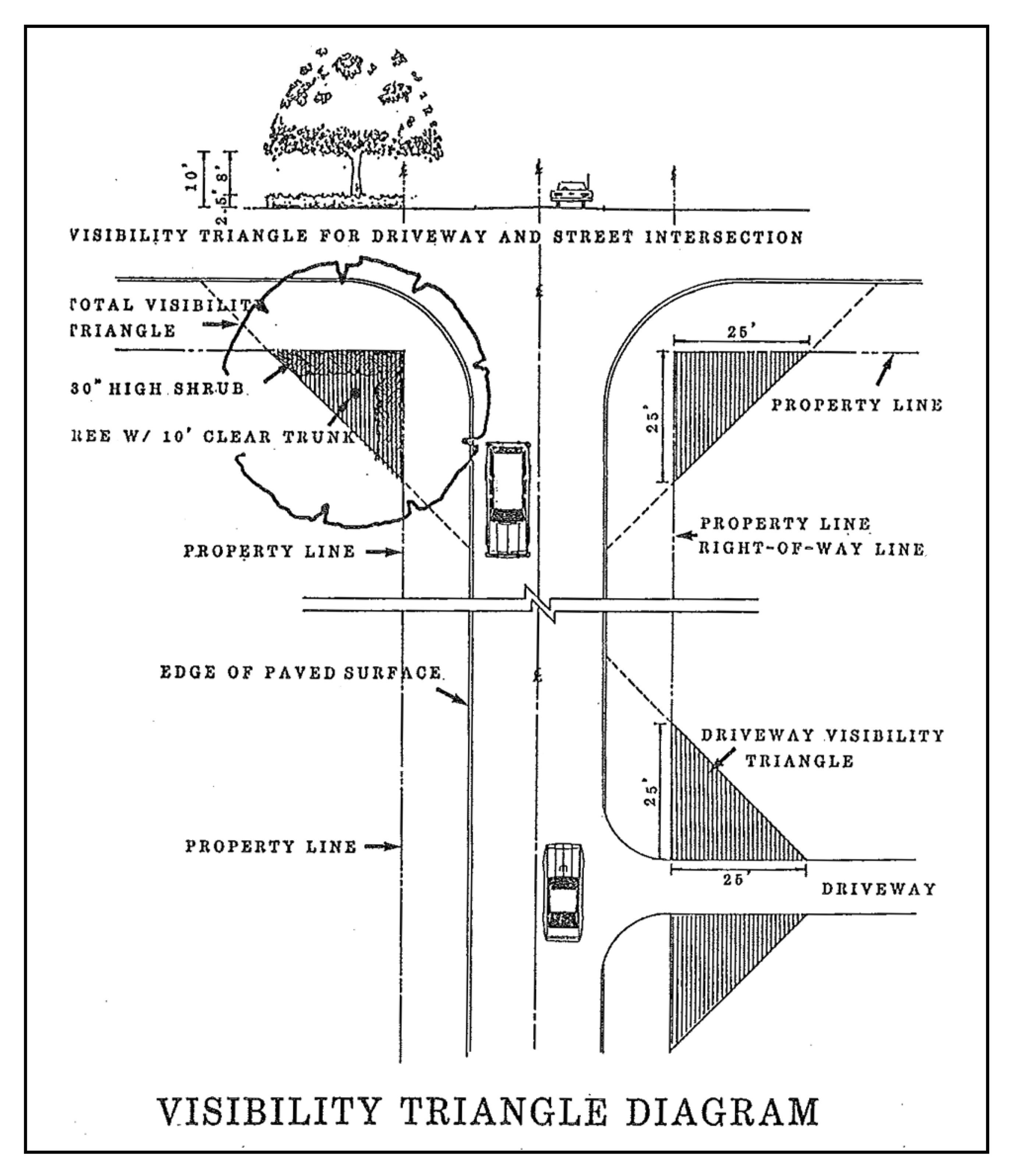
Sec. 4.5.5.10. - Purpose.
According to the legislative intent of chapter 479 of the Florida Statutes, the control of signs in areas adjacent to the highways of Florida is declared to be necessary to protect the public investment in the state highways; to conserve the natural beauty of the state; to preserve and promote the recreational value of public travel; to assure that information in the specific interest of the traveling public is presented safely and aesthetically; to enhance the economic well-being of the state by promoting tourist-oriented businesses, such as public accommodations, vehicle services, parks, and recreational areas; and to promote points of scenic, historic, cultural, and educational interest. Therefore, signs adjacent to the state highway system are to be regulated in conformance with chapter 479, F.S., and as required in division IV, chapter 3 of the land development regulations.
Sec. 4.5.6.10. - Intent.
In order to accomplish the intent and purposes of the city comprehensive plan, right-of-way reservation requirements have been established for streets and the proposed extensions thereof within the city as set out in this article.
Sec. 4.5.6.20. - Right-of-way reservations.
1.
Where no yard requirements are set out for a zoning district, no building or structure or any part thereof, sign, canopy, or parking area shall extend streetward beyond the right-of-way reservation line, except as specifically set out in the land development regulations. In case of conflict between these minimum requirements and other requirements contained in the land development regulations or other city requirements, codes and ordinances, the most restrictive regulations shall apply.
2.
All development orders which require site plan and/or impact review or subdivision plat approval shall reserve right-of-way in compliance with the needs identified in the transportation corridor reservation index.
3.
The right-of-way needs as identified in the transportation corridor reservation index below may be modified for state and county roadways in accordance with the right-of-way plans, specific design requirements, construction plans, or recommendations of the Polk County Transportation Planning Organization, Polk County Engineering Department, or the Florida Department of Transportation.
4.
Generally, one-half of the right-of-way shall be reserved, measured from the centerline, unless property on both sides of the affected right-of-way is the subject of a development order request as identified in [section] 4.5.6.20(2), in which case the full width of the right-of-way shall be reserved.
5.
The reserved right-of-way shall be reserved for future purchase for roadway use, and shall be kept free and clear of all associated private development improvements, including but not limited to off-street parking, landscaping other than ground cover or grass, drainage, signage, and structures.
6.
All minimum yards required by the land development regulations shall be measured from the reserved right-of-way line.
7.
In all commercial and industrial zoning districts, no building or other structure shall be erected within 35 feet of the center line of any street where a greater setback has not been established as set out below.
8.
Existing nonresidential structures which fall within the limits of the right-of-way reservation as listed in the transportation corridor reservation index may be renovated, provided the cost of the renovation does not exceed 20 percent of the appraised value of the structure according to the latest tax record of the Polk County Property Appraiser's Office. The cost of the proposed renovation shall be certified by a licensed general contractor employed by the property owner.
9.
No restriction shall be placed upon the renovation of an existing residential structure which falls within the limits of the right-of-way reservation as listed in the transportation corridor reservation index.
10.
Ownership of the reserved right-of-way shall be retained by the property owner.
Sec. 4.5.6.30. - Dedications required.
The city may, as a condition to the approval of a site plan and/or impact review or subdivision plat, require the dedication by deed of the additional right-of-way necessary to implement the right-of-way needs identified in the transportation reservation corridor index where a finding is made that the following rational nexus criteria is present:
1.
The affected roadway is functioning below the acceptable level of service (LOS) as defined by the comprehensive plan, and the increased traffic impacts related to the proposed development will further degrade the operating condition of the affected roadway, or the increased traffic impacts related to the proposed development reduce the LOS at which the affected roadway is currently operating; and
2.
The improvement of the affected roadway or intersection is scheduled in the five-year capital improvements plan of the city, county, or state.
Sec. 4.5.6.40. - Transportation corridor reservation index.
1.
The city council hereby adopts the right-of-way transportation corridors reservation index for certain roadways within the corporate limits. This index shall be comprised of the streets listed in the setback lines section of the existing zoning ordinance and any amendments that may occur after adoption of the land development regulations.
2.
Upon adoption of the transportation corridor reservation index, the transportation corridor reservation index shall be effective for a period of five years from the date of adoption of the land development regulations. If the city, county, or state has not acquired all of the right-of-way within the limits of the transportation corridor, the city shall invalidate the transportation corridor reservation index. However, the city shall have the right to extend the effective period of the transportation corridor reservation index for additional five-year periods after holding a public hearing in accordance with the requirements to amend the land development regulations.
3.
The below list of roadways and their established right-of-way reservation needs constitute the transportation corridors reservation index. Right-of-way reservation lines are determined by dividing by two the rights-of-way indicated and measured from the center line of the street rights-of-way.
A.
US 17: 70 feet.
B.
Eagle Avenue: 80 feet.
Sec. 4.5.7.10. - Sidewalks.
1.
Sidewalks shall not be required on dead-end streets or on loop or minor streets which serve less than 25 dwellings. However, when the city staff determines that such a street may experience an average daily traffic (ADT) count of more than 250 trips per day, sidewalks shall be required along one side of said street. Sidewalks shall be required along at least one side of any collector or local street. Sidewalks shall be required on both sides of arterial streets. When arterial streets are provided with marginal access streets, sidewalks shall be required only along the marginal access street.
2.
Sidewalks shall be a minimum of four feet wide and four inches thick. At driveways, sidewalks shall be six inches thick and reinforced with No. 10 six-inch by six-inch woven wire fabric or equivalent steel rebars. Sidewalks shall be constructed a minimum of three feet outside of the curb back where curbs are provided and a minimum of six feet from the edge of pavement when no curb is required. All plans and specifications shall be included with final construction plans and will require approval by the city staff.
3.
Sidewalks shall be constructed after all other subdivision site improvements have been completed and prior to dwelling or other buildings are constructed.
Sec. 4.5.7.20. - Service easements.
Where pedestrian and service easements are provided, the city commission may require paved walkways, drainage, or other improvements therein, to be constructed in accordance with plans and specifications approved by the city staff.
Sec. 4.5.8.10. - Airport zoning.
Although there are no airports located within the corporate limits, when reviewing requests for development orders, the city will comply with applicable provisions of chapter 333, Florida Statutes, Airport Zoning.
Sec. 4.6.1.10. - Purpose.
All developments within the city, except where expressly provided otherwise, shall provide off-street parking spaces for the purpose of reducing on-street traffic congestion, minimizing vehicular and pedestrian conflicts, and generally to improve traffic flow on public streets.
Sec. 4.6.1.20. - Application of regulations.
1.
Off-street parking facilities required. Off-street parking facilities shall be provided as required herein. Required off-street parking areas for three or more automobiles shall have individual spaces clearly and permanently delineated, except as provided below, and shall be designed, maintained, and regulated such that no parking or maneuvering incidental to parking shall be on any public street, walk, or alley, and in such a manner that any automobile may be parked and unparked without moving another, except in cases where valet or attendant parking services are provided.
2.
Required parking calculations. For purposes of calculating required parking, an off-street parking space and necessary access and maneuvering room shall be estimated at 400 square feet. The minimum width of any parking stall or space shall be ten feet; however, off-street parking requirements shall be considered to be met only where actual spaces meeting the requirements above are provided and maintained and improved in the manner required by this chapter and in accordance with all other regulations of the city.
3.
Construction. Except as provided below, all off-street parking spaces, loading areas, and related access areas shall be constructed in accordance with the subdivision regulation construction requirements for minor streets and maintained in a manner permitting safe and convenient use, so as to avoid adverse effects on neighboring property resulting from dust, drainage, headlight glare, or lighting.
4.
Turf surfacing. Driveways, access aisles, and parking spaces for public and private schools offering academic courses, churches, and other large non-commercial areas of assembly may be surfaced with turf in areas involving only occasional use, which shall be considered not in excess of an average of three times per week.
5.
Alternate surfacing methods. When it can be demonstrated to the satisfaction of the administrative official that an alternate method of surfacing parking and driving areas meets the intent and requirements of more conventional surfacing methods, then the administrative official may permit such improvements. However, the burden of proof is on the developer and not the city to demonstrate that the alternative method of surfacing parking areas equals or exceeds asphalt or concrete in the areas of stability, level of maintenance, wear and durability. The applicable minimum requirements contained in division IX, appendix F shall be used as the standard upon which the alternate will be judged. Examples of surfacing materials which may be used are turf blocks, cypress mulch on compacted shell base, and concrete.
Sec. 4.6.1.30. - Parking for existing buildings or uses.
1.
Buildings existing as of the effective date of this chapter may be modernized, altered, repaired or expanded up to ten percent of the existing floor area at the time of permit petition without providing additional off-street parking or off-street loading facilities. Any increase in the existing floor area beyond the original allowable ten percent, whether at the time of first petition or any future petition shall cause the remaining applicable requirements of this chapter to be met.
2.
Where a building or use existed as of the effective date of this chapter and such building or use is enlarged in floor area, volume, capacity, or space occupied, except as provided above, off-street parking and off-street loading as herein specified shall be provided for the additional floor area, volume, capacity, or space so created or used.
3.
Where a change in use of a building or land requires additional parking or loading spaces, such spaces shall be provided in addition to the number existing for the prior use. Where the change in use decreases requirements, only the number required for the new use need be maintained.
4.
The required off-street parking facilities shall be located on the same lot or parcel of land they are intended to serve; provided, that the administrative official may approve the establishment of such off-street parking facilities a maximum of 400 feet from the premises they are intended to serve when:
A.
Practical difficulties prevent the placing of the facilities on the same lot as the premises they are designed to serve;
B.
The owner of the parking area shall enter into a written agreement with the city, with enforcement running to the city providing that the land comprising the parking area shall never be disposed of except in conjunction with the sale of the building which the parking area serves, so long as the facilities are required; and
C.
The owner agrees to bear the expense of recording the agreement with the Polk County Clerk of Court and agrees that the agreement shall bind his heirs, successors, and assigns. The written agreement shall be released by the city if equivalent off-street facilities are provided elsewhere in accord with this chapter.
Sec. 4.6.1.40. - Plans for off-street parking.
Except for an individual single-family detached dwelling on an individual lot, a plan shall be submitted with every application for a building permit for any building or use that is required to provide off-street parking. The plan shall accurately designate, by dimensions the required parking spaces, access aisles, and driveways, the relation of the off-street parking facilities to the uses or structures such facilities are designed to serve, and materials to be used for surfacing the parking area.
Sec. 4.6.1.50. - Combined off-street parking.
1.
Two or more owners or operators of buildings or land uses requiring off-street parking facilities may make collective provision for such facilities; provided that the total of such parking spaces when combined or used together shall not be less than the sum of the requirements computed separately.
2.
No part of an off-street area required for any building or use shall be included as a part of an off-street parking area similarly required for another building or use unless the administrative official shall find that the type of use indicates that the period of usage will not overlap or be concurrent with each other.
Sec. 4.6.1.60. - Employee parking.
Where off-street parking facilities are specified on the basis of number of employees, such parking shall be clearly marked and reserved for use of such employees. Where a use is required to provide and reserve a certain number of spaces for employees and the number of employees increases after the building is occupied, then the amount of off-street parking provided shall be increased in ratio to the increase in the number of employees. Plans submitted shall make provision for projected full or peak employment.
Sec. 4.6.1.70. - Parking for nonconforming uses.
Where major repairs, alterations, or extensions of use are to be made in a building occupied by a nonconforming use, no such repairs, alterations, or extensions shall be permitted unless and until the off-street parking requirements for a conforming use of the type involved in the district in which such use is first permitted are applied to the existing building or use and full provision for off-street parking facilities is made.
Sec. 4.6.2.10. - Table of off-street parking and loading requirements.
1.
All developments within the city shall provide the minimum number of off-street parking spaces in accordance Table 4.6.2.10(a). For the purposes of determining the application of the Table 4.6.2.10(a) to specific uses and/or developments, the administrative official shall take any necessary interpretation(s).
TABLE 4.6.2.10(a)
TABLE OF GENERALIZED OFF-STREET PARKING
AND LOADING REQUIREMENTS
1 Gross Floor Area
2 Per seat in the largest assembly area including, but not limited to, auditoriums, theaters, stadiums, grandstands, cafeterias, gymnasiums, etc.
3 The first required loading space must be sized to accommodate a tractor trailer. Fifty percent of all other required loading spaces (rounding down) must be sized to accommodate a tractor trailer. See section 4.6.2.120 for minimum off-street loading requirements.
4 The maximum number of motorcycle spaces is expressed as a percentage of the required passenger vehicle spaces that may be substituted for automobile spaces. Motorcycle parking spaces may be provided in lieu of or in addition to automobile spaces in accordance with the following standards:
A. Minimum width, three feet.
B. Minimum length, ten feet.
C. All motorcycle parking shall be clearly identified through signs or marking as reserved for motorcycles.
D. Where motorcycle spaces are provided in lieu of automobile spaces, not more than the percentage indicated of all automobile spaces or one space, whichever is greater, may be so converted.
5 Where bicycle rack spaces are provided in lieu of automobile spaces, not more than the percentage indicated of all automobile spaces or one space, whichever is greater, may be so converted. Bicycle parking spaces may be provided in lieu of or in addition to automobile spaces in accordance with the following standards:
A. All bicycle parking spaces shall be incorporated into a bicycle parking facility and shall conform to the following minimum standards:
(i) Minimum width: two feet;
(ii) Minimum length: six feet;
(iii) Each space must be located and positioned so a bicycle may be locked to a stationary object such as a bike rack utilizing a lock and chain provided by the user.
B. The administrative official shall be authorized to modify these standards where the facilities will be used predominantly by bicycles having different space needs (such as children's bicycles, adult tricycles, etc.).
Note 1: To utilize the table above, first determine the type (category) of use for which parking and loading are being determined. Second determine the number of units for that particular use. For example, a 15,000 square feet retail building would be 60 units (15,000 sq. ft./250 sq. ft. per unit) = 60 units) or a 100 room hotel (lodging) would be 100 units (one room = one unit). Third, multiply the units calculated by the factor in the vehicle and loading columns for the use requested. For example, the 15,000 square feet retail building would multiply 60 units by 1.0 to determine the minimum number of required vehicle spaces (60 units × 1.0 = 60 vehicle spaces), and for loading spaces, the minimum requirement would be (60 units × 0.0125 = 0.75) a minimum of one loading space because fractions above one-half are rounded up (See Note 2 below). In the case of the 100-room hotel example, a minimum of 100 vehicle spaces would be required (100 units (rooms) × 1.0 vehicle space = 100 vehicle spaces, and a minimum of one loading space would be required (100 units × 0.01 = 1.0 loading space).
Note 2: When determination of the number of parking spaces required by this table results in requirements of a fractional space, any fraction of one-half or less may be disregarded, while a fraction in excess of one-half shall be counted as one parking space.
2.
Individual assessment of parking requirements.
A.
In the event a proposed use is not listed in the table of generalized off-street parking and loading requirements, or is proposed to be operated in a manner which would create parking demands which are materially different than those set out in the applicable table, required parking may be determined by the city commission according to a technically competent parking study of similar uses in the city or in other places in Florida of a similar size and development pattern which are demonstrated to be of similar or greater reliability than the applicable table with regard to the proposed use. Mixed use projects that have uses with peak demands that are not coincidental with each other shall receive the appropriate consideration. Specific sources of parking data include, but are not limited to, Parking Generation 3rd Edition, Institute of Transportation Engineers or any more recent update.
B.
If the individual assessment is requested due to the unique nature of a proposed use which is listed in the parking table, then the city commission may permit a reduction in required parking only if:
1.
Re-use of the existing or proposed buildings on the parcel proposed for development for a permitted use will not be precluded as a result of the reduction in required parking; and
2.
The applicant provides a restrictive covenant in recordable form acceptable to the city which ensures that if the special conditions which served as the basis for a reduction in parking requirements change, the applicant will provide parking in accordance with the requirements of the underlying district regulations.
3.
Reduction of required loading area. A reduction of required loading area may be granted by the city commission if it is demonstrated that:
A.
The nature of the proposed use is such that it does not require regular deliveries during business hours, and there is sufficient parking area to avoid parking or standing of delivery vehicles in public rights-of-way; or
B.
Sufficient loading area is provided on an abutting parcel of land:
1.
Which provides convenient access for loading activities on the parcel proposed for development; and
2.
Which is subject to an executed agreement in recordable form ensuring the continued availability of the loading area for the duration that it is needed by the parcel.
4.
Maximum number of parking spaces. A development shall provide no more than 120 percent of the minimum required off-street parking spaces as determined by the table of generalized off-street parking and loading requirements unless specifically permitted by the city commission. Excess parking may be determined by the city commission according to a technically competent parking study of similar uses in the city or in other places in Florida of a similar size and development pattern which are demonstrated to be of similar or greater reliability than the applicable table with regard to the proposed use. Parking in excess of 120 percent of the minimum required amount shall only be approved if the following conditions are met:
A.
A transit stop is not located within one-quarter mile walking distance of the site and there is not a transit stop planned and programmed to be constructed within one quarter mile of the site within five years of the development's approval.
B.
The development does not exceed the maximum impervious surface coverage or the maximum lot coverage by all buildings for the zoning in which it is located.
C.
A letter from the applicable transit authority is received by the city indicating that the transit authority is not interested in pursuing or establishing a transit stop along the frontage of the development.
D.
The development does not require any other variance or waiver to parking/loading requirements relative to dimensions, number of spaces, location, or handicap accessibility standards.
E.
Additional wetlands or other environmentally sensitive lands are not impacted or eliminated to accommodate the excess parking spaces.
F.
Waivers or exceptions to the landscaping and tree protection requirements are not requested for the associated development.
Sec. 4.6.2.20. - Open Use Agriculture (OUA).
1.
Minimum off-street parking and loading requirements. See section 4.6.2.10 for a table of off-street parking and loading requirements.
A.
Single-family detached residences: Two spaces.
B.
Schools: Parking as required by the state requirement for educational facilities (SREF).
C.
Municipal and neighborhood buildings and churches: Three spaces for each office room, plus one for each 150 square feet of seating area (including aisles) in any room to be used for public meetings.
D.
Special exceptions permissible by planning commission: To be determined by the planning commission by general rule or by findings in the particular case.
E.
Other uses: As needed to accommodate the proposed use.
Sec. 4.6.2.30. - Single-Family Residential (RS).
1.
Minimum off-street parking and loading requirements. See section 4.6.2.10 for a table of off-street parking and loading requirements.
A.
Single-family detached residences: Two spaces.
B.
Schools: Parking as required by the state requirement for educational facilities (SREF).
C.
Municipal and neighborhood buildings and churches: Three spaces for each office room, plus one for each 150 square feet of seating area (including aisles) in any room to be used for public meetings.
D.
Special exceptions permissible by planning commission: To be determined by the planning commission by general rule or by findings in the particular case.
E.
Child care center: Two spaces per employee, plus an adequate provision for loading and unloading children from off the street.
F.
Churches, houses of worship: One space for each three seats in an auditorium, chapel, or main assembly area.
Sec. 4.6.2.40. - General Residential (RG).
1.
Minimum off-street parking and loading requirements. See section 4.6.2.10 for a table of off-street parking and loading requirements.
A.
Single-family detached residences: Two spaces.
B.
Schools: Parking as required by the state requirement for educational facilities (SREF).
C.
Municipal and neighborhood buildings and churches: Three spaces for each office room, plus one for each 150 square feet of seating area (including aisles) in any room to be used for public meetings.
D.
Special exceptions permissible by planning commission: To be determined by the planning commission by general rule or by findings in the particular case.
E.
Child care center: Two spaces per employee, plus adequate provision for loading and unloading children from off the street.
F.
Churches, houses of worship: One space for each three seats in an auditorium, chapel, or main assembly area.
G.
All other dwellings: Two spaces per unit.
H.
Funeral homes: One space for each three seats in the auditorium or chapel.
I.
Private clubs: One space for each three seats or one space for 200 square feet of gross floor area, whichever is greater.
Sec. 4.6.2.50. - Residential, Institutional, and Office (RIO).
1.
Minimum off-street parking and loading requirements. See section 4.6.2.10 for a table of off-street parking and loading requirements.
A.
Single-family detached residences: Two spaces.
B.
Schools: Parking as required by the state requirement for educational facilities (SREF).
C.
Municipal and neighborhood buildings and churches: Three spaces for each office room, plus one for each 150 square feet of seating area (including aisles) in any room to be used for public meetings.
D.
Child care center: Two spaces per employee, plus adequate provision for loading and unloading children from off the street.
E.
Family group home: One space for each two beds.
F.
Group homes: One space for each bed.
G.
Supervised living facility: One space for each bed.
H.
All other dwellings: Two spaces per unit.
I.
Funeral homes: One space for each three seats in the auditorium or chapel.
J.
Private clubs: One space for each three seats or one space for 200 square feet of gross floor area, whichever is greater.
K.
Hospitals: Two spaces for each bed.
L.
Sanitariums, rest homes, nursing homes, convalescent homes, homes for the aged: One space for each four beds.
M.
Medical and dental office or clinic: One space for each doctor, nurse, and employee, plus three spaces for each consultation and/or examination room.
N.
Professional and business office: One space for each 300 square feet of gross floor area, plus one space for each two occupants or employees.
O.
Business, commercial, or personal service establishments, unless otherwise listed: One space for each 150 square feet of non-storage first floor area, plus one space for each 250 square feet of non-storage area above the first floor.
P.
Art gallery or museum: One space for each 200 square feet of public floor area.
Q.
Library, community center, recreational facility: One space for each 200 square feet of gross floor area or one space for each three seats, whichever is greater.
R.
Little theater: One space for each three seats.
S.
Dance, art, and music studios: One space for each 300 square feet of gross floor area.
T.
Restaurant: One space for each three seats in public rooms plus one space for each two employees.
U.
Special exceptions permissible by planning commission: To be determined by the planning commission by general rule or by findings in the particular case.
V.
Off-street loading: Off-street loading space shall be provided if required in the routine operations of the use.
Sec. 4.6.2.60. - Neighborhood Commercial (CN).
1.
Minimum off-street parking and loading requirements. See section 4.6.2.10 for a table of off-street parking and loading requirements.
A.
All structures: One space for each occupant or employee working on the premises, plus one space for each 100 square feet of floor area open to the public in buildings.
Sec. 4.6.2.70. - General Commercial (CG).
1.
Minimum off-street parking and loading requirements. See section 4.6.2.10 for a table of off-street parking and loading requirements.
A.
Business, commercial, or personal service establishments unless otherwise listed: One space for each 150 square feet of non-storage first floor area plus one space for each 300 square feet of non-storage area above first floor.
B.
Professional and business office: One space for each 300 square feet of gross floor area, plus one space for each two occupants or employees.
C.
Restaurant, night club: One space for each three seats in public rooms plus one space for each two employees.
D.
Church, funeral home: One space for each three seats in auditorium or chapel area.
E.
Indoor motion picture theater: Ten spaces for first 100 seats plus one space for each five additional seats.
F.
Bowling alley: Three spaces for each three lanes.
G.
Billiard parlor: Two spaces for each three tables.
H.
Hotels, motels: One space for each sleeping room, plus two spaces for owner or manager, plus one space for each two employees, plus spaces as required for accessory uses such as restaurants, etc.
2.
Required off-street parking. Required off-street parking may be located on or within 200 feet of the premises. If located off the premises, required off-street parking shall be marked as reserved for the use for which provided. Failure to maintain and mark such required off-street parking space as reserved shall be violation of this chapter.
3.
Off-street loading. Off-street loading space shall be provided if required in the routine operations of the use.
Sec. 4.6.2.80. - Industrial, Light Warehouse (ILW).
1.
Minimum off-street parking and loading requirements. See section 4.6.2.10 for a table of off-street parking and loading requirements.
2.
Required off-street parking. Required off-street parking may be located on or within 200 feet of the premises. If located off the premises, required off-street parking shall be marked as reserved for the use for which provided. Failure to maintain and mark such required off-street parking space as reserved shall be violation of this ordinance.
A.
Business, commercial, or personal service establishments unless otherwise listed: One space for each 200 square feet of non-storage first floor area plus one space for each 300 square feet of non-storage area above first floor.
B.
Professional and business office: One space for each 300 square feet of gross floor area, plus one space for each two occupants or employees.
C.
Restaurant, night club: One space for each three seats in public rooms plus one space for each two employees.
D.
Other uses permitted in this district: One space for each employee on peak shifts, plus one space for each company vehicle operating from the premises, plus one space for each 1,000 square feet of gross floor area.
3.
Off-street loading.
A.
For uses permitted in this district: All permitted uses requiring loading space for normal operations shall provide adequate loading space so that no vehicle being loaded or unloaded in connection with normal operations shall stand in or project into any public street, walk, alley, or required yard.
Sec. 4.6.2.90. - Suburban Estate (SE).
1.
Minimum off-street parking and loading requirements. See section 4.6.2.10 for a table of off-street parking and loading requirements.
A.
Single-family detached residences: Two spaces.
B.
Schools: Parking as required by the state requirement for educational facilities (SREF).
C.
Municipal and neighborhood buildings and churches: Three spaces for each office room, plus one for each 150 square feet of seating area (including aisles) in any room to be used for public meetings.
Sec. 4.6.2.100. - Suburban Transitional (ST).
1.
Minimum off-street parking and loading requirements. See section 4.6.2.10 for a table of off-street parking and loading requirements.
A.
Single-family detached residences: Two spaces.
B.
Schools: Parking as required by the state requirement for educational facilities (SREF).
C.
Municipal and neighborhood buildings and churches: Three spaces for each office room, plus one for each 150 square feet of seating area (including aisles) in any room to be used for public meetings.
Sec. 4.6.2.110. - Planned development—General.
The preliminary plan shall show off-street parking arrangements at not less than two parking spaces per dwelling unit, in the case of a residential planned unit development with additional spaces for recreation facilities and other permitted uses at ratios as required by such uses in other applicable city zoning district classifications. PD-C permitted uses shall provide off-street parking and loading as required in the applicable commercial zoning districts; PD-I permitted uses shall provide off-street parking and loading spaces as required in the applicable industrial zoning districts. Actual individual spaces need not be delineated on the concept plan, but general areas and methods of treating off-street parking and off-street loading areas relative to the project development shall be illustrated.
Sec. 4.6.2.120. - Minimum off-street loading requirements.
See section 4.6.2.10 for the table of generalized off-street parking and loading requirements.
Off-street loading spaces shall be provided and maintained as follows:
1.
Each retail store, storage warehouse, wholesale establishment, industrial plant, factory, freight terminal, market, restaurant, mortuary, laundry, dry cleaning establishment or similar use(s) which has an aggregate floor area of:
TABLE 4.6.2.120(a):
MINIMUM OFF-STREET LOADING REQUIREMENTS
*plus one additional off-street loading space for each additional 100,000 square feet over 300,000 square feet or major fraction thereof.
2.
For each multiple-family dwelling, motel or hotel having at least 20 dwellings or units but not more than 50 dwellings or units: one space.
3.
For each multiple-family dwelling, motel or hotel having over 50 dwellings or units: one space, plus one space for each additional 50 dwellings or units, or major fraction thereof.
4.
For each auditorium, office building, hospital, stadium, welfare institution or similar use which has an aggregate floor area greater than 10,000 square feet but not over 40,000 square feet, one space; plus for each additional 60,000 square feet over 40,000 square feet or major fraction thereof, one space.
5.
For any use not specifically listed, the requirements for off-street loading facilities for a use which is so listed and to which the unlisted use is similar shall apply.
6.
An off-street loading space for straight type trucks shall have minimum dimensions of 25 feet in length; 12 feet in width; and 14 feet clear height.
7.
An off-street loading space for tractor trailer shall have minimum dimensions of 50 feet in length; 12 feet in width; and 14 feet clear height.
Sec. 4.6.2.130. - Accessibility to street and interior of building.
Each off-street loading space shall be directly accessible from a street or alley without crossing or entering any other required off-street loading space. Such loading space shall be accessible from the interior of the building it serves and shall be arranged for convenient and safe ingress and egress by straight truck and/or tractor trailer combination or service vehicle.
Sec. 4.6.2.140. - Change of use or enlargement of structure.
When the use of a structure or land or any part thereof is changed to a use requiring off-street loading facilities, the full amount of off-street loading space required shall be supplied and maintained. When any structure is enlarged or any use extended so that the size of the resulting occupancy requires an off-street loading space, the full amount of such space shall be supplied and maintained for the structure or use in its enlarged or extended size.
Sec. 4.6.2.150. - Combined loading facilities.
Collective, joint, or combined provisions for off-street loading facilities for two or more buildings or uses may be made provided, that such off-street loading facilities are equal in size and capacity to the combined requirements of the several buildings or uses and are designed, located, and arranged to be usable by the uses so involved.
Sec. 4.6.3.10. - General.
For purposes of these regulations, recreational equipment is defined to include boats and boat trailers, houseboats, travel trailers, buses, pick-up campers or coaches (designed to be mounted on automotive vehicles), motorized dwellings, pop-up tent trailers and similar vehicles, and cases or boxes used for transporting recreational equipment, whether occupied with such equipment or not.
Sec. 4.6.3.20. - Application.
1.
No recreational equipment shall be parked or stored on any lot in a residential district within a required front yard; provided, that such equipment may be parked anywhere on residential premises for not to exceed 48 hours during loading or unloading.
2.
Any recreational equipment less than eight feet in height above the ground or less than 20 feet in length may be stored in any required side or rear yard except when such yard is adjacent to a street. Minor portions of such equipment not exceeding three square feet in vertical cross section as viewed perpendicular to the adjacent lot line shall be permitted to extend above the eight-foot limit.
3.
Where a fence, wall, or hedge over eight feet in height, but not exceeding maximum heights permitted elsewhere in these development regulations, is placed and maintained in such a manner as to screen portions of recreational equipment above the height limits established in the preceding paragraph from view across side and/or rear lot lines within ten feet of the nearest portion of the recreational equipment, permissible height of such equipment shall be increased to the height of the fence, wall, or hedge, with minor portions above such height.
4.
Recreational equipment eight feet or more in average height above the ground or 20 feet or greater in length shall be considered as accessory buildings and all minimum required yards shall not be encroached upon by these vehicles any more than would an accessory building.
5.
Storage of vehicles or trailers shall not be permitted in any residential zoning district except in conjunction with the principle residence. No vacant lots or parcels within any residential zoning district shall be used for storage of any such above referenced vehicles.
Sec. 4.6.3.30. - Occupancy.
No such equipment shall be used for living, sleeping, or housekeeping purposes when parked or stored on a residential lot, or in any location not approved for such use.
Sec. 4.6.4.10. - General.
1.
Within any zoning district, no vehicles or trailers of any kind without applicable current license plates and in excess of one ton capacity, including recreational equipment in excess of eight feet or more in average height above the ground or 20 feet in length, shall be parked for storage purposes, including overnight, on any private property except within and under a carport or other enclosed structure.
2.
No person shall park a vehicle, including recreational equipment, on any public right-of-way within the city for the purpose of storage of any detached trailer or van when the towing unit has been disconnected or for the purpose of transferring merchandise or freight from one vehicle to another.
3.
It shall be unlawful to park or leave standing any truck of a greater total length than ten feet, including anything on or attached thereto, on any paved street in the city, except while loading or unloading in an expeditious manner.
Sec. 4.6.4.20. - Residential districts.
Off-street parking of vehicles other than automobiles, pickup trucks, vans, and similar sized motor vehicles in residential districts is recognized as a necessity under certain conditions. However, residential districts are to be protected from the adverse effects of parking of certain vehicles on a short and long term basis. The following requirements shall apply to the parking of these vehicles in residential districts:
1.
Trailers of less than one ton capacity, including cargo trailers, may be parked on non-public residentially zoned property; provided that such vehicles are not to be parked or stored within any required front yard. Such equipment may be parked anywhere on residential premises for not to exceed 48 hours during loading or unloading.
2.
Storage of vehicles or trailers shall not be permitted in any residential zoning district except in conjunction with the principle residence. No vacant lots or parcels within any residential zoning district shall be used for storage of any such above referenced vehicles.
3.
Heavy industrial equipment such as trucks, tractors, bulldozers, draglines, cranes, heavy tree trimming, tree removal equipment, and similar equipment may be parked on private residential property in a residential district only during periods when actually in use on such property, and for 48 hours preceding and after such use.
4.
The parking of tractor units (used for pulling trailers), tractor trailers, full trailers, straight, panel, dump trucks, buses, and any vehicle rated greater than one ton by the manufacturer, except as provided otherwise herein, is not permitted in any residential district. Such vehicles may be parked on private property only in the course of making deliveries or pickups or in rendering services on the premises for the occupants.
Sec. 4.6.4.30. - Other zoning districts.
1.
The overnight parking of tractor trailers and similar equipment shall be prohibited on a public right-of-way in any zoning district within the city.
2.
The overnight parking of tractor trailers and similar equipment shall be prohibited in any commercial district except at truck stops or truck parking lots approved under the provisions of these development regulations.
3.
The parking of public utility emergency vehicles is permitted in any zoning district.
Sec. 4.6.5.10. - Restrictions for parking at intersections.
No motorized vehicles, boat trailers, or any other type trailers shall be parked on a public right-of-way or on private property within the visibility triangle of any street intersections, or within 50 feet of any street intersections.
Sec. 4.6.6.10. - General.
Between Fourth and Fifth (US 17) Streets there exist certain cross or connecting streets with 70-foot-wide rights-of-way with pavements of approximately 18 to 22 feet wide. The full right-of-way for all of these streets will not be needed in the future for actual street improvements.
Sec. 4.6.6.20. - Criteria.
1.
In order to allow property owners abutting certain of these streets reasonable use of land for development within the business district of the city, the right-of-way on the below listed streets located between Fourth and Fifth Streets may be used for off-street parking subject to the below stated requirements:
A.
The designated streets are:
•
Laurel Avenue
•
McLeod Avenue
•
Pearce Avenue
•
Findley Avenue
•
Brookins Avenue
•
Lake Avenue
•
Bay Avenue
•
Gilbert Street
2.
A site plan shall be prepared in accordance with the applicable requirements of the land development regulations. The city shall not be responsible for any cost of actions resulting in these improvements. The site plan shall demonstrate compliance with the following conditions:
A.
Parking spaces may be provided beginning at a point no closer than 20 feet from the centerline of the right-of-way.
B.
All end parking spaces adjacent to Fourth and Fifth Streets shall have a 20-foot island (or no parking space) between the end space and Fourth and Fifth Streets right-of-way.
C.
All pavement improvements and maintenance thereof shall be provided and furnished at the expense of the property owner, developer, or petitioner for permits.
D.
Any drainage improvements required as a result of the provision of parking spaces shall be proved by and at the expense of the property owner, developer, or petitioner for permits. Such improvements shall be made in accordance with city drainage plans.
E.
Once such parking space and drainage improvements have been installed, they shall not thereafter be altered in any way without approval from the administrative official or planning commission, as appropriate to the case.
F.
No signs, buildings, or structures of any kind shall be permitted within the right-of-way area and no variances from these requirements shall be granted by the planning commission. All other setbacks, yards, and area requirements shall be met and measured from the property lines.
G.
All other provisions of this chapter shall be met except that of off-street loading which shall not be provided on a right-of-way. The city shall not be responsible for any costs of actions resulting from these improvements.
Sec. 4.7.1.10. - Intent.
Land developments, by their very nature, impact the city by creating demands for additional water, sewer, drainage facilities, public streets and public access, parks and recreation areas, schools, and related municipal facilities and services. To plan for, respond to, mitigate, and evaluate these demands, the city requires that an impact statement be prepared by the developer/applicant and/or property owner. The impact statement is intended to provide the city and its officials with factual information to determine the effect of the proposed development on the city and its residents.
Sec. 4.7.1.20. - Application submittals.
1.
Applications for comprehensive plan amendments, zoning district changes and/or special exceptions shall be required to submit an impact statement along with the corresponding application for review by the city and such public agencies as determined appropriate by city staff.
2.
Developments which qualify as a development of regional impact (DRI) pursuant to chapter 380.06, F.S., et seq., may substitute an application for development approval (ADA) for the impact statement required by this chapter.
Sec. 4.7.1.30. - Developments requiring impact statements.
The requirement for an impact statement shall not be subverted by applications for a fractional portion of a property. Applications may be made for a portion of a property; however, a subsequent action for a contiguous property by the same owner within a five-year period may be refused unless an impact statement for both properties is submitted with the subsequent applications.
The following developments shall be required to submit an impact statement:
1.
Institutional, commercial, office, or industrial developments involving a land area in excess of two acres.
2.
Residential developments involving one or more of the following:
A.
More than five acres;
B.
More than 20 dwelling units;
C.
More than three acres at a density of six to eight dwelling units per acre;
D.
More than two acres at a density of greater than eight but not more than 12 dwelling units per acre;
E.
More than 12 dwelling units per acre;
F.
Planned unit developments (PUD) shall be required to submit an impact statement report as applicable to the specific PUD classification which requires the petitioner to address the impacts created by the entire PUD;
G.
Mixed use developments.
Sec. 4.7.2.10. - Requirements.
1.
Six copies of the impact statement shall be submitted to the administrative official. All documentation shall be submitted in the form of a bound or looseleaf cover format, properly identified according to the information required, and not to exceed 11 inches by 14 inches in size. All maps and/or other large scale documentation materials shall be at a scale and size necessary to evaluate the applicable actions being requested. Should the applicant feel that some portion of the information requested is not applicable; the applicant must provide supportive written reasons for this position.
2.
The impact statement shall be reviewed by the administrative official for sufficiency of the information provided. If found insufficient, the administrative official shall notify the applicant in writing, within 14 working days after the receipt of the application, of any additional information required. The applicant may supply the information requested or notify the administrative official in writing that the requested information will not be supplied. After notification of insufficiency, processing of the application shall halt until either the additional information is obtained or notification is received that the information will not be provided.
3.
When the administrative official determines the impact statement is sufficient or receives written notification from the applicant that the additional requested information will not be supplied, copies of the application and impact statement will be distributed to appropriate city staff and such outside agencies as the administrative official may choose to consult.
4.
The administrative official shall schedule and conduct a meeting to be composed of local, regional, state, and federal agencies as determined to have jurisdictional concerns with the proposed development. Alternatively, written response from the agencies will suffice in lieu of meetings. These agencies as applicable include the following:
A.
Polk County Health Department;
B.
Southwest Florida Water Management District;
C.
Central Florida Regional Planning Council;
D.
Soil Conservation Service, United States Department of Agriculture;
E.
United States Environmental Protection Agency;
F.
Florida Department of Transportation;
G.
Florida Department of Natural Resources;
H.
Florida Department of Community Affairs;
I.
Florida Department of Environmental Permitting;
J.
Health and Rehabilitative Services; and
K.
United States Army Corps of Engineers.
5.
The reports of the participating public review agencies shall be to provide technical staff input to the administrative official for the purpose of preparing a recommendation on the action requested to the planning commission and the city commission.
6.
The administrative official shall prepare a composite report of all public agency findings and incorporate these into the city staff's recommendation.
7.
The Polk County School Board shall be notified, at the time of receipt of complete petitions, for all residential development orders requiring an impact statement and shall be supplied with applicable information regarding the number of dwelling units and occupant profiles, if available.
Sec. 4.7.3.10. - Provisions.
Answers to the following questions shall be provided to establish a basis for consideration by the city for the proposed action. The questions and information relate to such considerations as site conditions, suitability of the site for the proposed use or uses, relationship to adjoining land uses, compatibility with the comprehensive plan, infrastructure needs, changing conditions causing the need for the proposed development, and the public benefits to the city (public) should the request be granted. These responses will serve as an overview of the proposed development and will be used by city staff and commissions to evaluate the requested action.
1.
Will the proposed change be contrary to the established land use pattern(s) in the surrounding area? If an incompatibility would be created between the proposed and existing land uses, describe the techniques and methods to be used to minimize such differences?
2.
Describe how the proposed development would be consistent with the city comprehensive plan in relation to land use, transportation, recreation, utilities, and all related plan elements.
3.
What changed or changing conditions in the area make the approval of this petition necessary?
4.
Describe why the site is suitable for the intended uses.
5.
Describe the site and list all land uses (by area calculations) and structures existing on and adjacent to the site as of the petition date and how the proposed action is compatible or will be made compatible with such uses.
6.
Will the proposed development materially alter the population density of the area and thereby increase the demand on public facilities, i.e. schools, parks, sewers, water, and similar public services?
7.
Will the proposed development adversely affect property values of adjacent property?
8.
Will the proposed development create environmental problems? How will the proposed development take into account the natural features of the site, such as topography, wetlands, and similar conditions and what steps will be taken to protect these features?
9.
Will the proposed development encroach on or disturb rare, endangered, threatened, and special concern species wildlife habitat? What steps will be taken to protect these habitats?
10.
Will the proposed development create or excessively increase traffic congestion or otherwise affect public safety? A traffic analysis shall be required which addresses the impact of the proposed action on all roads?
11.
Will the proposed development adversely impact quality of life conditions on adjoining properties or within the neighborhood?
12.
If the proposed development is located in an area presently undeveloped, describe how the proposed development may or may not influence future land uses in the area.
13.
Describe the availability and suitability of other sites within the city suitable for the type of development proposed on land already zoned for such use(s)?
Sec. 4.7.4.10. - Land use.
1.
Describe each of the proposed land uses and identify the following where applicable:
A.
The density, typical floor areas, and type and number of residential dwelling units;
B.
Types of commercial, industrial, or other land uses proposed for the development;
C.
The customer service base and service area for intended commercial and/or industrial land uses;
D.
The gross land area proposed for each type of use, including parking, open space, recreation, and the gross areas of pervious and impervious surfaces, including structures, for the site.
Sec. 4.7.4.20. - Population.
1.
The anticipated population to be generated by the proposed action.
2.
Calculate the projected permanent and seasonal population of the proposed development and/or the population generated in the case of commercial or industrial land uses.
3.
If the proposed development is a commercial or industrial use, describe the employment characteristics, including the anticipated number of employees, type of job skills or training required for the new jobs, percentage of local people that will be employed and/or will be brought in from other locations, number of shifts per day, and peak shift employees.
4.
Describe the demographic composition of any additional population generated as a result of the proposed development.
Sec. 4.7.4.30. - Streets and access.
1.
Estimate the number of vehicle trips per day based upon the Institute of Transportation Engineers Trip Generation Manual (most current edition) expected to be generated and for the peak hour(s), for all streets impacted by the development. Establish background traffic counts and determine the impact on those streets affected by the proposed development. Provide a trip distribution model and traffic analysis prepared by a licensed traffic engineer, subject to approval by the administrative official as to the methodology.
2.
Describe what modifications would be required of the present transportation system (streets) of the city, county, and/or state to meet the needs of the proposed development.
3.
Describe the off street parking facilities to be used and the total number of spaces required for the proposed development.
4.
Describe the methods to be utilized for provision of ingress and egress to the site.
5.
Describe the walkway or other systems planned for accommodating pedestrian traffic.
Sec. 4.7.4.40. - Site conditions, surface and stormwater management, wildlife habitat.
1.
Describe the impact the proposed development will have on surface and stormwater management, including methods to be utilized to control off-site discharges and surface runoff.
2.
Describe any alteration of the site's natural drainage features or systems that would be necessary for the proposed development.
3.
Describe the local aquifer recharge system, groundwater conditions, well cones of influence, and any changes to these water supplies which would result from the proposed development.
4.
Identify all rare, endangered, threatened, and special concern species of wildlife and their habitats found on the site. Describe the impact of the proposed development on this wildlife and the proposed mitigation of these impacts.
Sec. 4.7.4.50. - Potable water, waste water, solid waste, and recreation.
1.
Indicate the location of the nearest city water supply that will serve the proposed development, size of line, length of extensions required, number of equivalent residential units or customers to be served, estimated gallons per day required, and impact and connection fees to be paid to the city.
2.
Indicate the location of the nearest city sewer main that will serve the proposed development, size of line, length of extensions required, number of units or customers to be served, estimated gallons per day to be generated, and impact and connection fees to be paid to the city.
3.
Calculate the solid waste volume anticipated to be generated in pounds per capita per day or tons per day, as a result of the proposed development. If contract services are to be considered, identify the solid waste disposal site and the entity responsible for collection and disposal.
Sec. 4.7.4.60. - Level of services.
Calculate the number of users as a result of the proposed development, on the following. Use the LOS standards contained in the concurrency management system (division IX, appendix B of the land development regulations) as the basis for calculations.
1.
Recreation;
2.
Educational facilities (K—12);
3.
Health care;
4.
Fire protection;
5.
Police protection;
6.
Electric power, gas, and phone.
Sec. 4.7.4.70. - Taxes.
Calculate the estimated ad valorem tax yield to the city government, school board, and any special taxing districts that levy taxes on the property, for the next five years.
Sec. 4.7.4.80. - Required exhibits and maps.
Exhibits and maps shall be of sufficient size and type to facilitate understanding of the components of the proposed development. The scale shall be dependent upon the specific application and the applicable requirements detailed in the land development regulations. Dates of preparation and any amendments shall be noted on all exhibits and maps. The following exhibits and maps shall be provided as a part of all impact statements:
1.
A location map showing the proposed development in relationship to streets, community facilities, schools, and natural features of the area such as lakes and drainage ways.
2.
A topographic map with contour intervals meeting the requirements as spelled out for the particular petition and delineation of areas of special flood hazard (100-year flood plain) as identified on the flood insurance rate maps (FIRM) issued by the Federal Emergency Management Agency (FEMA) for the city or for Polk County in the case of annexation.
3.
An existing land use and zoning map of the site and the abutting properties.
4.
A soils map with the accompanying soils classifications as provided by the Soils Conservation Service. If other sources are utilized for this information, such data and maps shall be fully explained and interpreted.
5.
A traffic circulation map identifying existing streets on or adjacent to the proposed development site, identifying them by name, maintenance responsibility, pavement width, and right-of-way dimensions.
6.
A site plan meeting the requirements of the specific petition but in any case showing at a minimum the proposed land uses, type, and maximum density for each residential area, typical minimum lot sizes and dimensions for each use and unit by type, dimensions of buffers, easements, open space areas, parking and loading areas, setbacks, and circulation routes.
7.
A drainage plan showing existing and proposed drainage areas, water retention sites, structures, easements, canals, wetlands, water courses, and any other drainage features that may be necessary for the proposed development.