
El Dorado County Unincorporated
City Zoning Code
City Zoning Code
ARTICLE 3
- SITE PLANNING AND PROJECT DESIGN STANDARDS*
CHAPTER 130.39. - OAK RESOURCES CONSERVATION[1]
Editor's note—Ord. No. 5235, § 1, adopted July 22, 2025, amended Ch. 130.39 in its entirety to read as herein set out. Former Ch. 130.39, §§ 130.39.010—130.39.100, pertained to similar subject matter, and derived from the original Code and Ord. No. 5234, §§ 4.A.—C., adopted July 22, 2025.
Sec. 130.30.010 - Applicability.
This Chapter identifies development standards that apply to all zones in order to provide consistent application of development standards throughout the County. Standards pertaining to the creation of new lots, new projects or the modification of existing lots are found in the Design and Improvement Standards Manual (DISM)/Land Development Manual (LDM), or successor document as applicable.
Sec. 130.30.020 - Minimum Area and Width of Lots.
A.
The minimum area and width of lots shall be as defined in the Development Standards for each zone as set forth in Chapters 130.21 (Agricultural, Rural, and Resources Zones) through 130.26 (Meyers Area Plan [MAP] Zone) in Article 2 (Zones, Allowed Uses, and Zoning Standards) of this Title, inclusive, and Title 120 (Subdivisions) of the County Code of Ordinances.
B.
Measurement of Lot Width. Lot width shall be measured in accordance with the following:
1.
The lot width shall be measured at the front lot line or the edge of the right-of-way or road easement. Where a lot is located at the end of a cul-de-sac or on the outside curve of a road, the lot width shall be measured at the minimum front setback line as established by the development standards of the zone.
2.
For a flag lot, the measurement requirements under Subsection B.1 above in this Section shall be taken across that portion of the lot not containing the access strip.
Sec. 130.30.030 - Parcel Size Exception—Parcels Conveyed to Government Agency.
A.
The minimum parcel size as set forth in each of the zone district regulations provided for in this Section shall be inapplicable to parcels created for the singular purpose of conveyance, dedication or transfer of the parcel to a governmental agency, public entity or public utility for such uses by the agency, entity or utility as may be authorized by law.
————
*Editor's note—Ord. No. 5090, adopted Aug. 14, 2018, amended Title 130 in its entirety, with the exception of Article 9, to read as herein set out. Capitalization and expression of numbers in text have
been unchanged from the original ordinance. Obvious misspellings and punctuation errors
have been corrected without notation. Amendments to said ordinance are indicated by
parenthetical history notes following amended provisions. The absence of a history
note indicates that the provision remains unchanged from the original ordinance. For
a detailed analysis and derivation of former Title 130, see the Code Comparative Table.
B.
At such time as a parcel created under the provisions of Subsection A of this section as conveyed or otherwise transferred to an entity other than a governmental agency, public entity or public utility, then the parcel shall be required to meet applicable minimum size regulations.
Sec. 130.30.040 - Parcel Size Exception—Same Generally.
In the following zone districts: RE, AG, LA, PA (where the property is not under a Williamson Act contract), RL, and FR, an existing parcel may be subdivided in such a way that one new parcel of less size than is required in the prevailing zone regulations is created within each subdivision provided the following conditions exist:
A.
Either the parcel is shown on the County tax roll or recorded deed as a separate parcel, is described as a fractional division of a section and a subsequent survey of the parcel shows it to be a maximum of 10 percent less than the acreage indicated on that tax roll; or
B.
The parcel is shown on the 1979 County tax roll as a separate parcel and the roll shows it to be a maximum of 10 percent less than the acreage required to make even divisions into the minimum parcel size to which it is zoned; or
C.
The parcel is shown on the 1979 County tax roll as a separate parcel and a survey shows it to be a maximum of 10 percent less than the acreage required to make even divisions into the minimum parcel size to which it is zoned; and both of the following:
1.
The smallest parcel proposed to be created is no less than 75 percent of the minimum size required by the applicable zone but, in no case shall a parcel be created less than 4.5 acres when groundwater dependent; and
2.
All other parcels proposed to be created are no less than the minimum required by the applicable zone or no more than one-tenth of an acre larger than the minimum.
No parcel size exception shall be granted where the exception would conflict with general plan policies or provisions of this Title that require buffers to adjacent parcels.
(Ord. No. 5241, § 5, 8-19-2025)
Sec. 130.30.050 - Setback Requirements and Exceptions.
All structures and buildings (see Article 8—Glossary: "Structure" of this Title) shall be located on a lot so as to conform to the setback requirements established for the zone in which the lot is located, as set forth in Chapters 130.21 (Agricultural, Rural , and Resources Zones) through 130.26 (Meyers Area Plan [MAP] Zone) in Article 2 (Zones, Allowed Uses, and Zoning Standards) of this Title, inclusive, except as provided in this Chapter unless and until a Variance is granted in compliance with Section 130.52.070 (Variance) in Article 5 (Planning Permit Processing) of this Title or standards are modified pursuant to a Development Plan permit in compliance with 130.52.040 (Development Plan Permit) in Article 5 (Planning Permit Processing) of this Title.
A.
Measurement of Setbacks. Setbacks shall be measured from the closest of either a property line, the edge of a road easement, or the edge of a right-of-way line to the nearest point of the foundation or support of a building or structure, on a line perpendicular to the property line, road easement, or right-of-way line.
1.
Setbacks adjacent to existing private roads without defined right-of-way or road easements shall be measured from the edge of the maintained area of the road. Setbacks adjacent to County-maintained roadways shall be measured from a distance of 30 feet from the centerline of the road.
2.
Where the Board has adopted a future roadway alignment, the minimum setback shall be measured from the edge of the future right-of-way line.
3.
Expanded setbacks from major roads identified in the Design and Improvement Standards Manual (DISM)/Land Development Manual (LDM), or successor document shall be applied to protect future right of way for the planned widening of those roads. Proposed development adjacent to these roads shall be increased by the distance shown in the DISM/LDM, or successor document.
4.
Corner Lots. A corner lot with frontage on two or more streets shall have front yard (see Article 8 - Glossary: "Yards" of this Title) setback requirements, as identified in the Development Standards Tables in Article 2 (Zones, Allowed Uses, and Zoning Standards) of this Title, along each property line adjacent to a street, subject to the following exceptions:
a.
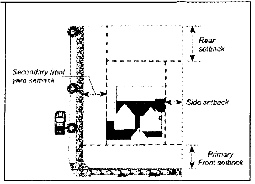
Double Frontage Corner Lots. On a corner lot with frontage on two streets, the building permit application shall specify the primary front yard; the remaining street frontage shall be considered the secondary front yard, as shown in Figure 130.30.050.A (Example: Corner Lot Setbacks) below in this Section. The yard opposite the primary front yard shall be considered the rear yard. The primary front yard setback shall comply with the front yard setbacks of the zone; the secondary front yard setback shall comply with the secondary front setback applicable to the zone.
Figure 130.30.050.A Example: Corner Lot Setbacks
b.
Triple Frontage Corner Lots. On a corner lot with frontage on three streets, the building permit application shall specify the primary front yard. The frontage opposite the primary front yard shall be considered a rear yard for setback purposes, providing vehicular access is restricted.
c.
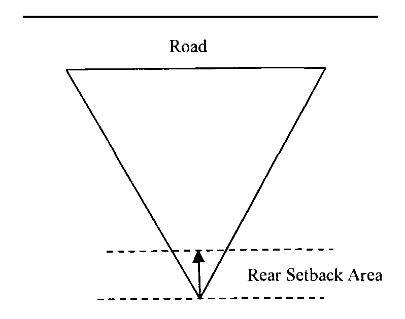
Rear Setback on Triangular Lot. Where a triangular lot has no rear lot line because its side lot lines converge to a point, an assumed line placed at the point, or vertex, of the angle and running perpendicular to a line bisecting the angle shall be considered the rear lot line for the purpose of measuring the required rear setback, as shown in Figure 130.30.050.B (Example: Rear Setbacks, Triangular Lots) below in this Section.
Figure 130.30.050.B Example: Rear Setbacks, Triangular Lots
5.
Through Lots. Through lots, or double frontage non-corner lots, shall maintain front yard setbacks for the primary frontage containing the driveway encroachment, and rear yard setbacks for the opposite frontage, providing vehicular access is restricted. Where vehicular access is allowed, front yard setbacks shall apply.
B.
Exceptions to Setback Requirements. The following exceptions to the setback requirements shall be allowed when the qualifying conditions have been documented by a licensed civil engineer or surveyor. All reductions in front yard setbacks shall be subject to cross visibility area (CVA) requirements under Subsection 130.30.070.B.4 (Fences, Walls, and Retaining Walls—Front Yards) below in this Chapter.
1.
Front Setback Reduction for Slope. Where the elevation of a lot measured at the required front setback line averages six feet or more for a lot less than one acre, or eight feet or more for a lot one acre or greater, above or below the elevation at the edge of road pavement adjacent to said lot, the required front setback for a single-story structure may be reduced by 50 percent, except:
a.
Where a lot has more than one frontage, the elevation criteria set forth under this Subsection B.1 must be satisfied for all frontages.
b.
Any parking structure allowed by this Subsection B.1 at a reduced front setback shall provide at least 20 feet of parking area between the edge of road pavement and the structure.
2.
Administrative Relief. Setback reductions for a multi-story structure, or where all frontages of a lot do not meet the elevation criteria set forth in Subsection B.1 (Front Setback Reduction for Slope) above in this Subsection may be approved under administrative relief subject to Chapter 130.52 (Permit Requirements, Procedures, Decisions, and Appeals) in Article 5 (Planning Permit Processing) of this Title provided the requirement under Subsection B.1.b above in this Subsection is met.
C.
Projections into Required Setbacks.
1.
Cornices, window canopies, eaves, bay windows, or similar architectural features, which do not qualify as habitable area under the building code; heating and air conditioning equipment; and uncovered and unenclosed decks of 30 inches in height or less, excluding handrails, may extend into any required setback by not more than 50 percent provided that no such feature shall be allowed within three feet of any side lot line.
a.
For uncovered and unenclosed decks, setbacks shall be measured from the closest portion of the deck, such as flooring, footing, or foundation, to the property line.
2.
Front yards may have the following additional encroachments:
a.
Fences and walls, subject to Section 130.30.070 (Fences, Walls, and Retaining Walls) below in this Chapter.
b.
Bear resistant garbage can containers, subject to Subsection 3.g (Bear Resistant Garbage Can Containers) below in this Section.
c.
Signs, subject to Chapter 130.36 (Signs) below in this Chapter.
3.
The following encroachments or reduced setbacks into the required yards are allowed for the following specific uses, provided there is no encroachment into any public utility or drainage easement:
a.
Swimming pool, heating and air conditioning equipment may encroach into any setback by up to 50 percent but not less than 3 feet from any lot line. When located within a required setback as allowed by this Subsection, accessory mechanical equipment that generates noise (such as air conditioning or swimming pool equipment) shall be enclosed with an appropriate noise barrier when less than 10 feet from the property line.
b.
Swimming pools measured to the back edge (non-water side) of the bond beam and their accessory water features, such as manmade waterfalls, if 30 inches in height or less:
(1)
Front. Setback required by zone.
(2)
Side and Rear. 5 feet minimum.
c.
Propane Tanks shall meet the applicable standards of the fire code (See Article 8: Glossary—"Fire Code" and "Fire Safe Regulations" of this Title) subject to the following conditions:
(1)
Front. The propane tank may be located within the front setback provided it is not less than 10 feet from the property line and the tank is less than 40 inches in height and fully screened by fencing or landscaping.
(2)
Underground Tanks. May be located within any setback.
d.
Portable Sheds (non-habitable, less than 120 square feet of floor space, containing no utilities):
(1)
Front. Setback required by zone.
(2)
Side and Rear. Five feet minimum, subject to fire safe regulations under Subsection D (Fire Safe Setbacks) below in this Section.
e.
Chimneys (at ground level):
(1)
Front and Rear. Three feet into setbacks.
(2)
Side. Three feet into setback, but in no instance shall the remainder of the side yard be less than three feet.
(3)
Chimneys that protrude above ground level, such as cantilevered chimney chases on the second story of a residence, shall not be subject to setback requirements.
f.
Solar Collectors that are ground mounted shall comply with the required side and rear setbacks for the zone, subject to the height requirements and maximum reduction in setbacks allowed under state Public Resource Code Section 25981.
g.
Bear Resistant Garbage Can Containers. A bear resistant garbage can enclosure in compliance with the approved list maintained by the Environmental Management Department shall be subject to the following minimum setbacks:
(1)
Ten feet from the road as measured from the edge of the curb-face or pavement if no curbing exists. In no event shall a container be placed within the road right-of-way or easement.
(2)
On corner lots, containers shall not be located within the CVA at the intersection, as shown in Figure 130.30.070.B (Cross Visibility Area (CVA) Example #2) below in this Chapter.
h.
Trellises and Arbors.
(1)
A trellis shall be considered similar to a fence for setback purposes and be subject to the requirements for fences under Section 130.30.070 (Fences, Walls, and Retaining Walls) below in this Chapter.
(2)
An arbor less than 50 percent open shall be considered a structure and be subject to development standards, including setback requirements, for the zone.
D.
Special Setbacks for Agricultural and Timber Resource Protection. Notwithstanding any other provision of this Title, where incompatible uses, as defined in Article 8 (Glossary: see "Incompatible Uses: Agricultural") of this Title, adjacent to the agricultural zones of LA, PA, and AG, or the Forest Resource (FR) and Timber Production Zone (TPZ), the following setbacks shall apply on those lots containing the incompatible use:
1.
Setback Standards on Lots Adjacent to Agricultural Zones.
a.
When the agriculturally zoned lot is located within a General Plan designated Agricultural District: 200 feet.
b.
When the agriculturally zoned lot is located outside of a General Plan designated Agricultural District:
(1)
A lot with the proposed incompatible use is 10 acres or larger: 200 feet.
(2)
A lot with the proposed incompatible use is less than 10 acres: No special agricultural setback is required.
c.
When the lot adjacent to the agriculturally zoned lot is in a General Plan designated Community Region or Rural Center: 50 feet.
2.
Setback Standards on Lots Adjacent to the Forest Resource or Timber Production Zone:
a.
When the lot adjacent to the Forest Resource or Timber Production Zone is within the General Plan designated Rural Region: 200 feet.
b.
When the lot adjacent to the Forest Resource or Timber Production zone is within a General Plan designated Community Region or Rural Center: 50 feet.
3.
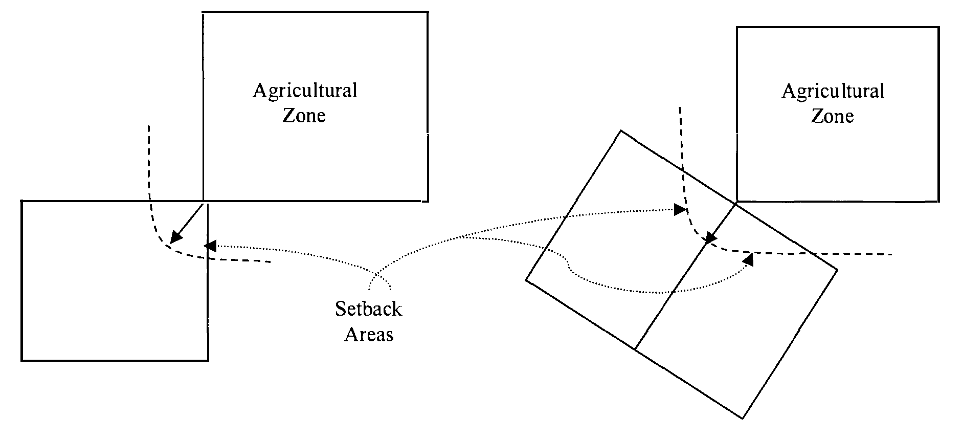
Setbacks and Buffers for Adjacent Tangent Lots. Where an agricultural or timber production zoned lot abuts a lot at a tangent or single point and where an agricultural or timber production zone setback will apply to the adjacent lot, the setback will be measured as a radius the length of the required setback, from the point of tangent into the adjacent lot, as shown in Figure 130.30.050.C (Examples: Tangential Setbacks) below in this Section:
Figure 130.30.050.C Examples: Tangential Setbacks
4.
Administrative Relief. Administrative relief from the setback requirements established in Subsections E.1 through E.3 above in this Section may be granted by the Ag Commission or the Director under an Administrative Permit (Section 130.52.010, Administrative Permit, Relief, or Waiver) in Article 5 (Planning Permit Processing) of this Title in compliance with criteria set forth by resolution of the Board, as amended from time to time.
E.
Special Setbacks for Mineral Resource Protection.
1.
Notwithstanding any other provision of this Title, where incompatible uses, as defined in Article 8 (Glossary: see "Incompatible Uses: Mining") of this Title, adjacent to lands located in the -MR Combining Zone containing existing approved mining operations, the following setbacks shall apply on those lots containing the incompatible use:
a.
250 feet on lots ten acres or greater.
b.
150 feet on lots less than ten acres in size.
2.
The required setbacks in Subsection F.1 above in this Section, may be administratively reduced under an Administrative Permit, in compliance with Section 130.52.010 (Administrative Permit, Relief, or Waiver) in Article 5 (Planning Permit Processing) of this Title by not more than 50 percent when the property owner affected by the setback has demonstrated to the Director that the mineral resource is at least 250 feet from the property line and mining activities are not likely to be carried on within 250 feet of the property line.
F.
Protection of Wetlands and Sensitive Riparian Habitat.
1.
Content. This subsection establishes standards for avoidance and minimization of impacts to wetlands and sensitive riparian habitat as provided in General Plan Policies 7.3.3.4, 7.4.2.5 and 7.4.2.8.
2.
Applicability. The standards in this subsection apply to all ministerial or discretionary development proposed adjacent to any perennial streams, rivers or lakes, any intermittent streams and wetlands, as shown on the latest 7.5 minute, 1:24,000 scale United States Geological Survey (USGS) Quadrangle maps, and any sensitive riparian habitat within the County. Activities regulated under this subsection include those activities also regulated under the federal Clean Water Act (33 U.S.C. § 1251 et seq.) and California Fish and Game Code (Section 1600-1607). These standards do not apply to culverted creeks and engineered systems developed or approved by the County or other public agency for collection of storm or flood waters, or systems other than natural creeks designed to deliver irrigation or water supplies. Additional standards applicable to the design of new developments or subdivisions are found in the Design and Improvement Standards Manual (DISM)/Land Development Manual (LDM), or successor document.
3.
Use Regulations.
a.
New ministerial and discretionary development shall avoid or minimize impacts to perennial streams, rivers or lakes, intermittent streams and wetlands, and any sensitive riparian habitat to the maximum extent practicable. Where avoidance and minimization are not feasible, the County shall make findings, based on documentation provided by the project proponent, that avoidance and minimization are infeasible.
b.
Any new development which does not avoid impacts to wetlands and sensitive riparian habitat shall prepare and submit a Biological Resource Assessment identifying the location of all features regulated under this Section.
c.
An applicant shall obtain all required permits from state or federal agencies having jurisdiction, and shall fully implement any mitigation program required as a condition of such permit. Where the area impacted is not within federal or state jurisdiction, the County shall require appropriate mitigation as recommended in a Biological Resource Assessment.
d.
Ministerial development, including single family dwellings and accessory structures, shall be set back a distance of 25 feet from any intermittent stream, wetland or sensitive riparian habitat, or a distance of 50 feet from any perennial lake, river or stream. This standardized setback may be reduced, or grading within the setback may be allowed, if a biological resource evaluation is prepared which indicates that a reduced setback would be sufficient to protect the resources.
e.
All discretionary development which has the potential to impact wetlands or sensitive riparian habitat shall require a Biological Resource Assessment to establish the area of avoidance and any buffers or setbacks required to reduce the impacts to a less than significant level. Where all impacts are not reasonably avoided, the biological resource evaluation shall identify mitigation measures that may be employed to reduce the significant effects. These mitigation measures may include the requirement for compliance with the mitigation requirements of a state or federal permit, if required for the proposed development activity.
f.
Any setback or buffer required by this subsection shall be measured from the ordinary high water mark of a river, perennial or intermittent stream, and the ordinary high water mark or spillway elevation of a lake or reservoir.
g.
Except where otherwise provided in this section, filling, grading, excavating or obstructing streambeds is prohibited except where necessary for placement of storm drain and irrigation outflow structures approved by the County; placement of public and private utility lines; construction of bridges and connecting roadways; maintenance activities necessary to protect public health and safety; and creek restoration and improvement projects.
h.
All new septic system construction shall comply with standards established by the Environmental Management Department, or applicable state and federal regulations for setbacks from lakes, rivers and streams.
i.
Projects within the joint jurisdiction of the County and the Tahoe Regional Planning Agency (TRPA) shall be subject to setbacks established by TRPA.
4.
Exceptions; Uses allowed. The following uses are allowed:
a.
Native landscaping;
b.
Fencing, consistent with the provisions of Subsection 130.30.070.B (Fences, Walls, and Retaining Walls—Front Yards) below in this Chapter, that does not interfere with the flow of waters or identified wildlife migration corridors;
c.
Roads or driveways used primarily for access or for the maintenance of a property;
d.
Utilities;
e.
Storm drains into riparian areas and creeks;
f.
Trails and passive recreational activities not involving the establishment of any structures;
g.
Boat ramps, docks, piers, and related features used for private purposes, subject to applicable local, state, or Federal regulations;
h.
Construction and maintenance of bridges, culverts, rip-rap, and other drainage facilities;
i.
Agricultural activities that utilize best management practices (BMPs), as recommended by the Ag Commission and adopted by the Board.
5.
Exceptions; Conditionally Permitted Uses.
a.
The uses, and structures allowed in applicable zones are allowed within riparian areas with an approved Minor Use Permit;
b.
In addition to the findings required for approval of a Minor Use Permit, the Zoning Administrator shall make all of the following findings for a Minor Use Permit for riparian area development:
(1)
The proposed use, structure, or encroachment cannot be feasibly located outside the riparian area or such location would have a more adverse effect on the stream environment.
(2)
Measures are included that provide adequate protection of wildlife habitat, water quality and in-stream habitat, and capacity for flood management.
6.
Performance Standards.
a.
Construction is prohibited in riparian buffers unless the necessary permits have been obtained from other responsible governmental agencies, and plans have been approved by the County.
b.
Grading, alteration of the natural contours of the land, or cutting or alteration of natural vegetation that protects sensitive riparian habitat is prohibited within riparian areas except when such action is required for the construction of an approved development or structure, associated with an agricultural use utilizing approved BMP's, or a creek restoration and enhancement project, or necessary to protect public health and safety.
7.
Specific setbacks for major lakes, rivers and streams. The setbacks identified in Table 130.30.050.H.1 (Specific Riparian Setbacks) below in this Section shall be provided, unless a discretionary approval by the County provides a larger or smaller setback.
Table 130.30.050.H.1—Specific Riparian Setbacks
8.
Coordination with Other Regulatory Agencies. All required permits from the California Department of Fish and Wildlife, the U.S. Army Corps of Engineers, regional water quality control board(s), California State Water Resources Control Board, or other applicable agencies, shall be obtained prior to commencement of construction. Evidence of approval or pending approval of any such permit shall be provided to the County, including all appropriate supporting materials, environmental documentation, and studies.
(Ord. No. 5241, § 6, 8-19-2025)
Sec. 130.30.060 - Height Limits and Exceptions.
All structures and buildings shall conform to the maximum height requirements established for the zone in which the lot is located as set forth in Chapters 130.21 (Agricultural, Rural, and Resources Zones) through 130.26 (Meyers Area Plan [MAP] Zone) in Article 2 (Zones, Allowed Uses, and Zoning Standards) of this Title, inclusive, subject to the exceptions under Subsection C (Exceptions to Building Height Requirements) below in this Section unless a Development Plan or Conditional Use Permit is approved allowing additional height, in compliance with Sections 130.52.040 (Development Plan Permit) or 130.52.021 (Conditional Use Permit) in Article 5 (Planning Permit Processing) of this Title.
A.
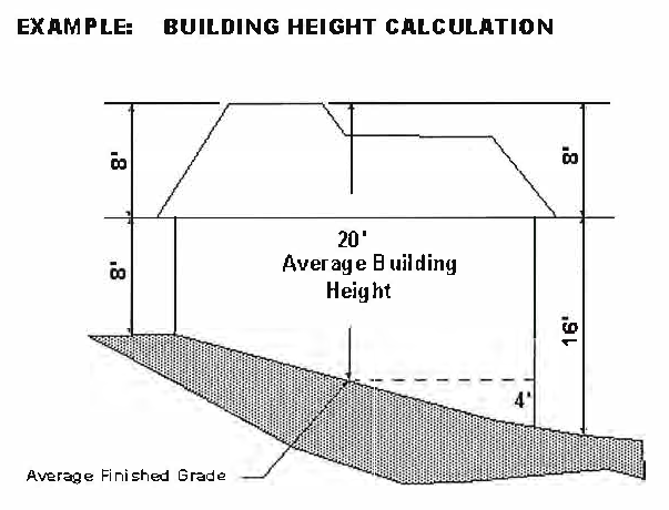
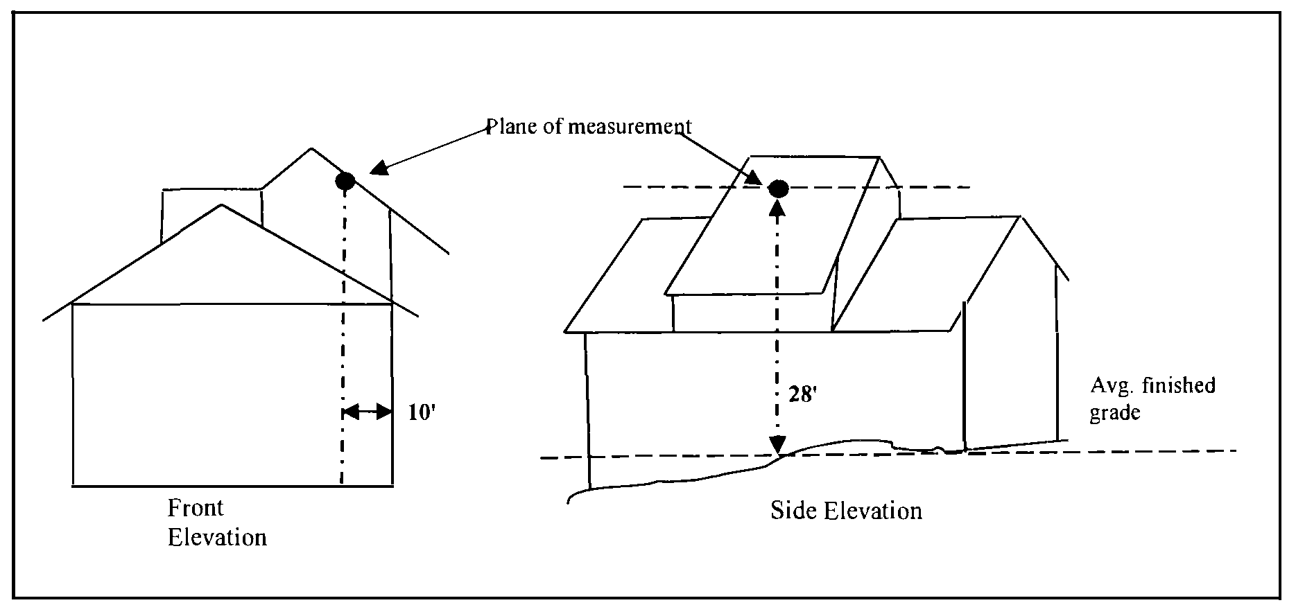
Measurement of Building Height. The height of a building is determined by calculating the average finished grade of each building wall, and measuring the height between this average finished grade and the highest point of the building, as shown in Figure 130.30.060.A (Example: Building Height Calculation) below in this Section. Where a retaining wall supporting a drop in grade is within a five foot horizontal distance from the exterior wall, the height of the retaining wall shall be included in the building height. If each building wall has a different height, then the average height of all four walls is calculated to determine the actual building height, as shown in Figure 130.30.060.A (Example: Building Height Calculation) below in this Section.
Figure 130.30.060.A
B.
Building Height Calculation for Determination of Side Yard Setback in Residential Zones. This Subsection shall apply in all zones that require setbacks of less than 30 feet. To calculate side yard setbacks based on building height, the wall facing the side yard shall be measured in compliance with Subsection A above in this Section for average grade, but in this case the highest point of the building shall be that highest point within ten feet from the surface of the wall being measured, as shown in Figure 130.30.060.B (Example: Building Height Determination for Side Yard Setbacks) below in this Section:
Figure 130.30.060.B Example: Building Height Determination for Side Yard Setbacks
For purposes of calculating the side yard setback, every foot or fraction thereof over a 25 foot height, as measured according to this Subsection, shall increase the setback by one foot. As demonstrated in Figure 130.30.060.B (Example: Building Height Determination for Side Yard Setbacks) above in this Section, the highest point measured, at 28 feet, shall increase the side yard setback by three feet.
C.
Exceptions to Building Height Requirements. Chimneys; church spires; elevator, mechanical and stair housings; flag poles; towers; vents; and other similar structures which are not used for human activity may be up to 20 percent higher than the maximum height requirements in all zones where the excess height is not prohibited by Section 130.27.100 (Airport Noise and Safety Contour [-ANS]) in Article 2 (Zones, Allowed Uses, and Zoning Standards) of this Title. The use of towers or similar structures to provide higher ceiling heights for habitable space shall be deemed a use intended for human activity. No such structure shall be employed for any commercial or advertising use unless specifically allowed by the applicable zone, except that antennas and associated equipment may be located within such structures.
Sec. 130.30.070 - Fences, Walls, and Retaining Walls.
A.
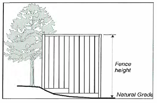
Measurement of Fence Height. Fence height shall be measured as the vertical distance between the natural or finished grade at the base of the lowest side of the fence, and the top edge of the fence material, as shown in Figure 130.30.070.A (Example: Fence Measurement) below in this Section:
Figure 130.30.070.A Example: Fence Measurement
B.
Front Yards. In all zones and for non-agricultural uses, the following fence and wall requirements shall apply within required front yard setback areas:
1.
Fences or walls at least 50 percent open shall be allowed up to a height of seven feet in both primary and secondary front yard setbacks, as determined in Subsection 130.30.050.A.4.a (Double Frontage Corner Lots) above in this Chapter.
2.
Fences or walls which are less than 50 percent open shall not exceed 40 inches in height in the primary front yard setback.
3.
The setback for a retaining wall greater than 36 inches in height may be reduced by 50 percent where the slope gradient for the front half of the lot exceeds 25 percent, providing:
a.
The exposed height shall not exceed seven feet.
b.
Any fence erected on the top of a retaining wall shall meet the requirements identified in this Section for height, construction, and cross-visibility area (CVA) purposes.
4.
Retaining walls that exceed the standards in 3.a above in this Section shall be subject to a Minor Use Permit in compliance with Section 130.52.020 (Minor Use Permit) in Article 5 (Planning Permit Processing) of this Title.
5.
Retaining walls necessary to provide site access or that do not exceed 36 inches in exposed height shall not be subject to setback requirements. In addition, such walls may be allowed within public utility easements but not within drainage easements.
6.
Fences or walls less than 50 percent open may be allowed up to a height of seven feet in the secondary front yard setback, but not less than 10 feet from the property line, right-of-way, or road easement where the property line is the center line of the road, subject to the cross-visibility area (CVA) restrictions in Subsections B.7 and B.8 (Front Yards) below in this Section.
7.
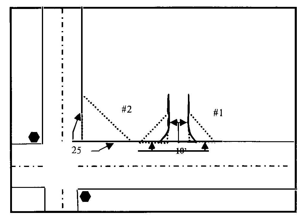
At a corner formed by any encroachment onto a road, no fence or wall greater than 40 inches in height shall be placed within the CVA consisting of a triangle having two sides 10 feet long, running along the driveway/encroachment edge and the road edge-of-pavement, said length beginning at their intersection, and the third side formed by a line connecting the two ends, as shown in Figure 130.30.070.B (Cross Visibility Area [CVA]) below in this Section (See #1 above in this Section).
8.
On corner lots, no fence or wall greater than 40 inches in height shall be placed within the CVA consisting of a triangle having two sides 25 feet long, running along each right of way or road easement, said length beginning at their intersection, and the third side formed by a line connecting the two ends, as shown in Figure 130.30.070.B (Cross Visibility Area [CVA]) below in this Section (See #2 above in this Section):
Figure 130.30.070.B Cross Visibility Areas (CVA)
C.
Side and Rear Yards. In all zones, fences, walls, cut retaining walls, or fences and walls that are erected within five feet of a retaining wall shall be allowed within required side and rear yard setbacks to a maximum cumulative height of seven feet. Fences, walls, or fences and walls that are erected within five feet of a retaining wall such that the cumulative height exceeds seven feet, but does not exceed ten feet in cumulative height, may be allowed subject to the following:
1.
Where the height of the fence or fence and wall is more than seven feet above the natural or finished grade of the adjacent property, a signed and notarized statement from the adjacent property owners that the proposed fence or wall, as described or shown in an attached exhibit, will not impact their view nor will it restrict light or movement of air and, therefore, they have no objection to the construction of the fence or wall;
2.
Director review of the notarized statement(s) to determine if it adequately represents the adjacent affected property. If such determination is made by the Director, the proposed fence or wall shall be approved through the Administrative Permit process in compliance with Section 130.52.010 (Administrative Permit, Relief, or Waiver) in Article 5 (Planning Permit Processing) of this Title. The Director may require additional notarized statements from neighboring properties if, in his/her opinion, they may be impacted by the fence or wall; and
3.
Issuance of a building permit where required by the applicable Building Code (Title 110—Buildings and Construction, of the County Code of Ordinances).
D.
Agricultural Uses. On lots that are located in the R1A, R2A, R3A, RE, RL, AG, PA, LA, FR, and TPZ zones, agricultural fencing, as defined in Article 8 (Glossary: see "Agricultural Fencing") of this Title, shall be allowed in any setback area provided it does not exceed 14 feet in height.
E.
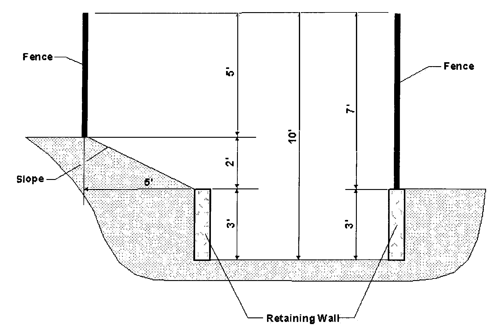
Retaining Walls. For the purposes of calculating fence or wall height, the height of a retaining wall is included in the calculation if the fence or wall is located on top of or within five feet of the retaining wall. A sloped area, if it exists between the retaining wall and the fence or wall shall be included in the height calculations as noted in Figure 130.30.070.C (Example: Retaining Wall/Fence Measurements) below in this Section.
Figure 130.30.070.C Example: Retaining Wall/Fence Measurements
F.
Fences shall not be allowed within a road easement or county-maintained right-of-way except as provided below:
1.
Gates and decorative entryways to a non-county maintained road system subject to the requirements under Section 130.30.090 (Gates) below in this Chapter;
2.
In RE, RL, AG, PA, LA, FR, and TPZ zones, agricultural fencing as defined in Article 8 (Glossary: see "Agricultural Fencing") of this Title, may be located within a county-maintained right-of-way or non-county maintained road easement, provided that the fence is located a minimum of five feet outside of all improved areas, including roadside drainage features and cut or fill slopes. When located within a county-maintained right-of-way or non-county maintained road easement, the property owner shall be required to remove or relocate said fence at the time any work or improvements are being made within the right-of-way or at the County's discretion when necessary to ensure the public health, safety, and welfare.
G.
Concertina wire, serpentine wire, barbed wire, razor wire, and other similar fencing materials capable of inflicting significant physical injury shall be prohibited. A Minor Use Permit will be required to allow these materials if it can be demonstrated that the proposed fencing is reasonably necessary to protect persons or property and will not constitute a safety hazard to members of the public conducting themselves in a lawful manner. In no event shall these fencing materials protrude into or over the public right-of-way. These regulations shall not apply to fencing required by court order, or when being used for animal husbandry and/or grazing operations.
H.
Fences and walls not located within any of the required setback or cross-visibility areas are limited in height only by the building height limitations of the zone in which they are located.
I.
A building permit shall be required, for any fence over seven feet in height, in compliance with Chapter 110.16 (Uniform Building Code) of Title 110 (Buildings and Construction) of the County Code of Ordinances, or as otherwise required by Title 110.
J.
Fences or walls shall not exceed the requirements of this Section unless and until a Minor Use Permit is granted in compliance with Section 130.52.020 (Minor Use Permits) in Article 5 (Planning Permit Processing) of this Title.
K.
Columns, pilasters, and support structures, and the decorative elements thereon associated with a fence or gate located on or within required setbacks may exceed the height limit provided they meet the following criteria:
1.
They do not exceed eight feet in height;
2.
They are not located closer than 16 feet on center;
3.
The fencing materials do not cumulatively exceed the see-through fence standard, where applicable; and
4.
They do not interfere with the cross visibility area (CVA) associated with any street or driveway.
Sec. 130.30.080 - Hillside Development Standards; 30 Percent Slope Restriction.
A.
Content. This Section contains standards to implement General Plan policies applicable to development within hillside areas. This Section regulates disturbance and development on existing lots containing slope gradients 30 percent or greater in all zones, provides for exceptions to allow reasonable use of property, relieve burdens on and promote agricultural production and protect the public health and safety.
Standards applicable to the creation of new lots or modification of existing lots (through the Boundary Line Adjustment process) containing slopes greater than 30 percent are found in the Hillside Land Use Standards of the Design and Improvement Standards Manual (DISM)/Land Development Manual (LDM), or successor document. The standards in this Title and the DISM/LDM, or successor document are provided to supplement other applicable regulations by providing additional planning and design tools to enable creative site planning, meeting the challenges of steep terrain, while minimizing the effects of construction on the hillside.
B.
Applicability; Slope Gradient Calculation. These standards in this Section shall apply to any development that will result in ground disturbance on any portion of an existing lot with a natural gradient of at least 30 percent (30 feet of vertical distance for every 100 feet of horizontal distance) and a vertical height of at least 50 feet.
The calculation of site gradient shall exclude the following:
1.
Artificial slopes created under a permit issued by the County or for which a permit was not required at the time the slopes were created.
2.
Slopes designated as open space or non-building areas in a Specific Plan or Planned Development, or protected through an open space designation, slope easement or other similar covenant.
3.
Areas of a site outside the area proposed for development, grading or other construction activity.
C.
Development Standards Applicable to Slopes 30 Percent or Greater. Development that will result in ground disturbance on slopes 30 percent or greater with a vertical height of 50 feet or more shall be prohibited, except where reasonable use of the property would be denied, as provided in Subsection E (Reasonable Use of Existing Lots or Parcels) below in this Section, or the activity is exempt under Subsection D (Exemptions) below.
Any development allowed on slopes 30 percent or greater shall require a grading or building permit and shall include an erosion and sediment control plan in compliance with the County Grading Design Manual.
Where required by the Grading Design Manual, technical studies from qualified professionals, such as soils or geotechnical reports to assess the erosion potential or slope stability may be required. Recommendations for erosion control or slope stabilization measures contained in the technical reports shall be implemented as a requirement of the grading or building permit. A surety bond, cash deposit or other security acceptable to the County may be required to ensure that long term erosion control measures, such as slope landscaping, are permanently established.
D.
Exemptions. The following types of development are exempt from the provisions of this Section:
1.
Development that will avoid disturbance of slopes 30 percent or greater;
2.
Development on slopes with a gradient of 30 percent or greater and a vertical height of 50 feet or less;
3.
Construction of public or private streets and roads, emergency vehicle access or driveways;
4.
Development approved prior to the adoption of this ordinance which has identified the extent of allowable development. These include approved variances, tentative and final subdivision and parcel maps, planned developments or other actions;
5.
Disturbance of existing artificial slopes created under a permit issued by the County or for which a permit was not required at the time the slopes were created;
6.
Repair of existing infrastructure, or replacement or repair of existing structures in substantially the same footprint;
7.
Disturbance on slopes necessary for public safety, such as removal of poisonous or noxious plants, controlled removal or thinning of vegetation as part of a fire protection program, or other public safety purpose;
8.
Development of a public trail comprising a component of the County's regional parks and trails master plans;
9.
Projects located in the Tahoe Basin. Such projects are subject to the policies and regulations of the TRPA Code of Ordinances;
10.
Underground utilities with accessory above ground components, utility poles and guy wires, and other similar features;
11.
Agricultural activities that utilize best management practices (BMPs), as recommended by the Ag Commission and adopted by the Board.
E.
Reasonable Use of Existing Lots or Parcels. Where reasonable use of an existing lot or parcel would otherwise be denied, development or disturbance of steep slopes is allowed under the reasonable use criteria in this Section. Reasonable use guidelines are applied based on the type of development proposed. The reasonable use criteria in this Title are not applicable to new subdivisions, or to the modification of existing parcels under the Boundary Line Adjustment process. Standards for new subdivisions or modifications of existing parcels are found in the Hillside Development Standards of the Design and Improvement Standards Manual (DISM)/Land Development Manual (LDM), or successor document.
1.
Single Family Residential on Existing Legal Lot. Development on existing, legally created parcels comprised of slopes that have a gradient of 30 percent or greater is allowed if ground disturbance related to development of the primary structure and any accessory structures and uses meets the following criteria:
a.
Minimize Area of Disturbance. The proposed total disturbance area on the parcel, excluding areas for septic systems, domestic water wells and driveways, shall not be greater than the thresholds contained in Table 130.30.080.A (Allowed Disturbance Area for Residential Parcels) below in this Section, based on the parcel size:
Table 130.30.080.A—Allowed Disturbance Area for Residential Parcels
b.
Minimize Grading. Minimize the impact of grading to the extent feasible through measures such as stepped foundations instead of graded pads, configuration of structures and grading to minimize the impact on natural topographic contours, rounding of cut and fill slopes, and the use of retaining walls to reduce the area of disturbance of slopes 30 percent or greater.
2.
Non-Residential and Multi-Family Residential Development on Existing Legal Lots. Lands designated for non-residential and multi-family residential are limited in extent and distribution to a small number of parcels, generally within Community Regions and Rural Centers. Development or disturbance of slopes 30 percent or greater will be allowed where:
a.
The proposed use is consistent with the General Plan and Zone designation for the property;
b.
The development or disturbance will not impair the stability of slopes on the property or on surrounding properties;
c.
The development or disturbance will conform to the requirements of the County Grading Ordinance, including best management practices for erosion and sedimentation control;
d.
Design techniques have been utilized, where feasible, to respect natural contours, including rounding of cut and fill slopes to minimize abrupt edges;
e.
The proposed use complies with the development standards of Subsection C (Development Standards Applicable to Slopes 30 percent or Greater) above in this Section.
3.
Reasonable use determinations for ministerial projects will be made by the Director or Building Official based on the criteria above. The determination of reasonable use for discretionary projects will be made as part of the discretionary review of the proposed project. The reasonable use determination may be appealed in the manner set forth in Section 130.52.090 (Appeals) in Article 5 (Planning Permit Processing) of this Title.
F.
Reasonable Use Criteria for Placement of Septic Systems on Existing Legal Lots or Parcels. General Plan Policy 7.1.2.1 (Erosion/Sedimentation) restricts the placement of septic systems to on steep slopes. Where public or private sewer service is unavailable, septic systems are integral to the development of most structures. Thus, the placement of an effluent disposal field on slopes of 30 percent or greater is considered as part of the reasonable use determination required for the development of parcels with slopes greater than 30 percent.
Septic system components may be located in areas containing slopes greater than 30 percent where alternative locations are not feasible or where the placement would reduce the overall disturbance of slopes. Location of septic system components shall comply with Chapter 110.32 (Private Sewage Disposal Systems) of Title 110 (Buildings and Constructions) of the County Code of Ordinances, and other regulations as determined by the Environmental Management Department. The area of disturbance associated with construction of septic system components is allowed in addition to the reasonable use areas identified above.
Sec. 130.30.090 - Gates.
The placement of gates across county-maintained rights-of-way shall be prohibited. The following regulations establish a supplemental review and approval procedure for placing gates across non-County-maintained roads or private driveways entering residential and nonresidential development. The regulations in this Section do not apply to gates serving exclusively agricultural uses.
A.
Single- and Multi-unit Residential Development. Single- and multi-unit residential dwellings located on one lot are allowed to construct gates across driveways providing the gates are located a minimum of 20 feet from the edge of pavement, will not swing into a county right-of-way or non-county maintained road or alley, are constructed consistent with applicable fire and building codes, and are in compliance with Subsections D.2 to D.5 (Design Standards for Gated Developments), inclusive, and D.9 ("Anti-directional" devices…) below in this Section.
B.
Nonresidential Development. An Administrative Permit is required, in compliance with Section 130.52.010 (Administrative Permit, Relief, or Waiver) in Article 5 (Planning Permit Processing) of this Title, to establish gates at nonresidential driveway entrances that will prohibit free access/egress to and from the site by either remaining closed during business hours, such as with manned or automatic toll booths, or when being used to prevent public access after close of business. In addition to requirements under Section 130.52.010 (Administrative Permit, Relief, or Waiver), the permit shall be in compliance with Subsections D.1 to D.5 (Design Standards for Gates Developments), inclusive, and D.9 ("Anti-directional" devices at gated entrances…) below in this Section.
C.
Residential Subdivisions. An Administrative Permit shall be required to establish gates across non-county maintained road(s) within a residential subdivision consisting of two or more lots, including condominium developments. An Administrative Permit to establish gates shall not be approved unless the Director finds all of the following:
1.
The gate will not impede public access to a public resource, such as a public park, or interfere with existing or planned traffic circulation patterns; and
2.
The project conforms to the standards of Subsection D (Design Standards for Gates Developments) below in this Section.
D.
Design Standards for Gated Developments. The following standards shall be required in the design of gated developments. Deviation from these standards shall require a Conditional Use Permit in compliance with Section 130.52.021 (Conditional Use Permits) in Article 5 (Planning Permit Processing) of this Title, except where conditions are included in a development plan permit or other project conditions.
1.
All Administrative Permits shall be subject to review by the Department of Transportation and the local fire district.
2.
Design and location of gates shall be consistent with Title 12 (Streets, Sidewalks, and Public Places) of the County Code of Ordinances.
3.
Road widths and gate openings shall conform to the minimum requirements of Title 14 Fire Safe Regulations.
4.
At least one lane in each direction shall provide a minimum of 14 feet of unobstructed vertical clearance.
5.
Gates shall be equipped with an emergency access lock system (approved by the fire department) that shall consist of a padlock in series on manual gates or a key switch on automatic gates. Automatic gates shall also be equipped with a receiver to allow remote activation by emergency vehicles to the satisfaction of the Sheriff's Department and the applicable fire department. Automatic gates shall be equipped with a mechanical release and a loop system to keep the gate open as long as traffic is passing through, and shall be designed to remain in the unlocked position during a power failure.
6.
Gated entrances shall be designed in compliance with the Design and Improvement Standards Manual (DISM)/Land Development Manual (LDM), or successor document as to approach distance between the gate and the road in order to accommodate vehicular stacking, and between the gated entrance and the gate controller to allow vehicles to turn around within the driveway without backing onto the adjacent road.
7.
Where entrance gates will create a dead-end road in excess of 150 feet in length, an area shall be provided along said road to allow fire trucks and equipment to turn around. The gradient of the road shall be level enough to allow for safe parking of the emergency vehicle when it is necessary to exit the vehicle for manual gate activation.
8.
One pedestrian access shall be provided at each gated entrance to a residential or non-residential development. This requirement does not apply to a gate to a single family residence.
9.
"Anti-directional" devices at gated entrances and exits, such as metal spikes that can cause tire damage, are prohibited.
10.
Unless already provided for in the recorded Covenants, Conditions & Restrictions (CC&Rs) for the property or subdivision, a maintenance agreement shall be established and recorded for the gated development. The agreement shall identify, and at all times keep in effect, a legal entity responsible for maintaining the gates and associated features.
(Ord. No. 5241, § 7, 8-19-2025)
Sec. 130.31.010 - Content.
As required by California Government Code Section 65915, this Chapter contains provisions to allow a density bonus or other incentives or concessions to developers for the production of housing units affordable to very low, lower, and moderate income households and to senior citizens and/or citizens with disabilities. In offering these incentives, this Chapter carries out the requirements of California Government Code Sections 65915, 65916, and 65917. The regulations set out in this Chapter shall apply to unincorporated areas of the County that are not within the TRPA's jurisdictional area. (Ord. 4816, 2009)
Sec. 130.31.020 - Definitions.
As used in this Chapter, the following words and terms shall have the meanings set forth below:
A.
"Affordable housing" means housing affordable to very low, lower, or moderate income households.
1.
"Very low income household" means a household that earns less than 50 percent of the area median income for El Dorado County, adjusted for family size and updated annually. This term includes extremely low income households earning less than 30 percent of the area median income for the County, adjusted for family size and updated annually. (See Health and Safety Code (HSC) Section 50105).
2.
"Lower income household" means a household that earns between 50 and 80 percent of the area median income for the County, adjusted for family size and updated annually. (See HSC Section 50079.5).
3.
"Moderate income household" means a household that earns between 80 and 120 percent of area median income for the County, adjusted for family size and updated annually. (See HSC Section 50093).
B.
"Density Bonus" means a density increase over the otherwise allowable maximum residential density under the applicable General Plan designation and Zone District.
C.
"Incentive" or "Concession" represents any of the following:
1.
Reduction in site development standards or a modification of zoning code requirements or architectural design requirements that exceed the minimum standards of the Building Code, including, but not limited to, a reduction in the setback and square footage requirements and in the ratio of vehicular parking spaces that would otherwise be required that results in identifiable, financially sufficient and actual cost reductions;
2.
Other concessions or incentives of a regulatory nature identified in the County's Incentive Based Affordable Housing policy (Note: policy is in development and not yet adopted by the Board), or proposed by the applicant or the County that result in identifiable, financially sufficient and actual cost reductions.
D.
"Qualifying housing development" means a single project for five or more residential units constructed within the unincorporated area of the County. For the purpose of calculating a density bonus, the residential units must be on contiguous sites that are the subject of one development application.
E.
"Senior citizen" means a person 62 years of age or older, or 55 years of age or older in a senior citizen housing development. (See Civil Code Section 51.3).
Sec. 130.31.030 - Eligibility for Bonus, Incentives, and/or Concessions.
A.
In order to be eligible for a density bonus or other incentive or concession as provided by this Chapter, a proposed qualifying housing development shall consist of five or more residential units, either for rent or for sale and where at least one unit is affordable to very low, lower, or moderate income households.
B.
A developer shall be granted a density bonus, incentives and/or concessions described in Section 130.31.040 (Bonuses, Incentives, and Concessions Allowed) below in this Chapter when he or she agrees to provide at least any one of the following:
1.
At least five percent of the total number of proposed units for very low income households;
2.
At least ten percent of the total number of proposed units for lower income households;
3.
A senior citizen housing development;
4.
At least 10 percent of the total number of proposed units in a condominium project, for persons and families of moderate income;
5.
The donation of land sufficient in size to allow development of at least 40 affordable housing units consistent with California Government Code Section 65915(h) and Subsection 130.31.040.B (Density Bonus for the Dedication of Land) below in this Chapter;
6.
The payment of a fee in lieu of providing affordable housing units as established in this Section and Subsection 130.31.040.D (Affordable Housing In-Lieu Fee) below in this Chapter.
C.
In order to be eligible for a bonus, incentive, and/or concession, the applicant shall ensure that all provisions of this Chapter are met.
D.
All eligible developments shall comply with the Fair Housing Act that protects all citizens from discrimination on the basis of race, color, national origin, religion, sex, disability, or familial status, such as families with children under the age of 18 living with parents or legal guardians, pregnant women, and people trying to get custody of children under 18 years of age.
E.
"Total units" does not include units added by a density bonus in compliance with this Chapter or by any other local policy granting a greater density bonus.
Sec. 130.31.040 - Bonuses, Incentives, and Concessions Allowed.
Qualifying housing development projects that satisfy all applicable provisions of this Chapter shall be entitled to a density bonus and additional incentives or concessions as follows:
A.
Density Bonus for Reservation of Affordable Units. The density bonus allowed by this Chapter shall consist of an increase in the number of dwelling units over the otherwise maximum allowable residential density under the applicable General Plan designation and zone. The amount of density bonus to which an applicant is entitled shall vary according to the amount by which the percentage of affordable housing units exceeds the percentages established in Subsection 130.31.030.B (Eligibility for Bonus, Incentives, and/or Concessions) above in this Chapter. The applicant who requests a density bonus in compliance with this Subsection shall elect which bonus shall be awarded. The density bonus shall be awarded pursuant to the calculations and limitations provided in California Government Code Section 16915(g) for very low, lower, and moderate income units.
B.
Density Bonus for the Dedication of Land. When an applicant for a subdivision, parcel map, or other residential development project donates land to the County for the development of affordable housing, the applicant shall be entitled to a density bonus consistent with and subject to the provisions of California Government Code Section 65915(h).
C.
Incentives for Provisions of Child Day Care Centers. When an applicant proposes to construct a housing development that conforms to Subsection 130.31.030.B (Eligibility for Bonus, Incentives, and/or Concessions) above in this Chapter, and includes a child day care center that will be located on the premises of, either as part of or adjacent to, the project, the County shall grant a density bonus or other incentive consistent with California Government Code Section 65915(i).
D.
Affordable Housing In-Lieu Fee. If the Board adopts a fee in lieu of providing the affordable housing units established by Section 130.31.030 (Eligibility for Bonus, Incentives, and/or Concessions) above in this Chapter, an applicant may choose to pay said fee in lieu of providing affordable housing.
1.
The amount and calculation of the affordable housing in lieu fee and the Affordable Housing Trust Fund Guidelines shall be established by resolution of the Board.
2.
The in lieu fee shall be calculated at the time of building permit application. The fee shall be paid at the time of issuance of the building permit, unless proof is provided that the required affordable housing units will be constructed on-site or that an alternative equivalent action was previously approved in accordance with this Chapter.
E.
Conversion of Market Rate Housing. When an applicant for a qualifying housing development acquires existing market rate dwelling units and enforces price restrictions on the rental or sale of the existing market rate dwelling units in compliance with this Chapter, he/she shall be entitled to a 15 percent increase above the otherwise maximum allowable density under the applicable General Plan designation and zone. The project must be reviewed as to the appropriateness of the conversion from market rate to income restricted units to minimize neighborhood impacts. It may require design upgrades subject to a Design Review Permit (Section 130.52.030, Design Review Permit) in Article 5 (Planning Permit Processing) of this Title, for compliance with current standards and regulations.
Sec. 130.31.050 - Processing of Requests.
A.
Requests for density bonuses, incentives, and/or concessions shall be made and evaluated through the County's existing permit processes where required, in compliance with Chapter 130.63 (Amendments and Zone Changes) in Article 6 (Zoning Ordinance Administration) of this Title, and Chapter 130.52 (Permit Requirements, Procedures, Decisions, and Appeals) in Article 5 (Planning Permit Processing) of this Title. Where no discretionary permits are otherwise required for a project, consideration of density bonuses, incentives, and/or concessions shall be made through an Administrative Permit in compliance with Section 130.52.010 (Administrative Permit, Relief, or Waiver) in Article 5 (Planning Permit Processing) of this Title.
B.
All requests for density bonuses, incentives, and/or concessions shall be subject to the following:
1.
Supporting Information. If regulatory concessions are sought, the developer shall include information with the application, based on building industry standards, to substantiate that any requested waiver or modification of zoning or subdivision standards is necessary to make housing units affordable to very low, lower, or moderate income households.
2.
Initial Review. Bonus, incentive, and/or concession requests shall be included as part of the permit application and shall be reviewed by the Director. The Director shall notify the applicant within 30 days of the acceptance of the project permit application as complete, whether the project qualifies for the requested additional density, incentive, and/or concession.
3.
Criteria to be Considered. The requested bonus, incentive, and/or concession shall be reviewed for consistency with the General Plan and other applicable County regulations. Particular attention shall be given to application of Housing Element policies and policies addressing the source and distribution of potable water, the type and scale of available wastewater disposal and treatment, and roadway capacity.
4.
Findings for Approval.
a.
In addition to the findings required for approval of the proposed project, support of a density bonus by the appropriate review authority shall also require the following special findings:
(1)
There are sufficient provisions to guarantee that units will remain affordable in the future, consistent with the requirements of Section 130.31.060 (Continued Availability of Affordability) above in this Chapter and the California Government Code Sections 65915(c) and 65915(h)(4).
(2)
Adequate evidence exists to indicate that development of the subject property in compliance with a valid permit or entitlement will result in the provision of housing affordable to very low, lower, and moderate income households in a manner consistent with this Chapter.
(3)
The number of dwelling units approved by the permit or entitlement can be accommodated by existing and/or planned infrastructure, consistent with General Plan requirements for concurrency for such services.
b.
The County shall grant the requested bonus, concession(s), and/or incentive(s) requested by the applicant unless the County makes a written finding, based upon substantial evidence, of either of the following:
(1)
The concession or incentive is not required in order to provide for affordable housing costs, as defined in California Health and Safety Code Section 50052.5, or for rents for the targeted units to be set as specified in California Government Code Section 65915(c); or
(2)
The concession or incentive would have a specific adverse impact, as defined in California Government Code Section 65589.5(d)(2), upon health, safety, the physical environment, or any real property that is listed in the California Register of Historical Resources and for which there is no feasible method to satisfactorily mitigate or avoid the specific adverse impact without rendering the development economically infeasible to very-low, lower, and moderate income households.
Sec. 130.31.060 - Continued Availability of Affordability.
A.
Affordability shall be based on the following:
1.
Affordable Rental Housing is a rental dwelling for which the total monthly expense of rent plus the standard County Housing Authority utility allowance, does not exceed 30 percent of the maximum monthly income limit for very low and low income households in the County as established and updated yearly by the State Department of Housing and Community Development. (California Government Code Section 65915(c)(1)).
2.
An Affordable Purchase Price is the sales price at which the affordable unit will be offered to prospective eligible buyers. The monthly housing cost factors required to be included in the calculation of the Affordable Housing Price shall be provided by the County based on the average total monthly housing expenses during the first calendar year of a household's occupancy, including but not limited to property taxes, homeowner's insurance, homeowner's association dues, if any, mortgage loan principal and interest, mortgage insurance, and Mello Roos or other applicable assessments, which are equal to or less than one-twelfth) of 35 percent of no greater than 120 percent of Median Family Income, adjusted for Household Size based on an occupancy standard of one-person per bedroom, plus one additional person (for example, a three-bedroom home will be priced based on the income of a four-person family).
B.
The permit application for the development project shall include the procedures proposed by the developer to maintain the continued affordability of all very low, lower, and senior citizen units, as follows:
1.
Maintain affordability for at least 30 years for units that were built with the assistance of County funding, including assistance in the forms of contributions to the cost of infrastructure, write-down of land costs, or construction cost subsidization.
2.
Maintain affordability as required by the construction or mortgage financing assistance program, mortgage insurance program, or rental subsidy program, typically for a minimum of 30 years.
C.
Moderate income condominium or planned development units approved and/or constructed in compliance with this Chapter shall remain affordable for at least 20 years.
1.
If such units are sold within the 20 year affordability time frame, the seller of the unit shall retain the value of any improvements, the down payment, and the seller's proportionate share of appreciation.
2.
The County shall recapture its proportionate share of appreciation, which shall then be used within three years for any of the purposes promoting home ownership, as described in Health and Safety Code Section 33334.2(e).
D.
The developer shall be required to enter into an Affordable Housing Agreement with the County. The Agreement shall delineate those concessions to be made by all parties to ensure that affordable housing can be and is constructed and remains available to the residents for a period of time consistent with Subsections B and C above in this Section. The developer or his/her successor in interest shall not sell, rent, lease, sublet, assign, or otherwise transfer any interests for same without written approval of the County Housing Authority, confirming that the cost of the units will remain consistent with the limits established for the affected density bonus. The Agreement shall also establish specific compliance standards and remedies available to the County upon failure by the developer to make the target units available to intended households.
Sec. 130.31.070 - Location of Bonus Units.
Units affordable to very low, lower, or moderate income households constructed in compliance with this Chapter shall be approved under a single development application and be built within one-quarter mile of the boundary of the proposed housing development, unless the County and developer agree to an alternative site for development in the Affordable Housing Agreement.
Sec. 130.31.080 - Time of Construction and Occupancy.
Units affordable to very low, lower, or moderate income households must be constructed concurrently with nonrestricted units and shall be made available for occupancy not later than the time at which the first nonrestricted dwelling unit is available for occupancy, unless the County and developer agree within the Affordable Housing Agreement to an alternative schedule for development and occupancy.
Sec. 130.31.090 - Design.
Except as provided for in Section 130.31.040 (Bonuses, Incentives, and Concessions Allowed) above in this Chapter, units affordable to very low, lower, or moderate income households shall be built on-site and be dispersed throughout the housing development wherever feasible. In addition, the number of bedrooms of the units affordable to very low, lower, or moderate income households shall be equivalent to the bedroom mix of the nonrestricted units of the housing development unless the County and developer agree within the Affordable Housing Agreement to an alternative mix. The developer may include a higher proportion of units affordable to very low, lower, or moderate income households with more bedrooms. The design and appearance of the units affordable to very low, lower, or moderate income households shall be compatible with the design of the total housing development.
Sec. 130.32.010 - Statutory Authorization, Findings of Fact, Content and Methods.
A.
Statutory Authorization. The legislature of the state has in California Government Code, Sections 65302, 65560, and 65800, conferred upon local governments the authority to adopt regulations designed to promote the public, health, safety, and general welfare of its citizenry. Therefore, the Board does hereby adopt the following floodplain management regulations.
B.
Findings of Fact.
1.
The flood hazard areas of the County are subject to periodic inundation, which could result in loss of life and property, health and safety hazards, disruption of commerce and governmental services, extraordinary public expenditures for flood protection and relief, and impairment of the tax base, all of which adversely affect the public health, safety and general welfare.
2.
These flood losses are caused by uses that are inadequately flood-proofed, elevated or otherwise protected from flood damage. The cumulative effect of obstructions in areas of special flood hazards that increase flood heights and velocities also contribute to flood losses.
C.
Content. This Chapter implements General Plan Policy 6.4.1.1 requiring continued participation in the National Flood Insurance Program in order to promote the public health, safety, and general welfare, and to minimize public and private losses due to flood conditions in specific areas. This Chapter serves to provide legally enforceable regulations applied uniformly throughout the community to all publicly and privately owned land within flood prone areas. These regulations are designed to:
1.
Protect human life and health;
2.
Minimize expenditure of public money for costly flood-control projects;
3.
Minimize the need for rescue and relief efforts associated with flooding and generally undertaken at the expense of the general public;
4.
Minimize prolonged business interruptions;
5.
Minimize damage to public facilities and utilities such as water and gas mains; electric, telephone and sewer lines; and streets and bridges located in areas of special flood hazard;
6.
Help maintain a stable tax base by providing for the sound use and development of special flood hazard areas so as to minimize future blighted areas caused by flood damage;
7.
Ensure that potential buyers are notified that property is in a special flood hazard area;
8.
Ensure that those who occupy the special flood hazard areas assume responsibility for their actions.
D.
Methods of Reducing Flood Losses. In order to accomplish its purposes, this Chapter includes regulations to:
1.
Restrict or prohibit uses which are dangerous to health, safety, and property due to water or erosion hazards, or which result in damaging increases in erosion, or in flood heights or velocities;
2.
Require that uses vulnerable to floods, including facilities that serve such uses, be protected against flood damage at the time of initial construction;
3.
Control the alteration of natural floodplains, stream channels, and natural protective barriers, which help accommodate or channel floodwaters;
4.
Control the filling, grading, dredging, and other development which may increase flood damage; and
5.
Prevent or regulate the construction of flood barriers which will unnaturally divert floodwaters or which may increase flood hazards in other areas.
These regulations take precedence over any less restrictive or conflicting laws, ordinances or codes.
Sec. 130.32.020 - Definitions.
Unless specifically defined below, words or phrases used in this Chapter shall be interpreted so as to give them the meaning they have in common usage and to give this Chapter its most reasonable application.
"A zone" means Area of 100-year flood where base flood elevations and flood hazard factors have not been determined.
"A1-A30 zones" means Area of 100-year flood where base flood elevations and flood hazard factors have been determined.
"Accessory structure" means a subordinate building or structure detached from the primary building or structure on the same lot and incidental to the primary building.
"Accessory use" means a use which is incidental and subordinate to the primary use of the parcel of land on which it is located.
"Appeal" means a request for a review of the Floodplain Administrator's interpretation of any provision of this Chapter.
"B zone" means areas between limits of the 100-year flood and 500-year flood; or certain areas subject to 100-year flooding with average depths less than one foot or where the contributing drainage area is less than one square mile.
"Base flood" means a flood having a one percent chance of being equaled or exceeded in any given year (also called a "100-year flood"). Base flood is the term used throughout this Chapter.
"Base flood elevation" (BFE) means the elevation shown on the Flood Insurance Rate Map for Zones A1-30, that indicates the water surface elevation resulting from a flood that has a one percent or greater chance of being equaled or exceeded in any given year.
"Basement" means any area of the building having its floor subgrade (i.e., below ground level) on all sides.
"Building"—see "structure".
"Development" means any man-made change to improved or unimproved real estate, including, but not limited to buildings or other structures, mining, dredging, filling, grading, paving, excavation or drilling operations, or storage of equipment or materials.
"Encroachment" means the advance or infringement of uses, plant growth, fill, excavation, buildings, permanent structures, or other development into a floodplain that may impede or alter the flow capacity of the floodplain.
"Existing manufactured home park or subdivision" means a manufactured home park or subdivision for which the construction of facilities for serving the lots on which the manufactured home is to be affixed (including, at a minimum, the installation of utilities, the construction of streets, and either final site grading or the pouring of concrete pads) is completed before the effective date of this Chapter.
"Expansion to an existing manufactured home park or subdivision" means the preparation of additional sites by the construction of facilities for serving the lots on which the manufactured homes are to be affixed (including the installation of utilities, the construction of streets, and either final site grading or pouring of concrete pads).
"Flood, flooding, or floodwater" means a general and temporary condition of partial or complete inundation of normally dry land areas from:
1.
The overflow of inland or tidal waters; or
2.
The unusual and rapid accumulation of runoff of surface waters from any source.
"Flood boundary and floodway map (FBFM)" means the official map on which the Federal Emergency Management Agency or Federal Insurance Administration has delineated both the special flood hazards areas and the floodway.
"Flood insurance rate map (FIRM)" means the official map on which the Federal Emergency Management Agency or Federal Insurance Administration has delineated both the special flood hazards areas and the risk premium zones applicable to the community.
"Flood insurance study (FIS)" means the official report provided by the Federal Insurance Administration that includes flood profiles, the Flood Insurance Rate Map, the Flood Boundary and Floodway Map, and the water surface elevation of the base flood. The flood insurance study, FIRMs and FBFMs are on file at the Department, 2850 Fairlane Court, Placerville, California 95667.
"Floodplain or flood-prone area" means an area susceptible to floodwater. Also see "Flood, flooding, or floodwater".
"Floodplain Administrator" is the community official designated by title to administer and enforce the floodplain management regulations. In El Dorado County, this duty falls on the Director or his/her authorized representative.
"Floodplain management" means the operation of an overall program of corrective and preventive measures for reducing flood damage and preserving and enhancing, where possible, natural resources in the floodplain, including but not limited to emergency preparedness plans, flood control works, floodplain management regulations, and open space plans.
"Floodplain management regulations" means this Chapter, the remaining Zoning Ordinance, subdivision regulations, building codes, health regulations, special purpose ordinances (such as grading and erosion control) and other applications of police power that control development in flood-prone areas. This term describes federal, state or local regulations in any combination thereof that provide standards for preventing and reducing flood loss and damage.
"Floodproofing" means any combination of structural and nonstructural additions, changes or adjustments to structures that reduce or eliminate flood damage to real estate or improved real property, water and sanitary facilities, structures, and their contents. For guidelines on dry and wet floodproofing, see Federal Emergency Management Agency (FEMA) Technical Bulletins TB 1-93, TB 3-93, TB 7-93, and subsequent updates.
"Floodway" means the channel of a river or other watercourse and the adjacent land areas that must be reserved in order to discharge the base flood without cumulatively increasing the water surface elevation more than one foot. Also referred to as "Regulatory Floodway".
"Floodway fringe" is that area of the floodplain on either side of the "Regulatory Floodway" where encroachment may be permitted.
"Functionally dependent use" means a use which cannot perform its intended purpose unless it is located or carried out in close proximity to water. The term includes only docking facilities, port facilities that are necessary for the loading and unloading of cargo or passengers, and ship building and ship repair facilities, and does not include long-term storage or related manufacturing facilities.
"Highest adjacent grade" means the highest natural elevation of the ground surface next to the proposed walls of a structure prior to construction.
"Lowest floor" means the lowest floor of the lowest enclosed area—see "Basement". An unfinished or flood-resistant enclosure that is usable solely for parking of vehicles, building access or storage in an area other than a basement area, is not considered a building's lowest floor provided it conforms to applicable non-elevation design requirements under Section 130.32.050 (Provisions for Flood Hazard Reduction).
"Manufactured home" means a structure, transportable in one or more sections, which is built on a permanent chassis and is designed for use with or without a permanent foundation when connected to the required utilities. For floodplain management purposes, the term manufactured home also includes mobile homes, park trailers, and other similar vehicles placed on a site for greater than one hundred eighty consecutive days. The term "manufactured home" does not include a "recreational vehicle."
"Manufactured home park or subdivision" means a lot (or contiguous lots) of land divided into two or more manufactured home lots for rent or sale.
"Market value" means the value of the structure shall be determined by estimating the cost to replace the structure in new condition and adjusting that cost figure by the amount of depreciation which has accrued since the structure was constructed.
1.
The cost of replacement of the structure shall be based on a square foot cost factor determined by reference to a building cost estimating guide recognized by the building construction industry.
2.
The amount of depreciation shall be determined by taking into account the age and physical deterioration of the structure and functional obsolescence as approved by the floodplain administrator, but shall not include economic or other forms of external obsolescence.
Use of replacement costs or accrued depreciation factors different from those contained in recognized building cost estimating guides may be considered only if such factors are included in a report prepared by an independent professional appraiser and supported by a written explanation of the differences."
"Mean sea level" means, for purposes of the National Flood Insurance Program, the National Geodetic Vertical Datum (NGVD) of 1929, or other datum, to which base flood elevations shown on a community's Flood Insurance Rate Map are referenced.
"Modern construction" means structures for which the "start of construction" commenced on or after April 1, 1986, the initial adoption date of the County's Flood Damage Prevention Ordinance, and includes any subsequent improvements to such structures, pursuant to the Department of Water Resources Guidelines, for floodplain management purposes.
"Modern manufactured home park or subdivision" means a manufactured home park or subdivision for which the construction of facilities for servicing the lots on which the manufactured homes are to be affixed, including at a minimum, the installation of utilities, the construction of streets, and either final site grading or the pouring of concrete pads, is completed on or after April 1, 1986.
"Obstruction" includes, but is not limited to, any dam, wall, wharf, embankment, levee, dike, pile, abutment, protection, excavation, channelization, bridge, conduit, culvert, building, wire, fence, rock, gravel, refuse, fill, structure, vegetation or other material in, along, across or projecting into any watercourse which may alter, impede, retard or change the direction and/or velocity of the flow of water, or due to its location, its propensity to snare or collect debris carried by the flow of water, or its likelihood of being carried downstream.
"One-hundred-year flood" or "100-year flood" means a flood having a one percent chance of being equaled or exceeded in any given year (also called a "base flood").
"Public safety and nuisance" as related to Section 130.32.060 (Variance Procedures) of this Chapter, means that the granting of a variance must not result in anything which is injurious to safety or health of an entire community or neighborhood, or any considerable number of persons, or unlawfully obstructs the free passage or use, in the customary manner, of any navigable lake, or river, bay, stream, canal, or basin.
"Recreational vehicle" means a motor home, travel trailer, truck camper, or camping trailer, with or without motive power, originally designed for human habitation for recreational or emergency occupancy with a living area of 320 square feet or less and bearing the state or federal insignia of approval for recreational vehicles.
"Regulatory floodway" means the channel of a river or other watercourse and the adjacent land areas that must be reserved in order to discharge the base flood without cumulatively increasing the water surface elevation more than one foot.
"Remedy a violation" means to bring the structure or other development into compliance with state or local floodplain management regulations, or, if this is not possible, to reduce the impacts of its noncompliance through such means as protecting the structure or other affected development from flood damages, implementing the enforcement provisions of the Chapter or otherwise deterring future similar violations, or reducing state or federal financial exposure with regard to the structure or other development.
"Riverine" means relating to, formed by, or resembling a river (including tributaries), stream, brook, etc.
"Special flood hazard area (SFHA)" means an area in a floodplain subject to a base flood. In El Dorado County, it is shown on an FHBM or FIRM, and all subsequent amendments and/or revisions, as Zones A, A1-A9, A14, A24, or B, which are defined under "A zone", "A1-A30 zones" and "B zone".
"Start of construction", as defined in Article 8 (Glossary) of this Title and for purposes of this Chapter, includes substantial improvement and other proposed new development. For a substantial improvement, the actual start of construction means the first alteration of any wall, ceiling, floor, or other structural part of a building, whether or not that alteration affects the external dimensions of the building.
"Structure" means a walled and roofed building that is principally above ground; this includes a gas or liquid storage tank or a manufactured home.
"Substantial damage"
1.
Damage of any origin sustained by a structure whereby the cost of restoring the structure to its before-damaged condition would equal or exceed 50 percent of the market value of the structure before damage occurred; or
2.
Flood-related damages sustained by a structure on two separate occasions during a 10-year period for which the cost of repairs at the time of each such event, on the average, equals or exceeds 25 percent of the market value of the structure before the damage occurred. This is also known as 'repetitive loss.'
"Substantial improvement" means any repair, reconstruction, or improvement to a structure, the cost of which exceeds 50 percent of the market value of the structure, before the "start of construction" of the improvement. This term includes structures which have incurred "substantial damage" regardless of the actual repair work performed. The term does not include any alteration of a "historic structure" provided the alteration will not preclude the structure's continued designation as a "historic structure."
"Variance" means a grant of relief from the requirements of this Chapter which permits construction in a manner that would otherwise be prohibited by this Chapter.
"Violation" means the failure of a structure or other development to be fully compliant with this Chapter. A structure or other development without the elevation certificate, other certifications, or other evidence of compliance required in this Chapter is presumed to be in violation until such time as that documentation is provided.
"Water surface elevation" means the height, in relation to the National Geodetic Vertical Datum (NGVD) of 1929, North American Vertical Datum (NAVD) of 1988, or other datum, of floods of various magnitudes and frequencies in the floodplains of coastal or riverine areas.
"Watercourse" means a lake, river, creek, stream, wash, arroyo, channel, or other topographic feature on or over which waters flow at least periodically. Watercourse includes specifically designated areas in which substantial flood damage may occur.
Sec. 130.32.030 - General Provisions.
A.
Application. This Chapter shall apply to all development in the SFHAs within the jurisdiction of the County.
B.
Compliance. Violation of the following requirements (including violations of conditions and safeguards) shall constitute a misdemeanor. Nothing herein shall prevent the County from taking such lawful action as is necessary to prevent or remedy any violation.
1.
No structure shall hereafter be located, constructed, extended, converted, nor land altered without full compliance with the terms of this Chapter and other applicable regulations.
2.
No new critical or high occupancy structures (such as schools and hospitals) shall be located in the 100-year floodplain of any river, stream, or other body of water pursuant to General Plan Policy 6.4.1.3 (Flood Hazards, Development Regulations).
C.
Abrogation and Greater Restrictions. This Chapter is not intended to repeal, abrogate, or impair any existing easements, covenants, or deed restriction. However, where this Chapter and another ordinance, easement, covenant, or deed restriction conflict or overlap, whichever imposes the more stringent restrictions shall prevail.
D.
Interpretation. In the interpretation and application of this Chapter, all provisions shall be:
1.
Considered as minimum requirements;
2.
Liberally construed in favor of the governing body; and
3.
Deemed neither to limit nor repeal any other powers granted under state statutes.
E.
Warning and Disclaimer of Liability. The degree of flood protection required by this Chapter is considered reasonable for regulatory purposes and is based on scientific and engineering considerations. Larger floods can and will occur on rare occasions. Flood heights may be increased by man-made or natural causes. This Chapter does not imply that land outside the special flood hazard areas or uses permitted within such areas will be free from flooding or flood damages. This Chapter shall not create liability on the part of the County, any officer or employee thereof, the State of California, or the Federal Emergency Management Agency for any flood damages that result from reliance on this Chapter or any administrative decision lawfully made hereunder.
F.
Severability. This Chapter and the various parts thereof are hereby declared to be severable. Should any section of this Chapter be declared by the courts to be unconstitutional or invalid, such decision shall not affect the validity of this Chapter as a whole, or any portion thereof other than the Section so declared to be unconstitutional or invalid.
Sec. 130.32.040 - Administration.
A.
Designation of the Floodplain Administrator. The Director or authorized representative is appointed to administer, implement, and enforce this chapter by granting or denying development permits in accordance with its provisions.
B.
Duties and Responsibilities of the Floodplain Administrator. The duties and responsibilities of the Floodplain Administrator shall include, but not be limited to the following:
1.
Permit Review. Review all development permits to determine that:
a.
Permit requirements of this Chapter have been satisfied, including determination of substantial improvement and substantial damage of existing structures;
b.
All other required state and federal permits have been obtained;
c.
The site is reasonably safe from flooding;
d.
The proposed development does not adversely affect the carrying capacity of areas where base flood elevations have been determined but a floodway has not been designated. This means that the cumulative effect of the proposed development when combined with all other existing and anticipated development will not increase the water surface elevation of the base flood more than one foot at any point within El Dorado County; and
e.
All Letters of Map Revision (LOMRs) for flood control projects are approved prior to the issuance of building permits. Building permits must not be issued based on Conditional Letters of Map Revision (CLOMRs). Approved CLOMRs allow construction of the proposed flood control project and land preparation as specified in the "start of construction" definition.
2.
Review, Use and Development of Other Base Flood Data. The Floodplain Administrator shall obtain, review, and reasonably utilize any base flood elevation and floodway data available from a federal agency, such as that provided by the Federal Emergency Management Agency (FEMA) under the Flood Insurance Study for El Dorado County, or state agency or other source, in order to administer Section 130.32.050 (Provisions for Flood Hazard Reduction) below in this Chapter. NOTE: A base flood elevation shall be obtained using one of two methods from the FEMA publication, FEMA 265, "Managing Floodplain Development in Approximate Zone A Areas - A Guide for Obtaining and Developing Base (100-year) Flood Elevations" dated July 1995.
3.
Notification of Other Agencies. The Floodplain Administrator shall perform the following tasks prior to a County permit being issued if, as the result of the permit issuance, the following physical changes will occur:
a.
Alteration or relocation of a watercourse:
(1)
Notify surrounding communities and the California Department of Water Resources;
(2)
Submit evidence of such notification to the Federal Insurance Administration, Federal Emergency Management Agency; and
(3)
Assure that the flood-carrying capacity within the altered or relocated portion of said watercourse is maintained.
b.
Base Flood Elevation changes based on Subsection 130.32.050.D (Provisions for Flood Hazard Reduction, Floodways) below in this Chapter:
(1)
Submit, or assure that the permit applicant submits, technical or scientific data to FEMA for a Letter of Map Revision (LOMR). Such submissions are necessary so that upon confirmation of those physical changes affecting flooding conditions, risk premium rates and floodplain management requirements are based on current data.
c.
Changes in corporate boundaries:
(1)
Notify FEMA in writing whenever the corporate boundaries have been modified by annexation or other means, to include a copy of a community map clearly delineating the new corporate limits.
4.
Documentation of Floodplain Development. Obtain and maintain for public inspection and make available as needed all certifications, records and permits demonstrating compliance with the requirements of this Chapter. In addition, a record of all variance actions, including justification for their issuance, shall be maintained and submitted in the biennial report to FEMA.
5.
Map Determination. Make interpretations where needed, as to the exact location of the boundaries of the SFHA, where there appears to be a conflict between a mapped boundary and actual field conditions. The person contesting the location of the boundary shall be given a reasonable opportunity to appeal the interpretation as provided in Subsection 130.32.040.D (Appeals) below in this Section.
6.
Remedial Action. Take action to remedy violations of this Chapter as specified in Subsection 130.32.030.B (Flood Damage Prevention, General Provisions: Compliance) above in this Chapter.
7.
Biennial Report. Every two years, complete and submit a Biennial Report to FEMA describing the County's progress in the previous two years in implementing floodplain management measures and on its needs for re-mapping and technical assistance. Submission of this report is required as part of the County's participation in the NFIP.
8.
Planning. Assure the General Plan is consistent with floodplain management objectives herein.
9.
Non-conversion of Enclosed Areas Below the Lowest Floor. To ensure that the areas below the BFE shall be used solely for parking vehicles, limited storage, or access to the building and not be finished for use as human habitation without first becoming fully compliant with the floodplain management Ordinance in effect at the time of conversion, the Floodplain Administrator shall:
a.
Determine which applicants for new construction and/or substantial improvements have fully enclosed areas below the lowest floor that are five feet or higher;
b.
Enter into a "NON-CONVERSION AGREEMENT FOR CONSTRUCTION WITHIN FLOOD HAZARD AREAS" or equivalent with the County. The agreement shall be recorded with the County Recorder as a deed restriction. The non-conversion agreement shall be in a form acceptable to the Floodplain Administrator and County Counsel; and
c.
Have the authority to inspect any area of a structure below the base flood elevation to ensure compliance upon prior notice of at least 72 hours.
C.
Development Permit Process. All development that requires a building or grading permit within a SFHA shall comply with the following requirements:
1.
In addition to the standard submittal information required under the building and/or grading permit application, the applicant shall provide the following minimum information:
a.
Plans in duplicate, drawn to scale, showing:
(1)
Location of the regulatory floodway when applicable;
(2)
Base flood elevation information as specified in Subsection 130.32.040.B.2 (Review, Use and Development of Other Base Flood Data) above in this Section;
(3)
Proposed elevation in relation to mean sea level of the lowest floor (including basement) of all structures; and
(4)
Proposed elevation in relation to mean sea level to which any nonresidential structure will be floodproofed, as required in Subsection 130.32.050.A.3.b (Elevation and Floodproofing, Nonresidential Construction) below in this Chapter and detailed in FEMA Technical Bulletin TB 3-93.
b.
Certification from a registered civil engineer or architect that the nonresidential floodproofed building meets all applicable floodproofing criteria under Section 130.32.050 (Provisions for Flood Hazard Reduction) below in this Chapter.
c.
For a crawl-space foundation, location and total net area of foundation openings as required in Subsection 130.32.050.A.3.c (Elevation and Floodproofing, Flood Openings) below in this Chapter and detailed in FEMA Technical Bulletins 1-93 and 7-93.
d.
Description of the extent to which any watercourse will be altered or relocated as a result of proposed development.
e.
All appropriate certifications, records and permits demonstrating compliance with the requirements of this Chapter.
D.
Appeals. The Board shall hear and decide appeals when it is alleged there is an error in any requirement, decision, or determination made by the Floodplain Administrator in the enforcement or administration of this Chapter.
Sec. 130.32.050 - Provisions for Flood Hazard Reduction.
A.
Standards of Construction. In all SFHAs, the following standards are required:
1.
Anchoring. All new and modern construction and substantial improvement of any structure shall be adequately anchored to prevent flotation, collapse or lateral movement of the structure resulting from hydrodynamic and hydrostatic loads, including the effects of buoyancy.
2.
Construction Materials and Methods. All new and modern construction and substantial improvement of any structure shall be constructed:
a.
With flood-resistant materials and utility equipment resistant to flood damage for areas below the base flood elevation;
b.
Using methods and practices that minimize flood damage; and
c.
With electrical, heating, ventilation, plumbing and air conditioning equipment and other service facilities that are designed and/or located so as to prevent water from entering or accumulating within the components during conditions of flooding.
3.
Elevation and Floodproofing.
a.
Residential Construction. All new and modern construction and substantial improvement of any residential structure shall have the lowest floor, including basement:
(1)
In A1-A9, A14 and A24 Zones, at or above the base flood elevation (BFE);
(2)
In an A zone, without BFEs specified on the FIRM (unnumbered A zone), at or above the base flood elevation. The applicant shall identify the SFHA and BFE in compliance with Subsection 130.32.040.B.2 (Review, Use and Development of Other Base Flood Data);
(3)
Manufactured/mobile homes or Temporary Mobile Home/RV with a Hardship Permit (TMA), placed or substantially improved on a site within any SFHA, shall:
(a)
Be elevated on a permanent foundation such that the lowest floor of the dwelling unit is at or above the BFE, as specified on the FIRM or as determined under Subsection 130.32.040.B.2 (Review, Use and Development of Other Base Flood Data), and be securely fastened to an adequately anchored foundation system to resist flotation, collapse, and lateral movement.
Prior to the foundation or set-up inspection approval, the elevation of the lowest floor, as defined, shall be certified by a registered civil engineer or licensed land surveyor, and certified by a County building inspector to be properly elevated. Failure to submit elevation certification shall be cause to issue a stop work order for the project. As-built plans certifying the elevation of the lowest adjacent grade is also required. Such certification and verification shall be provided to the Floodplain Administrator.
b.
Nonresidential Construction. All new and modern construction and substantial improvement of any nonresidential structure shall either be elevated to conform to Subsection 130.32.050.A.3.a (Elevation and Floodproofing, Residential Construction) above in this Section or:
(1)
Be floodproofed, together with attendant utility and sanitary facilities, below the elevation recommended under Subsection 130.32.050.A.3.a (Elevation and Floodproofing, Residential Construction) above in this Section, so that the structure is watertight with walls substantially impermeable to the passage of water;
(2)
Have structural components capable of resisting hydrostatic and hydrodynamic loads and effects of buoyancy; and
(3)
Be certified by a registered civil engineer or architect that the standards of both Subsections 130.32.050.A.3.a (Elevation and Floodproofing, Residential Construction) or 130.32.050.A.3.b (Elevation and Floodproofing, Nonresidential Construction) above in this Section are satisfied. Such certification shall be provided to the Floodplain Administrator.
c.
Flood Openings. All new and modern construction and substantial improvements of any structures with fully enclosed areas below the lowest floor (excluding basements) that are usable solely for parking of vehicles, building access or storage, and which are subject to flooding, shall be designed to automatically equalize hydrostatic flood forces on exterior walls by allowing for the entry and exit of floodwater. Designs for meeting this requirement must meet the following minimum criteria:
(1)
For non-engineered openings:
(a)
Have a minimum of two openings on different sides having a total net area of not less than one square inch for every square foot of enclosed area subject to flooding;
(b)
The bottom of all openings shall be no higher than one foot above grade;
(c)
Openings may be equipped with screens, louvers, valves or other coverings or devices provided that they allow the automatic entry and exit of floodwater; and
(d)
Buildings with more than one enclosed area must have openings on exterior walls for each area to allow flood water to directly enter; or
(2)
Be certified by a licensed civil engineer or architect.
d.
Garages and Low Cost Accessory Structures.
(1)
Attached Garages.
(a)
A garage attached to a residential structure, constructed with the garage floor slab below the BFE, must be designed to allow for the automatic entry of flood waters; see Subsection 130.32.050.A.3.c (Elevation and Floodproofing, Flood Openings) above in this Section. Areas of the garage below the BFE must be constructed with flood resistant materials; see Subsection 130.32.050.A.2 (Standards of Construction, Construction Materials and Methods) above in this Section.
(b)
A garage attached to a nonresidential structure must meet the above requirements or be dry floodproofed. For guidance on below grade parking areas, see FEMA Technical Bulletin TB-6.
(2)
Detached Garages and Accessory Structures.
(a)
"Accessory structures" used solely for parking, limited storage, or other non-habitable use, may be constructed such that its floor is below the BFE, provided the structure is designed and constructed in accordance with the following requirements:
(i)
Use of the accessory structure must be limited to non-habitable use;
(ii)
The portions of the accessory structure located below the BFE must be built using flood-resistant materials;
(iii)
The accessory structure must be adequately anchored to prevent flotation, collapse and lateral movement;
(iv)
Any mechanical and utility equipment in the accessory structure must be elevated or floodproofed to or above the BFE;
(v)
The accessory structure must comply with floodplain encroachment provisions in Subsection 130.32.050.D (Provisions for Flood Hazard Reduction, Floodways) below in this Section; and
(vi)
The accessory structure must be designed to allow for the automatic entry of flood waters in accordance with Subsection 130.32.050.A.3.c (Elevation and Floodproofing, Flood Openings) above in this Section.
(b)
Detached garages and accessory structures not meeting the above standards must be constructed in accordance with all applicable standards in Subsection 130.32.050.A (Provisions for Flood Hazard Reduction, Standard of Construction) above in this Section.
e.
Crawlspace Construction. This Subsection applies to buildings with crawl spaces up to two feet below grade. Below-grade crawl space construction in accordance with the requirements listed below will not be considered basements.
(1)
The building must be designed and adequately anchored to resist flotation, collapse, and lateral movement of the structure resulting from hydrodynamic and hydrostatic loads, including the effects of buoyancy. Crawl space construction is not allowed in areas with flood velocities greater than five feet per second unless the design is reviewed by a qualified design professional, such as a licensed engineer or architect;
(2)
The crawl space is an enclosed area below the BFE and, as such, must have openings that equalize hydrostatic pressures by allowing for the automatic entry and exit of floodwaters. For guidance on flood openings, see FEMA Technical Bulletin 1-93;
(3)
Portions of the building below the BFE must be constructed with materials resistant to flood damage. This includes not only the foundation walls of the crawl space used to elevate the building, but also any joists, insulation, or other materials that extend below the BFE;
(4)
Any building utility systems within the crawl space must be elevated above BFE or designed so that floodwaters cannot enter or accumulate within the system components during flood conditions;
(5)
Requirements for all below-grade crawl space construction, in addition to the above requirements, to include the following:
(a)
The interior grade of a crawl space below the BFE must not be more than two feet below the lowest adjacent exterior grade (LAG), shown as D in Figure 3 of Technical Bulletin 11-01;
(b)
The height of the below-grade crawl space, measured from the interior grade of the crawl space to the top of the crawl space foundation wall must not exceed four feet (shown as L in Figure 2 of Technical Bulletin 11-01) at any point;
(c)
There must be adequate drainage system that removes floodwaters from the interior area of the crawl space within a reasonable period of time after a flood event, not to exceed 72 hours; and
(d)
The velocity of floodwaters at the site should not exceed five feet per second for any crawl space. For velocities in excess of five feet per second, other foundation types should be used.
B.
Standards for Utilities.
1.
All new and replacement water supply and sanitary sewage systems shall be designed to minimize or eliminate infiltration of floodwaters into the system and discharge from systems into floodwaters.
2.
On-site waste disposal systems shall be located to avoid impairment to them, such as soil scouring from flood waters, or contamination from them during flooding.
C.
Standards for Subdivisions and Other Proposed Development.
1.
Creation of new lots which lie entirely within the SFHAs as identified on the most current version of the flood insurance rate maps provided by FEMA is prohibited in compliance with General Plan Policy 6.4.1.4 (Flood Hazards, Development Regulations).
2.
New lots which are partially within the SFHAs must have sufficient land available outside the FEMA or county designated SFHAs for construction of dwelling units, accessory structures, and septic systems, while meeting all other required development standards, in compliance with General Plan Policy 6.4.1.5 (Flood Hazards, Development Regulations).
3.
All new subdivision proposals and other proposed development, including proposals for manufactures home parks and subdivisions, shall:
a.
Identify the SFHAs and the BFEs.
b.
Identify the elevations of the lowest floors of all proposed structures and pads, if applicable, on the final plans.
c.
If the site is filled above the BFE, the following as-built information for each structure shall be certified by a registered civil engineer or licensed land surveyor and provided as part of an application for a Letter of Map Revision Based on Fill (LOMR-F) to the Floodplain Administrator:
(1)
Lowest floor elevation.
(2)
Pad elevation.
(3)
Lowest adjacent grade.
4.
All subdivision proposals shall be consistent with the need to minimize flood damage.
a.
All subdivision proposals and other proposed development shall have public utilities and facilities such as sewer, gas, electrical, and water systems located and constructed to minimize flood damage.
b.
All subdivisions and other proposed development shall provide adequate drainage provided to reduce exposure to flood hazards.
D.
Floodways. Since floodways are an extremely hazardous area due to the velocity of floodwaters which carry debris, potential projectiles, and erosion potential, the following provisions apply:
1.
Until a regulatory floodway is adopted, no new or modern construction, substantial improvement of any structure, or other development (including fill) shall be permitted within Zones A1-A9, A14 and A24, unless it is demonstrated that the cumulative effect of the proposed development, when combined with all other development, will not increase the BFE more than one foot at any point within the County.
2.
Within an adopted regulatory floodway, the County shall prohibit encroachments, including fill, new or modern construction, substantial improvements to any structure, and other development, unless certification by a licensed civil engineer is provided demonstrating that the proposed encroachment shall not result in any increase in flood levels during the occurrence of the base flood discharge.
3.
If Subsections 1 and 2 above are satisfied, all new or modern construction, substantial improvement to any structure, and other proposed new development shall comply with all other applicable flood hazard reduction provisions of this Section (130.32.050, Provisions for Flood Hazard Reduction).
Sec. 130.32.060 - Variance Procedures.
A.
Nature of Variances. The issuance of a variance is for floodplain management purposes only. The variance criteria set forth in this Chapter are based on the general principle of zoning law that variances pertain to a piece of property and are not personal in nature. Insurance premium rates are determined by statute according to actuarial risk and will not be modified by the granting of a variance.
In addition to the specific findings found under Section 130.52.070 (Variance) in Article 5 (Planning Permit Processing) of this Title, approval of a variance for floodplain management purposes must not cause fraud on or victimization of the public. In examining this requirement, the approving authority will consider the fact that every newly constructed building adds to government responsibilities and remains a part of the community for 50 to 100 years. Buildings that are permitted to be constructed below the BFE are subject during all those years to increased risk of damage from floods, while future owners of the property and the community as a whole are subject to all the costs, inconvenience, danger, and suffering that those potential risks bring. In addition, future owners may purchase the property, unaware that it is subject to potential flood damage, and could be insured only at very high flood insurance rates.
The long term goal of preventing and reducing flood loss and damage can only be met if variances are strictly limited. Therefore, the variance guidelines provided in this Chapter are more detailed and contain multiple provisions that must be met before a variance can be properly granted. The criteria are designed to screen out those situations in which alternatives other than a variance are more appropriate.
B.
Criteria. In passing upon requests for variances, the approving authority shall consider all technical evaluations, relevant factors, standards specified in other sections of this Chapter, as well as the:
1.
Danger that materials may be swept onto other lands to the injury of others;
2.
Danger to life and property due to flooding or erosion damage;
3.
Susceptibility of the proposed facility and its contents to flood damage and the effect of such damage on the existing individual owner and future owners of the property;
4.
Importance of the services provided by the proposed facility to the community;
5.
Necessity to the facility of a waterfront location, where applicable;
6.
Availability of alternative locations for the proposed use which are not subject to flooding or erosion damage;
7.
Compatibility of the proposed use with existing and anticipated development;
8.
Relationship of the proposed use to the comprehensive plan and floodplain management program for that area;
9.
Safety of access to the property in time of flood for ordinary and emergency vehicles;
10.
Expected heights, velocity, duration, rate of rise, and sediment transport of the flood waters expected at the site; and
11.
Costs of providing governmental services during and after flood conditions, including maintenance and repair of public utilities and facilities such as sewer, gas, electrical, and water system, and streets and bridges.
C.
Provisions.
1.
Generally, variances may be issued for new or modern construction, substantial improvement of any structure, and other proposed new development on a lot of one-half acre or less in size adjacent to and surrounded by lots with existing structures constructed below the BFE, providing that the procedures of Sections 130.32.040 (Administration) and 130.32.050 (Provision for Flood Hazard Reduction) above in this Chapter have been fully considered. As the lot size increases beyond one-half acre, the technical justification required for issuing the variance increases.
2.
Variances may be issued for the repair or rehabilitation of "historic structures", as defined in Article 8 (Glossary: see "Structure: Historic") of this Title, upon a determination that the proposed repair or rehabilitation will not preclude the structure's continued designation as an historic structure and the variance is the minimum necessary to preserve the historic character and design of the structure.
3.
Variances shall not be issued within any mapped regulatory floodway if any increase in flood levels during the base flood discharge would result.
4.
Variances shall only be issued upon a determination that the variance is the "minimum necessary", considering the flood hazard, to afford relief. "Minimum necessary" means to afford relief with a minimum of deviation from the requirements of this Chapter. For example, in the case of variances to an elevation requirement, this means the approving authority need not grant permission for the applicant to build at grade, or even to whatever elevation the applicant proposes, but only to that elevation which the approving authority believes will both provide relief and preserve the integrity of the Ordinance.
5.
In addition to the findings under Section 130.52.070 (Variances) in Article 5 (Planning Permit Processing) of this Title, variances shall only be issued upon a determination that the granting of a variance will not result in increased flood heights, additional threats to public safety, or extraordinary public expense; and will not create a nuisance, cause fraud and victimization of the public, or conflict with existing laws or ordinances.
6.
Upon consideration of the factors of Subsection 130.32.060.C.1 (Variance Procedures, Provisions) above in this Section and the purposes of this Chapter, the Board may attach such conditions to the granting of variances as it deems necessary to further the purpose of this Chapter.
7.
Any applicant to whom a variance is granted shall be given written notice over the signature of the Director that:
a.
The issuance of a variance to construct a structure below the BFE will result in increased premium rates for flood insurance; and
b.
Such construction below the BFE increases risks to life and property. A copy of the notice may be recorded by the Floodplain Administrator in the office of the County Recorder-Clerk and in a manner so that it appears in the chain of title of the affected lot of land.
8.
The Floodplain Administrator will maintain a record of all variance actions, including justification for their issuance, and report such variances issued in its biennial report submitted to FEMA.
Sec. 130.33.010 - Content.
This Chapter identifies the use types which require the submittal of landscape plans, subject to the adopted Landscaping and Irrigation Standards (Resolution 198-2015), prior to the issuance of a building permit. Additionally, the Chapter contains landscaping standards to comply with the Water Conservation in Landscaping Act: Model Water Efficient Landscape Ordinance (California Government Code 65591—65599).
Sec. 130.33.020 - Applicability.
All ministerial and discretionary development for industrial, research and development, commercial, multi-unit residential, civic, or utility uses shall provide landscaping for the areas of a lot that do not include footprints of buildings or structures, sidewalks, driveways, parking lots, decks, patios, gravel or stone walks, other pervious or impervious hardscapes, and other non-irrigated areas designated for non-development (e.g., open spaces and existing native vegetation).
A Water Efficient Landscape Plan, in compliance with the provisions of California Government Code Sections 65591 through 65599 and this Chapter, may be required. The required components of such plan are described in the adopted Landscaping and Irrigation Standards (Resolution 198-2015).
A landscape plan, in compliance with the standards contained in the DISM/LDM, or successor document, shall be required prior to the issuance of any building permit subject to the requirements of this Chapter. Plans shall include a site plan, grading plan, planting plan, irrigation design plan, and all other details and specifications necessary for a complete landscape plan review, on an application form provided by the Department.
Sec. 130.33.030 - Exemption.
Commercial uses on agricultural, rural lands and resource zoned land shall be exempt from the requirements of this Chapter; except for the following:
A.
A permanent parking lot located adjacent to a public road shall be subject to landscape standards contained in the adopted Landscaping and Irrigation Standards (Resolution 198-2015).
B.
A permanent paved parking lot shall be subject to the shade requirements contained in the DISM/LDM, or successor document.
Sec. 130.34.010 - Content.
This Chapter complies with General Plan Objective 2.8.1, providing standards consistent with prudent safety practices for the elimination of excess nighttime light and glare. Outdoor lighting criteria for lighting practices and systems are contained in the adopted Outdoor Lighting Standards (Resolution 199-2015).
Sec. 130.34.020 - Outdoor Lighting Standards.
All outdoor lighting shall be located, adequately shielded, and directed such that no direct light falls outside the property line, or into the public right-of-way as illustrated in Figure 130.34.020.1 (Light Source Not Directly Visible Outside Property Perimeter) below in this Section.
Figure 130.34.020.1—Light Source Not Directly Visible Outside Property Perimeter
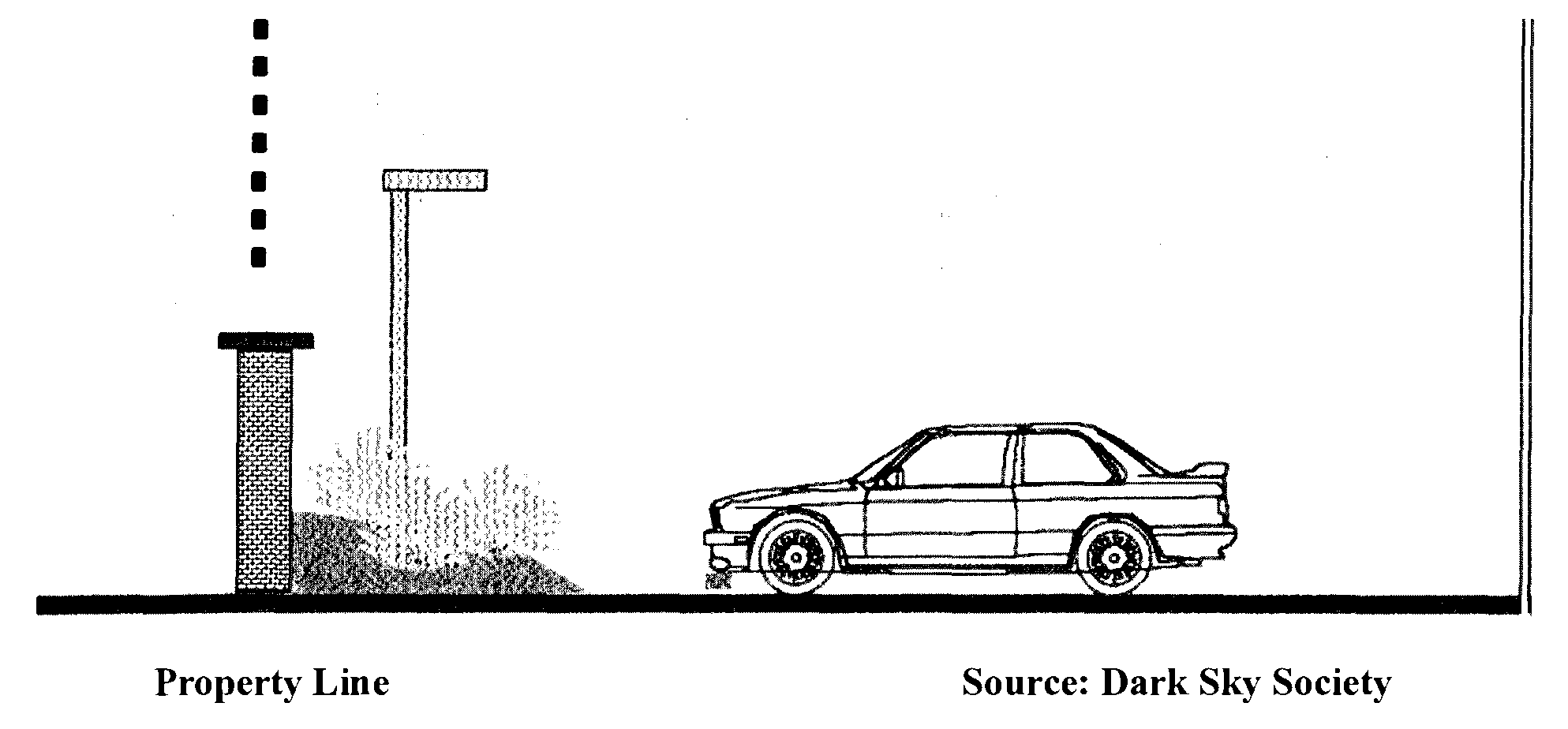
Sec. 130.34.030 - Exemptions.
The following lighting shall be exempt from the provisions of this Section:
A.
Airport lighting that is required for the safe and efficient movement of aircraft during flight, take off, landing, and taxiing. All other outdoor lighting at airport facilities shall comply with the provisions of this Chapter.
B.
Lighting used by law enforcement or other emergency personnel.
C.
Lighting used by public agencies for nighttime public works or road construction projects.
D.
Lighting used for the illumination of the United States flag subject to the requirements for nighttime illumination of the United States Flag Code.
E.
Temporary outdoor lighting that is designed to eliminate glare and minimize light pollution as much as possible in compliance with this Chapter. To qualify for this exemption a completed application form for an Administrative or Temporary Use Permit and a site plan shall be provided demonstrating location of proposed fixtures, manufacturer's specification sheets including lamp type, wattage, initial lumen output and shielding, intended use of lighting, and other information as the Director may require.
F.
Seasonal or holiday type lighting.
G.
Street Lights.
Sec. 130.34.040 - Effect on Existing Outdoor Lighting.
Lighting lawfully in place prior to the effective date of this Chapter may remain in use except as provided below:
A.
Any nonconforming lighting that is replaced, re-aimed, or relocated must meet the standards of this Chapter.
B.
Nonconforming lighting that direct light toward streets in such a manner as to cause potentially hazardous glare to motorists or cyclists shall be either replaced or re-directed so as to meet full-cutoff requirements.
Sec. 130.35.010 - Content.
This Chapter contains standards for off-street parking requirements for residential and non-residential uses. Additional standards for the design for the required parking for new development are found in the adopted Parking and Loading Standards (Resolution 202-2015).
Sec. 130.35.020 - Definitions.
"Active use area (AUA)" means all developed areas within a building except for storage areas, restrooms, and employee lunchroom/cafeteria(s).
"Gross floor area (GFA)". See Article 8 (Glossary).
"Outside use area (OUA)" means the total square footage of an area dedicated to the performance of a specific activity, where uses and activities are or may be conducted, including, but not limited to recreational use, retail sales, rentals, and restaurant seating. The OUA excludes the area of walkways, promenades, restrooms, landscaping and parking areas and a nursery dedicated to the growing of plant material or areas related product and equipment storage.
Sec. 130.35.030 - Off-street Parking and Loading Requirements.
A.
Off-street parking shall be provided in accordance with Table 130.35.030.1 (Schedule of Off-Street Vehicle Parking Requirements) below in this Section, unless otherwise provided in this Chapter. Where a parking requirement results in a fraction of a space, the number of parking spaces required shall be rounded to the nearest whole number.
B.
Uses Not Listed. Where the parking requirement for a use is not specifically listed in the parking schedule, the parking requirement for that use shall be determined by the Director based on the most similar use or activity for which parking requirements are established.
C.
Combined Uses. In situations where a combination of uses or activities are developed on a single site, parking shall be calculated for each separate use according to the parking schedule, except as otherwise provided in standards for shared parking, or for certain accessory uses that are subject to a 50 percent reduction in parking requirements, as noted in the parking schedule.
Table 130.35.030.1—Schedule of Off-Street Vehicle Parking Requirements
(Ord. No. 5127, § 4, 9-1-2020; Ord. No. 5152, § 7, 11-16-2021)
Sec. 130.36.010 - Content and Applicability.
Content. This Chapter pertains to the regulation of signs and supersedes all previously adopted standards and ordinances regarding signs and applies prospectively only. The purpose of this Chapter is to establish sign regulations that are consistent with the goals, objectives and policies of the El Dorado County General Plan and the County's visual and aesthetic goals and provide adequate identification for establishments. Specifically, this Chapter regulates the size, quantity, and location of signs to maintain and enhance the visual appearance of the County (Goal 2.7), regulates the location, number and size of highway signs and, to the extent allowable by law, eliminates billboards along identified scenic and historic routes (Objective 2.7.1). The Sign Ordinance shall include design review for signs within the foreground and background of the designated scenic corridors commensurate with the goal of scenic corridor viewshed protection (Policy 2.7.1.1).
Applicability. This Chapter applies only to the unincorporated areas of the County; within such areas, this Chapter applies to signs located or mounted on private property, as well as County owned properties and land owned by public entities over which the County has land use regulatory authority. For lands subject to the regulatory authority of the Tahoe Regional Planning Agency (TRPA), signs shall meet TRPA design standards and permitting regulations or any superseding standards and regulations applicable to unincorporated lands within the Lake Tahoe Basin. Where a standard is missing for a proposed sign (such as a billboard), design standards and permitting regulations will be set by the regulations in this Chapter. For the purposes of this Chapter, Community Region sign regulations established herein shall apply to those areas designated in the County General Plan Land Use Diagram as Community Regions.
The County recognizes that signs are an essential element of a community's visual appearance and provide a means to identify communities and promote commerce, provide useful information to the public, and should not become visual distractions along public roadways.
These regulations are intended to protect the public health, safety, and welfare and provide for the integrity of the County's aesthetics.
In addition, these regulations are intended to:
A.
Promote economically stable and visually attractive communities within the County;
B.
Promote signs that are attractive, pleasing, and harmonized with the physical character of the structure and environment of surrounding properties;
C.
Recognize the distinct signage needs and applications in the County's designated Community Regions and rural areas through distinct sign regulations;
D.
Prevent an inadvertent favoring of commercial speech over noncommercial speech or favoring of any particular noncommercial message over any other noncommercial message;
E.
Protect viewsheds in designated scenic corridors;
F.
Encourage individuality among communities and businesses through signage;
G.
Encourage consolidation of signs to reduce visual clutter;
H.
Improve traffic safety and the smooth and efficient flow of pedestrians, bicyclist and vehicles to their destinations;
I.
Direct persons to various activities and enterprises, in order to provide for maximum public convenience;
J.
Regulate signs in a constitutional manner, including required content-neutrality; and
K.
Respect and protect the right of free speech by sign display, while reasonably regulating the structural, locational and other noncommunicative aspects of signs, generally, for the public health, safety, welfare, and specifically, to serve the public interests in community aesthetics and traffic and pedestrian safety.
(Ord. No. 5242, § 1, 9-16-2025)
Sec. 130.36.020 - General Sign Requirements.
Except as otherwise specifically noted herein, the following requirements shall apply to all signage in the unincorporated Community Regions and rural areas of the County.
A.
Regulatory Interpretations. The requirements of this Chapter shall not be interpreted to nullify any easements, covenants, or other private agreements that provide for more restrictive sign regulations than are required by this Chapter.
B.
Message Neutrality. In adopting this Chapter, the County intends to regulate signs within the scope of this Chapter in a way that does not favor commercial speech over noncommercial speech and does not regulate noncommercial speech based on message content. The message of any sign shall not be reviewed except to the minimum extent necessary to identify the type of sign.
C.
Message Substitution. Subject to the property owner's consent, a constitutionally protected noncommercial message of any type may be substituted in whole or in part for the message displayed on any sign for which the sign structure or mounting device is authorized in compliance with this Chapter, without consideration of message content. Such substitution of message may be made without any additional approval or permitting. This provision is to prevent any inadvertent favoring of commercial speech over noncommercial speech or favoring of any particular protected noncommercial message over any other protected noncommercial message. In addition, any on-site commercial message may be substituted, in whole or in part, for any other on-site commercial message, provided that the sign structure or mounting device is authorized in compliance with this Chapter, without consideration of message content.
This provision does not create a right to increase the total amount of signage on a parcel, lot, or land use; does not affect the requirement that a sign structure or mounting device be properly permitted; does not allow a change in the physical structure of a sign or its mounting device or location; does not allow for the substitution of an off-site commercial message in the place of an on-site commercial or noncommercial message, and does not authorize the conversion of an existing sign to general advertising for hire.
D.
On-Site/Off-Site Distinction. Within this Chapter, the distinction between on-site and off-site signs applies only to commercial messages.
E.
Community Region/Rural Distinction. Within this Chapter, Community Region sign regulations shall apply to those areas designated as Community Regions on the County General Plan Land Use Diagram. Rural sign regulations shall apply to areas in the unincorporated County not otherwise designated as Community Region in the County General Plan Land Use Diagram. Unless otherwise noted, sign regulations in this Chapter shall apply to both Community Regions and rural areas equally.
F.
General Prohibition. Permanent signs not expressly allowed by this Chapter are prohibited.
G.
Exceptions to Limitations. Any exception to the limitations and/or sign development standards stated or shown within this Chapter shall require a Variance in compliance with Government Code Section 65906 (Variance) or a Development Plan Permit in compliance with Section 130.52.040 (Development Plan Permit) in Article 5 (Planning Permit Processing) of this Title. However, consideration of the Variance request or Development Plan Permit shall not evaluate the message or graphic design of the sign.
H.
Severability. If any Section, Subsection, sentence, clause, phrase or part of this Chapter is for any reason found by a court of competent jurisdiction to be invalid or unconstitutional, such decision shall not affect the validity of the remaining portions of this Chapter, which shall be in full force and effect. The Board hereby declares that it would have adopted this Chapter with each Section, Subsection, sentence, clause, phrase or part thereof irrespective of the fact that any one or more Sections, Subsections, sentences, clauses, phrases or parts be declared invalid or unconstitutional.
(Ord. No. 5242, § 1, 9-16-2025)
Sec. 130.36.030 - Exemptions.
The following sign types are expressly exempted from the Planning Sign Permit requirements of this Chapter but must satisfy all other applicable permit requirements when applicable (e.g., Building, Electrical, Plumbing, Grading, Encroachment). Except as otherwise specifically noted herein, these exemptions shall apply in all unincorporated Community Regions and rural areas of the County.
A.
Exempt Signs Without Limitations. The following signs are exempt from Sign Permit requirements with no specific limitations:
1.
Conforming signs that change messages, but do not alter the size, location, or illumination. This provision does not authorize the conversion of an existing legal sign to a general advertising for hire use or to a digital display.
2.
All devices which are excluded from the definition of a "sign" as set forth in this Chapter.
3.
Official traffic signs or other municipal governmental signs, legal notices, advertisements and notices prescribed by law and placed by governmental entities, and signs indicating the location of buried utility lines or any notice posted by a governmental officer in the scope of his or her duties.
4.
Direction, warning, or information signs or structures required or authorized by law, or by federal, state, county, or county authority, including, but not limited to, traffic control signs (e.g., stop, yield), highway route number signs, and construction zone or site signs. Such signs may include electronic (digital) message signs, as defined in this Chapter and are not limited to 50 percent display area.
5.
Noncommercial utility company signs identifying cables, conduits, and dangerous situations.
6.
Street address signs on structures and building identification signs consistent with the County-adopted building code or relevant provisions of the County Municipal Code. Notwithstanding anything in this Section, street address signs may be illuminated and may contain reflective paint or material.
7.
Tablets and plaques installed by the County, or by a state, federal, or county recognized historical organization exempt from federal taxation under Section 501 of USC Title 26 (IRS Code), or signs authorized and installed by county, state or federal agencies on public owned lands.
8.
Vehicle signs on currently registered and operable vehicles and vessels, including license plates, license plate frames, registration insignia, noncommercial messages, messages relating to the establishment for which the vehicle or vessel is an instrument or tool (not including general advertising, such as mobile billboards), and messages relating to the proposed sale, lease, or exchange of the vehicle or vessel.
9.
Signs and advertising located upon the buses, vehicles and bus shelters of the El Dorado Transit Authority.
10.
Signs on California State Park Lands in conformance with the standards enforced by the State of California as set forth in the Department of Parks and Recreation Sign Handbook, 1973, as amended.
11.
Signs on National Forest lands, including sites permitted for private use, in conformance with the standards enforced by the U.S. Forest Service as set forth in the Forest Service Catalog of Posters and Signs, EM-7100-15, as amended.
12.
Relocation or Digital Conversion of Off-Site Billboards. Notwithstanding the prohibition on billboards in Subsection 130.36.090.B.2 (Prohibited Signs) the Board may, at its sole discretion, enter into written agreements for 1) relocation of existing off-site general advertising for hire signs (e.g. billboards) to County owned land, and such relocation may, in the County's sole discretion, allow conversion of a relocated non-digital sign to a digital sign and/or 2) conversion of existing non-digital billboard signs to digital signs on private property, both in accordance with Business and Professions Code Section 5412. The display area of such signs shall not be limited to 50 percent.
B.
Exempt Signs With Limitations. The following signs are exempt from Sign Permit requirements, provided that they meet the size, height, duration, and/or maximum number limitations listed below. Exempt signs that do not meet the limitations listed may be allowed only by Variance or Development Plan Permit as outlined in Section 130.36.020.G (Variance) or in Section 130.52.040 (Development Plan Permit) in Article 5 (Planning Permit Processing) of this Title.
1.
No more than 25 percent of total window area shall be obscured by signs. Window signs do not count toward cumulative allowable sign area. Window signage shall be placed so that law enforcement personnel have a clear and unobstructed view of the interior of the establishment, including any cash registers.
2.
Temporary signs in conformity with Section 130.36.050 (Temporary Signs) below in this Chapter.
3.
Flags, not subject to the standards set forth in Table 130.36.050.1 (Allowed Temporary On-Site Sign Standards) below in this Chapter, shall meet the following requirements:
a.
Flag poles shall be located outside of the public right-of-way.
b.
The maximum height for flag poles is 30 feet.
c.
The maximum size for any one flag is 30 square feet.
4.
Signs on property undergoing construction or remodeling not exceeding 32 square feet each in area and limited to one sign for each street frontage. Such signs shall not be illuminated. Such signs shall be removed within 30 days of the earliest of the following events: final building inspection approval, issuance of a valid certificate of occupancy, opening for business to the public, or expiration of the Building Permit.
5.
Signs warning against trespass, hunting or shooting as described in Section 602 of the California Penal Code not to exceed two square feet per sign and spaced in accordance with the requirements of state law.
6.
Signs on property that is currently offered for sale, lease, or rental [also referred to as "real estate signs" as defined in 130.36.120 (Definitions)]:
a.
On single-family home and improved multi-family property for two to four units, one sign not exceeding eight square feet and not exceeding a height of five feet. Up to four signs to direct traffic to the subject property are allowed, provided each sign does not exceed eight square feet in area and three and one-half feet in height. A sign shall not be placed on a sidewalk or street or public right-of-way. A sign shall not create a safety hazard. Such signs shall not be illuminated.
b.
On nonresidential and residential property suitable for investment and development, and agricultural and resource-zoned property, one sign per street or road frontage, not exceeding 32 square feet in area and 12 feet in height. The sign shall not be illuminated.
7.
Signs on private property where there is a garage, yard, or estate sale taking place. Such signs may be posted for no more than 48 hours and must be removed at the end of the sale. A maximum of six square feet is allowed per sign.
8.
On-site directional signs, such as exit, entrance, or other on-site traffic directional signs, the maximum height of any directional sign shall not exceed three and one-half feet and the maximum size shall not exceed six square feet within designated Community Regions under 3,000-foot elevation of the County. Within the designated rural areas, the maximum height of any on-site directional sign shall not exceed 12 feet and the maximum size shall not exceed 32 square feet. Within Community Regions above 3,000-foot elevation, rural area height limit shall apply. In both Community Regions and rural areas of the County, no advertising or message other than for traffic direction shall be displayed on the signs authorized by this subsection.
9.
Off-site commercial directional signs on private property within the designated rural areas of the County, for establishments that are not directly abutting County roads. For establishments that solely derive access from a private road, each establishment is allowed one non-illuminated commercial directional sign with a maximum sign area of 16 square feet and a maximum height of 12 feet at the intersection of the private road with the county road. Additional commercial directional signs are allowed for the establishment at other intersecting points along the private road to provide guidance to the establishment. Each additional commercial directional sign shall have a maximum allowed area of 12 square feet and a maximum height of 12 feet. Such signs may be permanent or temporary and require property owner consent. This provision does not allow general advertising for hire.
10.
Temporary signs displaying noncommercial messages subject to:
a.
Six square feet of signage, set back at least five feet from the public right-of-way and not projecting above the roofline of any structure.
b.
During the time period beginning 60-days before a special, general, or primary election and ending two weeks after such election, the total allowed sign area for noncommercial messages may be 32 square feet in area. The same setback and height restrictions listed above shall apply to this additional area. Such signs shall be non-illuminated.
11.
Home Occupation signs identifying authorized home business activities on site. All signs shall be non-illuminated, compatible in design with existing residential structures, and consistent with the sign development and design standards as listed on Table 130.36.070.3 (Sign Standards for Home Occupation Signs) below in this Chapter.
12.
Motor vehicle fuel pricing signs, as required by state law, which identify the brand, types, octane rating, etc., of motor vehicle fuel for sale within the County (Section 13531 of the Business and Professional Code as it may be amended). Motor vehicle fuel pricing signs are limited to one sign per establishment, in addition to the business identification sign provided for in this Chapter, and shall have a maximum sign area (including the area for all brands, types, octane rating, price, and the service station name) of 60 square feet.
(Ord. No. 5242, § 1, 9-16-2025)
Sec. 130.36.040 - Permanent Signs.
A.
Permanent On-Site Signs. Permanent on-site signs allowed in the County's zoning districts include the following sign types:
1.
Building-Attached Signs. Allowed permanent on-site signs attached to a structure include wall signs, projecting signs, awning or canopy signs, under canopy signs, and roof signs on non-residential structures within the designated rural areas of the County, consistent with the standards listed in Table 130.36.070.2 (Rural Area Signage Standards for Permanent On-Site Signs) below in this Chapter.
2.
Freestanding Signs. Allowed permanent freestanding signs include monument and pylon signs. Permanent on-site signs shall be consistent with the sign design and developments standards as described in this Chapter and shown on Tables 130.36.070.1 and 130.36.070.2 (Signage Standards for Permanent On-Site Signs, Community Region and Rural Area, respectively) below in this Chapter.
3.
Signs for Drive-In and Drive-Through Uses. Signage shall be consistent with the sign design and developments standards as described in this Chapter. No alterations or additions (e.g., rider signs) along the exterior of the sign are allowed.
4.
U.S. Highway 50-Oriented Signs. Signs on properties within 100 feet of the edge of the right-of-way or designed to be visible from U.S. Highway 50 that are outside of the designated State Scenic Highway Corridor. (Note: Designated State Scenic Highway Corridors in El Dorado County shall be subject to special sign regulations under the reserved Section 130.27.070 (Design Review—Scenic Corridor (-DS) Combining Zone) in Article 2 (Zones, Allowed Uses, and Zoning Standards) of this Title.)
Permanent on-site signs shall not be used as general advertising for hire.
(Ord. No. 5242, § 1, 9-16-2025)
Sec. 130.36.050 - Temporary Signs.
Temporary signs may include, but are not limited to, commercial signs (including sign twirlers) for grand openings, products/services, sales, special events, and new apartments/multi-family units. All temporary signs must comply with the standards listed in Table 130.36.050.1 (Allowed Temporary On-Site Sign Standards) below in this Section and are subject to the conditions herein.
A.
Time Duration. Display periods for temporary on-site signs shall be limited to a cumulative maximum of 90 days per establishment per calendar year, unless otherwise specified below.
1.
Apartment Signs. Signs at new or substantially renovated apartments shall be removed six months from opening.
2.
Banner Signs. All banner signs (including feather banners) utilized for grand opening events shall be limited to a maximum of 30 consecutive days per establishment per calendar year.
3.
Feather Banners and Sign Twirlers. Feather banners and sign twirlers shall be allowed only on-site during daylight hours and shall be removed from dusk to dawn and during all times when the establishment is closed or event is completed.
4.
A-Frame Signs. A-frame signs are not subject to the 90-day display period and shall be allowed year-round. A-Frame signs shall be allowed only on-site during daylight hours and shall be removed from dusk to dawn and during all times when the establishment is closed or event is completed. A-frame signs must be located outside the public right-of-way and allow sufficient access to doors/pathways and not impede pedestrian access or movement allowing for at least five feet clearance.
B.
Illumination. Temporary signs shall not be illuminated.
C.
Message. Temporary signs displaying a commercial message shall be limited to on-site signage only. Off-site signage displaying a commercial message shall not be allowed, except as noted in Section 130.36.030.B.9 (Exempt Signs With Limitations) above in this Chapter.
D.
Illegal Signs. Illegal temporary signs shall be removed immediately.
Table 130.36.050.1—Allowed Temporary On-Site Sign Standards
(Ord. No. 5242, § 1, 9-16-2025)
Sec. 130.36.060 - Community Sign Programs.
In addition to the sign permits required by this Chapter, a Community Sign Program shall be required for all new or modified community directional, identity, event, and industry association signs located on private property or County-maintained roads or rights-of-way [per Section 130.36.110 (Signs on County Property)] that are part of a County-authorized and coordinated program to provide the public with information and guidance concerning public accommodations, facilities, commercial services, events, and points of scenic, cultural, historic, educational, recreational, religious interest, and other local community destinations. For existing community signs without a community sign program in place, the purpose of this provision is to bring eligible signs under the program into conformance with the development code, while allowing existing legal signage to remain until new signage is proposed. Signs under this program shall be permitted in any zone district by a Design Review Permit (DR) and be subject to review and approval by the approval authority as shown on Table 130.36.080.1. At a minimum, community sign programs applications should include the program type (directional, identity, event, industry association), the number of signs, sign area, height, and location of signs, and should include plans illustrating sign type, size, color, materials. Program descriptions and standards for each sign type are outlined below.
A.
Community Directional. Community directional sign programs generally include, but are not limited to, signs to direct residents and visitors to points of interest, recreational areas, and tourist industries in the County. Application for community directional signs shall clearly identify the intent of the proposed sign program (e.g. points of interest, recreational areas, tourist industries, historical structures). Community directional signs shall be limited to freestanding signs. Freestanding direction signage shall be limited to six square feet in total sign area, set back at least five feet from the public right-of-way, and not projecting above the roofline of any structure.
B.
Community Identity. Community identity sign programs shall establish a means for individual communities within the County to designate their name at main point(s) of entry to their community. Such signage shall be unique in design as a means to define each community's character, quality, or historic contribution to the County. Community identity signs are limited to a maximum of two signs per community. Community identity signs shall conform to the following standards:
1.
Area. Community identity signs shall not exceed 96 square feet in sign area.
2.
Height. Signs shall not exceed 12 feet in height.
3.
Illumination. Signs may be internally or externally illuminated.
4.
Sign Spacing. Community identity signs shall be located a minimum of 250 feet apart.
5.
Architectural Compatibility. Signs shall be compatible in architectural scale and bulk with the architectural style of one or more visually prominent structures within the identified community. The applicant shall incorporate construction materials, color, letter style, and other design details in designing an architecturally compatible sign. It is not the intent of this provision to regulate creative aspects of signage, but only to regulate the size, height, placement, and physical characteristics of signs in order to protect the public health, safety and welfare and to avoid incompatibility with the surrounding local neighborhood or community.
C.
Community Events. Community event sign programs are limited to identified sites for the display of event signs as shown on a new or modified application, as appropriate. Signs may be allowed to be displayed up to 30-days prior to the event and shall be removed within three days after the event has ended. The following standards shall apply. Community event signs shall be limited to banners, feather banners, and A-frame signs and shall conform to the standards in Section 130.36.050 (Temporary Signs).
D.
Industry Association Signs. Industry association sign programs shall establish directional and identifying agricultural industry association signs such as those offered by the El Dorado County Farm Bureau, Farm Trails, Apple Hill Growers Association, El Dorado Winery Association and similar groups. The intent of this Section is not to duplicate requirements outlined in Section 130.36.060.A (Community Directional). Industry association signs shall be limited to pylon and pole signs with a maximum sign area of 12 square feet, a maximum height of eight feet, non-illuminated, and set back at least five feet from the public right-of-way.
(Ord. No. 5242, § 1, 9-16-2025)
Sec. 130.36.070 - Sign Development and Design Standards.
This Section establishes standards for sign development and design, including, but not limited to, methods for measuring sign size, area and height, sign placement, construction, design, illumination, maintenance, and removal. Unless otherwise specified in this Section, sign development and design standards shall apply to all signs within the unincorporated Community Regions and rural areas of the County.
A.
General Sign Design Requirements for Permanent Signs. Permanent Signs shall comply with the following general design requirements as well as design standards applicable to specific types of signs listed herein in Subsection 130.36.070.K (Standards for Permanent On-Site Signs) below in this Section.
1.
Design Compatibility with Structure. Signs shall be compatible in architectural scale and bulk with the architectural style of the main structure or structures on the site where the sign is located. The applicant shall incorporate construction materials, color, letter style, and other design details in designing an architecturally compatible sign. Multiple signs on any structure, or on structures within the same development, shall have the same primary type of building-attached sign. It is not the intent of this provision to regulate creative aspects of signage, but only to regulate the size, height, placement, and physical characteristics of signs in order to protect the public health, safety and welfare and to avoid incompatibility with the surrounding local neighborhood or community.
2.
Sign Illumination. The artificial illumination of signs, from either an internal or external source, shall be designed to prevent the casting of stray light on surrounding rights-of-way and properties. All illuminated signs shall comply with the following:
a.
External light sources shall be directed toward the sign and fully shielded to limit direct illumination of any object other than the sign.
b.
The light from an illuminated sign shall not be of an intensity or brightness that creates glare or other negative impacts on residential properties in direct line of sight to the sign.
c.
Unless otherwise allowed by another provision of this Chapter, signs shall not have blinking, flashing, or intermittent lights or other illumination devices that have a changing light intensity, brightness, or color.
d.
Colored lights shall not be used at a location or in a manner so as to be confused or interpreted as traffic control devices.
e.
Light sources shall utilize energy-efficient fixtures compliant with Title 24 of the California Code of Regulations.
B.
Sign Area Measurement Procedures. The sign area is determined by the shape of the sign. For signs that are not four-sided, the sign area is the available display area. For example, for the star-shaped logo sign shown in Figure 130.36.070.A (Star Shaped Sign Area) below in this Section, the sign area is the shaded area within the star shape. For irregularly shaped signs or signs with cursive individual letters, the area of the sign may be calculated by using multiple geometric shapes (see Figure 130.36.070.B (Irregularly Shaped Sign Area) below in this Section. In determining the area of an individual sign that has more than one face (e.g., a monument or projecting sign), the single sign face with the greatest area shall be used.
1.
Sign Area Examples.
Figure 130.36.070.A Star Shaped Sign Area

Figure 130.36.070.B Irregularly Shaped Sign Area
2.
Awning, Canopy, Push Pin, and Channel Letter Sign Area. Sign area for copy, which is applied to an awning, canopy, or as separate lettering onto the building facade shall be computed at 100 percent of the area within a single parallelogram enveloping the sign copy.
3.
Freestanding Sign Area. Freestanding sign area is to be computed as total height by the total length of the sign face for one side regardless if it is single- or double-face, excluding structural or architectural framework with no sign copy. See Figure 130.36.070.C (Freestanding Sign Area) below in this Section.
Figure 130.36.070.C Freestanding Sign Area
4.
Three-Dimensional Objects. Where a sign consists of one or more three-dimensional objects (e.g., balls, cubes, clusters of objects, sculptures, or statue-like trademarks or symbols), the sign area shall be measured as their maximum visible surface area from any vantage point. See Figure 130.36.070.D (Area of Three-Dimensional Objects) below in this Section.
Figure 130.36.070.D Area of Three-Dimensional Objects
C.
Sign Height Measurement. Sign height shall be measured from the ground, adjacent to the sign, to the top of the sign and support structure. If the ground under the sign slopes, the height shall be measured from the average grade under the sign itself.
D.
Construction Requirements. Every sign and all parts, portions, and materials thereof shall be manufactured, assembled, and erected in compliance with all applicable state, federal, and county laws and regulations, including the locally adopted building code. All signs shall comply with the following criteria:
1.
All transformers, equipment, programmers, and other related items shall be screened and/or painted to match the structure or shall be concealed within the sign.
2.
All permanent signs shall be constructed of quality materials such as metal, concrete, natural stone, wood, glass, and acrylics. Techniques shall be incorporated during construction to reduce fading and damage caused by exposure to sunlight or degradation due to other elements.
3.
All freestanding signs that incorporate lighting shall have underground utility service.
4.
All temporary signs and banners shall be maintained in good condition for as long as the sign is displayed.
E.
Sign Placement.
1.
Location of Building-Attached Signs. Building-attached signs may be located along any frontage of a building that faces directly onto a public right-of-way or an internal circulation path of the site. Orientation of signs that face directly onto residential property is allowed only when there is no practical alternative, the visibility of the sign from the residence is minimized and the sign is not illuminated.
2.
Clearance from Public Utility Facilities. The person erecting a sign and the owner of the premises shall maintain any legally required clearance from communications and electric facilities. A sign may not be constructed, erected, installed, maintained, or repaired in any manner that conflicts with a rule, regulation, or order of the California Public Utilities Commission pertaining to the construction, operation, and maintenance of public utilities facilities.
3.
Interference with Motorist Field of Vision.
a.
No sign shall be located in a manner that obstructs the view of traffic or safety signs, encroaches into a cross-visibility area as described in the County Design Improvement Standards Manual (DISM) or otherwise poses a traffic or safety hazard.
b.
Any landscaping shall be trimmed as needed to provide clear visibility of the sign or signs.
c.
Signs shall not be located within the "cross visibility area," as defined in the Design Improvement Standards Manual.
4.
Setback and Spacing of Freestanding Signs. Setback and spacing standards for freestanding signs are as follows:
a.
The minimum setback distance for any portion of any freestanding sign shall be measured from the back of the public right-of-way or side of a driveway. With the exception of front setbacks, sign setbacks shall be determined by base zone district. Signs may be allowed within front setbacks, provided that the signs are not located within a public right-of-way, required cross visibility area as described in the County DISM, utility or private road easement.
b.
The minimum spacing distance between permanent freestanding signs, excluding on-site directory signs, shall be 250 feet, (except that U.S. Highway 50—oriented signs shall be separated by a minimum of 1,000 feet). The designated approving authority as noted in Table 130.36.080.1 (Planning Sign Permits and Review Authority) below in this Chapter may allow a reduction in minimum spacing requirements to ensure that a qualified establishment can have at least one freestanding sign as allowed in Tables 130.36.070.1 and 130.36.070.2 (Signage Standards for Permanent On-Site Signs, Community Region and Rural Area, respectively) below in this Section and also for establishments with more than one street frontage (e.g., corner lots). The designated approving authority will review a proposed sign location on a case-by-case basis to ensure the sign is located outside the required cross visibility area as described in the County DISM and does not inhibit motorist safety.
F.
Maintenance Requirements. Every sign and all parts, portions, and materials thereof shall be maintained and kept in proper repair. The display surface of all signs shall be kept clean, neatly painted, and free from rust and corrosion. Any cracked, broken surfaces, malfunctioning lights, missing sign copy, or other non-maintained or damaged portions of a sign shall be repaired or replaced within 30 days following notification by the County. Noncompliance with such a notice will constitute a nuisance and zoning violation and will be enforced as such. Application for additional sign permits will not be processed until all existing signs on the premise are in compliance with this Section.
G.
Sign Removal or Replacement. When a sign is removed or replaced, all brackets, poles, and other structural elements that support the sign shall also be removed. Affected surfaces shall be restored to match the adjacent portion of the structure. This requirement does not apply to routine maintenance.
H.
Design Standards for Specific Sign Types. In addition to the general sign design requirements in Subsection A, the following requirements shall apply to specific sign types listed below.
1.
A-Frame Signs. A-frame signs, where allowed under Section 130.36.050 (Temporary Signs) above in this Chapter, shall be placed at least five feet behind the face of curb and outside the County right-of-way. Where there is no sidewalk or curb, A-frame signs shall be located outside of the County right-of-way. A-frame signs shall not be placed where they may obstruct vision or create other public safety hazards. A-frame signs shall comply with clearance rules under the Americans with Disabilities Act. A-frame signs shall be removed during all times when the establishment is closed.
2.
Awning and Canopy Signs. Awning and canopy signs may be allowed only as an integral part of the awning or canopy to which they are attached or applied and shall be considered wall signs for sign area calculation purposes. The following requirements shall apply:
a.
Lettering shall not exceed 25 percent of the total surface area.
b.
Only permanent signs that are an integral part of the awning or architectural projection shall be allowed. Temporary signs shall not be placed on awnings.
c.
Awning signs shall be allowed only on first- and second-story occupancies.
d.
Awnings shall not be lit from under the awning (backlit) so that the awning appears internally illuminated. Lighting directed downward that does not illuminate the awning is allowed.
e.
Awnings shall maintain a minimum of eight feet above grade.
3.
Electronic (Digital) Signs. Where allowed, the following standards apply to electronic (digital) signs:
a.
Digital display is limited to 50 percent of the total allowable display face area of any particular sign.
b.
Signs shall not change message more than once every eight seconds (dwell time).
c.
Digital signs shall not operate at brightness levels of more than 0.3 foot-candles above ambient light, as measured using industry standard procedures at a distance from the sign face as determined by the following formula:
![]()
Each digital display area shall have a light-sensing device that will adjust the brightness of the sign as ambient light conditions change throughout the day.
4.
Freestanding Signs. Freestanding sign materials and design, including monument and pylon signs, shall be complementary to the materials and design of the structures for the related development. For example, if the facade of the structure is made of brick or brick veneer, a complementary freestanding sign would also include brick.
5.
Projecting Signs. Projecting signs, including, but not limited to, blade signs, bracket signs, hanging and suspended signs, under canopy signs, and marquee signs, shall be considered wall signs for the purposes of sign area calculation purposes. Projecting signs shall only be allowed as follows:
a.
Location. Projecting signs shall be placed only on ground-floor facades, except for establishments located above the ground level with direct exterior pedestrian access. Within the designated rural areas, projecting signs may also be placed on fences, posts, and railings.
b.
Angle of Projection. Projecting signs shall either be located at right angles to the structure front along the facade, or, when located on the corner of a building, at a 45-degree angle to the corner of the structure.
c.
Height. Where located above a pedestrian walkway, the lowest point of a blade, bracket, or hanging and suspended sign shall be a minimum of eight feet above grade.
d.
Projection. The sign may project a maximum of 5.5 feet from the structure. A projecting sign may not extend onto or over the street or public right-of-way unless an Encroachment Permit is secured through the Director of the Transportation Department.
e.
Suspension. The sign shall be suspended with a clear space of at least six inches between the sign and the structure. Exceptions may be granted consistent with applicable building code requirements.
f.
Sign Structure. Sign supports and brackets shall be compatible with the design and scale of the sign.
g.
Multiple Projecting Signs. Multiple projecting signs shall not be installed within ten feet of each other if on the same property and shall be separated from projecting (including hanging and suspended) signs on adjacent properties and other establishments by at least ten feet to ensure adequate visibility.
6.
Wall Signs.
a.
Wall signs shall not project more than one foot from the structure's facade.
b.
Wall sign raceways shall be concealed from public view (e.g., within the structure's wall or otherwise integrated with the design of the sign and structure) so as to not detract from the architectural character of the structure.
c.
Wall signs shall not be placed in front of architectural building features (such as cornices and other decorative features), windows, doors, and other points of access.
I.
Standards for Off-Site Subdivision Signs. The purpose of subdivision signs is to direct the traffic related to new residential subdivisions in a manner that minimizes visual clutter, reduces unnecessary traffic through established neighborhoods, and provides an orderly, attractive, high-quality image of the County.
1.
Subdivision signs shall not exceed 60 square feet in sign area, 12 feet in height, and the display area shall be at least two feet off the ground.
2.
All subdivision signs require approval of a Subdivision Sign Permit as required under Section 130.36.080.D (Subdivision Sign Permit) below in this Chapter and their locations approved within or outside of the County's right-of-way.
3.
Subdivision signs listing multiple subdivisions shall include removable sign panels with no more than one panel per residential subdivision.
4.
No subdivision sign may be located within 1,000 feet of another subdivision sign except in the case of signs on different corners of an intersection.
5.
All subdivision signs placed on private property require written consent of the property owner and require an Administrative Permit. All subdivision signs placed within County right-of-way require an Encroachment Permit issued by the County Department of Transportation.
6.
Subdivision signs may only be located in a manner that does not obstruct the view of traffic or safety signs, encroach within the cross-visibility area described in the County DISM, or otherwise pose a traffic or safety hazard.
7.
There shall be no additions, tag signs, streamers, balloons, flags, riders, devices, display boards, or appurtenances added to the subdivision signs as approved.
8.
Structures and panels on subdivision signs may not be displayed after a subdivision developer has completed the sale of all units in the development. Each developer shall be responsible for sign removal.
9.
All signs for housing subdivisions shall be removed within 30 days after all lots in the subdivision are sold.
10.
Security Deposit. The County shall require the developer to submit a performance deposit or other form of security to ensure compliance with the standards of this Section. The form, amount and term of the security instrument shall be specified by the permit issuing body and approved by County Counsel.
J.
Standards for U.S. Highway 50-Oriented Signs. Proposed on-site signs designed for visibility from U.S. Highway 50, including signs within 100 feet of the edge of the right-of-way, but outside of the officially designated scenic corridor, are subject to a Design Review Permit. U.S. Highway 50-oriented signs shall be consistent with the standards provided below, and as required in other provisions of this Chapter. U.S. Highway 50-oriented signs shall not be used as general advertising for hire.
1.
Location.
a.
Spacing Between Signs. U.S. Highway 50-oriented signs shall be separated by at least 1,000 feet between signs.
b.
Setbacks. All signs must be set back a minimum of 100 feet from the highway right-of-way. All U.S. Highway 50-oriented signs must be located a minimum of 200 feet from any residential zone as listed under Chapter 130.24 (Residential Zones).
c.
Visibility. U.S. Highway 50-oriented signs shall not be located to inhibit pedestrian or vehicular visibility and more specifically shall not be located within the clear visibility area as defined in this Chapter or other County adopted policies or standards. Illuminated signs shall be directed away from any residentially designated land.
2.
Quantity. One U.S. Highway 50-oriented sign shall be allowed per either:
a.
Integrated developments, as defined in this Chapter; or
b.
Sites with a single tenant of ten acres or more.
3.
Area.
a.
Maximum Allowed Area. For single-tenant signs, the maximum sign area shall be 60 square feet. For multi-tenant signs, the maximum sign area shall be 200 square feet.
b.
Ancillary Components. Ancillary components of the sign, such as shopping center identification, shall not exceed 25 percent of the total sign area and shall be excluded from the calculation of the sign area.
c.
Freestanding Sign Area. The area of a U.S. Highway 50-oriented sign shall be in addition to the allowable freestanding street frontage sign area if the underlying property is adjacent to the highway and a local street.
4.
Height. The maximum height of U.S. Highway 50-oriented signs shall be as follows:
a.
For single-tenant signs, 1.5 times the height of an adjacent structure up to a maximum of 30 feet. Within designated scenic corridors, the maximum height of a single-tenant sign shall be 24 feet.
b.
For multi-tenant signs, a maximum of 50 feet. Within designated scenic corridors, the maximum height of a multi-tenant sign shall be 48 feet.
5.
Architecture. U.S. Highway 50-oriented signs shall be designed as pylon signs and shall be composed of materials and design-compatible with the building materials and design of the applicable establishment.
6.
Illumination. If illuminated, U.S. Highway 50-oriented signs must be internally lit. Signs shall not have blinking, flashing, or intermittent lights or other illuminating devices that have a changing light, brightness, or color. Electronic (digital) changeable copy LED lights are allowed to be incorporated into the structure consistent with restrictions listed in Section 130.36.070.H.3 (Electronic (Digital) Signs) above in this Section.
7.
Special Development and Design Standards for Designated State Scenic Highway Corridors. (Reserved for future Scenic Corridor Ordinance.)
K.
Standards for Permanent On-Site Signs. Permanent on-site sign standards in this Section are listed separately for the designated Community Regions and rural areas of the County based on zone and sign type. See Table 130.36.070.1 (Community Region Area Signage Standards for Permanent On-Site Signs) and Table 130.36.070.2 (Rural Area Signage Standards for Permanent On-Site Signs) below in this Section. Standards for home occupation signs are on Table 130.36.070.3 (Sign Standards for Home Occupation Signs) below in this Section. Standards for U.S. Highway 50-oriented signs are in Section 130.36.070.J (Standards for U.S. Highway 50-Oriented Signs) above in this Section. Where allowed, the following sign types shall conform to standards listed below.
1.
Building-Attached Sign Allowance. Building-attached signs (and projecting signs placed on fences, posts, railings and roofs within the designated rural areas) have a maximum allowable sign area that can be used for one or more signs as specified in Tables 130.36.070.1 and 130.36.070.2 (Signage Standards for Permanent On-Site Signs, Community Region and Rural Area, respectively) below in this Section. Building-attached signs are allowed on walls that face public streets, parking areas, and pedestrian walkways. Wall signs are not allowed on walls facing adjoining residential property within designated community regions of the County. Within the designated rural areas of the County, wall signs (where allowed), may face adjoining residential properties.
2.
Freestanding Sign Allowance. Freestanding signs are allowed a maximum number, maximum sign area, and maximum height standard per individual establishment or integrated development as specified in Tables 130.36.070.1 and 130.36.070.2 (Signage Standards for Permanent On-Site Signs, Community Region and Rural Area, respectively) below in this Section. For definitions, see Section 130.36.120 (Definitions) below in this Section.
3.
Changeable Copy Allowance. Changeable copy signs are only allowed in commercial and agricultural zoning districts and for nonresidential uses in residential zones (e.g., religious institutions and public service uses, home occupations, community centers, and schools).
4.
Signs for Drive-In and Drive-Through Uses. Where allowed, each drive-in or drive-through use is allowed a maximum of 60 square feet of signage, with no one sign to exceed 30 square feet. The sign(s) shall not count toward the cumulative allowable display area purposes of Tables 130.36.070.1 and 130.36.070.2 (Signage Standards for Permanent On-Site Signs, Community Region and Rural Area, respectively) below in this Section, either in terms of number or cumulative area. The maximum sign height shall be six feet.
Table 130.36.070.1a—Community Region Area Signage Standards for Permanent On-Site Signs
Table 130.36.070.1b—Community Region Area Signage Standards for Permanent On-Site Signs
Table 130.36.070.1c—Community Region Area Signage Standards for Permanent On-Site Signs
Table 130.36.070.1d—Community Region Area Signage Standards for Permanent On-Site Signs
Table 130.36.070.2a—Rural Area Signage Standards for Permanent On-Site Signs
Table 130.36.070.2b—Rural Area Signage Standards for Permanent On-Site Signs
Table 130.36.070.2c—Rural Area Signage Standards for Permanent On-Site Signs
Table 130.36.070.2d—Rural Area Signage Standards for Permanent On-Site Signs
Table 130.36.070.3—Sign Standards for Home Occupation Signs
(Ord. No. 5242, § 1, 9-16-2025)
Sec. 130.36.080 - Permit Requirements and Review Procedures.
This Section describes permit requirements and review procedures applicable to all signage in the unincorporated Community Regions, Rural Centers and Rural Regions of the County. Signs proposed within a Community Region or Rural Center with County adopted local sign standards shall conform to those standards.
A.
Sign Permit Required. Planning Sign Permits shall be required for specified types of permanent signs prior to erection, relocation, alteration, or replacement, as listed in Table 130.36.080.1 (Planning Sign Permits and Review Authority) below in this Section, unless otherwise exempted by this Chapter. Planning Sign Permits shall be processed in accordance with Chapter 130.52 (Permit Requirements, Procedures, Decisions, and Appeals) in Article 5 (Planning Permit Processing) of this Title.
1.
No planning approvals shall be required for general maintenance of existing conforming signs or replacement of a conforming sign face (including message) when the area of the sign is not being changed, subject to Section 130.36.020 (General Sign Requirements) above in this Chapter.
2.
Sign Permit(s) shall be required as part of the review of any discretionary application that includes proposed signage. The Sign Permit shall be in addition to the discretionary application or permit.
3.
Sign Permits are not required for the display of temporary signs. However, temporary signs shall be consistent with the development standards and time duration limits established in this Chapter.
B.
Uniform Sign Program Required. A Development Plan Permit (PD) shall be required for all new or modified Uniform Sign Programs as shown on Table 130.36.080.1 (Planning Sign Permits and Review Authority). A Uniform Sign Program shall be required for all new multi-tenant shopping centers, office parks, and other multi-tenant, mixed-use, or otherwise integrated developments of three or more separate tenants/uses that share structures, public spaces, landscape, and/or parking facilities where deviations from the development standards of this Chapter are requested. A Uniform Sign Program provides a process for the County's review of, and decisions related to, requests for signs for multi-tenant projects. The Uniform Sign Program allows for the integration of a project's signs with the design of the structures to achieve a unified architectural statement and to approve common sign regulations for multi-tenant projects. The Zoning Administrator is typically the decision-making authority for Uniform Sign Programs. However, if part of an application is reviewed and decided by the Planning Commission or Board of Supervisors, the Uniform Sign Program shall be decided by same higher-level Review Authority in conjunction with other entitlements. Deviations from the sign standards in Section 130.36.070 (Sign Development and Design Standards) above in this Chapter are allowed through the Uniform Sign Program. Standard procedures for application submittal, review, decision, and appeal are outlined in Chapter 130.52 (Permit Requirements, Procedures, Decisions, and Appeals) in Article 5 (Planning Permit Processing) of this Title.
C.
U.S. Highway 50-Oriented Signs. A Design Review Permit shall be required for all proposed new or remodeled signs within 100 feet of the right-of-way or designed for visibility from U.S. Highway 50. The approval of a Design Review Permit is a ministerial project pursuant to CEQA when in compliance with adopted standards set forth in Section 130.36.070.J (Standards for U.S. Highway 50-Oriented Signs) above in this Chapter. If part of an application is reviewed and decided by the Planning Commission or Board of Supervisors, the Design Review Permit shall be decided by the same higher-level Review Authority in conjunction with other entitlements. Standard procedures for application submittal, review, decision, and appeal are outlined Chapter 130.52 (Permit Requirements, Procedures, Decisions, and Appeals) in Article 5 (Planning Permit Processing) of this Title.
D.
Subdivision Sign Permit. Off-site subdivision signs are subject to approval of an Administrative Permit. The applicant shall submit, as a requirement of the application, a map identifying the proposed location of the sign. Site Plans shall illustrate sign type, number, location, size, colors and materials, and type of illumination (if any) for all off-site subdivision signs. As part of the permitting process, all off-site subdivision signs shall be reviewed by the County to ensure their locations are approved within or outside the County's right-of-way and that they are consistent with the standards under Section 130.36.070.I (Standards for Off-Site Subdivision Signs) above in this Chapter.
E.
Variances. Requests for individual signs not associated with an approved Uniform Sign Program that deviate from the development standards of this Chapter shall require processing of a variance application as detailed in Section 130.36.020.G.
F.
Community Sign Program Required. A Design Review Permit shall be required for all new or modified Community Sign Programs. A Community Sign Program shall be required for all new or modified community directional, identity, event, and industry association signs located on private property or County-maintained roads or rights-of-way (per Section 130.36.110 (Signs on County Property) in this Chapter) that are part of a County-authorized and coordinated program to provide the public with information and guidance on topics including, but not limited to, public accommodations, facilities, commercial services, events, and points of scenic, cultural, historic, educational, recreational, religious interest, and other local community destinations.
G.
Review Procedures.
1.
Method of Application. An application for a Sign Permit, Uniform Sign Program, Community Sign Program, U.S. Highway 50-Oriented Sign Permit, or Variance shall be made on the form(s) prescribed by the Planning Division. The application shall be accompanied by any fees as specified by Board resolution.
2.
Application Review Procedures, Decisions, and Appeals. The application review procedures, decisions, and appeals of decisions for Sign Permit, Uniform Sign Programs, Community Sign Program, U.S. Highway 50-Oriented Sign Permits, or Variances shall be as provided in Chapter 130.52 (Permit Requirements, Procedures, Decisions, and Appeals) in Article 5 (Planning Permit Processing) of this Title.
Table 130.36.080.1—Planning Sign Permits and Review Authority
(Ord. No. 5242, § 1, 9-16-2025)
Sec. 130.36.090 - Prohibited Signs.
A.
General Prohibition. All off-site commercial signage on private property is prohibited unless as otherwise allowed in this Chapter. Existing off-site signs (e.g., billboards) are considered nonconforming signs as regulated by Section 130.36.100 (Illegal, Abandoned, and Nonconforming Signs) below in this Chapter. Off-site signs on County property are regulated by Section 130.36.110 (Signs on County Property) below in this Chapter.
B.
The signs listed in this Section are prohibited in all zones. Except as otherwise specifically noted herein, these prohibitions apply in all unincorporated Community Regions and rural areas of the County.
1.
Any sign not specifically allowed by this Chapter.
2.
Electronic (digital) message signs as defined herein, with the following exceptions:
a.
Motor vehicle fuel pricing signs as defined in Section 130.36.030.B.12;
b.
Signs displaying time, date, temperature, or weather information;
c.
Public service message signs on property leased or owned by a Community Services District established under Title 3, Division 6 of the Government Code.
d.
Relocation or digital conversion of off-site billboards in accordance with Business and Professions Code Section 5412.
3.
Billboards as defined herein. This does not prohibit relocation agreements as authorized by state law (California Business and Professions Code Section 5412).
4.
Roof signs or signs placed above the roofline in Community Regions.
5.
Animated, flashing, scrolling, digital or video screen signs where the message is displayed for less than eight seconds (dwell time) before changing to a different message.
6.
Pennants, banners, balloons, or other paraphernalia composed of paper, cloth, or other flexible material, except as otherwise allowed.
7.
Pole signs except where permitted within designated rural areas of the County, consistent with standards listed in Table 130.36.070.2 (Rural Area Signage Standards for Permanent On-Site Signs) above in this Chapter.
8.
Signs placed on the public right-of-way or affixed to an element or structure on the public right-of-way, or located on a publicly owned tree, fence, or utility pole or otherwise posted on public property, except where required by a governmental agency.
9.
Inflatable balloon signs, including, but not limited to, individual balloons, balloon strings, and other inflatable objects made of a flexible material and inflated so as to be lighter than air.
10.
Signs painted upon a fence or freestanding wall.
11.
Mobile billboard advertising displays traversing upon or parked on a public right-of-way for the primary purpose of general advertising for hire.
12.
Movable signs with a commercial message.
13.
Signs attached to light standards (poles), traffic control devices, or utility poles.
14.
Signs affixed to a structure or property not owned by the person or entity installing the signs, unless authorized by the written consent of the owner of the structure or property. For purposes of this provision, "owner" means any person or entity holding the immediate right of possession and control.
15.
Signs that are dilapidated, abandoned, or in disrepair or dangerous condition.
16.
Window signs that exceed 25 percent of any window.
(Ord. No. 5242, § 1, 9-16-2025)
Sec. 130.36.100 - Illegal, Abandoned, and Nonconforming Permanent Signs.
A.
Illegal Permanent Signs. Illegal permanent signs shall be abated by the property owner or person responsible for installing or maintaining the sign. Should the property owner or responsible person not abate the illegal sign, the sign may be abated via any remedy authorized under this Code.
1.
The duty to abate arises upon notice by the Planning Director. Such notice shall give such parties a 30-day opportunity to cure by conformance to current law and/or current permit, to abate by removal or other remedial action.
2.
Such notices may be appealed in the same manner as any other sign-related decision. However, when a sign poses a serious and immediate threat to public health or safety by virtue of its physical condition, without consideration of the message thereon, then the threat may be summarily abated by court order, or an emergency abatement may be summarily abated by the County with the reasonable cost of abatement chargeable to the sign owner and/or property owner.
B.
Abandoned Signs. The following standards shall apply to conforming and nonconforming abandoned signs:
1.
If a sign is maintained, the sign copy shall be replaced with blank sign copy within 90 days of the close of the operation (e.g., no utility service, not open for more than two weeks).
2.
A nonconforming sign that is maintained with blank copy shall only be allowed to remain for nine consecutive months (for a total of 12 months from closure of the establishment). At the conclusion of this time period, if a new establishment that utilizes the nonconforming sign structure has not been established, the entire sign structure shall be removed. However, within the designated rural areas of the County, the maximum timeline to maintain blank copy on a nonconforming sign shall be 24 months from establishment closure.
3.
A conforming sign not in use, but which could be re-used in conjunction with the ownership or operation of a new establishment on a property, shall not fall under the definition of abandoned.
4.
Abandoned signs that are not maintained or removed consistent with the requirements of this Section may be abated by the County according to the provisions of Chapter 9.02 of County Code (Code Enforcement).
C.
Nonconforming Signs.
1.
Removal/Abatement. Any sign which becomes nonconforming as a result of the provisions of this Chapter shall be protected from removal by applicable provisions of state law and may be removed only as allowed by state law. The County shall order nonconforming signs to be abated by the property owner and/or person or entity responsible for sign installation and/or maintenance.
2.
Maintenance and Repair. Any sign currently in use that was legally installed but does not conform to the requirements of this Chapter may continue with routine maintenance and repair.
3.
Relocation and Alteration. No nonconforming sign shall be moved, enlarged, or raised in height unless such relocation, alteration, or enlargement is required by law, or brings the sign into conformance with the provisions of this Chapter. Modification of a nonconforming sign may be allowed through the plan check application process so long as it is determined that there is an increase in the level of conformity of the subject nonconforming sign. No nonconforming sign shall be converted to a digital sign unless pursuant to a relocation agreement as authorized by state law (California Business and Professions Code Section 5412).
4.
Restoration of Damaged Signs. As determined by the Director, whenever 50 percent or less of a nonconforming sign is destroyed by fire or other calamity (not including intentional acts), the sign may be restored to its nonconforming condition and the use modified as necessary to comply with current safety code requirements. Any nonconforming sign destroyed by more than 50 percent shall not be restored unless it is brought into compliance with the provisions of this Chapter.
5.
Building Facade Modifications. If a Building Permit is issued for major modifications to the exterior of a building facade, as determined by the County, any nonconforming building signs on the facade undergoing modification shall be brought into full conformance with the provisions of this Chapter prior to approval for final occupancy.
(Ord. No. 5242, § 1, 9-16-2025)
Sec. 130.36.110 - Signs on County Property.
This Section states rules and policies for display of signs on properties owned by El Dorado County, either in fee or by holding the present right of possession and control. This Section provides the process and standards for establishing signage on County property. In adopting this Section, the Board acts in its proprietary capacity as to County property, as defined in this Section, within the County. This Section is adopted in compliance with the County's general powers, property rights, Government Code §§ 65850(b), 38774, and 38775, Business and Professions Code § 5200 et seq., and Penal Code § 556 et seq.
A.
Public Forum. The County declares that County property shall not function as a designated public forum, unless some specific portion of County property is designated herein, or by Resolution of the Board, as a public forum of one particular type. In such case, the declaration as to public forum type shall apply strictly and only to the specified area and for the specified time period. For the purposes of this Chapter, a public forum is a government-owned property that is open to public expression and assembly that is protected under the First Amendment.
B.
General Prohibition. Unless specifically authorized by this Chapter, no private party signs may be displayed on County property. Any sign posted on County property in violation of this Section may be summarily removed by the County as a trespass and a public nuisance.
C.
Certain Governmental Signs. The following signs may be erected and displayed on County property:
1.
Traffic control and traffic directional signs erected by the County or another governmental unit.
2.
Official notices required or authorized by law.
3.
Signs placed by the County in furtherance of its governmental functions, including the dissemination of its own speech and information to the public.
4.
Signs allowable under Subsections E and F below in this Section.
5.
Off-site digital general advertising for hire signs; such signs are only allowed by written agreement with the County.
D.
Temporary Signs Displaying Noncommercial Message. In areas qualifying as traditional public forums, private persons may display noncommercial message signs thereon, provided that such signs conform to all of the following:
1.
The signs must be personally held by a person or personally attended by one or more persons. "Personally attended" means that a person is physically present within five feet of the sign at all times.
2.
The maximum aggregate size of all signs held or personally attended by a single person is six square feet. For purposes of this rule, apparel and other aspects of personal appearance do not count toward the maximum aggregate sign area.
3.
The maximum size of any one sign which is held or personally attended by two or more persons acting in concert is 50 square feet.
4.
The sign must have no more than two display faces and may not be inflatable, inflated or air-activated.
5.
In order to serve the County's interests in traffic flow and safety, persons displaying signs under this Section may not stand in any vehicular traffic or bicycle lane, and persons displaying signs on public sidewalks must give at least five feet width clearance for pedestrians to pass by. Persons holding signs may not obstruct the "cross visibility area," as defined in the Design Improvement Standards Manual.
6.
The message substitution policy as described in Section 130.36.020 (General Sign Requirements) above in this Chapter, applies only to traditional public forum areas.
E.
Off-Site Signage in Designated Rural Areas. Within designated rural areas of the County, off-site commercial signs are allowed with limitations listed or approved by the Board or Planning Commission as outlined below.
1.
Board approved Industry Association Sign as part of Community Sign Programs, as listed in Section 130.36.060 (Community Sign Programs) above in this Chapter.
a.
Signs located on County property along the street shall be located so as not to obscure vision or create other public safety hazards as determined by the Director of the Department of Transportation based on the requirements of the County DISM; and
b.
Signs located on County property may shall be subject to an encroachment permit issued by the County Department of Transportation.
F.
Relocation of Off-Site Billboards. Notwithstanding the prohibition on billboards in Subsection 130.36.090.B.2 (Prohibited Signs) above in this Chapter, pursuant to state law, the Board may approve agreements for relocation of existing off-site general advertising for hire (e.g., billboards) to County-owned land.
(Ord. No. 5242, § 1, 9-16-2025)
Sec. 130.36.120 - Definitions.
As used in this Chapter, the terms below are defined as follows:
"Abandoned Sign" means any display or sign remaining in place or not maintained which no longer identifies an ongoing business, product, or service available on the premises where the display or sign is located or where the structure or establishment to which the display or sign is related has ceased operation, or have not been updated upon occupancy of a new establishment.
"A-Frame Sign" means a portable sign capable of standing without support or attachment and sometimes referred to as a "sandwich board." Such signs typically resemble the letter "A" but may also resemble the letters "T" (upright or inverted) or "U" or "H" and are hinged or designed to fold up for easy moving by hand. See Figure 130.36.120.A (A-Frame Sign) in this Section.
Figure 130.36.120.A A-Frame Sign
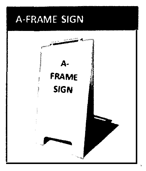
"Air-Activated Sign" means an attention attracting device that is activated by wind or forced air, portions of which flutter or flap in the air; examples are known by commercial names such as sky puppet, air puppets, air crows, air dancers and wind dancers; the definition includes functionally similar devices.
"Animated Sign" means any sign that uses movement or change of lighting to depict action or movement of visual elements.
"Banner" means any sign made of cloth, lightweight fabric, bunting, plastic, vinyl, paper or similar material that is permanently or temporarily placed on, or affixed to, real property in a location where the message or image displayed is visible to the public from outside of the building or structure. A flag, as defined, shall not be considered a banner.
"Billboard" means a sign which meets any one or more of the following criteria:
1.
A sign structure which is used for the display of off-site commercial messages;
2.
A sign structure which constitutes a principal, separate, or secondary use, as opposed to an accessory use, of the parcel on which it is located;
3.
An outdoor sign used as general advertising for hire, e.g., on which display space is made available to parties other than the owner or operator of the sign or occupant of the parcel (not including those who rent space from the sign owner, when such space is on the same parcel or is the same development as the sign), in exchange for a rent, fee, or other consideration; or
4.
An off-site outdoor advertising sign on which space is leased or rented.
"Blade/Bracket Sign" means a small, pedestrian-oriented sign that projects perpendicular from a structure (including fences, posts, and railings).
"Building-Attached Sign" means a sign placed on a wall or canopy, projecting from a wall, or hung underneath a canopy or overhang structure, or placed in a window. This sign category includes wall signs, canopy signs, projecting signs, under canopy signs, and window signs as defined herein. See Figure 130.36.120.B (Building-Attached Signs) below in this Section.
Figure 130.36.120.B Building-Attached Signs
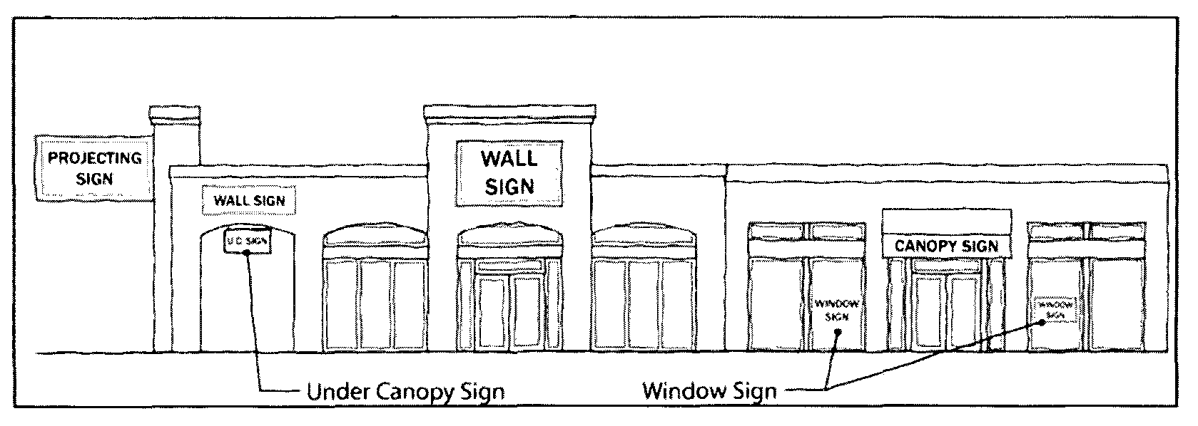
"Building Facade" means all walls, or portions thereof, of a building's exterior which is exposed to public view, excepting alleys.
"Can Sign" means a type of sign which contains all the text and/or logo symbols within a single enclosed cabinet that is mounted to a wall or other surface. Such sign structures typically use slide in panels to display the message to the public. See Figure 130.36.120.C (Can Sign) in this Section.
Figure 130.36.120.C Can Sign
"Canopy Sign" means any sign that is a part of or attached to an awning, canopy, or other fabric, plastic, or structural protective cover (excluding a marquee) over an actual or faux door, entrance, window, or outdoor service area. See Figure 130.36.120.B (Building-Attached Signs) above in this Section.
"Changeable Copy Sign" means a sign or portion thereof with characters, letters, or illustrations that can be changed or rearranged manually without altering the face or surface of the sign. See Figure 130.36.120.D (Changeable Copy Sign) in this Section.
Figure 130.36.120.D Changeable Copy Sign
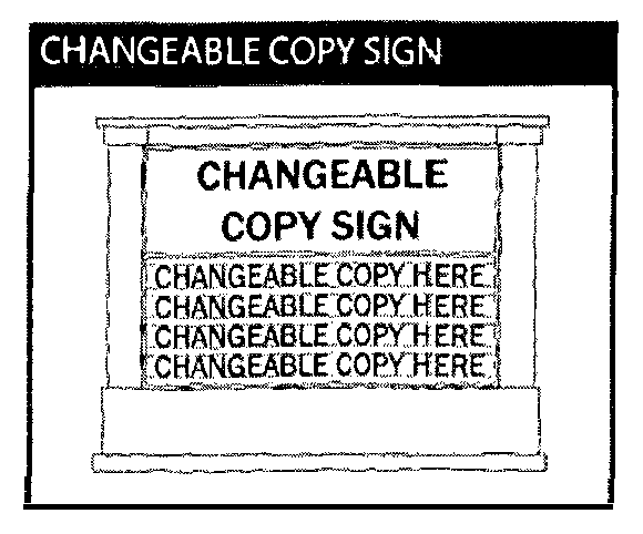
"Channel Letter Sign" means a type of sign comprising individual letters that are independently mounted to a wall or other surface with a covered face. The "air space" between the letters is the building facade. A logo may also be considered a channel letter provided it is clearly distinguishable from other sign elements. See Figure 130.36.120.E (Channel Letter Sign) in this Section.
Figure 130.36.120.E Channel Letter Sign
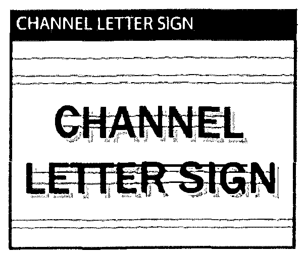
"Commercial Directional Sign" means a sign whose primary function is to provide directional information for an establishment offering retail sales to the general public, when the establishment does not have access through frontage on a county road.
"Commercial Message" means any sign, wording, logo, or other representation that names or advertises an establishment, product, service, or other commercial activity, primarily concerns the economic interest of the message sponsor or audience, or which proposes a commercial transaction.
"Community Sign" means a sign located on private property or County-maintained roads or rights-of-way (per Section 130.36.110 (Signs on County Property) above in this Chapter) that is part of a County-authorized and coordinated program to provide the public with information and guidance on topics including, but not limited to, public accommodations, facilities, commercial services, events, and points of scenic, cultural, historic, educational, recreational, religious interest, and other local community destinations as designated and recognized by a Community Sign Program.
"Construction Site Sign" means a temporary sign mounted or displayed on the site of a construction project during the time when actual physical construction is ongoing.
"Copy" means the words, letters, numbers, figures, designs, or other symbolic representations incorporated into the visually communicative elements of a sign.
"Design and Improvement Standards Manual (DISM)" means the County document adopted on May 27, 1986, by Resolution No. 128-90, including subsequent revisions, that contains development standards for specified land use and transportation-related improvements on public and private lands for purposes of public safety and consistency with generally accepted engineering practices.
"Digital Display" means display methods utilizing Light Emitting Diode (LED), Liquid Crystal Display (LCD), Plasma, projected images, or any functionally equivalent technology, and which is capable of automated remote or computer control to change the image, either in a "slide show" manner (series of still images), or full motion animation, or flashing, blinking or intermittent light, or any combination of them. Also known as dynamic signs, Electronic Message Center (EMC) and Commercial Electronic Variable Message Signs (CEVMS).
"Digital Sign." See "Electronic (Digital) Message Sign."
"Directional Sign" means any sign (building-attached or freestanding) intended to be permanently affixed and utilized only for the purpose of indicating the direction of any object, place, or area.
"Directory Sign" means a pedestrian-oriented sign that identifies or lists the names and locations of tenants at a multi-tenant site.
"Display Face." See "Sign Face."
"Dwell Time" means the number of seconds an electronic (digital) message is displayed before changing to a different message.
"Electronic (Digital) Message Sign" means an electronic sign, typically comprising a liquid crystal diode (LCD), light-emitting diode (LED), plasma, or other digital illuminated display that contains one or more messages. An electronic message sign is different from an illuminated sign in that the illumination of the display creates the message, rather than an internal or external light source illuminating the message. Also known as Electronic Message Center (EMC). See Figure 130.36.120.F (Electronic (Digital) Message Sign).
Figure 130.36.120.F Electronic (Digital) Message Sign
"Establishment" means any legal use of land, other than long-term residential, which involves the use of structures subject to the Building Code. By way of example and not limitation, this definition includes businesses, tenants and or lessees, factories, farms, schools, hospitals, hotels, and motels, offices and libraries, but does not include single-family homes, mobile homes, residential apartments, or residential condominiums. Multi-units housing developments are considered establishments during the time of construction; individual units are not within the meaning of establishment once a certificate of occupancy has been issued or full-time residency begins.
"Exempt Sign" means a sign that is not subject to a plan check approval or a sign that is not subject to a sign permit.
"Feather Banner" means a pole (typically flexible) with an attachment generally made of fabric and in the shape of a feather or quill, used to attract attention and/or present some visually communicative image to public view. Also known as feather flag, quill flag and similar names.
"Flag" means any fabric, banner, or bunting containing distinctive colors, patterns, or design that displays the symbol(s) of a nation, state, local government, company, organization, belief system, idea, or other meaning.
"Freestanding Sign" means a permanent sign that is self-supporting in a fixed location and not attached to a building. A freestanding sign can be connected or attached to a sign structure, fence, or wall that is not an integral part of a building. Freestanding signs include, but are not limited to, monument/pylon signs and pole signs as described in this Section.
"General Advertising for Hire" means the enterprise of advertising or promoting other businesses, establishments or causes using methods of advertising, in contrast to self-promotion or on-site advertising. The term applies regardless of whether a given message is commercial, noncommercial, or "public service" in nature. Also known as general advertising.
"Highway-Oriented (U.S. Highway 50 only) Sign" means an on-site freestanding sign structure (single or multi-tenant identification) located on property within 100 feet of the edge of the right-of-way or otherwise designed to be visible from U.S. Highway 50 that is outside of the officially designated scenic corridor for which a U.S. Highway 50-Oriented Sign Permit is issued.
"Home Occupation Sign" means a sign located at a residence advertising a business or profession legally conducted in the residence.
"Illegal Sign" means a sign which is not lawfully permitted in accordance with current adopted regulations.
"Illuminated Sign" means a sign with an artificial light source incorporated internally or externally for the purpose of illuminating the sign; includes signs made from neon or other gas tube(s) that are bent to form letters, symbols, or other shapes. An illuminated sign excludes electronic (digital) message signs, which are separately defined.
"Inflatable Balloon Sign" means a sign consisting of balloons and inflatables made of latex, metallic and/or cloth material, regardless of the size that is used, for the purpose of attracting attention.
"Integrated Development" means a property or combination of properties containing three or more separate tenants and which share common parking, driveway, and access areas.
"Legal Nonconforming Sign" means a sign that was lawfully erected but that does not comply with the provisions of this Chapter.
"Marquee" means any permanent roofed structure projecting over public property or right-of-way attached to and supported by a building.
"Mobile Billboard" means a vehicle which parks upon public land or traverses upon public roads for the primary purpose of displaying general advertising for hire.
"Monument Sign" means a freestanding sign detached from a building and having a support structure with a base that appears to be solid and is constructed of permanent material, such as concrete block or brick. This sign type also includes multi-tenant signs. See Figure 130.36.120.G (Monument Sign) in this Section.
Figure 130.36.120.G Monument Sign
"Motor Vehicle Fuel Pricing Signs" means signs identifying the brand, type, octane rating, etc., of motor vehicle fuel for sale, as required by state law.
"Movable Sign" means a sign that can easily be moved from one place to another, typically by mounting it on a vehicle or trailer, or by attaching wheels to it.
"Mural" means a painted or otherwise attached or adhered image or representation on the exterior of a structure that is visible from a public right-of-way or neighboring property, does not contain commercial advertisement (is noncommercial in nature), and is designed in a manner so as to serve as public art, to enhance public space, and to provide inspiration.
"Noncommercial Message" means a message that addresses topics of public debate and concern. By way of example and not limitation, such messages often express opinions and views on subjects such as religion, politics, commentary on the arts or sports, or protests.
"Off-Site Sign" means any sign not located on the premises of the establishment indicated or advertised by such sign. This definition shall include, but not be limited to, billboards, poster panels, painted bulletins, and other similar advertising displays.
"On-Site Sign" means a sign directing attention to an establishment, commodity, service, or entertainment conducted, sold, or offered upon the same property as that upon which the sign is maintained.
"Painted Sign" means a sign that comprises only paint applied on a structure.
"Pennant" means any lightweight plastic, fabric, or other material, whether or not containing a message of any kind, attached to a rope, wire, or string, usually in a series, designed to move in the wind and attract attention.
"Permanent Sign" means a sign that is entirely constructed out of durable materials, is fixed in place, and is intended to exist for more than 120 days.
"Pole Sign" means a freestanding sign detached from a building and supported by one or more structural elements that are either: (a) architecturally dissimilar to the design of the sign; or (b) less than one-quarter the width of the sign face. Pole signs do not include traffic signs (as defined in Section 130.36.030—Exemptions) or monument signs. See Figure 130.36.120.H (Pole Sign) in this Section. (Freestanding signs constructed with poles as the substructure where the poles are encased to incorporate design features are not considered pole signs.)
Figure 130.36.120.H Pole Sign
"Portable Sign" means any sign not permanently attached to the ground or other permanent structure, or a sign designed to be transported. Portable signs include, but are not limited to, signs designed to be transported by means of wheels, A-frame signs, menu and sandwich board signs, and umbrellas used for advertising. Clothing or other aspects of personal appearance are not within this definition.
"Projecting Sign" means a sign attached to and extending outward from the face of a structure. Includes, but is not limited to, a blade/bracket sign, hanging or projecting sign, or marquee sign. See Figure 130.36.120.B (Building-Attached Signs) above in this Section.
"Pushpin Letter Sign" means a type of sign comprising individual letters that are independently mounted to a wall or other surface. Such sign may be illuminated by an external light source, such as pendant lighting. The "air space" between the letters is the building facade. See Figure 130.36.120.I (Pushpin Sign) in this Section.
Figure 130.36.120.I Pushpin Sign
"Pylon Sign" means a freestanding sign detached from a building and having a support structure with a base that appears to be solid and is constructed of permanent material, such as concrete block or brick. See Figure 130.36.120.J (Pylon Sign) in this Section.
Figure 130.36.120.J Pylon Sign
"Raceway (Sign)" means a sign channel for protecting and holding electrical wires and cables, especially a metal rectangular tube used for such purposes.
"Real Estate Sign" means a temporary sign advertising the sale or lease or other economic transaction involving real property. All signs described in Civil Code Section 713 are within this definition.
"Roof Sign" means a sign erected, constructed, painted, or placed upon or over a roof or parapet wall of a building and which is wholly or partly supported by the building or roof structure.
"Sign" means any device, structure, fixture, or placard displaying graphics, symbols, and/or written copy for the primary purpose of communicating with the public. The following do not fall within the definition of a "sign" for purposes of this Chapter:
a.
Architectural or decorative features of buildings (not including lettering, trademarks, or moving parts).
b.
Fireworks, candles, and artificial lighting. The legal use of fireworks, candles, and artificial lighting not otherwise regulated by this Chapter.
c.
Graphic images that are visible only from above, such as those visible only from airplanes or helicopters, but only if not visible from the street surface or public right-of-way.
d.
Gravestones and grave markers.
e.
Holiday and cultural observance decorations that are on display for not more than 45 calendar days per year (per parcel or use) and which do not include commercial advertising messages.
f.
Interior signs or other visual communicative devices that are located entirely within a building or other enclosed structure and are not visible from the exterior thereof or located at least three feet from the window on the interior of the structure.
g.
Manufacturers' marks on tangible products that identify the maker, seller, provider, or product and which customarily remain attached to the product even after sale.
h.
Mass transit graphic images mounted on trains or duly licensed mass transit vehicles that legally pass through the County.
i.
Murals, painted or otherwise attached or adhered image or representation on the exterior of a structure that is visible from a public right-of-way or neighboring property, does not contain commercial advertisement (is noncommercial in nature), and is designed in a manner so as to serve as public art, to enhance public space, and to provide inspiration.
j.
News racks and newsstands.
k.
Personal appearance items or devices of personal apparel, decoration, or appearance, including, but not limited to, tattoos, makeup, wigs, costumes, and masks.
l.
Shopping carts, golf carts, and horse-drawn carriages.
m.
Symbols embedded in architecture such as symbols of noncommercial organizations or concepts including, but not limited to, religious or political symbols, when such are permanently integrated into the structure of a building; the definition also includes foundation stones and cornerstones.
n.
Vehicle and vessel insignia as shown on street-legal vehicles and properly licensed watercraft including, but not limited to, license plates, license plate frames, registration insignia, noncommercial messages, messages relating to the business of which the vehicle or vessel is an instrument or tool (not including general advertising for hire), and messages relating to the proposed sale, lease, or exchange of the vehicle or vessel.
o.
Vending machines that do not display off-site commercial messages or general advertising messages.
"Sign Face" means that area or portion of a sign on which copy is intended to be placed.
"Sign for Drive In/Drive Through Uses" means a sign installed in a drive-through facility and oriented so as to be visible primarily by drive-through customers.
"Sign Twirler" means a human being, or a robotic imitation of a human being, displaying signs visible from the public right-of-way by holding the physical sign and twirling or spinning for the purpose of attracting public attention. Also known as sign spinner.
"Subdivision Sign" means a temporary or otherwise limited-term sign for the purpose of providing direction for vehicular and/or pedestrian traffic to the new home sale of multiple lots or dwelling units with a single builder within a master planned community, including both single-family and multi-family for-sale products. All other home sales signs are included within the definition of real estate sign.
"Temporary Promotional Sign" means any sign displaying a commercial/promotional message, pennant, streamer, banner, beacon, bunting material, or other similar nonpermanent sign made of paper, cloth, canvas, lightweight fabric, or other non-rigid material, with or without frames, whether displayed as freestanding, wall-mounted, pole-mounted, window-mounted, or painted, or any other method of attachment, or beacon, which is intended to be displayed for a limited period of time.
"Temporary Sign" means a sign used for the public display of visual messages or images, which is easily installed with or without common hand tools, and which is not intended or suitable for long-term or permanent display (e.g., less than 120 days), due to lightweight or flimsy construction materials. Examples include, but are not limited to, A-frame signs, banners, pennants, streamers, or similar nonpermanent signs made of paper, cloth, canvas, lightweight fabric, or other non-rigid material, with or without frames. Any device that meets the definition of a "structure" in the building code is not within this definition.
"Tourist Industry" means commercial businesses that provide goods and/or services (such as attractions and recreation; accommodations; restaurants and retail; transportation, travel and rental car services) for people traveling for pleasure (e.g., vacation, recreation, sightseeing).
"Under Canopy Sign" means a pedestrian-oriented sign hung from underneath an awning, canopy or overhang structure/breezeway. See Figure 130.36.120.B (Building-Attached Signs) above in this Section.
"Vehicle Sign" means a sign mounted upon a vehicle which may legally be parked on or move on public roads as well as a sign mounted upon a water vessel which may legally move upon the waters.
"Wall Sign" means a sign attached to or erected against the wall of a building or structure with the exposed face of the sign parallel to the plane of such wall. See Figure 130.36.120.B (Building-Attached Signs) above in this Section.
"Window Sign" means any permanent or temporary sign, picture, letter, character, or combination thereof, designed to communicate information about an activity, business, commodity, event, sale, or service that is placed upon and/or inside and/or within three feet of a window for the purpose of being visible from the exterior of the window. See Figure 130.36.120.B (Building-Attached Signs) above in this Section.
(Ord. No. 5242, § 1, 9-16-2025)
Sec. 130.37.010 - Content.
This Chapter complies with General Plan Goal 6.5 (Acceptable Noise Levels), and supplements County Code Chapter 9.16 (Noise) by establishing standards concerning acceptable noise levels for both noise-sensitive land uses and for noise-generating land uses.
Sec. 130.37.020 - Exemptions.
The following noise sources shall be exempt from the standards of this Chapter:
A.
Activities conducted in public parks, public playgrounds, and public or private school grounds, including but not limited to school athletic and school entertainment events, providing an amplified sound system is not required or used.
B.
The use of any mechanical device, apparatus, or equipment related to or connected with emergency activities or emergency work to protect life or property.
C.
Safety signals, warning devices, and emergency pressure relief valves properly operated and in good working order.
D.
Noise sources associated with property maintenance, such as lawn mowers, trimmers, snow blowers, power tools in good working order, and cutting of firewood for non-commercial personal use, provided that the activities take place between the hours of eight a.m. and nine p.m. on weekdays and nine a.m. to nine p.m. on weekends and federal holidays.
E.
Noise sources associated with agricultural uses listed in Section 130.21.020 (Agricultural Zones: Matrix of Allowed Uses) in Article 2 (Zones, Allowed Uses, and Zoning Standards) of this Title that are performed consistent with the standards and practices of the agricultural industry.
F.
Noise sources associated with work performed by public or private utilities in the maintenance or modification of its facilities.
G.
Noise sources associated with public holidays, or other commonly celebrated occasions.
H.
Traffic on public roadways, railroad line operations, aircraft in flight, and any other activity where regulation thereof has been preempted by state or federal law.
I.
Construction (e.g., construction, alteration or repair activities) during daylight hours provided that all construction equipment shall be fitted with factory installed muffling devices and maintained in good working order.
Sec. 130.37.030 - Applicability.
Subject to the exemptions in Section 130.37.020 (Noise Standards, Exemptions) above in this Chapter, noise standards established in this Chapter shall apply to all noise generating uses requiring discretionary review or ministerial permits, with the exception of existing and new single-unit residential dwellings on legal lots that are not within areas governed by an Airport Comprehensive Land Use Plan. (General Plan Policy 6.5.1.4, Acceptable Noise Levels, Protection of Noise-Sensitive Development).
Sec. 130.37.040 - Definitions.
The following definitions shall apply to this Chapter:
"Acoustic Specialist" means a person trained in acoustic sampling that is qualified to measure sound levels consistent with criteria contained within this article.
"Ambient Sound Level" means the composite of normal or existing sound from all sources, measured at a given location for a specified time of the day or night.
"A-weighting" means the scale for measuring sound that de-emphasizes low and high frequencies in order to simulate human hearing; indicated as dBA.
"Community Noise Equivalent Level (CNEL)" means a weighted average hourly noise level over a 24 hour day used specifically for airport and aircraft noise assessment.
"Day-Night Average Sound Level (Ldn)" means the dBA for a given area during a 24-hour day with a 10dB weighting applied to nighttime sound levels.
"Decibel" means a unit of relative loudness on a logarithmic scale that runs from zero for the least perceptible sound to 140 for sound that causes pain.
"Equivalent Noise Level (Leq)" means the average energy noise level determined by averaging the cumulative noise event levels during a specific period of time and expressing it in A-weighted decibels, or dBA.
"Fixed Sound Source" means a device or machine which creates sounds while fixed or stationary, including but not limited to residential, agricultural, industrial, and commercial machinery and equipment, pumps, fans, compressors, air conditioners and refrigeration equipment, and motor vehicles operated on private property.
"Maximum Sound Level (Lmax)" means the maximum instantaneous noise level measured on a sound level meter.
"Non-Transportation Noise Source" means industrial operations, commercial land uses, outdoor recreation activities and facilities, Heating, Ventilation and Air Conditioning (HVAC) units, schools, hospitals, and other outdoor land use.
"Sensitive Receptor" means a land use in which there is a reasonable degree of sensitivity to noise. Such uses include single- and multi-unit residential dwellings including frequently inhabited outbuildings, schools, hospitals, churches, rest homes, cemeteries, public libraries, and other sensitive uses as determined by the Director.
"Sound Level Meter" means an instrument meeting American National Standard Institute (ANSI) Standard S1.4A-1985 for Type 1 or Type 2 sound level meters, or an instrument and associated recording and analyzing equipment that will provide equivalent data.
"Transportation Noise Source" means traffic on public or private (non-county maintained) roadways, railroad line operations, and aircraft in flight.
Sec. 130.37.050 - Acoustic Analysis Requirements.
An acoustic analysis prepared by an acoustic specialist shall be required prior to discretionary authorization or permit approval for the following uses:
A.
New noise-generating land uses likely to exceed the performance thresholds in the Tables in Section 130.37.060 (Noise Standards) below in this Chapter when proposed in areas adjacent to sensitive receptors. Noise sources may include industrial operations, outdoor recreation facilities, outdoor concerts and events utilizing amplified sound systems, commercial land uses, fixed sound sources, and other similar uses; or
B.
New noise-sensitive land uses proposed in areas exposed to existing or projected exterior noise levels likely to exceed the thresholds in the Tables in Section 130.37.060 (Noise Standards) below in this Chapter.
Sec. 130.37.060 - Noise Standards.
The following standards shall apply to all development projects for which an acoustic analysis is required:
A.
Noise sensitive land uses affected by non-transportation noise sources shall not exceed standards set forth in Table 130.37.060.1 (Noise Level Performance Standards for Noise Sensitive Land Uses Affected by Non-Transportation Sources) below in this Section:
Table 130.37.060.1—Noise Level Performance Standards for Noise Sensitive Land Uses Affected by Non-Transportation Sources
1.
Each of the noise levels specified above shall be lowered by five dBA for simple tone noises, noises consisting primarily of unamplified speech or music, or for recurring impulsive noises. These noise level standards do not apply to residential units established in conjunction with industrial or commercial uses, such as caretaker dwellings.
2.
The Director can impose noise level standards which are up to five dBA less than those specified above, based upon a determination of existing low ambient noise levels in the vicinity of the project site.
3.
The exterior noise level standard shall be applied as follows:
a.
In Community Regions, at the property line of the receiving property;
b.
In Rural Centers and Regions, at a point 100 feet away from a sensitive receptor or, if the sensitive receptor is within the Platted Lands Overlay (-PL) where the underlying land use designation is consistent with Community Region densities, at the property line of the receiving property or 100 feet away from the sensitive receptor, whichever is less; or
c.
In all areas, at the boundary of a recorded noise easement between affected properties.
B.
Transportation noise shall not exceed thresholds set forth in Table 130.37.060.2 (Noise Level Standards for Noise-Sensitive Land Uses Affected by Transportation Noise Sources) below in this Section:
Table 130.37.060.2—Noise Level Standards for Noise-Sensitive Land Uses Affected by Transportation Noise Sources
1.
In Community Regions and Rural Centers:
(a)
Where the location of outdoor activity areas is not clearly defined, the exterior noise level standard shall be applied at the property line of the sensitive receptor.
(b)
For residential uses with front yards facing the identified noise source, an exterior noise level threshold of 65 dBA Ldn shall be applied at the dwelling facade in addition to the required threshold at the outdoor activity area.
2.
In Rural Regions: An exterior noise level threshold of 60 dBA Ldn shall be applied at a 100-foot radius from the dwelling on lots five acres and larger. Those lots less than five acres shall have the noise level standards applied at the property line.
3.
Where it is not possible to reduce noise levels in those outdoor activity areas limited to 60 dBA Ldn/CNEL thresholds using a practical application of the best-available noise reduction measures, an exterior noise threshold of up to 65 dBA Ldn/CNEL may be allowed provided that available exterior noise level reduction measures have been implemented and interior noise levels are in compliance with this table.
C.
Construction-related noise shall allow for exceptions to the evening and night time standards or other temporary exceedances of noise standards as may be approved by the Director, where necessary to alleviate traffic congestion and safety hazards, or where authorized by an approved permit.
Sec. 130.37.070 - Noise Reduction Measures.
Noise reduction measures shall be incorporated into the project design to reduce noise levels at or below the thresholds set forth in Tables in Section 130.37.060 (Noise Standards) above in this Chapter. Where applicable, the following specific requirements shall also apply:
A.
To meet noise threshold standards under Table 130.37.060.2 (Noise Level Standards for Noise-Sensitive Land Uses Affected by Transportation Noise Sources) above in this Chapter, where feasible, setbacks shall be the preferred method of noise abatement for residential projects located along U.S. Highway 50. Noise walls shall be discouraged within the foreground viewshed of U.S. Highway 50 and shall be discouraged in favor of less intrusive noise mitigation (e.g., landscaped berms, setbacks) along other high volume roadways.
B.
For outdoor concerts and events utilizing amplified sound system(s), a discretionary permit shall be required in the form of a Temporary or Conditional Use Permit, except for special events and marketing events that are allowed by right or with an administrative permit consistent with Chapter 130.44 (Ranch Marketing) or 130.40.400 (Wineries). Self-monitoring shall be performed to ensure that sound system levels are in compliance with those specified in the conditions of approval based on the acoustic analysis. As a standard condition of approval for such use permits, failure to comply with sound system levels shall result in termination of the event for the duration of the period approved under the use permit and a moratorium on future events for the applicant or the property owner of two calendar years from the date of noncompliance. A second violation after such time shall result in revocation of the Conditional Use Permit, if applicable, and a permanent moratorium on future events for the applicant and property owner whether on that site or any other within the County.
(Ord. No. 5177, § 3, 6-20-2023)
Sec. 130.37.080 - Noise Level Measurements.
For the purpose of evaluating conformance with the standards of this Chapter, noise levels shall be measured as follows:
A.
Use of Meter. Any noise measurement shall be made with a sound level meter using the A-weighted scale. Calibration of the measurement equipment utilizing an acoustical calibrator shall be performed immediately prior to recording any noise data.
B.
Ambient Sound Levels. Compliance with the above standards shall be determined by measuring the existing noise level with a sound level meter using slow response, with the sound source at issue remaining silent. The ambient sound level shall be determined based on the mean average of not less than three 20-minute measurements for any given time period. Additional noise measurements may be necessary to ensure that the ambient sound level is adequately determined.
C.
Measuring Exterior Noise Levels. Except as otherwise provided in this Chapter, exterior noise levels shall be measured at the property line of the affected noise-sensitive land use. Where practical, the microphone shall be positioned five feet above the ground and away from reflective surfaces.
D.
Measuring Interior Noise Levels. Interior noise levels shall be measured within the sensitive receptor, as defined in Section 130.37.040 (Noise Standards, Definitions) above in this Chapter, at points at least four feet from the wall, ceiling, or floor nearest the noise source, with windows in the normal seasonal configuration. The reported interior noise level shall be determined by taking the arithmetic average of the readings taken at the various microphone locations.
Sec. 130.39.010 - Content.
This Chapter establishes standards for implementing the County's Oak Resources Management Plan (ORMP) in compliance with General Plan Policy 7.4.4.4 and Implementation Measure CO-P (mitigation requirements for impacts to oak resources). This Chapter shall be referred to as the Oak Resources Conservation Ordinance (ordinance).
(Ord. No. 5235, § 1, 7-22-2025)
Sec. 130.39.015 - Conflict of Ordinances.
A.
The operation of this Chapter shall in no way change or diminish the application of other ordinances in this Code dealing with like or similar matters.
B.
In any case where a provision of this, or any other, Chapter conflicts with a provision of any zoning, building, fire safety, or health ordinance or any other section of the Code, including fines, the provision which establishes the higher standard for the promotion and protection of the health and safety of the people shall prevail.
C.
It is not intended by this Chapter to repeal, abrogate, annul, or in any way impair or interfere with existing provisions of other laws or ordinances.
(Ord. No. 5235, § 1, 7-22-2025)
Sec. 130.39.020 - Applicability.
With the exception of exempt activities listed in Section 130.39.050 (Exemptions) below in this Chapter, the requirements of this Chapter shall apply to both ministerial (including streamlined) and discretionary development activities resulting in impacts to Oak Resources as defined in this Chapter. This Chapter shall apply to all privately-owned lands within the unincorporated area of the County at or below the elevation of 4,000 feet above sea level where Oak Resources are present. Projects directly undertaken by the County are exempt from the permit requirements of this Chapter. However, where mitigation to oak woodlands is required, pursuant to the California Environmental Quality Act, Public Resources Code [PRC] Section 21083.4, the mitigation requirements of this Chapter may be applied.
(Ord. No. 5235, § 1, 7-22-2025)
Sec. 130.39.030 - Definitions.
For the purposes of this Chapter, the following terms and phrases shall have the meanings respectively ascribed to them by this Section. Any definition cross-referenced to other provisions of this Code is repeated for convenience only and any subsequent update or amendment to those cross-referenced definitions shall apply to this Chapter:
Agricultural cultivation/operations. As defined by General Plan Policy 8.2.2.1.
Arborist means a person certified by the International Society of Arboriculture (ISA) that provides professional advice regarding trees in the County.
CAL FIRE means the California Department of Forestry and Fire Protection.
Commercial firewood cutting means fuel wood production where a party cuts firewood for sale or profit.
Conservation easement means an easement granting a right or interest in real property that is appropriate to retaining land or water areas predominately in their natural, scenic, open, or wooded condition; retaining such areas as suitable habitat for fish, plants, or wildlife; or maintaining existing land uses. A Conservation Easement shall be established consistent with the requirements of Section 6.0 (Definitions) of the ORMP.
Construction/disturbance area means any area in which movement of earth, alteration in topography, soil compaction, disruption of vegetation, change in soil chemistry, and any other change in the natural character of the land occurs as a result of site preparation, grading, building construction or any other construction activity.
Deed restriction means private agreements that restrict the use of the real estate and are listed in the deed. Restrictions travel with the deed and cannot generally be removed by new owners.
Defensible space. As defined in Chapter 8.09 of this Code (Hazardous Vegetation and Defensible Space), means the buffer that responsible person(s) is (are) required to create on their property between a structure and the plants, brush, and trees or other items surrounding the structure that could ignite in the event of a fire.
Diameter at breast height (dbh) means the measurement of the diameter of a tree in inches, specifically four feet six inches above natural grade on the uphill side of the tree. In the case of trees with multiple trunks, the diameter of the three largest stems (trunks) at breast height shall be combined to calculate the diameter at breast height of the tree.
Fire hazard. As defined in Chapter 8.09 of this Code (Hazardous Vegetation and Defensible Space), means any condition, arrangement, act, or omission which:
1.
Increases, or may cause an increase of hazard or menace of fire to a greater degree than that customarily recognized as normal by persons in the public service regularly engaged in preventing, suppressing, or extinguishing fire; or
2.
May obstruct, delay, hinder, or interfere with the operations of a fire department or the egress of occupants in the event of fire.
Hazardous vegetation. As defined in Chapter 8.09 of this Code (Hazardous Vegetation and Defensible Space), means any vegetation that is combustible and endangers the public safety by creating a fire hazard. Hazardous vegetation includes material that in its natural state will readily ignite, burn, and transmit fire from native or landscape plants to any structure or other vegetation. Hazardous vegetation includes, but is not limited to, dry grass and leaves, brush, weeds, green waste, dead or dying trees, low-hanging branches, litter, or other flammable vegetation that create a fire hazard. Hazardous vegetation shall not include a commercial agricultural crop that is being actively grown and managed by a responsible person.
Heritage trees means any live native oak tree of the genus Quercus (including blue oak (Quercus douglasii), valley oak (Quercus lobata), California black oak (Quercus kelloggii), interior live oak (Quercus wislizeni), canyon live oak (Quercus chrysolepis), Oregon oak (Quercus garryana), oracle oak (Quercus x morehus), or hybrids thereof) with a single main trunk measuring 36 inches dbh or greater, or a multiple trunked tree with the aggregate diameter of the three largest trunks measuring 36 inches dbh or greater.
Impact, for individual native oak trees, means the physical destruction, displacement or removal of a tree or portions of a tree caused by poisoning, cutting, burning, relocation for transplanting, bulldozing or other mechanical, chemical, or physical means. Impact includes regulated activities within the tree protection zone. For oak woodlands, tree and land clearing associated with land development, including, but not limited to, grading, clearing, or otherwise modifying land for roads, driveways, building pads, landscaping, utility easements, fire-safe clearance and other development activities.
In-lieu fee means cash payments that may be paid into the County's Oak Woodland Conservation Fund by an owner or developer as a substitute for a deed restriction, conservation easement or replacement planting. In-lieu fee amounts for individual native oak trees, heritage trees, and oak woodlands as presented in the ORMP may be adjusted by the County over time to reflect changes in land values, labor costs, and nursery stock costs.
Individual native oak tree(s) means any live native oak tree of the genus Quercus (including blue oak (Quercus douglasii), valley oak (Quercus lobata), California black oak (Quercus kelloggii), interior live oak (Quercus wislizeni), canyon live oak (Quercus chrysolepis), Oregon oak (Quercus garryana), oracle oak (Quercus x morehus), or hybrids thereof) with a single main trunk measuring six inches dbh or greater, but less than 36 inches dbh, or with a multiple trunk with an aggregate trunk diameter measuring greater than ten inches dbh and is not a heritage tree.
Minor trimming means the cutting of dead or diseased limbs or twigs, parts which may result in damage to an existing dwelling, parts which must be removed for safety or public utilities or pruning to promote the health or growth of the tree. Safety includes, but is not limited to, minor trimming to comply with defensible space requirements outlined in Chapter 8.09 of this Code. Trimming which substantially reduces the overall size, density or alters the natural shape of the tree is not considered minor trimming.
Oak resources. Collectively, oak woodlands, individual native oak trees, and heritage trees.
Oak resources technical report means a stand-alone report prepared by a qualified professional containing information, documents and formatting as specified in Section 2.5 (Oak Resources Technical Reports) of the ORMP.
Oak tree removal permit means a permit issued by the County allowing removal of individual native oak trees not located within an oak woodland or where less than two acres of oak woodland will be impacted by a project. An oak resources technical report shall accompany any tree removal permit application submitted to the County. Conditions of approval may be imposed on the permit.
Oak Woodland Conservation Fund means a fund set up by the County to receive in-lieu fees (Oak woodland in-lieu fee and individual tree in-lieu fee) which shall be used to fund the acquisition of land and/or oak woodlands conservation easements from willing sellers, native oak tree planting projects, and ongoing conservation area monitoring and management activities, including, but not limited to, fuels treatment, weed control, periodic surveys, and reporting.
Oak woodland(s) means an oak stand with a greater than ten percent canopy cover or that may have historically supported greater than ten percent canopy cover (California Fish and Game Code Section 1361).
Oak woodland removal permit means a permit issued by the County allowing removal of oak trees that are a component of an oak woodland. Where two acres or more of oak woodlands will be impacted, an oak woodland removal permit is required. Otherwise, an oak tree removal permit is required. An oak resources technical report shall accompany any oak woodland removal permit application submitted to the County. Conditions of approval may be imposed on the permit.
Qualified professional means an arborist certified by the International Society of Arboriculture (ISA), a qualified wildlife biologist, or a registered professional forester (RPF).
Qualified wildlife biologist means a professional with a BA or BS or advanced degree in biological sciences or other degree specializing in the natural sciences; professional or academic experience as a biological field investigator, with a background in field sampling design and field methods; taxonomic experience and knowledge of plant and animal ecology; familiarity with plants and animals of the area, including the species of concern; and familiarity with the appropriate County, State, and Federal policies and protocols related to special status species and biological surveys.
Regulated activity means construction activity within the tree protection zone, including, but not limited to, grade changes (cut and fill), introduction of impervious services, soil compaction or chemical spillage with a high likelihood of detrimental effects to the tree.
Registered professional forester (RPF) means a registered professional forester (RPF) licensed by the State of California to perform professional services that require the application of forestry principles and techniques to the management of forested landscapes. RPFs have an understanding of forest growth, development, and regeneration; soils, geology, and hydrology; wildlife and fisheries biology and other forest resources. RPFs are also trained in fire management and, if involved in timber harvesting operations, have expertise in both forest road design and application of the various methods used to harvest.
Responsible person. As defined in Chapter 8.09 of this Code (Hazardous Vegetation and Defensible Space), means an owner, tenant, occupant, lessor, manager, licensee, political subdivision, local government agency, municipality, or other person having control over a structure or parcel of land or, to the fullest extent allowed by law, the parent or legal guardian of any person under 18 years who have done any act for which a penalty may be imposed under this Chapter, or any other person required to comply with the provisions of the Code and, any other lien holder, secured party, or other person who has properly recorded a security interest or other appropriate document evidencing an interest in the property, which has been recorded in the official records of the County.
Structure. As defined in Chapter 8.09 of this Code (Hazardous Vegetation and Defensible Space), includes buildings which qualify for occupancy classification and use designation per the County building code, such as residential dwellings (which includes trailers and mobile homes, whether situated in a park or installed on private property), commercial buildings, industrial buildings, agricultural buildings, barns, storage buildings, government buildings, and any accessory buildings thereto deemed appropriate for a site address by the County surveyor.
1.
Exception: Any freestanding outbuilding 120 square feet or less in floor area.
Tree protection zone (TPZ) means the area surrounding a tree where the majority of the tree's roots take place. The TPZ shall be the greater of the following: (1) one foot diameter for every inch of trunk diameter, or (2) the area of ground beneath the tree's canopy. Wildland-Urban Interface (WUI) Fire Safe Plan. Defined in the El Dorado County General Plan (Policy 6.2.2.2) as a plan prepared by a qualified progressional as approved by the El Dorado County Fire Prevention Officers Association and approved by the local Fire Protection District and/or the California Department of Forestry and Fire Protection (CAL FIRE). The plan is prepared to demonstrate that development can be adequately protected from wildland fire hazard in areas of high and very high wildland fire hazard or in areas identified as [WUI] communities within the vicinity of Federal lands that are a high risk for wildfire, as listed in the Federal Register Executive Order No. 13728, dated May 18, 2016.
(Ord. No. 5235, § 1, 7-22-2025)
Sec. 130.39.040 - Prohibition.
With the exception of exempt activities listed in Section 130.39.050 (Exemptions) below in this Chapter, no person shall remove, or otherwise cause an impact to oak resources located wholly or partially within the unincorporated areas of the County unless the requirements of this Chapter are fully met, and a permit has been obtained.
(Ord. No. 5235, § 1, 7-22-2025)
Sec. 130.39.050 - Exemptions.
Oak resources impact mitigation is required for any non-exempt action requiring discretionary development entitlements or approvals from El Dorado County, or ministerial actions requiring a building permit or grading permit issued by El Dorado County. With the exception of dead, dying, and diseased trees, trees that have fallen or sustained damage due to natural disasters/incidents or trees considered hazardous vegetation pursuant to Section 8.09 of this Code (Hazardous Vegetation and Defensible Space), all impacts to heritage trees, individual valley oak trees, and valley oak woodlands shall be subject to the provisions and mitigation requirements contained in the ORMP, regardless of whether or not the action requires a development permit. With the above-noted exceptions, the provisions of this Chapter do not apply to the following activities except where provisions of a memorandum of understanding between the County and another governmental agency provide for County regulatory authority or otherwise provided by law. Although County permission is not required to remove oak trees for the activities listed below, property owner documentation of oak removal is strongly encouraged. Exemptions from mitigation requirements, including insurance required removal, are detailed in Section 130.39.070:
A.
Fire safe activities. Actions taken pursuant to an approved WUI Fire Safe Plan to protect existing structures, a Community Wildfire Protection Plan, or in accordance with maintenance of defensible space as identified in PRC Section 4291 or Chapter 8.09 of this Code are exempt from the permit requirements included in this Chapter. Oak resources impacts for initial defensible space establishment for new development are not exempt from the permit requirements included in this Chapter. In addition, fuel modification activities outside of defensible space, as defined in Section 130.39.030 (Definitions), are exempted from the permit requirements included in this Chapter.
B.
Dead, dying, or diseased trees inspected by an investigative official as defined in Section 8.09.030 of this Code (Hazardous Vegetation and Defensible Space) and documented in writing to the Planning and Building Department that said tree(s) constitute hazardous vegetation pursuant to Section 8.09 of this Code.
C.
Trees that have fallen or sustained damage due to thunderstorms, windstorms, floods, earthquakes, fires or other natural disasters/incidents.
D.
Utility line location, construction and maintenance. Actions associated with location and construction of new electrical energy facilities as specified in Subsection 130.10.040.B (Exemptions from Zone Ordinance Requirements) in Article 1 (Zoning Ordinance Applicability) of this Title, or actions taken to maintain safe operation of existing utility facilities in compliance with State regulations (PRC 4292-4293 and California Public Utilities Commission (CPUC) General Order 95) are exempted from the permit requirements included in this Chapter.
E.
Agricultural activities. With the exception of uses/activities that require issuance of a conditional use permit, and when such uses/activities are otherwise consistent with other provisions of County Code Title 130 (Zoning Ordinance), the following types of agricultural activities are exempted from the permit requirements included in this Chapter:
1.
Agricultural activities conducted for the purposes of producing or processing plant and animal products or the preparation of land for this purpose;
2.
Agricultural cultivation/operations, whether for personal or commercial purposes (excluding commercial firewood operations and ranch marketing); and
3.
Activities occurring on lands in Williamson Act contracts or under Farmland Security Zone programs.
F.
Emergency operations. Actions taken during emergency firefighting operations or responses to natural disasters (e.g., floods, landslides, avalanches, etc.) and associated post-fire or post-disaster remediation activities are exempted from the permit requirements included in this Chapter.
G.
Timber Harvest Plan. Tree removal permitted under a Timber Harvest Plan approved by CAL FIRE is exempted from the permit requirements included in this Chapter.
H.
Minor trimming, as defined within this Chapter, and conforming to the most current standards of the American National Standards Institute (ANSI).
(Ord. No. 5235, § 1, 7-22-2025)
Sec. 130.39.060 - Oak Tree and Oak Woodland Removal Permits.
An oak tree and/or oak woodland removal permit shall be required for all non-exempt activities with confirmed impacts to oak resources. The permit may be issued as a stand-alone permit or in conjunction with another ministerial or discretionary permit. Where two acres or more of oak woodland will be impacted, an oak woodland removal permit is required. Otherwise, an oak tree removal permit is required. Permits shall contain the following minimum information as specified below:
A.
Administrative permit. For purposes of this Chapter, oak tree and oak woodland removal permits shall be processed as an administrative permit pursuant to Section 130.52.010 (Administrative Permit, Relief, or Waiver) in Article 5 (Planning Permit Processing) of this Title.
B.
General permit requirements. Application for an oak tree or oak woodland removal permit shall be made by filing a completed application form with the Director. The form shall require the following minimum information:
1.
A Code compliance certificate, on a form approved by the Director, verifying that no oak resources have been impacted within two years prior to submittal of permit application;
2.
An oak resources technical report as defined in this Chapter;
3.
Condition of the oak resource(s) subject to impact;
4.
Site/plot plan of affected parcel(s) as required by administrative permit requirements;
5.
Reason and objective for impact;
C.
Oak tree and oak woodland removal permits—Permit processing:
1.
The director shall issue an oak tree or oak woodland removal permit pursuant to administrative permit processing requirements.
2.
The property owner shall be required to mitigate oak resources impacts as shown in Section 130.39.060.D (Mitigation-Oak Woodland Removal) and/or Section 130.39.060.E (Mitigation—Individual Native Oak Tree/Heritage Tree Removal) below in this Section.
D.
Commercial firewood. For purposes of this Section, commercial firewood cutting operations shall be considered discretionary and subject to a minor use permit pursuant to Section 130.52.020 (Minor Use Permit) in Article 5 (Planning Permit Processing) of this Title. In addition to the specific findings required for minor use permits, a minor use permit for commercial firewood cutting operations shall also consider the following:
1.
Whether the removal of the tree(s) would have a significant negative environmental impact;
2.
Whether the proposed removal would not result in clear-cutting, but would result in thinning or stand improvement;
3.
Whether replanting would be necessary to ensure adequate regeneration;
4.
Whether the removal would create the potential for soil erosion;
5.
Whether any other limitations or conditions should be imposed in accordance with sound tree management practices; and
6.
The resulting distribution and type of remaining oak resources including individual native oak trees, oak woodland, heritage trees, valley oak trees and valley oak woodland, as applicable.
E.
Denial of oak tree and/or oak woodland removal permit. If a tree removal permit application is denied, the County shall provide written notification, including the reasons for denial, to the applicant. Oak tree or oak woodland removal permit processing and approval will be conducted concurrently with the environmental review process for discretionary projects or concurrent with other permit review and processing for ministerial projects (e.g., building permits)
(Ord. No. 5235, § 1, 7-22-2025)
Sec. 130.39.070 - Mitigation.
Mitigation requirement. Impacts to oak resources shall be mitigated as follows:
A.
Oak woodland removal. If identified oak woodland will be impacted, the applicant shall mitigate for loss of oak woodland. Mitigation shall occur at the ratio identified in Table 3 (Oak Woodland Mitigation Ratios). Multifamily and mixed-use housing projects that qualify for streamlined ministerial processing under State law shall mitigate for impacts via an in-lieu fee payment as outlined in Subsection 130.39.070(1) below. For all other development projects, impacts shall be mitigated through the applicant's selection of one or more of the following options as specified in the ORMP:
1.
In-lieu fee payment based on the percent of on-site oak woodland impacted by the development as shown in Table 5 (Oak Woodland In-Lieu Fee) in the ORMP to be used by the County to fund the acquisition of land and/or oak woodlands conservation easements from willing sellers, native oak tree planting projects, and ongoing conservation area monitoring and management activities, including, but not limited to, fuels treatment, weed control, periodic surveys, and reporting;
2.
Off-site deed restriction or conservation easement acquisition for purposes of off-site oak woodland conservation consistent with Chapter 4.0 (Priority Conservation Areas) of the ORMP;
3.
Replacement planting within an area on-site for up to 50 percent of the total oak woodland mitigation requirement consistent with Section 2.4 (Replacement Planting Guidelines) of the ORMP. This area shall be subject to a deed restriction or conservation easement;
4.
Replacement planting within an area off-site for up to 50 percent of the total oak woodland mitigation requirement. Off-site replacement planting areas shall be consistent with Section 2.4 (Replacement Planting Guidelines) and Chapter 4.0 (Priority Conservation Areas) of the ORMP. This area shall be subject to a deed restriction or conservation easement; or
5.
A combination of options 1 through 4 above.
B.
Individual native oak tree/heritage tree removal. If individual native oak trees, including heritage trees, will be impacted as part of the permit, the applicant shall mitigate for loss of individual tree(s). Multifamily and mixed-use housing projects that qualify for streamlined ministerial processing under State law shall mitigate for loss of individual tree(s) via in-lieu fee payment as outlined in Subsection 130.39.070(2)(a) below. For all other development projects, impacts shall be mitigated by the applicant's selection of one or more of the following options as specified in the ORMP:
1.
In-lieu fee payment for individual oak tree removal to be either used by the County to plant oak trees or to be given by the County to a land conservation organization to plant oak trees as shown in Table 6 (Individual Oak Tree In-Lieu Fee) in the ORMP;
2.
Replacement planting on-site consistent with Section 2.4 (Replacement Planting Guidelines) of the ORMP within an area subject to a deed restriction or conservation easement and utilizing the replacement tree sizes and quantities shown in Table 4 (Oak Tree Replacement Quantities) in the ORMP. On-site replacement planting shall be consistent with Section 2.4 (Replacement Planting Guidelines) of the ORMP;
3.
Replacement planting off-site within an area subject to a conservation easement or acquisition in fee title by a land conservation organization utilizing the replanting sizes and quantities specified in Table 4 (Oak Tree Replacement Quantities) in the ORMP. Off-site replacement planting shall be consistent with Section 2.4 (Replacement Planting Guidelines) of the ORMP; or
4.
A combination of options 1 through 3 above.
Table 3 (ORMP)
Oak Woodland Mitigation Ratios
Source: ORMP, Section 2.2.2 (Oak Woodland Mitigation)
Table 4 (ORMP)
Oak Tree Replacement Quantities
C.
Security deposits for oak tree / oak woodland preservation and replacement planting. The Director shall create departmental procedures to implement the following sections:
1.
Security deposit for on-site oak tree/oak woodland preservation. If security is required for oak resources identified for on-site preservation as part of a discretionary project, $10,000.00 or 100 percent of estimated in-lieu mitigation fees, whichever is greater, shall be required as a condition of issuance of the discretionary permit and/or authorization during the construction and/or grading period. Prior to the issuance of any grading or building permit, the owner or developer shall deposit the cash or other acceptable security. The County shall hold the deposit to guarantee the health of the trees for a five-year period after completion of activity in the construction/disturbance areas.
2.
On-site oak tree/oak woodland replacement planting. If oak tree replacement planting is proposed for a project, the applicant shall post a bond, cash deposit, or other security instrument in an amount equal to 100 percent of the current value of required replacement tree(s) and/or acorns, plus the cost of maintenance and monitoring, as determined by a qualified professional. The security instrument shall be for a term of either seven years from the date of issuance of an oak tree/oak woodland removal permit, or from the date of the last replacement tree(s) planted as mitigation for the project, whichever is greater. The form and amount of the security instrument shall be specified by the permit issuing body and approved by County Counsel. No grading or other on-site work shall be permitted until the security is posted.
D.
Mitigation exemptions and reductions. The following projects require issuance of a permit, per Section 130.39.060. Mitigation may be reduced or exempted as follows:
1.
Mitigation reductions for affordable housing. Development projects that propose a minimum of ten percent of the dwelling units as deed restricted affordable units, as defined by California Health and Safety Code Sections 50052.5, 50053, and 50093, shall be granted a reduction in the amount of oak woodland that is required to be mitigated, as set forth in Table 2 (Affordable Housing Mitigation Reduction) in the ORMP. The reduction is to be applied to the mitigation ratio presented in Table 3 (Oak Woodland Mitigation Ratios) in the ORMP and shall only be applied to the residential portion(s) of the proposed project. This reduction for affordable housing projects does not apply to removal of heritage trees or individual valley oak trees. This reduction for affordable housing projects also does not apply to impacts to valley oak woodlands. In no case shall the mitigation requirement be less than zero.
Table 2 (ORMP)
Affordable Housing Mitigation Reduction
Source: ORMP, Section 2.1.11 (Mitigation Reductions for Affordable Housing).
Example: A project proposes 25 percent of the units to be affordable in the lower income category. The oak woodland mitigation ratio may be reduced by 25 percent. A moderate income project that provides all units at that income level may reduce the oak woodland mitigation ratio by 50 percent. A project with 20 percent very low income units would receive a 40 percent reduction in oak woodland mitigation ratio.
2.
Dead, dying, or diseased trees. Individual native oak tree removal (including individual valley oak trees and valley oak trees within valley oak woodlands) is exempted from the mitigation requirements included in this Chapter when:
a.
Affected tree(s) are dead, dying, or diseased, as certified in writing by a certified arborist or registered professional forester; and/or
b.
Affected tree(s) exhibit high failure potential with the potential to injure persons or damage property, as certified in writing by a certified arborist or registered professional forester.
c.
If multiple trees are proposed for removal as part of a proposed project and 50 percent or more of the trees are deemed dead, dying, diseased or as having a high failure potential, a second certification from another certified arborist or registered professional forester on the status of the health of the trees will also be required from applicant. If the two certifications disagree, the report most protective of oak resources shall apply.
3.
Exemption from mitigation for personal use. Removal of a native oak tree, other than a heritage tree or individual valley oak trees and valley oak woodlands, when it is cut down on the owner's property for the owner's personal use, is exempted from the mitigation requirements included in this Chapter provided that no more than eight trees are removed from a single parcel per year and provided that the total diameter inches at breast height (dbh) of trees removed from a single parcel per year does not exceed 140 inches. Personal use shall include only trees removed for firewood, woodworking, or fabrication of oak wood products (sale or barter of oak wood products may be subject to other State regulatory approvals). The act of preparing land for subsequent development constitutes an impact that is not covered under this exemption.
4.
Insurance-required oak removal. To qualify for an exemption from mitigation for the removal of healthy oak trees for the purpose of complying with insurance company criterion to protect persons, structures or property, a parcel-specific assessment of tree(s) required to be removed must be submitted to the El Dorado County Planning and Building Department from one of the following officials:
a.
A qualified professional as defined in Section 130.39.030 (Definitions) above in this section (an arborist certified by the International Society of Arboriculture, a qualified wildlife biologist, or a registered professional forester); or
b.
Written documentation from the property owner's insurance company identifying specific healthy oak tree(s) required to be removed to protect life or property in the event of a wildfire or hazardous natural condition.
The assessment under either scenario shall highlight specific healthy trees required to be removed.
(Ord. No. 5235, § 1, 7-22-2025)
Sec. 130.39.080 - In-lieu Fee Appeals.
A.
In-Lieu fee appeals. Appeals of in-lieu fees may be granted by the Director under any one of the following scenarios:
1.
The requirements of this Chapter have been incorrectly applied; and/or
2.
That application of the requirements of this Chapter is unlawful under and/or conflict with Federal, State, or local law and/or regulation including constituting an unlawful taking of property without just compensation.
B.
Application for appeals of in-lieu fees. Application must be made no later than the date of application for building, grading and/or other ministerial development permit(s) with impacts to oak resources. Application shall be on a form provided by the County and shall include payment of fees as established in the ORMP. The burden of establishing by satisfactory factual proof the applicability and elements of this Section shall be on the applicant. The applicant must submit full information in support of their submittal as requested by the Director. Failure to raise each and every issue that is contested in the application and provide appropriate support evidence will be grounds to deny the application and will also preclude the applicant from raising such issues in court. Failure to timely submit such an application shall constitute a failure to exhaust administrative remedies that shall preclude such person from challenging in-lieu fees in court. The Director may require at the expense of the applicant, review of the submitted materials by a third party.
C.
Written determination. The County shall mail the applicant a final, written determination on the application for a reduction and/or appeal. The applicant may appeal the Department's decision to the Director. The Director's decision shall be final and not administratively appealable.
(Ord. No. 5235, § 1, 7-22-2025)
Sec. 130.39.090 - Enforcement.
A.
Fines. As established in ORMP Sections 2.2.1 (Oak Woodland Removal Permits) and 2.3.1 (Oak Tree Removal Permits), fines shall be issued to any person, entity, firm, or corporation that is not exempt from the standards included in the ORMP who impacts an oak resource without first obtaining an oak tree and/or oak woodland removal permit.
1.
Unpermitted removal of oak woodland. For unpermitted removal of oak woodland, fines shall be issued in an amount up to three times the current oak woodland in-lieu fee amount, based on the area of oak woodland removed.
2.
Unpermitted removal of individual native oak trees. For unpermitted removal of individual native oak trees, fines shall be issued in an amount up to three times the current market value of replacement trees, including the estimated cost of replacement, and/or the cost of replacement of up to three times the number of required replacement trees.
3.
Unpermitted heritage tree removal. For unpermitted removal of any heritage tree, fines shall be issued in an amount up to nine times the current market value of replacement trees, including the estimated cost of replacement, and/or the cost of replacement of up to nine times the number of required replacement trees.
B.
Other penalties. In addition to fines, if an oak resource is impacted without an oak woodland and/or oak tree removal permit, any and all applications for development of that property shall be deemed incomplete unless and until the property owner enters into a settlement agreement with the County or all code enforcement and/or criminal proceedings are complete and all penalties, fines and sentences are paid or fulfilled.
(Ord. No. 5235, § 1, 7-22-2025)
Sec. 130.39.100 - Mitigation Maintenance, Monitoring and Reporting.
Required care, inspection and documentation of replacement oak trees, including acorns, when planted as mitigation for loss of oak woodlands, loss of individual native oak tree(s) or heritage tree(s) shall be consistent with all applicable provisions of the ORMP Section 6.0 (Definitions—Mitigation Maintenance, Monitoring and Reporting), including annual monitoring and replacement of any dead trees for a period of seven years from the date of planting.
A.
Five-year monitoring and reporting—Oak tree/oak woodland removal permits and enforcement actions. The County shall monitor all oak tree and oak woodland removal permits and any enforcement actions and provide the results of this monitoring in a report to the Board of Supervisors every five years. The report shall include the quantity of permits issued and estimated inches/acres approved for removal during the reporting period.
B.
Five-year reporting—Oak Woodland Conservation Fund fees. The County shall monitor all in-lieu fees deposited into the Oak Woodland Conservation Fund and provide a report documenting fees collected and recommend fee adjustment(s), as appropriate, to the Board of Supervisors every five years, as specified in Appendix A of the ORMP.
(Ord. No. 5235, § 1, 7-22-2025)