
Eustis City Zoning Code
CHAPTER 109
LAND USE DISTRICTS AND DESIGN DISTRICT OVERLAYS1
Editor's note— Ord. No. 16-31, § 1.d.(Exh. A), adopted Dec. 15, 2016, repealed the former subpt. B, land development regulations, ch. 109, and enacted a new chapter as set out herein. The provisions of former ch. 109 pertained to similar subject matter and derived primarily from Ord. No. 15-13, § 1(Exh. E), adopted Oct. 1, 2015. See the Code Comparative Table for additional historical derivations.
Cross reference— Cross References: Concurrency, ch. 106; development standards, ch. 110; general building and site design standards, ch. 115; construction standards, ch. 118; resource protection standards, ch. 121
Sec. 109-1.- General
The purpose of this chapter is to specify the different types of land uses that are permitted and prohibited within each land use district and the minimum standards to be used when developing property that is located within the city corporate boundaries through the application of a design district overlay. The intent of the land use and design regulations, described herein, are to promote the health, safety, and welfare of the community; to ensure that future growth and development which occurs in Eustis is consistent and compatible with the city comprehensive plan; is compatible with existing and planned development in the city in type, design, and location; is served by adequate public services and facilities; and in all other respects achieves and implements the goals, objectives, and policies of the city as contained in the city comprehensive plan.
(Ord. No. 16-31, § 1.d.(Exh. A), 12-15-2016)
Sec. 109-2. - Land use districts.
Editor's note— Provisions pertaining to land use districts are set forth in the subsequent sections below, sections 109-2.1—109-2.8.
Sec. 109-2.1. - Purpose and intent.
Development and adoption of the city comprehensive plan, specifically the future land use element and future land use map series, has established various land use classifications. These land use classifications are defined within the future land use element and delineated on the future land use map series of the city comprehensive plan, and shall be the determinants of permitted and prohibited activities within each specific land use district.
(Ord. No. 16-31, § 1.d.(Exh. A), 12-15-2016)
Sec. 109-2.2. - Districts enumerated.
The future land use element of the comprehensive plan contains definitive explanations and definitions for the below-referenced land use classifications. These same classifications, which are described in the city comprehensive plan, directly correspond to the land use districts that are used throughout this land development regulation and are listed below:
(Ord. No. 16-31, § 1.d.(Exh. A), 12-15-2016)
Sec. 109-2.3. - Residential districts intent statements.
(a)
Rural residential district (RR). This designation provides for large lot development near or on the periphery of the Eustis Urbanized Area. Densities of one unit per acre or less are appropriate in areas of steep slope near lakes where soil erosion is a potential problem and in remote locations where provision of urban services is not economically feasible.
(b)
Suburban residential district (SR). Areas designated suburban residential (SR) have a maximum density of five units to one acre. The SR designation is intended to provide for a mix of single-family detached, patio homes and townhouse-type dwellings in a suburban atmosphere.
(c)
Urban residential district (UR). This designation applies to areas near the downtown core of the city. This land use designation has a maximum density of 12 units per acre.
(d)
Manufacture home community (MH). This designation provides guidelines for mobile home and recreational vehicle parks. The purpose of this district is to provide for a mobile home urban environment in a rental park where the dwelling unit may or may not be owned by the tenant residing within, provided however, that the real property for the entire mobile home community is under single ownership.
(Ord. No. 16-31, § 1.d.(Exh. A), 12-15-2016)
Sec. 109-2.4. - Commercial districts intent statements.
General commercial district (GC). An area consisting of primarily freestanding commercial land uses serving both motorists and local residents.
(Ord. No. 16-31, § 1.d.(Exh. A), 12-15-2016)
Sec. 109-2.5. - Industrial districts intent statements.
General industrial district (GI). This land use designation is provided for those businesses that may have one or more objectionable uses such as noise, dust or odor. The purpose of this district is to provide a method whereby industries necessary to the area, but with inherent characteristics which could prove obnoxious or detrimental to a different type of industrial operation, may locate in the most suitable and advantageous spots to minimize inconvenience to the general public. This district also offers greater economy and freedom to the industrial developer by the relaxation of certain standards and screening requirements within the district itself.
(Ord. No. 16-31, § 1.d.(Exh. A), 12-15-2016)
Sec. 109-2.6. - Mixed use districts intent statements.
(a)
Central business district (CBD). This land use designation has a mix of commercial, public/institutional and residential uses that is desired in the downtown areas.
(b)
Residential/office transitional district (RT). This land use designation applies to older residential areas having residential character, which are located adjacent to nonresidential development. The purpose is to provide for establishment of business and professional offices and limited retail and service business while maintaining residential character or compatibility.
(c)
Mixed commercial/residential district (MCR). This land use designation is intended to regulate the character and scale of commercial and residential uses so as to minimize their impacts on adjacent roadways and to promote their compatibility with adjacent or nearby land uses, and provide for mixed use development.
(d)
Mixed commercial/industrial district (MCI). This land use designation is intended to provide for development of light manufacturing, distribution, corporate office and related commercial and industrial facilities in select high profile locations and in well planned environments.
(Ord. No. 16-31, § 1.d.(Exh. A), 12-15-2016)
Sec. 109-2.7. - Other districts intent statements.
(a)
Public/institutional (PI). This land use designation applies to public and quasi-public properties and other facilities that provide a community service.
(b)
Agricultural district (AG). This land use designation provides for general agricultural land uses outside the urban area and can limit the premature spread of urban growth and conversion of productive agricultural lands until and only if necessary in the future.
(c)
Conservation district (CON). This land use designation provides for lands that have environmental sensitivity and significance.
(Ord. No. 16-31, § 1.d.(Exh. A), 12-15-2016)
Sec. 109-2.8. - Planned development overlay intent statements.
(a)
The planned development overlay provides an opportunity for planned residential or mixed-use communities, containing a variety of residential structures and diversity of building arrangements, with complementary and compatible commercial or industrial uses or both; planned commercial centers with complementary and compatible residential or industrial uses or both; or planned industrial parks with complementary and compatible residential or commercial uses or both; developed in accordance with an approved development plan.
(b)
The planned development overlay provides an opportunity to allow for diversification of uses, structures, and open spaces in a manner compatible with existing and permitted land uses on abutting properties.
(c)
The planned development overlay shall preserve the natural amenities and environmental assets of the land by encouraging the preservation and improvement of scenic and functional open areas and shall encourage an increase in the amount and usability of open space areas by permitting a more economical and concentrated use of building areas than might be possible through conventional subdivision practices.
(d)
The planned development overlay shall provide an opportunity for application of innovative concepts of site planning in the creation of aesthetically pleasing living, shopping, and work environments on properties of adequate size, shape, and location.
(Ord. No. 16-31, § 1.d.(Exh. A), 12-15-2016)
Sec. 109-3. - Land use district development intensity.
The land use districts establish the maximum standards and limitations for density, intensity and impervious surface and minimum standards for required open space consistent with the limitations of the City of Eustis Comprehensive Plan. The design standards for an individual project shall be determined through the application of design district compatibility standards and limitations provided in section 109-5. The land use district development intensity shall be limited according to land use district (Table 1) and may be further restricted by design district designation and other locational criteria (Table 2):
Table 1: Intensity limitations by land use district.
Table Footnotes:
Generally: Specified densities and intensities will not be achieved in all cases. Compatibility standards and other land development regulations, including those regulating the interaction between land use districts and design districts, as related to each specific site's unique characteristics, will determine actual achievable densities and intensities.
1.
Park requirements. (See Sec. 115-9.)
2.
Density bonuses for affordable housing. Density bonuses are permitted for the provision of affordable housing, including opportunities for a bonus increase between 5—15 percent in density in these classifications where at least 20 percent of the dwelling units are affordable to families having incomes less than 80 percent of the Orlando Metropolitan Statistical Area median, or where at least 50 percent of the dwelling units are affordable to families having incomes less than 120 percent of the Orlando Metropolitan Statistical Area median. Affordability is based on a housing cost-to-family income factor of 30 percent.
3.
The maximum of 40 units per acre is permitted in the portion of the central business district bordered on the west by Bay Street, south by Orange Avenue, east by Center Street and north by Clifford Avenue. The remainder of the Central Business District shall have a base maximum density of 12 du/acre and shall require a conditional use permit to develop up to 40 units per acre.
4.
Allowable intensities incrementally decrease between downtown and outlying areas, and between corridors and neighborhoods, as specified in Table 2. Higher intensities apply in urban districts, medium intensities in suburban districts and lower intensities in rural districts. Similarly, within those districts, higher intensities apply along corridors and lower intensities in neighborhoods.
5.
The minimum open space and maximum impervious surface requirements apply to the development as a whole, when common area is provided. In no case shall individual building lot coverage exceed 80 percent regardless of whether common area open space is provided for the development as a whole. Open space and impervious surface are defined in chapter 100.
6.
Developments within the Wekiva Protection Overlay that include longleaf pine, sand hill, sand pine, and xeric oak communities shall protect these areas as dedicated open space or conservation easements, with total open space equal to at least 35 percent of the net buildable area.
Table 2: Intensity (floor area ratio) limitations by design district designation and further locational limitations
All districts.
Unless maximum intensity is further restricted by either or both the underlying future land use designation or the maximum intensity column below, the following additional limitations apply:
• Any structure or portion thereof in urban and suburban design districts placed within 100 feet of a rural or suburban residential future land use district is limited to an FAR of 0.75.
• Any structure or portion thereof in rural design districts placed within 100 feet of a rural or suburban residential future land use district is limited to an FAR of 0.35.
Table Footnotes:
1.
Intensity range is specified primarily by future land use district per the comprehensive plan. Maximum intensity by design district does not supersede those maximum intensities established for each future land use district in the comprehensive plan.
(Ord. No. 16-31, § 1.d.(Exh. A), 12-15-2016; Ord. No. 19-22, § 1(Exh. A), 8-1-2019)
Sec. 109-4. - Use regulations table.
(a)
No building, structure, land, or water shall hereafter be used or occupied, except in conformity with the regulations herein specified for the district in which it is located.
(b)
Use table key.
(1)
Uses permitted by right (P). A "P" indicates that a use is allowed by right in the respective district. Such uses are subject to all other applicable requirements of these regulations, including the compatibility determination and design regulation.
(2)
Uses permitted with limitations—Limited uses (L). An "L" indicates a use that will be permitted subject to the use limitations in the "Standards" column.
(3)
Conditional use (C). A "C" indicates a use that is allowed only where approved as a conditional use by the city commission in accordance with the procedures of section 102-30. Conditional uses are subject to all other applicable requirements of these regulations.
(4)
Uses not allowed. A blank cell in the use table indicates that a use is not allowed in the respective district.
Standards.
(1)
The "Limited" uses in MH are permitted as a use upon site plan approval and when they are integrated into the rental park specifically for the purpose of serving the residents of the park; and where the total site area for the facilities does not exceed two percent of the overall land area in the rental park.
(2)
In the general commercial district, the "Limited" residential uses are limited to the upper floors of buildings above ground-level commercial and office uses.
(3)
In the conservation land use district, outdoor recreation facilities are limited to interpretive and educational features and related facilities for nature study and enjoyment. All structures/facilities shall be of an unobtrusive nature to enable a compatible mixture of natural and manmade features, including but not limited to the following: boardwalks and nature/hiking trails; environmental/ecological education centers; and shelters/restrooms and other similar uses.
(4)
Agricultural uses are limited to silviculture and native range land only in the conservation land use category unless specified otherwise as part of a conditional use permit.
(5)
Neighborhood scale commercial uses may be permitted within these districts when limited in scale consistent with a residential structure on a lot when a development of 50 homes or greater is approved or as part of a planned unit development master plan on previously undeveloped property. These uses are not permitted in established and existing neighborhoods.
(6)
Home occupation which: a) is clearly incidental and subordinate to the use of the dwelling unit as a residence; b) is conducted only by members of the family residing in the dwelling unit and entirely within the principal structure; c) does not offer products for sale from the premises; d) does not alter or change the residential character or exterior appearance of the dwelling unit and no evidence of the use is visible or audible from the exterior of the residential property; e) does not generate traffic in excess of that customary at residences; and f) where no commercial vehicles or equipment associated with the business are kept on premises unless stored in an enclosed structure or screened from view from the street or adjacent properties unless otherwise permitted by these regulations.
(7)
Limited to the building type design standards of the applicable design district, chapter 110.
(8)
Allowed when the facility is in conjunction with a planned unit development.
(9)
Allow commercial as general accessory, complementary use with a marina and/or outdoor recreation facilities in PI.
(10)
The size and scale of the wholesale facility shall be compatible and consistent with the adjacent building typologies.
(11)
An outdoor shooting range is permitted as a conditional use only in suburban residential land use districts located within a rural design district.
(12)
Must be consistent with chapter 10 of the Code of Ordinances.
(13)
In SR, UR, MH: Public and utility services and facilities that are two acres or less in size are also permitted. In GC, CBD, RT, MCR, GI: Public and utility services and facilities that are five acres or less in size are also permitted.
(14)
In the CBD, the "Limited" mobile vendor use applies to mobile vendors in conjunction with city sponsored or city sanctioned events as approved by the city manager. Mobile vendors offering food service only (food trucks) proposing regular operation in the CBD may apply for a conditional use permit approval by city commission; provided the proposed operation is located on a developed site where the food truck use is managed by and/or operated dependently in association with an eating and/or drinking establishment located in an onsite building with restroom facilities. All mobile vendors are required to apply for and obtain a business tax receipt. Application requirements include letter of permission from the property owner, site plan layout showing driveway connection, and location that does not impede access to the site or required parking.
(15)
Permitted accessory uses/structures. Uses and/or structures that are customary and secondary to the primary use or structure permitted by the land use district and meet any additional requirements listed in section 110-5, for special accessory uses where applicable.
(Ord. No. 16-31, § 1.d.(Exh. A), 12-15-2016; Ord. No. 19-12, § 1(Exh. A), 5-2-2019; Ord. No. 20-45, § 1, 11-19-2020)
Sec. 109-5. - Design districts.
Editor's note— Provisions pertaining to design districts are set forth in the subsequent sections, sections 109-5.1—109-5.8, below.
Sec. 109-5.1. - Purpose and intent.
The design districts function to establish a consistent method for regulating a variety of uses and building types through specific performance standards which are regulated through three distinct development patterns and four design districts as identified in figure 1.0 as they may be amended from time to time in accordance with chapter 102. These design districts apply to all land parcels within the city other than those with a conservation land use designation.
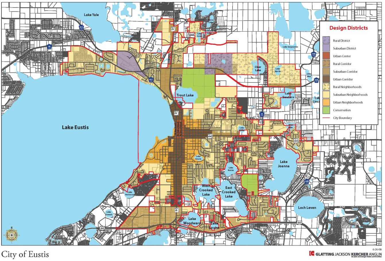
Figure 1.0 Design Districts by Development Pattern
(Ord. No. 16-31, § 1.d.(Exh. A), 12-15-2016)
Sec. 109-5.2. - Districts enumerated.
(a)
Development pattern and design districts. The development patterns will be classified as urban, suburban or rural. Within each development pattern there are four design districts. They are categorized as 1) Neighborhood (NHB), 2) District (DST), 3) Center (CTR) and 4) Corridor (COR). The following sections include a graphic to illustrate each development pattern, a brief description of the development pattern, definitions of each of four design districts as they relate to that particular development pattern, and development and design standards for each design district.
(Ord. No. 16-31, § 1.d.(Exh. A), 12-15-2016)
Sec. 109-5.3. - Urban development pattern intent statements.
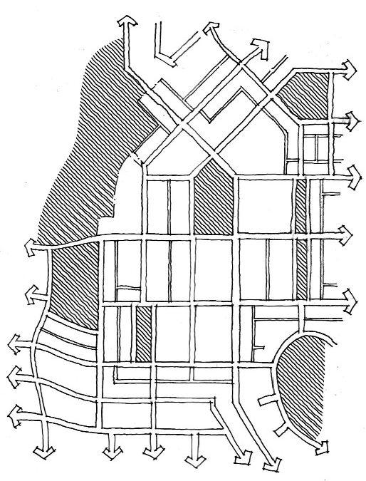
(a)
Intent. The urban development pattern relies primarily on a system of interconnected street grids that prioritizes pedestrians and transit features and links civic buildings, squares, parks and other neighborhood uses. Usable public open space organizes development to make a place. This pattern is characterized by a mix of building typologies with a defined center which can be a park, civic space or neighborhood commercial/retail feature.
(b)
Form. Usable public open space organizes development to make a place. Mix of unit types with focus on "center" park, civic or neighborhood commercial/retail feature.
(c)
Design districts.
(1)
Urban neighborhood.
a.
Definition. Predominately residential uses with some neighborhood scale commercial services.
b.
Structure. Interconnected streets and blocks with alleys
c.
Form. Mix of unit types with focus on "center" park, civic or neighborhood commercial/retail feature
(2)
Urban district.
a.
Definition. Areas of a predominant single use, such as warehouses, office parks, and campuses.
b.
Structure. All uses have public street access. Streets and alleys connect to other streets. Cul-de-sacs, T-turnarounds and gated or dead-end streets are not generally permitted.
c.
Form. Usable public open space organizes development to make place.
(3)
Urban center.
a.
Definition. Mix of commercial, office, and multifamily uses with a public space or water body and a main street.
b.
Structure. Development blocks organized with streets and alleys/driveways.
c.
Form. Usable public open space organizes development to make place.
(4)
Urban corridor.
a.
Definition. Linear concentrations of typically commercial uses, predominately auto-oriented uses. The parcel size is primarily shallow in nature, compatible with the adjacent neighborhoods.
b.
Structure. Interconnected driveways or rear lanes, access ways
c.
Form. Predominately single-use areas that may include a mix of uses, retail, and residential.
(Ord. No. 16-31, § 1.d.(Exh. A), 12-15-2016)
Sec. 109-5.4. - Urban performance standards
The city has established four distinct design districts within the urban area: neighborhood, center, corridor and district. The following provisions apply to all urban districts. Specific standards by district are also included herein.
(1)
Urban Building Lot Types. The following building lot types are permitted within the city's urban area.
(X) permitted, Blank cell- prohibited
(1)
The size shall be limited to neighborhood scale.
(2)
Up to four cottage building lot types when developed as one project, may apply for a waiver to permit an averaging of the side setback.
(Ord. No. 16-31, § 1.d.(Exh. A), 12-15-2016)
Sec. 109-5.5. - Suburban development pattern intent statements.
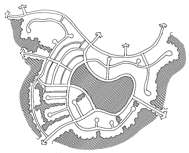
(a)
Intent. The suburban development pattern relies primarily on a pattern of residential development that provides the majority of property owners with substantial yards on their own property. The street layout, comprised of streets with fewer vehicular connections, helps to reduce cut-through traffic and establishes distinct boundaries for residential communities/subdivisions. Nonresidential uses are primarily located on corridors, districts and a mix of uses is prominent in centers. Each land use provides for pedestrian and bicycle connections.
(b)
Design districts.
(1)
Suburban neighborhood.
a.
Definition. Predominately residential uses with some neighborhood scale commercial services.
b.
Structure. Interconnected trails, bikeways and walkways with a street framework comprised of a range of blocks permitted throughout the neighborhoods.
c.
Form. Mix of detached residential uses with some neighborhood supporting retail, parks and civic spaces as focal points in the neighborhoods.
(2)
Suburban district.
a.
Definition. Areas of a predominant single use, such as warehouses, office parks, and campuses.
b.
Structure. The street system is designed to accommodate the density, intensity, and form of suburban development and provides functional connections that link neighborhoods to shopping areas.
c.
Form. Predominately single use areas.
(3)
Suburban center.
a.
Definition. Mix of commercial, office, and potentially multifamily residential uses.
b.
Structure. Development blocks organized with streets, pedestrian walkways and driveways.
c.
Form. Mix of nonresidential uses from office to commercial with supportive uses adjacent to larger use types.
(4)
Suburban corridor.
a.
Definition. Linear concentrations of typically commercial uses, predominately auto-oriented uses. The parcel size ranges from large areas of depth to shallow in nature, compatible with the adjacent neighborhoods.
b.
Structure. The street system is designed to accommodate the density, intensity, and form of suburban development and provides functional connections that link neighborhoods to shopping areas.
c.
Form: Predominately single-use areas that may include a mix of uses, retail, and residential.
(Ord. No. 16-31, § 1.d.(Exh. A), 12-15-2016)
Sec. 109-5.6. - Suburban performance standards.
The city has established four distinct design districts within the suburban area: neighborhood, center, corridor and district. The following provisions apply to all districts. Specific standards by district are also included herein.
(1)
Suburban building lot types. The following building lot types are permitted within the city's suburban area:
(x) permitted, Blank cell - prohibited
(1)
The size shall be limited to neighborhood scale.
(2)
All apartment, town home building types are permitted only on parcels with an MCR land use designation or as a part of a mixed-use project that requires a minimum of 15 percent of the development acreage to be devoted to nonresidential support uses.
(3)
Permitted within a PUD.
(Ord. No. 16-31, § 1.d.(Exh. A), 12-15-2016)
Sec. 109-5.7. - Rural development pattern intent statements.
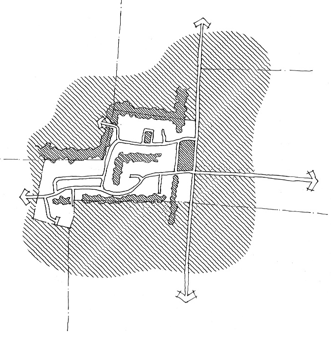
(a)
Intent. The rural development pattern relies primarily on a pattern of clustered residential development that provides substantive open space that serves to preserve and enhance the rural view shed and character of the community. Nonresidential uses are primarily located in centers and may contain a mix of uses.
(b)
Design districts.
(1)
Rural neighborhood.
a.
Definition. Predominately residential uses where a portion of the land is designated as undivided, permanent open space of a site in an effort to preserve the existing natural resource areas while providing a significant amount of open space.
b.
Structure. Developable land is subdivided into buildable lots. This development option provides an opportunity for communities to meet both their development and conservation goals by concentrating homes in a small portion of a site in an effort to preserve the existing natural resource areas on a larger scale.
c.
Form. Preservation of natural landscape organizes development to make a place.
(2)
Rural district.
a.
Definition. Areas of a predominant single use, such as warehouses, office parks, and campuses.
b.
Structure. Development is organized to help efficient use of land for a single use district.
c.
Form. Predominately single-use areas.
(3)
Rural center.
a.
Definition: Mix of neighborhood scale commercial, office, and residential uses with a public space, preservation space or water body and a main street.
b.
Structure: Development blocks organized with streets and alleys (where applicable)/driveways while preserving large areas of land for conservation, open space and/or preservation.
c.
Form: Preservation of natural landscape organizes development to make a place. Mix of unit types with focus on "center" park, civic or neighborhood commercial/retail feature.
(4)
Rural corridor.
a.
Definition. Linear concentrations of roadways that preserve scenic views and existing open vistas, and protect the integrity of the existing rural community character.
b.
Structure. Interconnected driveways, access-ways.
c.
Form. Predominately rural roadways with adjacent single use areas.
(Ord. No. 16-31, § 1.d.(Exh. A), 12-15-2016)
Sec. 109-5.8. - Rural performance standards.
The city has established four distinct design districts within the rural area: neighborhood, center, corridor and district. The following provisions apply to all districts. Specific standards by district are also included herein.
(1)
Rural building lot types The following building lot types are permitted within the city's rural area.
(X)
permitted, Blank cell- prohibited
(Ord. No. 16-31, § 1.d.(Exh. A), 12-15-2016)