
Eustis City Zoning Code
CHAPTER 115
GENERAL BUILDING AND SITE STANDARDS1
Editor's note— Ord. No. 16-31, adopted Dec. 15, 2016, amended the former subpt. B, land development regulations, ch. 115, in effect repealing and reenacting a new chapter as set out herein. The provisions of former ch. 115 pertained to general development standards and derived primarily from Ord. No. 15-13, § 1(Exh. G), adopted Oct. 1, 2015. See the Code Comparative Table for additional historical derivations.
Cross reference— Concurrency, ch. 106; land use and design districts, ch. 109; development standards, ch. 110; construction standards, ch. 118; resource protection, ch. 121.
Sec. 115-1.- Purpose and intent.
(a)
Intent. The purpose of this chapter is to provide development design standards that are applicable to development activity within the city corporate boundaries. The intent of the development design standards, described herein, is to ensure safe, functional and attractive development. All development designs shall consider the protection of the public and natural resources, as prescribed in chapter 121 of this land development regulation, as the first objective before complying with the design standards described in this chapter. All developments shall be designed to avoid unnecessary impervious surface cover, to provide adequate access to lots and sites, and to avoid adverse effects of shadow, glare, noise, odor, traffic, drainage, and utilities on surrounding properties. All improvements required by these design standards are the financial responsibility of the property owner/developer, including the costs associated with design, applications, permits, construction, installation, repair or maintenance, as specified within this land development regulation. Please refer to chapter 100, Definitions, of this land development regulation for definitive explanations of particular terms used in this section.
(b)
Homestead lot residential subdivisions containing no more than four lots, each lot containing a minimum of one and one-half acres of gross land area, shall be exempt from the provisions in chapter 115.
(Ord. No. 16-31, 12-15-2016; Ord. No. 22-04, § 1, 2-17-2022)
Sec. 115-2. - Administration and enforcement.
(a)
General. The development services director or designee shall administer and enforce the provisions of this chapter. A violation of this chapter shall, in addition to other appropriate sanctions, be enforced in accordance with the code enforcement board procedures as set out under chapter 2 of the city Code of Ordinances.
(b)
Penalties. Penalties shall be in accordance with the requirements set forth in chapter 2 of the city Code of Ordinances.
(Ord. No. 16-31, 12-15-2016)
Sec. 115-3. - Residential compatibility and design district transitions.
The compatibility standards below provide standard and predictable measures for establishing and creating compatibility through landscapes, buffers, natural areas or transitional development practices in an effort to lessen impacts and integrate development along the edges of properties where different land use districts or densities are present, as provided for in the future land use element of the comprehensive plan. These standards are in addition to the development pattern and design district standards in Chapter 109 that provide for compatible lot typologies.
(Ord. No. 21-09, § 1, 6-17-2021)
Sec. 115-3.1. - Urban districts.
(a)
Urban residential compatibility. The maximum residential density permitted within any urban design district shall be consistent with the maximum density of the applicable land use district assigned to each individual property.
(b)
When any urban design district abuts an existing development in an urban design district, and proposed new residential lots will share a common boundary with existing or platted lots:
The width of the new lots may be no more than 110 percent of the width of the existing or platted lots, unless such existing or platted lots are non-conforming with the urban design district standards.
(c)
When any urban design district abuts a suburban design district, and proposed new residential lots will share a common boundary with existing or platted lots:
(1)
The width of the new lots may be no less than 60 percent of the width of the existing or platted lots, unless:
a.
A landscape buffer (7 to 10 feet wide) is provided between the new lots and existing or platted lots; or
b.
Park space as permitted by section 115-8.1 is provided between the new lots and the existing platted lots; or
c.
A consistent opaque buffer wall/fence is provided between the new lots and the existing or platted lots.
(Ord. No. 16-31, 12-15-2016; Ord. No. 21-09, § 1, 6-17-2021)
Sec. 115-3.2. - Suburban districts.
(a)
Suburban residential compatibility. The maximum residential density permitted within any suburban design district shall be consistent with the maximum density of the applicable land use district assigned to each individual property.
(b)
When any suburban design district abuts an existing development in a suburban district, and proposed new residential lots will share a common boundary with existing or platted lots:
(1)
The width of the new lots may be no more than 150 percent of the width of the existing or platted lots, unless:
a.
The existing or platted lots are non-conforming to the suburban design district standards;
b.
Central sewer service is not available.
(c)
When any suburban design district abuts a rural design district, and proposed new residential lots will share a common boundary with existing or platted lots:
(1)
The width of the new lots may be no less than 75 percent of the width of the existing or platted lots; unless:
a.
A landscape buffer (10 to 15 feet wide) is provided between the new lots and existing or platted lots; or
b.
Park space as permitted by section 115-8.3 is provided between the new lots and existing or platted lots.
(Ord. No. 16-31, 12-15-2016; Ord. No. 21-09, § 1, 6-17-2021)
Sec. 115-3.3. - Rural districts.
(a)
Rural residential compatibility. For lands within the rural design district, the maximum residential density permitted shall be consistent with the maximum density of the applicable land use district assigned to each individual property.
(b)
When any rural design district abuts an existing development in a suburban district, and proposed new residential lots will share a common boundary with existing or platted lots:
(1)
The width of the new lots may be no more than 200 percent of the width of the existing or platted lots, unless:
a.
The existing or platted lots are non-conforming to the suburban design district standards;
b.
Central sewer service is not available.
c.
When any rural design district abuts an existing development in a rural district, and proposed new residential lots will share a common boundary with existing or platted lots:
1.
The width of the new lots may not be less than 85 percent of the width of the existing or platted lots, unless:
i.
A landscape buffer (15 to 25 feet wide) is provided between the new lots and existing or platted lots; or
ii.
Park space as permitted by section 115-8.3 is provided between the new lots and existing or platted lots.
(Ord. No. 16-31, 12-15-2016; Ord. No. 21-09, § 1, 6-17-2021)
Sec. 115-4. - Site design standards.
Editor's note— Provisions pertaining to site design standards are set forth in the subsequent sections, sections 115-4.1—115-4.11, below.
Sec. 115-4.1. - Open space.
(a)
When there is a requirement that the minimum open space required within a development be under common ownership or unified control, or within a subdivision, the open space shall be property under control of the developer or in public or common private ownership. It shall not be in individual lots unless restricted by a conservation easement protecting natural resources and prohibiting construction of impervious surface improvements.
(b)
Open space may be used for parks, recreation, conservation, preservation of native habitat and other natural resources, stormwater management, historic or scenic purposes. When used for recreation, the following shall apply:
(1)
Recreational activities in conservation or preservation open space areas shall maintain the areas in their natural state with little or no land disturbance. Structures are limited to improvements such as boardwalks, permeable pathways and signage necessary for resource management.
(2)
Recreational activities in all other open space areas may include, but are not limited to active and passive recreation where not more than five percent of the area of any required open space shall be occupied by impervious surfaces other than sidewalks, boardwalks, and other pedestrian pathways.
(Ord. No. 16-31, 12-15-2016)
Sec. 115-4.2. - General site design criteria.
Editor's note— Provisions pertaining to general site design criteria are set forth in sections 115-4.2.1 and 115-4.2.2, below.
Sec. 115-4.2.1. - All districts.
(a)
General site design criteria. Proposed development plans must be organized into three components: 1) wetlands and water bodies; (2) open space; and (3) developed areas. The plan design must respect the natural topography of the site and generally follow the four-step design process described below:
(1)
Step 1 - Delineate open space areas as outlined below:
a.
Create or add to a larger contiguous off-site network of interconnected open space, particularly existing habitats and opportunities for restoring native habitats.
b.
Create connected and integrated open space within the development to the maximum extent practicable based on the context sensitive site design standards and priorities below:
1.
Protect listed species.
2.
Create/enhance connectivity.
3.
Protect native habitat.
4.
Restore native habitat.
(2)
Step 2 - Define development areas in such a way as to preserve the function, purpose and integrity of the natural features of the land, the on-site natural resources, and the environmental systems to the maximum extent practicable.
(3)
Step 3 - Align streets and trails to avoid or at least minimize adverse impacts on designated open space. The streets and trails shall provide external and internal connectivity and the street layout of subsequent phases shall be coordinated with the street system of previous phases.
(4)
Step 4 - Lots lines and building placement should be added as the last step in the design process.
(Ord. No. 16-31, 12-15-2016)
Sec. 115-4.2.2. - Rural design districts.
Greater flexibility and creativity in the design of residential developments within the rural design districts is permitted through the subdivision development approval process and the design criteria provided herein as a means to preserve on-site environmental resource and preservation areas. Rural subdivisions shall be organized into three components: 1) wetlands and water bodies; 2) open space; and 3) developed areas.
(a)
Site design process. After delineating the wetlands and water bodies on a site, development within the rural design districts shall generally follow a four-step design process as described below.
(1)
Step 1: Delineate open space areas and development areas.
a.
External connectedness. Except as otherwise prioritized by subsection c. below and when off-site open space exists, open space shall be configured to create or add to a larger contiguous off-site network of interconnected open space, particularly existing habitats, and opportunities for restoring native habitats. Whenever opportunities exist to create connections with existing or potential off-site open space, greenways or conservation systems on adjoining parcels or with existing or proposed local or regional recreational trails, such connections shall be provided. Opportunities for connections will be determined based upon the natural features of both the subject property and adjacent properties; the existence of connected natural systems, the existence of a proposed local or regional trail, or the existence of other such features that would function and support the purpose and intent of the rural design districts. Where open space would further support critical linkages of either an existing or proposed local or regional recreational trail, such connection shall be made accessible to the public for such purpose.
b.
Internal connectedness. Open space shall be configured to create connected and integrated open space within the subdivision parcel to the maximum extent practicable and shall be based upon the context sensitive site design standards and priorities that are provided in subsection c. below. Open space shall still be considered connected if it is separated by a roadway or accessory amenity.
c.
Context sensitive site design. The areas to be preserved shall be identified on a case-by-case basis to address the individual natural features of each site. The open space preservation objectives, in order of priority, are to: 1) protect listed species, 2) create/enhance connectivity of open space, 3) protect native habitat and 4) restore native habitat. The relative size and functional value of each feature shall be assessed as a part of the site design process to determine the protection measures required. Based on an assessment of the quality and quantity of on-site natural resources, departures from the above prioritization are allowed. In addition to the protection of natural features as described above, other types of allowable open space may be provided as a secondary priority including:
1.
View shed protection of existing and planned public roadways.
2.
Continuation of agriculture uses; and
3.
Recreation.
d.
Perpetual easement. Open space shall be preserved in perpetuity through the use of an irrevocable open space/conservation easement. The easement shall be in such form as is deemed acceptable by the city attorney and shall be recorded for the entire property which is subject to development including both the developed lots and the remaining open space.
e.
Maintenance of native habitat areas. Protected habitat areas within the open space, shall not be converted to other uses, and shall be maintained in their natural condition and managed to sustain or enhance their native function. These areas may be modified to restore the overall condition and natural functions of the features.
(2)
Step 2: Location of development lots. The location of residential development lots shall be configured to meet the following standards:
a.
Residential lots shall be arranged in a contiguous pattern and shall be clustered in such a way as to preserve the function, purpose and integrity of the on-site natural resources and environmental systems to the maximum extent practicable.
b.
The development shall minimize disturbance to woodlands, wetlands, and other natural features.
c.
The development shall protect and preserve the rural appearance of land when viewed from public roads and from abutting properties to the maximum extent practicable.
d.
The design shall minimize the amount of road length required for the subdivisions to the maximum extent practicable.
(3)
Step 3: Alignment of streets and trails.
a.
Support of open space areas. Streets shall avoid or at least minimize adverse impacts on the designated open space areas. To the greatest extent practicable, wetland crossings shall be avoided.
b.
Continuation of street pattern between phases. The street layout of subsequent phases shall be coordinated with the street system of previous phases.
c.
A proposed trail network should be shown consistent with the obligations included herein that require external connectedness with existing or proposed local or regional recreational trails. Where critical linkages of either an existing or proposed local or regional recreational trail exist, such connection shall be made accessible to the public for such purpose.
(4)
Step 4: Design of lots. Lot lines for the subdivision should be drawn as the last step in the design process.
(Ord. No. 16-31, 12-15-2016)
Sec. 115-4.3. - Access and pedestrian network.
The intent of these standards is to provide safe, adequate and efficient circulation by assuring that developments provide adequate access, storage and movement of vehicles consistent with good engineering and development design practices to minimize the traffic impacts from development.
(a)
Specific standards, purpose and intent. The purpose of this section is to describe the minimum requirements for existing collector and arterial roadways that property owners/developers must comply with when requesting residential plat approval or site plan approval, and/or nonresidential site plan approval for property located within the city. These standards shall apply to existing public and private streets, bicycle/pedestrian paths associated with those streets, and access control to and from public streets. All local roadway networks internal to the development site and associated amenities including bicycle/pedestrian requirements shall be governed by the standards set forth in section 115-7.3 as applicable to the design district of the development.
(1)
Access. All property owners/developers requesting development approval shall be required to provide adequate access from a proposed development to the corresponding street system. All access shall be consistent with the standards in this land development regulation.
Cross Access Easement
(2)
Joint use driveways and cross access easements. A system of joint use driveways and cross access easements as illustrated shall be established wherever feasible along the identified corridors and the building site shall incorporate the following:
Joint Use Driveway
a.
A continuous service drive or cross access extending the entire length of each parcel served to provide for driveway separation consistent with access management classification system and standards.
b.
Stub-outs and other design features to make it visually obvious that the butting properties may be tied in to provide cross access via a service drive;
c.
A unified access and circulation system plan that includes coordinated or shared parking areas is encouraged wherever feasible.
(3)
Streets. All property owners/developers requesting subdivision or nonresidential development approval shall be required to provide an internal street system to adequately link each principal use and lot within a proposed development to the corresponding street system. All streets shall be consistent with the standards of this land development regulation.
(4)
Driveways. Private driveways shall be located not closer than three feet from stormwater inlet structures and five feet from property corners. All driveways shall be paved to the edge of the road pavement. On roads with curb and gutters, valley gutters shall be required in driveways and shall be placed in line with the gutter line. The driveways shall be designed to accommodate and improve drainage facilities at the site in accordance with the approved site plans. The drainage facility shall dictate that the driveways shall act as a paved swale or swale check. The crown of a cross-section driveway shall be one foot higher than the crown of the road to avoid potential flooding to the building during storms.
The minimum design criteria of driveways are as follows:
*House lots less than 70 feet wide are limited to one driveway connection per road frontage. A minimum of 25 feet must be provided between driveways on the same property.
(5)
Clear sight zone. A clear sight zone shall be provided for all intersections to allow for safe ingress, egress, crossing, and turning maneuvers. A clear visibility triangle shall be maintained and clear of any obstructions within the triangle area measured from the center of the intersection to an arbitrary point along each centerline of the intersecting roads in all directions; fences, signs and similar structures not exceeding a height of four feet may be permitted in the clear sight zone. The clear sight distances required are as follows:
(6)
Acceleration, deceleration, and turning lanes. All turn lanes shall consist of storage lanes with tapers. The right turn deceleration lane and left turn lane shall have the storage and taper lengths as follows:
*Note: 100 foot storage length for left turn lane. The "stop cond." column applies to both right turn and left turn lanes. The "free right" column applies to the right turn lane only.
(7)
Emergency access.
a.
All new development shall be required to provide emergency access to police, fire, and emergency medical services as follows:
1.
When the new development has only one primary access to a publicly maintained paved street.
2.
When the distance from the primary entrance to the furthest point of paved street within the new development is greater than 500 feet and there are no publicly maintained paved intersecting streets with separate access.
3.
When and as required by the Florida Fire Prevention Code, effective January 1, 2005 as may be amended from time to time.
b.
The required emergency access may, at the discretion of the developer, be closed to normal public traffic by use of devices acceptable to the director of development services. The construction standards for the required emergency access shall be determined by the curb return radii designed based on the street section or otherwise, concrete curbed to protect the asphaltic surface edges, stabilized with minimum of 12 inches of sub-base compacted to a lime rock bearing ratio (LBR) of 40 at 95 percent minimum density in accordance with American Association of State Highway and Transportation Officials (AASHTO) T-180 standard compaction procedure, a minimum of six inches of lime rock base with LBR of 100 compacted to a minimum of 98 percent of density in accordance with the AASHTO T-180 standard. The surface course shall be one and one-fourth inch thick Florida Department of Transportation (FDOT) Type III asphaltic concrete compacted to 95 percent density; or an alternative design approved by the city engineer. All construction shall meet FDOT standards for construction of streets.
(8)
Sidewalks and bicycle/pedestrian paths. All property owners/developers requesting subdivision or nonresidential development approval shall be required to provide sidewalks or bicycle/pedestrian paths along streets within a proposed development. All sidewalks and bicycle/pedestrian paths shall be consistent with the standards listed in this land development regulation.
(9)
Pathways. All property owners/developers' nonresidential development approval shall be required to provide alternative modes of transportation by connecting with existing and future transit, pedestrian and bicycle pathways within the corridor and to provide safe passage from the public right-of-way to the building.
a.
Pathways shall connect all primary building entrances to one another.
b.
In addition, pathways shall extend throughout the development site and connect all primary building entrances, surrounding streets, external sidewalks, adjacent trails, transit stops, parking areas, recreational facilities and common areas, out-parcels, future phases of development, and adjacent developments to the site, as applicable. Shared pedestrian walkways are encouraged between adjacent projects. The applicant may also be required to connect or stub pathway(s) to adjacent roads and private property.
c.
Pathways within developments shall provide reasonably direct and safe connections.
d.
Pathways shall comply with the Florida Accessibility Code, which requires accessible routes of travel. In addition, all pathways used to comply with these standards shall conform to all the following criteria:
1.
Pathway surfaces and multi-use paths shall be concrete, colored concrete, stamped pattern concrete asphalt, brick/masonry pavers or other durable surfaces.
2.
Pedestrian walkways shall be a minimum of five feet wide. Multi-use paths (i.e. for bicycle and pedestrians) shall be a minimum of ten feet wide within a twenty foot wide right-of-way or easement that allows access for emergency vehicles. Stairs or switchback paths using a narrower right-of-way/easement may be required in lieu of a multi-use pathway where grades are steep.
e.
Pedestrian pathways shall be separated a minimum of five feet from all residential living areas on the ground floor, except at building entrances. Separation is measured from the pathway edge to the closest dwelling unit. No pathway/building separation is required for commercial, industrial, public, or institutional uses.
f.
Crosswalks shall be designed and coordinated to move people safely to and from buildings and parking areas. Where pathways cross a parking area, driveways or road, they shall be clearly marked with contrasting paving material, humps, raised crossing or painted striping. If painted striping is used, it shall consist of thermo-plastic striping or similar type of durable application.
(10)
Sidewalks. Sidewalks shall be provided for connections to the existing adjacent sidewalks which lead to public facilities such as schools, churches, public libraries and other public facilities within walking distances. Sidewalks, if required, shall be a minimum of five feet wide, four inches thick, and six inches thick with wire mesh at driveways with a minimum compressive strength of 3,000 psi concrete. All sidewalks shall have wheelchair and handicap ramps for crossing street intersections. Sidewalks may be required to have safety handrails at locations with a steep slope.
(11)
Bikeways. On street bicycle lanes shall be one-way drive in the same direction as the motor vehicle traffic. Bicycle lanes, if required, shall be a minimum of four feet wide and shall be designed in accordance with the state department of transportation Bicycle Facilities Planning and Design Manual.
(Ord. No. 16-31, 12-15-2016; Ord. No. 21-09, § 1, 6-17-2021)
Sec. 115-4.4. - Loading and off-street parking requirements.
(a)
Purpose and intent. The purpose of this section is to provide guides for the design of off-street parking and loading in order to provide adequate off-street parking facilities for use by the owner, occupants, employees, visitors, customers and patrons to relieve congestion in the streets. All property owners/developers requesting subdivision or nonresidential development approval shall be required to provide adequate off-street parking and loading areas and facilities within a proposed development. All parking and loading facilities shall be consistent with the standards listed in this land development regulation.
(b)
Permitting. A permit is required for the additions of existing off-street parking spaces due to the building expansion of floor area, volume, capacity, or space occupied, use intensified, or the construction of new off-street parking facilities. An existing building that undergoes remodeling, alteration or repair without requiring additional off-street parking spaces does not require an application for parking approval.
(c)
Performance criteria and standards. All off-street parking and loading shall be planned, designed, constructed and maintained to meet the performance criteria and standards as described herein.
(d)
Parking locational requirements. Lot typologies indicate zones where parking is permitted. The diagram illustrates an "A" and "B" street. In areas where A/B street designation has not been determined or required, all streets shall be considered "A" streets for determination of parking location only. Zones are defined and illustrated:
Zone 1: Lot area between the principal building and the right-of-way of any 'A' street.
Zone 2: Lot area between the principal building and any common interior lot line.
Zone 3: Lot area between the principal building and any rear lot line.
Zone 4: Lot area between the principal building and the right-of-way of any 'B' street.
Parking Locations
(e)
Parking spaces. Required minimum numbers of off-street parking spaces are those determined by a parking study approved by the city or as listed in Table 5200-1. All parking spaces for residential uses shall be located no further than 200 feet for resident parking and 250 feet for visitor parking as measured from the dwelling unit's closest entry to the parking space, except within the central business district.
(f)
Maneuvering. Off-street parking and loading areas shall be designed to provide maneuvering and access aisle areas of sufficient size to permit a vehicle to enter and leave in a forward manner. Where the off-street parking area is used for access to the building, sufficient area shall be provided and designated for fire apparatus to be positioned as deemed necessary by the city for the proposed or existing building's fire protection
(g)
Ingress and egress. There shall be adequate provisions for ingress and egress to all parking areas. Where a parking area does not abut a public right-or-way, private alley or access easement, an access drive shall be provided into the parking area which shall consist of one drive per lane of traffic and shall not be less than 18 feet in width. Where the off-street parking area is used for ingress to the building, there shall be sufficient area to allow for additional fire apparatus ingress, and a safe egress from the building without lengthy backing of the fire apparatus, as deemed necessary by the city.
(h)
Accessibility. Access to and from all off-street parking areas along public right-of-ways shall consist of well-defined separate or common entrances and exits. Access drives shall not open onto any public right-of-way within 25 feet of the nearest right-of-way line of any intersecting public street or highway, or where the sight distance in either direction along the public thoroughfare would be less than 500 feet when the posted speed limit exceeds 35 miles per hour. This sight distance requirement may be reduced to 250 feet when the posted speed limit is 35 miles per hour or less.
(i)
Surfacing and drainage. All newly constructed off-street parking spaces and access aisles shall be graded for proper drainage and shall be surfaced with asphalt or concrete. For redevelopment sites, off-street parking spaces and access isles shall be graded for proper drainage and shall be surfaced with a durable surface such as, but not limited to, gravel, concrete, or bituminous material. Grassed overflow parking may also be permitted if so designated on an approved site plan.
(j)
Lighting. All lighting used to illuminate parking areas shall be so arranged as to direct the light away from adjoining properties and right-of-ways and shall be consistent with the requirements of section 115-4.5.
(k)
Size and width. The minimum parking stall size shall be 9 feet by 18 feet for regular stalls. Handicap stalls shall meet the applicable ADA Design Guide dimensions. A maximum of 20 percent of the required parking area may be allocated for parking of compact cars. The minimum parking stall size for compact cars shall be 8 feet by 15 feet. The director of development services may require wheel stops or curbs for demarcation and/or pedestrian safety. The minimum aisle width shall be as follows:
(l)
Bicycle parking. The installation of bicycle parking stalls shall be encouraged to promote the use of bicycles as a means of transportation in Eustis. The number of bicycle parking spaces required shall be as listed in Table 5200-2. Bicycle parking facilities shall include provisions for the secure storage and locking of bicycles. Spaces that are intended to serve as bicycle parking facilities shall be clearly labeled. Bicycle parking facilities shall support bicycles in a stable, up-right position without damage to wheels, frame, or components. A minimum 18-inch clearance from the center line of adjacent bicycles shall be provided on one side and at least 24 inches on the other side so as to allow parked bicycles to be locked to the parking rack. The rack shall also be placed at least ten inches from walls or other obstructions.
(m)
Accessible parking. Parking facilities used by the public shall provide parking spaces that are accessible to persons with disabilities. The number, design and location of these spaces shall be in accordance with state statutes, the ADA Design Guidelines, and as listed below, whichever is greater. The minimum parking spaces required for persons with disabilities are as follows:
Parallel parking spaces for persons with disabilities shall be located either at the beginning or end of a block or adjacent to alley entrance. Each such parking space shall be conspicuously marked with blue and shall be posted with a permanent, above-grade sign bearing the symbol of "PARKING BY DISABLED PERMIT ONLY".
(n)
Off-street loading.
(1)
Semi-truck and trailer parking. No on street or off street parking and loading facilities for semi-trucks and trailers shall be allowed in any residential area or mixed-use land use district developed as residential.
(2)
Schools, hospitals, nursing homes, and other similar institutional uses and mid and high-rise residential uses shall provide one loading space for the first 100,000 square feet of gross floor area or fraction thereof, and one space for each additional 100,000 square feet or fraction thereof.
(3)
Auditoriums, gymnasiums, stadiums, theaters, convention centers, and other buildings for public assembly shall provide one space for the first 20,000 square feet of gross floor area or fraction thereof, and one space for each additional 100,000 square feet.
(4)
Office and financial institutions shall provide one space for the first 75,000 square feet of gross floor area or fraction thereof and one space for each additional 25,000 square feet.
(5)
Retail commercial, service, road service, and commercial entertainment uses shall provide one space for the first 10,000 square feet of gross floor area and one space for each additional 20,000 square feet.
(6)
Industrial uses shall provide one space for every 10,000 square feet of gross floor area.
(7)
The standard off-street loading space shall be 10 feet wide, 25 feet long with a vertical clearance of 15 feet with sufficient space for maneuvering and ingress and egress. The length of one or more of the loading spaces may be increased up to 55 feet if full-length tractor-trailers must be accommodated.
Table 5200-1 Parking Spacing Requirements
Off-Street Parking Requirements
**In addition to vehicle parking spaces, any business operation, which utilizes merchandise/shopping carts, must provide a parking area for said carts.**
GFA = gross floor area RPC= rated patron capacity sf = square feet
Table 5200-2
Bicycle Parking Requirements
(Ord. No. 16-31, 12-15-2016; Ord. No. 21-09, § 1, 6-17-2021)
Sec. 115-4.5. - Site lighting.
Pedestrian and Street Lighting
(a)
Commercial buildings and projects, including outparcels, shall be designed to provide safe, convenient and efficient lighting for pedestrians and vehicles. Lighting shall be designed in a consistent and coordinated manner for the entire project. Lighting shall be used to accent key architectural elements and/or to emphasize landscape features, and shall be designed and installed to avoid the creation of hot spots, glare or a nuisance.
(b)
To provide cohesiveness and uniformity, a lighting plan prepared by an architect, engineer or other professional certified/licensed to practice in the State of Florida shall be submitted to the city as part of an application for site plan and/or final engineering and construction approval, and said professional shall: (1) certify that the lighting plans are compliant with the requirements of the design standards and regulations provided for herein; or (2) so certify to the extent said lighting plans are compliant with the requirements of the design standards and regulations provided for herein and provide a written explanation for any deviations. Lighting intensities shall be designed as recommended by the Illuminating Engineering Society (IES).
(c)
Light fixtures shall be designed as an integral design element that complements the design of the project through style, material or color. All light poles and fixtures shall be black, dark green or a color that is consistent with the architectural design scheme of the property. Lighting of on-site buildings shall be limited to wall-washer type fixtures or up-lights, which do not produce spillover lighting or glare. Site lighting shall not incorporate floodlight fixtures mounted on building walls, roofs, or poles.
(d)
A light fixture (the pole and light source/luminary) shall be a maximum of 30 feet in height within any parking lot, and a maximum of 16 feet in height within any non-vehicular pedestrian area (with height being measured from the finished grade to the top of the light fixture).
(e)
Lighting levels for fire lanes or driveways at building entrances shall not exceed five foot-candles (fc). Lighting at fire lanes or driveways at building entrances may exceed allowable standards of intensity for safety purposes upon demonstration to the city that compliance with these lighting criteria would otherwise create a safety hazard, provided, however, that such lights shall be directed downward to minimize spillover lighting and glare.
(f)
Illumination levels at the property line shall range between a minimum of 0.0 fc and a maximum of 1.0 fc, with as close to 0.0 fc as reasonably feasible when lighting is located next to residential. To keep light rays and glare from encroaching onto adjacent properties, illumination shall be installed with house-side shields and reflectors, and shall be maintained in such a manner as to confine light rays to the premises.
(g)
Parking areas shall be illuminated as follows, with horizontal lamps highly recommended, except for parking areas service stations and convenience centers located under an awning, canopy, porte-cochere, etc.:
(1)
Parking area lighting fixtures shall be shielded from adjacent properties by utilizing flat lenses, houseside shields, and "NEMA" type II, III, and IV reflectors.
(2)
The lamp source shall be metal halide, florescent, LED or approved equal. Illumination levels shall range between a minimum of 0.6 fc to a maximum (outside a 20 foot radius from the pole) of 3.6 fc, not including overflow lighting in a transition zone adjacent to a service station and convenience center canopy.
(3)
Phosphor coated lamps shall be utilized in all luminaries where the lamp source is not hidden by the luminary housing or equipped with a diffused lens.
(4)
Decorative acorn-type fixtures shall not exceed 18 feet in height and shall have a textured clear lens/globe, frosted/phosphor coated bulbs, and an internal optical system.
(h)
Pedestrian walkways and bikeways that are accessible after dark shall be illuminated as follows:
(1)
The lamp shall be decorative in appearance, style and finish. Selected luminaries shall have the lamp source shielded from view. Translucent diffusers may be an acceptable substitute to avoid visual glare and brightness.
(2)
The lamp source shall be metal halide, florescent, LED or approved equal. Illumination levels shall range between a minimum of 0.5 fc to a maximum of 2.5 fc.
(3)
Phosphor coated lamps shall be utilized in all luminaries where the lamp source is not hidden by the luminary housing or equipped with a diffused lens.
(i)
Building lighting:
(1)
All buildings shall have exterior lightings and shall be self-contained to that building without glare or shine onto other areas of the site.
(2)
Lighting intensities for ATM machines shall comply with Florida Statutes.
(3)
At service stations and convenience centers, lighting under awnings, canopies, porte-cocheres, etc., should be recessed. If not recessed, the box type or other lighting fixture shall be opaque on all sides with a flat lens (no light shall emanate from any side of the fixture). Additionally, the following lighting standards shall apply:
a.
The light source shall be metal halide, fluorescent, LED or approved equal.
b.
The luminaires shall be phosphor coated when used with a clear flat glass lens, or may be clear when used with a diffused flat glass lens; and
c.
The maximum foot-candle level shall be 30 fc (average maintained maximum) - see the IES Lighting Handbook, 8th edition, at chapter 11, figure 11-1, part iv, outdoor facilities, service stations (lighting level at grade).
(Ord. No. 16-31, 12-15-2016)
Sec. 115-4.6. - Mechanical equipment/utility lines.
(a)
Ground level mechanical equipment. Mechanical equipment at ground level shall be placed on the parking lot side of the building away from view from any streets and sidewalks and shall be screened from view by fencing, vegetation, or by being incorporated into a building utilizing the same materials as the principal building, i.e., stone, brick or stucco. The screening shall be at least equal to the width and height of the equipment to be screened from view.
(b)
Rooftop mechanical equipment. Rooftop mechanical equipment screens shall be required at a height that is as high or higher than the rooftop equipment being screened. Screening shall be provided in a manner that is architecturally integral to the overall appearance of the building. The use of parapet walls or specially designed rooftop penthouse enclosures are the preferred methods of screening for rooftop mechanical equipment. Partition screens are generally less desirable for screening purposes. However, when using partition screens, the use, design, and material of the screen should blend with the building architecture and create a massing hierarchy that projects the same high quality appearance as the building façade.
(c)
Other above-ground equipment/utility elements such as pull boxes, transformers, and backflow preventers shall be located and designed to permit convenient maintenance access, painted dark green or black and screened with a 24 inch planted hedge that shall reach 36 inch- 42 inch height and 90 percent opacity within one year.
(d)
Utility lines. All electric and telephone lines shall be located underground except under exceptional circumstances.
(Ord. No. 16-31, 12-15-2016)
Sec. 115-4.7. - Utilities.
(a)
Potable water. All property owners/developers, requesting development approval, shall be required to connect to the city's public water system, consistent with the standards listed in state statutes and this land development regulation.
(b)
Sanitary sewer disposal. All property owners/developers, requesting development approval, shall be required to connect to the city's public sewer system, consistent with the standards listed in state statutes and this land development regulation.
(1)
The city manager may grant an exemption to the public sewer connection requirement, if conditions or situations warrant such action. Upon receipt of a formal application, the city manager will evaluate the request based on the criteria listed below. The city manager, upon completion of said evaluation, shall make a determination of exemption or require connection to the city's public sewer system. All appeals to decisions made by the city manager shall be submitted to the city commission for resolution.
(2)
Exemption criteria. In addition to the following criteria, the on-site system must be permittable by state and local agencies having jurisdiction under Florida Statutes including the requirements of Chapter 118D-6 FAC.
a.
The existing lot-of-record has central water and is greater than or equal to 10,000 square feet in lot area (provided the parcel was established and recorded prior to the adoption of these regulations).
b.
The parcel location creates an undue financial burden to either the property owner/developer or the city by requiring the extension of sewer lines or facilities to a proposed development.
c.
Public sewer is unavailable to the parcel at the time of development application, but scheduled for construction within the city's current five-year capital improvement program. (Property owners/developers shall provide for both interim waste disposal and future connection to the city's sewer system by the installation of dry lines if the development has a gross residential density of 1.5 dwelling units per acre or higher and individual lots of 25,000 square feet or smaller.)
d.
Public sewer is unavailable to the parcel at the time of development application, and not scheduled for construction within the city's current five-year capital improvement program.
e.
The maximum gross density for use of on-site subsurface waste disposal methods is 4 dwelling units per acre and 10,000 square feet for individual lots.
f.
No on-site subsurface waste disposal is permitted in areas having the soil types listed below, except for existing lots-of-record of not less than 25,000 square feet and provided that the on-site disposal method is permittable by state and local agencies having jurisdiction under Florida Statute:
(3)
The city manager may grant an exemption provided the property owner/developer signs an agreement with the city that requires connection of a previously exempted parcel to the city's public sewer system, if changing conditions warrant such action in the future, including but not limited to the following:
a.
Public sewer system connection becomes available.
b.
Health or safety reasons (septic tank not functioning properly).
c.
Environmental reasons (contamination of soil, surface or groundwater; ground slope; or proximity to environmentally sensitive areas).
(c)
Electricity. All property owners/developers requesting development approval shall be required to provide electric power to every principal use and lot within a proposed development. The electric power shall be adequate to accommodate the reasonable needs of each principal use and lot within a proposed development and consistent with the standards listed in chapter 118 of this land development regulation.
(d)
Telephone/cable TV. All property owners/developers requesting development approval shall be required to provide telephone/cable television service to every principal use and lot within a proposed development. The telephone/cable television service shall be adequate to accommodate the reasonable needs of each principal use and lot within a proposed development.
(e)
Fire hydrants. All property owners/developers requesting development approval for a subdivision or a nonresidential development shall be required to provide a system of fire hydrants within proposed developments. The fire hydrant system shall be consistent with the standards listed in this land development regulation.
(f)
Street lights. All property owners/developers requesting development approval for a subdivision or a nonresidential development shall be required to provide lighting to all streets, sidewalks/bicycle paths, driveways, parking lots and other common areas within proposed developments. The lighting shall provide adequate illumination to the above-referenced areas within proposed developments, consistent with the standards listed in this land development regulation.
(Ord. No. 16-31, 12-15-2016)
Sec. 115-4.8. - Water and sewer facility design guidelines.
(a)
Purpose and intent. The purpose of this section is to provide design guidelines for water and sewer facilities for developments within the city. The intent of this section is to serve and protect the health, safety, and welfare of the public.
(b)
Permitting. The city and state department of environmental regulation require permits for construction and operation clearance of utilities. Developers are required to submit all permits to the city for review and approval prior to construction.
(c)
Performance criteria and standards. All developments shall provide necessary utilities. All utilities shall be planned, designed, constructed and maintained to meet the minimum performance criteria and standards as described herein.
(1)
Water. The city central water system shall provide adequate services to existing and future development in accordance with the city's five-year capital improvements program and consistent with the level of service standard in the city's comprehensive plan. Additions to the city's water system shall be planned, designed, constructed and maintained to meet the performance criteria and standards as described herein. The construction specifications and standards of water are listed in appendix C of these specifications. [2]
a.
Average flow. The minimum average daily flow is 140 gallons per capita per day.
b.
Maximum flow. The maximum day instantaneous demand is 1.0 gallon per minute (gpm) per single-family unit and 0.7 gpm per unit for multi-family dwellings and mobile homes.
c.
Fire flow. The minimum fire flow capacity is 1,000 gpm at a residual pressure of 20 psi in single-family residential areas, and 1,500 gpm at a residual pressure of 20 psi in multi-family, commercial, institutional and industrial areas and apartments. Larger commercial/industrial, major shopping centers, schools, and similar uses shall have a fire flow capacity of 1,000 to 3,500 gpm, or as determined necessary by the city.
d.
Fire hydrant. The maximum distance from the furthermost point of any structure to a fire hydrant shall be 500 feet determined as the fire apparatus would lay hose, unless otherwise allowed by the city. Additional fire hydrants may also be required. In low density residential subdivisions, fire hydrants shall be connected to minimum six-inch water mains of satisfactory loop design and, in all other areas, connection to minimum eight-inch water mains is required. Provided that required flow is maintained, connection to a dead end stub is acceptable if the stubbed water main is not less than eight inches.
e.
Flow and pressure. The minimum design for water distribution systems shall provide for at least 100 percent of the combined maximum day-demand rate and required fire flow for said rate, with special provision for peak flows in excess thereof. The allowable minimum service pressure under said design shall not be less than 20 psi.
f.
Valve spacing. Valves shall be provided for all branch connections, loop ends, fire hydrant stubs, or other locations, as required to provide an operable, easily maintained, and repaired water distribution system. Valves are to be placed so that the maximum allowable length of water main required to be shutdown for repair work shall be 500 feet in commercial, industrial or high-density residential districts, or 1,000 feet in other areas.
g.
Easement. Water mains shall be located in dedicated rights-of-way or utility easement. The minimum width of water and sewer utility easement is 15 feet. Water mains shall not be placed under retention/detention basins, tennis courts, parking lots, or other structures unless approved by the city.
h.
Backflow prevention. The owner shall provide backflow prevention devices for all commercial, industrial and institutional complexes. All developments, including residential, with reclaimed water, private irrigation wells, alternative water supply systems, fire sprinkler, standpipe systems, or irrigation systems, require backflow prevention devices. The backflow prevention devices shall be installed, above ground, directly following the water meter on the property side.
(2)
Wastewater. The designed sewage flow for collection, transmission and treatment shall be based on an average daily flow of 250 gallons per household per day or 120 gallons per capita per day for residential use and 2,000 gallons per acre per day for nonresidential use as the minimum. The construction specifications and standards of wastewater are available from the city engineer.
Sewage pump station.
a.
A sewage pump station shall be designed for the total ultimate development flow from all contributory areas as required by the city.
b.
The designed (maximum) pumping capacity shall be based upon the peak design flow which shall be calculated by multiplying the average daily flow with the applicable peaking factors. The peaking factors at different flow ranges are: four at 0.05 mgd or less, three at 0.05 to 0.25 mgd, 2.5 at 0.25 to two mgd, and two at two mgd or more.
c.
For peak design flow of 1,000 gpm or less, a minimum of two pumps shall be provided, each with a rated capacity of 100 percent of peak design flow. For peak design flow of more than 1,000 gpm, three or more pumps shall be provided to handle the peak design flow with the largest pumping unit out of service.
d.
Submersible pumps shall be capable of handling raw sewage and passing spheres of at least three inches in diameter. Pump suction and discharge openings shall be at least four inches in diameter.
e.
Head capacity curves shall be prepared and submitted along with the pump station plans. Such curves shall verify that the pumps selected are operating at peak efficiency and are suitable for the peak design flow application. Pump and motor selection and head capacity curves shall reflect hydraulic conditions in cases where receiving force main systems are interconnected to additional pumping stations.
Sanitary gravity sewers.
a.
The sanitary gravity sewer shall be designed for the total ultimate development flow from all contributory areas as required by the city.
b.
Gravity sewers shall be designed on the basis of peak design flow calculated by multiplying the average daily flow with the applicable peaking factors as discussed above.
c.
Size. The minimum gravity sewer main is eight inches in diameter.
d.
Slope. All sewers shall be designed and constructed to give minimum velocities of not less than two feet per second, based on Manning's formula using an "n" value of 0.013. Sewers shall be designed to provide minimum slopes to reduce solids deposition and provide cleansing action of the lines.
Slopes of slightly less than those required for two feet per second velocity (two fps) may be permitted providing the depth of flow is not less than 0.3 of the diameter at the average daily flow.
e.
Manhole spacing. Sewers 24 inches in diameter or less shall be installed with straight alignment and grade between manholes, with manhole spacing not to exceed 400 feet for sewers 14 inches or less, and 500 feet for sizes larger. All sanitary sewers shall terminate at manholes.
Sanitary force main.
a.
The sanitary force main shall be designed for the total ultimate development flow from all contributory areas as required by the city.
b.
The force main shall be designed on the basis of peak design flow calculated by multiplying the average daily flow with the applicable peaking factors as discussed above.
c.
Velocity. The force main shall be designed to provide a minimum cleansing velocity of two fps at minimum design pumping rates.
d.
Size. The force main shall be a minimum of four inches in diameter.
e.
Formula. The calculations of friction losses through force mains shall be based on the Hazen and Williams formula. The "C" value shall be 120 for ductile iron pipe and 130 for PVC pipe.
(3)
Reclaimed/reuse/alternative water service.
a.
Minimum service requirements.
1.
All new subdivisions located within the city shall construct reclaimed/reuse/alternative water mains to provide irrigation and other non-potable service to all lots based on the projected amount of property to be irrigated, as well as other potential non-potable uses, including common areas. Reclaimed/reuse/alternative water service including required back flow prevention devices (on drinking water service) and taps shall be installed for each lot, with a minimum service tap size of one inch in diameter. Actual service tap size and potential sharing of service lines shall be reviewed and approved by the city engineer. These improvements shall be completed and in place regardless of whether city reclaimed/reuse water or alternative water supply is available to the project at the time of development. At such time as city reclaimed/reuse water or alternative water supply is available each lot and other property to which a tap was required shall accept city reclaimed/reuse water service.
2.
Site development plans for all new development on previously vacant property where the city reclaimed/reuse/alternative water lines adjoin the property shall show irrigation systems connected to reclaimed/reuse water mains where available. Where such service is not currently available, site plans shall show irrigation systems which shall be configured for ultimate connection to reclaimed/reuse/alternative water mains by locating pumps or potable water system connections adjacent to the right-of-way or other planned reclaimed/reuse/alternative water main location.
3.
Existing landscape irrigation systems located within the city shall accept city reclaimed/reuse/alternative water service when available as follows:
i.
If the existing irrigation system on such property is using city potable water for irrigation the property shall connect to the city's reclaimed/reuse/alternative water service when available.
ii.
If the existing irrigation system on such property is using a private well located on the property or lake water for irrigation then such property shall connect to the city's reclaimed/reuse/alternative water service when the well or lake irrigation fails. Pump service or replacement shall not be construed as the well or lake irrigation failing.
4.
No new irrigation system for landscaping use shall be allowed in the city unless it connects to the city's reclaimed/reuse water lines if such lines are available to the property seeking irrigation.
b.
System design. The layout of reclaimed/reuse/alternative water distribution systems shall comply with the following design criteria and the adopted standard utility details of the city:
1.
General standards. Design and installation practices, materials and methods shall conform with requirements for potable water systems, except where specifically modified by policies or details adopted for the reclaimed/reuse water system.
2.
Main size. Mains shall be sized based on the anticipated demand for reclaimed water use based on land use, soil characteristics and potential non-irrigation use.
3.
Extension of lines to project boundaries. Reclaimed/reuse water mains shall be designed to stub out to the project boundaries to serve adjacent unserved properties. This shall include mains in all rights-of-way, across the entire project frontage on existing roads without existing mains, and to the property boundary via easement when no other access is available to unserved properties.
4.
Color coding of reclaimed/reuse water appurtenances. All reclaimed/reuse water distribution materials shall be color coded purple from the manufacturer.
c.
Availability. Availability shall mean the city having sufficient capacity to provide service to a subject property and the reclaimed/reuse water lines being physically located within 120 feet of the subject property.
(Ord. No. 16-31, 12-15-2016)
Editor's note— Ord. No. 16-31, § 1.f.(Exh. A), adopted Dec. 15, 2016, repealed appendix C, utility construction standards, which will be incorporated by reference hereafter.
Sec. 115-4.9. - Stormwater management.
(a)
Purpose and intent. The purpose of this section is to provide stormwater management for protecting the public health, safety, and welfare from deterioration of water quality, damage of property and infrastructures, and degradation of environment. The intent of the stormwater management is to confine and regulate runoff from polluting surface water, reducing erosion and sedimentation, preventing flooding and endangerment of the ecological balance of the environment. Proper stormwater management enhances landscape value, increases groundwater recharge, and decreases groundwater consumption. All new developments require stormwater management with the financial responsibility of design, permits, construction and maintenance being born by the developer.
(b)
Permitting. A site development permit is required for all construction activities such as land clearing for stormwater control, subdivision development, infrastructures installation, pavement, altering shoreline or water bodies functions, etc. Exemptions will be provided for activities such as individual residential construction within a permitted subdivision, agricultural and silvicultural activities permitted by regulatory agencies as required. All permit applications shall include sufficient information and documentation in the form of maps, plans, specifications, and calculations signed and sealed as required by law.
(c)
Performance criteria and standards. All stormwater management shall be planned, designed, constructed and maintained to meet the performance criteria and standards as described herein and required by law. The city engineer shall provide stormwater construction specifications and standards.
(1)
Pollution abatement. Stormwater runoff shall be contained as required by state and federal regulatory agencies to provide retention and detention storage as required by the agency having jurisdiction (St. Johns River Water Management District). In unincorporated planning areas, both St. Johns River Water Management District and Lake County Environmental Services shall be contacted for permit requirements. Retention basins with percolation and detention basins without filtration (wet detention) are recommended. The use of detention basins with underdrain filtration (dry detention) is discouraged due to maintenance problems.
(2)
Water quantity and flood control. Stormwater runoff shall be contained as required by state and federal regulatory agencies to limit post-development peak rate and volume discharge as required by the agency having jurisdiction (St. Johns River Water Management District). Designs for the drainage basins shall be based on storm events as follows:
a.
The 25-year 96-hour storm event shall be used for land locked (without positive drainage outfall) areas which are:
1.
Low-lying with a history of flooding problems; or
2.
Have a high water table; or
3.
Contain impervious soils.
Stormwater runoff shall be contained such that the post-development volume of runoff shall not exceed pre-development conditions based on a 25-year, 96-hour storm event. For certain drainage basins as identified in the city's 1990 stormwater facilities study there may be additional requirements to achieve discharge and flood control requirements.
b.
The 25-year, 24-hour storm event shall be used for areas having positive drainage outfall to an existing storm sewer or drainage ditch which leads to open surface waters of a lake or a canal. The post-development peak rate of discharge of stormwater runoff shall not exceed the pre-development conditions.
c.
Retention systems must provide an available capacity for the appropriate treatment volume of stormwater within 72 hours following a storm event assuming average antecedent moisture conditions. Percolation rates for soils within the retention/detention area shall be determined by a geotechnical engineer and contained within a signed and sealed soils report.
Percolation rates must be designed with a safety factor of at least two unless the applicant affirmatively demonstrates based on plans, test results, calculations or other information that a lower safety factor is appropriate for the specific site conditions.
d.
Plans and calculations for all stormwater retention/detention facility shall be sealed by a degreed civil engineer registered in the state who shall assume all responsibility and liability for their form, function and performance.
(4)
Erosion control. Erosion and sedimentation control devices shall be installed between the disturbed area and water bodies, watercourses and wetlands prior to construction. Vegetated buffer strips shall be retained in their natural state along the banks of all watercourses, water bodies and wetlands. Best management practices (BMPs) as described by the state department of environmental regulation's Florida Land Development Manual shall be incorporated into all designs to control erosion on site and sedimentation in watercourses.
(5)
Flood plain. Development within the flood plain is discouraged. Construction within the flood prone areas as defined by Federal Emergency Management Act maps shall be compensated by providing storage volume for all flood water displaced by development below the elevation of the 100-year flood plain. All developments within riverine flood prone areas shall be designed to maintain the flood carrying capacity of the floodway such that the flood elevations are not increased, either upstream or downstream. Additionally, portions of structures below the flood area must be flood-proofed.
(6)
Off-site drainage. Off-site areas which drain to or across a developing site must be accommodated in the stormwater management plans. Developing sites which drain to off-site areas must include those off-site areas in the stormwater management plans. The stormwater management system for the development must be capable of transporting flows without increasing stages or flows upstream or downstream of the developing areas. Stormwater runoff shall be contained at site without draining to the adjacent property unless proper drainage easement is secured.
(7)
Roadway swales. Roadside swales may be acceptable for retention and detention of stormwater runoff from the roadway. Swale drainage shall be designed to provide positive drainage on site or conveyance of runoff to the retention or detention ponds based on 10-year, 24-hour storm event. Positive percolation on site will be accepted only when the seasonal high ground water level is a minimum of one foot below the invert of the swale.
(8)
Storm sewer. Storm sewer shall be designed based on a minimum of 10-year, 24-hour storm event. The minimum size of pipe used for storm sewer is 15 inches. All storm sewers shall be designed for a minimum velocity of two fps when flowing full, and the outlet ends shall be equipped with energy dissipaters for erosion control. Storm sewers shall be designed such that the hydraulic gradient is one foot below the gutter line or edge of pavement for arterial roadways, and one-half foot below the gutter line or edge of pavement for collector and local roadways.
(9)
Stormwater facilities. Stormwater facilities shall be designed to provide the following levels of service:
Bridges: Hydraulic profile shall be below the top cord of the bridge for the 50-year, 24-hour storm event.
Canals: Canals, ditches, or culverts external to the development, and stormwater detention or retention basins which are not part of a project that is contributory to land-locked areas with no positive outlet, shall be designed for the 25-year, 96-hour storm event.
Roadway: Stormwater flooding for arterial and collector roadways shall not exceed one-half of the roadway width. For local roads, stormwater flooding shall not exceed the crown of the road for the 10-year, 24-hour storm event.
(10)
Wetlands. Natural wetlands may only be used to attenuate runoff peak discharges if the regulatory agencies accept and approve such measures. Copies of permits from the agencies shall be submitted to the city prior to the city's final approval.
(11)
Easement. A minimum 15 feet drainage easement shall be granted to the city for maintenance of drainage ways on-site or through the retention/detention basins. A 20-foot wide berm easement around the storage basins for maintenance purposes shall be provided to the city. This easement shall in no way relieve the property owner of maintenance of the drainage facility (for example, mowing of grass or weed control). It is not the intent of the city to provide routine maintenance in these easements; rather, the intent is to allow the city access to maintain the easement area as deemed necessary in the city's sole discretion.
(12)
Safety protection. Where a sidewalk or public right-of-way is immediately abutting a retention/detention basin, a guardrail or other protective device shall be installed along the sidewalk or right-of-way. A dry basin designed for more than five feet in depth at 3:1 to 4:1 (horizontal: vertical) side slopes shall be fenced. Required fences for dry basins not steeper than 4:1 side slope shall be based on case by case basis. Minimum requirements of side slopes shall not be steeper than 3:1 for basin and 4:1 for swale designs.
(d)
Additional design standards. Stormwater facilities may count toward the minimum open space requirements of these regulations if they meet the following minimum design standards:
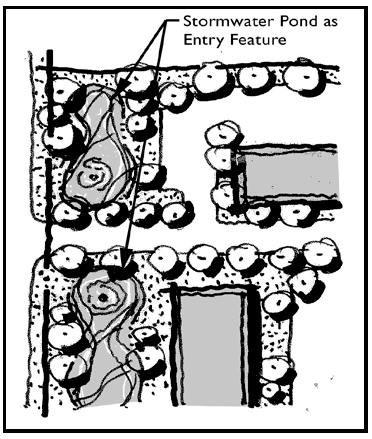
Stormwater Facilities as a Design Feature
(1)
Stormwater facilities (ponds and/or depressions) shall be designed and utilized as site amenities along entrances and street frontages or incorporated with buffers between incompatible uses. These areas shall count toward open space requirements if the impervious area of the site does not exceed 75 percent.
(2)
Stormwater facilities should be designed and permitted so as not to require fencing. If fencing is required, a green or black vinyl/painted finish is required. Walls or other railings for structured stormwater 'boxes' must be decorative. Fenced or walled ponds shall not count toward open space requirements within a project and shall only be located at the side or rear of a site. Max. Fence Height: four feet zero inches.
(3)
Subject to the requirements of St. Johns River Management District, other governmental agencies, and a consideration of safety related issues stormwater facilities that are located in the front of a property may be prohibited from having fencing.
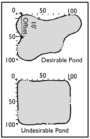
Desirable and Undesirable Detention/Retention Design
(4)
Wet stormwater detention/retention facilities adjoining public streets shall include a water feature such as a fountain or spray jet, and shall be planted with appropriate aquatic materials as specified in Table C. Detention/retention along the front of a property shall be designed with curvilinear edges - not as a straight "box". Retention embankments shall be planted with 1 tree per 50 linear feet of retention perimeter measured from top of slope. Trees shall be suitable for wet locations as identified in Table C, Approved Aquatic Plant Materials List.
(5)
Dry retention areas shall be planted with grass, and unless maintained as an open lawn swale, shall be screened from view with a continuous hedge of shrubs on 36 inch centers around at least 75 percent of the perimeter at the top of the slope.
* Other aquatic plants may be used from the List of Aquatic Plants Found in Florida, as prepared by the Florida Department of Natural Resources, Bureau of Aquatic Plant Management.
(Ord. No. 16-31, 12-15-2016)
Sec. 115-4.10. - Solid waste (dumpsters).
(a)
All storage or dumpster/solid waste areas shall be designed with a six foot masonry wall. The wall shall be of a decorative 'split face' concrete masonry, "Norman" brick or standard concrete masonry clad with painted stucco or other masonry veneer. The wall shall include a continuous cap feature and closing gate.
(b)
In addition to the masonry enclosure, dumpster/solid waste areas shall be treated with a 24 inch high planted hedge that shall reach 36 inches to 42 inches in height and 90 percent opacity within one year.
(Ord. No. 16-31, 12-15-2016)
Sec. 115-4.11. - Mobile home park/RV park.
(a)
Location. The mobile home park or trailer park shall be located on a well drained site, susceptible to quick drying following rains and shall be so located that its drainage will not endanger any water supply. Land within the 100-year flood plain will be left open space.
(b)
Size and spacing. The area of the park shall be large enough to accommodate the designated number of spaces, necessary streets and roadways and parking areas for motor vehicles.
(c)
Mobile home space. Each mobile home space shall be clearly defined and shall abut on a driveway or other clear space with unobstructed access to a public street. Mobile home spaces in trailer parks hereafter constructed in mobile home spaces hereafter added to existing trailer parks shall meet the following specifications:
(1)
Each independent mobile home space shall contain a minimum of 2,400 square feet at least 40 feet wide.
(2)
Each dependent mobile home space and each travel trailer space shall contain a minimum of 1,200 square feet, at least 20 feet wide.
(3)
A minimum distance of ten feet between mobile homes or any enclosed appurtenances thereof shall be maintained at all times. Said ten-foot distance shall also be maintained between mobile homes and trailer park buildings or structures except where a dependent mobile home space is served by its own toilet or utility building. All mobile homes or appurtenances shall be more than 20 feet from the exterior boundary of the trailer park. All mobile homes and appurtenances shall be placed as to leave public walkways, streets, highways, right-of-ways, trailer park roadways and walkways clear and unobstructed.
(d)
Roads—Mobile home parks. Paved access roads shall be provided to each mobile home space. Roads in new mobile home parks and roads added to existing mobile home parks shall have a paved minimum width of 30 feet unless adequate off-street parking for automobiles is provided, in which event 24 feet shall be the minimum paved road width. Perimeter roads, having mobile homes parked on one side only, shall have a minimum width of at least 24 feet and be paved.
(e)
Recreation units—Density and separation. The term "recreation units" as used in this subsection shall include all units defined in chapter 100.
(1)
Density. The density shall not exceed eight recreation units per acre of gross site.
(2)
Separation. Recreation units shall be separated from each other and from other structures by at least ten feet. Any accessory structure such as attached awnings, carports, or individual storage facilities shall, for purpose of this separation requirement, be considered to be part of the unit. All units or appurtenances shall be more than 20 feet from the exterior boundary of the trailer park.
(f)
Roads—For recreation units. All recreation units shall be located more than 25 feet from any public street or highway right-of-way. Each parking area shall be provided with safe and convenient vehicular access to and from public streets or roads. Alignment and gradient shall be properly adapted to topography. Surfacing and maintenance shall provide a smooth hard surface that shall be well drained. Access to each recreation unit space shall be designed to minimize congestion and hazards. Paved roadways shall be of adequate width to accommodate anticipated traffic and in any case shall meet the following minimum requirements:
(1)
One-way, no parking, 11 feet, only if less than 250 feet total length and serving less than 25 trailer spaces.
(2)
One-way, parking on one side only, 18 feet, only if serving less than 50 trailer spaces.
(3)
Two-way, no parking, 24 feet.
(4)
Two-way, parking on one side only, 27 feet.
(5)
Two-way parking on both sides, 34 feet.
Each parking area shall provide sufficient parking and maneuvering space so that the parking, loading or maneuvering of recreation units incidental to parking shall not necessitate the use of any public street, sidewalk or right-of-way or any private ground not part of the parking area.
(h)
Water supply. An accessible, adequate, safe and potable supply of water shall be provided in each trailer park and shall be in compliance with the Florida Administrative Code and according to the city specifications. Whenever a municipal or public water supply is available to the park property, such water supply shall be used. A water supply outlet shall be available within a distance of 300 feet of any dependent trailer space or recreational unit space.
(1)
In mobile home parks, at least one water service connection meter shall be provided for each mobile home space and shall be so constructed as to prevent damaging by the parking of mobile home.
(2)
In travel trailer parks or recreation unit parks, an easily accessible water supply outlet for filling trailer water storage tanks shall be provided as follows:
For each additional 500 spaces, one such water supply outlet shall be provided. Provided that in parks completely served by a water service connection and sewage connection to each space, only one common water supply outlet shall be required. Water supply outlets required in this section shall consist of at least a water hydrant and the necessary appurtenances and shall be protected against the hazards of backflow and siphonage. A sign shall be erected at this location indicating water is for filling trailer water storage tanks only.
(i)
Sewage disposal. An adequate and safe method of sewage collection, treatment and disposal shall be provided in each trailer park and shall be in compliance with the Florida Administrative Code and according to city specification. Whenever a municipal or public sewer system is available to the park property, such system shall be used. A minimum figure of three persons per trailer coach space shall be used to estimate the daily sewage flow.
(1)
In parks providing travel trailer or recreation unit spaces, a sanitary station shall be provided consisting of at least: a trapped four-inch sewer riser pipe, connected to the park sewerage system, surrounded at the inlet end by a concrete apron sloped to the drain, and provided with a suitable hinged cover; and a water outlet with the necessary appurtenances, properly protected from backflow or back siphonage, connected to the park water supply system to permit wash down of the immediate adjacent areas. A sign shall be erected to indicate water at this location is not for filling trailer water storage tanks.
(2)
Each park providing travel trailer or recreation unit spaces shall be provided with sanitary stations as follows:
For each additional 500 spaces, one additional dump station shall be provided. Provided that in parks completely served by a water service connection and a sewage connection to each space, only one sanitary dump station will be required.
(j)
Travel trailer or recreation unit parks restricted to completely self-contained units, including water supply tank, waste water tank, toilet, shower or tub, handwashing sink and kitchen sink, may omit public toilet facilities. All liquid waste on such units must be discharged into the unit waste tank. A sanitary station to accommodate such areas shall be required as provided in this chapter.
(k)
Toilet facilities:
(1)
Trailer parks accommodating, providing for, or catering to one or more dependent trailer units shall provide toilet and bathing facilities in accordance with overnight provisions of the Florida Administrative Code.
(2)
Trailer parks shall provide minimum public toilet facilities in accordance with provisions of Florida Administrative Code, for any trailer park structure used as a recreational center or other public gathering place. Minimum toilet facilities shall also be provided in all parks accepting trailers making one night stops only. Trailer parks restricted entirely to independent trailers and not accepting trailers for one night stops nor providing structures for public use may omit public toilet facilities.
(3)
Recreation unit parks shall provide toilet and bathing facilities in accordance with provisions of the Florida Administrative Code. Toilet facilities shall be available within 300 feet of any dependent trailer space.
(l)
Plumbing. Plumbing shall be in compliance with the Florida Administrative Code, and city specifications. Trailer park owners or operators shall refuse to connect trailer coaches with plumbing not complying with provisions of the Administrative Code. A self-drainage water and gas tight connection from the trailer coach waste line to the park sewer connection shall be made by means of a readily removable acid resistant semi-rigid or flexible connector. Sheet metal down spouts or other sheet metal pipes or tubes are not acceptable for this purpose. The park sewer outlet shall be tightly capped when not in use.
(m)
Sewage and refuse disposal.
(1)
Waste from showers, bathtubs, flush toilets, urinals, lavatories, slop sinks and laundries in service and other buildings within the park shall be discharged into a public sewer system in compliance with applicable ordinances.
(2)
Each mobile home space shall be provided with a trapped sewer at least four inches in diameter, which shall be connected to receive the waste from the shower, bath tub, flush toilet, lavatory and kitchen sink of the mobile home harbored in such space and having any or all of such facilities. The trapped sewer in each space shall be connected to discharge the mobile home waste into a public sewer system in compliance with applicable ordinances or into a private sewer disposal plant or septic tank system or such construction and in such manner as will present no health hazard.
(n)
Garbage receptacles. Garbage cans with tight fitting covers shall be provided in quantities adequate to permit disposal of all garbage and rubbish. Garbage cans shall be located not farther than 150 feet from any mobile home space. The cans shall be kept in sanitary conditions at all times. Garbage and rubbish shall be collected and disposed of as frequently as may be necessary to insure that the garbage cans will not overflow.
(o)
Electricity. Electrical installations shall comply with all codes and ordinances and all electrical utilities shall be underground.
(1)
In mobile home parks, an electrical outlet supplying at least 110 volts shall be provided for each space. Such electrical outlets shall be certified for weatherproofing.
(2)
In recreation unit parks, if individual spaces are provided with electrical service, such service receptacle shall be located not more than 25 feet from the recreation unit.
(3)
Electrical systems in mobile homes and travel trailers shall be in compliance with standards for mobile homes and travel trailers as specified in Florida Statutes.
(p)
Fire protection. The trailer park shall conform to regulations or standards issued by the state fire marshal and shall be subject to the rules and regulations of the city fire department. The park and space under individual trailer coaches shall be kept free of litter, rubbish, and flammable materials. Fire extinguishers of a type and size approved by the city fire department shall be kept in service buildings and in all other locations named by such fire department and shall be maintained in good operating condition. Heating systems in mobile homes and travel trailers shall be in compliance with standards for mobile homes and travel trailers as specified in Florida Statutes.
(q)
Safety shelter. New trailer parks proposed within the city shall have an area designated as a safety shelter for residents within the trailer park. This shelter is provided for times of hurricane, tornado and other emergency situations. The clubhouse may serve such purpose. Construction of designated shelter shall be of standard construction material and to the construction standards adopted in these regulations.
(1)
Master park plan permit.
a.
No construction, extension, alteration or disturbance of the land or its natural features and vegetation is recommended, nor shall any building permit be issued, prior to the review of a master park plan by the development review committee (DRC) and the city commission. Prior to the issuance of a master park plan permit, a master park plan must be reviewed by DRC and approved by the city commission. The entire procedure for the preparation of a master park plan is as follows:
1.
Upon completion of preliminary design plans, the developer shall contact the director of development services and arrange a pre-application conference between his designer and the director of development services.
2.
The director of development services shall review the preliminary design plans with the designer. When the preliminary plan receives the approval of the director of development services, the developer may proceed with his engineering. An adequate setback with or without vegetative buffers may be required.
3.
Upon completion of the preliminary engineering plans in accordance with the approved preliminary design plans, the developer shall have his engineer and designer proceed through the development services division.
4.
After approval by the development services divisions has been obtained, the developer may then submit the master park plan to the city commission and the Division of Health and the Department of Environmental Regulation, State of Florida, for necessary approvals.
5.
A professional engineer shall seal the master park plan prior to submittal to the city.
(Ord. No. 16-31, 12-15-2016)
Sec. 115-5. - Frontage build-out requirements and retail complex block configuration.
(a)
Frontage buildout requirements for "A" and "B" Streets. The minimum frontage requirements are only permitted along "B" streets and the maximum frontage requirement shall be met along "A" streets. If any of the designated "A" streets do not have an alley or alternative drive access, the minimum frontage build out may be reduced to allow 24 feet of driveway access.
(b)
The building lot typologies specify the setbacks permitted within each building lot type. The frontage buildout percentage required by building lot type may be met if a knee wall is constructed with the following provisions.
(1)
In urban districts, only 25 percent of the required frontage may be credited as part of a knee wall. In suburban districts 25 percent of the required frontage may be credited as part of a knee wall.
(2)
Minimum two feet in height to a maximum of three feet.
(3)
The knee wall must be an opaque material which complements the primary building's architecture by utilizing the same architectural style.
(c)
In a retail complex, internal streets shall be constructed to provide a block structure. One street parallel to the anchor store shall be provided and one street that bisects the parcel shall be constructed. This will provide for a modified block structure. Both streets shall include a sidewalk for pedestrian passage, bike lanes are not required. Street standards can be selected from any of the approved suburban area streets. If a frontage road is adjacent to a proposed development, this road can be considered and measured as part of the block structure.
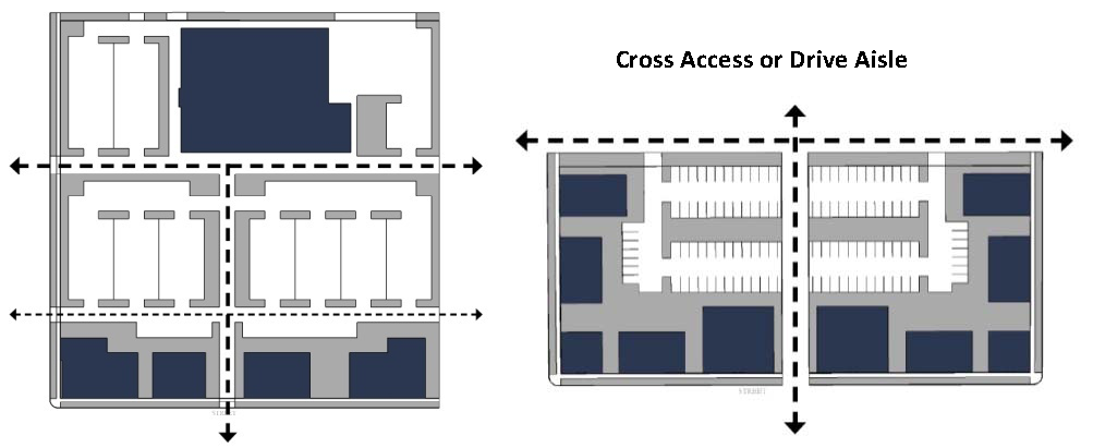
Figure 4 Retail Complex Block Structure
(Ord. No. 16-31, 12-15-2016)
Sec. 115-6. - Building design standards.
The following standards are for building design of nonresidential building types for all building types excluding the industrial building lot types and the industrial complex.
(Ord. No. 16-31, 12-15-2016)
Editor's note— See Sections 115-6.1—115-6.2.
Sec. 115-6.1 - All districts.
(a)
Public entrance. Buildings that are open to the public shall have an entrance for pedestrians from the street to the building interior. This entrance shall be designed to be a distinctive and prominent element of the architectural design, and shall be open to the public during business hours. Buildings shall incorporate lighting and changes in mass, surface, or finish to give emphasis to the entrances.
Figure 6. Variation of Mass and Scale.
(b)
Mass and scale. Buildings that are more than 150 feet in length/width shall comply with the following. No more than 60 feet of horizontal distance of wall shall be provided without architectural relief a minimum of 30 feet wide and three feet deep for building walls and frontage walls facing the street.
(c)
Building façade. Buildings shall provide a foundation or base, typically from ground to bottom of the lower windowsills, with changes in volume or material. A clear visual division shall be maintained between the ground level floor and upper floors with either a cornice line or awning from 12 feet to 16 feet above base flood elevation or grade, whichever applies to the proposed development.
(d)
Building features. Buildings shall utilize at least three of the following design features to provide visual relief along all elevations of the building:
(1)
Divisions or breaks in materials (materials should be drawn from a common palette).
(2)
Window bays.
(3)
Separate entrances and entry treatments, porticoes extending at least five feet.
(4)
Variation in roof lines.
(5)
Awnings installed in increments of 15 feet or less.
(6)
Dormers.
(7)
Canopies, extending at least five feet.
(8)
Overhang extending at least five feet.
(9)
Recessed entries (at least three feet from the primary façade).
(10)
Protruding entries (at least three from the primary façade).
(11)
Covered porch entries.
(e)
Storefront character. Commercial and mixed-use buildings shall express a "storefront character". This guideline is met by providing all of the following architectural features along the building frontage as applicable. Commercial and mixed use buildings located on arterial roads in a suburban corridor design district (i.e. US Hwy 441, SR 19 south of Ardice Ave./north of Laurel Oaks) shall be exempt from meeting these requirements.
(1)
Corner building entrances on corner lots.
(2)
Regularly spaced and similar-shaped windows with window hoods or trim (all building stories).
(3)
Large display windows on the ground floor. All street-facing, park-facing and plaza-facing structures shall have windows covering a minimum of 40 percent and a maximum 80 percent of the ground floor of each storefront's linear frontage. Blank walls shall not occupy over 50 percent of a street-facing frontage and shall not exceed 30 linear feet without being interrupted by a window or entry. Mirrored glass, obscured glass and glass block cannot be used in meeting this requirement.
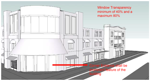
Figure 7. Storefront character.
(f)
Orientation. The primary building entrances shall be visible and directly accessible from a street. Building massing such as tower elements shall be used to call-out the location of building entries.
(g)
Habitable street frontage. The first 20 feet of depth of the first floor of any mixed-use structure's primary building frontage facing a street shall be constructed as habitable space.
(Ord. No. 16-31, 12-15-2016)
Sec. 115-6.1.2. - Metal buildings.
(a)
Definition. For the purposes of this section, a metal building is any structure (other than the exemptions included in subsection (d)) that has steel or metal walls, sheeting, or siding on more than 25% of its exterior surface. Painting or other surface coating shall not be considered a sufficient covering to eliminate the visibility of the metal exterior surface. In calculating the percentage of a building's exterior surface area, all exterior wall surfaces together with fascia surfaces and gable end areas of a building shall be included, less the total area of all exterior doors and windows. Metal garage or overhanging doors, soffits, or metal roofs are permitted and shall not be considered in the calculation.
(b)
Permitted. Metal buildings may be constructed in general industrial (GI) land use districts. Metal buildings as defined in this section may be permitted in public institutional (PI) or mixed commercial industrial (MCI) land use districts if:
(1)
The property has an existing metal building, and the construction proposes the expansion of the existing building or additional metal buildings associated with an existing city public works complex;
(2)
On property in the MCI district, in the established industrial use area along Dillard Road/Huffstetler Drive/Mount Homer Road.
(c)
Metal buildings on properties in PI and MCI land use districts that do not meet the above criteria may be approved by the city commission by waiver or variance as provided for in sections 102-21.1 and 102-31.1.
(d)
Exemptions. This section shall not apply to manufactured homes, mobile homes, and/or residential accessory structures 800 square feet or smaller.
(e)
Non-conforming use. Metal buildings which would otherwise be prohibited hereunder, but which were constructed prior to the effective date of this section shall be considered existing, non-conforming uses. As an existing, non-conforming use, if such metal building is damaged or destroyed by 51 percent or more of its value (as determined by the building official), that structure shall not be rebuilt as a metal building.
(Ord. No. 16-31, 12-15-2016; Ord. No. 17-17, § 1, 11-2-2017)
Sec. 115-6.1.3. - Drive-through services and automotive lifts.
(a)
Drive-through services. Drive through customer services shall be located at the rear or the side of the building. In urban areas, the drive-through may be located at the rear or side of a building or on a side facing a "B" street. Drive-throughs shall not be permitted along "A" streets in urban areas. Landscaping of drive-through windows and lanes shall have a five-foot wide buffer located between the lane and the perimeter of the property that is visible from the street. The length shall be determined by the length of the window and lane. The buffer shall be planted with shrubs a minimum of 20 inches in height at time of planting and be capable of attaining a height of two feet within one year and three feet within two years. ATM machines shall be visible from the street.
(b)
Automotive lifts. Except in general industrial (GI) land use districts, automotive lifts must be contained within an enclosed building. Legally existing automotive lifts installed outdoors prior to the adoption of this regulation may be covered with a canopy or shade structure that is architecturally consistent with the existing building.
(Ord. No. 16-31, 12-15-2016)
Sec. 115-6.2. - Central business district/urban center design district.
(a)
Building heights.
(1)
Within the central business district and urban center design district area, buildings shall a minimum of two stories (or provide the visual appearance of a two story building), regardless of lot typology provisions for minimum building height.
(2)
Buildings are adjacent to Lake Eustis, may not exceed three stories. One additional story for every 100 feet from the lake shall be permitted.
(b)
Mixed-use buildings required. In the central business district area identified with the yellow highlight below, residential uses are limited to the upper floors of buildings above ground-level commercial and office uses.
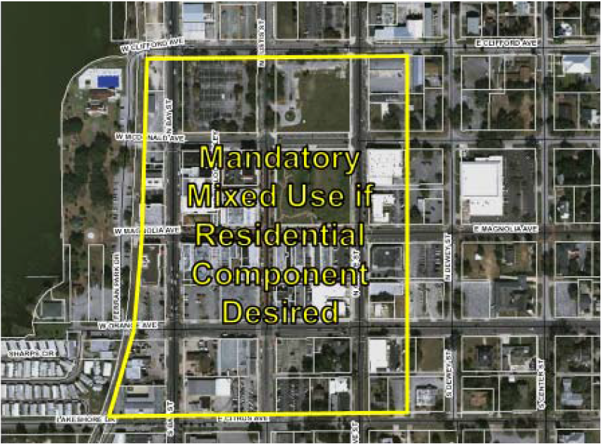
(c)
Building design. In the central business district, buildings shall be designed consistent with the following Buildign Design Standards:
The following standards and review process shall be applicable to the central business district.
(1)
Street-wall alignment. Building facades of new buildings shall have a maximum setback of five feet. On corner lots, new construction shall be build out to both sidewalks or to the maximum allowable setback. Exceptions can be granted in the design review process, on a case-by-case basis depending on the intended use and architectural design of the building.
(2)
Infill buildings. Building construction shall extend the full width of the lot. Gaps between new construction and existing buildings shall be avoided unless meeting the ten feet required by code.
(3)
Where the property owner has several vacant adjacent lots, the infill building should be built adjacent to an existing structure or on the corner lot.
(4)
Form and proportion. New construction shall have massing and configuration similar to buildings in the traditional center of the district (Magnolia Avenue between Grove and Bay Streets.) Factors which effect a building's mass are height, width and roof lines.
a.
Height. New buildings shall be at least 2 stories in height and shall provide a street facade wall at least 28 feet in height.
b.
Width. Where new buildings will exceed the historical 30 to 40 feet in width, the facade shall be visually subdivided into proportional bays, similar in scale to the adjacent buildings. This can be done by varying roof heights, or applying vertical divisions, materials and detailing to the facade.
c.
Proportion. New construction and facade rehabilitation shall maintain horizontal and vertical spacing of elements similar to other buildings on the block.
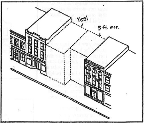
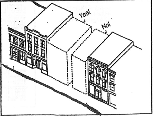
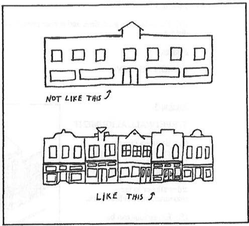
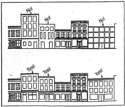
(5)
Detail features. The design elements in the following standards shall be integral parts of the building's exterior facade and shall be integrated into the buildings overall architectural style. These elements shall not consist solely of applied graphics or paint and shall apply to all facades visible from the public right-of-way. Blank wall areas shall not exceed 10 feet in vertical direction nor 20 feet in horizontal direction of any facade. Control and expansion joints within this area shall constitute blank wall area unless used as a decorative pattern and spaced at intervals of six feet or less. Relief and reveal work depth must be a minimum of one-half inch.
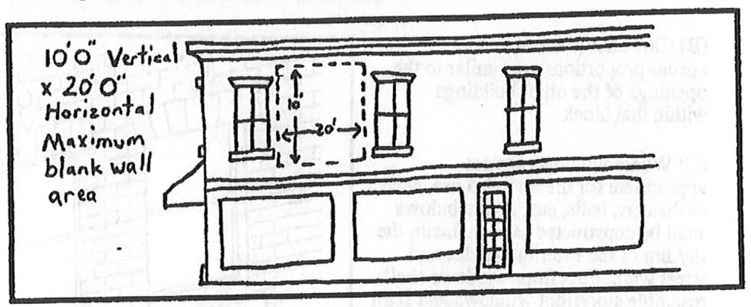
Building facades shall include a repeating pattern and shall include no less than three of the design elements listed below. At least one of these elements shall repeat horizontally. All design elements shall repeat at intervals of no more than 30 feet either horizontally or vertically.
a.
Color change;
b.
Texture change;
c.
Material module change;
d.
Expression of architectural or structural bays, through a change in plane of no less than 12 inches in width, such as a reveal, an offset, or a projecting rib.
e.
Architectural banding.
f.
Building setbacks or projections, a minimum of three feet in width on upper level(s) or,
g.
Pattern change.
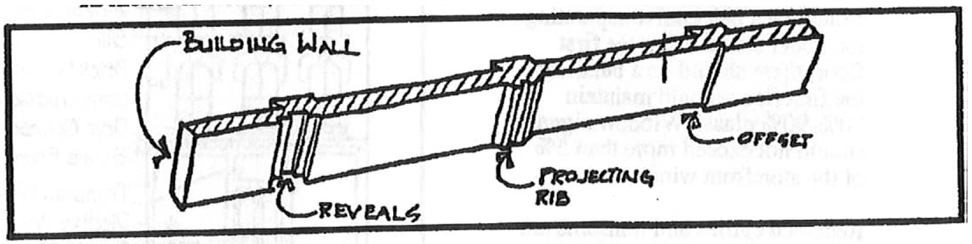
(6)
Windows.
a.
Upper story. The openings above the first floor shall appear as "punched" openings within a solid wall, rather than as windows separated only by their frames or curtain wall as in the storefront. A solid wall must appear to be the structural element. For wood-frame construction, cornice and sill is an acceptable alternative; three inch minimum projection.
b.
Care should be taken to ensure proportions are similar to the openings of the other buildings within that block.
c.
Where windows are not appropriate for the intended use, such as theaters, halls, etc., faux windows shall be constructed as to maintain the rhythm of the exterior facades and street wall. First floor windows shall resemble storefront windows and shall retain the 80 percent coverage required. The interior backdrop shall be two to three feet back allowing for use as a display window for products, murals, etc. Second, third and fourth floor windows shall be made to resemble the existing window designs and rhythm in the surrounding historic building stock.
d.
Storefront configurations. New and existing storefronts shall include the basic features of a historic storefront. There should be a belt course separating the upper stories from the first floor; there should be a bulkhead; the first floor should maintain should not exceed more than five percent of the storefront window area. Recessed entries and transoms are encouraged as historical elements.
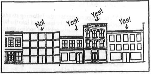
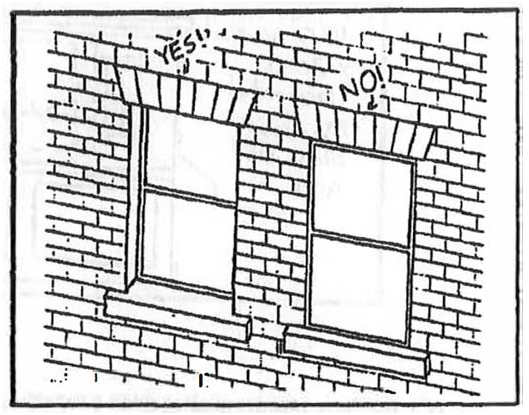
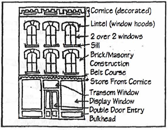
Store Front Cornice Transom Window Display Window Double Door Entry
(7)
Window and door openings. Storefront components shall be designed to be consistent with existing historical storefront designs. The storefront shall contain a 80—90 percent glass area. Wood is strongly recommended for windows, doors and frames. Metal windows and doors finished in baked enamel are permitted. Unfinished metal or raw aluminum windows and doors should be avoided. Flush or snap-in muntins in windows should be avoided. Window openings should be spaced as to maintain the surrounding rhythm of the downtown facades.
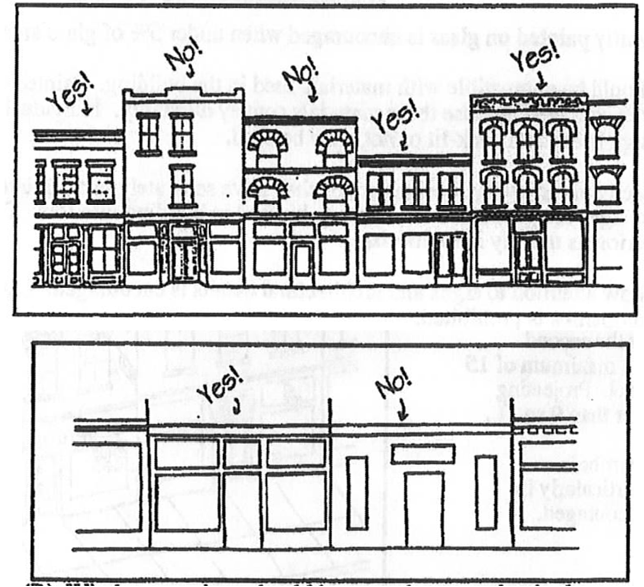
(8)
Signs.
a.
Wall signs shall not exceed the height of the building cornice. On street facades signs and display ads shall not exceed ten percent of each main floor facade area. Wall signs should be flush-mounted or painted directly upon the flat surface of the building.
b.
Wall signs shall be placed in traditional locations in order to fit within architectural features, for example:
• Above transoms
• On cornice fascia boards
• Below cornices
c.
Brackets for projecting signs shall be located under the second floor window sills or a maximum of 15 feet from the street level. Projecting signs shall be no larger than nine square feet.
d.
The use of sign symbols, logos, and cut-outs, particularly in projecting signs, is encouraged.
e.
Signage permanently painted on glass is encouraged when under five percent of glass area.
f.
Sign materials should be compatible with materials used in the building. Painted wood and metal are particularly encouraged because these materials convey durability. Individual letters, affixed directly to a sign frieze and back-lit or not, may be used.
g.
Signs shall be directly or indirectly illuminated, or shall have separately back-lit letters. Internally illuminated signs are prohibited. Neon may be used in building interiors. The use of neon on building exteriors is usually inappropriate.
h.
Spot lighting to draw attention to signs and architectural details is encouraged. Light spillage on adjacent properties is prohibited.
i.
Sign designs based upon designs in use earlier than the architectural style of the building are discouraged. Signs should be in the same style as the building.
j.
The use of the following, are prohibited in the central business district:
• Internally lit and/or plastic awnings, with or without signs
• Internally lit signs
• Flashing signs
• Pedestal signs and pole mounted signs
• Ground mounted signs
• Mass-produced blow molded plastic signs
• Portable trailer signs
• Historically incompatible canopies, awnings, and imitation mansard roofs made of metal, rough-sawn wood, plastic, shakes, or asphalt roofing.
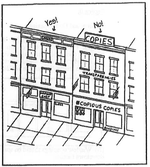
(9)
Awnings. Fabric awnings are encouraged. If possible, awnings shall fit storefront openings or individual window openings. Top edges of awnings shall be mounted to align with the transom or with the framing above the main display window. The use of awning valances for signs is encouraged.
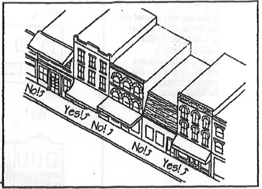
(10)
Roof forms.
a.
Roof lines of new construction shall be similar to those in adjacent buildings. Exotic roof shapes tend to disrupt the rhythm of the streetscape and must be avoided. Gable roof shapes are acceptable if parapet walls hide the end wall and water drainage is contained within the property. When original rooflines have been altered inappropriately, it is preferable to restore the original shape if feasible.
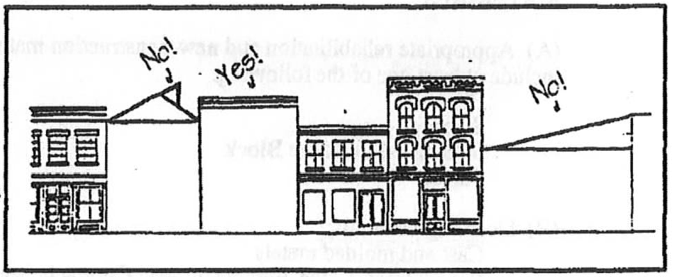
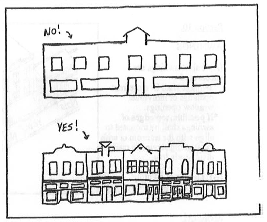
b.
Where new buildings will exceed the historical 30 to 40 feet in width, the roofline shall be visually broken with cornices similar in scale to the existing historic building stock.
(11)
Materials.
a.
Appropriate rehabilitation and new construction materials for all exposed surfaces shall include at least one of the following:
Brick
Stone
Split-faced concrete block
Stucco
b.
Detailing materials:
Cast and molded metals
Wood (treated pine, mahogany, and Cyprus is best for exterior applications)
Fiberglass replications
Gypsum detailing
Structural glass when replicating a pre-1940 storefront design
Architecturally detailed exterior insulation finish system (commonly known as Dryvit)
c.
The following materials are prohibited for visible surfaces:
Wood, vinyl or aluminum siding
Wood, asphalt or fiberglass shingles
Structural ribbed metal panels Corrugated metal panels
Plywood sheathing
Plastic sheathing
Structural glass, unless used to replicate a pre-1940 storefront design
Reflective or moderate to high grade tinted glass
d.
Appropriate colors for exterior materials are colors found in natural materials such as browns, grays, deep reds and deep greens.
(12)
Parking structure standards. Wherever practical, structured parking facilities shall be designed with retail, office or other permitted uses at the street level. Where this is not possible, the structure shall have an architecturally articulated facade designed to screen the parking areas of the structure, to encourage pedestrian scale activity, and to provide for urban open space. Where automobile access is provided, two smaller openings are preferable to one large one. A minimum of 60 percent of any primary facade of a parking structure or covered parking facility shall incorporate two of the following:
a.
Transparent windows, with clear or lightly-tinted glass, where pedestrian oriented businesses located along the facade of the parking structure;
b.
Display windows:
c.
Decorative metal grille-work or similar detailing which provides texture and partially and/or fully covers the parking structure opening(s);
d.
Art or architectural treatment such as sculpture, mosaic, relief work or similar features; or,
e.
Vertical trellis or other landscaping or pedestrian plaza area.
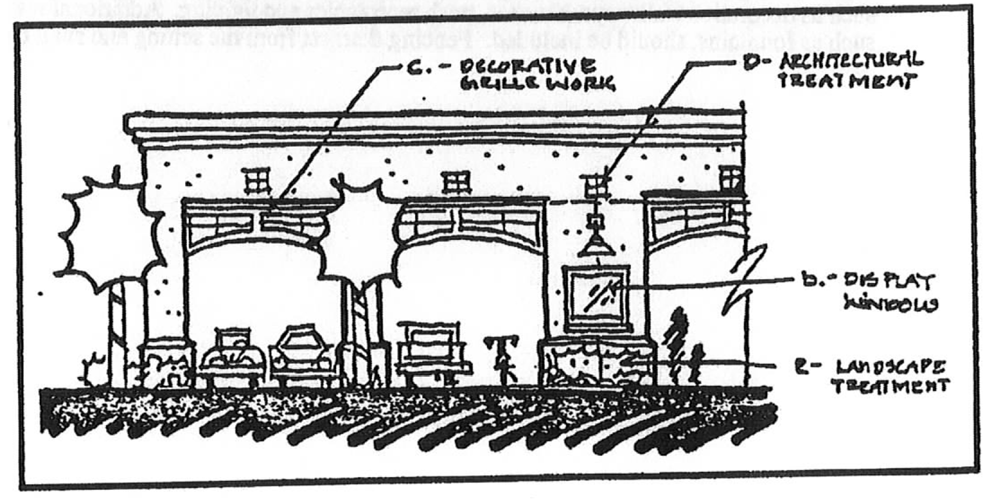
(Ord. No. 16-31, 12-15-2016)
Sec. 115-7. - Block structure, street types and transportation system.
Editor's note— Provisions pertaining to block structure, street types and transportation systems are set forth in the subsequent sections, sections 115-7.1—115-7.7.3.3, below.
Sec. 115-7.1. - Block structure.
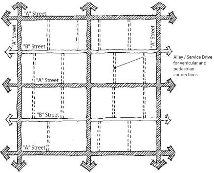
Figure 9. Block Configuration.
(a)
Block configuration and preferred size. In order to create a system of land subdivision and development which links one area to another, land should be organized by development blocks to the maximum extent feasible given the topography and physical characteristics of each individual site. The flexibility to design each site to preserve on-site environmental resource and preservation areas is permitted through the development approval processes and the design criteria provided herein.
Blocks shall be designed to conform to a street pattern that is connected and may be in a gridiron, curvilinear, organic, radial or any other style that provides internal connections and external linkages. The size, location and placement of blocks shall respect natural features by recognizing the natural and environmental features of the area and incorporating the protection and preservation of these features as an amenity to the development, where such protection is required by applicable environmental regulations. The relative size and functional value of each feature shall be assessed as a part of the site design process to determine the protection measures required.
(1)
Urban districts. The preferred block length shall range from 300 to 400 feet including alleys that may bisect the block. The maximum block perimeter shall not exceed 1,600 feet.
(2)
Suburban districts. When land within the suburban area is being redeveloped, infill or large open areas of five acres or greater, a block configuration will need to be introduced as part of the proposed development. The preferred block length shall range from 500 to 700 feet including alleys that may bisect the block. The maximum block perimeter shall not exceed 2,400 feet.
(3)
Rural centers. Rural centers will be required to follow the urban block configuration guidelines when a mix of residential and nonresidential building types is located in the center. The residential areas shall be considered a center when the following building types are used in concert with one another.
(b)
Block structure and pedestrian network. The pedestrian network shall be in a connected block pattern throughout the developed area. Intersections of pedestrian facilities shall occur on every pedestrian facility every 500 feet at a minimum. The following elements qualify as a pedestrian facility and may form a side of a block: Continuous sidewalks along roadways, alleys less than or equal to 500 feet in length, pass-throughs located at mid-block locations or at cul-de-sac heads, boardwalks, and multi-use trails. The following elements do not qualify as pedestrian facilities and may not form a side of a block: Recreational or open space without a designated pedestrian or multi-use path, alleys greater than 500 feet in length, and trails, sidewalks, and boardwalks that dead-end. Pedestrian network standards may be modified under the following circumstances: 1) Boardwalks crossing environmental areas are physically impractical due to required length, or 2) Boardwalks crossing environmental areas are prohibited due to avoidable impacts to wetlands or native habitat.
(Ord. No. 16-31, 12-15-2016)
Sec. 115-7.2. - Transportation system.
(a)
Official street map. The future traffic circulation map series and any amendments thereto, which is a part of the city comprehensive plan, is hereby made the official street map of the city. All existing roadways within the city's jurisdiction shall be designated on the official street map according to the foregoing classification system. Any street abutting or affecting the design of a development which is not already classified on the official street map shall be classified according to its function, design, and use by the city at the request of the applicant or during plat or site plan review. The city shall use the official street map as a basis (along with all relevant preliminary design and engineering studies for the area, Lake County's Comprehensive Road Improvement Plans, and FDOT's current five-year work plan) for decision-making regarding required road improvements, reservation or dedication of rights-of-way for required road improvements, or access of proposed land uses to existing or proposed roadways.
(b)
General street design standards. Street layouts in all new developments shall be consistent with the block design standards and site design standards provided for each design district and detailed herein.
(c)
Streets.
(1)
Functional classification.
a.
Streets within the city are classified according to function and existing and projected future traffic volumes in order to regulate access, right-of-way and road widths, circulation patterns, design speed and construction standards.
b.
All public and private streets are classified in a street hierarchy system with roadway design adapted to the anticipated street function. The street hierarchy system is defined by road function and average daily traffic (ADT), calculated by trip generation rates prepared by the Institute of Transportation Engineers (ITE). Trip generation rates from other sources may be used, if approved by the director of development services, if the developer demonstrates the alternative source better reflects local conditions.
c.
Whenever a new street in a development connects to and continues an existing street that previously terminated outside of said development, or it is expected that a street in a development will be continued beyond said development at some future time, the classification of the street will be based on the entire or anticipated entire street, both within and outside the development.
d.
The following street hierarchy, from low to high order, is established as follows: residential, collector, and arterial roadways. Each street type is divided into subcategories. All development proposals containing new streets or providing access from existing roads shall comply with the standards within this section.
(d)
Street hierarchy.
(1)
Residential streets. Residential streets (sometimes referred to as local streets) provide direct access to residential development. Residential streets shall be governed by the design district of the development.
(e)
Collector streets. Collector streets provide access to nonresidential uses and connect lower order streets to arterial streets. Design speeds and average daily traffic (ADT) volumes will be higher than for lower order streets. Collector streets shall have a design speed of 45 miles per hour or less and an ADT between 2,000 and 7,000. Each collector street shall be classified and designed for its entire length to meet the minimum standards for one of the following three collector street types:
(1)
Minor collector. Minor collector streets are local collectors that provide direct access to commercial and industrial uses and to residential developments, but do not provide direct access to individual dwelling units. Minor collector streets may receive access from other collector streets, minor arterials, or arterials. Minor collector streets may give access to any residential street type.
(2)
Collector. Collector streets may serve commercial and industrial uses as well as providing a route for through traffic. Collector roads may receive access from other collector streets, major collectors, minor arterials or arterials, and give access to any lower order street.
(3)
Major collector. Major collector streets serve major community or regional facilities as well as providing a route for through traffic. Major collector roads may receive access from other major collectors, minor arterials and arterials, and may give access to the same or any other lower order of street type.
(f)
Arterial roads. Arterial roads provide links between communities or to limited-access expressways and limit direct access from abutting properties except for regionally significant uses. Arterial roads are designed for speeds up to 55 miles per hour and ADT of 7,000 or greater. Each arterial road shall be classified and designed for its entire length to meet the minimum standards for one of the following three arterial road types:
(1)
Minor arterial. Minor arterial roads link community districts to regional or state highways. These roads may also provide direct access to regionally significant land uses.
(2)
Major arterial. Major arterial roads are major regional highways providing links between communities.
(g)
Eustis street classification. Arterial and collector streets within the city planning area are listed below according to the functional classification as designated within the traffic circulation element of the city's comprehensive plan and on the future traffic circulation map series (official street map). Streets that are not listed below are assumed to be residential or lower order streets:
(h)
Right-of-way. The minimum right-of-way widths within the city are as follows:
(i)
Street naming. All proposed street names shall be submitted to the city for review and approval. New street names shall avoid duplication, shall not be offensive, and shall not be confusing with existing or proposed names. Streets which are in line with current streets shall be considered a continuation of an existing street and named appropriately. Street designations shall be as follows:
Avenue: Travels in an east-west direction and has a minimum of two intersections.
Street: Travels in a north-south direction and has a minimum of two intersections.
Drive: A two-lane traffic route which travels in a non-directional pattern and has a minimum of two intersections.
Boulevard: A traffic route with three or more lanes which travels in a non-directional pattern and has a minimum of two intersections.
Road: A two-lane traffic route which travels in a non-directional pattern and directly links two state routes.
Court: A roadway which is 500 feet, or less, and ends in a dead end cul-de-sac.
Circle: A traffic route which connects itself together.
Lane: A roadway which is over 500 feet and ends in a dead end cul-de-sac.
(Ord. No. 16-31, 12-15-2016)
Sec. 115-7.3. - Street types.
The categories of regulations that are provided on each street section are defined as follows.
(a)
Design parameters.
(1)
Target speed, the desired motor vehicle operating speed and design speed of the facility.
(2)
Movement, the characteristic of motor vehicle traffic flow, described as free, slow, or yield.
(b)
Travelway configurations.
(1)
Travel lanes (each direction), the number of through lanes to be provided in each direction (not applicable for yield movement facilities).
(2)
Turn lanes, the lanes that may be provided on each approach at intersections where turn lanes are required (not applicable for yield movement facilities) to facilitate traffic operations.
(3)
Bike facility, the provision of facilities for bicycle use, described as bike lane or bike route.
(c)
Lane dimensions.
(1)
Travel lane(s) width (feet), the width of each travel lane measured to the face of curb (or edge of pavement if no curb).
(2)
Bike lane width (feet), the width of bike lane measured to the face of curb (or edge of pavement if no curb).
(3)
Continuous left turn lane width (feet), the width of center left turn lane measured to the edge of the adjacent travel lane.
(4)
Parking lane width (parallel parking) (feet), the width of parking lane, if provided, on facility with parallel parking.
(5)
Parking lane width (angled parking) (feet), the width of parking lane, if provided, on facility with angled parking, measured from the face of curb or edge of pavement if no curb).
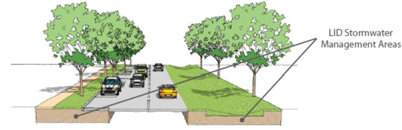
(d)
Roadway edge.
(1)
Outside curb type, the type of edge treatment to be provided at the outside edge of pavement, described as type B, D, E, F, ribbon, or no curb.
(2)
Median curb type, the type of edge treatment at the inside edge of pavement on a median facility, described as type B, D, E, F, ribbon, or no curb.
(e)
Medians.
(1)
Allowable median type, the type of median that may be provided between directions of traffic, described as narrow or wide.
(2)
Narrow median width (ft.), the width of a narrow median.
(3)
Wide median width (ft.), the width of a wide median.
(f)
Public frontage.
(1)
Planter type, the type of planting area that must be provided outside of the travelway, described as grass, intermittent, tree well, swale or natural area.
(2)
Planter width (feet), the width of planting area.
(3)
Walkway width (each side) (feet), the width of pedestrian walkway that must be provided on each side of the travelway, unless noted otherwise.
(g)
Right-of-way. Right-of-way width (feet), the width of right-of-way based on the minimum amount of space needed to accommodate the required elements of the design section.
(h)
Low impact development is permitted in street design and construction in all areas outside of the travelways. Those areas include on-street parking, sidewalks, planters, swales, or shoulders which may be used for stormwater infiltration, exfiltration, or storage, as shown on the example street section. Low impact development practices are particularly encouraged in rural areas.
(Ord. No. 16-31, 12-15-2016)
AVENUE
A limited distance, free movement thoroughfare connecting locations within an urbanized area.
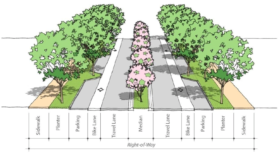
BOULEVARD
A long-distance, free movement thoroughfare traversing an urbanized area which is flanked by parking, sidewalks, and side parkways buffering buildings which line the edges.
DRIVE
A thoroughfare which defines the edge between an urbanized area and natural feature or open space, usually along a waterfront, a park, or a preserved natural area, with one side having the urban character of a street or boulevard, with sidewalks and buildings, while the other has the qualities of a road, with naturalistic planting and rural detailing.
COMMERCIAL STREET
A small scale slow or yield movement, local thoroughfare suitable for centers and cores providing frontage for higher density urban uses like shops, offices, apartment buildings, townhouses, or small-lot single family homes.
STANDARD STREET
A small scale, slow or yield movement, local thoroughfare suitable for centers and cores providing frontage for higher density urban uses like shops, offices, apartment buildings, townhouses, or small-lot single family homes.
RESIDENTIAL STREET
A small scale, slow or yield movement, local thoroughfare suitable for centers and cores providing frontage for higher density urban uses like townhouses, or small-lot single family homes.
RESIDENTIAL ROAD
A small scale slow or free movement local thoroughfare suitable to provide frontage for low-density buildings.
GENERAL ROAD
A small scale slow or free movement local thoroughfare suitable to provide frontage for low-density buildings.
RURAL ROAD
A small scale slow or free movement local thoroughfare suitable to provide frontage for low-density buildings.
COMMUNITY THOROUGHFARE ROAD
A small scale free movement local road suitable to provide frontage for low-density buildings.
REAR ALLEY
A yield movement right-of-way providing access to service areas, parking, outbuildings (garage) and contains utility easements. This condition is more urban in nature and does not include any streetscape requirements.
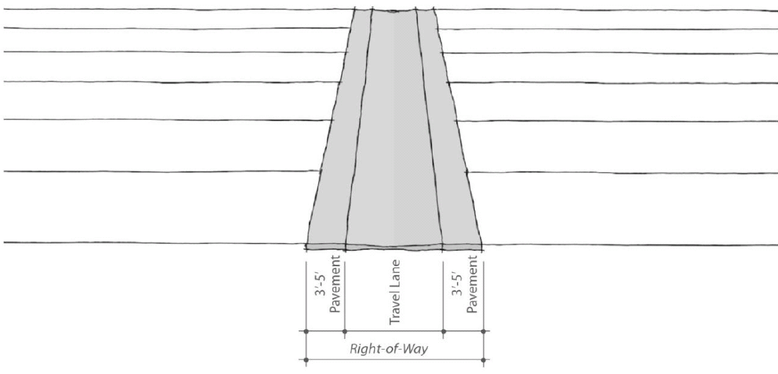
REAR LANE
A yield movement providing access to service areas, parking, outbuildings (garage) and contains utility easements. The streetscape consists of gravel or landscaped edges.
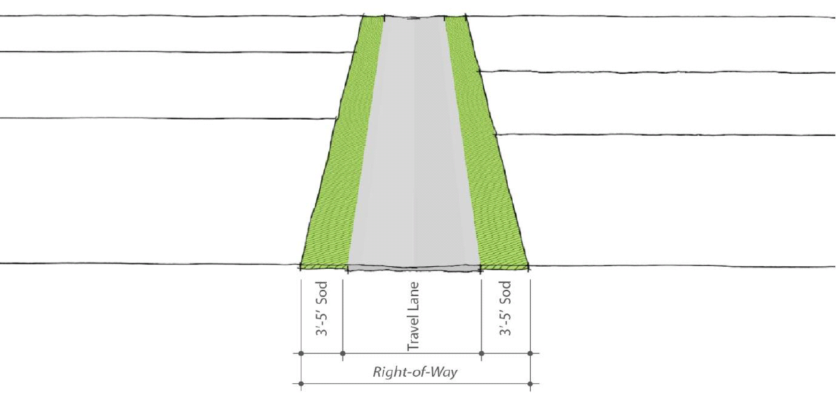
(Ord. No. 16-31, 12-15-2016)
Sec. 115-7.3.1. - Urban street types.
(a)
Urban street types. Within the urban area, all newly constructed streets, excluding alleys and multi-use trails, shall be designated an "A" street or a "B" street on the site plan. In addition, the following restrictions shall apply:
(1)
A street shall be classified an "A" street unless otherwise designated on the site plan. "B" streets may be designated by individual block faces; however, no block face shall be split by "A" street and "B" street designations. See figure 2 for illustration.
A. Acceptable A-B Street Layout
B. Unacceptable A-B Street Layout
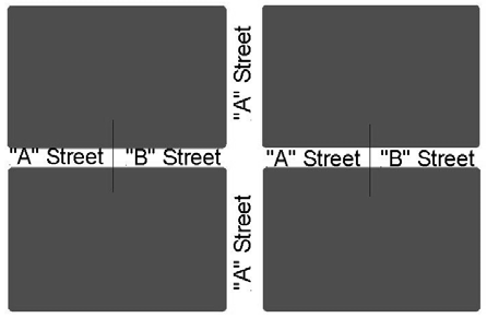
Figure 10. Street Layout examples.
Alleys are required to serve all residential lots less than 50 feet in width. Alleys and other streets shall be interconnected whether multiple streets are being constructed or there are opportunities to connect to existing streets.
(b)
The following streets are designated "A" streets within the urban center. If a street has not been identified, it shall be designated a "B" street.
(c)
The following street types are permitted within the city's urban design districts:
(X) Permitted, Blank cell - prohibited
(Ord. No. 16-31, 12-15-2016)
Sec. 115-7.3.2. - Suburban street types.
(a)
The following street types are permitted within the city's suburban design districts.
(X) Permitted, Blank cell - prohibited
Alleys are required to serve all residential lots less than 50 feet in width. Alleys and other streets shall be interconnected where multiple streets are being constructed or there are opportunities to connect to existing streets.
(Ord. No. 16-31, 12-15-2016)
Sec. 115-7.3.3. - Rural street types.
(a)
The following street types are permitted within the city's rural design districts:
(X) Permitted, Blank cell - prohibited
Alleys are required to serve all residential lots less than 50 feet in width. Alleys and other streets shall be interconnected where multiple streets are being constructed or there are opportunities to connect to existing streets.
(Ord. No. 16-31, 12-15-201)
Sec. 115-8. - Park space types.
(a)
The following park space types identify the range of parks that are permitted within the city. Refer to sections 115-8.1—8.3 for permitted parks by design district. Each park type includes the following four categories:
(1)
General description, identifies the type of park
(2)
Size criteria, provides a minimum and maximum acreage
(3)
Location criteria, includes the type of area that may be served by the park type
(4)
Example facilities, include a range of facilities that may be considered as a component of the park type.
Community Park
Cultural Resource Area
Green
Greenway
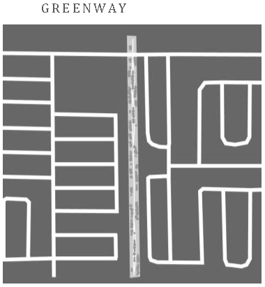
Mini Park/Playground
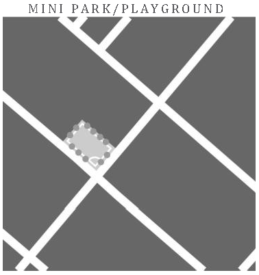
Natural Resource Area

Neighborhood Park
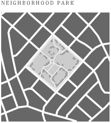
Plaza
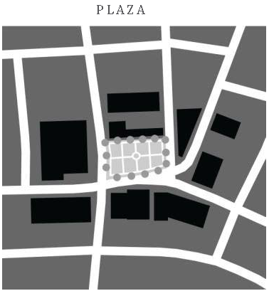
Regional Park
Special Use Facility
Sports Complex
Square
(b)
Park requirements. The city requires that all new residential subdivisions incorporate into their development plan, lands for parks to be used by the residents of that development consistent with the standards for parks provided in chapter 110.
(1)
The parks may count toward the minimum required open space for each land use district, as consistent with the definition of open space.
(2)
The size of the park(s) for each subdivision shall be determined by the size of the subdivision and in the size increments specified herein. This requirement shall not be measured by portion of increments.
(Ord. No. 16-31, 12-15-2016)
Sec. 115-8.1. - Urban district park types.
The following public spaces are permitted within the city's urban areas. The required minimum park space is provided in section 115-8(b) of the Land Development Code.
(X) Permitted, Blank cell - prohibited
(Ord. No. 16-31, 12-15-2016)
Sec. 115-8.2. - Suburban district park types.
The following public spaces are permitted within the city's suburban area. The required minimum park space is provided in Section 115-8(b) of the Land Development Code.
(X) Permitted, Blank cell - prohibited
(Ord. No. 16-31, 12-15-2016)
Sec. 115-8.3. - Rural district park types.
The following public spaces are permitted within the city's rural area. The required minimum park space is provided in section 115-8(b) the Land Development Code.
(X) Permitted, Blank cell - prohibited
(Ord. No. 16-31, 12-15-2016)
Sec. 115-9. - General landscaping standards.
Editor's note— Provisions pertaining to general landscaping standards are set forth in the subsequent sections, sections 115-9.1—115-9.3.3, below.
Sec. 115-9.1. - Landscaping and landscape irrigation.
(a)
Low quality water service: Minimum service requirements.
(1)
All new subdivisions located within the city or connecting to the city water systems shall construct dual water mains to provide irrigation and other non-potable service to all lots based on the projected amount of property to be irrigated, as well as other potential non-potable uses, including common elements. Low quality water services from reclaimed water, surface water, and stormwater including required back flow prevention devices and taps shall be installed for each lot and landscaped common area, with a minimum service tap size of one inch in diameter.
Actual service tap size and potential sharing of service lines shall be reviewed and approved by the city engineer. These improvements shall be completed and in place regardless of whether low quality water is available to the project at the time of development. At such time as low quality water is available, each lot and other property to which a tap was required shall accept low quality water service.
(2)
Site development plans for all new development on previously vacant property where the low quality water lines adjoin the property shall show irrigation systems connected to the low quality water mains where available. Where such service is not currently available, site plans shall show irrigation systems that shall be configured for ultimate connection to the low quality water mains by locating pumps or potable water system connections adjacent to the right-of-way or other planned low quality water main location.
(3)
Existing landscape irrigation systems located within the city shall accept low quality water services when available as follows:
a.
If the existing irrigation system on such property is using city potable water for irrigation, the property shall connect to the low quality water service when available.
b.
If the existing irrigation system on such property is using lake water or stormwater for irrigation, then such property shall continue to use that low quality water.
(4)
No new irrigation system for landscaping use shall be allowed in the city unless it connects to the low quality water lines if such lines are available to the property seeking irrigation.
(5)
Drought tolerant landscaping that promotes good horticulture practice for efficient use of water shall be used for all new development within the city. Installed trees and plant materials shall be grouped together with plants of the same water use needs into zones. The majority of plant material shall be selected from drought tolerant species that do not require irrigation. Grass areas shall be limited to those areas that receive pedestrian traffic, recreation uses, or erosion control. Mulch shall be used for plant beds and around trees in grass areas except annual beds. Moisture sensor and/or rain gauges shall be provided with automatic irrigation systems. The use of low volume, emitter, or target irrigation shall be used for trees, shrubs and groundcovers. All new landscaping shall meet the guidelines of the Florida Friendly Landscaping and Waterwise Florida Landscapes guides published by the St. Johns River Water Management District.
(b)
System design. The layout of low quality water distribution systems shall comply with the following design criteria and the adopted standard utility details of the city:
(1)
General standards. Design and installation practices, materials and methods shall conform with requirements for potable water systems, except where specifically modified by policies or details adopted for the low quality water system.
(2)
Main size. Mains shall be sized based on the anticipated demand for low quality water use based on land use, soil characteristics and potential non-irrigation use. Minimum main size shall be six inches in diameter.
(3)
Extension of lines to project boundaries. Low quality water mains shall be designed to stub out to the project boundaries to serve adjacent unserved properties. This shall include mains in all rights-of-way, across the entire project frontage on existing roads without existing mains, and to the property boundary via easement when no other access is available to unserved properties.
(4)
Color coding of low quality water appurtenances. All low quality water distribution materials shall be color coded purple from the manufacturer.
(c)
Availability. Availability shall mean the city having sufficient capacity to provide service to a subject property and reclaimed or reuse water lines being physically located within 120 feet of the subject property.
(d)
A developer having developed surface water or stormwater for irrigation within the development with sufficient capacity to provide service to the subject property and the low quality water lines being physically installed within the subdivision.
(Ord. No. 16-31, 12-15-2016)
Sec. 115-9.2. - Xeriscaping standards.
(a)
Xeriscaping measures. The purpose of this subsection is to establish minimum standards for the development, installation, and maintenance of landscaped areas on a site with water use efficiency as a goal without inhibiting the use of creative landscape design. Xeriscaping encourages specific water conservation measures including the re-establishment of native plant communities, the use of site-specific plant materials, and the use of native vegetation. The intent of this subsection is to recognize the need for and the protection of groundwater as a natural resource through the application of enhanced landscape practices, that water-efficient landscaping maximizes the conservation of water by using site adapted plants and efficient watering methods that will generally result in a reduction of irrigation requirements, costs, energy and maintenance.
(1)
The following items will be required as a part of the submittal for landscape plan approval.
a.
Illustrate and label the water zone requirements.
b.
Illustrate and label all areas of the site to be preserved.
c.
Illustrate and label all turfgrass areas.
(2)
Any construction or development activity requiring a planting within buffers or other landscaping shall be consistent with water-efficient landscaping standards established herein. To achieve the objectives of this subsection, the seven basic principles of water-efficient landscaping are incorporated. These principles are:
a.
Good design. Preservation of existing vegetation areas when possible. Installation of plant material in groups according to the water needs of the genus and species.
b.
High water use zones. Plant material that is associated with moist soils and require supplemental water in addition to natural rainfall to survive. The high water use zone plant material should be limited to less than 50 percent of the total landscaped area of the site.
c.
Moderate water use zones. Plant material that can survive on natural rainfall with supplemental water during seasonal dry periods.
d.
Low water use zone. Plant material that can survive on natural rainfall with no supplemental water.
e.
Soil improvement. The existing soils on the site should be analyzed to help determine the appropriate plant types for the site. The soils should be enhanced if needed to give the soils more moisture retention capabilities.
f.
Use of mulch. Organic mulches should be used and maintained around all trees located in turfgrass areas, in landscaped areas not planted or not appropriate for growing turfgrass or groundcover, and in all planted areas.
g.
Limit lawn areas. The use, type, and location of lawn area in the landscape shall be selected in a planned manner and not used as a fill-in material. Since most lawn varieties used in the landscape require supplemental watering more frequently than other types of landscape plants, turf shall be placed so that it can be irrigated separately.
h.
Use of low water use plants. Plants should be selected based on the plant's adaptability to the site, desired effect, color, texture, and mature size. The landscape should be designed to give the desired aesthetic effect and plants should be grouped in accordance with their respective water needs. The use of native plants is encouraged whenever possible. A list of recommended xeriscape plant material is listed in Table 1: List of Recommended Xeriscape Plants.
i.
Efficient irrigation. The irrigation system shall be designed to correlate to the water use plant zones established in the landscape design. The following criteria for irrigating the site should be used in the design of the system.
1.
In the high water use zones all portions of the zone shall be provided with an automatic irrigation system with low volume heads that are timed to produce no more than two inches of water per week in established landscapes.
2.
In the moderate water use zone, all portions of the zone shall be provided with a readily available water supply within 25 feet to supplement natural rainfall when needed and to help ensure that watering will take place until the plant material is established.
3.
In low water use zones, all portions of the zone shall be provided with a readily available water supply within 50 feet to supplement natural rainfall when needed and to help ensure that watering will take place until the plant material is established.
4.
Rain sensor devices shall be required on all automatic irrigation systems to avoid irrigation during periods of sufficient rainfall.
5.
The irrigation system shall be designed to minimize irrigation overthrow onto impervious surfaces and to negate any ponding effects.
j.
Appropriate maintenance. Proper maintenance will preserve and enhance the quality of the landscape. Included in the maintenance schedule should be the time periods for the following: the checking, adjusting, and repairing of the irrigation system, resetting of the irrigation schedule according to the season, re-mulching, fertilizing, weeding, and pruning.
Table 1: List of Recommended Xeriscape Plants
From Drought Tolerant Plant Guide for Lake County published by the Lake County Water Authority and Xeriscape plant list from St. John's Water Management District.
+ = Low drought tolerance
++ = Moderate drought tolerance
+++ = High drought tolerance
*Indicates species is native to North America
Canopy Trees:
Understory and Palm Trees:
Shrubs:
Vines:
Groundcover:
Annuals and Perennials:
(Ord. No. 16-31, 12-15-2016)
Sec. 115-9.3. - All districts.
(a)
Parking lot landscaping.
(1)
Parking lots shall be planted with canopy trees at a rate of one tree per ten spaces. Parking lots shall not extend more than 12 spaces without a tree island break.
(2)
At time of parking lot construction and planter installation, all planter islands shall be excavated to the full width of the parking planter island and through the full depth of compacted subgrade to remove all compacted material, all limerock or other material deleterious to plant health, and backfilled with clean planting fill.
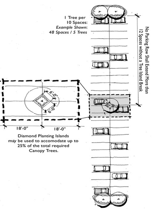
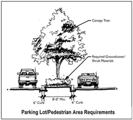
(3)
Planting areas must be equal or greater to ten percent of paved area within project site, not including building square footage or retention ponds.
(Ord. No. 16-31, 12-15-2016)
Sec. 115-9.3.1. - Urban design district standards.
Figure 11. Urban Landscape.
(a)
Urban landscape. When buildings are brought up to the street and utilizing a build-to-line, an urban buffer shall be provided.
The urban buffer shall be determined by the sidewalk width. An eight foot wide pedestrian area must be maintained for at least 50 percent of the street frontage. Therefore, if the sidewalk is five feet wide an additional three feet shall be required as an urban buffer or front setback.
The front buffer for an urban type development shall be allowed to provide potted plants. At a minimum, a 36 inch diameter pot by 24 inches high should be provided every 20 lineal feet of building frontage. The plant species should be two times as high as the height of the pot. Low growing plants, flowering annuals should be planted at the base of the pot. All efforts should be made to preserve existing tree canopy within the right-of-way.
(b)
Street trees.
(1)
Trees shall have a minimum two inches DBH and be of Florida No. 1 grade as per "Grades and Standards for Nursery Plants," Florida Department of Agriculture and Consumer Services. All landscaping shall meet FDOT visibility standards.
(2)
Tree spacing: For corridors and centers, one street tree shall be planted for every 30 linear feet or frontage or fraction thereof. For all other streets, one street tree shall be planted 40 to 60 feet on center. Street trees shall be planted a minimum of ten feet from any above ground utility, such as transformer pads and fire hydrants.
(3)
Tree species: Select tree species that are appropriate for street tree planting conditions shall be used.
(Ord. No. 16-31, 12-15-2016)
Sec. 115-9.3.2. - Suburban design district standards.
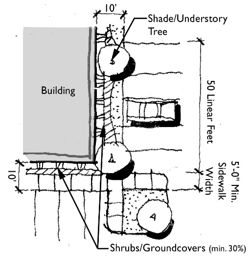
(a)
Suburban landscape.
(1)
Building open areas. The green spaces around buildings shall be landscaped completely with trees, shrubs, groundcovers, annuals or sod.
a.
A minimum ten foot wide landscape area shall be located around all buildings. A five foot sidewalk may be included in this buffer area. Suburban buildings that utilize the minimum front setback requirements shall be exempt from this requirement.
b.
An average of one understory or canopy tree shall be located for every 50 linear feet of building perimeter.
c.
All edges of buildings shall have a foundation planting of shrubs and groundcovers as a minimum. Shrubs and groundcovers shall comprise at least 30 percent of the required green space.
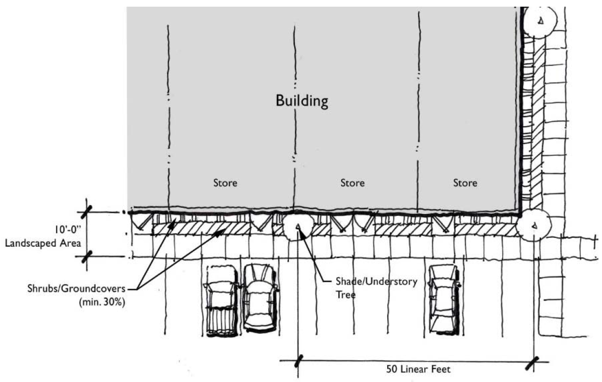
d.
Landscaping requirement around the perimeter of large strip commercial centers or "big box" structures with a continuous building length of at least 150 feet along the primary street frontage as follows:
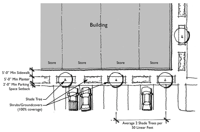
Figure 12. Big Box structures with a continuous building length of at least 150' along
the primary street frontage.
1.
Rear/service area does not require planting.
2.
The remaining three sides of building perimeter shall include a five foot minimum continuous sidewalk as well as landscape planter areas along at least 60 percent of that linear distance.
3.
The required 60 percent landscape coverage shall be in at-grade or raised planters at least five feet deep and five feet wide. Raised planters shall not exceed 24 inches overall height.
4.
Planters may be located along building edge, or along street, drive or parking edge. Planters along head-in parking shall be located at least two feet clear from edge of curb to allow for continuous pedestrian access without stepping in landscape area.
5.
All required planters shall be planted 100 percent with shrubs and groundcovers. Sod is prohibited.
6.
An average of one understory or canopy tree per 50 linear feet shall be required for the remaining three sides of building perimeter. Trees may be placed in planter areas.
(2)
Landscape buffer along public streets.
a.
A 15 to 24-foot landscape buffer shall be required along public streets with vegetation planted per the table below. Buffers smaller than 15 feet may be permitted when the building is sited with a street setback between 5 to 15 feet, or when the buffer must be reduced to meet individual site constraints. When a building is sited with a zero street setback, they shall be exempt from any street yard buffer requirement.
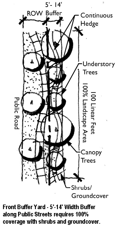
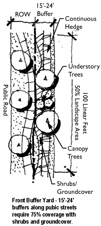
b.
All planted shrub and groundcover areas shall achieve 100 percent coverage of their planting area within one year.
c.
Additional features such as maximum 24-inch knee walls and maximum 48 inch decorative "wrought iron" picket fences shall also be allowable elements. Decorative fences must have at least 50 percent of required buffer planting adjacent to right-of-way.
d.
Permitted features for front buffers - sidewalks, signs, low wall and 'wrought iron' or decorative treated wood picket fences, retention features.
e.
Prohibited features in front buffers - chain-link, untreated non-decorative wood or PVC fences, walls greater than two feet, loading, service or dumpster areas or similar items may not be placed in the front buffer or in any additional 'open space' adjacent to the street.
(3)
Suburban adjacencies for nonresidential parcels.
a.
Landscape buffers between parcels.
1.
A minimum ten-foot landscape buffer is required between adjacent tracts (side and rear property boundaries) with vegetation planted per table 2. shrubs and groundcover shall comprise at least 30 percent of the landscaped area.
2.
On adjoining parcels of similar use, when designed as one buffer (such as adjacent commercial outparcels with automobile and pedestrian cross access), the combined buffers may be reduced to a total of ten feet if the shrub and groundcover landscape areas are increased to at least 75 percent of the total required buffer area. The combined ten-foot buffer shall require a total of two canopy trees and three understory trees per 100 linear feet. No less than five feet is required on each of the two adjoining parcels.
3.
Unless the adjacent parcel has a residential land use, the side requirement can be waived if the building is sited with a zero common lot setback.
4.
Masonry wall: Side or rear buffers adjoining residential land use shall also be designed with a six-foot masonry wall. The wall shall be of a decorative 'split face' concrete masonry, "Norman" brick or standard concrete masonry clad with painted stucco or other masonry veneer. The wall shall include a continuous cap and end column features. The wall shall be placed a minimum of six inches from the adjoining property line. In addition, all active 'yard and shop' spaces with open work areas or other supply areas shall be treated with a similar six-foot masonry wall.
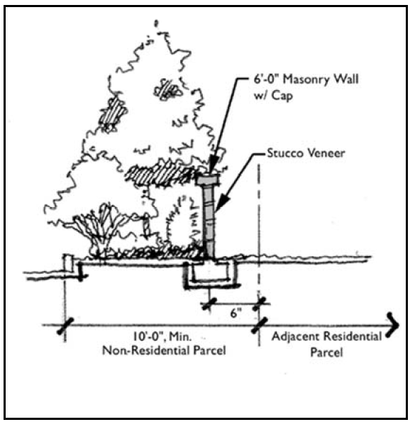
Section of Typical Rear Buffer
- adjacent residential land use requires 6'—0" Masonry wall with cap.
(Ord. No. 16-31, 12-15-2016)
Sec. 115-9.3.3. - Rural design district standards.
(a)
Rural buffer requirements. Existing vegetation within the buffer area shall generally be maintained in its natural condition, but may be modified to restore the overall condition and natural functions of the area. In areas of the buffer that are not densely vegetated, the buffer shall be supplemented with plantings to establish a minimum planting scheme of 4 canopy trees per 100 feet, 6 understory trees per 100 feet and a continuous hedge with a minimum height of three feet at planting. Canopy and understory trees may be clustered to accent entrances or other design features of the site. The areas shall only be irrigated where necessary, follow Florida Friendly Landscape criteria, and provide moisture sensors in any of the conservation open space areas if irrigated. Opaque walls are expressly prohibited within the required buffer area.
(b)
Buffer areas shall be provided as follows:
(Ord. No. 16-31, 12-15-2016)
Sec. 115-10. - Tree protection and vegetation preservation.
Purpose and intent. The purpose of this section is to establish rules and regulations governing the protection of trees and vegetative cover as a valuable community resource within the city; to encourage the proliferation of trees and vegetation within the city as well as their replacement; to recognize their importance and their meaningful contribution to a healthy, beautiful, and safer community attributable to their carbon dioxide absorption, oxygen production, dust filtration, wind and noise reduction, soil erosion prevention, lakeshore erosion protection, wildlife habitat, surface drainage improvement, beautification and aesthetic enhancement of improved and vacant lands; and the general promotion of the health, safety, welfare and well-being of the community. Tree protection is beneficial to the city by improving community appearance and quality of life, enhancing property values, and creating a functional and aesthetically pleasing living environment for existing and future residents. Therefore, the city finds that it is in the best public interest to enact and enforce the regulations described herein for the purpose of controlling tree removal, clear cutting and strip clearing of land.
(Ord. No. 16-31, 12-15-2016)
Sec. 115-10.1. - General requirements and definitions.
(a)
The terms and provisions of this section shall apply to all real property located within the corporate boundaries of the city, except such properties as are exempted herein.
(b)
It shall be unlawful for any person, firm or corporation, either individually or through an agent to cut down, destroy, clear cut, remove, or effectively destroy through damaging any protected tree without first obtaining an approved city tree removal permit, except as specifically exempted herein.
(c)
Developers of sites that have been completely or partially cleared of trees due to agricultural use or other reasons shall be required to comply with the minimum tree requirements as described in section 115-10.7.
(d)
Issuance of a city tree removal permit, or exemption from these requirements, does not exempt any legal obligation or requirement to comply with the regulations of any other governmental agency, local, state, or federal which may have jurisdiction over proposed activity upon the land.
(e)
Trees and vegetative groundcover should be preserved or enhanced in development areas exceeding ten percent slope, within the 100-year floodway, or within 50 feet of the ordinary high water line of lakes, rivers or canals to the greatest extent practicable. This 50-foot buffer area shall remain a natural vegetative buffer zone between development areas and the above-referenced water courses, except for city-approved water-related facilities, such as docks, walkovers, ramps, marinas, etc.
(f)
A protected tree is any tree not listed on the list of noxious/exotic species in section 115-10.9 and meeting one of the following requirements:
(1)
Trees with a DBH of six inches or greater.
(2)
Trees located in a wetland area as determined by the agencies having jurisdiction.
(g)
A specimen tree is a tree designated by the city commission that is rare or unique due to factors such as size, age, ecological value, or type of species having one or more of the following characteristics:
(1)
A diameter of 30 inches DBH or greater.
(2)
A determined age of 50 years or greater.
(3)
A determined ecological value; e.g. wildlife habitat, erosion control, etc.
(4)
A determined unique form or shape due to geography, climate, environment or natural growth conditions.
(5)
A rare, or unique, non-indigenous tree that is not common to the city (but not on the list of noxious/exotic species.
(Ord. No. 16-31, 12-15-2016)
Sec. 115-10.2. - Exemptions.
A tree removal permit (see section 115-10.3, Review procedures, and section 115-10.4, Submission requirements) shall not be required under the following conditions and situations as determined by the director of development services or designee:
(a)
A bona fide agricultural use such as citrus, tree nurseries, forest crops, animal husbandry, and greenhouses.
(b)
Removal of dead trees.
(c)
Removal of trees that are an imminent danger to public or private property, as verified by the director of development services or designee.
(d)
Removal of trees planted on the premises of a plant nursery or tree farm that have been grown expressly for the purpose of selling to the general public in the ordinary course of business.
(e)
Removal of any tree on the list of noxious/exotic species in section 115-10.9.
(f)
Removal of trees within approved utility rights-of-way or easements that are necessary to supply gas, water, sewer, telephone, cable television, electrical service, or other needed utilities. This exemption applies only to authorized personnel of the applicable utility and not to the property owner.
(g)
Public utilities with the power of eminent domain may remove or transplant trees either on-site or off-site without a permit.
(h)
Emergency conditions may require the director of development services or designee to waive all, or part, of the requirements of this chapter in the event of manmade or natural disasters such as hurricanes, tornadoes, floods, storms/high winds, hard freezes, fires, etc. The waiver shall apply to a geographically defined area for a period not to exceed 90 days. Longer periods shall require city commission approval.
(Ord. No. 16-31, 12-15-2016)
Sec. 115-10.3. - Review procedures.
(a)
A tree inventory and tree removal permit application shall be submitted to the director of development services or designee prior to the commencement of any development activity, except as specifically exempted herein.
(b)
Trees may be removed for construction purposes where all reasonable alternatives are exhausted for relocating the specific construction.
(c)
The removal/replacement of trees that are 24 inches DBH or greater is strongly discouraged. Therefore, all reasonable alternatives or methods that are available, such as design modifications, shall be closely examined before removal will be authorized.
(d)
During application review, the director of development services or designee shall consider the effect that the proposed development activity will have on the future viability of the trees to be retained/relocated within the area to be developed.
(e)
A tree removal permit shall be issued, as determined by the director of development services or designee, if one or more of the following conditions exists:
(1)
Street opening. Tree location restricts the opening of a street or road right-of-way.
(2)
Utilities and drainage. Tree location restricts the construction of public utility lines or drainage facilities.
(3)
Property access. Tree location restricts vehicular access to the property, where there are no other reasonable access points.
(4)
Property use. Tree location restricts reasonable use of the property consistent with all other applicable city, county and state codes, statutes and/or ordinances; and design modifications are not practical or reasonable.
(5)
Hazard. A tree that constitutes a hazard to life or property and can be resolved by removal.
(6)
Poor tree health. Tree is diseased, lacking functioning vascular tissue, or deteriorating to such a state that restoration methods to bring the tree to a sound condition are not practical; or the tree has a disease that can be expected to be transmitted to other trees thereby endangering their health.
(7)
Single family home. The protected tree is located within 15 feet of an occupied single family residence, but not within a public right-of-way or on someone else's property. The 15 foot distance shall be measured from the trunk of the subject tree to the dwelling unit structure.
(8)
Thinning of trees. Trees are so densely situated on a parcel as to significantly impair light and air circulation, which causes poor health conditions or tree disease, so that removal of up to 25 percent of such trees is necessary to alleviate the condition.
(9)
Redevelopment.
• For nonresidential developments, mixed use developments, and multi-family developments: The property owner has submitted a revised landscape plan consistent with city regulations for redevelopment of the subject site.
• For developed single family residential lots: The property owner is replacing the tree in another location or with an alternative species. The replacement tree must meet the minimum requirements set forth in section 115-10.7.
• For purposes of these land development regulations, redevelopment shall not be considered a valid condition for removal if the tree removal permit is submitted after the fact.
(f)
An approved city tree removal permit shall identify which trees are to be removed, methods of protection from impacts of construction, and the tree replacement requirements necessary to compensate for the loss of protected trees. The minimum compensation requirement shall be the number of replacement trees required to maintain compliance with the minimum tree requirements included in section 115-10.7.
(Ord. No. 16-31, 12-15-2016)
Sec. 115-10.4. - Submission requirements.
(a)
Clear-cutting of vacant land without an approved development plan is prohibited. All property owners planning to initiate any development activity which has the potential to affect trees and vegetative cover are hereby required to submit a city tree inventory and tree removal permit application. This requirement includes, but is not limited to, the following:
(1)
Developers of all new residential subdivisions shall be required to submit a tree inventory and tree removal permit application at the time of initial preliminary plan submittal to the city, so that due consideration may be given to protection of trees during the subdivision design and review process.
(2)
Developers of any commercial, industrial, multi-family, or other use, requiring site plan approval under the jurisdiction of this land development regulation, shall be required to submit a tree inventory and tree removal permit application at the time of initial site plan submittal to the development services division, so that due consideration may be given to protection of trees during the site plan design/review process. A tree inventory may be shown on the site plan.
(3)
Developers of all new single family and duplex dwelling units shall be required to submit a tree inventory/tree removal permit application at the time of city-issued building permit application. A tree inventory may be shown on the building permit site plan.
(b)
Each tree inventory, for subdivision/site plan review, shall consist of a drawing or accurate representation with an appropriate scale to show tree locations, delineating the following information:
(1)
Property boundaries, existing and proposed structures and surrounding road system;
(2)
Location, number, size, and species (utilizing botanical or common names) of all trees with a six inch dbh or greater within areas to be disturbed by construction. With approval of the director of development services, the inventory requirements may be modified for heavily wooded sites.
(Ord. No. 16-31, 12-15-2016)
Sec. 115-10.5. - Tree replacement.
(a)
All protected trees that have been removed, for which an approved city tree removal permit was required but not obtained and which do not meet the criteria listed under section 115-10.3 (e), will require replacement at a ratio of two replacement trees for each tree removed without a permit and other possible sanctions as determined by the code enforcement board or the special magistrate in accordance with F.S. § 162.09(2)(a).
(b)
All replacement trees shall be a minimum of two inches DBH, ten feet tall, and five feet wide at the time of planting and selected from the approved tree list included in section 115-10.7. Approved ornamental and palm trees shall not exceed 25 percent of tree replacement requirements and at least 50 percent of the trees shall be live oaks.
(c)
Replacement trees shall be planted on-site, if practical, otherwise the developer/property owner shall donate the monetary value of the required trees to the city for the purpose of planting trees on public property.
(d)
All replacement trees shall be in good health, conform to the standards for Florida No. 1 or better as given in Grades and Standards for Nursery Plants, State of Florida, Department of Agriculture and Consumer Services, Tallahassee (97T-05, second edition, February 1998), which is hereby adopted and included by reference herein. A copy of such publication is available from the director of development services or designee.
(e)
Any property owner that removes a protected tree for which an approved City tree removal permit was required, but not obtained, and which also meets the criteria for removal listed under section 115-10.3(e) shall be subject to a $2,500.00 fine per tree.
(Ord. No. 16-31, 12-15-2016; Ord. No. 23-08, § 1, 6-15-2023)
Sec. 115-10.6. - Tree protection during construction.
(a)
Property owners/developers shall protect, during construction, all protected trees within areas to be disturbed by construction activities as identified on an approved tree removal permit. Tree removal, building, or other development permits may be revoked if protective measures are not used at any time during construction.
(b)
The following shall be prohibited within the tree protection zone (defined in chapter 100) of designated trees, unless authorized by the director of development services:
(1)
Parking of heavy equipment, cars and trucks or vehicular traffic;
(2)
Stockpiling of any materials;
(3)
Deposition of soil, sediment, or mulch;
(4)
Grading or grubbing;
(5)
Excavation or trenching;
(6)
Burning or burial of debris, within the entire construction site;
(7)
Dumping oil, gasoline, paint, chemicals, wastewater, or other construction wastes. Storage of potentially hazardous materials shall be in appropriate, non-leaking containers as far away from tree protection zone as possible.
(Ord. No. 16-31, 12-15-2016)
Sec. 115-10.7. - Minimum tree planting requirements.
(a)
All properties requesting development approval (residential and nonresidential) must meet minimum tree requirements as specified below unless otherwise exempted.
(b)
Minimum tree requirements.
(c)
One of the minimum number of trees required shall be planted as a street tree. Such tree shall be planted prior to occupancy of the structure and shall be a maximum of ten feet inside the front property line.
(d)
All property owners/developers that are requesting building permits/development approvals for individual lots (single family or duplex), or individual lots within an approved subdivision (see section 115-10.4, Submission requirements), must meet minimum tree requirements for each specific lot prior to the issuance of a certificate of occupancy, unless otherwise exempted.
(e)
Proper care and maintenance of recently planted trees and vegetation; i.e., necessary water, fertilizer, and support structures, shall be the property owner's/developer's responsibility and be guaranteed for the duration of an approved maintenance agreement (two years) with the city. Upon sale of an individual lot, the responsibility for care and maintenance of trees is transferred to the new property owner of said individual lot.
(f)
Ongoing maintenance is required and shall consist of mowing, removal of litter and dead plant materials, necessary pruning, watering, fertilizing and replacing frozen or dead plants and trees. In the event vegetation or trees die over time, replacement of vegetation specific to genus and species shall be as originally illustrated on the approved site plan.
(g)
If required, the property owner will replace trees that do not survive during the approved maintenance agreement time period. The replacement tree shall fulfill the duration of the maintenance agreement.
(h)
Trees used in fulfillment of the requirements of this section shall be a minimum of two inches DBH and ten feet tall and five feet wide at the time of planting and selected from the approved tree list (section 115-10.7(f)). Approved ornamental and palm trees shall not exceed 25 percent of minimum tree requirements. All required trees shall be in good health, conform to the standards for Florida No. 1 or better, as given in the Grades and Standards for Nursery Plants, State of Florida, Department of Agriculture and Consumer Services as referenced herein. Trees used to meet these minimum tree requirements can also be used in calculations for minimum buffer requirements in chapter 110 of this land development regulation.
(i)
Trees and shrubs permitted within the city shall include but not be limited to the following:
Ash (Fraxinus sp.)
Atlantic White Cedar (Chamaecyparis thyoides)
Basswood (Tilia sp.)
Black Gum/Tupelo (Nyssa sylvatica)
Cabbage Palm (Sabal palmetto)
Cedar (tree form only) (Juniperus spp.)
Chickasaw Plum (Prunus angustifolia)
Crape Myrtle (Lagerstroemia indica)
Cypress (Taxodium spp.)
Date Palms (Phoenix spp.)
Devilwood (Osmanthus americanus)
Fringe Tree (Chionanthus virginicus)
Elm (Ulmus spp.)
Flowering Dogwood (Cornus florida)
Hackberry (Celtis spp.)
Hickory (Carya spp.)
Holly (tree form only) (Ilex spp.)
Hornbeam/Blue Beech (Carpinus caroliniana)
India Rosewood (Dalbergia sissoo)
Jerusalem Thorn (Parkinsonia aculeata)
Loblolly Bay (Gordonia lasianthus)
Loquat (Eribotrya japonica)
Magnolia (Magnolia spp.)
Maple (Acer spp.)
Oak (Quercus spp.)
Persimmon (Diospyros virginiana)
Pine (Pinus sp.)
Red Bay (Persea borbonia)
Redbud (Cercis canadensis)
Red Mulberry (Morus rubra)
Southern Wax Myrtle (Myrica cerifera)
Sparkleberry (Vaccinium arboreum)
Sweetgum (Liquidambar styraciflua)
Sycamore (Platanus sp.)
Tulip Poplar (Liriodendron tulipifera)
Washington Palm (Washingtonia robusta)
Willow (Salix sp.)
Fruit Trees:
Apple (Malus spp.)
Apricot (Prunus armeniaca)
Grapefruit (Citrus paradisi)
Lemon (Citrus limon)
Lime (Citrus aurantiifolia)
Orange (Citrus sinensis spp.)
Tangerine (Citrus reticulata)
Tangelo (Citrus reticulata x paradisi)
Fig (Ficus carica)
LeConte Pear (Pyrus communis x LeConte)
Plum (Prunus salicina)
(Ord. No. 16-31, 12-15-2016)
Sec. 115-10.8. - Voluntary planting.
(a)
Nothing in this chapter shall be construed to prohibit the planting of trees or vegetation except that which is identified on the list of noxious/exotic invasive species (section 115-10.9(a)). Trees and/or other plants indicated on the list of noxious/exotic invasive species shall not be planted in the city. Noxious/exotic invasive species (section 115-10.9(a)) shall be removed from all development sites as a part of the normal site preparation activity.
(b)
Permission from the director of development services shall be required prior to planting, pruning, or removing any tree in public parks, road rights-of-way, or other publicly owned property.
(Ord. No. 16-31, 12-15-2016)
Sec. 115-10.9. - Removal of noxious/exotic invasive species.
(a)
Specific plant species, which are prohibited within the city, are as follows:
(1)
Canopy and understory trees.
a.
Australian Pine (Casuarina spp.).
b.
Melaleuca (Melaleuca quinquenervia).
c.
Chinaberry (Melia azedarach).
d.
Ear Tree (Enterlobium cyclocarpum).
e.
Eucalyptus species (Eucalyptus spp.).
f.
Brazilian Pepper (Schinus terebinthifolius).
g.
Paper Mulberry (Broussonetia papyrifera).
h.
Silk Oak (Grevillea robusta).
i.
Empress Tree (Paulownia tomentosa).
j.
Tree of Heaven (Ailanthus altissima).
k.
Chinese Tallow Tree (Sapium sebiferum).
l.
Japanese Tallow Tree (Sapium japonicum).
m.
Camphor (Cinnamomum camphora).
n.
California Privet* (Ligustrum ovalifolium).
*both shrub and tree forms.
o.
Cedar Gum (Eucalyptus gunnii).
(2)
Shrubs, vines, and ground covers.
a.
Air potato/air yam (Dioscorea bulbifera).
b.
Downy rose myrtle (Rhodomyrtus tomentosa).
c.
African Bowstring Hemp (Sansevieria hyacinthoides).
d.
Castor Bean Plant (Ricinus communis).
e.
Kudzu (Pueraria lobata Willd.).
(b)
Removal of plants listed on the list of noxious/exotic invasive species (section 115-10.9(a)) is required as a part of normal site preparation and shall not require a city tree removal permit.
(Ord. No. 16-31, 12-15-2016)
Sec. 115-10.10. - Harmful acts.
(a)
No person shall abuse, mutilate or otherwise damage any protected tree, as described herein, or any tree located on public property, including those trees located in the public right-of-way along street frontages within subdivisions.
(b)
However, nothing in this section shall be construed to prevent reasonable and proper trimming of trees on public or private property by authorized persons in accordance with accepted horticultural methods established by the International Society of Arborists (ISA).
(c)
Any person who mutilates a tree in conflict with this section shall be required to remove the tree and will be required to comply with tree replacement provisions per section 115-10.5.
(d)
No person shall attach any signs in an injurious manner to any tree, nor shall any person cause any substance harmful to trees to come in contact with them, or prevent water or oxygen from reaching their roots by excessive cut and fill activities.
(Ord. No. 16-31, 12-15-2016)
Sec. 115-10.11. - Appeals.
(a)
It is the intent of this chapter that all questions of interpretation and enforcement shall be presented to the city commission.
(b)
An application for appeal of said decisions shall be presented in accordance with chapter 102 of this land development regulation on matters of interpretation and to the code enforcement board on matters of enforcement.
(Ord. No. 16-31, 12-15-2016)
Sec. 115-11. - Signage.
(a)
Purpose and intent. This section creates the legal framework for signage regulation that is intended to:
(1)
Properly protect the right of the public to engage in free speech;
(2)
Provide for adequate business identification, advertising, and communication;
(3)
Provide for the safety and welfare of the public;
(4)
Ensure an attractive and well-maintained community appearance;
(5)
Maintain the residential character of neighborhoods in Residential land use districts.
(b)
Severability. If any section, sentence, clause, phrase or word of this section is for any reason held, or declared to be unconstitutional, inoperative or void, such holding or invalidity shall not affect the remaining portions of this section; and it shall be construed to have been the city commission's intent to adopt these regulations without such unconstitutional, invalid or inoperative part therein. If this section or any provisions thereof shall be held inapplicable to any person, groups of persons, property, kind of property, circumstances or set of circumstances, such holding shall not affect the applicability thereof to any other person, property or circumstances.
(c)
Substitution. Signs containing noncommercial speech are permitted anywhere that advertising or business signs are permitted, subject to the same regulations applicable to such signs.
(d)
General requirements. All signage shall advertise only those products or services offered or carried on at the premises where the sign is located, except as specifically provided for herein. The use of signs visible from public rights-of-way shall be permitted, provided required permits are obtained and provided the signs are:
(1)
Compatible with their surroundings, of proper design and consistent with future land use and design district requirements;
(2)
Meet the sign user's needs while at the same time promoting the quality environment desired by the general public;
(3)
Designed, constructed, installed and maintained in such a manner that they do not endanger public safety or traffic safety;
(4)
Legible, readable and visible in the circumstances in which they are used;
(5)
Respectful of the reasonable rights of other advertisers whose messages are displayed.
(6)
Not constructed so as to exhibit any of the following characteristics and/or functions:
a.
Pose a danger or interfere with the peace, health, safety, or welfare of the public.
b.
Cause an obstruction to free use of public streets or sidewalks.
c.
Obstruct windows used for fire egress or fire escapes.
d.
Be obscene, immoral or indecent in design, display, word, statement, character, or illustration.
e.
No private sign shall be so designed or located in any manner or any color combination so as to be confused with any authorized traffic signal, sign or device.
(e)
Structural requirements and construction standards. All construction inspections and determinations shall be in accordance with chapter 118, construction standards, of this land development regulation.
(f)
Unsafe signs. When a sign has been deemed unsafe or not properly constructed, the property owner shall be notified in writing of the deficiencies and required to take appropriate remedial action or remove the sign within 48 hours of notification.
(Ord. No. 16-08, § 2(Exh. A), 4-7-2016; Ord. No. 16-31, 12-15-2016)
Sec. 115-11.1. - Permits required.
(a)
Sign permits. Prior to erecting, displaying, or replacing any sign visible from the public right-of-way the property owner shall obtain a permit from the city building department, by providing a legal description of the property, a scaled and dimensioned drawing of the proposed sign, furnishing any information or specifications as deemed necessary, and a site plan showing all existing signs, the proposed sign location, setbacks to the closest property lines, and by making payment of all applicable fees.
(1)
Exceptions. Those signs exempted in section 110-11.3.
(2)
Fees doubled.
a.
For any sign erected, displayed or replaced prior to obtaining the required permits, the specified fees shall be doubled.
b.
Payment of said double fee shall not relieve any person from complying with any city code.
(3)
Violations.
a.
Failure to obtain a permit.
b.
Performing work other than that which is described in the permit.
c.
Failure to maintain proper setbacks.
d.
Failure to conform to the provisions of this or other chapters.
e.
Failure to keep sign in proper repair.
(4)
Penalty and enforcement. In addition to double fees as described, any action deemed a violation of this chapter is enforceable by the code enforcement process according to the city code of ordinances.
(5)
Fee schedule shall be adopted by resolution of the city commission.
(Ord. No. 16-08, § 2(Exh. A), 4-7-2016; Ord. No. 16-31, 12-15-2016)
Sec. 115-11.2. - Sign standards.
(a)
Signage. Signs shall be permitted on developed properties:
(1)
In all commercial, industrial and mixed use land use districts.
(2)
In public/institutional and agricultural land use districts.
(3)
On any property where the city commission has approved a conditional use permit, provided that signs comply with restrictions (if any) adopted with the CUP ordinance.
(4)
On any property in a residential land use district where an existing legally conforming or non-conforming non-residential use exists.
(5)
In all residential and conservation land use districts only as specifically addressed herein.
(b)
Free-standing signs non-residential uses. Free standing signs in commercial, industrial, mixed use, public institutional and agricultural land use districts, or on property with an approved a conditional use permit for a non-residential use, or on any property in a residential land use district where an existing legally conforming or non-conforming non-residential use exists, shall be limited to multi-tenant ground signs and single tenant ground signs as described herein.
(1)
Maximum number of signs. The number of freestanding signs shall be limited as follows.
a.
Basic allowance. One double faced or single faced sign per parcel.
b.
Additional allowance. Developments with 500 feet of frontage or more on a major arterial road with more than one ingress/egress shall be permitted one additional sign. The minimum separation for all signs on a parcel shall be at least 200 linear feet.
c.
Corner lots. If a building is located on a corner lot with two street-facing sides, one sign may be located on each side served by an entryway provided there is a minimum separation of 200 linear feet.
(2)
Address. All freestanding signs must:
a.
Contain the street address number (the address will not count towards the copy area) of the property:
b.
Be displayed in a contrasting color with address numbers at a minimum height of six inches a maximum height of 12 inches.
(3)
Setbacks. Minimum setbacks for sign(s) shall be as follows:
a.
In all corridor design districts (urban, suburban, and rural):
Street setback: Five feet
Common lot setback: Ten feet
Rear setback: Ten feet
b.
Suburban and rural development design districts (district, center and neighborhood):
Street setback: Ten feet
Common lot setback: Ten feet
Rear Setback: Ten feet
c.
Urban development design districts (all):
Street setback: Five feet
Common lot setback: Ten feet
Rear setback: Ten feet
(4)
Additional standards.
a.
Height. Sign(s) shall be a maximum of 15 feet, measured from adjacent finished grade to the top of the sign supporting structure.
b.
Size. The maximum size of the background structure of a sign shall not exceed 110 percent of the total square footage of copy area. For example, 50 square foot of copy area can have 55 square feet of background structure area.
c.
Copy area. The maximum allowable copy area of any single, stand-alone tenant ground sign and the maximum allowable copy area for any single tenant within a multi-tenant parcel shall be determined by Table 4.0. The total maximum allowable copy area for a multi-tenant ground sign shall not exceed 150 square feet.
d.
Support base. The ground sign base shall be encased and meet the following standards:
1.
Signs shall be in an enclosed base possessing a minimum width of two-thirds the width of the sign.
2.
Base shall be designed to be compatible with the architecture of the building or other site features.
3.
A minimum depth of 36 inches of landscaping shall be incorporated around the base to include low growing shrubs and ground cover and/or flowering annual to promote color. This landscaping may also be credited to the landscaping requirements in chapters 110 and 115.
* Multi-tenant signs are limited to a total of 150 square feet of copy area
Single Tenant Ground Sign
Multi-Tenant Ground Sign
(c)
Free-standing signs-residential and conservation uses. Free standing signs in mixed use, residential and conservation land use districts shall be limited to residential subdivision/entry feature signs to identify the name of a residential subdivision, multi-family development or nature/ecology/park facility. Any sign that does not adhere to the conditions contained herein may be approved by the city commission as part of a site plan/preliminary subdivision plat.
(1)
Maximum number of signs: The number of freestanding signs shall be limited as follows.
a.
Basic allowance: One double faced or single faced sign per approved residential subdivision, multi-family development, or nature/ecology/park facility in a conservation land use.
b.
Additional allowance: Subdivision developments with more than one ingress/egress shall be permitted one additional sign. The minimum separation for all signs on shall be at least 200 linear feet.
c.
Corner lots: If a multi-family development is located on a corner lot with two street-facing sides, one sign may be located on each side served by an entryway provided there is a minimum separation of 200 linear feet.
(2)
Address. All freestanding signs must:
a.
Contain the street address number (the address will not count towards the copy area) of the property:
b.
Be displayed in a contrasting color with address numbers at a minimum height of six inches a maximum height of 12 inches.
(3)
Setbacks. Minimum setbacks for sign(s) shall be as follows:
a.
In all corridor design districts (urban, suburban, and rural):
Street setback: Five feet
Common lot setback: Ten feet
Rear setback: Ten feet
b.
Suburban and rural development design districts (district, center and neighborhood):
Street setback: Ten feet
Common lot setback: Ten feet
Rear setback: Ten feet
c.
Urban development design districts (all):
Street setback: Five feet
Common lot setback: Ten feet
Rear setback: Ten feet
(4)
Additional standards.
a.
Height. Sign(s) shall be a maximum of ten feet, measured from adjacent finished grade to the top of the sign supporting structure.
b.
Size. The maximum size of the background structure of a sign shall not exceed 110 percent of the total square footage of copy area. For example, 50 square foot of copy area can have 55 square feet of background structure area.
c.
Copy area. The maximum allowable copy area of any single ground sign shall be determined by Table 4.1.
d.
Support base. The ground sign base shall be encased and meet the following standards:
1.
Signs shall be in an enclosed base possessing a minimum width of two-thirds the width of the sign.
2.
Base shall be designed to be compatible with the architecture of the building or other site features.
3.
A minimum depth of 36 inches of landscaping shall be incorporated around the base to include low growing shrubs and ground cover and/or flowering annual to promote color. This landscaping may also be credited to the landscaping requirements in chapters 110 and 115.
(d)
Building signs nonresidential uses. Building signs are permitted in commercial, industrial, mixed use, public institutional and agricultural land use districts, or on any property with an approved a conditional use permit for a nonresidential use, or on any property in a Residential land use district where an existing legally conforming or non-conforming nonresidential use exists, with the following provisions.
(1)
Types of signs. Building signs shall be limited to wall, canopy, awning, marquee, and projecting signs.
(2)
Maximum number of signs. In corridor districts, up to two building signs are permitted per building elevation. In all other design districts, up to two building signs are permitted per building frontage.
Building Signs - Elevation, Plan & Section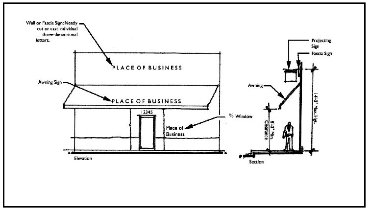
(3)
Placement. The permitted building signs may be placed on the wall, awnings, or be a projecting sign in compliance with the following standards:
a.
Building signs (wall, awning, marquee, canopy).
1.
Wall signs shall display only one surface, shall not be mounted more than 6 inches from any wall, and shall not project more than 12 inches from the building.
2.
The maximum combined copy area for building signs, including any sign backgrounds, shall be as follows:
Corridor design districts: One hundred square feet per building frontage, maximum letter size 36 inches, maximum logo size 48 inches. Maximum copy area may be distributed per sign and along building elevations as desired by the business consistent with the maximum number of signs permitted above; however, copy area per building elevation shall not exceed 100 square feet.
All other design districts: Seventy-two square feet per building frontage, maximum letter size 24 inches, maximum logo size 24 inches. Maximum copy area may be distributed per sign as desired by the business consistent with the maximum number of signs permitted above; however, copy area per building elevation shall not exceed 72 square feet.
b.
Projecting signs shall be limited to occupants that have a minimum of 20 feet of occupied building frontage provided that:
1.
All projecting signs shall not exceed four square feet and shall have a minimum clearance of eight feet from the ground to the bottom of the sign. A projecting sign may be a minimum of six feet from the ground when it is located above a landscaped area or other area that does not permit pedestrian traffic beneath said sign;
2.
The projecting sign shall be placed on the building so that said signs are intended to be viewed by the pedestrians on the abutting street or pedestrian way;
3.
The projecting sign shall not extend more than four feet from the wall of the building on which it is erected and shall not extend above the roofline or the parapet of the wall of the building on which it is erected;
4.
The maximum copy area shall be four square feet. Additional square footage may be permitted in the urban center if the sign is creative and expressly identifies a historic character in nature. In no event shall a sign exceed 20 square feet.
(e)
Building signs residential uses. Building signs to identify the name of a multi-family development are permitted in mixed use and residential land use districts for multi-family development with three or more units, as an alternative to a free-standing entry feature sign, with the following provisions.
(1)
Types of signs. Building signs shall be limited to wall, canopy, awning, and marquee.
(2)
Wall signs shall display only one surface, shall not be mounted more than six inches from any wall, and shall not project more than 12 inches from the building.
(3)
Maximum number and copy area of signs. One building sign per building frontage. The maximum copy area per sign, including any sign backgrounds, shall be as follows:
36 square feet, maximum letter size 24 inches, maximum logo size 24 inches
(f)
Signage, other.
(1)
Window signs. Total area of all window signs shall not exceed 50 percent of the total glass area of the building.
(2)
Changeable copy signage. Freestanding signs may have up to 50 percent of the permitted copy area as changeable copy or digital display. Digital signs may not change the display within a time period of less than six seconds.
(3)
Flags. A flag is any fabric or other flexible material attached to or designed to be flown from a flagpole. Standards are as follows:
a.
Only two such flags shall be permitted.
b.
The flags shall not be flown higher than a 35 foot pole, measured from grade.
c.
Only one flag per pole up to six feet by ten feet, or two flags per pole up to four feet by six feet, may be flown.
d.
The flag shall maintain a five foot setback to any property line.
(4)
In the central business district, one additional A-Frame or T-Frame sign, a maximum of eight square feet, shall be permitted in conjunction with an approved right-of-way utilization permit for outdoor seating areas, outdoor planters and/or additional signage.
(5)
Illumination. Freestanding and building signs may be illuminated in compliance with the following:
a.
Internally illuminated.
1.
The sign shall be constructed with either: an opaque background and translucent letters and symbols; or, a translucent darker colored background with a lighter contrasting color for the letters and symbols.
2.
No internal lighting shall include exposed incandescent or fluorescent bulbs.
b.
External illuminated.
1.
The lighting of signs that have a height of eight feet or less may be illuminated from the top of the sign or from the ground. The lighting of all other signs must be from the top of the sign and directed downward;
2.
Indirect light sources must be shielded from the view of persons viewing the sign and be further shielded and directed so that the light shines only on the sign and that illumination beyond the copy area is minimized.
(6)
Maintenance.
a.
Maintenance. All signs shall be maintained in good condition and working order, and be free of graffiti, peeling paint, faded colors, and/or broken and damaged materials. Grass and weeds shall not exceed a 12-inch height at or near the base of any sign.
b.
Discontinued signs. The owner of any permanent sign, for which the activity associated with such sign has been discontinued for a period of 90 or more consecutive days shall remove the sign, or, if desired, leave the background structure in place and replace the copy area with a blank insert, or paint over the copy area.
(Ord. No. 16-08, § 2(Exh. A), 4-7-2016; Ord. No. 16-31, 12-15-2016)
Sec. 115-11.3. - Exemptions.
No permit required. The following signs shall be exempt from the permitting requirements of this chapter and may be displayed provided that they meet all applicable standards contained herein:
(a)
Standards:
(1)
All signs permitted under this section shall be property secured to avoid the potential of the sign to become a projectile, and to prevent waiving or flapping.
(2)
All signs permitted under this section shall be placed on private property, except as specifically provided for herein, and must maintain a minimum five-foot setback to any property line.
(3)
The owner of any sign under this section, for which the activity associated with such sign has been discontinued for a period of 14 days, shall remove the sign and all associated background and/or supporting structures.
(b)
All land use districts (developed and vacant property):
(1)
Public signs. Public signs shall be permitted as approved by the city manager or designee. Public signs shall be those signs that are deemed in the public interest and/or for advertised activities of governmental organizations or government sponsored events and could include types of signs that would not otherwise be permitted.
(2)
Any sign required by a valid and applicable federal, state or local law.
(3)
A single non-illuminated non-commercial message sign not exceeding eight square feet.
(4)
Additional signage may be displayed under the following conditions:
a.
On properties with an active home occupation business tax receipt: A single non-illuminated sign not exceeding one square foot in area mounted flat against a wall of a structure.
b.
On properties with an approved garage sale permit: A single non-illuminated sign not exceeding four (4) square feet.
c.
On properties with an approved special event permit:
Two non-illuminated signs not exceeding 24 square feet each.
d.
On properties with an active listing for sale:
Residential districts: A single non-illuminated sign not exceeding 12 square feet.
Commercial, mixed use and other districts: A single non-illuminated sign not exceeding 32 square feet.
Corner lots and thru lots may have one sign per street frontage.
e.
On properties with an approved subdivision plat with active listings for sale:
A single non-illuminated sign not exceeding 64 square feet.
Subdivisions with more than one ingress/egress may have one sign per street entrance.
f.
On properties with an active building permit:
Residential districts: A single non-illuminated sign not exceeding 32 square feet,
Commercial, mixed use and other districts: Either a single non-illuminated sign not exceeding 64 square feet, or three non-illuminated signs of 20 square feet each.
g.
During the period between election qualifying and its subsequent election:
Residential districts: A single non-illuminated sign not exceeding 16 square feet.
Commercial, mixed use and other districts: A single non-illuminated sign not exceeding 32 square feet.
(c)
Non-residential uses in all commercial, industrial and mixed use land use districts, or public/institutional and agricultural land use districts, or on property with an approved conditional use permit for a non-residential use, or on any property in a residential land use district where an existing legally conforming or non-conforming non-residential use exists, or in conservation land use districts where a nature/ecology/park facility exists, may display the following additional signs.
(1)
Temporary signs. An informational display, banner, or other advertising device constructed of cloth, vinyl, canvas, fabric, or other temporary material with or without a structural frame, having a period of display not to exceed 12 months.
One non-illuminated sign per building frontage not exceeding 24 square feet.
2.
Blade signs. A flag-like banner sign, also known as feather signs or teardrop flags:
One per 50 linear feet of street frontage not to exceed three and one-half feet wide and 15 feet high, with a maximum of ten per property. A minimum of 50 feet must be maintained between blade signs.
(Ord. No. 16-08, § 2(Exh. A), 4-7-2016; Ord. No. 16-31, 12-15-2016)
Sec. 115-11.4. - Prohibited signs.
(a)
The following signs are prohibited if they are visible from the public right of way:
(1)
Off-site advertising signs, structures, or devices.
(2)
Attention getting signs and devices, except digital message and text signs displayed in compliance with this chapter, including but not limited to:
(3)
Any advertisement, banner, paper, notice or sign placed, painted, pasted, printed, or nailed, or attached in any other manner, on public property or right-of-way, except as permitted in other sections of this chapter, including but not limited to:
(4)
Any advertisement, banner, paper, notice or sign placed, painted, pasted, printed, or nailed, or attached in any other manner on private property, except as permitted in other sections of this chapter, including:
(5)
No sign, permanent or temporary, erected or placed that interferes with a clear sight triangle distance per Florida Department of Transportation (FDOT) design standards.
(6)
Roof signs.
(7)
Pole sign.
(8)
Pylon sign.
(9)
Unauthorized signs prohibited. Unauthorized signs are prohibited on public property, private property and rights-of-way of the city, county, state, or federal government ("right-of-way"). An unauthorized sign is any sign or other material placed on public property, private property, or a right-of-way by a person without the permission of the property owner.
(b)
Enforcement. Any person who erects, places, or constructs a sign or other material on any property (public, private or a right-of-way) without the permission of the property owner shall immediately cease the activity and may be issued a citation by the City of Eustis punishable by a fine not to exceed $500, as authorized under F.S. § 162.21(5), and sections 2-57 and 2-58 of the City of Eustis Code of Ordinances. Each action in violation of this section shall constitute a separate offense. Issuance of a citation does not preclude an action for injunction, issuance of a trespass warning where authorized, or any other legal remedy available to the City of Eustis, including charging an offender with criminal trespass after a proper trespass warning. Any unauthorized sign or other material may be immediately removed and discarded by the property owner without notice.
(Ord. No. 16-08, § 2(Exh. A), 4-7-2016; Ord. No. 16-31, 12-15-2016; Ord. No. 22-17, § 1, 6-16-2022)
Sec. 115-11.5. - Conditional signs.
(a)
Permitted. Permanent signs that are not addressed or permitted in this section may be permitted as conditional signs when there are unique situations or circumstances which require individual review of the location, size, and impact in order to determine the appropriateness of the sign on a particular site and its compatibility with adjacent uses.
(b)
Public hearing. The city commission may approve a conditional sign by resolution in a public hearing in accordance with section 102-7.
(c)
Conditions. The city commission may attach conditions and limitations to the approval as necessary to carry out the spirit and purpose of the land development regulations and the comprehensive plan and to prevent or minimize adverse impacts. These conditions may include, but are not limited to, size, duration, landscaping and lighting.
(d)
Findings. In approving conditional signs, the city commission shall make the following findings:
(1)
There are special circumstances and conditions peculiar to the site, the business, or the sign that are not applicable to other sites or businesses.
(2)
The approval does not grant any special privilege denied to other sites or businesses.
(3)
The sign is compatible with its environment and does not create any unsafe conditions or detriments to the public welfare.
(Ord. No. 16-08, § 2(Exh. A), 4-7-2016; Ord. No. 16-31, 12-15-2016)
Sec. 115-11.6. - Variances.
Applications of the regulations may be varied in accordance with chapter 102 of this land development regulation, where, owing to special conditions, a literal enforcement of the provisions of this ordinance will, in an individual case, result in practical difficulty or unnecessary hardship peculiar to property and not people. Such variance may be granted in such individual case as provided for in section 102-31 of this land development regulation. An application review and processing fee will be paid upon application for consideration of a variance in accordance with a fee schedule approved by the city commission.
(Ord. No. 16-08, § 2(Exh. A), 4-7-2016)
Sec. 115-11.7. - Nonconforming signs.
(a)
Alterations. Legally existing signs that do not conform to the standards of this chapter are deemed to be non-conforming signs and the overall size cannot be increased; nor may the size of the copy area of the sign be changed; nor may the height be increased; nor may the location be changed unless the sign is made to conform to the requirements of this chapter. The copy area/message/logo may be changed if the sign is not altered in any other way.
(b)
Demolition. All non-conforming signs shall be removed or made to conform when the sign is substantially demolished. For purposes of this section, a sign shall be considered substantially demolished when either:
(1)
More than 50 percent of the upright supports of a sign structure are physically damaged such that normal repair practices of the industry would call for, in the case of wooden sign structures, replacement of the broken supports and, in the case of a metal sign structure, replacement of at least 25 percent of the length above ground of each broken, bent, or twisted support; or
(2)
The replacement materials cost to re-erect the sign in the same condition as the previously existing sign exceeds 50 percent of the value of the structural materials in the sign immediately prior to destruction. Structural materials shall include all materials constituting the sign including the face, braces, poles, and any other component necessary for the sign to display a message, but shall not include any materials to replace or repaint any message or copy on the face of the sign. The value of the structural materials in the sign immediately prior to destruction shall be based on the cost of all structural materials contained in the sign as it was configured just prior to damage and the cost of such materials shall be based on normal market cost as if purchased new on or about the date of destruction, without regard to labor costs or special marketing conditions.
(Ord. No. 16-08, § 2(Exh. A), 4-7-2016; Ord. No. 16-31, 12-15-2016)