
Farmers Branch City Zoning Code
ARTICLE 5
- SPECIAL DISTRICTS
5.1 - FLOOD PLAIN
A.
Flood Plain Prefix
To provide for the appropriate use of land that has a history of inundation or is determined to be subject to flood hazard, and to promote the general welfare and provide protection from flooding, portions of certain districts are designated with a Flood Plain Prefix, "FP." Areas designated on the Zoning District Map by an "FP" Prefix shall be subject to the following provisions:
B.
Uses Permitted
The permitted uses in that portion of any district having a Flood Plain ("FP") prefix shall be limited to the following:
1.
Agricultural activities including the ordinary cultivation or grazing of land and legal types of animal husbandry.
2.
Off-street parking incidental to any adjacent main use permitted in the district.
3.
Electrical substation.
4.
All types of local utilities including those requiring Specific Use Permits when approved as provided in Section 6.5.
5.
Parks, community centers, playgrounds, public golf courses.
6.
Private open space.
7.
Heliport when approved by specific use permit as provided in Section 6.5.
C.
Flood Plain Requirements
In addition to the provisions of this zoning ordinance applicable to the zoning district in which the subject land is located, the use and development of land located within an area of special flood hazard or controlled flood protection shall be subject to the provisions of Chapter 42 of the Code of Ordinances, as amended. In the event of any irreconcilable conflict between the provisions of this zoning ordinance and said Chapter 42, the provisions of said Chapter 42 shall control.
(Ord. No. 3415, § 1(Exh. A), 1-20-2017)
5.2 - HISTORIC LANDMARK PRESERVATION
A.
Historic Landmark
1.
Any zoning district designation appearing on the Zoning District Map may be followed by the suffix "H" indicating a Historic Landmark subdistrict. Such subdistrict may include buildings, land, areas, or districts of historical, architectural, archaeological, or cultural importance or value which merit protection, enhancement, and preservation in the interest of the culture, prosperity, education, and welfare of the people.
2.
The "H" designation shall apply to those premises, lots, or tracts designated through procedures set forth in this zoning ordinance. Additional uses may be permitted in any specific "H" subdistrict and shall be enumerated in the ordinance establishing such subdistrict. Such suffix shall not affect the legal use of the property except as provided in the ordinance establishing the subdistrict.
B.
Defined
As used in this section, the term "Historic Landmark" shall mean any buildings, land, areas or districts of historical, architectural, archaeological, or cultural importance or value, which the City Council determines shall be protected, enhanced, and preserved in the interest of the culture, prosperity, education and welfare of the people.
C.
Declaration of Policy
The City Council finds and declares as a matter of public policy that the protection, enhancement, preservation and use of historic landmarks is a public necessity and is required in the interest of the culture, prosperity, education and welfare of the people.
D.
Designation
1.
The City Council may designate certain buildings, land, areas, and districts in the City as historic landmarks and define, amend and delineate the boundaries by establishing a historic landmark designation in the same manner as required to amend, repeal or alter the zoning on a tract or parcel of land.
2.
The suffix "H" shall indicate the zoning subdistrict designation of those buildings, land, areas and districts which the City Council has designated historic landmarks.
3.
Such designation shall be in addition to any other zoning district designation established in the zoning ordinance. All Zoning District Maps shall reflect the designation of a historical landmark subdistrict by the letter "H" as a suffix.
E.
Criteria to Be Used in Determination
In making such designation as set forth in Section 5.2D, the City Council and the Commission shall consider one or more of the following criteria:
1.
Character, interest or value as part of the development, heritage or cultural characteristics of the City of Farmers Branch, State of Texas, or the United States;
2.
Identification with a person or persons who significantly contributed to the culture and development of the City;
3.
Location as the site of a significant historic event;
4.
Exemplifications of the cultural, economic, social, or historical heritage of the City;
5.
Relationship to other distinctive buildings, sites, or areas which are eligible for preservation according to a plan based on historical, cultural or architectural motif;
6.
Unique location of singular physical characteristics representing an established and familiar visual feature of a neighborhood, community or the City;
7.
Value as an aspect of community sentiment or public pride.
F.
Removal, Demolition or Substantial Alteration
1.
If an application is received by the Building Department for demolition, removal, razing or substantial reconstruction of any designated historic landmark, the Commission shall hold a public hearing, and make a recommendation to the City Council on whether to grant or deny the application.
2.
No permit shall be issued to demolish, remove, raze or substantially alter or reconstruct until such matter is resolved.
3.
The Commission shall conduct a hearing within 30 days of receipt of the application by the Director.
4.
After the public hearing, the Commission shall recommend to the City Council whether to grant or deny the application.
G.
Council Action
The City Council shall consider the Commission's recommendation not later than 30 days after the Commission close of the meeting at which the Commission voted on its recommendation. The City Council, after conducting a public hearing and taking into consideration all of the factors presented, may approve or disapprove the application for a permit to demolish, remove, raze, or substantially alter or reconstruct. The Council's action shall be final.
H.
Present Use Not Affected
Use classifications of all property included in a historic landmark subdistrict shall continue to be governed by this zoning ordinance.
(Ord. No. 3415, § 1(Exh. A), 1-20-2017)
5.3 - PLANNED DEVELOPMENT DISTRICT (PD)
A.
Creation
A Planned Development District may be created relating to the use and development of property within the City for any one or more uses which are otherwise permitted within the City but which use requires the adoption of customized use and development regulations in order to provide a development which will be appropriate given the location of the property and the uses of property within close proximity to the property being developed.
B.
Detailed Site Plan
1.
No development on property located within a Planned Development District established in accordance with this section shall commence prior to approval of a Detailed Site Plan relating to the development of such property by the City Council following review and recommendation by the Commission.
2.
No building permit shall be issued for property located in a Planned Development District until approval of a Detailed Site Plan for the property on which the permit is sought.
3.
A Detailed Site Plan for property located within a Planned Development District shall be substantially consistent with the development regulations of the Planned Development District in which the property is located and, as a minimum, set forth the following:
a.
Requirements for ingress and egress to the property;
b.
Locations and dimensions of public and/or private streets or drives;
c.
Identify adequate right-of-way to be dedicated to conform to the City's thoroughfare plan, if applicable;
d.
The location of sidewalks, utilities, drainage facilities, and on-street and off-street parking areas and space;
e.
Height of buildings;
f.
Maximum lot coverage;
g.
Locations and area of yards and open spaces;
h.
Design and location of screening walls and/or fences;
i.
A detailed landscaping plan;
j.
Building locations;
k.
Location and area of recreation areas; and
l.
Details of protective requirements considered necessary to create a reasonable transition to and protection of the adjacent property, including varying the uses allowed, and their locations, within the district.
4.
If new construction is required to comply with a Detailed Site Plan or to be able to use property for the use for which a Detailed Site Plan is granted, a development permit for construction of buildings and/or improvements on the property described in the Detailed Site Plan must be obtained from the City not later than two years after the later of the date of approval of the Detailed Site Plan or the date such Detailed Site Plan is to become effective; provided, however, the city council may authorize one or more extensions of such deadline for a period totaling not more than an additional one year after the original deadline. A Detailed Site Plan and the resolution approving same shall terminate and be of no further effect if (i) a development permit has not been issued within the time required by this Section 5.3.B.4, or (ii) if a development permit has been issued for such construction but has subsequently expired without completion of construction of the buildings and/or improvements.
5.
If no new construction is required to comply with a Detailed Site Plan or to make the property usable for the use for which a Detailed Site Plan is granted, the Detailed Site Plan and the resolution granting same shall expire and be of no further effect if a certificate of occupancy is not obtained and use of the property for which the Detailed Site Plan was granted has not commenced within the later of six months after the date of approval of Detailed Site Plan or the date of termination of the Detailed Site Plan expressly set forth in the resolution approving the Detailed Site Plan. If the resolution approving a Detailed Site Plan does not expressly state a deadline by which a certificate of occupancy must be issued following the approval of the Detailed Site Plan, the city council may authorize one or more extensions of such deadline for a period totaling not more than an additional one year after the original deadline.
C.
Approval
1.
Every Planned Development District approved under the provisions of this zoning ordinance shall constitute an amendment to the zoning ordinance as applicable to the property within the boundaries of the proposed district.
2.
In approving a Planned Development District, the City Council may impose conditions relative to the standard of development, which may include conditions to which compliance must be obtained before a building permit and/or certificate of occupancy is issued for the construction and/or use of the land or any structure which constructed on property within the Planned Development District. Such conditions shall not be construed as conditions precedent to the approval of the zoning amendment, but shall be construed as conditions precedent to the granting of a building permit and/or certificate of occupancy, as the case may be.
3.
All Planned Development Districts approved in accordance with the provisions of this zoning ordinance shall be referenced on the Zoning District Map and a list of such Planning Development Districts together with the category of permitted uses shall be maintained in Appendix A of this zoning ordinance.
4.
A public hearing may be held on any Detailed Site Plan required as a condition of a Planned Development District when such Detailed Site Plan is submitted or whenever significant changes are proposed in such plan and the public hearing shall be subject to the same procedure of notice as is specified for amending the zoning ordinance.
(Ord. No. 3415, § 1(Exh. A), 1-20-2017; Ord. No. 3859, §§ 1A, B, 5-21-2024)
5.4 - EAST SIDE BUSINESS DISTRICT
A.
Purpose
The purpose of the East Side Business District is to effectively manage vehicle sales within the City by requiring all used vehicle sales, regardless of its indoor or outdoor status, to be located within either a Light Industrial or Heavy Industrial zoning district. The East Side Business District was created to stimulate design-related retail activity in the area.
B.
Location
East Side Business District means all properties within the City subject to the development and use regulations of the Light Industrial District (including any planned development with a base zoning of LI "Light Industrial") located within the following boundaries:
Beginning at a point in the east right-of-way of Midway Road 200 feet north of the intersection of Midway Road and Spring Valley Road; then easterly to the northeast corner of property described as Lot 1, Block A, J. L. Williams Industrial Park No. 1, (also known as 4601 Spring Valley Road); then southerly along the east property line of said 4601 Spring Valley Road to the north right-of-way line of Spring Valley Road; then westerly along the north right-of-way line of Spring Valley Road to its intersection with Welch Road; then southerly along the east right-of-way line of Welch Road to its intersection with the south right-of-way line of Olin Road; then easterly along the southern right-of-way line of Olin Road and continuing along the same line to the east line of the railroad right-of-way (being also the west property line of a parcel within Lot B, Block 3, Metropolitan Industrial Park, Section No. 1 also known as 14107 Inwood Road); then southerly along the eastern line of the railroad right-of-way to its intersection with Alpha Road, then continuing across Alpha Road and following the split in the railroad right-of-way that curves to the southwest, then westerly along the southern line of the railroad right-of-way to the northeast corner of a 2.9 acre parcel being part of Lot B, Block 2, Metropolitan Industrial Park, Section No. 1 (also known as 13524 Welch Road), then southerly along the east property line of said 13524 Welch Road and crossing Simonton Road to a point in its south right-of-way line; then west along the south right-of-way line to the northeast corner of the property described as a 2.315 acre tract out of Lot C, Block 1, Metropolitan Industrial Park, Section No. 1 (also known as 4600 Simonton Road); then southerly along the east property line of said 4600 Simonton Road to the southeast corner of said property; then westerly along the south property line of said 4600 Simonton Road, continuing westerly across Welch Road, and along the south property lines of properties described as (i) a 7.631 acre tract out of Metropolitan Industrial Park Section No. 2 (also known as 4552 Simonton Road), (ii) a 3.5352 acre tract out of Revised Metropolitan Industrial Park, Section 2 (also known as 4430 Simonton Road), (iii) an 8.1841 acre tract out of Revised Metropolitan Industrial Park, Section No. 2 (also known as 4248 Simonton Road), and (iv) a 3.3082 acre tract (per Dallas Central Appraisal District records) out of Revised Metropolitan Industrial Park, Section No. 2 (also known as 13400 Midway Road) to the east right-of-way line of Midway Road; then northerly along the east right-of-way line of Midway Road to the point of beginning, said boundaries being generally depicted on Appendix C of this zoning ordinance. For purposes of this definition, all subdivisions referenced herein are additions to the City of Farmers Branch, Dallas County, Texas.
(Ord. No. 3415, § 1(Exh. A), 1-20-2017)
5.5 - BEER AND WINE SALES OVERLAY DISTRICT
A.
Purpose
A Beer and Wine Sales Overlay District ("BW") is an area designated within the City where property located within the district's boundaries may be developed and used as a Beer and Wine Package Sales Establishment. Because the sale of alcoholic beverages has been prohibited in all zoning districts except in Heavy Industrial (HI) Districts by right and in Light Industrial ("LI") Zoning Districts by specific use permit since 1972, the Beer and Wine Sales Overlay District is intended, consistent with the Texas Alcoholic Beverage Code, to lessen the 1972 restrictions on the location of establishments which may sell beer and wine for off-premises consumption to specific areas within existing zoning districts where such establishments may be located in addition to the uses allowed within such zoning districts. The use and development of property located within a Beer and Wine Sales Overlay District shall continue to be subject to the applicable use and development regulations of the base zoning district, but may additionally be used and developed as Beer and Wine Package Establishment. The designation of a Beer and Wine Sales Overlay District is intended to substantially advance a legitimate governmental interest that includes enhancing the quality of life in City, to regulate the character of growth within the Beer and Wine Sales Overlay District, and to ensure the careful and orderly growth of such establishments.
B.
Location
1.
Any zoning district designation appearing on the Zoning District Map may be followed by the suffix "BW" indicating a Beer and Wine Sales Overlay subdistrict.
2.
Designated Beer and Wine Sales Overlay Districts
The following described areas of the City shall each constitute a Beer and Wine Sales (BW) Overlay District, each of which may consist of two or more subdistricts as described below:
Beer and Wine Sales (BW) Overlay District 1:
BW Subdistrict 1-A: Being an area bounded on the west by Interstate Highway 35E; on the north by the common city limit line between the City of Farmers Branch and the City of Carrollton; on the east by Denton Drive; and on the south by Valwood Parkway.
BW Subdistrict 1-B: Being all of Lot 1, Block 1, Daltex Addition, an area that is bounded on the north by Valwood Parkway; on the west by Interstate Highway 35E; on the east and south by Lot 2-A, Block 1, Daltex Addition No. 2.
BW Subdistrict 1-C: Being all of Lot 2-B, Block 1, Daltex Addition No. 2, an area that is bounded on the north by Valwood Parkway; on the east by Denton Drive; and on the west and south by Lot 2-A, Block 1 Daltex Addition No. 2.
BW Subdistrict 1-D: Being all of M&G Produce aka M.S. Subdivision No. 1, and all of American Petrofina Subdivision, an area that is bounded on the north by Valwood Parkway; on the west by the DART rail right-of-way; on the east by Distribution Way; and on the south by the north line of S.U.M Subdivision that is approximately 150 south of Valwood Parkway.
BW Subdistrict 1-E: Being Lot 1, Block 1, Valwood Distribution Industrial Park addition bounded on the north by Valwood Parkway; on the west by Distribution Way; on the south by K.D. Industrial Park Subdivision, and on the east by Lot 2, Block 1, Valwood Distribution Industrial Park addition.
Beer and Wine Sales (BW) Overlay District 2:
BW Subdistrict 2-A: Being an area bounded on the north by Valley View Lane; on the west by the DART rail right-of-way; on the east by Bee Street; and on the south by Pike Street.
BW Subdistrict 2-B: Being an area bounded on the north by Valley View Lane; on the west by Bee Street; on the south by Pepperwood Street and Krause-Braack Addition; and bounded on the east by Lot 1, Block 1, First Baptist Church Addition and Goodland Street.
Beer and Wine Sales (BW) Overlay District 3: Being an area bounded on the west by Treeview; on the south by LBJ Freeway; on the east by Webb Chapel and on the north by Maybrook Drive.
Beer and Wine Sales (BW) Overlay District 4 (Four Corners):
BW Subdistrict 4-A (Southwest corner): Being an area bounded on the north by Valley View Lane; on the east by Josey Lane; on the south by Tara Place Addition; on the west by a north/south line located approximately 660 feet west of Josey Lane that extends from the north line of said Tara Place Addition a distance of approximately 800 feet northward to a point on the south right-of-way line of Valley View Lane that is approximately 660 feet west of Josey Lane.
BW Subdistrict 4-B (Northwest corner): Being an area bounded on the south by Valley View Lane; on the west by Wilmington Drive and also bounded on the west by a 1.394 acre parcel of land at the northeast corner of Valley View Lane and Wilmington Drive known as Tract 1, J.C. Whitten Addition; and bounded on the north by Lots 1 through 11, Block B, Revised Parkway South addition; and also bounded on the north by a 0.938 acre tract of land conveyed to the City of Farmers Branch by deed recorded in Volume 71024, Page 0882, Deed Records, Dallas County, Texas; and bounded on the east by Josey Lane.
BW Subdistrict 4-C (Northeast corner): Being an area bounded on the west by Josey Lane; on the south by Valley View Lane; on the east by Green Meadows Estates addition; and on north by Shelly Square Addition.
BW Subdistrict 4-D (Southeast corner): Being an area bounded on the north by Valley View Lane; on the west by Josey Lane; on the east by Veronica Road, and also bounded on the east by a 0.9811 acre tract of land described in deed recorded as Instrument No. 201000048029, Deed Records, Dallas County, Texas, said tract being part of the Valley View Village Shopping Center addition; and bounded on the south by Lots 1 through 8, Block E, Valley View Estates No. 1 Addition.
Beer and Wine Sales (BW) Overlay District 5 (The Beltline Corridor): Being an area within the city limits of the City of Farmers Branch, Texas, known as The Beltline Corridor, and being comprised of subdivisions and tracts of land generally having frontage on Belt Line Road, Webb Chapel Road, Marsh Lane, Venture Drive, Trend Drive, Enterprise Drive, Towerwood Road, and Garden Brook Drive, said area being more particularly described as follows:
Beginning at the intersection of south right-of-way line of Belt Line Road and east right-of-way line of Webb Chapel Road;
Thence in an easterly direction, along the south right-of-way line of Belt Line Road, a distance of approximately 9,500 feet to a point at the intersection of the south right-of-way line of Belt Line Road with the west right-of-way line of Marsh Lane;
Thence in a southerly direction along the west right-of-way of Marsh Lane to a point at the southeast corner of Mason Addition, an addition to the City of Farmers Branch, Dallas County, Texas as recorded in Volume 2004182, Page 0086 of the Deed Records, Dallas County, Texas;
Thence along the south line of said Mason Addition, a distance of 377.29 feet to the beginning of a curve to the left, said curve having a radius of 225.00 feet;
Thence along said curve to the left, a distance of 202.82 feet to a point for corner, said point being the most southerly southwest corner of said Mason Addition;
Thence in a northerly direction along the west line of said Mason Addition a distance of approximately 343 feet more or less to a point that is approximately 175 feet south of said Belt Line Road right-of-way;
Thence departing said west line of said Mason Addition, North 89 degrees 41 minutes West, a distance of approximately 375 feet to a point in the centerline of Venture Drive (a 60 foot wide ROW);
Thence in a southerly direction along said Venture Drive centerline a distance of approximately 240 feet to a point that is approximately 400 feet south of the south right-of-way line of said Belt Line Road;
Thence departing said Venture Drive centerline, parallel to and approximately 400 feet south of said Belt Line Road, in a westerly direction a distance of approximately 700 feet to a point in the center line of Trend Drive (a 60 foot wide ROW);
Thence in a southerly direction, along said center line of Trend Drive, a distance of approximately 108 feet to a point that is approximately 509 feet south of the south right-of-way line of said Belt Line Road;
Thence departing said Trend Drive centerline in a westerly direction, parallel to said Belt Line Road and at 30 feet passing the southeast corner of a 6.75 acre tract of land, and continuing along the south line of said tract a distance of approximately 578 feet to the southwest corner of said 6.75 acre tract, and continuing in a westerly direction a distance of 30 feet to a point in the center line of Enterprise Drive (a 60 foot wide ROW).
Beer and Wine Sales (BW) Overlay District 6:
BW Subdistrict 6-A: Being all of East Valley View at LBJ Addition, an area that is bounded on the north by Valley View Lane; on the south by LBJ Freeway; and on the west by Morans Valley View Addition.
BW Subdistrict 6-B: Being all of Greenbriar Midway Addition and Pace Addition Replat, an area that is bounded on the east by Midway Road; on the south by LBJ Freeway and Valley View Lane; on the north by Blue Lake Circle.
BW Subdistrict 6-C: Being all of Exxon No. 6-3903 Addition and all of Midway Park Addition, an area that is bounded on the west by Midway Road; on the south by LBJ Freeway; and on the east by Lot 1, Block 5, Metropolitan Industrial Park Section 2 addition, aka the Freed Furniture property.
Beer and Wine Sales (BW) Overlay District 7:
BW Subdistrict 7-A: Being all of Lots 1 and 2, Block A, Great Indoors Addition, an area that is bounded on the north by Alpha Road; on the east by Inwood Road; on the west by Cambridge Concourse; and on the south by the south by Simonton Road.
BW Subdistrict 7-B: Being a part of Lot 1, Block 1, Broadstone Galleria Addition that is bounded on the north by Simonton Road; on the south by Galleria Drive; on the east by Inwood Road; and on the west by a north/south line extending within a dedicated fire lane between the north right-of-way line of Galleria Drive and the south right-of-way line of Simonton Road from points on said rights of way that are respectively located approximately 345 feet and approximately 120 feet west of the west right-of-way line of Inwood Road.
BW Subdistrict 7-C: Being all of Lots 1, 2, 3, 4, and 5 of Inwood Parkway Office Park Addition, an area that is bounded on the north by Alpha Road; on the west by Inwood Road; on the east by the common city limit line of the City of Farmers Branch and the City of Dallas; and on the south by Galleria Drive eastward extension to said city limit line.
Beer and Wine Sales (BW) Overlay District 8: Being an area bounded on the east by Inwood Road; on the west by a 54 foot wide rail right-of-way owned by the St. Louis Southwestern Railway; and bounded on the south and west by Lot A, Block 3, Metropolitan Industrial Park Sect 1 addition, and on the extreme south by Alpha Road.
Beer and Wine Sales (BW) Overlay District 9: Being an area that is bounded on the north by IH635 and on the west by Luna Road and being that same 7.105 acre tract of land described as Tract IV - Pac Trust in a Trustee's Deed to Graham Mortgage Corporation, recorded as Document No. 201100087228, in the Deed Records, Dallas County, Texas, said property also known as Lot 1, Block 1, Park West Phase 5 , in Volume 87007, Volume 3105, of the Deed Records of Dallas, Texas. (See Appendix C for map of various BW overlay districts and subdistricts).
Beer and Wine Sales (BW) Overlay District 10 (Mira Lago Peninsula Tract): Being an area bounded by IH-635/LBJ Freeway on the north, Luna Road on the east, the Elm Fork of Trinity River on the west, and Farmers Branch Creek on the south and southeast, comprising approximately 67.6 acres, as depicted on Appendix D.
C.
Residential Uses Within a Beer and Wine Sales Overlay District
Section 46-2 of the Code of Ordinances shall be controlling with respect to the sale of beer and wine in residential areas and on property used for residential purposes located within a Beer and Wine Sales Overlay District. Nothing in this Section 5.5 shall be construed as authorizing the development and use of property as a Beer and Wine Package Sales Establishment in a residential area or on property used for a residential purpose that is located in a Beer and Wine Sales Overlay District except where the sale of beer and wine does not constitute a violation of Section 46-2(a) of the Code of Ordinances as described in Section 46-2(c) of the Code of Ordinances.
(Ord. No. 3415, § 1(Exh. A), 1-20-2017; Ord. No. 3701, § 1A, 9-21-2021)
5.6 - ALCOHOLIC BEVERAGE (ON-PREMISE) OVERLAY DISTRICT
A.
Purpose
An Alcoholic Beverage (On-Premise) Overlay District ("AB-OP") is an area designated within the City where property located within the AB-OP district may serve and sell beer, wine, and mixed beverages for on-premises consumption in accordance with applicable provisions of state law including, but not limited to, the Texas Alcoholic Beverage Code, as amended, without being a Qualifying Restaurant as provided in Section 2.6 but subject to additional regulations as may be set forth in this Section 5.6.
B.
Development Regulations
Property located within an AB-OP Overlay District shall be developed and used in accordance with the underlying development and use regulations for the zoning district in which the property is located; provided, however, the sale of beer, wine, and mixed beverages for on-premises consumption is permitted within any non-residential use permitted within an AB-OP Overlay District subject to any additional use and development regulations, if any, set forth in Section 5.6.E.
C.
Conflicts with Underlying Zoning
If the use and development regulations applicable to a property located within an AB-OP Overlay District expressly (i) prohibit or (ii) require the approval of a specific use permit for the development and use of property for bars, saloons, or similar non-residential uses that involve the sale of beer, wine, and mixed beverages for on-premises consumption, the provisions relating to the permitted service and sale of beer, wine, and mixed beverages for on-premises consumption in the AB-OP Overlay District shall control.
D.
Restrictive Covenants
Nothing in this Section 5.6 shall be construed as prohibiting an owner of property located within an AB-OP Overlay District from imposing a restrictive covenant on such property that prohibits, restricts, or regulates the sale or service of beer, wine, and mixed beverages for on-premises consumption on the property.
E.
Designated Alcoholic Beverage (On-Premise) Overlay Districts
The following described areas of the City shall each constitute an Alcoholic Beverage (On-Premise) Overlay District ("AB-OP"):
Boardwalk Alcoholic Beverage (On-Premise) Overlay District
Being a 19.51± tract of land out of the H. C. Marsh Survey, Abstract No. 916, City of Farmers Branch, Dallas County, Texas, and being more particularly described by metes and bounds as follows (based on records and not an on-the-ground survey):
Beginning in the southerly right-of-way line of LBJ Freeway and the easterly boundary line of the same tract of land described in the deed to 2M Holdings, LP recorded as Document No. 201100225464 in the Official Public Records of Dallas County, Texas;
Thence South 08 degrees 37 minutes 58 seconds West with said easterly boundary line a distance of 163.72 feet;
Thence North 81 degrees 22 minutes 02 seconds West a distance of 23.44 feet;
Thence South 43 degrees 21 minutes 29 seconds West a distance of 28.27 feet;
Thence South 57 degrees 30 minutes 351 seconds West a distance of 335.55 feet;
Thence South 59 degrees 56 minutes 34 seconds West a distance of 53.53 feet;
Thence South 44 degrees 06 minutes 28 seconds West a distance of 28.07 feet;
Thence South 40 degrees 07 minutes 44 seconds West a distance of 188.06 feet;
Thence South 60 degrees 18 minutes 47 seconds West a distance of 112.39 feet;
Thence South 81 degrees 31 minutes 25 seconds West a distance of 165.26 feet;
Thence North 84 degrees 15 minutes 23 seconds West a distance of 117.80 feet;
Thence North 76 degrees 30 minutes 38 seconds West a distance of 31.33 feet;
Thence North 60 degrees 43 minutes 54 seconds West a distance of 124.96 feet;
Thence North 51 degrees 23 minutes 21 seconds West a distance of 30.47 feet;
Thence North 39 degrees 56 minutes 07 seconds West a distance of 180.19 feet;
Thence North 64 degrees 13 minutes 09 seconds West a distance of 29.69 feet;
Thence South 87 degrees 28 minutes 20 seconds West a distance of 520.79 feet;
Thence North 84 degrees 43 minutes 59 seconds West a distance of 200.96 feet;
Thence North 82 degrees 26 minutes 33 seconds West a distance of 138.67 feet to the westerly boundary line of said 2M tract;
Thence North 00 degrees 33 minutes 53 seconds West with said westerly boundary line a distance of 315.07 feet to said southerly right-of-way line;
Thence North 89 degrees 44 minutes 04 seconds East with said southerly right-of-way line a distance of 514.53 feet;
Thence North 85 degrees 23 minutes 28 seconds East continuing with said southerly right-of-way line a distance of 357.12 feet;
Thence North 87 degrees 59 minutes 30 seconds East continuing with said southerly right-of-way line a distance of 707.23 feet;
Thence South 89 degrees 25 minutes 45 seconds East continuing with said southerly right-of-way line a distance of 503.97 feet to the point of beginning.
Station Area Alcoholic Beverage (On-Premise) Overlay District
An area bounded as follows:
Beginning at a point at the intersection of the east right-of-way line of Denton Drive with the south right-of-way line of Pike Street;
Then, in a northwesterly direction, along the east right-of-way line of Denton Drive, crossing the Pike Street right-of-way, to a point at the southeast corner of Valley View Lane and Denton Drive;
Then, departing the east right-of-way line of Denton Drive, along the south right-of-way line of Valley View Lane, crossing the Rossford Street right-of-way and crossing the DART rail right-of-way, continuing east along said south right-of-way line of Valley View Lane, crossing the Bee Street right-of-way to a point for corner located at the northeast corner of a 0.788 acre tract of land conveyed to FB Land LTD by deed recorded as Instrument No. 201300240537, Official Public Records, Dallas County, Texas;
Then, departing said south right-of-way line of Valley View Lane and the northeast corner of said tract of land conveyed to FB Land LTD, in a southeasterly direction along the east line of said 0.788 acre tract, to a point at the northeast corner of Jenny Lynn Addition;
Then, in a southeasterly direction, along the east line of said Jenny Lynn Addition to the southeast corner of said addition, being a point in the north right-of-way line of Pepperwood Street;
Then, departing said southeast corner, in a westerly direction along the south side of said Jenny Lynn Addition and the north right-of-way line of said Pepperwood Drive to a point in the east right-of-way line of Bee Street;
Then, departing the north right-of-way line of Pepperwood Drive in a northwesterly direction along said east right-of-way line of Bee Street to a point that is at the eastward prolongation of the south right-of-way line of Pike Street with said east right-of-way line of Bee Street;
Then, departing said east right-of-way line of Bee Street, in a westerly direction along said prolongation line, to a point in the west right-of-way line of said Bee Street, and being the southwest corner of the intersection of said Bee Street and Pike Street rights-of-way;
Then, in a westerly direction, along said south right-of-way line of Pike Street, crossing the DART rail right-of-way and crossing the Rossford Street right-of-way to a point in the east right-of-way of Denton Drive, being the Point of Beginning.
Mira Lago Peninsula Tract Alcoholic Beverage (On-Premise) Overlay District:
Being an area bounded by IH-635/LBJ Freeway on the north, Luna Road on the east, the Elm Fork of Trinity River on the west, and Farmers Branch Creek on the south and southeast, comprising approximately 67.6 acres, as depicted on Appendix D.
Spring Valley Alcoholic Beverage (On-Premise) Overlay District
Being a tract of land situated in the Josiah Pancoast Survey, Abstract No. 1146, City of Farmers Branch, Dallas County, Texas, and being part of Spring Valley Business Park, as recorded in Volume 82222, Page 2782, of the point of intersection of the west line of Arborview Road (A 60 Foot R.O.W.), and the North Line of Spring Valley Road (A 100 Foot R.O.W.), a ½ inch iron stake set for comer;
Thence South 89 degrees, 31 minutes West, along said North line of Spring Valley Road, a distance of 243.50 feet to a point being the Southeast corner of a tract of land owned by Summers Electric, a ½ inch iron stake found for comer;
Thence North 0 degrees, 10 minutes, 43 seconds West, along the East lines of the following property owners, said Summer Electric, Southland Supply Co. and J.L Wiliams, a distance of 855.80 feet to a point in the South line of a tract owned by Cullum Companies, a ½ inch iron stake found for comer;
Thence North 89 degrees, 58 minutes, 19 seconds East, along said South line of Cullum CO. tract a distance of 547.02 feet to a point being the Northwest comer of a tract of land owned by Carl J. Amelang, a ½ inch iron stake set for comer;
Thence South 0 degrees, 10 minutes, 35 seconds East, along the West line of said Carl J. Amelang tract and the Iremco Development Co. tract, a distance of 453.20 feet to a point in the North line of above-mentioned Arborview Road, a ½ inch iron stake set for comer;
Thence along the North and West line of said Arborview Road the following: South 89 degrees, 31 minutes West, a distance of 243.81 feet to the beginning of a curve to the left, having a central angle of 89 degrees, 41 minutes 43 seconds and a radius of 60.0 feet, a ½ inch iron stake set for comer;
Around said curve, a distance of 93.93 feet to a ½ inch iron stake set for comer;
South 0 degrees, 10 minutes 43 seconds East, a distance of 338.57 feet to the Place of Beginning and containing 7.962 acres of land.
(Ord. No. 3446, § 1, 6-6-2017; Ord. No. 3701, § 1B, 9-21-2021; Ord. No. 3954, § 1, 9-16-2025)
5.7 - ENTERTAINMENT OVERLAY DISTRICT
A.
Purpose
The purpose of the Entertainment Overlay District is to allow for the development of property as destination venues that will be used to promote a vibrant and active East Side, thereby providing residents and employees opportunities to socialize and be entertained within the City. The Entertainment Overlay District is designed to encourage economic development through infill and redevelopment of underutilized properties and adaptive reuse of existing buildings to assist in the ongoing revitalization efforts. The balance of land uses for working, living, shopping, and entertainment will increase quality of life for residents of Farmers Branch and create a unique identity for the East Side.
B.
Applicability
The regulations in this section shall apply to any property located within the Entertainment Overlay District.
C.
Conflicts with Underlying Zoning
Except to the extent modified by this Section 5.7, property located within the Entertainment Overlay District shall be developed and used in accordance with the regulations applicable to the zoning district in which the property is located as shown on the Zoning District Map.
D.
Location
The Entertainment Overlay District shall consist of the property located within the boundaries set forth below and as depicted on Diagram 5.7:
Beginning at a point at the intersection of the west right-of-way line of Inwood Road with the south right-of-way line of Spring Valley Road;
Then, in a westerly direction, along the south right-of-way line of Spring Valley Road to a point at the intersection of the south right-of-way line of Spring Valley Road with the east right-of-way line of Midway Road;
Then, in a southerly direction along the east right-of-way line of Midway Road to a point at the intersection of the north right-of-way line of Simonton Road with the east right-of-way line of Midway Road;
Then, in an easterly direction along the north right-of-way line of Simonton Road to a point at the intersection of the north right-of-way line of Simonton Road with the west right-of-way line of Welch Road;
Then, in a southerly direction along the west right-of-way line of Welch Road to a point at the intersection of the west right-of-way line of Welch Road with the north right-of-way line of McEwen Road;
Then, in an easterly direction along the north right-of-way line of McEwen Road to a point at the intersection of the north right-of-way line of McEwen Road with the west right-of-way line of Galleria Drive;
Then, in a northerly direction along the west right-of-way line of Galleria Drive and continuing in an easterly direction along the north right-of-way line of Galleria Drive to the City of Farmers Branch eastern city limit line;
Then, in a northerly direction along the City of Farmers Branch eastern city limit line to a point for corner located at the northeast corner of a 0.4837-acre tract of land described as Lot 1, Inwood Parkway Office Park Addition, an addition to the City of Farmers Branch, Texas, according to the plat thereof recorded in Volume 77180, Page 3083, Map Records, Dallas County, Texas;
Then, in a westerly direction along the north line of said Inwood Parkway Office Park Addition to a point at the intersection of the west right-of-way line of Inwood Road with the south right-of-way line of Alpha Road;
Then, in a northerly direction along the west right-of-way line of Inwood Road to a point at the intersection of the west right-of-way line of Inwood Road with the south right-of-way line of Spring Valley Road, being the Point of Beginning.

E.
Uses Permitted
1.
Additional Permitted Uses. In addition to the purposes for which the property may be developed and used in accordance with the Zoning District Map, property located within the Entertainment Overlay District may be developed and used by right for the following purposes:
a.
Amusement Commercial, Indoor
b.
Banquet Hall or Events Center
c.
Bar or Tavern
d.
Breweries (includes wineries)
e.
Brewpub
f.
Distillery
g.
Private Club
h.
Restaurant, General
i.
Restaurant, Qualifying
j.
Theatre, Indoor
k.
Tobacco Store
2.
Additional Uses Requiring SUP. In addition to the purposes for which property may be developed and used in accordance with the Zoning District Map, property located within the Entertainment Overlay District may be developed and used for as a Smoking Establishment following approval of a Specific Use Permit in accordance with Section 6.5.
3.
Alcoholic Beverage Sales and Service.
a.
Alcoholic beverages may be sold and/or served for on or off-premise consumption on property located within the Entertainment Overlay District that is developed and used as a banquet hall or events center, bar or tavern, brewery (including winery), brewpub, distillery, and/or indoor theatre subject to the terms of the permit or license issued to the owner or operator of the property by the Texas Alcoholic Beverage Code, as amended, without such use being a Qualifying Restaurant.
b.
Alcoholic beverages may be sold and/or served for on or off-premise consumption on property located within the Entertainment Overlay District developed and used for the following purposes is permitted without requiring prior approval of a specific use permit subject to the terms of the permit or license issued by the Texas Alcoholic Beverage Code, as amended, to the owner or operator of such property:
(1)
Banquet Hall or Events Center
(2)
Bar or Tavern
(3)
Breweries (includes wineries)
(4)
Brewpub
(5)
Distillery
(6)
Private Club
(7)
Restaurant, Qualifying
(8)
Theatre, Indoor
F.
Performance Standards for Smoking Establishments
A Smoking Establishment located on property within the Entertainment Overlay District shall be constructed, and operated, in accordance with the following:
1.
The building or space in which the Smoking Establishment is located shall be constructed and equipped with an adequate ventilation system as required by the International Building Code, as adopted and amended in Chapter 22, Article III of the Code of Ordinances, and Chapter 34, Article III, Division 2 of the Code of Ordinances;
2.
The building or space in which the Smoking Establishment is located shall be constructed and equipped with an air filtration system that prevents the commingling of air from within the Smoking Establishment with other businesses, common areas, hallways and other nonsmoking areas;
3.
With respect to Smoking Establishments located within a multi-tenant building or that shares a common wall with one or more other businesses, the tenant demising wall of the building or space in which the Smoking Establishment is located must terminate at the roof deck with all penetration sealed, and constructed in accordance with the International Building Code, as adopted and amended in Chapter 22, Article III of the Code of Ordinances;
4.
The owner or operator of the Smoking Establishment must post a sign stating "this is a smoking establishment" conspicuously at all entrances to the establishment;
5.
The Smoking Establishment, including a Smoking Establishment also operating as a bar or tavern, shall not be open for business to the public between 2:00 a.m. and 8:00 a.m. any day of the week;
6.
An applicant desiring to operate a smoking establishment must indicate on the application for a Certificate of Occupancy that:
a.
The property will be used and operated as a "Smoking Establishment"; and
b.
The applicant acknowledges, understands, and agrees that the Smoking Establishment will be continuously operated in accordance with the standards required by this Section 5.7.F, including, but not limited to, the requirement that not less than 30% of its gross revenues of the establishment must come from:
(1)
The sale of tobacco and/or tobacco products; and
(2)
The sale or rental of smoking implements or smoking accessories.
7.
Tobacco products consumed within the smoking establishment must be purchased from said smoking establishment; patrons are not allowed to bring their own tobacco products, smoking implements, or accessories to a smoking establishment for consumption or use; and
8.
Such other terms and conditions as may set forth in the ordinance granting the Specific Use Permit for the Smoking Establishment.
G.
Operating Hours for Bars or Taverns
Property located in the Entertainment Overlay District and developed and used as a bar or tavern shall not be open for business to the public between 2:00 a.m. and 8:00 a.m. any day of the week.
(Ord. No. 3663, § 2, 10-27-2020)
5.8 - MOBILE FOOD UNIT OVERLAY DISTRICTS
A.
Purpose
The primary goals of the Mobile Food Unit Overlay Districts are to designate specific locations that are best suited for the operation of mobile food units in an effort to facilitate successful operations of mobile food units and economic growth within such districts but also create a diverse social land use, fostering new economic opportunities in targeted areas of the city.
B.
Applicability
The regulations in this Section 5.8 shall apply only to property located within the Mobile Food Unit Overlay Districts described in Section 5.8.D.
C.
Conflicts with Underlying Zoning
Except to the extent modified by this Section 5.8, property located within each Mobile Food Unit Overlay District shall be developed and used in accordance with the regulations applicable to the zoning district in which the property is located as shown on the Zoning District Map.
D.
Locations
The Mobile Food Unit Overlay Districts shall consist of the properties located within the boundaries described in this Section 5.8.D and as depicted on Diagram 5.8.D.:
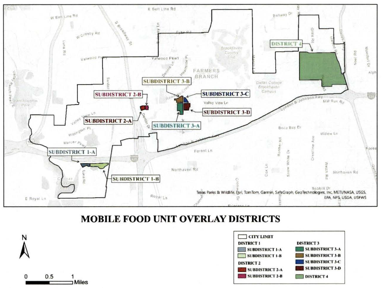
Diagram 5.8.D
Mobile Food Unit (MFU) Overlay District 1 (West Side):
MFU Subdistrict 1-A: Being an area that is bounded on the north by IH-635 and on the west by Luna Road and being that same 7.105 acre tract of land described as Tract IV - Pac Trust in a Trustee's Deed to Graham Mortgage Corporation, recorded as Document No. 201100087228, in the Deed Records, Dallas County, Texas, said property also known as Lot 1, Block 1, Park West Phase 5, in Volume 87007, Volume 3105, of the Deed Records of Dallas, Texas.
MFU Subdistrict 1-B: Being a 19.51± acre tract of land out of the H.C. Marsh Survey, Abstract No. 916, City of Farmers Branch, Dallas County, Texas, and being more particularly described by metes and bounds as follows (based on records and not an on-the-ground survey):
Beginning in the southerly right-of-way line of LBJ Freeway and the easterly boundary line of the same tract of land described in the deed to 2M Holdings, LP recorded as Document No. 201100225464 in the Official Public Records of Dallas County, Texas;
Thence South 08 degrees 37 minutes 58 seconds West with said easterly boundary line a distance of 163.72 feet;
Thence North 81 degrees 22 minutes 02 seconds West a distance of 23.44 feet;
Thence South 43 degrees 21 minutes 29 seconds West a distance of 28.27 feet;
Thence South 57 degrees 30 minutes 351 seconds West a distance of 335.55 feet;
Thence South 59 degrees 56 minutes 34 seconds West a distance of 53.53 feet;
Thence South 44 degrees 06 minutes 28 seconds West a distance of 28.07 feet;
Thence South 40 degrees 07 minutes 44 seconds West a distance of 188.06 feet;
Thence South 60 degrees 18 minutes 47 seconds West a distance of 112.39 feet;
Thence South 81 degrees 31 minutes 25 seconds West a distance of 165.26 feet;
Thence North 84 degrees 15 minutes 23 seconds West a distance of 117.80 feet;
Thence North 76 degrees 30 minutes 38 seconds West a distance of 31.33 feet;
Thence North 60 degrees 43 minutes 54 seconds West a distance of 124.96 feet;
Thence North 51 degrees 23 minutes 21 seconds West a distance of 30.47 feet;
Thence North 39 degrees 56 minutes 07 seconds West a distance of 180.19 feet;
Thence North 64 degrees 13 minutes 09 seconds West a distance of 29.69 feet;
Thence South 87 degrees 28 minutes 20 seconds West a distance of 520.79 feet;
Thence North 84 degrees 43 minutes 59 seconds West a distance of 200.96 feet;
Thence North 82 degrees 26 minutes 33 seconds West a distance of 138.67 feet to the westerly boundary line of said 2M tract;
Thence North 00 degrees 33 minutes 53 seconds West with said westerly boundary line a distance of 315.07 feet to said southerly right-of-way line;
Thence North 89 degrees 44 minutes 04 seconds East with said southerly right-of-way line a distance of 514.53 feet;
Thence North 85 degrees 23 minutes 28 seconds East continuing with said southerly right-of-way line a distance of 357.12 feet;
Thence North 87 degrees 59 minutes 30 seconds East continuing with said southerly right-of-way line a distance of 707.23 feet;
Thence South 89 degrees 25 minutes 45 seconds East continuing with said southerly right-of-way line a distance of 503.97 feet to the point of beginning.
Mobile Food Unit (MFU) Overlay District 2 (Station Area):
MFU Subdistrict 2-A: Beginning at a point at the intersection of the east right-of-way line of Denton Drive with the south right-of-way line of Pike Street;
Then, in a northwesterly direction, along the east right-of-way line of Denton Drive, crossing the Pike Street right-of-way, to a point at the southeast corner of Valley View Lane and Denton Drive;
Then, departing the east right-of-way line of Denton Drive, along the south right-of-way line of Valley View Lane, crossing the Rossford Street right-of-way and crossing the DART rail right-of-way, continuing east along said south right-of-way line of Valley View Lane, crossing the Bee Street right-of-way to a point for corner located at the northeast corner of a 0.788 acre tract of land conveyed to FB Land LTD by deed recorded as Instrument No. 201300240537, Official Public Records, Dallas County, Texas;
Then, departing said south right-of-way line of Valley View Lane and the northeast corner of said tract of land conveyed to FB Land LTD, in a southeasterly direction along the east line of said 0.788 acre tract, to a point at the northeast corner of Jenny Lynn Addition;
Then, in a southeasterly direction, along the east line of said Jenny Lynn Addition to the southeast corner of said addition, being a point in the north right-of-way line of Pepperwood Street;
Then, departing said southeast corner, in a westerly direction along the south side of said Jenny Lynn Addition and the north right-of-way line of said Pepperwood Drive to a point in the east right-of-way line of Bee Street;
Then, departing the north right-of-way line of Pepperwood Drive in a northwesterly direction along said east right-of-way line of Bee Street to a point that is at the eastward prolongation of the south right-of-way line of Pike Street with said east right-of-way line of Bee Street;
Then, departing said east right-of-way line of Bee Street, in a westerly direction along said prolongation line, to a point in the west right-of-way line of said Bee Street, and being the southwest corner of the intersection of said Bee Street and Pike Street rights-of-way;
Then, in a westerly direction, along said south right-of-way line of Pike Street, crossing the DART rail right-of-way and crossing the Rossford Street right-of-way to a point in the east right-of-way of Denton Drive, being the Point of Beginning.
MFU Subdistrict 2-B: Being an area bounded on the north by Valley View Lane; on the west by Bee Street; on the south by Pepperwood Street and Krause-Braack Addition; and bounded on the east by Lot 1, Block 1, First Baptist Church Addition and Goodland Street.
Mobile Food Unit (MFU) Overlay District 3 (Four Corners):
MFU Subdistrict 3-A (Southwest corner): Being an area bounded on the north by Valley View Lane; on the east by Josey Lane; on the south by Tara Place Addition; on the west by a north/south line located approximately 660 feet west of Josey Lane that extends from the north line of said Tara Place Addition a distance of approximately 800 feet northward to a point on the south right-of-way line of Valley View Lane that is approximately 660 feet west of Josey Lane.
MFU Subdistrict 3-B (Northwest corner): Being an area bounded on the south by Valley View Lane; on the west by Wilmington Drive and also bounded on the west by a 1.394 acre parcel of land at the northeast corner of Valley View Lane and Wilmington Drive known as Tract 1, J.C. Whitten Addition; and bounded on the north by Lots 1 through 11, Block B, Revised Parkway South addition; and also bounded on the north by a 0.938 acre tract of land conveyed to the City of Farmers Branch by deed recorded in Volume 71024, Page 0882, Deed Records, Dallas County, Texas; and bounded on the east by Josey Lane.
MFU Subdistrict 3-C (Northeast corner): Being an area bounded on the west by Josey Lane; on the south by Valley View Lane; on the east by Green Meadows Estates addition; and on north by Shelly Square Addition.
MFU Subdistrict 3-D (Southeast corner): Being an area bounded on the north by Valley View Lane; on the west by Josey Lane; on the east by Veronica Road, and also bounded on the east by a 0.9811 acre tract of land described in deed recorded as Instrument No. 201000048029, Deed Records, Dallas County, Texas, said tract being part of the Valley View Village Shopping Center addition; and bounded on the south by Lots 1 through 8, Block E, Valley View Estates No. 1 Addition.
Mobile Food Unit (MFU) Overlay District 4 (East Side):
Beginning at a point at the intersection of the west right-of-way line of Inwood Road with the south right-of-way line of Spring Valley Road;
Then, in a westerly direction, along the south right-of-way line of Spring Valley Road to a point at the intersection of the south right-of-way line of Spring Valley Road with the east right-of-way line of Midway Road;
Then, in a southerly direction along the east right-of-way line of Midway Road to a point at the intersection of the north right-of-way line of Simonton Road with the east right-of-way line of Midway Road;
Then, in an easterly direction along the north right-of-way line of Simonton Road to a point at the intersection of the north right-of-way line of Simonton Road with the west right-of-way line of Welch Road;
Then, in a southerly direction along the west right-of-way line of Welch Road to a point at the intersection of the west right-of-way line of Welch Road with the north right-of-way line of McEwen Road;
Then, in an easterly direction along the north right-of-way line of McEwen Road to a point at the intersection of the north right-of-way line of McEwen Road with the west right-of-way line of Galleria Drive;
Then, in a northerly direction along the west right-of-way line of Galleria Drive and continuing in an easterly direction along the north right-of-way line of Galleria Drive to the City of Farmers Branch eastern city limit line;
Then, in a northerly direction along the City of Farmers Branch eastern city limit line to a point for corner located at the northeast corner of a 0.4837-acre tract of land described as Lot 1, Inwood Parkway Office Park Addition, an addition to the City of Farmers Branch, Texas, according to the plat thereof recorded in Volume 77180, Page 3083, Map Records, Dallas County, Texas;
Then, in a westerly direction along the north line of said Inwood Parkway Office Park Addition to a point at the intersection of the west right-of-way line of Inwood Road with the south right-of-way line of Alpha Road;
Then, in a northerly direction along the west right-of-way line of Inwood Road to a point at the intersection of the west right-of-way line of Inwood Road with the south right-of-way line of Spring Valley Road, being the Point of Beginning.
E.
Parking
1.
Mobile Food Units must be parked on an improved surface located on private property.
2.
While operating, a Mobile Food Unit must be located on a developed tract or lot on which is located at least one primary structure occupied by a business holding a current and valid Certificate of Occupancy for such tract or lot.
3.
A Mobile Food Unit shall not be parked in a manner that creates a hazard for any pedestrian, vehicle, patron, or emergency personnel.
4.
The number of off-street parking spaces on which a Mobile Food Unit is parked shall be deducted from the number of off-street parking spaces required to be maintained for the property. An application for a Mobile Food Unit Location Permit shall include sufficient evidence that the minimum number of off-street parking spaces will be maintained even with the Mobile Food Unit located on the property.
F.
Maximum Number Per Property
1.
Except as provided in paragraph 2, below, no more than one (1) Mobile Food Unit may be located on a property with a single address.
2.
One (1) Mobile Food Unit for each occupied unit on a non-residential property on which is located a building with multiple units; provided, however, the number of Mobile Food Units located on the property shall not exceed the lesser of:
(a)
The number of occupied units within the building located on the property; and
(b)
Three (3).
G.
Owner Consent
Location of a Mobile Food Unit on private property is prohibited unless the owner of the Mobile Food Unit has obtained the written consent of the owner of the property or a person authorized by the owner of the property to grant such consent. Such written consent shall include the days and times on which the Mobile Food Unit is authorized to be located on the property.
H.
Restrooms
The owner of a Mobile Food Unit shall obtain written consent for customers of the Mobile Food Unit to use restrooms:
1.
Located within the primary building located on the property on which the Mobile Food Unit is parked; or
2.
Located within a building located within 100 feet of the location of the Mobile Food Unit.
This Section 5.8.H. shall not be applicable to a Mobile Food Unit parked on private property but within 100 feet of a public restroom located on or within a public park or other government owned building that allows for entry by the general public, but only of such public restroom may be accessed during the hours of operation of the Mobile Food Unit.
I.
County Health Permit
The owner of a Mobile Food Unit engaged in selling food and beverages within the City pursuant to this Section 5.8 shall possess a valid mobile food unit health permit issued by the Environmental Health Division of the Dallas County Health and Human Services Department and be in full compliance all requirements listed in such permit.
J.
Fire Permits. The owner of a Mobile Food Unit shall obtain all required inspections and obtain and comply with all required permits required by the Fire Code.
K.
Mobile Food Unit Location Permit
1.
Permit Required. Except as otherwise provided in this section, no person shall sell or serve any food or beverage from a Mobile Food Unit located within the City without first obtaining a Mobile Food Unit Location Permit pursuant to this Section 5.8.M.
2.
Application. Application for a Mobile Food Unit Location Permit shall be made on a form provided by the City and shall contain the following information or be accompanied by the following:
(a)
The name and address of the owner of the Mobile Food Unit;
(b)
The name, address, phone number, and email address of the primary contact person for the owner of the Mobile Food Unit;
(c)
If different than (b), the name, address, phone number, and email address of the person who will be operating the Mobile Food Unit during the operating hours and at the location identified in the application;
(d)
The address of the property on which the Mobile Food Unit will be operating pursuant to the permit;
(e)
The name, address, primary contact telephone number, and primary contact email address of the owner or, if applicable, authorized representative of the owner, of the property on which the Mobile Food Unit will be operating pursuant to the permit;
(f)
The dates and times during which the Mobile Food Unit will be operating pursuant to the permit;
(g)
A copy of the written consents required by Sections 5.8.G. and H;
(h)
A copy of the Mobile Food Unit Health Permit issued by Dallas County for the Mobile Food Unit identified in the application;
(i)
The description of the Mobile Food Unit, the number on the license plate affixed to the Mobile Food Unit, and the state of issuance of said license plate;
(j)
A diagram of the property on which the Mobile Food Unit will be located showing:
(1)
the location on the property where the Mobile Food Unit will be parked while in operation, including the number of off-street parking spaces, if any, that will be occupied by the Mobile Food Unit; and
(2)
the location of the restrooms that will be available and accessible for use by customers while the Mobile Food Unit is operating;
(k)
A copy of a current fire inspection and any required permits issued pursuant to the Fire Code; and
(l)
The permit application fee set forth in Appendix A of this Code.
3.
Application Deadline. An application for a Mobile Food Unit Location Permit must be submitted not later than thirty (30) days prior to the first day on which the Mobile Food Unit will be operating on the property as set forth in the application; provided, however, the Planning Director shall have the authority to accept a late application provided:
(a)
The application is complete, contains all information required to be submitted, and is accompanied by the proper application fee; and
(b)
There is sufficient and reasonable time between the date of delivery of the application and the first date of the event shown on the application to determine the operation of the Mobile Food Unit pursuant to the application will be in compliance with this section.
L.
Operation Limited to District; Exemptions.
1.
Prohibited Conduct. It is unlawful for any person to park a Mobile Food Unit within the City and, from such location, sell or serve food and/or beverages from such Mobile Food Unit unless:
(a)
The Mobile Food Unit is parked at a location within a Mobile Food Unity Overlay District;
(b)
A Mobile Food Unit Location Permit has been issued to the owner and/or operator of the Mobile Food Unit;
(c)
The operation of the Mobile Food Unit is in full compliance with the Mobile Food Unit Location Permit that was issued and the provisions of this section.
2.
Exemptions. This section shall not apply to Mobile Food Units operating within the City, even if operating outside of a Mobile Food Unit Overlay District, if:
(a)
The Mobile Food Unit is operating pursuant to a written agreement with the City in relation to an event sponsored in whole or in part by the City, whether or not located on property owned, leased, or controlled by the City;
(b)
The Mobile Food Unit is operating on property owned, leased, or otherwise under the control of the City that is operating pursuant to an agreement or permit through the Parks and Recreation Department or the Office of the City Manager;
(c)
The Mobile Food Unit is operating at a private event in compliance with the following criteria:
(1)
The event is a private gathering held on private property, such as, but not limited to, wedding ceremonies, birthday parties, or at home gatherings;
(2)
The Mobile Food Unit is parked on the private property on which the private event is being conducted and does not encroach on any public street, alley, or sidewalk;
(3)
Attendance is limited to the invited guests or members of family or employees of the host conducted the private and is not open to the general public;
(4)
Food is provided without any cost to the invited guests or members; and
(5)
The Mobile Food Unit is not parked on the property for a period that exceeds the one hour prior to the start time for the private event or one hour following the conclusion of the private event;
(d)
The Mobile Food Unit is operating during an event constituting a public gathering other than one described in (a) or (b), above, such as, but not limited to, a concert, sporting event, carnival, festival, or similar events, where food is sold from the Mobile Food Unit to attendees of the event, provided such operation is in compliance with the following criteria:
(1)
The Mobile Food Unit is parked on the private property on which the private event is being conducted and does not encroach on any public street, alley, or sidewalk;
(2)
The Mobile Food Unit is not parked on the property on which the public event is being conducted for a period that exceeds the one hour prior to the start time for the event or one hour following the conclusion of the private event;
(3)
The Mobile Food Unit does not operate for more than two (2) consecutive days during the event unless otherwise authorized in writing by the City Manager; and
(4)
No other public event has been conducted on the same property during which a Mobile Food Unit provided food service within the thirty (30) days prior to the date the Mobile Food Unit is to commence operations at the public event unless such restriction is waived by the City Manager.
(Ord. No. 3848, § 1B, 2-20-2024)