
Fernley City Zoning Code
CHAPTER 32
03.- ADMINISTRATION
Sec. 32.03.010.- Generally.
(a)
Applicability.
(1)
This chapter applies to any application of land development approval in the city.
(2)
This chapter establishes procedures for land development decisions made under this chapter. These include:
a.
Legislative decisions, including rezoning and changes to this zoning code and the master plan. These involve a new policy or rule, or a change in land development policy.
b.
Quasi-judicial decisions, including conditional use permits and variances. These proceedings require a weighing of the evidence, a balancing of the equities, an application of rules, regulations and ordinances to facts and a resolution of specific issues. These also involve a public hearing and the exercise of discretion by the decision-making body.
c.
Administrative decisions, such as building permits and certificates of occupancy. These apply this Code or conditions of a quasi-judicial decision to a specific project that is either clearly defined in this Code, or that has already obtained all necessary legislative and quasi-judicial approvals. Because these involve the application of non-discretionary rules to specific projects, these decisions are made by city staff without a public hearing.
(b)
Process elements. This chapter sets up rules for procedures, such as pre-application, neighborhood notification, notices and public hearings. It then describes the process for specific land use decisions. The procedures have a common workflow and description, as follows:
Figure 32.03.010-1 - Process Flowchart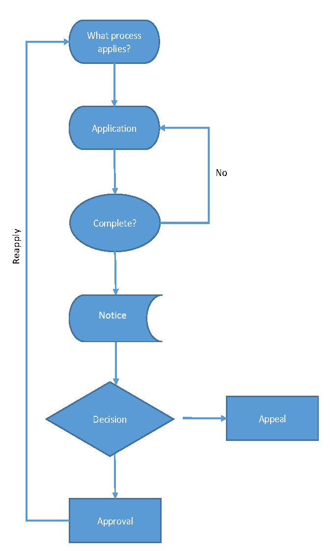
(Ord. No. 2020-005, § 1(Exh. A), 3-4-2020)
Sec. 32.03.020. - Review and decision-making bodies.
(a)
Summary table. Table 32.03.020-1 summarizes the development review process, decision-making responsibilities of the entities that have roles in the procedures set forth in this chapter and noticing requirements. Other duties and responsibilities of these entities are set forth in subsequent subsections of this chapter.
TABLE 32.03.020-1 - Summary Table of Development Review Procedures
(b)
Decision making bodies. Refer to section 32.02.010, agencies.
(1)
Zoning administrator.
(2)
Planning commission.
(3)
City council.
(Ord. No. 2020-005, § 1(Exh. A), 3-4-2020)
Sec. 32.03.030. - Common review procedures.
The common review procedures in this section provide a foundation for the specific review and approval procedures in sections 32.03.040 through 32.03.090. See sections 32.03.040 through 32.03.100 to determine which of these common procedures apply to an individual application for development review.
(a)
Applications.
(1)
What are the general requirements?
a.
Applications filed under this chapter must include the information required by appendix A-4 (submittal requirements). All applications shall be made on forms prepared by the city and available in the planning division.
b.
The council may establish fees for all applications required in this chapter by resolution.
(2)
How are applications reviewed for completeness?
a.
An application is not complete until all required items are submitted (see appendix A-4).
b.
The city will not process incomplete applications. Review for completeness of application forms is solely to determine whether preliminary information required for submission with the application is sufficient to allow further processing. It does not constitute a decision as to whether an application complies with this chapter.
c.
Within 15 working days after an application is received, the administrator shall determine whether the application is complete and send a written notice of the determination to the applicant. The administrator shall specify those parts of the application that are incomplete and will indicate how they can be made complete. The administrator and the decision-making agency are not obligated to further review the application until the required information is provided.
1.
If the administrator determines that the application is still not complete, the applicant may appeal that determination to the city council by filing a written notice of appeal with the administrator. The notice of appeal shall be filed within ten days after the administrator's determination. The city council shall issue a written determination on the appeal within 60 days after receipt of the notice of appeal.
d.
Nothing in this section precludes an applicant and the city from mutually agreeing to an extension of any time limit provided by this section.
(3)
Concurrent processing.
a.
In order to facilitate the development process, the following applications may be submitted and processed concurrently:
1.
Administrative review.
2.
Annexations.
3.
Conditional use permits.
4.
Major deviations.
5.
Master plan amendments.
6.
Minor deviations.
7.
Parcel maps.
8.
Tentative maps.
9.
Variances.
10.
Zoning map amendments (rezonings).
b.
Multiple applications submitted for a single development project may be processed concurrently to allow for an expedited review and processing schedule for a project. The time frame and approval process for a consolidated application shall follow the longest time frame and approval process required from among the multiple applications. For example, multiple applications for zoning map amendment and conditional use permit may be processed concurrently, in which case both applications would be considered based on the more extensive zoning map amendment procedure, and the city council would be the final decision body on both applications unless otherwise provided by law.
(b)
Notice.
(1)
What are the general procedures for notice? State law establishes various requirements for public notice. Unless otherwise provided, the notice established in this chapter is as follows:
TABLE 32.03.030-1 - Notice
(2)
Notice shall include the following information, unless the process includes a different requirement.
a.
Time, date and place of the public hearing or meeting;
b.
The type of land use or development decision that is being considered;
c.
A telephone point of contact within the planning division.
(3)
Additional notice. The city may provide additional notice not required by this chapter or state law at its discretion.
(c)
Public hearing.
(1)
Generally.
a.
A public hearing gives interested parties an opportunity to be heard. The specific processes for providing testimony and conducting the hearing are established by the agency that conducts the hearing.
b.
Where a public hearing is required for legislative action, the hearing may be called:
1.
By the planning commission upon its own initiative, or
2.
At the direction of the Fernley City Council.
(2)
Whenever this title requires a public hearing, the following procedures apply (unless otherwise provided):
a.
At least ten days' notice of the time, place and purpose of such public hearing shall be:
1.
Published in an official newspaper or newspaper of general circulation in the city, county or region; and
2.
Given by mail to the owner, applicant or appellant, as the case may be.
b.
Parties in interest and citizens shall have an opportunity to be heard and the written communications relative to the hearing may be considered.
(Ord. No. 2020-005, § 1(Exh. A), 3-4-2020)
Sec. 32.03.040. - Annexation, comprehensive master plan, and zoning applications.
(a)
Annexation.
(1)
Applicability. This section delineates the process and criteria by which the City of Fernley processes annexation applications pursuant to NRS 268.670.
(2)
Initiation. The applicant files an application for annexation with the administrator.
(3)
Completeness. See section 32.03.030.
(4)
Notice.
a.
Before adopting any annexation, a public hearing will be conducted after at least ten days' notice is given by mail to owners of property 750 of the exterior limits of the property or area proposed for annexation, as shown by the assessor's latest ownership maps.
b.
Notice is provided by publication and mail as provided by NRS 268 and chapter 32.03 of this title.
(5)
Decision.
a.
The planning commission will conduct a hearing and will recommend approval, or denial of the annexation.
b.
The city council will approve deny with or without prejudice, table or continue the annexation.
(6)
Findings for approval. When considering an application for annexation submitted under the procedures set forth in NRS 268.670, the city shall consider the following factors in rendering a decision on the application:
a.
The Request conforms to the requirements of NRS ch. 268.
b.
The request conforms to the findings established for annexation:
1.
Location of the property to be considered for annexation;
2.
The logical extension of City limits;
3.
The need for the expansion to accommodate planned regional growth;
4.
The location of existing and planned water and sewer service;
5.
Community goals that would be met by the proposed annexation;
6.
The efficient and cost-effective provision of service areas and capital facilities;
7.
Fiscal analysis regarding the proposed annexation;
8.
Whether Lyon County has adopted a community management plan for the proposed annexation area;
9.
Whether the annexation creates any islands; and
10.
Any other factors concerning the proposed annexation deemed appropriate for consideration by the city council.
c.
The property requested to be annexed conforms to the master plan.
d.
Public notice was given, and a public hearing held per the requirements of the development code.
(7)
Subsequent applications. If the annexation of territory to a city is not approved, an application to annex the same or substantially the same territory will not be accepted for at least one year after the date of disapproval.
(8)
Appeals. See section 32.09.090(e), appeals.
(9)
Scope of approval.
a.
Generally. After the area is annexed, it becomes subject to all ordinances and regulations of the City of Fernley.
b.
Classification of annexed territory. Territory annexed to the city is classified for purposes of this chapter as follows:
TABLE 32.03.040-1 - Zoning Conversion Upon Annexation
(10)
Recordkeeping. The city clerk will maintain a record of the annexation ordinance in accordance with its normal ordinance tracking procedures.
(b)
Comprehensive master plan amendments.
(1)
Applicability. The City of Fernley Master Plan is a legislative planning document with respect to the city's vision, goals, and policies relative to such matters as population, housing, streets, and resource use which is governed by NRS 278.150 to and including NRS 278.250.
(2)
Initiation.
a.
Master plan amendments shall be initiated by the administrator, planning commission, city council or by a person's application.
b.
The administrator shall make a recommendation regarding the application to the planning commission.
(3)
Completeness. See section 32.03.030.
(4)
Notice. Notice is provided by publication and mail as provided by NRS 278.210 and chapter 32.03 of this title.
(5)
The adoption of the master plan must be by resolution of the planning commission carried by the affirmative votes of not less than two-thirds of the total membership of the commission. The resolution must refer expressly to the maps, descriptive matter and other matter intended by the commission to constitute the plan or any amendment, addition or extension thereof, and the action taken must be recorded on the map and plan and descriptive matter by the identifying signatures of the secretary and chair of the commission.
(6)
Findings for approval. In order to adopt an amendment to the master plan, the planning commission shall find that a change is justified based on the following:
a.
The master plan amendment would implement the goals listed within the City of Fernley Master Plan as listed in the staff report.
b.
The master plan amendment would be compatible with surrounding land uses.
c.
Public notice was given, and a public hearing held per the requirements of Nevada Revised Statutes and Fernley Development Code.
(7)
[Certification.] Certification by the city council shall be by the affirmative votes of a simple majority of the entire city council.
(c)
Minor comprehensive master plan amendments.
(1)
Applicability. This section is authorized by NRS 278.225.
(2)
Initiation.
a.
A minor master plan amendment shall be initiated by either the administrator or city council.
b.
There shall be no limit to the number of minor master plan amendments initiated or adopted.
c.
The administrator shall prepare the minor master plan amendments and provide a recommendation to the city council.
d.
There are no time limits for public hearings or city council decisions regarding minor master plan amendments.
(3)
Completeness. See section 32.03.030.
(4)
Notice. Notice is provided by publication and mail as provided by NRS 278.210 and chapter 32.03 of this title.
(5)
[Public hearing.] The city council shall hold a public hearing regarding the minor master plan amendment.
(6)
Findings for approval. In order to adopt a minor amendment to the master plan, the city council shall find that a change is justified because of one of the following:
a.
Evidence is produced that an error exists in the mapped location of a geographical feature, including without limitation, topography, slopes, hydrographic features wetland delineation and floodplains;
b.
The name of a jurisdiction, agency, department or district by the city, governing board or other governing authority of the jurisdiction, agency, department or district, as applicable, or another entity authorized by law to make such an alteration is altered; or
c.
Statistical information that results from a new or revised study and alters existing information.
(7)
[Majority vote necessary for adoption.] Adoption by the city council shall be by the affirmative votes of a simple majority of the entire city council.
(d)
Development code text amendments.
(1)
Applicability. This applies to the amendment or repeal of this title.
(2)
Initiation.
a.
The city council.
b.
The administrator.
(3)
Completeness. See section 32.03.030.
(4)
Notice. Notice is provided by publication and mail as provided by NRS 278.260 and chapter 32.03 of this title.
(5)
Decision. The following procedures apply to development code text amendments:
a.
The planning commission shall file a written report with the city clerk relative to the proposed amendment. The written report shall recommend approval or disapproval of the proposed amendment.
b.
Upon the filing of the report, the city clerk shall cause a bill to be prepared and placed on the agenda of the city council for a first reading pursuant to NRS 268.
c.
The city council shall then comply with the ordinance enactment procedures set forth in NRS 268. At the meeting of the city council, the city council shall hold a public hearing relative to the report of the planning commission and the proposed zoning map amendment or code amendment bill before taking any action on the bill. No additional notice of this hearing is required.
(6)
Findings for approval. A development code text amendment is committed to the city council's legislative discretion. A development code text amendment may be approved if it is:
a.
Consistent with the city's master plan and otherwise consistent with state and federal law.
b.
Public notice was given, and a public hearing held per the requirements of the Development Code and Nevada Revised Statutes.
(7)
Appeals. See subsection 32.09.090.E, appeals.
(8)
Scope of approval.
a.
A code amendment applies to all situations, uses or development within the scope of the adopted ordinance.
(9)
Recordkeeping.
a.
The city clerk will maintain a record of all code amendments as provided by the city Charter and Nevada law.
(e)
Zoning map amendments (rezoning).
(1)
Applicability. This applies to any amendment to the zoning map (a "rezoning").
(2)
Initiation.
a.
Amendments to the zoning map may be initiated by:
1.
The city council; or
2.
The owner of a lot or parcel within the area sought for amendments.
b.
The applicant files an application for zoning map amendment with the administrator.
(3)
Completeness. See section 32.03.030.
(4)
Notice. Notice is provided by publication and mail as provided by NRS 278.260 and chapter 32.03 of this title.
(5)
Decision. The following procedures apply to zoning map amendments (rezonings):
a.
The planning commission shall file a written report with the city clerk relative to the proposed amendment. The written report shall recommend approval or disapproval of the proposed amendment. The report shall be filed within 40 days following the public hearing. Failure of the planning commission to file a report is deemed a recommendation for approval.
b.
The planning commission shall mail to the applicant notice of the recommendation within five days following the filing of the report with the city clerk.
c.
Upon the filing of the report, the city clerk shall cause a bill to be prepared and placed on the agenda of the city council for a first reading pursuant to NRS 268.
d.
If the planning commission does not file the report within 40 days, the city clerk will place a bill on the city council agenda as provided above.
e.
The city council shall then comply with the ordinance enactment procedures set forth in NRS 268. At the meeting of the city council, the city council shall hold a public hearing relative to the report of the planning commission and the proposed zoning map amendment or code amendment bill before taking any action on the bill. No additional notice of this hearing is required.
(6)
Findings for approval. A zoning map amendment is committed to the city council's legislative discretion. The zoning map amendment be approved if it is:
a.
Consistent with the city's master plan and otherwise consistent with state and federal law.
b.
Consistent with the surrounding land uses.
c.
Public notice was given, and a public hearing held per the requirements of the development code and nevada revised statutes.
(7)
Appeals. See section 32.09.090.E, appeals.
(8)
Scope of approval.
a.
After a zoning map amendment is approved, all new development within the area subject to the approved rezoning is subject to the uses and development standards in the zoning districts applied by the zoning map amendment ordinance.
(9)
Recordkeeping.
a.
The administrator will revise the zoning map to reflect the approved zoning map amendment.
(f)
Planned developments (rezoning to PD).
(1)
Tentative application pre-application conference. Prior to submitting a formal application, applicant will prepare a preliminary development plan for review by the administrator at an informal pre-application conference. Formal application for tentative approval must be made within six months following the pre-application conference.
(2)
Formal application. An application for tentative approval of the plan for a planned unit development must be filed with the administrator by or on behalf of the landowner. The application will be made on a form provided by the administrator. A preliminary development plan, design regulations and architecture manual must be submitted with the application.
(3)
Application fee. The application shall be accompanied by a fee as established by resolution of the city council.
(4)
Procedure of tentative approval.
a.
The city staff will formally review the application, and development plan. Staff will evaluate the proposal and submit its recommendation for approval or denial to the Fernley Planning Commission.
b.
A public hearing on the application shall be held by the Fernley Planning Commission. No application for tentative approval will be scheduled for consideration before the planning commission or city council if the application contains errata sheets or is missing any of the contents required by appendix A-4, application contents. Public notice of the hearing shall be given in the manner prescribed by in chapter 32.03. The hearing may be continued from time to time or the planning commission may refer the matter to the planning department for a further report, but the public hearing or hearings shall be concluded within 60 days after the date of the first public hearing unless the landowner consents in writing to an extension of the time within which the hearings shall be concluded.
c.
Recommendation to grant, deny, or condition tentative approval.
1.
Following the conclusion of the public hearing, the planning commission shall recommend:
A.
Granting tentative approval of the plan as submitted;
B.
Granting tentative approval of the plan subject to specified conditions not included in the plan as submitted; or
C.
Denying tentative approval of the plan.
2.
If granting tentative approval is recommended, the planning commission shall, as part of its action, specify the drawings, specifications and any special financial assurances that shall accompany an application for final approval.
d.
Findings of fact required. The recommendation must set forth the reasons for granting, with or without conditions, or for denying, and the minutes must set forth with particularity in what respects the plan would or would not be in the public interest, including, but not limited to, findings on the following:
1.
In what respects the plan is or is not consistent with the statement of objectives of a planned unit development.
2.
The extent to which the plan departs from zoning and subdivision regulations, otherwise applicable to the property, including, but not limited to, density, bulk and use, and the reasons why these departures are or are not deemed to be in the public interest.
3.
The ratio of residential to nonresidential use in the planned unit development.
4.
The purpose, location and amount of the common open space in the planned unit development, the reliability of the proposals for maintenance and conservation of the common open space, and the adequacy or inadequacy of the amount and purpose of the common open space as related to the proposed density and type of residential development.
5.
The physical design of the plan and the manner in which the design does or does not make adequate provision for public services and utilities, provide adequate control over vehicular traffic, and further the amenities of light, air, recreation and visual enjoyment.
6.
The relationship, beneficial or adverse, of the proposed planned unit development to the neighborhood in which it is proposed to be established.
7.
In the case of a plan which proposes development over a period of years, the sufficiency of the terms and conditions intended to protect the interests of the public, residents and owners of the planned unit development in the integrity of the plan.
e.
Specification of time for filing application for final approval. Unless the time is specified in an agreement entered into pursuant to NRS 278.0201, if a plan is recommended for tentative approval, an application for final approval of the plan, or any portion of the plan, must be filed within one year from the date of city council tentative approval. In no event shall the first application for final approval be filed later than one year from the date of city council tentative approval unless an alternative time frame is identified in the phasing of the project (as provided in the application for tentative approval).
f.
The planning commission shall file a written report of its recommendation with the city clerk who shall place it on the agenda of the city council. The city council shall:
1.
Grant tentative approval of the plan as submitted;
2.
Grant tentative approval of the plan subject to specified conditions not included in the plan as submitted; or
3.
Deny tentative approval of the plan.
g.
In its grant or denial of tentative approval, the city council must conduct a hearing and provide findings of fact as delineated in subsection D.4 above.
h.
The effect of tentative approval is to provide the applicant with a clear indication of requirements needed for final approval of the development plan including a schedule for submittal of application for final approval. Tentative approval does not qualify a plat or the planned unit development for recording or authorize development or the issuance of any building permit.
(5)
Final approval application. An application for final approval is a necessary precursor to the issuance of a permit under Fernley Municipal Code Title 8 for construction activity. An application for final approval must be accompanied by a final development plan, design regulations and a fee in the amount established by resolution of city council.
(6)
Procedure for final approval.
a.
Application for final review by the Fernley Planning Commission and ultimate final approval by the Fernley City Council must be made to the administrator within the time specified by the minutes granting tentative approval.
b.
A public hearing on an application for final approval of the plan, or any part thereof, is not required if the plan, or any part thereof, submitted for final approval is in substantial compliance with the plan which has been given tentative approval. No application in final approval will be scheduled for consideration before the planning commission or city council if the application contains errata sheets or is missing any of the contents required by appendix A-4, application contents. The plan submitted for final approval is in substantial compliance with the plan previously given tentative approval if any modification by the landowner of the plan as tentatively approved does not:
1.
Vary the proposed gross residential density or intensity of use;
2.
Vary the proposed ratio of residential to nonresidential use;
3.
Involve a reduction of the area set aside for common open space or the substantial relocation of such area;
4.
Substantially increase the floor area proposed for nonresidential use; or
5.
Substantially increase the total ground areas covered by buildings or involve a substantial change in the height of buildings.
c.
A public hearing need not be held to consider modifications in the location and design of streets or facilities for water and for disposal of storm water and sanitary sewage.
d.
All requirements and regulations pertaining to the application for final approval, substantial compliance with tentatively approved plan, alternative proceedings for final action on plans not in substantial compliance, recourse to courts for failure of city to grant or deny final approval, certification and filing of approved plan upon abandonment or failure to carry out approved plan shall be provided in NRS 278A.530 to 278A.580, inclusive.
(7)
Modification of final approved plan.
a.
The following persons may file with the administrator an application to modify an approved final plan:
1.
An owner or owners of real property located within the boundaries of the planned unit development;
2.
The master developer; or
3.
Any other person, to the extent and in the manner expressly authorized by the provisions of the final approved plan.
b.
All provisions of the plan authorized to be enforced by the city may be modified, removed or released by the city, except grants or easements relating to the service or equipment of a public utility unless expressly consented to by the public utility. The following provisions of the plan may be enforced, modified, removed or released by the city:
1.
The use of land and the use, bulk and location of buildings and structures;
2.
The quantity and location of common open space;
3.
The intensity of use or the density of residential units; and
4.
The ratio of residential to nonresidential uses.
c.
Notice of a public hearing regarding an application for modification of an approved final plan shall be provided according to NRS 278.260 and section 32.03.030.
d.
Procedure for decision.
1.
Within 40 days after a public hearing, the planning commission shall file a written report with the city clerk relative to the proposed modification.
2.
The report shall recommend approval, denial, or conditional approval of the proposed modification.
3.
Failure of the planning commission to file a report is deemed a recommendation for approval.
4.
Within five days of filing the report with the city clerk, the planning commission shall mail to the applicant notice of the recommendation.
5.
Upon the filing of the report or the failure of the planning commission to file a report within 40 days, the city clerk shall cause a bill prepared and be placed on the agenda of the city council for a first reading.
6.
The city council shall hold a public hearing relative to the report of the planning commission and the proposed modification before taking any action on the proposed modification.
e.
Rights of residents.
1.
No modification, removal or release of the provisions of an approved final plan by the city may affect the rights of the residents of a planned unit residential development to maintain and enforce those provisions.
2.
All provisions of the plan shall run in favor of the residents of a planned unit residential development, but only to the extent expressly provided in the plan and in accordance with the terms of the plan and to that extent such provisions, whether recorded by plat, covenant, easement or otherwise, may be enforced at law or equity by the residents acting individually, jointly or through an organization designated in the plan to act on their behalf.
3.
No provision of the plan exists in favor of residents on the planned unit residential development except as to those portions of the plan which have been finally approved and have been recorded.
f.
Required findings. No modification, removal or release of the provisions of the plan by the city is permitted except upon a finding by the city, following a public hearing, that it:
1.
Is consistent with the city's master plan and otherwise consistent with state and federal law;
2.
Is consistent with the surrounding land uses;
3.
Will be fiscally positive to the city for a period of at least 20 years if the site affected by the modification, removal or release is 20 or more acres and the modification, removal or release involves permitted uses, residential density or nonresidential intensity;
4.
Furthers the mutual interest of the residents and owners of the planned unit development and of the public in the preservation of the integrity of the plan as finally approved;
5.
Will not impair the reasonable reliance of the residents and owners upon the provisions of the plan;
6.
Will not result in changes that would adversely affect the public interest;
7.
Is consistent with the efficient development and preservation of the entire planned unit development;
8.
Does not adversely affect either the enjoyment of land abutting upon or across a street from the planned unit development or the public interest;
9.
Is not granted solely to confer a private benefit upon any person; and
10.
Public notice was given, and a public hearing held as required by the Fernley Municipal Code and Nevada Revised Statutes.
g.
Judicial review. Any decision of the city under this chapter granting or denying tentative or final approval of the plan or authorizing or refusing to authorize a modification in a plan is a final administrative decision and is subject to judicial review in properly presented cases.
(Ord. No. 2020-005, § 1(Exh. A), 3-4-2020)
State Law reference— Planned development, NRS Ch. 278A.
Sec. 32.03.050. - Entitlements.
(a)
Administrative review.
Purpose: Administrative review determines whether the proposed use, building, structure addition or change to any building, structure or use will conform to the city's zoning code, building and fire codes and other applicable ordinances and requirements. Administrative Review insures the development of an aesthetically acceptable and well-ordered community serving the interests of public health, safety and general welfare.
(1)
Applicability. Administrative review is required:
a.
Where indicated in the use table;
b.
For any public facility, commercial, industrial or multifamily (three units or more) construction or addition when a conditional use permit is not required or
c.
Where specifically required in this title.
(2)
Initiation. The applicant files an application for administrative review with the administrator.
(3)
Completeness. See section 32.03.030.
(4)
Notice. Not required.
(5)
Decision.
a.
Within 30 days from the date the administrative review application is deemed complete:
1.
The administrator shall review the application for compliance with this title; and
2.
The administrator shall approve, conditionally approve or deny the administrative review application; and
3.
If the application is approved or conditionally approved, the administrator shall submit to the applicant a letter and conditions of approval relative to the administrative review.
b.
Issuance of the administrative review does not occur until all the conditions of approval are satisfied.
c.
If the conditions of approval are not satisfied within two years of the date of the letter from the administrator, or within another specified time limit stated as a condition of approval, the approval is automatically rescinded.
(6)
Approval criteria. The administrative review application shall comply with all applicable requirements of this title, including the following:
a.
The proposed development shall not create unsafe traffic conditions or cause a reduction in the level of service on surrounding streets, taking into consideration:
1.
Any change in traffic conditions on abutting streets created by additional trips generated by the proposed development;
2.
The layout of the site with respect to locations and dimensions of vehicular and pedestrian entrances, exits, drives, walkways and fire-department access lanes;
3.
The arrangement and adequacy of off-street parking facilities to prevent traffic congestion;
4.
The location, arrangement and dimensions of truck loading and unloading facilities;
5.
The surfacing and lighting of off-street parking;
6.
Design of proposed building; and
7.
Location of refuse storage and disposal facilities.
(7)
Subsequent applications.
a.
An administrative review permit may be amended if:
1.
A condition of approval cannot be met;
2.
There are substantial changes in the project; or
3.
The administrator determines that proposed changes to an approved project will impact surrounding properties.
b.
Amendments to administrative reviews must follow the same procedure as a new application, including the application fee and information required by the appendices to this code.
(8)
Appeals. See subsection 32.09.090(e), appeals.
(9)
Scope of approval.
a.
Administrative review certificate. After the applicant satisfies the conditions of approval, the administrator will issue a certificate indicating that the conditions are satisfied.
b.
Responsibility. The property owner shall comply with and maintain the conditions of approval of an administrative review permit. An administrative review runs with the land, subject to termination in accordance with the procedures in this section.
c.
Modifications. In issuing building permits, the administrator may approve minor adjustments of the location and/or dimensions of buildings, parking areas and roadways if they do not change any points of ingress or egress to the site or reduce the parking or landscaping requirements to less than the minimum required by this title. No modification of an approved application can be approved unless specifically provided in writing.
d.
Expiration of administrative review.
1.
An applicant has one year to establish the permitted use after the administrative review is approved.
2.
If the permitted use is not established or construction to accommodate that use begun and diligently pursued during this time, the administrative review or administrative review permit becomes null and void. If the use is established during this time, the administrative review permit is valid until revoked unless there is a specific expiration date.
3.
The administrator may extend the expiration date for up to one year if:
A.
The applicant files a written request, which includes the current status of the project, with the administrator before the approval expires.
(10)
Revocation.
a.
The administrator may revoke an administrative review if:
1.
The permit holder violates any condition of the permit;
2.
The permitted use becomes a public nuisance; or
3.
The permit was granted on the basis of false statements or fraudulent application.
b.
If the administrator has reason to believe that an administrative review permit is subject to revocation, the administrator may institute proceedings to revoke the permit.
(11)
Recordkeeping. The administrator and the applicant shall maintain a record of the administrative review and administrative review permit.
(b)
Conditional use permit.
Purpose: This subsection promotes the public health, safety and general welfare by providing for special safeguards in the location and design of certain uses in certain zoning districts, and by allowing for minor adjustments in the impact of some regulations as specifically provided elsewhere in this title.
(1)
Applicability.
a.
This subsection applies to:
1.
Any use designated as a conditional use in the use table (chapter 32.06); or
2.
Any other situation where this title requires conditional use approval.
b.
This section does not authorize a use variance, or a deviation based on hardship or difficulty. However, an applicant may combine a request for a variance with a conditional use permit, and the city may process both applications concurrently.
c.
A conditional use permit application may be processed concurrent with a zoning map amendment (rezoning) application.
d.
Multiple applications submitted for a single development project may be processed concurrently to allow for an expedited review and processing schedule for a project. The time frame and approval process for a consolidated application shall follow the longest time frame and approval process required from among the multiple applications. For example, multiple applications for zoning map amendment and conditional use permit may be processed concurrently, in which case both applications would be considered based on the more extensive zoning map amendment procedure, and the city council would be the final decision body on both applications unless otherwise provided by law.
(2)
Initiation. The applicant files an application for a conditional use permit with the administrator.
(3)
Completeness. See section 32.03.030
(4)
Notice. See NRS 278.315 and chapter 32.03.
(5)
Decision.
a.
For purposes of this section, the approving agency for a conditional use permit is:
1.
The planning commission; or
2.
The city council if the planning commission's decision is appealed.
b.
The planning commission will hold a public hearing within 65 days after the application is filed, unless a longer time or a different process of review is provided in a development agreement (see NRS 278.0201).
c.
The planning commission shall:
1.
Approve the conditional use permit;
2.
Approve the conditional use permit with conditions;
3.
Deny the conditional use permit, with or without prejudice;
d.
The approving agency may impose conditions on the conditional use permit to safeguard the public health, safety, morals and general welfare. The conditions may address, but are not limited to, compatibility, site design, architecture, landscaping, building materials, access, internal circulation, lighting, signage, parking, operation of the use, the mitigation of potential impacts, and any other criteria permitted by state law.
e.
An application may be tabled or continued so long as a new public hearing is held within 65 days after the application is heard, unless a longer time or a different process of review is provided in a development agreement (see NRS 278.0201 and NRS 278.315.2).
f.
Within ten days after final action and at the conclusion of any appeal period, the planning commission's administrative secretary or the city clerk will notify the applicant in writing of that action, including any conditions imposed by the planning commission or city council. The planning commission's administrative secretary must also notify the city clerk's office if the planning commission takes final action.
g.
After a conditional use is approved, the administrator shall issue the permit when all conditions of approval, except for continuing conditions, are satisfied.
(6)
Findings for approval.
a.
The approving agency must make findings that the proposed conditional use will be in compliance with the master plan;
b.
The conditional use will be compatible with the existing or permitted uses of adjacent properties;
c.
The potential impairment of natural resources and the total population which the available natural resources will support without unreasonable impairment;
d.
The availability of and need for affordable housing in the community, including affordable housing that is accessible to persons with disabilities;
e.
The conditional use permits impacts have been conditioned to address identified impacts; and
f.
Public notice has been given and a public hearing held per the requirements of the development code and the nevada revised statutes.
(7)
Amendments.
a.
A conditional use permit must be amended if:
1.
One or more of the conditions of approval cannot be met;
2.
There are substantial material changes in the project; or
3.
The Administrator determines that proposed changes to an approved project will materially impact surrounding properties.
b.
Amendments to conditional use permits must follow the same procedure as for a new application.
(8)
Appeals. See subsection 32.09.090(e), appeals.
(9)
Scope of approval.
a.
Compliance certificate. After the applicant satisfies the conditions of approval, the administrator will issue a certificate indicating that the conditions are satisfied.
b.
Responsibility. The property owner is responsible for compliance with and maintenance of the conditions of approval of a conditional use permit for a particular use on a particular piece of property.
c.
Duration.
1.
A conditional use permit runs with the land, subject to termination in accordance with the procedures set forth in this section.
2.
Upon cessation of an established use for which a conditional use permit has been issued, the approved conditional use permit and any conditions thereto shall run with the land for a period not to exceed one year from the date the business license associated with the use expires.
3.
A conditional use permit issued by the administrator is valid until revoked, unless it contains a specified expiration date.
4.
If a final subdivision map is recorded on any portion of a project while a conditional use permit for the project is in effect, the use of that portion of the project is considered established, even if construction has not taken place, unless the subdivision map is amended or reverted to acreage.
d.
Rescission. If any conditions of approval (other than continuing conditions) are not satisfied within one year after final action is taken, or within another time limit specified in the permit, the approval is automatically rescinded.
e.
Expiration of an approved conditional use permit.
1.
An applicant has one year to establish the permitted use after the conditional use permit is approved.
2.
If the permitted use is not established or construction to accommodate that use begun and diligently pursued during this time, the conditional use permit becomes null and void. If the use is established during this time, the conditional use permit is valid until revoked unless there is a specific expiration date.
3.
The approving agency may extend the expiration date for up to one year if:
A.
If a permit holder is unable to establish the permitted use or begin construction to accommodate it within one year or the time specified in the conditional use permit, the approving agency may extend the expiration date. The extension may not exceed one year beyond the original expiration date. To obtain an extension, the applicant must submit a written request to the approving agency before the permit expires.
f.
If the administrator has reason to believe that a conditional use permit is subject to revocation, the administrator may institute proceedings to revoke the permit. Before revoking any conditional use permit, the body which approved it must hold a public hearing as provided in this chapter.
1.
The administrator may revoke a conditional use permit if:
A.
The permit holder violates any condition of the permit;
B.
The permitted use becomes a public nuisance; or
C.
The permit was granted on the basis of false statements or fraudulent application.
(10)
Recordkeeping. The administrator and the applicant shall maintain a record of the conditional use permit.
(c)
Temporary use permits.
(1)
Applicability.
a.
Where indicated in the use table; or
b.
Where specifically required in this title.
(2)
Initiation. The applicant files an application for temporary use permit with the administrator. Temporary use permits for special event should be submitted to the administrator at least 30 days prior to the requested date of the proposed special event. All other temporary use permit applciations should be submitted to the administrator at least seven days prior to the requested date of the proposed temporary use. Both temporary use permit application types shall be accompanied by the associated fee as established by resolution of the city council.
(3)
Completeness. See section 32.03.030.
(4)
Notice. Not required.
(5)
Decision.
a.
The administrator shall review the application for compliance with this title; and
b.
The administrator shall approve, conditionally approve or deny the temporary use permit application; and
c.
If the application is approved or conditionally approved, the administrator shall submit to the applicant a letter and conditions of approval relative to the temporary use permit.
(6)
Approval criteria.
a.
Temporary use permits may be approved by the administrator only upon a finding that all of the following criteria have been met:
1.
The proposed temporary use will be located, operated, and maintained in a manner consistent with the policies of the comprehensive plan and the provisions of this code;
2.
Approval of the application will not be detrimental to property or improvements in the surrounding area or to the public health, safety, or general welfare; and
3.
The proposed temporary use complies with all applicable standards of this code unless otherwise expressly stated.
b.
In approving a temporary use permit, the administrator (or, upon appeal, the planning commission) may impose conditions, stipulations, or limitations as are deemed necessary to ensure that the activity will be consistent with this section and the proposed temporary use. Such conditions may include, but are not limited to the following:
1.
Provision for temporary parking facilities, including vehicle ingress and egress;
2.
Measures to prevent or reduce nuisance factors such as glare, excessive illumination, noise, vibration, smoke, dust, dirt, odors, gases, and heat;
3.
Regulation of placement, height, size, and location of structures, facilities, landscaping and equipment, including provision for buffering and separation;
4.
Provision for sanitary facilities and for waste collection and disposal;
5.
Measures to promote safety and security;
6.
Regulation of signs and other attention-gaining devices;
7.
Regulation of operating hours and duration of the temporary commercial use;
8.
Regulation of the hours and duration of set-up and dismantling activities;
9.
Compliance with applicable provisions of the Fernley Municipal Code (FMC);
10.
Any other conditions that will ensure the operation of the proposed temporary use is conducted in an orderly, efficient manner and in accordance with the intent and purpose of this code.
(7)
Subsequent applications. Amendments to temporary use permits must follow the same procedure as a new application, including the application fee and information required by the appendices to this Code.
(8)
Appeals. See subsection 32.09.090(e), appeals.
(9)
Scope of approval.
a.
Responsibility. The holder of a temporary use permit shall be responsible for leaving the property free of debris, litter, or other evidence of the temporary use immediately upon completion or removal of the use. If the holder of the temporary use permit is not the record owner of the property, the holder and the property owner(s) are jointly and severally responsible for compliance with this subsection.
b.
Time limits. Temporary use permits shall be valid for a period of time, not to exceed 30 days, unless a longer period of time is specified in the code.
c.
Lapse of approval. A temporary use permit shall lapse if not used within the dates approved.
d.
Complaints regarding approved temporary use permits. Complaints regarding approved temporary use permits shall be processed in accordance with the provisions in chapter 32.05, violations, enforcement, and penalties.
(10)
Revocation. A temporary use permit may be revoked or modified by the administrator, upon notice to the permit holder, if the director finds that:
a.
The permit was obtained by misrepresentation or fraud;
b.
The activity is not in compliance with the permit or any condition of approval;
c.
The use to be allowed by means of the permit is conducted in violation of any applicable statute, ordinance, or regulation; or
d.
The permit is being employed to circumvent the limitations of this Code.
(11)
Recordkeeping. The administrator and the applicant shall maintain a record of the temporary use permit.
(Ord. No. 2020-005, § 1(Exh. A), 3-4-2020; Ord. No. 2024-005, § 1, 7-3-2024)
Sec. 32.03.060. - Land division applications.
Purpose: The design, improvement, maps and sales of subdivisions are governed by the Planning and Zoning Act (NRS 278.030, et seq.) and the provisions of this chapter. The purposes of this chapter are to safeguard the public health, safety and general welfare by establishing certain additional standards of design, improvement, survey and development of subdivisions hereafter platted in the incorporated areas of the City of Fernley in order to provide and insure the orderly and proper growth and development thereof.
(a)
Generally.
(1)
It is unlawful for any individual, firm, association, syndicate, co-partnership, trust or any other legal entity, as a principal, agent or otherwise, to offer to sell, to contract to sell, or lease, or transfer any subdivision of land or any part thereof in the county unless and until all requirements hereinafter provided have been performed. This shall not be construed to prohibit the sale of any lot or parcel of land which is of record as a lot or parcel of land on the effective date of the ordinance codified in this chapter.
(2)
Authority. The design, improvement, mapping and sale of subdivision lots, parcel map lots, or land division map lots, are regulated by NRS chs. 117, 278 and 278A of NRS, and by the provisions of this code.
(3)
Applicability. These procedures shall apply uniformly to all divisions of land within the city. No land shall be divided within the limits of the city after the effective date of these regulations until:
a.
The owner or his agent submits a tentative map application to the city through the department.
b.
The tentative and final maps are approved.
c.
Subdivision improvements have been constructed as follows:
1.
On and off-site water and sewer improvements are complete including all necessary improvements for fire flows.
2.
Streets are complete or at minimum sub-base is in place and is adequate to support emergency access vehicles to the satisfaction of the fire department.
3.
Street identification signs are in place.
4.
Drainage conveyance facilities and other improvements have been constructed and functional.
d.
The approved map is recorded with the county recorder.
(4)
No certificate of occupancy for any structure on any parcel or lot created after the effective date of these regulations until the conditions required by approval of a land division application are met.
(5)
The standards to be applied for approving divisions of land relating to adequate public facilities, improvement and design standards, environmental performance standards and other substantive criteria established elsewhere in the development code are incorporated by reference.
(6)
Tentative map applications will be submitted to other agencies for review, comment, and approval, as prescribed by NRS, or as otherwise provided by law.
(7)
The title of any property dedicated to the city by the owner shall pass to the city when the approved map is recorded. If, at the time of final map approval, any properties or improvements are rejected, offers of dedication shall remain open for public use until accepted by the city.
(8)
Prohibited activities.
a.
No owner, or agent of the owner, of any lot or parcel of land located in a proposed subdivision of land shall transfer or sell any such parcel before a map of such division has been approved by the city and recorded by the county recorder.
b.
The division of any lot or any parcel of land, by the use of metes and bounds description for the purpose of sale, transfer, or lease with the intent of evading these regulations, shall not be permitted.
c.
No building permit shall be issued for the construction of any building or structure located on a lot or parcel divided or sold in violation of the provisions of these regulations, except as otherwise provided in this development code.
(9)
Surveys.
a.
Before a final map of a land development can be recorded, an accurate and complete boundary survey, setting of monuments and the final map must be made by a Nevada registered land surveyor, or a security in an amount approved by the city guaranteeing placement of all monuments pertaining to the building sites, blocks, roads, easements and boundaries must be submitted by the developer. All surveys shall be tied to public land survey points.
b.
Marking monuments: Monuments shall be set as defined in this section and shall be permanently and visibly marked or tagged with the registration and license number of the surveyor under whose supervision the survey was made. A description of each monument to be set subsequent to recordation shall be shown on the final map. The minimum allowable error or closure shall be 1/10,000. Closure for an exterior boundary traverse shall be 1/10,000 and the registered land surveyor shall furnish to the city engineer at the time of filing the final map said traverse sheets showing mathematic closure together with such other data as may be required for checking.
c.
Setting specifications: The registered land surveyor in charge of survey shall cause permanent monuments to be set as follows:
1.
A class A monument shall be set at:
A.
Subdivision boundary corners, angle points and section corners.
B.
Intersections of street center lines.
C.
Intersections of street center lines with subdivision boundaries.
D.
Angle points and points of curvature, including beginning curves and ending curves, in street center lines.
2.
A class B monument shall be set on each building site corner.
d.
Materials: Monuments required by this development code shall be as follows:
1.
A class A monument shall be as shown in the public works standards.
2.
A class B monument shall consist of an iron pipe having an inside diameter of three-fourths inch or more and at least 18 inches long, driven at least 12 inches in the ground, extending between four inches and six inches above the surface and having a stamped galvanized cap or a reinforcing steel bar with a minimum diameter of five-eighths inch and at least 18 inches long driven in the ground at least 12 inches and extending above the surface of the ground not more than six inches with the top painted red and tagged with a brass tag or plastic or aluminum cap with identifying RLS#.
(b)
Boundary line adjustments.
(1)
Applicability. The procedures of this section shall apply to all boundary line adjustments.
(2)
Application filing. Applications for boundary line adjustments shall be submitted to the administrator.
(3)
Review and decision. The administrator shall review each proposed boundary line adjustment and, within 30 days of a complete application, act to approve, approve with conditions, or deny the application based on the approval criteria of this subsection and NRS ch. 278. Failure to take action within 30 days shall constitute approval of the application, unless the time frame is extended by mutual agreement.
(4)
Approval criteria. No boundary line adjustment shall be approved unless the administrator and city surveyor determine that the proposed adjustment complies with all of the following criteria:
a.
No additional lots shall be created;
b.
No parcel shall be created that is smaller than allowed by the underlying zoning district;
c.
No parcel shall be created that does not have paved road access; and
d.
The application shall comply with all other applicable requirements of this development code and all other applicable regulations.
(5)
Recording; lapse of approval. The applicant shall be responsible for recording approved boundary line adjustments with the county recorder. If the approved boundary line adjustment is not recorded within one year of the date of approval of the boundary line adjustment, the approval shall lapse and be of no further effect.
(6)
Appeals. See subsection 32.09.090(e), appeals.
(c)
Division of land into large parcels.
(1)
Divisions of land that otherwise would require tentative and final map approval under subsections (d) and (f) of this section may be processed in accordance with the large parcel division procedures of NRS 278.471 to 278.4725 if each proposed lot is at least:
a.
Forty acres in area, including roads and easements;
b.
One sixteenth of a section, as described by a government land office.
(d)
Parcel maps.
(1)
Tentative parcel maps.
a.
Applicability. Parcel maps shall be required for all nonexempt subdivisions consisting of four or fewer lots.
b.
Application filing. Applications for tentative parcel map approval shall be submitted to the administrator.
c.
Administrator review and report. The administrator shall review each proposed tentative parcel map in light of the approval criteria of this subsection and distribute the application to other review agencies, including those required by NRS. Based on the results of those reviews, the administrator shall provide a report to the planning commission.
d.
Planning commission review and decision. After reviewing the tentative parcel map and the administrator's report, the planning commission shall act to approve, approve with conditions, or deny the application, based on the approval criteria of this subsection and NRS 278.335. The planning commission shall take action on the tentative parcel map within 60 days of receipt of a complete application, unless the time frame is extended by mutual agreement.
e.
Approval criteria. No tentative parcel map shall be approved unless the planning commission determines that the map complies with all applicable standards of this code and NRS ch. 278.
f.
Exemptions to waive the tentative parcel map process. For parcels that are served by adequate public services, facilities, and access, the administrator may waive the tentative parcel map process and allow an applicant to proceed directly to the final parcel map process.
(2)
Final parcel maps.
a.
Application filing. Applications for final maps shall be submitted to the administrator.
b.
Administrator review and action. The administrator shall distribute the application to other city departments for their review and comment. After reviews are complete, the administrator shall act to approve, approve with conditions, or deny the application, based on whether the final map is consistent with the approved tentative parcel map and whether it complies with this Code and all other applicable regulations.
c.
Recording; lapse of approval. The applicant shall be responsible for recording approved parcel maps with the county recorder. If the approved parcel map is not recorded within one year of the date of approval of the parcel map, the parcel map shall lapse and be of no further effect.
(e)
Reversions to acreage.
(1)
Applicability. The procedures of this subsection shall apply to all requests for reversions (to acreage) of any subdivision map, parcel map, map of large parcel division, or any part thereof.
(2)
Mandatory conference. Prior to filing an application for a reversion to acreage, an applicant shall conduct a pre-application meeting to ensure the city has full information on the proposal.
(3)
Application filing. Applications for reversions to acreage shall be submitted to the administrator.
(4)
Review and decision. The administrator shall review each proposed reversion to acreage and distribute the application to other city departments. Based on the results of those reviews, the administrator shall, within 60 days of a complete application, act to approve or deny the application, based on whether it complies with the standards of this development code and NRS 278.490.
(5)
Merger and re-subdivision maps.
a.
In lieu of reverting pre-existing parcels to acreage in accordance with NRS 278.490, two or more contiguous parcels may be merged and re-subdivided into new parcels or lots in accordance with the procedures of NRS 278.4925.
b.
Parcels or lots merged without reversion to acreage must be re-subdivided and recorded on a final map, parcel map or map of division into large parcels, as appropriate, in accordance with NRS ch. 278 and any applicable local ordinances.
(6)
Recordation. The applicant shall be responsible for recording the reversionary map with the county recorder. If the approved reversionary map is not recorded within one year of the date of approval of the reversion to acreage, the approval shall lapse and be of no further effect.
(f)
Subdivision maps.
(1)
Tentative subdivision maps.
a.
Applicability. Tentative maps shall be required for all nonexempt subdivisions consisting of five or more lots. The property included within the boundaries of the proposed tentative map shall coincide with platted lands or deed boundaries or must be platted prior to the recordation of the first final map.
b.
Application filing. Applications for tentative maps shall be submitted to the administrator.
c.
Administrator review and report. The administrator shall review each proposed tentative map in light of the approval criteria of this subsection and distribute the application to other review agencies, including those required by NRS. Based on the results of those reviews, the administrator shall provide a report to the planning commission.
d.
Planning commission review and decision. After reviewing the tentative map and the administrator's report, the planning commission shall act to approve, approve with conditions, or deny the application, based on the approval criteria of this subsection. The planning commission shall take action on the tentative map within 60 days of receipt of a complete application.
e.
Tentative map approval criteria
f.
[Recommendations and decisions.] Recommendations and decisions on tentative maps shall be based on consideration of all of the following criteria:
1.
Compliance with environmental and health laws and regulations concerning water and air pollution, solid waste disposal, water supply facilities, community or public sewage disposal, and, where applicable, individual systems for sewage disposal;
2.
Availability of water that meets applicable health standards and is sufficient for the reasonably foreseeable needs of the subdivision;
3.
Availability and accessibility of utilities;
4.
Availability and accessibility of public services such as schools, police and fire protection, transportation, recreation facilities, and parks;
5.
Consistency with the zoning district regulations;
6.
Conformity with the master streets and highways plan;
7.
Effect of the proposed subdivision on existing public streets and the need for new streets or highways to serve the subdivision;
8
Physical land characteristics, such as floodplain, slope, soil, and elevation differentials with abutting properties;
9.
Recommendations and comments of review bodies;
10.
Conformity to the master sewer and water utility plan; and
11.
Compliance with this Code and all other applicable regulations.
g.
Appeals. See subsection 32.09.090(e), appeals.
h.
Lapse of approval.
1.
An approved tentative map shall lapse and be of no further force and effect four years after the date of tentative map approval by the planning commission unless one of the following occurs:
A.
A final map for the subdivision is recorded; or
B.
The first of a series of final maps covering a portion of the approved tentative map is recorded. Subsequently, the subdivider shall record a series of final maps, each covering a portion of the approved tentative map, within successive two-year periods after the date of recordation of the latest final map in the series.
2.
If the subdivider fails to record a final map for any portion of the tentative map within four years after the date of approval of the tentative map or within two years after the date of recordation of the most recently recorded final map, all proceedings concerning the subdivision are terminated.
3.
The planning commission may grant an extension of time of up to two years for the recordation of any final map in cases where the subdivider is presenting a series of successive final maps. If the subdivider is submitting final maps for a phased subdivision in a timely manner, no new requirements or conditions other than those imposed on each of the final maps in the series may be placed on the final map when an extension of time is granted unless the requirement is directly attributable to a change in applicable laws that affect the public health, safety or welfare.
i.
Amendments to approved tentative subdivision maps. Amendments to approved tentative maps or conditions of approval shall be processed in the same manner as the original application for division of land.
(2)
Final subdivision maps (tract maps).
a.
Application filing. Applications for final maps shall be submitted to the administrator.
b.
Administrator review and action. The administrator shall distribute the application to other city departments for their review and comment. After reviews are complete, the administrator shall act to approve, approve with conditions, or deny the application, based on whether the final map is consistent with the approved tentative map and whether it complies with this Code and all other applicable regulations.
c.
Acceptance of dedications. In approving a final map, the administrator and the city surveyor shall be authorized to accept or reject offers of dedications and to require improvements of streets and easements.
d.
Civil drawings. After approval of the tentative map, but prior to submitting the final map or starting construction of any required improvements, civil drawings shall be submitted to the City of Fernley for review. Prior to submittal of the final map for City of Fernley signatures, bonds, fees, and civil drawings must be approved and the applicant shall pay all required fees.
e.
Certificates and acknowledgments. The certificates and acknowledgments required by the applicable provisions of NRS 278 and the city shall appear on a final map.
f.
Recording; lapse of approval. The applicant shall be responsible for recording the approved final map with the county recorder. If the approved final map is not recorded within one year of the date of approval of the final map, the approved final map shall lapse and be of no further effect.
g.
Copy of recorded map to be delivered to city. Within 15 days of recordation of the final map, the subdivider shall deliver an 11-inch by 17-inch conformed copy of the recorded final map, along with an application for street addressing, to the administrator for establishment of street addresses and storage in the city files.
h.
Effect of approval. Following approval of the final map by the administrator, the subdivider may obtain a building permit for the subject property or transfer, sell, agree to sell, or negotiate to transfer or sell the subject lots.
i.
Title to dedicated property. Title to property accepted for dedication passes when the final map is recorded. If offers of dedication are rejected at the time of final map approval, offers of dedication shall be deemed to remain open. The city council may, by resolution at any later date and without further action by the subdivider, rescind its action of nonacceptance and accept and open the streets for public use, which acceptance shall be recorded in the office of the county recorder and be so noted on the subdivision map by the recorder.
j.
Amending recorded maps. Plat or survey amendments shall be processed in accordance with NRS 278.473 through 278.477, inclusive.
(g)
Subdivision and parcel map technical design standards.
(1)
Subdivision and parcel map design standards.
a.
Blocks.
1.
Dimensions, shape and orientation of blocks shall be determined with due regard to:
A.
Provisions of building sites suitable to the use and types of buildings contemplated.
B.
Minimum site requirements, particularly as to site, slope and dimension.
C.
Control, safety and convenience of pedestrian and vehicular traffic.
D.
Topography and other land features.
E.
Orientation and scenic enhancement.
F.
Pedestrian ways may be required to provide pedestrian accessibility for public facilities and open spaces. Such pedestrian ways shall be a minimum of 15 feet in width and be paved, unless part of an un-improved trail system.
b.
Parcel and lot design.
1.
Size, shape and placement determination. The dimensions, shape and orientation of all parcels or lots should be determined with regard to all natural terrain features, topography, landscaping, road access, design objectives, and other relevant features, including color, orientation, prevailing winds, snow and icing conditions, relation of masses of structures to be erected, spaces between future buildings, setback variations, shadow patterns, hours of sunlight and design elements intended to create identity and interest in the development.
2.
Usable and open areas. All building sites shall relate usable and open areas suitable to the character and type of buildings contemplated and to the various requirements of zoning with due regard to minimum disturbance of the natural grade.
3.
Lands subject to known hazards. Land subject to known hazards such as slides, periodic or occasional inundation or otherwise unsuitable for the intended use shall be:
A.
Set aside as a permanent nonuse reservation;
B.
Improved with such corrective measures, as approved by the city, as will be reasonably expected to limit the hazard or make the land suitable for the intended use;
C.
Protected by adequate legal instrumentation to insure the responsibilities of the city and/or the owner;
D.
Steep slopes. Land having an average natural cross-slope over 40 percent shall be preserved as open space but may be counted as part of the parcel size.
4.
Street frontage and access.
A.
Reverse frontage sites. Reverse frontage parcels shall be provided when necessary for protection of residential properties from through traffic and adverse nonresidential uses, for separation of through and local traffic and to overcome difficulties of topography and other physical conditions.
B.
Rear or side lines bordering a collector, arterial or highway. When the rear or side lines of any building site border a collector, arterial or highway, the developer is required to execute and deliver to the city an approved instrument prohibiting the right of ingress and egress across the side or rear lines to any parcel bordering any such road.
C.
Reserve strips. Reserve strips controlling access to streets or other land shall not be approved except as otherwise provided and if ownership control of the strips is placed with the city.
D.
Flag lots. A flag lot shall have an access of not less than 25 feet in width, connecting the building site with a street. The strip connecting the building site with the street shall not exceed 400 feet.
E.
All newly created parcels shall have direct access from a public road or street that is located within an easement or a right-of way.
5.
Building placement.
A.
No building site shall be divided by city or county boundary lines.
B.
No building shall be divided by a property line unless appropriate provisions have been made for separate ownership.
c.
Snow storage. Areas to accommodate snow storage shall be provided in an amount and in a location as necessary upon review of the tentative map to accommodate safe vehicular circulation.
d.
Fire hazard areas. In areas of possible fire hazards, unobstructed access for fire protection equipment and access easements not less than 24 feet shall be dedicated from the public street to the land development boundary. Such easement shall be located, designed and graded as determined by the city and the fire district.
e.
Preservation of natural features; street trees.
1.
Healthy trees, rock outcrops and other native features shall be preserved to the extent practical and must be protected during periods of construction. All native growths within the area to be divided shall be surveyed for weakness, maturity, decadence, potential hazard, infestation, vigor, density, spacing and type. A preservation and protection plan shall be submitted with the application for a tentative map with an indication of those growths proposed to be removed, those to remain and where new elements are to be planted. Clearing of topsoil, trees and shrubs and other native cover prior to site development approval is prohibited. Removed trees shall be replaced within the development. The location of native features shall be considered when designing building sites, underground services, walkways, paved or parking areas, playgrounds and especially finished grade levels.
2.
Existing plants may be preserved within any public road when such growths are suitably located, healthy and where approved grading is suitable.
3.
Additional tree preservation and replacement may be required by policies set forth in master plan.
f.
Dedications and reservations of land.
1.
Reservation of land for a park, or dedication of land for a school site or other public purpose, in an amount and location consistent with the master plan and the park and recreation plan, may be required as a condition of tentative map approval.
2.
Upon consideration of the particular type of improvement proposed in a development of 500 units, the city may require the dedication or reservation of common areas or sites for community purposes for the needs created by such development.
3.
Additional structures provided by developer. The developer shall be required to provide necessary structures such as bridges, concrete boxes, culverts, headwalls, cattle guards, appurtenant fencing and other features as necessary to construct the required improvements pursuant to the adopted public works design standards or as required by conditions of approval.
4.
Additional requirements. Additional improvements may be required in order to preserve and enhance scenic values and natural features of the area of the area being developed to meet the goals and policies of the master plan.
(Ord. No. 2020-005, § 1(Exh. A), 3-4-2020; Ord. No. 2024-005, § 1, 7-3-2024)
Sec. 32.03.080. - Vacations.
(a)
Type I vacations. The Type I vacation procedures of this subsection shall apply to all requests to vacate or abandon any public (city) street, any City of Fernley easement other than standalone Type II, or the city's interest in any easement owned by agencies other than the city. Requests to vacate only municipal utility easements shall be processed in accordance with subsection 32.03.080(b), Type II vacations.
(1)
Application filing. Applications for Type I vacations shall be submitted to the city surveyor.
(2)
Public hearing notice. Notice of public hearings on Type I vacations shall be published in accordance with the requirements of subsection 32.03.030(b), notice. Additionally, all owners of property abutting the proposed area to be vacated shall be notified by mail pursuant to a method that provides confirmation of delivery per NRS 278.480.4(a). Notice shall be provided not less than ten days before the scheduled public hearing.
(3)
Administrator review and report. The administrator shall review each proposed Type I vacation and distribute the application to other review agencies. Based on the results of those reviews, the administrator shall provide a report to the planning commission.
(4)
Planning commission review and recommendation. After reviewing the Type I vacation application and the administrator's report, the planning commission shall hold a public hearing on the application and, at the conclusion of the hearing, act to recommend that the city council approve, approve with conditions, or deny the application. If, upon public hearing, the planning commission is satisfied that the public will not be materially injured by the proposed vacation, it shall recommend the application be approved. The planning commission may make the recommendation conditional such that the vacation becomes effective only upon the fulfillment of the conditions prescribed. The planning commission's recommendation shall be based on whether the application complies with the standards of this development code and NRS ch. 278.
(5)
City council review and decision. After reviewing the Type I vacation application, the city council shall act to approve, approve with conditions, or deny the application based on whether it complies with the standards of this development code and NRS ch. 278. If the city council is satisfied that the public will not be materially injured by the proposed vacation, it shall approve the application. The city council may make the order conditional such that the vacation becomes effective only upon the fulfillment of the conditions prescribed.
(6)
Recordation. The applicant shall be responsible for preparing all vacation documents except the vacation order. The city shall prepare the vacation order and record all documents with the county recorder at such time as all conditions of the order, if any, have been fulfilled.
If the approved vacation order is not recorded within one year of the date of approval, the approval shall lapse and be of no further effect unless a one-time administrative extension of time has been granted by the public works parks and recreation director on a form established by the public works parks and recreation director.
(b)
Type II (municipal utility easement) vacations. The Type II vacation procedures of this subsection shall apply to all requests to vacate municipal (city) utility easements. The procedures of this subsection shall not apply to requests to vacate public streets, non-municipal utility easements, or the city's interest in any utility controlled by agencies other than the city such as the easements associated with a Type I vacation.
(1)
Application filing. Applications for municipal utility easement vacations shall be submitted to the city surveyor.
(2)
Public works director/city engineer review and report. The public works director/city engineer shall review each proposed municipal utility easement vacation and distribute the application to other review agencies. Based on the results of those reviews, the public works director/city engineer shall provide a report to the city council.
(3)
City council review and decision. After reviewing the application for a municipal utility easement vacation and the public works director/city engineer's report, the city council shall act to approve, approve with conditions, or deny the application based on whether it complies with the standards of this development code and NRS ch. 278. If the city council is satisfied the public will not be materially injured by the proposed vacation, it shall approve the application. The city council may make the order conditional such that the vacation becomes effective only upon the fulfillment of the conditions prescribed.
(4)
Recordation. The applicant shall be responsible for preparing all municipal utility easement vacation documents except the municipal utility easement vacation order. The city shall prepare the municipal utility easement vacation order and record all documents with the county recorder at such time as all conditions of the order, if any, have been fulfilled. If the approved municipal utility easement vacation order is not recorded within one year of the date of approval of the municipal utility easement vacation, the approval shall lapse and be of no further effect unless a one-time administrative extension of time has been granted by the public works parks and recreation director on a form established by the public works parks and recreation director.
(Ord. No. 2020-005, § 1(Exh. A), 3-4-2020)
Sec. 32.03.090. - Modifications and appeals.
Purpose. The development review procedures in this section are intended to allow relief and flexibility in the development review process. Generally, it is the intent of the city to allow reductions or deviations from the minimum standards of this Code only in exchange for a higher level of quality development and compensating benefits.
(a)
Summary table. Table 32.03.090-1, summary of modification options, summarizes the principal tools that are available to provide relief from the strict application of the standards in this Code. The table includes procedures that allow reduction, adjustment, or exemption from certain code standards, and applicable limitations.
Table 32.03.090-1 - Summary of Modification Options
(b)
Major deviations. Authorized pursuant to NRS 278.315.
(1)
Applicability. This section authorizes the planning commission to approve (see NRS 278.315):
a.
Special exceptions greater than ten percent and less than 50 percent from requirements for land use in this title; or
b.
Special exceptions from development standards that can be quantified.
c.
This section does not authorize a use variance, or a deviation based on hardship or difficulty. However, an applicant may combine a request for a variance with a major deviation, and the city may process both applications concurrently. The section does not apply to parking or sign regulations of this title.
(2)
Initiation.
a.
The applicant files an application for a major deviation with the administrator. The major deviation request may be combined with the underlying application for which it is requested. However, the underlying application will not be approved until the major deviation is approved, unless it is possible to comply with the standards associated with the underlying application without the major deviation.
(3)
Completeness. See section 32.02.030.
(4)
Notice. A notice setting forth the time, place and purpose of the hearing must be sent at least ten days before the hearing to:
a.
The applicant; and each owner, as listed on the county assessor's records, of real property located within 500 feet of the property in question;
b.
Notify minimum of the 30 separately owned parcels nearest the property in question as listed on the county assessor's records; and
c.
Notify each tenant of a mobile home park located within 500 feet of the property in question.
(5)
Decision.
a.
The planning commission will review the major deviation at a hearing. The hearing is held within 65 days after the filing of the application, unless a longer time or a different process of review is provided in a development agreement.
b.
The planning commission may:
1.
Grant the major deviation, which may be subject to conditions as provided in subsection (4);
2.
Deny the major deviation, with or without prejudice; or
3.
Continue or table the application.
c.
If an application is tabled or continued, the planning commission shall hold a new public hearing within 65 days after the application was filed with the planning commission, unless a longer time or a different process of review is provided in an agreement entered into pursuant to NRS 278.0201.
d.
The planning commission may impose conditions on a major deviation to safeguard the public health, safety, morals and general welfare and to protect the interests of the persons residing or working in the surrounding areas.
(6)
Findings for approval. If granting the approval of the major deviation, the planning commission must make findings that the proposed major deviation will be compatible with the existing or permitted uses of adjacent properties and is consistent with the City of Fernley Comprehensive Master Plan. The planning commission must conclude that:
a.
The request is consistent with the stated purposes of title 32, zoning;
b.
Granting the major deviation will not be materially detrimental to the public health, safety or welfare, or injurious to property or improvements in the vicinity;
c.
Granting the major deviation is necessary for the preservation and enjoyment of a property right possessed by other property owners in the same vicinity and land use district and is denied to the property for which the major deviation is sought; and
d.
Granting of the major deviation does not constitute a special privilege inconsistent with the limitations upon other properties in the vicinity and land use district in which the property is located.
(7)
Subsequent applications. If the planning commission denies a major deviation, unless the denial is specifically stated to be without prejudice, a new application for a substantially similar major deviation may not be submitted for at least six months following the denial.
(8)
Appeals. See subsection 32.09.090(e), appeals.
(9)
Scope of approval.
a.
Lapse of major deviation.
1.
A major deviation automatically lapses and becomes void one year following the date on which the major deviation became effective, unless during this time a building permit is issued, and construction is commenced and diligently pursued toward completion on the site which was subject to the major deviation application.
2.
The administrator may renew the major deviation for an additional year if an application to renew the major deviation is filed with the administrator before the original expiration date.
(10)
Revocation of major deviation.
a.
A major deviation may be revoked by the planning commission for any of the following reasons:
1.
The recipient or his successor in interest violates any condition of the approval.
2.
The approval was granted on the basis of false statements or a fraudulent application.
3.
The development as modified becomes a public nuisance.
(11)
Recordkeeping. Within ten days after the planning commission's final action, the administrative secretary to the planning commission must notify the applicant and the city clerk in writing of that action, including any conditions the planning commission imposed.
(c)
Minor deviations.
(1)
Applicability. This section allows deviations of less than ten percent from requirements for land use in this title. Does not apply to the sign chapter of this title.
(2)
Initiation.
a.
The applicant files an application for a minor deviation with the administrator. The minor deviation request may be combined with the underlying application for which the minor deviation is requested.
(3)
Notice.
a.
The applicant for a minor deviation must provide the written consent of the owner of any real property that would be affected by the deviation.
(4)
Decision.
a.
The administrator will approve, approve with conditions or deny the deviation. No public hearing is required.
b.
The applicant must obtain the written consent of the owner of any real property be affected by the minor deviation. This includes any abutting property, unless the administrator determines that existing natural or manmade barriers or other factors resolve any potential impacts resulting from the deviation.
(5)
Approval criteria.
a.
The deviation shall not change any points of ingress or egress to the site or exceed the density.
b.
The deviation shall not impair the purpose of the zoning district or any district regulations.
c.
Any changes that might be affected by fire, building or health regulations must be reviewed and approved by the responsible agencies before any deviation is granted.
d.
The administrator may require mitigation measures to address potential impacts arising from the deviation.
(6)
Subsequent applications. No restriction.
(7)
Appeals. See subsection 32.09.090(e), appeals.
(8)
Scope of approval. After a minor deviation is approved, the applicant may apply for a building permit or certificate of occupancy.
(9)
Recordkeeping. The administrator and the applicant shall maintain a record of the minor deviation.
(d)
Variances.
(1)
Applicability.
a.
This section authorizes the planning commission to grant a variance for the development of property if the variance is necessary:
1.
Prevent or to lessen any peculiar and exceptional practical difficulties, or exceptional and undue hardships, and
2.
The difficulties or hardships would result from a strict application and enforcement of any provision of this title except the sign standards (see chapter 32.10).
b.
A peculiar and exceptional practical difficulty or exceptional and undue hardship may result from the size, shape or dimensions of a site or the location of existing structures, or from geographic, topographic or other physical conditions on the site.
c.
Cost to the applicant of strict compliance shall not be the sole reason for granting a variance.
d.
Use variances are not allowed.
(2)
Initiation. The applicant files an application for a variance with the administrator. The variance request may be combined with the underlying application for which the variance is requested. However, the underlying application will not be approved until the variance is approved, unless it is possible to comply with the standards associated with the underlying application without the variance.
(3)
Completeness. See section 32.03.030.
(4)
Notice. A notice setting forth the time, place and purpose of the hearing must be sent at least ten days before the hearing to:
a.
The applicant;
b.
Each owner as listed on the county's assessor's records, of real property located within 500 feet of the property in question;
1.
The owner, as listed on the county assessor's records, of each of the 30 separately owned parcels nearest the property in question, to the extend this noticed does not duplicate the notice given.
c.
Each tenant of a mobile home park located within 100 feet of the property in question.
(5)
Decision.
a.
The planning commission will review the variance application at a public hearing.
b.
The planning commission may:
1.
Grant the variance, which may be subject to conditions as provided in subsection 6 below; or
2.
Deny the variance, with or without prejudice; or
3.
Continue or table the application.
c.
If an application is tabled or continued, the planning commission shall hold a new public hearing within 65 days after the application was filed with the planning commission, unless a longer time or a different process of review is provided in an agreement entered into pursuant to NRS 278.0201.
d.
The planning commission may impose conditions on a variance to safeguard the public health, safety, morals and general welfare and to protect the interests of the persons residing or working in the surrounding areas.
(6)
Findings for approval. To approve or conditionally approve a variance, the planning commission must make findings of fact that:
a.
There are exceptional or extraordinary circumstances or conditions applicable to the property involved that do not generally apply to other properties classified in the same zoning district;
b.
Strict interpretation and enforcement of the specified provisions would deprive the applicant of privileges enjoyed by the owners of other properties classified in the same zoning district;
c.
The variance will not constitute or grant a special privilege inconsistent with limitations on other properties classified in the same zoning district.
d.
The variance will not substantially impair the public health, safety or welfare or materially injure properties or improvements in the vicinity.
e.
The potential impairment of natural resources and the total population which available natural resources will support without unreasonable impairment has been considered.
f.
The affect the availability of and need for affordable housing in the community, including affordable housing that is accessible to persons with disabilities has been considered.
g.
Public notice was given, and a public hearing held per the requirements of the development code and the Nevada Revised Statutes.
(7)
Subsequent applications. If the planning commission denies a variance, unless the denial is specifically stated to be without prejudice, a new application for a substantially similar variance may not be submitted for at least six months following the denial.
(8)
Appeals. See subsection 32.09.090(e), appeals.
(9)
Scope of approval.
a.
Lapse of variance.
1.
A variance automatically lapses and becomes void two years following the date on which the variance became effective, unless during this time a building permit is issued, and construction is commenced and diligently pursued toward completion on the site which was subject to the variance application.
2.
The administrator may renew the variance for an additional year if an application to renew the variance is filed with the administrator before the original expiration date.
b.
Revocation of variance. A variance may be revoked by the planning commission for any of the following reasons:
1.
The recipient or his successor in interest violates any condition of the variance.
2.
The variance was granted on the basis of false statements or a fraudulent application.
3.
The variance becomes a public nuisance.
(10)
Recordkeeping. Within ten days after the planning commission's final action, the administrative secretary to the planning commission must notify the applicant and the city clerk in writing of that action, including any conditions the planning commission imposed.
(e)
Waivers.
(1)
Purpose. The purpose of the waiver is to provide relief with respect to specific areas of the city that have significant restraints that hinder development or redevelopment.
(2)
Applicability.
a.
A waiver allows the full waiver of certain development standards where the strict adherence to the standards may be considered excessive due to the site location and/or nature of the proposed use.
b.
A waiver can be used only for the development standards in the areas of the City identified in Table 32.03.090-1 below.
Table 32.03.090-1 - Waivers Available
(3)
Initiation/application.
a.
The applicant files an application for a waiver with the administrator. The waiver request may be combined with the underlying application for which the waiver is requested.
b.
The submittal package for a waiver must include the following items:
1.
Application.
2.
Fee.
3.
All items required in the submittal checklist found in Appendix A of this chapter.
4.
Written explanation of why the waiver is necessary and how it complies with the items listed in subsection 5 (below).
5.
Any other plans, renderings, reports, or other information necessary to support the waiver request.
(4)
Completeness.
a.
Applications are subject to section 32.02.030 of this chapter.
(5)
Notice.
a.
No public hearing is required for the waiver itself.
b.
If a waiver is combined with another application, the notice requirements for that application apply.
(6)
Approval criteria/findings. To approve of a waiver, the planning commission or city council must make all of the following findings:
a.
There is evidence of circumstances beyond the reasonable control of the property owner such as:
1.
Unusual size, shape, or topography of the site; and/or
2.
Existing conditions on the site that make complying with the code impractical; and/or
3.
The site is somehow legally nonconforming.
b.
The waiver does not impair the purpose of the zoning district.
c.
The waiver does not impact any fire, building, or health codes.
d.
The waiver is consistent with the master plan.
e.
The waiver is necessary to preserve a substantial property right enjoyed by surrounding properties.
(7)
Decision.
a.
Planning commission shall approve all waivers except those combined with applications for which the city council is the decision-making body.
1.
Planning commission decisions may be appealed to the city council per section 32.03.090(f) of this Code.
b.
City council shall approve waivers combined with tentative subdivision maps.
1.
City council decisions may be appealed per section 32.03.090(f)(8).
c.
City staff and/or the approving body may include conditions and/or mitigation measures to address any potential impacts of the waiver.
(8)
Precedents. The fact that a waiver for the same or similar use has been granted previously shall not establish a precedent. Each waiver is considered on a case-by-case basis.
(9)
Burden of proof. The applicant bears the burden of proof to establish that a waiver is warranted.
(f)
Appeals.
(1)
Applicability.
a.
This section applies to any decision of the planning commission, administrator, or any other person appointed or employed by the city council who is authorized to make administrative decisions regarding the use of land under this title.
b.
An applicant or any person aggrieved may appeal a decision subject to subsection (1) appeal if they claim that:
1.
The intent of a standard in this title was incorrectly interpreted;
2.
This title does not apply;
3.
A better form of design is proposed that does not require a waiver of the requirements of this title; or
4.
The decision would violate state or federal law.
c.
This section does not apply to a recommendation or other action or decision routinely reviewed by the city council.
d.
The right to appeal to the city council is waived upon failure to comply with the procedures set forth in this section.
(2)
Initiation.
a.
The appeal is initiated by filing a written notice of appeal with the city clerk which identifies all pertinent issues within 11 days after the action or decision.
b.
The mayor or any member of the city council may request review of a planning commission action or decision with a written notice to the city clerk or orally at a meeting of the city council. Any such notice must be made within 11 days after the action or decision.
(3)
Completeness. See section 32.03.030.
(4)
Notice. No specific notice is required by this Code. The city will provide notice by mail or email to the applicants or aggrieved parties who request personal notice.
(5)
Decision.
a.
The city clerk shall set the matter for public hearing at the next available regular meeting of the city council.
b.
The city council shall review the matter de novo.
c.
The city council may affirm, modify, remand for further consideration or reverse the action or decision.
d.
The city council shall render its decision within 60 days after a complete appeal is filed.
(6)
Approval criteria. In deciding an appeal, the Fernley City Council will consider:
a.
The statement of purpose underlying the regulation of the improvement of land expressed in Nevada state law;
b.
The plain language of the regulation and principles of interpretation in this chapter and Nevada law; and
c.
Any applicable requirements of state or federal law.
(7)
Subsequent applications. After the city council renders a final decision, the city will not consider an appeal involving:
a.
The same property and issues, including the same regulations of this title involved in the subject of the appeal; or
b.
Any issues that could have been raised during the original appeal.
(8)
Appeals.
a.
The decision of the Fernley City Council is a final decision for the purpose of judicial review.
b.
Any person who has appealed a decision to the governing body in accordance with this section and is aggrieved with the decision of the Fernley City Council may appeal the decision, pursuant to NRS ch. 278, to a court having competent jurisdiction by filing a petition for judicial review within 25 days after the date of filing of notice of the decision with the clerk of the Fernley City Council.
(9)
Scope of approval. Any permit or decision rendered under this chapter shall comply with any order of the city council, as modified or reversed by a final decision on judicial review.
(10)
Recordkeeping. The city clerk will maintain a record of all appeals as provided by the city Charter and Nevada law.
(Ord. No. 2020-005, § 1(Exh. A), 3-4-2020; Ord. No. 2024-006, § 1, 7-3-2024)
Sec. 32.03.100. - Other procedures.
(a)
Development agreements.
Purpose: This section provides procedures and requirements for the consideration of development agreements for the purposes specified in and as authorized by NRS ch. 278.
(1)
Applicability.
a.
This section provides for development agreements to regulate the development of land within the city.
b.
The administrator has authority to apply, administer and enforce this section, including the negotiation and enforcement of development agreements.
(2)
Initiation. The applicant files an application for a development agreement, along with the proposed development agreement, with the administrator.
(3)
Completeness. See section 32.03.030.
(4)
Notice. See NRS ch. 266.
(5)
Decision.
a.
Before the city council enters into a development agreement, the planning commission shall review the agreement for consistency with the city's master plan.
b.
If the sole purpose of the development agreement is to allow an alternate time period for review of an entitlement application, the agreement is processed directly by the city council and subsection (1) does not apply.
c.
The city council shall review and approve, approve with modifications, or deny the development agreement by ordinance.
(6)
Approval criteria. A development agreement is committed to the city council's legislative discretion. The city council may approve the development agreement if it is:
a.
Consistent with the city's master plan (NRS 278.0284); and
b.
Otherwise consistent with Nevada or federal law.
(7)
Subsequent applications. Not applicable.
(8)
Appeals. See subsection 32.09.090(e), appeals.
(9)
Scope of approval. Except as otherwise provided in NRS 278.0201 to 278.0207, or in a development agreement entered into pursuant to this chapter, all the procedures and requirements of title 32 of this Code apply to the development of property that is the subject of a development agreement.
(10)
Recordkeeping.
a.
The city clerk will record with the county recorder:
1.
The original development agreement or any amendments to the agreement; and
2.
A certified copy of the ordinance adopting the development agreement and any amendments to the ordinance.
b.
The original of the amendment must be filed for recording with the county recorder.
(b)
Creation of landscape maintenance districts. Landscape maintenance districts shall be established pursuant to NRS 278.478 through 278.4789 inclusive.
(c)
Distance separation analysis.
(1)
Applicability. A distance separation analysis is utilized to measure the distances between a proposed use and a protected use, as defined by this Code. This analysis is used to determine if the proposed use meets the required distance separation from one or more protected uses. The distance separation analysis shall be the responsibility of the applicant and shall be completed by an engineer or surveyor licensed in the State of Nevada.
(2)
Application filing. A distance separation analysis shall be submitted with any application for any use which has a distance separation requirement.
(3)
Administrator review and report. The administrator shall review each proposed distance separation analysis and, as deemed necessary, distribute the application to other reviewers. Based on the results of those reviews, the administrator shall provide a final determination to the applicant.
(4)
Notice of decision. The administrator shall provide notice of the decision to the applicant and all other parties who have made a written request for notification.
(5)
Appeals. Appeals of the administrator's distance separation analysis determination shall be made to the planning commission in accordance with the appeal procedures set forth in subsection 32.09.090(e), appeals.
(d)
Reasonable accommodation process.
Purpose. It is the policy of the City of Fernley to provide individuals with disabilities reasonable accommodation in its rules, policies, practices, and procedures to ensure the equal access to housing and facilitate the development of housing for individuals with disabilities in compliance with the Federal Fair Housing Act, Section 504 of the Rehabilitation Act, and the Americans with Disabilities Act (referred to herein as the "Federal Acts.") This section provides a procedure for making requests for reasonable accommodations in land use and zoning policies, practices, and procedures of the City of Fernley to comply fully with the intent and purpose of the Federal Acts. Nothing in this section requires persons with disabilities or operators of community residences for persons with disabilities acting or operating in accordance with applicable zoning, licensing, or land use laws or practices to seek reasonable accommodation under this section.
(1)
Applicability.
a.
Eligible applicants.
1.
A request for a reasonable accommodation to any provision of this Code or any related policy or practice may be made by any person with a disability, his or her representative (e.g. family member, care provider, etc.), or a provider of housing for persons with disabilities, when the application of such provision, policy or practice may act as a barrier to affording such person equal opportunity to use and enjoy a dwelling.
2.
A person with a disability is a person who has a physical or mental impairment that limits one or more major life activities, anyone who is regarded as having this type of impairment, or anyone who has a record of this type of impairment. While a person recovering from substance abuse is considered a person with a disability, a person who is currently engaging in the current illegal use of controlled substances is not.
3.
This section is intended to apply those persons who are defined as disabled or handicapped under the Federal Acts.
b.
Eligible requests.
1.
A request for a reasonable accommodation may include a modification or exception to the provisions of this Code, or any policies, rules, standards and practices for the siting, development, and use of housing or housing-related facilities that would eliminate regulatory barriers and provide a person with a disability equal opportunity to use and enjoy a dwelling of his or her choice.
2.
A request for a reasonable accommodation shall comply with subsection 32.03.100(d)(2).
3.
The city will provide the assistance necessary to the applicant in making a request for a reasonable accommodation. A request by an applicant for reasonable accommodation may be made orally or in writing, although requests made in writing may be encouraged by city staff to avoid misunderstandings and maintain an accurate record of the request. The city shall assist the applicant by furnishing any information maintained by the city as a public record, such as city ordinances, policies, rules and regulations, necessary for processing the reasonable accommodation request.
4.
Notice of the availability of a reasonable accommodation shall be prominently displayed at all public information counters in the city's community development and services department and city clerk's office. Forms for requesting reasonable accommodations shall be available to the public in the community development and services department or upon request.
5.
If the information provided by the applicant includes medical information or records of the applicant, including records indicating medical condition, diagnosis, or medical history of the applicant, the city, to the extent permitted by law, shall treat such information as confidential information of the city. The city shall provide written notice to the applicant and any person designated by the applicant to represent the applicant in the application process, of any request received by the city for disclosure of the medical information or documentation which the applicant has provided to the city. The city will cooperate with the applicant, to the extent permitted by law, in actions initiated by the applicant to oppose the disclosure of such medical information or documentation.
(2)
Application requirements.
a.
The community development and services department shall provide applicants for a reasonable accommodation with an application form eliciting the following information:
1.
The applicant's name, address and telephone number;
2.
The name, address, and telephone number of the property owner and the current address for which the request is being made;
3.
The current actual use of the property;
4.
The basis for the claim that the applicant is considered disabled under the Federal Acts or provides housing for persons considered disabled under the Federal Acts. Only that information necessary to evaluate the reasonable accommodation shall be requested. Medical records and detailed information regarding an individual's disability are usually not necessary for this inquiry. All information submitted in support of the basis of a claim of disability shall be retained in a manner so as to respect privacy rights of the applicant and shall not be made available for public inspection;
5.
The development code provision, regulation or policy from which reasonable accommodation is being requested; and
6.
An explanation why the reasonable accommodation is necessary to make specific property available for the individual.
b.
The community development and services department shall assist the applicant in completing the form, as necessary, or shall elicit oral information from the applicant necessary for the department to complete the form. In the event the department completes the form by eliciting oral information from the applicant, the department shall read the completed form to the applicant to ensure its accuracy and shall provide a copy of the completed form to the applicant.
c.
A reasonable accommodation shall not affect an individual's obligation to comply with other applicable regulations not at issue in the requested accommodation.
(3)
Review of applications.
a.
A request for a reasonable accommodation shall be reviewed, and a determination made, by the administrator.
b.
The director shall make a written determination within 30 days of the submittal of a complete application and either approve, approve with modifications, or disapprove a request for a reasonable accommodation in compliance with subsection 32.03.100(d)(4).
c.
If necessary, to reach a determination on the request for reasonable accommodation, the administrator may request further information from the applicant consistent with the Federal Acts, specifying in detail the information that is required. In the event that a request for further information is made, the 30-day period to issue a decision is stayed until the applicant responds to the request.
(4)
Findings and decision.
a.
The written decision to approve or disapprove a request for a reasonable accommodation will be consistent with the Federal Acts and shall be based on consideration of all of the following factors:
1.
Whether the housing, which is the subject of the request, will be used by one or more individuals with a disability as defined under the Federal Acts;
2.
Whether the request for a reasonable accommodation is necessary to make specific housing available to an individual with a disability under the Federal Acts;
3.
Whether the requested reasonable accommodation would impose an undue financial or administrative burden on the city (this determination will be made on a case by case basis and will involve various factors);
4.
Whether the requested accommodation would fundamentally alter the nature of a city program or law, including, but not limited to, land use and zoning; and
5.
If the city determines that the applicant's request would impose an undue financial or administrative burden on the city, or fundamentally alter a city program or law, it may propose an alternative accommodation that would provide an equal benefit. In the event the city makes a determination not to accommodate an applicant's initial request, this determination shall be documented.
b.
The written decision on the request for a reasonable accommodation shall include the administrator's findings and any other relevant information upon which the decision is based. All written decisions shall give notice of the applicant's right to appeal and to request reasonable accommodation in the appeals process in compliance with subsection 32.09.090(e), appeals, provided, however, that the appeal period shall be extended to 20 days rather than nine days.
c.
The written decision of the administrator shall be final unless appealed in accordance with subsection 32.09.090(e), appeals.
d.
A grant or grant with modifications made in compliance with this section may be conditioned to provide for its rescission or automatic expiration under appropriate circumstances, such as in the event that the disabled person vacates the subject property.
(Ord. No. 2020-005, § 1(Exh. A), 3-4-2020)