
Fernley City Zoning Code
CHAPTER 32
09.- DEVELOPMENT STANDARDS
Sec. 32.09.010.- Generally.
Purpose: The purpose of this title is to safeguard the public health, safety, convenience and general welfare and to bring about an orderly, coordinated and economic development of the area, by establishing minimum uniform standards of design and improvement for development of any property hereafter platted in the incorporated area of the City of Fernley. The provisions of this title shall be held to be minimum requirements only and are not intended to repeal, abrogate, annul or in any manner interfere with any existing laws, covenants or rules, but where the provisions of this title impose a greater restriction than is required by existing laws, covenants or rules, the provisions of this title shall govern.
(a)
Applicability.
(1)
This chapter establishes development and improvement standards for all development in the City of Fernley.
(2)
This chapter applies to any application for administrative review, conditional use permit, major or minor deviation, subdivision and parcel maps, variance, zoning map amendment, or building permit review.
(b)
Waivers. A standard in this chapter may be waived if an applicant obtains a variance from the standard or on appeal.
(Ord. No. 2020-005, § 1(Exh. A), 3-4-2020)
Sec. 32.09.020. - Accessory structures.
(a)
Applicability. This section applies to the location of any accessory structure. Any garage or accessory building which includes the storage of vehicles, boats or similar items, whether attached or detached, shall be located at least ten feet from the principal building, unless otherwise allowed by the building code.
(1)
Detached accessory structures.
a.
Detached accessory structures must not exceed the height of the permitted main structure.
b.
There shall be no drainage from the roof onto adjacent property.
(b)
Detached garages and carports.
(1)
Generally. Detached garages and carports:
a.
Shall be built after the permitted main structure is built.
b.
May be constructed on any lot, subject to this section.
c.
Shall be located at least ten feet from the principal building, unless otherwise allowed by the building code.
d.
Shall not encroach on a drainage or utility easement
e.
A detached garage or carport is subject to the same required setback as the main structure.
(c)
[Single-family residential districts.] In all single-family (SF) residential districts, the design and construction of any garage or carport shall be similar to or compatible with the design and construction of the main building. Must not exceed the height of the main structure.
(d)
[Accessory structures.] Accessory structures are permitted if:
(1)
They are incidental to and do not alter the character of the premises in respect to uses permitted in the district, and
(2)
There is a permitted main structure on the same lot or parcel.
(e)
Location of accessory structures.
(1)
One-story detached accessory buildings used as tool and storage sheds, playhouses, gazebos, arbors and similar uses that do not exceed 200 square feet:
a.
Do not require a building permit.
b.
Shall be located a minimum five feet from the permissive main structure.
c.
Shall be at least three feet from the property lines.
d.
shall only be located in the side or rear yard, except in GR20, RR5, and RR1 zoning districts.
(2)
One-or-more-story detached accessory buildings used as tool and storage sheds, playhouses and similar uses, that exceed 200 square feet:
a.
Require a building permit.
b.
Shall be at least five feet from the permissive main structure.
c.
Shall be at least five feet from the side and rear property lines.
d.
Shall only be located in the side or rear yard, except in GR20, RR5, and RR1 zoning districts.
(Ord. No. 2020-005, § 1(Exh. A), 3-4-2020)
Sec. 32.09.030. - Adjacency standards.
Purpose. The purpose of this section is to define adjacency standards for different types and intensities of development.
(a)
Applicability. The standards established in this section shall apply to any new development. Wherever a natural barrier (e.g., ridgeline, river, open space, or natural terrain change) buffers the existing built environment or platted lots from the new development, these standards shall not apply.
(b)
Density. To the extent that land in such areas affected by this standard would be buildable under federal, state, or local regulations, the full eligible density may be utilized on other locations on the site.
(c)
Generally.
(1)
All development shall be designed to minimize impacts on adjacent properties by:
a.
Limiting exterior lighting to full-cutoff shielded fixtures and directing lights away from adjacent properties;
b.
Limiting sources of audible noise (e.g., heating and air conditioning units) from building facades that face lower intensity uses; and
c.
Locating off-street parking, loading, and service areas away from the shared property and incorporating them into the design of buildings they are intended to serve
d.
Placing windows on the new development so as to maintain privacy by avoiding direct lines of sight into adjacent properties; and
e.
Orienting balconies and other outdoor living spaces away from a shared property line.
(d)
Lot adjacency and transition standards—Single-family residential.
(1)
To provide adequate transition between varying sizes of single-family residential parcels designated one dwelling unit per five acres to one dwelling unit per acre, the minimum adjacent lot size shall be one acre, unless approved otherwise by the administrator.
(2)
To provide adequate transition between varying sizes of single-family residential parcels designated as one unit per acre or greater density, one of the following methods shall be utilized:
a.
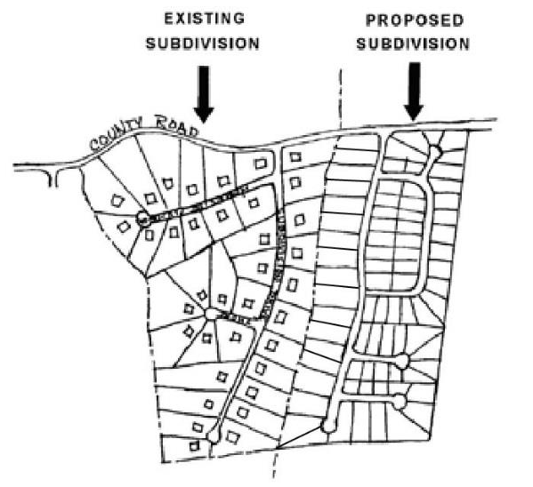
Transition. New subdivision lots adjacent to existing subdivision lots shall match the rear yard setbacks per base zoning, not exceed the number of stories of the existing adjacent homes and shall not exceed a 50-percent reduction in lot size of the existing subdivision lots. If existing subdivision lots are less than half acre, no transition is required.
Figure 32.09.030-1 - Lot Size Transition
b.
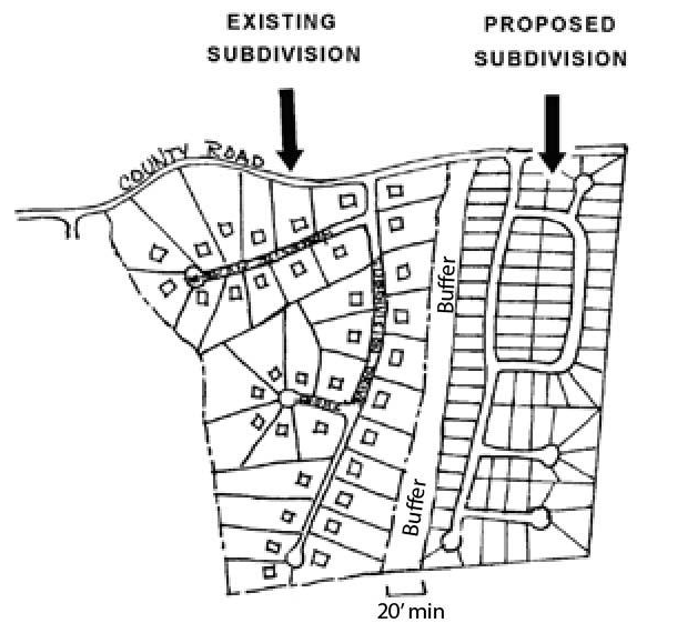
Buffering. A "buffer zone" shall be established and shall be a minimum of 20 feet wide. The buffer zone may be common open space for the proposed subdivision and shall include at least one of the following improvements: paths, trails, drainageways, landscaping, berms, or other subdivision amenities. The city may require a larger landscape buffer of a specific width, or other visual and/or sound barrier (open view fence, wall, landscaping, or combination of such measures), to mitigate any potential adverse impacts. The city may allow a major roadway or railroad right of way to constitute adequate buffering.
Figure 32.09.030-2 - Buffering
c.
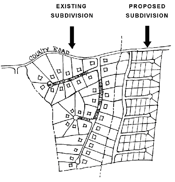
Yard matching. The rear yard widths of the proposed development shall match the rear yard widths of the existing development as depicted in Figure 32.09.030-3:
Figure 32.09.030-3 - Yard Matching
(2)
In addition, lots proposed within a new subdivision that share a common property line with an established subdivision shall not contain structures that exceed the maximum height of the adjacent equivalent zoning district.
(e)
Lot adjacency standards—Multiple-family residential.
(1)
Residential infill that exceeds the height of adjacent existing homes by more than one story in height and/or are significantly larger in terms of their overall mass shall provide a transition using at least three of the following techniques:
a.
"Stepping down" building height and mass along the shared property line to meet the height of the existing adjacent home, the "stepped down" portion of the building shall be a minimum of ten feet in depth along a minimum of 50 percent of the building's length;
b.
Increasing the side yard setback, a minimum of five feet beyond that which is required and providing a landscape buffer along a shared lot edge;
c.
Providing variations in the side building wall and roof form so that new structures have a comparable scale as adjacent homes along a shared side;
d.
Utilizing a roof pitch and overhang similar to that of the adjacent structures; and
e.
Utilizing dormers and sloping roofs to accommodate upper stories.
Alternative approaches may be approved by the administrator provided the overall objective of this standard can be satisfied.
(f)
Lot adjacency standards—Commercial and mixed use.
(1)
Transitions between mixed-use and commercial areas and adjacent residential neighborhoods shall be provided by utilizing the following techniques, as applicable:
a.
Concentrating tallest buildings at the center of the site or along primary street frontages;
b.
Providing gradual decreases in building height and mass so that new structures are a maximum of 24 feet in height along the shared lot line or a maximum of 36 feet height along the shared lot line or street frontage; or
c.
Incorporating lower-intensity housing types (e.g., townhomes, duplexes, etc.) along a shared street frontage.
(g)
Lot adjacency standards—Industrial.
(1)
Industrial development shall be oriented on the site to minimize off-site adverse impacts of noise, glare, smoke, dust, exhaust, vibration, etc., and protect the privacy of adjacent nonindustrial zoning districts to the extent practicable. The following standards apply to all development within industrial zoning districts when abutting nonindustrial zoning districts:
a.
Mechanical equipment, lights, emissions, shipping/receiving areas, and other components of an industrial use that are outside of an enclosed building shall be located away from abutting residential zoning districts, schools, parks and other nonindustrial zoning districts as practicable; and
b.
A buffer with a minimum width of 20 feet is required between industrial development and any adjacent residential zoning district. The buffer shall provide landscaping to screen the industrial activities, such as parking, service and delivery areas, from the residential districts. The buffer shall not contain trash receptacles or be used for the storage of equipment, materials, vehicles, etc. The city may require a larger landscape buffer of a specific width, or other visual and/or sound barrier (fence, wall, landscaping, or combination of such measures), to mitigate any potential adverse impacts.
(Ord. No. 2020-005, § 1(Exh. A), 3-4-2020)
Sec. 32.09.035. - Dedication of water rights and facilities for residential subdivision and parcel maps, construction of new homes and industrial and commercial buildings.
Purpose: The purpose of this section is to ensure that new development projects dedicate a sufficient quantity of water rights to the city to ensure long-term water resources are available to serve said development. Except as expressly provided in subsection (g) herein, or as authorized by a development agreement or water rights banking and dedication agreement approved by the city council, water rights owned by the city shall not be sold or otherwise allocated to a development project to meet the requirements of this section.
(a)
For municipal water delivery.
(1)
An applicant shall dedicate to the city, as a condition precedent to approval of a final subdivision map, final parcel map or issuance of a building permit, the surface water or groundwater rights reasonably necessary to ensure an adequate water supply to serve all parcels or lots within the project or a building. This section applies to projects that will be served by the city's municipal water system, or by domestic wells.
(2)
As a condition precedent to a final subdivision or parcel map, an applicant also must dedicate facilities for storm drainage, water treatment, supply, storage, transmission and distribution, and any facilities for sewage collection, treatment and disposal, and appurtenances (such as wells, pipelines, pumps and storage tanks) located within or outside of the property, which are reasonably necessary to ensure an adequate water supply to the property, adequate sewage disposal for the property, and adequate storm collection and disposal for the property, along with any easement or legal access reasonably necessary to ensure an adequate water supply to the property.
(3)
For dedications of non-surface water rights, the amount of water required to be dedicated to the city pursuant to this section shall be:
a.
For each single-family residential parcel or lot - the amount of water demand calculated by the following formula:
1.4 * (1/(1.1 + (10,000/Lot Size)))
b.
For each commercial and industrial parcel or lot - the amount of water required to meet the estimated average annual average demand of the development. The amount of water required to meet the annual average demand of the development shall be determined by the director of public works based on information provided by the applicant.
c.
For each mobile or manufactured home on a lot or space within a mobile home park, multi-family unit, condominium, townhouse, or similar type of development - the amount of water required for each unit shall be based on the number of fixture units, as defined by the most current version of the plumbing code adopted by the city, multiplied by 25 gallons per day and 365 days, then converted to acre-feet. The amount of water required for uses external to each unit (landscaping, recreational facilities, laundry facilities, clubhouses, etc.) shall be determined by the director of public works based in information provided by the applicant.
(4)
For dedications of surface water rights, the amount of water required to be dedicated to the city pursuant to this section shall be:
a.
For each single-family residential lot or parcel - 1.12 acre-feet per lot, or
b.
For all other parcels or lots - multiplying the applicable water dedication requirement for non-surface water dedications by 1.35.
(5)
For surface water dedications, the city may also require an applicant to pay a fee, established by resolution of the city council, to pay for the costs of constructing, operating, and maintaining:
a.
Upstream drought storage facilities, or
b.
Facilities required to convey surface water from the source to the municipal water treatment facility.
(6)
In the event of a parcel splitting that occurs subsequent to the initial parcel map, the applicable water right dedication shall be required for each additional parcel or lot created.
(7)
Dedication of surface water or groundwater rights must meet the following conditions:
a.
The applicant must submit proof of the validity of the water right and the complete chain of title establishing ownership. The water right must be in good standing and of sufficient quantity and quality to service the needs of the development. In the case of a certified right, the city may request proof of use within the preceding five years.
b.
The water right must be legally available for the beneficial use of the proposed development. All costs of transfer of any points of diversion or change in manner and place of use shall be the responsibility of the applicant. All water rights transfers are subject to the state water engineer's approval, proof of which must be submitted before acceptance.
(b)
Domestic well use.
(1)
For construction of new residences on existing parcels that were created on or after July 8, 1996, and that will be served by domestic wells, water rights shall be dedicated prior to the approval of a building permit for the residence. For vacant parcels that have existing wells, proof of water right dedication shall be submitted with the building permit. Parcels created before July 8, 1996, are exempt pursuant to NRS 534.350. Nothing in this article is intended to supersede the provision of FTO 13.
(2)
Prior to the approval of any new parcel map or subdivision map that creates new parcels that are five acres or less gross acreage, and which will utilize a domestic well for the property's domestic water supply, rather than the city municipal water system, the applicant shall dedicate to the city, at the applicants cost, 2.02 acre-feet per year of certificated groundwater rights from within the Fernley Area Hydrographic Basin.
(3)
The city, at its sole discretion, may accept, in lieu of the dedication of part or all of the 2.02 acre-feet of groundwater rights, as required in subsections (b)(l) and (2) of this section, up to 2.02 acre-feet of surface or other water rights that the city can utilize in its municipal water system. Supplemental irrigation water rights may not be dedicated to satisfy the requirements of this article.
(4)
Any water rights that are dedicated to the city under this section shall be withdrawn or committed to the use at the applicable parcel or lot pursuant to the policies and requirements of the city and the state.
(5)
In the event a property for which water rights were dedicated to the city and is subsequently connected to the city municipal water system:
a.
The water rights dedicated pursuant to this section may be credited toward the dedication requirements that exist for connecting the subject property to the municipal water system; but
b.
Said city credit will only be granted if the former domestic well is abandoned and plugged pursuant to state law.
(6)
If the abandonment of a domestic well under this article could qualify the city for a domestic well credit pursuant to NRS 534.350, or any regulations adopted pursuant thereto, no city credit towards the municipal service water dedication requirement will be allowed unless the city receives a domestic well credit pursuant to NRS 534.350, and regulations adopt pursuant thereto.
(7)
If a domestic well credit is granted to the city pursuant to NRS 534.350, and the amount of that credit for a specific well is greater than the credit a property owner is allotted to from the city pursuant to subsection (6) of this subsection (b), the property owner will receive the benefit of any such excess and may apply that excess toward another utility connection in the city service area.
(c)
Use of water rights and facilities. The city may, by contract or written agreement, permit the use of the dedicated water rights and/or facilities by other governmental entities, public or private utilities, or any other person or entity, including those engaged in providing water, storm drainage or sewer services.
(d)
Nature of dedication. The dedication of water rights and facilities required herein may be satisfied if the applicant enters into an agreement with the city secured by a performance bond or other undertaking acceptable to the city. The agreement must constitute a binding offer to dedicate, conditioned only upon failure to receive final approval of the application for water service.
(e)
Facilities standards. The facilities which are the subject of a dedication agreement must be designed and constructed in accordance with standards and other requirements established by the public works design standards manual.
(f)
Approval of service, conditional. Every "will-serve" notification and administrative approval of applications for water service is conditioned upon the acceptance of the dedication or the execution of an agreement conforming to this chapter.
(g)
Payment in lieu of dedication of water rights.
(1)
The following properties may pay a fee in lieu of dedication of water rights pursuant to the requirements set forth in subsection (3) of this section:
a.
New residences on parcels created by:
1.
Final subdivision maps;
2.
Tentative subdivision maps that have not expired; or
3.
Final parcel maps;
that were approved prior to December 14, 2004; or
b.
Commercial or industrial properties where the calculated ERC required to serve a proposed improvement is equal to or less than 0.5 ERCs.
(2)
The right to pay a fee in lieu of dedication pursuant to subsection (l)a. of this section shall expire on January 1, 2018, if not exercised before that date.
(3)
Standards for payment in lieu of fee of dedication of water rights.
a.
If a property on which the project listed in subsection (1) of this section has appurtenant water rights, those water rights shall be dedicated to the city, to the extent required for water service. In the event an applicant is unable to convey sufficient water rights because there are insufficient water rights on the subject property for the project, a fee may be paid in lieu of dedication of the unavailable water right or the applicant may acquire and dedicate an equivalent replacement water right.
b.
An applicant does not qualify for payment in lieu of dedication of water rights if the property that would otherwise qualify under subsection (l)a. of this section once had appurtenant water rights, and those rights were previously stripped from the property for use outside of the city. The burden of proof is on the applicant to show the lack of sufficient appurtenant water rights and/or the history of the transfer or unavailability of any appurtenant water rights. Any costs incurred by the city in determining the applicant's eligibility to pay a fee in lieu of dedication shall be the responsibility of the applicant.
c.
In the event that a fee in lieu of dedication of water rights is allowed as herein provided, said fee shall be the market rate for water rights as set by Truckee Meadows Water Authority. Any funds that are paid to the city in lieu of a dedication of water rights shall only be spent on:
1.
The acquisition of additional water rights;
2.
Projects designed to expand the quantity of water available to the municipal water system. Such projects may include, without ]imitation, projects for the storage of water during normal water years for use by the municipal water system during drought years; or
3.
New projects to enhance the quality of water within the municipal water system.
d.
The payment of a fee in lieu of dedication of water rights pursuant to this chapter must be made:
1.
For an eligible tentative subdivision map that has not expired and that was approved prior to December 14, 2004, at or before the time of approval of any final subdivision or final parcel map;
2.
For an eligible final subdivision map or final parcel map approved prior to January 1, 2008, at or before the time the water service connection fee is paid. If, prior to October 12, 2015, the water service connection fee was paid, but the payment of the fee in lieu of dedication of water rights was not paid at or before that time, the payment of the fee in lieu of dedication of water rights shall be paid at or before the time of the physical connection of any structure on the lot to the water service system;
3.
For all other eligible final subdivision maps or final parcel maps for which the fee was not collected at the time of submittal or recordation of such final subdivision map or final parcel map, at or before a building permit for any lot contained within the final subdivision map or final parcel map is submitted; or
4.
For improvements to commercial or industrial property eligible to pay an in lieu of fee pursuant to subsection (1)b. of this section, at the time a building permit is submitted.
e.
Notwithstanding any provisions of subsection 32.09.035(a) to the contrary, the required dedication rate on which the payment of a fee in lieu of dedication shall be calculated pursuant to this section for each residential lot for which water is allocated from the city's existing pool of ground water rights, shall be the amount of ground water actually allocated to serve such lots as evidenced by the records of the state engineer.
(Ord. No. 2020-005, § 1(Exh. A), 3-4-2020; Ord. No. 2021-004, §§ 1—6, 2-17-2021; Ord. No. 2023-005, 11-1-2023)
Sec. 32.09.037. - Procedures for obtaining appraisals of real property.
(a)
List of qualified appraisers.
(1)
Purpose. The purpose of this provision is to meet the minimum requirements set forth by the legislative mandate of Assembly Bill No. 312, as amended by Senate Bill No. 394 of the 73rd Session of the Nevada Legislature, and as further amended by Assembly Bill No. 462 of the 74th Session of the Nevada Legislature. To comply with that legislative mandate, the council adopts an ordinance establishing the procedures for creating and amending a list of appraisers qualified to conduct appraisals of real property offered for sale or lease by the city.
a.
This provision applies when the city is offering real property for sale or lease except as otherwise provided by state law, including, but not limited to, those exceptions contained NRS 268.059.
b.
This provision does not create a legal right, including, but not limited to, a property or other constitutional right, to be placed upon the established appraisal lists or to be awarded a contract for professional services.
(2)
Procedure.
a.
The director shall obtain from the state real estate division a list of all general appraisers qualified to act as a general appraiser in the county.
b.
The director shall send a request for qualification to each appraiser on the list to determine if the appraiser is interested in performing appraisals for the city under terms and conditions stated therein, and what types of appraisals the appraiser is qualified to perform based on training and experience. An appraiser who fails to respond to the request for qualifications to the satisfaction of the director shall not be placed on the list.
c.
From the responses to the requests for qualifications, the director shall prepare the following five lists:
1.
Residential appraisers;
2.
General commercial and/or industrial appraisers;
3.
Ranches appraisers;
4.
Open space appraisers; and
5.
Water rights appraisers.
d.
The names on the five lists set forth in subsection (a)(2)c of this section must be organized in a random order in a fashion determined by the director.
e.
To create the five lists set forth in subsection (a)(2)c of this section, the following standards shall be used to determine minimum qualifications:
1.
The appraiser must possess all necessary licenses;
2.
The appraiser must not have violated professional appraiser standards or statutory requirements in the performance of appraisals or cannot have been disciplined or fined by any state or federal agency for conduct that relates to the ability of the appraiser to perform the work to be required by the city;
3.
The appraiser must have the ability to obtain and maintain insurance coverage as required by the city;
4.
The appraiser must have the professional qualifications and experience for the specific appraisal required by the city;
5.
During the five years immediately preceding the date of the appointment by the city, the appraiser cannot have filed as a debtor in a business capacity under the provisions of the United States Bankruptcy Code or breached any contract with a public agency or person in this state or any other state;
6.
The appraiser's application must be truthful and complete; and
7.
The appraiser must execute the application form and consent to and have the ability to satisfy all terms and conditions contained in any proposed contract for appraisal services presented by the city.
f.
Appraisers on the lists shall keep the director informed of any change in the status of standards listed above in subsection[s] e.l through 7 of this section. The change in the appraiser's status or failure to maintain the minimum qualifications is cause for immediate removal from the list by the director. The director shall provide written notice to any appraiser of his removal.
g.
The names of appraisers who are organized in a firm of appraisers may be placed on the list independently if each is independently qualified. No two appraisers from the same firm can be selected to appraise the same real property. An appraiser who cannot be selected because of an appraisal firm relationship retains his place on the list for the next appraisal required by the city.
h.
From time to time the director shall obtain a new list from the state real estate division and follow the procedures of this article to assemble a new list. An appraiser whose name is stricken from the list as required by this section may be added to the new list if properly qualified and responsive.
(3)
Appraiser selection process.
a.
When an appraisal is required for the sale or lease of real property owned by the city, the director shall send a request for proposal to the appraiser whose name is next on the list for the type of property appraisal required, and who has not been hired by the city for an appraisal since the last time the list was assembled or reordered.
b.
The request for proposal shall identify:
1.
The property to be appraised;
2.
The desired terms and conditions of appraisal; and
3.
The requirements for the response to the request for proposal.
c.
The response from the appraiser must include:
1.
A statement of specific qualifications to do the type of appraisal required;
2.
A proposal complying with the terms and conditions of the request;
3.
The names of other appraisers in the appraiser's firm, if any;
4.
A statement that the appraiser is not related within the first degree of consanguinity or affinity to any person who has an interest in the real property or an adjoining property; and
5.
A disclosure statement which includes, without limitation:
A.
All sources of income that may constitute a conflict of interest;
B.
Any prior appraisal by the appraiser of the subject property; and
C.
Any relationship of the appraiser with the city, the owner of the subject property or the owners of any adjoining property to the one being appraised.
d.
If an appraiser responds to the request in terms that are responsive and satisfactory to the director, the appraiser's proposal shall be presented to the council which shall verify the qualifications of the appraiser. The determination of the council as to qualifications is conclusive. An appraiser's name shall be stricken from the list for the type of appraisal requested if the appraiser does not satisfactorily respond to the request as determined by the director or if the council declines to verify the appraiser's qualifications.
e.
The director shall use the list and repeat the selection procedures until the council approves an appraiser. To expedite the selection process, the director may send a request for proposal to more than one appraiser on the list. Those appraisers who respond but are not selected shall retain their places on the list. The director may also send the names of more than one appraiser to the council but shall report to the council the order of the appraisers on the list.
(Ord. No. 2023-005, 11-1-2023)
Sec. 32.09.040. - Drainage.
(a)
Applicability. This section applies to any development served by an adequate storm drainage system.
(b)
Adequate storm drainage. New development shall be served by an adequate storm drainage system. Storm drainage shall be considered adequate when:
(1)
Pursuant to an approved drainage plan, on-site drainage facilities are capable of conveying through and from the property the design flow of stormwater originating within the development, as determined in accordance with public works design standards, as well as flows originating from upstream properties in a pre- and post-development stages, post development being based on ultimate master buildout;
(2)
The off-site downstream drainage system is capable of conveying to an approved outfall the design flow of stormwater runoff originating in the development and from other developed and undeveloped land upstream, without resulting in erosion, sedimentation or flooding of the receiving channel and downstream properties and without creating any adverse impact to downstream property.
(c)
Prohibition on alteration of water course. Storm drainage shall not result in the alteration or relocation of a water course which will reduce the flood-carrying capacity of the water course, nor shall drainage facilities result in the damming, filling, relocating or other interference with the natural flow of surface water along any surface water drainage channel or natural water course, except as may be approved as part of the drainage study.
(d)
Drainage facilities. Design and construction of storm drainage facilities shall be in accordance with public works design standards. Detention facilities, restrictions on impervious surfaces and other techniques may be required by the city in order to satisfy adequacy requirements, in accordance with an approved drainage plan. Where special site conditions or circumstances require, the city may allow the use of retention or infiltration facilities.
(e)
Dedication of drainage facilities and rights-of-way.
(1)
Stormwater drainage facilities which are necessary to ensure an adequate stormwater collection and disposal system to serve the development, together with necessary rights-of-way and easements for operation and maintenance of such facilities. Unless accepted by the city, drainage facilities shall be maintained by the developer or successors in interest.
(2)
Preservation of natural drainageways and irrigation waterways: All natural drainageways and irrigation waterways shall be preserved with appropriate easements and/or pedestrian walkways where necessary and required by city and any irrigation districts.
(3)
Conservation easement along waterways: A conservation easement of a width to be determined by stream flow requirements shall be provided along all live waterways and streams to contain the channel during flood stages and to maintain the ecological integrity of the watercourse and to prevent encroachment. This easement shall be open to public access, but no tree or bush removal, gravel excavating, filling or side casting of materials shall be allowed within the area, and no construction of any kind shall be allowed below the mean high-water line.
(f)
Storm and surface water damage. The developer shall design the development so that it shall be protected from inundation, flood hazard, sheet overflow and ponding of local storm water, springs and other surface waters. The design of improvements shall be such that water occurring within the development will be carried off without impact to any improvements, building sites or residences to be installed on sites within the development or adjoining areas. Water occurring within the development shall be carried to a storm drainage facility approved for the project. Drainage design within the development shall accommodate reasonable anticipated future improvement within the drainage area. Any off-tract outlet drainage facility required to carry storm water from the proposed development to a defined channel or conduit shall be made adequate for the ultimate stage of improvement in the drainage area. All water shall be discharged into a controlled outlet stabilized storm channel for erosion control. All such off-site drainage water shall be materially free of silt or other polluting features.
(Ord. No. 2020-005, § 1(Exh. A), 3-4-2020)
Sec. 32.09.050. - Fences, walls and hedges.
(a)
Applicability. This section applies to any fence, wall or hedge.
(b)
Materials and construction.
(1)
A fence may be constructed of but not limited to: wire, chain links, wood, stone or any standard building materials to the approval of the administrator.
(2)
Barbed wire, (above ground) is only permitted in the C1, C2, TC, EC, I, PF, RR1, RR5, and GR20 zoning districts.
a.
All barbed wire fencing shall be on top of an eight-foot fence.
b.
Extension arms, when used, shall not extend beyond the property line.
c.
Barbed wire must not extend beyond the property line.
(3)
Razor wire fencing is only permitted in industrial zoning districts.
a.
All razor wire fencing shall be on top of an eight-foot fence.
b.
Extension arms, when used, shall not extend beyond the property line.
c.
Razor wire shall not extend beyond the property line.
(4)
Electric fencing is only permitted in the I zoning district.
a.
Electrification. The energizer for electric theft deterrent devices shall be powered by a battery not to exceed 12 volts DC.
b.
Perimeter fence or wall.
1.
No electric theft deterrent devices shall be installed or used unless it is completely within a non-electrical fence or wall that is at least six feet in height.
2.
The electric fence shall not exceed ten feet in height.
c.
Warning signs.
1.
Electric security fences shall be clearly identified with incidental signs that, at a minimum, read: "Warning-Electric Fence" at intervals of at least 25 feet.
2.
At least one sign shall be placed on each side of the fence.
3.
The minimum size of the sign shall be 12 inches wide by nine inches tall with a minimum lettering size of one inch. The sign shall be located on the perimeter of the fence and directed to the inside and outside of the secured area.
(c)
Fences or walls.
(1)
Fences or walls six feet or less in height may be erected in any zoning district except where a site issue may be created. Therefore, when constructing in the required front or exterior side setback, fences shall comply with the following standards:
a.
No more than three feet in height.
b.
Fencing may be increased to four feet in height when the fence is at least 50 percent open view.
(2)
Residential fences may be constructed up to six feet in height in the exterior side yard if the administrator determines a visibility issue will not be created.
(3)
Fences or walls in the industrial zoning districts:
a.
May be erected in the required front setback or exterior side yard and may exceed six feet in height.
(4)
Public utilities in any zone may be enclosed by a fence with barbed wire as long as the total height does not exceed nine feet.
(Ord. No. 2020-005, § 1(Exh. A), 3-4-2020)
Sec. 32.09.060. - Floodplain management.
Purpose. It is the purpose of this section to promote the public health, safety and general welfare and to minimize public and private losses due to flood conditions in specific areas by provisions designed:
•
To protect human life and health;
•
To minimize expenditure of public money for costly flood-control projects;
•
To minimize the need for rescue and relief efforts associated with flooding and generally undertaken at the expense of the general public;
•
To help maintain a stable tax base by providing for the sound use and development of areas of special flood hazard so as to minimize future flood blight areas;
•
To ensure that potential buyers are notified that property is in an area of special flood hazard; and
•
To ensure that those who occupy the areas of special flood hazard assume responsibility for their actions.
(a)
Statutory authority. The Legislature of the State of Nevada has, in NRS ch. 244 and NRS ch. 543, delegated the responsibility to local governmental units to adopt regulations designed to promote the public health, safety and general welfare of its citizenry. Therefore, the Fernley City Council do ordain as set forth in this section.
(b)
Findings of fact.
(1)
The flood hazard areas of the city are subject to periodic inundation which results in loss of life and property, health and safety hazards, disruption of commerce and governmental services, extraordinary public expenditures for flood protection and relief and impairment of the tax base, all of which adversely affect the public health, safety and general welfare.
(2)
These flood losses are caused by the cumulative effect of obstructions in areas of special flood hazards which increase flood heights and velocities and, when inadequately floodproofed, elevated or otherwise protected from flood damage, also contribute to the flood loss.
(c)
Methods of reducing flood loses. In order to accomplish its purposes, this section includes methods and provisions for:
(1)
Restricting or prohibiting uses which are dangerous to health, safety and property due to water or erosion hazards or which result in damaging increases in erosion or in flood heights or velocities;
(2)
Requiring that uses vulnerable to floods, including facilities which serve such uses, be protected against flood damage at the time of initial construction;
(3)
Controlling the alteration of natural flood plains, stream channels and natural protective barriers which help accommodate or channel flood waters;
(4)
Controlling filling, grading, dredging and other development which may increase flood damage; and
(5)
Preventing or regulating the construction of flood barriers which will unnaturally divert flood waters or may increase flood hazards in other areas.
(d)
Definitions. Certain words and terms used herein are defined, for the purpose of this section, as provided in this section. Unless specifically defined in this section, words or phrases used in this section shall be interpreted so as to give them the meanings they have in common usage and to give its most reasonable application.
TABLE 32.09.060-1 - Definitions
(e)
Interpretation, application and compliance.
(1)
This section shall apply to all areas of special flood hazards within the jurisdiction of the city.
(2)
In the interpretation and application of this section, all provisions shall be:
a.
Considered as minimum requirements;
b.
Liberally construed in favor of the city; and
c.
Deemed neither to limit nor repeal any other powers granted under state statutes.
(3)
This section is not intended to repeal, abrogate or impair any existing easements, covenants or deed restrictions. However, where this section and another ordinance, easement, covenant or deed restriction conflict or overlap, whichever imposes the more stringent restrictions shall prevail.
(4)
No structure or land shall hereafter be constructed, located, extended, converted or altered without full compliance with the terms of this section and other applicable regulations.
(f)
Basis for establishing areas of special flood hazard; information maintained.
(1)
Flood insurance study and maps: The areas of special flood hazard identified by the Federal Insurance Administration in a scientific and engineering report entitled "The Flood Insurance Study for Lyon County," dated November 20,1998, with accompanying flood insurance maps is hereby adopted by reference and declared to be a part of this section. The flood insurance study and flood insurance rate maps are on file at the City of Fernley City Hall. Interpretations, where needed, as to exact location of the boundaries of the areas of special flood hazards (for example, where there appears to be a conflict between a mapped boundary and actual field conditions) shall be made by the floodplain administrator. The person contesting the location of the boundary shall be given a reasonable opportunity to appeal the interpretation as provided in subsection 32.09.060(m).
(2)
Use of other base flood data: When base flood elevation data has not been provided in accordance with subsection (1) of this section, the city engineer shall obtain, review and reasonably utilize any base flood elevation and floodway data available from a federal, state or other source in order to administer this section.
(3)
Information obtained and maintained:
a.
Where base flood elevation data is provided through the flood insurance study or required as in subsection (2) of this section, the actual elevation (in relation to mean sea level) of the lowest floor (including basement) of all new or substantially improved structures and whether or not the structure contains a basement shall be obtained and recorded.
b.
For all new or substantially improved floodproofed structures:
1.
The actual elevation (in relation to mean sea level) shall be verified and recorded; and
2.
The floodproofing certifications required by this section shall be maintained.
c.
All records pertaining to the provisions of this section shall be maintained for public inspection.
(g)
Development permit.
(1)
Permit required: A development permit shall be obtained before construction or development begins within any area of special flood hazard established in this section. The permit shall be for all structures, including manufactured homes as set forth in this section, and for all development, including fill and other activities, also as set forth in this section.
(2)
Application for permit: Application for a development permit shall be made on forms furnished by the city and may include, but not be limited to, plans in duplicate drawn to scale showing the nature, location, dimensions and elevations of the area in question and existing or proposed structures, fill, storage of materials, drainage facilities and the location of the foregoing. Specifically, the following information is required:
a.
Elevation in relation to mean sea level of the lowest floor (including basement) of all structures.
b.
Elevation in relation to mean sea level to which any structure has been floodproofed.
c.
Certification by a registered professional engineer or architect that the floodproofing methods for any nonresidential structure meet the floodproofing criteria in this Section.
d.
Description of the extent to which a watercourse will be altered or relocated as a result of proposed development.
(3)
Permit review and approval: The administrator is appointed to administer and implement this section by granting or denying development permit applications in accordance with its provisions. Duties and responsibilities of the administrator shall include, but not be limited to:
a.
Review all development permits to determine that the permit requirements of this section have been satisfied.
b.
Review all development permits to determine that all necessary permits have been obtained from those federal, state or other governmental agencies from which prior approval is required.
c.
Review all permits to determine that the site is reasonably safe from flooding.
d.
Review all development permits to determine if the proposed development adversely affects the flood carrying capacity of the area of special flood hazard. For purposes of this section, "adversely affects" means that the cumulative effect of the proposed development, when combined with all other existing and anticipated developments, will not increase the water surface elevation of the base flood more than one foot at any point.
(h)
Alteration of watercourses.
(1)
Adjacent communities and the Nevada Department of Water Resources shall be notified prior to any alteration or relocation of a watercourse, and evidence of such notification shall be submitted to the Federal Emergency Management Agency.
(2)
Require that the flood carrying capacity of the altered or relocated portion of said watercourse equals or exceeds the capacity of the watercourse before it was altered or relocated.
(3)
Maintenance provided within the altered or relocated portion of said watercourse shall be required so that the flood carrying capacity is not diminished.
(i)
Maintenance of flood protection measures. The maintenance of any public flood protection measures (levees, dikes, dams or reservoirs) will be the responsibility of the city. If these measures are privately owned, an operation or maintenance plan will be required of the owner to be on file with the community development department.
(j)
Hazard mitigation plan. In reviewing proposals for new development, the city council, planning commission or community development department shall weigh all requests for future flood plain development against the city's master plan and zoning. Considerations of the following elements are required before approval:
(1)
Determination if proposed development is in or affects a known flood plain.
(2)
Inform the public of the proposed activity.
(3)
Determine if there is a practicable alternative or site for the proposed activity.
(4)
Identify impact of the activity on the flood plain.
(5)
Provide a plan to mitigate the impact of the activity with provisions of this section.
(k)
General standards for flood hazard reduction. In all areas of special flood hazards, the following standards are required:
(1)
Anchoring:
a.
All new construction and substantial improvements shall be anchored to prevent flotation, collapse or lateral movement of the structure.
b.
All manufactured homes must likewise be anchored to prevent flotation, collapse or lateral movement and shall be installed using methods and practices that minimize flood damage. Anchoring methods may include, but are not limited to, use of over the top or frame ties to ground anchors (reference FEMA's "Manufactured Home Installation in Flood Hazard Areas" guidebook for additional techniques).
(2)
Construction materials and methods:
a.
Materials: All new construction and substantial improvements shall be constructed with materials and utility equipment resistant to flood damage.
b.
Construction methods and practices: All new construction and substantial improvements shall be constructed using methods and practices that minimize flood damage.
c.
Location of service facilities: Electrical, heating, ventilation, plumbing and air conditioning equipment and other service facilities shall be designed and/or otherwise elevated or located so as to prevent water from entering or accumulating within the components during conditions of flooding.
d.
Elevation and floodproofing:
1.
New construction and substantial improvement of any structure shall have the lowest floor, including basement, elevated to one foot above the base flood elevation. Nonresidential structures may meet the standards in subsection (2)d.2., below. Upon completion of the structure, the elevation of the lowest habitable floor, including basement, shall be certified by a registered professional engineer or surveyor or verified by the city that elevation requirements have been met. Notification of compliance shall be recorded as set forth in this section.
2.
Nonresidential construction shall either be elevated to conformance with subsection (2)d.1., hereinabove or, together with attendant utility and sanitary facilities:
A.
Be floodproofed so that below the base flood level the structure is watertight with walls substantially impermeable to the passage of water;
B.
Have structural components capable of resisting hydrostatic and hydrodynamic loads and effects of buoyancy; and
C.
Be certified by a registered professional engineer or architect that the standards of this subsection are satisfied. Such certifications shall be provided to the administrator.
3.
Manufactured homes shall meet the above standards.
(3)
Storage of materials and equipment:
a.
The storage or processing of materials that are, in time of flooding, buoyant, flammable, explosive or could be injurious to human, animal or plant life is prohibited.
b.
Storage of other material or equipment may be allowed if not subject to major damage by floods and firmly anchored to prevent flotation or if readily removable from the area within the time available after flood warning.
(4)
Utilities:
a.
All new and replacement water supply systems shall be designed to minimize or eliminate infiltration of flood waters into the system and discharge from systems into flood waters.
b.
New and replacement sanitary sewage systems shall be designed to minimize or eliminate infiltration of flood waters into the systems and discharge from the systems into flood waters; and
c.
On-site waste disposal systems shall be located to avoid impairment to them or contamination from them during flooding.
(5)
Land division proposals:
a.
All land division proposals shall be consistent with the need to minimize flood damage;
b.
All subdivision proposals shall have public utilities and facilities such as sewer, gas, electrical and water systems located and constructed to minimize flood damage;
c.
All subdivision proposals shall have adequate drainage provided to reduce exposure to flood damage; certification of compliance shall be required of the developer; and
d.
Where base flood elevation data has not been provided or is not available from another authoritative source, it shall be generated for subdivision proposals and other proposed developments which contain at least 50 lots or five acres (whichever is less).
(6)
[Application review.] Where elevation data is not available either through the flood insurance study or from another authoritative source, applications for building permits shall be reviewed to assure that proposed construction will be reasonably safe from flooding. The base flood elevation shall be determined by a Nevada registered civil engineer and submitted to the city with the submittal of a building permit. Construction of the structure shall conform to this section.
(7)
[Conditional letter of map revision from FEMA.] When required by the administrator, the applicant shall be required to apply to FEMA for a conditional letter of map revision (CLOMR) and subsequent letter of map revision (LOMR) in order that a finding can be made regarding the impacts from proposed development.
(l)
Specific standards for flood hazard reduction. In all areas of special flood hazards where base flood elevation data has been provided as set forth in this section, the following provisions are required:
(1)
Residential construction:
a.
New construction and substantial improvement of any residential structure shall have the lowest floor, including basement, elevated to one foot above base flood elevation.
b.
Fully enclosed areas below the lowest floor that are subject to flooding are prohibited or shall be designed to automatically equalize hydrostatic flood forces on exterior walls by allowing for the entry and exit of flood waters. Designs for meeting this requirement must either be certified by a registered professional engineer or architect or must meet or exceed the following minimum criteria:
1.
A minimum of two openings having a total net area of not less than one square inch for every square foot of enclosed area subject to flooding shall be provided.
2.
The bottom of all openings shall be no higher than one foot above grade.
3.
Openings may be equipped with screens, louvers or other coverings or devices; provided, that they may permit the automatic entry and exit of flood waters.
(2)
Nonresidential construction: New construction and substantial improvement of any commercial, industrial or other nonresidential structure shall either have the lowest floor, including basement, elevated to the level of the base flood elevation or, together with attendant utility and sanitary facilities, shall:
a.
Be floodproofed so that below the base flood level the structure is watertight with walls substantially impermeable to the passage of water;
b.
Have structural components capable of resisting hydrostatic and hydrodynamic loads and effects of buoyancy;
c.
Be certified by a registered professional engineer or architect that the design and methods of construction are in accordance with accepted standards of practice for meeting provisions of this subsection based on their development and/or review of the structural design, specifications and plans. Such certifications shall be provided to the official as set forth in this section.
d.
Nonresidential structures that are elevated, not floodproofed, must meet the same standards for space below the lowest floor as described in subsection (1)b. of this section.
e.
Applicants floodproofing nonresidential building shall be notified that flood insurance premiums will be based on rates that are one foot below the floodproofed level (e.g. a building constructed to the base flood level will be rated as one foot below that level).
(3)
Manufactured homes: All manufactured homes to be placed or substantially improved within Zones A, AH and AE shall be elevated on a permanent foundation such that the lowest floor of the manufactured home is at or above the base flood elevation and shall be securely anchored to an adequately anchored foundation system in accordance with the provisions of this section.
(4)
Floodways: Located within areas of special flood hazard established in this section are areas designated as floodways. Since the floodway is an extremely hazardous area due to the velocity of flood waters which carry debris, potential projectiles and erosion potential, the following provisions apply:
a.
Encroachments, including fill, new construction, substantial improvements and other development are prohibited unless certification by a registered professional engineer or architect is provided demonstrating that encroachments shall not result in any increase in flood levels during the occurrence of the base flood discharge.
b.
If subsection (4)a., above is satisfied, all new construction and substantial improvements shall comply with all applicable flood hazard reduction provisions of this section.
(m)
Variances and appeals.
(1)
Authority: The city council shall hear and decide appeals and requests for variances from the requirements of this section.
(2)
Appeals:
a.
The city council shall hear and decide appeals when it is alleged there is an error in any requirement, decision or determination made by the floodplain administrator of this section.
b.
Those aggrieved by the decision of the city council may appeal such decision to the appropriate court as provided in Nevada Revised Statutes.
(3)
Variances:
a.
Application for variance: In passing upon such applications, the city council shall consider all technical evaluations, all relevant factors, standards specified in other sections of this section and:
1.
The danger that materials may be swept onto other lands to the injury of others;
2.
The danger to life and property due to flooding or erosion damage;
3.
The susceptibility of the proposed facility and its contents to flood damage and the effect of such damage on the individual owner;
4.
The importance of the services provided by the proposed facility to the community;
5.
The necessity to the facility of a waterfront location, where applicable;
6.
The availability of alternative locations for the proposed use which are not subject to flooding or erosion damage;
7.
The compatibility of the proposed use with existing and anticipated development;
8.
The relationship of the proposed use to the comprehensive plan and floodplain management program for that area;
9.
The safety of access to the property in times of flood for ordinary and emergency vehicles;
10.
The expected heights, velocity, duration, rate of rise and sediment transport of the flood waters and the effects of wave action, if applicable, expected at the site; and
11.
The costs of providing governmental services during and after flood conditions, including maintenance and repair of public utilities and facilities such as sewer, gas, electrical and water system and streets and bridges.
b.
Conditions may be imposed: Upon consideration of the factors of subsection (3)a. above and the purposes of this section, the city council may attach such conditions to the granting of variances as it deems necessary to further the purposes of this section.
c.
Standards for granting variances:
1.
Generally, the only condition under which a variance from the elevation standard may be issued is for new construction and substantial improvements to be erected on a lot of one-half acre or less in size contiguous to and surrounded by lots with existing structures constructed below the base flood level, providing items 1. through 11. in subsection (3)a. of this section have been fully considered. As the lot size increases, the technical justification required for issuing the variance increases.
2.
Variances may be issued for the reconstruction, rehabilitation or restoration of structures listed on the National Register of Historic places or the State Inventory of Historic places without regard to the procedures set forth in the remainder of this subsection.
3.
Variances shall not be issued within any designated floodway if any increase in flood levels during the base flood discharge would result.
4.
Variances shall only be issued upon determination that the variance is the minimum necessary, considering the flood hazard to afford relief.
5.
Variances shall only be issued upon:
A.
A showing of good and sufficient cause such as renovation, rehabilitation or reconstruction. Variances issued for economic considerations, aesthetics or because variances have been used in the past are not good and sufficient causes;
B.
A determination that failure to grant the variance would result in exceptional hardship to the applicant; and
C.
A determination that the granting of a variance will not result in increased flood heights, additional threats to public safety, extraordinary public expense, create nuisances, cause fraud on or victimization of the public or conflict with existing local laws or ordinances.
6.
Variances, as interpreted in the National Flood Insurance Program, are based on the general zoning law principle that they pertain to a physical piece of property, they are not personal in nature and do not pertain to the structure, its inhabitants, economic or financial circumstances. They primarily address small lots in densely populated residential neighborhoods. As such, variances from the flood elevations should be quite rare.
7.
Variances may be issued for nonresidential buildings in very limited circumstances to allow a lesser degree of floodproofing than watertight or dry floodproofing, where it can be determined that such action will have low damage potential, complies with all other variance criteria except subsection (3)c.1. hereof and otherwise complies with this section.
c.
Notice when variance granted: Any applicant to whom a variance is granted shall be given written notice that the structure will be permitted to be built with a lowest floor elevation below the base flood elevation and that the cost of flood insurance will be commensurate with the increased risk resulting from the reduced lowest floor elevation.
(4)
Records and reports: The community development department shall maintain the records of all appeal actions and report any variances to the Federal Emergency Management Agency upon request.
(n)
Letter of map amendment (LOMA).
(1)
The following administrative procedures are provided to have the Federal Insurance Administrator review information from an owner or lessee of property who believes his property has been inadvertently included in a special flood hazard area. These procedures shall not apply when there has been any alteration of topography since the effective date of the first FIRM or FHBM showing the property within an area of special flood hazard. The scientific or technical information submission may include, but is not limited to the following:
a.
An actual copy of the recorded map bearing the seal of the county recorder, including recording information;
b.
A topographical map showing:
1.
Ground elevation contours;
2.
The total area of the property in question;
3.
The location of the structure or structures located on the property in question;
4.
The elevation of the lowest adjacent grade to a structure or structures; and
5.
An indication of the curvilinear line which represents the area subject to inundation by a base flood. The curvilinear line should be based upon information provided by an appropriate authoritative source, such as a federal agency, department of water resources, the city, a Federal Emergency Management Agency Flood Insurance Study, or a determination by a licensed professional engineer;
c.
A copy of the FHBM or FIRM indicating the location of the property in question;
d.
A certification by a registered professional engineer or licensed land surveyor that the lowest grade adjacent to the structure is above the base flood elevation; and
e.
The completion of the appropriate forms in the FEMA's Packet, Amendments and Revisions to National Flood Insurance Program Maps.
(Ord. No. 2020-005, § 1(Exh. A), 3-4-2020)
Sec. 32.09.070. - Grading.
All grading requirements shall be as set forth herein.
(a)
Grading permits required; conditions. Any grading over 50 cubic yards shall be performed under a grading permit or a building permit. At the time of such permit, the city may restrict improvements consisting of the clearing of brush and trees or the moving of earth by mechanical equipment. Such restrictions may include a provision that no such improvements may be made for a given period of time, including the time up to the issuance of a grading permit or building permit. Conditions and restrictions on grading permits and building permits shall be evaluated upon the following:
(1)
Pollution, contamination, or silting of lakes, rivers, streams of domestic water supplies, irrigation waterways.
(2)
Erosion damage.
(3)
Alteration of natural drainage patterns in a manner likely to cause damage to the property or persons from which or to which the normal drainage is diverted.
(4)
Large parcel clearing with respect to wind erosion and dust hazards.
(b)
Geologic survey report. If geologic problems are likely or apparent, a geologic survey report shall be required prior to the issuance of the building permit or grading permit.
(c)
Erosion control. All cleared slopes, all cuts and fills and all other areas vulnerable to erosion shall be either stabilized with grass or other protective ground cover or properly mulched to assure establishment, riprapped for slope control, treated with a soil solidifier or be provided with appropriate drainage benches as may be determined by the administrator. On steep slopes, controls, as necessary to the circumstances, may be required.
(d)
Landscaping.
(1)
In addition to the landscaping requirements of this section, landscaping and/or revegetation is required to stabilize all slopes which have been:
a.
Cleared;
b.
Graded;
c.
Otherwise disturbed by development subject to this section; or
d.
Visible from public rights-of-way.
(2)
Landscaping shall be dispersed throughout the stabilized area.
(3)
Interior side yard sloped areas of individual lots are exempt from the landscaping and irrigation requirement.
(4)
Planting shall be designed to achieve 90 percent ground coverage of any disturbed area within three years.
(Ord. No. 2020-005, § 1(Exh. A), 3-4-2020)
Sec. 32.09.080. - Intensity standards.
(a)
Glare. Except in processes of construction, glare from arc welding, acetylene torch cutting, or similar activity shall be performed so as not to be seen from any point outside the property on which the work is being performed.
(b)
Noise. Noise shall be muffled so as not to become objectionable due to intermittence, beat, frequency or shrillness.
(c)
Smoke, odor and gas.
(1)
The emission of obnoxious odors of any kind shall not be permitted.
(2)
No gas shall be emitted which is deleterious to the public health, safety or general welfare.
(d)
Vibration. No use, activity, or process shall produce vibrations that are perceptible without instruments at the property line for more than three minutes in any one hour of the day between the hours of 7:00 a.m. and 10:00 p.m. or for more than 30 seconds in any one hour between the hours of 10:00 p.m. and 7:00 a.m.
(Ord. No. 2020-005, § 1(Exh. A), 3-4-2020)
Sec. 32.09.090. - Landscaping and screening.
Purpose: This section promotes the public health, safety and general welfare by establishing regulations for the installation and maintenance of landscaping according to recognized resource-efficient principles, and to provide for the protection of existing vegetation, where appropriate. The regulations:
•
Enhance the aesthetics of the community;
•
Conserve water and other natural and energy resources by requiring the use of resource-efficient guidelines and principles;
•
Provide environmental controls such as, but not limited to, the reduction of noise, dust and erosion;
•
Reduce air pollution by encouraging the use of vegetation for air filtration, absorption of carbon dioxide and production of oxygen;
•
Assist in ground water recharge;
•
Reduce visual pollution which might otherwise occur within an urbanized area;
•
Establish a greater sense of privacy from visual and physical intrusion;
•
Encourage a balanced landscape approach with a variety of landscape materials; and
•
Buffer structures and uses from noise or undesirable views.
(a)
Applicability. The provisions of this section apply to:
(1)
All new development projects, including model homes for subdivisions.
(2)
An expansion to any existing building, when not in conformance with the minimum landscaping requirements shall provide a proportionate amount to the expansion as demonstrated in the following example:
EXAMPLE:
Existing building = 10,000 sf
Expansion = 1,000 sf or 10% increase
Zoning = C-2; 15% required
.10 × .15 = .015 or 1.5% of the site is to be landscaped.
(3)
If a proposed building expansion exceeds 75 percent of the present size of the building, the site must be brought into compliance with the current landscape ordinance.
(4)
Exceptions. This section does not apply to:
a.
Single-family dwelling units or duplexes on separate lots, except common areas in planned developments.
b.
Permits such as, but not limited to, reroofing, siding, temporary power, change of electrical service, change of furnace, mobile home set-up, addition of interior plumbing, addition of interior electrical, fencing, on and off-premises signs and encroachment.
c.
Development projects where the existing vegetation to be retained meets or exceeds the requirements of this section.
(b)
Landscape and irrigation plans. Landscape and irrigation plans shall be provided in accordance with the standards outlined in appendix A-6, landscape and irrigation plans.
(c)
General landscape standards.
(1)
Landscape elements shall provide a vertical dimension. Trees and tall shrubs shall be used in addition to grass and groundcover.
(2)
Landscaping shall be used to enhance the quality of the residential environment, to buffer the units from noise or undesirable views and to separate roads within the development.
(3)
Landscaping around the entire foundation base of buildings is required to enhance the edge between the parking lot and the structure.
(4)
Landscaping shall be protected from vehicular and pedestrian encroachment by raised planters or the use of curbs. Stepping stones shall be provided as access through a landscape planter(s) when adjacent to parking spaces.
(5)
All landscape planters shall be protected by a minimum six-inch high concrete curb.
(6)
All ground surfaces shall have one or more of the following treatments:
a.
Paving.
b.
Turf.
c.
Four-inch rounded river rock.
d.
Decomposed granite with a pre-emergent herbicide using weed barrier underneath.
e.
Other similar ground surface as approved by the administrator.
(7)
Landscaping shall be sited so that at maturity the plants do not inhibit visibility in any sight triangle.
(8)
Planting islands in parking lots shall have a minimum width of eight feet interior, protected by six-inch high curb.
(9)
Artificial turf is permitted as a landscape cover in side and rear yards that are not adjacent to streets.
(d)
Specific standards.
(1)
Areas disturbed by grading activity that do not include permanent structures, pavement, parking areas or landscaping, shall be revegetated with indigenous or natural appearing plants.
(2)
All landscaping materials shall aesthetically enhance and be environmentally compatible with the site area. The landscaping shall be installed to enhance the view of the property from the public streets(s) adjoining the property. Insofar as is practical, the trees used shall represent a mixture of deciduous and coniferous varieties.
Existing trees and shrubs may be incorporated into a landscaped area as long as they are healthy and in good condition and do not conflict with plant location requirements of this section (such as in parking areas).
(3)
The minimum portion of the site area to be landscaped, as required by this section, is:
TABLE 32.09.090-1 - Minimum Landscape Requirements
Notes:
a.
Applies to all uses except single-family detached.
b.
Includes landscaping strips along street frontages. Landscaping strips shall be at least ten feet wide regardless of the percentage of the site area involved. The administrator may approve narrower landscaping strips in conjunction with alternative screening compliance that exceeds the minimum requirements for perimeter landscaping in this section. This may include a combination of a masonry wall and plant materials or an increase in landscape plant materials of 30 percent or more above minimum quantities.
c.
When occupying an existing building, if compliance with the landscaping ordinance creates a non-conformance in any aspect of the code, an applicant may apply for an administrative review to demonstrate how the proposal will bring the site closer to compliance with the code.
d.
Includes all setback areas from public or private streets. Setback areas with street frontages shall be landscaped regardless of the percentage of the site area involved.
(4)
The minimum number of trees to be planted in the required landscape area is one tree per 300 square feet in all MF zoning districts and one tree per 500 square feet in other zoning districts. Parking area trees per subsection (10) below are in addition to this requirement.
(5)
Evergreen trees shall be at least six feet in height at time of planting. Fifty percent of deciduous trees shall be a minimum caliper of one inch and 50 percent shall be a minimum caliper of two inches at time of planting.
(6)
Existing trees and shrubs may be incorporated into a landscaped area if they are healthy and in good condition and do not conflict with plant location requirements of this section (such as in parking areas).
(7)
The minimum number of shrubs to be planted in the required landscape area in one shrub per 15 square feet in all zoning districts. Sixty percent of container-grown shrubs and plants (excluding trees), and excluding those plants grown in flats, shall be minimum five-gallon size and the remainder shall be minimum one-gallon size at time of planting.
(8)
Turf grass.
a.
The maximum slope of an area planted in turf grass is four to one.
b.
Turf grass is not required and may not constitute more than 80 percent of the required landscape area.
(9)
Parking area landscaping is in addition to other required landscaping. The parking area is subject to the following minimum standards:
a.
Each planter island containing a tree shall have at least 288 square feet for double loaded parking and 144 square feet for single loaded parking, with an eight-foot minimum interior width protected by a six-inch curb.
b.
At least one shade tree shall be planted for each seven parking spaces for parking lots under 125 spaces in size. For those over 125 spaces, at least one shade tree shall be planted for each ten parking spaces.
c.
All areas used for landscaping shall be surrounded by curbing at least six inches in height and four inches in width and shall be constructed of reinforced concrete.
d.
Landscaping strips, a minimum of ten feet in width (except as otherwise specified in this title) shall be provided along public street frontages. One tree shall be planted in the landscaping strips for each 30 feet of street frontage.
(10)
Ground covering shall be provided over the entire landscape area to prevent erosion, inhibit weed growth, and to present an aesthetically pleasing appearance. Ground covering may include:
a.
Living plants, such as shrubs, turf grasses, vines, or other living ground covers. Ornamental grasses and shrubs need to be 30 inches in height at maturity.
b.
Decorative rock, pavers, rock mulch, decomposed granite or other non-living materials may also be used.
c.
Non-permeable materials may not be used for more than 20 percent of the total landscaped area and excludes the areas of temporary coverage allowed for all plant and ground cover maturity.
(11)
The following types of trees are prohibited in landscaping as required by this section because of undesirable characteristics: Populus genus (poplars and cottonwoods), salix genus (willows), ulmus genus (elms) and zelkova genus (zelkova).
(12)
If specimens of these trees exist on a site to be landscaped, they may be retained and counted towards the required number of trees.
(13)
All landscaped areas shall be watered by a water-conserving irrigation system including drip, low-arching and/or low-gallonage heads, as appropriate, controlled by an automatic timer.
(e)
Buffer requirements.
Purpose. The intent of buffering is to provide landscaped separation between residential and nonresidential uses and to screen from view certain land uses that may create visual clutter and distraction. The standards of this section provide for increases in the width and the opacity of the buffer as the land use intensity of the new or expanded development increases.
(1)
Applicability. This section applies to any activity involving new construction when adjacent to existing residential development and applies to the following:
a.
Residential development adjacent to non-residential development, and
b.
Single-family development adjacent to multi-family development
(2)
Buffering.
a.
Evergreen trees shall be planted to screen parking lots and non-residential building walls to provide a visual barrier between non-residential and residential uses. In no instance shall evergreen trees be planted further apart than 30 feet on center.
b.
Screening between uses (i.e. fencing, walls, landscape buffers, etc.) shall be required to mitigate impacts subject to the administrator approval.
(3)
Exemptions. This section does not apply to:
a.
Residential uses adjoining residential uses within the same residential zoning district.
b.
Agricultural uses.
c.
Nonresidential uses adjoining other nonresidential uses of the same zoning classification.
d.
Any change of use that does not increase the existing building square footage or parking area.
e.
Single-family dwellings located on an existing lot of record.
f.
Contiguous commercial parcels or land areas under common ownership.
(4)
Reduction in required buffers. The buffer requirements are reduced where a buffer exists on an abutting property, and the net buffer satisfies the minimum buffer requirements of this section.
(f)
Bonding requirements.
(1)
All landscaping material for a development project shall be installed in accordance with the landscape plan. A surety bond is required if the landscaping is not satisfactorily installed at the time a certificate of occupancy or business license is requested. The bond shall be written by a surety company authorized to do business in this state, to be filed with the city clerk prior to issuance of a certificate of occupancy.
(2)
In lieu of filing a surety bond, cash, a cashier's check, or a letter of credit issued by a bank licensed in this state may be filed with the city clerk.
(3)
The bond, cash deposit, cashier's check or letter of credit shall be in an amount sufficient to ensure the installation of all required landscaping as required by this section.
(4)
The administrator shall inspect the landscaping to insure proper installation according to the approved landscape plan.
(5)
The bond, or equivalent surety, will not be released until final approval of the landscaping.
(6)
If the landscaping material is not installed in accordance with the landscape plan, the administrator may cause the bond, cash deposit, or letter of credit to be forfeited in an amount necessary to complete the installation. The administrator may waive the surety requirement.
(g)
Maintenance.
(1)
If any portion of the landscaping material or irrigation equipment is damaged or destroyed, the owner, operator or other person in control of the development project shall replace or repair the damage or injury within 30 days following notification from the administrator. If the season of the year makes this repair or replacement infeasible within the 30-day period, the person responsible for the landscaping shall schedule an appropriate time for the accomplishment of this work with the administrator.
(2)
If the repair or replacement is not accomplished in a timely fashion, the administrator may initiate proceedings to revoke the conditional use permit or business license for the subject use.
(h)
Landscaping at site entries.
(1)
The project entry shall be treated with special landscape elements that will provide an individual identity to the project (i.e., special paving, graphic sign, water feature, specialty lighting, specimen trees and flowering plants).
(2)
Entry/access drives for multi-family/attached single-family projects with more than 50 units shall include at least one of the following:
a.
A minimum of five-foot wide (exclusive of curbs) landscaped median;
b.
Textured paving, interlocking pavers or rough textured concrete;
c.
Other "gateway" elements such as lights, bollards, water feature, monument/statue, entry walls, etc., as approved by the administrator.
d.
A roundabout containing landscaping and/or water fountain/feature, artwork, etc.
(3)
In parking lots with over 125 parking stalls, a main entry drive shall extend from the public street to the front cross aisle and shall:
a.
Include a minimum four-foot wide sidewalk from the street to the front cross aisle on at least one side.
b.
Include ten-foot wide landscape parkways on each side.
c.
Prohibit parking stalls along the entry drive.
d.
Include a minimum seven-foot wide enhanced paving crosswalk do delineate the pedestrian crossing at the public sidewalk.
(i)
Trash enclosure and mechanical/electrical.
(1)
Trash enclosures shall allow convenient access from each tenant.
(2)
Trash enclosures shall be constructed to be architecturally compatible with the project. All trash enclosures shall be treated with anti-graffiti material. The trash enclosure shall be constructed of substantial building materials used in the design of the building(s). The gates shall be constructed of durable material that screens the trash enclosure. Wood and chain link gates are not allowed.
(3)
Switch boxes, transformers, electrical and gas meters, including ground mounted air conditioning units and other above ground or building mounted utility elements (including antennas or satellite disks), shall be screened or located out of view from public roads, driveways and common public areas, such as exterior entrances.
(4)
All roof-mounted equipment shall be screened with a parapet from adjacent properties, public rights-of-way, and driveways/common areas within project. The screening elements shall be designed to be compatible with building architecture.
(j)
Walls. The following standards shall be used for the consistent design of perimeter walls:
(1)
Walls shall be decorative using materials and colors to complement the architectural design of the adjacent buildings/development theme as approved by the administrator.
(2)
Walls shall incorporate at least one of the following every 50 linear feet:
a.
At least a two-foot change in plane for at least ten feet;
b.
At least 18-inch raised planter for at least ten feet;
c.
Use of a pilaster at 75-foot intervals, on property corners or at changes in wall planes; or
d.
A section of open metal fencing at least four feet in height for at least ten feet.
(3)
Walls adjacent to a public walkway (sidewalks, path/trails, etc.) shall have masonry construction (either solid or with metal fencing insets) and a landscaped setback of at least four feet. Walls or solid fences are not permitted between public open spaces and adjacent roads except upon approval of the administrator.
(4)
Walls between public open spaces shall have an open design and a maximum height of four feet. The administrator shall approve solid fences/walls between open space and multi-family/attached single family developments.
(5)
The maximum height of rockery is six feet.
(6)
All screening devices shall be properly maintained.
(Ord. No. 2020-005, § 1(Exh. A), 3-4-2020)
Sec. 32.09.100. - Lighting.
Purpose: This section sets forth criteria and standards to mitigate impacts caused by future development so as to promote dark skies.
(a)
Generally. Any lighting facilities shall be installed to reflect away from adjoining properties to promote dark-sky compliance.
(b)
Light. Any new development shall submit a photometric plan for review and approval by the administrator at time of building permit demonstrating:
(1)
Any lighting facilities will be installed to reflect away from adjoining properties.
(2)
Covers will be installed on all lighting fixtures and lamps will not extend below the bottom of the cover.
(3)
Light standards in or within 100 feet of residential zones will not exceed 12 feet in height. Additional standard height may be permitted by the administrator if lights are a sharp cutoff lighting system.
(4)
No permanent rotating searchlights are permitted in any zoning district, except that the administrator may approve a temporary searchlight by temporary use permit for up to three days and up to three times in any calendar year.
(c)
Lighting design. The style and intensity of lighting shall consider not only function and appearance but shall reflect the existing character of surrounding areas and shall replicate natural light color as much as possible.
(d)
Parking lot lighting.
(1)
The height of parking lot lighting shall not exceed 20 feet from grade of parking lot. The parking lot lighting poles shall be decorative, complementary and consistent with the architecture of the project.
(Ord. No. 2020-005, § 1(Exh. A), 3-4-2020)
Sec. 32.09.110. - Patio covers, decks and building projections.
Purpose: this section establishes rules to administer the lot and setback regulations, and to provide for the appropriate development of lots in zoning districts.
(a)
Patio covers/decks.
(1)
Attached patio covers.
a.
Location. Attached patio covers may extend to within ten feet of a rear property line but must not extend into any required front or side setback.
b.
Height. Unenclosed structures must not exceed the height of the permitted main structure.
(2)
Decks within two feet above grade. Uncovered structures such as decks not higher than the ground floor elevation of a building and not higher than two feet above grade at any point may:
a.
Extend to the side and rear property lines, but
b.
Must not encroach into a required front setback.
(3)
Decks higher than two feet above grade
a.
Decks such as decks with a floor higher than two feet above grade at any point must comply with the setback requirements of the district in which the permitted structure is located.
b.
Decks with a floor higher than two feet above grade shall not exceed the height of the permitted principal structure.
(b)
Building projections.
(1)
Cornices, overhangs and eaves may not project more than two feet into any required front, side, or rear setback.
(2)
Fireplaces, chimneys, greenhouse windows, bay windows, and other projections may project beyond the exterior wall of a building up to two feet. The maximum two-foot projection(s) shall not exceed ten square feet.
(Ord. No. 2020-005, § 1(Exh. A), 3-4-2020)
Sec. 32.09.120. - Parking and loading.
Purpose: This section sets minimum standards for off-street parking requirements for new construction and expansion of or changes to existing uses. This section ensures that uses have a minimum level of off-street parking to avoid congestion on surrounding streets without creating excessive parking, discouraging pedestrian access, driving up the cost of development and inviting excessive levels of traffic congestion.
(a)
Off-street parking—General requirements.
(1)
Permanently maintained off-street parking shall be provided in accordance with the provisions of this section for all developed property within the city. Lawfully established uses which do not conform to the requirements of this section are considered to be substandard developments and are covered by chapter 32.08 of this title. If the use of any developed lot or parcel is changed in such a manner as to increase the number of parking spaces required under this section, all requirements of this section shall apply to that lot or parcel.
(2)
All required parking must be located on the same site as the use it serves, except that:
a.
Off-site parking for commercial uses will be allowed to be located anywhere within the parking district.
b.
Within the I district, parking for a nonresidential use may be located off-site, provided that it is within 500 feet of the use it serves except accessible parking spaces as required by ADA Standards for accessible design must still be provided on-site to the approval of the administrator. Off-site parking for nonresidential uses shall be dedicated to the use in compliance with the requirements of this section. Documentation of the dedicated parking shall be provided with the business license application to the approval of the administrator and shall be provided with each renewal of the business license. Failure to maintain the off-site parking will result in revocation of business license.
(3)
Plans for construction or alteration of any off-street parking facility subject to this section must be approved by the administrator. If it is necessary to prevent unsafe conditions or material damage or prejudice to adjacent properties, the administrator may impose requirements in addition to those specified in this title. Such requirements may include, but are not limited to, visual and sound buffers, directional and warning signs, lighting and other security provisions, limitations on hours of operation and limitations on ingress and egress.
(4)
Shared parking and alternative standards: In any nonresidential development where the requirements of this section can be met by non-concurrent, joint use of the same spaces by more than one business, the administrator may permit the parking requirement to be reduced accordingly. For nonresidential developments, the administrator may approve the use of alternative parking space requirements based on Urban Land Institute, American Planning Association, Institute of Transportation Engineers, or other analytical studies approved by the administrator, that take into account factors including monthly, hourly and weekly variation; peaking characteristics, and shared uses. It shall be the responsibility of the applicant to justify the use of and appropriateness of alternative parking number calculations.
(5)
For residential uses on lots or parcels occupied by no more than four dwelling units, the administrator may approve a parking layout which contains tandem parking spaces.
(6)
All parking spaces which must be provided to satisfy the requirements of this section shall conform to the minimum sizes and design geometry contained in this section. In parking facilities accommodating at least 20 cars, a maximum of 25 percent of the parking spaces required by this section may be sized for compact cars. Such spaces shall conform to the minimum sizes and design geometry for compact cars, contained in this section, and shall be given preferred locations within the facility. Each compact space shall be clearly marked "compact only."
(7)
Accessible parking.
a.
Accessible parking shall comply with applicable provisions of all codes adopted pursuant to Title 8 of the City of Fernley Municipal Code, and with all other ordinances and provisions of Fernley Municipal Code.
b.
All such spaces must be indicated by a sign which complies with NRS 484.408, and the bottom of which is not less than seven feet above the ground.
(8)
Unobstructed access to a public right-of-way shall be provided for all parking facilities covered by this section. Driveways shall intersect with public or private streets at an angle of approximately 90 degrees. One-way driveways and parking aisles shall be not less than 12 feet in width. Two-way driveways and parking aisles shall be not less than 20 feet in width. However, any driveway or parking aisle which serves as a required fire lane shall meet the requirements of the fire marshal. Adequate circulation and maneuvering space shall be provided on-site in all off-street parking facilities.
(9)
Off-street parking facilities shall be striped and otherwise marked so that individual spaces and aisles are clearly indicated. Directional markers and signs indicating spaces reserved for compact cars and the handicapped shall be painted on the pavement or placed on standards, as directed by the administrator.
(10)
All off-street parking lots as well as driveways and access roads must be paved. The administrator may grant an exception for any parking lot which is, of necessity, subject to regular use by heavy construction equipment. The city council may, by conditional use permit, allow the temporary use of unpaved parking lots for a period not to exceed one year. Designs for paving, curb and gutter, sidewalks, utilities and drainage for all off-street parking facilities shall be approved by the administrator prior to construction.
(11)
Notwithstanding any contrary parking requirement or standard in this section, the administrator may approve an alternative parking plan with unique parking space requirements for a project when any reduction in parking requirements from that provided in this section is supported by an analytical study (which study may be national in scope and need not be site specific) by the Urban Land Institute, American Planning Association, Institute of Transportation Engineers, or any other analytical study approved by the administrator.
(b)
Off-street parking spaces—Number required. This section specifies the required number of off-street parking spaces related to various land uses. For any use not specifically covered by one of the following categories, the requirement shall be determined by the administrator based on actual parking demand associated with that use. If the administrator determines that special circumstances exist, he may require spaces in addition to those specified in this section.
TABLE 32.09.120-2 - Parking Ratios
(c)
Parking geometry.
(1)
All required off-street parking facilities shall be designed and constructed according to the following geometric configurations: (See table below).
(2)
Curbs shall be provided where parking adjoins landscaping and sidewalks. A three-foot overhang is permitted where parking abuts a landscape strip. This allows for a 15-foot stall length.
TABLE 32.09.120-3 - Individual Parking Space Requirements (feet)
*Minimum aisle width for two=way traffic is 20 feet.
Fig. 32.09.120-1 -Parking Lot Layout
(d)
Off-street loading.
(1)
In order to avoid undue interference with the public use of streets or alleys, there shall be provided and maintained adequate off-street space for standing, loading or unloading for those uses involving receipt and distribution of vehicles or merchandise and materials off-street.
(2)
Loading space design.
a.
Each required loading space shall be at least ten feet by 45 feet with a 14-foot height clearance.
b.
For a non-residential building containing less than 3,000 square feet of gross floor area, a combined parking and loading area is acceptable.
(Ord. No. 2020-005, § 1(Exh. A), 3-4-2020)
Sec. 32.09.130. - Slopes, hilltops and ridges.
Purpose: This section regulates development on hills and slopes to promote quality land development by regulating the potential for the aesthetic degradation of sites through orderly development with slopes in conjunction with of the city's natural environment and scenic backdrop.
(a)
Applicability.
(1)
A pre-submittal meeting with staff is required for any development project to be undertaken on project sites having slope gradients of at least ten percent or greater over at least 25 percent of the site. For development greater than ten acres and/or when exceeding any minimum standard in this section a conditional use permit may be applied for. For projects less than ten acres and compliance with standards is demonstrated, the administrative review process shall be utilized.
(2)
The minimum average slope of a project site is used to identify the threshold (i.e., a slope map).
(b)
Design policies. Any development subject to the requirements of this section shall be designed in accordance with the best applicable practices of land use planning, engineering, geology, hydrology, civil and structural engineering, environmental design, architecture and landscape architecture, including, but not limited to, the following:
(1)
The site of the proposed development shall be analyzed to identify the design constraints imposed by hydrological and geological conditions, soils, slopes and other natural topographic conditions. In order to secure a conditional use permit, the project shall respect the natural constraints in the design of the development.
(2)
The development shall be designed with consideration for limiting aesthetic degradation of the site, as well as erosion, sedimentation and other hazards.
(3)
Long slopes with sharp transitions are generally considered undesirable.
(4)
Buildings should be designed and placed on the site so as to visually complement each other and the natural land forms of the site. The placement of buildings on or near hilltops or ridges must show a high degree of sensitivity to the terrain and its visual impact. Definitive plans shall be prepared that clearly demonstrate this sensitivity for project approval.
(c)
Grading.
(1)
No grading or clearing of any kind may be initiated until a final grading permit is issued unless exempted by Fernley Building and Building Regulations Code Title 8. Grading shall also comply with the most restrictive requirements of Title 8 of the Fernley Building and Building Regulations Code.
(2)
Grading shall be designed so that finished grading resembles natural land forms as much as practical with rounded transitions or variable slope gradients.
(3)
A graded slope that exceeds 33⅓ percent (3:1) and over three feet in height shall have a solution presented that stabilizes the slope and minimizes scarring.
(4)
The portion of any development site which may be cleared, graded or otherwise disturbed by construction is limited to a percentage of the site area, based on the natural slope of the site, as follows:
a.
The applicant shall provide a slope or "cell" map which groups small areas of similar slope together, gridded at a maximum contour interval of two feet.
b.
The slope categories or groups are as listed below. This establishes the maximum disturbed area within each slope category over the entire site.
c.
Then the maximum area within each category that can be disturbed is calculated by applying the fraction indicated below:
TABLE 32.09.130 - Maximum Disturbed Area
d.
Once the calculation of disturbed area is made, this becomes the total disturbed area over the entire site. Disturbed areas can be aggregated and do not need to be specific to the slope category.
(5)
The final grading plan for the development shall include mapping and calculations necessary to demonstrate compliance with these requirements.
(6)
Before a grading permit is issued, a temporary fence shall be constructed on the site defining the limits of the area to be disturbed as shown on the final grading plan. That fence shall be inspected and approved by the administrator before the grading permit is issued and shall remain in place until final grading inspection and approval.
(d)
Erosion and sedimentation control.
(1)
For any project which involves a graded area larger than one acre, a temporary erosion and sedimentation plan, including dust control must be approved by the administrator before a grading permit is issued. If grading of an area larger than one acre is to proceed in phases, the erosion and sedimentation control plan shall contain a phasing schedule showing how large an area will be exposed at any one time. Land will be considered exposed from the time it is cleared, graded or otherwise disturbed until it is permanently stabilized by paving, landscaping or vegetation according to approved plans.
(2)
At any time during construction when more than one acre is exposed, all temporary erosion and sedimentation control measures shall be continuously applied and maintained.
(3)
In order to keep the grading permit valid, a bond or other surety in an amount determined by the administrator must be provided by the developer.
(e)
Landscaping.
(1)
In addition to the landscaping requirements of this section, landscaping and/or revegetation is required to stabilize all slopes which have been:
a.
Cleared;
b.
Graded;
c.
Otherwise disturbed by development subject to this section; or
d.
Visible from public rights-of-way.
(2)
Landscaping shall be dispersed throughout the stabilized area.
(3)
Interior side yard sloped areas of individual lots are exempt from the landscaping and irrigation requirement.
(4)
Planting shall be designed to achieve 90 percent ground coverage of any disturbed area within three years.
(f)
Open space.
(1)
Any portion of a development on which clearing and grading is not allowed under subsection (d) (undisturbed area) must be:
a.
Placed within any required open space;
b.
Protected from disturbance through fencing or other permanent access restrictions; or
c.
Subject to a permanent open space deed restriction in favor of the city.
(2)
If the application involves subdivision plat approval, the applicant must provide a plan to maintain any required open space which is not a part of a developed lot.
(3)
Open space areas shall include a variety of slope gradients and not contain only slopes within one slope category.
(4)
The open space must be accessible to the residents.
(g)
Hilltops or ridgelines. Any hilltop or ridgeline, that is identified by the city as a significant hilltop or ridgeline, shall have additional setback requirements. The setback requirement shall vary dependent on the slope(s) of the ridgeline or hilltop and the proposed heights or structures.
(h)
Application requirements. In addition to the usual requirements for a conditional use permit or administrative review; the application for any development subject to the requirements of this section shall include the following information:
(1)
Preliminary grading plan and slope analysis. A preliminary grading plan and slope analysis shall be provided in accordance with standards outlined in appendix A-7, preliminary grading plan and slope analysis.
(2)
Supplemental information for development on slopes, hilltops and ridges. Supplemental information for development on slopes, hilltops, and ridges shall be provided in accordance with the standards outlined in appendix A-8, supplemental information for development on slopes, hilltops and ridges.
(Ord. No. 2020-005, § 1(Exh. A), 3-4-2020)
Sec. 32.09.140. - Streets (roadways).
(a)
Conformance with master plan.
(1)
If the circulation element of the master plan shows any right of way so located that any portion lies within the proposed land development, such portion shall be shown as a right-of-way or part thereof within the general location as shown on the master plan.
(2)
The location, width and alignment of streets shall conform to the master plan and be arranged to produce the most advantageous improvement of the area, preserve the natural features and enhance overall design. The layout, character, extent, width, grade, location of all proposed streets shall be established with due regard for:
a.
Public convenience and safety.
b.
Topography and other land features.
c.
Proposed uses of the land to be served by such streets and expected future traffic needs.
d.
Expected traffic type and volume to be carried by such streets.
e.
Proper relation to, connection with, continuation and projection of streets in the adjacent area, whether these streets are existing or proposed in another development, in an area plan, or in the master plan.
(b)
General requirements. Each street and highway (except under steep slope conditions) shall conform to the following requirements and be constructed to the adopted street standards:
(1)
Minor arterials, as designated by the master plan, shall conform to a right-of-way width of 80 feet or more.
(2)
Entrance or collector streets and local streets serving lots used for other than single family dwelling purposes shall have a dedicated right-of-way of not less than 60 feet.
(3)
Local residential streets shall have a dedicated right-of-way of not less than 50 feet.
(4)
A cul-de-sac street shall have a dedicated right-of-way of 50 feet radius and total center line length is not in excess of 400. Cul-de-sacs in excess of 400 feet may be approved as part of a tentative map or parcel map, if 50-foot radius turn around bulbs are provided at 400-foot intervals and if secondary emergency access is provided. Cul-de-sacs exceeding 400 feet must be approved by the fire district.
(5)
Have a maximum roadway gradient of not more than allowed by the most current International Fire Code adopted by the fire district and the public works design standards.
(6)
All abutting or interior roads shall be paved to city standards and additional right-of-way shall be dedicated to meet these standards.
(c)
Street extensions. The proposed street layout shall provide for the continuation or projection of existing streets unless extension is undesirable for specific reasons of topography or design. Some proposed streets may be required to extend to the boundary line of the development to provide access to adjacent properties. When building sites have access from such street stub, or the street stub terminates on the property owned by the development, a temporary turnaround easement shall be provided at that end. The street stub so created shall be required to be improved. A barrier, if required by the public works department, shall be installed at the end of the pavement.
(d)
Streets or alleys adjoining development boundary.
1.
Existing road or alley rights-of-way. Existing roads or alleys shall be improved to a fullwidth pavement section. If required, curb, gutter and sidewalk shall be constructed only along the side or the road or alley abutting the development boundary. Curb, gutter and sidewalk do not have to be installed on the opposite side of the road or alley.
(2)New roads or alleys. If new adjoining roads or alleys are required, the development shall dedicate the one-half width of the required right-of-way if it is practical, to require the dedication of the other one-half when the adjacent property is developed. Such portion of the road or alley shall be distinctly designated as being a "portion only" and not full width. The road or alley shall be improved to a one-half width pavement section. If required, curb, gutter and sidewalk shall be constructed only along the side or the road or alley abutting the development boundary. All one-half roads shall have a minimum travel lane width of 24 feet, excluding curb, gutter and sidewalk.
(e)
Intersections.
(1)
Number of intersections: The number of street intersections shall be kept consistent with the block and design requirements.
(2)
Design: Whenever any street or highway is proposed requiring a separation of grades or any special form of intersection design, the development shall be so designed to conform to the plan of intersection design and all building sites shall, when necessary, be provided with at grade access from local access roads.
(3)
Property line at block corners: At each street intersection, the property line at each block corner shall be rounded by a curve having a radius of not less than set forth by the public works design standards.
(f)
Residential development abutting collector or arterial road. When a residential development abuts or includes an existing or proposed collector or arterial, the following standards shall apply:
(1)
Access to individual residential lots or parcels is prohibited.
(2)
A solid six-foot high masonry wall shall be constructed along the right-of-way lines along non-rural residential lots or parcels.
(g)
Slope areas.
(1)
Where a cut or fill slope is outside the normal right-of-way of the street, a slope easement shall be provided of sufficient width to permit proper maintenance of the slopes by the city.
(2)
Retaining walls shall be required whenever topographic conditions warrant or where necessary to retain fill or cut slopes within the rights of way or slope easement.
(3)
Alternative roadway designs may be permitted by the city to reduce the need for significant cut and fill designs in order to preserve natural slopes, minimize significant visual impacts and to retain natural vegetation.
(h)
Center line curve radii. Minimum center line curve radii shall be determined based on traffic flow requirements including design, speed and sight distance set forth in the public works design standards.
(i)
One-way streets. One-way streets may be allowed if existing conditions prohibit the acquisition of additional right-of-way, or when it is determined that one-way traffic flows improve the level of service of a street or intersection.
(j)
Lesser developed streets, rights-of-way and sections. Lesser developed streets, rights-of-way and sections may be permitted when no on-street parking is permitted or under one-way design. Increased widths may be required when streets are to serve commercial property or where traffic conditions warrant. Lesser streets may be approved by the city. Design criteria shall follow the street design standards adopted by the city.
(k)
Pedestrian ways. Pedestrian ways may be required to provide pedestrian accessibility for public facilities and open spaces. Such pedestrian ways shall be a minimum of 15 feet in width and be paved, unless part of an un-improved trail system.
(l)
Street names. Street names and suffixes shall be designated by the developer, subject to the approval by the city, in accordance with the following requirements:
(1)
Be short (under 12 letters, if possible) and preferably in one word.
(2)
Have a simple spelling and easy pronunciation.
(3)
Avoid prefixes such as north and south, east and west and upper and lower, etc.
(4)
Be related to the type and importance of the street. (The suffix boulevard should not be attached to the name of a minor residential street.)
(5)
Avoid the use of numbers or letters as street names.
(6)
Not be incongruous, offensive or geographically misleading.
(7)
Not be repetitive or similar in sound and character.
(8)
Have a single name for a street having a continuous alignment.
(9)
When to be connected in the future into a continuous alignment or extended, bear the same name as the existing street.
(10)
Have a metal street sign to be erected as specified in the public works design standards on at least one corner of every intersection and shall identify each street name thereof.
(11)
Have a different spelling but the same pronunciation as other street names.
(m)
Construction specifications. These specifications shall govern all construction within the public rights-of-way and easements within the city and all new roads in any proposed subdivision or new development within the city.
(1)
Plans and profiles:
a.
Drainage plans showing street drainage to the public works department for approval. Provision must be made for all on-site drainage that affects the volume and/or time of concentration of runoff crossing or entering any roadway.
b.
Profile of all roads to be constructed, together with typical cross-sections showing the relationship of the final road section to the adjacent land, must be submitted to the public works department for approval.
(2)
Aggregate base: Aggregate base shall meet the requirements as specified in the public works design standards.
(3)
Asphaltic concrete pavement: Asphaltic concrete pavement shall meet the requirements as specified in the street design standards set forth in the public works design standards.
(4)
Concrete curbs, gutters and sidewalks: Concrete curbs, gutters and sidewalks shall meet the requirements as specified in the street design standards set forth in the public works design standards. All development shall require the "L" curb and gutter. Rolled curb and gutter is not permitted.
(5)
Road and utility line improvements:
a.
The required improvements for subdivision and subsequent parcel maps, and commercial, industrial, multi-family developments are as follows:
TABLE 32.09.140-1 - Road and utility line improvements for Subdivisions
b.
The required improvements on first-time parcel maps are as follows:
TABLE 32.09.140-2 - Road and utility line improvements for First Time Parcel Maps
(n)
Payment for facilities of greater capacity or size than required for a particular development to be serviced.
(1)
The city may require the subdivider to provide streets of greater capacity and width than required for any particular subdivision. The public works director shall determine the width of streets required for the proper development of the city.
(2)
It shall be the policy of the city that the city will pay the additional cost for city streets that are wider than the required normal width city street. Subdividers and the city may enter into agreements setting forth the cost sharing and method of payment for over-sized facilities.
(Ord. No. 2020-005, § 1(Exh. A), 3-4-2020)
Sec. 32.09.150. - Utilities.
Purpose: This section establishes the standards for utilities improvements, including water, sewer, electrical, gas, telephone, cable, and related improvements associated with any development located outside of the public right of way.
(a)
Applicability.
(1)
This subsection does not apply if the parcel is part of a subdivision or a development agreement where the city has determined that there is sufficient capacity for, and has approved the design of, water, sewer, electrical, gas, telephone, cable, and related improvements for the proposed use.
(2)
Administrative review is required if the utility project has not been approved as part of a subdivision plat application (unless a conditional use permit is required).
(3)
The requirement for a conditional use permit and/or administrative review is not required for projects with an associated building permit.
(b)
Easements and dedication.
(1)
Development plans shall identify needed right-of-way or easement locations necessary for the provision of utilities, drainage and vehicular or pedestrian circulation within the development which meet specified levels of service called for in adopted city plans and policies. Easements may be granted and right-of-way dedicated to the public by the applicant as part of the development approval process or through separate instrument, which shall be in a form approved by the city attorney.
(2)
Drainage easements needed for storm water management as indicated on an approved drainage or grading plan shall be provided.
(3)
Utility easements required by the various public and private utilities shall be provided. The various utility agencies and the City of Fernley shall be consulted as to current policy on design and required easement widths.
(4)
Vegetation located on utility easements shall be placed so as to not interfere with the free movement of service vehicles.
(5)
Structures shall not be placed on utility easements.
(Ord. No. 2020-005, § 1(Exh. A), 3-4-2020)
Sec. 32.09.160. - Undergrounding of utilities.
Purpose: The purpose of the following provisions is to protect the public health and safety of city residents, and to maintain and enhance the aesthetic qualities and character through the undergrounding of certain new utilities, including electric service lines, telephone lines and cable television.
(a)
Definitions. The following words and phrases, when used in this section, are defined as follows:
TABLE 32.09.160-1 - Definitions
(b)
Applicability.
(1)
All on-site utilities servicing a division of land created by subdivision map or parcel map or a new structure must be installed underground, except as otherwise provided in subsection 32.09.160(c).
(2)
Any new line extensions required to service a division of land created by subdivision map or parcel map or a new structure must be installed underground, commencing from the terminus of the existing utility service to the project site, except as otherwise provided in subsection 32.09.160(c).
(3)
Any new line extensions or modifications to existing overhead facilities requiring the placement of new utility lines must be installed underground, except as otherwise provided in subsection 32.09.160(c).
(c)
Exemptions. The following types of facilities are exempted from the undergrounding of utilities:
(1)
Existing poles, overhead wires and associated utility services, and any appurtenant structures and equipment such as surface mounted transformers, pedestal-mounted terminal boxes and meter cabinets;
(2)
New or modifications to poles, overhead wires and associated utility services that are used for the transmission of electric energy at a nominal voltage of 33,000 volts or higher, and any appurtenant structures and equipment such as surface mounted transformers, pedestal-mounted terminal boxes and meter cabinets;
(3)
Temporary poles, overhead wires and associated utility services used or to be used in conjunction with construction projects;
(4)
Temporary poles, overhead wires and associated utility services for a temporary use when a temporary use permit has been issued and when the permit requires removal of the temporary utility service upon completion of the temporary use;
(5)
Normal maintenance performed by a public utility doing work governed by the rules, regulations and tariffs of the public service commission;
(6)
Emergency poles, overhead wires, and utility services to be installed and maintained for a period not to exceed ten days, with the approval of the director;
(7)
Whenever an unreasonable hardship has been found and a waiver granted by the hearing body pursuant to subsection (d) below.
(d)
Hardship waiver.
(1)
Whenever the financial cost of placing new line extensions underground causes an unreasonable hardship, the owner or owners of the real property which is subject to the approval may apply in writing to the hearing body for relief from the provisions of this section. The request shall contain a detailed description of the utility services proposed to be placed underground and separate itemized cost estimates of construction of the project if the utilities were placed or converted to underground facilities.
(2)
Unreasonable hardship findings. After considering the request for relief, final decision maker of the pertinent application may grant relief of the undergrounding requirement. The final decision maker may grant a waiver on placing existing utilities underground is disproportionate to the total cost and exceeds 20 percent of the project valuation, or the installation of such utilities underground is impractical or unreasonable due to topographic, soil or other conditions.
(Ord. No. 2020-005, § 1(Exh. A), 3-4-2020)
Sec. 32.09-170. - Water supply and fire hydrants; wastewater facilities.
(a)
The construction and installation of all water and wastewater facilities, maintenance of water and wastewater facilities shall comply with the Fernley Municipal Code.
(b)
All maps of land division, including parcel maps, subdivision maps and maps of division of land into large parcels, must dedicate or relinquish water rights as provided in the Fernley Municipal Code.
(c)
Water supply and fire hydrants.
(1)
The water supply shall be adequate for all domestic use and fire protection needs.
(2)
Fire hydrants shall be located not less than 18 inches from the back of the curb to the center of the fire hydrant.
(3)
Water lines to hydrants shall conform to recommendations of the National Board of Fire Underwriters and shall be clear of pedestrian lanes.
(d)
Waste water facilities.
(1)
Sewage collection or treatment or collection and treatment shall comply with the laws of the state and all local ordinances, be subject to the approval of the public works director and conform to all standards and specifications of the city.
(2)
All sewage facilities shall be installed within the public street right-of-way. Installation of sewage facilities may be permitted in dedicated easements providing readily available access is provided for maintenance purposes.
(3)
Each sheet of sewer plans and profiles submitted to the public works director shall show all required information as herein required. Each plan view shall show lot lines, lot and block numbers, the exact location of the sewer line with reference to property lines, the location of manholes and house laterals, with reference to property lines. Each profile shall show the original ground line flow line of the proposed sewer construction, design line of the proposed street construction, top of manhole elevations, invert elevations, stationing of each manhole, size and type of pipe, percent of grade and exact distance between manholes.
(e)
Payment for facilities of greater capacity or size than required for a particular development to be serviced.
(1)
The city may require the subdivider to provide sanitary sewers of greater capacity and width than required for any particular subdivision. The public works director shall determine the size of sewers required for the proper development of the city.
(2)
It shall be the policy of the city that the city will pay the additional cost for oversizing sanitary sewers. Subdividers and the city may enter into agreements setting forth the cost sharing and method of payment for over-sized facilities.
(Ord. No. 2020-005, § 1(Exh. A), 3-4-2020)