
Fort Myers City Zoning Code
ARTICLE 1
- GENERAL PROVISIONS
118.1.1 - Purpose.
The city is divided into zoning districts established in this article of the Land Development Code with the intent:
A.
To provide for the geographic distribution of land uses as contemplated by the goals, objectives, and policies in the comprehensive plan;
B.
To maintain stability in land use commitments through the provision of harmonious groupings of uses possessing compatible characteristics and levels of activity;
C.
To maintain commitments in public service facilities, such as transportation systems, parks, and utilities; and
D.
To provide an efficient and compatible relationship of land uses and zoning districts.
(Ord. No. 3422, § 4, 1-14-2008)
118.1.2 - Districts Established.
Zoning districts in the City are hereby established as follows:
A.
Base districts.
B.
Overlay districts.
C.
Planned districts.
D.
Special development areas.
Sun City (Pelican Preserve)
Forum
E.
Downtown redevelopment area.
F.
Neighborhood redevelopment district.
(Ord. No. 3422, § 4, 1-14-2008; Ord. No. 3890, § 1(Exh. A), 1-21-2020; Ord. No. 3893, § 1(Exh. A), 2-3-2020; Ord. No. 3918, § 1, 12-6-2021)
118.1.3 - Official Zoning Map.
A.
The Official Zoning Map shall be amended in accordance with 98.3.9, Land Development Code and Official Zoning Map Amendments. The designation, location, and boundaries of the zoning districts established by this Article are as shown and depicted on the Official Zoning Map adopted in the Comprehensive Plan and which are incorporated by reference as part of this Land Development Code.
B.
A working copy of the Official Zoning Map shall be maintained by the Community Development Department. This map shall be current and reflect the latest changes duly authorized by the Council and supportive data for these changes shall be readily available in the Community Development Department's files and in the City Clerk's Office.
C.
No changes of any nature shall be made on this working copy, except those changes as authorized by ordinance, and such changes shall be made by authorized persons only.
(Ord. No. 3422, § 4, 1-14-2008)
118.1.4 - Interpretation of Map Boundaries.
The Community Development Director (Director) is authorized to interpret district boundaries as shown on the Official Zoning Map. Where uncertainty exists the following rules shall apply:
A.
Boundaries indicated as approximately following the centerlines of streets, highways or alleys shall be construed to follow such centerlines.
B.
Boundaries indicated as approximately following platted lot lines shall be construed as following such lot lines.
C.
Boundaries indicated as approximately following city limits shall be construed as following city limits.
D.
Boundaries indicated as following railroad lines shall be construed to be midway between the main tracks.
E.
Boundaries indicated as following shorelines shall be construed to follow such shorelines, and in the event of a change in the shoreline, shall be construed as moving with the actual shoreline.
F.
Boundaries indicated as parallel to or extensions of features indicated in paragraphs A and E above shall be so construed. Distances not specifically indicated on the Official Zoning Map shall be determined by the scale of the map.
G.
Where the street or property layout existing on the ground is at variance with that shown on the Official Zoning Map, or in other circumstances not covered by paragraphs A and F above, the Board of Adjustment shall interpret the district boundaries.
(Ord. No. 3422, § 4, 1-14-2008; Ord. No. 3841, § 1(Exh. A), 10-1-2018)
118.1.5 - Application of District Regulations.
A.
General restrictions. No building, structure, or land shall be used or occupied, and no building or structure or part of a building or structure shall be erected, constructed, reconstructed, moved or structurally altered except in conformity with the regulations for the district in which such building, structure or land is located.
B.
Open spaces for each building or use. No part of any yard, parking space, loading space, or other open space required about or in connection with any building, structure or use for the purpose of complying with this chapter shall be included as a part of such open spaces that may be similarly required for any other building, structure or use.
C.
Reduction of lot or open spaces. No lot, in existence at the time of the zoning code, adoption September 11, 1967, shall be reduced in area, width, or depth to less than that required by this chapter; nor shall any lot be reduced in any manner that would result in the reduction of any yard, parking space, loading space or other open space or spaces to less than that required by this Land Development Code.
D.
Principal buildings (RS- districts only). Every building erected, constructed, reconstructed or structurally altered shall be located on a lot, and in no case shall there be more than one principal building and its customary accessory buildings on any one lot, except as specifically provided for in this code, or as permitted in other than RS- districts.
(Ord. No. 3422, § 4, 1-14-2008; Ord. No. 3841(Exh. A), § 1, 10-1-2018)
118.1.6 - Measurements and Exceptions.
A.
Density. The number of residential dwelling units permitted per gross acre of land.
1.
For multifamily density calculation purposes only:
a.
A studio unit or a one-bedroom unit with 750 square feet or less is equivalent to 0.5 dwelling unit;
b.
A two-bedroom unit with 1,200 square feet or less is equivalent to 0.75 dwelling unit;
c.
All other unit types are considered equivalent to one dwelling unit.
d.
An applicant may request alternative multifamily unit density equivalencies on a case-by-case basis (i.e. a two-bedroom unit larger than 1,200 square feet is equivalent to a fraction of one dwelling unit). The applicant must conclusively demonstrate that wastewater flows will be less than average of 75 gal/capita/day, or household size will be less than average of 2.5 persons per household. Alternative multifamily unit density equivalencies may be approved upon finding by the city staff that: (1) the requested equivalency is justified based on sound engineering analysis, and (2) the potential impact to city services is adequately addressed. If an alternative equivalency is approved, it will be enforced through monitoring of the actual flows following construction. If the flow levels exceed the levels that were provided as justification, the city is authorized to impose utility fee surcharges for the overages.
2.
For group living density calculation purposes, assisted care facilities (including but not limited to assisted living facility, nursing homes, and life care facilities) shall be restricted to the same multifamily density regulations applicable within the district in which they are allowed. For the purposes of determining conformance with the densities requirements and all other district requirements, every 1.93 occupants of an assisted care facility shall be deemed to equal one dwelling unit. To calculate future occupants and subsequent density when number of bed spaces is used as opposed to number of units, 1.0 bed space shall equal 1.0 occupant. The number of occupants divided by the household size (1.93) shall equal the number of units.
3.
As defined in chapter 142, article 2 a guest house, cottage, or garage apartment accessory to a principal dwelling unit, as regulated in section 118.3.11, are not subject to density calculations.
4.
Hotels and hospitals are not subject to density calculations.
B.
Site. A continuous quantity of land to be developed as a single project.
C.
Area. Site area is measured in gross acres and is the total land area of a proposed development. A site may include multiple lots.
D.
Open space.
1.
The minimum open space required in a development under common ownership or unified control, or within a subdivision, shall be property under public or common private ownership. Such open space may be held privately. All open space shall be unoccupied or predominately unoccupied by buildings or other impervious surfaces. Unoccupied or predominately unoccupied by buildings or other impervious surfaces shall mean that not more than five percent of the area of any required open space shall be occupied by such surfaces.
2.
Required open space in RS- and RM- districts shall be measured exclusive of any individual lots, except in the RS-E District.
3.
Open space may be used for parks, recreation, agriculture, conservation, preservation of native habitat and other natural resources, stormwater management, historic or scenic purposes. When used for recreation, the following shall apply:
a.
Recreational activities in conservation or preservation open space areas shall maintain the areas in their natural state with little or no land disturbance. Structures are limited to improvements such as boardwalks, permeable pathways and signage necessary for resource management.
b.
Recreational activities in all other open space areas may include, but are not limited to, structures or other active, player-oriented facilities such as playgrounds, ball fields, golf courses, club houses, tennis courts and associated accessory facilities such as parking areas and restrooms, subject to the limits on occupation of open space in Section a. above.
c.
Any property within 20 feet of any structure (except any accessory structures within the designated open space) or having a dimension of less than 15 square feet, regardless of ownership, shall not be considered open space in meeting the requirements of this Land Development Code.
E.
Lot. A parcel of land occupied or capable of being occupied or designed to be occupied by one or more principal buildings or uses, for the district in which located, and the accessory buildings or uses customarily incidental to it, including such open spaces as required.
1.
Area.
a.
Lot area is measured in gross square feet and is the area included in a single, undivided piece of land.
b.
Minimum lot areas shall be exclusive of existing or proposed public right-of-way.
2.
Width. The horizontal distance between the side lot lines measured at the front setback line.
3.
Depth. The distance measured from midpoint of the front lot line to the midpoint of the rear lot line.
F.
Yard setbacks.
1.
Applicability.
a.
No part of a yard or other open space required by the provisions of this Land Development Code shall be included as a part of any yard or other open space similarly required for another structure or use.
b.
Unless specifically set forth in section 118.3.4, Accessory Uses and Structures, the district setback requirements apply to principal and accessory structures.
2.
Types of yards.
a.
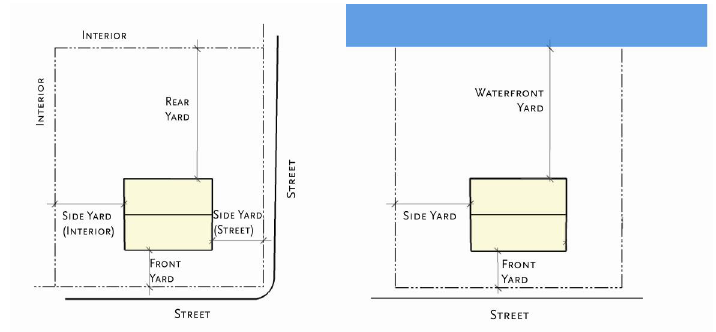
There are five types of yards - front, side (street), side (interior), rear, and waterfront yard.
b.
Double frontage lots shall be considered to have two front yards.
3.
Measurement of yards.
a.
All front yard and side yard (street) setbacks shall be measured from the edge of the right-of-way.
b.
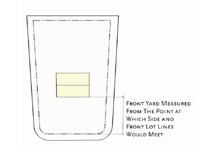
Depth of a required front yard shall be measured at right angles to a straight line joining the foremost points of the side lot lines. The foremost point of the side lot lines, in the case of rounded property corners at street intersections, shall be assumed to be the point at which the side and front lot lines would have met without such rounding.
c.
Width of a required side yard shall be measured in such a manner that the yard established is a strip of the minimum width required by district regulations with its inner edge parallel with the side lot line.
d.
Depth of a required rear yard shall be measured in such a manner that the yard established is a strip of the minimum width required by district regulations with its inner edge parallel with the rear lot line.
4.
Setbacks.
a.
The front setback shall be as stated in this Land Development Code. All setbacks shall be based on the future right-of-way line established in the Comprehensive Plan, or as identified on the Metropolitan Planning Organization's Long Range Transportation Plan, 2030 Adopted Highway Element. All lots shall have the minimum lot width as prescribed by this Land Development Code and shall be located on an improved dedicated street right-of-way.
b.
Attached residential garages shall have a minimum front setback of 25 feet where the doors face the right-of-way.
c.
On corner lots, the secondary front yard, or yard not accessed by a driveway or vehicular accessway, shall be not less than 25 percent of the lot width; however, when the lot is less than 50 feet, the minimum side yard shall be a minimum of 12½ feet. When the lot width is greater than 80 feet, the secondary front yard shall be a minimum of 20 feet.
5.
Encroachments. Every part of a required yard shall be open from its lowest point to the sky unobstructed, except for the encroachments listed below. See also section 118.3.4, Accessory Uses and Structures, and section 118.3.5, Temporary Uses and Structures.
a.
Fences as noted in section 118.3.8, flag poles, sidewalks, and driveways.
b.
Projection of sills, belt courses, cornices, buttresses, ornamental features, bay windows where allowed by the building code, chimneys, flues and eaves; however, no such projection shall exceed 30 inches into a minimum yard area.
c.
Parking structures may extend into the rear yard of a lot, where there is access through an alley. Such structures shall be located either within three feet or less from the rear property line, or at least 20 feet from the rear property line.
d.
Security gates and guard stations may be located within any required yard.
e.
Covered porches may encroach a maximum of eight feet into a required street yard setback or 20 percent of the required street yard setback depth, whichever is less.
f.
Mechanical equipment for residential uses, such as HVAC units, generators and security lighting, may extend into any required side yard but shall remain at least three feet from the property line.
g.
Driveways may extend into any required yard, if acceptable to the engineering division.
h.
Utility lines located underground and minor structures accessory to utility lines (such as hydrants, manholes, and transformers and other cabinet structures) may encroach into any required yard.
i.
Sport courts, trampolines, swingsets and other similar equipment shall be located to the rear of the front building line, and outside of any required side yard setbacks.
G.
Bulk.
1.
Height.
a.
Applicability. Unless specifically set forth in section 118.3.4, Accessory Uses and Structures, the base district height requirements apply to principal and accessory structures.
b.
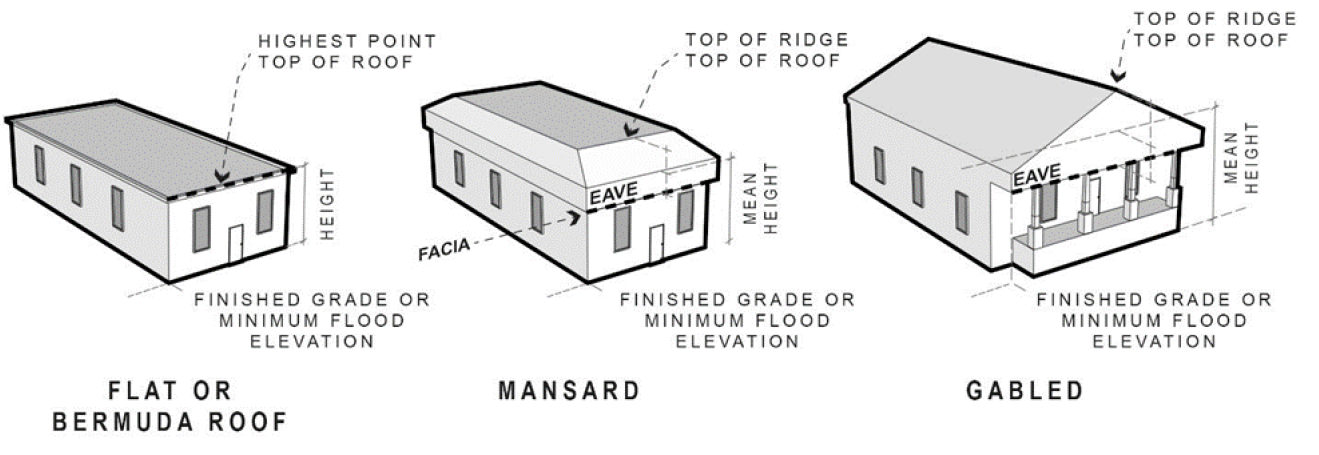
Determination. Height shall be determined by the vertical distance measured from the mean finished grade to the highest point of the roof surface of a flat or Bermuda roof, the mean height between the facia and highest point of a mansard roof and to the mean height level between eaves and ridge of gable, hip and gambrel roofs. Where minimum floor elevations in flood hazard areas have been established by law, height shall be measured from such required minimum floor elevations.
c.
Exemptions. The height limits of this Land Development Code shall not apply to church spires, belfries, monuments, transmission towers, telecommunications towers, water towers, flagpoles, chimneys, cooling towers, fire towers and other structures not intended for human occupancy, and subject to approval by the director. These exceptions shall not apply in an airport flight zone.
d.
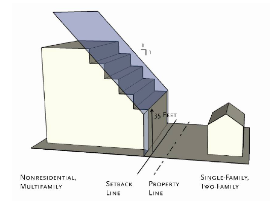
Bulk plane. Any new building that abuts an existing RS- district shall be subject to a bulk plane starting at 35 feet in height at the side or rear setback line, and extending upward one additional foot for every additional foot into the site from the setback line.
2.
Building coverage. The maximum area of the lot that is permitted to be covered by buildings, including both principal structures and accessory buildings. Building coverage does not include paved areas such as driveways, uncovered porches or patios, decks, swimming pools or pool cages.
3.
Living area. Living area shall include all areas within the enclosing walls of a building except garages, outside utility rooms, carports, cabanas, porches, patios and unroofed or unenclosed areas.
4.
Building separation. The required separation between any two buildings located on the same lot or site. Where this Land Development Code allows a building separation of less than ten feet, additional fire code requirements may apply.
(Ord. No. 3422, § 4, 1-14-2008; Ord. No. 3473, § 1, 6-16-2008; Ord. No. 3563, § 1, 8-16-2010; Ord. No. 3790, § 1, 1-3-2017; Ord. No. 3841(Exh. A), § 1, 10-1-2018; Ord. No. 3883, § 1(Exh. A), 1-6-2020; Ord. No. 3890, § 1(Exh. A), 1-21-2020)