
Fort Myers City Zoning Code
ARTICLE 4
- OVERLAY DISTRICTS
118.4.1 - Application of Overlay Districts.
A.
This chapter contains overlay districts that are applied by modifying the underlying zoning through application of the additional provisions below.
B.
Not all overlay districts are mapped on the official zoning map. The following overlay districts are applied at the time of application for a permit based on the specifics of the site and the development proposal:
1.
Emergency management communications overlay; and
2.
Environmentally sensitive lands overlay.
(Ord. No. 3422, § 4, 1-14-2008)
118.4.2 - Winkler Avenue.
A.
Within the Winkler Avenue development district, the following special requirements shall apply to all property fronting on Winkler Avenue, east of Metro Parkway:
1.
Signage standards.
a.
Signage is an integral component of the building and site design and should be appropriately scaled and consistent in character with the project's overall design.
b.
Number of signs: There shall be one sign per facade.
c.
Size of signs: A wall or monument sign shall be no greater in size than five percent of the linear frontage; if two or more streets are involved, the street deemed the "frontage/entrance" shall apply for measuring the five percent limit. Monument signs shall not exceed eight feet in height.
d.
Project identification/entry signs are permitted in conjunction with the requirements in section 126-99.
e.
Prohibited signs: In addition to those signs prohibited in section 126-91, billboards, pole signs and promotional inflatable signs are expressly prohibited.
f.
Additional signage or modifications to the signage provisions may be considered through the deviation process referenced below.
2.
Special setback. The minimum setback for buildings and structures shall be 80 feet. A maximum of two rows (one double-loaded aisle) of parking may be located in the front yard (setback), if desired. When parking is located within this front yard setback, a screening wall or fence of solid construction at three and one-half feet in height shall be required. This decorative screening wall is not to be one solid expanse of wall. The intent is to provide a direct proportion of wall segments to open space therefore, the wall segments/open space segments shall be a minimum length of 30 foot intervals, up to a maximum length of 60 foot intervals. The open space shall be landscaped with earth berms, shade trees and shrubs. A double row of shrubs planted at staggered spacing and meeting the requirements of subsection 138-42(d) shall be located in front of the wall segments. The screening wall shall be located 20 feet from the property line and at least 25 feet from intersections with driveways and other streets (See subsection 134.2.21).
3.
Minimum setback. The minimum setback for parking, if located in the front yard (setback), shall be 25 feet. This 25 foot yard area shall be used for landscaping, street trees, allowable signs, and such necessary walks or driveways as may be approved by the community development official and public works.
4.
Pedestrian ways. Pedestrian ways linkages or paths must be designed and constructed to provide access between parking areas and building entries and from the building entries to surrounding streets, external sidewalks and out parcels. Pedestrian ways may be incorporated within a required landscape perimeter buffer or enhanced landscape areas.
5.
Deviations/betterment plan.
a.
If an applicant desires to deviate from the above requirements, administrative deviations may be requested in accordance with section 98.3.3 relating to administrative deviations, and 138-4(h) relating to alternative landscape betterment plans. Where deviations to the special setbacks set forth in this section are requested, such deviations shall be considered only as part of a Planned Unit Development (PUD) rezoning petition, or a variance reviewed by the board of adjustments pursuant to the criteria in Chapter 98.
(Ord. No. 3422, § 4, 1-14-2008; Ord. No. 3841(Exh. A), § 1, 10-1-2018; Ord. No. 3890, § 1(Exh. A), 1-21-2020)
118.4.3 - Cleveland Avenue.
A.
U.S. 41 (Cleveland Avenue) design standards are as follows:
1.
Purpose and intent. The purpose and intent of this subsection is to supplement and enhance existing regulations and encourage the design of developments which will provide safe, convenient, and efficient access for vehicles while also providing safe convenient access and efficient passage for pedestrians from the public right-of-way to the commercial building or development. It is further the intent of this subsection to maintain and complement the streetscape by requiring that buildings be designed with architectural features and patterns that provide visual interest. Where these supplemental regulations conflict with other Code requirements, these supplemental regulations shall apply.
2.
Applicability. All new development, renovations, or redevelopment of property abutting Cleveland Avenue shall be subject to these supplemental requirements. For purposes of this subsection, the term "renovation and redevelopment" shall mean, in the case of additions or renovations to, or redevelopment of, an existing building or project, where the costs of such addition, renovation, or redevelopment exceeds 20 percent of the assessed value (land and building value) as determined by the county property appraiser's office, of the existing site, or an increase by 20 percent of the existing square footage. Failure by a property owner to comply with the terms of this subsection shall be subject to the penalty clause in section 98.1.7, or prosecution as provided in section 1-14.
3.
Design standards.
a.
A landscape treatment/feature consisting of a combination of ground cover, trees and shrubbery shall be instituted along street frontages and shall be a minimum area of at least nine percent of the actual front yard setback area (see illustration below). Recommended trees, shrubs, ground cover and planting specifications to be utilized within the actual nine percent landscape area are found in table 1 below.
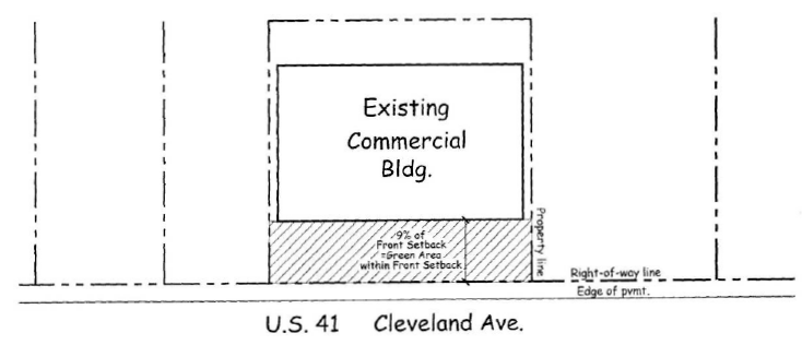
Table 1: Plant List
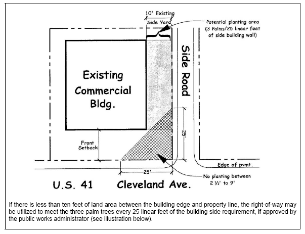
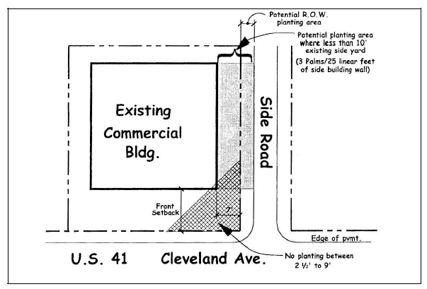
b.
Royal Palms are the desired tree species to be planted along the Cleveland Avenue street frontage. Where buffer yards are required, Royal Palms may be substituted (on a one-for-one basis) in lieu of another canopy tree. The recommended planting height of the Royal Palms shall be a minimum of 14 feet, spaced approximately 15—20 feet on center.
c.
Maintenance of the required landscape area shall be the responsibility of the property owner. If the plant materials die, they shall be replaced within 60 days. The landscaping shall be maintained, fertilized, including use of the appropriate pesticide and weed control application, and sprinklered in perpetuity to the extent that healthy plant life is sustained, or, if needed, removed and replaced to keep the area in its condition when first installed.
d.
No parking shall be allowed within the front setback area for new developments. Parcels to the rear and contiguous to properties abutting Cleveland Avenue may be used to meet the minimum parking requirements, regardless of the future land use designation. However, parcels designated RS-6, RS-7, RS-D, RM-12 or RM-16 shall not allow parking to be located within 200 linear feet of an existing single-family residence. A new car lot may utilize up to 50 percent of the front setback area for the display of vehicles, and the other 50 percent of the front setback area shall be provided with the required landscaping.
e.
Pedestrian ways, linkages or paths must be designed and constructed to provide access between parking areas and building entries and from the building entries to surrounding streets, external sidewalks and out parcels. Pedestrian ways may be incorporated within a required landscape perimeter buffer or enhanced landscape areas. Shared pedestrian walkways are encouraged.
f.
Lighting must be designed and installed using cut-off fixtures. A 270-degree radius/plan view cut-off shall be used on corner lots. A 180-degree radius/plan view cut-off shall be used on interior lots or for lights placed within 20 feet from the intersection, road right-of-way, or adjacent property lines. Lighting fixtures may not exceed a maximum of 30 feet in height within the parking lot and a maximum of 17 feet in height within nonvehicular pedestrian areas.
g.
All primary facades must be designed with consistent architectural style, detail, and trim features. For the purposes of this subsection, the term "primary facade" means any facade abutting a street. Corner lots shall be defined as having two primary facades. Buildings must provide a minimum of four of the following eight building design treatments and must comprise 50 percent of the facade area:
1)
Awnings on all windows and door openings facing rights-of-way (use of plastic or vinyl material is prohibited),
2)
Attached canopies,
3)
Substantial overhangs (18 inches minimum),
4)
Porticos,
5)
Arcades,
6)
Peaked roof forms,
7)
Display windows along a minimum of 20 percent of the first floor front walls or any other wall alongside a pedestrian walkway,
8)
Clock or bell towers.
h.
Building walls and facades must avoid large blank wall areas by including at least three of the four design elements listed below, in a repeating pattern. At least one of the design elements must repeat horizontally:
1)
Material change,
2)
Offsets or projections,
3)
Bandings,
4)
Reveals.
i.
Signs should be designed to complement rather than detract from the visual impact of a commercial development by utilizing design elements consistent with those employed in the structure's architecture. A unified sign plan must be utilized when multiple on-premises signs are proposed for a single site or development, or in the case of a shopping center or other multiple-occupancy complex, including out parcels under unified control with the main development. A building permit application must be accompanied by a graphic and narrative representation of the unified sign plan to be utilized on the site. Minimum uniform elements shall be utilized and include colors, construction materials and architectural design.
j.
Deviations for an exceptional building design, the number of parking spaces required by chapter 134, and/or the provisions of this section may be sought where a hardship exists due to physical constraints, environmental concerns, or safety issues justifying such deviation. Deviations shall be processed in accordance with section 98.3.4.
(Ord. No. 3422, § 4, 1-14-2008; Ord. No. 3841(Exh. A), § 1, 10-1-2018)
118.4.4 - Dr. Martin Luther King Jr. Boulevard and Veronica S. Shoemaker Boulevard.
A.
Purpose and Intent: The purpose and intent of the Dr. Martin Luther King, Jr. Boulevard and Veronica S. Shoemaker Boulevard overlay district is to implement the provisions of the Dr. Martin Luther King Jr. and Veronica S. Shoemaker Boulevards Revitalization Plan (the Plan) by creating new regulations and supplementing existing regulations to establish certain physical design criteria for redevelopment and development activity. The overlay district is intended to shape neighborhood areas that will provoke visual interest, promote new economic opportunity, and provide a hierarchy of safe and convenient access for pedestrians and bicyclists. The design criteria centers around the buildings character, its orientation to the streets and other buildings, and creates design standards requiring specific details of the building's shape, look, roof line, doors, windows, landscaping, and parking.
B.
Applicability: All new development, redevelopment or renovations of property are subject to these overlay requirements referred to as the Dr. Martin Luther King Jr. Boulevard and Veronica S. Shoemaker Boulevard Overlay District. Such property is generally located abutting Dr. Martin Luther King Jr. Boulevard, east of Evans Avenue and west of Mission Lane; and all property fronting on Veronica S. Shoemaker Boulevard, between Dr. Martin Luther King Jr. Boulevard and Canal Street. A map of the specific area by parcel is on file in the community development department and city clerk's office.
C.
Conflict: The provisions of this section shall take precedence over other codes, ordinances, regulations, and standards except those listed in section 118.4.4.E., superseding regulations. Other requirements of the land development code or other applicable ordinances continue to be applicable to issues not covered by this section, except where those would contradict the intent of this section.
D.
For purposes of this subsection, the term "renovation and redevelopment" shall encompass the meanings as follows:
1.
Additions or renovations or redevelopment to existing buildings or properties;
2.
Where the costs of such addition, renovation, or redevelopment exceeds 20 percent of the assessed value (land and building value) as determined by the Lee county property appraiser's office, of the existing site; or
3.
An existing building's square footage increases by 20 percent.
E.
Superseding Regulations. The provisions of the following regulations take precedence over the provisions of this chapter:
1.
Adult entertainment regulations.
2.
Noise regulations.
3.
Flood hazard regulations.
4.
Historic preservation regulations.
5.
Accessibility (Americans with Disabilities Act) standards.
6.
Florida Building Code.
7.
Florida Fire Prevention Codes.
F.
Lot Designation Types:
1.
Small lots are lots with less than 10,000 square feet in area
2.
Large lots are lots with a minimum of 10,000 square feet in area and larger, and
3.
Urban node lots are lots designated within areas termed urban nodes.
118.4.4.1. Applicable to all lot and node designations.
A.
Design standards.
1.
Establish a landscape treatment/feature consisting of the required street trees and a combination of ground cover and shrubbery along street frontages that shall be a minimum area of at least nine percent of the actual front yard setback area. Recommended shrubs, ground cover, and planting specifications to be utilized within the actual nine percent landscape area are in section 118.4.3., Cleveland Avenue overlay district, Table 1; and the setback area is illustrated following Table 1.
2.
A combination of Geiger Trees or, Glaucous Cassia, or Silver Buttonwoods trees interspaced with Royal Palms are the desired tree species to be planted along the street frontage of Dr. Martin Luther King Jr. Boulevard. A combination of Lavender Tabebuia or Gumbo Limbo trees interspaced with Sable Palms are the desired street trees along the street frontage of Veronica S. Shoemaker Boulevard. The recommended planting height of the Royal Palms shall be a minimum of 14 feet, spaced approximately 15 to 20 feet on center. Detailed street tree requirements are in section 138-72. Shade trees shall be ten to 12 feet high with three inch to four inch caliper at 12 inches from base of trunk.
3.
Maintenance of the required landscape area shall be the responsibility of the property owner. If the plant materials die, they shall be replaced within 60 days. The landscaping shall be maintained, fertilized, including use of the appropriate pesticide and weed control application, and sprinklered in perpetuity to the extent that healthy plant life is sustained, or, if needed, removed and replaced to keep the area in its condition when first installed.
4.
Parking shall be allowed within the front setback area for new developments. Parcels to the rear and contiguous to properties abutting Dr. Martin Luther King Jr. Boulevard and Veronica S. Shoemaker Boulevard may be used to meet the minimum parking requirements. A new car lot may utilize up to 50 percent of the front setback area for the display of vehicles, and the other 50 percent of the front setback area shall be provided with the required landscaping.
5.
Pedestrian ways, linkages or paths shall be designed and constructed to provide access between parking areas and building entries and from the building entries to surrounding streets, external sidewalks and out parcels. Pedestrian ways may be incorporated within a required landscape perimeter buffer or enhanced landscape areas. Shared pedestrian walkways are encouraged.
6.
Lighting shall be designed and installed using cut off fixtures. Cut off light fixtures do not allow light dispersion or direct glare to shine above 90 degrees from the base of the fixture. A 270-degree radius/plan view cut off shall be used on corner lots. A 180-degree radius/plan view cut off shall be used on interior lots or for lights placed within 20 feet from the intersection, road right of way, or adjacent property lines. Lighting fixtures may not exceed a maximum of 30 feet in height within the parking lot and a maximum of 17 feet in height within non-vehicular pedestrian areas.
7.
All primary facades shall be designed with consistent architectural style, detail, and trim features. For the purposes of this subsection, the term "primary facade" means any facade abutting a street. Corner lots shall be defined as having two primary facades fronting two streets. The design of the buildings shall contain a minimum of four of the following eight building design treatments and must comprise 50 percent of the facade area:
a.
Awnings on all windows and door openings facing rights of way (use of plastic or vinyl material is prohibited),
b.
Attached canopies,
c.
Substantial overhangs (18 inches minimum),
d.
Porticos,
e.
Arcades,
f.
Peaked roof forms,
g.
Display windows along a minimum of twenty (20) percent of the first floor front walls or any other wall alongside a pedestrian walkway, this feature is required of all new development or redevelopment along Dr. Martin Luther King Jr. Boulevard between Cranford Avenue and Ford Street.
h.
Other architectural features must be approved by the community development department director.
8.
Building walls and facades shall avoid large blank wall areas by including at least three of the four design elements listed below, in a repeating pattern. At least one of the design elements must repeat horizontally:
a.
Material change,
b.
Offsets or projections,
c.
Bandings,
d.
Reveals.
9.
Signs should be designed to complement rather than detract from the visual impact of a commercial development by utilizing design elements consistent with those employed in the structure's architecture. A unified sign plan must be utilized when multiple on premises signs are proposed for a single site or development, or in the case of a shopping center or other multiple occupancy complex, including out parcels under unified control with the main development. A building permit application must be accompanied by a graphic and narrative representation of the unified sign plan to be utilized on the site. Minimum uniform elements shall be utilized and include colors, construction materials and architectural design.
10.
Deviations for an exceptional building design, the number of parking spaces required by chapter 134, and/or the provisions of this section may be sought where a hardship exists due to physical constraints, environmental concerns, or safety issues justifying such deviation. Deviations shall be processed in accordance with section 98.3.4.
B.
Uses permitted/adverse impact uses.
1.
The uses permitted in each land use district shall be as provided in subsection 118.2.3, except as listed in subsection 2. below.
2.
Uses not expressly permitted in subsection 118.2.3 or which create an adverse impact are not permitted through the conditional use process. Uses considered to have an adverse impact include:
a.
Billboards, except as permitted by section 126-105.
b.
Depots for large scale storage and distribution.
c.
Animal husbandry.
d.
Nurseries.
e.
Landfills and dumps.
f.
Mineral extraction areas.
g.
Prisons, except as accessories to police stations;
h.
Recycling facility;
i.
Scrap yards for the processing and storage of waste materials.
3.
Uses permitted in subsection 118.2.3 that require approval through the conditional use process include:
a.
Animal boarding, animal shelter, kennels;
b.
Bar, tavern, cocktail lounge, bottle club, and nightclubs;
c.
Increase density in the RM 12 zoning district;
d.
Liquor stores;
e.
Outdoor storage;
f.
Public or private surface parking lots (not associated with an on-site business);
g.
Public or private parking garages without liner buildings on primary street frontages or adjacent to residential uses;
h.
Vehicle sales, new or used;
i.
Vehicle service and repair.
C.
Development on properties zoned RM 12.
1.
All single family development is permitted in accordance with the section 118.2.1.B.2 building envelope standards.
2.
Townhouse development is encouraged, in accordance with section 118.2.1.B.2. except as follows:
a.
Minimum lot area: One acre.
b.
Maximum height: 35 feet
c.
Density: 12 units per acre, density may be increased through the conditional use process.
(Ord. No. 3918, § 9, 12-6-2021)
118.4.4.2 Small Lots in the Overlay District.
A.
Improved small lots (less than 10,000 square feet) with existing commercial or residential structures and zoned for commercial uses in the overlay district are subject to the following regulations.
1.
The requirements of this section shall apply to new commercial uses or a change in commercial use for lots with an existing principal building occupying the site. With a change in ownership or use triggered by application for a business tax receipt, the business shall receive an inspection and shall be in compliance with the regulations in this section. A certificate of use will not be issued until the property becomes compliant.
2.
Permitted commercial uses are listed in the land development code, section 118.2.3, table of uses.
3.
All small lots within the overlay district shall be landscaped which shall be maintained in the front yard, both side yards, and the rear yard of the lot. The landscaping shall include one shade tree where the lot abuts sidewalks or where a sidewalk will be located
4.
No on-site parking is required. Shared parking with area businesses is encouraged. Parking spaces on the street and shared spaces on other sites can fulfill the parking requirements for small lots in the overlay district.
5.
On site retention, construction of public sidewalks, and commercial driveway regulations are waived for small lots.
6.
Sign regulations set forth in chapter 126, signs, shall apply, number, size, and location of signs for small lots shall be in accordance with subsection 126-103(b).
7.
Contiguous lots under common ownership which total 10,000 square feet or more shall develop in accordance with section 118.4.4.3 or 118.4.4.4, whichever is applicable, pursuant to section 98.4.3.
B.
Vacant small lots less than 10,000 square feet in commercially zoned areas may be developed for commercial uses. Vacant small lots will be considered legal non-conforming lots with regard to lot width and lot area for which no variance shall be required. The following requirements shall apply to all new construction on small lots for commercial uses.
1.
Building setbacks:
a.
Front: ten feet
b.
Side (interior): five feet
c.
Side (street): ten feet
d.
Rear: 15 feet
2.
Buffer yards as further detailed in section 138-4.
a.
Front: Type D buffer
b.
Side (interior): none
c.
Side (street): Type D buffer
d.
Rear: Type A buffer
3.
Driveway and drive aisle width: 22 feet
4.
Parking:
a.
Number of space required: three spaces including a required handicap space
b.
Parking space dimensions: nine feet wide and 18 feet long
(Ord. No. 3918, § 10, 12-6-2021)
118.4.4.3 Vacant Large Lots in the Overlay District between Urban Nodes.
A.
Large lots having a minimum of 10,000 square feet or larger land area located outside or between a delineated urban node in the overlay district may be developed.
B.
Parking Standards.
1.
One row of parking spaces is allowable in the front of the building(s).
2.
New development or redevelopment shall provide a minimum of one parking space per 300 square feet of gross floor area. Medical shall provide a minimum of one parking space per 200 square feet of gross floor area.
3.
On street parking, if available within two blocks, or within 600 feet, and/or shared parking, within three blocks may count toward 25 percent of the required parking.
C.
Cross-Access Easements. New development or redevelopment shall provide a cross access easement to the adjacent properties and shall be reviewed and approved by the city prior being recorded at the Lee County Clerk of Courts and shall be at the expense of the developer, prior to receiving a certificate of occupancy.
D.
Signs. Sign standards are set forth in chapter 126, signs.
E.
Landscaping and Buffer Standards. Landscaping and buffer standards are required as provided in section 118.4.4.1 and chapter 138, except as listed below:
a.
Interior side buffer yards shall not be required between like uses, such as commercial to commercial.
b.
Native Canopy Trees: In addition to the landscape requirements above, a minimum of one native canopy tree is required for every 6,000 square feet of permeable area or for every 3,000 square feet of impermeable area.
c.
Heat Island Effect Reduction: All new parking lots shall include tree plantings designed to result in 50 percent shading of the parking lot surface areas at maturity. The recommended trees to utilize are as follows:
1.
Gumbo Limbo
2.
Green Buttonwood
3.
Sea Grape
4.
Pigeon Plum
Exceptions to the shading calculation include:
1.
Single family and two family residential parking areas.
2.
Parking structures.
3.
Truck loading areas in front of overhead doors.
4.
Truck maneuvering and parking areas unconnected to and exclusive of any vehicle parking.
5.
Surfaced areas not to be used for vehicle parking, driving or maneuvering, provided they are made inaccessible to vehicles by a barrier such as bollards, curb, or fencing.
6.
Vehicle display, sales, service, and storage areas (parking facilities for these uses are subject to shading requirements).
7.
Parking areas under covered stalls and in garages.
118.4.4.4. Urban Nodes within the Overlay District.
A.
Name and Location of Urban Nodes.
1.
Western Gateway Node: Property fronting on the north side of Dr. Martin Luther King Jr. Boulevard, east of Evans Avenue and west of Palm Avenue and includes the redevelopment area known as McCollum Hall, 2701 Dr. Martin Luther King Jr. Boulevard.
2.
Clemente Dunbar Node: Property fronting on the south side of Dr. Martin Luther King Jr. Boulevard from Ford Street to Henderson Avenue; lots south from Dr. Martin Luther King Jr. Boulevard to Thomas Street, and from Ford Street on the west to Henderson Avenue on the east. Includes five blocks of Ford Street, Cuba Street, Carver Avenue, and Henderson Avenue.
3.
Mid-town Dunbar Node: All property fronting on Veronica S. Shoemaker Boulevard, from the intersection with Dr. Martin Luther King Jr. Boulevard south to Canal Street; the district is located east to west from Veronica S. Shoemaker Boulevard to Highland Avenue.
B.
Design Standards. A mix of residential, office and commercial uses are allowable in all urban nodes.
1.
Building Height: Building height shall be a maximum of three stories. Apartment type units may be located on the second and third floors of mixed-use buildings.
2.
Setbacks: The required front setback is ten feet from the front property line for property fronting on Dr. Martin Luther King Jr. Boulevard and all other setbacks are as listed for the zoning district in section 118.2.1 building envelope standards.
3.
Parking shall be in the rear or side of the property whenever possible. A limited amount of street parking will be available for use as provided in subsection 7. below.
4.
Sidewalks in Western Gateway Node and Clemente Dunbar Node:
a.
Private areas may be allowed to have outdoor dining and seating in the style of First Street.
b.
A sidewalk shall have a minimum width of eight feet reserved for outdoor dining and seating as measured from the building outward; bordered by a two-foot wide planting strip or planters facing the right-of-way and shall include a public pedestrian walking area a minimum of four feet wide.
c.
A continuous awning between the front property lines shall project at least five feet over the outdoor seating area between the building and the street.
5.
Shade Trees: Shade trees shall create a canopy over all parking lots of at least 50 percent coverage. The street trees shall be planted where required by chapter 138.
6.
Parking Lots: Parking lots shall be shaded at least 50 percent by canopy trees. Wheel stops shall only be required to protect landscaping. Planting areas shall be required in accordance with chapter 134. On-site parking spaces shall be nine feet wide by 18 feet long.
7.
On Street Parking: Parallel on street parking shall be allowed along one side of all streets, except Dr. Martin Luther King, Jr. Boulevard and Veronica S. Shoemaker Boulevard. Signage will be installed by the city designating a fire lane to delineate which side of the street is available for on street parking.
8.
Sidewalks. Sidewalks shall be installed by the developer at the time a lot is developed or redeveloped.
A map showing specific parcels is on file in the community development department and the city clerk's office.
C.
Cross-Access Easements. New development or redevelopment shall provide a cross access easement to the adjacent properties and shall be reviewed and approved by the city prior being recorded at the Lee County clerk of courts at the expense of the developer, prior to receiving a certificate of occupancy.
D.
Signs. Sign standards are set forth in chapter 126, signs.
E.
Landscaping and Buffer Standards. Landscaping and buffer standards are required as provided in section 118.4.4.1 and chapter 138, except as listed below:
1.
Interior side buffer yards shall not be required between like uses, such as commercial to commercial.
2.
Native Canopy Trees: In addition to the landscape requirements above, a minimum one such tree is required for every 6,000 square feet of permeable area or for every 3,000 square feet of impermeable area.
3.
Heat Island Effect Reduction: All new parking lots shall include tree plantings designed to result in 50 percent shading of the parking lot surface areas at maturity. The recommended trees to utilize are as follows:
1.
Gumbo Limbo
2.
Green Buttonwood
3.
Sea Grape
4.
Pigeon Plum
Exceptions to the shading calculation include:
1.
Single family and two family residential parking areas
2.
Parking structures
3.
Truck loading areas in front of overhead doors
4.
Truck maneuvering and parking areas unconnected to and exclusive of any vehicle parking
5.
Surfaced areas not to be used for vehicle parking, driving or maneuvering, provided they are made inaccessible to vehicles by a barrier such as bollards, curb, or fencing
6.
Vehicle display, sales, service, and storage areas (parking facilities for these uses are subject to shading requirements)
7.
Parking areas under covered stalls and in garages
(Ord. No. 3727, § 1, 1-5-2015; Ord. No. 3841(Exh. A), § 1, 10-1-2018; Ord. No. 3890, § 1(Exh. A), 1-21-2020)
Sec. 118.4.5 - Airport Compatibility Regulations.
The city shall utilize section 34-1101 et seq. of the Lee County Land Development Code when reviewing temporary and permanent structures or uses for compliance with airport compatibility regulations.
(Ord. No. 3422, § 4, 1-14-2008; Ord. No. 3934, § 1-18-2022)
118.4.6 - Emergency management communications.
The city shall consider the functionality of the emergency management communications system when reviewing structures over 35 feet in height for compliance.
(Ord. No. 3422, § 4, 1-14-2008)
118.4.7 - Correctional Facilities.
A.
The public/private correctional facilities overlay zone is established to encourage the concentration of governmental and private correctional facilities and their ancillary uses on city owned property in a designated area of the city. Correctional facilities shall include, but are not limited to, those uses listed in the North American Industrial Classification System (NAICS) 92214, Correctional Institutions; 56121, facilities Support Services; and 62322, Residential Mental Health and Substance Abuse Facilities.
B.
Correctional facilities, both public and private, including their ancillary uses, shall be permitted uses only within the area designated as the public/private correctional facilities overlay zone on the future land use map date June 15, 1998, and on file in the city clerk's office. Correctional facilities shall be designed and constructed in compliance with the underlying land use district regulations. All existing correctional facilities as of June 15, 1998, shall be considered grandfathered and may be allowed to expand, enlarge, remodel or rebuild.
(Ord. No. 3422, § 4, 1-14-2008)
118.4.8 - Environmentally Sensitive Lands.
A.
Intent and purpose. The intent and purpose of this section is to protect the public health, safety and welfare of the residents in the city by limiting the uses permitted in wetland preservation areas.
B.
Applicability. This section shall apply to all land within the municipal boundaries of the city. Any person who seeks to develop wetlands, questions the existence of such wetlands, or seeks to develop land in a manner not permitted by this section shall be required to provide an environmental assessment refuting the city's position, as well as obtain a letter of agreement from the South Florida Water Management District before receiving a building permit.
C.
Relationship to other requirements. In addition to meeting the requirements of this article and all other applicable sections of the land development code, development plans shall comply with applicable federal, state and water management district regulations relating to environmentally sensitive lands. In all cases, the strictest of the applicable standards shall apply.
D.
Permitted uses. The following uses may be permitted within wetlands:
1.
One single-family unit, only if the parcel was legally in existence as of the date of the ordinance from which this chapter is derived, the disturbance of wetlands is minimized, and all other applicable requirements are met.
2.
All uses of a recreational, open space or conservation nature that will not adversely affect the critical environmental character and function.
3.
Public roads built in accordance with chapter 134.
4.
Public utility poles, lines and/or pipes.
(Ord. No. 3422, § 4, 1-14-2008)
118.4.9 - Potable Wellfields.
A.
Generally. This article is established pursuant to and in accordance with the provisions of F.S. § 163.3202(2)(c), which requires, as a minimum, regulations for the protection of potable wellfields, as well as other applicable provisions of law authorizing the city to enact, amend and enforce wellfield protection regulations.
B.
Intent and purpose. The intent and purpose of this article is to protect and safeguard the health, safety and welfare of the residents of the city by establishing a protection zone around the municipal wellfield site and regulating toxic and hazardous substances within the zone.
C.
Establishment of Protection Zone. Based on the groundwater flow model developed during a recent wellfield investigation report prepared by RMA GeoLogic Consultants, Inc. (RMA, 2021) it was determined that Lower Hawthorn (Upper Floridan aquifer system) groundwater levels may be significantly affected for a certain distance from each well to a point where groundwater elevation is generally unaffected by stress placed on the groundwater system. This modeling has established the ten-year groundwater travel time contour, which was used to establish the wellfield protection zone (see Map A).
D.
Special regulations. In addition to adherence of the applicable land use district requirements, the following special regulations shall apply to all land within the wellfield protection zone:
1.
The municipal wellfield site and established protection zone shall be preserved for recreational purposes, and development of any other kind shall be prohibited.
2.
Activities within the wellfield protection zone are prohibited from using, producing, handling, or storing toxic or hazardous substances which would result in the violation of the water quality standards found in F.A.C. Ch. 17-3, most recent edition, and any amendments thereto.
3.
Sanitary hazard zone. In addition to the protection zone, as defined above, a sanitary hazard zone shall be established, wherein sanitary hazards shall be prohibited within a 100-foot radius around an existing or proposed public water supply well, where they are deemed to pose a potentially high risk to groundwater quality and public health. In accordance with 62-555.312(3) of the F.A.C., new wells shall be located no closer than 100 feet from other sanitary hazards that pose a potentially high risk to ground water quality and public health and shall be located no closer than 50 feet from other sanitary hazards that pose a moderate risk to ground water quality and public health.
New Wellfield Protections Zones Map A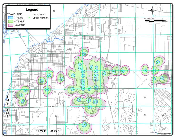
(Ord. No. 3422, § 4, 1-14-2008; Ord. No. 3918, § 11, 12-6-2021; Ord. No. 3984, § 1, 9-18-2023)