
Fort Pierce City Zoning Code
ARTICLE IV
BASIC ZONING DISTRICTS
Sec. 125-187.- Allowed uses.
(a)
Uses listed. Uses listed are allowed in each zoning district in accordance with the use table.
(b)
Permitted uses. Uses identified with a "P" in the use table are permitted in the subject zoning district provided that the uses will not violate basic use standards specified in each zoning district, other applicable use standards, additional zoning ordinance provisions and other city laws.
(c)
Conditional uses. Uses identified with a "C" in the use table are permitted in the subject zoning district, if the city commission, after a public hearing, determines that the location and development plans comply with applicable standards and will not violate basic use standards specified in each zoning district, other applicable use standards, additional zoning ordinance provisions and other city laws.
(d)
Innovative community development. Uses identified with a "I" in the use table are permitted in the subject zoning district, if the city commission, after a public hearing, determines the proposal conforms to the standards for innovative community developments at section 125-243 of this Code.
(e)
Prohibited uses. Uses identified with a "-" in the use table are expressly prohibited.
(f)
Planned development zone (PD) and planned unit redevelopment zone (PUR). Permitted and conditional uses are identified during the review for all proposed PD and PUR districts.
(g)
Edgartown Settlement (ES) zoning district. Permitted, conditional, and accessory uses shall be allowed in the ES district consistent with section 125-197.
(h)
Use table.
(Code 1960, § 20-29; Code 1983, §§ 9-179, 22-22; Ord. No. I-120, § 2, 7-15-1985; Ord. No. L-295, § 1, 11-4-2013; Ord. No. 14-017, § 1, 7-21-2014; Ord. No. 15-009, § 1, 4-20-2015; Ord. No. 15-054, § 1, 11-16-2015; Ord. No. 16-013, § 1, 7-5-2016; Ord. No. 16-018, § 1, 9-19-2016; Ord. No. 17-032, § 1, 10-2-2017; Ord. No. 18-004, § 1, 2-20-2018; Ord. No. 18-024, § 1, 7-16-2018; Ord. No. 19-013, § 1, 4-15-2019; Ord. No. 19-034, § 1, 9-23-2019; Ord. No. 20-009, § 1, 8-17-2020; Ord. No. 21-020, § 1, 8-2-2021; Ord. No. 24-031, § 1, 9-3-2024)
Sec. 125-188. - Single-Family Estate Density Zone (E-1).
(a)
Purpose. This classification is intended to provide for areas of single-family dwellings with an average net density of approximately one unit per acre.
(b)
Basic use standards. Uses in an E-1 zone must meet the requirements of this section. More restrictive requirements, set forth in accordance with other provisions of this chapter, must be satisfied by some conditional uses.
(1)
Lot size.
a.
The minimum lot area for single-family dwellings shall be 30,000 square feet.
b.
The minimum lot width shall be 100 feet.
c.
The minimum lot depth shall be 200 feet.
(2)
Yards.
a.
The minimum depth of the front yard will be 85 feet.
b.
The minimum depth of the side yards shall be 15 feet, except on corner lots the minimum side yard depth on a street side will be 20 feet.
c.
The minimum depth of the rear yard shall be 40 feet for a distance equal to 30 percent of the length of a line which is parallel to the rear lot line, is 40 feet from the rear lot line and extends to the closest property lines. The minimum depth of the rear yard for the remainder of the lot will be 14 feet, except on double-frontage and waterfront lots it shall be 40 feet.
(3)
Lot coverage. Buildings will not cover more than 25 percent of the lot.
(4)
Building heights. No building shall exceed a height of 35 feet above grade.
(c)
Other applicable use standards.
(1)
Accessory buildings shall comply with all yard, lot coverage and building height requirements of this chapter, except that buildings not on double-frontage lots may be in the rear yard if they are at least seven feet from the rear lot line.
(2)
On any lot used for residential purposes, no more than one residential building will be allowed on the lot, except one building without kitchen facilities may be allowed as a guest house, provided that the lot on which such guest house is located is 30,000 square feet or more in size.
(3)
Every lot shall abut a street other than an alley for at least 25 feet, except the minimum frontage for a lot on a cul-de-sac shall be 15 feet.
(4)
Materials or objects which would detract from open space character of an uncovered and unenclosed area will not be permitted in such an area.
(5)
All uses will comply with applicable access, parking and loading standards in sections 125-315 and 125-316.
(6)
Conditional uses will meet the requirements in sections 125-235 through 125-247.
(7)
Signs will comply with standards referred to in section 125-310.
(8)
All other applicable ordinance requirements will also be satisfied.
(d)
Nonconforming situations. Nonconforming structures and characteristics of farmstand sales establishments that have been damaged or destroyed by natural disaster or other catastrophic event, i.e., fire or other calamity, may be replaced or reconstructed provided that:
(1)
The significance of the property owner's hardship is more compelling than, and reasonably overbalances, the public benefit resulting from not allowing the use or structure to be re-established;
(2)
Replacement or reconstruction of the use or structure is compatible with the character of the neighborhood and will not jeopardize future development of the area in compliance with the provisions and intent of the city's land development regulations;
(3)
The value of properties in the vicinity of the replacement or reconstruction will not be adversely affected;
(4)
No expansion of gross floor area occurs;
(5)
The degree of nonconformity is not increased;
(6)
The replacement structure is in compliance with the city's adopted building code, coastal construction control line, and FEMA regulations; and
(7)
A building permit is issued within 24 months after the date of destruction and the construction is diligently pursued to completion.
(Code 1983, § 22-23; Ord. No. H-186, § 30-23, 6-15-1981; Ord. No. I-222, § 1, 6-1-1987; Ord. No. K-24, § 1, 8-21-2000; Ord. No. L-12, §§ 2, 3, 5-5-2008; Ord. No. L-295, § 2, 11-4-2013)
Sec. 125-189. - E-2 Residential single-family—two units per acre.
(a)
Purpose. This classification is primarily intended to provide for areas of single-family dwellings with an average net density of less than two units per acre for conventional developments. Regulations for the district are designed to promote sound neighborhoods and accommodate compatible nonresidential uses. Water and sewer service should be available.
(b)
Basic use standards. Uses in an E-2 zone, except innovative residential developments, must meet the requirements of this section. More restrictive requirements, set forth in accordance with other provisions of this chapter, must be satisfied by some conditional uses.
(1)
Lot size.
a.
The minimum lot area for single-family dwellings shall be 15,000 square feet.
b.
The minimum lot width shall be 100 feet.
c.
The minimum lot depth shall be 110 feet.
(2)
Yards.
a.
The minimum depth of the front yard will be 25 feet.
b.
The minimum depth of the side yards shall be ten feet, except on corner lots the minimum side yard depth on a street side will be 20 feet.
c.
The minimum depth of the rear yard shall be 20 feet for a distance equal to 30 percent of the length of a line which is parallel to the rear lot line, is 20 feet from the rear lot line and extends to the closest property lines. The minimum depth of the rear yard for the remainder of the lot will be seven feet, except on double-frontage and waterfront lots it shall be 20 feet.
(3)
Lot coverage. Buildings will not cover more than 25 percent of the lot.
(4)
Building heights. No building shall exceed a height of 35 feet above grade.
(c)
Other applicable use standards.
(1)
Accessory buildings shall comply with all yard, lot coverage and building height requirements of this chapter, except that buildings not on double-frontage lots may be in the rear yard if they are at least seven feet from the rear lot line.
(2)
On any lot used for residential purposes, no more than one residential building will be allowed on the lot, except one building without kitchen facilities may be allowed as a guest house, provided that the lot on which such guest house is located is 30,000 square feet or more in size.
(3)
Every lot shall abut a street other than an alley for at least 25 feet, except the minimum frontage for a lot on a cul-de-sac shall be 15 feet.
(4)
Materials or objects which would detract from the open space character of an uncovered or unenclosed area will not be permitted in such an area.
(5)
All uses will comply with applicable access, parking and loading standards sections 125-315 and 125-316.
(6)
Conditional uses will meet the requirements in sections 125-235 through 125-247.
(7)
Signs will comply with standards referred to in section 125-310.
(8)
All other applicable ordinance requirements will also be satisfied.
(Code 1983, § 22-23.1; Ord. No. K-517, § 1, 11-19-2007; Ord. No. L-295, § 3, 11-4-2013)
Sec. 125-190. - E-3 Residential single-family—three units per acre.
(a)
Purpose. This classification is primarily intended to provide for areas of single-family dwellings with an average net density of less than three units per acre for conventional developments. Regulations for the district are designed to promote sound neighborhoods and accommodate compatible nonresidential uses. Water and sewer service should be available.
(b)
Basic use standards. Uses in an E-3 zone, except innovative residential developments, must meet the requirements of this section. More restrictive requirements, set forth in accordance with other provisions of this chapter, must be satisfied by some conditional uses.
(1)
Lot size.
a.
The minimum lot area for single-family dwellings shall be 12,000 square feet.
b.
The minimum lot width shall be 75 feet.
c.
The minimum lot depth shall be 110 feet.
(2)
Yards.
a.
The minimum depth of the front yard will be 25 feet.
b.
The minimum depth of the side yards shall be ten feet, except on corner lots the minimum side yard depth on a street side will be 20 feet.
c.
The minimum depth of the rear yard shall be 20 feet for a distance equal to 30 percent of the length of a line which is parallel to the rear lot line, is 20 feet from the rear lot line and extends to the closest property lines. The minimum depth of the rear yard for the remainder of the lot will be seven feet, except on double-frontage and waterfront lots it shall be 20 feet.
(3)
Lot coverage. Buildings will not cover more than 25 percent of the lot.
(4)
Building heights. No building shall exceed a height of 28 feet above grade, except that conditional uses with buildings that have a maximum height of 35 feet above grade may be approved.
(c)
Other applicable use standards.
(1)
Accessory buildings shall comply with all yard, lot coverage and building height requirements of this chapter, except that buildings not on double-frontage lots may be in the rear yard if they are at least seven feet from the rear lot line.
(2)
On any lot used for residential purposes, no more than one residential building will be allowed on the lot, except one building without kitchen facilities may be allowed as a guest house, provided that the lot on which such guest house is located is 30,000 square feet or more in size.
(3)
Every lot shall abut a street other than an alley for at least 25 feet, except the minimum frontage for a lot on a cul-de-sac shall be 15 feet.
(4)
Materials or objects which would detract from the open space character of an uncovered or unenclosed area will not be permitted in such an area.
(5)
All uses will comply with applicable access, parking and loading standards sections 125-315 and 125-316.
(6)
Conditional uses will meet the requirements in sections 125-235 through 125-247.
(7)
Signs will comply with standards referred to in section 125-310.
(8)
All other applicable ordinance requirements will also be satisfied.
(Code 1983, § 22-23.2; Ord. No. K-517, § 1, 11-19-2007; Ord. No. L-295, § 4, 11-4-2013)
Sec. 125-191. - Single-family low density zone (R-1).
(a)
Purpose. This classification is primarily intended to provide for areas of single-family dwellings with an average net density of less than four units per acre for conventional developments. Regulations for the district are designed to promote sound neighborhoods and accommodate compatible nonresidential uses. Water and sewer service should be available.
(b)
Basic use standards. Uses in an R-1 zone, except innovative residential developments, must meet the requirements of this section. More restrictive requirements, set forth in accordance with other provisions of this chapter, must be satisfied by some conditional uses.
(1)
Lot size.
a.
The minimum lot area for single-family dwellings shall be 12,000 square feet.
b.
The minimum lot width shall be 75 feet.
c.
The minimum lot depth shall be 110 feet.
(2)
Yards.
a.
The minimum depth of the front yard will be 25 feet.
b.
The minimum depth of the side yards shall be seven feet, except on corner lots the minimum side yard depth on a street side will be 15 feet.
c.
The minimum depth of the rear yard shall be 20 feet for a distance equal to 30 percent of the length of a line which is parallel to the rear lot line, is 20 feet from the rear lot line and extends to the closest property lines. The minimum depth of the rear yard for the remainder of the lot will be seven feet, except on double-frontage and waterfront lots it shall be 20 feet.
(3)
Lot coverage. Buildings will not cover more than 25 percent of the lot.
(4)
Building heights. No building shall exceed a height of 28 feet above grade, except that conditional uses with buildings that have a maximum height of 35 feet above grade may be approved.
(c)
Other applicable use standards.
(1)
Accessory buildings shall comply with all yard, lot coverage and building height requirements of this chapter, except that buildings not on double-frontage lots may be in the rear yard if they are at least seven feet from the rear lot line.
(2)
On any lot used for residential purposes, no more than one residential building will be allowed on the lot, except one building without kitchen facilities may be allowed as a guest house, provided that the lot on which such guest house is located is 30,000 square feet or more in size.
(3)
Every lot shall abut a street other than an alley for at least 25 feet, except the minimum frontage for a lot on a cul-de-sac shall be 15 feet.
(4)
Materials or objects which would detract from the open space character of an uncovered or unenclosed area will not be permitted in such an area.
(5)
All uses will comply with applicable access, parking and loading standards sections 125-315 and 125-316.
(6)
Conditional uses will meet the requirements in sections 125-235 through 125-247.
(7)
Signs will comply with standards referred to in section 125-310.
(8)
All other applicable ordinance requirements will also be satisfied.
(Code 1983, § 22-24; Ord. No. H-186, § 30-24, 6-15-1981; Ord. No. I-222, § 2, 6-1-1987; Ord. No. J-29, §§ 1, 2, 12-7-1992; Ord. No. K-24, § 2, 8-21-2000; Ord. No. K-114, § 1, 10-15-2001; Ord. No. L-295, § 5, 11-4-2013)
Sec. 125-192. - Single-family intermediate density zone (R-2).
(a)
Purpose. This district is designed mainly for areas of single-family dwellings with an average net density of less than five units per acre for conventional developments. In addition to housing, various public facilities and other nonresidential uses are permitted under the conditions and safeguards referred to in this section. Areas in this classification should have public water and sewer service.
(b)
Basic use standards. Uses in an R-2 zone, except innovative residential developments, must meet the requirements of this section. More restrictive requirements, set forth in accordance with other provisions of this chapter, must be satisfied by some conditional uses.
(1)
Lot size.
a.
The minimum lot area for single-family dwellings shall be 9,000 square feet.
b.
The minimum lot width shall be 70 feet.
c.
The minimum lot depth shall be 110 feet.
(2)
Yards.
a.
The minimum depth of the front yard will be 25 feet.
b.
The minimum depth of the side yards shall be seven feet, except on corner lots the minimum side yard depth on a street side will be 15 feet.
c.
The minimum depth of the rear yard shall be 15 feet for a distance equal to 30 percent of the length of a line which is parallel to the rear lot line, is 15 feet from the rear lot line and extends to the closest property lines. The minimum depth of the rear yard for the remainder of the lot will be seven feet, except on double-frontage and waterfront lots it shall be 15 feet.
(3)
Lot coverage. Buildings will not cover more than 30 percent of the lot area.
(4)
Building heights. No building shall exceed a height of 28 feet above grade, except that conditional uses with buildings that have a maximum height of 35 feet above grade may be approved.
(c)
Other applicable use standards.
(1)
Accessory buildings shall comply with all yard, lot coverage and building height requirements of this chapter, except that buildings not on double-frontage lots may be in the rear yard if they are at least seven feet from the rear lot line.
(2)
On any lot used for residential purposes, no more than one residential building will be allowed on the lot, except one building without kitchen facilities may be allowed as a guest house, provided that the lot on which such guest house is located is 30,000 square feet or more in size.
(3)
Every lot shall abut a street other than an alley for at least 25 feet, except the minimum frontage for a lot on a cul-de-sac shall be 15 feet.
(4)
Materials or objects which would detract from the open space character of an uncovered or unenclosed area will not be permitted in such an area.
(5)
All uses will comply with applicable access, parking and loading standards in section 125-315 and 125-316.
(6)
Conditional uses will meet the requirements in sections 125-235 through 125-247.
(7)
Signs will comply with standards referred to in section 125-310.
(8)
All other applicable ordinance requirements will also be satisfied.
(Code 1983, § 22-25; Ord. No. H-186, § 30-25, 6-15-1981; Ord. No. I-222, § 3, 6-1-1987; Ord. No. J-29, §§ 3, 4, 12-7-1992; Ord. No. K-24, § 3, 8-21-2000; Ord. No. K-114, § 1, 10-15-2001; Ord. No. L-295, § 6, 11-4-2013)
Sec. 125-193. - Single-family moderate density zone (R-3).
(a)
Purpose. The major purpose of this zoning district is to provide for residential areas with an average net density in conventional developments of approximately six units per acre. Innovative residential developments, however, may have higher net densities not exceeding eight units per acre. Duplexes and certain nonresidential uses are allowed when appropriate conditions and safeguards indicated in this section are fulfilled. This classification can be effectively applied to areas serving as a transition between lower density single-family zones and residential districts with medium or high densities. Public water and sewer service should be available.
(b)
Basic use standards. Uses in an R-3 zone, except innovative residential developments, must meet the requirements of this section. More restrictive requirements, set forth in accordance with other provisions of this chapter, must be satisfied by some conditional uses.
(1)
Lot size.
a.
The minimum lot area for a single-family dwelling shall be 7,200 square feet.
b.
The minimum lot area for a duplex will be 12,000 square feet.
c.
The minimum lot width shall be 75 feet for a duplex.
d.
The minimum lot width for other uses will be 65 feet.
e.
The minimum lot depth for a duplex will be 120 feet.
f.
The minimum lot depth for other uses shall be 100 feet.
(2)
Yards.
a.
The minimum depth of the front yard will be 25 feet.
b.
The minimum depth of the side yards shall be seven feet, except on corner lots the minimum side yard depth on a street side will be 15 feet.
c.
The minimum depth of the rear yard shall be 15 feet for a distance equal to 30 percent of the length of a line which is parallel to the rear lot line, is 15 feet from the rear lot line and extends to the closest property lines. The minimum depth of the rear yard for the remainder of the lot will be six feet, except on double-frontage and waterfront lots it shall be 15 feet.
(3)
Lot coverage. Buildings will not cover more than 35 percent of the lot.
(4)
Building heights. No building shall exceed a height of 28 feet above grade, except that conditional uses with buildings that have a maximum height of 35 feet above grade may be approved.
(c)
Other applicable use standards.
(1)
Accessory buildings shall comply with all yard, lot coverage and building height requirements of this chapter, except that buildings not on double-frontage lots may be in the rear yard if they are at least six feet from the rear lot line.
(2)
On any lot used for residential purposes, no more than one residential building will be allowed on the lot, except one building without kitchen facilities may be allowed as a guest house, provided that the lot on which such guest house is located is 30,000 square feet or more in size.
(3)
Every lot shall abut a street other than an alley for at least 25 feet, except the minimum frontage for a lot on a cul-de-sac shall be 15 feet.
(4)
Materials or objects which would detract from the open space character of an uncovered or unenclosed area will not be permitted in such an area.
(5)
All uses will comply with applicable access, parking and loading standards in sections 125-315 and 125-316.
(6)
Conditional uses will meet the requirements in sections 125-235 through 125-247.
(7)
Signs will comply with standards referred to in section 125-310.
(8)
All other applicable ordinance requirements will also be satisfied.
(Code 1983, § 22-26; Ord. No. H-186, § 30-26, 6-15-1981; Ord. No. I-222, § 4, 6-1-1987; Ord. No. J-29, §§ 5—8, 12-7-1992; Ord. No. K-24, § 4, 8-21-2000; Ord. No. K-148, § 1, 4-15-2002; Ord. No. L-82, § 2, 4-20-2009; Ord. No. L-295, § 7, 11-4-2013; Ord. No. 21-008, § 2, 4-5-2021)
Sec. 125-194. - Medium density residential zone (R-4).
(a)
Purpose. The medium density residential district is designed to accommodate a variety of housing types, including conventional single-family dwellings, duplexes and, where desirable, townhome dwellings, mobile homes or multifamily housing with three or more dwelling units. Maximum gross densities should generally not exceed ten units per acre for conventional developments and 12 units per acre for innovative residential developments. This intensity of residential use is envisioned for locations which have public water and sewer service and which have adequate access to arterial or collector streets. Certain nonresidential uses are permitted under the parameters and safeguards set forth in this section.
(b)
Basic use standards. Uses in an R-4 zone, except innovative residential developments, must meet the requirements of this section. More restrictive requirements, set forth in accordance with other provisions of this chapter, must be satisfied by some conditional uses.
(1)
Lot size.
a.
The minimum lot area for a single-family dwelling shall be 5,000 square feet.
b.
The minimum lot area for a duplex, triplex or a quadraplex shall be 4,000 square feet per unit.
c.
The minimum lot area for a townhome dwelling shall be 1,500 square feet.
d.
Multifamily housing developments will utilize a lot with a gross density that shall not exceed ten units per acre.
e.
The minimum lot width for duplexes, triplexes, quadraplexes, and multifamily housing development shall be 75 feet.
f.
The minimum lot width for townhome developments shall be 200 feet. Townhome developments shall be subdivided into a minimum lot width of 16 feet and maximum lot width of 24 feet.
g.
The minimum lot width for other uses will be 60 feet.
h.
The minimum lot depth for duplexes, triplexes, quadraplexes, townhomes and multifamily housing development shall be 90 feet.
i.
The minimum lot depth for other uses will be 70 feet.
(2)
Yards.
a.
The minimum depth of the front yard for townhome developments will be ten feet. The minimum depth of the front yard for other uses shall be 25 feet.
b.
The minimum depth of the side yards for triplexes, quadraplexes and multifamily developments shall be ten feet, except on corner lots the minimum side yard depth on a street side will be 15 feet.
c.
The minimum depth of the side yards on the periphery of the townhome developments shall be ten feet, except on corner lots the minimum side yard depth on a street side will be 15 feet. The minimum depth of the side yard between individual townhome units or lots shall be zero feet.
d.
The minimum depth of the side yards for other uses shall be six feet, except on corner lots the minimum side yard depth on a street side will be 15 feet.
e.
The minimum depth of the rear yard shall be 20 feet for triplexes, quadraplexes and multifamily developments.
f.
The minimum depth of the rear yard for townhome lots that abut an alley shall be zero feet. The minimum depth of the rear yard for townhome lots with all other conditions shall be 15 feet.
g.
The minimum depth of the rear yard for other uses shall be 15 feet for a distance equal to 30 percent of the length of a line which is parallel to the rear lot line, is 15 feet from the rear lot line and extends to the closest property lines. The minimum depth of the remainder of the rear yard will be five feet, except on double-frontage and waterfront lots it shall be 15 feet.
h.
The minimum distance between residential buildings shall be 20 feet except that screen porches located on the ground floor may project into the minimum distance, and except that screen porches in owner occupied condominium projects that maintain a minimum building separation of 28 feet or more may be enclosed with glass. The maximum combined projection between two or more buildings shall be eight feet.
(3)
Lot coverage.
a.
Buildings in multifamily housing developments shall not cover more than 50 percent of the lot area.
b.
Buildings for principal residence in townhome developments and townhome dwelling lots shall not cover more than 50 percent of the lot area. Accessory buildings may cover an additional 15 percent of the building site.
c.
Buildings in other developments shall not cover more than 40 percent of the lot area.
(4)
Building heights. No building shall exceed 45 feet above grade.
(5)
Additional requirements dwelling, townhome.
a.
Ownership. 100 percent of the total lot area shall be the minimum area conveyed to the lot owner, including the front yard, back yard and side yard. A homeowners maintenance shall be formed among the unit owners to ensure compliance with exterior area maintenance regulations as may be adopted by the association.
b.
Common area. Any portion of the original lot not divided among and incorporated into the resulting individual townhome dwelling unit lots shall be held by either of the following or a combination of the following: each lot owner shall have an undivided interest in the common area, which shall be appurtenant to that lot. The individual interest in the common areas shall not be conveyed separately from the ownership of the said lot; or a property owners association (POA).
c.
Parking. Two parking spaces per dwelling units shall be provided for townhome developments and shall be side-by-side parking and not in-line tandem parking. No off-street parking spaces shall be located between the front of the principal residence and the front property line.
d.
Access. When townhome lots abut an alley, the site plan shall include provisions to utilize the alley as a service corridor for the townhome units. When townhome lots do not abut an alley, the site plan shall include a 20-foot-wide, unobstructed service corridor along the rear of the properties which shall be dedicated to service use. Garages, surface parking and garbage pickup shall be accessed and accommodated by the service corridor.
e.
Yards. Front yards of townhome units shall include a porch, stoop or covered entry. Rear yards shall be enclosed by a building wall or garden wall.
(c)
Other applicable use standards.
(1)
All multifamily housing developments shall be subject to site plan review procedures specified in section 125-313.
(2)
Accessory buildings shall comply with all yard, lot coverage and building height requirements of this chapter, except that buildings not on double-frontage lots may be in the rear yard if they are at least five feet from the rear lot line.
(3)
On any lot used for residential purposes, other than a multifamily housing development, no more than one residential building will be allowed on the lot, except one building without kitchen facilities may be allowed as a guest house.
(4)
Every lot shall abut a street other than an alley for at least 25 feet, except the minimum frontage for a lot on a cul-de-sac shall be 15 feet, or the minimum frontage for a single townhome lot shall be 16 feet.
(5)
Materials or objects which would detract from the open space character of an uncovered or unenclosed area will not be permitted in such an area.
(6)
All uses will comply with applicable access, parking and loading standards in sections 125-315 and 125-316.
(7)
Conditional uses will meet the requirements in sections 125-235 through 125-247.
(8)
Signs will comply with standards referred to in section 125-310.
(9)
All other applicable ordinance requirements will also be satisfied.
(Code 1983, § 22-27; Ord. No. H-186, § 30-27, 6-15-1981; Ord. No. I-114, § 2, 7-1-1985; Ord. No. I-202, § 2, 1-20-1987; Ord. No. I-222, § 5, 6-1-1987; Ord. No. I-461, § 2, 6-3-1991; Ord. No. J-29, § 9—11, 12-7-1992; Ord. No. K-24, § 5, 8-21-2000; Ord. No. K-148, § 2, 4-15-2002; Ord. No. K-464, § 2, 11-18-2006; Ord. No. L-82, § 3, 4-20-2009; Ord. No. L-284, §§ 1, 2, 11-19-2012; Ord. No. L-295, § 8, 11-4-2013; Ord. No. 19-016, § 1, 5-20-2019)
Sec. 125-195. - Hutchinson Island Medium Density Residential Zone (R-4A).
(a)
Purpose. It is the purpose of this section to establish height and density regulations for lands located within the city which are situated east of the Indian River. The R-4A zone is compatible with the Medium Density Residential Hutchinson Island designation in the comprehensive plan. Permitted gross residential densities in this district may not generally exceed eight units per acre. Bonus density of up to one additional unit per acre is available as provided for in this section. This district is established because Hutchinson Island is a sensitive barrier island which presents development considerations which are either unique to the area or are of added concern, such as environmental fragility, beach erosion, and hurricane evacuation.
(b)
Basic use standards. Uses in an R-4A zone must meet the requirements of this section. More restrictive requirements, set forth in accordance with other provisions of this chapter, must be satisfied by some conditional uses.
(1)
Lot size.
a.
The minimum lot area for a single-family dwelling shall be 5,000 square feet.
b.
The minimum lot area for a townhome dwelling lot shall be 1,500 square feet.
c.
The minimum lot area for a duplex, triplex or a quadraplex shall be 5,000 square feet per unit.
d.
Multifamily housing developments will utilize a lot with a gross density that shall not exceed eight units per acre.
e.
The minimum lot width for duplexes, triplexes, quadraplexes and multifamily housing developments shall be 75 feet.
f.
The minimum lot width for townhome developments shall be 200 feet. Townhome developments shall be subdivided into a minimum lot width of 16 feet and maximum lot width of 24 feet.
g.
The minimum lot width for other uses shall be 60 feet.
h.
The minimum lot depth for duplexes, triplexes and multifamily housing developments shall be 90 feet.
i.
The minimum lot depth for townhome development shall be 90 feet.
j.
The minimum lot depth for other uses shall be 70 feet.
(2)
Yards.
a.
The minimum depth of the front yard for townhome developments will be ten feet. The minimum depth of the front yard for other uses shall be 25 feet.
b.
The minimum depth of the side yards for triplexes, quadraplexes and multifamily developments shall be ten feet, except on corner lots the minimum side yard depth on a street side will be 15 feet.
c.
The minimum depth of the side yards on the periphery of the townhome developments shall be ten feet, except on corner lots the minimum side yard depth on a street side will be 15 feet. The minimum depth of the side yard between individual townhome units or lots shall be zero feet.
d.
The minimum depth of the side yards for other uses shall be six feet, except on corner lots the minimum side yard depth on a street side will be 15 feet.
e.
The minimum depth of the rear yard shall be 20 feet for triplexes, quadraplexes and multifamily developments.
f.
The minimum depth of the rear yard for townhome lots that abut an alley shall be zero feet. The minimum depth of the rear yard for townhome lots with all other conditions shall be 15 feet.
g.
All other uses. The minimum depth of the rear yard shall be 15 feet for a distance equal to 30 percent of the length of a line which is parallel to the rear lot line, is 15 feet from the rear lot line and extends to the closest property lines. The minimum depth of the rear yard for the remainder of the lot will be five feet, except on double-frontage and waterfront lots it shall be 15 feet.
h.
The minimum distance between residential buildings shall be 20 feet except that screen porches located on the ground floor may project into the minimum distance, and except that screen porches in owner-occupied condominium projects that maintain a minimum building separation of 28 feet or more may be enclosed with glass. The maximum combined projection between two or more buildings shall be eight feet.
(3)
Lot coverage.
a.
Buildings in multifamily housing developments shall not cover more than 45 percent of the lot area.
b.
Buildings for principal residence in townhome developments and townhome dwelling lots shall not cover more than 50 percent of the lot area. Accessory buildings may cover an additional 15 percent of the building site.
c.
Buildings in other developments shall not cover more than 40 percent of the lot area.
(4)
Buildings heights. No building shall exceed 45 feet above grade.
(5)
Density. Unless otherwise provided, densities on land within the city situated east of the Indian River may not exceed eight units a gross acre, other provisions of this chapter notwithstanding. However, upon application in the manner provided for by section 125-313, the commission may allow one additional density bonus for landscaping, for a maximum allowable addition of one density bonus unit per acre upon consideration by the commission of their compatibility with the natural features of the area and surrounding development and the availability of supporting infrastructure. The application shall demonstrate compliance with each of the following criteria depending upon the categories for which density bonuses are sought: Landscaping.
a.
Landscape area requirements as specified in section 125-314 shall be increased by 20 percent;
b.
Landscape tree planting requirements as specified in section 125-314 shall be increased by 20 percent;
c.
Minimum height levels of required trees at time of planting, as specified in section 125-314(b)(3)b.1. shall be increased by 50 percent;
d.
Landscape irrigation/sprinkler systems shall be installed;
e.
All plant species must be salt tolerant and meet with the approval of the director of development. An approved species list may be obtained from the director of development.
(6)
Additional requirements dwelling, townhome.
a.
Ownership. 100 percent of the total lot area shall be the minimum area conveyed to the lot owner, including the front yard, back yard and side yard. A homeowners maintenance shall be formed among the unit owners to ensure compliance with exterior area maintenance regulations as may be adopted by the association.
b.
Common area. Any portion of the original lot not divided among and incorporated into the resulting individual townhome dwelling unit lots shall be held by either of the following or a combination of the following. Each lot owner shall have an undivided interest in the common area, which shall be appurtenant to that lot. The individual interest in the common areas shall not be conveyed separately from the ownership of the said lot; or, a property owners association (POA).
c.
Parking. Two parking spaces per dwelling units shall be provided for townhome developments and shall be side-by-side parking and not in-line tandem parking. No off-street parking spaces shall be located between the front of the principal residence and the front property line.
d.
Access. When townhome lots abut an alley, the site plan shall include provisions to utilize the alley as a service corridor for the townhome units. When townhome lots do not abut an alley, the site plan shall include a 20-foot-wide, unobstructed service corridor along the rear of the properties which shall be dedicated to service use. Garages, surface parking and garbage pickup shall be accessed and accommodated by the service corridor.
e.
Yards. Front yards of townhome units shall include a porch, stoop or covered entry. Rear yards shall be enclosed by a building wall or garden wall.
(c)
Other applicable use standards.
(1)
All multifamily housing developments shall be subject to site plan review procedures specified in section 125-313.
(2)
Accessory buildings shall comply with all yard, lot coverage and building height requirements of this chapter, except that buildings not on double-frontage lots may be in the rear yard if they are at least five feet from the rear lot line.
(3)
On any lot used for residential purposes, other than a multifamily housing development, no more than one residential building will be allowed on the lot, except one building without kitchen facilities may be allowed as a guest house.
(4)
Every lot shall abut a street other than an alley for at least 25 feet, except the minimum frontage for a lot on a cul-de-sac shall be 15 feet, or the minimum frontage for a townhome development shall be 16 feet.
(5)
Materials or objects which would detract from the open space character of an uncovered or unenclosed area will not be permitted in such an area.
(6)
All uses will comply with applicable access, parking and loading standards in sections 125-315 and 125-316.
(7)
Conditional uses will meet the requirements in sections 125-235 through 125-247.
(8)
Signs will comply with standards referred to in section 125-310.
(9)
All other applicable ordinance requirements will also be satisfied.
(Code 1983, § 22-27; Ord. No. I-461, § 1, 6-3-1991; Ord. No. I-469, §§ 1—4, 7-15-1991; Ord. No. J-29, §§ 12—14, 12-7-1992; Ord. No. K-24, § 6, 8-21-2000; Ord. No. K-148, § 3, 4-15-2002; Ord. No. K-464, § 3, 11-18-2006; Ord. No. L-73, § 1, 1-5-2009; Ord. No. L-295, § 9, 11-4-2013; Ord. No. 19-016, § 2, 5-20-2019)
Sec. 125-196. - High density residential zone (R-5).
(a)
Purpose. This residential category is intended to encourage the development of multifamily dwellings. Maximum gross densities should generally not exceed 15 units per acre for conventional developments and 18 units per acre for innovative residential developments. This zone provides for high density residential uses in locations which have suitable utilities and have good access to arterial or collector streets. Single-family homes, townhomes, duplexes, other residential uses, and various nonresidential uses are allowed when parameters and safeguards in this section are satisfied.
(b)
Basic use standards. Uses in an R-5 zone, except innovative residential developments, must meet the requirements of this section. More restrictive requirements, set forth in accordance with other provisions of this chapter, must be satisfied by some conditional uses.
(1)
Lot size.
a.
The minimum lot area for a single-family dwelling shall be 5,000 square feet.
b.
The minimum lot area for a townhome dwelling shall be 1,500 square feet.
c.
The minimum lot area for a duplex shall be 7,000 square feet.
d.
The minimum lot area for a triplex and quadraplex shall be 2,500 square feet per unit.
e.
Multifamily housing developments will utilize a lot with a gross density that shall not exceed 15 units per acre.
f.
The minimum lot width for duplexes, triplexes, quadraplexes and multifamily housing developments shall be 60 feet.
g.
The minimum lot width for townhome developments shall be 200 feet. Townhome developments shall be subdivided into a minimum lot width of 16 feet and maximum lot width of 24 feet.
h.
The minimum lot width for other uses will be 60 feet.
i.
The minimum lot depth for duplexes, triplexes, quadraplexes and multifamily housing developments shall be 80 feet.
j.
The minimum lot depth for other uses will be 70 feet.
k.
The minimum lot depth for townhome development shall be 90 feet.
(2)
Yards. The following yard requirements shall apply except when a lot has a building over 45 feet tall. In such cases, side and rear requirements and the minimum distance between residential buildings located on the same property will be increased by one foot for every foot the tallest building on the lot exceeds 45 feet in height.
a.
The minimum depth of the front yard for townhome developments will be ten feet. The minimum depth of the front yard for other uses shall be 25 feet.
b.
The minimum depth of the side yards for triplexes, quadraplexes and multifamily housing developments shall be ten feet, except on corner lots the minimum side yard depth on a street side will be 15 feet.
c.
The minimum depth of the side yards on the periphery of the townhome developments shall be ten feet, except on corner lots the minimum side yard depth on a street side will be 15 feet. The minimum depth of the side yard between individual townhome units or lots shall be zero feet.
d.
The minimum depth of the side yards for other uses shall be six feet, except on corner lots the minimum side yard depth on a street side will be 15 feet.
e.
The minimum depth of the rear yard shall be 20 feet for triplexes, quadraplexes and multifamily housing developments.
f.
The minimum depth of the rear yard for townhome lots that abut an alley shall be zero feet. The minimum depth of the rear yard for townhome lots with all other conditions shall be 15 feet.
g.
The minimum depth of the rear yard for other uses shall be 15 feet for a distance equal to 30 percent of the length of a line which is parallel to the rear lot line, is 15 feet from the rear lot line and extends to the closest property lines. The minimum depth of the remainder of the rear yard will be five feet, except on double-frontage and waterfront lots it shall be 15 feet.
h.
The minimum distance between residential buildings shall be 20 feet except that screen porches located on the ground floor may project into the minimum distance. The maximum combined projection between two or more buildings shall be eight feet.
(3)
Lot coverage.
a.
Buildings in multifamily housing developments shall not cover more than 50 percent of the lot area.
b.
Buildings for principal residence in townhome developments and townhome dwelling lots shall not cover more than 50 percent of the lot area. Accessory buildings may cover an additional 15 percent of the building site.
c.
Buildings in other developments shall not cover more than 45 percent of the lot area.
(4)
Building heights. No building shall exceed 200 feet above grade.
(5)
Additional requirements dwelling, townhome.
a.
Ownership. 100 percent of the total lot area shall be the minimum area conveyed to the lot owner, including the front yard, back yard and side yard. A homeowners maintenance shall be formed among the unit owners to ensure compliance with exterior area maintenance regulations as may be adopted by the association.
b.
Common area. Any portion of the original lot not divided among and incorporated into the resulting individual townhome dwelling unit lots shall be held by either of the following or a combination of the following: each lot owner shall have an undivided interest in the common area, which shall be appurtenant to that lot. The individual interest in the common areas shall not be conveyed separately from the ownership of the said lot; or, a property owners association (POA).
c.
Parking. Two parking spaces per dwelling units shall be provided for townhome developments and shall be side-by-side parking and not in-line tandem parking. No off-street parking spaces shall be located between the front of the principal residence and the front property line.
d.
Access. When townhome lots abut an alley, the site plan shall include provisions to utilize the alley as a service corridor for the townhome units. When townhome lots do not abut an alley, the site plan shall include a 20-foot-wide, unobstructed service corridor along the rear of the properties which shall be dedicated to service use. Garages, surface parking and garbage pickup shall be accessed and accommodated by the service corridor.
e.
Yards. Front yards of townhome units shall include a porch, stoop or covered entry. Rear yards shall be enclosed by a building wall or garden wall.
(c)
Other applicable use standards.
(1)
All multifamily housing developments shall be subject to site plan review procedures specified in section 125-313.
(2)
Accessory buildings shall comply with all yard, lot coverage and building height requirements of this chapter, except that buildings not on double-frontage lots may be in the rear yard if they are at least five feet from the rear lot line.
(3)
On any lot used for residential purposes, other than a multifamily housing development, no more than one residential building will be allowed on the lot, except one building without kitchen facilities may be allowed as a guest house.
(4)
Every lot shall abut a street other than an alley for at least 25 feet, except the minimum frontage for a lot on a cul-de-sac shall be 15 feet, or the minimum frontage for a townhome development shall be 16 feet.
(5)
Materials or objects which would detract from the open space character of an uncovered or unenclosed area will not be permitted in such an area.
(6)
All uses will comply with applicable access, parking and loading standards in sections 125-315 and 125-316.
(7)
Conditional uses will meet the requirements in sections 125-235 through 125-247.
(8)
Signs will comply with standards referred to in section 125-310.
(9)
All other applicable ordinance requirements will also be satisfied.
(Code 1983, § 22-28; Ord. No. H-186, § 30-28, 6-15-1981; Ord. No. I-114, §§ 3, 4, 7-1-1985; Ord. No. I-222, § 6, 6-1-1987; Ord. No. I-461, §§ 3, 4, 6-3-1991; Ord. No. J-29, §§ 15—18, 12-7-1992; Ord. No. K-24, § 7, 8-21-2000; Ord. No. K-148, § 4, 4-15-2002; Ord. No. K-464, § 4, 11-18-2006; Ord. No. K-495, § 1, 6-18-2007; Ord. No. L-82, § 4, 4-20-2009; Ord. No. L-295, § 10, 11-4-2013; Ord. No. 19-016, § 3, 5-20-2019)
Sec. 125-197. - Edgartown Settlement (ES) Zoning District.
(a)
Purpose. The Edgartown Settlement zoning district is intended to provide for a mix of uses integrating small scale, compatible commercial uses, public uses, and accessory dwelling units into an existing urban residential neighborhood with access to multi-modal transit options and adjacency to a mixed use downtown area; to create new housing units while respecting the scale of the neighborhood; to increase the housing stock in a manner that is less intense than alternatives; to allow more efficient use of existing housing stock and infrastructure; to provide a mix of housing that responds to changing family needs and smaller households; and to provide a broader range of accessible and more affordable housing.
(b)
Definitions. The following words, terms, and phrases, when used in this section, shall have the meanings ascribed to them in this sub-section, except where the context clearly indicates a different meaning:
Accessory dwelling unit (ADU). A second dwelling subordinate in size to the principal dwelling unit on the lot, located in an accessory structure.
Accessory structure. A structure located on the same lot with the main building, detached or attached, and is subordinate and incidental to the primary or accessory uses of the site.
Artisan manufacturing. On-site production of goods by hand manufacturing, involving the use of hand tools and small-scale, light mechanical equipment in a completely enclosed building with no outdoor operations, on site-retail or storage, and occupying no more than 1,000 square feet of gross floor area.
Catering. An establishment that supplies food to be consumed off-premises.
Childcare. Day care home or day care center (as licensed by the state) which provides regular shelter, care, activity, and supervision for children. Academic instruction may or may not be included.
Community garden. Vacant land used for vegetable, fruit or flower gardening by individuals or groups in order to strengthen the community food system.
Cultural/community. Uses of a public, nonprofit, or charitable nature providing ongoing education, training, or counseling to the general public on a regular basis.
Detached dwelling. A principal residential building containing one dwelling unit.
Detached garage. An accessory structure detached from the primary structure onsite which is designed for the storage of vehicles.
Eating and drinking establishment; brewpub. A restaurant or pub which also brews beer on-site.
Eating and drinking establishment; neighborhood bistro. An eating establishment that may serve wine, beer, or other alcohol, but does not have a separate bar with seating.
Eating and drinking establishment; wine and cigar bar. A bar that serves only wine and beer and may or may not serve food.
Entertainment—Indoor. Activities characterized by people gathering indoors within private property for entertainment, food, drink, or recreational purposes that typically involve music or noise.
Entertainment—Outdoor. Activities characterized by people gathering outdoors on private property for entertainment, food, drink, or recreational purposes that typically involve music or noise.
Habitable space. An insulated, finished living space.
Microbrewery. A craft beer brewery with a production of less than 15,000 barrels per year.
Mixed use. A structure which contains a commercial or public use on the ground floor, with residential uses located above and/or to the rear of the commercial or public use on the ground floor.
Office. A location at which the affairs of a business, profession, service industry or government are conducted.
Overnight accommodations, bed and breakfast. Overnight accommodations, serving breakfast, and located in an owner-occupied residential structure, offering up to eight guest rooms.
Overnight accommodations, boutique hotel. Overnight accommodations which include an amenity such as a restaurant or spa, offering up to 18 rooms and located within a structure of residential building typology.
Overnight accommodations, vacation rental. Vacation rentals shall be as defined in chapter 22, article X, Short term and vacation rental regulations.
Park and open space. A public or private area of land, with or without buildings, opens to the public for outdoor active or passive recreational uses.
Pedicabs. Any vehicle with three or more wheels propelled solely by human power, which is used for transporting passengers for consideration.
Primary use. A permitted or conditional use of a property as defined by the ES use table, classifications, definitions, and standards.
Retail sales, service, and repair (light). Companies or individuals involved in the sale, lease, or rental of new or used products, or providing personal or repair services to the general public.
Rowhouse. A single dwelling unit in a rowhouse group.
Rowhouse group. At least three and no more than six contiguous rowhouses located on conforming rowhouse lots.
Two-unit residential. A structure used for two separate dwelling units, having the exterior appearance of a detached dwelling, each unit having private egress or a common stairwell egress.
Urban food production. The use of land for growing crops for sale off-premises to support the community food system.
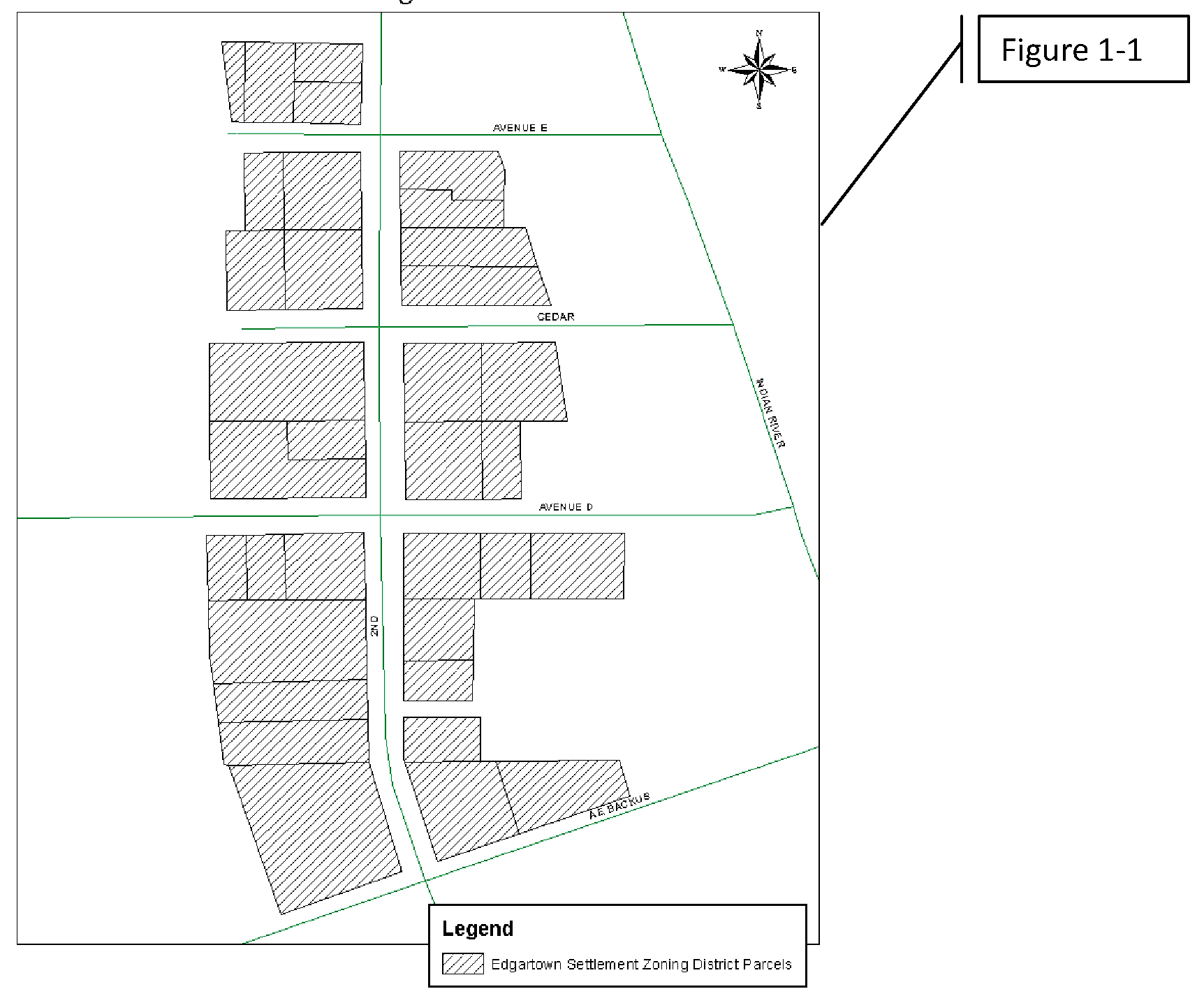
(c)
Delineation of district. Edgartown Settlement District includes all parcels in the shaded area as indicated in Figure 1-1.
Edgartown Settlement Zoning District
(d)
Uses allowed.
(1)
Permitted uses. Uses identified with a "P" in Chart 1-1, use table are permitted as-of-right, subject to any listed use standards and all other applicable standards of this Code.
(2)
Conditional uses. Uses identified with a "C" in Chart 1-1, use table may be allowed if reviewed and approved in accordance with conditional use criteria and procedures of the land development regulations. Conditional uses are subject to compliance with any listed use standards and all other applicable standards of this Code.
(3)
Accessory uses. Uses identified with an "A" in Chart 1-1, use table are subordinate to a primary use of the property, shall not be located within any front facade bay, and are subject to any listed use standard, and to all other applicable standards of this Code. All accessory uses shall be located either within the rear section of the primary structure, within the rear yard or within an accessory structure at the rear of the property. Few customers, especially the general public, come to the site to access the use. All accessory uses in total may occupy no more than 20 percent of the parcel's total lot area.
(4)
Reclassification to conditional use. If an amendment to this section changes a use classification from permitted to conditional, the requirement to obtain conditional use approval shall apply prospectively to new or changed uses and not retroactively to lawful uses that are ongoing as of the effective date of the amendment. This subsection shall not be construed to excuse a legal nonconforming or grandfathered property from otherwise complying with the city's Code of Ordinances.
(e)
Density calculations. Density is calculated based on the ES boundaries, as defined on Figure 1-1, per future land use density caps of the subject properties. A total of 137 dwelling units are permitted within the map area, regardless of lot configuration and size. Maximum density is not calculated based on each lot as it is subdivided.
(f)
Development standards.
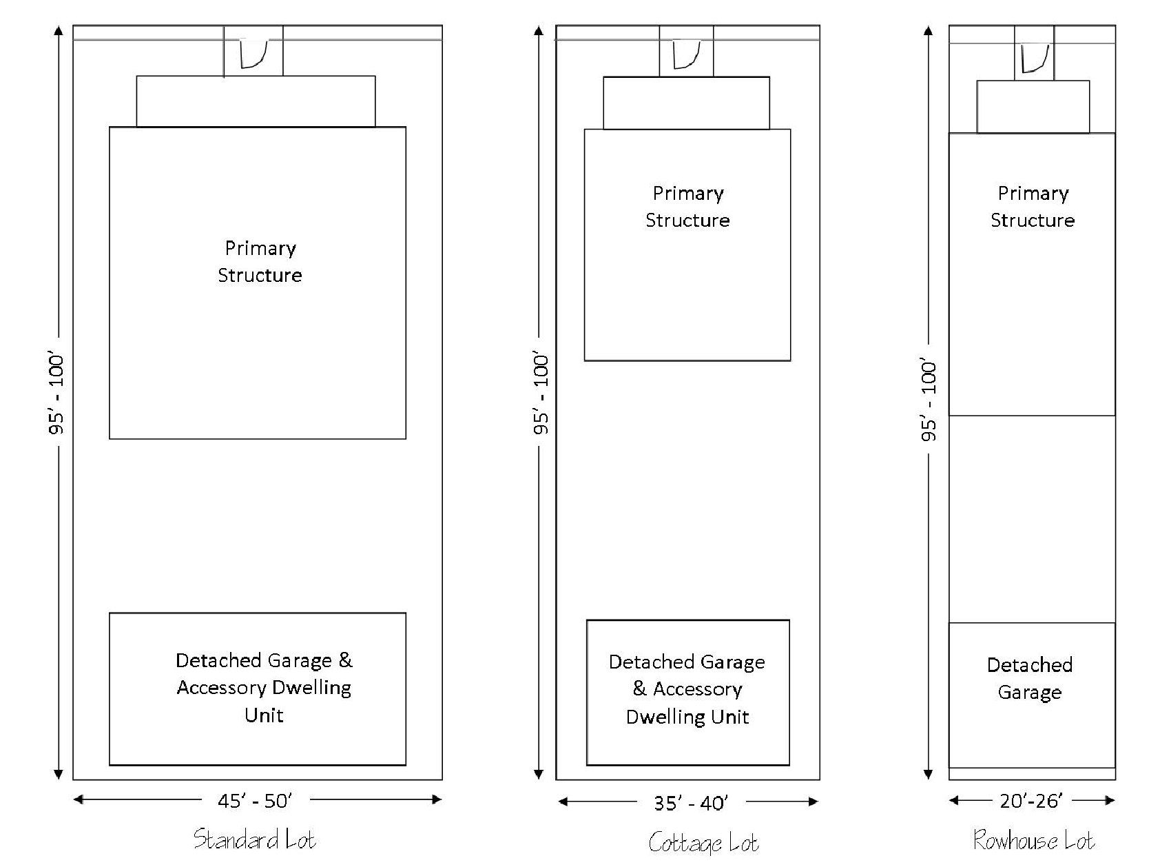
(1)
Standard lot: 45 feet to 50 feet wide lots reflective of the existing historic development pattern of the neighborhood. Standard lots are permitted fronting on any vehicular right-of-way. Standard lots permit up to a two and one-half-story primary structure as well as a detached garage with an accessory dwelling unit located above the garage. Up to three separate primary uses are permitted: two uses in the primary structure, and one in the accessory dwelling unit. Accessory uses are permitted in addition to the primary permitted uses.
(2)
Cottage lot: 35 feet to 40 feet wide lots which permit a small scale, tightly knit pedestrian court type of housing. Cottage lots are permitted fronting a pedestrian-only right-of-way in groups of at least three contiguous lots. Cottage lots permit a two-story primary structure as well as a detached garage with an accessory dwelling unit located above the garage. Up to two separate primary uses are permitted: One use in the primary structure and one use in the accessory dwelling unit. Accessory uses are permitted in addition to the primary permitted uses.
(3)
Rowhouse lot: 20 feet wide lot in a group of at least three but no more than six contiguous lots (rowhouse group), with separate dwelling units attached horizontally in a linear arrangement. Rowhouse groups are permitted along any vehicular right-of-way Each lot permits a two-story connected rowhouse and a detached garage. Accessory dwelling units are not permitted. One primary use is permitted on a rowhouse lot in the primary structure. Accessory uses are permitted in addition to the primary use.
(4)
Lot types:
Edgartown Settlement (ES) Zoning District Lot Types
(5)
Lot dimensional standards.
(6)
Additional dimensional standards and definitions.
a.
Building height. Measured from first floor elevation to top of eave. Roofs and incorporated architectural features such as cupolas and widow's walks are not included in building height unless habitable space is incorporated within half stories shall be incorporated into a sloped roof line with dormers and gables. All new construction shall follow historic construction patterns of building the first-floor elevation at least one and one-half feet to two feet above grade on a stem wall or pillars even if base floor is lower.
b.
Contextual build-to/setback. When subject lot is adjacent to lots with existing structures, the planning director may permit a contextual setback/build-to based on an average of the requirement and the adjacent properties.
c.
Porches. All new construction shall incorporate an open, covered, minimum eight feet deep front porch. On corner lots, open, covered side porches are encouraged but not required.
d.
Parking. No off-street parking is required for any use. Any proposed off-street parking shall be located to the rear of the property behind the primary structure.
e.
Uses allowed per lot, total. Indicates the total number of primary uses (does not include accessory uses) allowed on a specific lot type. For instance, a standard lot could have one commercial use, and two residential dwelling units, or two commercial uses and one residential dwelling unit. The combination of uses is limited only by dwelling units per lot, imposed by density constraints. Accessory uses, regulated by separate standards, are allowed in addition to primary uses.
f.
Variances. The historic preservation board shall have the power to waive, with or without conditions, subdivision, and dimensional standards in the Edgartown Settlement zoning district. The proposed variance shall further the continued preservation of the historic site and historic district more appropriately than adherence to the subject regulation. The board shall only grant such variances when an application for a certificate of appropriateness has been issued to promote preservation, rehabilitation, or restoration. In carrying out this responsibility, the historic preservation board must follow the same procedures specified for the board of adjustment in division 3 of article II of this chapter.
(g)
Residential use standards.
(1)
Rowhouse standards. Each unit's entrance is located on its fully exposed front facade, within a covered porch, and has a fully exposed rear facade opening to a private, fenced or walled rear yard.
(2)
Accessory dwelling unit (ADU) use standards. ADU should be designed to respect the historic, small scale residential detached building typology in the Edgartown Settlement zoning district, as well as the architectural design of the primary structure on the site. Accessory dwelling units may or may not include a detached garage. A detached garage may be constructed without an incorporated accessory dwelling unit.
(3)
ADU development standards.
a.
Build-to line, rear: two feet.
b.
Build-to, side corner: eight feet; or with porch: six feet.
c.
Setback, side: five feet.
d.
Building height. No greater than height of principal structure unless granted variance. Maximum height of proposed structure may not exceed the maximum height allowed on subject lot. The historic preservation board will act as the decision-making body for this variance.
e.
Massing. No greater than mass of principal structure unless granted variance. The historic preservation board will act as the decision-making body for this variance.
f.
Parking. No additional parking is required for the ADU.
g.
Architectural compatibility. Architectural style and building materials shall be compatible with the primary structure's architectural style.
(h)
Public and civic use standards.
(1)
Community garden standards.
a.
Entrance. Each unit's entrance located on its fully exposed front facade, within a covered porch, and has a fully exposed rear facade opening to a private, fenced or walled rear yard.
b.
Compatibility. Community gardens shall be subject to the compatibility standards for general commercial uses set forth in section 125-197(i)(6).
c.
Xeriscape. Water source shall be reclaimed on-site of off-site water, i.e., rain barrel, sub-grade, or landscape-screened cistern, etc.
d.
Topsoil retention. Site shall be configured in such a way that no exposed soil shall be prone to stormwater runoff.
e.
Outdoor storage. All equipment and materials shall be enclosed within a permitted structure. Compost shall be screened with landscaping.
f.
Ownership. Owner of site shall provide a written agreement allowing the site to be used as a community garden.
(2)
Childcare. Day care home or day care center standards.
a.
Arrival and departure. Site design must provide for the safe arrival and departure of children.
b.
Traffic. Drop off areas must be arranged so that an adult can remove a child from the pedestrian side of the vehicle and proceed directly to the front entrance on a sidewalk.
c.
Security. The entrance must be readily identifiable and accessible to emergency personnel. The location must allow for all entrances and exits to be secured, with a secured play yard perimeter and controlled access.
d.
Exterior play yards. The site shall provide an outdoor play yard and amenities. Play yards should provide for a variety of developmentally appropriate activities and amenities.
e.
Fencing. Play yards must be enclosed by fences to define and secure the play yard. Chain-link is not an acceptable material. The material chosen must have no sharp exposed connections. When play yards are located adjacent to a street, raised planters should be incorporated into fencing design to create a more secure barrier between an errant vehicle and children in the play yard.
f.
Alternative compliance. When play yard areas cannot be provided in compliance with these criteria due to site constraints, the center may propose access to alternate play areas for large motor skill development. These may include public parks with appropriate play equipment within one-fourth mile of the childcare center, provided safe pedestrian routes with adequate sidewalks and crosswalks are identified.
(i)
Commercial general use standards.
(1)
Applicability. These standards are applicable to all commercial uses, except as modified by applicable standards for specific primary uses.
(2)
Floor area: 2,000 square feet, maximum per tenant.
(3)
Hours of operation: No business may operate between the hours of 11:00 p.m. and 7:00 a.m.
(4)
Parking, off-street; not required. When provided, parking shall be located to the rear of the primary structure.
(5)
Parking, on-street. If on-street parking is not present on all adjacent rights-of-way, the applicant shall be required to install adopted streetscape improvements for deficient street, including on-street parking, street trees, lighting, and sidewalks.
(6)
Compatibility. No business may operate in such a manner that it generates persistent light, odor, vibration, or visual blight of such a nature that it adversely affects the comfort, repose, health, or safety of persons occupying an adjacent property, as deemed by a reasonable person.
(7)
Adaptive re-use of a historic structure. Provides for a wider variety of allowed uses than those allowed in the existing zoning district for structures designated as contributing or individually designated historic structures on the city register of historic places. A proposed use not listed as permitted or conditional in the ES zoning district may be applied for through this adaptive re-use conditional use process. The historic preservation board will act as the decision-making body for this conditional use based on the following criteria:
a.
Architectural character. The proposed use and any subject alterations shall maintain the architectural character of the historic property and modifications shall be governed by the Secretary of the Interior's Standards for the Treatment of Historic Properties.
b.
Historic character. The proposed use shall promote the preservation of the historic character of the historic district or, if the structure is individually designated, shall benefit the character of the surrounding neighborhood.
c.
Comprehensive plan. The proposed conditional use is consistent with the comprehensive plan.
d.
Concurrency. The proposed conditional use will not cause the level of service of public facilities that are subject to concurrency requirements to drop below levels of service established by the comprehensive plan.
e.
Compatibility. The proposed conditional use at the proposed location will not result in adverse impacts to adjacent property, the character of the neighborhood, traffic conditions, parking, public improvements, public sites or rights-of-way, or other matters affecting the public health, safety, and general welfare, either as they now exist or as they may exist in the future.
f.
Impact. Existing regulations are in place to mitigate potential adverse impacts of the proposed conditional use, or reasonable conditions can be imposed and enforced to mitigate potential adverse impacts.
(j)
Eating and drinking establishment; brewpub, use standards.
(k)
Eating and drinking establishment; neighborhood bistro, use standards.
(l)
Eating and drinking establishment; wine and cigar bar, use standards.
(m)
Vacation rental use standards. Vacation rentals shall be subject to the standards in chapter 22, article X, Short term and vacation rental regulations.
(n)
Retail sales, service, and repair (light) use standards.Use classifications (examples, similar and not limited to):
(1)
Sales oriented. Examples of sales-oriented retail sales and service include stores selling, leasing or renting consumer, home and business goods including alcoholic beverages; antiques; small appliances; art; art supplies; baked goods; bicycles; books; cameras; carpet and floor coverings; crafts; clothing; computers; convenience goods; dry goods; electronic equipment; fabric; flowers; garden supplies; gifts; groceries; hardware; household products; jewelry; medical supplies; microbreweries with a retail off-premises sales component; musical instruments; neighborhood commercial sales; pet food and/or pets; pharmaceuticals; photo finishing; picture frames; plants; printed material; produce; sporting goods; seafood retailers and markets; stationery; tobacco; and related products and videos.
(2)
Personal service oriented. Examples of personal service-oriented retail sales and service include animal grooming facilities; health clubs; business, driving, trade and other commercial schools; dance, art, fitness/wellness, gymnastic, yoga or music studios or classes; dry-cleaning and laundry drop-off establishments; hair, nail, tanning and personal care services; laundromats; massage therapy; funeral homes; neighborhood commercial services; photocopy, blueprint and quick-sign services; photographic studios; security services; and small-scale catering.
(3)
Repair oriented. Examples of repair-oriented retail sales and service include locksmiths; small appliances and electronics, bicycles, canvas products, clocks, computers, jewelry, musical instruments, shoes, televisions, and watches; and tailors, milliners, and upholsterers.
(4)
Uses not included. Adult entertainment; large-scale catering; laundry and dry-cleaning plants; lumber yards and other building material sales that sell primarily to contractors and do not have a retail orientation; repair and service of motor vehicles, motorcycles, recreational vehicles, boats, light and medium trucks; sale or rental of machinery, equipment, heavy trucks, building materials, special trade tools, welding supplies, machine parts, electrical supplies, janitorial supplies, restaurant equipment and store fixtures; tattoo or piercing services; and exterior freestanding vending machines.
(o)
Urban food production use standards.
(1)
Size. No more than ten percent of the site may be dedicated to the use.
(2)
Compatibility. Urban food production shall be subject to the compatibility standards for general commercial uses set forth in section 125-197(i)(6).
(3)
Xeriscape. Irrigation source shall be reclaimed on-site or off-site water, i.e., rain barrel, sub-grade, or landscape-screened cistern, etc.
(4)
Topsoil retention. Site shall be configured in such a way that no exposed soil shall be prone to erosion.
(5)
Buffer. Use shall be buffered from view from any adjacent right-of-way or property by appropriate fencing and/or landscaping.
(6)
Outdoor storage. All equipment and materials shall be enclosed within a permitted structure. Compost shall be screened with vegetation or enclosed within a bin.
(7)
Uses not included. Gardens or fruit trees for any animal which causes excessive noise or odor, such as roosters or peacocks.
(p)
Sound levels. All provisions of chapter 26, article II of this Code, shall apply within the Edgartown Settlement Zoning District, with the following exception: Between the hours of 7:00 a.m. and 11:00 p.m. each day, subject to the exemptions in chapter 26, article II, section 26-41, sound levels shall not exceed 55 dBA, 55 dBC, or 55 dBZ when measured from the property line of the nearest receiving single-family residential property.
(Code 1983, § 22-28.1; Ord. No. L-270, § 1, 10-1-2012; Ord. No. 23-019, §§ 1—15, 4-17-2023)
Sec. 125-198. - Office Commercial Zone (C-1).
(a)
Purpose. This commercial classification is intended primarily for uses involving business and institutional uses which do not involve the direct sale or display of goods, the production of goods or the storage or shipment of bulk or large volume materials. Convenience commercial facilities, restaurants and certain other uses are allowed when appropriate conditions and safeguards indicated in this section are fulfilled. Uses in this district should have good access to arterial or collector streets. This district is sometimes suitable for use as a buffer separating other commercial zones from residential districts.
(b)
Basic use standards. Uses in a C-1 zone must meet the requirements of this section. More restrictive requirements, set forth in accordance with other provisions of this chapter, must be satisfied by some conditional uses.
(1)
Lot size.
a.
The minimum lot area shall be 10,000 square feet.
b.
The minimum lot width shall be 70 feet.
c.
The minimum lot depth shall be 90 feet.
(2)
Yards.
a.
The minimum depth of the front yard will be 25 feet.
b.
The minimum yard depth (if not the front yard) for portions of the property abutting a public right-of-way or residential district shall be 15 feet.
(3)
Lot coverage. Buildings shall not cover more than 60 percent of the lot area.
(4)
Building height. No building shall exceed a height of 65 feet above grade.
(c)
Other applicable use standards.
(1)
Site plan review shall be required as outlined in section 125-313.
(2)
Accessory buildings shall comply with all yard, lot coverage and building height requirements of this chapter.
(3)
Every lot shall abut a street other than an alley for at least 50 feet.
(4)
Materials or objects which would detract from the open space character of an uncovered or unenclosed area will not be permitted in such an area.
(5)
All uses will comply with applicable access, parking and loading standards in sections 125-315 and 125-316.
(6)
Conditional uses will meet the requirements in sections 125-235 through 125-247.
(7)
Signs will comply with standards referred to in section 125-310.
(8)
All other applicable ordinance requirements will also be satisfied.
(Code 1983, § 22-29; Ord. No. H-186, § 30-29, 6-15-1981; Ord. No. H-207, § 1, 5-3-1982; Ord. No. I-147, § 3, 2-3-1986; Ord. No. I-148, § 1, 2-3-1986; Ord. No. I-308, § 1, 2-6-1989; Ord. No. K-24, § 8, 8-21-2000; Ord. No. K-122, § 1, 12-17-2001; Ord. No. L-295, § 11, 11-4-2013; Ord. No. 19-016, § 4, 5-20-2019)
Sec. 125-199. - Neighborhood Commercial Zone (C-2).
(a)
Purpose. This district is intended to be a restricted commercial zone which is designed to meet some of the commercial needs of the immediate residential neighborhood. Uses allowed are primarily those which provide convenience goods or frequently used services. Large business operations and extensions of strip commercial areas are not desired. Areas zoned C-2 should be located near the intersections of major streets and generally close to an R-4 zone.
(b)
Basic use standards. Uses in a C-2 zone, except multifamily housing developments, must meet the requirements of this section. More restrictive requirements, set forth in accordance with other provisions of this chapter, must be satisfied by some conditional uses.
(1)
Lot size.
a.
The minimum lot area shall be 10,000 square feet.
b.
The minimum lot width shall be 70 feet.
c.
The minimum lot depth shall be 90 feet.
(2)
Yards.
a.
The minimum depth of the front yard will be 25 feet.
b.
The minimum yard depth (if not the front yard) for portions of the property abutting a public right-of-way or residential district shall be 15 feet.
(3)
Lot coverage. Buildings shall not cover more than 60 percent of the lot area.
(4)
Building height. No building shall exceed a height of 45 feet above grade.
(c)
Other applicable use standards.
(1)
Site plan review shall be required as outlined in section 125-313.
(2)
Accessory buildings shall comply with all yard, lot coverage, and building height requirements of this chapter.
(3)
Every lot shall abut a street other than an alley for at least 50 feet.
(4)
Materials or objects which would detract from the open space character of an uncovered or unenclosed area will not be permitted in such an area.
(5)
All uses will comply with applicable access, parking and loading standards in sections 125-315 and 125-316.
(6)
Conditional uses will meet the requirements in sections 125-235 through 125-247.
(7)
Signs will comply with standards referred to in section 125-310.
(8)
All other applicable ordinance requirements will also be satisfied.
(Code 1983, § 22-30; Ord. No. H-186, § 30-30, 6-15-1981; Ord. No. K-24, § 9, 8-21-2000; Ord. No. L-295, § 12, 11-4-2013; Ord. No. 19-016, § 5, 5-20-2019)
Sec. 125-200. - General Commercial Zone (C-3).
(a)
Purpose. The district is intended to provide for a broad variety of business activities including shoppers' goods stores, convenience goods and service establishments, offices and tourist/entertainment facilities. Many public and semi-public uses are also appropriate. Compared to the C-4 zone, this district is more suitable for uses requiring a high degree of accessibility to vehicular traffic, low intensity uses on large tracts of land, most repair services and small warehousing and wholesaling operations. Although this zone should be located along or near arterial or collector streets, it is not the intent of this district to encourage the extension of strip commercial areas. Instead it should promote concentrations of commercial activities.
(b)
Basic use standards. Uses in a C-3 zone must meet the requirements of this section. More restrictive requirements, set forth in accordance with other provisions of this chapter, must be satisfied by some conditional uses.
(1)
Lot size.
a.
The minimum lot area shall be 10,000 square feet.
b.
The minimum lot width shall be 70 feet.
c.
The minimum lot depth shall be 90 feet.
(2)
Yards.
a.
The minimum depth of the front yard will be 25 feet.
b.
The minimum yard depth (if not the front yard) for portions of the property abutting a public right-of-way or residential district shall be 15 feet.
(3)
Lot coverage. Buildings shall not cover more than 60 percent of the lot area.
(4)
Building height. No building shall exceed a height of 65 feet above grade, except that multifamily developments in accordance with the requirements of the R-5 zone may be approved.
(c)
Other applicable use standards.
(1)
Site plan review shall be required as outlined in section 125-313.
(2)
Accessory buildings shall comply with all yard, lot coverage and building height requirements of this chapter.
(3)
Every lot shall abut a street other than an alley for at least 50 feet.
(4)
Materials or objects which would detract from the open space character of an uncovered or unenclosed area will not be permitted in such an area.
(5)
All uses will comply with applicable access, parking and loading standards in sections 125-315 and 125-316.
(6)
Conditional uses will meet the requirements in sections 125-235 through 125-247.
(7)
Signs will comply with standards referred to in section 125-310.
(8)
All other applicable ordinance requirements will also be satisfied.
(9)
An adult establishment is not permitted in C-3 unless the adult establishment is at least:
a.
One thousand feet from any other adult establishment:
b.
Four hundred feet from any established church, public or private school, public playground or public park;
c.
Four hundred feet from any areas zoned E-1, R-1, R-2, R-3, R-4, or R-5.
(10)
For purposes of the distance limitations contained in subsection (c)(9) of this section, the measurement shall be made by extending a straight line from the main entrance of the building of the adult establishment to the:
a.
Front door of the main building occupied by any other adult establishment or any established church; or
b.
To the nearest property line of any residential district, playground, school or park.
(Code 1983, § 22-31; Ord. No. H-186, § 30-31, 6-15-1981; Ord. No. H-217, § I, 7-6-1982; Ord. No. I-10, §§ 14—16, 6-6-1983; Ord. No. I-120, § 3, 7-15-1985; Ord. No. I-147, § 4, 2-3-1986; Ord. No. I-148, § 2, 2-3-1986; Ord. No. J-420, § 2, 5, 4-20-1998; Ord. No. J-487, § 1, 1-19-1999; Ord. No. K-24, § 10, 8-21-2000; Ord. No. K-149, § 1, 4-15-2002; Ord. No. K-187, § 1, 2-18-2003; Ord. No. K-221, § 1, 6-16-2003; Ord. No. L-11, § 1, 4-21-2008; Ord. No. L-97, § 2, 11-16-2009; Ord. No. L-217, § 3, 12-5-2011; Ord. No. L-295, § 13, 11-4-2013; Ord. No. 19-016, § 6, 5-20-2019)
State Law reference— Prohibition of adult entertainment establishment that displays, sells, or distributes materials harmful to minors within 2,500 feet of a school, F.S. § 847.0134.
Sec. 125-201. - Central Commercial Zone (C-4).
(a)
Purpose. This direct is intended to serve as a primary center of commercial and institutional activity and as a readily identifiable focal point of the community and surrounding area. It is intended to be an intensively used area catering primarily to the pedestrian. The district is not suitable for low intensity uses requiring a large tract of land, most types of repair services, warehouses and other uses which would detract from the character of the area.
(b)
Basic use standards. Uses in a C-4 zone, except multifamily housing developments, must meet the requirements of this section. More restrictive requirements, set forth in accordance with other provisions of this chapter, must be satisfied by some conditional uses.
(1)
Yards. The minimum yard depth for portions of the property abutting a residential district or across an existing street from a residential district will be 15 feet.
(c)
Other applicable use standards.
(1)
Uses identified as a permitted use within the use table are only permitted if they do not include drive-in purchase or service facilities which make it possible for a person to transact business from a vehicle. Uses identified as a permitted use within the use table that have drive-in purchase or service facilities which make it possible for a person to transact business from a vehicle shall be allowed as a conditional use.
(2)
Site plan review shall be required as outlined in section 125-313.
(3)
Indoor storage will not be the principal use of the ground floor of any building.
(4)
Accessory buildings shall comply with yard, lot coverage and building height requirements of this chapter.
(5)
Every lot shall abut a street other than an alley for at least 15 feet.
(6)
Materials or objects which would detract from the open space character of an uncovered or unenclosed area will not be permitted in such an area.
(7)
All uses will comply with applicable access, parking and loading standards in sections 125-315 and 125-316.
(8)
Conditional uses will meet the requirements in sections 125-235 through 125-247.
(9)
Signs will comply with standards referred to in section 125-310.
(10)
All other applicable ordinance requirements will also be satisfied.
(Code 1983, § 22-32; Ord. No. H-186, § 30-32, 6-15-1981; Ord. No. I-26, § I, 8-15-1983; Ord. No. I-120, § 4, 7-15-1985; Ord. No. J-199, § 1, 8-20-1996; Ord. No. J-517, § 5, 8-2-1999; Ord. No. K-24, § 11, 8-21-2000; Ord. No. K-258, § 1, 1-20-2004; Ord. No. L-97, § 3, 11-16-2009; Ord. No. L-295, § 14, 11-4-2013; Ord. No. 19-016, § 7, 5-20-2019)
Sec. 125-202. - Tourist Commercial Zone (C-5).
(a)
Purpose. The intent of this district is primarily to provide suitable locations for tourist facilities and certain tourist related establishments. In part, this means that areas in the zone should be in close proximity to an arterial or collector street. It also means that the uses allowed should be much more limited than those permitted in a C-3 or C-4 zone. Regulations for the district are designed to enhance the attractiveness and convenience of the facilities for tourist use.
(b)
Basic use standards. Uses in a C-5 zone, except multifamily housing developments, must meet the requirements of this section. More restrictive requirements, set forth in accordance with other provisions of this chapter, must be satisfied by some conditional uses.
(1)
Lot size.
a.
The minimum lot area shall be 10,000 square feet.
b.
The minimum lot width shall be 70 feet.
c.
The minimum lot depth shall be 90 feet.
(2)
Yards.
a.
The minimum depth of the front yard will be 25 feet.
b.
The minimum yard depth (if not the front yard) for portions of the property abutting a public right-of-way or residential district shall be 15 feet.
(3)
Lot coverage. Buildings shall not cover more than 60 percent of the lot area.
(4)
Building height. No building shall exceed a height of 45 feet above grade, except that multifamily housing developments in accordance with the requirements of the R-5 zone may be approved.
(c)
Other applicable use standards.
(1)
Site plan review shall be required as outlined in section 125-313.
(2)
Accessory buildings shall comply with all yard, lot coverage and building requirements of this chapter.
(3)
Every lot shall abut a street other than an alley for at least 50 feet.
(4)
Materials or objects which would detract from the open space character of an uncovered or unenclosed area will not be permitted in such an area.
(5)
All uses will comply with applicable access, parking and loading standards in sections 125-315 and 125-316.
(6)
Conditional uses will meet the requirements in sections 125-235 through 125-247.
(7)
Signs will comply with standards referred to in section 125-310.
(8)
All other applicable ordinance requirements will also be satisfied.
(Code 1983, § 22-33; Ord. No. H-186, § 30-33, 6-15-1981; Ord. No. I-114, § 5, 7-1-1985; Ord. No. K-24, § 12, 8-21-2000; Ord. No. K-441, § 3, 1-16-2007; Ord. No. L-207, § 1, 1-18-2011; Ord. No. L-255, § 1, 5-7-2012; Ord. No. L-295, § 15, 11-4-2013; Ord. No. 19-016, § 8, 5-20-2019)
Sec. 125-203. - Marine Commercial Zone (C-6).
(a)
Purpose. The intent of this district is primarily to provide suitable locations for compatible marine commercial and tourist-related facilities. In part, this means that areas in the zone should be in close proximity to an arterial or collector street and should also be located in close proximity to the waterfront. The requirements in this zone recognize that certain marine oriented commercial activities can be compatible with activities that are more tourist-related and when combined can create a special environment. The uses laid out in this zone are not meant to be as inclusive as those found in a general commercial zone, but rather should be reserved for uses that are dependent on or benefit from proximity to the water.
(b)
Basic use standards. Uses in a C-6 zone must meet the requirements of this section. More restrictive requirements, set forth in accordance with other provisions of this chapter, must be satisfied by some conditional uses.
(1)
Lot size.
a.
The minimum lot area shall be 10,000 square feet.
b.
The minimum lot width shall be 70 feet.
c.
The minimum lot depth shall be 90 feet.
(2)
Yards.
a.
The minimum depth of the front yard will be 25 feet.
b.
The minimum yard depth (if not the front yard) for portions of the property abutting the public right-of-way or residential district shall be 15 feet.
(3)
Lot coverage. Building shall not cover more than 60 percent of the lot area.
(4)
Building height. No building shall exceed the height of 65 feet above grade, except that multifamily housing developments in accordance with the requirements of the R-5 zone may be approved.
(c)
Other applicable use standards.
(1)
Site plan review shall be required as outlined in section 125-313.
(2)
Accessory buildings shall comply with all yard, lot coverage and building requirements of this chapter.
(3)
Every lot shall abut a street other than an alley for at least 50 feet.
(4)
Materials or objects which would detract from the open space character of an uncovered or unenclosed area will not be permitted in such an area.
(5)
All uses will comply with applicable access, parking and loading standards in sections 125-315 and 125-316.
(6)
Conditional uses will meet the requirements of sections 125-235 through 125-248.
(7)
Signs will comply with standards referred to in section 125-310.
(8)
All other applicable ordinance requirements will also be satisfied.
(Code 1983, § 22-33.1; Ord. No. I-404, § 2, 12-3-1990; Ord. No. K-24, § 13, 8-21-2000; Ord. No. L-295, § 16, 11-4-2013; Ord. No. 19-016, § 9, 5-20-2019)
Sec. 125-204. - Light Industrial Zone (I-1).
(a)
Purpose. The purpose of this district is to provide for industrial and related uses with limited objectionable external effects in areas that are suitable for such operations due to the desirability of site characteristics, adequacy of utilities, appropriateness of transportation facilities and other factors. Acceptable manufacturing, warehousing, heavy commercial and similar uses are encouraged. Uses in the district may perform a support role for uses in other industrial areas.
(b)
Basic use standards. Uses in an I-1 zone must meet the requirements of this section. More restrictive requirements, set forth in accordance with other provisions of this chapter, must be satisfied by some conditional uses.
(1)
Lot size.
a.
The minimum lot width shall be 100 feet.
b.
The minimum lot depth shall be 100 feet.
(2)
Yards. The minimum yard depth for portions of the property abutting a public right-of-way or nonindustrial district will be 15 feet.
(c)
Other applicable use standards.
(1)
Site plan review shall be required as outlined in section 125-313.
(2)
Accessory buildings shall comply with all yard, lot coverage and building height requirements of this chapter.
(3)
Every lot shall abut a street other than an alley for at least 50 feet.
(4)
Materials or objects which would detract from the open space character of an uncovered or unenclosed area will not be permitted in such an area.
(5)
All uses will comply with applicable access, parking and loading standards in sections 125-315 and 125-316.
(6)
Conditional uses will meet the requirements in sections 125-235 through 125-247.
(7)
Signs will comply with standards referred to in section 125-310.
(8)
All other applicable ordinance requirements will also be satisfied.
(Code 1983, § 22-34; Ord. No. H-186, § 30-36, 6-15-1981; Ord. No. H-245, § 1, 12-20-1982; Ord. No. I-26, § 4, 8-15-1983; Ord. No. K-24, § 14, 8-21-2000; Ord. No. L-04, § 1, 3-3-2008; Ord. No. L-97, § 4, 11-16-2009; Ord. No. L-267, § 2, 11-5-2012; Ord. No. L-295, § 17, 11-4-2013; Ord. No. 19-016, § 10, 5-20-2019)
Sec. 125-205. - Heavy Industrial Zone (I-3).
(a)
Purpose. The purpose of this district is to provide for heavy industrial and related uses with limited objectionable external effects in areas that are suitable for such operations due to the desirability of site characteristics, adequacy of utilities, appropriateness of transportation facilities and other factors. Acceptable manufacturing, warehousing, heavy commercial and similar uses are encouraged.
(b)
Basic use standards. Uses in an I-3 zone must meet the requirements of this section. More-restrictive requirements, set forth in accordance with other provisions of this chapter, must be satisfied by some conditional uses.
(1)
Lot size.
a.
The minimum lot width shall be 100 feet.
b.
The minimum lot depth shall be 100 feet.
(2)
Yards. The minimum yard depth for portions of the property abutting a public right-of-way or nonindustrial district will be 15 feet.
(c)
Other applicable use standards.
(1)
Site plan review shall be required as outlined in section 125-313.
(2)
Accessory buildings shall comply with all yard, lot coverage and building height requirements of this chapter.
(3)
Every lot shall abut a street other than an alley for at least 50 feet.
(4)
Conditional uses will meet the requirements in sections 125-235 through 125-247.
(5)
Signs will comply with standards referred to in section 125-310.
(6)
All other applicable ordinance requirements will also be satisfied.
(d)
Parking and loading standards. The following are the off-street parking and loading standards for the I-3 zone:
(1)
Parking.
a.
Less than 100,000 square feet equals 2.0 spaces per 1,000 square feet of floor area.
b.
More than 100,000 square feet equals 1.0 space per 1,000 square feet of floor area.
(2)
Loading.
a.
Zero to 24,999 square feet equals one loading space.
b.
Twenty-five thousand to 59,999 square feet equals two loading spaces.
c.
Sixty thousand to 119,999 square feet equals three loading spaces.
d.
One hundred twenty thousand to 199,999 square feet equals four loading spaces.
e.
Two hundred thousand to 299,999 square feet equals five loading spaces.
(e)
Annexed property assigned I-3 zoning. This subsection shall apply to any annexed property that does not comply with subsection (d) of this section and this subsection (e) at the time of annexation. Any property annexed and assigned I-3 zoning shall be allowed to continue all uses occurring on the property at the time of annexation. No modifications to any part of the property shall be required by the city. In the event the annexed property is damaged or destroyed due to fire or natural disaster, then the property owner shall be permitted to reconstruct the property to the form, manner and condition the property was in prior to the damage or destruction notwithstanding any non-compliance with subsection (d) of this section and this subsection (e). Property annexed and assigned I-3 zoning is exempt from section 125-322.
(Code 1983, § 22-34.1; Ord. No. L-63, § 1, 12-1-2008; Ord. No. L-219, § 7, 9-19-2011; Ord. No. L-295, § 18, 11-4-2013; Ord. No. 19-016, § 11, 5-20-2019)
Sec. 125-206. - Marine Industrial Zone (I-2).
(a)
Purpose. This zone is intended primarily to provide a location for port activities, marine industry and supporting uses. In addition, certain nonindustrial water-oriented uses and uses associated with them may be permitted. The district is designed to exclude uses which can be located equally well elsewhere and are inconsistent with the character of the district. Large areas with adequate waterfront, street and railroad access are appropriate for this type of zoning.
(b)
Basic use standards. Uses in an I-2 zone must meet the requirements of this section. More restrictive requirements, set forth in accordance with other provisions of this chapter, must be satisfied by some conditional uses.
(1)
Lot size.
a.
The minimum lot width shall be 100 feet.
b.
The minimum lot depth shall be 100 feet.
(2)
Yards. The minimum yard depth for portions of the property abutting a public right-of-way or nonindustrial district will be 15 feet.
(c)
Special conditional use criteria. No conditional use will be allowed in an I-2 zone unless it meets one or more of the following criteria:
(1)
The use is a water-dependent use, which means that it can only be carried out on, in or adjacent to water and the location or access is needed for:
a.
Waterborne transportation (such as navigation; moorage, fueling and servicing of ships or boats; terminal and transfer facilities; fish or other resource and material receiving and shipping);
b.
Recreation (active recreation such as swimming, boating or fishing; passive recreation such as viewing or walking);
c.
A source of water (such as energy production, cooling of industrial equipment or wastewater or other industrial processes); or
d.
Marine research or education (such as viewing, sampling, recording information, conducting experiments or teaching).
(2)
The use is a water-related use, which means that:
a.
It provides goods and/or services that are directly associated with water-dependent uses (supplying materials to, using products of or offering commercial or personal services to water-dependent uses); or
b.
If it were not located near the water, it would experience a public loss of quality in the goods and services offered (evaluation of public loss of quality will include a subjective consideration of economic, social and environmental consequences of the use).
(3)
The use which is not the primary use of the structure, shares an existing structure with a water-dependent use or water-related use and the combination results in a multiple use facility.
(4)
The project provides significant public access or recreation uses through the provision of waterfront seating, walkways, piers, street furniture or similar facilities.
(5)
The use is an accessory use important to the operations of the principal use.
(6)
The use is a temporary use which meets the requirements of section 125-320.
(d)
Other applicable use standards.
(1)
Site plan review shall be required as outlined in section 125-313.
(2)
Accessory buildings shall comply with all yard, lot coverage and building requirements of this chapter.
(3)
Every lot shall abut a street other than an alley for at least 50 feet.
(4)
Materials or objects which would detract from the open space character of an uncovered or unenclosed area will not be permitted in such an area.
(5)
All uses will comply with applicable access, parking and loading standards in sections 125-315 and 125-316.
(6)
Conditional uses will meet the requirements in sections 125-235 and 125-247.
(7)
Signs will comply with standards referred to in section 125-310.
(8)
All other applicable ordinance requirements will also be satisfied.
(Code 1983, § 22-35; Ord. No. H-186, § 30-35, 6-15-1981; Ord. No. H-228, § 1, 10-4-1982; Ord. No. 1-26, § 3, 8-15-1983; Ord. No. 1-377, § 2, 5-7-1990; Ord. No. K-24, § 15, 8-21-2000; Ord. No. L-295, § 19, 11-4-2013; Ord. No. 19-016, § 12, 5-20-2019)
Sec. 125-207. - Commercial Parkway Zone (CP-1).
(a)
Purpose. The CP-l district is established for the purpose of providing space for large lot development along principal vehicular approaches into the city. This is a mixed use district which should provide for certain types of office, commercial, and industrial operations which are typically characterized by a business park setting. This district may function as a transition zone between commercial/light industrial activities and uses which may be sensitive to nuisance such as residential land uses.
(b)
Basic use standards. Uses in a CP-1 zone must meet the requirements of this section. More restrictive requirements, set forth in accordance with other provisions of this chapter, must be satisfied by some conditional uses.
(1)
Lot size.
a.
The minimum lot area shall be 20,000 square feet.
b.
The minimum lot width shall be 100 feet.
c.
The minimum lot depth shall be 100 feet.
(2)
Yards.
a.
The minimum depth of the front yard shall be 25 feet.
b.
The minimum depth of the rear yard shall be 20 feet.
c.
The minimum depth of the side yard shall be ten feet, except on corner lots the minimum side yard depth on a street side will be 20 feet.
(3)
Lot coverage. Buildings will not cover more than 60 percent of the lot area.
(4)
Building heights. No building shall exceed a height of 65 feet above grade.
(c)
Open space standards.
(1)
A minimum of 20 percent of the gross area of land to be devoted to a commercial parkway development must be reserved for use as parks, recreation areas, marinas, open space, planting, or other public purposes other than rights-of-way, utility easements, and parking areas. At the request of the developer and subject to the approval of the city commission, use of recreational facilities may be offered to the general public. Areas that are natural or manmade floodways, lakes, and stormwater retention areas may be also be used to satisfy the total open space requirement.
(2)
All land dedicated for open space shall be under the legal control of the developer.
(d)
Other applicable use standards.
(1)
Site plan review shall be required as outlined in section 125-313.
(2)
Accessory buildings shall comply with all yard, lot coverage and building height requirements of this chapter.
(3)
Every lot shall abut a street other than an alley for at least 60 feet.
(4)
Materials or objects which would detract from the open space character of an uncovered or unenclosed area will not be permitted in such an area.
(5)
All uses will comply with applicable access, parking and loading standards in sections 125-315 and 125-316.
(6)
Conditional uses will meet the requirements in sections 125-235 through 125-247.
(7)
Signs will comply with standards referred to in section 125-310.
(8)
All other applicable ordinance requirements will also be satisfied.
(Code 1983, § 22-35.1; Ord. No. J-05, § 1, 2-18-1992; Ord. No. J-452, § 2, 9-21-1998; Ord. No. K-24, § 16, 8-21-2000; Ord. No. K-170, § 1, 12-2-2002; Ord. No. L-295, § 20, 11-4-2013; Ord. No. 19-016, § 13, 5-20-2019)
Sec. 125-208. - General and Recreational Open Space Zone (OS-1).
(a)
Purpose. This zone is intended primarily for uses which, by their nature of development, contribute open space and visual relief, significant to the area's development pattern, in part, due to the scenic value or the buffering functions of the use. The zone is designed to achieve this by primarily allowing recreational uses.
(b)
Basic use standards. Uses in an OS-1 zone must meet the requirements of this section. More restrictive requirements, set forth in accordance with other provisions of this chapter, must be satisfied by some conditional uses:
(1)
Lot size.
a.
The minimum lot width shall be 100 feet.
b.
The minimum lot depth shall be 100 feet.
(2)
Yards. The minimum yard depth for portions of the property abutting a public right-of-way or residential district will be 15 feet.
(3)
Lot coverage. Buildings shall not cover more than 40 percent of the lot area.
(4)
Building height. No building shall exceed a height of 35 feet above grade.
(c)
Other applicable use standards.
(1)
Site plan review shall be required for uses which have buildings with more than 4,000 square feet of floor area.
(2)
Accessory buildings shall comply with all yard, lot coverage and building height requirements of this chapter.
(3)
Every lot shall abut a street other than an alley for at least 50 feet.
(4)
Materials or objects which would detract from the open space character of an uncovered or unenclosed area will not be permitted in such an area.
(5)
All uses will comply with applicable access, parking and loading standards in sections 125-315 and 125-316.
(6)
Conditional uses will meet the requirements in sections 125-235 through 125-247.
(7)
Signs will comply with standards referred to in section 125-310.
(8)
All other applicable ordinance requirements will also be satisfied.
(Code 1983, § 22-36; Ord. No. H-186, § 30-36, 6-15-1981; Ord. No. H-245, § 1, 12-20-1982; Ord. No. 1-26, § 4, 8-15-1983; Ord. No. K-24, § 17, 8-21-2000; Ord. No. L-295, § 21, 11-4-2013)
Sec. 125-209. - Conservation Open Space Zone (OS-2).
(a)
Purpose. This district is for areas containing important natural environmental features which pose severe limitations on their suitability for development. It is the intent of the zone to retain to open character of the zone wherever possible by limiting the uses primarily to conservation, low intensity recreation and other compatible uses. Due to the sensitive environmental character of areas in the district, many users are allowed as conditional uses.
(b)
Basic use standards. Uses in an OS-2 zone, except innovative residential developments, must meet the requirements of this section. More restrictive requirements, set forth in accordance with other provisions of this chapter, must be satisfied by some conditional uses.
(1)
Lot size.
a.
The minimum lot area for single-family dwelling shall be five acres.
b.
The minimum lot width shall be 100 feet.
c.
The minimum lot depth shall be 200 feet.
(2)
Yards.
a.
The minimum depth of the front yard will be 40 feet.
b.
The minimum depth of the side yard will be 20 feet.
c.
The minimum depth of the rear yard shall be 30 feet.
(3)
Lot coverage. Buildings will not cover more than five percent of the lot.
(4)
Height of buildings. No building shall exceed a height of 28 feet above grade, except fire control towers.
(c)
Other applicable use standards.
(1)
Accessory buildings shall comply with all yard, lot coverage and building height requirements of this chapter.
(2)
On any lot used for residential purposes, no more than one residential building will be allowed on a lot, except one building without kitchen facilities may be allowed as a guest house.
(3)
Materials or objects which would detract from the open space character of an uncovered or unenclosed area will not be permitted in such an area.
(4)
Conditional uses will meet the requirements in sections 125-235 through 125-247.
(5)
Signs will comply with standards referred to in section 125-310.
(6)
All other applicable ordinance requirements will also be satisfied.
(Code 1983, § 22-37; Ord. No. H-186, § 30-37, 6-15-1981; Ord. No. I-26, § 5, 8-15-1983; Ord. No. K-24, § 18, 8-21-2000; Ord. No. L-295, § 22, 11-4-2013)
Sec. 125-210. - Aquatic Conservation Zone (A-1).
(a)
Purpose. This district is intended to help ensure that aquatic areas having exceptional biological, aesthetic, educational or scientific value are appropriately protected for future generations. The regulations are designed to encourage management of these areas for low to moderate intensities of use, with emphasis on maintaining the flow of aquatic resources and recreational benefits. To the extend practical, damage to the ecosystems of the affected aquatic and shoreland areas and adverse impacts on the public's use of the water should be minimized.
(b)
Building heights. No building will exceed a height of 25 feet above the mean high tide line in tidal areas and the ordinary high water line in nontidal areas.
(c)
Special conditional use criteria. No conditional use will be allowed in an A-1 zone unless it meets one or more of the following criteria:
(1)
The use is a water-dependent use, which means that it can only be carried out on, in or adjacent to water and the location or access is needed for:
a.
Waterborne transportation (such as navigation; moorage, fueling and servicing of ships or boats; terminal and transfer facilities; fish or other resource and material receiving and shipping);
b.
Recreation (active recreation such as swimming, boating or fishing; passive recreation such as viewing or walking);
c.
A source of water (such as energy production, cooling of industrial equipment or wastewater or other industrial processes); or
d.
Marine research or education (such as viewing, sampling, recording information, conducting experiments or teaching).
(2)
The use is a water-related use, which means that:
a.
It provides goods and/or services that are directly associated with water-dependent uses (supplying materials to, or using products of or offering commercial or personal services to water-dependent uses); or
b.
If it were not located near the water, it would experience a public loss of quality in the goods and services offered (evaluation of public loss of quality will include a subjective consideration of economic, social and environmental consequences of the use).
(3)
The use which is not the primary use of the structure, shares an existing structure with a water-dependent use or water-related use and the combination results in a multiple use facility.
(4)
The project provides significant public access or recreation uses through the provision of waterfront seating, walkways, piers, street furniture or similar facilities.
(5)
The use is an accessory use important to the operations of the principal use.
(6)
The use is a temporary use which meets the requirements of section 125-320.
(d)
Other applicable use standards.
(1)
Accessory buildings shall comply with all building height requirements of this chapter.
(2)
Materials or objects which would detract from the open space character of an uncovered or unenclosed area will not be permitted in such an area.
(3)
All uses will comply with applicable access, parking and loading standards in sections 125-315 and 125-316.
(4)
Conditional uses will meet the requirements in sections 125-235 and 125-247.
(5)
Signs will comply with standards referred to in section 125-310.
(6)
All other applicable ordinance requirements will also be satisfied.
(e)
Unregulated activities. The provisions of this district will not be interpreted to prohibit or regulate the following activities, unless the prohibition or regulation is specifically stated as a condition of approval of a conditional use:
(1)
Filling.
(2)
Dredging.
(3)
Dredged material disposal.
(4)
Bankline/stream alteration.
(5)
Construction and repair of shoreline stabilization structures, mosquito control structures and dikes.
(6)
Installing types of navigational structures not previously listed in this subsection.
(Code 1983, § 22-38; Ord. No. H-186, § 30-38, 6-15-1981; Ord. No. K-24, § 19, 8-21-2000; Ord. No. L-206, §§ 1, 2, 1-18-2011; Ord. No. L-295, § 23, 11-4-2013)
Sec. 125-211. - Aquatic Development Zone (A-2).
(a)
Purpose. This district is intended for aquatic areas which should be managed primarily for navigation and other water-oriented uses, consistent with the need to minimize damage to the ecosystem of the area. Water-dependent, water-related and other uses are allowed which are consistent with the character of nearby shoreland areas. Aquatic development areas may include areas suitable for navigation (including shipping and access channels and turning basins), areas adjacent to developed or developable shorelands which may need to be altered to provide navigational access or create new land for water-oriented uses and other appropriate areas.
(b)
Building heights. No building will exceed a height of 45 feet above the mean high tide line in tidal areas and the ordinary high water line in nontidal areas.
(c)
Special conditional use criteria. No conditional use will be allowed in an A-2 zone unless it meets one or more of the following criteria:
(1)
The use is a water-dependent use, which means that it can only be carried out on, in or adjacent to water and the location or access is needed for:
a.
Waterborne transportation (such as navigation; moorage, fueling and servicing of ships or boats; terminal and transfer facilities or fish or other resource and material receiving and shipping);
b.
Recreation (active recreation such as swimming, boating or fishing; passive recreation such as viewing or walking);
c.
A source of water (such as energy production, cooling of industrial equipment or wastewater or other industrial processes); or
d.
Marine research or education (such as viewing, sampling, recording information, conducting experiments or teaching).
(2)
The use is a water-related use, which means that:
a.
It provides goods and/or services that are directly associated with water-dependent uses (supplying materials to, or using products of or offering commercial or personal services to water-dependent uses); or
b.
If it were not located near the water, it would experience a public loss of quality in the goods and services offered (evaluation of public loss of quality will include a subjective consideration of economic, social and environmental consequences of the use).
(3)
The use which is not the primary use of the structure, shares an existing structure with a water-dependent use or water-related use and the combination results in a multiple use facility.
(4)
The project provides significant public access or recreation uses through the provision of waterfront seating, walkways, piers, street furniture or similar facilities.
(5)
The use is an accessory use important to the operations of the principal use.
(6)
The use is a temporary use which meets the requirements of section 125-320.
(d)
Other applicable use standards.
(1)
Uses identified as a permitted use within the use table are only permitted if no dredging or filling is necessary and piers or similar facilities are not required in new locations. If dredging and/or filling or new piers or similar facilities are required, said uses shall be allowed as a conditional use.
(2)
Uses identified as a permitted use within the use table are only permitted when access to the facilities are provided from a property in an I-2, C-3, C-4 or C-5 zone by piers or similar means.
(3)
Commercial or industrial uses situated on floating structures shall be located so they will be protected from currents and wave action and so they will not rest on the bottom at low water.
(4)
Accessory buildings shall comply with all building height requirements of this chapter.
(5)
Materials or objects which would detract from the open space character of an uncovered or unenclosed area will not be permitted in such an area.
(6)
All uses will comply with applicable access, parking and loading standards in sections 125-315 and 125-316.
(7)
Conditional uses will meet the requirements in sections 125-235 through 125-247.
(8)
Signs will comply with standards referred to in section 125-310.
(9)
All other applicable ordinance requirements will also be satisfied.
(e)
Unregulated activities. The provisions of this district will not be interpreted to prohibit or regulate the following activities, unless the prohibition or regulation is specifically stated as a condition of approval of a conditional use:
(1)
Filling.
(2)
Dredging.
(3)
Dredged material disposal.
(4)
Bankline/stream alteration.
(5)
Construction and repair of shoreline stabilization structures, mosquito control structures and dikes.
(6)
Installing types of navigational structures not previously listed in this subsection.
(Code 1983, § 22-39; Ord. No. H-186, § 30-39, 6-15-1981; Ord. No. K-24, § 20, 8-21-2000; Ord. No. L-295, § 24, 11-4-2013)
Sec. 125-212. - Planned Development Zone (PD).
(a)
Purpose. The Planned Development (PD) Zone District is to provide a process for the evaluation of developments which are not otherwise permitted in the zoning districts established by this chapter. The PD District is a voluntary process commenced by an applicant for such zoning designation. The intent is to establish a resilient living and working environment through the application of enlightened and imaginative approaches to community planning, stormwater infrastructure and property design. A PD should provide a variety of natural features and scenic areas, efficient and economical land use, improved amenities, orderly and economic development, and the protection of adjacent existing and future development. Therefore, the PD alternative may allow uses and design concepts which are not specifically allowed in standard zoning districts. To the extent that any provisions of this section conflict with any other provisions of this Code, the provisions of this section shall prevail.
(b)
Definitions. The following words, terms, and phrases, when used in this article, shall have the meanings ascribed to them in this section, except where the context clearly indicates a different meaning:
Architectural drawing means building elevations depicting color, height and architectural elements drawn and submitted by a licensed architect demonstrating the design concept of the project.
Boundary survey means a boundary survey of the entire site including the legal description, parcel control number(s) and acreage, with a date of last field work within 180 days of the date of application. The boundary survey must be an original, signed and sealed by a licensed Florida Professional Surveyor and Mapper and must reference the current title commitment, list all easements and encumbrances of record, and show all those easements and encumbrances that affect the property and are plottable.
Compatibility means a condition in which land uses or conditions can coexist in relative proximity to each other in a stable fashion over time such that no use or condition is unduly negatively impacted directly or indirectly by another use or condition.
Construction plans means land clearing and erosion control plans, the original signed and sealed by a licensed Florida professional engineer and if practicing through a duly authorized engineering business, the name, address, and certification of authorization number of the engineering business.
Environmental assessment means a full assessment of native upland habitats, delineated wetlands, and listed species on property, the assessment shall include existing permits and note permits required.
Final PD (FPD) means approval of a final PD shall authorize the applicant to submit lot site plans or building permit applications in accordance with the terms and conditions of the approval. Permission to initiate construction of site improvements shall not be granted or building permits issued until all required documents are executed and all applicable conditions of approval satisfied.
Final stormwater report means a report prepared by a licensed Florida professional engineer, the report originally signed and sealed, will calculate the pre-development and post-development stormwater runoff discharge rate and provide calculations on how the water quality is to be treated (i.e. swales, exfiltration trenches, dry retention, wet detention, bioswales, etc.).
Floor plans means a separate plan for each floor within the proposed structures including the identification of the proposed use(s) and the area of the proposed use(s). Include square footage of each typical residential unit.
Landscape plans means plans prepared by a licensed landscape architect, the plans shall detail the size, species and locations of existing and proposed trees, shrubs and groundcovers, proposed tree mitigation, and tree replacement schedule, if required.
Legal description means the full legal description including parcel control number(s) and total acreage.
Lighting plans means a plan with photometric, light pole and fixture details to show compliance with the city's lighting requirements.
Master PD (MPD) means a preliminary planned development approval document. Approval of a master PD shall authorize the applicant to submit the associated final PD in accordance with the terms and conditions of the master PD, including the timetable of development and phasing. Issuance of a development order for a master PD shall not constitute approval to build or construct any improvements and is not the final approval necessary for construction of the development.
Master stormwater report means a report prepared by a licensed Florida professional engineer, the report originally signed and sealed, will discuss high-level calculations of the pre-development and post-development stormwater runoff discharge rate and provide a discussion on how the water quality is conceptually proposed to be treated (i.e. swales, exfiltration trenches, dry retention, wet detention, bioswales, etc.).
PD site plan means the proposed master PD site plan or final PD site plan including consistent data tables and detail sheets. The site plan should identify unit numbers and types, use areas, and access points. The master PD site plan is not required to identify individual lots until submittal of a final PD site plan, and shall detail at minimum, open space coverage, general areas of wetlands, preserve areas, general uses proposed, maximum commercial floorspace and range of residential density.
PD phasing plan means a clear depiction of the area and timing of distinct phases with descriptions of included infrastructure, landscaping, stormwater, and preservation areas to be included within each phase and confirmation that all elements will be functional.
PD zoning agreement means is an agreement between the city and the applicant that includes the methods and mechanisms of development of the PD.
Preserve area management plan means a plan required if the environmental assessment identifies wetlands or native habitats that are required to be preserved on site. The preserve area management plan shall describe how the wetlands and native habitats are to be monitored and maintained.
Project narrative means a summary including the history of the property and project, description, and justification of type of development being proposed, the location and size of the subject property, current zoning and future land use, request for zoning and future land use, preserve and landscape areas, square footage nonresidential), number of residential units, and proposed density. If the application is for an amendment, the project narrative outlines the changes being requested.
Proposed water sources means proposed utilities and the available capacity, and irrigation water sources including any proposed use of wells.
Recorded deed means a copy of the recorded deed(s) for the subject property.
Site location map means a map that shall, using a clear site boundary, include all adjacent and internal roadways, surrounding properties, existing and proposed zoning, and future land use designations.
Statement of PD benefits means a statement, which shall be included within the project narrative, of proposed public benefits, to include a comparative analysis of developer benefits gained by the PD designation.
Stormwater operation and maintenance means a narrative of how the proposed stormwater system will be maintained and operated.
Timetable for development means a good faith breakdown of the stages of development of a PD which identifies the, order, start date, and completion date of each phase and the date of final buildout.
Traffic impact analysis means an analysis or statement originally signed and sealed by a licensed Florida professional engineer. Development projects shall be categorized as either exempt, de minimis, or with significant impacts.
Tree mitigation plan means a narrative and/or plan setting out the replanting scheme, types and species of trees and maintenance of the replanted trees and tree mitigation calculation if required.
Tree survey means a boundary/topographic survey that identifies any hardwood native tree having a diameter of 14 inches DBH or greater and any palms which have a minimum clear trunk of ten feet, tree species, DBH, horizontal location, tree identifier (number).
Topographic survey means a survey of the project site that extends a minimum of 200 feet outside the proposed limits of construction (or until a discernible drainage basin boundary is reached). The topography must be collected at an interval adequate to generate one-foot contours. The date of the field survey must be within 180 days of the date of this application; the survey must be originally signed and sealed by a licensed Florida professional surveyor and mapper.
Utilities and wastewater service means confirmation of water and wastewater service.
(c)
General standards for approval. The planned development (PD) district is designed to allow an applicant to submit a proposal for consideration for any use or any mixture of uses on property not less than five acres in area or on property located within the Fort Pierce Redevelopment Area (FPRA). The approval of planned development rezoning rests with the city commission. However, no rezoning or PD may be approved unless the following standards are met:
(1)
Comprehensive plan consistency. The proposed development shall be shown to be consistent with the goals, objectives, and policies of the comprehensive plan, and consistent with the future land use element, and the standards and criteria contained in the following sections, unless a corresponding amendment to the comprehensive plan is also adopted.
(2)
Density. In no event shall the density granted exceed the maximum gross density of the underlying future land use and, if utilized, the allowable density bonuses permitted within the comprehensive plan.
(3)
Perimeter setbacks. Setbacks at the perimeter of the development shall be determined by the city commission, consistent, compatible, and in character with adjoining properties and existing or approved development. The city commission will determine perimeter setbacks based upon the following factors:
a.
Property in the abutting zoning district is located across a major roadway from the PD, and therefore, a reduced setback would have little or no impact on the character of the adjacent property.
b.
The minimum PD perimeter setback required by this section cannot be achieved due to exceptional narrowness, shallowness, shape, topographic condition or physical or environmental feature uniquely affecting the subject property.
c.
A PD perimeter setback shall provide a suitable landscape strip, except where driveways and pedestrian access points are located, or if a building elevation of a project is located directly on a street sidewalk, and meet these requirements:
1.
The strip shall be no less than ten feet wide and include at least one tree for every 200 square feet of required landscaped strip and contain a hedge of landscape material which shall be installed and maintained so as to form a six feet or higher, continuous, unbroken, solid, visual screen within one year after installation, except in clear vision areas required by city code. The remainder of the required landscaped strip shall be completely covered with groundcover or grass.
2.
A wall, berm with planting, or other durable, non-wood privacy fence may be included as part of the required six feet high landscape strip but shall not replace it.
d.
A reduced PD perimeter setback for buildings located on, and accessed directly from, a street sidewalk shall provide pedestrian amenities such as, and not limited to, bike racks, benches, shade structures, canopies, and arcades.
(4)
Open space. In all planned developments at least 20 percent of the site shall be devoted to open space, regardless of project size or intended use; open space shall be land devoid of any aboveground structures or buildings, except pergolas, gazebos, pavilions, or other open-air structures; or landscape structures such as terraces, planters, walls or retaining walls. Open space may include natural areas, buffer areas, upland habitats, including those areas of on-site preservation required by the other provisions of this Code; recreation areas, but not including swimming pools, tennis courts or other impervious activity areas; but may include parks, golf courses, sports fields; bicycle, pedestrian or equestrian paths and facilities; common open space, common landscaping or planting areas; stormwater detention and retention facilities providing that no more than 30 percent of the overall open space requirement shall be satisfied in this manner, conservation areas or other areas intended for public purposes other than street or road rights-of-way.
(5)
Applicability to other code of ordinances not in conflict herein. All building code, housing code, and other land use regulations of the city not directly in conflict herewith are applicable to the PD district.
(6)
Easements. Easements necessary for the orderly extension and maintenance of public utilities and/or other special needs may be required as a condition of approval.
(7)
Phasing. When provisions for phasing are included in the development plan, each phase of development must be so planned and so related to previous development, surrounding properties, and the available public facilities and services, that failure to proceed with subsequent phases will not adversely impact drainage, utilities, parking, or the traffic flow of the completed phases.
(8)
Other standards. All planned developments will comply with regulations affecting signs referred to in section 125-310 and applicable portions of the city's regulations governing subdivisions except that in case of conflict.
(9)
Additional requirements. The city commission may also establish additional requirements which it considers necessary to ensure that a planned development conforms to the intent of this section.
(10)
Variances are not necessary. The specific development standards of the PD district are contained in the approved development documents for each planned development. All matters which might otherwise be the subject of variance review by the board of adjustment shall be itemized and considered at time of PD approval.
(d)
Application requirements. When an application is submitted to rezone property to a PD zoning district, the following items will be submitted according to the stage of PD rezoning.
(1)
Table (c)(1) Required planned development plans and documents.
X=Required, (X)= Draft, O=If required
(2)
Planned development review procedures.
a.
A PD zoning application may be reviewed sequentially in two stages; a master PD (MPD) followed with a final PD (FDP). However, the applicant has the option to move directly to an FPD. The MPD is primarily conceptual in design. The FPD includes a fully designed site plan and associated documents including detailed analysis and calculation.
b.
A PD zoning application shall include appropriate plans and information as specified in table (c)1 of this section to meet sufficiency in accordance with the applicable stage of the PD zoning application.
c.
The planning department shall review the PD zoning application for sufficiency. Should the application be found to be sufficient it will be forwarded to the technical review committee (TRC). The recommendation of the TRC shall be forwarded to the planning board for review and recommendation to the city commission. Should the application be found to be insufficient, the applicant shall have 90 days from receipt of written notification of insufficiency to provide all the necessary information to remedy the insufficient application. The application shall be deemed withdrawn and denied unless the applicant responds, within the allotted timeframe, in one of the following ways:
1.
The applicant provides all the information necessary to remedy an insufficient application; or
2.
The applicant may provide documentation to establish that the applicant is continuing in good faith to remedy the insufficiencies; or
3.
The applicant requests in writing that the application be processed in its present form. In this case the applicant acknowledges that the application has been determined by the Director to be insufficient, the applicant waives the right to supplement the application with additional information, and the applicant agrees to allow a decision on the application based on the information submitted. The application shall then be processed in its present form.
d.
A final plat may be reviewed concurrently with an FPD.
e.
The city commission shall hold a public hearing in accordance with section 125-37 in order to assess the MPD or FPD. The city commission shall approve, approve with conditions, or disapprove the MPD or FPD.
(e)
Modification of an approved PD. Changes to an approved PD are either major modifications or minor modifications. A major modification shall require the approval of the technical review committee, planning board, and the city commission, while a minor modification shall be processed administratively by review of the technical review committee and thereafter by the planning director (or designee).
(1)
Major PD modification: Generally, additions, deletions, changes in the use, density, sequence of development or other specifications of an approved PD are to be viewed as a major modification. The applicant shall follow the same procedure as a new PD zoning application request. Applications for a major modification of an approved PD will require at time of submittal a narrative description of the modification and reasons such a change is necessary, and additional information as required by the planning director (or designee) to adequately review the proposed modification. The following alterations shall be considered a major modification:
a.
An increase in intensity of use of greater than five percent of usable floor area, in the number of dwelling units, of outside land area devoted to sales, displays, or demonstrations. In no case shall the intensity or density be increased over the maximum allowed by the future land use element of the comprehensive plan.
b.
A change of ten percent or more in the number of approved car parking spaces.
c.
An increase in occupiable building height of more than one story or 12 feet.
d.
Any reduction in the amount of approved open space by five percent or more, or a substantial change in the location or characteristics of open space uses.
e.
Substantial changes in the approved location or type of pedestrian or vehicular access or circulation.
f.
Any change which would increase traffic generation by more than ten percent.
g.
Any deviation exceeding 12 inches from the setbacks, area, or dimensional standards approved as part of the PD site plan.
h.
A change to the buffering material that negatively impacts the surrounding neighborhood.
i.
Any substantial change in the design and/or location of the stormwater facility.
j.
Any addition or reduction to the area of a PD.
k.
Any change in a condition specifically required by the city commissioners as part of the planned development approval.
(2)
Minor PD modification. Any modification to an approved PD which does not constitute a major modification shall be considered a minor modification. Generally, minor variations, extensions, alterations or modifications of proposed uses, buildings/structures or other improvements which are consistent with the purpose and intent of the approved PD are considered minor modifications. Applications for a modification shall include a revised PD site plan indicating the impacts of the proposed change and a narrative description of the modification and the reasons why such a change is necessary. Upon determination that the proposed modification is a minor modification, the planning director (or designee) shall render a decision to the applicant within 30 working days after submission of a completed modification application.
(3)
Amendments to a PD prior to full buildout. Prior to the build-out of 50 percent of the land in a FPD, the property owner shall have the right to initiate any amendments to any developed or undeveloped portions of the planned development. After 50 percent or more of the land in the planned development has been built-out, the property owner may initiate any amendments to undeveloped portions of the planned development; however, amendments to developed portions of the planned development may only be initiated by:
a.
The property owner, for an amendment to the planned development which is not applicable to all developed portions of the planned development;
b.
Petition by the owners of more than 50 percent of the developed property in the PD district for an amendment to the planned development applicable to all of the developed portions of the planned development; or
c.
City commission, where necessary to preserve the health, safety, and welfare of the property owners in the planned development.
(4)
Expiration of an approved PD. Approved MPD and FPD are subject to the following development timelines unless the MPD or FPD conditions of approval state otherwise:
a.
An approved MPD shall expire two calendar years after approval by the city commission unless a longer period is agreed at time of MPD approval. The property owner may request an extension of the timeline through the same process as a major amendment to a PD. The request for the extension shall be submitted no later than 30 days prior to the date of expiration and shall be accompanied with appropriate reasoning for the request.
b.
An approved FPD or approved phase of the FPD which has failed to secure a building permit for a vertical improvement in accordance with the phasing timetable for development, agreed at FPD approval, shall be considered expired. Prior to expiration, the property owner may request an extension of the timeline(s) through the same process as a major PD amendment. The request for the extension shall be submitted no later than 30 days prior to the date of expiration and shall be accompanied with appropriate reasoning for the request.
(5)
Expiration of FPD phasing. An expired FPD which has completed one or more of the phases as approved in the FPD will retain the PD zoning. However, the phases which have not secured a building permit for a vertical improvement within the timetable for development agreed at FPD approval shall not receive any building permits until a major amendment to the FPD is approved through the major FPD amendment process.
(6)
Expiration of a PD. Upon expiration of an MPD or expiration of an FPD which has not secured a building permit for vertical improvement for any part of the approved FPD the property owner will be required to process a new zoning application either for a major amendment to the existing PD zoning, or another zoning classification before any building permits or other approvals will be processed for the land subject to the expired MPD or expired FPD.
(7)
Status of previously approved PD (Planned Development zone) plans or PUR (Planned Unit Redevelopment zone) plans. Any active or completed planned development project approved prior to the adoption of this section shall continue to be governed by the approved PD site plan and any agreements, terms and conditions to which the approval may be subject, as long as the project continues to be actively under development. Any time limitations to which the approved PD plan may be subject shall also continue to apply. However, whenever any application is made to substantially modify (see major modification), the approved PD plan or to undertake a new development on part or all of the property, the application shall be made under the terms and procedures of this section.
(f)
Requirements of a planned development (PD) zoning agreement.
(1)
A planned development zoning agreement may include, but is not limited to, the following:
a.
A legal description of the land subject to the agreement;
b.
The names of the legal and equitable owners;
c.
The duration of the agreement;
d.
A development timeline;
e.
Phasing requirements;
f.
The development uses permitted on the land, including population densities, building intensities, and height;
g.
A description of public facilities that will service the development, including who shall provide such facilities; the date any new facilities, if needed, will be constructed; and a schedule to assure public facilities are available concurrent with the impacts of the development;
h.
A description of any reservation or dedication of land for public purposes;
i.
A description of all local development permits approved or needed to be approved for the development of the land;
j.
A finding that the development permitted or proposed is consistent with the local government's comprehensive plan and land development regulations;
k.
A list of any conditions, terms, restrictions, or other requirements determined to be necessary by the local government for the public health, safety, or welfare of its citizens; and
l.
A statement indicating that the failure of the agreement to address a particular permit, condition, term, or restriction shall not relieve the developer of the necessity of complying with the law governing said permitting requirements, conditions, term, or restriction.
(2)
A planned development zoning agreement may provide that the entire development or any phase thereof be commenced or completed within a specific period of time.
(Code 1983, § 22-40; Ord. No. 15-004, §§ 1, 2, 3-2-2015; Ord. No. 15-006, § 1, 6-15-2015; Ord. No. 24-015, § 1, 6-17-2024)
Sec. 125-213. - Reserved.
Editor's note— Ord. No. 24-015, § 2, adopted June 17, 2024, repealed § 125-213, which pertained to Planned Unit Redevelopment Zone (PUR) and derived from Code 1983, § 22-42; Ord. No. H-186, § 30-42, adopted June 15, 1981; Ord. No. K-258, § 3, adopted Jan. 20, 2004; and Ord. No. L-260, § 3, adopted June 18, 2012.