
Fort Walton Beach City Zoning Code
CHAPTER 4
DEVELOPMENT STANDARDS
4.09.00 - STANDARDS FOR SITE PREPARATION AND IMPROVEMENTS
Site preparation and site improvements shall comply with the requirements set forth in the Engineering Standards Manual of Fort Walton Beach.
4.00.01 - Applicability.
The purpose of this chapter is to provide development standards applicable to all development activity within the City. Subdivisions, new land uses and structures, and alterations to existing land uses and structures shall be designed, constructed, and established in compliance with the development standards for the applicable zoning district and the development standards for all zoning districts as set forth in this chapter.
4.00.02 - Measurements.
A.
Lot Width and Lot Frontage.
1.
Lot width is the horizontal distance between side lot lines measured at the mid-point between the endpoints of the side lot lines.
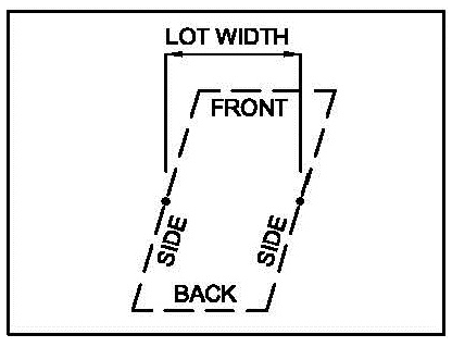
Figure 4.00.02 (A). Lot Width
2.
Lot frontage is the property line affronting a roadway right-of-way which provides the principal access and is used by the U.S. Postal Service for the delivery of mail to the structure located on the property.
a.
Minimum lot frontage for residential zoned property shall be twenty-five (25) feet.
B.
Setbacks.
1.
Setbacks are measured as the shortest distance from the exterior building wall to the property line.
2.
The rear yard setback for any waterfront lot is measured to the mean high water line.
3.
Eave overhangs shall not be included as a main part of any building, provided, however, that no eave overhang shall exceed three (3) feet and shall not be less than eight (8) feet from ground level.
C.
Specific measurement requirements for flag lots.
1.
The design requirements for platting flag lots are set forth in Section 4.07.03.C.
2.
A flag lot is exempt from the frontage requirements set forth in this LDC, provided that the width of the pole or access portion of the lot is not less than twenty (20) feet.
3.
The maximum length of the pole portion of the lot, measured from the right-of-way to the end of the pole at the point of connection to the flag is 150 feet.
4.
The setbacks for a flag lot are measured for the flag portion of the lot, excluding the pole portion of the lot.
D.
The impervious surface ratio is calculated by dividing the total of all impervious surfaces on the lot by the total lot area. Water bodies are impervious surfaces.
E.
Building height.
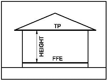
Figure 4.00.02 (E). Building Height.
1.
Building height is measured from the top of the floor at the finished floor elevation to the top plate of the highest habitable floor.
2.
Calculation of maximum building height shall not include the roof above the top plate of the highest habitable floor.
3.
Calculation of maximum building heights shall not include water towers, utility facility, or appurtenances or attachments such as chimneys, elevator shafts, antennas, decorative architectural features, steeples, air conditioning equipment enclosures, cupolas, weather vanes, and other similar building features. All appurtenances or attachments which are exempt for purposes of calculating the maximum height shall not be habitable. In certain zoning districts, it may be necessary to calculate the height of a building from mean sea level in order to determine compatibility with the Eglin Air Force Base mission, in which case appurtenances shall also be considered.
(Ord. No. 1969, § 2, 2-14-17)
4.00.03 - Compatibility Standards Pertaining to Building Height in All Zoning Districts.
A.
Applicability. The standards set forth in this section apply to buildings other than single-family dwellings when such buildings are located adjacent to parcels zoned to allow single-family residential use.
B.
Maximum height standards.
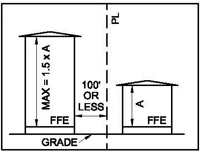
Figure 4.00.03 (B). Building Height & Distance from SFR
1.
The maximum height for buildings located 100 feet or less from a parcel with a single-family residential use shall not exceed one and one-half (1.5) times the average height of single-family dwellings in the adjacent or surrounding block.
4.00.04 - Standards Pertaining to Metal Buildings in all Zoning Districts.
A.
Applicability.
1.
The standards set forth in this section apply to principal buildings and accessory buildings larger than 1,000 sq. ft.
2.
The requirement for a veneer applies to metal building facades that are visible from a public right-of-way.
3.
Metal buildings within the CTP zoning district are exempt from the requirements in this section.
B.
Standards.
1.
Facades subject to this section shall have a veneer added consisting of brick, stucco, stone, or a similar decorative material.
2.
The decorative material shall be applied to 100 percent of the façade.
C.
Waiver Entitlement. The requirements of this section may be waived by the Board of Adjustment, pursuant to certain review criteria as outlined in Section 8.00.01.
4.01.01 - Site Development Standards.
A.
The base standards for development in residential zoning districts are provided in Table 4.01.01.
B.
A lot of record in the R-1E zoning district is a lot with an area of at least 8,000 s.f., provided that such lot was established on or before December 10, 2002. A lot of record is exempt from the lot area requirements set forth in Table 4.01.01.
Table 4.01.01. Development Standards in Residential Zoning Districts.
1
See Section 4.05.00 for bonus provisions.
2
The side setback in the YC zoning district is increased to ten (10) feet when abutting
R-1E, R-1, or R-2 zoned lots or parcels.
4.01.02 - Residential Design Standards.
All single-family dwellings, whether site-built or built off-site and moved onto the lot shall comply with the following design standards.
A.
The minimum width of the building shall exceed sixteen (16) feet.
B.
The minimum roof pitch shall be 3:12.
C.
The minimum roof overhang shall be twelve (12) inches, exclusive of porches and patios.
D.
All homes shall be situated on the lot so that the conventional front of the home faces the front yard.
E.
The building shall be constructed according to standards established by the State.
F.
The exterior siding material shall consist of wood, masonry, concrete, stucco, masonite, or vinyl lap or other materials of like appearance. Where vinyl lap siding is used, the siding shall not have a shiny surface or be reflective.
G.
The dwelling shall be attached to a permanent foundation system, including supporting, blocking, leveling, securing, and anchoring the home and connecting multiple and expandable sections of the home. The foundation shall be designed and constructed according to the requirements of the Florida Building Code.
H.
Roof materials shall be wood shakes, asphalt composition, wood shingles, standing seam metal, raised rib metal, other typical residential metal roofing systems, concrete, clay tile, fiberglass tiles, slate, or built-up gravel materials.
I.
For dwellings elevated forty-eight (48) inches or less, the area beneath the home shall be enclosed by brick, concrete, wood, rock, vinyl or other materials specifically manufactured for this purpose and shall enclose the space between the floor joists and the ground level, except for the required minimum ventilation and access. Such access shall remain closed when not being used for that purpose. Dwellings located within flood zones A or V are exempt from this requirement.
J.
For manufactured homes, all tongues, wheels, axles, transporting lights and other towing apparatus shall be removed from the site prior to occupancy.
K.
At each exterior door, there shall be a landing that is a minimum of thirty-six (36) inches by thirty-six (36) inches. Such landing shall be permanently affixed to the ground and shall be constructed of materials similar to other housing in the surrounding area, where porches, landings, or stoops are constructed.
4.02.01 - Site Development Standards.
A.
The base standards for development in the mixed-use zoning districts are provided in Table 4.02.01, except as modified below.
B.
Specific site development standards are provided for townhouse development in Section 5.04.02.
C.
Specific site development standards apply within the Downtown Design Overlay District, as set forth in Section 4.02.04. Standards in the DDOD supersede the standards in the underlying zoning district.
D.
Proposed building height, including appurtenances and building attachments, in the MX-2 or MX-3 district shall be analyzed to determine if it exceeds the limitations of the Eglin Air Force Base Tall Structure Analysis Map. In consultation with an Eglin AFB representative, the City may establish the maximum height at less than one-hundred-twenty (120) feet in the MX-2 or MX-3 districts, but no less than the maximum structure height (above mean sea level) causing no major negative mission impacts for Eglin AFB, as depicted in the Map.
E.
Parcels abutting the water which have a view corridor established by a valid development order approved prior to the date of adoption of this LDC shall maintain such view corridor according to the terms and conditions set forth in the development order. No development shall be approved which results in encroachment into such established view corridors.
F.
New view corridors may be provided as a bonus provision, as set forth in Section 4.05.00. When a view corridor is established, the following standards for design and use of the view corridor shall apply:
1.
Sidewalks, pedestrian paths, bicycle paths, or driveways may cross or be located within the corridor, provided that no fixtures, street furniture, or other structures obstructs the view between two and one-half feet (2.5) above the natural grade and eight (8) feet above the natural grade.
2.
Landscaping, vegetation, and trees shall not obstruct the view of the waterfront between two and one-half feet (2.5) above the natural grade and eight (8) feet above the natural grade.
3.
Balconies, awnings, or other permissible structures or structural components that overhang the view corridor shall be designed, constructed, and installed such that the lowest structural component is at least eight (8) feet above the natural grade.
Table 4.02.01. Development Standards in Mixed-Use Zoning Districts.
1 See Section 4.05.00 for bonus provisions.
(Ord. No. 2149, § 2, 3-11-25)
4.02.02 - Standards for Mixing Uses on One (1) Lot.
A.
Uses identified in Table 2.03.02 for the MX-1, MX-2 and MX-3 zoning districts may be combined on one (1) development lot or parcel.
B.
When combining uses, the development may include the maximum number of residential units based on the density calculation plus the maximum amount of floor area based on the floor area ratio. Residential dwelling units are not included in the calculation of floor area.
C.
Shared parking is required. A parking study shall be prepared according to the standards set forth in Section 6.04.06 to demonstrate the actual parking requirements for the project.
D.
Where multiple uses and multiple buildings are proposed on one (1) lot, there is no buffer requirement between buildings containing different uses.
E.
Multiple buildings proposed on one (1) lot shall have an integrated design. An integrated design shall not be construed to mean that buildings are identical.
F.
Access to residential units shall be separated from access to nonresidential development in order to provide privacy for residents. A shared entrance to a building may be established, provided that the interior entrances to the residential areas and nonresidential areas are separated.
G.
Balconies, courtyards, plazas, recreation areas, and outdoor gathering places shall be located and designed to ensure privacy for residents.
H.
Buildings may have a common wall. However, when separated, the separation shall be a minimum of five (5) feet to ensure space for maintenance of each building.
(Ord. No. 2149, § 2, 3-11-25)
4.02.03 - Standards for Mixing Uses Within One (1) Building.
A.
Uses identified in Table 2.03.02 for the MX-1, MX-2 and MX-3 zoning districts may be combined within one (1) building. The building may stand alone on a development parcel or may be integrated into a mixed use development consisting of multiple buildings.
B.
When combining uses, the development may include the maximum number of residential units based on the density calculation plus the maximum amount of floor area based on the floor area ratio. Residential dwelling units shall not be included in the calculation of floor area.
C.
Shared parking is required. A parking study shall be prepared according to the standards set forth in Section 6.04.06 to demonstrate the actual parking requirements for the project.
D.
Access to residential units shall be separated from access to nonresidential development in order to provide privacy for residents within the building. This requirement may be met when an elevator serves upper floor residential units through a secured access method, such as key-activated access to residential floors.
E.
Balconies, courtyards, plazas, recreation areas, and outdoor gathering places shall be located and designed to ensure privacy for residents.
(Ord. No. 2149, § 2, 3-11-25)
4.02.04 - Site Development Standards for the Downtown Design Overlay District (DDOD).
A.
The DDOD is intended to provide development standards specific to the downtown area of Fort Walton Beach. The boundary is shown on the Official Zoning Map.
B.
The development standards shown in Table 4.02.04 below supersede and replace the development standards otherwise required for the underlying zoning district. Where no standard is provided in Table 4.02.04, the standards of the underlying zoning district are required.
C.
Buildings within the DDOD are not subject to the standards set forth in Section 4.00.03.
D.
In addition to signs permissible subject to the standards set forth in Section 5.03.00, development within the DDOD may have one (1) sandwich sign in compliance with the following standards:
1.
The sign shall not exceed two (2) feet in width.
2.
The color and font shall be consistent with the color and font of other signs for the business displaying the sandwich sign.
3.
The sign shall include the business name or logo.
4.
The sign shall be located on private property. Where five (5) feet of width on the sidewalk can be maintained free of obstruction, the sign may be placed on the public sidewalk. When a sign is proposed to be located on the public sidewalk, the owner shall provide proof of insurance naming the City as an insured party.
5.
A sandwich sign shall only be displayed during the hours of operation of the business named on the sign.
E.
New development or redevelopment shall include sidewalks that are consistent with the requirements in the Engineering Standards Manual of Fort Walton Beach.
F.
Development in the DDOD is exempt from providing additional off-street parking spaces as set forth in Section 6.04.02 provided that there is sufficient public parking capacity in the block in which the proposed business is located.
Figure 4.02.04 (F).
Boundaries of DDOD
1.
The City shall evaluate the available capacity of public parking in the DDOD on a regular basis and make the information available to applicants upon request.
2.
If the City determines that available public parking capacity is insufficient for the proposed business, the applicant shall provide the required number of off-street parking spaces. The applicant may submit a parking study acceptable to the City that demonstrates the parking needs of the proposed business.
Table 4.02.04. Development Standards Within the Downtown Design Overlay District.
4.03.01 - Site Development Standards.
A.
The base standards for development in institutional, commercial, and industrial zoning districts are provided in Table 4.03.01.
B.
Specific site development standards apply within the Downtown Design Overlay District, as set forth in Section 4.02.04.
Table 4.03.01. Development Standards in Institutional, Commercial, and Industrial Zoning Districts.
1 See Section 4.05.00 for bonus provisions.
C.
Proposed building height, including appurtenances and building attachments, in the MX-2 CG district shall be analyzed to determine if it exceeds the limitations of the Eglin Air Force Base Tall Structure Analysis Map. In consultation with an Eglin AFB representative, the City may establish the maximum height at less than one-hundred-twenty (120) feet in the MX-2 CG district, but no less than the maximum structure height (above mean sea level) causing no major negative mission impacts for Eglin AFB, as depicted in the Map.
4.03.02 - Nuisance/Pollution Standards for Industrial Developments.
All uses and activities conducted in the CTP zoning district shall conform to the standards of performance described below. The failure to conform to any such standards is hereby declared to be a public nuisance.
A.
Fire and explosion hazards: All activities and all storage of flammable and explosive materials or products at any place shall be provided with adequate safety devices against the hazards of fire and explosion, including adequate firefighting and fire suppression equipment, as prescribed by all applicable fire prevention laws, ordinances, and regulations.
B.
Radiation: Any operation involving radiation (e.g. the use of neutrons, protons and other atomic or nuclear particles) shall be conducted in accordance with the codes, rules, and regulations of State and Federal regulating agencies. Radiation limitations shall not exceed quantities established as safe by the United States Bureau of Standards.
C.
Electromagnetic radiation: For the purpose of these regulations, electromagnetic interference shall be defined as disturbances of an electromagnetic nature which are generated by the use of electrical equipment, other than planned and intentional sources of electromagnetic energy, which would interfere with the proper operation of electromagnetic radiation for such purposes as communication, experimentation, entertainment, broadcasting, heating, navigation, therapy, vehicle velocity measurement, weather survey, aircraft detection, topographical survey, personal pleasure or any other use directly or indirectly associated with these purposes which does not comply with the current regulations of the Federal Communications Commission (FCC) regarding such sources of electromagnetic radiation. Further, said operations, in compliance with the FCC regulations, shall be unlawful if such radiation causes an abnormal degradation of performance of other electromagnetic radiators or electromagnetic receptors of quality and proper design because of proximity, primary field, blanketing, spurious re-radiation, conducted energy in power or telephone systems or harmonic content. The determination of "abnormal degradation of performance" and of "quality and proper design" shall be made in accordance with good engineering practices as defined in the latest principles and standards of the American Institute of Electrical Engineers, the Institute of Radio Engineers and the Radio Manufacturers' Association.
D.
Toxic or hazardous matter: Any activity involving the use or storage of toxic or hazardous matter shall comply with all State, Federal and local laws and all regulations of any Federal, State, or local agency concerning pollution control or toxic substances.
E.
Waste disposal: No activity shall be conducted which results in the discharge of any liquid or solid waste, including industrial wastes, into any public or private sewage system, the ground, or any lake, stream, or other body of water, in violation of any provision of State, Federal or local law or any regulation of any State, Federal or local agency.
F.
Vibration: No use of any property shall cause perceptible earth vibrations beyond any property line, except when pilings are driven for structure foundations. All stamping machines, punch presses, press brakes, hot forgings, steam board hammers, or similar devices shall be placed on shock absorption mountings and on suitable reinforced concrete footings. No machine shall be loaded beyond the capacity, as described by the manufacturers.
G.
Heat, cold, dampness, or movement of air: Activities on any property which produce any adverse effect on the temperature, motion, or humidity of the atmosphere beyond the lot lines are not permitted.
H.
Glare: There shall be no direct or sky-reflected glare, whether from floodlights, high temperature processing, combustion, welding, or otherwise so as to be visible at, or interfere with uses on, adjacent properties.
I.
Smoke, dust, and particulate matter: There shall be no emission of visible smoke, dust, dirt, fly ash, or any particulate matter from any pipes, vents, or other openings or from any other source, into the air which can cause damage or irritation to health, animals, vegetation, or to any form of property or which results in the violation of any applicable Federal, State or local requirements.
J.
Odor: There shall be no emission of odorous gases or other odorous matter in such quantities as to be offensive at the points of measurement. Any process which may involve the creation or emission of any such odors shall be provided with both a primary and a secondary safeguard system so that control may be maintained in the event of failure of the primary safeguard system.
K.
Noise: Reserved.
4.04.01 - Site Development Standards.
The standards for development in the recreation and open space zoning district are provided in Table 4.04.01.
Table 4.04.01. Development Standards in the Recreation and Open Space Zoning District.
4.05.01 - Purpose and Intent.
The purpose of this section is to outline the standards for obtaining additional density and floor area above the maximum, but not to exceed one and one-half (1.5) times the maximum base density and intensity. The bonus provisions set forth are generally intended to offset the added impact that additional density and intensity may have on the environment and the public welfare.
4.05.02 - Eligibility.
A.
Additional density and floor area beyond the maximum base standards may be obtained by demonstrating compliance with standards set forth in Table 4.05.03 that add up to a corresponding number of points. Eligible sites include property in the R-2, MX-1, MX-2, MX-3, CG, and MB zoning districts that are proposed for new development or redevelopment. This includes improvements to existing buildings. Sites shall not be nonconforming unless proposed improvements bring property into conformity.
B.
Applicants shall demonstrate desire for additional density and/or intensity by submitting a completed Bonus Scorecard and depicting proposed improvements in the development application submitted to the City. Application requirements are set forth in Chapter 9.
(Ord. No. 2149, § 2, 3-11-25)
4.05.03 - Bonus Features Available by Category.
Available bonus features are provided in Table 4.05.03. The points attainable for each feature may differ between zoning districts.
Table 4.05.03. Development Features Available and Corresponding Bonus Points.
(Ord. No. 2149, § 2, 3-11-25)
4.05.04 - Density and Intensity Available with Bonus Points (Bonus Scorecard).
Table 4.05.04 contains the maximum allowable dwelling units or floor area as it corresponds to the accumulated points obtained from completed bonus features.
Table 4.05.04. Bonus Scorecard.
(Ord. No. 2149, § 2, 3-11-25)
4.06.01 - Generally.
A.
Purpose and intent. A planned unit development (PUD) is an overlay available to encourage flexibility in the design and development of land and allow improved design and quality in new development. The PUD is intended to provide for diversification and integration of uses and structures consistent with the underlying zoning district. The PUD is specifically intended to:
1.
Promote more efficient and economic uses of land;
2.
Lower development and building costs by permitting smaller networks of utilities and streets and the use of more economical building types and shared facilities;
3.
Provide for open spaces and common areas and provide usable and suitably located recreation facilities within the development; and
4.
Allow clustering or other innovative designs to protect sensitive environmental areas within the proposed site.
B.
Applicability.
1.
A proposal for a PUD overlay district shall be an entirely voluntary procedure.
2.
The minimum area of a PUD overlay district shall be two (2) acres.
3.
The PUD overlay district shall be permissible in all zoning districts.
4.
A PUD requires a preliminary and final site development plan prepared, reviewed, and approved according to the procedures set forth in Chapter 9.
5.
A PUD requires a preliminary and final plat approval, if applicable, according to the procedures set forth in Chapter 9.
6.
Preliminary and final site development plans and plats may be combined upon approval of the Development Administrator.
C.
Uses. Permissible uses in a PUD are limited to those identified for the underlying zoning district, as set forth in Table 2.03.02.
4.06.02 - Site Development Standards.
A.
A proposed PUD shall include design standards necessary to meet the unique design requirements of the proposed development, in compliance with the following:
1.
The maximum residential density shall not exceed the permissible maximum density of the underlying zoning district.
2.
The maximum floor area ratio (FAR) shall not exceed the permissible FAR of the underlying zoning district.
3.
The setback on the perimeter of the development parcel shall not be less than required by the underlying zoning district.
4.
Building height and building height compatibility, consistent with the standards set forth in Sections 4.00.02 and 4.00.03.
5.
Maximum lot coverage for the underlying zoning district.
6.
Parking.
7.
Accessory structures.
8.
Signage.
9.
Landscaping, tree protection, buffers, and stormwater management.
10.
Other applicable standards in Chapter 3, Environmental and Resource Protection.
11.
All remaining aspects of the proposed development shall comply with the standards of the underlying zoning district and the requirements of this LDC.
B.
Upon approval and recordation of the final development plan for a PUD, the site development standards contained in the final development plan shall be binding upon all future development on the PUD site. The PUD may be amended as contained in Chapter 9, Administrative Procedures.
4.06.03 - Compatibility Standards.
A PUD provides the means to depart from the site development standards required for the underlying zoning district. The purpose of this departure is to allow flexibility in design toward the end of creating better design and higher quality development. However, the variation in site development standards also has the potential for incompatibility with adjacent development. Therefore, a proposed PUD shall demonstrate that compatibility is maintained in compliance with the following standards:
A.
Landscaped buffers shall be provided at the perimeter of the development parcel when the adjacent zoning district provides for less intense development as measured by residential density and floor area ratio.
B.
Plazas, courtyards, recreation facilities, and outdoor gathering spaces shall be located and buffered to protect adjacent properties from noise and loss of privacy.
C.
Outdoor lighting for security, pedestrian paths, parking lots, and other purposes shall be shielded and directed to avoid glare and spillover onto adjacent properties.
D.
Parking lots, drive-thru lanes, and loading areas shall be located and buffered to protect adjacent properties from noise, light, and loss of privacy.
E.
Dumpsters shall not be located at the perimeter adjacent to property zoned for residential use.
F.
Loudspeakers, including equipment for fast-food restaurant ordering, shall be located to protect adjacent property zoned for residential use from noise.
4.06.04 - Conditions of Approval.
Specific conditions may be required to address compatibility, including conditions to address the situations identified in Section 4.06.03, and any other compatibility factors that may be identified during the review process. Such conditions shall be depicted upon the approved and recorded site development plan and shall be binding upon all future development on the PUD site.
4.07.01 - Purpose and Applicability.
A.
Applicability.
1.
The provisions of this section apply to all divisions of land within the City. All development shall be on a designated, platted, and recorded lot that meets all standards set forth in this LDC.
2.
Property owned by the City within the Fort Walton Beach Industrial Park shall be exempt from the provisions set forth in this section. The City shall not be construed to be a developer, person, or sub-divider. The City may divide and convey parcels of land for the purpose of transfer of ownership within the Industrial Park by metes and bounds description.
B.
Purpose. This section is provided for the following purposes:
1.
To establish the standards for the division of land within the City and ensure proper legal description, identification, monumentation, and recordation of real estate boundaries;
2.
To assure the orderly layout of parcels, blocks, and lots;
3.
To provide suitable building sites;
4.
To provide for well-planned neighborhoods; and
5.
To promote the public health, safety, and general welfare.
D.
Procedures for preparing, reviewing, approving, and recording plats are set forth in Chapter 9, Administrative Procedures.
4.07.02 - Generally.
A.
A proposal to subdivide a parcel into three (3) or more lots is considered a subdivision. A subdivision shall comply with the design standards set forth in Section 4.07.03.
B.
A proposal to divide a parcel into two (2) lots shall be considered a minor lot split and shall comply with the standards set forth in Chapter 9, Administrative Procedures. A proposal to adjust the common lot lines between two (2) or more parcels or defining ownership of property by describing parcel as parts of existing platted lots shall be considered a lot line adjustment. A lot line adjustment shall comply with the standards set forth in Chapter 9, Administrative Procedures.
4.07.03 - Design Standards for Subdivisions.
A.
Blocks.
1.
The lengths, widths, and shapes of blocks shall be determined with due regard to:
a.
The provision of adequate building sites suitable to the special needs of the type of use contemplated;
b.
The need for convenient and safe access, circulation and control of pedestrian and vehicular traffic;
c.
Zoning requirements as to lot sizes and dimensions; and
d.
Limitations and opportunities of topography.
2.
Blocks shall be a minimum of five hundred (500) feet and a maximum of 1,320 feet in length.
3.
Rights-of-way for pedestrian crosswalks may be required in order to provide direct pedestrian access to schools, shopping centers, and parks. Such crosswalks shall be a minimum of ten (10) feet in width.
B.
Lots.
1.
The lot size, width, depth, shape, orientation, and the minimum building setback lines shall comply with the requirements for the zoning district set forth in this LDC.
2.
Corner lots for residential use shall have extra width to permit appropriate building setback from, and orientation to, adjacent streets on all sides.
3.
Side lot lines shall be approximately at right angles to straight right-of-way lines or radial to curved right-of-way lines.
4.
Double frontage and reverse frontage lots shall be avoided. Where such lots are necessary to provide separation of residential development from arterial streets or to meet specific orientation requirements, the access to such lots shall be from the street with the lower functional classification. A landscaped buffer strip, in addition to landscaping and buffering required by Section 4.08.05 shall be provided along the property line abutting the street with the higher functional classification.
C.
Specific requirements for flag lots.
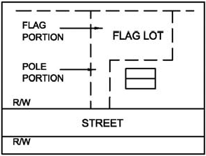
Figure 4.07.03 (C). Illustration of a flag lot
1.
A flag lot is any lot that does not front on a public street. Frontage is provided by a private driveway. See Figure 4.07.03.C for an illustration of a flag lot.
2.
Flag lots are permissible in the R-1 zoning district and shall be measured and meet the dimensional requirements set forth in Sections 4.00.02.C and Table 4.01.01.
3.
Each private driveway shall serve only one (1) flag lot.
4.
There shall be no more than two (2) abutting private driveways.
5.
The design, dimensions, and construction requirements for driveways shall comply with the Engineering Standards Manual of Fort Walton Beach.
6.
Nothing in this section shall be construed to prohibit flag lots in a planned unit development or zero lot line development.
D.
Access requirements.
1.
Each lot shall have frontage on and permanent access to an existing or proposed paved public street.
2.
A subdivision plat shall include streets as established by transportation plans in the Comprehensive Plan and plans by the Transportation Planning Organization. The arrangement, character, extent, width, grade, and location of all streets shall conform to the plans of the State, Okaloosa County, and the City, respectively, and shall be considered in their relation to existing and planned streets, to topographical conditions, and to public convenience and safety.
3.
Alleys shall be provided to serve multifamily development, commercial development, and industrial development.
4.
Private streets are prohibited.
5.
All streets shall be designed and constructed in compliance with the standards of the City set forth in the Engineering Standards Manual of Fort Walton Beach. All costs shall be paid by the subdivider.
6.
Subdivisions shall include sidewalks and bicycle paths or lanes in compliance with the standards set forth in the Engineering Standards Manual of Fort Walton Beach.
E.
Easements. All lots within a subdivision shall provide easements for stormwater drainage, water systems, sanitary sewer systems, gas lines, electric lines, cables, telephone lines, and utility poles. Standards for such utility easements are set forth in the Engineering Standards Manual of Fort Walton Beach.
F.
Site improvements.
1.
All subdivisions shall be required to have underground utility service (electrical, cable television and telephone) unless all lots within the subdivision front existing streets that currently are serviced above ground.
2.
Land shall be dedicated for parks if the subdivision plat proposes ten (10) lots or more. The amount of land to be dedicated shall equal at least five percent (5%) of the gross area of the land to be subdivided. The park shall be deeded to the City and open to the public for park purposes.
3.
Land which is determined to be unsuitable for subdivision due to flooding, bad drainage, or other features likely to be harmful to the health, safety, and general welfare of future residents, shall not be subdivided, unless adequate methods of correction are formulated by the subdivider and approved by the City.
4.
All standards for site preparation and improvement set forth in Section 4.09.00 shall be met.
5.
All applicable standards set forth in Chapter 3, Environmental and Resource Protection, shall be met.
4.07.04 - Specific Requirements for Zero Lot Line Development.
A parcel may be platted and developed as a zero lot line development, according to the standards set forth in this section.
A.
Purpose. Zero lot line development is intended to meet the following purposes:
1.
More efficient and affordable single-family development.
2.
Design of dwellings that integrates and relates internal-external living areas, resulting in more pleasant and enjoyable living facilities.
3.
Designing and using outdoor space to its maximum benefit by placing the dwelling along one (1) property line.
B.
Applicability.
1.
Zero lot line development shall be permissible in R-1 and R-2 zoning districts.
2.
Zero lot line development shall comply with the standards of the R-1 and R-2 zoning districts, except where such standards are in conflict with the standards set forth in this section. The standards in Section 4.07.04 shall supersede the standards for the applicable zoning district.
3.
Zero lot line development shall meet the subdivision standards set forth in Section 4.07.03, except where such standards are in conflict with the standards set forth in this section. Standards in Section 4.07.04 shall supersede the subdivision standards.
a.
A zero lot line development in the R-1 zoning district shall have a minimum of ten (10) lots.
b.
A zero lot line development in the R-2 zoning district shall have a minimum of three (3) lots.
4.
Nothing in this section shall be construed to permit the construction of a zero lot line structure in a platted subdivision in existence as of January 1, 1985.
C.
Site development standards.
1.
The uses permissible on a lot in a zero lot line development are limited to detached single-family dwellings on individually platted lots, including customary accessory uses according to standards for accessory uses set forth in Chapter 5.
2.
Fencing, walls, trellises, and other similar features may be used as connecting elements between single-family dwellings on adjacent lots. Garages, carports, and utility storage structures shall not be constructed or used as connecting elements.
3.
Lots shall be designed and buildings placed to meet the setback standards in Table 4.07.04. There is no minimum lot width or lot area requirement. The lot width and lot area shall be determined by the site design, meeting the lot coverage and building setback requirements.
Table 4.07.04. Site Development Standards for Zero Lot Line Development.
4.
Setbacks shall not include connecting elements. Patios, garden elements, and other similar elements are permissible within the side setback area.
5.
The total lot coverage shall not exceed fifty percent (50%) of the total lot area.
6.
The maximum building height shall not exceed thirty-five (35) feet.
7.
Access of a total of ten percent (10%) of the linear length of the total perimeter wall area of the dwelling unit, as measured in plan form, shall be provided to exterior patio and court areas. Such access shall be totally visible and physically passable.
8.
The wall of the dwelling located on the lot line shall have no windows, doors, air conditioning units, or other openings. However, atriums or courts shall be permitted on the zero-lot line side when the court or atrium is enclosed by three (3) walls of the dwelling unit and a solid wall of at least eight (8) feet in height is provided on the zero-lot line. Such wall shall be constructed of the same material as the exterior walls of the unit.
D.
Maintenance and drainage easements. A perpetual four (4)-foot wall-maintenance easement shall be provided on the lot adjacent to the zero-lot line property line, which, with the exception of walls and/or fences, shall be kept clear of structures. This easement shall be shown on the plat and incorporated into each deed transferring title to the property. The wall shall be maintained in its original color and treatment, unless otherwise agreed to in writing by the two (2) affected lot owners. Roof overhangs may penetrate the easement on the adjacent lot a maximum of twenty-four (24) inches, but the roof shall be so designed that water runoff from the dwelling placed on the lot line is limited to the easement area.
4.08.01 - Generally.
A.
Purpose. The purpose of this section is to provide requirements for landscaping, buffering of developments, and tree protection within Fort Walton Beach.
B.
Intent. It is the intent of this section to establish minimum requirements for the development, installation, and maintenance of landscaped areas without inhibiting creative landscape design and to promote the public health, safety, and general welfare. The specific intent of the City is to reduce potential adverse visual, environmental, and aesthetic effects of development in order to:
1.
Minimize the rate of stormwater runoff;
2.
Maximize the capability of groundwater recharge;
3.
Provide shade for the ground surfaces;
4.
Buffer adjacent incompatible land uses;
5.
Filter and reduce the glare of headlights and reflected sunlight from parked automobiles onto the public street rights-of-way and adjacent properties;
6.
Improve the appearance of parking areas and vehicular surface areas;
7.
Assist in energy conservation, production of oxygen, and reduction of carbon dioxide;
8.
Filter dust and pollutants;
9.
Reduce the negative impacts of noise; and
10.
Provide habitats.
C.
Specific intent for water conservation. It is further the intent of the City that creative site development concepts shall be used to promote water conservation. Water requirements may be reduced by providing for:
1.
The preservation of existing plant communities;
2.
The reestablishment of native plant communities;
3.
The use of site specific plant materials;
4.
Site development that retains stormwater runoff on site;
5.
The use of pervious paving materials;
6.
The use of water efficiency in landscaping; and
7.
Other environmentally sensitive site development concepts.
D.
Applicability. This section shall apply to all new construction; site modification of areas devoted to parking, driveways, access points, pavements, buffers, stormwater management, or open spaces, and clearing and grubbing when affecting ten (10) percent or more of the site; redevelopment; change of use; and maintenance of all property within the City except for the following situations:
1.
Single-family and two-family dwellings;
2.
Applications for accessory uses, accessory structures, or temporary uses;
3.
Plant or tree nurseries or botanical gardens;
4.
The City or its authorized agent for the purpose of removal of a tree on City-owned property or a public right-of-way that is dead or a hazard to the public;
5.
Utility companies or their authorized agents for the purpose of removal of a tree that is a substantial hazard to overhead wires or for trimming that is necessary for establishment or maintenance of service;
6.
The trimming or pruning of trees or the removal of underbrush; or
7.
The removal of trees or other landscaping damaged by fire, windstorm, lightning, or other acts of nature, which pose imminent danger to life or property.
E.
Landscaping plan required. In order to demonstrate compliance with the requirements of this section, a landscaping plan shall be submitted in compliance with the following standards:
1.
The landscaping plan shall be prepared by a licensed landscape architect; the landscape plan may be prepared by another licensed design professional when such plan is submitted as part of the site development application.
2.
The landscaping plan shall include a maintenance plan and schedule, soils analysis, and an irrigation plan.
3.
The requirements for plan contents and procedures for submittal, review, and approval of all applications are set forth in Chapter 9, Administrative Procedures.
F.
Prohibited conditions. The following conditions regarding landscaping and plant materials are prohibited:
1.
Trees, plants, shrubs, vegetation, or parts thereof, which overhang any sidewalk, street, alley or fire hydrant, and obstruct or impair the free and full use of the sidewalk, street, alley, or fire hydrant by the public.
2.
Grass, weeds, shrubs, bushes, trees, or vegetation which constitutes a fire hazard or a menace to public health, safety, or welfare.
4.08.02 - Requirements for Irrigation and Irrigation Systems.
A.
All new, preserved, or retained landscaped areas shall be divided into water use zones. The irrigation system shall be included in the landscaping plan and shall be designed to correlate to the water use zones.
1.
The high water use area shall not exceed twenty-five percent (25%) of the total landscaped area. A non-potable water source shall be used. A central, automatic water system shall be installed.
2.
The moderate water use area shall not exceed twenty-five percent (25%) of the total landscaped area. A non-potable water source shall be available within twenty-five (25) feet of the landscaped area to allow watering during periods of drought or low rainfall.
3.
The low water use area shall be comprised of drought-tolerant or Xeriscape plant materials. A non-potable water source shall be available within fifty (50) feet of the landscaped area to allow watering during periods of extreme drought.
B.
The irrigation system shall be designed to provide only the water required to sustain the plants and vegetation.
C.
New and replacement irrigation systems shall comply with the following standards:
1.
Moisture sensor and rain shut-off equipment shall be required on automatic irrigation systems. The equipment shall consist of an automatic mechanical or electronic sensing device or switch which will override the irrigation cycle of the sprinkler system when adequate rainfall has occurred.
2.
Only non-potable or reclaimed water shall be used in the irrigation system.
3.
Drip or trickle irrigation systems shall be used to deliver water directly to the root system of plants. Where drip systems are impractical due to the large area to be irrigated, micro-sprinkler systems may be approved. Only drip, trickle, or micro-sprinkler systems are permissible in new or replacement irrigation systems.
4.08.03 - Specifications for Landscape Materials and Vegetation.
A.
Minimum specifications for plant materials:
1.
All plant material shall be nursery grown, number 1 grade, meet current American Association of Nurseryman Standards, and installed according to accepted planting procedures.
2.
Shrubs shall be at least eighteen (18) inches in height at the time of installation.
3.
Shrubs shall be planted approximately thirty-six (36) inches apart, measured on center.
4.
Hedges shall be planted in double-staggered rows.
5.
Trees shall be a minimum of three (3) inches dbh (diameter at breast height) at the time of installation.
6.
Trees shall be planted to provide a minimum growing area consistent with best horticultural practices.
7.
Trees shall be properly guyed, braced, and/or staked at the time of planting to ensure established and erect growth. Nail staking or other methods that cause cosmetic or biological damage to the tree are prohibited. Trees shall be re-staked within twenty-four (24) hours in the event of failure of the guying or staking system. Stakes shall be removed when the tree is established, and not later than twelve (12) months after installation.
8.
Canopy trees shall not be installed under any overhead utility line, over any buried utilities, or within a utility easement.
9.
All landscaped areas and buffers shall be stabilized with grass (sod or seeded) or ground cover. Ground cover used in lieu of grass shall be planted so as to present a finished appearance and substantially complete coverage.
10.
Mulch or other acceptable ground cover material may be used in lieu of grass or ground cover. Mulch shall be provided in planting areas for shrubs and ornamental plants and around individual trees. Mulch shall be organic and provided to a depth of three (3) inches. The use of impervious materials as a weed barrier under mulch is prohibited. Mulch shall be maintained free of debris and replaced as needed to comply with best horticultural management practices.
11.
Landscaped areas shall be protected from vehicular or pedestrian encroachment through the use of wheel stops, curbs, raised planting areas, or other approved protection devices. Vehicles may overhang not more than one (1) foot into landscape areas.
12.
Trees, shrubs, grasses, and ground cover for landscaped and buffer areas shall be selected from lists of appropriate plants for north Florida identified by the Institute of Food and Agricultural Sciences, University of Florida.
13.
Landscaping materials qualify as native plants and drought tolerant plants when selected from the Florida-Friendly Landscaping Pattern Book: Sample plant lists and designs for four Florida regions - USDA Hardiness Zones 8A and 8B, North Florida.
B.
Prohibited plant materials include all vegetation identified on the Noxious Weed List as adopted in the Florida Statutes.
C.
Synthetic and artificial plants are prohibited outdoors.
D.
Site preparation shall be limited to the minimum area necessary for plantings and shall occur in stages based on the proposed planting schedule. Site preparation shall include erosion control measures consistent with the requirements set forth in the Engineering Standards Manual of Fort Walton Beach.
(Ord. No. 2100, § 2, 5-24-22)
4.08.04 - Requirements for Trees and Tree Protection.
A.
Preservation of protected trees.
1.
The trees listed in Table 4.08.04.A are protected in the sizes indicated.
Table 4.08.04.A. Protected Trees.
2.
Removal of any protected tree shall require a tree removal and replacement permit (local development permit). Procedures for local development permits are set forth in Chapter 9.
3.
Protected trees removed for any purpose shall be replaced on an inch-for-inch basis, measured as diameter at breast height (dbh).
4.
The applicant may elect to replace the trees at a pre-approved off-site location or pay into the Tree Mitigation Fund if it is demonstrated to the Development Administrator that the site cannot accommodate the total number of replacement trees required by this section as a result of insufficient planting area. The replacement value and payment into the Tree Mitigation Fund will be established in the Comprehensive Fee Schedule.
5.
Trees for replacement shall be native and selected from a list of trees for reforestation from the Institute of Food and Agricultural Sciences, University of Florida.
6.
The design of any required perimeter or interior landscaping or buffers shall include preservation of protected trees on the development site to the maximum extent possible.
B.
Reduction of required parking spaces for tree protection. The required number of parking spaces may be reduced when such reduction results in the preservation of a protected tree at least eight (8) inches dbh. Table 4.08.04.C provides the allowable reduction in required spaces. When the calculation results in a fraction of a parking space, the number of spaces shall be rounded up to the next whole number.
Table 4.08.04.B. Parking Reduction for Tree Protection.
C.
During development activity, preserved trees shall be protected from activities which may injure or kill them. Tree protection techniques found in the Urban Forestry Manual, Southern Group of State Foresters and USDA Forest Service, Southern Region, or equivalent techniques, shall be used.
D.
Trees shall be maintained or removed as follows: Dead, dying, damaged, or diseased trees are prohibited. The Development Administrator may make a determination that a tree is in danger of falling upon an adjacent lot or street due to death, disease, or damage, including damage caused by weather conditions, which shall be considered prima facie evidence of a violation.
4.08.05 - Landscape and Buffer Requirements.
A.
All development sites not otherwise exempt as set forth in Section 4.08.01.D shall provide a minimum of fifteen (15) percent of the site as landscaped area in compliance with the standards in this section.
B.
All properties (other than those within the CTP Zoning District) shall have a ten (10) foot-wide strip of privately owned land, located along the front and/or side property line(s) adjacent to a street right-of-way that shall be landscaped. In no case shall this strip be less than ten (10) feet wide. Width of sidewalks shall not be included within the ten (10) foot-wide perimeter landscape area. This perimeter landscape requirement shall be credited toward the percentage required for the total developable site in subsection A of this section, above.
C.
Tree Requirements:
1.
One (1) tree for each twenty-five (25) feet or portion thereof of front and/or side property line(s) adjacent to a street right-of-way shall be preserved or planted.
a.
All trees must be planted in the ten (10) foot-wide buffer along the rights-of-way.
b.
If trees are required where overhead utilities exist, understory trees will be substituted for canopy trees with two (2) understory trees equal to one (1) canopy tree.
2.
One (1) tree for each fifty (50) feet of linear perimeter that is NOT adjacent to a right-of-way shall be preserved or planted.
a.
These trees are not required to be along the perimeter and can be planted anywhere on the property
b.
Trees required per Section 4.08.06 will count against this requirement.
3.
On properties within the CTP Zoning District, the number of trees required shall be calculated as one (1) tree for each sixty-five (65) linear feet of the perimeter dimension of the site. These trees can be located anywhere on the property.
4.
Existing trees located on the proposed development site within the interior or perimeter landscaped use areas shall be eligible for credit against the total number of trees required on the site given the following:
a.
The trees shall be native and be a minimum of eight (8) inches dbh, or if included in Table 4.08.04.A, shall meet the dbh standards of the table.
b.
Trees that are dead, diseased, dying, or prohibited are not eligible for credit.
c.
One-half (½) of the area within the drip line of preserved trees, which are eligible for credit pursuant to this section, shall be maintained in either vegetative landscape material or pervious surface cover.
D.
Both canopy (shade) and under-story trees shall be provided. A minimum of fifty (50) percent of the trees shall be canopy trees unless exempted under subsection C.1 above.
E.
Where nonresidential development abuts on the side or rear property line land zoned for residential purposes, the following standards apply:
1.
A landscaped buffer shall be provided on land zoned CTP adjacent to land zoned for residential purposes. The buffer shall be a minimum of ten (10) feet in width and shall include under-story trees, a hedge, and a fence or wall. The fence or wall shall be six (6) feet in height and shall comply with the standards set forth in Section 5.01.08. The buffer strip and plantings shall be counted toward meeting the landscaping requirement for the site.
2.
A landscaped buffer shall be provided on land zoned CG, MB, MX-1, or MX-2 adjacent to land zoned for residential purposes. The buffer shall be a minimum of five (5) feet in width.
3.
Access ways, sidewalks, and pedestrian paths may cross buffer areas.
F.
Where industrial uses are located within the MB zoning district, a landscaped buffer shall be provided in compliance with the following standards:
1.
The buffer shall be provided on the perimeter of the property on which industrial uses are located.
2.
The buffer shall be a minimum of ten (10) feet in width and shall include under-story trees and a hedge, fence, or wall. The fence of wall shall be six (6) feet in height and shall comply with the standards set forth in Section 5.01.08. The buffer strip and plantings shall be counted toward meeting the landscaping requirement for the site.
G.
Utility and service equipment shall be buffered by a continuous hedge. An access across the buffer, not to exceed five (5) feet in width, may be provided.
H.
Planters may be used in landscaped areas provided that such plants are integrated into the design of the site, provide adequate depth and area consistent with best horticultural practices, and are maintained free of debris and litter.
I.
Where property abuts a water body, watercourse, wetland, or shoreline, the natural shoreline vegetation shall be retained. Where no shoreline vegetation exists, a vegetated buffer shall be provided.
(Ord. No. 1942, § 2, 4-26-16; Ord. No. 2100, § 2, 5-24-22)
4.08.06 - Landscaping Requirements for Vehicle Use Areas.
A.
All new or redeveloped off-street parking lots with ten (10) or more required parking spaces, including access drives, service drives, and loading areas, shall be landscaped as set forth in this section.
B.
Perimeter landscaping.
1.
A landscaped area not less than five (5) feet in width shall be located around the perimeter of the parking lot.
2.
Where the parking lot abuts a side or rear property line, and a buffer is required, the buffer shall satisfy the requirements for perimeter landscaping of the parking lot.
3.
A vehicular or pedestrian access way may be provided through the required perimeter landscaping.
4.
Perimeter landscaping of parking lots shall include canopy trees consistent with best horticultural practices.
C.
Interior landscaping.
1.
Parking lots with more than twenty-five (25) parking spaces shall be required to provide interior landscaping.
a.
On lands zoned CTP, interior landscape planting areas shall not be required where parking spaces abut warehouse building space/doors.
2.
Interior planting areas shall be provided as tree islands, terminal islands, or medians.
3.
Canopy trees should be included in the interior planting areas consistent with best horticultural practices.
4.
There shall be not more than ten (10) contiguous parking spaces (twenty [20] in a double parking row) between interior planting areas.
5.
Interior planting areas shall be located and designed to accommodate stormwater runoff.
6.
Where existing trees are preserved within the vehicular use area, tree wells, tree islands, or other protection shall be provided to protect the trunk and root system from damage. A drainage system shall be provided within the area defined by the drip line of the tree(s).
(Ord. No. 1941, § 2, 4-7-16)
4.08.07 - Requirements for Street Trees.
A.
Street trees are trees located on land lying between property lines on either side of all streets, avenues, and rights-of-way within the City.
B.
The City shall have the right to plant, prune, maintain, and remove street trees as well as plants and shrubs within the public right-of-way.
4.08.08 - Maintenance Requirements.
A.
All landscaped areas shall be maintained to ensure that plant materials are healthy and thriving, and present an orderly appearance, clear of weeds, refuse, and debris. Structural elements relating to nonliving landscape material shall be maintained in good condition at all times. Any diseased or dead plant materials shall be replaced as soon as reasonably possible based on the growing season, but not later than six (6) months following identification of the need for replacement. Upon inspection, the City may provide notice regarding corrective action to replace plant materials or other elements of the landscaped area. (See Chapter 9 regarding code enforcement procedures.)
B.
A watering plan shall be provided and implemented to ensure that plants are established in a healthy growing condition. Standards for irrigation are set forth in Section 4.08.02.
C.
Necessary trimming and maintenance shall be performed to maintain the health of the plant materials, to provide an aesthetically pleasing appearance, and to assure that the landscaped and buffer areas serve the intended purpose.
D.
No required landscaped area shall be used for stormwater retention, sidewalks, recreation facilities, parking, storage, dumpsters, or other structures, except as specifically permissible according to the standards set forth in this LDC.
4.09.01 - Site Lighting.
Site lighting is not required. However, where site lighting is proposed, a lighting plan shall be provided to demonstrate compliance with the following standards:
A.
Lighting shall be designed to shine downward and not skyward.
B.
Lighting shall be shielded to avoid glare and direct illumination of adjacent properties.
C.
Only full-cut off lighting fixtures shall be permitted.
4.10.01 - Purpose and intent.
The regulations in this section are intended to encourage workforce housing opportunities within the City through the implementation of the goals, objectives, and policies of the City of Fort Walton Beach Comprehensive Plan Housing Element.
(Ord. No. 2099, § 2, 4-26-22)
4.10.02 - Definitions.
In addition to the definitions in Section 1.08.02 of this LDC, words defined in this Section have the meaning provided when used in this LDC.
Affordable owner occupied housing unit: A dwelling unit for which the mortgage payment does not exceed thirty (30) percent of the gross income of the household.
Affordable renter occupied housing unit: A dwelling unit for which the rental payment does not exceed thirty (30) percent of the gross income of the household.
Area median income (AMI): The median family income for the Fort Walton Beach Metropolitan Statistical Area, as published by the US Bureau of the Census and the US Department of Housing and Urban Development, unless otherwise specified.
Low Income: A household with an income up to eighty (80) percent of the area median income.
Market-rate unit: A dwelling unit in a residential development that is not a workforce housing unit.
Moderate Income: A household with an income up to one hundred and twenty (120) percent of the area median income.
Very low Income: A household with an income up to fifty (50) percent of the area median income.
Workforce housing unit: Housing unit built for very low, low, and moderate income households.
(Ord. No. 2099, § 2, 4-26-22)
4.10.03 - Eligibility.
A.
Eligible projects shall include:
1.
Rehabilitation to address HUD or building code violations in units that will be provided as workforce housing.
2.
Construction of new single-family workforce housing units.
3.
Construction of new multi-family workforce housing units.
(Ord. No. 2099, § 2, 4-26-22)
4.10.04 - Requirements for Workforce Housing.
A.
Applicants shall demonstrate desire for participation in the workforce housing program by submitting a completed application at the time the development application is submitted to the City.
B.
Applicants shall submit a workforce housing plan which must include the following:
1.
A site plan that identifies the number, structure type, location, and size of the proposed workforce housing units and market rate units;
2.
The income levels to which the workforce housing units will be restricted;
3.
The mechanisms that will be used to assure that the units remain available to workforce housing income groups;
4.
Any other information as may be deemed necessary to demonstrate compliance with this section.
C.
The development shall have thirty (30) percent or more of the dwelling units available to households defined as workforce, consistent with annually adjusted Department of Housing and Urban Development income guidelines.
D.
There shall be adequate assurances (e.g., deed restrictions or restrictive covenants) that the housing units will remain workforce housing units over a period of fifteen (15) years.
(Ord. No. 2099, § 2, 4-26-22)
4.10.05 - Incentives for Workforce Housing.
A.
The following incentives shall be available to qualified workforce housing development:
1.
Density Bonus: Any development providing workforce housing pursuant to this section shall be entitled to additional density beyond the maximum base standards that are otherwise provided in the established zoning district in which the development is located. Table 4.10.05 contains the maximum allowable dwelling units per acre (du/ac).
Table 4.10.05. Density Bonus
2.
Parking Reduction: The required number of parking spaces may be reduced for any development providing workforce housing units pursuant to this section. Parking space requirements may be reduced up to ten (10) percent of the total requirement, not to exceed a total reduction of ten (10) spaces.
3.
Accelerated Review: The developer of a workforce housing development shall be eligible for accelerated development review. The developer shall inform the Growth Management Department prior to development review submittal that the development will include workforce housing. Accelerated reviews shall take priority and be reviewed prior to other development applications.
(Ord. No. 2099, § 2, 4-26-22; Ord. No. 2149, § 2, 3-11-25)
4.10.06 - Workforce Housing Incentive Fund.
A.
Authorization for Use of Workforce Housing Incentive Funds: Any workforce housing development meeting the criteria in this section may qualify for funding from the Workforce Housing Incentive Fund. Requests to utilize this Fund shall be brought to City Council for consideration and approval.
B.
Funding requests to utilize the Workforce Housing Incentive Fund shall be evaluated on a first come, first-serve basis and until the Fund is depleted. City Council has the sole authority to replenish the Fund.
C.
The City Council may grant such incentives through approval of a development agreement pursuant to Section 9.08.00, so long as the Council finds the following:
1.
The application of the incentive is consistent with the goals and objectives of the City of Fort Walton Beach Comprehensive Plan; and,
2.
The provision of the incentive furthers the intent of this section.
(Ord. No. 2099, § 2, 4-26-22)
CHAPTER 4
TABLE OF HISTORICAL NOTES AND REFERENCES