
Franklin County Unincorporated
City Zoning Code
City Zoning Code
CHAPTER 17
76 - AIRPORT ZONING2
Editor's note— Ord. No. 6-2013, adopted Aug. 21, 2013, amended Chapter 17.76 in its entirety in effect repealing and reenacting a new Chapter 17.76, as set out herein. Former Chapter 17.76, §§ 17.76.010—17.76.080, pertained to similar subject matter, and derived from Ord. No. 7-2005, §§ 38.1.0—38.8.0, adopted in 2005.
17.76.010 - Purpose.
The purpose of the airport overlay district is to protect the viability of the Tri-Cities Airport as a significant resource to the community by encouraging compatible land uses, densities and reducing hazards that may endanger the lives and property of the public and aviation users.
(Ord. No. 6-2013, 8-21-2013)
17.76.020 - Airport overlay district.
There is hereby created an airport overlay district as identified in the map made a part hereof and labeled, Tri-Cities Airport Future Part 77 Zones Map, and the Airport Safety Compatibility Zones Map, as established by the current Tri-Cities Airport Master Plan. All lands lying within the zones therein shown are subjected to the building and use restrictions within this chapter. This chapter shall be used in addition to and in combination with all other district and development regulations contained in this title. The airport shall be responsible for providing updated maps to the county, coincident with ten (10) year updates to the airport master plan. The airport overlay district classification identifies a series of imaginary surfaces and safety zones within the airport influence area that has historically been prone to hazards associated with aircraft and airports. This chapter is based on aircraft accident data from the National Transportation Safety Board (NTSB) and the Federal Aviation Regulations (FAR) Part 77 Imaginary Surfaces and the "Airports and Compatibility Land Use Guidebook" produced by the Washington State Department of Transportation Aviation Division. As the name implies, this classification is laid over the existing Franklin County zoning districts to ensure densities and land use requirements of the underlying zoning districts are consistent with the NTSB standards and provide for maximum protection to the public, health, safety and general welfare of the community and for those citizens working and residing within the airport influence area.
(Ord. No. 6-2013, 8-21-2013)
17.76.030 - Authority.
The legislature of the state of Washington through RCW 14.12 the "Airport Zoning Act" has given authority to local governments to adopt regulations within its jurisdiction to promote the public health, safety, and general welfare of its citizenry regarding airport hazards. RCW 36.70.547 requires every county, city, and town in which there is located an airport to discourage the siting of incompatible uses adjacent to such aviation airport.
(Ord. No. 6-2013, 8-21-2013)
17.76.040 - Applicability.
The provisions of this chapter shall apply to all lands, buildings, structures, natural features or uses located within those areas that are defined by the airport overlay district and designated on the Tri-Cities Airport Part 77 Surfaces map which identifies areas of height limitations and the Airport Safety Compatibility Zones (ASCZ) map.
(Ord. No. 6-2013, 8-21-2013)
17.76.050 - Definitions.
The following terms shall have the meanings indicated, specific to this chapter only:
"Airport" shall mean the Tri-Cities Airport.
"Airport elevation" shall mean the highest point of an airport's useable landing area measured in feet from sea level. The Tri-Cities Airport is four hundred ten (410) feet above mean sea level.
"Approach surface" shall mean an imaginary surface longitudinally centered on the extended runway centerline, extending outward and upward from the end of the primary surface and at the same slope as the approach zone height limitation slope set forth in Section 17.76.060. The perimeter of the approach surface coincides with the perimeter of the approach zone.
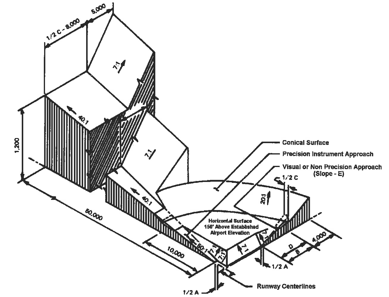
"Conical surface" shall mean an imaginary surface extending outward and upward from the periphery of the horizontal surface at a slope of twenty (20) to one for a horizontal distance of four thousand (4,000) feet.
"Deed notice" shall mean a formal statement provided in Section 17.76.110 as a note on the face of a short plat, major subdivision or binding site plan recorded against the property notifying potential property owners that the property is located adjacent to an active airport and said property may be impacted by aircraft noise, odors, vibration, and low flying aircraft.
"FAA Form 7460-1, Notice of Proposed Construction or Alteration" shall mean a form which the Federal Aviation Administration requires to be completed by anyone who is proposing to construct or alter an object that could affect airspace and allows the FAA to conduct an airspace analysis to determine whether the object will adversely affect airspace or navigational aids. More information regarding this requirement can be found on the FAA website.
"FAR Part 77" shall mean the Part of 49 CFR of the Federal Aviation Regulations that deals with objects affecting navigable airspace.
"FAR Part 77 Surfaces" shall mean imaginary airspace surfaces established with relation to each runway of an airport. There are five types of surfaces: (1) primary; (2) approach; (3) transitional; (4) horizontal; and (5) conical.
"Hazard to air navigation" shall mean an obstruction determined to have a substantial adverse effect on the safe and efficient utilization of the navigable airspace.
"Height" shall mean for the purpose of determining the height limits in all zones and as shown on the Tri-Cities Airport Future Part 77 Zones map, this datum shall be height above mean sea level elevation unless otherwise specified.
"Horizontal surface" shall mean a horizontal plane one hundred fifty (150) feet above the established airport elevation, the perimeter of which plane coincides with the inner perimeter of the conical surface. This is five hundred sixty (560) feet above mean sea level for the Tri-Cities Airport.
"Infill" shall mean a development designed to occupy scattered vacant parcels of land which remain after the majority of development has occurred in an area.
"Obstruction" shall mean any object of natural growth, terrain, of permanent or temporary construction or alteration, including equipment or materials used therein which exceeds a limiting height set forth in Section 17.76.070.
"Precision approach" shall mean a landing approach made without visual reference to the ground by the use of aircraft instruments and ground-based electronic or communications systems or devices. An aircraft making such an approach should be flying in accordance with an IFR (instrument flight rules) flight plan.
"Primary surface" shall mean a surface longitudinally centered on a runway with a width of one thousand (1,000) feet for instrument approaches and five hundred (500) feet for visual approaches. When the runway has a specially prepared hard surface, the primary surface extends two hundred (200) feet beyond each end of the runway. The elevation of any point on the primary surface is the same as the elevation of the nearest point on the runway centerline. The elevation of the primary surface at the Tri-Cities Airport is four hundred ten (410) feet above mean sea level.
"Runway" shall mean a defined area on an airport prepared for landing and take-off of aircraft along its length.
"Transitional surfaces" shall mean these imaginary surfaces extend outward at ninety-degree angles to the runway centerline, and runway centerline extended, at a slope of seven (7) feet horizontally for each foot vertically (7:1) from the sides of the primary and approach surfaces to where they intersect with the horizontal and conical surfaces.
"Tree" shall mean any object of natural growth.
"Visual runway" shall mean a runway intended solely for the operation of aircraft using visual approach procedures, with no straight-in instrument approach procedure and no instrument designation indicated on an FAA-approved airport layout plan.
(Ord. No. 6-2013, 8-21-2013)
17.76.060 - Height limitation zones.
The height limitation zones are hereby established, consistent with the FAR Part 77 Surfaces—Objects Affecting Navigable Airspace, and are described below.
A.
Precision Instrument Approach Zone. Includes Runways 3L, 21R, 30. A precision instrument approach zone is established at each end of a precision instrument runway for instrument landings and takeoffs. The precision instrument approach zones shall have a width of one thousand (1,000) feet at a distance of two hundred (200) feet beyond each end of the runway, coinciding with the primary surface widening thereafter uniformly to a width of sixteen thousand (16,000) feet at a distance of fifty thousand two hundred (50,200) feet beyond each end of the runway, its centerline being the continuation of the centerline of the runway.
B.
Nonprecision Instrument Approach Zone. Includes Runway 12. A nonprecision instrument approach zone is established at each end of a nonprecision instrument runway for improved landings and takeoffs. The nonprecision instrument approach zones shall have a width of five hundred (500) feet at a distance of two hundred (200) feet beyond each end of the runway, thereafter widening uniformly to a width of three thousand five hundred (3,500) feet at a distance of ten thousand two-hundred (10,200) feet beyond each end of the runway, its centerline being the continuation of the centerline of the runway.
C.
Visual Approach Zone. Includes Runways 3R and 21L. A visual approach zone is established at each end of all visual runways for landings and takeoffs. The visual approach zones shall have a width of five hundred (500) feet at a distance of two hundred (200) feet beyond each end of the runway, widening thereafter uniformly to a width of one thousand five hundred (1,500) feet at a distance of five thousand two hundred (5,200) feet beyond each end of the runway, its centerline being the continuation of the centerline of the runway.
D.
Transition Zones. Transition zones are hereby established adjacent to each instrument and noninstrument runway and approach zone as indicated on the Tri-Cities Airport Future Part 77 Zones map. Transition zones symmetrically located on either side of runways have variable widths as shown on the map. Transition zones extend outward from a line two hundred fifty (250) feet on either side of the centerline of the non instrument runway, for the length of such runway plus two hundred (200) feet on each end; and five hundred (500) feet on either side of the centerline of the instrument runway, for the length of such runway plus two hundred (200) feet on each end, beginning at and are parallel and level with such runway centerlines. The transition zones along such runways slope upward and outward one foot vertically for each seven feet horizontally to the point where they intersect the surface of the horizontal zone. Further, transition zones are established adjacent to both instrument and non-instrument approach zones for the entire length of the approach zones. These transition zones have variable widths, as shown on the Tri-Cities Airport Future Part 77 Zones map. Such transition zones flare symmetrically with either side of the runway approach zones from the base of such zones and slope upward and outward at the rate of one foot vertically for each seven feet horizontally to the points where they intersect the horizontal and conical surfaces . Additionally, transition zones are established adjacent to the instrument approach zone where it projects through and beyond the limits of the conical zone, extending a distance of five thousand (5,000) feet measured horizontally from the edge of the instrument approach zones at right angles to the continuation of the centerline of the runway.
E.
Horizontal Zone. A horizontal zone is hereby established as the area within a horizontal plane one hundred fifty (150) feet above the established airport elevation or at a height of five hundred sixty (560) feet above mean sea level, the perimeter of which is constructed by swinging arcs of ten thousand (10,000) feet radii from the center of each end of the primary surface of each runway of the airport and connecting the adjacent arcs by lines tangent to those arcs. The horizontal zone does not include the instrument and non-instrument approach zones and the transition zones.
F.
Conical Zone. A conical zone is hereby established as the area that commences at the periphery of the horizontal zone and extends outward therefrom a distance of four thousand (4,000) feet. The conical zone does not include the instrument approach zones and transition zones.
(Ord. No. 6-2013, 8-21-2013)
17.76.070 - Height limitations.
No building, pipe, chimney, tower, steeple, stand, platform, pole, wire or structure or erection or object of natural growth, or obstruction of any kind or nature whatsoever, shall be built, placed, hung, or permitted to grow or allowed to be built, placed or hung which shall at any point or part thereof exceed the heights as provided in the zones established herein. Where an area is covered by more than one height limitation, the more restrictive limitations shall prevail. The restrictions shall apply to the area surrounding all runways and approaches situated thereon. The owner of any existing nonconforming building, structure, or tree shall be required to permit the installation, operation, and maintenance thereon of any markers and lights as deemed necessary by the airport sponsor or the FAA to indicate to operators of aircraft in the vicinity of the airport the presence of such airport obstruction. Such height limitations are hereby established for each zone as follows:
A.
Precision Instrument Approach Zone. Beginning at the end of and at the same elevations as the primary surface, slopes one foot in height for each fifty (50) feet (50:1) in horizontal distance and extending to a distance of ten thousand two hundred (10,200) feet from the end of the runway; thence one foot in height for each forty (40) feet in horizontal distance to a point fifty thousand two hundred (50,200) feet from the end of the runway;
B.
Nonprecision Instrument Approach Zone. Beginning at the end of and at the same elevations as the Primary Surface, slopes one foot in height for each thirty-four feet (34:1) in horizontal distance and extending to a distance of ten thousand two hundred feet (10,200) from the end of the runway;
C.
Visual Approach Zones. Beginning at the end of and at the same elevation as the Primary Surface, slopes one foot in height for each twenty feet (20:1) in horizontal distance and extending to a point five thousand two hundred (5,200) feet from the end of the runway;
D.
Transition Zones. Slopes outward one foot in height for each seven feet (7:1) in horizontal distance beginning at the primary surface, extending to a height of one hundred fifty (150) feet above the airport elevation which is four hundred ten (410) feet above mean sea level. In addition to the foregoing, there are established height limits of one foot vertical height for each seven feet horizontal (7:1) distance measured from the edges of all approach zones for the entire length of the approach zones and extending upward and outward to the points where they intersect the horizontal or conical surfaces. Further, where the instrument approach zone projects through and beyond the conical zone, a height limit of one foot for each seven feet of horizontal distance shall be maintained beginning at the edge of the instrument approach zone and extending a distance of five thousand (5,000) feet from the edge of the instrument approach zone measured normal to the centerline of the runway extended;
E.
Horizontal Zone. One hundred fifty (150) feet above the airport elevation or a height of five hundred sixty (560) feet above mean sea level;
F.
Conical Zone. Slopes outward one foot in height for each twenty (20) feet (20:1) of horizontal distance beginning at the periphery of the horizontal zone, extending four thousand (4,000) feet to a height of three hundred fifty (350) feet above the airport elevation or a height of seven hundred sixty (760) feet above mean sea level .
(Ord. No. 6-2013, 8-21-2013)
17.76.080 - Use restrictions.
A.
General Requirements. Notwithstanding any other provisions of this chapter, no use may be made of land or water within any zone established by this chapter in such a manner as to create electrical interference with navigational signals or radio communication between the airport and aircraft, make it difficult for flyers to distinguish between airport lights and others, result in glare in the eyes of flyers using the airport, impair visibility in the vicinity of the airport, create bird strike hazards or otherwise in any way endanger or interfere with the landing, taking off, or maneuvering of aircraft.
B.
Lighting. No new or expanded industrial, commercial, recreational or residential use shall project lighting directly onto an existing runway, taxiway, or approach/departure surface except where necessary for safe air travel. Lighting for these uses shall incorporate shielding to reflect light away from the airport and shall not imitate airport lighting.
C.
Communications Facilities. Approval of cellular and other communications or transmission towers located within any zone described within Section 17.76.060 shall be conditioned to require their removal within ninety (90) days of discontinuance of use.
(Ord. No. 6-2013, 8-21-2013)
17.76.090 - Airport safety compatibility zones.
Zones described below are shown in the Airport Safety Compatibility Zones (ASCZ) map with the prohibited land uses listed below in order to promote the general safety and general welfare of properties surrounding the airport and the continued viability of the airport.
Zone 1—Runway Protection Zone (RPZ). Only airport uses and activities are allowed within the RPZ.
Zone 2—Inner Approach/Departure Zone. Prohibited land uses within this zone are places of public assembly such as churches, schools (K-12), colleges, hospitals; high density office, retail or service buildings; shopping centers and other uses with similar concentrations of persons. Residential is permitted on legal lots of record and on new lots provided the density is not greater than four dwelling units per twenty (20) acres. Clustering of residential lots to preserve open space adjacent to approach corridors and new runway end is preferred. South of I-182, infill residential is allowed provided the density is similar to the existing residential development in the area. North of I-182, infill residential is allowed provided the land is zoned rural residential and the density is similar to the existing residential development in the area. All new lots and infill residential development must include the disclosure statement in Section 17.76.110 on plats, short plats and binding site plans.
Production of asphalt paving and roofing materials or rock crushing are also prohibited. Fuel storage facilities or the storage or use of significant amounts of materials which are explosive, flammable, toxic, corrosive, or otherwise exhibit hazardous characteristics shall not be located within the inner approach/departure zone. Hazardous wildlife attractants including waste disposal operations, water management and storm water facilities with above-ground water storage, and man-made wetlands shall not be allowed within the inner approach/departure zone.
Zone 3—Inner Turning Zone. Prohibited land uses within this zone are schools (K—12) and hospitals. New residential development is prohibited unless it is infill residential similar in density to the existing residential development. All new infill residential development must include the disclosure statement in Section 17.76.110 on plats, short plats and binding site plans.
Zone 4—Outer Approach/Departure Zone. Prohibited land uses within this zone are places of public assembly such as churches, schools (K—12), hospitals, shopping centers and other uses with similar concentrations of persons. Residential is permitted on legal lots of record and on new lots provided the density is not greater than four dwelling units per twenty (20) acres. Clustering of residential lots to preserve open space adjacent to approach corridors and new runway end is preferred. South of I-182, infill residential is allowed provided the density is similar to the existing residential development in the area. North of I-182, infill residential is allowed provided the land is zoned rural residential and the density is similar to the existing residential development in the area. All new lots and infill residential development must include the disclosure statement in Section 17.76.110 on plats, short plats and binding site plans.
Zone 5—Sideline Zone. Prohibited land uses within this zone are residences, except residences that are constructed to replace existing residences, of like size and type, damaged by fire and other causes, places of public assembly such as churches, schools, hospitals, shopping centers and other uses with similar concentrations of persons. Mining, including sand and gravel pits are prohibited in the sideline zone.
Zone 6—Traffic Pattern Zone. Prohibited land uses within this zone are new schools (K-12), hospitals and other uses with similar concentrations of persons. Replacement or expansion of existing schools is permitted. All new residential developments must include the disclosure statement in Section 17.76.110 on plats, short plats and binding site plans.
(Ord. No. 6-2013, 8-21-2013)
17.76.100 - General review procedures.
No use, building, structure, or development activity shall be permitted, established, altered or relocated by any person except as otherwise authorized by this chapter. All permit applications within the airport overlay district shall, in addition to being reviewed through the standard development review process, be subject to the following:
A.
All developments, permits or plats with proposed buildings and/or structures found to be within twenty (20) feet of any of the height limitations described in Section 17.76.070 and/or all buildings and structures over two hundred (200) feet in height must submit a site plan, building elevations and an FAA Form 7460-1 to the Port of Pasco Administrative Office for Port and FAA review and approval. Upon review, further documentation shall be required, if more accurate data is necessary for a determination of impact including detailed surveys by a licensed land surveyor.
B.
All developments, permits or plats falling within the ASCZs described in Section 17.76.090 associated with special use permits, variances or existing nonconforming uses must also submit a site plan to the Port of Pasco Administrative Office for Port review.
(Ord. No. 6-2013, 8-21-2013)
17.76.110 - Disclosure.
To all extents possible, property owners and potential property buyers should be made aware of the following disclosure. The disclosure statement shall be listed on all approved subdivision plats, short plats, binding site plans and deeds within any of the identified zones in Sections 17.76.060 or 17.76.090.
"Properties near the Tri-Cities Airport may be subject to varying noise levels and vibration. Properties near the airport may be located within height and use restriction zones as described and illustrated by Federal standards and regulations and the Franklin County Zoning and Development Regulations. There is the potential that standard flight patterns will result in aircraft passing over the properties at low altitudes and during all hours of the day. Future airport expansion including a potential 1850' foot runway extension to the northwest may impact the size and number of aircraft that utilize the airport. Generally it is not practical to redirect or severely limit airport usage and/or planned airport expansion. Developments near the airport should assume that at any given time there will be some impact from air traffic."
(Ord. No. 6-2013, 8-21-2013)