
Galveston City Zoning Code
ARTICLE 10
- ZONING AND OVERLAY DISTRICT STANDARDS
Division 10.200 - Neighborhood Conservation Districts
Galveston is home to many unique and distinctive residential neighborhoods that contribute significantly to the overall character and identity of the City. These neighborhoods are worthy of preservation and protection but may lack sufficient historical, architectural, or cultural significance to be regulated as historic districts. Designation as a Neighborhood Conservation District (NCD) offers neighborhood control and input and shall follow the procedures in this Division and the procedures for a rezoning as provided in Division 13.600, Map Amendments. Following approval by City Council, NCDs will be subject to a neighborhood-specific plan and neighborhood design standards in addition to any standards contained in this Division.
(Ord. No. 18-037, § 2, 6-21-18)
SEC. 10.101 - PURPOSE
Galveston is known nationwide for its historic architecture, cultural and historical traditions, and for the preservation of its historical, cultural, and architectural resources. Galveston's unique character has proven increasingly attractive to residents, business interests, and visitors to the City, positively affecting the community.
SEC. 10.102 - HISTORIC DESIGNATIONS
Properties may be designated individually as a Galveston Landmark (GL) or collectively as a Historic Overlay District (HOD). Following designation as a GL or a HOD, affected property owners shall comply with the requirements of this Division, other ordinances of the City, and the City of Galveston Design Standards for Historic Properties (Historic Design Standards), which are maintained by the Historic Preservation Officer.
A.
Galveston Landmarks. This designation may be applied to a structure, object, site, or building that is at least 50 years old and is deemed to have historic significance in accordance with the criteria in Section 10.104.A, below.
B.
Historic Overlay District. This designation establishes a historic district encompassing historic, contributing and non-contributing structures. Areas within a HOD retain their underlying zoning designation for land use and the overlay requires conformance to the Historic Design Standards.
SEC. 10.103 - PROHIBITED ACTIONS
All properties designated GL under this Division and properties located within a HOD are subject to the requirements of this Article and the Historic Design Standards.
SEC. 10.104 - CRITERIA FOR HISTORIC DESIGNATION
In evaluating proposed designations under this Division, the Landmark Commission shall consider the criteria provided in this Section.
A.
Criteria for Galveston Landmarks. In determining if a GL designation should be made, the Commission shall consider the following elements, one or more of which may be found sufficient for designation:
1.
Character, interest, or value as part of the development, heritage, or cultural characteristics of the City, Galveston County, the State of Texas, or the United States;
2.
Recognition as a recorded Texas Historic Landmark, National Historic Landmark, or entry in the National Register of Historic Places;
3.
Association with events that have made significant contributions to the broad patterns of local, regional, state, or national history;
4.
Association with the lives of people significant in the City, region, state, or national past;
5.
Distinctive characteristics of a period or method of construction, or architecture, representative of, or a rare survivor of, the work of a master designer, builder, or craftsmen;
6.
Retention of elements that have yielded, or may be likely to yield, important information about local, regional, state, or national prehistory or history;
7.
Retention of interim physical alterations that themselves form an important part of the building's history;
8.
Representative of an established and familiar visual feature of a neighborhood, community, or city;
9.
Retention of historic integrity, meaning that the property possesses several, and usually most of the following aspects of integrity:
a.
Location;
b.
Design;
c.
Setting;
d.
Materials;
e.
Workmanship;
f.
Feeling; or
g.
Association.
10.
Likelihood of the continuation of a building's historical use or its potential adaptation for new uses without the need for major intervention that could seriously damage its historic character and integrity;
11.
Likelihood of preserving a building or structure with significant architectural value or is the surviving structure most importantly associated with a historic person or event even though the building or structure is no longer in its original location;
12.
Opportunity to preserve a reconstructed building that was accurately executed in a suitable environment and presented in a dignified manner as part of a restoration master plan and when no other building or structure with the same association has survived;
13.
Opportunity to preserve a property that is primarily commemorative in intent but reflects an age, design, tradition, or symbolic value that has invested it with its own historical significance; or
14.
Opportunity to preserve a property that is of exceptional importance although this significance was achieved within the last 50 years.
B.
Criteria for Historic Overlay Districts. In determining if a historic overlay district should be established or amended, the Commission shall consider:
1.
The same criteria as provided for GL in subsection 10.104.A, above, applied to the proposed area;
2.
The definition of and considerations for a HOD in the Historic Design Standards; and
3.
The criteria and considerations for proposed zoning map amendments provided in Division 13.600, Map Amendments.
SEC. 10.105 - DESIGNATION PROCEDURES
The designations under this Division for GLs and HODs are through common procedures as outlined in Table 10.105, Designation Procedures, along with certain variations unique to each type of designation.
(Ord. No. 18-037, § 2, 6-21-18; Ord. No. 19-043, § 2, 8-22-19)
SEC. 10.106 - CERTIFICATE OF APPROPRIATENESS
A.
When Required.
1.
Galveston Landmarks. A person shall not alter, change, relocate, or demolish a GL without first obtaining a certificate of appropriateness from the Landmark Commission in accordance with this Section and the regulations contained in all applicable ordinances or by obtaining administrative approval from the Officer for eligible activities as provided in Section 10.104.A, Criteria for Galveston Landmarks.
2.
Historic Overlay Districts: A person shall not build, reconstruct, alter, change, relocate, or demolish a structure or building in a HOD without first obtaining a certificate of appropriateness from the Commission in accordance with this Section and the regulations contained in all applicable ordinances or by obtaining administrative approval from the Officer for eligible activities as provided in Section 10.104.A, Criteria for Galveston Landmarks.
3.
Exception: A certificate of appropriateness shall not be required for ordinary repair or maintenance of any exterior architectural feature of a Galveston Landmark provided such repair or maintenance does not involve a change in design, material, or outward appearance. In-kind replacement or repair shall be considered ordinary repair or maintenance.
B.
Application. The Officer shall provide application forms for a Certificate of Appropriateness. The applicant shall submit a complete application including all applicable documents and fees to the Officer.
C.
Review of Application. The Officer shall review the submitted application and all documents and determine if additional information is required. Upon receiving all information necessary to constitute a completed application in accordance with Section 13.304, Application Completeness Review, the Officer shall handle the application administratively, if allowed, or forward the application to the Commission for consideration at its next regularly scheduled meeting, unless a special meeting is called.
D.
Administrative Review by Historic Preservation Officer. The Officer may act on applications that are eligible for administrative approval and shall approve an application only after finding that the proposed activity is in compliance with the Historic Design Standards. The Officer, at his sole discretion, may refer any application eligible for administrative approval to the Commission for review and decision.
E.
Review by Landmark Commission. The Commission shall conduct a public hearing and consider an application it is required or requested to hear following receipt of a complete application by the Officer and after the Officer provides the Commission any review comments or questions. Applicants may appear before the Commission in person or by agent and shall furnish the Officer all plans, specifications, drawings, renderings, and designs necessary for the Commission to render a final decision.
F.
Decision by Landmark Commission. The Commission shall, in an open meeting, approve, approve with conditions or deny the certificate of appropriateness. If the Commission denies an application, the Commission shall state the reasons for the denial.
1.
Consistency with Historic Design Standards for Approval: To approve an application, the Commission must find that the proposed activity is in compliance with the Historic Design Standards.
2.
Approval with Conditions: The Commission may impose conditions of approval that are necessary to meet the intent of the Historic Design Standards.
3.
Required Denial: The Commission shall deny the application if it finds that the proposed work will have an adverse effect on:
a.
The external architectural features of the GL;
b.
The external architectural features of the properties in the block or in the historic overlay district as a whole; or
c.
The future preservation, maintenance or use of the GL or of the properties within the HOD.
SEC. 10.107 - DEMOLITION
A person shall not demolish or cause the demolition of a GL or a structure of any size or kind located within a HOD without securing approval as required by this Section. Review and permitting is an important element of achieving the goals of the City of Galveston 2011 Comprehensive Plan, but the demolition review and permitting process shall not be used to block demolition of structures without historic significance.
This Section does not affect the authority of the City to regulate, repair, demolish, or require corrective action to substandard buildings and dangerous structures. The Landmark Commission shall not deny a request for demolition of a structure that the City has determined to be structurally deficient.
A.
Applicability. The provisions in this Section apply to any structure designated as a GL or any structure in a HOD. They do not apply to properties in Neighborhood Conservation Districts (NCDs).
B.
Application for a Certificate of Appropriateness to Demolish a Historic or Contributing Structure. A property owner seeking demolition of a structure designated as a GL or of a structure in a HOD that the Officer determines is a contributing property shall submit to the Officer an application for a certificate of appropriateness requesting approval for demolition of the structure. The application shall include but may not be limited to all of the following:
1.
Signatures of All Property Owners. The application must be signed by all owners of the property.
2.
Affidavits. One or more affidavits in which:
a.
The applicant swears or affirms that all information submitted in the application is true and correct; and
b.
The owner(s) swears or affirms that they are the owner(s) of the subject property and that there are no other owner(s) of the property.
3.
Statement of Reasons. A statement of the reasons that the demolition is being sought and documentation in support of each reason cited.
4.
Burden of Proof. The applicant has the burden of proof in presenting all necessary facts and documentation to warrant approval of the application.
C.
Procedure for Reviewing Proposed Demolitions. The Officer shall review and act on all applications for demolition as specified in this Section. A building that is designated as a GL or that is classified as a contributing structure in a HOD shall not be demolished unless the Commission determines that preventing demolition would cause an economic hardship upon the owner. The following steps shall be completed to determine the appropriateness of a proposed demolition:
1.
Confirm Historical Significance. The Officer shall confirm whether the building is historically significant. In evaluating significance, the Officer shall determine If the building is a designated GL it is considered to be a contributing structure to the district in that it meets the criteria for designation in Section 10.104, Criteria for Historic Designation or that it is listed as such in an officially adopted survey of historic resources.
Additionally, the Officer shall determine if the building retains historic integrity as defined in Section 10.104.A.9. If the building is confirmed as a designated GL or a contributing structure within a HOD, the Officer shall consider if there is any new information that would alter the building's status as a historic resource.
2.
Input from Other Parties. The Officer may consult with other persons or entities including but not limited to the City departments, Texas Historical Commission, and local non-profit entities focused on historic preservation. Additionally, these agencies and entities may submit information to the Officer pertaining to a demolition request.
3.
Timing of Review Procedure. Upon the filing of a complete application, the Officer shall attempt to conclude the review process under this subsection within 60 days from the date the complete application was received. An application shall not be deemed complete until the applicant has provided the Officer all requested information in accordance with Section 13.304, Application Completeness Review. In some cases, more time may be necessary to obtain information necessary to the significance determination from the applicant or other sources, and the applicant will be advised of this.
4.
Result of Significance Determination. Following the review of the application materials submitted under Section 10.107.B, above, and the information gathered under this subsection, the Officer may:
a.
Determine that the building lacks historic significance in which case a certificate of appropriateness for demolition may be issued; or
b.
Determine that the building has historic significance in which case a certificate of appropriateness for demolition shall not be issued.
The Officer may refer any determination regarding historical significance or the appropriateness of proposed demolition to the Landmark Commission for review and decision.
5.
Appeal and Economic Hardship Options if Disapproved. The owner may appeal a disapproval decision by the Officer to the Commission as provided in Section 10.110, Appeals. The owner also may request a determination of economic hardship as provided in subsection 10.107.E, below, which may provide a basis for demolition to proceed.
D.
Delay of Demolition. When the City determines that a structure designated as a GL or a contributing structure in a HOD is structurally deficient, the Landmark Commission may request that the Building Official or Building Standards Commission delay a demolition order for the purpose of seeking an alternative to demolition in such cases.
E.
Claim of Economic Hardship. After denial of a certificate of appropriateness for demolition under this Section, an applicant may commence the hardship process. No building permit or demolition permit shall be issued unless the Commission finds that a hardship exists.
1.
Burden of Proof. When a claim of economic hardship is made due to the effect of this Section, the owner must prove that:
a.
He cannot realize a reasonable rate of return on the property unless the demolition is allowed regardless of whether the return realized is the most profitable return;
b.
The structure cannot be adapted for any other use that would result in a reasonable rate of return on the property; and
c.
He has failed during the last two years to find one or more purchasers or tenants for the property that would enable him to realize a reasonable rate of return on the property.
2.
Good Faith Efforts. The applicant shall consult in good faith with the Commission, Officer, local preservation groups and interested parties in a diligent effort to seek an alternative that will result in preservation of the property. Such efforts must be shown to the Commission.
3.
Required Information. An applicant claiming an economic hardship shall submit the following information to the Officer. If any of the required information is not reasonably available to or otherwise cannot be obtained by the applicant, he shall describe the reasons. The Commission may specify that certain information items are not relevant or necessary for a particular case.
a.
Nature of ownership (individual, business, or non-profit) or legal possession, custody and control.
b.
Amount paid for the property, date of purchase, or other means of acquisition of title such as gift or inheritance and the party from whom purchased or otherwise acquired including a description of the relationship between the owner and the person from whom the property was purchased.
c.
Financial resources of the owner and any parties in interest.
d.
Drawings, photographs, or written descriptions depicting the current condition of the structure.
e.
Assessed value of the land and improvements according to the two most recent assessments.
f.
Real Estate taxes for the previous two years.
g.
Verification of the presence or absence of a lien against the property from any agency.
h.
Current fair market value of the structure and property as determined by an independent licensed appraiser.
i.
All appraisals obtained by the owner or prospective purchasers within the previous two years in connection with the potential or actual purchase, financing, or ownership of the property.
j.
Any listing of the property for sale or rent, price asked, and any offers received within the previous two years.
k.
If the property is income-producing:
i.
Annual gross income from the property for the previous two years;
ii.
Itemized operating and maintenance expenses for the previous two years, including proof that adequate and competent management procedures were followed including but not limited to assurance of regular maintenance and inspection intervals of the property;
iii.
Annual cash flow, if any, for the previous two years and proof that efforts have been made by the owner to obtain a reasonable return on his investment based on previous service;
iv.
All capital expenditures during the current ownership;
v.
Annual debt service, if any, for the previous two years; and
vi.
Two separate detailed cost analyses conducted independently by contractors registered with the City who are proficient in rehabilitation and repair of historic structures that estimate the cost of making the building structurally sound and safe for use or occupancy.
vii.
A restoration study of the structure performed by a licensed architect that analyzes the feasibility of restoration or adaptive reuse of the structure.
4.
Review and Determination by Landmark Commission.
a.
The Officer shall submit the claim for economic hardship to the Commission a minimum of 30 days before the Commission considers the claim. The Commission may require the applicant to furnish such additional information that the Commission finds to be relevant to its determination of the claim.
b.
The Commission shall conduct a public hearing and consider the claim no later than the 30 th day following receipt of all the requested information. Applicants may appear before the Commission in person or by agent. Notices of all public hearings shall be in accordance with Section 13.308, Public Notice.
c.
The Commission shall attempt to render a final decision on the claim of economic hardship not later than the 60 th day following the day of the public hearing. The Commission may decide or the applicant may request to continue consideration of a claim of economic hardship to a later meeting, which shall be done in accordance with Section 13.311, Continuances and Withdrawal.
d.
The Commission shall, in an open meeting, approve, approve with conditions or deny the claim of economic hardship. If the Commission denies an application, the Commission shall state the reasons for the denial. The Commission shall consider all of the following in making its decision:
i.
The conditions the owner is required to prove under subsection 10.107.E.1, above.
ii.
Whether the cost of restoration or repair would render the property incapable of earning a reasonable return, taking into account guidance in the Historic Design Standards for evaluating the reasonable cost of maintenance and rehabilitation needs including possible use of alternative materials or treatments and the potential for identifying locations on individual buildings where more flexibility in meeting the standards may be granted.
iii.
The interest of preserving historic values will not be adversely affected or can be best served by such demolition.
F.
Issuance of Demolition Permits. If the Officer makes a finding of no historical significance and approves an application for demolition or if the Commission allows a demolition to proceed based on a successful claim of economic hardship and no appeal is made in accordance with this Division or other applicable law, the Building Official may issue a demolition permit if all other requirements pertaining to demolition are met. Nothing contained herein shall be construed to relieve the applicant of the necessity of obtaining any and all other permits required by the City or other agencies.
G.
Successive Applications. If an application for a certificate of appropriateness to demolish a structure is denied, an application that is substantially similar to the denied application shall not be accepted for one year from the date of the final decision unless the Commission waives the time limitation because the Commission finds that there are changed circumstances regarding the property that warrant a new hearing.
SEC. 10.108 - PROCEDURE TO ADDRESS DEMOLITION BY NEGLECT
A.
Documentation of Neglect. The Officer and the Building Official shall document evidence of disrepair or neglect on designated GLs and contributing properties located within a HOD.
B.
Notification of Property Owner. If the disrepair or neglect does not rise to a level that warrants the Building Official's intervention, the Officer shall notify the property owner in writing, informing the owner of the specifics of the alleged deterioration and requesting that the owner appear before the Landmark Commission within 45 days of the date of the notification. The notification shall be provided to the owner either personally or by regular mail.
C.
Hearing. The Commission shall conduct a hearing in accordance with the procedures in Section 13.309.D.1 and 2. The purpose of the hearing is to enable the Commission to make a fuller and more accurate determination of the existence and degree of deterioration and the urgency for corrective action. The owner may appear before the Commission in person or by agent.
D.
Required Action Upon Finding of Demolition by Neglect. If the Commission determines that the deterioration has produced a detrimental effect on the historic integrity of the property, the Commission may order the owner to cure the deterioration by repair or other appropriate actions within a reasonable time period. If required by this Division, the owner must obtain a certificate of appropriateness for making the necessary repairs to correct the deterioration.
E.
Claim of Economic Hardship. Upon receiving a notification or corrective order under this Section, the property owner may make a claim of economic hardship through the procedure provided in Section 10.107.E, in which case the corrective order issued under this Section shall be stayed until the Commission makes its determination on the claim.
1.
Corrective Order if Claim Unsuccessful. In the event of a finding of no economic hardship, the Commission may direct the Officer to proceed with a corrective order as provided under this Section. The Commission may direct the Officer to coordinate with the property owner on a compliance plan and schedule to address the detrimental deterioration that is the focus of the corrective order.
2.
Potential Voluntary Measures if Claim Successful: In the event of a finding of economic hardship, the Commission may recommend options for addressing the detrimental deterioration while relieving the economic hardship, and the Officer may also recommend voluntary actions the property owner may take to address the detrimental deterioration.
SEC. 10.109 - EMERGENCY PROCEDURES
A.
Immediate Repair. If a GL is damaged and the Officer determines additional deteriorations likely to occur without immediate repair, the Officer may authorize the property owner or agent on behalf of the property owner to take temporary measures to stabilize and protect the structure. In such cases, the property owner or agent on behalf of the property owner shall apply for a certificate of appropriateness within 10 days of completion of the emergency corrective measures. The corrective measures authorized under this subsection shall not permanently alter the architectural features of the Landmark.
B.
Emergency Demolition. If, in the opinion of the Building Official, a GL or a structure located within a HOD exhibits unsafe and dangerous conditions, poses a fire hazard or other public health or safety risk, and such danger or hazard is so great and so immediate that time normally taken for evaluation of the structure or consideration by the Landmark Commission should be circumvented to prevent immediate and substantial harm to persons or property, the Officer is authorized to approve emergency demolition or removal of specific structural features that are the source of danger or hazard upon finding both of the following in consultation with the Building Official:
1.
The structure to be demolished or the structural features to be removed, endanger public health, or safety due to the risk of immediate:
a.
Physical damage to adjacent properties or structures from potential structural collapse or from pieces of the structure becoming detached and falling or blowing from the structure due to advanced deterioration or a serious state of disrepair;
b.
Encroachment into or physical damage within abutting public right-of-ways due to the conditions described in item 10.109.B.1.a, above; or
c.
Physical damage to public infrastructure, utilities, or other public facilities, and
2.
There is no reasonable way, other than demolition or removal of specific structural features to eliminate the immediate threat.
If the Officer is not able to make both required findings above, then the procedure in Section 10.107.C, Procedure for Reviewing Proposed Demolitions, for evaluating proposed demolitions shall be followed expeditiously.
The Officer shall give required notices to the property owner of any public hearings, public meetings, and final determination made under this subsection by the Commission. The Officer may invoke the emergency provisions of this Section if structural conditions change such that immediate and substantial harm is anticipated.
SEC. 10.110 - APPEALS
Decisions made by the Landmark Commission or the Officer may be appealed as provided in this Section. Appeals may follow from decisions involving proposed certificates of appropriateness for activities addressed by Section 10.106, Certificate of Appropriateness, and for demolition of a structure under Section 10.107, Demolition, and from decisions related to claims of economic hardship under Section 10.107.E, Claim of Economic Hardship.
A.
Appeals to Landmark Commission. The applicant or any person aggrieved by an administrative determination made by the Officer may appeal the Officer's decision to the Commission.
B.
Appeals from Landmark Commission. The applicant or any person aggrieved by a decision made by the Commission may appeal the Commission's decision to the Zoning Board of Adjustment.
C.
Timing of Procedure for Appeal. The party appealing a decision must submit a written request for appeal to the Officer not later than the 10 th day following the date of the Commission's or the Officer's decision. Appeals shall be processed and decided in accordance with Division 13.900, Administrative Appeals.
SEC. 10.201 - PURPOSE
The purposes of a NCD are to:
A.
Protect and strengthen desirable and unique physical features, design characteristics, and recognized identity and charm;
B.
Promote and provide for economic revitalization;
C.
Protect and enhance the livability of the City;
D.
Reduce conflict and prevent blighting caused by incompatible and insensitive development, and to promote new compatible development;
E.
Stabilize property values;
F.
Provide residents and property owners with a planning tool for future development;
G.
Encourage and strengthen civic pride; and
H.
Ensure the harmonious, orderly, and efficient growth and redevelopment of the City.
SEC. 10.202 - CRITERIA FOR NEIGHBORHOOD CONSERVATION DISTRICTS
In determining if an NCD overlay should be established or amended, the Landmark Commission shall consider the following:
A.
Size Requirements.
1.
The area contains a minimum of three contiguous, full city blocks or six contiguous blockfaces unless there are unique and compelling circumstances for the designation.
2.
Additions to existing NCDs:
a.
Contains a minimum of one blockface;
b.
May be non-contiguous;
c.
Is within the same neighborhood boundaries as the existing NCD, as defined by the City's neighborhood planning areas map; and
d.
Possesses the same distinctive features as the existing NCD.
3.
Requests for the establishment of a new NCD adjacent to an existing NCD must demonstrate distinctive features that warrant the establishment of a new district rather than incorporation into an existing district.
B.
Age of Improvements. At least 75 percent of the land area in the proposed district was improved at least 25 years ago. Improved is defined as the construction of a main habitable structure and is not defined as an accessory structure, fence, swimming pool, or other similar item.
C.
Distinctive Features. The area possesses one or more of the following distinctive features that create a cohesive identifiable setting, character, or association:
1.
Scale, size, type of construction, or distinctive building materials;
2.
Spatial relationships between buildings;
3.
Lot layouts, setbacks, street layouts, alleys, or sidewalks;
4.
Unique natural or streetscape characteristics such as parks, gardens, or street landscaping;
5.
Land use patterns including mixed or unique uses or activities; or
6.
Abuts or links designated historic landmarks or districts.
SEC. 10.203 - PROCEDURES FOR NEIGHBORHOOD CONSERVATION DISTRICTS
A.
Initiation. A rezoning application for designation as a NCD may be initiated as follows:
1.
Property Owners. A petition may be submitted by:
a.
Property owners representing 51 percent of the land area within the proposed district; or
b.
51 percent of property owners within the proposed district.
2.
Landmark Commission, Planning Commission, or City Council. If the designation is initiated by the City, the Development Services Director shall arrange for:
a.
Provision of a minimum of two notices, either hand delivered or mailed, to all affected property owners and tenants advising of the City's interest in designation of an NCD incorporating their property, inviting their participation, and advising of meeting times and dates; and
b.
A minimum of two public forums, conducted by the Department of Planning with the affected property owners and tenants; and
c.
Except as modified by this Section, NCD designations shall follow all the procedures for a rezoning as provided in Division 13.600, Map Amendments.
B.
Neighborhood Conservation Plan. Upon receipt of a petition or conclusion of the public forums, the Department of Planning shall develop a Neighborhood Conservation Plan (NCP) for the proposed district. All property owners within the proposed district shall be afforded the opportunity to review and comment on the NCP, which shall be included as part of the ordinance creating an NCP. The NCP shall include, at a minimum:
1.
Maps indicating boundaries, age of structures, and existing land use within the proposed district;
2.
Maps and other graphic and written materials identifying and describing the distinctive neighborhood and building characteristics of the proposed district;
3.
A list of all property owners with legal addresses, neighborhood associations, or other organizations representing the interests of property owners in the proposed district; and
4.
Design standards for new construction of any building or structure, the relocation of any building or structure, or rehabilitation to the street facade of an existing building or structure.
C.
Neighborhood Design Standards. The NCP shall include NCDs.
1.
Ordinary Repair and Maintenance Exempted. The NCP shall not include provisions applying to those activities that constitute ordinary repair and maintenance, such as using the same material and design.
2.
Minimum Required Elements. The NCD for each NCP must include or note the inapplicability of the following elements governing the physical characteristics and features of all property, public or private, within the proposed district:
a.
Building height and number of stories;
b.
Building size and massing;
c.
Building relocation (in, out, and within district);
d.
Front, side, and rear yard setbacks;
e.
Lot size and coverage;
f.
Off-street parking and loading requirements;
g.
Paving and hardscape covering;
h.
Principal elevation features; and
i.
Roofline and pitch.
3.
Additional Elements. The NCDs may also include but shall not be limited to the following elements:
a.
Common architectural style and details;
b.
Building materials;
c.
Building orientation;
d.
Density;
e.
Driveways, curbs, and sidewalks;
f.
Entrance lighting;
g.
Fences and walls;
h.
Floor area ratio;
i.
Garage entrance location;
j.
General site planning;
k.
Landscaping;
l.
Right-of-way;
m.
Signage;
n.
Street furniture;
o.
Solar systems, components;
p.
Utility boxes and trash receptacles; and
q.
Window/dormer size and location.
4.
Modifications. Modifications to the Neighborhood Design Standards for an NCD shall be approved by City Council and may be initiated as follows:
a.
A petition may be submitted by:
i.
Property owners representing 51 percent of the land area within the designated district; or
ii.
51 percent of the property owners within the designated district.
b.
The City Council may initiate modifications, in which case the Development Services Director shall arrange for the same notices and public forums as under Section 10.203.A.2, above, for original designation of the NCD.
SEC. 10.204 - DEMOLITION OF STRUCTURES IN EXISTING NEIGHBORHOOD CONSERVATION DISTRICTS
Proposed demolitions in NCDs established prior to the adoption of these regulations on October 30, 2014 are subject to Landmark Commission review and approval only if the Development Services Director finds reasons for potential disapproval in which case the proposed demolition shall be referred to the Commission for review and decision. The proposed demolition shall not be prohibited unless the Officer determines that the structure has historic significance and recommends that the Commission initiate the designation procedure for a GL in Section 10.105, Designation Procedures.
SEC. 10.205 - ADMINISTRATION AND APPEALS
Details of administration for each NCD may be spelled out in the ordinance approving a specific NCD. The following general provisions apply, unless otherwise stated in the adopting ordinance.
A.
Neighborhood Ordinance Administration. No building permit shall be issued by Building Official for demolition, relocation, new construction, or an alteration or addition to the street facade of an existing building or structure within a designated NCD without the submission and approval of design plans and the issuance of a certificate of zoning compliance by the Director of Planning.
B.
Appeals. An applicant may appeal a decision of the Development Services Director or the Officer to the Zoning Board of Adjustment. The party appealing a decision must submit a written request for appeal to the Development Services Director not later than the 10 th day following the date of the Director's or the Officer's decision. Appeals shall be processed and decided in accordance with Division 13.900, Administrative Appeals.
SEC. 10.301 - PURPOSE
A.
The purpose of this HDDZ is to create new prescriptive development standards for key areas of the city in order to:
1.
Promote development and redevelopment that is compatible in height, mass, and scale with surrounding neighborhoods and preserves view corridors and access to Gulf of Mexico breezes;
2.
Promote development and redevelopment that meets community objectives and supports an overall future vision for the island;
3.
Promote sustainable design within the overlay zones; and
4.
Allow for the continued growth and expansion of the local economy.
B.
For the purposes of this zone, density refers to the area of the development that is allowed on a site. In some cases, this area is described in units per acre, but in other cases is described using floor area ratio (in general, the ratio of the total floor area to the area of the lot).
SEC. 10.302 - HEIGHT AND DENSITY CHARACTER AREAS
The development standards of the HDDZ apply to all development within the designated Overlay Zones established on the Zoning Map. A series of character areas (subareas) is hereby established and these character areas are further defined in the separate Height and Density Development Plan and Design Guidelines. The approximate boundaries of each character area are:
A.
Gateway. 59 th to Blume Street between Broadway Boulevard and Offat's Bayou/English Bayou.
B.
Seawall East. Inland side of Seawall Boulevard from Beach Drive to 6 th Street.
C.
Seawall Core A. Inland side of Seawall Boulevard from 6 th Street to 45 th Street.
D.
Seawall Core B. Inland side of Seawall Boulevard from 45 th Street to 61 st Street.
E.
Seawall West. Inland side of Seawall Boulevard from 61 st Street to Cove View Boulevard.
F.
Seawall West to 11 Mile Road. The area south of Stewart Road from Cove View Boulevard to 11 Mile Road.
SEC. 10.303 - DEFINITIONS
The following definitions shall apply to this Section.
A.
Building Footprint. The area of the ground floor of a building calculated by multiplying the exterior width of the building at the ground floor by the exterior depth of the building at the ground floor.
B.
Building Floor Plate. The area of all portions of a building at a specific floor level as calculated using the outside perimeter of the building. For purposes of this ordinance, maximum floor plate requirements limit the dimensions of any mid-rise portions of a building.
C.
Build-To-Line. The inside edge of the sidewalk at the front of the property. The build-to line may be the same as the front property line if all sidewalk area is located within the public right-of-way.
D.
Community Benefits. For purposes of the HDDZ, specific community benefits include the following:
1.
Inclusionary housing;
2.
Natural resource protection;
3.
Hotels;
4.
Parking space (public);
5.
Parking Space (Beach Access);
6.
Public Boat Launch;
7.
Public Park or Plaza;
8.
Public Restrooms;
9.
Public Trail or Path; and
10.
Public Transit Stop.
E.
Floor Area Ratio (FAR). The ratio of the total above-grade floor area of all structures on a lot to the total square footage of the lot.
1.
The following areas are not considered lot square footage for purposes of calculating floor area ratio:
a.
Public street areas;
b.
Street right-of-ways closed or abandoned after the adoption [April 28, 2008] of this ordinance;
c.
Verified delineated Wetland areas; and
d.
Dune protection areas.
2.
The following areas are considered above grade floor area for purposes of calculating floor area ratio:
a.
All enclosed, roofed, above ground, building floor area;
b.
The roofed interior floor area of all parking structures; and
c.
Porches, loggias, gazebos, and other structures that are roofed but not enclosed on more than two sides by walls of habitable areas or parking structure to a maximum depth of 8 feet to 0 inches. Balcony depth greater than 8 feet to 0 inches will be considered for purposes of calculating floor area ratio.
F.
Footprint. See Building Footprint.
G.
Floor Plate. See Building Floor Plate.
H.
Grade. The elevation of the ground on April 28, 2008, the adoption of this ordinance;
I.
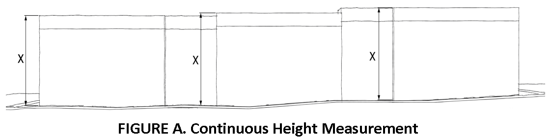
Height. Maximum height shall be measured to the top of parapet for a flat roof or to the roof ridge for a sloping roof including all areas, parking, or habitable. All height shall be measured continuously from existing or finished grade whichever is more restrictive as shown in Figure A. Where fill has been used to elevate finished grade for flood regulations, the City may make an exception to adjust the starting point for grade measurement up to 6 feet. For the purposes of Article 11, Nonconformities, the City must determine that the adjustment results in an improved ground level design as described in the Height and Density Development Plan and Design Guidelines. City Hall reviews the regulations related to height measurements in conjunction with adjustments to FEMA flood elevations.
J.
Improved Public Open Space. Open space areas that are visible and accessible to the public during daylight hours.
1.
Areas considered improved public open space may include:
a.
Plazas;
b.
Courtyards directly accessible from the street;
c.
Landscaped park or pocket park areas;
d.
Landscaped front and side yard setback areas;
e.
Landscaped areas within view corridors; and
f.
Improved waterfront areas with direct public access.
2.
Areas not considered improved public open space:
a.
Landscaping in parking areas;
b.
Areas not visible from adjacent streets or located along through pedestrian connections; and
c.
Fenced front or side yard areas.
K.
Lot Coverage. Lot coverage shall consist of all building footprints plus all impervious pavement (asphalt or concrete) on the site. Where areas are paved with pervious materials such as pavers, grasscrete, turf blocks, permeable asphalt, or other pervious material approved by the City Engineer, only 75 percent of the area shall be considered impervious cover.
L.
Low-rise. A low-rise is defined as a building or structure more than three stories or 35 feet in height and less than six stories or 70 feet in height, whichever is more restrictive.
M.
Mid-rise. A mid-rise is defined as a building or structure more than five stories or 70 feet in height and less than nine stories or 105 feet in height, whichever is more restrictive. A maximum of 20 percent of the uppermost floor plate is permitted to a total height of 120 feet. Should this portion of the building be roofed and enclosed on more than two sides it shall be considered for purposes of calculating floor area ratio.
N.
Neighborhood Transition Area. An area of a lot within HDDZ that is adjacent to a residential zone district boundary. The dimensions of the Neighborhood Transition Area and the reduced height limits that apply within these areas are defined as standards within this section.
O.
Tier. A level of development intensity: Height and Density Development Zone. Includes Base Tier, Mid-rise Tier.
P.
Very Low-rise. A very low-rise is defined as a building or structure no more than three stories or 35 feet in height, whichever is more restrictive.
SEC. 10.304 - APPLICATION OF OVERLAY ZONE
A.
This HDDZ shall apply over existing zones designated in the City including areas with existing Overlay Zones. The zoning designation for property located within the HDDZ shall consist of the base zone symbol and the overlay district symbol (HDDZ) as a suffix. The character areas of the HDDZ shall be numbered sequentially to distinguish among the individual character areas and labeled as such on the zoning map:
1.
Gateway. HDDZ-1
2.
Seawall East. HDDZ-2
3.
Seawall Core A. HDDZ-3
4.
Seawall Core B. HDDZ-4
5.
Seawall West. HDDZ-5
6.
End of Seawall to 11 Mile Road. HDDZ-6
B.
The standards of this Section apply in addition to the standards of the underlying zone and any applicable overlay zones. Where there is a conflict, the standards of this Section apply.
C.
For areas with an underlying height restriction, the more restrictive regulations shall apply.
D.
Where an existing development agreement or restrictive covenant is more restrictive than the provisions of this section, the specific restriction in the previous condition shall prevail.
E.
Any tract of land currently platted for single family detached development is exempt from the Height and Density Development Plan.
SEC. 10.305 - HEIGHT AND DENSITY TIERS
The HDDZ allows for two separate tiers of development activity. Each tier has increasingly restrictive development standards and requires additional development review. Two height and density tiers are hereby established in the HDDZ as defined below:
A.
Base Tier (very low-rise and low-rise).
1.
Development with a maximum height of five stories or 70 feet above grade and a floor area ratio not to exceed that defined for the character area.
2.
Development is approved by staff, provided it meets the standards of this regulation.
3.
Development conforming to this tier is allowed in each character area.
B.
Mid-rise Tier.
1.
Development with a maximum height of eight stories or 105 feet above grade and a floor area ratio not to exceed that defined for the character area. A maximum of 20 percent of the uppermost floor plate is permitted to a total height of 120 feet. Should this portion of the building be roofed and enclosed on more than two sides it shall be considered for purposes of calculating floor area ratio.
2.
Development is approved by staff provided it meets the standards of this regulation.
3.
Development conforming to this tier is allowed in each character area provided the project earns adequate height and floor area through the provision of specified community benefits.
C.
Development Tiers Allowed by Character Area. Base and Mid-rise Tiers are allowed in all character areas.
SEC. 10.306 - DEVELOPMENT STANDARDS FOR ALL TIERS
A.
Design Guidelines Apply. The Height and Density Development Plan and Design Guidelines in the Seawall and Gateway Areas apply to all development in the HDDZs. The design guidelines shall be employed by the City staff, the Planning Commission, and City Council, as applicable, in their review of new development.
B.
Site Area. A minimum site area is required for all development. The minimum site area varies by development tier and character area as shown in Table 10.306A, Site Area (Minimum) by Character Area, below. Properties that lack the minimum site area shown in the table below shall not be developed using Mid-Rise standards. The minimum site area shall not include dune protection areas, beaches or submerged land. The Base Tier site area shall not be less than 3,000 square feet. The Mid-Rise Tier site area shall not be less than 65,340 square feet.
C.
Required Yards. The standards of this paragraph establish a yard requirement for the HDDZ.
1.
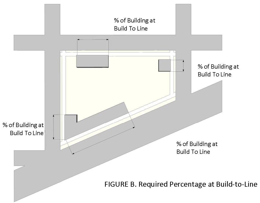
Required Percentage at Build-To-Line. The table below establishes the required percentage of a building that must be located at the build-to line as shown in Figure B. For the purposes of this paragraph, the build-to line along streets with no specific setback requirement shall be considered the interior edge of the sidewalk located furthest from the adjacent roadway. Along streets with a specific setback requirement, the build-to line shall be considered to be at the required setback.
Required yards are not applicable when rows or columns are marked —
1 This yard area is subject to specific landscaping requirements
2 As defined in paragraph Section 10.306.C.1.
3 May be reduced to 15 feet where rear lot line is adjacent to an alley at least 10' in width
4 May be reduced to 0 feet (at bulkhead) where lot line is adjacent to open water
2.
Neighborhood Transition Area. Heights shall be limited in neighborhood transition areas to maintain compatibility with adjacent residential zones. Lots that are not adjacent to a residential zone boundary do not have any transition area requirement. The specific heights allowed are found in Section 10.311, Base Tier Development Standards.
a.
Transition Area Type 1: The side or rear of a property directly adjacent to any residential zone in any character area, or the front of a property facing any residential zone across East-West (lettered) avenues in the Seawall Core A, Seawall Core B, Seawall East, or Seawall West or any street in the Gateway Area or West of Seawall areas. There are two segments of the property where special height limits apply as described below and in Figures C and D.
i.
Transition Area 1a: All lot areas that are within 20 feet of the required front, side, or rear yard setback
ii.
Transition Area 1b: All lot areas that are more than 20 feet but less than 50 feet from the required front, side, or rear yard setback
b.
Transition Area Type 2: The front of a property facing any residential zone across North-South (numbered) streets in the Seawall Core A, Seawall Core B, Seawall East, or Seawall West areas. There is one segment where special height limits apply as described below and shown in Figure E.
i.
Transition Area 2a: All lot areas that are within 20 feet of the required front yard setback
c.
Transition Area Type 3: The side or rear of a property abutting Offat's Bayou and English Bayou in the Gateway Area. There is one segment where special height limits apply as described below and shown in Figure F.
i.
Transition Area 3a: All lot areas that are within 30 feet of the property line.
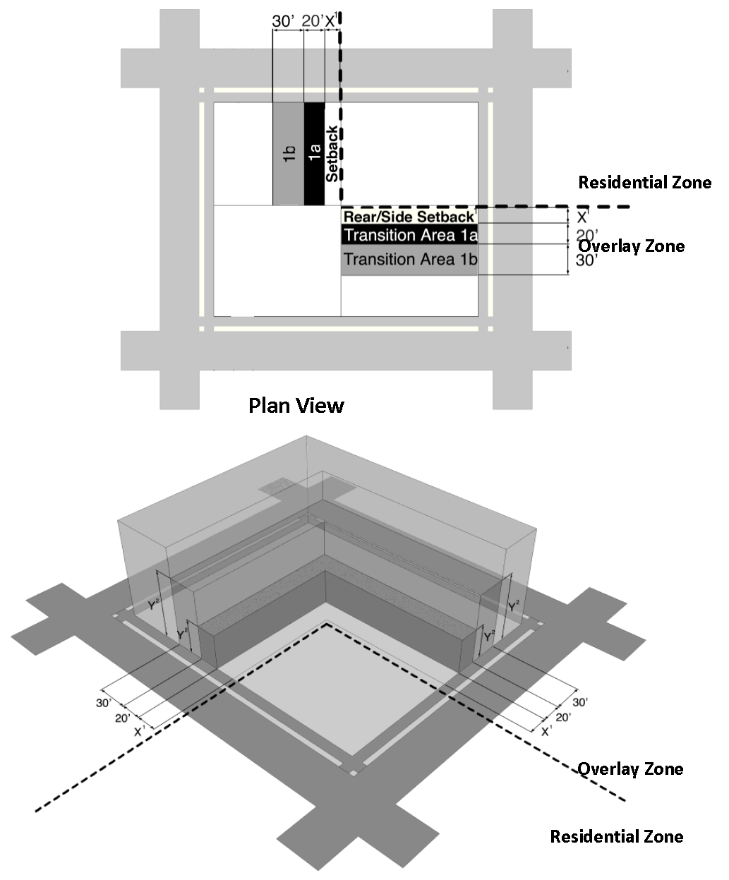
FIGURE C. Transition Area 1a and 1b on the side or rear of a lot directly abutting a residential zone district in any character area.
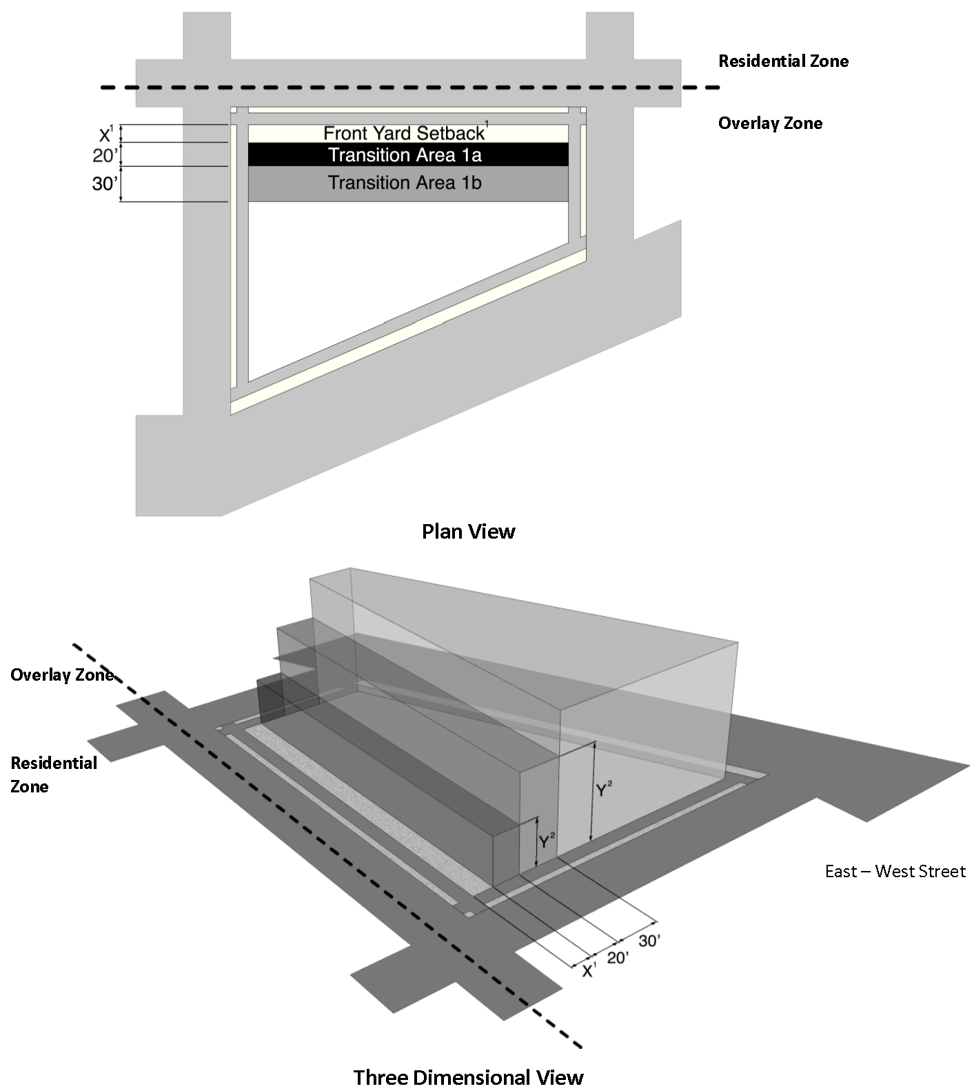
Figure D.
1
Required setback varies by character area.
2
The specific height limits for each Transition Area are described in paragraph (g)
Base Tier Development Standards.
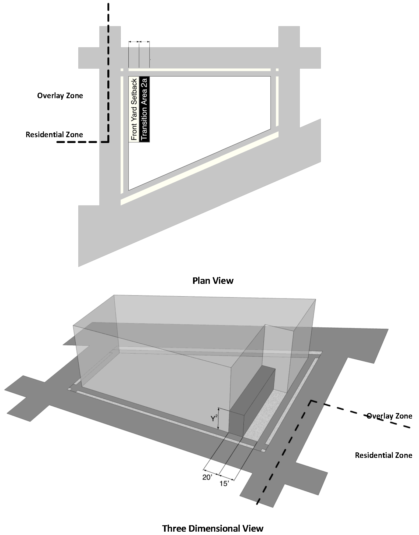
FIGURE E. Transition Area 2a on the front of a lot facing a Residential Zone across
a north-south street in the Seawall Core A, Seawall Core B, Seawall East or Seawall
West areas.
2
The specific height limits Transition Areas are described in paragraph (g) Base Tier
Development Standards.
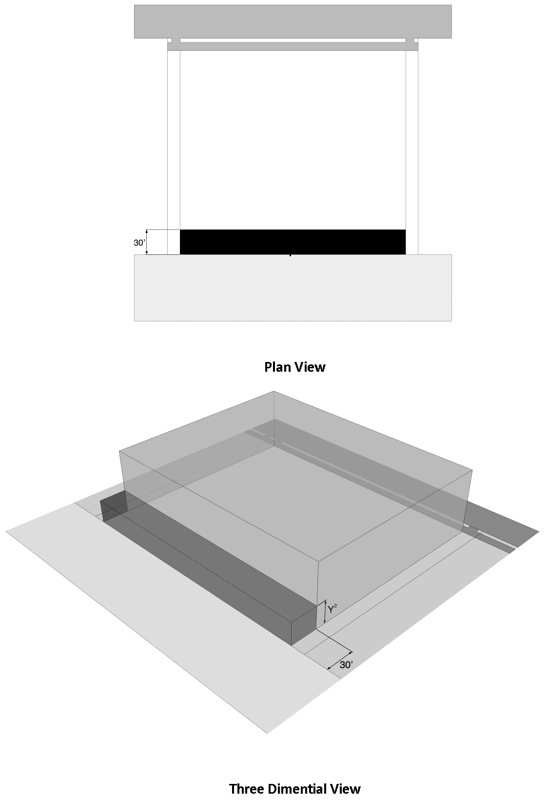
FIGURE F: Transition Area 3a on the edge of a lot directly abutting open water including,
but not limited to Offat's Bayou and English Bayou.
2
The specific height limits for Transition Areas are described in paragraph (g) Base
Tier Development Standards.
SEC. 10.307 - BUILDING MASS AND FORM STANDARDS
A.
Building Floor Plate.
1.
Mid-rise. Maximum floor plate area for floors six through eight shall be 15,000 square feet.
B.
Shading of Adjacent Residential Zone, Public School, or Public Park:
1.
Mid-rise. No mid-rise structure in the HDDZ shall impact development within any adjacent residential zone, public school, or public park through substantial shading.
2.
For the purpose of this paragraph, substantial shading shall be considered shading of an adjacent parcel for more than four hours, as measured on December 21 st . A three-dimensional model illustrating the potential shading for the project shall be provided to the City for review.
C.
Wall Plane Articulation. A building shall be articulated with wall place offsets to encourage a varied and interesting street front and break down the visual mass of taller buildings elements, as illustrated in Figure G1. Table 10.307, Wall Plane Articulation establishes the required articulation for different vertical sections of a building:
1.
Requirements. Wall Plane Articulation shall be not required for the rear elevation unless the rear elevation is adjacent to a rights-of-way or residentially zoned property. Wall Plane Articulation shall only be required for exterior building walls. For example, porches or freestanding, open air structures, such as gazebos, are not required to provide Wall Plane Articulation.
2.
Options.
a.
Indented Offsets: Articulation may be provided with indented offsets as shown in Figure G2.
b.
Offset Wall Places: Articulation may be provided with offsets that extend outwards towards the lot line as shown in Figure G3. Please note that the offsets need to meet any setback requirements.
c.
Projected Offsets: Articulation may be provided with alternative designs, such as curved walls, that meet the building wall length and offset requirements set forth in the Wall Place Articulation table above and subject to approval by the Development Services Director.
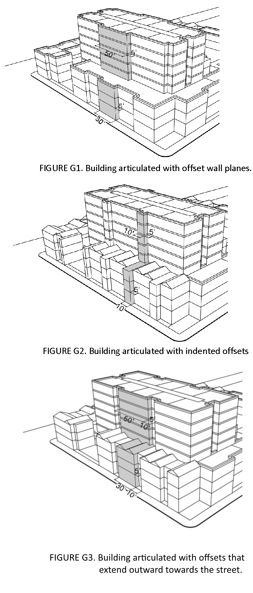
3.
Special Exception to Wall Plane Articulation Standards for Very Low-Rise Buildings. The Development Services Director may permit an increase of up to 40 feet to the maximum building wall length, a reduction of up to 3 feet in minimum offset depth,, and/or a reduction of up to 5 feet in minimum offset length for very low-rise buildings. Permitted exceptions must meet the intent of the Building Massing and Articulation section of the Height and Density Development Plan and Design Guidelines.
D.
View Corridors.
1.
Gateway View Corridor. A view corridor shall be established in the Gateway portion of the HDDZ. The height limits for Transition Area 3a shall apply within the established view corridor. Additional review of the view corridor is necessary prior to designation, and therefore, staff recommends the view corridor be established by separate ordinance.
2.
Permanent Street Closures. When a single development includes multiple blocks, it may be beneficial to close a street to provide additional open space. A permanent street closure may only be considered on a case-by-case basis where such closures do not significantly impact traffic flow and where it will provide a high quality space that contributes positively to the overall neighborhood character and pedestrian circulation system. The intent of this section is to maintain views, airflow of Gulf breezes, and to retain traditional block shapes and sizes. The land area of any new street closure may not be included in floor area ratio calculations as described in the floor area ratio definition.
a.
Closure of a city street or avenue after the adoption of this ordinance may only be considered where it meets the following criteria including but not limited to:
i.
There is a demonstrated community benefit;
ii.
The street segment is not a part of a historic district or a potentially eligible historic district;
iii.
No structure shall be erected within the original right-of-way; and
iv.
The closure does not negatively impact public safety or traffic.
b.
When closing a city street or avenue:
i.
Maintain existing view corridors and breezeways along the original right-of-way;
ii.
Maintain pedestrian access through the development along the original right-of-way; and
iii.
Provide additional landscaping including decorative paving in the closed area.
c.
When an existing site contains privately owned land that was formerly a city street, avenue, alley, or other right-of-ways at the time of adoption of the HDDZ that area shall be considered typical site area and is exempt from the requirements of this section.
d.
Closure of an alley after the adoption of this ordinance may only be considered when it meets the following criteria including but not limited to:
i.
Closing the alley is necessary to build a parking structure or orient a mid-rise building as recommended by the Height and Density Development Plan and Design Guidelines.
ii.
The alley segment is not part of a historic district or a potentially eligible historic district.
iii.
Closing the alley would cause a loss of service access to other properties.
iv.
Utility service lines can be feasibly relocated, by the developer or applicant following review and approval by the Public Works Department.
E.
Use Regulations. The use regulations of the underlying zone districts shall apply including any additional use restrictions imposed by applicable overlay districts. Where any underlying district requires a specific use permit (SUP) such permit shall continue to be required in the HDDZ.
SEC. 10.308 - STREET EDGE STANDARDS
The street edge standards of this Section shall apply to all development within the HDDZ.
A.
Visual Interest. In order to enhance the experience of the traveling public, the following visual interest elements shall be required along any street edge:
1.
Active storefronts containing commercial or office uses; and
2.
Decorative architectural surfaces such as:
1.
Public art or murals approved by the Galveston Commission for the Arts or designee
2.
Porches, galleries, arcades, or other architectural features providing outdoor protected shade for pedestrians or residents.
B.
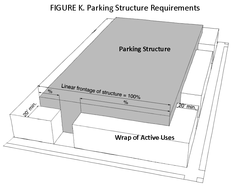
Parking Structure Requirements: Any structured parking must have other active uses (commercial or residential) located between the structure and the required building setback for a minimum depth of 20 feet as shown in Figure K. It must extend a minimum of 60 percent of the linear frontage of the structure on any street face. This wrap of other uses may be built within any required Neighborhood Transition Area subject to the height requirements for the transition area.
SEC. 10.309 - NATIONAL REGISTER OF HISTORIC PLACES ELIGIBLE BUILDINGS
Any buildings on the project site (whether the development site or a site designated for community benefit provided to achieve additional floor area) that are listed or eligible for listing on the National Register of Historic Places shall be preserved or moved to an alternative site within the City. No demolition of eligible structures is permitted in the HDDZ.
SEC. 10.310 - WETLAND BUFFERS
The following wetland buffers shall apply in the Height and Density Development Zone.
A.
Buffer Required. A 25 foot wetland buffer shall be established along the edges of any wetland under the jurisdiction of the US Corps of Engineers or the State of Texas. Buffers shall be shown an all plans and plats.
B.
Activity Allowed in Wetland Buffers. Wetland buffers shall remain undisturbed and no development, including land-disturbing activities, shall occur within this wetland buffer. Overhead or underground utilities, roads, streets, bridges, or similar structures should be placed within existing public right-of-ways if possible but in any case, must cross the buffer as close to perpendicular as possible.
C.
Revegetation. All disturbed areas within the buffer area, permitted or not, shall be revegetated with perennial vegetation as soon as practical (immediately) after the disturbance.
SEC. 10.311 - BASE TIER DEVELOPMENT STANDARDS
A.
In General. The base tier development standards allow very low and low-rise development subject to review and approval by the City.
B.
Site Development Standards: Table 10.311 shows the low-rise site development standards that shall apply in the HDDZ:
Special Transition Area height limits are not applicable when rows are columns are marked —
1 See paragraph (f) subsection (3)c. above for description of transition areas.
2 In the Base Tier, height standards do not differ for Transition Area 1b and for areas that are not in a transition area.
C.
Improved Public Open Space: The improved public open space requirement replaces any requirement for Usable Open Space per Section 29-65(e).
SEC. 10.312 - MID-RISE TIER DEVELOPMENT STANDARDS
A.
In General: The base tier development standards allow mid-rise development subject to review and approval by the Development Services Department provided the project earns adequate height and floor area through the provision of specified community benefits.
B.
Site Development Standards: Table 10.312 shows the mid-rise site development standards that shall apply in the HDDZ:
Special Transition Area height limits are not applicable when rows are columns are marked —
1 See paragraph (f) subsection (3)c. above for description of transition areas.
2 Any height above 90 feet shall be contained in a sloping roof structure not including the special height exception for penthouse building elements as described below.
3 Special height exception for penthouse building elements: Up to 20 percent of the area of the building floor plate at the 90 foot height limit for a flat-roofed structure may rise an additional one or two-stories to a maximum height of 110 feet at the parapet of a flat roof or 120 feet at the peak of a sloped roof. The standard flat and sloped roof height limits in the table above will apply to the remaining 80 percent of the building floor plate.
C.
Improved Public Open Space: The improved public open space requirement replaces any requirement for Usable Open Space.
SEC. 10.313 - COMPENSATING COMMUNITY BENEFITS
A.
Benefits Required: In order for a project to earn the right to either height or floor area that exceeds the standards for the Base Tier, compensating benefits to the community must be provided. A balance of the community's interest in reduced height with the applicant's interest in achieving a financially feasible, marketable project is defined in the tables below. All community benefit are encouraged to be on-site and within the affected area, and can be considered off-site through the approval process. Community Benefits must be completed within two years from the date of approval.
B.
Description of Community Benefits:
1.
Inclusionary Housing. Creation of housing units that meet the City definition of affordable or workforce housing units. Such units may be established in any of the following ways in order of preference:
a.
On-site within the project;
b.
Off-site through renovation of existing housing stock subject to permanent restriction for use as an affordable or workforce housing unit;
c.
Off-site through creation of new infill housing stock subject to permanent restriction for use as an affordable or workforce housing unit; or
d.
Off-site through creation of new greenfield housing stock subject to permanent restriction for use as an affordable or workforce housing unit.
e.
All inclusionary housing will be governed by a separate Inclusionary Housing Requirement Policy in a form yet to be determined.
2.
Natural Resource Protection. Permanent protection of conservation areas on Galveston Island may be achieved through transfer of development rights to the City, the County, or an established land trust of conservation organization. Perpetual maintenance of the natural resource area must be accomplished at no cost to the City.
3.
Natural Resource Protection Beach Renourishment. Project or funding for beach replenishment. Minimum dimension of 350 linear feet engineered in accordance with state and federal standards.
4.
Hotel. A hotel available for overnight stays by the general public. The hotel may be incorporated into a building containing residential or other uses.
5.
Parking Space (Public). A parking space dedicated for use by the public within a private enclosed parking structure.
6.
Parking Space (Beach Access). A parking space dedicated for use by the general public with accessible pedestrian access to a public beach area on the Gulf of Mexico.
7.
Public Boat Launch. A designated public boat launch that provides access to the Gulf of Mexico, English Bayou, Offats Bayou, and/or Galveston Bay.
8.
Public Park or Plaza. A public park or plaza meeting the requirements contained in the Height and Density Development Plan and Design Guidelines.
9.
Public Restrooms. Restrooms that are open free of charge to the general public from dawn to dusk.
10.
Public Trail or Path. A public trail or path meeting the requirements contained in the Height and Density Development Plan and Design Guidelines.
11.
Public Transit Stop. An improved transit stop providing both seating and shade acceptable to Island Transit.
C.
Initial Community Benefit Increment. The applicant shall apply the benefit from Table 10.313A to earn their initial increment of additional floor area or height (stories). When the maximum additional increment for all of the categories in this table have been earned, the applicant may use the secondary community benefits in the table in subsection D, below.
D.
Secondary Community Benefits: The applicant shall apply the benefit from Table 10.313B to earn additional secondary floor area or height (stories) only after the maximum initial community benefit increment in subsection C, above, has been earned.
1 Public parking spaces must be provided in parking structures to earn floor area increments.
2 Improved transit stops are to include a permanent shade structure and seating area and must be located at an existing or planned transit stop.
SEC. 10.314 - ADMINISTRATION
A.
Design Review and Approval. City staff reviews all development for compliance with this ordinance and other applicable sections of the City Code and Zoning Standards. Final review and approval for each tier of development is provided as follows:
1.
Very Low-rise, Low-rise and Mid-rise Development:
a.
City staff shall review and approve all low-rise development that does not include additional floor area beyond that allowed in the Base Tier.
b.
City staff shall review all low-rise development to ensure it meets the requirements of this Section, other applicable sections of the City Code and Zoning Standards, and is consistent with the Height and Density Development Plan and Design Guidelines.
c.
Where very low-rise, low-rise, and mid-rise development includes additional floor area in trade for compensating community benefits, it shall be reviewed as though it were mid-rise development by the Planning Commission.
B.
Pre-Development Meeting. A pre-development meeting with the City staff is highly recommended prior to submission of an application for approval of any development in the HDDZ. The applicant is also encouraged to meet and discuss the proposed project with adjacent neighborhoods and/or business interests. A pre-development meeting is neither an application for approval of a plan or plat nor does it constitute a permit application or other type of development approval. A pre-development meeting does not vest any rights with regard to the development of the subject property.
C.
Design Guidelines. The Planning Commission shall adopt and amend Height and Density Development Plan and Design Guidelines to be used by staff and the Commission for the review of projects within the HDDZ as required.
D.
Unity of Title Required. Each project site must be under single ownership at the time of application. Development of sites that include additional floor area in trade for compensating community benefits shall not be further subdivided into additional parcels following approval (this provision is not intended to restrict the ability to create a project under condominium, cooperative, or other unsubdivided regimes). Where subdivision is permitted, it shall occur concurrent with review under this Section.
E.
Appeals. All appeals of final City staff and/or Planning Commission decisions shall be taken to the Zoning Board of Adjustment. Appeals of final decisions of the Zoning Board of Adjustment shall be taken to a court of competent jurisdiction.
SEC. 10.401 - ZONING STANDARDS APPLICABLE IN A TRADITIONAL NEIGHBORHOOD (TN) ZONING DISTRICT
A.
TND Development Objectives
The Traditional Neighborhood (TN) zoning districts should be based on a harmonious plan of buildings, streets, and open space, including the arrangement of vehicular and pedestrian circulation, the relationship of buildings to streets, parking, and open space, contained in an integral, cohesive plan, reflecting the layout and planning principles of traditional neighborhoods and the historic residential sections of the City of Galveston. More specifically, the intent and purpose of this TND is as follows:
1.
To balance dependence upon the automobile by providing, within a walkable neighborhood, a mixture of housing types, shopping, businesses, offices, schools, churches and other civic uses, and recreational opportunities.
2.
To establish a street geometry which maintains a basic geographic orientation and directional legibility throughout the neighborhood.
3.
To reflect historic architectural styles and themes; including the scale, details, massing and ornamentation and specific architectural elements, particularly front porches, characteristic of traditional neighborhoods and the historic areas of Galveston.
4.
To encourage a pedestrian circulation system, linking the major elements of the community, including neighborhood parks, plazas and squares, and other destinations such as shopping, recreation and civic uses, with provisions for bikeways.
5.
To encourage the preservation and protection of environmentally-sensitive open space, views and natural areas.
6.
To provide for commercial retail structures directly facing on wide sidewalks, with parking in the rear or in enclosed garage space, with upper floors above retail applicable for compatible multifamily residential, office and other uses.
7.
To provide for the majority of residential lots served by rear service lanes or alleys.
8.
To provide, in single family detached areas, for quarters above garages in the rear of residential lots, providing expanded housing opportunities. Garages or garage doors, which face the principal street, should have increased front yard setbacks to minimize the visibility of garage doors.
9.
To encourage a variety of usable civic places and facilities, as important destinations in the neighborhood, such as schools, libraries, recreation and community centers.
(Ord. No. 18-037, § 2, 6-21-18; Ord. No. 19-043, § 2, 8-22-19)
SEC. 10.402 - GENERAL REGULATIONS/PROVISIONS/ELIGIBILITY
A.
All applications for TN developments shall be submitted with written authorization from the property owner(s).
B.
The minimum tract area shall be 50 acres of developable land, excluding protected wetlands, beaches, and dunes, unless mitigated.
C.
This ordinance will provide for the traditional neighborhood character through the modification of certain City zoning and subdivision standards, consistent with promoting the health, safety, welfare and appearance of the community, including reduced front yard setbacks, a variety of lot types, the compatible mixing of uses within the same structure, and where appropriate, wider sidewalks and a network of pedestrian and bikeways.
D.
Direct access from major state highway, or arterial street to the TN development shall be provided.
E.
All TN's shall be served by public water and sewer systems.
F.
Mixed-use buildings shall conform with the applicable construction requirements of the City Building Code.
G.
All parking, lighting, and landscaping shall comply with Articles 7, 8, and 9 of these Land Development Regulations, respectively.
SEC. 10.403 - AREA BULK AND DIMENSIONAL REGULATIONS
The following area and dimensional regulations a TN shall apply:
A.
Maximum Building Coverage on a lot shall be as follows:
1.
Single family detached: 60%
2.
Single family patio or ZLL: 70%
3.
Single family attached: 80%
4.
Commercial mixed-use: 85%
B.
Minimum Open Space
The minimum required open space within a TN is eight percent (8%) of the tract area. Required open space may include natural areas, golf courses and club houses, civic uses (squares, plazas, parks), any area devoted exclusively to pedestrian or bicycle use, but excluding wetlands, non-parkland detention/retention areas, and dune line setback areas. A public pedestrian path system shall be provided through open space areas, with access to water areas where feasible and consistent with sound environmental practices. For beachfront tracts, the area seaward of the dune vegetation line is not considered open space.
C.
Projections allowed within the front and rear setback or building line
1.
In residential areas, porches, bay windows and stairs may extend to within five-feet (5') of the rear property line provided there is no conflict with utilities, and provided further that such property line adjoins a greenway or greenbelt.
2.
In commercial, retail or mixed-use areas, no front yard setback is required, provided the building fronts on a 12-foot wide minimum sidewalk. The minimum distance from the building line to the street or curb line is 12-foot.
D.
Canopies and awnings may extend beyond the property line to within six feet (6') of the curb line, where the sidewalk is a minimum of 15-feet wide. However, no canopies or awnings shall extend above underground utilities. Any item to be placed into the City rights-of-way shall require a License to Use (LTU)
E.
Density and Intensity of Use. The density and/or intensity of use within the TN shall be limited by the lot size, setbacks, building heights and other area and bulk regulations.
F.
Land Use Mix. The Land Use mix shall be accomplished through deed restrictions.
SEC. 10.404 - WASTE MANAGEMENT AND UTILITIES
A.
Waste Management Refuse and Trash Pick-up — Trash and refuse storage and collection areas must be screened and located, convenient for deposit, collection and removal, and must not be visible from a public right-of-way. Trash collection should occur in rear alleys and in specially designated areas, where possible. Waste area screening in a TN shall comply with Chapter 15, Section 15-4 of City Code.
B.
Utilities — All utilities shall be underground or within designated easements or R.O.W.'s. All transformers and telephone components shall be located on public property or within easements or within public R.O.W.'s, and shall be screened, where practical from the public view. Easements for utilities shall be provided as required by the City and by the respective utility companies. Utilities may be located in rear alley ways where appropriate.
SEC. 10.405 - APPLICABILITY OF TND REGULATIONS, VARIANCES
A.
The standards requirements and procedures of other applicable City ordinances shall apply to a TN, unless specifically modified or amended by this TN ordinance, or through variances granted by the Zoning Board of Adjustments (ZBA), as provided herein. The ZBA may grant variances to these regulations and/or to the zoning regulations generally, provided that: (a) actions, designs or solutions proposed by the Applicant, although not literally in accord with these TN regulations or with the City's zoning and subdivision regulations, satisfy the intent and purpose of TN's at least to an equivalent degree; (b) the ZBA determines that the proposed modifications promote the health, safety, appearance, and general welfare of the community.
SEC. 10.406 - PHASING
A.
The TN may be developed in phases, or sections, based on a phasing plan, submitted as part of a General Plan, to be included as part of the Site Plan application. If any section includes modifications, deemed to be substantial by the Development Services Department, the Development Services Director may require submission of a revised General Plan to the Planning Commission, demonstrating that the overall land use, intensity of use, circulation and open space is consistent with the intent and purposes of the previously approved Site Plan.
SEC. 10.407 - SIGNS
A.
All signage within the TN shall conform to Article 5 of these regulations and all other applicable City codes. Permits for approved signs must be obtained from the proper City departments, as per the City's sign ordinance.
SEC. 10.408 - PROCEDURE — REVIEW OF TND DEVELOPMENT APPLICATIONS
A.
Prior to, or in conjunction with, the submission of a subdivision plat for all or portions of a TND development, the Applicant shall submit a Change of Zoning request from the existing zoning category to Traditional Neighborhood (TN). The change of zoning to Traditional Neighborhood will require the development to comply with all regulations of Article 10 of these Land Development Regulations pertaining to TN development.
B.
Prior to the submission of a subdivision plat for all or portions of a TN development, the Applicant shall submit a Site Plan, together with a General Plan for the entire TN project, for Site Plan Review by the Planning Commission.
C.
Any person aggrieved by the Planning Commission's approval or disapproval of the site plan review in the Traditional Neighborhood District, may file an appeal to the City Council. Such appeal must be filed with the Development Services Department no later than ten (10) working days from the date of the Planning Commission's decision. The City Council may uphold or reverse the decision of the Planning Commission in which event, the City Council's decision shall be final. In addition, the City Council may refer the matter back to the Planning Commission with specific instructions to consider new information. In such event, the Planning Commission shall reconsider the matter at the next regularly scheduled Planning Commission meeting.
SEC. 10.409 - SUBDIVISION REGULATIONS — ALTERNATIVE STREET UTILITY AND DRAINAGE STANDARDS APPLICABLE IN A TRADITIONAL NEIGHBORHOOD
A.
TND Subdivision Objectives
1.
The Traditional Neighborhood Development should be based on a harmonious, cohesive plan of buildings, streets, and open space, including the arrangement of vehicular and pedestrian circulation, the relationship of buildings to streets, parking, and open space, reflecting the layout and planning principles of traditional neighborhoods in the region and historic residential sections of the City of Galveston.
B.
This ordinance recognizes that TN's require alternative design and planning standards in order to encourage a human-scaled, pedestrian-oriented, built environment, reflecting the character of the traditional, historic districts of Galveston, balancing the functional needs of vehicular-pedestrian circulation and neighborhood residential life.
C.
The intent and purpose of these TND subdivision regulations are as follows:
1.
To provide for streets and R.O.W.'s typical of successful current-day TND's and of the older historic areas of Galveston.
2.
To provide for the traditional neighborhood character through the modifications of certain subdivision standards, consistent with promoting the health, safety, welfare and appearance of the community, including a variety of street types, with minimum street pavement widths, and where appropriate, wider sidewalk widths, and provisions for pedestrian and bikeways throughout the neighborhood.
3.
To establish the street geometry should maintain a basic geographic orientation and directional legibility throughout the neighborhood.
4.
To encourage a village-wide pedestrian circulation system, linking the major elements of the community, including neighborhood parks, plaza and squares, and other destinations such as shopping, recreation and civic uses, with provisions for bicycle ways.
5.
To provide for the majority of residential lots served by service lanes in the rear or alleys.
D.
Street and Road Definitions
Shall be amended to include, in a TND, to include, in addition to the City's typical standards, the following street types:
1.
Residential Local Streets and Roads. Residential local streets include streets with a R.O.W. of 60-feet or less, except Minor streets (as described below). They serve traffic within a neighborhood district and provide access to residential and other uses. The design speed shall not to exceed 20 MPH. On-street parking is encouraged.
2.
Major Streets and Roads. Major streets and roads include streets with a R.O.W. of greater than 60-feet (Major Street, Small Avenue). They serve to carry traffic from Minor and Local streets to Major Collector and Arterial streets, including entrances to a TND, with a design speed of 25-to 30 MPH.
3.
Minor Streets and Roads. Minor streets and roads include generally short streets or alley type streets (Close, Minor road, Service lane, Rear lane, Passage). Minor streets lanes are used for service access to the rear of properties otherwise abutting on a street or on a Passage. This category of streets also includes a PASSAGE or pedestrian street, which is a linear pedestrian street with sidewalks on both sides, and may be used for emergency vehicle access. The design speed should not exceed 15 MPH.
4.
"Streets" are defined as having curbs and gutters, occur in the more urban, higher density and mixed-use areas. "Roads", without curb and gutter (but with shoulders and drainage swales on both sides) primarily occur in the lower density, less urban areas.
5.
See the following chart "Street Types" for R.O.W. and pavement widths and street section details.
E.
Street Standards in a TN
1.
The following street standards are permitted in a TN:
NOTE: Lane widths are back-to-back of curb, where curbed; parking spaces are counted as seven feet (7') wide. Typical lane widths are 10-to 12-feet wide. On streets without curbs, seven foot (7') wide drainage swales slope to a maximum 12-inches deep maximum. Additional width for infrastructure (drainage, underground utilities, and sidewalks) may be provided in utility easements parallel to street R.O.W.'s.
F.
Other Street Provisions
1.
Rear Alleys and Service lanes are encouraged in residential areas. Where rear alleys serve lots, driveways and curb cuts from front streets are prohibited.
2.
Although streets generally intersect at right angles, streets may intersect at oblique angles, where the design speed is 20 MPH or less.
3.
Streets with "T" intersections and focal points or view corridors are encouraged.
a.
Site distances, shall be as per Section 29-4(A)8, except where commercial or mixed-use buildings front on 10-to 12-feet wide sidewalks with the public R.O.W.
b.
Fire Vehicle Access. All front entries of dwelling units shall be within 150-feet of all weather access by Fire Vehicles. The minimum unobstructed emergency vehicle access on an all-weather surface is 20-feet in commercial and mixed-use areas and 14-feet in residential areas. Where 14-feet access occurs, there shall be a secondary means of access a minimum of 14-feet wide.
c.
Each lot shall be provided with adequate vehicular and pedestrian access, which may be a service lane, alley, or shared common access drive. The minimum distance between structures for fire access is eight feet (8').
d.
Street types within a TN may be either public or private.
e.
The maximum vertical grade for an elevated street (five feet (5') or more above existing grade) is eight percent (8%); otherwise, the horizontal curve provisions of Section 29-4(A)6 shall apply.
f.
Required shoulder parking lanes on streets without curb and gutter may be constructed of an all-weather wearing surface material, such as crushed limestone, different than main travel lanes.
g.
Streets with reduced pavement widths (skinny streets) are intended to be used in lower density, lower speed, single family residential areas.
h.
Commercial and mixed-use areas of a TND shall have a 20-foot wide unobstructed access to within 150-feet of all buildings for Fire and Emergency vehicles.
i.
Commercial and mixed-use areas of a TND shall have streets with a minimum 20-foot wide unobstructed access way.
j.
The 20-foot wide access way may include adjacent sidewalks with a mountable curb, or an adjacent stabilized base in a median or planting area, provided there are no vertical obstructions such as fire hydrants, trees, lamp posts, etc. However, on-street parking shall not be counted as part of the unobstructed width.
k.
A 20-foot wide unobstructed access may be provided by an adjacent stabilized shoulder or sidewalk with a mountable curb.
l.
The above stated street standards and layout (Chart I), are subject to approval by the Development Services Director, the City Traffic Engineer, City Engineer and the City Fire Marshall or Fire Chief, based on standards contained herein.
m.
The above street standards and layout (Chart I) are permitted, subject to a drainage plan approved by the City Engineer
G.
Lot Lines: Configuration
1.
Lots may front on a street or on a Passage or public or common open space, if served (in the rear) by a Lane or Alley type street.
2.
Side lot lines are generally at right angles to streets, although angled side lot lines and irregular lot lines are permitted.
3.
Flag lots, which is defined as a lot fronting on a street by means of a narrow access way, are permitted, with a private common driveway easement a minimum of 20-feet wide and a maximum length of 120-feet
H.
Utilities and Drainage
1.
Utility easements on lot frontages as per Section 6.308 of these regulations may not be required where alleys or service lanes provide access to the rear of lots.
2.
Lots not served by rear Alleys or Service Lanes shall have adequate utility easements adjacent to the public R.O.W. and if necessary, additional easements within the front yard of lots, as well as utility easements in the rear of lots.
3.
In general, for lots without rear access lanes or Alleys, electrical, gas, and cable may be provided in adjoining easements in the rear of lots, a minimum of 10-foot wide, or as per utility company standards. Sanitary, sewer and water lines shall be located within the street R.O.W. or within lot easements adjacent to the property line abutting the street R.O.W. If dry utilities (electrical, gas, cable) and wet utilities (sanitary sewer, water) are located in the same easement, that easement shall be sixteen feet (16') wide, adjacent to the street right-of-way.
4.
For streets without curbs and gutters, storm drainage may be located in swales on each side of the street pavement section, a minimum of seven feet (7') wide, excluding sidewalk areas, except for service lanes, where width may vary. Driveways across swales require a 12-inch diameter minimum culvert. Alleys and lanes may have a depressed concrete apron at the driveway entrance for storm water flow. No culverts shall be permitted in swales less than 10-feet in width.
5.
Service lanes and Alleys may have an inverted pavement section, with surface flow or with inlets and subsurface storm lines where feasible.
I.
Platted Lots
The minimum lot width in a TN is 18 feet. A variance from the Zoning Board of Adjustment may be granted for single family detached homes or non-residential uses, occupying more than one lot, where the minimum required lot width for a primary use is greater than 18-feet.
J.
Procedure
All subdivisions within a TN shall follow the procedures described in Section 29-5 of the Subdivision Ordinance of the City of Galveston. Prior to submission of a preliminary plat, site plan approval is required by the Planning Commission, in accordance with Section 29-88 of the Zoning Standards.
SEC. 10.501 - PURPOSE, GENERAL PROVISIONS AND SITE PLAN REQUIREMENT
A.
Purpose. The Neighborhood Services (NS) district is intended to serve as a buffer zone between residential and certain commercial uses for the convenience of people living in surrounding residential areas without undue harmful effects to neighboring residential uses.
B.
General Provisions:
1.
Intensity of Use. In order to help insure compatibility with surrounding residential uses, the following restrictions limit the intensity of use to which a premises may be used.
a.
A Neighborhood Services (NS) zoning district may only be established on a parcel or tract of land abutting an Urban Neighborhood (UN), Traditional Neighborhood (TN), Commercial (C), or Resort/Recreation (RES/REC) zoning district.
b.
New structures shall meet the minimum front yard requirement of the most restrictive zoning district abutting the sides of the property being developed.
c.
The gross floor area of the structures located on the premises shall not exceed 2,000 square feet on the first floor, and shall not exceed a cumulative square footage of 4,000 square feet per building.
d.
All signage within the Neighborhood Services (NS) district shall conform to Article 5 of these regulations and all other applicable City codes.
e.
Landscaping shall conform to the requirements of Article 9 of these regulations and all other applicable City codes.
f.
Any outdoor storage areas accessory to the main use shall be enclosed by a solid masonry or concrete wall, or a wood fence of sufficient height such that no stored materials or merchandise are visible above the top of the screening wall or fence.
C.
Site Plan Approval. When development in this district is located on a lot located adjacent to the side or front yard of existing residential development or residentially zoned property, site plan approval shall be required before the issuance of a Building Permit.