
Gordon County Unincorporated
City Zoning Code
City Zoning Code
CHAPTER 3
PROTECTION OF NATURAL FEATURES AND RESOURCES
3.00.00 - GENERALLY
The provisions set forth in Chapter 3 are intended to protect the natural features and natural resources within Gordon County, and to implement policies in the Gordon County Comprehensive Plan. The natural features and natural resources included in Chapter 3 are the floodplain, water supply watersheds, groundwater recharge areas, river corridors, wetlands, and erosion and sediment control.
3.01.00 - FLOOD DAMAGE PREVENTION
3.01.01 Statutory Authorization
Article IX, Section II of the Constitution of the State of Georgia and O.C.G.A. § 36-1-20(a) have delegated the responsibility to local governmental units to adopt regulations designed to promote the public health, safety, and general welfare of its citizenry. Therefore, the Gordon County Board of Commissioners of Gordon County, Georgia, does ordain as follows.
A.
The flood hazard areas of Gordon County, Georgia are subject to periodic inundation which results in loss of life and property, health and safety hazards, disruption of commerce and governmental services, extraordinary public expenditures for flood relief and protection, and impairment of the tax base, all of which adversely affect the public health, safety and general welfare.
B.
These flood losses are caused by the occupancy in flood hazard areas of uses vulnerable to floods, which are inadequately elevated, flood-proofed, or otherwise unprotected from flood damages, and by the cumulative effect of obstructions in floodplains causing increases in flood heights and velocities.
It is the purpose of this section to promote the public health, safety and general welfare and to minimize public and private losses due to flood conditions in specific areas by provisions designed to:
A.
Require that uses vulnerable to floods, including facilities, which serve such uses, be protected against flood damage at the time of initial construction;
B.
Restrict or prohibit uses which are dangerous to health, safety and property due to water or erosion hazards, or which increase flood heights, velocities, or erosion;
C.
Control filling, grading, dredging and other development which may increase flood damage or erosion;
D.
Prevent or regulate the construction of flood barriers which will unnaturally divert floodwaters or which may increase flood hazards to other lands; and
E.
Control the alteration of natural floodplains, stream channels, and natural protective barriers, which are involved in the accommodation of floodwaters.
The objectives of this section are to:
A.
Protect human life and health;
B.
Minimize damage to public facilities and utilities such as water and gas mains, electric, telephone and sewer lines, streets and bridges located in floodplains;
C.
Help maintain a stable tax base by providing for the sound use and development of flood prone areas in such a manner as to minimize flood blight areas;
D.
Minimize expenditure of public money for costly flood control projects;
E.
Minimize the need for rescue and relief efforts associated with flooding and generally undertaken at the expense of the general public;
F.
Minimize prolonged business interruptions; and
G.
Ensure that potential home buyers are notified that property is in a flood area.
3.01.05 Lands to which Section Applies
This section shall apply to all areas of special flood hazard within the County.
3.01.06 Basis for Establishing the Areas of Special Flood Hazard
A.
The areas of special flood hazard identified by the Federal Emergency Management Agency in its Flood Insurance Study (FIS), dated September 26, 2008 with accompanying maps and other supporting data and any revision thereto, are adopted by reference and declared a part of this section.
B.
For those land areas acquired by a municipality through annexation, the current effective FIS dated September 26, 2008, with accompanying maps and other supporting data and any revision thereto, for Gordon County are hereby adopted by reference.
C.
Areas of Special Flood Hazard may also include those areas known to have flooded historically or defined through standard engineering analysis by governmental agencies or private parties but not yet incorporated in a FIS.
D.
The Repository for public inspection of the FIS, accompanying maps and other supporting data is located at: Gordon County Building, Planning and Development office, Wall Street Annex building, First Floor, 200 S. Wall Street, Calhoun, Georgia.
3.01.07 Development Permit Required
A development permit shall be required in conformance with the provisions of this section prior to the commencement of any development activities.
No structure or land shall hereafter be located, extended, converted or altered without full compliance with the terms of this section and other applicable regulations.
3.01.09 Conflict with Other Provisions
This section is not intended to repeal, abrogate, or impair any existing easements, covenants, or deed restrictions. However, where this section and another conflict or overlap, whichever imposes the more stringent restrictions shall prevail.
3.01.10 Abrogation and Greater Restrictions
This section is not intended to repeal, abrogate, or impair any existing ordinance, easements, covenants, or deed restrictions. However, where this section and another conflict or overlap, whichever imposes the more stringent restrictions shall prevail.
In the interpretation and application of this section, all provisions shall be:
A.
Considered as minimum requirements;
B.
Liberally construed in favor of the governing body; and
C.
Deemed neither to limit nor repeal any other powers granted under state statutes.
3.01.12 Warning and Disclaimer of Liability
A.
The degree of flood protection required by this section is considered reasonable for regulatory purposes and is based on scientific and engineering consideration.
B.
Larger floods can and will occur. Flood heights may be increased by manmade or natural causes.
C.
This section does not imply that land outside the areas of special flood hazard or uses permitted within such areas will be free from flooding or flood damages.
D.
This section shall not create liability on the part of the County or by any officer or employee thereof for any flood damages that result from reliance on this section or any administrative decision lawfully made hereunder.
3.01.13 Penalties for Violation
A.
Failure to comply with the provisions of this section or with any of its requirements, including conditions and safeguards established in connection with grants of variance or special exceptions shall constitute a violation.
B.
Any person who violates this section or fails to comply with any of its requirements shall, upon conviction thereof, be fined not more than five hundred dollars ($500.00) or imprisoned for not more than five (5) days, or both, and in addition, shall pay all costs and expenses involved in the case.
C.
Each day such violation continues shall be considered a separate offense.
D.
Nothing contained in this section shall prevent the County from taking such other lawful actions as is necessary to prevent or remedy any violation.
3.01.14 Designation of Floodplain Coordinator
The Director of Building Inspections is hereby appointed to administer and implement the provisions of this section.
Application for a Development Permit shall be made to the Director of Building Inspections on forms furnished by the community prior to any development activities, and may include, but not be limited to the following: plans in duplicate drawn to scale showing the elevations of the area in question and the nature, location, dimensions, of existing or proposed structures, earthen fill placement, storage of materials or equipment, and drainage facilities. Specifically, the following information is required:
A.
Application stage
1.
Elevation in relation to mean sea level (or highest adjacent grade) of the lowest floor, including basement, of all proposed structures;
2.
Elevation in relation to mean sea level to which any nonresidential structure will be flood-proofed;
3.
Design certification from a registered professional engineer or architect that any proposed nonresidential flood-proofed structure will meet the flood-proofing criteria in Section 3.01.18(B) below;
4.
Description of the extent to which any watercourse will be altered or relocated as a result of the proposed development.
B.
Construction stage
1.
For all new construction and substantial improvements, the permit holder shall provide to the Director of Building Inspections an as-built certification of the regulatory floor elevation or flood-proofing level immediately after the lowest floor or floodproofing is completed.
2.
Any lowest floor certification made relative to mean sea level shall be prepared by or under the direct supervision of a registered land surveyor or professional engineer and certified by same.
3.
When floodproofing is utilized for nonresidential structures, said certification shall be prepared by or under the direct supervision of a professional engineer or architect and certified by same.
4.
Any work undertaken prior to submission of these certifications shall be at the permit holder's risk.
5.
The Director of Building Inspections shall review the above-referenced certification data submitted.
6.
Deficiencies detected by such review shall be corrected by the permit holder immediately and prior to further progressive work being allowed to proceed.
7.
Failure to submit certification or failure to make said corrections required hereby, shall be cause to issue a stop-work order for the project.
3.01.16 Duties and Responsibilities of Floodplain Coordinator
The duties of the floodplain coordinator shall include, but not be limited to:
A.
Review all permit applications to assure that the permit requirements of this section have been satisfied.
B.
Review proposed development to assure that all necessary permits have been received from governmental agencies from which approval is required by Federal or State law, including Section 404 of the Federal Water Pollution Control Act Amendments of 1972, 33 U.S.C. 1334. Require that copies of such permits be provided and maintained on file.
C.
When Base Flood Elevation data or floodway data have not been provided in accordance with Section 3.01.15, then the Director of Building Inspections shall require the applicant to obtain, review and reasonably utilize any base flood elevation and floodway data available from a Federal, State or other sources in order to administer the provisions of this ULDC.
D.
Receive and review elevation certificates and floodproofing certificates for all new or substantially improved buildings, for compliance with this section.
E.
When flood-proofing is utilized for a structure, the Director of Building Inspections shall require the applicant to obtain certification of design criteria from a registered professional engineer or architect in accordance with Section 3.01.15 and Section 3.03.18.
F.
Make substantial damage determinations following a flood event or any other event that causes damage to structures in flood hazard areas.
G.
Notify adjacent communities and the Georgia Department of Natural Resources prior to any alteration or relocation of a watercourse and submit evidence of such notification to the Federal Emergency Management Agency (FEMA).
H.
For any altered or relocated watercourse, the Director of Building Inspections shall require the applicant to submit engineering data/analysis within six (6) months to the FEMA to ensure accuracy of community flood maps through the Letter of Map Revision process.
I.
Require that the applicant shall assure flood carrying capacity of any altered or relocated watercourse is maintained.
J.
Interpret the provisions of this section. In the interpretation and application of this section all provisions shall be considered as minimum requirements. They shall be liberally construed in favor of the governing body with jurisdiction, and the provisions of this section shall not be deemed to limit or repeal any other powers granted under state statutes.
K.
Maintain all records pertaining to the provisions of this section, which shall be open for public inspection.
(Res. of 12-20-11)
In all areas of special flood hazard, the following provisions are required:
A.
New construction and substantial improvements of existing structures shall be anchored to prevent flotation, collapse or lateral movement of the structure.
B.
New construction and substantial improvements of existing structures shall be constructed with materials and utility equipment resistant to flood damage.
C.
New construction or substantial improvements of existing structures shall be constructed by methods and practices that minimize flood damage.
D.
All heating and air conditioning equipment and components (including ductwork), all electrical, ventilation, plumbing, and other service facilities shall be designed and/or located so as to prevent water from entering or accumulating within the components during conditions of flooding.
E.
Manufactured homes shall be anchored to prevent flotation, collapse, or lateral movement. Methods of anchoring may include, but are not limited to, use of over-the-top or frame ties to ground anchors. This standard shall be in addition to and consistent with applicable State requirements for resisting wind forces.
F.
New and replacement water supply systems shall be designed to minimize or eliminate infiltration of floodwaters into the system.
G.
New and replacement sanitary sewage systems shall be designed to minimize or eliminate infiltration of floodwaters into the systems and discharges from the systems into floodwaters.
H.
On-site waste disposal systems shall be located and constructed to avoid impairment to them or contamination from them during flooding.
I.
Any alteration, repair, reconstruction or improvement to a structure, which is not compliant with the provisions of this section, shall be undertaken only if the nonconformity is not furthered, extended or replaced.
J.
Accessory structures shall be subject to the standards of this section.
In all areas of special flood hazard the following provisions are required:
A.
New residential construction and/or substantial improvements. Where base flood elevation data are available, new construction and/or substantial improvement of any residential structure or manufactured home shall have the lowest floor, including basement, elevated no lower than one (1) foot above the base flood elevation. Should solid foundation perimeter walls be used to elevate a structure, openings sufficient to facilitate equalization of flood hydrostatic forces on both sides of exterior walls shall be provided in accordance with standards of subsection (C) of this section. All heating and air conditioning equipment and components (including ductwork), all electrical, ventilation, plumbing, and other service facilities shall be elevated at or above one (1) foot above the base flood elevation.
B.
Nonresidential construction. New construction and/or the substantial improvement of any structure located in A1—30, AE, or AH zones, may be flood-proofed in lieu of elevation. The structure, together with attendant utility and sanitary facilities, must be designed to be water tight to one (1) foot above the base flood elevation, with walls substantially impermeable to the passage of water, and structural components having the capability of resisting hydrostatic and hydrodynamic loads and the effect of buoyancy. A registered professional engineer or architect shall certify that the design and methods of construction are in accordance with accepted standards of practice for meeting the provisions above, and shall provide such certification to the official as set forth above and in Section 3.01.16(G).
C.
Elevated buildings. All new construction or substantial improvements of existing structures that include any fully enclosed area located below the lowest floor formed by foundation and other exterior walls shall be designed so as to be an unfinished or flood resistant enclosure. The enclosure shall be designed to equalize hydrostatic flood forces on exterior walls by allowing for the automatic entry and exit of floodwater.
1.
Designs for complying with this requirement must either be certified by a professional engineer or architect or meet the following minimum criteria:
a.
Provide a minimum of two (2) openings having a total net area of not less than one (1) square inch for every square foot of enclosed area subject to flooding;
b.
The bottom of all openings shall be no higher than one (1) foot above grade; and
c.
Openings may be equipped with screens, louvers, valves or other coverings or devices provided they permit the automatic flow of floodwater in both direction;
2.
So as not to violate the "Lowest Floor" criteria of this section, the unfinished or flood resistant enclosure shall only be used for parking of vehicles, limited storage of maintenance equipment used in connection with the premises, or entry to the elevated area; and
3.
The interior portion of such enclosed area shall not be partitioned or finished into separate rooms.
D.
Standards for manufactured homes and recreational vehicles where base flood elevation data are available.
1.
All manufactured homes placed, and/or substantially improved, on individual lots or parcels, in expansions to existing manufactured home parks or subdivisions, in new and/or substantially improved manufactured home parks or subdivisions, or on a site in an existing manufactured home park or subdivision where a manufactured home has incurred "substantial damage" as the result of a flood, must have the lowest floor including basement, elevated no lower than one (1) foot above the base flood elevation.
2.
All manufactured homes placed and/or substantially improved in an existing manufactured home park or subdivision must be elevated so that:
a.
The lowest floor of the manufactured home is elevated no lower than one (1) foot above the level of the base flood elevation, or
b.
The manufactured home chassis is elevated and supported by reinforced piers (or other foundation elements of at least an equivalent strength) of no less than thirty-six (36) inches in height above grade.
c.
All manufactured homes must be securely anchored to an adequately anchored foundation system to resist flotation, collapse and lateral movement.
3.
All recreational vehicles placed on sites must either:
a.
Be on the site for fewer than one hundred eighty (180) consecutive days, or
b.
Be fully licensed and ready for highway use, (a recreational vehicle is ready for highway use if it is licensed, on its wheels or jacking system, attached to the site only by quick disconnect type utilities and security devices, and has no permanently attached structures or additions), or
c.
The recreational vehicle must meet all the requirements of Section 3.01.18(A) including the anchoring and elevation requirements of Section 3.01.18(D)(2)(c), above.
E.
Floodways. Located within areas of special flood hazard established in Section 3.01.06 are areas designated as floodways. A floodway may be an extremely hazardous area due to velocity floodwaters, debris or erosion potential. In addition, the area must remain free of encroachment in order to allow for the discharge of the base flood without increased flood heights. Therefore, the following provisions shall apply:
1.
Encroachments are prohibited, including earthen fill, new construction, substantial improvements or other development within the regulatory floodway. Development may be permitted however, provided it is demonstrated through hydrologic and hydraulic analyses performed in accordance with standard engineering practice that the encroachment shall not result in any increase in flood levels or floodway widths during a base flood discharge. A registered professional engineer must provide supporting technical data and certification thereof.
2.
If subsection (E)(1) of this section is satisfied, all new construction and substantial improvements shall comply with all applicable flood hazard reduction provisions of this section.
3.01.19 Standards for Streams without Established Base Flood Elevation and/or Floodways (A-Zones)
Located within the areas of special flood hazard established in Section 3.01.06, where streams exist but where no base flood data has been provided (A-Zones), or where base flood data have been provided but a floodway has not been delineated, the following provisions apply:
A.
When base flood elevation data or floodway data have not been provided in accordance with Section 3.01.06, then the Director of Building Inspections shall obtain, review, and reasonably utilize any scientific or historic base flood elevation and floodway data available from a Federal, State, or other source, in order to administer the provisions of this section. ONLY if data are not available from these sources, then the following provisions (B) and (C) shall apply.
B.
No encroachments, including structures or fill material, shall be located within an area equal to the width of the stream or twenty (20) feet, whichever is greater, measured from the top of the stream bank, unless certification by a registered professional engineer is provided demonstrating that such encroachment shall not result in more than a one-foot increase in flood levels during the occurrence of the base flood discharge.
C.
In special flood hazard areas without base flood elevation data, new construction and substantial improvements of existing structures shall have the lowest floor of the lowest enclosed area (including basement) elevated no less than three (3) feet above the highest adjacent grade at the building site. Openings sufficient to facilitate the unimpeded movements of floodwaters shall be provided in accordance with standards of Section 3.01.18(C).
1.
The lowest floor shall be elevated one (1) foot above the estimated base flood elevation in A-Zone areas where a Limited Detail Study has been completed.
2.
All heating and air conditioning equipment and components (including ductwork), all electrical, ventilation, plumbing, and other service facilities shall be elevated no less than three (3) feet above the highest adjacent grade at the building site.
D.
The Director of Building Inspections shall certify the lowest floor elevation level and the record shall become a permanent part of the permit file.
3.01.20 Standards for Areas of Shallow Flooding (AO Zones)
Areas of Special Flood Hazard established in Section 3.01.06 may include designated "AO" shallow flooding areas. These areas have base flood depths of one (1) to three (3) feet above ground, with no clearly defined channel. The following provisions apply:
A.
All new construction and substantial improvements of residential and nonresidential structures shall have the lowest floor, including basement, elevated to the flood depth number specified on the Flood Insurance Rate Map (FIRM), above the highest adjacent grade. If no flood depth number is specified, the lowest floor, including basement, shall be elevated at least three (3) feet above the highest adjacent grade. Openings sufficient to facilitate the unimpeded movements of floodwaters shall be provided in accordance with standards of Section 3.01.18(C), "Elevated buildings".
B.
The Director of Building Inspections shall certify the lowest floor elevation level and the record shall become a permanent part of the permit file.
C.
New construction or the substantial improvement of a nonresidential structure may be flood-proofed in lieu of elevation. The structure, together with attendant utility and sanitary facilities, must be designed to be water tight to the specified FIRM flood level plus one (1) foot, above highest adjacent grade, with walls substantially impermeable to the passage of water, and structural components having the capability of resisting hydrostatic and hydrodynamic loads and the effect of buoyancy. A registered professional engineer or architect shall certify that the design and methods of construction are in accordance with accepted standards of practice for meeting the provisions above, and shall provide such certification to the official as set forth above and as required in Section 3.01.15(A)(3) and Section 3.01.15(B).
D.
Drainage paths shall be provided to guide floodwater around and away from any proposed structure.
3.01.21 Standards for Subdivision Proposals
A.
All subdivision and/or development proposals shall be consistent with the need to minimize flood damage.
B.
All subdivision and/or development proposals shall have public utilities such as sewer, gas, electrical and water systems located and constructed to minimize flood damage.
C.
All subdivision and/or development proposals shall have adequate drainage provided to reduce exposure to flood hazards.
D.
For subdivisions and/or developments greater than fifty (50) lots or five (5) acres, whichever is less, base flood elevation data shall be provided for subdivision and all other proposed development, including manufactured home parks and subdivisions. Any changes or revisions to the flood data adopted herein and shown on the FIRM shall be submitted to FEMA for review as a Conditional Letter of Map Revision (CLOMR) or Conditional Letter of Map Amendment (CLOMA), whichever is applicable. Upon completion of the project, the developer is responsible for submitting the "as-built" data to FEMA in order to obtain the final LOMR.
3.01.22 Standards for Critical Facilities
A.
Critical facilities shall not be located in the 100-year floodplain or the 500-year floodplain.
B.
All ingress and egress from any critical facility must be protected to the 500-year flood elevation.
A.
The Gordon County Planning Commission as established by the Gordon County Board of Commissioners shall hear and decide requests for appeals or variance from the requirements of this section.
B.
The Gordon County Planning Commission shall hear and decide appeals when it is alleged an error in any requirement, decision, or determination is made by the Director of Building Inspections in the enforcement or administration of this section.
C.
Any person aggrieved by the decision of the Gordon County Planning Commission may appeal such decision to the Superior Court of Gordon County, Georgia, as provided in O.C.G.A. § 5-4-1.
D.
Variances may be issued for the repair or rehabilitation of historic structures upon a determination that the proposed repair or rehabilitation will not preclude the structure's continued designation as a historic structure and the variance is the minimum to preserve the historic character and design of the structure.
E.
Variances may be issued for development necessary for the conduct of a functionally dependent use, provided the criteria of this section are met, no reasonable alternative exists, and the development is protected by methods that minimize flood damage during the base flood and create no additional threats to public safety.
F.
Variances shall not be issued within any designated floodway if any increase in flood levels during the base flood discharge would result.
G.
In reviewing such requests, the Gordon County Planning Commission shall consider all technical evaluations, relevant factors, and all standards specified in this and other sections of this section, and the:
1.
Danger that materials may be swept onto other lands to the injury of others;
2.
Danger to life and property due to flooding or erosion damage;
3.
Susceptibility of the proposed facility and its contents to flood damage and the effect of such damage on the individual owner;
4.
Importance of the services provided by the proposed facility to the community;
5.
Necessity to the facility of a waterfront location, in the case of a functionally dependent facility;
6.
Availability of alternative locations, not subject to flooding or erosion damage, for the proposed use;
7.
Compatibility of the proposed use with existing and anticipated development;
8.
Relationship of the proposed use to the comprehensive plan and floodplain management program for that area;
9.
Safety of access to the property in times of flood for ordinary and emergency vehicles;
10.
Expected heights, velocity, duration, rate of rise and sediment transport of the floodwaters and the effects of wave action, if applicable, expected at the site; and
11.
Costs of providing governmental services during and after flood conditions including maintenance and repair of public utilities and facilities such as sewer, gas, electrical, and water systems, and streets and bridges.
H.
The conditions for the granting of variances shall be as follows:
1.
Variances shall only be issued upon a determination that the variance is the minimum necessary, considering the flood hazard, to afford relief; and in the instance of a historical structure, a determination that the variance is the minimum necessary so as not to destroy the historic character and design of the structure.
2.
Variances shall only be issued upon:
a.
A showing of good and sufficient cause;
b.
A determination that failure to grant the variance would result in exceptional hardship; and
c.
A determination that the granting of a variance will not result in increased flood heights, additional threats to public safety, extraordinary public expense, create nuisance, cause fraud on or victimization of the public, or conflict with existing local laws or ordinances.
3.
Any applicant to whom a variance is granted shall be given written notice specifying the difference between the base flood elevation and the elevation of the proposed lowest floor and stating that the cost of flood insurance will be commensurate with the increased risk to life and property resulting from the reduced lowest floor elevation.
4.
The Director of Building Inspections shall maintain the records of all appeal actions and report any variances to the Federal Emergency Management Agency upon request.
5.
Upon consideration of the factors listed above and the purposes of this section, the Gordon County Planning Commission may attach such conditions to the granting of variances as it deems necessary to further the purposes of this section.
3.02.00 - WATER SUPPLY WATERSHED PROTECTION
3.02.01 Findings of Fact
In order to provide for the health, safety and welfare of the public and a healthy economic climate within Gordon County and surrounding communities, it is essential that the quality of public drinking water be assured. The ability of natural systems to filter stormwater runoff can be threatened by unrestricted development. Land-disturbing activities associated with development can increase erosion and sedimentation, which threatens the storage capacity of reservoirs. In addition, stormwater runoff, particularly from impervious surfaces, can introduce toxicants, nutrients and sediment into drinking water supplies, making water treatment more complicated and expensive and rendering water resources unusable for recreation. Industrial land uses that involve the manufacture, use, transport and storage of hazardous or toxic waste materials result in the potential risk of contamination of nearby public drinking water supplies.
The purpose of this section is to establish measures to protect the quality and quantity of the present and future water supply of the County; to minimize the transport of pollutants and sediment to the water supply; and to maintain the yield of the water supply watershed. This section shall apply to the portions of watershed(s) which occur within the jurisdiction of the County and are herein identified as water supply watersheds.
3.02.03 Establishment of Water Supply Watershed District
A.
Generally
1.
The water supply watershed district is hereby designated and shall comprise the land that drains to the water supply intake from the stream bank to the ridge line of the watershed.
2.
The boundary of the water supply watershed district is defined by the ridge line of the watershed, the boundary of a radius seven (7) miles upstream of the water supply intake or by the political boundaries of the County, where those boundaries occur within the watershed.
B.
Water Quality Critical Area
1.
The water quality critical area is established for land that lies within one thousand (1,000) feet on either side of a perennial stream, as measured from each stream bank, located upstream of a water supply intake and within seven (7) miles from the intake.
C.
Water Supply Watershed District Map. The general boundaries of the water supply watershed and water quality critical area are shown on Figure 3.02 Water Supply Watershed District. The figure is provided for planning purposes only and shall not serve as a substitute for delineation of water supply watershed and water quality critical area boundaries as identified on a site plan prepared by a licensed professional engineer or surveyor.
A.
Within the water supply watershed district, no land-disturbing activity, construction or other development, other than certain exempted activities identified herein, may be conducted without a permit from the County or its designee and must be in full compliance with the terms of this section and other applicable regulations.
B.
All activities that are not permissible as of right or as special permit uses shall be prohibited.
Figure 3.02 Water Supply Watershed District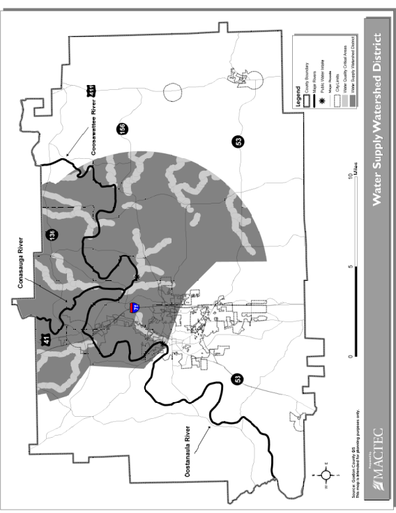
The following land use activities are exempted from the permit and site plan requirements of this section:
A.
Agriculture and forestry
1.
Normal agricultural activities involving planting and harvesting of crops, as well as livestock, poultry and horticulture are exempted if they conform to best management practices established by the Georgia Department of Agriculture and USDA.
2.
Silvicultural activities must conform to best management practices established by the Georgia Forestry Commission.
B.
Mining activities. All mining activities that are permitted by the Georgia Department of Natural Resources under the Georgia Surface Mining Act as amended are exempted.
A.
Within the water supply watershed district, the following limitations on permissible uses shall apply to all water quality critical areas:
1.
Industries. No industries or businesses that distribute or warehouse hazardous materials may be located within the water quality critical area.
2.
Commercial and service establishments. Uses that provide for the sale of fuel for motor vehicles are prohibited within the water quality critical area.
3.
Residential land use. There are no additional restrictions on the types of residential land use allowed within the water quality critical area.
4.
Agricultural land use. Uses that are not in conformance with the best management practices (BMPs) of the Georgia Department of Agriculture and USDA are prohibited.
5.
Landfills and waste disposal. No landfills or wastewater disposal facilities of any kind (except for septic tanks approved by the Board of Health) shall be allowed within the water quality critical area.
6.
Hazardous and toxic materials. No underground fuel or chemical storage tanks shall be allowed in the water quality critical area. No facilities that dispose of toxic or hazardous waste may be located within the water quality critical area. No industries or businesses classified as large quantity generators of hazardous waste may be located within the water quality critical area.
7.
Fuel and chemical storage tanks. Underground fuel or chemical storage tanks within the water supply watershed district shall meet all applicable requirements set by the Georgia Department of Natural Resources, Environmental Protection Division.
B.
Impervious surface setbacks
1.
For all perennial streams within a seven-mile radius of water supply intake, no impervious surface shall be constructed within a one hundred fifty (150) feet setback area on both sides of the stream as measured from the stream banks.
2.
For all perennial streams beyond a seven-mile radius of the water supply intake, no impervious surface shall be constructed within a seventy-five (75) feet setback area on both sides of the stream as measured from the stream banks.
C.
Vegetative buffers
1.
Stream buffers within water quality critical area. For all perennial streams within a seven-mile radius of a water supply intake, a vegetative buffer shall be maintained for a distance of fifty (50) feet on both sides of the stream as measured from the stream banks.
2.
Stream buffers outside the water quality critical area. For all perennial streams beyond a seven-mile radius of a water supply intake, a buffer shall be maintained for a distance of twenty-five (25) feet on both sides of the stream as measured from the stream banks.
3.
Silvicultural BMPs. Notwithstanding any other provisions of this section, forestry practices, in accordance with a forest management plan that incorporates best management practices (BMPs) approved by the Georgia Forestry Commission, shall be permissible in the buffer areas.
4.
Agricultural BMPs. Notwithstanding any other provisions of this section, the continued cultivation of agricultural crops and the pasturing of livestock shall be permissible within the buffer area, provided that the best management practices of the Georgia Department of Agriculture are followed.
D.
Septic tank drainfield restrictions. Septic tanks and septic tank drainfields are prohibited in the setback area established in subsections (B)(1) and (B)(2) above.
E.
Street runoff and drainage
1.
New streets constructed within the water quality critical area shall not require any curb and gutter improvements additional to those required in this ULDC.
2.
New streets that cross perennial streams within a seven-mile radius upstream of the water supply intake shall be designed in such a way as to avoid direct runoff from the paved surface into the streams they cross.
3.
Such design features shall be shown on the site plan.
F.
Hazardous materials handling
1.
New facilities located within the water supply watershed district that handle hazardous materials of a type and amounts requiring a permit from the department of natural resources or that require disposal at a hazardous materials facility by a hazardous materials handler permitted or licensed by the department of natural resources, shall perform their operations on impermeable surfaces having spill and leak collection systems.
2.
Such spill and leak collection systems shall be shown on the site plan in detail and must be approved, as part of the site plan, by the Director of Planning and Development.
G.
Soil erosion and sedimentation control. All developments and land-disturbing activity within the water supply watershed district shall comply fully with Section 3.06.00 of this ULDC.
The County or its designee, its agent, officers and employees shall have authority to enter upon privately owned land for the purpose of performing their duties under this section and may make or cause to be made such examinations, surveys or sampling as the County or its designee deems necessary.
A.
The Director of Planning and Development is hereby designated as the administrator and enforcement authority for this section.
B.
The Director of Planning and Development shall have authority to:
1.
Enforce this section;
2.
Issue permits hereunder; and
3.
Address violations or threatened violations hereof by issuance of violation notices, administrative orders and civil and criminal actions.
4.
All costs, fees and expenses in connection with such actions may be recovered as damages against the violator.
C.
Law enforcement officials or other officials having police powers shall have authority to assist the Director of Planning and Development in enforcement of this section.
D.
Any person who commits, takes part in or assists in any violation of any provision of this section shall be fined not more than two thousand five hundred dollars ($2,500.00) for each offense. Each violation shall be a separate offense and, in the case of a continuing violation, each day's continuance shall be deemed to be a separate and distinct offense.
E.
The Director of Planning and Development shall have the authority to issue cease and desist orders in the event of any violation of this section. Cease and desist orders may be appealed to a court of competent jurisdiction, as identified in Section 3.02.11 below.
F.
When a building or other structure has been constructed in violation of this section, the violator shall be required to remove the structure.
G.
When removal of vegetative cover, excavation or fill has taken place in violation of this section, the violator shall be required to restore the affected land to its original contours and to restore vegetation, as far as practicable.
Applications for a development permit within the watershed district shall include:
A.
Site plans required. Except for the exemptions listed in this section, all forms of development within the watershed district shall be required to have a site plan prepared and approved according to this section before any building permits or other development related permits may be issued or any land-disturbing activity may take place.
B.
Information required. Each site plan submitted under this section shall include the following:
1.
A site plan drawn to a scale of not less than one (1) inch equals fifty (50) feet showing all planned improvements including the width, depth and length of all existing and proposed structures, roads, watercourses and drainageways; water, wastewater and stormwater facilities; and utility installations.
2.
Location, dimensions and area of all impervious surfaces, both existing and proposed, on the site.
3.
The orientation and distance from the boundaries of the proposed site to the nearest bank of an affected perennial stream or water body.
4.
Elevations of the site and adjacent lands within two hundred (200) feet of the site at contour intervals of no greater than five (5) feet.
5.
Location and detailed design of any spill and leak collection systems designed for the purpose of containing accidentally released hazardous or toxic materials.
6.
Calculations of the amount of cut and fill proposed and cross-sectional drawings showing existing and proposed grades in areas of fill or excavation. Elevations, horizontal scale and vertical scale must be shown on cross-sectional drawings.
C.
Activities to comply with site plan. All development activities or site work conducted after approval of the site plan shall conform with the specifications of said site plan. Significant changes to the site plan, that would alter the amount and velocity of stormwater runoff from the site, increase the amount of impervious surface within the development, alter the overall density of development, result in a considerable increase in the amount of excavation, fill or removal of vegetation during construction or otherwise result in an alteration of the overall appearance of the development as proposed, can be amended only with the approval of the Director of Planning and Development. Minor changes, such as realignment of streets or minor alterations to drainage structures and other infrastructure to meet unexpected conditions, are exempted from this requirement.
D.
Exemptions from site plan requirement. The following activities and developments are exempt from the requirement for detailed site plans:
1.
Single-family detached homes constructed within a subdivision of fewer than five (5) parcels.
2.
Repairs to a facility that is part of a previously approved and permitted development.
3.
Construction of minor structures, such as sheds or additions to single-family residences.
E.
Pre-application conference. A pre-application conference between the applicant and the Director of Planning and Development can be scheduled at the request of the applicant. The purpose of the meeting is to review local land use restrictions, site plan requirements and the permitting process.
F.
Filing fee
1.
At the time of the application, the applicant shall pay a filing fee specified by the County or its designee.
2.
Filing fees up to a maximum of one hundred dollars ($100.00) may be required to evaluate the application.
3.
This fee may be used to retain expert consultants who will provide services pertaining to functional assessment and mitigation measures as deemed necessary by the Director of Planning and Development.
G.
Review procedures
1.
The application shall be made to the Director of Planning and Development and will be reviewed within thirty (30) days.
2.
The review period shall include the preparation of findings (approval or disapproval) by the Director of Planning and Development.
3.
The applicant will receive written notification of the findings of the Director of Planning and Development.
4.
If the review process is not completed within thirty (30) days, the application is considered to be approved.
H.
Appeals
1.
Decisions on permit applications made by the Director of Planning and Development may be appealed to the Gordon County Planning Commission.
2.
The appeal must be made within thirty (30) days of the decision rendered by the Director of Planning and Development.
3.
A public hearing shall be held for appeals.
4.
Public announcement of the hearing shall be printed in local newspapers at least fifteen (15) days prior to the hearing.
5.
Any person may offer testimony at the hearing.
6.
The decision of the Gordon County Planning Commission may be appealed to a court of competent jurisdiction, as discussed in Section 3.02.11.
I.
Public notice and public hearing
1.
Public notice of permit applications, through publication in local newspapers, is required.
2.
A public hearing on the application may be scheduled if requested by a citizen.
3.
Notice of the public hearing, through a local newspaper of general circulation, must be published at least fifteen (15) days prior to the hearing.
4.
A record of the proceedings shall be made and kept on file by the County or its designee.
5.
Any person may testify at the hearing.
J.
Duration of permit validity
1.
If construction described in the development permit has not commenced within twelve (12) months from the date of issuance, the permit shall expire.
2.
If construction described in the development permit is suspended after work has commenced, the permit shall expire twelve (12) months after the date that work ceased. In cases of permit expiration due to abandonment or suspension of work, the landowner shall be required to restore topography to its original contours and restore vegetation as far as practicable.
A.
Previous uses preserved generally. The lawful use of any building, structure or land use existing at the time of the enactment of this section may be continued, even though such use does not conform with the provisions of this section, except that the nonconforming structures or use shall not be:
1.
Changed to another nonconforming use;
2.
Reestablished after discontinuance for one (1) year;
3.
Extended except in conformity with this section;
4.
Structurally altered, except for repairs necessary for the continuation of the existing use.
B.
Replacement of nonconforming uses. A nonconforming building, structure or improvement which is hereafter damaged or destroyed to an extent exceeding fifty (50) percent of the reasonable estimated replacement cost of the structure, building or improvement, as determined by the Director of Planning and Development, may not be reconstructed or restored to the same nonconforming use except upon written approval of the Director of Planning and Development.
C.
Application to projects partially complete
1.
For any development that has received, before the effective date of this section, either preliminary plat approval, site plan approval, building permit or other relevant permits provided by the County or its designee and for which substantial work has been completed or substantial investment made in reliance upon such a permit, any future work included in said plat or plan may be completed without being subject to the additional regulations imposed in this section.
2.
Any significant additions, expansions or phases that deviate significantly from said plat or plan or that have not yet received a permit shall be subject to the provisions of this section.
A.
When issued. The Director of Planning and Development may authorize, upon appeal in individual cases, variances from the terms of this section as will not be contrary to the public interest. Variances will only be issued in cases where, owing to special conditions, a literal enforcement of the provisions of this section will result in unnecessary hardship. Such variance may be granted in individual cases of practical difficulty or unnecessary hardship only upon a finding by the Director of Planning and Development that all of the following conditions exist:
1.
There are extraordinary and exceptional conditions pertaining to the particular piece of property in question because of its size, shape or topography;
2.
The application of this section to the particular piece of property would create an unnecessary hardship;
3.
Relief, if granted, would not cause substantial detriment to the water quality of the water supply intake stream or impair the purposes and intent of this section;
4.
The special circumstances surrounding the request for a variance are not the result of acts by the applicant;
5.
The variance is not a request to permit a use of land, buildings or structures that is not permissible in the district involved; and
6.
The variance will not result in an increase of the impervious surface of the development beyond that prescribed according to Section 3.02.06.
B.
Conditions. The County or its designee may, as a condition of the variance to certain provisions of this section, require that alternative measures be taken by the applicant such that the purposes of this section may be achieved through alternative means.
A.
Jurisdiction. All final decisions of the County or its designee concerning denial, approval or conditional approval of a special permit shall be reviewable in the County superior court.
B.
Alternative actions. Based on these proceedings and the decision of the court, the Director of Planning and Development may, within the time specified by the court, elect to:
1.
Institute negotiated purchase or condemnation proceedings to acquire an easement or fee interest in the applicant's land;
2.
Approve the permit application with lesser restrictions or conditions (i.e., grant a variance); or
3.
Institute other appropriate actions ordered by the court that fall within the jurisdiction of the Director of Planning and Development.
These regulations and the watershed district map may from time to time be amended in accordance with procedures and requirements in the general statutes and as new information becomes available.
3.03.00 - GROUNDWATER RECHARGE AREA PROTECTION
3.03.01 Findings of Fact
A.
In order to provide for the health, safety and welfare of the public and a healthy economic climate within Gordon County, Georgia, and surrounding communities, it is essential that the quality of public drinking water be ensured.
B.
For this reason, it is necessary to protect the subsurface water resources that the County and surrounding communities rely on as sources of public water.
C.
Groundwater resources are contained within aquifers, which are permeable rock strata occupying vast regions of the subsurface.
D.
These aquifers are replenished by infiltration of surface water runoff in zones of the surface known as groundwater recharge areas.
E.
Groundwater is susceptible to contamination when unrestricted development occurs within significant groundwater recharge areas.
F.
It is, therefore, necessary to manage land use within groundwater recharge areas in order to ensure that pollution threats are minimized.
The objectives of this section are to:
A.
Protect groundwater quality by restricting land uses that generate, use or store dangerous pollutants in recharge areas;
B.
Protect groundwater quality by limiting density of development; and
C.
Protect groundwater quality by ensuring that any development that occurs within the recharge area shall have no adverse effect on groundwater quality.
3.03.03 Establishment of Groundwater Recharge Area District
A groundwater recharge area district is hereby established which shall correspond to all lands within the jurisdiction of the County that are mapped as significant recharge areas by the Georgia Department of Natural Resources in Hydrologic Atlas 18, 1989 edition.
3.03.04 Determination of Pollution Susceptibility
Each recharge area shall be determined to have a pollution susceptibility of high, medium or low based on the Georgia Pollution Susceptibility Map prepared by the Georgia Department of Natural Resources.
3.03.05 Permit Requirements and Enforcement
A.
Generally. No building permit, rezoning request or subdivision plan will be approved by the Director of Planning and Development unless the permit, request or plan is in compliance with the groundwater protection standards listed in Section 3.03.06.
B.
Enforcement. Gordon County, its agent, officers and employees shall have authority to enter upon privately owned land for the purpose of performing their duties under this section and may make or cause to be made such examinations, surveys or sampling as the County deems necessary.
1.
The Director of Planning and Development is hereby designated as the administrator and enforcement officer for this section.
2.
The Director of Planning and Development shall have authority to enforce this section, issue permits hereunder, and address violations or threatened violations hereof by issuance of violation notices, administrative orders and civil and criminal actions. All costs, fees and expenses in connection with such actions may be recovered as damages against the violator.
3.
Law enforcement officials or other officials having police powers shall have authority to assist the Director of Planning and Development in enforcement.
4.
Any person who commits, takes part in or assists in any violation of any provision of this section shall be fined not more than two thousand five hundred dollars ($2,500.00) for each offense. Each violation shall be a separate offense and, in the case of a continuing violation, each day's continuance shall be deemed to be a separate and distinct offense.
5.
The Director of Planning and Development shall have the authority to issue cease and desist orders in the event of any violation of this section. Cease and desist orders may be appealed to a court of competent jurisdiction, as identified in Section 3.03.07.
6.
When a building or other structure has been constructed in violation of this section, the violator shall be required to remove the structure.
7.
When removal of vegetative cover, excavation or fill has taken place in violation of this section, the violator shall be required to restore the affected land to its original contours and to restore vegetation, as far as practicable.
8.
No person may begin the physical development of a lot or structure thereon, where an on-site sewage management system will be utilized, not install an on-site sewage management system or component thereof without having first applied for and obtained from the Board of Health a construction permit for the installation.
C.
Permit review and site plan requirement. With the exception of certain exempted activities identified in Section 3.03.05(D), applications for a development permit within the groundwater recharge area district shall include a site plan. The following information is required for all site plans:
1.
A map or maps, drawn to a scale of not less than one (1) inch equals fifty (50) feet, showing all planned improvements including the width, depth and length of all existing and proposed structures, roads, watercourses and drainageways, water lines, wastewater and stormwater facilities, and utility installations, shall be provided by the applicant.
2.
Location, dimensions and area of all impervious surfaces, both existing and proposed, on the site.
3.
The orientation and distance from the boundaries of the proposed site to the nearest bank of an affected perennial stream or water body.
4.
Elevations of the site and adjacent lands within two hundred (200) feet of the site at contour intervals of no greater than five (5) feet.
5.
Location and detailed design of any spill and leak collection systems designed for the purpose of containing accidentally released hazardous or toxic materials.
6.
Calculations of the amount of cut and fill proposed and cross-sectional drawings showing existing and proposed grades in areas of fill or excavation. Elevations, horizontal scale and vertical scale must be shown on cross-sectional drawings.
7.
Activities to comply with site plan. All development activities or site work conducted after approval of the site plan shall conform with the specifications of said site plan. Significant changes to the site plan that would alter the amount and velocity of stormwater runoff from the site, increase the amount of impervious surface within the development, alter the overall density of development, result in a considerable increase in the amount of excavation, fill or removal of vegetation during construction or otherwise result in an alteration of the overall appearance of the development as proposed, can be amended only with the approval of the Director of Planning and Development. Minor changes, such as the realignment of streets or minor alterations to drainage structures and other infrastructure to meet unexpected conditions, are exempted from this requirement.
D.
Exemptions to site plan requirements. The following activities and developments are exempt from the requirement for detailed site plans:
1.
Single-family detached homes constructed within a subdivision of fewer than five (5) parcels.
2.
Repairs to a facility that is part of a previously approved and permitted development.
3.
Construction of minor structures, such as sheds or additions to single-family residences.
E.
Review procedures
1.
The application shall be made to the Director of Planning and Development and will be reviewed within thirty (30) days.
2.
The review period shall include the preparation of findings (approval, approval with conditions or disapproval) by the Director of Planning and Development.
3.
The applicant will receive written notification of the findings of the Director of Planning and Development.
4.
If the review process is not completed within thirty (30) days, the application is considered to be approved.
5.
Decisions of the Director of Planning and Development may be appealed to the County.
F.
Public notice and public hearing
1.
Public notice of permit applications, through publication in local newspapers, is required.
2.
A public hearing on the application, to be held before the County, may be scheduled if requested by a citizen.
3.
Public announcement of the hearing shall be printed in a local newspaper of general circulation at least fifteen (15) days prior to the hearing.
4.
A record of the proceedings shall be made and kept on file by the County.
5.
Any person may testify at the hearing.
6.
Decisions of the County may be appealed to a court of competent jurisdiction identified in Section 3.03.07.
G.
Duration of permit validity
1.
If construction described in the development permit has not commenced within twelve (12) months from the date of issuance, the permit shall expire.
2.
If construction described in the development permit is suspended or abandoned after work has commenced, the permit shall expire twelve (12) months after the date that work ceased.
3.
Written notice of pending expiration of the development permit shall be issued by the County.
3.03.06 Groundwater Protection Standards
A.
For all pollution susceptibility areas, new waste disposal facilities must have synthetic liners and leachate collection systems.
B.
New agricultural impoundments shall meet the following requirements:
1.
For areas of high susceptibility, a liner shall be provided that is approved by the Natural Resource and Conservation Service (NRCS).
2.
For areas of medium susceptibility, an NRCS approved liner shall be provided if the site exceeds fifteen (15) acre-feet.
3.
For areas of low susceptibility, an NRCS approved liner shall be provided if the site exceeds fifty (50) acre-feet.
C.
No land disposal of hazardous waste shall be permitted within any significant groundwater recharge area.
D.
For all significant groundwater recharge areas, the handling, storage and disposal of hazardous materials shall take place on an impermeable surface having spill and leak protection approved by the Georgia Department of Natural Resources, Environmental Protection Division (EPD).
E.
For all significant groundwater recharge areas, new aboveground chemical or petroleum storage tanks larger than six hundred fifty (650) gallons must have secondary containment for one hundred ten (110) percent of tank volume or one hundred ten (110) percent of the largest tanks in a cluster of tanks.
F.
For high pollution susceptibility areas, new wastewater treatment basins shall have an impermeable liner approved by EPD.
G.
For high pollution susceptibility areas, no new stormwater infiltration basins may be constructed.
H.
For high pollution susceptibility areas, wastewater spray irrigation systems or the land spreading of wastewater sludge shall be practiced in accordance with department of natural resources criteria for slow rate land treatment. An application for a development permit for activities involving wastewater spray irrigation or land spreading of wastewater sludge must be accompanied by proof that the applicant has received a land application system permit from EPD.
I.
Minimum lot sizes and septic systems. To provide for the orderly and safe development of property utilizing on-site sewage management systems, minimum lot sizes have been established. Larger lot sizes may be required depending on the proposed development of the property. The Board of Health and/or other County authorities may require larger minimum lot sizes; the larger minimum lot sizes will take precedence. Lot sizing requirements are as follows for single-family dwellings such as mobile homes, stick built homes, modular homes, etc. on individual lots in subdivisions and mobile home lots located in areas other than commercial mobile home parks. See Tables 3.03.06(A) and 3.03.06(B) below.
Table 3.03.06(A)
Minimum Lot Size Requirements
Note: Refer to Section 3.03.04, Determination of pollution susceptibility.
Table 3.03.06(B)
Minimum Lot Sizes and Maximum Allowable Sewerage Flow, Based on Type of Water Supply
System
1 Zoning district may require a larger minimum lot size; reference Chapters 2 and 4 for requirements.
1.
The above minimum lot sizes are for the typical size home (three- or four-bedroom) with basic appurtenances such as driveway, minimum number of trees, and water supply line. If larger homes, swimming pools, tennis courts or outbuildings, etc. are proposed to be constructed or if trees would interfere with installation of an on-site sewage management system, larger lots will be required by the Board of Health to assure usable soil area.
2.
The Board of Health will also require larger lot sizes when physical factors indicate the need to do so. These factors include, but are not limited to, the availability of sufficient unobstructed land areas for an approved on-site sewage management system and approved replacement system, slope over five (5) percent, percolation rates higher than forty-five (45) minutes per inch, and need for subsurface drainage or adverse topographic features.
3.
The following land area is not considered as a part of a lot when calculating the required minimum lot size: Rights-of-way of roads, easements (such as power line or pipe line) that exclude installation of an on-site sewage management system, bodies of water, land within a floodplain, land within fifty (50) feet of a lake, river, stream, wetland or other body of water and similar limiting factors.
4.
There must be an unobstructed area on each lot for installation of an approved on-site sewage management system and an equal or larger area, as appropriate, for an approved replacement system. This will include sufficient area for necessary site modifications for installation of both the initial system and replacement system. All pertinent County zoning setbacks and other space requirements must also be met.
5.
The maximum daily sewage flow for each lot or parcel of land shall not exceed six hundred (600) gallons per acre per day (gpad) or one thousand two hundred (1,200) gpad when served by a non-public or public water supply system respectively. When sewage flows exceed these quantities (six hundred (600) or one thousand two hundred (1,200) gpad as indicated) for a given dwelling structure, the minimum lot size or parcel of land shall be increased proportionally according to the following example: Assume a public water supply exists (so one thousand two hundred (1,200) gpad maximum sewage flow allowed per minimum required land area twenty-one thousand seven hundred eighty (21,780) square feet), and there is a proposed sewage flow of five thousand (5,000) gpad. To determine X = the square footage of the lot needed, use the following formula (Note: 43,560 sq. ft. = One (1) acre):
J.
Minimum lot sizes are determined based on site specific high intensity soil study conducted by approved soil classifiers. Soil classifiers are as defined in the Rules of Department of Community Health Public Health, Chapter 290-5-26, On-Site Management Systems.
1.
Minimum requirements for a High Intensity Soil Study
i.
A High Intensity Soil Study shall be identified as a Level III Soil Survey and Map. A Level III Soil Survey and/or Soil Map are based on a comprehensive soils investigation of a given landscape. The purpose of the soil survey is to identify, delineate and interpret the suitability of the soil series found on the site as it pertains to use for an on-site sewage management systems. The soil survey must meet or exceed specified accuracy and quality standards for the data from which the Board of Health permits on-site sewage management systems.
ii.
All Level III Soil Surveys and related interpretive data shall be based on the Georgia Department of Community Health Manual for On-Site Sewage Management Systems, National Cooperative Soil Survey standards and the current Soil Survey Manual (Soil Survey Staff, 1993). Soil series used to name map units must be classified according to the most recent edition of Soil Taxonomy (Soil Survey Staff, 1999), with map unit boundaries and map features plotted on a map at a scale that may range from one inch equals ten feet (1" = 10') to one inch equals one hundred feet (1" = 100'). Smaller map scales (1" = 200', 1" = 500', etc.) are not acceptable.
iii.
Level III Soil Surveys must be based on a two-foot contour interval topographic map. The topographic map and boundary survey must be provided before the beginning of any fieldwork. The soil survey must include a title block or caption that includes the project and/or client name, location of the project, date of the survey, narrative and bar scale and north arrow. The soil survey shall include any features that may affect the location or performance of on-site sewage management systems. Examples are: The location of springs, wells, existing structures, rock outcrops, ephemeral drains, gullies and visible trash pits. The soil survey must include a legend that defines any symbols used to illustrate these features on the soil map. The soil survey and soil map must bear the name, stamp, address and telephone number of the Certified Soil Classifier, Registered Engineer or Registered Geologist performing the survey. The "Official" Level III Soil Survey used for on-site sewage management system permitting is that which bears the original seal and signature of the individual performing the work. The Certified Soil Classifier, Registered Engineer or Registered Geologist shall affix their signature and seal only on soil surveys that are their work or work performed under their direct supervision. Any revision to a Level III Soil survey must be clearly designated as such and dated.
iv.
The Level III Soil Survey must include a table or narrative that describes site-specific properties of each map unit (named for soil series) mapped at the site. For each map unit, the table or narrative must include the following: soil series name (symbols are not allowed), the percent slope or slope range (symbols are not allowed), minimum depth (range is unnecessary) to seasonal saturation (seasonal high water table), minimum depth (range is unnecessary) to auger refusal or impervious layer (soft or hard bedrock or other horizons that restrict water movement), recommended installation depth (if applicable) and estimated percolation rate at the recommended installation depth (if applicable). The estimated percolation rate shall be based on the most limiting soil horizon that comes into contact with the absorption trench sidewall, bottom and for a distance one (1) foot below the recommended installation depth.
v.
The upper and lower depth limits of the horizon in which installation is recommended shall be provided for each map unit. The depth range over which installation is recommended must be at least twenty-four (24) inches to encompass a twelve-inch sidewall thickness and twelve (12) inches of soil below the trench bottom. If the twenty-four-inch thickness installation zone includes a horizon with lower percolation rate than the optimum, the maximum percolation rate in the depth interval must be used for on-site system design. Minimum depths to bedrock or seasonal saturation shall be provided for each map unit and specific depths identified for each boring on the soil map. Phases of soil series are an acceptable method to map depths more narrow than those used to define the series. Variants of series have different interpretations than the named series and these differences shall be reflected in the interpretive table.
vi.
An interpretive statement describing the limitations for utilization of on-site sewage management systems shall be provided for each Soil Series map unit. This interpretive statement may contain notes, observations or other pertinent information reflecting the soil properties of the map unit that affect its ability to function for wastewater disposal. These map unit interpretation statements must be based on the soil properties and landscape positions observed on-site by the approved professional. Map unit interpretive statements shall be expressed in a narrative format on the soil survey report or soil map.
vii.
The number of soil observations required for the Level III Soil Survey will depend on the soil conditions encountered during the study and landscape complexity at the site. At least four (4) pedons shall be evaluated and classified for each one (1) acre mapped. For example, if an area is 1.5 acres, a minimum of six (6) test borings must be evaluated and classified. If the site is less than one (1) acre, a minimum of four (4) pedons shall be evaluated and classified. However, the soil classifier, registered engineer or registered geologist shall perform as many soil boring observations as necessary to ensure the named soil series or a soil series with similar or more favorable properties are verifiable on-site. All soil observations must be numbered and flagged on site and their location illustrated with a symbol and corresponding boring number on the finished soil map. All permanent and reproducible ground control points utilized to locate soil observations will be shown on the finished soil map so these observation points can be reestablished at a later date. All soil maps must contain a statement describing the method and/or instruments used to locate each soil observation from control points.
viii.
Boundaries between map units are commonly gradual instead of abrupt as implied by a line drawn on a map. In addition, the boundary between map units may be difficult to locate exactly unless definitive landscape features are present or closely spaced soil observations are made to locate the boundary. To ensure that on-site sewage systems are not installed in soils unsuitable for their use, soil delineation lines between suitable soils, limited suitable soils and unsuitable soils shall be accurate to within twenty (20) feet of the delineated soil boundary. If through additional closely spaced soil observations the site evaluator can document the area within twenty (20) feet of the boundary has soils suitable for an on-site sewage system (conventional or alternative), the system may be installed closer than twenty (20) feet from the suitable-limited suitable-unsuitable boundary. The location of all observations used to determine near boundary soil suitability must be shown on the final soil map and characteristics observed must be summarized in the site report.
ix.
All soil observations shall be a minimum depth of seventy-two (72) inches unless a refusal layer, including seasonal saturation horizon, is identified. If the lower limit of the recommended installation depth is greater than forty-eight (48) inches, the soil observation must be extended to no less than twenty-four (24) inches beneath this lower limit. Backhoe pits may be substituted for observations from auger borings. Mechanical augers, which disturb soil structure, shall not be used.
x.
The soil classifier, registered engineer or registered geologist must keep field notes for each soil observation that include: boring number, soil series name, percent slope, depth and type of restrictive horizons present and morphological properties of major subsoil horizons (upper and lower depth, texture, matrix and redoximorphic feature color (Munsell notation)). All surveys and related interpretive data shall meet National Conservation Soil Survey (NCSS) and United States Department of Agriculture (USDA) Soil survey manual standards for map purity. Map units will not have more than fifteen (15) percent inclusions of soils with different interpretation for on-site sewage management systems from the named series.
2.
Minimum requirements for special soil investigations
i.
A special soil study shall be identified as a Level IV Soil Survey. The Board of Health may require special soil studies when alternative on-site sewage management systems are proposed and additional soil data are needed to adequately address site suitability and/or system design. The Board of Health should be consulted prior to the initiation of the special investigation.
ii.
The special investigation will typically be made for a specific location within an individual lot or parcel in the area proposed for the installation of an on-site sewage management system. Special investigations may include measurement of percolation rate for specific horizons, excavations to determine bedrock hardness and continuity, monitoring seasonal groundwater tables or other similar data that may be needed to aid in the interpretation of soil suitability and the protection of ground and surface water. Finished soil reports will have clear and obvious designations as to information that is Level III and/or Level IV.
iii.
A Level IV Soil Survey expands on the existing Level III Soil Survey in thoroughness and/or detail. Results of the Level IV soil investigation should be presented in a format similar to that of the Level III soil investigation, including a map with more detailed soil delineations and/or location of measurements, an interpretive table and, if needed, narrative statements describing methods and results that impact suitability for an on-site sewage management system. The Level IV Soil Survey shall meet all minimum requirements of the Level III Soil Survey, with the exception that test boring sites from the previous Level III investigation may be used for the Level IV investigation. There is no minimum number of pedon observations required for a Level IV. At a Level IV intensity, individual soil series are expected to be mapped and delineated with such a degree of accuracy that, at any location chosen to investigate within a given map unit, the named soil series or one with similar or more favorable properties for the installation of an on-site wastewater management system must be verifiable. The name, official seal and signature of the Certified Soil Classifier, Registered Engineer or Registered Geologist performing the investigation must be on the report.
3.
Soil data acceptability for individual lots
i.
Soil evaluations on individual lots shall be performed by the following individuals: A Certified Soil Classifier, Registered Engineer or Registered Geologist if a Level 3 Soil Survey is required.
ii.
With the approval of the Board of Health, an Environmental Health Specialist I or higher, District Environmental Health Director, DCH Environmental Health Program Director, meeting the following requirements, may conduct soil investigations for individual lots for single family residences: A Level II Inspector Certification; and, successfully passes a field examination demonstrating the ability to identify soil texture and expected percolation rate, identify redoximorphic features and identify restricted or impervious soil horizons.
iii.
Individuals who are approved by the Board of Health that perform soil evaluations on individual lots for single-family residences shall follow the following protocols: A minimum of three (3) soil borings shall be dug in the proposed location of the on-site sewage management system absorption field and duplicate absorption field area; and, all borings shall be dug to a minimum depth of seventy-two (72) inches unless a refusal layer is identified or to no less than twenty-four (24) inches beneath the planned absorption trench bottom installation depth.
iv.
A soil report shall be made containing: a sketch identifying boring locations; a table identifying boring number, expected percolation rate and depth at which it occurs, the depth of seasonal high water table and depth of any refusal layer; and, sites with poor percolation, redoximorphic features or impervious soil horizons within twenty-four (24) inches of the planned absorption trench bottom, a seasonal high water table within thirty (30) inches of the original ground surface or any other questionable soil features will be referred to a certified soil classifier, registered engineer or registered geologist for evaluation.
4.
Evaluation of soil for use as fill material
i.
Evaluation of soil for use as fill material on individual lots may be performed by the following individuals: a Certified Soil Classifier, Registered Engineer or Registered Geologist; with approval of the Board of Health, a Level II Certified Environmental Health Specialist I or higher, who has successfully completed training and demonstrated proficiency in soil fill evaluation may approve soil for fill material.
ii.
Individuals approved by the Board of Health to perform soil evaluations of fill material shall follow the following protocols: a minimum of four (4) borings shall be dug within the in place fill material; all borings shall be dug to a minimum depth twelve (12) inches below the original soil surface; and, a fill site evaluation form shall be completed providing evidence that the vegetative topsoil has been removed and fill area properly tilled, the soil fill is examined for texture and fines, the percolation rate is estimated, and the size of the filled area is identified and the filled area properly sloped.
(Res. of 12-20-11)
A.
Jurisdiction. All final decisions of the County or its designee concerning denial, approval or conditional approval of a special permit shall be reviewable in the County superior court.
B.
Alternative actions. Based on these proceedings and the decision of the court, the Director of Planning and Development may, within the time specified by the court, elect to:
1.
Institute negotiated purchase or condemnation proceedings to acquire an easement or fee interest in the applicant's land;
2.
Approve the permit application with lesser restrictions or conditions (i.e., grant a variance); or
3.
Institute other appropriate actions ordered by the court that fall within the jurisdiction of the Director of Planning and Development.
These regulations may, from time to time, be amended in accordance with procedures and requirements in general state statutes and as new information becomes available to Gordon County.
3.04.00 - RIVER CORRIDOR PROTECTION
3.04.01 Findings and Purpose
A.
The Conasauga, Coosawattee and Oostanaula Rivers have been designated as protected rivers by the Georgia Department of Community Affairs, and the Gordon County River Corridor Protection Plan has been adopted by the County.
B.
The purpose of the Gordon County River Corridor Protection District is to establish measures to guide future growth and development in the areas adjacent to the Conasauga, Coosawattee and Oostanaula Rivers.
3.04.02 Establishment of River Corridor Protection Districts
A.
The County river corridor protection district is hereby designated and shall comprise the land within one hundred (100) feet horizontally on both sides of the Conasauga, Coosawattee and Oostanaula Rivers, which have been designated as protected rivers by the Georgia Department of Community Affairs.
B.
The district establishes measures to guide future growth and development in areas adjacent to the Conasauga, Coosawattee and Oostanaula Rivers. Because these protective measures allow some latitude with land uses and because the district is not intended to prescribe a specific land use but rather to define a range of acceptable land uses, the district is designated as an overlay district. Within the range of land uses which can be located within the district, there are established in Section 3.04.04 protection criteria which apply to development within the district.
3.04.03 Regulation of Underlying Zoning District
Unless otherwise noted in this section, the regulation of the underlying zoning district as provided in this ULDC shall be maintained and not affected.
A.
All development within the County river corridor district shall maintain a natural vegetative buffer except as otherwise provided herein.
B.
The natural vegetative buffer shall be restored as quickly as possible following any land-disturbing activity within the river corridor.
C.
Except as noted below, all construction within the buffer area is prohibited.
D.
Exemptions from protection requirements:
1.
Construction of road crossings and utility crossings of river corridors are exempt provided that construction of such road and utility crossings shall meet all requirements of the Erosion and Sedimentation Control Act of 1975, and of the applicable local provisions pertaining to soil erosion and sedimentation control as identified in this ULDC.
2.
Land use existing prior to the adoption of this section subject to the following conditions:
a.
Industrial and commercial uses of river corridors shall not impair the drinking quality of the river water; and
b.
Industrial and commercial activity within the river corridor shall meet all state and federal environmental rules and regulations.
3.
Mining activities if permitted by the Georgia Department of Natural Resources pursuant to the Georgia Surface Mining Act of 1968, as amended.
4.
Utilities (except as discussed above in Section 3.04.04(D)(2), if such utilities cannot feasibly be located outside the buffer area (feasibility shall be decided conservatively by the local government), provided that:
a.
The utilities shall be located as far from the river bank as reasonably possible;
b.
Installation and maintenance of the utilities shall be such as to protect the integrity of the buffer area as well as is reasonably possible; and
c.
Utilities shall not impair the drinking quality of the river water.
6.
Specific forestry and agricultural activities except as discussed in Section 3.04.04(D)(7) below.
7.
The following acceptable uses of river corridors are allowed, provided that such uses do not impair the long-term functions of the protected river or the river corridor:
a.
Timber production and harvesting, subject to the following conditions:
1.
Forestry activity shall be consistent with best management practices established by the Georgia Forestry Commission; and
2.
Forestry activity shall not impair the drinking quality of the river water as defined by the Federal Clean Water Act, as amended.
b.
Wildlife and fisheries management activities consistent with the purposes of O.C.G.A. § 12-2-8, Article 1, Chapter 2, Title 12 (as amended).
c.
Wastewater treatment.
d.
Recreational usage consistent either with the maintenance of a natural vegetative buffer or with river-dependent recreation. For example, a boat ramp would be consistent with this criterion but a hard-surface tennis court would not. Parking lots are not consistent with this criterion. Paths and walkways within the river corridor are consistent with this criterion.
e.
Natural water quality treatment or purification.
f.
Agricultural production and management, subject to the following conditions:
1.
Agricultural activity shall be consistent with best management practices established by the Georgia Soil and Water Conservation Commission;
2.
Agricultural activity shall not impair the drinking quality of the river water as defined by the Federal Clean Water Act, as amended; and
3.
Agricultural activity shall be consistent with all state and federal laws, and all regulations promulgated by the Georgia Department of Agriculture.
g.
Other uses permitted by the Georgia Department of Natural Resources or under Section 404 of the Clean Water Act, with the exception of inhabitable structures.
Within the County river corridor protection district, the following limitations on permissible uses shall apply in addition to the regulations of the underlying zoning district:
A.
Except as expressly provided for under Section 3.04.04(D)(1) of these criteria (dealing with single-family dwellings within the river corridor), septic tanks and septic tank drainfields are prohibited within river corridors.
B.
Handling areas for the receiving and storage of hazardous waste are prohibited within river corridors.
C.
Hazardous waste or solid waste landfills are prohibited within river corridors.
D.
Other uses unapproved by the County shall not be acceptable within river corridors.
3.05.00 - WETLANDS PROTECTION
3.05.01 Findings, Title, and Purpose
A.
Findings of fact
1.
The wetlands within Gordon County, Georgia, are indispensable and fragile natural resources with significant development constraints due to flooding, erosion and soils limitations.
2.
In their natural state, wetlands serve man and nature. They provide habitat areas for fish, wildlife and vegetation; water quality maintenance and pollution control; flood control; erosion control; natural resource education; scientific study; and open space and recreational opportunities. In addition, the wise management of forested wetlands is essential to the economic well-being of many communities within the State of Georgia.
3.
Nationally, a considerable number of these important natural resources have been lost or impaired by draining, dredging, filling, excavating, building, pollution and other acts. Piecemeal or cumulative losses will, over time, destroy additional wetlands. Damaging or destroying wetlands threatens public safety and the general welfare.
4.
It is therefore necessary for the County to ensure maximum protection for wetlands by discouraging development activities that may adversely affect wetlands.
B.
Title. This section shall be known as "Wetlands Protection."
C.
Purpose. The purpose of this section is to promote wetland protection, while taking into account varying ecological, economic development, recreational and aesthetic values. Activities that may damage wetlands should be located on upland sites to the greatest degree practicable as determined through a permitting process. The objective of this section is to protect wetlands from alterations that will significantly affect or reduce their primary functions for water quality, floodplain and erosion control, groundwater recharge, aesthetic nature and wildlife habitat.
3.05.02 Wetlands Protection District
A.
The Wetlands Protection District is hereby established which shall correspond to all lands within the jurisdiction of Gordon County, Georgia that are mapped as wetland areas by the U.S. Fish and Wildlife Service, National Wetlands Inventory Maps. The NWI Maps are available at http:www.fws.gov/nwi
B.
The generalized wetland map is a general reference document, and wetland boundaries indicated on the map are approximations. The purpose of the generalized wetland map is to alert developers/landowners if they are within proximity to a wetland, which means that there is a high likelihood of the presence of a jurisdictional wetland and a need for the developer/landowner to seek U.S. Army Corps of Engineers guidance as to whether a Section 404 permit will be required prior to any activity.
C.
The generalized wetland map does not represent the boundaries of jurisdictional wetlands within the jurisdiction of the County and cannot serve as a substitute for a delineation of wetland boundaries by the U.S. Army Corps of Engineers, as required by Section 404 of the Clean Water Act, as amended.
D.
Any local government action under this section does not relieve the landowner from federal or state permitting requirements.
3.05.03 Local Development Permit Requirements
A.
Generally
1.
No regulated activity will be allowed within the wetland protection district without written permission from the County or its designee in the form of a local development permit. Issuance of a local development permit is contingent on full compliance with the terms of this section and other applicable regulations.
2.
All activities that are not identified in subsection (B) below or in other provisions of this ULDC shall be prohibited without prior issuance of a local development permit.
3.
If the area proposed for development is located within two hundred (200) feet of the wetland protection district boundary, as determined from the generalized wetland map, a U.S. Army Corps of Engineers determination shall be required.
4.
If the corps determines that wetlands are present on the proposed development site and that a Section 404 permit or letter of permission is required, a local development permit will be issued only following issuance of the Section 404 permit or letter of permission.
B.
Permissible uses (uses as of right). The following uses shall be allowed as of right within a wetland to the extent that they are not prohibited by any other ordinance or law, including laws of trespass, and provided they do not require structures, grading, fill, draining or dredging except as provided herein:
1.
Conservation or preservation of soil, water, vegetation, fish and other wildlife, provided they do not affect waters of Georgia or of the United States in such a way that would require an individual 404 permit.
2.
Outdoor passive recreational activities, including fishing, bird watching, hiking, boating, horseback riding and canoeing.
3.
Forestry practices applied in accordance with best management practices approved by the Georgia Forestry Commission and as specified in Section 404 of the Clean Water Act.
4.
The continued cultivation of agricultural crops. Agricultural activities shall be subject to best management practices approved by the Georgia Department of Agriculture.
5.
The pasturing of livestock, provided that riparian wetlands are protected, that soil profiles are not disturbed and that approved agricultural best management practices are followed.
6.
Education, scientific research and nature trails.
7.
Temporary emergency permit. A temporary emergency permit can be issued by the County or its designee for the following reasons:
a.
Maintenance or repair of lawfully located roads or structures and of facilities used in the service of the public to provide transportation, electric, gas, water, telephone, telegraph, telecommunications or other services, provided that such roads, structures or facilities are not materially changed or enlarged and written notice prior to the commencement of work has been given to the County or their designee and provided that the work is conducted using best management practices to ensure that flow and circulation patterns and chemical and biological characteristics of the wetland are not impaired and that any adverse effect on the aquatic environment will be minimized.
b.
Temporary water-level stabilization measures associated with ongoing silvicultural operations.
c.
Limited ditching, tilling, dredging, excavating or filling done solely for the purpose of maintaining or repairing existing drainage systems necessary for the cultivation of agricultural crops, provided that the maintenance or repair activity does not result in the impairment, alteration or loss of wetlands not previously subject to agricultural and silvicultural use.
d.
Limited excavating and filling necessary for the repair and maintenance of piers, walkways, nature trails, observation decks, wildlife management shelters, boathouses or other similar water-related structures, provided that they are built on pilings to allow unobstructed flow of water and preserve the natural contour of the wetland.
C.
Site plans. Applications for a local development permit within the generalized wetland protection district shall include a site plan, drawn at a scale of not less than one (1) inch equals fifty (50) feet, with the following information:
1.
A map of all planned excavation and fill, including calculations of the volume of cut and fill involved, cross-sectional drawings showing existing and proposed grades. Elevations, horizontal scale and vertical scale must be shown on the cross-sectional drawings.
2.
A map of any wetland boundaries occurring within the site must be provided. This boundary may be included on other maps provided by the applicant.
3.
Location, dimensions and area of all impervious surfaces, both existing and proposed, on the site and adjacent to the site for a distance of one hundred (100) feet.
4.
The orientation and distance from the boundaries of the proposed site to the nearest bank of an affected perennial stream or water body.
5.
Elevations of the site and adjacent lands within two hundred (200) feet of the site at contour intervals of no greater than two (2) feet; and no greater than one (1) foot for slopes less than or equal to two (2) percent.
6.
Location and detailed design of any spill and leak collection systems designed for the purpose of containing accidentally released hazardous or toxic materials.
7.
All proposed temporary disruptions or diversions of local hydrology.
D.
Activities to comply with site plan. All development activities or site work conducted after approval of the site plan shall conform with the specifications of said site plan. The site plan may be amended only with the approval of the County or its designee. The County or its designee may require additional information deemed necessary to verify compliance with the provisions of this section or to evaluate the proposed use in terms of the purposes of this section.
E.
Subdivision design options in the wetland protection district. Any subdivision that includes jurisdictional wetlands shall be allowed and encouraged to use the following options:
1.
Lot size averaging. Lot size averaging is encouraged in single-family detached subdivisions as a means to work around wetland areas. The County or their designee may allow a reduction in lot size provided that the same number of lots in the same subdivision are oversized by an equal or greater area. The maximum permissible reduction shall not exceed twenty-five (25) percent of the minimum required lot area. The number of lots with areas reduced shall not exceed twenty-five (25) percent of the total number of lots in the subdivision. The County or its designee shall require no more than a twenty-five (25) percent adjustment of rear, side and front setbacks for each affected lot.
2.
Cluster development. Clustering of residential development is encouraged. When considering subdivision approval, the County or its designee will allow incorporation of wetland or other significant natural areas as open space in the subdivision plan. Such plans should designate at least twenty-five (25) percent of the gross land area as open space. Density shall be calculated by subtracting from the total acreage of a parcel all land dedicated or in use for private or public roads, including all vehicular rights-of-way. The resultant acreage will then be divided by the minimum allowed lot size of the district to derive the number of lots permissible.
F.
Filing fee. At the time of the application, the applicant shall pay a filing fee specified by the County or its designee. Filing fees up to a maximum of one hundred dollars ($100.00) may be required to evaluate the application. This fee may be used to retain expert consultants who will provide services pertaining to functional assessment, mitigation and wetland boundary determinations as deemed necessary by the County or its designee.
G.
Enforcement authority. The Director of Planning and Development is hereby established as the administrator of this section.
H.
Review procedures. The application shall be made to the Director of Planning and Development and will be reviewed within thirty (30) days. The review period shall begin upon determination by the Director of Planning and Development that the application submitted is complete. The review period shall include the preparation of findings (approval or disapproval) by the Director of Planning and Development. The applicant will receive written notification of the findings of the County or its designee. If the review process is not completed within thirty (30) days, the application is considered to be approved.
I.
Appeals. Decisions on permit applications made by the Director of Planning and Development may be appealed to the Gordon County Planning Commission. The appeal must be made within thirty (30) days of the decision rendered by the Director of Planning and Development. A public hearing shall be held for appeals. Public announcement of the hearing shall be printed in a local newspaper of general circulation at least fifteen (15) days prior to the hearing. Any person may offer testimony at the hearing. The decision of the Gordon County Planning Commission may be appealed to a court of competent jurisdiction, as discussed in Section 3.05.06.
J.
Duration of permit validity
1.
If construction described in the development permit has not commenced within twelve (12) months from the date of issuance, the permit shall expire.
2.
If construction described in the development permit is suspended or abandoned after work has commenced, the permit shall expire twelve (12) months after the date that work ceased.
3.
Written notice of the pending expiration of the development permit shall be issued by the Director of Planning and Development.
3.05.04 Monitoring and Enforcement
A.
The County or their designee, its agent, officers and employees shall have authority to enter upon privately owned land for the purpose of performing their duties under this section and may make or cause to be made such examinations, surveys or sampling as the County or its designee deems necessary.
1.
All enforcement and monitoring activities conducted by the County or its designee that involves entrance to privately owned land by the County or its designee shall be preceded by written notification to the landowner. Said notification shall be issued at least seven (7) days prior to the activities specified in the notification.
2.
The Director of Planning and Development shall have authority to enforce this section; issue permits hereunder; and address violations or threatened violations hereof by issuance of violation notices, administrative orders and civil and criminal actions. All costs, fees and expenses in connection with such actions may be recovered as damages against the violator.
3.
Law enforcement officials or other officials having police powers shall have authority to assist the Director of Planning and Development in enforcement.
4.
The Director of Planning and Development shall have authority to issue cease and desist orders in the event of any violation of this section. Cease and desist orders may be appealed to a court of competent jurisdiction, as identified in Section 3.05.06.
B.
The County or its designee may require a bond in an amount of one thousand dollars ($1,000.00) and with surety and conditions sufficient to secure compliance with the conditions set forth in the permit. The particular amount and the conditions of the bond shall be consistent with the purposes of this section. In the event of a breach of any condition of any such bond, the County or its designee may institute an action in a court of competent jurisdiction upon such bond and prosecute the same to judgment and execution.
A.
Any person who commits, takes part in or assists in any violation of any provision of this section may be fined not more than two thousand five hundred dollars ($2,500.00) for each offense. Each violation shall be a separate offense and, in the case of a continuing violation, each day's continuance shall be deemed to be a separate and distinct offense.
B.
When a building or other structure has been constructed in violation of this section, the violator may be required to remove the structure at the discretion of the County or its designee.
C.
When removal of vegetative cover, excavation or fill has taken place in violation of this section, the violator may be required to restore the affected land to its original contours and to restore vegetation, as far as practicable, at the discretion of the County or its designee.
D.
If the County or its designee discovers a violation of this section that also constitutes a violation of any provision of the Clean Water Act as amended, the County or its designee shall issue written notification of the violation to the U.S. Environmental Protection Agency, the U.S. Army Corps of Engineers and the landowner.
E.
Suspension, revocation. The County or its designee may suspend or revoke a permit if it finds that the applicant has not complied with the conditions or limitations set forth in the permit or has exceeded the scope of the work set forth in the permit. The County or its designee shall cause notice of denial, issuance, conditional issuance, revocation or suspension of a permit to be published in a daily newspaper having a broad circulation in the area where the wetland is located.
A.
Jurisdiction. All final decisions of the County or its designee concerning denial, approval or conditional approval of a special permit shall be reviewable in the County superior court.
B.
Alternative actions. Based on these proceedings and the decision of the court, the Director of Planning and Development may, within the time specified by the court, elect to:
1.
Institute negotiated purchase or condemnation proceedings to acquire an easement or fee interest in the applicant's land;
2.
Approve the permit application with lesser restrictions or conditions (i.e., grant a variance); or
3.
Institute other appropriate actions ordered by the court that fall within the jurisdiction of the Director of Planning and Development.
These regulations and the generalized wetland map may from time to time be amended in accordance with procedures and requirements in the general statutes and as new information concerning wetland locations, soils, hydrology, flooding or plant species peculiar to wetlands becomes available.
Assessors and boards of assessors shall consider wetland regulations in determining the fair market value of land. Any owner of an undeveloped wetland who has dedicated an easement or entered into a conservation program with the government or a nonprofit organization restricting activities in a wetland shall have that portion of land assessed consistent with those restrictions. Such landowner shall also be exempted from special assessment on the wetland to defray the cost of municipal improvements such as sanitary sewers, storm sewers and water mains.
3.05.09 Source Material Appendix
The following map resource materials may be used as source material for the preparation of Generalized Wetland Maps:
A.
National Wetlands Inventory Maps (NWI)
1.
NWI maps are the most commonly used maps. Most of these maps are at scales of 1:24,000 and correspond to United States Geologic Survey (USGS) topographic maps. The minimum area mapped is usually one (1) to three (3) acres. Small wetlands and very narrow wetlands in river corridors may be missed.
2.
These maps were developed from interpretations of available aerial photographs; therefore, mapped boundaries of wetlands do not reflect jurisdictional boundaries (as would be determined if the federal delineation manual were used on the ground).
3.
Only a small portion of the maps has been "ground-truthed," but nationwide efforts to assess the accuracy of the maps have been extensive. Accuracy varies upward from about sixty (60) percent, with most maps being at least ninety (90) percent accurate.
4.
The strength of these maps is the spatial resolution (often to within one (1) acre, which is relatively good). NWI maps identify the location of wetlands and indicate wetland type using the Cowardin classification scheme.
5.
The limitations of these maps are that wetlands that were cultivated at the time of mapping are generally not depicted and forested wetlands are poorly discriminated. In some areas, these two (2) wetland types are a major portion of the wetlands resource. Particularly in areas of rapid growth and accelerated wetlands loss, many maps have become quickly outdated.
6.
Maps are available through:
a.
Department of Community Affairs, 60 Executive Park South, NE, Atlanta, Georgia, 30329. Telephone: 1-404-679-4940.
b.
National Wetlands Inventory, U.S. Fish and Wildlife Service Regional Office, 1875 Century Boulevard, Atlanta, Georgia, 30345. Telephone: 1-404-266-8500.
c.
Earth Science Information Center, U.S. Geological Survey, Reston, Virginia. Telephone: 1-800-USA-MAPS.
d.
Other information, including information about wetland functions and values and options for their protection, can be obtained from the EPA Wetland Protection Hotline, LABAT-ANDERSON, Inc., 2200 Clarendon Boulevard, Suite 900, Arlington, Virginia, 22201. Telephone: 1-800-832-7828.
B.
County soil survey maps
1.
These maps range in scale from 1:15,840 to 1:31,680. Soil maps do not delineate wetlands, but rather their presence may be inferred from the occurrence of soils classified as "hydric" by the soil conservation service. From accompanying soil interpretation record data, wetlands might cautiously be classified by type. These maps were developed by trained soil scientists who examined vertical soil profiles at regular intervals along ground transects and generalized subjectively from them to the surrounding landscape on the basis of landform, vegetation and other factors.
2.
These maps do not specify wetland type as do the NWI maps. Most published soil surveys report the acreage of each soil series in the survey area. Soil survey maps are extensively used as a secondary data source for wetlands mapping. However, hydric soil inclusions (patches of hydric soil too small to map) are probably common in many soils mapped as nonhydric, but the extent to which this occurs is unknown. It should also be noted that some soils classified as hydric are not hydric everywhere they are mapped; marginally hydric soils indicate wetlands only in certain landscape positions. Caution should therefore be used when inferring the presence of wetlands from soils classified and mapped as hydric.
3.
The advantage of using these maps is that they are sometimes available in areas where NWI maps are not yet available. Soil surveys might be used, with caution, to infer locations of cropped wetlands not included in NWI maps; to differentiate among some wetland functional types (alluvial seasonally flooded vs. isolated seasonally flooded) when linked with the Natural Resource and Conservation Service (NRCS) SOILS database which describes the physical properties of each soil series; and to categorize hydrologic and water purification function of specific wetlands.
4.
Limitations of these maps are numerous. Many small but cumulatively significant areas that often are wetlands (with hydric soil inclusions) are not mapped because the soil classification systems used in soil survey maps classify soils in landscape groupings. A quatic bed and many tidal or permanently flooded wetlands are typically mapped as open water, not wetlands, on NRCS maps. Areas classified as having hydric soils are not always wetlands, in part because they may have been drained (either prior to or after the survey was conducted). This can lead to overestimation of current wetlands acreage. Many drained hydric soils can retain sufficient "hydric" features to result in their being classified by soil mappers as hydric even after decades of continuous drainage. Conversely, not all wetlands contain soils that are classified as hydric, and this can lead to underestimation of wetlands acreage. Wetlands may be the result of recent impoundment; in such areas, it typically takes at least a decade for hydric soil features to appear. Moreover, even the soils of some wetlands with hydric characteristics that have existed for decades do not appear on the NRCS hydric soils list.
5.
Maps are available through: U.S. Department of Agriculture, Natural Resource and Conservation Service (NRCS) field offices (generally located in the county seat of each county).
C.
State Soil Geographic Data Base (STATSGO) and National Soil Geographic Data Base (NATSGO) maps
1.
STATSGO maps are available at 1:250,000 scale with about one hundred (100) acres resolution. These maps include soils on federal land.
2.
NATSGO maps are available at 1:3,000,000 and are currently available showing the entire United States. They do not include federal land.
3.
STATSGO maps are generally based on soil surveys completed since 1960. NRCS has determined the map unit composition (the groupings of soil types mapped as a single polygon or unit) by transecting or sampling areas on the more detailed NRCS County Soil Survey maps and expanding the data statistically to characterize each whole map unit.
4.
Wetlands themselves are not delineated; rather their presence may be inferred from the presence of soils officially considered "hydric." From accompanying SOILS data, which describe the physical properties of each soil series, these wetlands landscapes might cautiously be classified by function.
5.
NATSGO maps are also generally based on soil surveys completed since 1960. Map units are the polygons of NRCS's Major Land Resource Area (MLRA) map. The sample points of the National Resources Inventory (NRI) are statistically aggregated within each MLRA unit. Each NRI record is keyed to the soil interpretation record (SOILS) database so that soil attributes relevant to wetlands function are available for each of the three hundred thousand (300,000) NRI sample points.
6.
These maps are relatively new and have not been tested extensively against wetlands field data.
7.
Both map types are the only currently available maps from which the landscape-level water purification and flood control functions of wetlands might be inferred for all areas of the United States.
8.
The scale/resolution of the maps is inappropriate for most planning purposes at the local level. Also, these maps cannot be used to infer the functions of an individual wetland. Inferences of wetlands functions at the landscape level would be based on hydric soils, but not all hydric soils are wetlands. In the case of the STATSGO data, the soil mapping units do not necessarily coincide with physical boundaries that are relevant to defining landscape functional units (watersheds). This could lead to some imprecision in estimates compiled on that basis. The generation and compilation of thematic maps from STATSGO and NATSGO maps requires a mainframe computer with adequate storage, advanced database management and GIS software and a skilled computer technician.
9.
Maps are available from: National Cartographic Center, USDA National Resource Conservation Service, Fort Worth, Texas.
D.
Natural Resource and Conservation Service (NRCS) Swampbuster Maps
1.
These maps are mostly at a scale of 1:12,000 or 1:20,000 and primarily cover cropland and areas closely associated with cropland.
2.
Most maps were completed since 1987 and largely represent a one-time assessment; about five (5) percent may be reassessed annually.
3.
Wetland boundaries were hand drawn on recent aerial photographs. The delineations were based on an overlay of hydric soils maps; hydrophytic vegetation and presence of surface water (as visible from aerial photographs from multiple years); and, in some cases, field checking to confirm wetlands status.
4.
These maps probably represent the most extensive, detailed and up-to-date map source for wetlands in certain areas. However, because these maps are relatively new, they are not widely used because of limited distribution.
5.
These maps are not for sale but can be viewed at state NRCS offices.
6.
The strength of these maps is that they are a useful complement to NWI maps because they include many of the wetlands that NWI misses, specifically, cropped and very small wetlands.
7.
The limitation of these maps is that, because wetland boundaries were drawn on aerial photographs not printed for mass distribution, the maps are difficult to access and compile and they often do not include prior converted wetlands.
E.
FEMA Flood Hazard Maps
1.
The scale varies depending on the locality and ranges from one (1) inch = two thousand (2,000) feet to one (1) inch = two hundred (200) feet.
2.
Maps show floodplains of 100- and 500-year storm events based on analyses conducted since 1968. Floodplains were delineated from topographic maps, stream flow data, channel cross-sectional measurements and aerial photographs supplemented with limited hydraulic modeling and ground-checking.
3.
These maps are not extensively used to identify wetlands.
4.
The strength of these maps is that they might be used to help identify dominant water sources and transport vectors for specific wetlands located near rivers. They also might be used to identify wetlands that, if they store floodwater, are likely to have greater value because they help protect downstream properties that otherwise are likely to be flooded.
5.
Limitations are that FEMA maps are not available for all jurisdictions. The 100- and 500-year floodplains do not have any particular ecological or geomorphic significance (annual, two-year and five-year floodplains are probably more functionally important) and their correlation with wetlands or hydric soil extent or function is unknown. Their accuracy may be reduced in areas with very wide, flat floodplains and backwater flooding. Boundaries may be outdated on maps of communities that have experienced rapid development since mapping.
6.
Maps are available through: Flood Map Distribution Center, Federal Emergency Management Agency, Baltimore, MD.
F.
USGS Land Use Land Analysis Maps (LUDA)
1.
Most LUDA maps are at a scale of 1:250,000; some are at 1:100,000. The minimum map unit size for the former is generally forty (40) acres (ten (10) acres for open water).
2.
These maps are based on interpretation of aerial photographs at a scale of 1:62,500 and recognize only two (2) types of wetlands: forested and nonforested wetlands. Additionally, each map represents only one (1) time period, ranging from the late 1960s to the present.
3.
The maps are seldom used in identifying wetlands.
4.
The strengths of these maps are that they are the only source of digital wetlands data for nearly the entire United States and the only map data source that includes all landscape components, not just wetlands. This allows for better integration of wetlands data with other landscape data when interpreting the role of wetlands in the landscape.
5.
The limitation of these maps is that wetlands are grossly underestimated, because the minimum map unit size is too coarse and also because a consistent, modern definition of wetlands was not used during the mapping. In particular, forested, cropped and aquatic bed wetlands appear to be ignored or severely underestimated.
6.
Maps are available from: Earth Science Information Center, U.S. Geological Survey, Reston, Virginia.
G.
Georgia Department of Natural Resources (DNR) Landcover Maps
1.
These maps show fifteen (15) types of land use, including seven (7) wetland classes, and have been produced at a scale of 1:24,000. They are not available for general distribution, but are on file at RDC offices.
2.
Digital versions of the landcover data are available from: USGS Center for Spatial Analysis Technologies, Georgia Institute of Technology Research Institute, Baker Building, Atlanta, Georgia, 30332. This information is derived from automated classification of lands at satellite imagery. As with NWI maps, they cannot be used to determine jurisdictional wetlands as regulated by the Army Corps of Engineers. Although a useful complement to NWI maps, they were produced at an accuracy of eighty-five (85) percent and have not been thoroughly field checked.
REFERENCE: Cowardin, L.M., et al., Classification of Wetlands and Deepwater Habitats of the United States, Washington, D.C.: U.S. Fish and Wildlife Service, 1979.
3.06.00 - GORDON COUNTY SOIL EROSION, SEDIMENTATION AND POLLUTION CONTROL ORDINANCE
3.06.01 Title
This ordinance will be known as "Gordon County Soil Erosion, Sedimentation and Pollution Control Ordinance."
(Ord. of 12-20-16(1), § I)
The following definitions shall apply in the interpretation and enforcement of this ordinance, unless otherwise specifically stated:
1.
Best management practices (BMPs): These include sound conservation and engineering practices to prevent and minimize erosion and resultant sedimentation, which are consistent with, and no less stringent than, those practices contained in the 'Manual for Erosion and Sediment Control in Georgia' published by the Commission as of January 1 of the year in which the land-disturbing activity was permitted.
2.
Board: The board of natural resources.
3.
Buffer: The area of land immediately adjacent to the banks of state waters in its natural state of vegetation, which facilitates the protection of water quality and aquatic habitat.
4.
Certified personnel: A person who has successfully completed the appropriate certification course approved by the Georgia Soil and Water Conservation Commission.
5.
Coastal marshlands: Shall have the same meaning as in O.C.G.A. 12-5-282.
6.
Commission: The Georgia Soil and Water Conservation Commission (GSWCC).
7.
CPESC: Certified Professional in Erosion and Sediment Control with current certification by EnviroCert, Inc., which is also referred to as CPESC or CPESC, Inc.
8.
Cut: A portion of land surface or area from which earth has been removed or will be removed by excavation; the depth below original ground surface to the excavated surface. Also known as excavation.
9.
Department: The Georgia Department of Natural Resources (DNR).
10.
Design professional: A professional licensed by the State of Georgia in the field of: engineering, architecture, landscape architecture, forestry, geology, or land surveying; or a person that is a Certified Professional in Erosion and Sediment Control (CPESC) with a current certification by EnviroCert, Inc. Design Professionals shall practice in a manner that complies with applicable Georgia law governing professional licensure.
11.
Director: The director of the environmental protection division or an authorized representative.
12.
District: The Gordon County Soil and Water Conservation District.
13.
Division: The Environmental Protection Division (EPD) of the Department of Natural Resources.
14.
Drainage structure: A device composed of a virtually nonerodible material such as concrete, steel, plastic or other such material that conveys water from one place to another by intercepting the flow and carrying it to a release point for storm water management, drainage control, or flood control purposes.
15.
Erosion: The process by which land surface is worn away by the action of wind, water, ice or gravity.
16.
Erosion, sedimentation and pollution control plan: A plan required by the Erosion and Sedimentation Act, O.C.G.A. Chapter 12-7, that includes, as a minimum protections at least as stringent as the state general permit, best management practices, and requirements in section 3.06.04 C. of this ordinance.
17.
Fill: A portion of land surface to which soil or other solid material has been added; the depth above the original ground surface or an excavation.
18.
Final stabilization: All soil disturbing activities at the site have been completed, and that for unpaved areas and areas not covered by permanent structures and areas located outside the waste disposal limits of a landfill cell that has been certified by EPD for waste disposal, one hundred (100) percent of the soil surface is uniformly covered in permanent vegetation with a density of seventy (70) percent or greater, or landscaped according to the plan (uniformly covered with landscaping materials in planned landscape areas), or equivalent permanent stabilization measures as defined in the Manual (excluding a crop of annual vegetation and seeding of target crop perennials appropriate for the region). Final stabilization applies to each phase of construction.
19.
Finished grade: The final elevation and contour of the ground after cutting or filling and conforming to the proposed design.
20.
Grading: Altering the shape of ground surfaces to a predetermined condition; this includes stripping, cutting, filling, stockpiling and shaping or any combination thereof and shall include the land in its cut or filled condition.
21.
Ground elevation: The original elevation of the ground surface prior to cutting or filling.
22.
Land-disturbing activity: Any activity which may result in soil erosion from water or wind and the movement of sediments into state waters or onto lands within the state, including, but not limited to, clearing, dredging, grading, excavating, transporting, and filling of land but not including agricultural practices as described in section 3.06.03 5.
23.
Larger common plan of development or sale: A contiguous area where multiple separate and distinct construction activities are occurring under one plan of development or sale. For the purposes of this paragraph, "plan" means an announcement; piece of documentation such as a sign, public notice or hearing, sales pitch, advertisement, drawing, permit application, zoning request, or computer design; or physical demarcation such as boundary signs, lot stakes, or surveyor markings, indicating that construction activities may occur on a specific plot.
24.
Local issuing authority: The governing authority of any county or municipality which is certified pursuant to subsection (a) O.C.G.A. 12-7-8.
25.
Metropolitan River Protection Act (MRPA): A state law referenced as O.C.G.A. 12-5-440 et seq. which addresses environmental and developmental matters in certain metropolitan river corridors and their drainage basins.
26.
Natural ground surface: The ground surface in its original state before any grading, excavation or filling.
27.
Nephelometric turbidity units (NTU): Numerical units of measure based upon photometric analytical techniques for measuring the light scattered by finely divided particles of a substance in suspension. This technique is used to estimate the extent of turbidity in water in which colloidally dispersed or suspended particles are present.
28.
NOI: A Notice of Intent form provided by EPD for coverage under the State General Permit.
29.
NOT: A notice of termination form provided by EPD to terminate coverage under the state general permit.
30.
Operator: The party or parties that have: (A) operational control of construction project plans and specifications, including the ability to make modifications to those plans and specifications; or (B) day-to-day operational control of those activities that are necessary to ensure compliance with an erosion, sedimentation and pollution control plan for the site or other permit conditions, such as a person authorized to direct workers at a site to carry out activities required by the erosion, sedimentation and pollution control plan or to comply with other permit conditions.
31.
Outfall: The location where storm water in a discernible, confined and discrete conveyance, leaves a facility or site or, if there is a receiving water on site, becomes a point source discharging into that receiving water.
32.
Permit: The authorization necessary to conduct a land-disturbing activity under the provisions of this ordinance.
33.
Person: Any individual, partnership, firm, association, joint venture, public or private corporation, trust, estate, commission, board, public or private institution, utility, cooperative, state agency, municipality or other political subdivision of the State of Georgia, any interstate body or any other legal entity.
34.
Phase or phased: Sub-parts or segments of construction projects where the sub-part or segment is constructed and stabilized prior to completing construction activities on the entire construction site.
35.
Project: The entire proposed development project regardless of the size of the area of land to be disturbed.
36.
Properly designed: Designed in accordance with the design requirements and specifications contained in the "Manual for Erosion and Sediment Control in Georgia" (Manual) published by the Georgia Soil and Water Conservation Commission as of January 1 of the year in which the land-disturbing activity was permitted and amendments to the manual as approved by the commission up until the date of NOI submittal.
37.
Roadway drainage structure: A device such as a bridge, culvert, or ditch, composed of a virtually nonerodible material such as concrete, steel, plastic, or other such material that conveys water under a roadway by intercepting the flow on one side of a traveled roadway consisting of one or more defined lanes, with or without shoulder areas, and carrying water to a release point on the other side.
38.
Sediment: Solid material, both organic and inorganic, that is in suspension, is being transported, or has been moved from its site of origin by wind, water, ice, or gravity as a product of erosion.
39.
Sedimentation: The process by which eroded material is transported and deposited by the action of water, wind, ice or gravity.
40.
Soil and water conservation district approved plan: An erosion, sedimentation and pollution control plan approved in writing by the Gordon County Soil and Water Conservation District.
41.
Stabilization: The process of establishing an enduring soil cover of vegetation by the installation of temporary or permanent structures for the purpose of reducing to a minimum the erosion process and the resultant transport of sediment by wind, water, ice or gravity.
42.
State general permit: The National Pollution Discharge Elimination System (NPDES) general permit or permits for storm water runoff from construction activities as is now in effect or as may be amended or reissued in the future pursuant to the state's authority to implement the same through federal delegation under the Federal Water Pollution Control Act, as amended, 33 U.S.C. Section 1251, et seq., and subsection (f) of Code Section 12-5-30.
43.
State waters: Any and all rivers, streams, creeks, branches, lakes, reservoirs, ponds, drainage systems, springs, wells, and other bodies of surface or subsurface water, natural or artificial, lying within or forming a part of the boundaries of Georgia which are not entirely confined and retained completely upon the property of a single individual, partnership, or corporation.
44.
Structural erosion, sedimentation and pollution control practices: Practices for the stabilization of erodible or sediment-producing areas by utilizing the mechanical properties of matter for the purpose of either changing the surface of the land or storing, regulating or disposing of runoff to prevent excessive sediment loss. Examples of structural erosion and sediment control practices are riprap, sediment basins, dikes, level spreaders, waterways or outlets, diversions, grade stabilization structures and sediment traps, etc. Such practices can be found in the publication Manual for Erosion and Sediment Control in Georgia.
45.
Trout streams: All streams or portions of streams within the watershed as designated by the Wildlife Resources Division of the Georgia Department of Natural Resources under the provisions of the Georgia Water Quality Control Act, O.C.G.A. 12-5-20, in the rules and regulations for Water Quality Control, Chapter 391-3-6 at www.epd.georgia.gov. Streams designated as primary trout waters are defined as water supporting a self-sustaining population of rainbow, brown or brook trout. Streams designated as secondary trout waters are those in which there is no evidence of natural trout reproduction, but are capable of supporting trout throughout the year. First order trout waters are streams into which no other streams flow except springs.
46.
Vegetative erosion and sedimentation control measures: Measures for the stabilization of erodible or sediment-producing areas by covering the soil with:
a.
Permanent seeding, sprigging or planting, producing long-term vegetative cover, or
b.
Temporary seeding, producing short-term vegetative cover; or
c.
Sodding, covering areas with a turf of perennial sod-forming grass.
Such measures can be found in the publication Manual for Erosion and Sediment Control in Georgia.
47.
Watercourse: Any natural or artificial watercourse, stream, river, creek, channel, ditch, canal, conduit, culvert, drain, waterway, gully, ravine, or wash in which water flows either continuously or intermittently and which has a definite channel, bed and banks, and including any area adjacent thereto subject to inundation by reason of overflow or floodwater.
48.
Wetlands: Those areas that are inundated or saturated by surface or ground water at a frequency and duration sufficient to support, and that under normal circumstances do support a prevalence of vegetation typically adapted for life in saturated soil conditions. Wetlands generally include swamps, marshes, bogs, and similar areas.
(Ord. of 12-20-16(1), § II)
This section shall apply to any land-disturbing activity undertaken by any person on any land except for the following:
1.
Surface mining, as the same is defined in O.C.G.A. 12-4-72, "The Georgia Surface Mining Act of 1968".
2.
Granite quarrying and land clearing for such quarrying;
3.
Such minor land-disturbing activities as home gardens and individual home landscaping, repairs, maintenance work, fences, and other related activities which result in minor soil erosion;
4.
The construction of single-family residences, when such construction disturbs less than one (1) acre and is not a part of a larger common plan of development or sale with a planned disturbance of equal to or greater than one (1) acre and not otherwise exempted under this paragraph; provided, however, that construction of any such residence shall conform to the minimum requirements as set forth in O.C.G.A. 12-7-6 and this paragraph. For single-family residence construction covered by the provisions of this paragraph, there shall be a buffer zone between the residence and any state waters classified as trout streams pursuant to Article 2 of Chapter 5 of the Georgia Water Quality Control Act. In any such buffer zone, no land-disturbing activity shall be constructed between the residence and the point where vegetation has been wrested by normal stream flow or wave action from the banks of the trout waters. For primary trout waters, the buffer zone shall be at least fifty (50) horizontal feet, and no variance to a smaller buffer shall be granted. For secondary trout waters, the buffer zone shall be at least fifty (50) horizontal feet, but the director may grant variances to no less than twenty-five (25) feet. Regardless of whether a trout stream is primary or secondary, for first order trout waters, which are streams into which no other streams flow except for springs, the buffer shall be at least twenty-five (25) horizontal feet, and no variance to a smaller buffer shall be granted. The minimum requirements of subsection (b) of O.C.G.A. 12-7-6 and the buffer zones provided by this paragraph shall be enforced by the local issuing authority;
5.
Agricultural operations as defined in O.C.G.A. 1-3-3, "definitions", to include raising, harvesting or storing of products of the field or orchard; feeding, breeding or managing livestock or poultry; producing or storing feed for use in the production of livestock, including but not limited to cattle, calves, swine, hogs, goats, sheep, and rabbits or for use in the production of poultry, including but not limited to chickens, hens and turkeys; producing plants, trees, fowl, or animals; the production of aqua culture, horticultural, dairy, livestock, poultry, eggs and apiarian products; farm buildings and farm ponds;
6.
Forestry land management practices, including harvesting; provided, however, that when such exempt forestry practices cause or result in land-disturbing or other activities otherwise prohibited in a buffer, as established in paragraphs (15) and (16) of section 3.06.04 C. of this ordinance, no other land-disturbing activities, except for normal forest management practices, shall be allowed on the entire property upon which the forestry practices were conducted for a period of three (3) years after completion of such forestry practices;
7.
Any project carried out under the technical supervision of the Natural Resources Conservation Service (NRCS) of the United States Department of Agriculture;
8.
Any project involving less than one (1) acre of disturbed area; provided, however, that this exemption shall not apply to any land-disturbing activity within a larger common plan of development or sale with a planned disturbance of equal to or greater than one (1) acre or within two hundred (200) feet of the bank of any state waters, and for purposes of this paragraph, "state waters" excludes channels and drainage ways which have water in them only during and immediately after rainfall events and intermittent streams which do not have water in them year-round; provided, however, that any person responsible for a project which involves less than one (1) acre, which involves land-disturbing activity, and which is within two hundred (200) feet of any such excluded channel or drainage way, must prevent sediment from moving beyond the boundaries of the property on which such project is located and provided, further, that nothing contained herein shall prevent the Local Issuing Authority from regulating any such project which is not specifically exempted by paragraphs 1., 2., 3., 4., 5., 6., 7., 9. or 10. of this section;
9.
Construction or maintenance projects, or both, undertaken or financed in whole or in part, or both, by the Department of Transportation, the Georgia Highway Authority, or the State Road and Tollway Authority; or any road construction or maintenance project, or both, undertaken by any county or municipality; provided, however, that construction or maintenance projects of the Department of Transportation or the State Road and Tollway Authority which disturb one or more contiguous acres of land shall be subject to provisions of O.C.G.A. 12-7-7.1; except where the Department of Transportation, the Georgia Highway Authority, or the State Road and Tollway Authority is a secondary permittee for a project located within a larger common plan of development or sale under the state general permit, in which case a copy of a notice of intent under the state general permit shall be submitted to the local issuing authority, the local issuing authority shall enforce compliance with the minimum requirements set forth in O.C.G.A. 12-7-6 as if a permit had been issued, and violations shall be subject to the same penalties as violations by permit holders;
10.
Any land-disturbing activities conducted by any electric membership corporation or municipal electrical system or any public utility under the regulatory jurisdiction of the public service commission, any utility under the regulatory jurisdiction of the Federal Energy Regulatory Commission, any cable television system as defined in O.C.G.A. 36-18-1, or any agency or instrumentality of the United States engaged in the generation, transmission, or distribution of power; except where an electric membership corporation or municipal electrical system or any public utility under the regulatory jurisdiction of the public service commission, any utility under the regulatory jurisdiction of the Federal Energy Regulatory Commission, any cable television system as defined in O.C.G.A. 36-18-1, or any agency or instrumentality of the United states engaged in the generation, transmission, or distribution of power is a secondary permittee for a project located within a larger common plan of development or sale under the state general permit, in which case the Local Issuing Authority shall enforce compliance with the minimum requirements set forth in O.C.G.A. 12-7-6 as if a permit had been issued, and violations shall be subject to the same penalties as violations by permit holders; and
11.
Any public water system reservoir.
(Ord. of 12-20-16(1), § III)
3.06.04 Minimum requirements for erosion, sedimentation and pollution control using best management practices
A.
General provisions. Excessive soil erosion and resulting sedimentation can take place during land-disturbing activities if requirements of the ordinance and the NPDES General Permit are not met. Therefore, plans for those land-disturbing activities which are not exempted by this section shall contain provisions for application of soil erosion, sedimentation and pollution control measures and practices. The provisions shall be incorporated into the erosion, sedimentation and pollution control plans. Soil erosion, sedimentation and pollution control measures and practices shall conform to the minimum requirements of section 3.06.04 B. and C. of this ordinance. The application of measures and practices shall apply to all features of the site, including street and utility installations, drainage facilities and other temporary and permanent improvements. Measures shall be installed to prevent or control erosion, sedimentation and pollution during all stages of any land-disturbing activity in accordance with requirements of this ordinance and the NPDES General Permit.
B.
Minimum requirements/BMPs.
1.
Best management practices as set forth in section 3.06.04 B. and C. of this ordinance shall be required for all land-disturbing activities. Proper design, installation, and maintenance of best management practices shall constitute a complete defense to any action by the director or to any other allegation of noncompliance with paragraph (2) of this subsection or any substantially similar terms contained in a permit for the discharge of storm water issued pursuant to subsection (f) of O.C.G.A. 12-5-30, the "Georgia Water Quality Control Act". As used in this subsection the terms "proper design" and "properly designed" mean designed in accordance with the hydraulic design specifications contained in the "Manual for Erosion and Sediment Control in Georgia" specified in O.C.G.A. 12-7-6 subsection (b).
2.
A discharge of stormwater runoff from disturbed areas where best management practices have not been properly designed, installed, and maintained shall constitute a separate violation of any land-disturbing permit issued by a local issuing authority or of any state general permit issued by the division pursuant to subsection (f) of O.C.G.A. 12-5-30, the "Georgia Water Quality Control Act", for each day on which such discharge results in the turbidity of receiving waters being increased by more than twenty-five (25) nephelometric turbidity units for waters supporting warm water fisheries or by more than ten (10) nephelometric turbidity units for waters classified as trout waters. The turbidity of the receiving waters shall be measured in accordance with guidelines to be issued by the director. This paragraph shall not apply to any land disturbance associated with the construction of single family homes which are not part of a larger common plan of development or sale unless the planned disturbance for such construction is equal to or greater than five (5) acres.
3.
Failure to properly design, install, or maintain best management practices shall constitute a violation of any land-disturbing permit issued by a local issuing authority or of any state general permit issued by the division pursuant to subsection (f) of Code Section 12-5-30, the "Georgia Water Quality Control Act", for each day on which such failure occurs.
4.
The director may require, in accordance with regulations adopted by the board, reasonable and prudent monitoring of the turbidity level of receiving waters into which discharges from land disturbing activities occur.
5.
The LIA may set more stringent buffer requirements than stated in C.15,16 and 17, in light of O.C.G.A. § 12-7-6 (c).
C.
The rules and regulations, ordinances, or resolutions adopted pursuant to O.C.G.A. 12-7-1 et. seq. for the purpose of governing land-disturbing activities shall require, as a minimum, protections at least as stringent as the state general permit; and best management practices, including sound conservation and engineering practices to prevent and minimize erosion and resultant sedimentation, which are consistent with, and no less stringent than, those practices contained in the Manual for Erosion and Sediment Control in Georgia published by the Georgia Soil and Water Conservation Commission as of January 1 of the year in which the land-disturbing activity was permitted, as well as the following:
1.
Stripping of vegetation, regrading and other development activities shall be conducted in a manner so as to minimize erosion;
2.
Cut-fill operations must be kept to a minimum;
3.
Development plans must conform to topography and soil type so as to create the lowest practicable erosion potential;
4.
Whenever feasible, natural vegetation shall be retained, protected and supplemented;
5.
The disturbed area and the duration of exposure to erosive elements shall be kept to a practicable minimum;
6.
Disturbed soil shall be stabilized as quickly as practicable;
7.
Temporary vegetation or mulching shall be employed to protect exposed critical areas during development;
8.
Permanent vegetation and structural erosion control practices shall be installed as soon as practicable;
9.
To the extent necessary, sediment in run-off water must be trapped by the use of debris basins, sediment basins, silt traps, or similar measures until the disturbed area is stabilized. As used in this paragraph, a disturbed area is stabilized when it is brought to a condition of continuous compliance with the requirements of O.C.G.A. 12-7-1 et. seq.;
10.
Adequate provisions must be provided to minimize damage from surface water to the cut face of excavations or the sloping of fills;
11.
Cuts and fills may not endanger adjoining property;
12.
Fills may not encroach upon natural watercourses or constructed channels in a manner so as to adversely affect other property owners;
13.
Grading equipment must cross flowing streams by means of bridges or culverts except when such methods are not feasible, provided, in any case, that such crossings are kept to a minimum;
14.
Land-disturbing activity plans for erosion, sedimentation and pollution control shall include provisions for treatment or control of any source of sediments and adequate sedimentation control facilities to retain sediments on-site or preclude sedimentation of adjacent waters beyond the levels specified in section 3.06.04 B.2. of this ordinance;
15.
Except as provided in paragraph (16) and (17) of this subsection, there is established a twenty-five-foot buffer along the banks of all state waters, as measured horizontally from the point where vegetation has been wrested by normal stream flow or wave action, except where the director determines to allow a variance that is at least as protective of natural resources and the environment, where otherwise allowed by the director pursuant to O.C.G.A. 12-2-8, where a drainage structure or a roadway drainage structure must be constructed, provided that adequate erosion control measures are incorporated in the project plans and specifications, and are implemented; or where bulkheads and sea walls are installed to prevent shoreline erosion on Lake Oconee and Lake Sinclair; or along any ephemeral stream. As used in this provision, the term 'ephemeral stream' means a stream: that under normal circumstances has water flowing only during and for a short duration after precipitation events; that has the channel located above the ground-water table year round; for which ground water is not a source of water; and for which runoff from precipitation is the primary source of water flow, Unless exempted as along an ephemeral stream, the buffers of at least twenty-five (25) feet established pursuant to part 6 of Article 5, Chapter 5 of Title 12, the "Georgia Water Quality Control Act", shall remain in force unless a variance is granted by the Director as provided in this paragraph. The following requirements shall apply to any such buffer:
a.
No land-disturbing activities shall be conducted within a buffer and a buffer shall remain in its natural, undisturbed state of vegetation until all land-disturbing activities on the construction site are completed. Once the final stabilization of the site is achieved, a buffer may be thinned or trimmed of vegetation as long as a protective vegetative cover remains to protect water quality and aquatic habitat and a natural canopy is left in sufficient quantity to keep shade on the stream bed; provided, however, that any person constructing a single-family residence, when such residence is constructed by or under contract with the owner for his or her own occupancy, may thin or trim vegetation in a buffer at any time as long as protective vegetative cover remains to protect water quality and aquatic habitat and a natural canopy is left in sufficient quantity to keep shade on the stream bed; and
b.
The buffer shall not apply to the following land-disturbing activities, provided that they occur at an angle, as measured from the point of crossing, within twenty-five (25) degrees of perpendicular to the stream; cause a width of disturbance of not more than fifty (50) feet within the buffer; and adequate erosion control measures are incorporated into the project plans and specifications and are implemented: (i) Stream crossings for water lines; or (ii) Stream crossings for sewer lines; and
16.
There is established a fifty-foot buffer as measured horizontally from the point where vegetation has been wrested by normal stream flow or wave action, along the banks of any state waters classified as "trout streams" pursuant to Article 2 of Chapter 5 of Title 12, the "Georgia Water Quality Control Act", except where a roadway drainage structure must be constructed; provided, however, that small springs and streams classified as trout streams which discharge an average annual flow of twenty-five (25) gallons per minute or less shall have a twenty-five-foot buffer or they may be piped, at the discretion of the landowner, pursuant to the terms of a rule providing for a general variance promulgated by the board, so long as any such pipe stops short of the downstream landowner's property and the landowner complies with the buffer requirement for any adjacent trout streams. The director may grant a variance from such buffer to allow land-disturbing activity, provided that adequate erosion control measures are incorporated in the project plans and specifications and are implemented. The following requirements shall apply to such buffer:
a.
No land-disturbing activities shall be conducted within a buffer and a buffer shall remain in its natural, undisturbed, state of vegetation until all land-disturbing activities on the construction site are completed. Once the final stabilization of the site is achieved, a buffer may be thinned or trimmed of vegetation as long as a protective vegetative cover remains to protect water quality and aquatic habitat and a natural canopy is left in sufficient quantity to keep shade on the stream bed: provided, however, that any person constructing a single-family residence, when such residence is constructed by or under contract with the owner for his or her own occupancy, may thin or trim vegetation in a buffer at any time as long as protective vegetative cover remains to protect water quality and aquatic habitat and a natural canopy is left in sufficient quantity to keep shade on the stream bed; and
b.
The buffer shall not apply to the following land-disturbing activities, provided that they occur at an angle, as measured from the point of crossing, within twenty-five (25) degrees of perpendicular to the stream; cause a width of disturbance of not more than fifty (50) feet within the buffer; and adequate erosion control measures are incorporated into the project plans and specifications and are implemented: (i) Stream crossings for water lines; or (ii) Stream crossings for sewer lines; and
17.
Section 17 of the Model Soil Erosion, Sedimentation and Pollution Control Ordinance pertaining of 2016 as suggested by Georgia EPD pertaining to coastal marshland as defined by O.C.G.A. § 12-5-282 has been intentionally omitted.
D.
Nothing contained in O.C.G.A. 12-7-1 et. seq. shall prevent any Local Issuing Authority from adopting rules and regulations, ordinances, or resolutions which contain stream buffer requirements that exceed the minimum requirements in section 3.06.04 B. and C. of this ordinance.
E.
The fact that land-disturbing activity for which a permit has been issued results in injury to the property of another shall neither constitute proof of nor create a presumption of a violation of the standards provided for in this ordinance or the terms of the permit.
(Ord. of 12-20-16(1), § IV)
3.06.05 Application/permit process
A.
General. The property owner, developer and designated planners and engineers shall design and review before submittal the general development plans. The local issuing authority shall review the tract to be developed and the area surrounding it. They shall consult the zoning ordinance, storm water management ordinance, subdivision ordinance, flood damage prevention ordinance, this section, and any other ordinances, rules, regulations or permits, which regulate the development of land within the jurisdictional boundaries of the local issuing authority. However, the owner and/or operator are the only parties who may obtain a permit.
B.
Application requirements.
1.
No person shall conduct any land-disturbing activity within the jurisdictional boundaries of Gordon County without first obtaining a permit from the Building Inspection Department of Gordon County, Georgia to perform such activity and providing a copy of notice of intent submitted to EPD if applicable.
2.
The application for a permit shall be submitted to the Building Inspection Department of Gordon County, Georgia and must include the applicant's erosion, sedimentation and pollution control plan with supporting data, as necessary. Said plans shall include, as a minimum, the data specified in section 3.06.05 C. Erosion, sedimentation and pollution control plans, together with supporting data, must demonstrate affirmatively that the land disturbing activity proposed will be carried out in such a manner that the provisions of section 3.06.04 B. and C. of this ordinance will be met. Applications for a permit will not be accepted unless accompanied by at least three (3) (or as otherwise directed by the Gordon County Building Inspector) copies of the applicant's erosion, sedimentation and pollution control plans. All applications shall contain a certification stating that the plan preparer or the designee thereof visited the site prior to creation of the plan in accordance with EPD Rule 391-3-7-.10.
3.
In addition to the local permitting fees, fees will also be assessed pursuant to paragraph (5) subsection (a) of O.C.G.A. 12-5-23, provided that such fees shall not exceed eighty dollars ($80.00) per acre of land-disturbing activity, and these fees shall be calculated and paid by the primary permittee as defined in the state general permit for each acre of land-disturbing activity included in the planned development or each phase of development. All applicable fees shall be paid prior to issuance of the land disturbance permit. In a jurisdiction that is certified pursuant to subsection (a) of O.C.G.A. 12-7-8 half of such fees levied shall be submitted to the division; except that any and all fees due from an entity which is required to give notice pursuant to paragraph (9) or (10) of O.C.G.A. 12-7-17 shall be submitted in full to the Division, regardless of the existence of a local issuing authority in the jurisdiction.
4.
Immediately upon receipt of an application and plan for a permit, the local issuing authority shall refer the application and plan to the district for its review and approval or disapproval concerning the adequacy of the erosion, sedimentation and pollution control plan. The district shall approve or disapprove a plan within thirty-five (35) days of receipt. Failure of the district to act within thirty-five (35) days shall be considered an approval of the pending plan. The results of the district review shall be forwarded to the local issuing authority. No permit will be issued unless the plan has been approved by the district, and any variances required by section 3.06.04 C.15., 16. and 17. have been obtained, all fees have been paid, and bonding, if required as per section 3.06.05 B.6., have been obtained. Such review will not be required if the local issuing authority and the district have entered into an agreement which allows the local issuing authority to conduct such review and approval of the plan without referring the application and plan to the district. The local issuing authority with plan review authority shall approve or disapprove a revised plan submittal within thirty-five (35) days of receipt. Failure of the local issuing authority with plan review authority to act within thirty-five (35) days shall be considered an approval of the revised plan submittal.
5.
If a permit applicant has had two or more violations of previous permits, this ordinance section, or the Erosion and Sedimentation Act, as amended, within three (3) years prior to the date of filing the application under consideration, the local issuing authority may deny the permit application.
6.
The local issuing authority may require the permit applicant to post a bond in the form of government security, cash, irrevocable letter of credit, or any combination thereof up to, but not exceeding, three thousand dollars ($3,000.00) per acre or fraction thereof of the proposed land-disturbing activity, prior to issuing the permit. If the applicant does not comply with this section or with the conditions of the permit after issuance, the local issuing authority may call the bond or any part thereof to be forfeited and may use the proceeds to hire a contractor to stabilize the site of the land-disturbing activity and bring it into compliance. These provisions shall not apply unless there is in effect an ordinance or statute specifically providing for hearing and judicial review of any determination or order of the local issuing authority with respect to alleged permit violations.
C.
Plan requirements.
1.
Plans must be prepared to meet the minimum requirements as contained in section 3.0604 B. and C. of this ordinance, or through the use of more stringent, alternate design criteria which conform to sound conservation and engineering practices. The Manual for Erosion and Sediment Control in Georgia is hereby incorporated by reference into this ordinance. The plan for the land-disturbing activity shall consider the interrelationship of the soil types, geological and hydrological characteristics, topography, watershed, vegetation, proposed permanent structures including roadways, constructed waterways, sediment control and storm water management facilities, local ordinances and state laws. Maps, drawings and supportive computations shall bear the signature and seal of the certified design professional. Persons involved in land development design, review, permitting, construction, monitoring, or inspections or any land disturbing activity shall meet the education and training certification requirements, dependent on his or her level of involvement with the process, as developed by the commission and in consultation with the division and the stakeholder advisory board created pursuant to O.C.G.A. 12-7-20.
2.
Data required for site plan shall include all the information required from the appropriate Erosion, Sedimentation and Pollution Control Plan Review Checklist established by the commission as of January 1 of the year in which the land-disturbing activity was permitted.
D.
Permits.
1.
Permits shall be issued or denied as soon as practicable but in any event not later than forty-five (45) days after receipt by the local issuing authority of a completed application, providing variances and bonding are obtained, where necessary and all applicable fees have been paid prior to permit issuance. The permit shall include conditions under which the activity may be undertaken.
2.
No permit shall be issued by the local issuing authority unless the erosion, sedimentation and pollution control plan has been approved by the district and the local issuing authority has affirmatively determined that the plan is in compliance with this ordinance, any variances required by section 3.06.04 C.15., 16. and 17. are obtained, bonding requirements, if necessary, as per section 3.06.05 B.6. are met and all ordinances and rules and regulations in effect within the jurisdictional boundaries of the local issuing authority are met. If the permit is denied, the reason for denial shall be furnished to the applicant.
3.
Any land-disturbing activities by a local issuing authority shall be subject to the same requirements of this ordinance, and any other ordinances relating to land development, as are applied to private persons and the division shall enforce such requirements upon the local issuing authority.
4.
If the tract is to be developed in phases, then a separate permit shall be required for each phase.
5.
The permit may be suspended, revoked, or modified by the local issuing authority, as to all or any portion of the land affected by the plan, upon finding that the holder or his successor in the title is not in compliance with the approved erosion and sedimentation control plan or that the holder or his successor in title is in violation of this ordinance. A holder of a permit shall notify any successor in title to him as to all or any portion of the land affected by the approved plan of the conditions contained in the permit.
6.
The LIA may reject a permit application if the applicant has had two or more violations of previous permits or the Erosion and Sedimentation Act permit requirements within three (3) years prior to the date of the application, in light of O.C.G.A. 12-7-7(f)(1).
(Ord. of 12-20-16(1), § V)
3.06.06 Inspection and enforcement
A.
The Building Inspection Department of Gordon County, Georgia will periodically inspect the sites of land-disturbing activities for which permits have been issued to determine if the activities are being conducted in accordance with the plan and if the measures required in the plan are effective in controlling erosion and sedimentation. Also, the local issuing authority shall regulate primary, secondary and tertiary permittees as such terms are defined in the state general permit. Primary permittees shall be responsible for installation and maintenance of best management practices where the primary permittee is conducting land-disturbing activities. Secondary permittees shall be responsible for installation and maintenance of best management practices where the secondary permittee is conducting land-disturbing activities. Tertiary permittees shall be responsible for installation and maintenance where the tertiary permittee is conducting land-disturbing activities. If, through inspection, it is deemed that a person engaged in land-disturbing activities as defined herein has failed to comply with the approved plan, with permit conditions, or with the provisions of this ordinance, a written notice to comply shall be served upon that person. The notice shall set forth the measures necessary to achieve compliance and shall state the time within which such measures must be completed. If the person engaged in the land-disturbing activity fails to comply within the time specified, he shall be deemed in violation of this ordinance.
B.
The local issuing authority must amend its ordinances to the extent appropriate within twelve (12) months of any amendments to the Erosion and Sedimentation Act of 1975.
C.
The county administrator and his designees including, but not limited to, the employees and agents of the building inspector's office and code enforcement officer shall have the power to conduct such investigations as it may reasonably deem necessary to carry out duties as prescribed in this ordinance, and for this purpose to enter at reasonable times upon any property, public or private, for the purpose of investigation and inspecting the sites of land-disturbing activities.
D.
No person shall refuse entry or access to any authorized representative or agent of the local issuing authority, the commission, the district, or division who requests entry for the purposes of inspection, and who presents appropriate credentials, nor shall any person obstruct, hamper or interfere with any such representative while in the process of carrying out his official duties.
E.
The district or the commission or both shall semi-annually review the actions of counties and municipalities which have been certified as local issuing authorities pursuant to O.C.G.A. 12-7-8 (a). The district or the commission or both may provide technical assistance to any county or municipality for the purpose of improving the effectiveness of the county's or municipality's erosion, sedimentation and pollution control program. The district or the commission shall notify the division and request investigation by the division if any deficient or ineffective local program is found.
F.
The division may periodically review the actions of counties and municipalities which have been certified as local issuing authorities pursuant to Code Section 12-7-8(a). Such review may include, but shall not be limited to, review of the administration and enforcement of a governing authority's ordinance and review of conformance with an agreement, if any, between the district and the governing authority. If such review indicates that the governing authority of any county or municipality certified pursuant to O.C.G.A. 12-7-8(a) has not administered or enforced its ordinances or has not conducted the program in accordance with any agreement entered into pursuant to O.C.G.A. 12-7-7(e), the division shall notify the governing authority of the county or municipality in writing. The governing authority of any county or municipality so notified shall have ninety (90) days within which to take the necessary corrective action to retain certification as a local issuing authority. If the county or municipality does not take necessary corrective action within ninety (90) days after notification by the division, the division shall revoke the certification of the county or municipality as a local issuing authority.
(Ord. of 12-20-16(1), § VI)
3.06.07 Penalties and incentives
A.
Failure to obtain a permit for land-disturbing activity. If any person commences any land-disturbing activity requiring a land-disturbing permit as prescribed in this ordinance without first obtaining said permit, the person shall be subject to revocation of his business license, work permit or other authorization for the conduct of a business and associated work activities within the jurisdictional boundaries of the Local Issuing Authority.
B.
Stop-work orders.
1.
For the first and second violations of the provisions of this ordinance, the director or the local issuing authority shall issue a written warning to the violator. The violator shall have five (5) days to correct the violation. If the violation is not corrected within five (5) days, the director or the local issuing authority shall issue a stop-work order requiring that land-disturbing activities be stopped until necessary corrective action or mitigation has occurred; provided, however, that, if the violation presents an imminent threat to public health or waters of the state or if the land-disturbing activities are conducted without obtaining the necessary permit, the director or the local issuing authority shall issue an immediate stop-work order in lieu of a warning;
2.
For a third and each subsequent violation, the director or the local issuing authority shall issue an immediate stop-work order; and;
3.
All stop-work orders shall be effective immediately upon issuance and shall be in effect until the necessary corrective action or mitigation has occurred.
4.
When a violation in the form of taking action without a permit, failure to maintain a stream buffer, or significant amounts of sediment, as determined by the local issuing authority or by the director or his or her designee, have been or are being discharged into state waters and where best management practices have not been properly designed, installed, and maintained, a stop work order shall be issued by the local issuing authority or by the director or his or her designee. All such stop work orders shall be effective immediately upon issuance and shall be in effect until the necessary corrective action or mitigation has occurred. Such stop work orders shall apply to all land-disturbing activity on the site with the exception of the installation and maintenance of temporary or permanent erosion and sediment controls.
C.
Bond forfeiture. If, through inspection, it is determined that a person engaged in land-disturbing activities has failed to comply with the approved plan, a written notice to comply shall be served upon that person. The notice shall set forth the measures necessary to achieve compliance with the plan and shall state the time within which such measures must be completed. If the person engaged in the land-disturbing activity fails to comply within the time specified, he shall be deemed in violation of this ordinance and, in addition to other penalties, shall be deemed to have forfeited his performance bond, if required to post one under the provisions of section 3.06.05 B.6. The local issuing authority may call the bond or any part thereof to be forfeited and may use the proceeds to hire a contractor to stabilize the site of the land-disturbing activity and bring it into compliance.
D.
Monetary penalties.
1.
Any person who violates any provisions of this ordinance, or any permit condition or limitation established pursuant to this ordinance, or who negligently or intentionally fails or refuses to comply with any final or emergency order of the director issued as provided in this ordinance shall be liable for a civil penalty not to exceed two thousand five hundred dollars ($2,500.00) per day. For the purpose of enforcing the provisions of this ordinance, notwithstanding any provisions in any City Charter to the contrary, municipal courts shall be authorized to impose penalty not to exceed two thousand five hundred dollars ($2,500.00) for each violation. Notwithstanding any limitation of law as to penalties which can be assessed for violations of county ordinances, any magistrate court or any other court of competent jurisdiction trying cases brought as violations of this ordinance under county ordinances approved under this ordinance shall be authorized to impose penalties for such violations not to exceed two thousand five hundred dollars ($2,500.00) for each violation. Each day during which violation or failure or refusal to comply continues shall be a separate violation.
(Ord. of 12-20-16(1), § VII)
3.06.08 Education and certification
A.
Persons involved in land development design, review, permitting, construction, monitoring, or inspection or any land-disturbing activity shall meet the education and training certification requirements, dependent on their level of involvement with the process, as developed by the commission in consultation with the division and the stakeholder advisory board created pursuant to O.C.G.A. 12-7-20.
B.
For each site on which land-disturbing activity occurs, each entity or person acting as either a primary, secondary, or tertiary permittee, as defined in the state general permit, shall have as a minimum one person who is in responsible charge of erosion and sedimentation control activities on behalf of said entity or person and meets the applicable education or training certification requirements developed by the Commission present on site whenever land-disturbing activities are conducted on that site. A project site shall herein be defined as any land-disturbance site or multiple sites within a larger common plan of development or sale permitted by an owner or operator for compliance with the state general permit.
C.
Persons or entities involved in projects not requiring a state general permit but otherwise requiring certified personnel on site may contract with certified persons to meet the requirements of this ordinance.
D.
If a state general permittee who has operational control of land-disturbing activities for a site has met the certification requirements of paragraph (1) of subsection (b) of O.C.G.A. 12-7-19, then any person or entity involved in land-disturbing activity at that site and operating in a subcontractor capacity for such permittee shall meet those educational requirements specified in paragraph (4) of subsection (b) of O.C.G.A 12-7-19 and shall not be required to meet any educational requirements that exceed those specified in said paragraph.
(Ord. of 12-20-16(1), § VIII)
3.06.09 Administrative appeal judicial review
A.
Administrative remedies. The suspension, revocation, modification or grant with condition of a permit by the local issuing authority upon finding that the holder is not in compliance with the approved erosion, sediment and pollution control plan; or that the holder is in violation of permit conditions; or that the holder is in violation of any ordinance; shall entitle the person submitting the plan or holding the permit to a hearing before the Gordon County Commission within twenty (20) days after receipt by the local issuing authority of written notice of appeal.
B.
Judicial review. Any person, aggrieved by a decision or order of the local issuing authority, after exhausting his administrative remedies, shall have the right to appeal denovo to the Superior Court of Gordon County, Georgia.
(Ord. of 12-20-16(1), § IX)
3.06.10 Effectivity, validity and liability.
A.
Effectivity. This ordinance shall become effective on the 1st day of January, 2016.
B.
Validity. If any section, paragraph, clause, phrase, or provision of this ordinance shall be adjudged invalid or held unconstitutional, such decisions shall not affect the remaining portions of this ordinance.
C.
Liability.
1.
Neither the approval of a plan under the provisions of this ordinance, nor the compliance with provisions of this ordinance shall relieve any person from the responsibility for damage to any person or property otherwise imposed by law nor impose any liability upon the local issuing authority or district for damage to any person or property.
2.
The fact that a land-disturbing activity for which a permit has been issued results in injury to the property of another shall neither constitute proof of nor create a presumption of a violation of the standards provided for in this ordinance or the terms of the permit.
3.
No provision of this ordinance shall permit any persons to violate the Georgia Erosion and Sedimentation Act of 1975, the Georgia Water Quality Control Act or the rules and regulations promulgated and approved thereunder or pollute any Waters of the State as defined thereby.
(Ord. of 12-20-16(1), § X)