
Gordon County Unincorporated
City Zoning Code
City Zoning Code
CHAPTER 4
SITE DESIGN STANDARDS
4.00.00 - GENERALLY
4.00.01 Purpose
The purpose of this chapter is to provide design standards applicable to all development activity within the County. This chapter also provides design standards applicable in specific situations, such as development within overlay districts or development of specific uses that require additional standards to address potential impacts.
4.00.02 Principles of Site Design and Development
Development design shall first take into account the protection of environmental and natural resources as set forth in Chapter 3. All development shall be designed to avoid unnecessary impervious surface cover; to provide adequate access to lots and sites; and to avoid adverse effects of shadow, glare, noise, odor, traffic, drainage, and utilities on surrounding properties.
4.01.00 - SITE DESIGN STANDARDS FOR BASE ZONING DISTRICTS
4.01.01 Design Standards for Lots
A.
Only one (1) principal residential building and its allowable accessory buildings shall hereafter be erected on any one (1) lot, parcel, or tract of land in any rural zoning district or single-family residential zoning district.
B.
Except as specifically provided in this ULDC, no lot existing at the time of adoption of this ULDC shall be reduced, divided, or changed so as to produce a lot or tract of land which does not comply with the minimum dimensional or area requirements of this section.
C.
Where the owner of a Lot of Record at the time of the adoption of this ULDC, or their successor in title thereto, does not own sufficient land to enable him or her to conform to the lot dimensional or area requirements of this ULDC, shall be allowed to build upon said lot in accordance with all other regulations of the applicable zoning district and with the approval of the Board of Health when such lots utilize a septic tank waste water system.
D.
Land which is required, dedicated, and accepted for public use is exempt from the requirement of Section 4.01.01(B).
E.
Lot width shall be measured at the building line, parallel to the street right-of-way line.
F.
Impervious surface standards are expressed as the maximum percent of land coverage for each zoning district. The impervious surface ration is calculated by dividing the total of all impervious surfaces on the lot by the lot area. Impervious surfaces include all buildings, structures, paving and water bodies.
G.
All lots shall front upon a dedicated street having a right-of-way of not less than fifty (50) feet in width.
H.
Side lot lines shall, as much as practical, be at right angles to straight street lines or radial to curved street lines and cul-de-sacs.
I.
All lots shall conform to the provisions of this ULDC.
J.
The minimum width of lot frontage shall be twenty-five (25) feet along the street right-of-way line on cul-de-sacs or eyebrows.
K.
Access on all double frontage lots in residential subdivisions shall be restricted to the lesser used street or the street with the lowest hierarchy in the street classification system.
L.
Commercial uses on corner lots which have frontage on interior residential subdivision streets shall have access only from the higher level street.
M.
The owner of lots zoned commercial, office, and institutional shall grant an access easement to each adjoining property that is zoned such. The granting of such easement shall be effective upon the granting of a reciprocal easement by the adjoining lot owner. Stub-outs and other design features shall be provided that make it visually obvious that the abutting lots will be tied in to provide cross-access, unless topography prohibits such features. Upon the availability of access to driveways and parking areas of the adjoining property, the pavement of each driveway and parking area shall be extended by each owner to the point of access on the lot line.
N.
Standards for lot area, width, and impervious surface coverage are set forth in Table 4.01.01(N).
Table 4.01.01(N)
Standards for Lot Area, Width, and Impervious Surface
1
1 Installation of septic systems are subject to the approval of the Board of Health.
2 Non-cul-de-sac lots. Cul-de-sac lots shall have a minimum lot width at the building line of seventy-five (75) feet and a minimum lot frontage of twenty-five (25) feet.
3 Family Ties Subdivision requests are exempt in accordance with Section 4.04.04(C).
4 Lot width and frontage may be reduced to sixty (60) feet with rear loading attached garage or front loading detached garage.
5 Minimum individual lot width per townhome is twenty (20) feet.
6 Total minimum land area required for a Manufactured Housing Development is ten (10) acres.
4.01.02 Dimensional Standards for Building Height and Location
A.
Measures of setbacks
1.
Front setbacks shall be measured from the edge of the public right-of-way to the wall of the building or structure.
2.
Side and rear setbacks shall be measured from the property line to the wall of the building or structure.
B.
Encroachments into required setbacks
1.
Building features, such as steps, fire escapes, cornices, eaves, gutters, sills and chimneys may project not more than three (3) feet beyond a required setback line, except where such projections would obstruct driveways which are used or may be used for access of service and/or emergency vehicles. An unenclosed front or side porch, portico or stoop in a residential zoning district shall be allowed not more than three (3) feet beyond the required front yard setback.
2.
In the case of automobile service stations and similar uses which serve the motoring public, canopies shall be allowed over a driveway or walkway within the front yard not to extend from the principal building to a point any closer than fifteen (15) feet from the street right-of-way line. Such canopies shall provide a minimum twelve (12) feet vertical clearance.
C.
Lots with multiple frontage
1.
Buildings constructed on lots abutting the right-of-way of more than one (1) street or road, regardless of whether said street or road is public or private, shall comply with the front yard setback requirements of the district on each frontage and all remaining property lines shall be considered side yards for setback purposes.
D.
Maintenance of setbacks
1.
No open space or yard established through standards for setbacks shall be encroached upon or reduced in any manner except as allowed herein. Shrubbery, driveways, retaining walls, fences, curbs, and planted buffer strips shall not be construed to be an encroachment of yards.
2.
No part of any required yard, open space, or off-street parking or loading space shall be considered to be part of a required yard, open space, or off-street parking or loading space for any other building or structure or use.
E.
Building setback and height standards are provided in Table 4.01.02(E).
Table 4.01.02(E)
Building Setback and Height Standards
1 Side yard may be reduced to eight (8) feet for lots having sixty (60) feet of road frontage.
2 Rear yard shall be a minimum of fifty (50) feet when abutting an A-1 zoning district having active agricultural farming or processing operations.
(Res. of 12-20-11)
4.01.03 Design Standards for Structures in Rural Zoning Districts and Residential Zoning Districts
A.
General
1.
This section applies to all principal structures or buildings in a rural zoning district or residential zoning district as established herein, whether constructed on-site or partially or wholly constructed off-site.
2.
Structures subject to these standards shall meet the standards for the zoning district in which the structure is proposed for location.
B.
Additional standards to ensure appearance consistent with the surrounding neighborhood are required as follows:
1.
All single-family dwelling structures shall be situated on the lot so that the conventional front of the structure faces the front yard (excludes the R-6 zoning district).
2.
Single-family dwelling structures shall be constructed according to standards established by the applicable codes listed in Section 1.07.04 and/or the State Minimum Standards Codes, the Standard Building Code, the National Manufactured Housing Construction and Safety Standards Act, or the State of Georgia Industrialized Building Act.
3.
All residential dwelling structure roofs shall have an overhang or eave having a minimum width of twelve (12) inches as measured from the wall of the dwelling to the outermost edge of the starter trim, drip rail, shingles, or the guttering system.
4.
All residential dwelling structure roofs shall have a minimum roof pitch of 3:12 unless otherwise regulated herein.
5.
The area beneath all residential dwelling structures shall be enclosed. The enclosure will include the space between the floor joists and the ground level, except for the required minimum ventilation and access.
6.
Exterior doors of all residential dwelling structures shall have a landing, porch, or stoop that is a minimum of thirty-six (36) inches by thirty-six (36) inches. Such landing shall be securely affixed to the ground.
7.
Exterior wall surfaces of all residential dwelling structures shall be brick, stone (natural or manufactured), solid wood, natural stucco, cement fiber board or other similar building code approved lapboard siding, or vinyl siding provided the grade of vinyl meets or exceeds the Standard Specification for Rigid PVC Siding (ASTM D-3679) and all manufacturers' recommendations concerning vinyl siding installation are closely followed. Said exterior wall surfaces shall not be made of a standard cement masonry unit (cement block).
8.
Detached single-family residential dwellings in the R-4 District shall have rear loading access or front loading detached access.
9.
Residential dwelling structures in the R-3 District with attached front loading access shall provide a garage that shall not extend beyond the front facade of the principal structure by more than three (3) feet.
10.
Detached residential dwelling structures in the R-4 District shall provide a front porch that is a minimum eight (8) feet in width.
C.
The following standards shall apply to manufactured homes:
1.
All new and pre-owned manufactured homes placed in the County shall require a State moving permit and a County manufactured home moving permit prior to placing or relocating the home into the County.
2.
All manufactured homes placed in the County shall be constructed in conformity with the requirements of the U.S. Department of Housing and Urban Development (HUD) and shall comply with the following standards:
a.
Any manufactured home shall be required to be skirted/underpinned at the time of installation. The underpinning shall consist of one (1) of the following: masonry, vinyl siding/panels or aluminum siding/panels or such other material as may be approved by the building inspector prior to installation. The following types of materials are not permitted to be used, including but not limited to, tin, wood (unless of natural decay-resistant types such as cedar), plastic sheeting or gypsum board (black board). The underpinning must be adequately secured to the manufactured house and, where necessary for stability, secured to the ground. Two (2) access doors are required to be installed in a manner which will provide adequate access for inspections and maintenance. Provisions must be made for adequate ventilation for the crawl space underneath the manufactured house.
b.
All tongues, wheels, axles, transporting lights, and other towing apparatus shall be removed from the home and placed out of sight prior to occupancy.
c.
All manufactured homes placed in the County shall be installed so as to comply with Chapter 120-3-7 Rules and Regulations for Manufactured Homes of the Rules of Comptroller General Safety Fire Commissioner, as authorized by O.C.G.A. § 8-2-160, et seq. The installation of tiedowns and ground anchors may vary from model to model and may comply with manufacturer's specifications where said specifications exist.
d.
Permanent additions may be built onto or become a part of any manufactured home unit and may include porches, carports, decks, and additional living space prescribed by the technical codes and with proper permits. However, in no case shall one (1) or more manufactured homes be attached to an existing manufactured home as a temporary or permanent addition.
e.
Any porch or deck located thirty (30) inches or greater above the ground shall be provided with guardrails and handrails as indicated in the International Residential Code for One and Two Family Dwellings. Steps higher than three (3) risers shall be provided with handrails.
f.
Electric service equipment (meter base and outside service disconnect switch) may be permanently attached to a manufactured home only when installed in accordance with the manufacturer's specifications.
g.
Each owner of a manufactured home located in the County shall obtain, at the time of purchase and each year thereafter that said home is located in the County, between January 1 and April 1, a County location decal (County tax sticker). Said decal shall be purchased from the tax commissioner of the County. No person shall be entitled to purchase a decal until he/she presents to the tax commissioner a certificate of title or other proof of his/her ownership. Failure to obtain a decal each year shall constitute a violation of this section.
h.
Any manufactured home which is damaged beyond repair, as determined by the building inspector and/or fire inspector of the County, by fire, natural disaster or man-made disaster, shall be removed and disposed of by the owner within ninety (90) days from inspection. An extension of time not to exceed an additional ninety (90) days may be approved by the building inspector upon a showing of good cause for such extension.
i.
No manufactured home permit shall be issued until the applicant provides certification from the City of Calhoun that the parcel is served by public sewer or, if a private septic tank system is proposed, whether existing or new, said system has been approved by the Board of Health and the applicant receives from said board a septic system permit.
j.
No manufactured home shall be used for any purpose other than as a dwelling unit, except in commercial applications when the unit has been specifically manufactured for that commercial purpose (i.e., office trailer on construction site).
k.
Any manufactured housing development validly existing prior to the adoption date of this ULDC shall not be expanded or enlarged in regards to the number of lots or pads for the purpose of accommodating additional manufactured homes. Such existing developments shall be considered "grandfathered" non-conforming uses of land and shall be regulated by the ordinances herein this ULDC.
3.
All pre-owned manufactured homes shall require a safety inspection permit prior to placing or relocating the home in Gordon County.
a.
Owners of homes that do not pass the required safety inspection shall post a one thousand dollar ($1,000.00) refundable guarantee of condition bond or cash deposit for the purpose of bringing the home into compliance with Section 4.01.03(C)(5) of this ULDC. Failure to bring the home into compliance within ninety (90) days of posting the bond or cash deposit shall result in forfeiture of the bond or cash deposit. The bond or cash deposit shall be refunded when a certificate of occupancy is issued or when it has been determined by the Building Inspector that all noted safety deficiencies are in compliance with this ULDC.
b.
Pre-manufactured homes currently located outside the County shall post the required bond prior to placing the home in the County. The applicant shall obtain a safety inspection permit upon the home's placement in Gordon County.
4.
All pre-owned manufactured homes shall require a manufactured home moving permit.
a.
Pre-owned manufactured homes currently located in the county. Should the owner of a pre-owned manufactured home request to relocate the home from its current location in Gordon County to another location in the County, the following information shall be provided to the Building Inspector in order to apply for a manufactured home moving permit:
i.
Proof that the manufactured home is located in the County, in the form of documentation from the office of the tax commissioner of the County that all taxes were paid during each year as the said taxes become due. If the owner is not able to establish that taxes have been paid on a yearly basis, then that manufactured home shall not be allowed to be relocated and a manufactured home moving permit shall not be issued.
ii.
A certificate of ownership (title) which corresponds with the manufacturer's serial number stamped into the frame of the manufactured home.
iii.
A copy of the approved safety inspection performed on the home by the County Building Inspector, or posting of a refundable one thousand dollar ($1,000.00) guarantee of condition bond or cash deposit.
iv.
A copy of the State moving permit.
v.
A copy of the Board of Health septic permit or certification of sewer service by the City of Calhoun.
vi.
A completed County manufactured home moving permit application form.
vii.
The permit and inspection fees required by the County.
b.
Pre-owned manufactured homes located outside of the County. Should the owner of a pre-owned manufactured home request to relocate the home from its current location outside of Gordon County to a location in the County, the following information shall be provided to the Building Inspector in order to apply for a manufactured home moving permit:
i.
A certificate of ownership (title) which corresponds with the manufacturer's serial number stamped into the frame of the manufactured home.
ii.
A copy of the approved safety inspection performed on the home by the County Building Inspector, or posting of a refundable one thousand dollar ($1,000.00) guarantee of condition bond or cash deposit.
iii.
A copy of the State moving permit.
iv.
A copy of the Board of Health septic permit or certification of sewer service by the City of Calhoun.
v.
A completed County manufactured home moving permit application form.
vi.
The permit and inspection fees required by the County.
5.
A pre-owned manufactured home shall be issued a manufactured home moving permit after it is found by the Building Inspector to be in compliance with: the electrical wiring standards as set forth in the National Electric Code; the standards set forth in Chapter 120-3-7 Rules and Regulations for Manufactured Homes of the Rules of Comptroller General Safety Fire Commissioner, as authorized by O.C.G.A. § 8-2-160, et seq.; and, the following minimum health and safety standards:
a.
The home shall be in compliance with HUD requirements and shall not have been altered in such a way that the home no longer meets the HUD requirements.
b.
Every floor, interior wall, and ceiling shall be in sound condition. Doors and windows shall be operable, watertight and in good working condition. The floor system shall be in sound condition and free of warping, holes, water damage, or deterioration.
c.
The exterior of a home shall be free of loose or rotting boards or timbers and other conditions that might admit rain or moisture to the interior portions of the walls or to occupied spaces. The exterior siding shall be free of rot and rust. Roofs shall be structurally sound and have no obvious defects that might admit rain or cause moisture to collect on the interior portion of the home.
d.
Every plumbing fixture, water, and waste pipe shall be in a sanitary working condition when properly connected, and shall be free from leaks and obstructions. Each home shall contain a kitchen sink. Each bathroom shall contain a lavatory and water closet. At least one (1) bathroom shall contain a tub and/or shower facilities. Each of these fixtures shall be checked upon being connected to ensure they are in good working condition.
e.
Heating shall be safe and in working condition. Un-vented heaters shall be prohibited.
f.
Electrical systems, including but not limited to switches, receptacles, and fixtures, shall be property installed and wired and shall be in working condition. Distribution panels shall be in compliance with the approved listing, complete with required breakers, with all unused openings covered with solid covers approved and listed for that purpose. All branch circuit conductors shall be copper. The home shall be subject to an electrical continuity test to assure that all metallic parts are properly bonded.
g.
Each home shall contain a water heater in safe and working order.
h.
Each bedroom shall have at least one (1) operable window of sufficient size to allow egress if necessary.
i.
The kitchen shall have at least one (1) operating window or other ventilating device.
j.
Each home shall contain one (1) operable battery-powered smoke detector in each bedroom and outside each separate sleeping area in the immediate vicinity of the bedrooms. The detectors shall be installed in accordance with the manufacturer's recommendations.
(Res. of 12-20-11; Ord. of 3-19-24(1))
4.01.04 Design Standards for Structures in Commercial, Office, and Institutional Zoning Districts
A.
General
1.
This section applies to all principal structures or buildings constructed in a Commercial, Office, and Institutional Zoning Districts as established herein.
2.
Structures subject to these standards shall meet the standards for the zoning district in which the structure is proposed for location.
3.
Proposed designs shall be submitted with applications for development plan approval in accordance with Section 10.02.04.
4.
Designs shall include a front elevation that depicts the exterior appearance of the front façade and clearly shows by way of illustration and explanatory text that the proposed design is in conformance with Section 4.01.04(B). The front elevation shall be prepared by an architect, engineer, landscape architect or land surveyor whose state registration is current and valid.
B.
Standards to ensure quality in appearance are required as follows:
1.
Front and side exterior wall surfaces shall be brick, stone (natural or manufactured), solid wood, natural stucco, architectural or rusticated cement masonry units, cement fiber board or other building code approved composite lapboard siding, Exterior Insulation Finish System (EIFS) product, or vinyl siding provided the grade of vinyl meets or exceeds the Standard Specification for Rigid PVC Siding (ASTM D-3679) and all manufacturers' recommendations concerning vinyl siding installation are closely followed. Metal panel sheathing or a standard cement masonry unit (cement block) is prohibited on front and side exterior façades, with the exception that cut-face, or split-face, block is permitted on front and side exterior façades.
2.
No greater than seventy-five (75) percent of the total surface area of exterior front or side walls shall be constructed of any one (1) exterior wall veneer product permitted in Section 4.01.04(B)(1) above (excluding Exterior Insulation Finish Systems) with the exception that any wall may be constructed entirely of brick, solid wood, natural stone, natural stucco, or cement fiber board or other building code approved composite lapboard siding.
3.
No greater than twenty-five (25) percent of the total surface area of exterior front or side walls, including accent trim, shall be constructed of vinyl siding or an Exterior Insulation Finish System (EIFS) product.
4.
Not less than thirty (30) percent of the total surface area of the front facade shall be public entrances and windows (including retail displays windows).
5.
Windows on front or side facades shall be transparent. Mirrored glass is prohibited on front or side facades.
6.
Rigid canopies or all fabric (non-vinyl), shed-style awnings are allowed. Awnings may be sideless construction. Projection shall be no less than 5.5 feet with a bottom edge no less than 7.5 feet above the sidewalk. Canopies and awnings shall only be as wide as the storefront and shall not cross major vertical building elements.
7.
Gable roofs and hip roofs shall provide a minimum overhang or eave of twelve (12) inches beyond the building wall. Flat roofs may be allowed with the use of a parapet wall having a minimum height of three (3) feet. Shed roofs shall be prohibited with the exception that such roofs may be allowed on incidental rooms or building wings attached to the primary structure and said roofs shall not exceed thirty (30) percent of the total roof area. Where roof materials are visible from the public right of way, only standing seam metal, stamped metal shingles, or fiberglass composite shingles may be utilized.
8.
Standards 4.01.04(B)(1)—(7) shall apply to all side walls on a building that is located on a double frontage lot or through lot.
(Res. of 12-20-11)
A.
Designation of street names and numbers. Streets now being maintained by the County and other public agencies within the unincorporated County shall in the future be named and numbered as now designated on the official map and official index of the County as amended by each implementing resolution. Every other street within the unincorporated County shown on the official index shall hereafter be referred to as designated on the official index for structure numbering purposes.
B.
Designation of structure numbers. The Emergency Management Director shall keep a record of all numbers assigned under this section. Such records may be maintained in data processing storage systems if so desired. Structure numbers for dwelling units, places of business, industrial locations and all other structures and uses requiring same shall be assigned by:
1.
The Emergency Management Director in conjunction with the United States Postal Service during the implementation stage of the system; and
2.
The Emergency Management Director following the implementation phase of the system.
C.
Posting of designated structure numbers. The owner, occupant or person in charge of any dwelling unit, structure or use to which a number has been assigned shall be notified in writing by the implementing agency of the number assigned to the same. Within sixty (60) days after receipt of such written notification, the owner, occupant or person in charge of any dwelling unit, structure or use to which a number has been assigned shall cause the same to be posted in either one (1) or two (2) locations depending on the following conditions:
1.
If the mailbox is located on the same side of the street and adjacent to the driveway or curb cut, the number shall be affixed to the mailbox in letters two (2) inches in height or larger and of a color contrasting with the color of the mailbox. This section does not preclude an individual from also numbering the front entrance of the structure if so desired.
2.
If the mailbox is not on the same side of the street and adjacent to the driveway or curb cut, the number shall be posted at two (2) locations:
a.
On the mailbox as prescribed by U.S. Postal Service regulations; and
b.
Either on the structure front if visible from the street or on an aboveground sign attached to a post or other object at the driveway or curb cut. The numbers shall be two (2) inches in height or larger and of a color contrasting with the color of the background. This section does not preclude an individual from also numbering the front entrance of his structure if so desired.
3.
In the case that a building is served by two (2) or more driveways or curb cuts, the number shall be assigned and posted to the front entrance or driveway.
4.
It shall be the duty of the owner, occupant or person in charge of the dwelling unit, structure or use, upon affixing the new number, to remove any different number which might be mistaken for or confused with the number assigned to the structure.
5.
In such cases where the assigned number cannot be posted as required above, the number shall be posted as prescribed by the Emergency Management Director after consultation with the owner.
D.
Types of numbers. Two (2) types of numbers are used under this section:
a.
A primary number to be assigned to each street frontage of each parcel of land, whether or not the parcel is occupied. The primary number is required to be posted only if the parcel occupied by a dwelling unit, structure or active use and the owner, occupant or person in charge is notified under Section 4.01.05(C). Other primary numbers are reserved for future development of the numbered parcels and will be assigned at the time of development.
b.
Secondary numbers may be used when a number of units, structures and uses coexist on the same parcel of land. Examples of parcels requiring secondary numbers include apartment projects, condominium projects, mobile home developments, office parks, recreational vehicle parks, recreational areas, shopping centers and other uses where the use of secondary numbers would clarify the location of a unit or use for public safety purposes. To provide secondary numbers, the Emergency Management Director shall work with the owner, manager, or person in charge of the project to determine a logical numbering system under the following guidelines:
a.
Existing numbered units and uses shall retain the present set of addresses with only the primary number being changed if the primary number is not in sequence with the overall system.
b.
Buildings on a single parcel with more than one (1) and less than five (5) units may be given a number designation as requested by the owner.
c.
A single building on a single parcel of land and with five (5) or more units may be given numerical designations such as Suite 5, Apartment 5, etc., if so desired.
d.
Multiple buildings on the same parcel of land may be given secondary numbers consisting of number designations if the buildings are accessed from a main entrance to the project. Generally the number designations should increase in a clockwise direction from the main entrance.
e.
Mobile home developments, recreational vehicle parks and similar uses shall be given number designations for lots or sections and number designations for individual lots or sites.
E.
Implementation in stages. Because of the large and complex nature of the County and the existing numbering system now in place in some portions of the Unincorporated County, this section shall be implemented in stages covering small sections of the entire area by the adoption of implementation resolutions for each section of the County. It shall be the policy of the County not to change existing numbered addresses if the existing system follows a logical and expandable order.
F.
Exempt and excluded structures. Those structures that do not present a significant danger to human life if destroyed by fire or other events shall be excluded from the provisions of this section. The following structures shall be excluded from the provisions of this section:
1.
Agricultural buildings not requiring a separate mailing address such as a barn, poultry house, outbuilding or equipment storage buildings. Buildings used as dwelling units, office or the normal work station of an employee shall not be exempt from the provisions of this section.
2.
Storage and accessory buildings for the use of the occupant of another building on the property. Buildings used as dwelling units, offices, or the normal work station of an employee, or requiring a separate mailing address, shall be exempt.
G.
New structure and lots.
1.
Structure numbers will be assigned to each new lot, tract or building site on the original drawings of a final subdivision plat or other plan requiring the approval of the Building Inspector or by the Planning and Development Department.
2.
No building, electrical, plumbing or mechanical permit for any new or remodeled or repaired structure will be issued by the Building Inspector following the implementation of this section in the affected area of the County until the owner, developer or builder has procured from the Emergency Management Director the official structure number or numbers. Final approval for a certificate of occupancy of any principal building erected or repaired, or use requiring such number, shall be withheld until permanent and proper numbers have been displayed in accordance with the standards of this section.
H.
Utility company compliance. Following the implementation of this section in any area of the County, all utility services regulated by the Georgia Public Service Commission or any utility cooperative service organization shall withhold service from any building until the owner or other requesting party has furnished the utility with a valid structure number.
4.02.00 - SITE DESIGN STANDARDS FOR SPECIAL AND OVERLAY DISTRICTS
Overlay Districts are a special purpose zoning classification used to supplement, not substitute for, the current zoning districts, called the "underlying district," in order to protect and promote public and private investment. More stringent controls generally apply within the overlay district than would normally be required in the underlying districts.
4.02.01 Site Design Standards for the New Echota Overlay District
A.
Description. The New Echota Overlay district shall be defined as all property east of Interstate 75 abutting or adjacent to State Highway 225, Craigtown Road, and Newtown Church Road as designated on the Gordon County Official Zoning Map.
B.
Generally.
1.
The purpose of the New Echota Overlay District is to protect the historic setting and viewsheds of the New Echota Historic Site and the unique experience enjoyed by residents and visitors by ensuring that new development in the district will complement rather than detract from the historic value of the site and surrounding area and will respect the district's rural character, natural features and significance as the former Cherokee Capital and Trail of Tears site and round-up route.
2.
This section establishes standards that apply to any new development on any lot or portion thereof that is in whole or in part contained within the boundaries of the New Echota Overlay District. These standards and criteria shall be applied in addition to the site design standards of the underlying zoning district and all other applicable standards of this ULDC. In the event of a conflict between the requirements of the New Echota Overlay District and the underlying zoning district or other applicable standards of this ULDC, the stricter standard shall apply.
3.
The provisions of these standards do not apply to:
a.
Farm or agricultural-related structures;
b.
Single-family dwellings and manufactured homes on an existing lot of record;
c.
Developments existing on the effective date of this section, provided that expansions or additions to existing development as defined in Section 4.02.01(C)(3) on or after the effective date of this section shall be subject to compliance with these regulations.
4.
The provisions of these standards do not require any change in the construction, or intended use of any structure, the construction or alteration of which was begun prior to the effective date of this section and which is pursuant to a valid building permit.
5.
Nothing contained herein shall be construed to replace or supersede existing zoning classifications of properties within the New Echota Overlay District. It is, however, the intent of this section for all properties developed in the district to meet all of the standards outlined herein. It is further the intent of this section that previously zoned properties shall develop using the standards outlined in this section.
C.
The following standards shall apply within the New Echota Overlay District:
1.
General Site Design
a.
Preservation of Site Features. Significant site features such as existing vegetation, natural or historic manmade ground forms, and significant view corridors shall be identified and incorporated into development plans. Clearing of native vegetation shall be limited to that required for the provision of essential purposes (e.g. access, building, utility crossing, sewage disposal).
b.
Site Grading. Developments shall be designed to fit the existing contours and landform of the site and to minimize the amount of excavation and moved earth to minimize visual impacts, erosion, and destruction of historic, manmade earthworks and archaeological resources.
i.
Where cut and fill is necessary, it shall be balanced.
ii.
When grading must occur, it shall blend with the natural landform as much as possible.
iii.
Abrupt or unnatural-appearing grading shall be prohibited, including the creation of harsh, easily eroded banks and cuts.
iv.
The height and length of retaining walls shall be minimized and screened with appropriate landscaping. The use of terracing or walls consisting of natural materials that blend with the vegetation or abutting landscaping features shall be required in areas that are visible from the public right-of-way. Tall or prominent, smooth-faced concrete retaining walls are prohibited in areas that are visible from the public right-of-way.
v.
Disturbed areas that are not used for roads, buildings or other auxiliary uses shall be replanted.
2.
Tree Protection. The removal of trees incidental to the development of land or to the marketing of land for development shall be done in conformance with the following provisions:
a.
Cutting and Clearing. All reasonable efforts shall be made to minimize cutting or clearing of trees and other woody plants.
i.
Removal of trees over five (5) inches in caliper shall be prohibited, where possible, by appropriately siting buildings, parking lots or entrance/exit drives.
ii.
Residential and mixed-use developments are required to retain twenty (20) percent of the site as woodland.
iii.
Commercial, office, institutional and industrial developments are required to retain fifteen (15) percent of woodland on the site.
iv.
If the site is not currently forested, or only partially forested, the property owner/developer shall be required to plant trees to meet this requirement.
b.
Replacement Trees. Where replacement or new trees are necessary to meet the above requirements, Sections 4.07.04(B)(6)—(8) of this ULDC shall be followed in addition to the following provisions:
i.
Trees shall be compatible with the site ecologically and in terms of space requirements.
ii.
Trees shall have potential for size and quality comparable to those removed.
iii.
No one (1) genus shall comprise more than thirty (30) percent of the replacement trees.
c.
Protection of Trees During Construction. Tree protection devices shall be installed prior to the issuance of a land use permit for any clearing and/or grading. All reasonable efforts to protect retained trees during the construction process shall be made, including, but not limited to, the following measures:
i.
Placing protective barriers (chain link fencing, orange laminated plastic fencing supported by posts, rail fencing, or other equivalent restraining material) around trees, including the trees' critical root zone (CRZ), which for the purpose of this section shall be defined as the minimum area beneath a tree which must be left undisturbed in order to preserve a sufficient root mass to give a tree a reasonable chance of survival. The protective barrier shall be located at the outer CRZ or the drip line, whichever is greater. For the purpose of this section the drip line shall be defined as line on the ground of points projected vertically from the ends of farthest branches of the tree;
ii.
Marking the required protective barriers with "tree save area" signs;
iii.
Not grading, excavating, or locating utilities within the trees' CRZ;
iv.
Maintaining the CRZ as a pervious surface;
v.
Maintaining the topsoil in the CRZ and preventing siltation; and
vi.
Maintaining tree protection devices in functioning condition throughout all phases of development, subject to inspection by Gordon County Building Inspector.
d.
Buffers. All buffers with existing trees that may be required by this ULDC or provided by a development shall be delineated on plans as tree save areas.
e.
Exempt Uses. The provisions of this section shall not apply to agricultural uses, to single-family dwellings and manufactured homes on an existing lot of record, and to new single-lot residential development not part of a residential subdivision.
3.
Commercial Development. The following standards shall apply to all new development, with the exception of development in a Rural Zoning District or a Residential Zoning District. In addition, these standards shall apply to any existing developed lot, parcel, or tract of land not located in a Rural Zoning District or a Residential Zoning District for which a sign or building permit is required. These standards shall be waived for any renovation of or addition to an existing building which the cost thereof is less than fifty (50) percent of the ad valorem tax value as established by the current digest at the time the proposed renovations and/or building additions begin or are contemplated.
a.
General Appearance Standards
i.
A building's size, scale, massing, fenestration, rhythm, setback, materials and context shall be compatible with the character of the district.
ii.
Exterior building features visible from a public right-of-way shall be organized to allow diversity in architectural design while incorporating traditional elements of commercial building forms such as canopies or awnings, storefront windows, cornice lines atop building facades, structural columns, facade recesses and projections, traditional roofs or parapet walls, varied parapet height, or traditional or varied arrangement of exterior building materials.
iii.
Multiple buildings on the same site shall be designed to create a cohesive visual relationship between the buildings.
b.
Size and Scale. The relationship of a building to the project site (building "size") and to buildings around it ("scale") shall be addressed as part of the design process. The following provisions shall apply:
i.
Maximum building height for a principal building shall be forty (40) feet, measured from the bottom of the base of the structure at ground level to the highest point of such structure.
ii.
The height of proposed buildings and adjacent structures shall be compatible.
c.
Massing. The relationship of a building's various parts to each other ("massing") shall reflect a human scale. For illustrative purposes, building elements that contribute to this desired scale include, but are not limited to, prominent entry features, inset windows or the use of cornice lines.
d.
Fenestration. The placement of doors and windows ("fenestration") shall create a balanced facade with traditional proportions and limited blank wall space, in accordance with the following provisions:
i.
Not less than sixty (60) percent of the total surface area of the front facade shall be public entrances and windows.
ii.
Blank facades visible from any public right-of-way are prohibited. Up to eighty (80) percent of the length of a facade may be exempt from this standard if oriented toward a loading or service area or if visible from, but not facing, a public right-of-way.
iii.
Windows shall be transparent. Mirrored, smoked or tinted glass is prohibited.
e.
Rhythm. The relationship of fenestration and facade recesses and projections ("rhythm") shall add visual interest and prevent long or continuous building walls. The following provision shall also apply:
i.
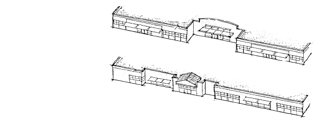
Building surfaces greater than two (2) stories in height or fifty (50) feet in width shall include changes in wall plane (i.e. recesses and projections).
Figure 1. Recesses and projections along a building facade
Source: Georgia Department of Community Affairs
f.
Setback. Building setbacks shall meet the minimum standards required by this ULDC.
g.
Materials. Exterior building materials shall meet the provisions identified below. Materials not identified shall be prohibited.
i.
Exterior wall surfaces shall be unpainted brick, stone, architectural or rusticated cement masonry units to imitate the look of stone, cement fiber board or other building code approved composition lapboard siding.
ii.
Facades facing a public right-of-way shall be a minimum of eighty (80) percent brick and/or stone.
iii.
Side facades shall be a minimum of fifty (50) percent brick and/or stone.
iv.
Rear facades not visible from a public right-of-way shall be permitted to consist of the materials identified above, in addition to natural or synthetic stucco. The color of the rear facade shall coordinate with the remaining facades of the building.
v.
A minimum of twenty (20) percent of a facade visible from a public right-of-way shall be a physical building material change. This change may include a change in color of a permitted building material, a change in permitted building materials, or a change in assembly of permitted building materials.
vi.
Framing of windows, doors and storefronts shall be constructed with wood or aluminum casings of no less than 1.5 inches in width, a profile depth of no less than one (1) inch, and frame or pier divisions between windows having a width of no less than five (5) inches. All windows must have a sill with a profile no less than five (5) inches. The portion of the facade below display windows ("bulkhead") should match exterior cladding materials or be of framed wood.
vii.
Rigid canopies or all fabric (non-vinyl), shed-style awnings are permitted. Awnings may be sideless construction. Valances on all canopy and awnings shall be fabric (non-vinyl) and shall be no less than eight (8) inches in width. Awnings shall project from the building facade no less than 5.5 feet, and the bottom edge shall be no less than 7.5 feet above the sidewalk. Canopies and awnings shall only be as wide as each storefront and shall not cross major vertical building elements, such as building piers or pilasters. Back-lit canopies or awnings are prohibited.
viii.
Roof materials, when visible from the public right-of-way, shall be standing seam, stamped metal shingle or faux architectural composite shingle.
h.
Building Color
i.
Facade colors shall be low reflectance, and neutral or earth-tone colors. High-intensity colors, metallic colors, black, fluorescent or neon colors are prohibited.
i.
Roof Form. Gable, hip, pyramid or flat roofs shall be required on any principal building, in accordance with the following provisions:
i.
Sloped roofs shall meet in a clear roof line or peak.
ii.
Gable and pyramid roofs shall have a minimum slope of 6/12.
iii.
Hip roofs shall have a minimum slope of 4/12.
iv.
Gable, pyramid and hip roofs shall provide a minimum overhang or eave of twelve (12) inches beyond the building wall.
v.
Flat roofs may be permitted with the use of a parapet wall having a minimum height of three (3) feet.
vi.
Shed roofs shall be prohibited with the exception that such roofs may be allowed on incidental rooms or building wings attached to the principal structure. Said roofs shall have a minimum slope of 4/12, shall provide a minimum overhang of twelve (12) inches beyond the building wall, and shall not exceed thirty (30) percent of the total roof area.
vii.
Other roof types not identified in this section are prohibited.
viii.
Roof materials shall be in accordance with Section 4.02.01(C)(3)(g)(viii).
Figure 2. Appropriate Roof Forms
Source: The Latest Illustrated Book of Development Definitions (Moskowitz and Lindbloom, 2004); MACTEC

j.
Signage
i.
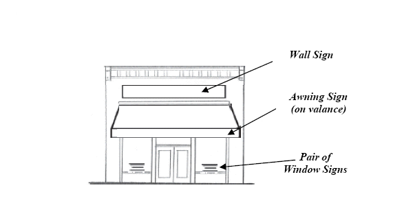
Single Building on a Lot. A combination of one (1) wall and one (1) monument sign is permitted for businesses and for public/institutional facilities. A wall sign shall not exceed two (2) square feet per linear foot of the building facade, with the total sign area not to exceed one hundred fifty (150) square feet. Except for double frontage lots no single building or unit shall be permitted more than one (1) wall sign. No monument sign, which shall be defined as the sign area and the base combined, shall have a height greater than six (6) feet, or an area greater than thirty-five (35) square feet per side. A monument sign shall not be located within ten (10) feet of a street right-of-way or within fifty (50) feet of any other sign, structure or building. Monument signs shall be mounted on a base constructed of the same material as the exterior building material of the principal use. If the principal use is constructed of a material not permitted in this section, the sign base shall be constructed of a material identified as permissible for front building facades in Section 4.02.01(C)(3)(g). No air space shall be visible within or between any portion of the sign display area and sign structure. Permitted signs shall not be internally illuminated.
ii.
Two (2) or More Businesses. Two (2) or more businesses consisting of individual buildings or units which are adjacent or abutting one another on a lot shall be permitted to erect one (1) shared monument sign. No monument sign, which shall be defined as the sign area and the base combined, shall have an area greater than forty-five (45) square feet or a height greater than six (6) feet. No portion of the sign shall include an area for changeable letters. One tenant directory sign is permitted per entrance. Directory signs shall not be designed or placed so as to be read from a public road. Each tenant shall be allowed up to one hundred eight (108) square inches of signage. Each panel on a directory sign shall be of the same size, color, and front. Each building or unit with a separate entrance, not accessible by other tenants, shall be permitted one (1) wall sign with a maximum area of five (5) percent of the building facade which it is mounted upon, but not to exceed one hundred fifty (150) square feet. Additional wall signs are not allowed for multiple facade frontages. If two (2) or more tenants, as in the case of an office building, share an entrance to a building, wall signs on the exterior of the building are not permitted. Permitted signs shall not be internally illuminated.
Figure 3A. Appropriate Sign Types
Source: Planning and Urban Design Standards (APA, 2004); MACTEC

iii.
Use of Awnings and Windows. The use of awnings and windows for business signs shall be reserved for secondary signs, which for the purpose of this section are defined as signs that are secondary in nature to, and smaller in size than, primary wall and monument signs. Each business shall be permitted to use either an awning or window space for secondary sign use. The use of an awning for signage shall be limited to the valance. Window signs shall be limited to the ground floor, and no window shall be covered by more than thirty (30) percent of signage. Window signs may be painted on the inside of the window. Hand written signs shall not be permitted. A maximum of twenty (20) percent of the allowable square footage of space for a wall sign shall be permitted for a secondary sign.
Figure 3B. Appropriate Sign Types
Source: MACTEC
iv.
Prohibited Signs. In addition to the prohibited signs identified in Section 5.04.02 of this ULDC, banners, rooftop signs, freestanding pole signs, electronic or changeable message/copy signs, flashing, blinking, rotating, fluctuating, or otherwise animated signs, streamers or pennants, and outdoor advertising signs (billboards) are prohibited.
k.
Sign Landscaping. Sign landscaping shall conform to Sections 4.07.03, 4.07.04 and 4.07.05 of this ULDC in addition to the following provisions:
i.
Monument signs shall have a landscaped area at the base of the sign which is a minimum of three (3) feet wide on each side, and at least the length of the sign. The sign area landscaping shall consist of a dense vegetative ground cover or a minimum one (1) shrub per three (3) linear feet of landscaped area on each side of the sign. Landscaped areas containing shrubs greater than three (3) feet in height shall be located a minimum of twenty (20) feet from the intersection of two (2) street rights-of-way lines, or the intersection of a street right-of-way line with a driveway pavement edge.
l.
Site Landscaping. Site landscaping shall conform to Sections 4.07.03, 4.07.04 and 4.07.05 of this ULDC in addition to the following provisions:
i.
A landscaped buffer having a minimum width of fifteen (15) feet is required along the entire length of any property line abutting a public right-of-way, residential uses or any residential or rural zoning district. There shall be one (1) tree for every thirty (30) feet of lot frontage along said property line.
ii.
Tree placement shall follow the guidelines established in Table 4.02.01(C)(3)(1) Guidelines to Avoid Conflicts with Infrastructure.
Table 4.02.01(C)(3)(1)
Guidelines to Avoid Conflicts with Infrastructure
m.
Site Lighting. Exterior lighting shall be architecturally compatible with the building style, material and colors and shall be directed onto the site.
i.
Full cut-off light fixtures are required to direct light downward, and in no case shall such lighting project into the right-of-way or neighboring properties.
ii.
Pedestrian scaled accent lighting to highlight building, landscape and sign features is permitted.
iii.
Roof lighting, down-lighting washing the building walls, illuminated awnings or canopies, searchlights, laser lights, and flashing, moving, revolving, flickering, strobe lights, or any lights that change intensity or color are prohibited.
iv.
Fixture mounting height in parking lots or service areas shall not exceed twenty (20) feet in height.
v.
Low, bollard-type fixtures no greater than four (4) feet in height are encouraged as pedestrian-area lighting.
n.
Fencing and Walls. In addition to meeting the provisions of Section 5.02.03 of this ULDC, the following provisions apply:
i.
The design and materials of fences and walls shall be compatible with the architecture of the main building(s).
ii.
Where permitted, fences shall be located in side and rear yards only, with the exception of property in a rural zoning district that is not within a platted subdivision, whereby fencing is permissible in accordance with Table 5.02.03(B) of this ULDC.
iii.
Where chain link is permitted, it shall be vinyl coated (black or green in color).
iv.
Walls along a public right-of-way are prohibited, except for low-lying decorative stone walls that do not impair viewsheds or walls that are needed for slope stabilization. Walls shall consist of natural materials and shall only be of those colors that blend with the vegetation or abutting landscape features.
o.
Parking
i.
Required off-street parking and loading areas shall be located to the rear of a principal building.
ii.
Parking lots shall have a landscaped perimeter in accordance with Section 4.07.05(B) of this ULDC.
iii.
A minimum of five (5) percent of the total parking lot area shall consist of internal landscaping.
iv.
Parking lots with twenty (20) or more parking spaces shall provide interior landscaping in accordance with Section 4.07.05(C) of this ULDC.
p.
Access
i.
The entire parcel, rather than simply a particular project, shall be considered in formulating and approving access plans.
ii.
Interparcel site access, for pedestrians as well as vehicles, shall be provided to adjacent properties when land uses are compatible.
iii.
Common access easements for shared driveways along state highways and busy streets are strongly encouraged.
Figure 4. Interparcel access through linked parking lots at the rear of buildings
Source: Rural by Design (Arendt, 1994)
q.
Utilities
i.
All electrical, cable, telephone and other such services shall be installed underground.
ii.
All transformers and other facilities and equipment, including telecommunications equipment, meters and meter boxes located on the ground shall be placed to the rear of the principal building and shall be screened from view from the public right-of-way, residential uses, or any residential or rural zoning district by one hundred (100) percent opaque fencing through the use of pressure treated, natural wood fencing or brick or stone walls with landscape screening and/or, the use of an earthen berm. Required landscaping shall consist of shrub plantings three (3) feet to five (5) feet in height and evergreen plantings five (5) feet to eight (8) feet in height that are designed and installed to provide a visually impervious screen within two (2) years of planting.
iii.
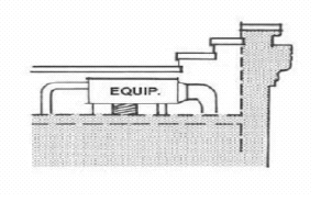
HVAC equipment and satellite dishes may be located on the roof of a principal building if said equipment is screened from view on all four (4) sides by architectural features such as the building roof, a parapet wall, or the building cornice integrated with the design of the building.
Figure 5. Roof-top equipment is screened from view on all four sides
Source: City of San Juan Capistrano (CA) Design Guidelines
r.
Dumpsters. In addition to meeting the provisions of Section 5.02.05 of this ULDC, the following provisions shall apply:
i.
Screening materials are required to be one hundred (100) percent opaque, pressure treated, natural wood fencing or brick or stone walls with landscaping to minimize the appearance from the public right-of-way, any residential use or any residential or rural zoning district.
ii.
Required landscaping shall consist of shrub plantings three (3) feet to five feet (5) in height and evergreen plantings five (5) feet to eight (8) feet in height designed and installed to provide a visually impervious screen within two (2) years of planting.
iii.
Dumpsters are encouraged to be integrated into the mass of the principal building.
iv.
Dumpsters shall not be located within fifty (50) feet of any residential use.
s.
Loading Areas. Loading docks and areas shall be located to the rear of a principal building and screened from view of any public right-of-way, residential use or any residential or rural zoning district with landscape screening by a continuous planting of evergreen plantings five (5) feet to eight (8) feet in height that are designed and installed to provide a visually impervious screen within two (2) years of planting, and/or the use of an earthen berm no less than five (5) feet in height.
t.
Other Accessory Site Features. Other accessory site features located on the ground shall be located to the rear of a principal building and shall be screened from view of any public right-of-way, residential use or any residential or rural zoning district by a one hundred (100) percent opaque, minimum six (6) feet high, pressure treated natural wood fence, landscaped berms and/or landscape screening with plantings that will reach a minimum height of six (6) feet within two (2) years of planting.
u.
Service Stations. Where service stations are permitted the following standards shall apply in addition to other applicable provisions of this section:
i.
Fuel pumps and car washes shall be located to the rear of the principal building. If a car wash is incorporated into a project, the car wash opening shall be sited so that it is not directly visible as the primary view from the street into the project site.
ii.
The design elements of the all structures on the site, including the principal building, canopies, cashier's booth, or car wash facility shall have consistent architectural detail and design elements to provide a cohesive project site. The overall design of the facility shall be aesthetically compatible with the surroundings.
iii.
All station amenities such as lighting fixtures, trash receptacles, and other features shall be coordinated in design with the building and the district.
iv.
Striping, neon, and illuminated panels are not permitted on buildings or canopies.
v.
All fuel canopy supports shall be clad in brick masonry construction or wood, with the exception that a maximum of twenty-five (25) percent of the cladding may be constructed of architectural concrete masonry units. Standard concrete block canopy and supports shall not be permitted.
vi.
The cladding of the columns shall be proportioned to the height and scale of the canopy.
vii.
All canopy downspouts and related hardware shall be integrated into the canopy structure.
viii.
The canopy structure shall relate to the main component of the building with respect to materials, massing, color, roof structure and overall design.
ix.
Lighting luminaries mounted under the canopy structures shall be shielded such that the lamp source is not visible and glare is not created.
v.
Drive-thru Facilities
i.
Drive-thrus are limited to one (1) window or may only have one (1) drive-thru lane, with the exception of banks, which may have two (2) drive-thru lanes.
ii.
Drive-thru facilities and stacking lanes, when adjacent to any public right-of-way, residential use or residential or rural zoning district shall be obscured from view by an earthen berm and/or landscape screening by a continuous planting of evergreen plantings five (5) feet to eight (8) feet in height that are designed and installed to provide a visually impervious screen within two (2) years of planting.
4.
Residential Uses
a.
Notwithstanding other land development regulations to the contrary, the use of conservation subdivision development in accordance with Section 4.05.00 of this ULDC is mandatory as a use by right in all residential developments in this district.
b.
Entrance signs to a residential development shall meet the standards for monument signs in accordance with Section 4.02.01(C)(3)(j)(i).
Figure 6. Conventional subdivision design (left) and conservation subdivision design (right), which maximizes open space and protects existing vegetation, and natural and historic features
Source: Rural by Design (Arendt, 1994)

5.
Prohibited Uses. The following uses are prohibited in the district:
a.
Outdoor storage for building supply and vehicle parts/accessories visible from the public right-of-way;
b.
Flea markets or similar outdoor or indoor/outdoor sales complexes;
c.
Outdoor arenas, rodeo grounds, livestock auction facilities, race tracks (auto, dog, go-kart, horse, motorcycle), outdoor shooting and firing ranges and similar activities (excludes hunting on private property);
d.
Storage yards for equipment, machinery and supplies for building and trades contractors, garbage haulers;
e.
Vehicle sales, rental, service, and repair including truck stops, body shops, road services, car washes that stand alone, and the sales, rental and repair or new or used automobiles, boats, buses, farm equipment, motorcycles, trucks, recreational vehicles, and mobile homes;
f.
Salvage yards and impound lots;
g.
Outdoor play equipment/play grounds visible from the public right-of-way;
h.
Industrial uses;
i.
Telecommunication towers (includes cell towers); and
j.
Adult entertainment establishments, including spas.
6.
Design Review Application Process
a.
Review of proposed development in the New Echota Overlay District, with the exception of development in Rural or Residential Zoning Districts, is required prior to issuance of applicable permits. A review panel consisting of the Gordon County Historic Preservation Commission (HPC) and the Planning Director or design shall accomplish such reviews. No review and approval of the Board of Commissioners or the Planning Commission shall be required. The Zoning Administrator shall be responsible for distributing all required application materials to each member of the review panel. Incompletion applications shall not be accepted. The review panel will meet monthly at a regularly scheduled meeting of the (HPC). No permit shall be issued prior to approval by the review panel. The following procedures shall apply to the review process:
i.
Prior to the formal submittal of a design plan, the applicant is encouraged to meet with the Planning Director or designee for a review of the location, scope and nature of the proposed project. No preliminary plans, drawings, sketches or concept plans reviewed informally, in writing, or otherwise shall confer any development rights under this section.
ii.
Seven (7) copies of design plans shall be submitted at least fourteen (14) days prior to the HPC meeting at which official review is requested.
iii.
Each design plan shall be prepared by an architect, engineer, landscape architect or land surveyor whose state registration is current and valid.
iv.
A design plan for new development, as defined in Section 4.02.01(C)(3), shall contain a development plan in accordance with the requirements of Section 10.02.04 Submittal Requirements for Development Plans of this ULDC with the exception that specific plans related to stormwater management, floodplain management, and erosion and sedimentation control shall not be required for review with the design plan. The design plan shall also include elevations depicting the exterior appearance of buildings, structures and signs with sufficient notation regarding proposed height, color, materials, composition and other physical elements subject to review in accordance with this section, as well as a statement indicating that the proposed design plan addresses and meets the standards of the New Echota Overlay District.
v.
Upon approval of the design plan by the review panel, a proposed development shall be reviewed and approved by the appropriate entities (including Director of Public Works, Fire Chief, Engineer, Building Official, Board of Health, Georgia Department of Transportation) in accordance with the requirements of Chapter 10 of this ULDC prior to issuance of any permits. Any local government action under this section shall not relieve the landowner from federal and state permitting requirements.
7.
Rezoning and Variance Applications
a.
Rezoning and variance applications for property within the district shall be reviewed by the Historic Preservation Commission prior to review by the Planning Commission. The HPC shall act as a recommending body only and shall forward its review comments to the Zoning Administrator, who shall be responsible for forwarding said comments to Planning Commission members prior to any action upon the rezoning or variance application. The comments shall be considered part of the official staff report that is provided by the Department of Planning and Development for each variance and zoning application that is submitted to the Planning Commission. In addition to rezoning and variance procedural requirements in Chapters 9 and 10 of this ULDC, the following provision shall apply:
i.
The Planning Commission shall grant a variance to the provisions of this section only in cases where it finds that the variance will result in equal or greater compliance with the purposes of this section.
4.02.02 Site Design Standards for the Resaca Battlefield Overlay District
A.
Description. The Resaca Battlefield Overlay district shall be generally defined as all property in unincorporated Gordon County south of the Gordon County/Whitfield County line, east of Hyde Road, along SR 136 west of Interstate 75, and west of the Conasauga River from the Whitfield County line to the Resaca town limits as designated on the Gordon County Official Zoning Map.
B.
Generally.
1.
The purpose of the Resaca Battlefield Overlay District is to protect the historic setting, viewsheds and topography of the Resaca Battlefield, which includes both public and private properties, and the unique experience enjoyed by residents and visitors by ensuring that new development in the district will complement rather than detract from the historic value of battlefield area and will respect the district's natural and historic features, its rural character, and its contributions to the heritage of Gordon County, the state and the nation.
2.
This section establishes standards that apply to any new development on any lot or portion thereof that is in whole or in part contained within the boundaries of the Resaca Battlefield Overlay District. These standards and criteria shall be applied in addition to the site design standards of the underlying zoning district and all other applicable standards of this ULDC. In the event of a conflict between the requirements of the Resaca Battlefield Overlay District and the underlying zoning district or other applicable standards of this ULDC, the stricter standard shall apply.
3.
The provisions of these standards do not apply to:
a.
Farm or agricultural-related structures;
b.
Single-family dwellings and manufactured homes on an existing lot of record;
c.
Developments existing on the effective date of this section, provided that expansions or additions to existing development as defined in Section 4.02.02(C)(3) on or after the effective date of this section shall be subject to compliance with these regulations.
4.
The provisions of these standards do not require any change in the construction, or intended use of any structure, the construction or alteration of which was begun prior to the effective date of this section and which is pursuant to a valid building permit.
5.
Nothing contained herein shall be construed to replace or supercede existing zoning classifications of properties within the Resaca Battlefield Overlay District. It is, however, the intent of this section for all properties developed in the district to meet all of the standards outlined herein. It is further the intent of this section that previously zoned properties shall develop using the standards outlined in this section.
C.
The following standards shall apply within the Resaca Battlefield Overlay District:
1.
General Site Design
a.
Preservation of Site Features. Significant site features such as existing vegetation, natural or historic ground forms or earthworks, and significant view corridors shall be identified and incorporated into development plans. Clearing of native vegetation shall be limited to that required for the provision of essential purposes (e.g. access, building, utility crossing, sewage disposal).
b.
Site Grading. Developments shall be designed to fit the existing contours and landform of the site and to minimize the amount of excavation and moved earth to minimize visual impacts, erosion, and destruction of historic, manmade earthworks and archaeological resources.
i.
Where cut and fill is necessary, it shall be balanced.
ii.
When grading must occur, it shall blend with the natural landform as much as possible.
iii.
Abrupt or unnatural-appearing grading shall be prohibited, including the creation of harsh, easily eroded banks and cuts.
iv.
The height and length of retaining walls shall be minimized and screened with appropriate landscaping. The use of terracing or walls consisting of natural materials that blend with the vegetation or abutting landscaping features shall be required in areas that are visible from the public right-of-way. Tall or prominent, smooth-faced concrete retaining walls are prohibited in areas that are visible from the public right-of-way.
v.
Disturbed areas that are not used for roads, buildings or other auxiliary uses shall be replanted.
2.
Tree Protection. The removal of trees incidental to the development of land or to the marketing of land for development shall be done in conformance with the following provisions:
a.
Cutting and Clearing. All reasonable efforts shall be made to minimize cutting or clearing of trees and other woody plants.
i.
Removal of trees over five (5) inches in caliper shall be prohibited, where possible, by appropriately siting buildings, parking lots or entrance/exit drives.
ii.
Residential and mixed-use developments are required to retain twenty (20) percent of the site as woodland.
iii.
Commercial, office, institutional and industrial developments are required to retain fifteen (15) percent of woodland on the site.
iv.
If the site is not currently forested, or only partially forested, the property owner/developer shall be required to plant trees to meet this requirement.
b.
Replacement Trees. Where replacement or new trees are necessary to meet the above requirements, Sections 4.07.04(B)(6—8) of this ULDC shall be followed in addition to the following provisions:
i.
Trees shall be compatible with the site ecologically and in terms of space requirements.
ii.
Trees shall have potential for size and quality comparable to those removed.
iii.
No one genus shall comprise more than thirty (30) percent of the replacement trees.
c.
Protection of Trees During Construction. Tree protection devices shall be installed prior to the issuance of a land use permit for any clearing and/or grading. All reasonable efforts to protect retained trees during the construction process shall be made, including, but not limited to, the following measures:
i.
Placing protective barriers (chain link fencing, orange laminated plastic fencing supported by posts, rail fencing, or other equivalent restraining material) around trees, including the trees' critical root zone (CRZ), which for the purpose of this section shall be defined as the minimum area beneath a tree which must be left undisturbed in order to preserve a sufficient root mass to give a tree a reasonable chance of survival. The protective barrier shall be located at the outer CRZ or the drip line, whichever is greater. For the purpose of this section the drip line shall be defined as line on the ground of points projected vertically from the ends of farthest branches of the tree;
ii.
Marking the required protective barriers with "tree save area" signs;
iii.
Not grading, excavating, or locating utilities within the trees' CRZ;
iv.
Maintaining the CRZ as a pervious surface;
v.
Maintaining the topsoil in the CRZ and preventing siltation; and
vi.
Maintaining tree protection devices in functioning condition throughout all phases of development, subject to inspection by Gordon County Building Inspector.
d.
Buffers. All buffers with existing trees that may be required by this ULDC or provided by a development shall be delineated on plans as tree save areas.
e.
Exempt Uses. The provisions of this section shall not apply to agricultural uses, to single-family dwellings and manufactured homes on an existing lot of record, and to new single-lot residential development not part of a residential subdivision.
3.
Commercial Development. The following standards shall apply to all new development, with the exception of development in a Rural Zoning District or a Residential Zoning District. In addition, these standards shall apply to any existing developed lot, parcel, or tract of land not located in a Rural Zoning District or a Residential Zoning District for which a sign or building permit is required. These standards shall be waived for any renovation of or addition to an existing building which the cost thereof is less than fifty (50) percent of the ad valorem tax value as established by the current digest at the time the proposed renovations and/or building additions begin or are contemplated.
a.
General Appearance Standards
i.
A building's size, scale, massing, fenestration, rhythm, setback, materials and context shall be compatible with the character of the district.
ii.
Exterior building features visible from a public right-of-way shall be organized to allow diversity in architectural design while incorporating traditional elements of commercial building forms such as canopies or awnings, storefront windows, cornice lines atop building facades, structural columns, facade recesses and projections, traditional roofs or parapet walls, varied parapet height, or traditional or varied arrangement of exterior building materials.
iii.
Multiple buildings on the same site shall be designed to create a cohesive visual relationship between the buildings.
b.
Size and Scale. The relationship of a building to the project site (building "size") and to buildings around it ("scale") shall be addressed as part of the design process. The following provisions shall apply:
i.
Maximum building height for a principal building shall be forty (40) feet, measured from the bottom of the base of the structure at ground level to the highest point of such structure.
ii.
The height of proposed buildings and adjacent structures shall be compatible.
c.
Massing. The relationship of a building's various parts to each other ("massing") shall reflect a human scale. For illustrative purposes, building elements that contribute to this desired scale include, but are not limited to, prominent entry features, inset windows or the use of cornice lines.
d.
Fenestration. The placement of doors and windows ("fenestration") shall create a balanced facade with traditional proportions and limited blank wall space, in accordance with the following provisions:
i.
Not less than sixty (60) percent of the total surface area of the front facade shall be public entrances and windows.
ii.
Blank facades visible from any public right-of-way are prohibited. Up to eighty (80) percent of the length of a facade may be exempt from this standard if oriented toward a loading or service area or if visible from, but not facing, a public right-of-way.
iii.
Windows shall be transparent. Mirrored, smoked or tinted glass is prohibited.
e.
Rhythm. The relationship of fenestration and facade recesses and projections ("rhythm") shall add visual interest and prevent long or continuous building walls. The following provision shall also apply:
i.
Building surfaces greater than two (2) stories in height or fifty (50) feet in width shall include changes in wall plane (i.e. recesses and projections).
Figure 1. Recesses and projections along a building facade
Source: Georgia Department of Community Affairs

f.
Setback. Building setbacks shall meet the minimum standards required by this ULDC.
g.
Materials. Exterior building materials shall meet the provisions identified below. Materials not identified shall be prohibited.
i.
Exterior wall surfaces shall be unpainted brick, stone, architectural or rusticated cement masonry units to imitate the look of stone, cement fiber board or other building code approved composite lapboard siding.
ii.
Facades facing a public right-of-way shall be a minimum of eighty (80) percent brick and/or stone.
iii.
Side facades shall be a minimum of fifty (50) percent brick and/or stone.
iv.
Rear facades not visible from a public right-of-way shall be permitted to consist of the materials identified above, in addition to natural or synthetic stucco. The color of the rear facade shall coordinate with the remaining facades of the building.
v.
A minimum of twenty (20) percent of a facade visible from a public right-of-way shall be a physical building material change. This change may include a change in color of a permitted building material, a change in permitted building materials, or a change in assembly of permitted building materials.
vi.
Framing of windows, doors and storefronts shall be constructed with wood or aluminum casings of no less than 1.5 inches in width, a profile depth of no less than one (1) inch, and frame or pier divisions between windows having a width of no less than five (5) inches. All windows must have a sill with a profile no less than five (5) inches. The portion of the facade below display windows ("bulkhead") should match exterior cladding materials or be of framed wood.
vii.
Rigid canopies or all fabric (non-vinyl), shed-style awnings are permitted. Awnings may be sideless construction. Valances on all canopy and awnings shall be fabric (non-vinyl) and shall be no less than eight (8) inches in width. Awnings shall project from the building facade no less than 5.5 feet, and the bottom edge shall be no less than 7.5 feet above the sidewalk. Canopies and awnings shall only be as wide as each storefront and shall not cross major vertical building elements, such as building piers or pilasters. Back-lit canopies or awnings are prohibited.
viii.
Roof materials, when visible from the public right-of-way, shall be standing seam, stamped metal shingle or faux architectural composite shingle.
h.
Building Color
i.
Facade colors shall be low reflectance, and neutral or earth-tone colors. High-intensity colors, metallic colors, black, fluorescent or neon colors are prohibited.
i.
Roof Form. Gable, hip, pyramid or flat roofs shall be required on any principal building, in accordance with the following provisions:
i.
Sloped roofs shall meet in a clear roof line or peak.
ii.
Gable and pyramid roofs shall have a minimum slope of 6/12.
iii.
Hip roofs shall have a minimum slope of 4/12.
iv.
Gable, pyramid and hip roofs shall provide a minimum overhang or eave of twelve (12) inches beyond the building wall.
v.
Flat roofs may be permitted with the use of a parapet wall having a minimum height of three (3) feet.
vi.
Shed roofs shall be prohibited with the exception that such roofs may be allowed on incidental rooms or building wings attached to the principal structure. Said roofs shall have a minimum slope of 4/12, shall provide a minimum overhang of twelve (12) inches beyond the building wall, and shall not exceed thirty (30) percent of the total roof area.
vii.
Other roof types not identified in this section are prohibited.
viii.
Roof materials shall be in accordance with Section 4.02.02(C)(3)(g)(viii).
Figure 2. Appropriate Roof Forms
Source: The Latest Illustrated Book of Development Definitions (Moskowitz and Lindbloom, 2004); MACTEC
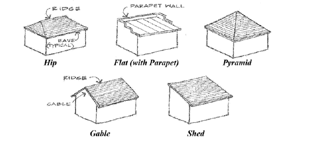
j.
Signage
i.
Single Building on a Lot. A combination of one (1) wall and one (1) monument sign is permitted for businesses and for public/institutional facilities. A wall sign shall not exceed two (2) square feet per linear foot of the building facade, with the total sign area not to exceed one hundred fifty (150) square feet. Except for double frontage lots no single building or unit shall be permitted more than one wall sign. No monument sign, which shall be defined as the sign area and the base combined, shall have a height greater than six (6) feet above normal grade, or an area greater than thirty-five (35) square feet. A monument sign shall not be located within ten (10) feet of a street right-of-way or within fifty (50) feet of any other sign, structure or building. Monument signs shall be mounted on a base constructed of the same material as the exterior building material of the principal use. If the principal use is constructed of a material not permitted in this section, the sign base shall be constructed of a material identified as permissible for front building facades in Section 4.02.02(C)(3)(g). No air space shall be visible within or between any portion of the sign display area and sign structure. Permitted signs shall not be internally illuminated.
ii.
Two (2) or More Businesses. Two (2) or more businesses consisting of individual buildings or units which are adjacent or abutting one another on a lot shall be permitted to erect one (1) shared monument sign. No monument sign, which shall be defined as the sign area and the base combined, shall have an area greater than forty-five (45) square feet or a height greater than six (6) feet. No portion of the sign shall include an area for changeable letters. One (1) tenant directory sign is permitted per entrance. Directory signs shall not be designed or placed so as to be read from a public road. Each tenant shall be allowed up to one hundred eight (108) square inches of signage. Each panel on a directory sign shall be of the same size, color, and font. Each building or unit with a separate entrance, not accessible by other tenants, shall be permitted one (1) wall sign with a maximum area of five (5) percent of the building facade which it is mounted upon, but not to exceed one hundred fifty (150) square feet. Additional wall signs are not allowed for multiple facade frontages. If two (2) or more tenants, as in the case of an office building, share an entrance to a building, wall signs on the exterior of the building are not permitted. Permitted signs shall not be internally illuminated.
Figure 3A. Appropriate Sign Types
Source: Planning and Urban Design Standards (APA, 2004); MACTEC
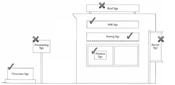
iii.
Use of Awnings and Windows. The use of awnings and windows for business signs shall be reserved for secondary signs, which for the purpose of this section are defined as signs that are secondary in nature to, and smaller in size than, primary wall and monument signs. Each business shall be permitted to use either an awning or window space for secondary sign use. The use of an awning for signage shall be limited to the valance. Window signs shall be limited to the ground floor, and no window shall be covered by more than thirty (30) percent of signage. Window signs may be painted on the inside of the window. Hand written signs shall not be permitted. A maximum of twenty (20) percent of the allowable square footage of space for a wall sign shall be permitted for a secondary sign.
iv.
Prohibited Signs. In addition to the prohibited signs identified in Section 5.04.02 of this ULDC, banners, rooftop signs, freestanding pole signs, electronic or changeable message/copy signs, flashing, blinking, rotating, fluctuating, or otherwise animated signs, streamers or pennants, and outdoor advertising signs (billboards) are prohibited.
Figure 3B. Appropriate Sign Types
Source: MACTEC

k.
Sign Landscaping. Sign landscaping shall conform to Sections 4.07.03, 4.07.04 and 4.07.05 of this ULDC in addition to the following provisions:
i.
Monument signs shall have a landscaped area at the base of the sign which is a minimum of three (3) feet wide on each side, and at least the length of the sign. The sign area landscaping shall consist of a dense vegetative ground cover or a minimum one (1) shrub per three (3) linear feet of landscaped area on each side of the sign. Landscaped areas containing shrubs greater than three (3) feet in height shall be located a minimum of twenty (20) feet from the intersection of two (2) street rights-of-way lines, or the intersection of a street right-of-way line with a driveway pavement edge.
1.
Site Landscaping. Site landscaping shall conform to Sections 4.07.03, 4.07.04 and 4.07.05 of this ULDC in addition to the following provisions:
i.
A landscaped buffer having a minimum width of fifteen (15) feet is required along the entire length of any property line abutting a public right-of-way, residential uses or any residential or rural zoning district. There shall be one (1) tree for every thirty (30) feet of lot frontage along said property line.
ii.
Tree placement shall follow the guidelines established in Table 4.02.02(C)(3)(l) Guidelines to Avoid Conflicts with Infrastructure.
Table 4.02.02(C)(3)(1)
Guidelines to Avoid Conflicts with Infrastructure
m.
Site Lighting. Exterior lighting shall be architecturally compatible with the building style, material and colors and shall be directed onto the site.
i.
Full cut-off light fixtures are required to direct light downward, and in no case shall such lighting project into the right-of-way or neighboring properties.
ii.
Pedestrian scaled accent lighting to highlight building, landscape and sign features is permitted.
iii.
Roof lighting, down-lighting washing the building walls, illuminated awnings or canopies, searchlights, laser lights, and flashing, moving, revolving, flickering, strobe lights, or any lights that change intensity or color are prohibited.
iv.
Fixture mounting height in parking lots or service areas shall not exceed twenty (20) feet in height.
v.
Low, bollard-type fixtures no greater than four (4) feet in height are encouraged as pedestrian-area lighting.
n.
Fencing and Walls. In addition to meeting the provisions of Section 5.02.03 of this ULDC, the following provisions apply:
i.
The design and materials of fences and walls shall be compatible with the architecture of the main building(s).
ii.
Where permitted, fences shall be located in side and rear yards only, with the exception of property in a rural zoning district that is not within a platted subdivision, whereby fencing is permissible in accordance with Table 5.02.03(B) of this ULDC.
iii.
Where chain link is permitted, it shall be vinyl coated (black or green in color).
iv.
Walls along a public right-of-way are prohibited, except for low-lying decorative stone walls that do not impair viewsheds or walls that are needed for slope stabilization. Walls shall consist of natural materials and shall only be of those colors that blend with the vegetation or abutting landscape features.
o.
Parking
i.
Required off-street parking and loading areas shall be located to the rear of a principal building.
ii.
Parking lots shall have a landscaped perimeter in accordance with Section 4.07.05(B) of this ULDC.
iii.
A minimum of five (5) percent of the total parking lot area shall consist of internal landscaping.
iv.
Parking lots with twenty (20) or more parking spaces shall provide interior landscaping in accordance with Section 4.07.05(C) of this ULDC.
p.
Access
i.
The entire parcel, rather than simply a particular project, shall be considered in formulating and approving access plans.
ii.
Interparcel site access, for pedestrians as well as vehicles, shall be provided to adjacent properties when land uses are compatible.
iii.
Common access easements for shared driveways along state highways and busy streets are strongly encouraged.
Figure 4. Interparcel access through linked parking lots at the rear of buildings
Source: Rural by Design (Arendt, 1994)

q.
Utilities
i.
All electrical, cable, telephone and other such services shall be installed underground.
ii.
All transformers and other facilities and equipment, including telecommunications equipment, meters and meter boxes located on the ground shall be placed to the rear of the principal building and shall be screened from view from the public right-of-way, residential uses, or any residential or rural zoning district by one hundred (100) percent opaque fencing through the use of pressure treated, natural wood fencing or brick or stone walls with landscape screening and/or the use of an earthen berm. Required landscaping shall consist of shrub plantings three (3) feet to five (5) feet in height and evergreen plantings five (5) feet to eight (8) feet in height that are designed and installed to provide a visually impervious screen within two (2) years of planting.
iii.
HVAC equipment and satellite dishes may be located on the roof of a principal building if said equipment is screened from view on all four (4) sides by architectural features such as the building roof, a parapet wall, or the building cornice integrated with the design of the building.
Figure 5. Roof-top equipment is screened from view on all four sides
Source: City of San Juan Capistrano (CA) Design Guidelines
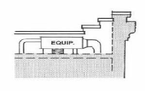
r.
Dumpsters. In addition to meeting the provisions of Section 5.02.05 of this ULDC, the following provisions shall apply:
i.
Screening materials are required to be one hundred (100) percent opaque, pressure treated, natural wood fencing or brick or stone walls with landscaping to minimize the appearance from the public right-of-way, any residential use or any residential or rural zoning district.
ii.
Required landscaping shall consist of shrub plantings three (3) feet to five (5) feet in height and evergreen plantings five (5) feet to eight (8) feet in height designed and installed to provide a visually impervious screen within two (2) years of planting.
iii.
Dumpsters are encouraged to be integrated into the mass of the principal building.
iv.
Dumpsters shall not be located within fifty (50) feet of any residential use.
s.
Loading Areas. Loading docks and areas shall be located to the rear of a principal building, and screened from view of any public right-of-way street, residential use or any residential or rural zoning district with landscape screening by a continuous planting of evergreen plantings five (5) feet to eight (8) feet in height that are designed and installed to provide a visually impervious screen within two (2) years of planting, and/or the use of an earthen berm no less than five (5) feet in height.
t.
Other Accessory Site Features. Other accessory site features located on the ground shall be located to the rear of a principal building and shall be screened from view of any public right-of-way, residential use or any residential or rural zoning district by a one hundred (100) percent opaque, minimum six (6) feet high, pressure treated natural wood fence and/or an earthen berm and/or landscape screening with plantings that will reach a minimum height of six (6) feet within two (2) years of planting.
u.
Service Stations. Where service stations are permitted the following standards shall apply in addition to other applicable provisions of this section:
i.
Fuel pumps and car washes shall be located to the rear of the principal building. If a car wash is incorporated into a project, the car wash opening shall be sited so that it is not directly visible as the primary view from the street into the project site.
ii.
The design elements of the all structures on the site, including the principal building, canopies, cashier's booth, or car wash facility shall have consistent architectural detail and design elements to provide a cohesive project site. The overall design of the facility shall be aesthetically compatible with the surroundings.
iii.
All station amenities such as lighting fixtures, trash receptacles, and other features shall be coordinated in design with the building and the district.
iv.
Stripping, neon, and illuminated panels are not permitted on buildings or canopies.
v.
All fuel canopy supports shall be clad in brick masonry construction or wood, with the exception that a maximum of twenty-five (25) percent of the cladding may be constructed of architectural concrete masonry units. Standard concrete block canopy and supports shall not be permitted.
vi.
The cladding of the columns shall be proportioned to the height and scale of the canopy.
vii.
All canopy downspouts and related hardware shall be integrated into the canopy structure.
viii.
The canopy structure shall relate to the main component of the building with respect to materials, massing, color, roof structure and overall design.
ix.
Lighting luminaries mounted under the canopy structures shall be shielded such that the lamp source is not visible and glare is not created.
v.
Drive-thru Facilities
i.
Drive-thrus are limited to one (1) window or may only have one (1) drive-thru lane, with the exception of banks, which may have two (2) drive-thru lanes.
ii.
Drive-thru facilities and stacking lanes, when adjacent to any public right-of-way, residential use or residential or rural zoning district shall be obscured from view by an earthen berm and/or landscape screening by a continuous planting of evergreen plantings five (5) feet to eight (8) feet in height that are designed and installed to provide a visually impervious screen within two (2) years of planting.
4.
Residential Uses
a.
Notwithstanding other land development regulations to the contrary, the use of conservation subdivision development in accordance with Section 4.05.00 of this ULDC is mandatory as a use by right in all residential developments in this district.
b.
Residential uses proposed on property with a natural slope of twenty-five (25) percent or more, including the crests, summits, and ridge tops which lie at elevations higher than any such areas even though the slopes of such crests, summits and ridge tops have a slope less than twenty-five (25) percent shall be subject to Section 4.02.02(C)(7).
c.
Entrance signs to a residential development shall meet the standards for monument signs in accordance with Section 4.02.02(C)(3)(j)(i).
Figure 6. Conventional subdivision design (left) and conservation subdivision design (right), which maximizes open space and protects existing vegetation, and natural and historic features
Source: Rural by Design (Arendt, 1994)
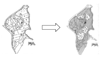
5.
Industrial Uses. Industrial development, where permitted by zoning, shall meet the provisions for Commercial Development as delineated in this section with the following exception:
a.
Building size and scale shall be regulated by Sections 4.01.01 and 4.01.02 of this ULDC.
6.
Prohibited Uses. The following uses are prohibited in the district:
a.
Outdoor storage for building supply and vehicle parts/accessories visible from the public right-of-way;
b.
Flea markets or similar outdoor or indoor/outdoor sales complexes;
c.
Outdoor arenas, rodeo grounds, livestock auction facilities, race tracks (auto, dog, go-kart, horse, motorcycle), outdoor shooting and firing ranges and similar activities (excludes hunting on private property);
d.
Storage yards for equipment, machinery and supplies for building and trades contractors, garbage haulers;
e.
Vehicle sales, rental, service, and repair including truck stops, body shops, road services, car washes that stand alone, and the sales, rental and repair or new or used automobiles, boats, buses, farm equipment, motorcycles, trucks, recreational vehicles, and mobile homes;
f.
Salvage yards and impound lots;
g.
Outdoor play equipment/play grounds visible from the public right-of-way;
h.
Telecommunication towers (includes cell towers); and
i.
Adult entertainment establishments, including spas.
7.
Hillside Development. The following provisions shall apply to any development proposal for property with a natural slope of twenty-five (25) percent or more, including the crests, summits, and ridge tops which lie at elevations higher than any such areas even though the slopes of such crests, summits and ridge tops have a slope less than twenty-five (25) percent.
a.
The following land uses or activities are exempt from the provisions of this section:
i.
Agriculture and forestry, provided that they are consistent with the best management practices established by the Georgia Forestry Commission or the Georgia Soil and Water Conservation Commission, consistent with all state and federal laws, and all applicable regulations promulgated by the Georgia Department of Agriculture;
ii.
Landscape maintenance activities, including the removal of diseased, dead or damaged trees provided that such activities shall be carried out in conformance with applicable regulations of this section and ULDC;
iii.
Any land, or part of any land, which was contained in or subject to any development plan, and which was filed with and approved by the County prior to the effective date of this section; and,
iv.
Additions to single-family residences on legal lots of record with existing residences that were approved prior to the effective date of this section, provided that the height of the building addition does not exceed thirty-five (35) feet measured vertically from the highest point of the natural grade and no land disturbance is required to accomplish the building addition.
b.
For purposes of determining whether these provisions apply to a development proposal, the natural slope of a given property shall be calculated perpendicular to topographic contours from property line to property line, prior to grading, using quadrangle maps of the United States Geological Survey, other reputable topographic maps of the subject area or a topographic survey of the subject property. Although the Steep Slopes Map prepared as part of the Gordon County Comprehensive Plan: 2007—2027 may be used as a general reference, it does not necessarily represent the boundaries of steep slopes within unincorporated Gordon County, Georgia and shall not serve as a substitute for delineating steep slope boundaries via the methods identified herein.
c.
For a proposed conservation subdivision (CS) development, these provisions shall not result in a loss in the number of units permissible by the zoning district in which the CS is located.
d.
Grading. Development on a site shall be located, designed and oriented so that grading and other site preparation are kept to the minimum needed to serve the intended building or use while minimizing disturbance to the natural environment and to significant historical and archaeological resources. The following provisions shall also apply:
i.
No grading, filling, clearing or excavation of any kind in excess of fifty (50) cubic yards shall be initiated until a grading plan is approved and a land disturbance permit is obtained from the Planning and Development Department.
ii.
Borrowing for fill shall be prohibited unless the material is obtained from a cut permitted under an approved grading plan or imported from outside the hillside area.
iii.
Any approved cut or fill slopes shall be no steeper than two (2) horizontal to one (1) vertical unless it can be shown by the project engineer that steeper slopes are feasible and such showing is accepted during the plan review process.
iv.
When grading must occur, it shall blend with the natural landform as much as possible. Grading to form level pads and building sites is prohibited.
v.
Projects involving more than one (1) use or phase shall be phased into workable units in a way that minimizes the amount of soil disturbance at any given point in time.
vi.
No cuts shall be permitted solely for the purpose of obtaining fill unless specifically approved in the grading plan.
vi.
Cut slope angles shall be determined in relationship to the type of materials of which they are composed. Steep-cut slopes shall be retained with stacked rock, engineered retaining walls or a functional equivalent, to control erosion and stabilize the slope. Retaining materials shall blend with the natural surroundings.
vii.
Cut faces on a terraced section shall not exceed a maximum height of five (5) feet, as measured on a vertical plane from the high point of the cut or fill to the bottom-most point.
viii.
Terrace widths shall be a minimum of three (3) feet to allow for the introduction of vegetation for erosion control. The total height of a cut slope shall not exceed fifteen (15) feet.
ix.
Fill slopes shall not exceed a total vertical height of twenty (20) feet, as measured on a vertical plane from the high point of the cut or fill to the bottom-most point. The toe of any fill slope area not utilizing an engineered retaining structure shall be a minimum of six (6) feet from any property line.
Figure 7. When grading must occur, it shall blend with the natural landform as much as possible.
Source: Mountain and Hillside Development Ordinance, White County, GA
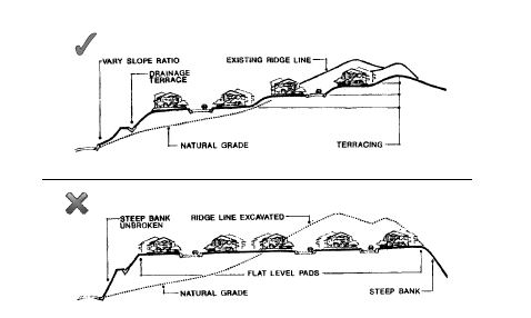
e.
Lot Size Requirements. All new lots created by subdivision shall contain a building envelope with a natural slope of thirty-five (35) percent or less and shall meet the lot size minimum based on slope as provided in this subsection below. Existing parcels without adequate buildable area less than or equal to thirty-five (35) percent cannot be subdivided but shall be considered buildable for one (1) unit. Subdivision of land, land disturbance, and development of lands that are subject to this section shall meet the requirements shown below:
*Lot size may not be less than what is required by a property's zoning district (see Chapter 4 of this ULDC).
f.
Trees and Vegetation
i.
Existing deep-rooted vegetation, including trees, bushes and ground covers, shall be removed only in cases where necessary for buildings, roads, driveways, parking and minimum required yards. View corridors from the proposed development to surrounding areas may be provided, but the thinning of limbs of individual trees is preferred over tree removal as a means to provide a view corridor.
ii.
No trees, other than those located within a building envelope, within a proposed street, driveway or parking area, or within a utility easement, shall be removed except by permit issued by the Planning and Development Department and upon approval by same department of a tree replacement plan.
g.
Roads, Driveways and Parking Areas. Roads, driveways, and parking areas shall be located and designed to parallel the natural contours of the site and such that the maximum number of existing trees on the site is preserved, and there is minimum feasible disturbance of soil and minimum feasible amounts of land coverage. No new road, driveway or parking area shall be constructed at or along the crests, summits, and ridge tops of mountains or hills in areas regulated by this section, and any such road shall be located at an elevation at least twenty (20) feet below said crests, summits, and ridge tops. Road design and construction must be approved by the Director of Public Works and shall be in accordance with applicable regulations found in Chapter 6 of this ULDC.
Variations in road design and road construction specified by the County in this ULDC shall be permitted, as approved by the Director of Public Works, to meet the standards of this section. Proposed variations shall be clearly itemized on plans submitted for review and approval in accordance with Section 4.02.02(C)(9).
h.
Buildings
i.
Large building pads and footings shall be split into more than one (i.e., split-level homes that step down the hillside), where possible, to allow the building pad and structure to more closely follow the existing slope of the land. Building footprint coverage should be minimized where possible by using multiple-level (two or more story) buildings.
ii.
Buildings and structures with roofs must be designed such that the roofline of the building shall be broken into a series of smaller building components to reflect the irregular forms of the surrounding hillside. Long, linear unbroken roof lines are discouraged. Flat roofs are prohibited. The slope angle of roof pitch shall be at or below the angle of the natural hillside slope.
iii.
The height of all buildings and structures shall not exceed thirty-five (35) feet measured vertically from the highest point of the natural grade and shall not extend closer than twenty (20) feet to the uppermost point of the crest, summit or ridge top of the hill or mountain on which the structure is located. Appurtenances attached to a single-family dwelling are permitted provided they do not extend to or beyond the uppermost point of the crest, summit, or ridge top of the hill or mountain on which said dwelling is constructed.
iv.
Building envelopes or buildable areas shall not be allowed to be established on the crest, summit, or ridge top of the mountain or hill on which said dwelling is constructed. In the case of an existing lot of record, the Planning Director or designee may permit a dwelling or other permitted use to be sited on the crest, summit, or ridge top of the mountain or hill on which said dwelling is constructed, if it is shown by the applicant to the satisfaction of the Planning Director or designee that no other reasonable building location is feasible within the boundaries of the lot of record.
v.
When appropriate, buildings and structures should be located as close to the street as possible to preserve the natural terrain and to minimize disturbance and the length of driveways.
vi.
The visible mass of larger buildings and structures should be reduced by utilizing below-grade rooms cut into the natural slope.
vii.
Buildings and structures should be clustered where possible to reduce disturbance and removal of vegetation.
viii.
Exterior colors for new buildings and structures shall be coordinated with the predominant colors of the surrounding landscape to minimize contrast between the structure and the natural environment.
ix.
Exterior windows, trim, and other exterior building materials shall be non-reflective.
x.
All outdoor lights shall have shielded fixtures that direct the light downward to eliminate scattered light and excessive glare. Light poles shall not exceed the height of surrounding buildings.
8.
Application Process (non-Steep Slope). Review of proposed development in the Resaca Battlefield Overlay District, with the exception of development in Rural or Residential Zoning Districts, is required prior to issuance of applicable permits. A review panel consisting of the Gordon County Historic Preservation Commission (HPC) and the Planning Director or designee shall accomplish such reviews. No review and approval of the Board of Commissioners or the Planning Commission shall be required. The Zoning Administrator shall be responsible for distributing all required application materials to each member of the review panel. Incompletion applications shall not be accepted. The review panel will meet monthly at a regularly scheduled meeting of the (HPC). No permit shall be issued prior to approval by the review panel. The following procedures shall apply to the review process:
a.
Prior to the formal submittal of a design plan, the applicant is encouraged to meet with the Planning Director or designee for a review of the location, scope and nature of the proposed project. No preliminary plans, drawings, sketches or concept plans reviewed informally, in writing, or otherwise shall confer any development rights under this section.
b.
Seven (7) copies of design plans shall be submitted at least fourteen (14) days prior to the HPC meeting at which official review is requested.
c.
Each design plan shall be prepared by an architect, engineer, landscape architect or land surveyor whose state registration is current and valid.
d.
A design plan for new development, as defined in Section 4.02.02(C)(3), in accordance with the requirements of Section 10.02.04 Submittal Requirements for Development Plans of this ULDC with the exception that specific plans related to stormwater management, floodplain management, and erosion and sedimentation control shall not be required for review with the design plan. The design plan shall also include elevations depicting the exterior appearance of buildings, structures and signs with sufficient notation regarding proposed height, color, materials, composition and other physical elements subject to review in accordance with this section, as well as a statement indicating that the proposed design plan addresses and meets the standards of the Resaca Battlefield Overlay District.
e.
Upon approval of the design plan by the review panel, a proposed development shall be reviewed and approved by the appropriate entities (including Director of Public Works, Fire Chief, Engineer, Building Official, Board of Health, Georgia Department of Transportation) in accordance with the requirements of Chapter 10 of this ULDC prior to issuance of any permits. Any local government action under this section shall not relieve the landowner from federal and state permitting requirements.
9.
Application Process (Steep Slope)
a.
Prior to the formal submittal of any plans, the applicant is encouraged to meet with the Planning Director or designee for a review of the location, scope and nature of the proposed project. No preliminary plans, drawings, sketches or concept plans reviewed informally, in writing, or otherwise shall confer any development rights under this section.
b.
Owners of individual lots that are subject to the requirements of this section shall be required to submit the following information, in addition to the requirements of Section 10.02.02 of this ULDC, for review and approval prior to issuance of any development permits:
i.
Topographic data including existing and planned contours for the area of construction or land disturbance, (cuts and fills for structures, driveways, etc.) shown in five-foot contour intervals, and indicating the slope of the buildable area.
ii.
Building elevations showing the height of the proposed structure, as well as building materials, color, and roof pitch.
iii.
Proposed retaining walls, driveway, septic tank and drainfield locations, and freestanding outdoor lighting.
iv.
Tree replacement plan if trees are proposed to be removed beyond areas cleared to accommodate the building envelope, a street, driveway or parking area, or a utility easement.
c.
For all other proposed development, including residential subdivisions, the applicant shall submit plans as required by Chapter 10 of this ULDC in addition to the additional elements identified in Section 4.02.02(C)(9)(b) above.
10.
Rezoning and Variance Applications. Rezoning and variance applications for property within the district shall be reviewed by the Historic Preservation Commission prior to review by the Planning Commission. The HPC shall act as a recommending body only and shall forward its review comments to the Zoning Administrator, who shall be responsible for forwarding said comments to Planning Commission members prior to any action upon the rezoning or variance application. The comments shall be considered part of the official staff report that is provided by the Department of Planning and Development for each variance and zoning application that is submitted to the Planning Commission. In addition to rezoning and variance procedural requirements in Chapters 9 and 10 of this ULDC, the following provision shall apply:
i.
The Planning Commission shall grant a variance to provisions of this section only in cases where it finds that the variance will result in equal or greater compliance with the purposes of this section.
(Res. of 12-20-11)
4.03.00 - SUPPLEMENTAL STANDARDS FOR SPECIFIC USES
4.03.01 Animal Care Facilities (Animal Hospitals, Veterinary Clinics, Kennels or other Animal Boarding Facilities)
A.
Animal hospitals and veterinary clinics are permissible in the A-1, O-1, C-C, C-G, C-H, I-1 and I-2 zoning districts, subject to the site design standards for the districts and the supplemental standards of this section.
B.
Animal hospitals and veterinary clinics shall be permissible in freestanding buildings only.
C.
Design standards for an animal hospital or veterinary clinic are shown in the following table:
Table 4.03.01(C)
Standards for an Animal Hospital or Veterinary Clinic
D.
Keeping of canines or felines, whether as pets for personal enjoyment, breeding, or boarding shall be considered a kennel when there are six (6) or more adult canines or felines on a property.
1.
A kennel without an outdoor run is permissible in the A-1, RA-1, O-I, C-C and C-H zoning districts subject to the site design standards of the zoning district and the supplemental standards of this section.
2.
A kennel with an outdoor run is permissible in the A-1 and RA-1 zoning districts subject to the site design standards of the zoning district and the supplemental standards of this section.
3.
A kennel shall comply with the nuisance requirements pertaining to animal control as set forth in the County Code of Ordinances.
4.
A kennel shall meet the design standards set forth in Table 4.03.01(D).
Table 4.03.01(D)
Standards for Kennels
4.03.02 Agricultural Uses (not including Commercial Greenhouses and Plant Nurseries)
A.
Agricultural and Farming operations are permissible in the A-1, RA-1, I-1, and I-2 zoning districts subject to the standards of the zoning district and the supplemental standards set forth in this section.
B.
Commercial Riding Stable Facilities are permissible in the A-1, RA-1, I-1, and I-2 zoning districts subject to the standards of the zoning district and the supplemental standards set forth in this section.
C.
Horse Stables (non-commercial) are permissible in the A-1, RA-1 and R-1 zoning districts subject to the standards of the zoning district and the supplemental standards set forth in this section.
D.
Commercial timber operations, including the operation of Sawmills and Woodyards, are permissible in the A-1, I-1, and I-2 zoning districts subject to the standards of the zoning district and the supplemental standards set forth in this section.
E.
Supplemental standards for Agricultural and Farming Operations are shown in the following table:
Table 4.03.02(E)
Standards for Agricultural and Farming Operations
F.
Supplemental standards for Commercial Riding Stable Facilities are shown in the following table:
Table 4.03.02(F)
Standards for Commercial Riding Stable Facilities
G.
Supplemental standards for non-commercial Horse Stables are shown in the following table:
Table 4.03.02(G)
Standards for Non-Commercial Horse Stables
H.
Supplemental standards for Commercial Timber Operations, including Sawmills and Woodyards, are shown in the following table:
Table 4.03.02(H)
Standards for Commercial Timber Operations
I.
This Table 4.03.02(1) applies to Commercial Livestock, Swine and Poultry Operations which are defined as having enclosures for housing, keeping, and feeding animals (including cattle barns, stables, hog pens and poultry houses) that are built or designed to contain more than one hundred (100) livestock or swine or more than two hundred fifty (250) poultry or chickens.
Table 4.03.02(I)
Standards for Commercial Livestock, Swine and Poultry Operations
J.
Rules applicable to Natural Buffers for Commercial Livestock, Swine and Poultry Operations. When a property located within the Agriculture District proposes to engage in commercial livestock or poultry operations adjacent to properties located within the Rural Residential, Suburban Residential, or Manufactured Home Park districts, or if properties located within these residential districts propose to develop adjacent to commercial livestock operations, either property or both properties (when both are initially undeveloped) will be subject to a 50-foot vegetated buffer from the adjoining property line, as outlined below. This vegetative buffer shall extend along the entire portion of the property line abutting the commercial livestock facilities plus fifty (50) feet in each direction beyond the facilities.
All buffers required by this article shall conform to the following specifications:
1.
Prior to development, a buffer plan shall be required to show the types and locations of all plantings within a required buffer. If a site plan is required, a buffer plan shall be incorporated as part of the site development plan.
2.
Landscaping within buffer areas shall be used to screen objectionable views or nuisances, such as parking and service areas, refuse containers, air conditioning units and transformers.
3.
The plantings on the Buffer shall consist of evergreen trees or shrubs at least eight (8) feet in height. Existing on-site trees may be credited as meeting the requirements of this article if the Planning and Development Department determines that such plant materials achieve the purposes of this article.
Location of buffers. Buffers shall be located on the outer perimeter of a lot or parcel along all lot lines adjoining dissimilar districts including adjacent property lines, which may be separated by an existing or proposed public right-of-way. Buffers shall not be located on any portion of existing, dedicated, or reserved public or private street right-of-way.
Variances. The requirements of this article may be waived by the appropriate agency under any of the following conditions:
1.
If it is clearly demonstrated that the existing topography and/or vegetation will achieve the purposes of this article,
2.
If it is clearly demonstrated that for topographic reasons, no required screening device could possibly screen the ground level activities of the use from the first floor view of the residential structure abutting the use,
3.
The adjoining property owners mutually agree in writing that the required buffer is not necessary for satisfactory use and enjoyment of their property rights, or
4.
It is clearly demonstrated that an existing (or proposed) public right-of-way separation between adjoining properties will achieve the purposes of this article.
Maintenance of Buffers. The responsibility for maintenance of buffers shall remain with the owner of the property. Any required plant that has died shall be replaced. Maintenance of planted areas shall consist of mowing, removal of litter and dead plant materials, and necessary pruning. Fences and walls shall be kept in a condition that meets the requirements of this article.
K.
Standards for Dry Litter Poultry Operations.
1.
Purpose.
a.
The Gordon County Board of Commissioners recognizes that farming is a large part of the history and heritage of Gordon County. Poultry farming is an important element of the Gordon County economy. Some new poultry farms have been built in Gordon County with substantially larger chicken houses with much higher concentrations of poultry located on the farm. In some circumstances, these poultry farms have been built in the vicinity of existing residential neighborhoods. The residents have complained that odor, dust and noise from these new farms have negatively impacted their use, enjoyment and value of their property. The Georgia Supreme Court has determined "a thing that is lawful and proper in one locality may be a nuisance in another. In other words, a nuisance may consist merely of the right thing in the wrong place." May v. Brueshaber, 466 S.E.2d 196,265 Ga. 889 (Ga., 1995). In that same spirit, the Board of Commissioners requires the proposed Dry Litter Poultry Operation will be compatible with the character of the surrounding neighborhood and will not cause hurt, inconvenience, harm or devaluation of adjacent properties. The Board of Commissioners seeks to find a fair balance between the right to farm and the rights of citizens to be free from unreasonable interference with their right to enjoy and use their property.
b.
In some circumstances, the complaints have been associated with allegations of poor management practices by the Poultry Farmer. This ordinance seeks to establish a complaint resolution process that will provide notice to growers and integrators when complaints are received so that remedial steps can be taken, if necessary, to resolve the complaint.
c.
The Gordon County Board of Commissioners finds that there is a legitimate public need to adopt this chapter to protect the right to farm in Gordon County while also protecting the health, safety and welfare of its residents from unreasonable interference from certain new large scale poultry farms.
2.
Definition Dry Litter Poultry Operation. A Dry Litter Poultry Operation (DLPO) in Gordon County, Georgia is an agricultural enterprise where poultry are kept and raised in concentrated situations. DLPO's congregate poultry, feed, and manure, dead poultry, and production operations on a relatively small land area. Feed is brought to the poultry rather than the poultry grazing or otherwise seeking feed in pastures, fields, or on rangeland. A DLPO is a Poultry feeding operation containing or designed to contain more than one thousand (1,000) birds on site at any time.
3.
Application Submittal Requirements. All applications for a permit to operate a Dry Litter Poultry Operation shall require a conditional use permit issued by the Board of Commissioners or its designee. The procedure for consideration of the Conditional Use Permit shall be the same as a request for re-zoning pursuant to Chapter 10 of the Unified Land Development Code. The following information shall be submitted with a Conditional Use application:
a.
Development and Design Plan. A comprehensive, detailed site plan showing and identifying significant onsite and proposed features, to include:
(1)
The boundaries of the parcel of land by survey.
(2)
Any existing and proposed structures on the property.
(3)
Any water impoundments and/or waterways on the property.
(4)
Any existing and proposed septic systems.
(5)
Any existing and proposed screening.
(6)
Any public roadways directly serving the parcel of land.
(7)
Required setbacks. See ULDC Section 4.03.02.
(8)
Required buffer zones as described in ULDC Section 4.03.021.
(9)
Any existing and proposed utility lines.
(10)
Existing and proposed topographic contours at vertical intervals of five (5) feet maximum (U.S.G.S topographic maps may be used for existing contours).
(11)
The design of the chicken houses, stack houses and operations should minimize the impacts of the poultry house on adjacent properties. For example, the ventilation fan exhausts should be directed away from the closest property lines of adjoining properties.
b.
Nutrient (waste) management plan. The Design and Development Plan shall include a Nutrient (Waste) Management Plan (NMP) that establishes the methods by which waste generated as part of the Dry Litter Poultry Operation will be managed and disposed of including any temporary storage of such waste if managed on-site. The NMP shall, at a minimum, include best management practices and procedures necessary to implement applicable waste limitations and standards. A copy of the plan must be maintained on site and available for inspection by the Ordinance Officer upon his request.
4.
Notice required. The Applicant for a conditional use permit to construct and operate a DLPO shall notify owners of adjacent property and the public pursuant to Section 10.00.07 of the ULDC.
5.
Additional requirements, review criteria, and standards.
a.
Odors, Noise and Dust. Dry Litter Poultry Operations shall be operated in such a manner as to not constitute a nuisance as defined by law or cause hurt, inconvenience, harm or devaluation of adjacent properties due to emissions of odors, dust or particulate matter.
b.
Character of the neighborhood and surrounding community. The Board of Commissioners should consider the concentration of Dry Litter Poultry Operations in the area; zoning classification of adjacent properties; level of traffic, driveway locations and road conditions; DLPO's may be twenty-four-hour per day operations; scale and design of buildings; noise, odor or vibration; proximity of existing residences; and, similar impacts associated with the proposed land use.
c.
Nuisance. No Dry Litter Poultry Operation shall be operated as a nuisance. See, O.C.G.A. § 41-1-1.
d.
Setbacks. The specific setback requirements for Dry Litter Poultry Operations set forth herein are intended to minimize the adverse effects commonly associated with such operations, provided that larger setbacks or other conditions may be imposed as conditions so as to minimize adverse effects on surrounding property in cases involving, but not limited to, uncommonly large operations, unusual topographical conditions, or proximity to sensitive natural, scenic, or historic areas, municipal boundaries, and residential areas.
(1)
No Dry Litter Poultry Operation shall be constructed in any location where any portion of the Confinement Area is two hundred (200) feet or less from the property boundaries of the parcel on which the Confinement Area is to be constructed.
(2)
No Dry Litter Poultry Operation shall be constructed in any location where any portion of the Confinement Area is five hundred (500) feet or less from any Residence.
(3)
No Dry Litter Poultry Operation shall be constructed in any location where any portion of the Confinement Area is one thousand five hundred (1,500) feet or less from any building or property that is regularly used as a school, hospital, church, a public park, a public recreational area, a senior center, a nursing home or retirement home, a restaurant, or public community center.
(4)
No Dry Litter Poultry Operation shall be constructed in any location where any portion of the Confinement Area is two hundred (200) feet or less from any perennial stream.
e.
Air quality protection. The County and Ordinance Officer may refer to and use State and Federal air quality standards and guidelines in determinations of appropriateness and enforcement.
f.
Dead poultry disposal. Dead poultry shall be disposed of in a way that does not adversely affect ground or surface water and does not compromise public health. Any dead poultry shall be disposed of upon discovery by removal for rendering, incineration, burial or composting as approved by the Georgia Department of Agriculture and by the Environmental Protection Division of the Georgia Department of Natural Resources.
6.
Existing Operations. Existing Dry Litter Poultry Operations which were in operation at the time the Zoning Ordinance of Gordon County, Georgia (hereinafter "Ordinance") was amended to include this Section 4.03.02(K), and which do not meet the requirements as described in this Section 4.03.02(K) shall be allowed as existing uses. No agricultural facility, agricultural operation, any agricultural operation at an agricultural facility, agricultural support facility, or any operation at an agricultural support facility shall be or shall become a nuisance, either public or private, as a result of changed conditions in or around the locality of such facility or operation if the facility or operation has been in operation for one year or more. The provisions of this subsection shall not apply when a nuisance results from the negligent, improper, or illegal operation of any such facility or operation. (See, O.C.G.A. § 41-1-7).
7.
Complaint Process. The County Ordinance Officer shall be authorized to investigate allegations of violations of this code section as he would other code and ordinance violations in Gordon County. In addition, if the Ordinance Officer receives a credible complaint that a Dry Litter Poultry Operation has become a nuisance or is in violation of the codes and ordinances of Gordon County, he should follow the following complaint resolution process.
(1)
The complaint should be documented in writing including the date, name and address of the complainant and nature of the complaint. The Ordinance Officer should contact the grower or its agent and inform him/her of the nature of the complaint. The grower will assist the Ordinance Officer in the investigation of the complaint including compliance with bio-security protocols and access to the property subject to the complaint for inspection.
(2)
As soon as practical, the Ordinance Officer will visit the Dry Litter Poultry Operation and investigate the complaint. If violations are found or probable cause exists to believe the operation is not in conformance with Gordon County Codes or Ordinances, the Ordinance Officer will inform the Owner, Operator or his agent on the premises of the violation. The Ordinance Officer will determine if a citation should be issued based upon the nature or severity of the violation. If the Ordinance Officer believes that probable cause exists that the operation constitutes a nuisance or is in violation of the law, he may also notify the appropriate departments in State and Federal Government and regulatory agencies that may have jurisdiction such as the EPA, EPD, and the Department of Agriculture;
(3)
The Integrator's have expressed an interest in protecting the integrity of their operations and good community relations. If the Owner, operator or agent has been notified of a violation or nuisance by the Ordinance Officer (whether cited or not), he shall immediately notify the integrator of the violation. The purpose of the notice to the integrator is to allow the integrator to determine if the best management practices of the integrator and industry are being implemented by the grower and to give the grower an opportunity to remediate or eliminate the violation. While remediation or elimination is preferred, it will not serve as a defense to a violation, but may be considered in mitigation of punishment. Nothing in this section is intended to create or expand any liability for the integrator beyond that which may exist under law.
(4)
The provisions of this subsection 7. for a Complaint Process are procedural in nature. Therefore, they may be applied to all Dry Litter Poultry Operations including those in existence prior to adoption of this ordinance.
8.
Violations and Penalties. Any person violating any of the provisions of this article shall be guilty of a misdemeanor, punishable by a fine not to exceed one thousand dollars ($1,000.00) per violation or by imprisonment for a period not to exceed sixty (60) days, or both. Once an operator is notified of a violation, each day of operation thereafter in violation of this article may be deemed a separate offense.
(Ord. of 7-21-15, §§ 1, 2; Ord. of 7-11-17(1); Ord. of 12-21-21(1))
A.
Keeping chickens. The following provisions apply to the keeping of chickens:
1.
Definition.
a.
Backyard chicken(s) shall mean a pullet or hen of the Gallus Domesticus; which are or may be raised for the purpose of providing food or companionship as a pet.
b.
Poultry are domesticated birds kept by humans for the eggs they produce, their meat, their feathers, or sometimes as pets. All forms of poultry other than "Backyard Chickens" are prohibited unless allowed under another zoning classification.
2.
Permitted zoning districts.
a.
The keeping of Backyard chickens is permitted in zoning districts A-1, R-1, and RA-1 subject to the requirements of this section.
b.
Nothing herein shall abrogate any prohibitions or restrictions contained in private neighborhood covenants, such covenants not being subject to investigation or enforcement by Gordon County.
3.
Number and type of chickens allowed.
a.
No birds are allowed on less than two acres of land.
b.
A maximum of twenty-four (24) birds are allowed on tracts containing from two (2) to five (5) acres.
c.
One rooster is allowed for every four (4) hens up to the twenty-four-bird maximum (total number of birds, both hens and roosters shall not exceed twenty-four (24)) on two (2) to five (5) acres.
4.
Noncommercial use only.
a.
Chickens, chicken products and/or by-products shall not be sold on property zoned R-1 or RA-1. Chickens and eggs may be sold on property zoned A-1 subject to all other regulations and licensing requirements.
5.
Enclosures.
a.
Chickens must at all times be kept in a c fenced enclosed area and shall not be allowed to stray upon the property of any other person, or upon any public rights-of-way. Chicken coups and areas where the chickens are fed shall be covered by a roof.
b.
All chicken houses and enclosures must be maintained in a clean and sanitary condition at all times, must be positioned at least thirty (30) feet from the property line in all zones, and in all cases such structures must be positioned at least fifty (50) feet from residential structures on neighboring parcels.
c.
Structures greater than one hundred (100) square feet will be considered an accessory structure and shall comply with the standards of Chapter 5.02.00 of the ULDC.
d.
Fences shall comply with the standards of Chapter 5.02.00 of the ULDC.
6.
Predators, rodents, insects and parasites.
a.
Feed must be stored in a fully enclosed, rodent-proof container.
b.
All structures, enclosures, area, pens, and premises must be kept free of rodents, insects and parasites.
7.
Registration.
a.
In the event of detection of avian influenza, early identification of all domestic birds in the area is essential to containment procedures. Commercial growers have these procedures in place.
b.
In order that health officials may readily identify all potentially infected birds, backyard growers may register their flock with the Gordon County Planning and development office by giving their name, address, telephone number and number of chickens. This registration shall be free of charge.
B.
Penalties.
1.
Any person violating any provision of this section may be punished by a fine not to exceed one thousand dollars ($1,000.00) and/or imprisonment in the county jail for a term not to exceed sixty (60) days. Jurisdiction for enforcement shall be as proscribed in the Unified Land Development Code of Gordon County, Georgia.
2.
Compliance may be enforced by the Gordon County Code Compliance Officer.
C.
Effective date. This ordinance shall become effective on approval by the board of commissioners.
(Ord. of 12-20-16(2))
4.03.03 Commercial Greenhouses and/or Plant Nurseries
A.
Commercial greenhouses and/or plant nurseries are permissible in the A-1 zoning district subject to the standards of the district.
B.
Commercial greenhouses and/or plant nurseries are permissible in the RA-1, C-C, C-G and C-H zoning districts, subject to the standards of the district and the supplemental standards of this section.
C.
The following are the site design requirements for greenhouses and plant nurseries:
Table 4.03.03(B)
Standards for Commercial Greenhouses and Plant Nurseries
4.03.04 Building Materials and Supply
A.
Building materials and supply establishments are permissible in the C-G, C-H and I-1 zoning districts, subject to the standards of the zoning district and the supplemental standards of this section.
B.
Outdoor storage of materials and supplies is permissible, subject to the following standards:
1.
Storage areas shall be in a side or rear yard;
2.
Storage areas abutting all other properties, excluding properties in an industrial district, shall provide a buffer equal to the width as stated in the district buffer requirements of Section 4.07.06; and
3.
Materials stored in such areas shall not exceed a height of twenty (20) feet.
C.
The primary access to the lumber and building supply establishment shall be from an arterial street. Where the property has frontage on two (2) streets, one (1) secondary access may be allowed on a collector street. Access on any local street is prohibited.
D.
All outside areas used for display, storage, or sale shall contain a dust-free surface.
E.
Audio amplification systems, including, but not limited to, telephone loudspeakers or paging systems, shall be designed so as not to be audible from adjacent properties at a level which may be a nuisance.
F.
Required parking shall not be used for storage, seasonal sales, promotional sales, or other retail or wholesale activities. Required parking shall be used for parking purposes only.
4.03.05 Farmers Markets, Outside and Seasonal Sales Facilities
A.
Farmers Markets and other outside and seasonal sales facilities are temporary or seasonal in nature and permissible in the A-1 zoning district subject to the standards of the district.
B.
Farmers Markets and other outside and seasonal sales facilities are temporary or seasonal in nature and permissible in the RA-1, C-G, C-H and I-1 zoning districts, subject to the standards of the zoning district and the supplemental standards of this section.
C.
Outside sales may include the sale of vegetables, fruit, produce, eggs, or other agricultural products, Christmas trees, pumpkins, and arts and crafts objects or supplies. Agricultural products shall not include poultry or livestock. Outside sales facilities as regulated herein do not include food or other vendors otherwise regulated by the County Code of Ordinances.
D.
Outside sales facilities may include temporary shelters, such as canopies, tents, or other similar structures, subject to the following standards:
1.
All such canopies, tents, or other structures shall comply with the International Building Code and any national, state, or local fire code.
2.
Tents shall be located at least five (5) feet from any curb, sidewalk, crosswalk, or fire hydrant.
3.
Tents shall be positioned so as to keep entrances, exits, and emergency exits clear at all times.
4.
Tables, chairs, displays, display stands, and other similar equipment shall be located at least five (5) feet from any curb, sidewalk, crosswalk, fire hydrant, entrance, or emergency exit.
D.
Outside sales facilities shall comply with the standards set forth in the following table:
Table 4.03.05(D)
Standards for Outside Sales, Including Farmers Markets
4.03.06 Vehicle Sales Establishments (Cars, Trucks, Motorsport Vehicles, Boats, or RVs)
A.
Vehicle sales establishments are permissible in the C-H zoning district, subject to the standards of the district and the supplemental standards of this section.
B.
Vehicle sales establishments may sell, rent, or lease new and/or used vehicles.
C.
The following are the site design standards for vehicle sales establishments.
Table 4.03.06(C)
Standards for Vehicle Sales Establishments
D.
Only motor vehicles, recreational vehicles, and watercraft that are operable may be sold or leased.
E.
The owner of vehicle sales establishment shall prepare a plan and inventory for the safe storage of flammable or hazardous materials to be stored or used on the property. The plan shall provide for the prevention, containment, recovery, and mitigation of spilled fuel or other hazardous material. The inventory shall be submitted to the County prior to the site plan approval, listing the type, quantity, and location of these materials. The inventory shall be kept current pursuant to direction provided by the County.
F.
Vehicles shall not be stored, parked, displayed, or otherwise placed on public rights-of-way at any time.
4.03.07 Vehicle Repair Shops (Major Repair)
A.
Vehicle repair shops conducting major repairs to cars, trucks, boats, motorsport vehicles, or other similar vehicles are permissible in the C-H zoning district, subject to the standards of the zoning district and the supplemental standards of this section.
B.
Major repair shall be defined as the repair, replacement, modification, adjustment, or servicing of the power plant or drive-train or other major components of vehicles mentioned herein, including, but not limited to, body work.
C.
Drainage pits for oil and fluid change shall be located within an enclosed structure. Applications for vehicle repair shops providing oil and fluid change facilities and services shall include proof of compliance with State and federal regulations regarding handling and disposal of oil and automotive fluids.
D.
Vehicle repair shops (major repair) shall comply with the standards set forth in the following table:
Table 4.03.07(D)
Standards for Vehicle Repair Shops (Major Repair)
4.03.08 Mini-storage or Self-service Storage Facilities
A.
Self-service storage facilities, also called mini-storage or self-storage, are permissible in the C-G, C-H and I-1 zoning districts, subject to the standards of the zoning district and the supplemental standards of this section.
B.
The following activities or uses are prohibited on the grounds or within the buildings of self-service storage facilities:
1.
Wholesale sales;
2.
Retail sales, including garage sales, or other commercial activities;
3.
Manufacturing, fabrication, processing, or other industrial activity;
4.
Service or repair of vehicles, engines, electronic equipment or similar activities;
5.
Rehearsal or practice of musical instruments; and
6.
Residential use.
C.
Notwithstanding the limitations described in Section 4.03.08(B) above, the following activities may be conducted:
1.
Rental of storage bays;
2.
Truck rental business, limited to a maximum of twenty-five (25) percent of the gross site area;
3.
Sales of boxes or goods related directly to the operation of a self-service storage facility; and
4.
Sales by the owner or manager of the facility of abandoned items for reclamation of rental costs.
D.
Except as specifically provided in this section, all property stored on the site shall be entirely within enclosed buildings.
E.
Storage of flammable liquids, highly combustible or explosive materials, or hazardous chemicals is prohibited.
F.
As an accessory use, one (1) dwelling unit may be established for security personnel, management personnel, or the facility owner.
G.
Exterior wall surfaces of such facilities located in the I-1 zoning district shall not be constructed of a metal panel product or standard cement masonry unit (standard cement block).
H.
The following site design requirements shall be met:
Table 4.03.08(H)
Site Design Standards for Self-Service Storage Facilities
I.
Outdoor (open) storage is permissible, subject to the following standards:
Table 4.03.08(I)
Standards for Outdoor Storage at Self-Service Storage Facilities
J.
Traffic circulation requirements:
1.
Traffic lane widths shall be established to provide for the adequate circulation, safety, and accessibility of trucks, cars, and individuals who utilize dead storage in such facilities;
2.
The minimum traffic lane width shall be twenty-five (25) feet;
3.
The maximum traffic lane width shall be forty (40) feet;
4.
Traffic flow patterns, directional signage, and painted land markings with arrows shall also be clearly marked;
5.
In order to ensure appropriate access and circulation by emergency vehicles and equipment, the turning radii of the aisle ways shall be approved by the County Engineer and the Fire Chief at the time of preliminary plan review; and
6.
There shall be no aisle ways or other vehicular access ways located in the buffer area or within the designated rights-of-way.
4.03.09 Recreational Vehicle Parks and Campgrounds
A.
Recreational vehicle (RV) parks and campgrounds are permissible in the A-1, RC-1, and C-H zoning districts, subject to the site design standards of the zoning district and the supplemental standards of this section.
B.
Recreational vehicle parks and campgrounds may include motor homes, travel trailers, fifth wheel trailers, pop-up trailers, tents, and other similar vehicles.
C.
The condition of soils, groundwater level, drainage, and topography shall not create hazards to the property or the health or safety of the occupants. The site shall not be exposed to objectionable smoke, noise, odors, or other adverse influences and no portion subject to unpredictable and/or sudden flooding, subsidence, or erosion shall be used for any purpose which would expose persons or property to hazards.
D.
Such parks or campgrounds shall provide restroom facilities. If such facilities are not connected to public sanitary sewer system, a private septic tank system shall be required as approved by the Board of Health.
E.
Accessory uses and structures permissible in the recreational vehicle park include management headquarters, recreational facilities, showers, coin-operated laundry facilities, and other uses and structures customarily incidental to operation of a recreational vehicle park. Standards for accessory uses are in the following table:
Table 4.03.09(E)
Standards for Accessory Uses in RV Parks and Campgrounds
F.
Site design standards for recreational vehicle parks are set forth in the following table:
Table 4.03.09(F)
Site Design Standards for RV Parks and Campgrounds
A.
Religious facilities, including churches and other places of worship, together with specified accessory uses and structures are permissible in the A-1, RA-1, R-1, R-2, R-3, R-4, R-5, R-6, and O-1 zoning districts, subject to the standards of the district and the supplemental standards of this section.
B.
The principal use is considered worship, which is a form of religious practice, together with its creed and ritual.
C.
Uses and activities other than worship shall be considered accessory uses and shall be clearly ancillary to the primary use. Such uses and activities shall be limited to:
1.
Religious instruction (such as "Sunday School," Bible school, or similar instruction or study typically associated with the religion);
2.
Offices to support the establishment;
3.
Child or adult day care, subject to the standards of Section 4.03.10(E);
4.
Private academic school, including nursery school or preschool, subject to the standards of Section 4.03.10(F);
5.
A fellowship hall, with or without a kitchen, (which may be known as a community center, activity hall, or life center);
6.
Recreation facilities;
7.
Individual meeting spaces; and
8.
A parsonage, subject to the standards of Section 4.03.10(H).
D.
All accessory uses are subject to the following requirements:
1.
The accessory use shall be owned and operated only by the owner of the primary use;
2.
The facility housing the accessory use shall meet all local, State, or federal standards;
3.
The owner of the primary use shall obtain any licenses required to conduct the accessory use. Any approval of the accessory use shall be contingent upon receipt of all licenses;
4.
Loudspeaker or paging systems shall be located to ensure that they cannot be heard at the property line of adjacent properties;
5.
All exterior lighting shall be directed or shielded to avoid illumination of adjacent properties, as measured at the property line;
7.
Outdoor play or activity areas shall be no closer than fifty (50) feet from any residential property line;
E.
Child day care, adult day care, preschool, or child nursery uses are allowable accessory uses subject to the following standards:
1.
An off-street drop-off area for persons served by the facility shall be provided. The entrance and vehicle drop off points shall not be located on a street providing primary access to residences, unless such street is classified as a collector or arterial.
F.
Private academic schools are allowable accessory uses subject to the following standards:
1.
The entrance and vehicle drop off points for students shall not be located on a street providing primary access to residences, unless such street is classified as a collector or arterial.
G.
One (1) residential dwelling unit is allowable to serve as a parsonage, subject to the following standards:
1.
A minimum lot area, within the parcel developed for religious uses and facilities, to be devoted to the dwelling unit ("parsonage lot") shall be eight thousand (8,000) square feet. The parsonage lot shall be used exclusively for the dwelling unit, and shall not include any primary or other accessory use allowable on the site. The parsonage lot shall not be used for any support activity to the primary or accessory uses, such as outdoor play areas, storage, or parking, other than as specifically provided in Section 4.03.10(H)(2) through (3) below.
2.
Two (2) off-street parking spaces shall be provided within the parsonage lot.
3.
The maximum building height on the parsonage lot shall be 2.5 stories.
H.
A specific parking plan shall be provided. This plan shall identify the principal use and each accessory use proposed on the site. The parking plan shall indicate the hours of operation and peak times of use (parking demand) for the primary use and each accessory use on the site. The parking standards for the principal use and each accessory use shall be identified based upon ULDC requirements, set forth in Section 6.01.07. The parking plan may propose reduced or shared parking. The parking plan shall indicate areas designated for overflow parking during times of extraordinary use (such as festival or holiday periods).
I.
For religious facilities that exceed ten thousand (10,000) square feet in total floor area, excluding the parsonage, if any, the minimum setback from any property line that is otherwise required shall increase five (5) feet for each two thousand (2,000) square feet, or portion thereof, over ten thousand (10,000) square feet.
J.
All principal use exterior lighting shall be directed or shielded to avoid illumination of adjacent properties, as measured at the property line.
K.
Religious facility properties shall comply with Section 4.07.00 of this ULDC regarding landscaping, buffers, and tree protection.
L.
Religious facility buildings and specified accessory structures built in any district mentioned in Section 4.03.10(A) shall comply with the following:
1.
Front and side exterior wall surfaces shall be constructed of unpainted brick, stone (natural or manufactured), solid wood, natural stucco, architectural or rusticated cement masonry units, cement fiber board or other building code approved composite lapboard siding, or vinyl siding provided the grade of vinyl meets or exceeds the Standard Specification for Rigid PVC Siding (ASTM D-3679) and all manufacturers' recommendations concerning vinyl siding installation are closely followed, or Exterior Insulation Finish Systems (EIFS);
2.
Front and side exterior wall surfaces exterior wall surfaces shall not be constructed of metal panel sheathing or standard cement masonry units (cement blocks), with the exception that cut-face, or split-face, block is permitted on front and side exterior facades;
3.
No greater than seventy-five (75) percent of the total exterior wall surface area of any front and side exterior wall shall be constructed of any one (1) exterior wall veneer product permitted in 4.03.10(L)(1.) with the exception that any such wall may be constructed entirely of unpainted brick, solid wood, natural stone, natural stucco, or cement fiber board or other building code approved composite lapboard siding;
4.
Roofs shall have an overhang or eave having a minimum width of twelve (12) inches as measured from the wall of the building to the outermost edge of the starter trim, drip rail, shingles, or guttering system;
5.
Flat roofs shall require a parapet wall having a minimum height of three (3) feet. Shed roofs shall be prohibited as a primary roof system and shall be allowed only as a secondary roof system subordinate to the primary roof; and
6.
Such buildings and structures, when erected in a rural or residential zoning district, shall be compatible in design and structural integrity with the surrounding built residential environment.
(Res. of 12-20-11)
A.
Cemeteries are permissible in the A-1, RA-1, R-1, O-I, C-C, C-G, C-H, and I-1 zoning districts, and any zoning district when an accessory use to a church or other place of worship, subject to the site design standards of the district and the specific supplemental standards of this section. Cemeteries for interment of human remains shall comply with State law and the provisions of Section 4.03.11. Cemeteries for interment of pet remains shall comply with the provisions of Section 4.03.11.
B.
A cemetery may include one (1) or more of the following:
1.
Burial park for earth interments;
2.
Mausoleum for vault or crypt interments;
3.
Columbarium; and/or
4.
Chapel.
C.
A cemetery shall not include a crematorium.
D.
Site design requirements are set forth in the following table:
Table 4.03.11(D)
Standards for Cemeteries
E.
Location requirements
1.
A cemetery shall not be located in a wetland, 100-year floodplain, floodway, or flood hazard area.
2.
All new cemeteries must be located not less than one hundred fifty (150) feet from a drinking water well.
F.
Adequate off-street waiting space shall be provided for funeral processions so that no vehicle stands or waits in a dedicated right-of-way.
G.
The entrance and exits to the cemetery shall be only from the frontage street.
H.
Mausoleums and columbaria may be located only within the boundaries of approved cemeteries. Mausoleums and columbaria shall have facades of brick or stone.
4.03.12 Child Day Care, Nursery School, and Preschool Facilities
A.
The requirements of this section apply to child day care facilities, nursery schools, and private preschools or Pre-K schools.
B.
Child day care facilities, nursery schools, private preschools or Pre-K schools are permissible in the following zoning districts, subject to the site design standards of the district and the supplemental standards of this section:
1.
Child Day Care Centers, nursery schools, and private preschools or Pre-K schools providing care or teaching for nineteen (19) or more children are permissible in the O-I, C-C, C-G and C-H zoning districts.
2.
Group Day Care Homes, nursery schools, and private preschools or Pre-K schools providing care or teaching for at least seven (7) and not more than eighteen (18) children are permissible in the A-1, RA-1, R-1, R-2, O-I, C-C, C-G, and C-H zoning districts.
3.
Family Day Care Homes, nursery schools, and private preschools or Pre-K schools providing care or teaching for less than seven (7) children are permissible in the A-1, RA-1, R-1, R-2, R-3, O-1, C-C, C-G, and C-H zoning districts.
C.
All facilities regulated in this section shall comply with State regulations and acquire applicable State licenses for operation.
D.
When any child day care facility or private school mentioned herein is operated as a home occupation, it shall comply with the provisions of Section 5.01.00 pertaining to home occupations.
E.
Child day care centers, nursery schools, private preschools or Pre-K schools providing care or teaching for nineteen (19) or more children shall comply with the following standards:
Table 4.03.12(E)
Standards for Child Day Care Centers, Nursery Schools, Private Preschools or Pre-K
Schools (Nineteen (19) or more children)
F.
Group day care homes, nursery schools, private preschools or Pre-K schools providing care or teaching for seven (7) to eighteen (18) children and family day care homes and such schools having six (6) or less children shall comply with the following standards:
Table 4.03.12(F)
Standards for Child Day Care Homes, Nursery Schools, Private Preschools or Pre-K Schools
(Seven (7) to Eighteen (18) children) and Family Day Care Homes and such schools having
six (6) or less children
4.03.13 Group Personal Care and Family Personal Care Homes
A.
Group personal care homes, as defined in State law, providing care for seven (7) to no more than fifteen (15) persons, are permissible in the A-1, RA-1, R-1, O-I, C-C, C-G, and C-H zoning districts, subject to the standards of the district and the supplemental standards of this section.
B.
Family personal care homes, as defined in State law, providing care for two (2) to no more than six (6) persons, are permissible in the A-1, RA-1, R-1, O-I, C-C, C-G, and C-H zoning districts, subject to the standards of the district and the supplemental standards set forth in this section.
C.
The following site design standards are required for group personal care homes and family personal care homes:
Table 4.03.13(C)
Standards for Group Personal Care Homes and Family Personal Care Homes
(Res. of 12-20-11)
4.03.14 Private Primary, Elementary, Junior High (Middle), or Senior High Schools
A.
Private primary, elementary, junior high (middle), or senior high schools are permissible in the A-1, RA-1, R-1, R-2, and R-3, zoning districts, subject to the standards of the district and the supplemental standards of this section.
B.
Private primary, elementary, junior high (middle), or senior high schools shall comply with the supplemental standards set forth in the following table:
Table 4.03.14(B)
Standards for Private Primary, Elementary, Junior High (Middle), or Senior High Schools
4.03.15 Private Colleges and Universities
A.
Private colleges and universities are permissible in the A-1, R-A1, R-1, R-2, and R-3 zoning districts, subject to the standards of the district and the supplemental standards of this section.
B.
The following are the site design standards for private colleges and universities:
Table 4.03.15(B)
Standards for Private Colleges and Universities
4.03.16 Bed and Breakfast Lodging
A.
Bed and breakfast lodging is permissible in the A-1, RA-1, O-1, C-C, and C-G zoning districts, subject to the standards applicable to the zoning district and the supplemental standards of this section.
B.
The owner of the bed and breakfast inn shall reside in the inn.
C.
Breakfast, social events, and activities shall be limited to the guests or lodgers in the bed and breakfast lodging, and shall not be held out to the general public.
D.
Parking for bed and breakfast lodging within residential zoning districts shall located as follows:
1.
One (1) parking space per guest room in addition to two (2) parking spaces for the main dwelling use.
2.
Required parking spaces may be located to the side or rear of the principal structure and shall be paved or graveled.
3.
There shall be no on-street parking associated with the bed and breakfast lodging.
E.
One (1) sign identifying the bed and breakfast inn shall be allowed, subject to the following standards:
1.
The maximum sign area shall not exceed eight (8) square feet.
2.
The sign shall have color, design, and materials consistent with the color, design, and materials of the lodging establishment.
3.
The sign shall not be illuminated.
4.
The sign shall be only a monument sign or a building mounted sign.
F.
The bed and breakfast inn shall be a single-family residential dwelling having a minimum heated floor area of two thousand five (2,500) square feet.
G.
The bed and breakfast inn shall hold a valid hood service permit, tourist accommodations permit, and on-site sewage management permit, if applicable, from the Board of Health.
(Res. of 12-20-11)
A.
Outdoor recreation is permissible in the A-1, RA-1, RC-1, C-H, I-1, and I-2 zoning districts, subject to the standards of the district and the supplemental standards of this section.
B.
Outdoor recreation facilities includes such activities as off-road biking, physical endurance courses, tracks for go-carts, paintball facilities, as well as less intensive activities such as sports fields, miniature golf, and other similar recreation activities.
C.
Outdoor recreation facilities may include accessory uses, such as snack shops or food stands, gift shops, or similar uses.
D.
Outdoor recreation facilities shall comply with the standards set forth in the following table:
Table 4.03.17(D)
Standards for Outdoor Recreation Facilities
4.03.18 Motorsport Race Tracks (Cars, Trucks, Motorcycle, ATV, or Similar)
A.
Motorsport race tracks are permissible in the A-1, RA-1, I-1, and I-2 zoning districts, subject to the standards of the district and the supplemental standards of this section.
B.
Motorsport race track facilities may include accessory uses, such as snack shops or food stands, or similar uses.
C.
Motorsport race track facilities shall comply with the standards set forth in the following table:
Table 4.03.18(D)
Standards for Motorsport Race Tracks
4.03.19 Outdoor Shooting and Indoor Shooting Ranges, Gun Clubs, Hunting Camps and Lodges
A.
Outdoor shooting ranges, gun clubs, hunting camps and lodges are permissible in the A-1 and RC-1 zoning districts, subject to the standards of the district and the supplemental standards of this section.
B.
Shooting ranges, gun clubs, hunting camps and lodges shall comply with the standards set forth in the following table:
Table 4.03.19(B)
Standards for Shooting Range, Gun Clubs, Hunting Camps and Lodges
(c)
Indoor shooting ranges.
1.
Any indoor shooting range in the unincorporated area of Gordon County, must meet at a minimum, all the following requirements:
a.
Shall be required to meet all applicable standards established by The NRA Range Source Book published by the NRA.
b.
Shall be required to meet all applicable standards established by Lead Management and OSHA Compliance for Indoor Shooting Ranges published by the National Association of Shooting Ranges (NASR) and the Occupational Safety and Health Administration (OSHA).
c.
Shall be required to have a NRA Range Technical Team Evaluation and provide a copy of the final report from the range technical team advisor prior to the certificate of occupancy and business license being issued.
d.
Liability insurance required. Each application for a license issued under this permit shall be accompanied by evidence that the applicant has obtained a general liability insurance policy in an amount not less than one million dollars ($1,000,000.00) per occurrence. Such insurance policy shall remain in force and effect during the term of the license. Such insurance policy shall contain a clause requiring the insurer to immediately notify the county if for any reason, coverage under the policy terminates. The proof of insurance required by this section shall be furnished to the county upon each renewal of the license. Additionally, the licensee shall furnish to the county proof of insurance when requested to do so.
e.
Certified instructors required. The owner or operator of an indoor shooting range shall have on the premises, at all times during range operation, an individual certified as a firearm or range instructor by the National Rifle Association or the Georgia Peace Officers Standards and Training (P.O.S.T.) Council.
f.
Shall provide an operating telephone available to range participants and spectators for the purpose of contacting emergency medical services.
g.
A first-aid kit containing the items recommended by a certified expert in emergency medical treatment shall be readily available at each shooting sports facility for emergency treatment or care of minor injuries.
h.
A management guidebook shall be maintained that includes procedures for operations, maintenance, and lead management and recovery. The management guidebook shall be kept on-site and shall be accessible at all times to those using the shooting sports facility. The procedures in the management guidebook shall be followed at all times.
i.
No alcoholic beverages are allowed on any firing range and shooting after consumption of any alcohol or drugs is expressly prohibited.
j.
The range must not constitute a nuisance or hazard to its contiguous areas. There shall he no more than forty (40) db of noise from indoor shooting audible at any area more than twenty-five (25) feet outside of the shooting range as measured from any point of the building structure housing the range. Prior to issuance of a permit allowing operation of the facility, the owner or operator of the proposed indoor shooting range shall provide the county building inspector with a report from a qualified expert in sound engineering that the indoor shooting range meets the sounds limits of this paragraph for the largest caliber firearm allowed to be fired in the facility. No firearm that exceeds the caliber used in the testing may subsequently be fired or discharged in or at the indoor shooting range.
k.
Applicant shall not exceed the noise level stated in subsection j. If complaints are received, the planning director shall use the best tools reasonably available to determine the merit of the complaint. If determined by the planning director that a valid noise concern exists, approval from board of commissioners to employ services of a noise consultant shall be requested. All related expenses shall be incurred by the owner or operator of the range. The planning department shall obtain an estimate of the expenses and the applicant shall pay the estimate in advance. Should the actual costs be less than the estimate, the applicant shall be returned the balance. In addition, applicant will be given thirty (30) days to modify shooting range to reduce noise to approved level or all shooting range activities shall cease.
(d)
Outdoor shooting ranges.
1.
Any outdoor shooting range in the unincorporated area of Gordon County must meet at a minimum, all the following requirements:
a.
Shall be required to meet all applicable standards established by The NRA Range Source Book published by the NRA.
b.
Shall be required to meet all applicable standards established by Lead Management and OSHA Compliance for Outdoor Shooting Ranges published by the National Association of Shooting Ranges (NASR) and the Occupational Safety and Health Administration (OSHA) and the EPA's Best Management Practices for Outdoor Shooting Ranges.
c.
Shall be required to have a NRA Range Technical Team Evaluation and provide a copy of the final report from the range technical team advisor prior to the certificate of occupancy and business license being issued.
d.
Liability insurance required. Each application for a license issued under this permit shall be accompanied by evidence that the applicant has obtained a general liability insurance policy in an amount not less than one million dollars ($1,000,000.00) per occurrence. Such insurance policy shall remain in force and effect during the term of the license. Such insurance policy shall contain a clause requiring the insurer to immediately notify the county if for any reason, coverage under the policy terminates. The proof of insurance required by this section shall be furnished to the county upon each renewal of the license. Additionally, the licensee shall furnish to the county proof of insurance when requested to do so.
e.
Certified instructors required. The owner or operator of an Outdoor Shooting Range shall have on the premises at all times during range operation an individual certified as a firearm or range instructor by the National Rifle Association or the Georgia Peace Officers Standards and Training (P.O.S.T.) Council.
f.
Shall provide an operating telephone available to range participants and spectators for the purpose of contacting emergency medical services.
g.
A first-aid kit containing the items recommended by a certified expert in emergency medical treatment shall be readily available at each shooting sports facility for emergency treatment or care of minor injuries.
h.
A management guidebook shall be maintained that includes procedures for operations, maintenance, and lead management and recovery. The management guidebook shall be kept on-site and shall be accessible at all times to those using the shooting sports facility.
i.
An outdoor shooting range shall require a conditional use permit. The permit may be issued after recommendation by to planning commission to the board of commissioners, in its discretion, that the shooting range is an appropriate use and will not constitute a hazard, danger or nuisance to surrounding properties or have a negative impact upon the use or values of nearby properties. The board of commissioners may consider the recommendation of the planning commission and grant or deny the request in the exercise of its discretion based upon the same criteria listed in the preceding sentence. Appeals from a denial of a conditional use permit shall be made to the Superior Court.
j.
Prior to submitting for the conditional use permit, applicant shall have the NRA Range Development Technical Team render a report as to the standard of noise reduction possible and to what decibel level the proposed operation will create at the property line with adjoining properties. Applicant shall provide the planning commission and board of commissioners with the complete NRA documentation of the evaluation including any potential noise levels at the property line with adjoining properties.
k.
Applicant shall not exceed the noise level granted in the conditional use permit. If complaints are received, the planning director shall use the best tools reasonably available to determine the merit of the complaint. If determined by the planning director that a valid noise concern exists, approval from board of commissioners to employ services of a noise consultant shall be requested. All related expenses shall be incurred by the applicant or owner or operator of the range. The planning department shall obtain an estimate of the expenses and the applicant shall pay the estimate in advance. Should the actual costs be less than the estimate, the applicant shall be returned the balance. In addition, applicant will be given thirty (30) days to modify shooting range to reduce noise to approved level or all outdoor shooting range activities shall cease.
(Ord. of 12-20-16(3))
4.03.20 Golf Courses and Driving Ranges
A.
Golf courses and driving ranges are permissible in A-1 and RC-1 zoning districts, subject to the standards of the district and the supplemental standards of this section.
B.
A golf course may be public or private and may include the following buildings and accessory uses:
1.
A clubhouse with or without a pro shop, retail sales of golf supplies and accessories, and a restaurant or snack shop;
2.
An equipment building for maintenance, minor repairs, and storage. Storage may include fertilizers, herbicides, or pesticides; and
3.
Driving range.
C.
The types of golf courses may be par 3, executive, or regulation.
D.
Golf courses and driving ranges shall comply with the standards set forth in the following table:
Table 4.03.20(D)
Standards for Golf Courses and Driving Ranges
A.
Private airfields are allowable in the A-1 zoning district, subject to the standards of the zoning district and the supplemental standards of this section.
B.
Private airfields shall comply with Federal Aviation Agency (FAA) and Georgia Department of Transportation requirements.
C.
The following uses are prohibited:
1.
Flight instruction;
2.
Aircraft storage (other than hangar to house aircraft);
3.
Aircraft maintenance (other than routine maintenance by the owner of the aircraft); and
4.
Aircraft fueling.
D.
Private airfields shall not be lighted for night operations.
E.
The site design standards required for a private airfield are set forth in the following table:
Table 4.03.21(E)
Standards for Private Airfields
(Res. of 12-20-11)
4.03.22 Amusement Parks, Outdoor Theaters, and Indoor Arenas
A.
Amusement parks, outdoor theaters and indoor arenas are permissible in the A-1, C-G, C-H and I-1 zoning districts, subject to the standards of the zoning district and the supplemental standards of this section.
B.
Amusement parks, outdoor theaters and indoor arenas may include accessory uses, such as snack shops or food stands, gift shops, or similar uses, provided that such uses are not open to the general public without entrance to the amusement park or outdoor theater.
C.
Amusement parks, outdoor theaters and indoor arenas shall meet the following site design standards:
Table 4.03.22(D)
Standards for Amusement Parks, Outdoor Theaters and Indoor Arenas
4.03.23 Hospitals and Nursing Homes
A.
Hospitals and nursing homes are permissible in the O-1 zoning district, subject to the standards of the district and the supplemental standards of this section.
B.
The following are site design standards for hospitals and nursing homes:
Table 4.03.23(B)
Standards for Hospitals and Nursing Homes
4.03.24 Private Club, Fraternal Lodge, Event or Meeting Facility
A.
Private clubs, fraternal lodges, and event or meeting facilities are permissible in the A-1 zoning district, subject to the standards of the district and the supplemental standards of this section.
B.
Fraternal organizations shall provide evidence that they have received recognition and sanction from a parent group or organization.
C.
Private clubs, fraternal lodges, event or meeting facilities shall provide evidence of required membership.
D.
No activities conducted by the uses mentioned herein shall cause a nuisance to surrounding properties including, but not limited to, exterior lighting and noise.
A.
Sanitary and inert landfills, together with necessary buildings and machinery for landfill operations, are allowable in the I-2 zoning district, subject to the standards of the zoning district and the supplemental standards of this section.
B.
The burying of debris on any lot, parcel, or tract of land which is not in an approved sanitary or inert landfill, according to the requirements of this section, shall be prohibited. Debris includes, but is not limited to, inert vegetation, stumps, trees, scrap building material, masonry products, scrap metal, appliances, household garbage or any other similar items. The action of filling in any depression, hollow, void, cavity, hole or any other such low area of any lot, parcel, or tract of land shall be allowed with screened, non-contaminated on-site or off-site fill material consisting of dirt, sand, gravel or loose natural rock no larger than six (6) inches in diameter and such fill shall be properly compacted according to the future use of the property being filled. This section does not permit the filling of any floodplain. Floodplain alteration shall comply with the regulations stated in Chapter 3 of this ULDC.
C.
Applications for approval of a new sanitary or inert landfill or the expansion of an existing landfill shall demonstrate compliance with all County, State and federal laws and regulations applicable to landfills.
D.
A waste-handling permit from the State and the County is required to operate a sanitary landfill.
E.
There shall be clear evidence, providing by licensed professional in soils, hydrology, or other applicable fields, that soils, groundwater levels, floodplains, and other natural resources shall not be negatively impacted by the landfill.
F.
The site design standards required for a sanitary landfill are set forth in the following table:
Table 4.03.25(F)
Standards for Sanitary and Inert Landfills
4.03.26 Industrial Uses with Nuisance Features
A.
Industrial uses associated with nuisance features, such as odor, noise, vibration, or the use or storage of hazardous materials are permissible in the I-2 zoning district, subject to the standards of the district and the supplemental standards of this section.
B.
Industrial uses associated with nuisance features shall comply with the standards in the following table:
Table 4.03.26(B)
Standards for Industrial Uses with Nuisance Features
A.
Homeless shelters are permissible in the O-I, C-G, and C-H zoning districts, subject to the standards of the district and the supplemental standards of this section.
B.
Such use shall be one thousand (1,000) feet from any other shelter for the homeless. Said distance shall be measured from property lines.
C.
In addition to required building setbacks, a minimum twenty-five-foot wide buffer shall be required along all property lines which abut a residential zoning district or use and planted in accordance with the section herein which addresses buffers.
D.
There shall be no use on the property other than the shelter for the homeless.
E.
Adequate shower and restroom facilities must be provided at the location of the shelter to meet the needs of the overnight guests.
F.
Beds must be provided for all overnight guests.
G.
Said use shall comply with all applicable building and fire codes and shall fully comply with O.C.G.A. § 30-3-1, et seq. before a certificate of occupancy will be issued.
4.03.28 Wildlife Conservation Park
A.
Wildlife conservation parks, including zoos and drive-thru parks, are permissible in the A-1, C-G, C-H, I-1 and I-2 zoning districts, subject to the standards of the district and the supplemental standards of this section.
B.
A minimum of fifty (50) acres shall be required for said park.
C.
All structures for the shelter of the animals shall be a minimum of two hundred (200) feet from the property line of any adjoining residential property and five hundred (500) feet from any neighboring single-family residential dwelling.
D.
In addition to required building setbacks, a minimum fifty-foot wide buffer shall be required along all property lines abutting a residential district or use and planted in accordance with Section 4.07.06 of this ULDC.
E.
The park facility shall be completely enclosed by a fence not less than six (6) feet in height.
F.
The park facility shall be so designed to recreate the animal's natural habitat in the outdoors, where possible.
G.
The park facility shall provide adequate dinning and refreshment facilities as well as adequate restroom facilities for park guests.
A.
Salvage yards are permissible in the I-2 zoning district, subject to the standards of the district and the supplemental standards of this section.
B.
Salvage yards may not be located adjacent to a residential zoning district.
C.
The site design standards for salvage yards are set forth in the following table:
Table 4.03.29(C)
Standards for Salvage Yards
A.
Bio-fuel plants for on-site production and use are permissible in the A-1 zoning district subject to the standards of the district.
B.
Bio-fuel plants for commercially oriented production and use are permissible in the I-2 zoning district subject to the standards of the district and the supplemental standards of this section.
C.
The site design standards for bio-fuel plants are set forth in the following table:
Table 4.03.30(C)
Standards for Bio-Fuel Plants
A.
Manufactured homes are permissible in the A-1 and RA-1 zoning districts subject to the standards of the district and Section 4.01.03(C).
B.
Manufactured housing developments are permissible in the R-6 zoning district subject to the standards of the district and Section 4.01.03(C).
C.
Manufactured homes, not including manufactured housing developments, are permissible in the R-6 zoning district subject to building setback and height standards of the district, the standards of Section 4.01.03(C), and the supplemental standards of this section.
D.
The site design standards for manufactured homes, not including manufactured housing developments, are set forth in the following table:
E.
Table 4.03.31(C). Standards for Manufactured Homes
(Res. of 12-20-11)
4.04.00 - CONVENTIONAL SUBDIVISION DESIGN STANDARDS
4.04.01 Generally
A.
The purposes of the subdivision design standards are:
1.
To encourage economically sound and stable development of land;
2.
To assure the provision of required streets, utilities, and other facilities and services;
3.
To assure the adequate provision of safe and convenient traffic access and circulation, both vehicular and pedestrian;
4.
To assure the provision of needed public open spaces and building sites through the dedication or reservation of land for recreational, educational, and other public purposes; and
5.
To assure that land is developed in conformity with the Gordon County Comprehensive Plan.
B.
At the discretion of the property owner and applicant, subdivision design may be proposed in compliance with alternative design standards.
1.
Clustering, through the application of conservation subdivision standards, is permitted, as provided in Section 4.05.00.
2.
Within a Mixed Use (MU) District, alternative residential subdivision design standards are permissible, as provided in Section 4.06.00.
4.04.02 General Design Standards for Subdivisions
A.
A proposal to subdivide a parcel into five (5) or more lots is considered a conventional or major subdivision. A proposal to subdivide a parcel into four (4) or fewer lots is considered a minor subdivision. The calculation of the number of lots subdivided from the parent tract shall be cumulative.
B.
All development shall be on a designated, platted, and recorded lot that meets all standards set forth in this ULDC.
C.
The standards for design and layout of conventional subdivisions are contained in this section. The standards for the design and installation of public improvements and infrastructure for subdivisions and all other developments are contained in Chapter 6.
D.
A subdivision shall have at least two (2) entrances if the subdivision is planned to have two hundred (200) or more lots.
E.
Submittal and procedural requirements regarding preliminary plats and final plats are set forth in Chapter 10.
F.
General requirements for potable water system
1.
Water mains properly connected with a County approved public water supply system shall be constructed in such a manner to adequately serve all lots shown on the subdivision plat for both residential use and fire protection.
2.
All subdivisions shall be required to connect to a County approved public water system when said water system is within two hundred (200) feet radius of the property line of a lot created by a new subdivision development.
3.
The subdividing of property resulting in the creation of no more one (1) additional lot, parcel, or tract of land shall be allowed to utilize a domestic primary water supply (on-site well water) in accordance with the rules and regulations of the state department of community health, environmental health division. The subdividing of property resulting in the creation of more than one (1) additional lot, parcel, or tract of land shall be required to utilize a County approved public water system.
4.
All public water facilities shall be installed subject to the policies and procedures of the applicable water and sewer utility provider.
G.
General requirements for public sewer system
1.
When the subdivision is located within the service area of a public sewerage system, sanitary sewers shall be installed to serve all lots with connection to the public system.
2.
All subdivisions shall be required to connect to a County approved public sewer system when said sewer system is within two hundred (200) feet radius of the property line of a lot created by a new subdivision development.
3.
Where sanitary sewer service is not available, all lots without connection to the public system shall be developed with a private septic tank system or decentralized wastewater management system consistent with the zoning and minimum lot area requirements of this ULDC or other such larger lot area requirement as may be required by the Board of Health at the time of preliminary plat.
4.
The standards for a public sewer system are set forth in Chapter 6.
H.
General requirements for all other utilities. The applicant shall make the necessary arrangements with the appropriate utility companies for the installation of utilities to assure that all lots have adequate gas, if available, electrical, cable, and telephone communication services.
(Res. of 12-20-11)
4.04.03 Design Standards for Blocks, Easements, and Lots
A.
Subdivision blocks shall be sufficient to provide for two (2) tiers of lots. The length, width, and shapes of blocks shall be determined with regard to:
1.
Dimensional requirements of lots, as set forth in Section 4.01.01;
2.
Provision of required yards, as set forth in Section 4.01.02;
3.
Provision of adequate sites to accommodate required parking, as set forth in Section 6.01.07;
4.
Protection of natural features and environmentally sensitive lands, as set forth in Chapter 3; and
5.
Provision of sites that are appropriate for the topographic conditions, natural conditions, and manmade features.
B.
Side lot lines shall be at right angles to straight lines and radial to curved street right-of-way lines.
C.
Each lot shall have frontage on and access to an existing or proposed paved public street.
D.
Flag lots shall be prohibited.
E.
Rights-of-way for pedestrian crosswalks may be required in order to provide direct pedestrian access to schools, shopping centers, and parks. Such rights-of-way shall comply with the standards set forth in Chapter 6.
F.
Easements
1.
All lots within a subdivision shall provide easements, as required, for stormwater drainage, water systems, sanitary sewer systems, gas lines, electric lines, cables, telephone lines, and utility poles. Standards for such utility easements are set forth in Chapter 6.
2.
Where a subdivision is traversed by a river, stream, watercourse, or drainage way, there shall be provided a drainage easement along each side of the watercourse. The easement, an undisturbed buffer, shall be at a width specified in Chapter 3.
4.04.04 Specific Provisions for Family Ties Land Division
A.
Applicability. The provisions of this section apply to land divisions in the A-1 or RA-1 zoning district.
B.
Exemptions from platting requirements
1.
Lots created as a result of the Family Ties Land Division are exempt from the subdivision standards set forth in Section 4.04.00 and the platting requirements set forth in Chapter 10, provided that the lots are conveyed to a grandparent, parent, stepparent, adopted parent, sibling, child, stepchild, adopted child, or grandchild of the owner of the parcel to be divided (parent parcel).
2.
Applications to create lots under the Family Ties Land Division process shall be processed by the Zoning Administrator as set forth in Chapter 10.
C.
Design standards for lots to be conveyed
1.
All lots created under the Family Ties Land Division process shall comply with all design standards for the zoning district in which the lots are located, except as specifically provided in this section.
2.
The minimum lot area is two (2) acres.
3.
All lots created under the Family Ties Land Division process shall meet one (1) of the following requirements for access:
a.
Have a minimum of fifty (50) feet of frontage on a paved public right-of-way and meet the lot width requirements set forth in Table 4.01.01(N); or
b.
Provide one (1) access driveway as follows:
i.
The access driveway easement shall be a minimum of twenty-five (25) feet wide and shall be recorded as an all purpose easement;
ii.
The access driveway shall be an all weather, non-dirt road having a minimum width of twelve (12) feet with a minimum clearance of twenty (20) feet in width and twelve (12) feet in height; and
iii.
The access driveway shall have a concrete or asphalt paved area at the point of connection with a paved public right-of-way and said area shall be a minimum width of twelve (12) feet and a minimum length of five (5) feet and of sufficient depth to support conventional vehicle traffic.
4.
The remainder of the parent parcel, after creation of lots under the Family Ties Land Division process, shall meet the site design requirements of the zoning district in which the parent parcel is located.
D.
Limitations on number of conveyances
1.
The parent parcel may be divided to create up to five (5) lots for conveyance to family members as described in Section 4.04.04(B).
2.
All lots created under the Family Ties Land Division process shall have a recorded survey prior to the issuance of any building permit.
(Res. of 12-20-11)
4.05.00 - ALTERNATIVE SUBDIVISION DESIGN STANDARDS
4.05.01 Conservation Subdivision (CS)
A.
Generally
1.
The intent of the conservation subdivision (CS) is to provide for flexibility of design in order to promote environmentally sensitive and efficient uses of the land.
2.
The number of residential dwelling units shall not exceed the number of such units permissible by the zoning district in which the CS is located.
3.
All requirements set forth in Section 4.04.00 regarding conventional subdivisions for provision of public improvements and infrastructure shall apply to conservation subdivisions except where specifically modified in this section.
4.
Where there is conflict between the standards and requirements set forth in this section for the CS and the standards and requirements in Section 4.04.00 regarding a conventional subdivision, the standards of this section shall apply. The standards set forth in this section are intended to replace the standards in Section 4.04.00 regarding the design of subdivisions.
5.
No building permits and no public improvements or services shall be authorized or installed for any CS until approval has been granted for the subdivision plat. Procedures for application, review, and approval of preliminary and final plats, and acceptance of public improvements, are set forth in Chapter 10.
6.
In addition to other application requirements, an application for CS approval shall include the following:
a.
Site analysis map depicting significant site features, consistent with the requirements of Chapter 3 for the protection of natural resources and environmentally sensitive lands;
b.
Plan for management of open space and common facilities; and
c.
Legal instrument for permanent protection of designated open space.
B.
Applicability. The CS development alternative shall be applied only to land in the A-1, RA-1, R-1, R-2 and R-3 zoning districts. The number of dwelling units permissible in a CS development shall not exceed the number of dwelling units that are permissible in the underlying zoning district.
C.
Purpose
1.
Promote the preservation of open space in environmentally sensitive areas, provide for open space connectivity, and provide for wildlife habitat and corridors within the region;
2.
Preserve in perpetuity unique or sensitive natural resources such as groundwater recharge areas, floodplains, wetlands, streams, woodlands, and wildlife habitat;
3.
Preserve important historic and archaeological sites;
4.
Permit clustering of houses and structures on less environmentally sensitive soils, which will reduce the amount of infrastructure, including paved surfaces and utility easements, necessary for residential development; and
5.
Reduce erosion and sedimentation by minimizing land disturbance and removal of vegetation in residential development.
D.
Minimum requirements for water and sewer. The CS shall have access to, or propose to install, a central sanitary sewer system that meets the requirements of Gordon County, the Board of Health and EPD. As an alternative, a shared drain field may be proposed whereby two (2) or more lots have septic tanks which flow to a drain field in a designated common area or open space. Shared drain fields shall only be allowable when approved by the Board of Health. A homeowner's or property owner's association shall be required for management and maintenance of the common drain field.
E.
The tract of land to be subdivided may be held in single or multiple ownership. If held in multiple ownership, however, the site shall be developed according to a single development plan. A legal instrument shall be required to designate the authority and responsibility for open space and other common areas.
F.
The CS shall meet the following design requirements:
1.
Minimum land area of ten (10) acres;
2.
Designation of open space pursuant to Section 4.05.01(H);
3.
Maximum number of dwelling units limited to the number of dwelling units permitted by the underlying zoning district (A-1, RA-1, R-1, R-2 or R-3);
4.
Clustering of residential development on remaining land after designation of protected open space (see Section 4.05.01(G));
5.
Location of dwellings and driveways to ensure minimal visual impact and to avoid interruption of views of open fields, pastures, or other agricultural areas;
6.
Limiting impervious surface area to a maximum of three (3) percent within designated open space areas and to a maximum of sixty (60) percent of residential development areas (including lots, driveways, and roads); and
7.
Meet the following standards presented in Table 4.05.01(F) for lots and building placement:
Table 4.05.01(F)
Dimensional Standards for Lots and Building Locations
in Conservation Subdivisions
G.
Open space standards
1.
All open space shall be permanently protected through a legal instrument of permanent protection approved by the Board of Commissioners.
2.
The minimum open space requirement shall be forty (40) percent of the gross tract area or the sum of primary conservation areas (see Section 4.05.01(H)), whichever is greater.
3.
At least seventy-five (75) percent of the open space shall be in one (1) contiguous tract.
4.
The open space shall adjoin any neighboring areas of protected open space, other protected areas, and non-protected natural areas that would be candidates for inclusion as part of a future area of protected open space.
5.
Open space shall be directly accessible to the majority of lots within the subdivision. Non-adjoining lots shall be provided with safe, convenient access to the open space.
H.
Designation of open space
1.
Primary conservation areas are required to be included within the open space. The following comprise primary conservation areas:
a.
The 100-year floodplain (see Section 3.01.00);
b.
Watershed protection areas (see Section 3.02.00);
c.
Groundwater protection areas (see Section 3.03.00);
d.
River corridor protection areas (see Section 3.04.00);
e.
Wetlands that meet the definition used by the U.S. Army Corps of Engineers pursuant to the Clean Water Act (see Section 3.05.00);
f.
Populations of endangered or threatened species, or habitat for such species; and
g.
Archaeological sites, cemeteries, and burial grounds.
2.
Secondary conservation areas shall be included within the open space, to the maximum extent feasible, in order to protect the following features:
a.
Important historic sites;
b.
Existing healthy, native forests of at least one (1) acre contiguous area;
c.
Other significant natural features and scenic vistas such as ridge lines, peaks, and rock outcroppings, particularly those that can be seen from public roads;
d.
Prime agricultural lands of at least five (5) acres contiguous area;
e.
Existing trails that connect the tract to neighboring areas; and
f.
Views from major and minor arterial roadways.
I.
Permitted uses of open space may include the following:
1.
Conservation of natural, archeological, or historical resources;
2.
Meadows, woodlands, wetlands, wildlife corridors, game preserves, or similar conservation-oriented areas;
3.
Unpaved walking or bicycle trails or paths;
4.
Passive recreation areas, such as open fields;
5.
Active recreation areas, such as playgrounds or playing fields which meet the following standards:
a.
Such areas do not exceed ten (10) percent of the total open space; and
b.
Such areas are located outside any primary conservation areas;
6.
Agriculture, horticulture, silviculture, equestrian, or pasture uses, provided that all applicable best management practices are used to minimize environmental impacts, and such activities are not conducted within primary conservation areas unless otherwise permitted by Chapter 3 of this ULDC;
7.
Easements for drainage, access, and underground utility lines; and
8.
Landscaped areas around stormwater management facilities and community wastewater disposal systems, provided that the stormwater management facilities or wastewater disposal system is located outside of Primary Conservation Areas. A retention or detention pond shall not be considered part of the open space.
J.
Prohibited uses of open space:
1.
Golf courses;
2.
Roads, parking lots, and impervious surfaces except as provided for in Section 4.05.01(F).
4.06.00 - STANDARDS FOR MIXED USE (MU) DISTRICT
4.06.01 Generally
A.
Purpose
1.
The purpose of the Mixed Use (MU) district is to encourage creative and flexible projects that include compatible residential, commercial, office, and related public facilities unified by a development plan.
2.
The MU district shall be a zoning district, and is permissible when approved according to a site plan that ensures the conservation of the natural environment, more efficient use of land, and efficiency in the extension of streets and utilities.
B.
Objectives. The Mixed Use District shall have the following characteristics:
1.
Open space. Encourage ingenuity and resourcefulness in land planning techniques by developing functional open spaces, including community gathering places and pedestrian amenities.
2.
Sense of place. Allow the design of developments that are architecturally and environmentally innovative and that achieve more efficient utilization of land than is possible through application of conventional zoning standards. Street level activity, distinct storefront character, and functional open spaces contribute to a sense of place.
3.
Mixture of uses. Accommodate both a horizontal and vertical mixture of land uses which are compatible internally and externally, which strengthen opportunities for economic vitality, and which accommodate diversity of housing opportunities.
4.
Protection of natural resources. Ensure the conservation of the natural environment including trees and vegetation, topography, and geological resources such as groundwater, soils, and drainage areas.
5.
Efficient land use. Encourage efficient use of land, street networks, and utility locations. Street networks should be designed with sidewalks and in a grid-like pattern of blocks and interconnecting streets to reduce the dependence on the automobile.
6.
Compatibility and consistency. Maintain compatibility with nearby development, including adequate transitions to adjacent neighborhoods and commercial areas, as well as consistency with the future land use element of the Gordon County Comprehensive Plan.
7.
Accessibility. Make commercial, office and institutional uses accessible from an arterial or major collector roadway, and make said uses within a Mixed Use District accessible to one another by an interconnected and nodal, versus linear, pattern of development.
A.
Unless specifically proposed with an MU district rezone application and approved by the Board of Commissioners, uses permitted within the MU district shall be limited to those specified in Table 2.03.03 Table of Land Uses. In addition, any specific use permitted in the I-1 district may be permitted within the MU district provided said use is accessible from a roadway classified as an interstate principal arterial or a principal arterial.
B.
The MU district may be proposed in any location consistent with the County Future Development Map in order to provide flexibility in the application of development and site design standards. An MU development shall meet the following development standards for size of lots, building setbacks, building height, building size, open space, and other development requirements stated in Table 4.06.02(B).
Table 4.06.02(B)
Mixed Use Requirements
C.
Provisions for the permanent ownership, operation, and maintenance of common open space shall be provided by covenant, deed restriction, easement, or ownership by and for the benefit of a property owners association, land trust, or other legal authority.
D.
Residential uses
1.
Except as prohibited herein, any type of single-family or multi-family residential dwelling unit is permissible;
2.
For multi-family development within an MU District, the density shall not exceed fourteen (14) units per acre and the number of multi-family dwelling units shall not exceed twenty-five (25) percent of the total number of dwelling units in MU development;
3.
Development of such uses shall be designed as a traditional town center or village; and
4.
Community centers, meeting facilities, and indoor or outdoor recreation facilities and spaces are permissible when limited to use by the residents of the MU development through recorded covenants and restrictions.
E.
Commercial and office uses
1.
Unless otherwise prohibited in this ULDC, any type of commercial or office use is permissible;
2.
Development of such uses shall be designed as a traditional town center or village;
3.
Regional-serving, "big box" commercial and office uses shall be accessible from an interstate principal arterial or a principal arterial roadway; and
4.
Specific building architectural design, exterior building material requirements, and required landscaping plan shall be set forth on the proposed site plan submitted at the time of application for rezoning and shall be specified in conditions of zoning.
F.
Civic and public uses
1.
Development shall be centrally located within the MU development to ensure adequate access by residents and users; and
2.
Pedestrian and bicycle paths shall be provided to connect commercial, civic and public uses to residential areas.
G.
Light industrial uses
1.
Development of such uses shall be accessible from an interstate principal arterial or a principal arterial roadway in order to benefit from close proximity to Interstate 75.
4.06.03 Site Plan Requirements
A.
An MU district shall require a site plan to accompany the application for rezoning. The submittal and content requirements for the site plan are set forth in Chapter 10.
B.
Specific site design, and overall project development standards, land uses (classified by residential neighborhoods, commercial and office areas, civic and public areas, and vertical mixed use areas), landscaping plan, and design standards shall be set forth on the site plan and submitted at the time of application for rezoning and said plan shall become a condition of zoning.
C.
Upon approval of the rezoning to an MU district, the site plan shall be binding on all future development and use within the MU development.
D.
Building permits and public improvements shall not be authorized or installed for any MU development until final approval has been granted.
E.
Procedures for minor and major modifications to an approved MU site plan are set forth in Chapter 10.
4.07.00 - LANDSCAPING, BUFFERS AND TREE PROTECTION
4.07.01 Purpose
A.
The purpose of this section is to provide requirements for landscaping, buffering of developments, and tree protection within Gordon County.
B.
It is the intent of the County to reduce the adverse visual, environmental, and aesthetic effects of development in order to:
1.
Minimize the rate of stormwater runoff;
2.
Maximize the capability of groundwater recharge;
3.
Provide shade for the ground surfaces;
4.
Buffering adjacent incompatible land uses;
5.
Filter and reduce the glare of headlights and reflected sunlight from parked automobiles onto the public street rights-of-way and adjacent properties;
6.
Improve the appearance of parking areas and vehicular surface areas; and
7.
Minimize the visual blight created by large expanses of paved surface area.
4.07.02 Applicability and Provision of Landscape Plans
A.
The requirements of Section 4.07.00 shall apply to all properties within the County to be developed, redeveloped, or involving renovations and/or building additions which the cost thereof exceeds fifty (50) percent of the ad valorem tax value as established by the current digest at the time the proposed renovations and/or building additions begin or are contemplated (except as may specifically be exempted in Section 4.07.02(C) below). At the discretion of the Director of Planning and Development, properties in the County involving renovation and/or building additions to structures existing prior to the adoption of this ULDC as described herein, shall be allowed to reduce the landscaping requirements by an amount sufficient to accomplish the intent of this section while not placing an undue hardship on the property owner.
B.
In order to demonstrate compliance with the requirements of this section, a landscaping plan shall be submitted with applications for development approval for all development subject to these standards. Compliance with the requirements of this section shall not result in noncompliance with the Americans with Disabilities Act, Federal or State law, or other regulations within this ULDC. The requirements and procedures for submittal, review, and approval of all applications are set forth in Chapter 10.
C.
The following types of development are required to provide a landscaping plan in accordance with this section:
1.
Multi-family dwellings;
2.
Commercial, office and institutional land uses;
3.
Industrial land uses;
4.
Mixed use development, with the exception that landscape plans are required to be submitted in accordance with Section 4.06.03.
D.
The following types of development are exempt from the requirements to provide a landscaping plan in accordance with this section:
1.
Applications for accessory uses, accessory structures, or temporary uses;
2.
Plant or tree nurseries or botanical gardens;
3.
Gordon County or its authorized agent for the purpose of removal of a tree on County-owned property or a public right-of-way that is dead or a hazard to the public;
4.
Utility companies or their authorized agents for the purpose of removal of a tree that is a substantial hazard to overhead wires or for trimming that is necessary for establishment or maintenance of service;
5.
The trimming or pruning of trees or the removal of underbrush;
6.
The removal of trees or other landscaping damaged by fire, windstorm, lightning, or other acts of nature, which pose imminent danger to life or property; or
7.
Development as a result of fire or natural disaster or structures which are improving their interior only shall not be required to comply.
4.07.03 Maintenance Requirements
A.
All landscaped areas shall be maintained to ensure that plant materials are healthy and thrive. Any diseased or dead plant materials shall be replaced as soon as reasonably possible based on the growing season, but not later than six (6) months following identification of the need for replacement.
B.
All landscaped areas shall be provided with an irrigation system or as an alternative, a watering plan shall be included with the landscaping plan, sufficient to ensure that plants are established in a healthy growing condition.
C.
Where an irrigation system is proposed in a landscaped area, the system shall be shown on the landscaping plan. Where proposed, irrigation systems shall provide an automatic shut-off feature activated during rain events.
D.
Necessary trimming and maintenance shall be performed to maintain the health of the plant materials, to provide an aesthetically pleasing appearance, and to assure that the landscaped and buffer areas serve the intended purpose.
E.
A landscaping plan, as required by this ULDC, shall remain enforceable on a site for the duration of site improvements regardless of a change of property ownership. Any plant material removed for any reason shall be replaced as required in Section 4.07.03(A).
4.07.04 General Landscape Standards
A.
Minimum specifications for plant materials:
1.
All plant material shall be nursery grown, number 1 grade, meet current "American Nursery and Landscape Association Standards", and installed according to accepted planting procedures.
2.
Shrubs shall be at least eighteen (18) inches in height at the time of installation.
3.
All landscaped areas and buffers shall be sodded or covered with ground cover.
4.
Retention of and replacement with native species or non-native, drought-resistant species that are appropriate for the Plant Hardiness Zone(s) for Gordon County, as defined by the Cooperative Extension, University of Georgia College Agricultural and Environmental Sciences.
5.
Installation of invasive species and the use of non-urban tolerant species of trees such as Bradford Pear shall be prohibited.
6.
At least twenty-five (25) percent of the required trees installed in landscaped buffers, landscaped parking areas, and to meet tree planting requirements shall be canopy trees.
7.
Existing trees, which are two (2) inches DBH (Diameter at Breast Height) or larger, and shrubs may be counted toward meeting the requirements for landscaped buffers, landscaped parking areas, and tree retention.
8.
Canopy trees shall not be installed under any overhead utility line, over any buried utilities, or within a utility easement.
9.
When possible, the natural topography of the land shall be preserved and natural growth shall not be disturbed beyond that which is necessary to prevent a nuisance, or to thin such natural growth where too dense for normal growth, or to remove diseased, misshapen, or dangerous and decayed timbers.
B.
Requirements for landscaping.
1.
The landscaping plan shall demonstrate compliance with the standards of this section. The plan shall show the location, size, description, and specifications of all proposed plant materials.
2.
Existing plant materials, other than invasive species, may be counted toward meeting the landscaping requirements set forth in this section.
3.
At least ten (10) percent of the total gross land area of a development site shall be landscaped. The landscaped areas shall be located on the site in such manner as to maximize preservation of existing trees.
4.
At least four (4) shade trees per acre shall be provided, which may include existing trees, trees required for buffers, or trees required for parking lot landscaping.
5.
The perimeter of each principal building on a site shall have landscaped area and/or sidewalk not less than ten (10) feet in width. Asphalt paving material shall not be allowed to abut the base or foundation of an exterior wall of a principal building. Portions of buildings intended for vehicle access shall be exempt from this requirement. Buildings in the I-1 zoning district and I-2 zoning district shall be exempt with the exception that office buildings in said districts shall comply with this section.
6.
Trees planted for the purpose of this section must meet the following criteria:
a.
All tree species shall be native to this region or appropriate for the region (generally, consistent with the "7b" Plant Hardiness Zone as defined by the Cooperative Extension, University of Georgia College Agricultural and Environmental Sciences);
b.
Shall have a minimum DBH (Diameter at Breast Height) of two (2) inches at time of planting;
c.
Shall have a minimum matured height of fifteen (15) feet;
d.
Shall be of a heat and drought tolerant species; and
e.
Shall be considered a mechanically strong tree species appropriate for an urban environment.
7.
Installation shall be completed prior to issuance of a certificate of occupancy with the exception that required plantings may be delayed during the months of June, July or August or during extreme drought conditions.
8.
Trees, shrubs and ground cover for landscaped and buffer areas shall be consistent with guidelines prepared by the Cooperative Extension, University of Georgia College Agricultural and Environmental Sciences, as follows: Xeriscape: A Guide to Developing a Water-Wise Landscape and Landscape Plants for Georgia.
4.07.05 Landscape Requirements for Parking Lots
A.
In addition to all other requirements in Section 4.07.00, all non-single-family residential lots, parcels, or tracts of land involving a parking lot or vehicular use area shall comply with the following:
B.
Perimeter landscaping for parking lots
1.
Parking lots shall have a landscaped perimeter having a minimum width of fifteen (15) feet along the entire length of any property line abutting a public or private right-of-way and a minimum width of five (5) feet along all other property lines. There shall be one (1) tree for every thirty (30) feet of lot frontage along any property line abutting a public or private right-of-way and one (1) tree for every seventy-five (75) feet on all other property lines. Where a buffer is required along any property line, the buffer requirements in Section 4.07.06 shall take precedence.
C.
Interior landscaping
1.
Parking lots with twenty (20) or more parking spaces shall provide interior landscaping. Interior landscaping shall consist of parking lot islands located at the ends of each single or double parking row and one (1) parking lot island every twelve (12) parking spaces in a row. Said islands shall be a minimum of one hundred sixty (160) square feet in area for single parking rows and three hundred twenty (320) square feet in area for double parking rows. Single parking row islands shall contain one (1) tree and double parking row islands shall contain two (2) trees. Said islands shall have additional landscaping consisting of appropriate ground cover or plant materials such as shrubs, mulch, straw, or sod.
2.
A minimum of five (5) percent of the total parking lot area shall consist of internal landscaping.
3.
Vehicle stops or curbing shall be required along all landscaped areas within a parking lot or vehicular use area.
4.
The property owner/developer shall make provisions for sidewalks within required landscaped areas when required. In such cases, additional width of a landscaped area may be required.
D.
A landscape plan shall be submitted with applications for development plan approval in accordance with Section 10.02.01(C)(5).
(Res. of 12-20-11)
4.07.06 Buffer and Open Space Requirements
A.
The intent of these requirements shall be to enhance the visual and aesthetic appearance of the County. The purpose of these buffer and open space requirements is to:
1.
Provide space definition and landscape continuity within the built environment;
2.
Provide appropriate screening and relief from traffic, noise, heat, glare, odor, and the spread of dust and debris;
3.
Reduce the impact of development on the drainage system and reduce flooding;
4.
Provide for a sense of privacy;
5.
Provide for reduction or elimination of incompatibility;
6.
Reduce the visual impact of unsightly aspects of adjacent development;
7.
Provide for the separation of spaces; and
8.
Provide for passive recreational areas and pedestrian or multi-use greenways and greenbelts.
B.
Location, Measurement, and Design of Buffers
1.
Buffers shall be located on private property on the outer perimeter of a lot, parcel, or tract of land extending to the lot, parcel, or tract boundary line and between the property line and any fence or wall, whether required or voluntary. Buffers shall not occupy any portion of an existing, dedicated, or reserved public or private street, or right-of-way. Structures, including fences, accessory buildings, etc. shall not be allowed in the buffers with the exception of freestanding signs as permitted by this ULDC.
2.
Buffer width is normally measured from the property line; however, design variations are allowed. Average width shall be measured at the two (2) end points of the buffer and two (2) additional points which are each approximately one-third (⅓) of the total linear distance from the end point.
3.
Excluding buffers required for single-family residential subdivision developments, buffers shall consist of a minimum three (3) shade trees per one hundred (100) linear feet. Buffer yards shall be maintained as green open space, consisting of grass or ground cover, along with required plantings and access drives only. Where such buffers are required, natural existing vegetation and trees shall be preserved when possible and may be substituted for any additional plantings as required herein.
4.
Buffers required for single-family residential subdivision developments shall remain undisturbed where possible with the exception that utility crossings and access drives may be allowed. Said buffers are intended to protect existing agricultural uses from encroachment by new residential development, preserve open space, protect the natural environment, create greenways, greenbelts and opportunities for multi-use trails, and promote connectivity between such developments throughout the County.
5.
Buffers shall be designed to avoid or minimize plantings within drainage, utility, or other easements.
6.
Buffers shall be designed taking into consideration the site's soils conditions, topography, and natural resources. Native vegetation shall be used for landscaping and buffering unless the applicant demonstrates that the use of non-native, drought-resistant plants would best serve the site.
7.
Buffers on multi-family residential, office, institutional, commercial, or industrial properties shall be established and maintained by the owner of the proposed development site. Buffers on single-family residential properties shall be maintained by the property owner.
8.
Required building setbacks may be located in the buffer.
C.
Buffer Area Standards
Table 4.07.06(C)
Buffer Area Standards
D.
When a single-family residential subdivision development is proposed adjacent to an active agricultural farming or processing operation the following shall apply:
1.
No dwelling constructed on the newly rezoned residential property shall be located less than five hundred (500) feet from the closest point of any existing major livestock enclosure or poultry house.
E.
In addition to required buffers, R-4, R-5 districts shall provide for common open space areas within the development, to be maintained by the property owner(s), and said areas shall be a minimum of ten (10) percent of the total project area or one-quarter (¼) acre, whichever is greater.
F.
Single-family residential subdivision development in the R-1, R-2, R-3 and R-6 Districts shall provide a minimum of fifteen (15) percent of gross acreage as common open space, green space, greenways and/or greenbelt buffers, to be maintained by the property owner(s). Buffers required in Table 4.07.06(C) shall be included when meeting the requirements of this section.