
Grantsville City Zoning Code
CHAPTER 2
Definitions
Unless the context requires otherwise, the following definitions shall be used in the interpretation and construction of this Code. Words used in the present tense shall include the future; the singular number shall include the plural, and the plural the singular; the word building shall include the word “structure;” the words "used" or "occupied" shall include arranged, designed, constructed, altered, converted, rented, leased, or intended to be used or occupied; the word “shall” is mandatory and not directory, and the word may is permissive; the word “person” includes a firm, association, organization, partnership, trust, company, or corporation, as well as an individual; the word “lot” includes the words plot or parcel. Words used in this Code but not defined herein shall have the meaning as defined in any other ordinance adopted by Grantsville City.
(1) ACCESSORY FARM EMPLOYEE HOUSING (Amendment 8/21/02, complete addition of definition). A single family dwelling providing the principal residence for a Farm employee and the employees’ family.
(2) ACCESSORY USE OR BUILDING. A use or building including solar energy systems and renewable energy uses on the same lot with, and of a nature customarily incidental and subordinate to, the principal use of building. An accessory use or building shall include any structure for caretaker, or security housing, or the confinement of animals.
(3) ACTIVE SOLAR SYSTEM. A system of equipment capable of collecting and converting incident solar radiation into heat, mechanical or electrical energy, and transferring these forms of energy by a separate apparatus to storage or to the point of use. It includes water heating, space heating or cooling, electric energy generating or mechanical energy generating and the architectural and engineering design or systems necessary to balance or optimize active components.
(4) AGENT. Any person who can show written proof that he is acting for the property owner and with the property owner's knowledge and permission.
(5) AGRICULTURE. The production of food through the tilling of the soil, the raising of crops, breeding and raising of domestic animals and fowl, except household pets, and not including any agricultural industry or business.
(6) AGRICULTURAL INDUSTRY (AGRICULTURAL BUSINESS). The processing of raw food products by packaging, treating and/or intensive feeding. Agricultural industry includes, but is not limited to, animal feed yards, the raising of fur-bearing animals, food packaging and/or processing plants, commercial poultry or egg production, commercial greenhouses, and similar uses as determined by the Planning Commission.
(7) ALLUVIAL SOILS. Areas subject to periodic flooding as defined in the soil survey prepared by the Soil Conservation Service which encompasses Grantsville City.
(8) ALTERATIONS, STRUCTURAL. Any change in the supporting members of a building, such as bearing walls, columns beams or girders.
(9) AMUSEMENT PARK. Any place of organized amusement activity not conducted wholly within a completely enclosed building, whether a commercial or non-profit enterprise, except temporary celebrations sanctioned by the City Council by a special permit.
(10) ANIMAL CLINIC (ALSO ANIMAL HOSPITAL). Any building or portion thereof designed or used for the care or treatment of animals or fowl, and/or in which veterinary service is provided or is available.
(11) APPURTENANCES. Appendages and incidental details on buildings are to be allowed such as building projections, coverings for mechanical equipment, etc.
(12) ARCHITECTURAL PROJECTION. Any building or structural projection which is not intended for occupancy and which extends beyond the face of an exterior wall of a building or structure, but not including signs.
(13) AUTOMOTIVE BODY AND FENDER SHOP. A facility for major automobile, truck, mobile home, recreational coach or recreation vehicle repairs to body, frame or fenders, and including rebuilding.
(14) AUTOMATIC CAR WASH. A facility for automatic or self-service washing and cleaning of automobiles and small trucks not exceeding 1.5 tons capacity.
(15) AUTOMOBILE PAINT SHOP. A facility for painting of automobiles, trucks, trailers, boats, or other travel or recreation vehicles or unit.
(16) AUTOMOBILE REPAIR FACILITY OR SERVICE STATION. A place where gasoline or any other motor fuel or lubricating oil or grease for operating motor vehicles is offered for sale to the public and repair services performed may include tube and tire repair, battery charging, storage of merchandise, and tune-up of automobiles, including major auto repair.
(17) AUTOMOBILE SALES AREA. An open area used for display, sale, or rental of new or used motor vehicles, mobile homes, recreational coaches, or recreation vehicles in operable condition.
(18) AUTOMOTIVE SALVAGE YARD (AUTOMOBILE WRECKING OR PROCESSING YARD). A lot or portion thereof used for the storage, dismantling, demolition, or abandonment, other vehicles, other machinery, or parts thereof.
(19) AUTOMOBILE SELF SERVICE STATION. A place where gasoline or any other motor fuel for operating motor vehicles is offered for sale and is dispensed to the vehicle by the purchaser, the self service station may be independent or in conjunction with a retail store.
(20) AUTOMATIC TRUCK WASH. A facility for automatic self-service washing or cleaning of trucks exceeding 1/2 tons capacity.
(21) AVERAGE SLOPE. An expression of rise or fall in elevation along a line perpendicular to the contours of the land connecting the highest point of land to the lowest point of land within a lot or building area. A vertical rise of 100 feet between two points 100 feet apart measured on a horizontal plane is 100 percent slope.
(22) BASEMENT. A story whose floor is more than 12 inches below the average level of the adjoining ground, but where no more than 1/2 of its floor-to-ceiling heights is below the average contact level of the adjoining ground. A basement shall be counted as a story for purposes of height measurement, and as a half-story for the purpose of side-yard determination.
(23) BASEMENT HOUSE. A residential structure without a full story structure above grade.
(24) BEGINNING OF CONSTRUCTION. The excavation or re-contouring of the site.
(25) BIKE PATH (BIKE TRAIL, BIKE LANE). A right-of-way designed and constructed for use by bicycles and not intended for use by pedestrians or motor vehicles of any kind. A bike path may be located within or without a street right-of-way, at grade, or at grade separated from vehicular traffic. Bike lanes may also be included as a part of a street.
(26) BLOCK. The land surrounded by streets or other rights-of-way, other than an alley, or land which is designated as a block on any recorded subdivision plat.
(27) BOARDING HOUSE. A dwelling where, for compensation, meals are provided for a least 3 but not more than 15 persons.
(28) BUILDABLE AREA. The portion of a lot remaining after required yards have been provided, except that land with an average grade exceeding 15 percent shall not be considered geotechnically buildable unless it is approved by conditional use permit.
(29) BUILDING. Any structure used or intended to be used for the shelter or enclosure of persons, animals, or property.
(30) BUILDING, ACCESSORY. A building which is subordinate to, and the use of which is incidental to that of the main building or use of the same lot.
(31) BUILDING, HEIGHT OF. The vertical distance from the average natural grade surface at the foundation, to the highest point of the building roof or coping.
(32) BUILDING OFFICIAL. The person designated or appointed as the Building Official for Grantsville City by the City Council.
(33) CAMPGROUND. A public area designated by a public agency for camping, or a private area licensed by the City Council for camping.
(34) CAMPING. A temporary establishment of living facilities such as tents or recreational coaches as regulated by this Code.
(44) CANOPY (BUILDING). A rigid multi-sided structure that may or may not be illuminated by means of internal or external sources, covered with fabric, metal or other material and supported by a building at one or more points or extremities and by columns or posts embedded.
(36) CARPORT. A private garage not completely enclosed by walls or floors. For the purposes of this Code, a carport shall be subject to all the regulations prescribed for a private garage.
(37) CELLAR. A room or rooms having more than 50 percent of the floor to ceiling height under the average level of the adjoining ground.
(38) CHIEF EXECUTIVE OFFICER. The Mayor in municipalities operating under all forms of municipal government, or the City Manager in municipalities operating under the Council-Manager form of municipal government.
(39) CHILD NURSERY (DAY CARE CENTER). An establishment for the care and/or the instruction of 5 or more children, for compensation, other than for members of the family residing on the premises, but not including a public school.
(40) CHURCH. A building, together with its accessory buildings and uses, maintained and controlled by a duly recognized religious organization where persons regularly assemble for worship and religious instruction.
(41) CITY COUNCIL. The elected legislative body of Grantsville City.
(42) CLEARVIEW ZONE OR SIGHT TRIANGLE. The area of a corner lot closest to the intersection which is kept free of impairment to allow full view of both pedestrian and vehicular traffic. Such area is established by marking a point at which the two curb lines intersect, measuring back thirty (30) feet along the back of the sidewalk of each street, and drawing a line between the two back points to form a triangular area.
(43) CLINIC, DENTAL OR MEDICAL. A building in which a group of dentists, physicians, and/or allied professionals in the healing arts are associated for the conduct of their professions. The clinic may include a dental and/or medical laboratory and an apothecary, but it shall not include in-patient care or operating rooms for major surgery.
(44) CLUB, PRIVATE. A social, recreational, or athletic club or similar association or corporation incorporated under the provisions of the Utah Non-Profit corporation and Co¬operation Act for the above-stated purposes, which maintains or intends to maintain premises upon which alcoholic beverages are or will be stored, consumed or sold, and which for that reason is required to be licensed by the State.
(45) COMMERCIAL DRIVEWAY. A driveway providing vehicular access to property used for purposes other than residential.
(46) COMMERCIAL STORAGE SHEDS. A facility that rents indoor storage spaces which do not exceed 20 x 15 in size that are enclosed in a structure with one or more units, and/or outdoor storage space (RV storage, boat storage, etc.).
(47) COMMON AREA. Any area or space designed for joint use of residents of a mobile home park, condominium, apartment complex, etc.
(48) COMPATIBLE WITH RESIDENTIAL. Compatibility will be measured by whether or not the proposed development adversely impacts the quality of life in the area. Property values must be sustained or enhanced as opposed to diminishing values: the effects of ultimate traffic on streets will be considered rather than complaints that a new development will increase unwanted traffic; improvements in the infrastructure will be considered as to how and who pays for them; positive contributions to the financing of needed improvements will be weighed against the assessment on existing residential developments; proximity of possible impacts will be evaluated and non-directly impacted citizens will be considered in the group of the general citizenry. Also considered will be relief from the monotonous, somewhat uniform subdividing of the countryside will be considered a positive factor if it provides an aesthetic relief.
(49) COMPREHENSIVE PLAN. (See General Plan).
(50) COMMUNITY GARDEN. means a parcel of land used collectively by a group of individuals for the cultivation of fruits, vegetables, flowers, or ornamental plants for personal use, donation, or community benefit. A Community Garden may include shared tool storage, composting areas, irrigation systems, and small accessory structures, but does not include commercial farming, animal husbandry, or on site retail sales unless expressly permitted by this Code.
(51) CONCEPT PLAN. means an early-stage, illustrative plan that conveys the general development intent for a tract, lot, or parcel of land by depicting proposed land uses, access and circulation, open space, and major site features at a planning-level scale. It may be used to evaluate feasibility and general consistency with this Code and the site development principles of Chapter 11 (Site Plan) prior to submittal of a Preliminary Plan or Preliminary Plat and is advisory only; it does not constitute approval of a land use application, confer vested rights, authorize development, or bind the municipality, applicant, or future decision-makers. Review or acceptance of a Concept Plan does not guarantee approval of any subsequent application, and vested rights are established only through approval of a complete land use application in accordance with Utah Code Title 10, Chapter 20.
(52) CONDITIONAL USE. Means a land use that may be allowed within a zoning district upon review and approval of a Conditional Use Permit because the use, due to its nature, operational characteristics, or potential impacts, requires case-specific evaluation to ensure compliance with applicable standards. A Conditional Use shall be approved when reasonable conditions are proposed or can be imposed by the approving authority, to mitigate the reasonably anticipated detrimental effects of the proposed use. The approving authority may deny a Conditional Use only if the reasonably anticipated detrimental effects cannot be substantially mitigated through the proposal or the imposition of reasonable conditions. Conditions of approval shall be stated on the record and shall reasonably relate to mitigating the anticipated detrimental effects of the proposed use.
(53) CONDITIONAL USE PERMIT. means a permit issued pursuant to this Code authorizing a Conditional Use on a specific property, subject to reasonable conditions imposed to mitigate the reasonably anticipated detrimental effects of the proposed use in accordance with applicable standards. A Conditional Use Permit shall be approved when the applicant demonstrates, and substantial evidence in the record supports, that the proposed use complies with applicable standards and that reasonably anticipated detrimental effects can be substantially mitigated through the proposal or the imposition of reasonable conditions. The permit may be denied only if the reasonably anticipated detrimental effects cannot be substantially mitigated.
(54) CONDOMINIUM. The ownership of a single unit in a multi-unit project, together with an undivided interest in the common areas and facilities of the property as provided by state law. A condominium-development is comparable to a subdivision in that each development is characterized by multiple individual ownership in a single development. In a condominium development the multiple individual ownership are in structures, whereas in subdivision such ownership are in land. For regulation purposes the development of a condominium project is treated by Utah State Code and by this code as a subdivision, and condominium developments must comply with the subdivision regulation of this Code.
(55) CONSERVATION STANDARDS. Guidelines and specifications for soil and water conservation practices and management, enumerated in the Technical Guide prepared by the USDA Soil Conservation Service, adopted by the Soil and Water Conservation District supervisors, and containing suitable alternatives for the uses and treatment of land based upon its capabilities, from which the land-owner selects that alternative which best meets his needs in developing his soil and water conservation plan.
(56) CONSTRUCTION SIGN. A temporary sign identifying an architect, contractor, subcontractor, and/or material supplier participating in construction on the property on which the sign is located.
(57) CORNER LOTS. A corner lot has two front yards prior to construction of a building. Upon construction, the front yard adjacent to the dwelling’s primary entrance façade shall remain the Front Yard, and the second front yard shall automatically convert to a Street Side Yard. For purposes of setbacks, fencing, landscaping, and all other yard based regulations, the required front yard setback shall apply to the designated Street Side Yard.
(58) CONVENIENCE STORE. A one story commercial retail operation containing less than 2,500 square feet of gross floor area, designed and stocked to sell primarily food, beverages, limited variety of goods for personal consumption, and other household supplies to retail customers who purchase only a relatively few items as well as gasoline and car care items.
(59) CORRAL. A space, other than a building, less than one acre in area or less than 100 feet in width, used for the confinement of animals or fowl.
(60) COURT, BUILDING. An open, unoccupied space, other than required yard, on the same lot with a building or group of buildings, and which is bounded on two or more sides by such building or buildings.
(61) COUNTY. The unincorporated area of Tooele County.
(62) CROSSWALK OR WALKWAY. A right-of-way designed for use by pedestrians and not intended for use by motor vehicles of any kind; a crosswalk or walkway or pedestrian- way may be located within or without a street right-of-way, at grade, or grade-separated from vehicular traffic.
(63) CULINARY WATER AUTHORITY. The department, agency, or public entity with responsibility to review and approve the feasibility of the culinary water system and sources for the subject property.
(64) CULINARY WATER FACILITIES. Water supply lines, pumps, springs, wells, and/or any other physical facilities necessary to provide a supply of culinary water to a use in sufficient quantity and of approved quality to meet the standards of State of Utah Rules for Public Drinking Water Systems and this Code.
(65) DAIRY. A commercial establishment for the manufacture, processing or packaging of dairy products, and their sale. For purposes of definition, the production of milk on a farm for wholesale marketing off the premises shall not classify the farm as a dairy.
(66) DENSITY. Density is a measure of the number of dwelling units per acre. It shall be expressed dwelling units per acre (DU/acre).
- Net Density and Developable Acreage: Net Density shall be determined by using the developable acreage of the entire proposed development. Developable acreage is land which is capable of being improved with landscaping or Dwelling Units.
- Land allocated to or containing the following purposes or features may not be considered developable acreage and shall be omitted from the total acreage used to determine density:
- Street rights of way (not including public utility easements situated entirely on individual lots);
- Public and private open space and buffers;
- Commercial uses;
- Detention/Retention Basins;
- Geological Hazards and/or related environmental protection zones;
- Slopes of 25% or greater; or
- Is otherwise restricted from being developed for landscaping or with Dwelling Units by contract or law.
(67) DESIGN, SUBDIVISION. The design includes: alignment, grade and width for easements and rights-of-way for utilities; the grading and general layout of lots and streets within the area; location of land to be dedicated for park and/or recreational purposes; and, such specific requirements in the plan and configuration of the entire subdivision as may be necessary or convenient to insure conformity to or implementation of applicable general or specific plans.
(68) DETRIMENTAL IMPACTS. means reasonably anticipated adverse effects of a proposed land use that are identifiable based on substantial evidence in the record and that relate to compliance with applicable standards of this Code. Detrimental Effects may include impacts such as traffic generation, noise levels, light spillover, odor, environmental impacts, or demands on public infrastructure, to the extent those impacts are regulated by adopted standards. Detrimental Effects do not include generalized community opposition or speculative concerns not supported by substantial evidence. Such effects may be substantially mitigated through the proposal or the imposition of reasonable conditions in accordance with this Code.
(69) DEVELOPER. Any person, firm, partnership, corporation or association who causes improvements to be constructed, land use to be changed, or land to be subdivided for himself/herself or others.
(70) DEVELOPMENT (LAND). The conversion or alteration of use or physical characteristics of land; placing improvements on the land; or putting land to intensive use such as a subdivision, P.U.D., mobile home park, recreation vehicle park, shopping center, industrial park, excavation, etc.
(71) DEVIATION. A limited, case specific departure from a numerical or dimensional zoning standard that may be approved when the requested relief is minor, does not alter the essential character of the area, and does not undermine the intent of the underlying regulation. A deviation may only be granted where strict application of the standard would create practical difficulty due to the physical characteristics of the property, and where the requested reduction or modification remains within the maximum deviation allowance established by this Code. A deviation is not a change to zoning, density, use, or any standard expressly requiring a variance.
(72) DIAGONAL TIE. Any tie down designed to resist horizontal or shear forces and which deviates not less than 30 degrees from a vertical direction.
(73) DIRECTION/INFORMATION SIGN. An on-premise sign giving directions, instructions, or facility information and which may contain the name or logo of an establishment, but no advertising copy, e.g., parking or exit and entrance signs. may contain logo provided that the logo may not comprise more than 20% of the total sign area. May include information about sales of agricultural products produced upon the premises.
(74) DISTRICT (ALSO ZONE OR ZONING DISTRICT). A portion of the territory of Grantsville City established as a zoning district by this Code, within which certain uniform regulations and requirements or various combinations thereof apply under the provisions of this Code.
(75) DRIVEWAY. An area on private property providing access for motor vehicles to a public right-of-way or private street. Minimum driveway length shall be 25-feet and primary access shall be provided by a standard residential street which the residence fronts.
(76) DRIVEWAY APPROACH. The improved area between the roadway of a public street and private property intended to provide access for motor vehicles to a well-defined area on private property.
(77) DRIVEWAY WIDTH. The width of the driveway measured at the right-of-way parallel with the roadway centerline. Minimum driveway width shall be 12-feet and primary access
shall be provided by a standard residential street which the residence fronts. Shared driveways shall be a minimum width of 24-feet.
(78) DWELLING. Any building or portion thereof designed or used as the principal residence of sleeping place of one or more persons or families, but not including a tent, a recreational coach, hotel, motel, hospital, or nursing home.
(79) DWELLING, FOUR FAMILY (FOUR-PLEX) or QUADPLEX. Means a single building containing four distinct, self-contained housing units, each with its own entrance, kitchen, and bathroom, designed to house separate families or renters under one roof, with layouts that can be side-by-side, stacked, or mixed.
(80) DWELLING GROUP. A form of multifamily housing, a group of two or more detached buildings used as dwellings, located on a lot on one parcel of land sharing common land, yards, or courts, designed as a coordinated development rather than separate lots, often to provide smaller, clustered housing with shared amenities.
(81) DWELLING, MULTIPLE FAMILY. A building containing more than one dwelling unit.
(82) DWELLING, SINGLE FAMILY. A building containing only one dwelling unit.
(83) DWELLING, THREE FAMILY (TRIPLEX). A building containing only three dwelling units containing three separate, self-contained living units, each with its own kitchen, bathroom, entrance, and address, sharing common walls and owned by one entity but rented out individually or occupied by the owner with layouts that can be side-by-side, stacked, or mixed.
(84) DWELLING, TWO FAMILY (DUPLEX). A building containing only two dwelling units containing two separate, self-contained living units, each with its own kitchen, bathroom, entrance, and address, sharing common walls and owned by one entity but rented out individually or occupied by the owner with layouts that can be side-by-side.
(85) DWELLING UNITS. One or more rooms in a dwelling, apartment complex, hotel, or motel, designed for and/or occupied by family for living or sleeping purposes and having not more than two kitchen or one set of fixed cooking facilities, other than hot plates or other portable cooking units.
(86) EASEMENT. That portion of a lot or lots reserved for present or future use by a person or agency other than the legal owner(s) of said property(ies). The easement may be for use on, under, or above said lot or lots.
(87) ELDERLY PERSON. A person who is 60 years old or older, who desires or needs to live with other elderly persons in a group setting, but who is capable of living independently.
(88) ELDERLY RESIDENTIAL FACILITY. A single family or multiple family dwelling unit that meets the requirements of Utah Code Annotated Title 17-27-501 and any ordinance adopted under authority of that part. An elderly residential facility does not include a health care facility as defined by Utah Code Unannotated Section 26-21-2.
(89) ELECTRIC, MOBILE HOME PARK. All of the electrical wiring, fixtures, equipment and appurtenances related to electrical installations within a mobile home park feeder assembly.
(90) EMPLOYEE. Means any person who performs work, services, or duties for a business, organization, or use located on a site, whether on a full time, part time, temporary, seasonal, or contract basis, and whether compensated by wages, salary, commission, or other remuneration. Employees include owners, partners, volunteers, and operators when they are engaged in the day to day operation of the user, but does not include customers or clients, unless otherwise specified by this Code.
(91) ENVIRONMENTAL IMPACT ASSESSMENT. A report which describes, by means of written narrative as well as maps, a geographical area in terms of existing; slope, soils, water, courses, water table, flood hazard areas, geologic hazards, vegetative types, wildlife, wildlife habitat, and essential urban services presently available. The report includes a tabulation of proposed population, density, and the numbers and types of proposed dwellings and other buildings and spaces to be occupied at full development. The report further describes by means of written narrative as well as maps the impact of the proposed development on the following specific subject areas once the anticipated population density is achieved within the area to be developed; water courses and reservoirs, natural vegetation, wildlife, erosion, topsoil, sedimentation of water courses and reservoirs, slope stability, dust, fire potential, accumulation of solid waste or liquid wastes, and the need and desire for urban services. The report also evaluates the potential area- wide economic impact of the development on both private and public economic sectors and the potential impact on school, public utility, and transportation systems. Finally, the report recommends measures which, if undertaken, will mitigate or obviate the adverse impacts resulting from construction of the proposed development, and discusses the benefits to be gained from such development, and what adverse impacts cannot be avoided and the extent of their detrimental influence.
(92) ESSENTIAL FACILITIES. Those facilities which are common to the community and essential for servicing the residents and businesses; utilities, radio and television stations (transmitting only), cable TV, sanitation, health and public safety for overhead, surface or underground services, and such other necessary uses as may be approved by the City Council by resolution, but excluding any building, electrical sub-station, or transmission line of 50 kv or greater capacity.
(93) EXCAVATION. Any disruption of the soil mantle and/or manmade surfacing of the same. Excavations may be either in the nature of a process or a use. Excavations undertaken for the purpose of preparing a site for an ultimate land use or for repairing or constructing urban service facilities are processes; whereas excavations such as gravel pits, quarries or mines are uses which require specific use authorization in the zoning district where located, in addition to a conditional use permit if such is required.
(94) FACADE. The entire building front including the parapet.
(95) FAMILY. One individual, or two or more persons related by blood, marriage, or adoption, living together in a single dwelling unit and maintaining a common household. a family may include four, but not more than four, non-related persons living with the residing family, the term family shall not be construed to mean a group of non-related individuals, a fraternity, club, or institutional group.
(96) FAMILY FOOD PRODUCTION AND THE RAISING OF LARGE, MEDIUM, AND SMALL ANIMALS. The raising or keeping of large, medium, and small animals on adequately sized lots in appropriate locations for family food production or personal use.
- Large Animals (horses, cows, etc.) — At least 10,000 square feet shall be provided for the first large animal. Each additional large animal shall have an additional 2,000 square feet of open area.
- Medium Animals (pigs, sheep, goats, etc.) — At least 1,000 square feet shall be provided for each medium animal, not to exceed six medium animals per half acre of open area.
- Small Animals (rabbits, poultry, etc.) — At least 100 square feet shall be provided for each small animal, not to exceed six small animals in any combination per half acre of open area.
- Setback From Dwellings — No animal shall be allowed to come closer than 100 feet from any dwelling, excluding the applicant’s dwelling. Gross land area shall be used for calculating required area.
(97) FARM OR RANCH. (Farm portion amended 8/21/02 to add farm employee housing) A parcel of land used primarily for agriculture uses and including accessory farm employee housing which must be located on the farm and shall not be divided or sold separately from the farm. A ranch is a parcel of land in an Agricultural zoning district which is used primarily for ranching purposes, such as grazing of livestock or other non- vegetative or fruit agricultural use.
(98) FEED YARD. An agricultural industry in which animals or fowls are kept and intensively fed in relatively restricted area, as contrasted with open pasturage.
(99) FEEDER ASSEMBLY. The overhead or under-chassis feeder conductors, including the grounding conductor, together with the necessary fittings and equipment, or a power supply cord listed for mobile home use, designed for the purpose of delivering energy from the source of electrical supply to the distribution panel board within the mobile home.
(100) FINAL PLAT. Is the official, legally recorded map showing the precise division of land into lots, streets, and easements for a new development, acting as the final map after preliminary approvals. Prepared by a surveyor, it details dimensions, boundaries, public rights-of-way, and utility locations, and must be approved by local authorities (like a Planning Commission and City Council) before recording in county records.
(101) FINAL PLAN. Serving as the approved blueprint for construction and official property recording after preliminary plans are approved. It's the comprehensive "master map" for the Community Development Department, incorporating all engineering details like grading, drainage, and utility connections, ensuring compliance with local regulations before final recordation.
(102) FIRE FIGHTING FACILITIES. Such water supply, water lines, fire hydrants and other protective devices as may be required in accordance with the provisions of this Code.
(103) FLOOD HAZARD. A hazard to land or improvements due to inundation or overflow water having sufficient velocity to transport or deposit debris, scour the surface soil, dislodge or damage buildings, or erode the banks of water courses.
(104) FLOOD PLAIN. Areas adjoining any streams, ponds or lakes which are subject to 100 year recurrence interval floods on maps prepared for the National Flood Insurance Program, or a study conducted by anyone else expert and experienced in the preparation of hydrological studies and the determination of flood lines.
(105) FLOOD PLAIN SOILS. Areas subject to periodic flooding and listed in the soil survey prepared by the Soil Conservation Service which encompasses Grantsville City as being on the floodplain or subject to flooding.
(106) FLOOD WAY. An area designated by the Planning Commission and City Council as subject to periodic inundation.
(107) FLOOR AREA. The sum of the areas of the several floors of the building or structure, including areas used for human occupancy or required for the conduct of the business or use, and basements, attics and penthouses, as measured from the exterior faces of the walls. It does not include cellars, solar green houses and/or other solar equipment appurtenant to a solar energy system, unenclosed porches, attics not used for human occupancy, nor any floor space in an accessory building or in the main building intended or designed for the parking of motor vehicles in order to meet the parking requirements of this Code, or any such floor space intended and designed for accessory heating and ventilating equipment.
(108) FRONT YARD SETBACK. That part of a lot that fronts a public or private street, road or highway, extending the full width of the lot, which is between the front property line and a building. The depth of the front yard is measured from the front property line to the front of the eaves or the front line of the building whichever is closer to the front lot line. Unenclosed stoops (porches) no larger than six foot by six foot or less is not considered the front line of a building.
(109) FRONTAGE. All property fronting either side of the street between intersecting or intercepting streets, or between a street and a right-of-way, waterway, end of dead-end street, or political subdivision boundary, measured along the street line. all intercepting street shall determine only the boundary of the frontage on the side of the street which it intercepts, or that common line between a lot and a public street. Street lines across which access is denied or cannot be had because of topography or for other reasons shall not constitute frontage for purposes of this Code.
(110) FRONTAGE, BLOCK. All property fronting on one (1) side of the street between intersecting or intercepting streets, or between a street and a right-of-way, waterway, end of dead-end streets, or political subdivision boundary, measured along the street line. An intercepting street shall determine only the boundary of the frontage on the side of the street which it intercepts, or that common line between a lot and a public street.
(111) FRONTAGE, BUILDING. The length of an outside building wall on a public right-of- way or an approved private road.
(112) FRONTAGE, LOT. The lineal measurement of the front lot line.
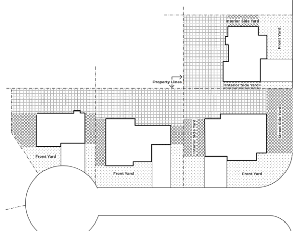
(113) FRONT YARD. The permeable area between the front lot line and the front facade of the main building and extending for the full width of the lot. The front yard must front a public street. Note – See corner lots for front yard calculations.
- STREET SIDE YARD. The yard area on a corner lot that extends from the street side lot line to the side façade of the main building, beginning at the point a dwelling is constructed. The street side yard is subject to front yard setbacks, fencing, and visibility requirements applicable to corner lots. For purposes of setback calculations, the required front yard setback shall apply to the designated Street Side Yard.
(114) GARAGE, PRIVATE. An accessory building designed and/or used for the storage of motor vehicles owned and used by the occupants of the building to which it is accessory, provided that a garage shall be considered part of the dwelling if the garage and dwelling have a roof or wall in common.
(115) GARAGE, PUBLIC. A building or portion thereof, other than a private garage, designed or used for servicing, repairing, equipping, hiring, selling, leasing, renting or storing motor vehicles.
(116) GARAGE, REPAIR. A structure or portion thereof, other than a private garage, used for the repair of self-propelled vehicles, trailers, or boats, including general repair, rebuilding or reconditioning of engines, motor vehicles, recreational coaches, and minor collision service, but not including major body, frame or fender repairs or overall automobile or truck painting, except by conditional use permit. A repair garage may also include incidental storage, care washing, or sale of automobiles.
(117) GENERAL PLAN. A document that a municipality adopts that sets forth general guidelines for proposed future development of the land within Grantsville City (2.1.9). The General Plan also includes what is commonly referred to as a "master plan", or "comprehensive plan".
(118) GEOLOGIC HAZARD. A hazard inherent in the crust of the earth, or artificially created, which is dangerous or potentially dangerous to life, property, or improvements, due to the movement, failure, or shifting of the earth, Geologic hazards include but are not limited to; rockfills, slide areas, flood plains, fault lines, high water table, and ground water problems, such as liquefaction, etc.
(119) GOVERNING BODY. The city council of Grantsville City.
(120) GOVERNMENT SIGN. Any temporary or permanent sign erected and maintained by the City, County, State, or Federal government for traffic direction, or designation to any school, hospital, historical site, or public service property, or facility.
(121) GRADE (LOT GRADE, FINISHED GRADE).
- For buildings adjoining one street only, the elevation of the sidewalk at the center of the wall adjoining the street.
- For buildings adjoining more than one street, the average of the elevations of the sidewalk at the centers of all walls adjoining the streets.
- For buildings having no wall adjoining the street, the average level of the finished surface of the ground adjacent to the centers of all exterior walls of the building.
- Any wall parallel or nearly parallel to and not more than 5 feet from a street line is to be considered as adjoining the street.
(122) GROUND ANCHOR. Any device at the mobile home stand designed for the purpose of securing a mobile home to the ground.
(123) GROUND SIGN (also "Blade Sign"). A sign which is anchored to the ground similar to a pylon or freestanding sign, but which has a monolithic or columnar line and which maintains essentially the same contour from grade to top. Height and setbacks are to be the same as for freestanding signs.
(124) GROUP HOMES. A home for certain handicapped or elderly persons as defined by Utah State law as being permitted in residential areas of Grantsville City by conditional use permit. (see Elderly, and Handicapped)
(125) HANDICAPPED PERSON. A person who has a severe, chronic disability attributable to a mental or physical impairment, or to a combination of mental and physical impairments, that is likely to continue indefinitely and that results in a substantial functional limitation in three or more of the following areas of major life activity; self-care, receptive and expressive language, learning, mobility, self-direction or sequence of special economic self-sufficiency; and, requires a combination or sequence of special interdisciplinary or generic care, treatment, or other services that are individually planned and coordinated to allow the person to function in, and contribute to a residential neighborhood.
(126) HANDICAPPED RESIDENTIAL FACILITIES. A single family dwelling or multiple- family dwelling unit that meets the requirements of Part 6 and any ordinance adopted under authority of that part.
(127) HOMEOWNERS’ ASSOCIATION (HOA). A private, legally established organization created through recorded covenants, conditions, and restrictions (CC&Rs) for the purpose of owning, managing, and maintaining common areas, enforcing private deed restrictions, and administering shared responsibilities within a subdivision or planned community. An HOA operates under bylaws adopted by its members and is governed by a board of directors elected in accordance with those bylaws. An HOA has no authority to approve, deny, or modify land use applications, building permits, or other regulatory actions administered by the City, and its private covenants do not supersede or replace any requirement of this Code.
(128) HOME OCCUPATION. A home occupation is a profession, or other economic activity conducted within a dwelling or its accessory structures by persons residing on the premises. The use must remain subordinate to the primary residential use of the property and shall not alter the residential character of the dwelling or neighborhood.
- Permitting Intent: Any conditional use permit issued for a home occupation shall ensure that the residential character of the premises and neighborhood is preserved. In cases of uncertainty, the protection of neighborhood residential values shall be paramount.
- Frontage: No property shall be eligible for a home occupation permit unless the lot has a minimum of 100 linear feet of continuous frontage along a public or private road that provides legal access to the property.
- Measurement: Frontage shall be measured along the property line abutting the road right-of-way.
- Road Type: The frontage may be on either a public street maintained by the municipality or county, or a private road that meets applicable access standards.
- Access: The frontage must provide direct vehicular access to the dwelling or principal structure.
- Area Restriction: The occupation shall occupy no more than 25% of the gross floor area of the dwelling unit or 500 square feet, whichever is less.
- Client Traffic: No more than two clients or customers per hour may visit the premises.
- Deliveries: Deliveries shall be limited to those normally made to a residence (e.g., postal service, small parcel carriers).
- Employees: Only residents of the dwelling may engage in the occupation, unless otherwise authorized by permit.
- Advertising & Signage: No on-site advertising or signage is permitted, except as specifically allowed by ordinance.
- Public Display: No outdoor display, storage, or activity related to the occupation shall be visible from adjoining properties or public rights-of-way.
- Noise & Nuisance: The occupation shall not produce noise, vibration, odor, smoke, traffic, or other impacts detectable beyond the property boundaries.
- Exceptions: Deviation to this requirement may only be granted by the Planning Commission upon a finding that adequate access and neighborhood compatibility are maintained.
(129) HOSPITAL. An institution providing health services, primarily for in-patients, and medical or surgical care of the sick or injured, including as an integral part of the institution such related facilities as laboratories, out-patient departments, training facilities, central service facilities, and staff offices.
(130) HOTEL. A building designed for or occupied as the more or less temporary abiding place of 16 or more individuals who are lodged for compensation, with or without meals.
(131) HOUSEHOLD PETS. A household pet is a domesticated animal, like a dog, cat, or bird, kept in a home for companionship and enjoyment, not for profit or farm use, except for normally dangerous animals, such as lions or tigers. This definition shall not include a sufficient number of dogs to constitute a kennel as defined in this code.
(132) IMPERVIOUS SURFACE. Impervious surfaces are those that do not absorb precipitation (water) and thus cause ponding and/or runoff. All buildings, parking areas, driveways, roads, sidewalks, and any areas in concrete and asphalt shall be considered impervious surfaces within this definition. In addition, other areas determined by the city engineer to be impervious within the meaning of this definition will also be classed as impervious surfaces.
(133) IMPERVIOUS SURFACE RATIO. The impervious surface ratio is a measure of the intensity of land use. It is determined by dividing the total area of all impervious surfaces within the site by the Base Site Area.
(134) IMPOUND/SECURITY LOT. A security lot fenced with or without guard dog and illuminated, where police or privately impounded vehicles may be kept for legal evidence or other purposes or while awaiting repairs. Normally where damaged vehicles are taken after an accident.
(135) IMPROVEMENTS. Work, objects, devices, facilities, or utilities required to be constructed or installed in a land development. Such improvements may include, but are not limited to, street construction to required standards, water facilities, sewer facilities, sidewalks, curbs and gutters, drainage facilities, street trees, street signs, street lights, traffic control or safety devices, fire hydrants, and such other facilities or construction required by this Ordinance, subdivision regulations, or by the Planning Commission and/or City Council for the necessary proper development of the proposed land development.
(136) INOPERATIVE VEHICLE OR TRAILER. Any vehicle or trailer that due to mechanical, electrical, structural problems, or lack of maintenance, cannot operate as it was originally constructed and designed to do or should not be operated due to conditions rendering it as unsafe. This includes any vehicle or trailer that is not currently licensed or which its operation is in violation of local, state and federal laws.
(137) INTERGRATED DEVELOPMENT PLAN. Comprehensive management for best assurance of maintaining standards and conditions of approval is the intent in the administration of a conditional use permit. Therefore every assurance will be required to maximize the meeting of the community's performance standards and minimize the problems of their enforcement through approved comprehensive management plans which have been prepared by the applicant and approved by the City Council. Single responsible management is felt crucial to consistent care and observance of binding regulations in assuring compatibility with the surrounding area of certain developments negotiated with the community. Agreed upon penalties for violations of the management plan are considered an important integral part of enforcement.
(138) INTERIOR SIDE YARD. The permeable and visible (not impeded by a fence) area between the lot line and the side facing facade of the main building as illustrated in Drawing 1 (see definition for Front Yard).
(139) JUNK. Any salvaged or scrap copper, brass, iron steel, metal, rope, rags, batteries, paper, wood, trash, plastic, rubber, tires, waste, or other articles or materials commonly designed as junk. Junk shall also mean any dismantled, wrecked or inoperable motor vehicles or parts thereof which remain in such condition for a period of time in excess of sixty days. An automobile, truck or bus shall be considered as inoperable if it is parked or stored on property outside of an enclosed garage and is not currently registered and licensed in this state or another state.
(140) JUNK YARD. The use of any lot, portion of a lot, or tract of land for the storage, keeping or abandonment of junk, including scrap metals or other scrap material, or for the dismantling, demolition or abandonment of automobiles, or other vehicles, or machinery or parts thereof, provided that this definition shall be deemed not to include such uses which are clearly accessory and incidental to any agricultural use permitted in the district.
(141) KENNEL. Any premises where 3 or more dogs older than 4 months are kept.
(142) KENNEL PERMIT, CLASS A: Means a permit authorizing the keeping, housing, or raising of not fewer than four and not more than fifteen animals on a single lot, subject to the following minimum standards:
- No animal shall be kept, penned, or raised within 100 feet of any pre-existing residential dwelling located on an adjacent lot, measured from the nearest corner of the residence.
- Each animal shall be provided a minimum of 1,000 square feet of dedicated area, with an additional 4,000 square feet required for each animal over five. A Class “A” Kennel Permit shall be issued only in accordance with applicable zoning regulations, licensing requirements, and conditions imposed by the City.
(143) LAND, AGRICULTURAL. Land used for bona fide agricultural purposes.
(144) LAND, COMMERCIAL. Land used for bona fide commercial purposes, or which is projected for commercial use by the master plan or the zoning ordinance adopted by Grantsville City, except legally existing non conforming uses in areas designated commercial in such ordinance.
(145) LAND DEVELOPMENT STANDARDS. Adopted construction standards, including but not limited to: drawings, tables, charts and references which have been adopted by the City Council by resolution and which set standards for the construction of improvements to land and which regulate said construction of improvements to land.
(146) LAND, INDUSTRIAL. Land used for bona fide industrial purposes or which is projected for industrial use by the general plan or the zoning ordinance adopted by Grantsville City, except legally existing non conforming uses in areas designated industrial in such ordinance.
(147) LAND USE INTENSITY. The degree to which land is used by man ranging from no use to unremitting, continual and concentrated use of the land. Land use intensity is normally measured by: type of use (i.e., agricultural, residential, commercial or industrial; period of use in average hours per day; numbers of humans, associated animals, and machines which occupy the land during the average hours of use; and the percent of the land covered by man-made structures.
(148) LANDSCAPING (LANDSCAPED). The planting, paving and dressing of finished graded earth (dirt) including retaining walls, trees, ground cover, perennial plants and annual plants, etc., and together with an (automatic) irrigation system to maintain the plants alive and flourishing for the length of time the plantings are to be maintained if not in perpetuity.
(149) LATERAL SEWER. A sewer which discharges into another sewer and has only sewer inlets from buildings and structures tributary into it.
(150) LEGISLATIVE BODY. The City Council.
(151) LIGHT MANUFACTURING. Only those processes which clearly do not threaten the natural environment with any more pollution than that normally experienced in the neighborhood or immediate vicinity may be considered light manufacturing and permitted in an area. Uses such as electronics, non-toxic welding or soldering of small items, assemblage of relatively small portable devises, highly controlled testing, and small area accessory warehouses or storage facilities to accommodate the in-house manufactured items with their associated stocks of supplies area allowed.
(152) LIGHT VEHICLE OR EQUIPMENT MAINTENANCE. The performance of routine maintenance tasks such as: changing the oil, checking tire pressure, replacing water hoses, etc., which do not involve the removal, repair or replacement of major mechanical, electrical, hydraulic, pneumatic, or components of the vehicle.
(153) LODGING HOUSE. A dwelling with not more than 10 guest, rooms where, for compensation, lodging is provided for at least 3 but not more than 15 persons, but not including motels or hotels.
(154) LOT. A parcel or unit of land abutting a public street or approved private street, described by metes and bounds and held or intended to be held in separate lease or ownership, or a parcel or unit of land shown as a lot or parcel on a subdivision plat map, planned unit development plat map, or condominium lot map, provided it is created pursuant to this Code.
(155) LOT AREA. The area contained within the property lines of the individual parcels of land shown on a subdivision plat or required by this Code, excluding any area within an existing street right-of-way, or any area required as open space under this Code, and including the area of any easements.
(156) LOT AREA PER DWELLING UNIT, AVERAGE. The average lot area for all dwelling units of a single type. Individual lots may be smaller or larger than the average, provided that the average size is maintained and that all other standards of this Code are met.
(157) LOT, CORNER. A lot abutting upon 2 or more streets at the their intersection or upon two parts of the same street, such streets or parts of the same street forming an interior angle of less than 135 degrees.
(158) LOT DEPTH. The horizontal distance between the front and the rear lot lines measured in the main direction of the side lot lines.
(159) LOT FRONTAGE. The length, in feet, of the front lot line which is co-terminus with the front street line.
(160) LOT FRONTAGE, REQUIRED. The length, in feet, of the front lot line which is co- terminus with the front street line.
(161) LOT HELD IN SEPARATE OWNERSHIP. Shall mean all contiguous land held in one ownership at the time of the passage of this Code.
(162) LOT, INTERIOR. A lot other than a corner lot.
(163) LOT, LEGAL NON-CONFORMING. A lot which was legally created prior to the adoption of this Code.
(164) LOT LINES. The property lines bounding the lot.
(165) LOT LINE ADJUSTMENT. The relocation of the property boundary line in a subdivision between two adjoining lots with the consent of the owners of record.
(166) LOT LINE, FRONT. For an interior lot, the lot line adjoining the street, for a corner lot or through lot, each lot line adjoining a street.
(167) LOT LINE, REAR. Ordinarily, that line of a lot which is opposite and most distant from the front line of the lot. In the case of a triangular or gore-shaped lot, a line 10 feet in length within the parcel parallel to and at a maximum distance from the front lot line. In cases where this definition is ambiguous, the Community Development Director, zoning administrator, or their designee shall designate the rear lot line.
(168) LOT, RESTRICTED. A lot having an average slope of 15 percent or more; a lot which does not contain at least 75 feet by 100 feet, or the minimum size of a lot permitted in the zoning district where located, with an average slope of less than 15 percent; and/or a lot which has vehicular ingress to the main building or structure which, upon completion of construction on the site, has a slope of 15 percent or greater; or a lot subject to geologic hazards.
(169) LOT RIGHT-OF-WAY. A strip of land not less than 26 feet in width connecting a lot to a street for use as private access to that lot.
(170) LOT, UNRESTRICTED. A lot having an average slope of less than 15 percent and containing a buildable area of at least 75 feet by one 100 feet, or the minimum size of a lot permitted in the zoning district in which it is located, with an average slope of less than 15 percent, or as a buildable area designated as such on the subdivision plat in which the lot is located, if the average slope of the lot is greater that 15 percent.
(171) LOT WIDTH. The horizontal distance between the side lot lines, measured at the required front yard setback line or rear yard setback line, whichever is shorter.
(172) MAIN USE OR BUILDING. The principal use which will occur on a lot or the principal structure to be used by the principal use on a lot, to which all other uses and structures are necessary.
(173) MAINTENANCE, VEHICLE OR EQUIPMENT. The maintenance or repair of a vehicle or piece of equipment that is other than routine maintenance, which the result of is to make it operable or safe to operate. May involve; the removal and/or replacement of major mechanical, electrical, hydraulic, pneumatic or other components, modifications in design, operation or structure.
(174) MANSARD. A sloped roof or roof-like facade architecturally comparable to a building wall.
(175) MANUFACTURED HOUSING. A transportable factory built housing unit constructed on or after June 15, 1976, according to the Federal Home Construction and Safety Standards Act of 1974 (HUD Code), in one or more sections, which, in the traveling mode is eight body feet or more in width, or 40 body feet or more in length, or when erected on site, is 400 or more square feet, and which is built on a permanent chassis and designed to be used as a dwelling with or without a permanent foundation when connected to the required utilities, and includes the plumbing, heating, air-conditioning, and electrical systems. All manufactured homes constructed on or after June 15, 1976, shall be identifiable by the manufacturer's data plate bearing the date the unit was manufactured and a HUD label attached to the exterior of the home certifying the home was manufactured to HUD standards.
(176) MARKET ANALYSIS. An economic analysis of the feasibility of a project.
(177) MARQUEE. A permanent roof-like structure or canopy of rigid materials supported by and extending from the facade of a building. (compare "Awning")
(178) MASTER PLAN. Means a comprehensive, long-range planning document that establishes the framework for phased development of a tract, lot, or parcel of land. It identifies intended land uses, transportation systems, utilities, open space networks, infrastructure, and development phasing necessary to ensure coordinated growth over time. A Master Plan shall be consistent with this Code, the municipal planning authority, City standards, the General Plan, and the site development standards and review procedures of Chapter 11 (Site Plan).
(179) MASTER DEVELOPMENT AGREEMENT (MDA). Is a foundational contract setting broad terms for a long-term, multi-project relationship, often between a developer and a landowner/client, outlining responsibilities, standards, timelines, and dispute resolution to streamline individual project negotiations. It covers the overall framework for future developments (like phases, parks, permits, MIH, etc.)
(180) PIONEERING AGREEMENT. Means a contractual agreement between the City and a developer that establishes the terms, responsibilities, cost sharing, and reimbursement mechanisms for public improvements or infrastructure that must be constructed in advance of, or at a scale larger than, the developer’s own project. A Pioneering Agreement identifies the standards, timing, and conditions under which the pioneering improvements will be designed, constructed, and financed, and provides the framework for allocating costs and benefits among subsequent developments that rely on those improvements.
(181) Micro Entrepreneurship: A low-intensity use consisting of one small, independent business operating at a limited scale, with minimal off-site impacts, and designed to be compatible with surrounding residential or rural uses.
(182) MITIGATION CONDITIONS. Means site-specific requirements, limitations, or improvements imposed by the approving authority as part of a Conditional Use Permit to reduce, avoid, or eliminate Detrimental Impacts associated with a proposed Conditional Use. Mitigation Conditions may include operational restrictions, design modifications, buffering, screening, hours of operation, performance standards, or any other measures necessary to ensure compatibility with surrounding properties.
(183) MOBILE HOME. A transportable factory built housing unit built prior to June 15, 1976, in accordance with a state mobile home code which existed prior to Federal Manufacturing Housing and Safety Standards Act (HUD Code).
(184) MOBILE HOME LOT. A space designed and approved by Grantsville City for occupancy by mobile homes, and meeting all requirements of this Code.
(185) MOBILE HOME PARK. A parcel of land that has been planned and improved for the placement of mobile homes for non-transient use and consisting of two or more mobile home spaces, where the entire project is to be under single ownership or management and meets all of the requirements of this Code for mobile home parks.
(186) MOBILE HOME SERVICE EQUIPMENT. That equipment containing the disconnecting means, over current protective devices, and receptacles or other means for connecting a mobile home feeder assembly.
(187) MOBILE HOME SPACE. A space within a mobile home park designed and to be used for the accommodation of mobile home.
(188) MOBILE HOME STAND. That part of the mobile home space which has been reserved for the placement of the mobile home and its appurtenant structures or additions.
(189) MOBILE HOME SUBDIVISION. A subdivision designed and intended for residential use where the lots are to be individually owned or leased, and occupied by mobile homes.
(190) MODULAR UNIT. A structure built from sections which are manufactured in accordance with the construction standards adopted pursuant to Section 58-56-4 of the Utah Code and transported to a building site, the purpose of which is for human habitation, occupancy, or use.
(191) MOTEL. A building or group of buildings for the accommodation of transient guests, comprising individual sleeping or living units, and designed and located to serve the motoring public.
(192) MUNICIPALITY. Grantsville City, other cities or a town.
(193) NATURAL RETENTION AREA. An area of poorly drained soils which lies along stream channels or swale or is adjacent to flood plain soils, which is subject to periodic flooding.
(194) NON CONFORMING USE. A use of land that does not conform with current zoning regulations, but, legally existed before its current zoning designation and has been maintained continuously since the time the zoning regulation governing the land changed.
(195) NON CONFORMING STRUCTURE. A structure that legally existed before the current zoning designation and because of subsequent zoning changes, does not conform with the zoning regulation's setback, height restrictions, or other regulations that govern the structure.
(196) NURSING HOME (ALSO REST HOME OR CONVALESCENT HOME). A home for the aged, chronically ill, or incurable persons in which three or more persons not of the immediate family are received, kept, or provided with food and shelter or care for compensation; but not including hospitals, clinics, or similar institutions devoted primarily to the diagnosis and treatment of the sick or injured.
(197) OCCUPANCY. The portion of a building or premises owned, leased, rented, or otherwise occupied for a given use.
(198) OCCUPIED AREA. The total of all of the lot area covered by a mobile home and its accessory buildings on a mobile home lot.
(199) OFFICIAL MAP. A map of proposed streets that has the legal effect of prohibiting development of the property until the City develops the proposed street.
(200) OFF-STREET PARKING SPACE. The space required to park passenger vehicle, which space shall meet the requirement of this Code.
(201) OFF-SITE IMPROVEMENTS. Improvements not on individual lots but generally within right-of-way and the boundaries of the development which they serve, and as further outlined in this Code.
(202) ON-SITE IMPROVEMENTS. Construction or placement of the main building, and its appurtenant improvements on a lot.
(203) OPEN SPACE. Land used for recreation, agriculture, resource protection, amenity, historical preservation, or buffers, and is protected by the provisions of this Code to ensure that it remains in such uses.
(204) OPEN SPACE, IMPROVED. Park area that is improved as part of a residential development. Improved open space may include, but need not be limited to, lawns, landscape areas, improved/paved trails, active recreation areas, children’s playgrounds, swimming pools, ball fields, multi-purpose courts, tennis courts, and other approved park improvements. The design and included elements in required improved open space are approved at the discretion of the planning commission and city council.
(205) OPEN SPACE, USABLE. Usable open space shall be any portion of a lot or building which meets all the following conditions:
- The open space shall be open to the sky or shall be open to view on at least two sides.
- The space shall be readily accessible by foot traffic from the dwelling unit to which it is accessory.
- If the space is provided on a balcony, roof, or other facility above grade, it shall have such protective devices as are deemed necessary by the building inspector to assure reasonably safe usage by the children and adults.
- The space shall not be provided from any required front or side yard, parking area, or driveway space.
(206) OWNER. The holder of the fee title to land or buildings or to property, whether a person, partnership, corporation, or other entity recognized by law, and his or its lessees, permittee, assignees, or successors in interest.
(207) OVERLAY DISTRICT: Means a zoning district applied to property in addition to the underlying base zone for the purpose of establishing supplemental regulations, development standards, or review procedures. An Overlay District does not, by itself, authorize any development rights. The Overlay District becomes effective only upon approval of a corresponding master development agreement that implements the standards, conditions, and requirements of the overlay. No rights, deviations, or entitlements provided by an Overlay District may be exercised until the associated master development agreement is approved and executed or amended in accordance with all applicable City procedures.
(208) PARAPET. The extension of a false front or wall above a roofline.
(209) PARCEL OF LAND. Means a contiguous quantity of real property described as a unit for purposes of ownership, conveyance, taxation, or development, and consisting of any real property interests recognized as “land”.
(210) PARKING FACILITY (PARKING LOTS, PARKING STRUCTURES). A building or open area, other than a street, used for the parking of more than 4 automobiles and available for public use, whether free, for compensation, or accommodation for clients or customers.
(211) PARKING LOT. An open area, other than a street, used for the parking of automobiles and available for public use, whether free, for compensation, or accommodation for clients or customers.
(212) PASSIVE SOLAR SYSTEM. A direct thermal system which utilizes the structure of a building and its operable components to provide for collection, storage and distribution of heating or cooling during the appropriate times of the year, by utilizing the climate resources available at the site. It includes those portions and components of a building that are expressly designed and required for the collection, storage, and distribution of solar and the architectural and engineering design or system simulation necessary to balance or optimize passive components.
(213) PEDESTRIAN-WAY (WALKWAY OR CROSS-WALK). A right-of-way designed for use by pedestrians and not intended for use by motor vehicles of any kind; a pedestrian- way may be located within or without a street right-of-way, at grade, or grade-separated from vehicular traffic.
(214) PERMITTED USE. Means a use of land that is expressly allowed within a zoning district as a matter of right, without the need to obtain a Conditional Use Permit, provided the use complies with all applicable standards, regulations, and requirements of this Code.
(215) PERSON. An individual, corporation, partnership, organization, association, trust, governmental agency, or any other legal entity or legal interest.
(216) PLANNED UNIT DEVELOPMENT (PUD). An integrated design for development of residential, commercial or industrial uses, or limited combination of such uses, in which the density and location regulations of the district in which the development is situated may be varied or waived to allow flexibility and initiative in site and building design and location, in accordance with an approved plan and imposed requirements. Planned unit development regulations may govern the subdivision of land if it is proposed by the developer to sell individual lots in the planned unit development. Thus planned unit development regulations can be subdivision regulations which may be chosen by the developer as an alternative to specifically designated subdivision regulations of this Code, to become effective only through the planned unit development approval process.
(217) PLANNING COMMISSION. The Planning Commission of Grantsville City.
(218) PLAT. An instrument subdividing property into lots as depicted on a map or other graphical representation of lands that a licensed professional land surveyor makes and prepares in accordance with Utah Code Ann. Section 10-20-803 or 57-8-13
(219) PREFABRICATED HOUSING. (See Modular Home).
(220) PREMISES. A parcel of land with its appurtenances and buildings which, because of its unit of use, may be regarded as the smallest conveyable unit of real estate for that zoning district.
(221) PRELIMINARY PLAT. Means a scaled map prepared by a licensed land surveyor that shows the proposed subdivision of a tract, lot, or parcel of land. It illustrates the intended layout of lots, streets, easements, public rights-of-way, utilities, and other improvements in sufficient detail to evaluate compliance with this Code and applicable state law. The Preliminary Plat is submitted for review and approval prior to preparation of a Final Plat, in accordance with Utah Code §10-20-803 and §57-8-13, and must be approved by the Planning Commission. All required local approvals must be obtained before a Final Plat may be recorded in the County Recorder’s office.
(222) PRELIMINARY PLAN. Means a conceptual or engineered plan submitted in conjunction with a Preliminary Plat that illustrates the proposed development layout, grading, drainage, utilities, access, and other site improvements. A Preliminary Plan provides the technical basis for evaluating subdivision feasibility and compliance with this Code before preparation of the Final Plan or Final Plat, consistent with the subdivision requirements of Utah Code §10-20.
(223) PRE-SECTIONED HOME. (See Modular Home).
(224) PRIME AGRICULTURAL SOILS. Areas of soils most suited for agriculture, those in capability units 1, 11, or 111, as indicated in the soil survey prepared by the Soil Conservation Service which encompasses Grantsville City.
(225) PRINCIPAL USE. Any use which is named and listed in the use regulations and other provisions of this Code, except those uses specifically designated as accessory uses; any use which is or may be conducted on a lot independently or any other use on the lot and not incidental or accessory to any other use on the lot; any use which establishes the primary activity on a lot.
(226) PRIVATE NON-PROFIT RECREATIONAL GROUNDS AND FACILITIES. Non-profit recreational grounds and facilities operated by a non-profit corporation, association, or group.
(227) PROCESS OR PROCESSING. The act, business or procedure of taking raw, extracted or preprocessed material and adding to or taking away from it, to produce a product that is purer, used, marketed, or uniquely different than the original raw material or product before the procedure was enacted.
(228) PROFESSIONAL TEAM, QUALIFIED. An individual(s) qualified by virtue of training, experience, state licensing where appropriate and membership in professional associations which pass upon qualifications prior to admittance to membership. A determination of whether or not a team is qualified, in the sense explained above, shall be made solely by the Planning Commission.
(229) PROTECTION STRIP. A strip of land between the boundary of a land development and a street within the land development, for the purpose of controlling the access to the street by property owners abutting the land development.
(230) PUBLIC FACILITIES AND PUBLIC SERVICE FACILITIES. For the public convenience, certain infrastructure including streets, water lines, sewer lines, public utilities and drainage facilities may be allowed to serve various areas of the community, as public facilities. Possible additional facilities such as a sub-station for fire and/or police, post office and/or hospital may be determined to be in the public interest as well, as public service facilities by Grantsville City.
(231) PUBLIC SYSTEM (WATER OR SEWAGE). A system which is owned and operated by a local governmental authority or by an established public utility company which is adequately controlled by a governmental authority. Such systems are usually existing systems serving a municipality, a township, an urban county, or a water or sewer district established and directly controlled under the laws of the state of Utah.
(232) QUASI-PUBLIC. A seemingly public institution, entity or organization that is not actually public. (Because of an independent or private control over it)
(233) REAR YARD REGULATIONS (REAR SETBACK). That part of a lot that adjoins another lot, alley, street, road or highway, which does not provide the main access to the lot, if any access at all is allowed, between the rear line of the building and the rear lot line, and extending the full width of the lot. The length of the rear yard is measured from the rear lot line to the eaves or the rear (back) line of a building whichever is closer to the rear lot line. Unenclosed stoops of six foot by six foot or less is not considered the rear line of a building.
(234) RECREATION DWELLING (CABIN, RECREATION CABIN). A dwelling designed for limited rather than primary occupancy and generally located adjacent to or with easy access to recreational area. The primary purpose for the construction of such a dwelling is to provide shelter during those limited periods of time when recreation is sought in the adjacent areas.
(235) RECREATIONAL VEHICLE (RECREATIONAL COACH). A vehicle with or without motive power, designed and constructed to travel on public streets, and designed for use as a human habitation of a temporary and recreational nature.
(236) RECREATIONAL VEHICLE PARK (TRAVEL TRAILER PARK). Any area or tract of land or a separately designated section within a mobile home park where lots are rented or held out for rent to one or more owners or users of recreational vehicles for a temporary time not to exceed 30 consecutive days.
(237) RECREATIONAL VEHICLE SPACE. A plot of ground within a recreational vehicle park designated and intended for the accommodation of recreational vehicle.
(238) RECORD OF SURVEY MAP. A map of a survey of land prepared in accordance with Utah Code Ann. Section 17-23-14, 17-23-17, 17-23-20, and the recording requirements of Utah Code §57-3-106.
(239) RENEWABLE ENERGY. That form of energy whose supply is natural, inexhaustible and not dependent upon fossil fuel supplies. Examples include residential solar heat, wind power, geothermal power and many other supply sources.
(240) RESIDENTAIL DRIVEWAY. A driveway providing vehicular access to property used for residential purposes. This includes driveways for single family detached/attached and two-family structures.
(351) RESIDENTIAL FACILITY FOR ELDERLY PERSONS. A single-family or multiple-family dwelling unit that meets the requirement of Chapter 8 of this Code and any ordinance adopted under authority of that chapter.
(242) RESIDENTIAL FACILITY FOR HANDICAPPED PERSONS. A single-family or multiple-family dwelling unit that meets the requirements of Chapter 8 of this Code and any ordinance adopted under authority of that chapter.
(243) RESIDUAL LAND. That land which does not meet the minimum standards for a lot and therefore must be attached and become part of another parcel which does or will conform to lot minimum standards, or be attached to public land for public purposes.
(244) RIGHT-OF-WAY. That portion of land dedicated to public use for street and/or utility purposes or maintained in private use for similar purposes.
(245) ROADWAY WIDTH. For a street with battered or roll curb to back of curb, otherwise the width of the actual paved surface.
(246) ROOFLINE. The top edge of a roof or building parapet, whichever is higher, excluding any mansards, cupolas, pylons, chimneys or minor projections.
(247) SANITARY SEWER AUTHORITY. The department, agency, or public entity with responsibility to review and approve the feasibility of sanitary sewer services or onsite wastewater services.
(248) SCHOOL, PRIVATE. A school which is operated by a quasi-public or private group, individual, or organization, for profit or non-profit and which has a curriculum similar to that provided in any public school whether or not a complete educational curriculum.
(249) SCHOOL, PUBLIC. A school operated by a school district or other public agency in the State of Utah.
(250) SECURITY SURVEILLANCE. When security is a paramount concern to a project, it may require continuous and comprehensive surveillance of the private streets if access is only through a guarded gate. Under these circumstances it is in the interests of the public to vary requirements sufficient to permit total control of a manager.
(251) SEWER CONNECTION. A connection consisting of all pipes, fittings, and appurtenances from the drain outlet of the mobile home to the inlet of the corresponding sewer riser pipe of the sewage system serving the mobile home development.
(252) SEWER RISER PIPE. That portion of the sewer which extends vertically to at least ground elevation and terminates at each mobile home stand.
(253) SIDE YARD SETBACK. That part of a lot that adjoins another lot, between the side line of the building and the side lot line, and extending from the Front yard setback to the Rear Yard setback. The width of the side yard is measured from the lot line to the end of the eaves or the side line of a building whichever is closer to the side lot line. Unenclosed stoops of six foot by six foot or less is not considered the side line of a building.
(254) SINGLE USE RESIDENTIAL DEVELOPMENT. A development that contains only single family dwellings, two family dwellings, or townhomes which are subject to the processes prescribed in Utah Code Ann. 10-20
(255) SITE. A parcel or parcels of land intended to have one or more buildings or intended to be subdivided into one or more lots.
(256) SITE AREA. All land area within the site as defined in the deed. Area shall be determined from an actual survey rather than from a deed description.
(257) SITE PLAN (PLOT PLAN). A plan required by and providing the information required by this ordinance in accordance to Chapter 11 and City standards.
(258) SKETCH PLAN. A generalized layout of a proposed subdivision or development, with accompanying general proposal and intentions of the subdivider or developer, and relating the proposed subdivision or development to its area, public, utilities, facilities, services, and to special problems which may exist in the area.
(259) SKY SPACE. That portion of the sky that must remain unobstructed for a solar collector to operate effectively. The sky space can be measured for specific time of year use and location . (See " SOLAR ACCESS").
(260) SOLAR ACCESS. The availability of sunlight to solar collectors and solar energy systems. Solar access to a site depends upon the specific system type and most often demands rooftop, south wall, south lot or detached collector protection.
(261) SOLAR ENERGY CONVERSION SYSTEM. Includes active, passive and photo voltaic solar systems which when placed on a structure to supply energy to that structure.
(262) SOLAR GREENHOUSE / SUNSPACE / SUNPARLOR. An attached space to a building or residence which may provide heat and/or food to users as part of a passive solar energy system.
(263) SPECIAL DISTRICT. All entities established under authority of Title 1 7A and any other governmental or quasi-governmental entity that is not a county, municipality, school district, or unit of the state.
(264) SPECIFIED PUBLIC UTILITY. An electrical corporation, gas corporation, telephone corporation, franchise or other quasi-public utility as those terms are defined in Utah Code Ann. Section 54-2-1 (2016).
(265) SPORTSMAN PERMIT. Means the keeping of 4-6 dogs for lawful sporting, training, field trial, or hunting-related purposes by their owner on a residential or agricultural property, pursuant to GCC 4-1-32(B) and subject to a conditional use permit and license issued by the City.
- No animal shall be kept, penned, or raised within 100 feet of any pre-existing residential dwelling located on an adjacent lot, measured from the nearest corner of the residence.
- Each animal shall be provided a minimum of 1,000 square feet of dedicated area, with an additional 4,000 square feet required for each animal over five. A Class “A” Kennel Permit shall be issued only in accordance with applicable zoning regulations, licensing requirements, and conditions imposed by the City.
(266) SPOT ZONE. A zoning amendment which singles out a relatively small parcel for a use classification totally different from that of the surrounding area, for the benefit of the owner of such property, which is invalid because it is not in accordance with a comprehensive plan.
(267) STABLE, PRIVATE. A detached accessory building for the keeping of livestock owned by the occupants of the premises and not kept for hire, renumeration, or sale.
(268) STABLE, PUBLIC. A detached accessory building where horses are boarded and/or kept for hire.
(269) STATE STORE. A facility for the sale of package liquor located on premises owned or leased by the state of Utah and operated by state employees. State store does not apply to any licensee, permittee, or to package agencies.
(270) STEEP SLOPES. Areas where the average slope exceeds 8 percent which, because of this slope, are subject to high rates of storm water runoff and therefore erosion.
(271) STORY, HALF. A partial story under a gable, hip, or gambrel roof, the wall plates of which are on at least two opposite exterior walls, do not extend more than four feet above the floor of such story, and the ceiling area of which does not exceed 2/3 of the floor area of ground, or attachment to something having a fixed location upon the ground, includes "building."
(272) STREET. A public right-of-way, including a highway, avenue, boulevard, parkway, road, lane, walk, alley, viaduct, subway, tunnel, bridge, public easement, or other way, and which may be classified as Rural, Residential, Local, Collector, Arterial, and Main Street or as otherwise defined in the Grantsville City Street Master Plan.
(273) STREET AND ROAD SYSTEMS. (AMENDED 5/97 & 11/06) (see Technical Specifications and Standard Drawings for Streets).
- ALLEY. Per Grantsville City Alley Street Cross Section. A private access-way or thoroughfare minimum 26-feet in travel way width, which is privately owned and maintained and is designed to give secondary access to lots or abutting properties; or provide direct access to townhome garages. An alley shall not be considered a street. A segment of an alley shall serve no more than 12 units without a second connection to a public street. Primary access shall be provided by a standard Residential Street which the residence fronts. Any alley that is longer than 150 feet as measured from the face of curb on the perpendicular intersecting street to the alley, shall have a cul-de-sac or hammerhead at the end thereof. The dimensions or layout of any required cul-de-sac or hammerhead shall comply with City’s standards and specifications for public cul-de-sac or the minimum specifications of the current International Fire Code for hammerheads. If driveways are provided off alleyways the minimum driveway length shall be 25 feet. These 25 feet of driveway length does not include a 30-inch-wide mountable curb and gutter, modified Type F Curb APWA Detail 205.2, for a normal crown alley section or ribbon curb for a reverse crown alley section. Curb and gutter shall be painted red with “No Parking” signs on each end of alley and every 50 feet of a thru alley and “No Parking” sign on entrance to dead-end alley. Water meters shall not be located in alley driveway or concrete apron of alley and shall be clustered in landscaped, public utility easement on side of buildings.
- Arterial - A limited access street which is designed to carry through traffic with their only access being from Collector streets and State roads at intervals of no less than 1/2 mile. Arterial streets are intended to serve up to 3500 or more average daily trips when the service area is fully developed.
- Collector-A Street which is designed to intercept traffic from a standard residential road. Collector streets are intended to serve up to 1500 average daily trips from 150 to 500 residential or equivalent units.
- CUL-DE-SAC. A street which is designed to remain permanently closed at one end, with the closed end terminated by a vehicular turnaround. For purposes of this code, the length of a cul-de-sac shall be measured from the centerline of the intersecting street along the centerline of the cul-de-sac, to a point to the center of the cul-de-sac.
- Local – Per Grantsville City Local Street Cross section. A street which creates the intercity grid network and functions to move traffic from Residential streets to Collector streets.
- MAJOR STREET PLAN. A map of Grantsville City which shows the existing and future public street system and which has been officially adopted by the Planning Commission and City Council as the major street plan for Grantsville City.
- PRIVATE LANE. A privately owned way or lane which affords the principal means of access to property. A private lane is not considered a street. A private lane which serves up to two (2) dwelling units shall have a right of way width of not less than 36 feet with or without fire hydrants and shall be constructed and maintained with an all-weather dustless surface that meets the specifications of the City for a standard residential street section, except that the base course need only be 26 feet wide with or without fire hydrants with a slope or crown of 2 to 4%, no bituminous surface course need be applied and said street shall have a shoulder v-ditch sized appropriately per Grantsville City Storm Drainage requirements. Any private lane that is longer than 150 feet as measured from the face of curb on the perpendicular intersecting street to the private lane, shall have a cul-de-sac or hammerhead at the end thereof. The dimensions or layout of any required cul-de-sac or hammerhead shall comply with City’s standards and specifications for public cul-de-sac or the minimum specifications of the current International Fire Code for hammerheads.
- PRIVATE STREET. Per Grantsville City Private Street Cross section. That serves more than two dwelling (2) units or any business activity intend to serve up to 1,000 average daily trips. Any private street that is longer than 150 feet as measured from the face of curb on the perpendicular intersecting street, shall have a cul-de-sac, or hammerhead at the end thereof. not to exceed 750 feet in length The dimensions or layout of any required cul-de-sac or hammerhead, shall comply with City’s standards and specifications for public cul-de-sac or the minimum specifications of the current International Fire Code for hammerheads. The developer or owner(s) of a private street shall place a street sign at the intersection of the private street and all public streets, indicating the name of the private street, the north or east coordinate and that the street is a “private street”. location and specifications for the Curb and gutter shall be painted red private with “No Parking” signs on each end of Private Street every 150 feet of a thru private street and “No Parking” sign on entrance to dead end private streets. Street sign shall be determined by the City Public Works Director.
- Public Street-A Street or road which has been dedicated or abandoned to the public and accepted by the proper public authority and affords principal access to abutting properties.
- Rural – A street located in outlying areas where volumes are less than a design hourly volume of 100 and intrusions such as driveways are greater than 1/4 mile apart with intersections being spaced no less than 1 mile apart.
- Single Family Residential Street -A Street which is designed to serve abutting land uses only. Standard residential streets are intended to serve up to 1000 average daily trips from no more than 100 residential or equivalent units. Residential streets may be developed to a Rural Residential Road Standard if the street meets criteria found in the Grantsville City Street Master Plan.
- Stub Streets-A Street or road extending from within a subdivision boundary and temporarily terminating with temporary turnaround (cul-de-sac). Stub streets are provided to permit adjacent undeveloped parcels of land to be developed later by continuing the stub street to a connecting street.
- STREET SIDE YARD. The permeable and visible (not impeded by a fence) area between the secondary street lot line and the side facing facade of the main building as illustrated in Drawing 1 (see definition for Front Yard).
- SLIP LANE. (Amended ___/24) A slip lane is a one-way lane which diverges from the main Arterial or Collector Street and allows vehicles to transition to a street running parallel to the arterial or Collector Street without requiring to stop or enter an intersection. The turnouts into the slip lanes must have a minimum 5:1 taper, refer to tables below for dimensions based on various design speeds. Slip lane turnout and mergers shall be a minimum of 300-feet from street intersections. Slip lanes typically have a 150-foot right-of-way, and are sloped at 2% from the street crown as shown in the slip lane street section below.
(274) STRUCTURE. Anything constructed, the use of which requires fixed location on the ground or attachment to something having a fixed location on the ground, includes "building".
(275) SUBDIVIDER (DEVELOPER). Means any person, firm, corporation, partnership or association who causes land to be divided into a subdivision for himself/herself or others; a developer.
(276) SUBDIVISION. Any land that is divided, resubdivided or purposed to be divided into two or more lots, parcels, sites, units, plots, or other dividsion of land for the purpose, whether immediate or future, for offer, sale, lease, or development either on the installment plan or upon any and all other plans, terms, and condition.
- Subdivision" includes:
- The or development of land whether by deed, metes and bounds description, devise and testacy, map, plat, or other recorded instrument, regardless of whether the division includes all or a portion of a parcel or lot; and
- Except as provided for in the following Subsection regarding the division or partition of agricultural land, divisions of land for residential and non-residential uses, including land used or to be used for commercial, agricultural, and industrial purposes.
- "Subdivision" does not include:
- A bona fide division or partition of agricultural land for the purposes of joining one of the resulting separate parcels to a contiguous parcel of unsubdivided agricultural land, if neither the resulting combined parcel nor the parcel remaining from the division or partition violates an applicable land use ordinance;
- A recorded document, executed by the owner of record;
- Revising the legal description of multiple parcels into a legal description encompassing all such parcels; or
- Joining a lot to a parcel.
- A boundary line agreement recorded with the Tooele County Recorder between owners of adjoining subdivided properties adjusting the mutual lot line boundary in accordance with Utah Code Ann. Section 10-20-507, 10-20-806, and 15-1-45, if:
- No new dwelling lot or housing unit will result from the adjustment; and
- The adjustment will not violate any applicable land use ordinance.
- A bona fide division of land by deed or other instrument if the deed or other instrument states in writing that the division;
- Is in anticipation of future land use approvals on the parcel or parcels;
- Does not confer any land use approvals; and
- Has not been approved by the land use authority.
- A parcel boundary adjustment;
- A lot line adjustment;
- A road, street, or highway purpose; or
- Any other division or land authorized by law.
(277) SUBDIVISION, CLUSTER. A subdivision of land in which the lots have areas less than the minimum lot area of the district in which the subdivision is located, but which complies with the cluster subdivision provisions of this Ordinance and in which a significant part of the land is privately reserved or dedicated as permanent common open space to provide low-density character for the residential lots in the subdivision.
(278) SUBDIVISION, MINOR. A subdivision of four (4) or less lots, which is not traversed by the mapped lines of a proposed street as shown in the general plan of Grantsville City, does not require the dedication of any land for street or other public purposes and each lot in the subdivision meets the frontage, width and area requirements of this zoning ordinance and Grantsville City zoning maps.
(279) SUBDIVISION VACATION. The process of removing from record a section of land that was subdivided into plats for development or sale, lease or to offer for sale. The subdivision area vacated ceases to exist, and the land is one parcel, and must be re- subdivided to sell in smaller sections.
(280) SWIMMING POOL. An accessory use subject to all state and local regulations governing safety and health, which requires a conditional use permit.
(281) TECHNICAL REVIEW COMMITTEE. The Zoning Administrator, with the approval of the Mayor, may designate and appoint certain professionals, officials and other competent resource persons to serve as advisors, meeting as a Technical Review Committee to assist her/him, and serve as Planning Commission staff for the purpose of evaluating applications for Planning Commission action.
(282) TEMPORARY USE. Any use of land which, in the determination of the Planning Commission, and approved by the City Council shall not extend beyond 2 years from inception of such land use. A determination as to whether or not a land use is temporary shall be based solely upon facts submitted to the Planning Commission at the time of application for a conditional use permit for a temporary use. Unless found to be temporary, any use of the land shall be presumed to be permanent. Such uses include construction facilities, emergency facilities as well as interim uses of land and buildings awaiting ultimate use, i.e. pasture for a few months before construction begins, a carnival, fair, sports field, staging area, etc.
(283) TIEDOWN. Any device designed for the purpose of anchoring a mobile home to ground anchors.
(284) TWIN HOME DWELLINGS. (Amendment 7/97) A two-family dwelling that is divided into attached single-family dwellings as the result of a division of the property upon which the two dwellings are situated into two separate lots along the common wall of the two single-family dwellings. The adjoining lots occupied by a twin home shall have the minimum square footage required for any lot in the zoning district in which the property is located, plus the additional square footage of the dwelling unit in the same zone. Twin home dwellings shall be either approved as a part of an initial subdivision application and approval process or as a result of the subdivision amendment process specified by the provisions of Chapter 21 of this Code.
(285) TWIN COMMERCIAL UNITS (06/06). A twin commercial unit is a commercial building or structure that is located on two adjoining lots, is separated by a common wall and the common wall is located on the lot line. The adjoining lots occupied by a twin commercial unit shall have the minimum square footage required for any lot in the zoning district in which the property is located. Twin commercial Units may be approved as a part of an initial subdivision approval process or may be approved as a conditional use for existing lots in specified commercial and industrial zoning districts. The ownership of each portion of a twin commercial unit shall run with the land that it is located upon.
(286) UNINCORPORATED. The area outside of the incorporated boundaries of Grantsville City. That area that falls under the jurisdiction of Tooele County.
(287) UNLICENSED MOTOR VEHICLES. Any vehicle which initially was designed or constructed to be self-propelled and which is not currently registered or licensed by the State of Utah, but does not include vehicles exempt from registration under Section 41-22- 9 Utah Code Annotated, 1953, as amended. "Unlicensed Motor Vehicle" does not include any motor vehicle kept or stored at an approved impound lot or commercial storage yard.
(288) URBAN SERVICES. Those services normally associated with urban living, including but not limited to the following; electricity, natural gas, streets, schools, culinary water, sewage collection and treatment facilities, and police and fire protection.
(289) USE. The purpose for which a building, lot, sign or structure is intended, designated, occupied, or maintained.
- Accessory Use means a use that is incidental, subordinate, and customarily associated with the principal use of a building, lot, or structure, and located on the same lot as the principal use.
- Temporary Use means a use that is permitted for a limited duration and under conditions specified by this Code, and that does not involve permanent structures or permanent alteration of the site.
(290) VARIANCE. A discretionary approval granted by the designated authority that allows a property to deviate from a zoning requirement when, due to unique physical conditions of the property, strict enforcement of the ordinance would result in unnecessary or unreasonable hardship. A variance may only be granted upon findings required by state law and this Code, and may not authorize a use that is otherwise prohibited, increase density, or grant relief from procedural requirements. A variance runs with the land and remains subject to all conditions imposed at the time of approval.
(291) VICINITY MAP (LOCATION MAP). A map or drawing, not necessarily to scale, showing where a subdivision, or proposed subdivision, PUD, commercial development, or other property is located.
(292) VICINITY PLAN. A map or drawing, to scale, of any area proposed for development, showing existing and proposed streets, buildings, public facilities and utilities within the general influence area of the proposed project such as mile radius; boundaries of zoning districts , taxing districts, and other special districts on and in the immediate vicinity of the land proposed for project; water course, impoundments, streams, springs, wells and areas subject to continuous or occasional flooding on and in the immediate vicinity of the land proposed for project and significant vegetative patterns on and in the immediate vicinity of the land proposed for development.
(293) VIEW-OBSCURING FENCE, WALL OR HEDGE. A fence, wall, or hedge of vegetation growth which prevents full view of property on one side by a viewer standing on the other side.
(294) WATER CONNECTION. A connection consisting of all pipes, fittings, and appurtenances from the water riser pipe to the water inlet pipe of the distribution system within the dwelling.
(295) WATER RISER CONNECTION. That portion of the water supply system which extends vertically to at least ground elevation and terminates at the water inlet pipe for each mobile home lot or dwelling.
(296) WATERWISE LANDSCPE. Landscaping for water conservation with (1) No more than 35% of the total landscaped area planted in lawn, (2) Planting beds and landscape plants
watered with a drip irrigation system, (3) Watering zones separate for lawn and landscape plants, (4) Back Flow Preventer required (5) and landscape plants should be waterwise, adapted to Grantsville’s local climate, able to thrive on less water.
(297) WATER FACILITIES, STORM: a system of engineered structures like pipes, ponds, swales, and filters designed to collect, control, treat, and convey rainwater runoff from developed areas, preventing urban flooding, erosion, and pollution from reaching local rivers and streams by allowing water to soak in or slowly release. These facilities manage water from impervious surfaces (roads, roofs) that can't absorb rain, removing pollutants like oil, grit, and trash before it enters natural waterways.
(298) WETLANDS. Areas known as marshes, swamps, or wetlands, including all areas greater than one-quarter acre where standing water is retained for a portion of the year and unique vegetation has adapted to the area, or as regulated by the U.S. Army corps of Engineers.
(299) WIND ENERGY CONVERSION SYSTEMS. Includes structure and all apparatus to utilize wind to drive generator.
(300) WINDOW SIGN. A sign installed inside a window and intended to be viewed from outside the building.
(301) Xeriscape Landscape. One of several methods of landscaping that employs a mix of drought tolerant plants and organic and inorganic mulch and are considered Waterwise Landscapes.
(302) YARD. A required open space on a lot, other than a court, unoccupied and unobstructed from the ground upward, except as permitted elsewhere in this Code.
(303) YARD, REAR. (See: Rear Yard Setback)
(304) YARD, SIDE. (See: Side Yard Setback)
(305) ZONE. (See "District, Zone")
(306) ZONING MAP. A map, adopted as part of a land use ordinance, that depicts land use zones, overlays, or districts.
Amended 05/97, 08/02, 11/05 by Ordinance 2005-20, 06/06 by Ordinance 2006-08, 09/07 by Ordinance 2007-31, 01/09 by Ordinance 2009-02, 09/18 by Ordinance 2018-16
Amended by Ord. 2019-10 on 5/1/2019
Amended by Ord. 2019-15 on 8/7/2019
Amended by Ord. 2021-23 on 5/19/2021
Amended by Ord. 2022-31 on 12/7/2022
Amended by Ord. 2023-03 on 5/17/2023
Amended by Ord. 2024-05 on 1/31/2024
Amended by Ord. 2025-01 on 1/30/2025
Amended by Ord. 2025-31 on 7/9/2025
Amended by Ord. 2025-39 on 12/3/2025
Amended by Ord. 2026-17 on 3/25/2026

