
Green Cove Springs City Zoning Code
CHAPTER 117
LAND USE REGULATIONS
ARTICLE VI.- INSTITUTIONAL LAND USE CATEGORY, INSTITUTIONAL ZONING CATEGORY[2]
Editor's note— Ord. No. O-09-2020, § 3, adopted Aug. 25, 2020, repealed the former Art. VI, §§ 117-386—117-388, and enacted a new Art. VI as set out herein. The former Art. VI pertained to similar subject matter and derived from Code 2001, § 102-291—102-293; Ord. No. O-01-2000, § 3.02.02(V), adopted June 6, 2000; and Ord. No. O-08-2011, § 6, adopted Dec. 6, 2011.
ARTICLE VIII.- RESERVED[3]
Editor's note—Ord. No. O-11-2024, § 1, adopted April 16, 2024, repealed Art. VIII, §§ 117-441—117-449, which pertained to Central Business District and derived from Code 2001, §§ 102-351—102-359; Ord. No. O-01-2000, § 3.04.02, adopted June 6, 2000; Ord. No. O-03-2005, §§ 1—4, adopted April 6, 2005; Ord. No. O-13-2008, § 1, adopted June 17, 2008; Ord. No. O-08-2011, § 6, adopted Dec. 6, 2011; Ord. No. O-03-2018, § 4, adopted May 15, 2018; and Ord. No. O-01-2022, §§ 3—5, adopted March 1, 2022.
Sec. 117-1.- Purpose.
The purpose of this chapter is to describe the specific uses and restrictions that apply to land use districts consistent with the future land use element of the comprehensive plan. These regulations are intended to allow development and use of property only in compliance with the goals, objectives, and policies in the city comprehensive plan.
(Code 2001, § 102-1; Ord. No. O-01-2000, § 3.00.01, 6-6-2000; Ord. No. O-08-2011, § 6, 12-6-2011)
Sec. 117-2. - Land use districts, generally.
(a)
Land use districts for the city are established in the comprehensive plan, future land use element, including the future land use map of the city comprehensive plan. The land use districts and classifications defined in the future land use element of the city comprehensive plan and delineated on the future land use map are the general determinant of permissible activities in the jurisdiction. Specific determinations on allowable uses on a parcel-by-parcel basis is established in this subpart and delineated on the tables in the applicable district. Allowable uses are shown in articles II through VI of this chapter to correlate individual land use activities with land use classifications included on the future land use map.
(b)
The city is divided into the following land use districts:
(c)
These districts have corresponding zoning categories that are consistent with the future land use and promote the implementation of the comprehensive plan. The planned unit development zoning category (PUD) is an allowable zoning category for all land use districts. The uses allowed in the PUD zoning district must be consistent with the future land use designation, promote the implementation of the comprehensive plan, and meet the requirements for a planned unit development included in this subpart.
Future Land Use and Zoning Capability Table
(Code 2001, § 102-2; Ord. No. O-01-2000, § 3.01.01, 6-6-2000; Ord. No. O-08-2011, § 6, 12-6-2011; Ord. No. O-09-2019, § 1, 7-9-2019; Ord. No. O-02-2022, § 1, 3-1-2022; Ord. No. O-13-2024, § 11, 5-21-2024)
Sec. 117-3. - Specific allowed uses, generally.
This chapter defines and prescribes the specific uses allowed within each land use district described in the comprehensive plan and this subpart.
(a)
Permitted use table.
(b)
Zoning district description.
(c)
Permitted use table footnotes.
P - Permitted. SE—Allowed by Special Exception.
1.
Subject to the conditions set forth in section 117-789.
2.
Single-family attached dwellings, up to four units.
3.
Subject to the conditions in section 117-122(4)(a)—(j).
4.
Multifamily dwelling units may omit garages through a special exception.
5.
Subject to development criteria in section 117-148. Each RRF parcel requires a PUD rezoning in compliance with section 117-421 in order to be developed.
6.
All permitted uses are subject to the conditions set forth in section 117-199.
7.
Subject to the limitations in section 117-200(7).
8.
Subject to the limitations in section 117-226.
9.
No kennels. Subject to the limitations in section 117-200(7).
10.
Musical instruments. Subject to the limitations in section 117-200(7).
11.
Including repair incidental to sales. Subject to the limitations in section 117-200(7).
12.
Not wholesale bakeries. Subject to the limitations in section 117-200(7).
13.
Subject to the limitations of section 117-226.
14.
Provided no manufacturing or storage for distribution is permitted on-premises.
15.
Subject to the limitations outlined in section 117-228(10).
16.
Light manufacturing, processing (including food processing but not slaughterhouse), packaging or fabricating.
17.
Bulk storage yards, not including bulk storage of flammable liquids.
18.
Race tracks for animals or vehicles.
19.
Plumbing, electrical, mechanical, and sheet metal.
20.
All uses must be in a totally enclosed building and no more than 20 percent of floor space to be devoted to storage. The permitted uses per section 117-540 are subject to the limitations in section 117-541(5)(b).
21.
Automobile rental not included as a use permitted by special exception.
22.
Establishments or facilities for automobile parts, sales, and service without use of an outdoor intercom or public address system or speakers, and no vehicle display racks that tilt vehicles in any way to show underside, unless they are located inside a show room.
23.
Through special exception, multifamily dwelling units can be built without garages.
24.
Rentals, excluding heavy equipment.
25.
Veterinarian clinics within enclosed buildings.
26.
The following are permitted uses in the institutional land use category, institutional zoning category: Any lawful civic, governmental, religious, public utility, and other public necessity uses or activities.
27.
Subject to the limitations of section 117-297(5).
28.
Golf courses and pro shop allowed by special exception.
29.
Pursuant to section 117-355: Allowable uses are public recreation uses that are compatible with the environmental characteristics of the property and, if purchased with grant funds, are consistent with grant conditions. No development potential is associated with these lands; however, recreation facilities may be constructed as a part of recreation uses that are consistent with the land use category.
30.
Subject to the conditions in section 117-796.
31.
Beer and wine sales only.
32.
Multifamily dwellings greater than 35 feet in building height.
33.
Drive-through facility in conjunction with this use is not allowed.
(Ord. No. O-09-2019, § 1, 7-9-2019; Ord. No. O-09-2020, § 2, 8-25-2020; Ord. No. O-10-2020, § 1, 8-25-2020; Ord. No. O-15-2020, § 1, 1-5-2021; Ord. No. O-01-2022, § 2, 3-1-2022; Ord. No. O-23-2022, § 1, 1-17-2023; Ord. No. O-21-2022, § 2, 3-7-2023; Ord. No. O-10-2023, § 1, 3-21-2023; Ord. No. O-11-2024, § 2, 4-16-2024; Ord. No. O-13-2024, § 12, 5-21-2024)
Sec. 117-4. - Prohibited uses.
The following uses are prohibited in any land use category within the city:
(1)
Acid manufacture;
(2)
Cement and lime manufacture;
(3)
Distillation of bones;
(4)
Manufacture of explosives;
(5)
Fat, tallow or lard rendering;
(6)
Garbage, offal or dead animal reduction;
(7)
Storage of toxic waste;
(8)
Automobile wrecking or junkyards;
(9)
Paper and pulp manufacturing;
(10)
Mining;
(11)
Uses that create smoke or fire unless approved by the city.
(Code 2001, § 102-4; Ord. No. O-01-2000, § 3.02.02, 6-6-2000; Ord. No. O-08-2011, § 6, 12-6-2011)
Sec. 117-5. - Enclosed garages required for all residential dwelling units.
All residential dwelling units within the city in any land use district or zoning category shall have an attached or detached enclosed garage of at least ten feet by 20 feet unless otherwise provided in this Code. Additional conditions and exceptions are as follows:
(1)
The requirement for garages may be eliminated in multifamily dwelling units with a special exception or by rezoning the property to a PUD. This requirement shall apply to all new construction.
(2)
All existing carports as of the date of adoption of the ordinance from which this chapter is derived in any residential zoning district shall be allowed. This shall not require construction of a garage at these properties. The size of a carport cannot be increased or another carport constructed on the site. A carport of the same size can be rebuilt on the site if it is destroyed by a calamity, such as fire or wind.
(3)
Remodeling of an existing dwelling unit, including enclosing a carport to living space, without a garage would not trigger constructing a garage. This would also include remodeling of an existing dwelling unit without a garage that increases the square footage.
(4)
Converting an existing garage into living space is not permitted, unless a garage is added to site.
(5)
Adding a carport to an existing residential site that has a garage is not permitted.
(6)
New carports except as set forth in subsection (2) of this section, cannot be constructed in the city.
(7)
Existing carports are permitted to be converted to a garage or living space.
(Code 2001, § 102-5; Ord. No. O-38-2007, § 1, 12-18-2007; Ord. No. O-08-2011, § 6, 12-6-2011; Ord. No. O-06-2016, § 2, 6-7-2016)
Sec. 117-6. - Lot requirements table.
(a)
Lot requirements table.
(b)
Lot requirements notes.
NMR—No minimum required MP—Minimum pervious
Districts.
1.
Form-based code - Refer to Section Chapter 117 Article XIV
A.
New Development.
The provisions contained in this article apply to all new developments within the form-based code area depicted in Figure XIV-1.
B.
Existing Development.
1.
Existing developments shall not be required to meet code unless site or building modifications are proposed. Sign permits shall not trigger the requirements of this section.
2.
Existing developments undergoing a major modification shall be required to bring the entire site up to code, except for the following. Major modification shall be defined as any repair, reconstruction, rehabilitation, addition, or improvement which costs 50 percent or more of the "just market value" of the property, as noted in the Clay County Property Appraiser's Office records or the increase or replacement of more than 50 percent of the existing building floor area. Replacement, in this instance, entails demolishing both interior and exterior portions of the building to build new. When calculating the cost of the improvement, it shall include the cost of improvements made over the preceding five years.
a.
Existing buildings not proposed to be expanded shall not be required to meet building setbacks (section 117-836 B), minimum building and ceiling height (section 117-837 C), and frontage requirements (section 117-837 D). All other site and building provisions shall apply.
b.
If the major modification involves building a new structure on the site and not making any changes to the existing building(s), the existing buildings will not be required to meet the requirements of this form-based code. The new building and the site, however, will be required to meet all the provisions of this Code.
3.
Existing developments undergoing minor modifications shall not be required to bring the entire site up to code. The specific changes to the site or building, however, shall be required to meet the standards of this article. Should the minor modification require additional parking spaces, the parking lot and parking lot landscaping shall be brought up to code. Dumpster screening, site/accent lighting, and landscaping not meeting current regulations shall be modified to meet code. Minor modifications are those that do not meet the definition of major.
2.
Gateway Corridor Residential Zoning Category: section 117-515.
1.
The gateway corridor residential zoning category is intended for all property located in the gateway corridor and designated as RLD (residential low density) and RMD (residential medium density) on the future land use map. The permitted uses, special exceptions, and density controls are R-1, single-family residential, for the RLD (residential low density) property and R-2, single-family multifamily residential, for the RMD (residential medium density) property.
2.
Where structures are in existence and situated in the gateway corridor residential zoning category at the time of the adoption of the ordinance from which this section is derived and are demolished or destroyed, the structures shall be allowed to be rebuilt to the same footprints and density as existed at the time of adoption of the ordinance from which this section is derived, provided the construction of the new structure meets current building codes.
Setbacks.
3.
Ten percent of lot width (the greater amount must be chosen).
4.
Not less than ten feet for the first two stories. For each story in excess of two, the required side yards shall be increased by five feet for each story so added.
5.
20 feet for the first two stories. For each story in excess of two, the required rear yards shall be increased by five feet for each story so added.
6.
Section 117-123(5)(c)—(e):
(c)
Minimum required from side and rear yard of the structure: Not less than 25 feet for the first two stories. For each story in excess of two, the required front, side and rear yards shall be increased by one foot horizontally for every one foot of vertical building rise;
(d)
Minimum required rear yard: 25 feet unless it fronts a state-owned property (St. Johns River or Governors Creek) then a minimum of 30 feet setback;
(e)
Minimum required side yard on each side of the structure: Not less than 25 feet for the first two stories. For each story in excess of two, the required side yards shall be increased by one foot horizontally for every one foot of vertical building rise.
7.
If abutting a dedicated alley, only five feet are required.
8.
No minimum required (NMR), except 15 feet on corner lots and 15 feet on interior lots when abutting a residential zone.
9.
Minimum required side yard on each side of the structure: Not less than five feet for the first two stories. For each story in excess of two, the required side yards shall be increased by five feet for each story so added.
Lot Width.
10.
100 feet on a public street.
11.
Minimum required lot width:
1.
Two-family: 75 feet
2.
Three-family: 100 feet
3.
Four-family: 150 feet
Living Area.
12.
Section 117-123(3)(f)(1)—(4)
f.
Minimum required living areas:
1.
Efficiency apartment: 800 square feet;
2.
One bedroom apartment: 800 square feet;
3.
Two bedroom apartment: 900 square feet;
4.
Three or more bedroom apartment: 900 square feet plus an additional 100 square feet for each bedroom over two bedrooms.
13.
Section 117-123(f)(1)—(4) and section 117-566(2)(f)(1)—(4).
f.
Minimum required living areas:
1.
Efficiency apartment: 800 square feet;
2.
One bedroom apartment: 800 square feet;
3.
Two bedroom apartment: 900 square feet;
4.
Three or more bedroom apartment: 900 square feet plus an additional 100 square feet for each bedroom over two bedrooms.
14.
Minimum required living area: 700 square feet per family.
Lot Area.
15.
7,500 square feet for the first two dwelling units and 2,700 square feet for each additional unit that is added.
16.
Minimum required lot area shall be 7,260 square feet for the first two dwelling units and 3,630 square feet for each additional unit that is added;
17.
Minimum required lot area:
1.
Two-family: 8,500 square feet;
2.
Three-family: 12,500 square feet;
3.
Four-family: 16,500 square feet.
Minimum Pervious.
18.
Minimum Pervious is 30%.
19.
Minimum pervious surface: 40%.
20.
Minimum pervious surface: 20%.
Structure Height.
21.
Mirror industrial height for utility structures i.e., elevated water storage tanks.
22.
Maximum number of stories: three. Maximum structure height: 35 feet. For commercial and professional offices: The maximum height may be increased to 50 feet. The building must be tiered back one foot for every foot over 35 feet.
23.
Maximum structure height: 54 feet. Maximum height may be increased to 70 feet. The building must be tiered back one foot for every foot over 54 feet. Maximum number of stories: four. For a single-family detached dwelling permitted by special exception, maximum height would be 35 feet and the maximum number of stories is three.
24.
Maximum structure height (buildings): 55 feet. Maximum accessory height (towers only): 85 feet.
25.
Building height can be increased subject to approval of a special exception as set forth in section 117-122(7).
(Ord. No. O-09-2019, § 2, 7-9-2019; Ord. No. O-15-2020, § 2, 1-5-2021; Ord. No. O-21-2022, § 1, 3-7-2023; Ord. No. O-11-2024, § 3, 4-16-2024; Ord. No. O-13-2024, § 13, 5-21-2024)
DIVISION 2.5. - RESIDENTIAL LOW DENSITY LAND USE, R-1A ZONING CATEGORY[1]
Editor's note— Ord. No. O-21-2023, § 1, adopted March 7, 2023, set out provisions intended for use as Div. 3, §§ 117-64—117-67. Inasmuch as there were already provisions so designated, said division has been codified herein as Div. 2.5, §§ 117-70—117-73 at the discretion of the editor.
Sec. 117-355.- Recreation.
To provide and maintain a full range of recreational activities to meet the cultural, social and athletic needs of the city and provide open space to meet the aesthetic, health, safety, and welfare needs of its citizens and visitors. Allowable uses are public recreation uses that are compatible with the environmental characteristics of the property and, if purchased with grant funds, are consistent with grant conditions. No development potential is associated with these lands; however, recreation facilities may be constructed as a part of recreation uses that are consistent with the land use category. The maximum floor area ratio (FAR) permitted for recreational structures is 0.2.
(Code 2001, § 102-261; Ord. No. O-01-2000, § 3.02.02(IV), 6-6-2000; Ord. No. O-08-2011, § 6, 12-6-2011)
Sec. 117-356. - Conservation.
The conservation land use category shall limit the use of the land to recreation or conservation uses that are compatible with the environmental character of the land; no residential use is permitted.
(Code 2001, § 102-262; Ord. No. O-08-2011, § 6, 12-6-2011)
Sec. 117-386.- Intent.
The institutional land use category consists of civic, cultural, governmental, religious, public utilities, and other public necessity uses.
(Ord. No. O-09-2020, § 3, 8-25-2020)
Sec. 117-387. - Permitted uses.
The following are permitted uses without exception in the Institutional (INS) district:
(1)
Residential uses: None permitted.
(2)
Retail uses: None permitted.
(3)
Service uses: None permitted.
(4)
Education/recreation/social uses:
a.
Church/place of worship.
b.
Childcare facilities.
c.
Adult daycare.
d.
Schools, public and private.
e.
Schools, vocational, technical.
f.
Recreational facilities.
(5)
Public uses:
a.
Civic, governmental, and other public necessity uses or activities.
b.
Public utilities.
(6)
Health care uses:
a.
Hospital.
(7)
Industrial uses: None permitted.
(Ord. No. O-09-2020, § 3, 8-25-2020)
Sec. 117-388. - Permitted accessory uses.
The following are permitted accessory uses in the institutional (INST) district:
(1)
Single-family dwelling as part of a church/place of worship or school site.
(2)
Outdoor recreation uses as part of a church/place of worship, or school site.
(3)
Bingo (per F.S. § 849.0931, requirements) as part of a church/place of worship, or school site.
(Ord. No. O-09-2020, § 3, 8-25-2020)
Sec. 117-389. - Special exceptions.
The following uses are permitted by special exception in the institutional (INST) district:
(1)
Residential uses: None permitted.
(2)
Retail uses: None permitted.
(3)
Service uses: None permitted.
(4)
Education/recreation/social uses: None permitted.
(5)
Public uses: None permitted.
(6)
Health care uses: Emergency shelters, subject to the requirements set forth in section 117-796.
(7)
Industrial uses: None permitted.
(Ord. No. O-09-2020, § 3, 8-25-2020)
Sec. 117-390. - Density controls.
Density controls in the institutional land use category, institutional zoning category shall be as follows:
(1)
Minimum required lot area: None.
(2)
Minimum required lot width: None.
(3)
Minimum required front yard: 20 feet.
(4)
Minimum required rear yard: Ten feet; if abutting a dedicated alley, only five feet are required.
(5)
Minimum required side yard: None, except 15 feet on comer lots and 15 feet on interior lot, when abutting residential zone.
(6)
Floor area ratio (FAR): 0.30.
(7)
Maximum structure height: 85 feet. (Mirror industrial height for utility structures i.e., elevated water storage tanks.)
(Ord. No. O-09-2020, § 3, 8-25-2020)
Sec. 117-420.- Purpose.
It is the purpose of this part to encourage new development and redevelopment, flexibility in design with the overall development consistent with this subpart and the city comprehensive plan. A planned unit development is permitted on a parcel of land under common control or ownership, where it would be beneficial for the city and improve the quality of the development, to permit flexibility in the location of land uses that are shown on the future land use map. The density or intensity of the development shall not exceed development approved in the future land use map.
(Code 2001, § 102-321; Ord. No. O-01-2000, § 3.02.01, 6-6-2000; Ord. No. O-08-2011, § 6, 12-6-2011)
Sec. 117-421. - Compliance procedure; submittals.
All proposed development requesting to be reviewed as a planned unit development shall provide the following information on the application for development approval:
(1)
The application for approval of a proposed development shall indicate that the development approval is requested as a planned unit development.
(2)
The application shall clearly show the calculation allowed by the future land use map per type of land use category and the calculation of the land use by type in the proposed development.
(3)
The application shall indicate the benefit to the city for allowing the planned unit development. The benefits may include:
a.
Permit a creative approach to the development of land;
b.
Accomplish a more desirable environment than would be possible through the strict application of minimum requirements of this subpart;
c.
Provide for an efficient use of land, resulting in smaller networks of utilities and streets;
d.
Enhance the appearance of neighborhoods through preservation of natural features, the provision of underground utilities and the provisions of recreation areas and open space;
e.
Provide an opportunity for new approaches to ownership;
f.
Provide an environment of stable character compatible with surrounding residential areas; and
g.
Retain property values over the years.
(4)
The application for development approval must comply with all requirements of this subpart.
(Code 2001, § 102-322; Ord. No. O-01-2000, § 3.02.02, 6-6-2000; Ord. No. O-08-2011, § 6, 12-6-2011)
Sec. 117-750.- Purpose and intent.
It is the purpose of this section to provide appropriate standards relating to the operation of certain activities throughout the city. Such operations may create or maintain such excessive noise, vibration, air pollution, odor, or electromagnetic interference as to be a detriment to the public health, comfort, convenience, safety, and welfare. The standards in this article are therefore provided to protect the public interest, and promote the public health and welfare.
(Code 2001, § 102-381; Ord. No. O-01-2000, § 9.00.01, 6-6-2000; Ord. No. O-08-2011, § 6, 12-6-2011)
Sec. 117-751. - Applicability.
This article shall apply to all lands within the city.
(Code 2001, § 102-382; Ord. No. O-01-2000, § 9.00.02, 6-6-2000; Ord. No. O-08-2011, § 6, 12-6-2011)
Sec. 117-752. - Standard manuals and measuring devices; references.
The following references of current editions or as amended are cited in this article:
(Code 2001, § 102-383; Ord. No. O-01-2000, § 9.00.03, 6-6-2000; Ord. No. O-08-2011, § 6, 12-6-2011)
Sec. 117-753. - Air pollution.
(a)
Standards. To protect and enhance the air quality of the city, all sources of air pollution shall comply with rules set forth by the Environmental Protection Agency (40 CFR) and the state department of environmental protection (F.A.C. ch. 17-2). No person shall operate a regulated source of air pollution without a valid operation permit issued by the state department of environmental regulation.
(b)
Testing. Air pollution emissions shall be tested and results reported in accordance with techniques and methods adopted by the state department of environmental protection and submitted to the state. These tests shall be carried out under the supervision of the state and at the expense of the person responsible for the source of pollution.
(c)
Air pollution creating land uses. No zoning, special exceptions, or conditional use permits may be issued with respect to any development or project until all applicable permits have been received to certify the development or project is in compliance with applicable air pollution laws.
(Code 2001, § 102-384; Ord. No. O-01-2000, § 9.01.00, 6-6-2000; Ord. No. O-08-2011, § 6, 12-6-2011)
Sec. 117-754. - Odor.
No use in any district may generate any odor that reaches the odor standard threshold at the lot line or outside boundary of the enterprise or source of the odor.
(Code 2001, § 102-385; Ord. No. O-01-2000, § 9.02.00, 6-6-2000; Ord. No. O-08-2011, § 6, 12-6-2011)
Sec. 117-755. - Smoke.
(a)
Determination of visual density. The Ringelmann Chart, published by the U.S. Department of the Interior, Bureau of Mines Information Circular 8333, May 1967, is the standard measure for determining the equivalent opacity of smoke. All measurements shall be taken at the point of emission of the smoke.
(b)
Standard. Any land use will be in violation of this article emitting from a vent, stack, chimney, or combustion process any smoke that exceeds a density or equivalent capacity of Ringelmann No. 2, except that such emission does not exceed a density or equivalent capacity of Ringelmann No. 3 for a duration of not more than four minutes during any eight-hour period.
(c)
Responsible party. No land use other than residences may emit any smoke that is visible to the normal vision of an individual, from a vent, stack, and chimney or combustion process. In such event, the generator will be liable for the cost of measurement as stipulated in subsections (a) and (b) of this section.
(Code 2001, § 102-386; Ord. No. O-01-2000, § 9.03.00, 6-6-2000; Ord. No. O-08-2011, § 6, 12-6-2011)
Sec. 117-756. - Electromagnetic interference and radiation.
(a)
Electromagnetic interference. In all districts, no use, activity, or process shall be conducted which produces electric and/or magnetic fields which adversely affect public health, safety, and welfare, including, but not limited to, interference with normal radio, telephone, or television reception from off the premises where the activity is conducted.
(b)
Electromagnetic radiations. No power lines in excess of 25 KV will be constructed on or above residential land uses in the city. Conversely residential land uses will not be allowed below 300 KV power lines within the city.
(Code 2001, § 102-387; Ord. No. O-01-2000, § 9.04.00, 6-6-2000; Ord. No. O-08-2011, § 6, 12-6-2011)
Sec. 117-757. - Adult arcade amusement center or electronic game promotion center.
(a)
Distance from schools, churches, parks, community centers, senior centers, child care centers, and military installation. No adult arcade amusement center or electronic game promotion center shall be allowed to operate within the city within 1,000 feet of any established schools, churches, or parks operated by a local, state, or federal government, community centers, senior centers, child care centers, or military installation.
(b)
Distance from adult arcade amusement center or electronic game promotion center. No adult arcade amusement center or electronic game promotion center shall be allowed to operate within the city within 5,000 feet of any adult arcade amusement center or electronic game promotion center.
(c)
Distance from establishment where alcoholic beverages may be sold, consumed or served within the city. No adult arcade amusement center or electronic game promotion center shall be allowed to operate within the city within 1,000 feet of any establishment where alcoholic beverages may be sold, consumed, or served.
(d)
Measurement. The distance provided for in this section shall be measured from property line to property line.
(e)
Signage. Exterior signage shall be subject to the sign regulations of chapter 125. No exterior signs shall refer to activities on the premises that are illegal.
(f)
Windows. Facility windows may not be covered with opaque or reflective window tinting, posters, flyers, or anything else that obstructs the exterior view into the interior of the facility.
(g)
Safety standards. Reasonable safety standards must be maintained which include, but are not necessarily limited to, lighted parking areas.
(h)
Other provisions. Other provisions contained within the Clay County Adult Arcade Amusement Centers provisions (Clay County Code § 12-151 et seq.) must be complied with at all times.
(i)
Nonconforming uses. Where electronic game promotion centers exist lawfully in any zoning district as of January 10, 2012, such use may be continued on such property or site, or within such center, as a nonconforming use subject to all other applicable provisions of this Code.
(Code 2001, § 102-388; Ord. No. O-02-2012, § 4, 4-3-2012)
Sec. 117-758. - Building setback requirements.
(a)
Generally. No portion of any building may be located on any lot closer to any lot line or to the street right-of-way line than authorized in this subpart.
(b)
Yard to be open and unobstructed. The required yard shall be open and unobstructed except for the ordinary projections of architectural features, provided that such features do not project more than four feet.
(c)
Gas pumps. Gas pumps may be placed in the required front yard, provided there is a minimum of 20 feet from all property lines.
(d)
Corner lots. All corner lots have two front yards. However, residential and residential professional offices (RPO) zoning category structures oriented parallel to a street must have the required front yard on such street, but the front yard on the remaining street may be 15 feet.
(e)
Accessory building setbacks for residential structures. Accessory building setbacks must comply with the front and side yard setbacks set forth in this subpart, except as follows:
(1)
The setback for a pool shall be at least 7½ feet to the water line.
(2)
The high point of the accessory building roof or any appurtenance of an accessory building shall not exceed the height of the principal structure.
(3)
Unless specified otherwise by a variance, the height of a permanent fence or wall shall not exceed six feet except along a boundary of the yard to the street or road right-of-way where it shall not exceed four feet. Also, no fence shall be located closer than two feet to a right-of-way line.
(4)
Fences or walls specifically required as a part of a special exception are exempt from subsection (e)(3) of this section.
(5)
A detached accessory building shall not be closer than six feet to the main building or no closer than ten feet from rear property.
(6)
No detached accessory building or use can be located in the front.
(Code 2001, § 98-5; Ord. No. O-01-2000, § 6.01.03, 6-6-2000; Ord. No. O-17-2003, § 1, 10-21-2003; Ord. No. O-08-2011, § 5, 12-6-2011; Ord. No. O-02-2013, § 2, 2-19-2013)
Sec. 117-785.- Applicability and purpose.
The regulations in this article shall apply generally to regulate specific uses and qualify or supplement other regulations appearing in this chapter. It is the purpose of this article to regulate specific uses, to regulate the installation, configuration, and use of accessory structures, and to regulate the conduct of accessory uses; in order to ensure that the specific uses and accessory uses and structures are not harmful either aesthetically or physically to residents and surrounding areas.
(Code 2001, § 102-411; Ord. No. O-01-2000, § 7.00.00, 6-6-2000; Ord. No. O-08-2011, § 6, 12-6-2011)
Sec. 117-786. - General standards and requirements for accessory structures.
Any number of different accessory structures may be located on a parcel, provided that the following requirements are met:
(1)
There shall be a permitted principal structure on the parcel, located in full compliance with all standards and requirements of this subpart.
(2)
All accessory structures shall comply with standards pertaining to the principal use, unless exempted or superseded elsewhere in this subpart.
(3)
Accessory structures shall not be located in a required buffer, landscape area, or minimum building setback area.
(4)
Accessory structures shall be included in all calculations of impervious surface and stormwater runoff.
(5)
Accessory structures shall be shown on any development plan with full supporting documentation as required in chapter 101.
(Code 2001, § 102-412; Ord. No. O-01-2000, § 7.01.01, 6-6-2000; Ord. No. O-08-2011, § 6, 12-6-2011)
Sec. 117-787. - Swimming pools, hot tubs, and similar structures.
(a)
Swimming pools shall be permitted only in side and rear yards, and shall not encroach into any required building setback.
(b)
Enclosures for pools shall be considered a part of the principal structure and shall comply with standards for minimum distance between buildings, yard requirements, and other building location requirements of this subpart.
(c)
All pools shall be completely enclosed with an approved wall, fence or other substantial structure not less than five feet in height. The enclosure shall completely surround the pool and shall be of sufficient density to prohibit unrestrained admittance to the enclosed area through the use of self-closing and self-latching doors and shall comply with the current requirements of state law.
(d)
No overhead electric power lines shall pass over any pool unless enclosed in conduit and rigidly supported, nor shall any power line be nearer than ten feet horizontally or vertically from the pool's water edge.
(e)
Excavations for pools to be installed for existing dwellings shall not exceed a 2:1 slope from the foundation of the house, unless a trench wall is provided.
(Code 2001, § 102-413; Ord. No. O-01-2000, § 7.01.02, 6-6-2000; Ord. No. O-08-2011, § 6, 12-6-2011)
Sec. 117-788. - Fences, walls and hedges.
(a)
Generally. A building permit is required for all fences constructed.
(b)
Compliance with state building code. All fences and walls shall be built to comply with the state building code and in accordance with the following dimensional and use regulations. All posts must be made of materials rated to provide sufficient strength and endurance for outdoor use. The posts of each fence must be resistant to decay, corrosion, and termite infestation. All chain-link and other non-rigid fencing must include top rails for support and uniformity.
(c)
General provisions.
(1)
Restrictions.
a.
No barbed wire, razor wire or similar material shall be allowed for residential uses. Temporary security fencing may be allowed for construction sites in residential zones.
b.
Barbed wire shall be prohibited for commercial and industrial uses, except when installed at an eight-foot height or greater.
c.
No doors, aluminum siding, corrugated roofing materials, plywood, OCB boards, or scrap materials shall be used in constructing fences or walls.
(2)
Height.
a.
Fences, walls or hedges may be located in all front, side and rear yard setback areas of all residential zones. Fences or hedges shall not exceed four feet in height when placed in the front yard (the yard abutting a road or public right-of-way), except that decorative or ornamental fences made of aluminum, steel, vinyl, wood, or wrought iron may be a maximum of six feet in height with columns or gates extending up to 12 inches above the fence height. Decorative or ornamental fences shall be designed with picket spacing to provide an opacity of no greater than 40 percent allowing unobstructed visibility into the property for public safety, and any landscaping planted along the fence shall be limited to a maximum vegetation height of 30 inches. Each fence or wall located in the side and rear yard setbacks shall not exceed the height of six feet. There is no height limitation on a hedge in the rear or side yard.
Example of Six-Foot-High Residential Decorative; Ornamental Fence and Opacity Requirements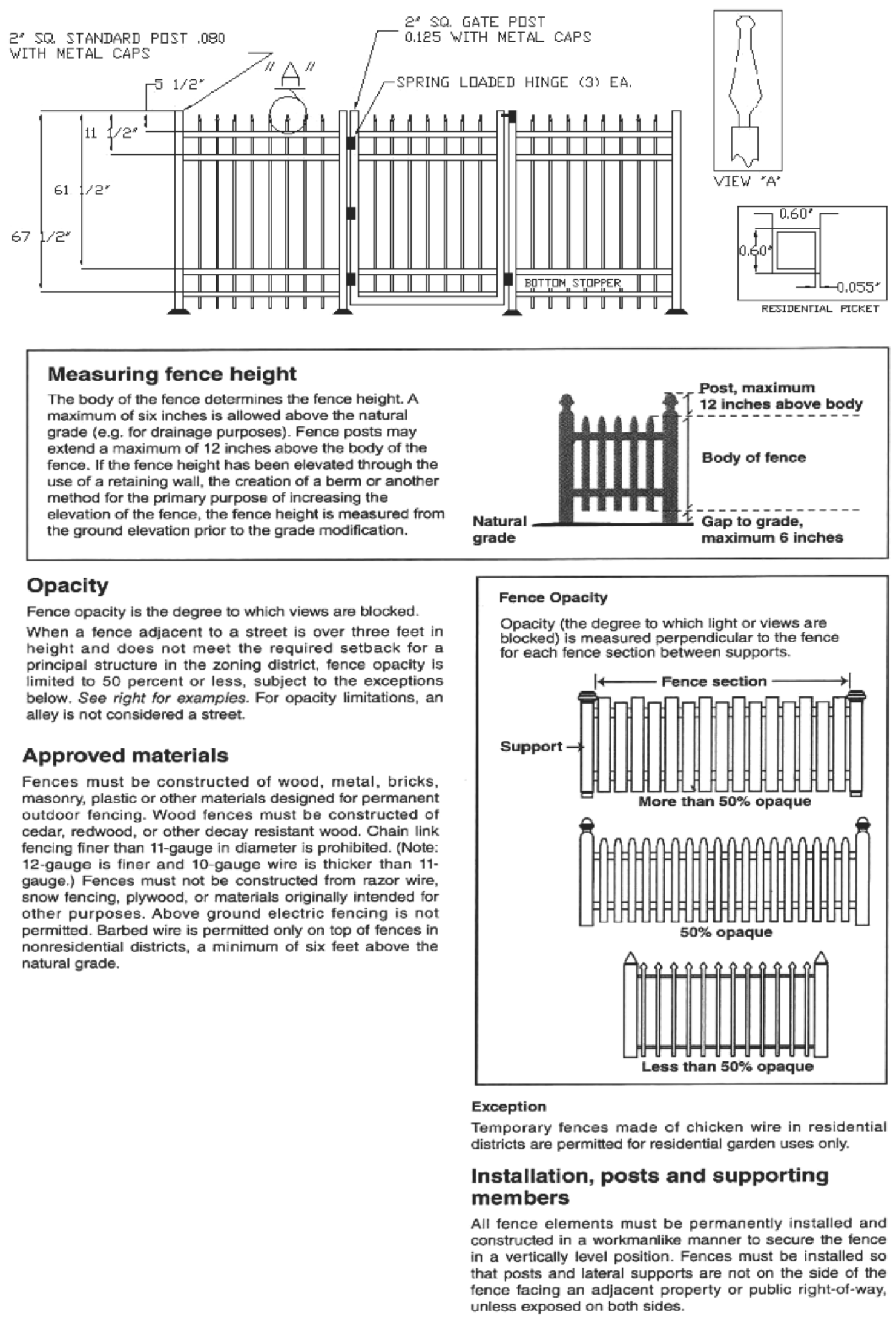
b.
Fences and walls in industrial (M-1, M-2) zones shall not exceed the height of ten feet.
c.
Fences and walls in commercial high intensity (CHI) zones shall not exceed a height of eight feet unless the fence or wall is considered to be a buffer to a conflicting zone or railway. A fence or wall considered to be a buffer shall not exceed a height of ten feet in a commercial high intensity (CHI) zone and the same for industrial M-1 and M-2 zones.
d.
Fences and walls in a residential professional office (RPO) zone shall not exceed the height of six feet.
e.
No permanent fence or wall located adjacent to any public right-of-way and designed to be an integral part of a new or existing subdivision improvement, including, but not limited to, subdivision entrances and subdivision walls, shall exceed ten feet in height, including columns.
f.
On atypical or vacant lots, chain-link fences may not exceed six feet in height. If a residence is constructed on a vacant lot, the fence in the front yard must be brought to four feet unless it is a decorative or ornamental fence constructed of aluminum.
g.
Where a fence or wall transitions from a higher to a lower height, the transition must be complete at or before the point where the lower height must begin. For example, where a six-foot-tall fence transitions to a four-foot-tall fence, the transition from higher to lower must be completed where the four-foot height limitation begins, such that no portion of the fence exceeds the height limitation.
(3)
Location.
a.
No permanent fence or wall shall be located within a city right-of-way line or utility easement.
b.
No permanent fence or wall shall be located within areas required to provide clearance for visibility in accordance with land development code triangle of visibility as referenced in section 113-76.
c.
A six-foot chain-link fence shall be required around all stormwater retention ponds for public health and safety.
(4)
Design and maintenance.
a.
All fences and walls shall be designed to comply with the architectural and landscaping requirements of this Code, when applicable.
b.
All fences shall be maintained in their original upright condition.
c.
Fences and walls designed for painting or similar surface finishes shall be maintained in their original condition as designed.
d.
Missing boards, pickets, posts or top rails and ties shall be replaced in a timely manner with material of the same type and quality.
e.
Fences or walls having a side with exposed or irregular structural components shall face inward on the property and the more finished, uniform and aesthetically attractive side shall be installed so that the more finished, uniform and aesthetically attractive side faces outward from the fenced property toward the adjoining property. This requirement shall not be construed as to require post components of fences to be invisible from the adjoining property.
f.
The smooth side of a fence or wall shall be installed facing outward towards an adjoining property to prevent an adverse visual impact to the adjoining property.
g.
No fence or hedge shall be constructed or installed in such a manner as to interfere with drainage on the site.
(5)
Exemptions.
a.
Customary fencing around tennis courts, other approved recreational amenities or public utility sites shall be exempt from height restrictions.
b.
Fences or hedges may be located in all front, side and rear yard setback areas. No fences or hedges shall exceed four feet in height when placed in the front yard (the yard abutting a road or public right-of-way), except in industrially zoned categories, where they shall not exceed six feet. Each fence located in the side and rear yard setbacks of a commercial high intensity and industrially zoned categories shall not exceed the height of eight feet, except for reasons as stated in subsection (2)b and c of this section, where they shall not exceed ten feet.
c.
Any fence located adjacent to a public right-of-way or private road shall be placed with the finished side facing that right-of-way.
(Code 2001, § 102-414; Ord. No. O-01-2000, § 7.01.03, 6-6-2000; Ord. No. O-08-2011, § 6, 12-6-2011)
Sec. 117-789. - Home occupations.
A home occupation shall be allowed in a bona fide dwelling unit, subject to the following requirements:
(1)
No person other than members of the family residing on the premises shall be engaged in such occupation.
(2)
The use of the dwelling unit for the home occupation shall be clearly incidental and subordinate to its use for residential purposes by its occupants, and shall, under no circumstances, change the residential character of the structure.
(3)
There shall be no change in the outside appearance of the building or premises, or other visible evidence of the conduct of such home occupation, other than one sign not exceeding one square foot in area.
(4)
No home occupation shall occupy more than 20 percent of the first floor area of the residence.
(5)
No traffic shall be generated by such occupation in greater volumes than would normally be expected in a residential neighborhood.
(6)
No equipment, tools, or process shall be used in such a home occupation which creates interference to neighboring properties due to noise, vibration, glare, fumes, odors, or electrical interference. In the case of electrical interference, no equipment or process shall be used which creates visual or audible interference in any radio, telephone, or television receivers off the premises or causes fluctuations in line voltage off the premises.
(7)
Fabrication of articles commonly classified under the terms arts and handicrafts may be deemed a home occupation, subject to the other terms and conditions of this definition and providing no retail sales are made at the home.
(8)
Outdoor storage of materials shall not be permitted.
(9)
A home occupation shall be subject to all applicable city local business tax receipt requirements, fees, and other business taxes.
(Code 2001, § 102-415; Ord. No. O-01-2000, § 7.02.01, 6-6-2000; Ord. No. O-08-2011, § 6, 12-6-2011)
Sec. 117-790. - Temporary construction trailers or structures.
(a)
Any person, firm or corporation may obtain a permit from the planning and zoning director as his designee for the construction and/or use of a temporary trailer or structure to be used as a construction shed and tool house for contractors and construction workers on the site. This temporary trailer or structure shall not be placed or erected on the property prior to the issuance of a building permit for the applicable construction, and shall be immediately removed upon completion of such construction project.
(b)
It shall be a violation of this section for any person, firm, or corporation to use such construction trailer for sales purposes without first applying to, and receiving written permission from, the planning and zoning director as his designee.
(c)
Construction trailers and structures will not be used for the purpose of living quarters, and such trailers or structures will have upon the unit, or attached thereto, an identification sign designating the owner or company and the words "Construction Office" in full view.
(Code 2001, § 102-416; Ord. No. O-01-2000, § 7.03.01, 6-6-2000; Ord. No. O-08-2011, § 6, 12-6-2011)
Sec. 117-791. - Special events.
(a)
Minor special event.
(1)
A minor special event is a promotional event for a business, civic, or fraternal clubs and the like or a revival for a church on less than ten acres of land or with an anticipated attendance of less than 500 persons. A social activity or gathering held on or at a homesteaded property or by the legal resident of the property shall be exempt from obtaining a minor special event permit.
(2)
A permit for a minor special event must be obtained from the city at least ten business days prior to the event. The permit will be granted based on the following criteria:
a.
The hours of operation are compatible with adjacent land uses.
b.
The amount of noise or visual pollution generated shall not be disruptive to activities or land uses adjacent to the special event site.
c.
The promoter or landowner guarantees that all litter will be removed at their own expense.
d.
The parking generated by the event can be accommodated onsite.
e.
The city may require a cash deposit to cover the cost of security and clean-up required by the event.
f.
License. A copy of all applicable licenses required from state and county agencies including the health department and food and beverage.
(3)
The city manager or his designee shall have the authority to approve a minor special event. An applicant may appeal a denial to the city council for review. The decision of the city council is final.
(b)
Major special event.
(1)
A public or private fair, festival, athletic events, exhibition, outdoor musical entertainment concert, or similar event on a minimum of ten acres or with anticipated attendance of over 500 persons per day and does not exceed the thresholds established for development of regional impact established in F.S. ch. 380 and F.A.C. subtitle 9J.
(2)
An application for site plan approval from the city council for events to occur on private property must be submitted 30 days prior to the event. The application may be requested for multiple events. The site plan shall have, at a minimum:
a.
Ingress and egress to the site;
b.
Areas for parking;
c.
Areas for the sale and/or consumption of food and beverage;
d.
Areas for the sale and consumption of alcohol;
e.
Areas for display;
f.
Areas for entertainment;
g.
Areas to address public safety; and
h.
Location for any permanent support facilities.
(3)
After the site plan is approved by the city council, the applicant shall submit the following to the city prior to issue of the permit:
a.
Sanitation facilities. A plan for adequate sanitation facilities, sewage disposal and garbage collection and disposal to be approved by the public works department.
b.
Medical facilities. A plan for adequate medical facilities to be reviewed and approved by the chief of police.
c.
Parking facilities. A plan for parking facilities designed to avoid material disruption of traffic flow to be approved by the city chief of police.
d.
Security and crowd control. A plan for adequate security and crowd control in and around the event area to be approved by the chief of police. The plan shall include, as a minimum, at least one police or security officer for each 250 persons attending the event.
e.
Lighting plan. A plan for adequate lighting if any portion of the event will be held during hours of darkness.
f.
Personal data. An affidavit setting forth the names, addresses, and relevant background and qualifications of the owner of the property.
g.
Time and location. The time and location of the event.
h.
Attendance. The estimated attendance of the event. The attendance shall be given per day on multiple day events.
i.
License. A copy of all applicable licenses required from state and county agencies including the health department and food and beverage.
j.
Liability insurance. The owner of the property shall provide proof of insurance to the city in an amount of no less than $2,000,000.00. The form of insurance shall be approved by the city attorney.
k.
Indemnity agreement. An agreement pursuant to which the applicant assumes full responsibility and liability for and indemnifies and saves the city harmless against:
1.
All liability, claims for damages, and suits for or by reason of any injury to any person, and damage to any property for every cause in any way connected with the holding of the festival irrespective of negligence, actual or claimed, upon the part of the city, its agents and employees, except willful and wanton acts of city employees and agents;
2.
All expenses incurred by the city in excess of normal operations, i.e., police protection, clean-up, etc., to the extent necessary to preserve public order and safety at the event; and
3.
The applicant shall agree to indemnify the city against all charges, expenses and costs, including the reasonable value of the services of the city attorney incurred on account of or by reason of any such injuries, damages, liability, claims, suits or losses, and all damages growing out of the same.
l.
Faithful performance guarantees. Faithful performance guarantees to be delivered to the city at the time the application is approved.
1.
A faithful performance bond in a form approved by the city attorney in the amount of $25,000.00, to be released after 30 days from the last date of the event covered by the bond conditioned that the applicant shall well and faithfully observe, fulfill and perform according to the plans approved and the requirements of this chapter and that, in the event of any failure to do so on the part of the applicant, the bond shall not be released and the amount thereof shall be recoverable by the city for all damages proximately resulting from the failure of the applicant to well and faithfully observe, fulfill and perform according to the conditions and requirements of this chapter;
2.
A cash deposit in the amount of $25,000.00 conditioned in the same manner as a performance bond under subsection (b)(3)l.1 of this section;
3.
An insurance policy in a form approved by the city attorney in the amount of $25,000.00 conditioned in the same manner as a performance bond in subsection (b)(3)l.1 of this section; or
4.
A personal bond secured by an unconditional and irrevocable letter of credit in the amount of $25,000.00, which letter of credit shall be issued by a state or United States banking institution to the city in a form approved by the city attorney, shall give the city the right to use any funds resulting from drafts on said letter of credit for all damages proximately resulting from the failure of the applicant to well and faithfully observe, fulfill and perform according to the plans approved and the requirements of this chapter, and shall be released and returned to the promoter after 30 days from the last date of the event covered by the personal bond.
Notwithstanding subsections (b)(3)l.1 through 4 of this section, the city council may reduce the bond based upon the applicants prior faithful performance hereunder, its credit worthiness, whether the applicant is the owner of the subject lands and any other factor deemed appropriate by the city.
m.
Other information. Such other information as the city council may reasonably require insuring compliance with this chapter.
n.
Revocation. The city manager or chief of police may revoke a permit if there is failure to comply with the standards for issuance of the permit and the plans submitted in connection with the permit application.
(4)
The applicant shall be required to pay the applicable fee based on the number of persons anticipated at the event:
a.
$500.00 for the first 5,000 persons in attendance over the entire event.
b.
$100.00 for each additional 1,000 persons in attendance.
c.
The applicant must provide attendance figures after the event to verify fees paid.
d.
The city may amend these fees at their discretion.
(5)
Upon submission of the items required in the preceding section, the filing of the required approvals by the city council, the county department of public safety and the city chief of police, and the payment of the application fee, the city manager shall issue a permit for the staging, promoting or conducting of an event at the time and location named in the application.
(Code 2001, § 102-417; Ord. No. O-01-2000, § 7.03.02, 6-6-2000; Ord. No. O-23-2004, § 1, 10-19-2004; Ord. No. O-17-2006, §§ 1, 2, 4-18-2006; Ord. No. O-27-2007, §§ 1, 2, 12-18-2007; Ord. No. O-14-2009, § 1, 7-21-2009; Ord. No. O-08-2011, § 6, 12-6-2011)
Sec. 117-792. - Alcoholic beverages.
(a)
Distance from schools and churches. No business selling alcoholic beverages for on-premises consumption shall be allowed to operate within the city within 1,000 feet of any established school or church ground.
(b)
Exceptions. The following shall be allowable exceptions to the above distance limitations:
(1)
Businesses licensed and operating closer than 1,000 feet to any established school or church ground as of the effective date of the ordinance from which this subpart is derived shall be exempt from this requirement until such time as the business ceases to operate. No new license will be issued to businesses in the location.
(2)
Notwithstanding the foregoing to the contrary,
a.
Licensed restaurants holding a state SRX alcoholic beverage license or other type state alcoholic beverage license wherein alcoholic beverage sales comprise less than 50 percent of total sales for any calendar year may be located anywhere within the gateway corridor district (GCD), or within a commercial shopping center under one common ownership in the C-2 zoning district, as described in this subpart, provided it is otherwise allowed and no closer than 200 feet from the nearest church or school ground or is separated from them by a street or highway. Such restaurants shall offer meals at all times that they sell, serve, or allow consumption of alcohol.
b.
Within the Form-based code area, alcoholic beverages for on-premises consumption are permitted without spacing requirements provided it is otherwise allowed.
(c)
Measurement. The distance provided for in this section shall be measured by following the shortest route of ordinary pedestrian travel from the main entrance of the church to the main entrance of the business and from the nearest point of a school's grounds to the main entrance of the business.
(d)
Hours of operation. Alcoholic beverages may be sold, consumed or served within the city by all establishments holding a state beverage license for the location of said establishment, daily, from 7:00 a.m. until the following day at 2:00 a.m.
(Code 2001, § 102-418; Ord. No. O-01-2000, § 7.03.03, 6-6-2000; Ord. No. O-14-2002, art. 1, 10-15-2002; Ord. No. O-32-2007, § 1, 11-20-2007; Ord. No. O-08-2011, § 6, 12-6-2011; Ord. No. O-11-2016, § 1, 8-16-2016; Ord. No. O-17-2016, § 1, 11-15-2016; Ord. No. O-03-2020, § 1, 7-21-2021; Ord. No. O-13-2024, § 3, 5-21-2024)
Sec. 117-793. - Mobile homes and mobile home parks.
(a)
Mobile homes. Mobile homes shall be parked only in licensed mobile home or trailer parks.
(b)
Recreational vehicles.
(1)
Recreational vehicles may not be used for permanent occupancy within the city limits.
(2)
Recreational vehicles parked may use water, electrical and sewer connections only for maintenance and repairs.
(3)
Recreational vehicles may be stored in a residential district as long as they are not connected to utilities or used for dwelling purposes.
(Code 2001, § 102-419; Ord. No. O-01-2000, § 7.03.04, 6-6-2000; Ord. No. O-08-2011, § 6, 12-6-2011)
Sec. 117-794. - Portable storage units.
(a)
Definitions. The following words, terms and phrases, when used in this section, shall have the meanings ascribed to them in this subsection, except where the context clearly indicates a different meaning:
Portable storage unit means any container designed for the storage of personal property which is typically rented to owners or occupants of property for their temporary use and which is delivered and removed by truck.
Site means a piece, parcel, tract, or plot of land occupied or to be occupied by one or more buildings or uses and their accessory buildings and accessory uses which is generally considered to be one unified parcel.
(b)
Number, duration and removal.
(1)
Portable storage units for onsite storage. There shall be no more than one portable storage unit per site no larger than eight feet wide, 16 feet long and eight feet high. No portable storage unit shall remain at a site in a residential district in excess of seven consecutive days unless an approved time extension is granted by the development services department.
a.
The approval for an extension of time shall be based on documented circumstances related to remodeling or renovation work on a residence or structure necessitating an extended period of time for completion. A request for an extension shall be approved based on the estimated time required for completion of the remodel or renovation work on a case-by-case basis.
b.
No portable storage units for onsite storage are permitted on a site if any portable storage units for transport as defined in subsection (a) of this section are on the site.
(2)
Portable storage units for transport. There may be up to two portable storage units, no larger than five feet wide, seven feet long, and eight feet high each, at a site in a residential district for a period not in excess of seven consecutive days when such units are being used for loading or unloading goods in connection with the transport of the goods, to or from storage, or, to or from another residential or nonresidential location. No portable storage units for transport are permitted on a site if any portable storage units for onsite storage as defined in subsection (a) of this section are on the site.
(3)
Cumulative time restriction. No portable storage units as defined in subsection (a) of this section shall be placed at any one site in a residential district in excess of seven days in any calendar year. No portable storage unit as defined in subsection (a) of this section shall remain at a site in a nonresidential district in excess of 14 consecutive days, and portable storage units as defined in subsection (a) of this section shall not be placed at any one site in a nonresidential district in excess of 28 days in any calendar year.
(c)
Removal of portable storage units in the event of a hurricane warning. Notwithstanding the time limitations set forth above, all portable storage units shall be removed immediately upon the issuance of a hurricane warning by a recognized government agency.
(d)
Signage. A portable storage unit shall have no signage other than the name, address and telephone number of the person or firm engaged in the business of renting or otherwise placing the portable storage unit.
(Code 2001, § 102-420; Ord. No. O-08-2011, § 6, 12-6-2011)
Sec. 117-795. - Conditions for medical marijuana treatment center dispensing facility.
(a)
No advertising may be visible to members of the public from any street, sidewalk, park, or other public place, except the dispensing facility may have a sign that is affixed to the outside or hanging in the window of the premises that identifies the dispensary by the licensee's business name, an approved trade name, or an approved logo. A trade name or logo may not contain wording or images commonly associated with marketing targeted toward children or which promote recreational use of marijuana (F.S. § 381.986(8)(h)(1)(2017)).
(b)
There shall be no dispensing from the premises of marijuana or marijuana delivery devices between the hours of 9:00 p.m. and 7:00 a.m., but all other operations may be performed and marijuana may be delivered to qualified patients 24 hours day (F.S. § 381.986(8)(f)(4)(2017)).
(c)
A medical marijuana treatment center dispensing facility may not be located within 500 feet of the real property that comprises a public or private elementary school, middle school, or secondary school (F.S. § 381.986(11)(2)(2017)).
(d)
Compliance with all applicable state laws, including amendments to the foregoing requirements in state law.
(Ord. No. O-03-2018, § 3, 5-15-2018)
Sec. 117-796. - Emergency shelters.
(a)
An emergency shelter shall be permitted in the Institutional Zoning District as a special exception, subject to the following provisions:
(1)
A minimum of 300 square feet of private indoor living space shall be provided for each occupant of a structure.
(2)
Minimum parking requirements shall be as follows:
a.
One parking space for each three beds; and
b.
One parking space for each employee.
(3)
All structures shall meet the city building code requirements, life safety code requirements, and housing code requirements pertaining to the intended use.
(4)
If a license to operate the facility is required by federal, state or local law, the applicant must either be in possession of such a license to operate such a facility or be in the posture to receive a license. Under no circumstances will permits or occupational licenses be issued by any city department until such license is presented to the building official.
(5)
No emergency shelter shall be located within 1,000 feet of any other emergency shelter. The distance requirements between two emergency shelters shall be measured from property line to property line.
(6)
The planning and zoning commission may place any reasonable special conditions, in addition to those provided in this subsection, on the special exception to ensure that the proposed use conforms with the character of the surrounding neighborhood; especially concerning: the prevailing dwelling unit density, the anticipated number of nonresident employees, lighting, service facilities, the background and history of the applicant/organization, approval can be limited to the owner/applicant, the type of activities and time limits regarding outdoor activities. In addition, the planning and zoning commission can evaluate and limit approval to the applicant/organization.
(7)
An emergency shelter shall adhere to all site plan requirements as per article IV of this chapter.
(8)
This special exception shall be limited to the proposed applicant or owner to whom the special exception is granted and shall be subject to the requirements of this subsection. Any changes in ownership or to the use of the property will require a new special exception application.
(b)
Emergency shelter responsible party.
(1)
The purpose of the responsible party is to respond to routine inspections, non-routine complaints, and other more immediate problems related to the emergency shelter of the property.
(2)
The property owner shall serve in this capacity or shall otherwise designate in writing to the city an emergency shelter responsible party to act on the property owner's behalf. Any person 18 years of age or older may be so designated provided they can perform the duties listed in subsection (c).
(3)
The duties of the emergency shelter responsible party, whether the party is a property owner or an agent, are to:
a.
Be available at a listed phone number 24 hours a day, seven days a week and capable of legally handling any issues arising from the emergency shelter use;
b.
Ensure all tenants have undergone a police background check. Individuals found guilty of violent crimes are prohibited from being tenants in an emergency shelter regardless of the length of stay. Failure to comply with this requirement shall result in revocation of the business tax receipt;
c.
Ensuring sexual offenders/predators as defined in F.S. §§ 775.21, 943.0435, 944.607, or 985.4815 register at the Clay County Sheriff's Office and the Green Cove Springs Police Department, following the process set forth in F.S. § 775.21, 48 hours prior to arrival at an emergency shelter, regardless of the length of stay. The property owner or agent shall comply with F.S. § 775.215, as amended from time to time, pertaining to the distance separation of homes with a sexual offender/predator residing within the emergency shelter and any business, school, child care facility, park, playground, or other places where children regularly congregate. Failure to comply with this requirement shall result in revocation of the business tax receipt.
(Ord. No. O-09-2020, § 4, 8-25-2020)
Sec. 117-797. - Outdoor sales of swimming pools, spas and hot tubs in GCC and C-2 Zoning District.
(a)
Outdoor sales of swimming pools, hot tubs and spas is allowed in the GCC zoning district as a special exception with the approval of the planning and zoning commission and as a permitted use in the C-2 Zoning District subject to the minimum criteria as provided in this chapter. The minimum criteria that must be met for this use in the C-2 and GCC Zoning District zoning district are as provided in this section. These criteria must be shown on the site plan or sketch submitted with the application for a special exception and must also be shown on the site plan submitted for site plan review. Additional criteria may be required by the planning and zoning commission pertaining to special exceptions.
(1)
The business must meet the site plan requirements of the land development code.
(2)
In addition to the application material for a special exception required by this chapter, an elevation view of the aboveground swimming pools, hot tubs and spas that will be on display, the required skirting, and the required decks, as seen from rights-of-way, must be submitted.
(3)
A maximum of 30 percent of the area of the site may be used as an outdoor display area or outdoor display and sales area, subject to the other limitations in the land development regulations. This area must be identified on the site plan or sketch submitted with the application for a special exception and must be shown on the site plan submitted for site plan review.
(4)
Aboveground swimming pools, spas, hot tubs and the decking described in this section must be located in the rear yard and be completely screened from public view behind the primary structure and ten feet from abutting properties. The setbacks must be landscaped with hedges and small trees such that there is a visual screen running the entire length of the property with a minimum opacity of 85 percent and a minimum height of six feet.
(5)
The entire outer shell of aboveground swimming pools, spas and hot tubs must be encased by a wooden deck.
a.
This deck must be level with the top of the aboveground swimming pools, spas or hot tubs; except that hot tubs or spas set up as a display on the deck are exempt from this requirement.
b.
The deck must be wheelchair accessible and be a minimum of five feet in width to accommodate wheelchairs.
c.
Above ground decks must meet the building code requirements for a railing.
d.
The building plans for the deck submitted to obtain a building permit must be sealed by a state certified engineer or architect showing that the mode and manner of construction will adequately withstand the loads imposed upon it.
e.
The decking shall include skirting from the top of the deck to the ground.
1.
This skirting may be of solid wood, metal, stone, lattice, provided that the spaces in the lattice are no larger than two inches square, or any other material approved by the planning and zoning commission during its review of the special exception request.
f.
Decking and skirting must be painted or stained and kept in good repair.
(6)
Outdoor swimming pools, spas and hot tubs must meet the requirements of the Florida Building Code pertaining to swimming pool barriers.
(7)
The water in the swimming pools, spas and hot tubs must be clear and free of algae, leaves and other plant matter.
(8)
No outdoor storage of merchandise is allowed.
(Ord. No. O-23-2022, § 4, 1-17-2023)
Sec. 117-814.- Purpose.
It is the purpose of this article to regulate the installation, configuration, construction, appearance, use and maintenance of certain encroachments upon city rights-of-way in order to ensure that they are not harmful either aesthetically or physically to persons or property.
(Code 2001, § 102-441; Ord. No. O-04-2002, art. 1, 3-19-2002; Ord. No. O-08-2011, § 6, 12-6-2011)
Sec. 117-815. - Encroachments, awnings, etc.
This article shall apply to the following zoning districts: form-based code. Encroachments into the public right-of-way for awnings, architectural features and decorations may be authorized administratively through a commercial site plan review process to be established by city council resolution and the encroachments whether existing or proposed shall, unless a waiver is granted, comply with the following specific criteria:
(1)
The bottom most portion of the encroachment shall be a minimum of eight feet above grade. There is no maximum projection into the right-of-way; however, no encroachment may project within two feet, six inches of that portion of the right-of-way intended for vehicular use.
(2)
Building columns or support poles are prohibited from projecting into the right-of-way.
(3)
Encroachments shall leave street corners free of obstruction to allow for safe traffic movement and proper placement of utilities.
(4)
Lighting underneath encroachments shall be provided and maintained by the property owner and comply with all applicable electrical codes.
(5)
If the right-of-way is needed by the city for any reason, the owner shall remove or relocate the encroachment at his expense within 45 business days of written notice by the city.
(6)
Temporary holiday decorations may be installed for periods not to exceed 60 continuous days or a total of 60 days in any calendar year. Such decorations may be displayed without the city permitting, but such decorations must not be a safety hazard or interfere with pedestrian traffic. The city may limit the size of the decorations.
(7)
A hold harmless agreement in a form acceptable to the city must be signed by the owner and submitted to the city prior to the issuance of permits.
(8)
The city council shall establish a permit fee amount and the length and conditions of such permit by resolution.
(9)
Existing encroachments shall not be required to pay for a permit or waiver, but shall be required to otherwise comply with this article.
(Code 2001, § 102-442; Ord. No. O-04-2002, art. 1, 3-19-2002; Ord. No. O-08-2011, § 6, 12-6-2011; Ord. No. O-13-2024, § 3, 5-21-2024)
Sec. 117-816. - Sign encroachments.
Signs and awnings extending into the city right-of-way require a hold harmless agreement in a form acceptable to the city must be signed by the owner and submitted to the city prior to approval and shall meet the requirements set in section 125 and chapter 117 article XIV.
(Code 2001, § 102-443; Ord. No. O-04-2002, art. 1, 3-19-2002; Ord. No. O-08-2011, § 6, 12-6-2011; Ord. No. O-13-2024, § 5, 5-21-2024)
Sec. 117-817. - Waiver.
The city council reserves the right to grant a waiver to the terms of this article when a hardship or extraordinary circumstances so exist. An example to justify a waiver could be to protect the structural or architectural integrity of a building or area. The city council may also set any condition upon such waiver as it deems necessary.
(Code 2001, § 102-444; Ord. No. O-04-2002, art. 1, 3-19-2002; Ord. No. O-08-2011, § 6, 12-6-2011)
Sec. 117-818.- Applicability.
(a)
This article shall apply to short-term vacation rentals which shall have that same meaning as defined for vacation rental in F.S. § 509.242.
(b)
This article shall not apply to any facilities that are either occupied on a full-time basis by the owner as an on-premises permanent resident or located on the same parcel as the owner as an on-premises permanent resident.
(Ord. No. O-15-2019, § 1, 11-19-2019)
Sec. 117-819. - Short-term vacation rental minimum requirements.
(a)
Short-term vacation rentals shall be permitted in all residential zoning districts provided they are in compliance with this article. No person shall rent or lease all or any portion of a dwelling unit as a short-term vacation rental without initially and then on a continuing basis:
(1)
Obtaining a short-term vacation rental certificate from the city pursuant to this article;
(2)
Obtaining a business tax receipt from the city pursuant to chapter 78, article II of the City Code;
(3)
Obtaining a Florida Department of Revenue certificate of registration for purposes of collecting and remitting tourist development taxes, sales surtaxes, and transient rental taxes;
(4)
Obtaining a Florida Department of Business and Professional Regulation license as a transient public lodging establishment; and
(5)
Obtaining an account with Clay County Tax Collector for the purpose of collecting and remitting tourist development taxes and other taxes as may be required by law.
(6)
As demonstrated through an affidavit, maintaining initial and ongoing compliance with the short-term vacation rental standards contained herein, plus any other local, state, and federal laws, regulations, and standards to include, but not be limited to, F.S. ch. 509, and Rule chapters 61C and 69A, Florida Administrative Code or such successor statutes or rules as may be applicable.
(Ord. No. O-15-2019, § 1, 11-19-2019)
Sec. 117-820. - Short-term rental standards.
The following standards shall govern the use of any short-term vacation rental as a permitted use:
(1)
Minimum life safety requirements:
a.
Swimming pool, spa and hot tub safety. A swimming pool, spa or hot tub shall comply with the current standards of the Residential Swimming Pool Safety Act, F.S. ch. 515.
b.
Sleeping rooms. All sleeping rooms shall meet the single- and two-family dwelling minimum requirements of the Florida Building Code.
c.
Smoke and carbon monoxide (CO) detection and notification system. If an interconnected and hard-wired smoke and carbon monoxide (CO) detection and notification system is not in place within the short-term vacation rental unit, then an interconnected, hard-wired smoke alarm and carbon monoxide (CO) alarm system shall be required to be installed and maintained on a continuing basis consistent with the requirements of section R314, Smoke Alarms, and section R315, Carbon Monoxide alarms, of the Florida Building Code—Residential.
d.
Fire extinguisher. A portable, multi-purpose dry chemical 2A:10B:C fire extinguisher shall be installed, inspected and maintained in accordance with NFPA 10 on each floor/level of the unit. The extinguisher(s) shall be installed on the wall in an open common area or in an enclosed space with appropriate markings visibly showing the location.
e.
Battery powered emergency lighting of primary exit. Battery powered emergency lighting which provides illumination automatically in the event of any interruption of normal lighting shall be provided for a period of not less than one hour to illuminate the primary exit.
f.
Florida Building Code and Florida Fire Protection Code. In addition to the above-listed minimum life safety requirements, all short-term vacation rentals shall be required to comply with the provisions of the Florida Building Code and the Florida Fire Protection Code.
(2)
Maximum occupancy. The following specific site considerations in subsection(s) a. and b., shall limit any short-term vacation rental occupancy to whichever is less as applicable, below:
a.
One person per 250 gross square feet of permitted, air-conditioned living space; or
b.
The maximum number of occupants allowed shall be restricted in accordance with any septic tank permit and the assumed occupancy/conditions pursuant to which the permit was issued.
(3)
Parking standard. One stabilized parking space per rental bedroom for transient occupants meeting the size requirements of section 113-160 (b) shall be required.
(4)
Solid waste handling and containment. Based on the maximum transient occupancy permitted, one trash storage container shall be provided per four transient occupants or fraction thereof. Appropriate screening and storage requirements for trash storage containers shall apply per any development approval, local neighborhood standard or City Code provision, whichever is more restrictive, and be incorporated into the certificate. For purposes of this section, a trash storage container shall be only those approved by the city, with the container to be placed at and removed from curbside at the times required under the City Code.
(5)
Minimum short-term vacation rental required postings. The short-term vacation rental shall be provided with posted material as required by the city in section 117-826.
(6)
Minimum short-term vacation rental lessee information. The short-term vacation rental lessee shall be provided with a copy of the information required in section 117-825.
(7)
Designation of a short-term vacation rental responsible party capable of meeting the duties provided in section 117-824.
(8)
Septic tank wastewater disposal. If wastewater service is provided through a private home septic system, then the owner shall provide the city a valid septic permit for the property, and the application it is based upon, demonstrating the capacity for the short-term vacation rental occupancy requested.
(9)
Advertising. Any advertising of the short-term vacation rental unit shall conform to information included in the short-term vacation rental certificate and the property's approval, particularly as this pertains to maximum occupancy.
(10)
Other standards. Any other standards contained within the city's land development regulations to include, but not be limited to: noise, setbacks, and similar provisions.
(Ord. No. O-15-2019, § 1, 11-19-2019)
Sec. 117-821. - Short-term rental certificate.
To verify compliance with these short-term vacation rental standards, any property owner who wishes to use his or her dwelling unit as a short-term vacation rental must first apply for and receive a short-term vacation rental certificate from the city and renew the certificate annually for as long as the unit is used as a short-term vacation rental. Each dwelling unit used as a short-term vacation rental requires a separate short-term vacation rental certificate. An annual certificate fee shall be paid for each dwelling unit certified as a short-term vacation rental in an amount of $50.00 to cover the costs of administration, plus any additional costs incurred by the city as a result of inspection(s) required under this article. Failure to comply with any of the requirements of this section shall be subject to the remedies and enforcement provided in section 117-828.
(Ord. No. O-15-2019, § 1, 11-19-2019)
Sec. 117-822. - Application for a short-term vacation rental certificate.
Each property owner seeking initial issuance of a short-term vacation rental certificate, renewal, transfer, or modification of a short-term vacation rental certificate, shall submit a short-term vacation rental application in a form specified by the city, along with an application fee in an amount of $50.00. The initial short-term vacation rental certificate shall be valid through September 30.
(1)
A complete application for the initial or modification of a short-term vacation rental certificate shall demonstrate compliance with the short-term vacation rental standards above through the following submittals:
a.
A completed application and applicable fees.
b.
Exterior site sketch.
1.
An exterior sketch of the facility demonstrating compliance with the Standards contained herein shall be provided to the city. The sketch shall be drawn to scale, showing all structures, pools, fencing, and uses, including areas provided for off-street parking and trash collection.
c.
Interior building sketch by floor.
1.
A building sketch(es) shall be provided by floor showing a floor layout and demonstrating compliance with the standards contained herein.
2.
The sketch shall be drawn to scale, showing all bedrooms and sleeping areas, exits, smoke and carbon monoxide detectors, and fire extinguishers, etc.
d.
Required short-term vacation rental postings.
1.
Copies of required postings shall be provided.
e.
A blank, draft short-term vacation rental/lease agreement showing required lease terms.
f.
A valid septic tank permit, if applicable.
g.
Proof of a local business tax application with the City of Green Cove Springs pursuant to chapter 78, article II.
h.
Proof of a Florida Department of Revenue certificate of registration for the purposes of collecting and remitting sales surtaxes, transient rental taxes, and other taxes as may be required by law.
i.
Proof of a Florida Department of Business and Professional Regulation (DBPR) license as a transient public lodging establishment.
j.
Proof of a current and active account with Clay County Tax Collector for the purpose of collecting and remitting tourist development taxes and other taxes as may be required by law.
k.
Any other required information necessary to demonstrate compliance with the short-term vacation rental standards herein.
(2)
Certificate renewals or transfers. The application for renewal or transfer of a short-term vacation rental certificate shall demonstrate compliance with the following:
a.
If no changes have occurred since the issuance of the most recent short-term vacation rental certificate, then no additional submittals are required to accompany the renewal/transfer short-term vacation rental certificate application except as subsections below may be applicable.
b.
If minor changes not involving the specific modifications described below in subsection (3) have occurred since the issuance of the most recent short-term vacation rental certificate, then additional submittals specific to the minor changes shall be required to accompany the application as necessary to demonstrate compliance with the standards herein.
c.
An inspection is required whenever there is a transfer of a certificate.
d.
A short-term vacation rental certificate holder must apply annually for a renewal no later than October 1 of each year and shall have passed all inspections and complied fully with the requirements of this article by December 31.
(3)
Modification of certificate. An application for modification of a short-term vacation rental certificate is necessary where any of the following apply:
a.
The gross square footage of the dwelling unit has increased; or
b.
The number of sleeping areas or bedrooms is proposed to increase; or
c.
The occupancy is otherwise proposed to increase.
For the inspection of a modification to a short-term vacation rental certificate, the modification in facility usage may not occur until after a successful inspection by the city; however, pending such successful inspection the existing certificate shall apply.
(Ord. No. O-15-2019, § 1, 11-19-2019)
Sec. 117-823. - Initial and routine compliance inspections of short-term vacation rentals.
(a)
An inspection of the dwelling unit for compliance with this section is required prior to issuance of an initial short-term vacation rental certificate. If violations are found, all violations must be corrected, and the dwelling unit must be re-inspected prior to issuance of the initial short-term vacation rental certificate as provided herein.
(b)
Once issued, a short-term vacation rental unit must be properly maintained in accordance with the short-term vacation rental standards herein and will be re-inspected annually or, in the event of a certificate transfer, re-inspected at the time of transfer. For an inspection, all violations must be corrected and re-inspected within 30 calendar days. Failure to correct such inspection deficiencies in the timeframes provided shall result in enforcement as provided in section 117-828 until such time as the violation(s) is/are corrected and re-inspected.
(c)
The inspections shall be made by appointment with the short-term vacation rental responsible party. If the city's inspector has made an appointment with the responsible party to complete an inspection, and the responsible party fails to admit the officer at the scheduled time, the owner shall be charged a fee in an amount of $50.00 to cover the administrative expense incurred by the city, plus any additional costs incurred by the city as a result of inspection(s) required under this article.
(d)
If the city's inspector is denied admittance by the short-term vacation rental responsible party or if the inspector fails in a least three attempts to complete an initial or subsequent inspection of the rental unit, the city shall provide written notice of failure of inspection to the owner at the address shown on the existing short-term vacation rental certificate or the application for short-term vacation rental certificate.
(1)
For an initial inspection, the notice of failure of inspection shall result in the certificate not being issued and the short-term vacation rental being deemed not in compliance with this article.
(2)
For a subsequent inspection, the notice of failure of inspection is considered a violation pursuant to subsection (b) above and is subject to enforcement remedies as provided herein.
(Ord. No. O-15-2019, § 1, 11-19-2019)
Sec. 117-824. - Short-term vacation rental responsible party.
(a)
The purpose of the responsible party is to respond to routine inspections, non-routine complaints, and other more immediate problems related to the short-term vacation rental of the property.
(b)
The property owner shall serve in this capacity or shall otherwise designate in writing to the city a short-term vacation rental responsible party to act on the property owner's behalf. Any person 18 years of age or older may be so designated provided they can perform the duties listed in subsection (c).
(c)
The duties of the short-term vacation rental responsible party, whether the party is a property owner or an agent, are to:
(1)
Be available at a listed phone number 24 hours a day, seven days a week and capable of legally handling any issues arising from the short-term vacation rental use;
(2)
If necessary, be willing and able to come to the short-term vacation rental unit within two hours following notification from an occupant, the property owner, or the city to address issues related to the short-term vacation rental;
(3)
Ensuring sexual offenders/predators as defined in F.S. 775.21, F.S. 943.0435, F.S. 944.607, or F.S. 985.4815 register at the Clay County Sheriff's Office and the Green Cove Springs Police Department, following the process set forth in F.S. 775.21, 48 hours prior to arrival at a vacation rental, regardless of the length of stay. The property owner or agent shall comply with Florida law, chapter 775.215, as amended from time to time, pertaining to the distance separation of homes with a sexual offender/predator residing within the vacation rental and any business, school, child care facility, park, playground, or other places where children regularly congregate. Failure to comply with this section shall result in revocation of the business tax receipt or short-term vacation rental certificate or both;
(4)
Authorized to receive service of any legal notice on behalf of the owner for violations of this section; and
(5)
Otherwise monitor the short-term vacation rental unit at least once weekly to assure continued compliance with the requirements of this section.
(d)
A property owner may change the designation of a short-term vacation rental responsible party temporarily or permanently; however, there shall only be one short-term vacation rental responsible party for each short-term vacation rental at any given time. To change the designated responsible party, the property owner shall notify the city in writing via a completed form provided by the city.
(Ord. No. O-15-2019, § 1, 11-19-2019)
Sec. 117-825. - Minimum provisions and requirements of short-term vacation rental or lease agreements.
Short-term vacation rental or lease agreements for properties subject to this article shall contain the following information at a minimum:
(1)
Maximum occupancy of the short-term vacation rental unit as permitted on the short-term vacation rental certificate for the property;
(2)
The name and ages of all persons who will be occupying the unit;
(3)
The license tag numbers for all vehicles that the occupant(s) will be parking at the unit, with a total number not to exceed the number of off-street parking spaces at the unit as designated on the short-term vacation rental certificate; and
(4)
A statement that all transient occupants must evacuate from the short-term vacation rental upon posting of any evacuation order issued by local, state, or federal authorities.
(5)
The rental or lease agreement shall be retained by the responsible party. The responsible party shall retain all rental or lease agreements for a minimum period of five years following the end of the rental period.
(6)
Provide the lessee with the evacuation zone designation of the subject property and the evacuation zone map as provided by the Clay County Emergency Management Department.
(7)
No rental or lease agreement shall be provided to or retained by the city except as part of an enforcement investigation, emergency, or other action by the city. At the city's request, the responsible party shall immediately provide the city with the rental or lease agreements described in subsection (5).
(Ord. No. O-15-2019, § 1, 11-19-2019)
Sec. 117-826. - Required posting of short-term vacation rental unit information.
(a)
On the back of or next to the main entrance door to the short-term vacation rental unit or on the unit's refrigerator there shall be provided the following information:
(1)
The name, address, and phone number of the short-term vacation rental responsible party;
(2)
The maximum occupancy of the unit;
(3)
Notice that quiet hours are to be observed between 10:00 p.m. and 7:00 a.m. daily or as superseded by any city noise regulation;
(4)
The maximum number of vehicles that can be parked at the unit, along with a sketch of the location of the off-street parking spaces;
(5)
The days of trash and recycling pickup;
(6)
The location of the nearest hospital.
(b)
If the short-term vacation rental unit includes three or more occupied floors, then on the third floor above ground level and higher floors there shall be posted, next to the interior door of each bedroom a legible copy of the building evacuation map.
(Ord. No. O-15-2019, § 1, 11-19-2019)
Sec. 117-827. - Offenses and violations.
(a)
Non-compliance with any provisions of this article shall constitute a violation of this article.
(b)
For purposes of this section, each day a violation of this article exists shall constitute a separate and distinct violation.
(Ord. No. O-15-2019, § 1, 11-19-2019)
Sec. 117-828. - Remedies and enforcement.
Violations of this article shall be subject to penalties as part of a progressive enforcement program with the primary focus on compliance and compatibility with adjoining properties, versus penalties and legal actions. To accomplish a safe and effective vacation rental program it is key that short-term rental responsible parties are responsive and responsible in the management of the property for compliance with this article. Code enforcement activities will be in accordance with F.S. ch. 162 and the City Code.
(1)
Warnings. Warnings may be issued for first-time violations and have a correction and compliance period associated with it. Such warnings may include notice to other agencies for follow-up by such agencies as applicable. Non-compliance with a correction compliance period shall result in the issuance of a citation or notice of violation.
(2)
The city may utilize F.S. ch. 162 or the City Code to prosecute a code violation and in such case, the city's special magistrate shall be authorized to hold hearings, assess fines, and authorize abatement in accordance with Florida law and the City Code.
(3)
Nothing contained herein shall prevent the city from seeking all other available remedies which may include, but not be limited to, injunctive relief, liens, and other civil or criminal penalties as provided by Florida law or the City Code, as well as referral to other enforcing agencies.
(Ord. No. O-15-2019, § 1, 11-19-2019)
Sec. 117-829. - Waivers and appeals.
(a)
If an application for a short-term vacation rental certificate submitted pursuant to section 117-821 of this article is denied by the city, the applicant may appeal said denial to the planning and zoning board. The planning and zoning board is authorized under this article to consider an appeal requesting a waiver from some or all of the requirements of this article. Applications appealing a denial of a short-term vacation rental certificate by the city shall be in writing on the form prescribed by the city. In order for an application to be deemed complete, the applicant must have also paid the $100.00 fee established hereunder for appeals.
(b)
Waivers may be granted by the planning and zoning board if the board finds, based on competent and substantial evidence, that the appeal application meets all of the following criteria:
(1)
There are practical or economic difficulties in carrying out the strict letter of the regulation;
(2)
The request is not based exclusively upon the desire to reduce the costs of compliance with the regulation;
(3)
The proposed waiver will not substantially diminish property values in, nor alter the essential character of, the area surrounding the property and will not substantially interfere or injure the rights of others whose property would be affected by the waiver; and
(4)
The proposed waiver will not be detrimental to the public health, safety or welfare, result in additional expense, the creation of nuisances or conflict with any other applicable law.
(c)
Decision final. The decision of the planning and zoning board shall be final.
(d)
The applicant or city may appeal the final decision to the circuit court in and for Clay County, Florida.
(Ord. No. O-15-2019, § 1, 11-19-2019)
Sec. 117-830.- Purpose.
The purpose of the form-based regulations is to:
A.
Promote multi-modal development patterns;
B.
Encourage infill development;
C.
Facilitate the aggregation of lots;
D.
Encourage and promote redevelopment on underdeveloped sites;
E.
Implement the Downtown Community Redevelopment Area (CRA) Redevelopment Plan.
(Ord. No. O-11-2024, § 4, 4-16-2024)
Sec. 117-831. - Scope/applicability.
A.
New development.
The provisions contained in this article apply to all new developments within the form-based code area depicted in Figure XIV-1.
B.
Existing development.
1.
Existing developments shall not be required to meet code unless site or building modifications are proposed. Sign permits shall not trigger the requirements of this section.
2.
Existing developments undergoing a major modification shall be required to bring the entire site up to code, except for the following. Major modification shall be defined as any repair, reconstruction, rehabilitation, addition, or improvement which costs 50 percent or more of the "just market value" of the property, as noted in the Clay County Property Appraiser's Office records or the increase or replacement of more than 50 percent of the existing building floor area. Replacement, in this instance, entails demolishing both interior and exterior portions of the building to build new. When calculating the cost of the improvement, it shall include the cost of improvements made over the preceding five years.
a.
Existing buildings not proposed to be expanded shall not be required to meet building setbacks (section 117-836 B), minimum building and ceiling height (section 117-837 C), and frontage requirements (section 117-837 D). All other site and building provisions shall apply.
b.
If the major modification involves building a new structure on the site and not making any changes to the existing building(s), the existing buildings will not be required to meet the requirements of this form-based code. The new building and the site, however, will be required to meet all the provisions of this Code.
3.
Existing developments undergoing minor modifications shall not be required to bring the entire site up to code. The specific changes to the site or building, however, shall be required to meet the standards of this article. Should the minor modification require additional parking spaces, the parking lot and parking lot landscaping shall be brought up to code. Dumpster screening, site/accent lighting, and landscaping not meeting current regulations shall be modified to meet code. Minor modifications are those that do not meet the definition of major.
(Ord. No. O-11-2024, § 4, 4-16-2024)
Sec. 117-832. - Development review and flexibility.
A.
Site plan review. New development and redevelopment activities in the form-based code area shall meet the site plan review provisions contained in chapter 101, article II, division 5, subdivision VI except that proposed developments not requiring a modification per section B, below, or requesting a bonus per section 117-843 may be approved by the development services director after review from site plan review team.
B.
Flexibility of regulations. Flexibility in the application of development requirements may be warranted in certain situations. While the Land Development Code provides for variances based on hardship (see section 101-159), the modifications of standards offered in this section may be obtained based on unforeseen design issues related to redevelopment of existing sites, the size of downtown lots, and other variables. A modification of standards may be requested by an applicant as part of the development review process.
1.
Application. All requests for modifications of standards shall be submitted in writing and in conjunction with the application for development review. The request shall be approved or denied during development plan review and, if granted, shall be noted on the final development plan.
2.
Administrative approval. The development services director shall have the authority to grant limited modifications of up to ten percent of any dimensional requirement noted in this article where it is determined that the proposed development meets the intent of the T-zone, the requested modification is the minimum necessary to allow reasonable development of the site, and the requested modification is not injurious to the public health, safety and welfare.
3.
Planning and zoning board approval. Modifications of more than ten percent but no more than 30 percent of a dimensional requirement listed above, modifications previously denied or referred to the Board by staff, and modifications to the non-dimensional requirements contained in this article shall be reviewed by the planning and zoning board. Changes of more than 30 percent of a dimensional requirement shall be processed as variances per section 101-159. The board may also consider waiving requirements to bring site features up to code in conjunction with minor modifications.
4.
Prohibited modifications. No modification shall be granted under this section for the following:
a.
Use of land.
b.
Development density which would exceed the maximum permitted in the future land use classification.
c.
A reduction in sidewalk width that would result in a sidewalk with less than five feet clear space.
5.
Review criteria. No modification may be granted under this section unless it meets all the requirements listed below:
a.
The modification is consistent with the stated purpose and intent of this Code and with the comprehensive plan;
b.
The request is within the parameters listed above;
c.
The modification will not have a material negative impact on adjacent uses, or the applicant proposes to mitigate the negative impact to be created by the proposed modification;
d.
The modification will permit superior design, efficiency, and performance;
e.
If applicable, the modification is necessary to preserve or enhance significant existing environmental or cultural features, such as trees, scenic areas, historic or archeological sites or public facilities, related to the development site;
f.
Compliance with the requirement is technically impractical or undesirable based on site conditions, or approval of the waiver will result in superior design;
g.
the modification will not result in a negative impact on the public facilities, land use, traffic, or environment of the neighborhood and the general community.
(Ord. No. O-11-2024, § 4, 4-16-2024)
Sec. 117-833. - The regulating plan.
The City of Green Cove Springs Downtown Form-based code uses the regulating plan (incorporated into the city's zoning map and shown in Figure XIV-1) to designate transect zones (T-zones), each with varying urban features consistent with the current character to be preserved and the envisioned future context.
The regulating plan also depicts areas currently utilized for civic purposes, such as government facilities and religious institutions. While those uses are expected to continue operating in those locations, if their buildings are ever demolished and a different type of use is established, the underlying transect will govern future development on the site.
Transect boundaries do not follow parcel lines and certain properties feature more than one T-zone designation. The design of the development within each zone will need to comply with the regulations of that zone, unless specifically stated otherwise in this article.
There is currently one site zoned planned unit development (PUD) within the form-based code area. New PUD zoning districts shall not be allowed within the Form-based code area.
The following sections show the intent of each T-zone.
Figure XIV - 1. Regulating Plan
NOTE: Map provided for illustrative purposes. Please refer to the city's official zoning map for the most current transect zone designations.
A.
Downtown Core Zone. This T-zone encompasses the original core of Downtown Green Cove Springs. Priority is placed on preserving the historic character and small scale of the corridor, increasing walkability, and creating a vibrant atmosphere. This zone permits a mix of uses with storefronts close to the sidewalk with the option of providing residential or office uses above the first story.
Figure XIV - 2. Example of appropriate building types within the Downtown Core Zone
B.
Primary Corridor Zone. This T-zone is primarily located along Orange Avenue and Ferris Street, and along Magnolia Avenue south of Spring Street. The purpose of the Primary Corridor Zone is to encourage infill development with a compact mix of uses, facilitate aggregation of lots, encourage redevelopment of underdeveloped sites, and implement the community redevelopment area (CRA) redevelopment plan. While two stories should be the predominant building height, some sites may support three stories, if approved through the bonus program (see section 117-843)
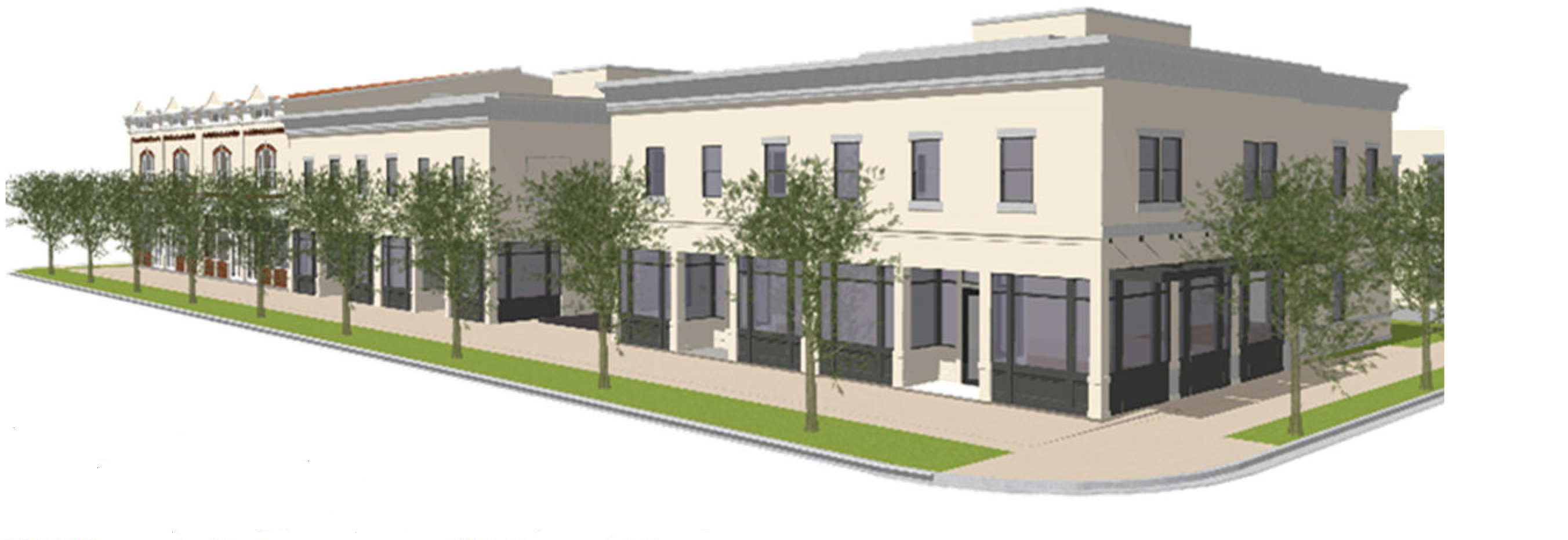
Figure XIV - 3. Example of appropriate building types within the Primary Corridor
Zone
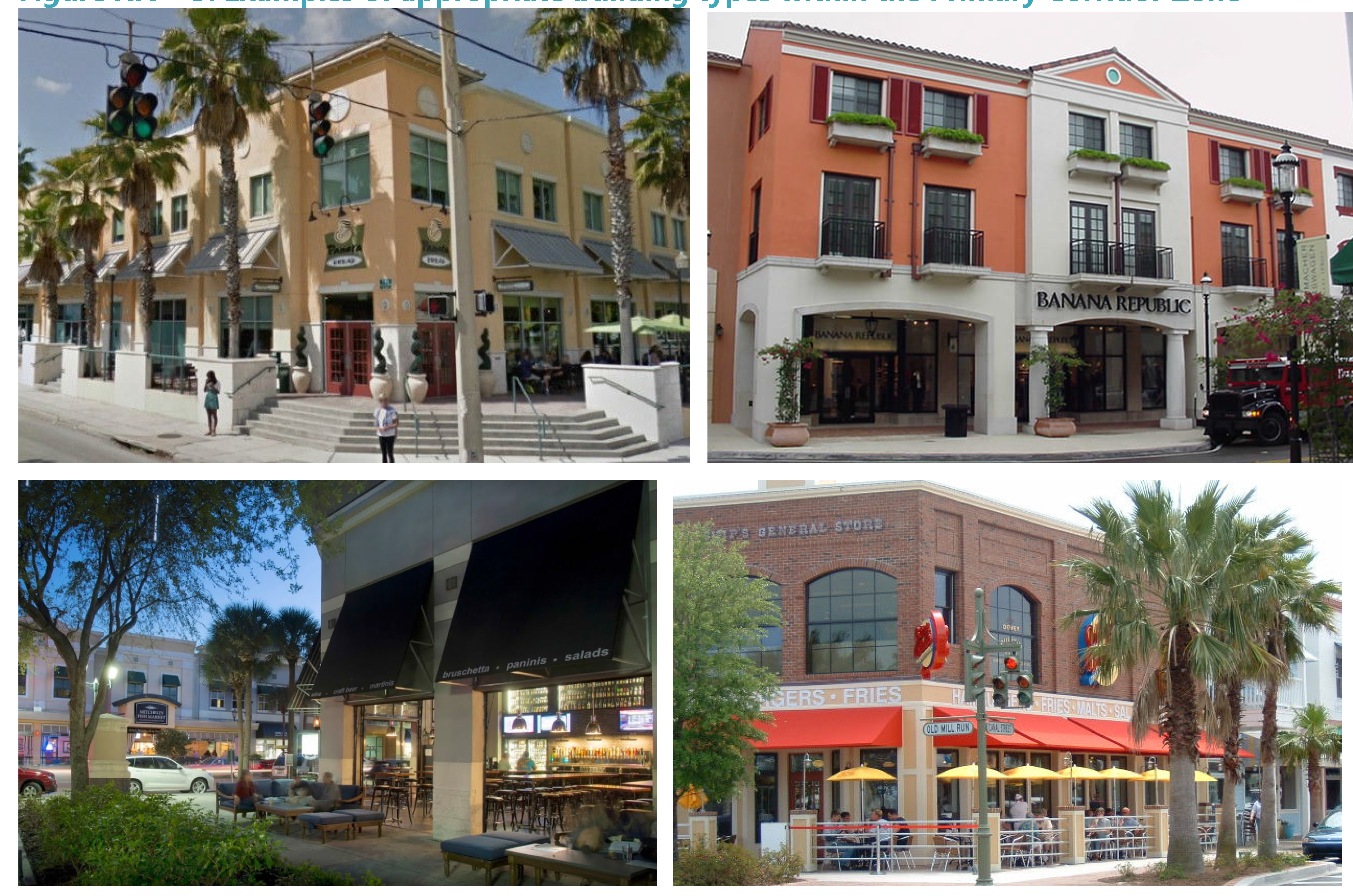
C.
Secondary Corridor Zone. Primarily located behind the major transportation corridors, this T-zone is intended to act as a transition between the heavier traffic and more intense development along Orange and Ferris Streets and lower intensity neighborhoods. The zone consists of a mix of uses in a pedestrian-oriented urban form. Buildings may be attached or detached with front facades located close to the sidewalk.
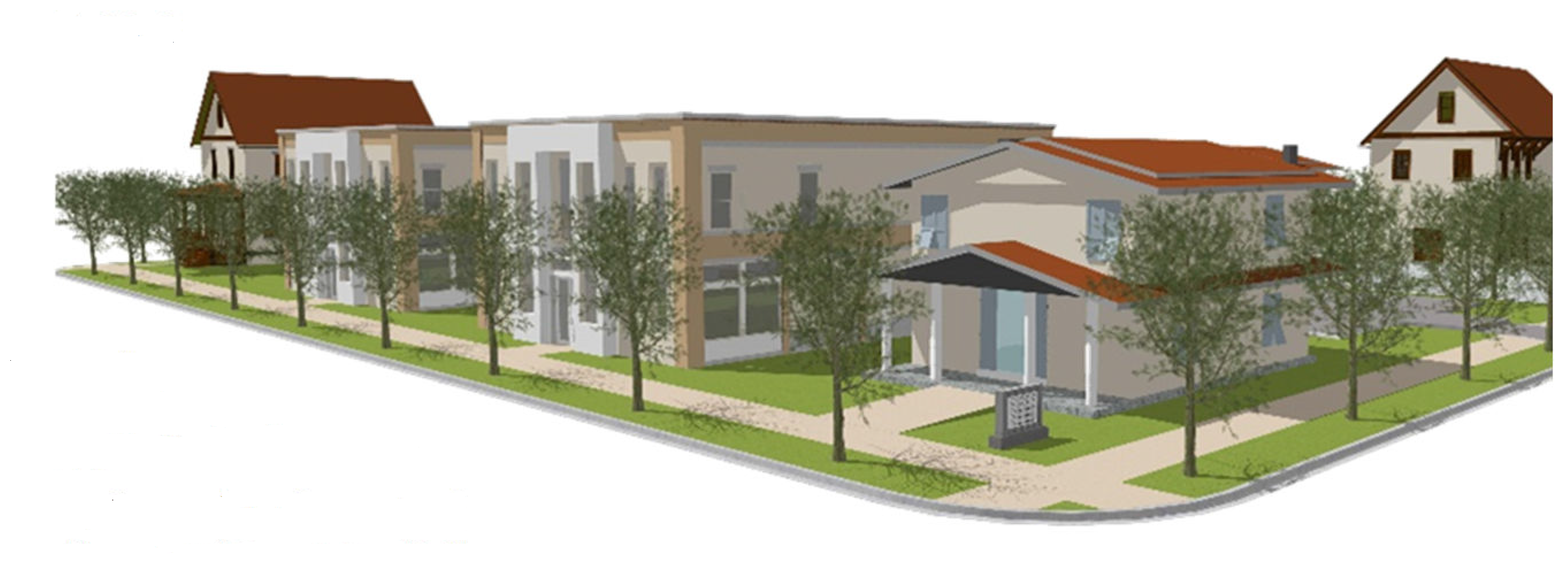
Figure XIV - 4. Example of appropriate building types within the Secondary Corridor
Zone
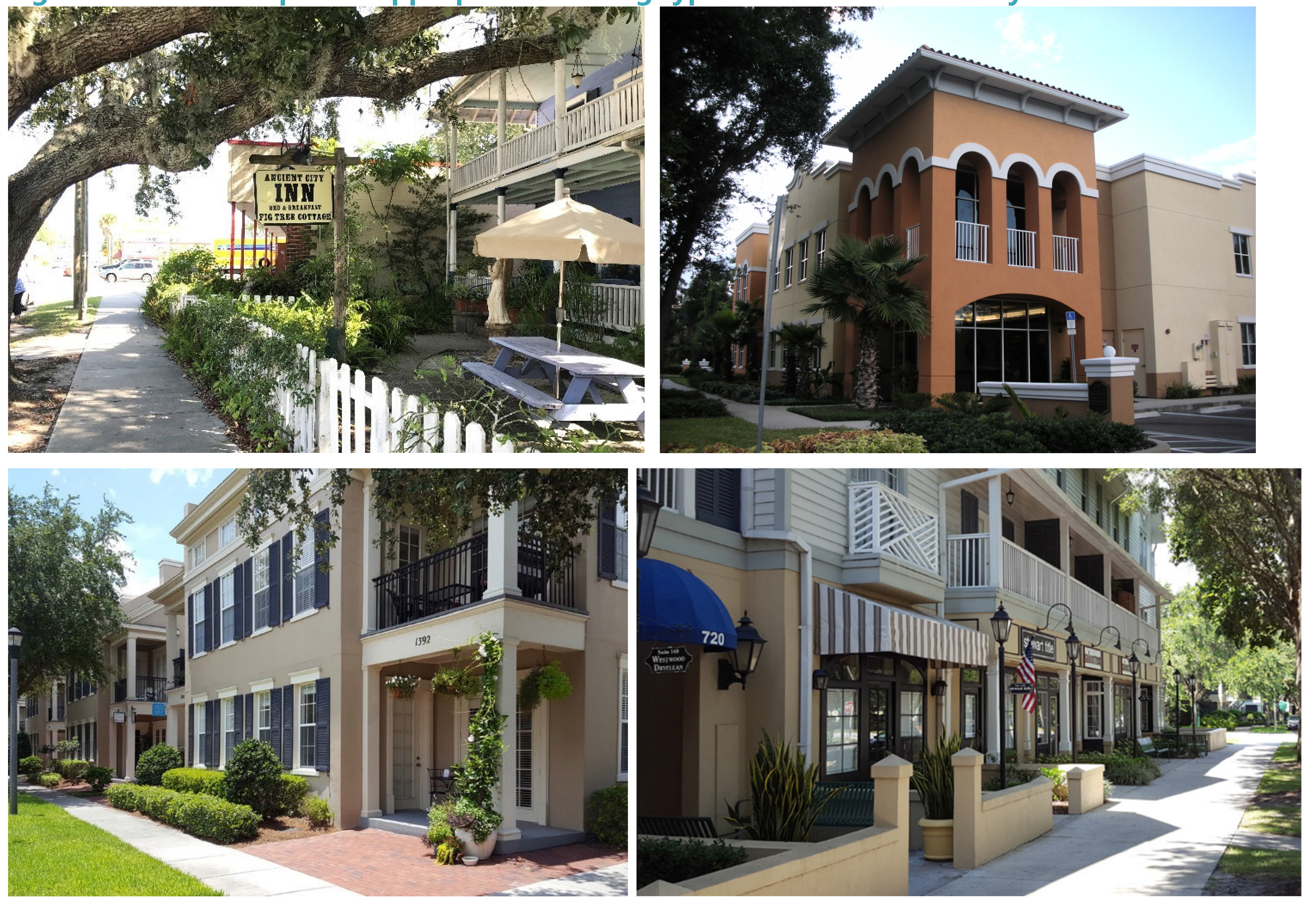
D.
Transition Zone. Primarily located behind the major transportation corridors, this T-zone is intended to act as a transition between the heavier traffic and more intense development along Orange and Ferris Streets and single-family neighborhoods. The zone consists of a mix of uses in a pedestrian-oriented urban form. Buildings may be attached or detached with front facades located close to the sidewalk.
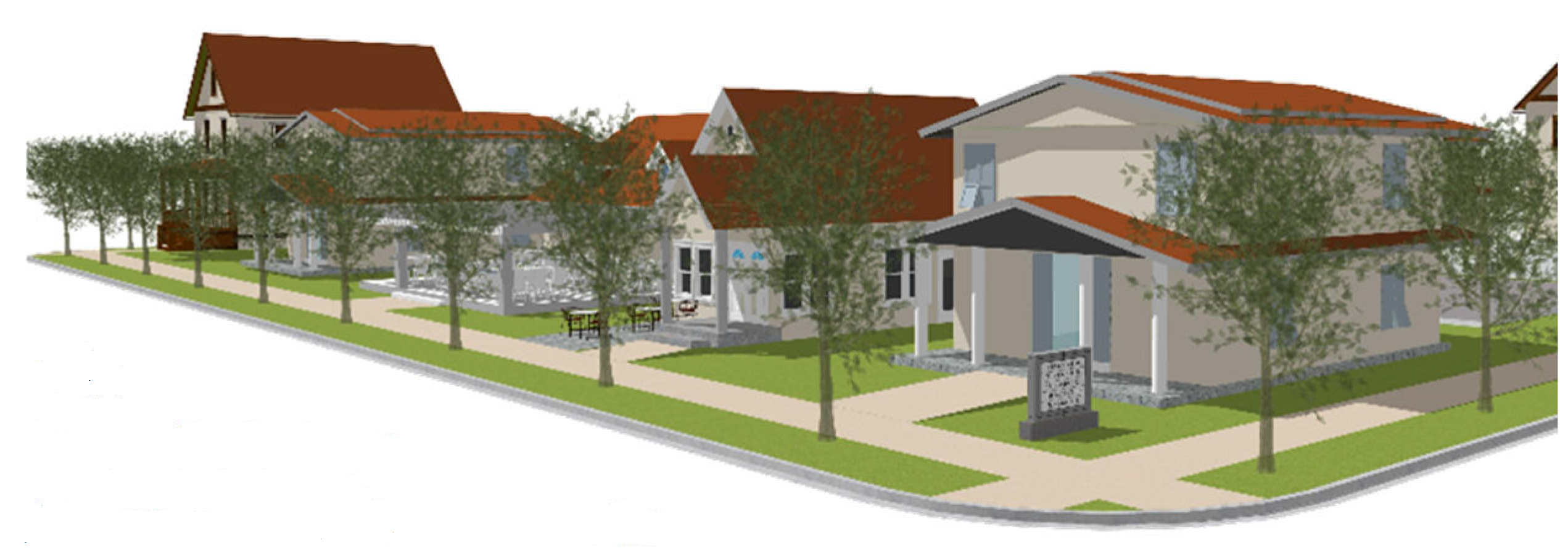
Figure XIV - 5. Example of appropriate building types within the Transition Zone
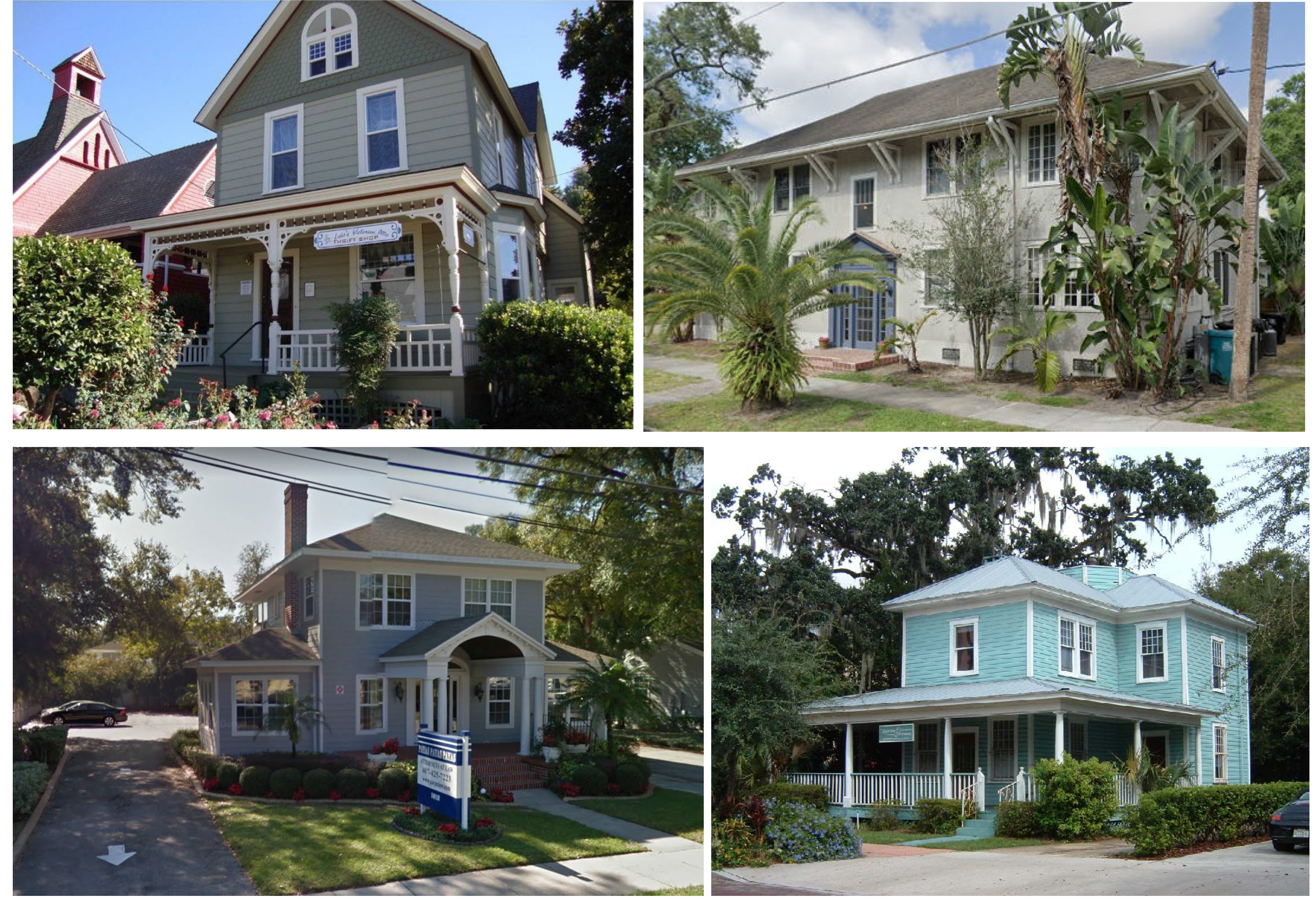
(Ord. No. O-11-2024, § 4, 4-16-2024)
Sec. 117-834. - Block standards.
The regulation of block size is fundamental to achieving good urban form and transportation connectivity. Shorter blocks improve the pedestrian experience as well as foster a street network grid that supports the efficient distribution of automobile traffic. Downtown Green Cove Springs generally displays a gridded street network, which shall be maintained and improved. If existing streets are vacated to allow the aggregation of smaller blocks into mega-blocks, the following provisions shall apply:
A.
Alternative vehicular connections shall be provided to continue the current block length within the downtown form-based code area which, with very few exceptions (Spring Park, west end of Ferris Street, and south of Cove Street), does not exceed 400 feet in length. The vehicular passage may be a public street or private drive but shall be open for public passage to another street/drive.
B.
Culs-de-sac and dead-end streets are not allowed.
(Ord. No. O-11-2024, § 4, 4-16-2024)
Sec. 117-835. - Use standards.
A.
Permitted uses.Section 117-3 lists the various uses allowed in the form-based code area and identifies whether a use is Permitted (P), Special Exception (SE), or Prohibited (blank) within the noted Transect Zone. Uses not listed in the table are prohibited.
Mixed-use developments are allowed in all zones, provided that the individual uses are all allowed in the zone. If one of the uses requires special exception approval, the entire development shall undergo special exception review.
Considering that the form-based code area is almost fully developed and includes a wide variety of uses, the continuation of the current uses is permitted and encouraged, even if they are not listed as a permitted use. If any of those structures are destroyed, they will be permitted to rebuild as they currently exist but will not be allowed to expand or intensify beyond their current status.
Where a site is split between two zones (e.g., the Downtown Core and Primary Corridor Zones), the allowable uses in both zones may be located anywhere on the site. However, the use shall comply with the site and building standards of the zone where they are located. For instance, a site with a Primary Corridor Zone designation along Orange Avenue and Secondary Corridor Zone designation along Palmetto Avenue may have a retail establishment, but the building will need to be close to and oriented toward Orange Avenue. Similarly, if the site is eligible for a height bonus, the tallest part of the building must be located along Orange Avenue. The portion of the building facing Palmetto Avenue will be required to meet the two-story limitation of the Secondary Corridor Zone.
All developments, regardless of the use classification, shall comply with the standards of this article and all other applicable articles of the land development code. See section 117-838 for specific requirements for certain uses.
B.
Accessory and temporary uses and structures. Accessory and temporary uses and structures shall meet the requirements of section 117-838(e) (Accessory building setbacks for residential structures), and article IX (Supplementary Regulations), unless otherwise specifically addressed in this article. Accessory structures visible from the right-of-way shall meet the site and building design standards of this article.
(Ord. No. O-11-2024, § 4, 4-16-2024)
Sec. 117-836. - Site dimensional standards.
The general intent of the T-zones is to ensure that the scale of the built form, formality of public spaces, and intensity of uses will vary throughout the community, and shall be reduced in scale, formality, and intensity as they go further away from the core. The site dimensional standards for each T-zone are described in the following sections.
A.
Lot size. It is not the intent of this code to prevent development on existing lots or to require lot aggregation. Lots within the form-based code area may be subdivided only if they meet a minimum lot depth of 100 feet. There are no minimum lot size or width requirements. However, subdivided lots must be adequate to accommodate the proposed development without the need for setback variances and not so wide that the building frontage requirement cannot be met.
B.
Building placement. The placement of a building on a site is critical to creating a coherent public realm. Urban development forms seek to support and foster pedestrian trips. Therefore, buildings need to be constructed in closer proximity to streets and sidewalks but not so close that the public realm is diminished. Figure XIV - 6 illustrates the location of the street, side (interior), and rear setbacks.
Figure XIV - 6. Building Setbacks
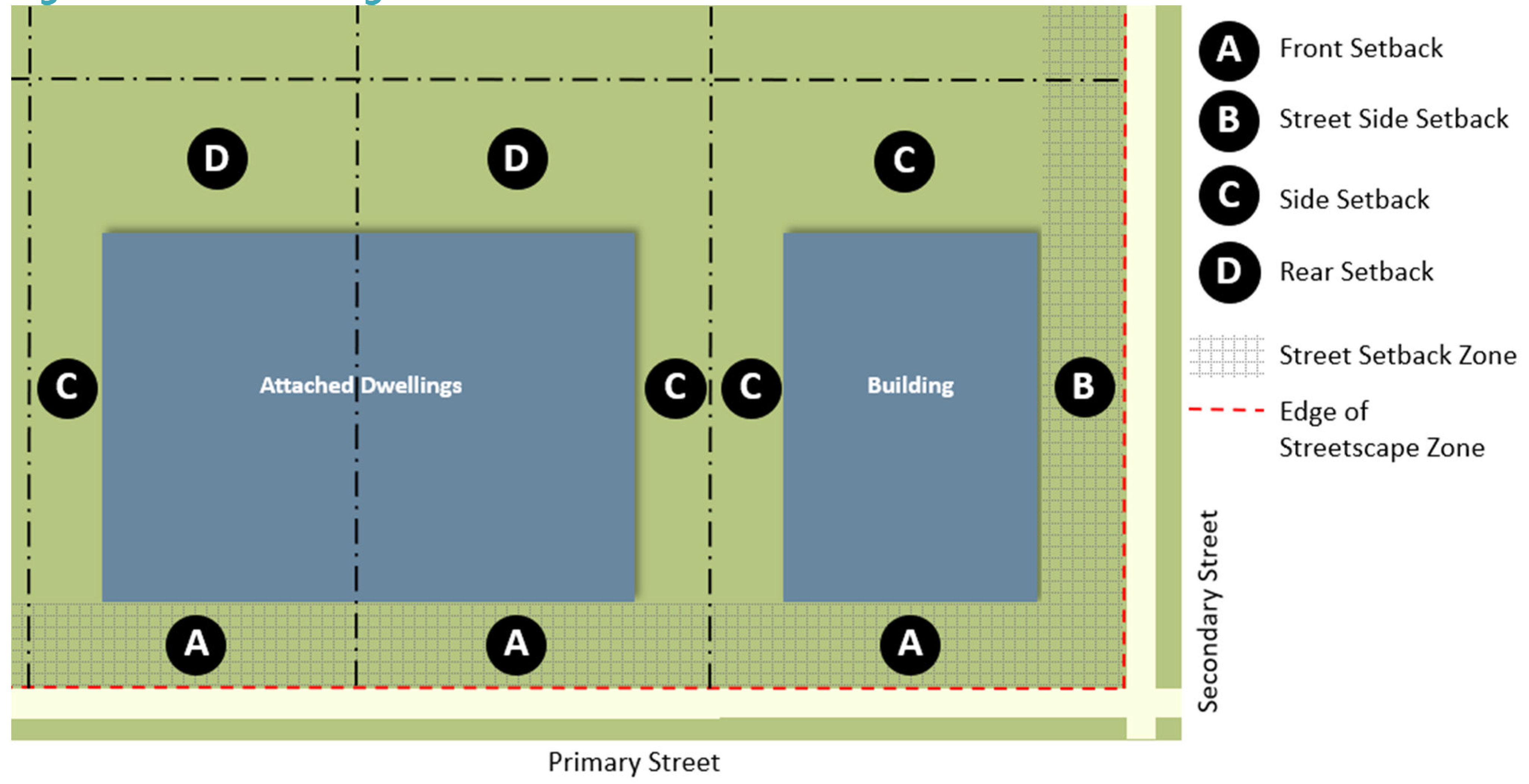
1.
Required setbacks. Table XIV-1 contains the required setbacks by T-zone. See section 117-837 D for minimum building frontage requirements, which are closely tied to the side setback requirements.
Table XIV - 1. Building Placement Standards by Transect
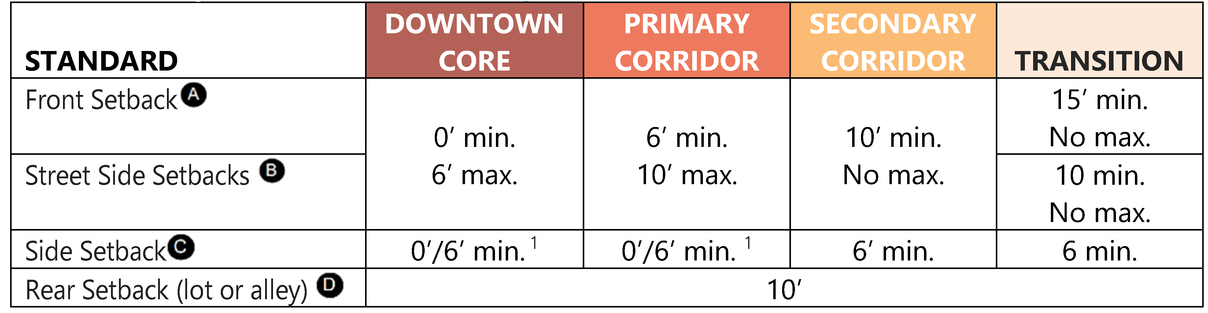
1 Zero-foot side yard setback permitted only if the adjacent building is also placed at the property line. Otherwise, six feet are required.
2.
Measuring setbacks.
a.
Rear and interior side setbacks are measured from property lines (even if the site is split by a T-zone line).
b.
Setbacks along streets shall be measured from the property line but may require an additional setback to ensure sidewalks and parkways can be accommodated in front of the site, as identified in Table XIV-2. Due to the lack of right-of-way to accommodate adequate sidewalks and parkways along all streets, some development applicants will be required to dedicate an easement to the city to accommodate such features. Setbacks along the segment of Walnut Street from Palmetto Avenue to St. Johns Avenue shall be measured from the back of sidewalk.
Table XIV - 2. Sidewalks and Parkways by Street
Segment
c.
The reconstruction of sidewalks and parkways shall be the responsibility of the development applicant but shall be coordinated with city staff. If the requirements cannot be met due to existing conditions or site constraints, the applicant may apply for a modification of standards (see section 117-832 B). Provisions shall be made to connect existing and new sidewalks that have different alignments (see Figure XIV - 7).
Figure XIV - 7. Connecting Existing and New
Sidewalks
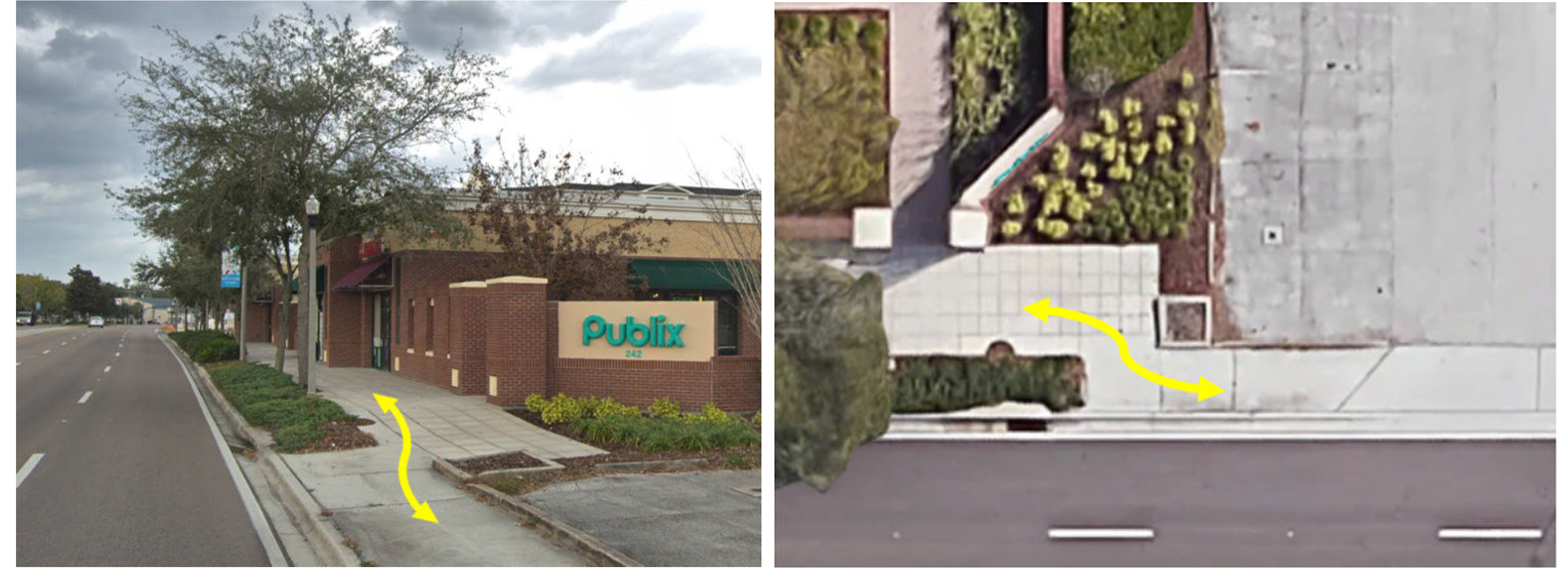
d.
The minimum and maximum setbacks along streets listed above do not apply to minor modifications but apply to new construction and major modifications (minor and major modifications are defined in section 117-831 B).
e.
The maximum setback requirement shall not apply to a major modification proposed to a historic home (identified in the city's GeoHub Stories dashboard) as long as the modification preserves the residential character of the existing building,
3.
Setback design. The intent of the setbacks along streets is to provide a transition, both physical and visual, from the street to the building. The setback area should vary in design depending on the level of privacy desired along the building facade. Commercial buildings usually have a setback area designed to attract customers into the building, while residential, hotel and office buildings often have a setback area designed to provide privacy to the ground floor spaces, as shown on Figure XIV - 8. Accessibility (ADA) laws shall be observed.
Figure XIV - 8. Examples of Front and Street Side Setback Area Activity
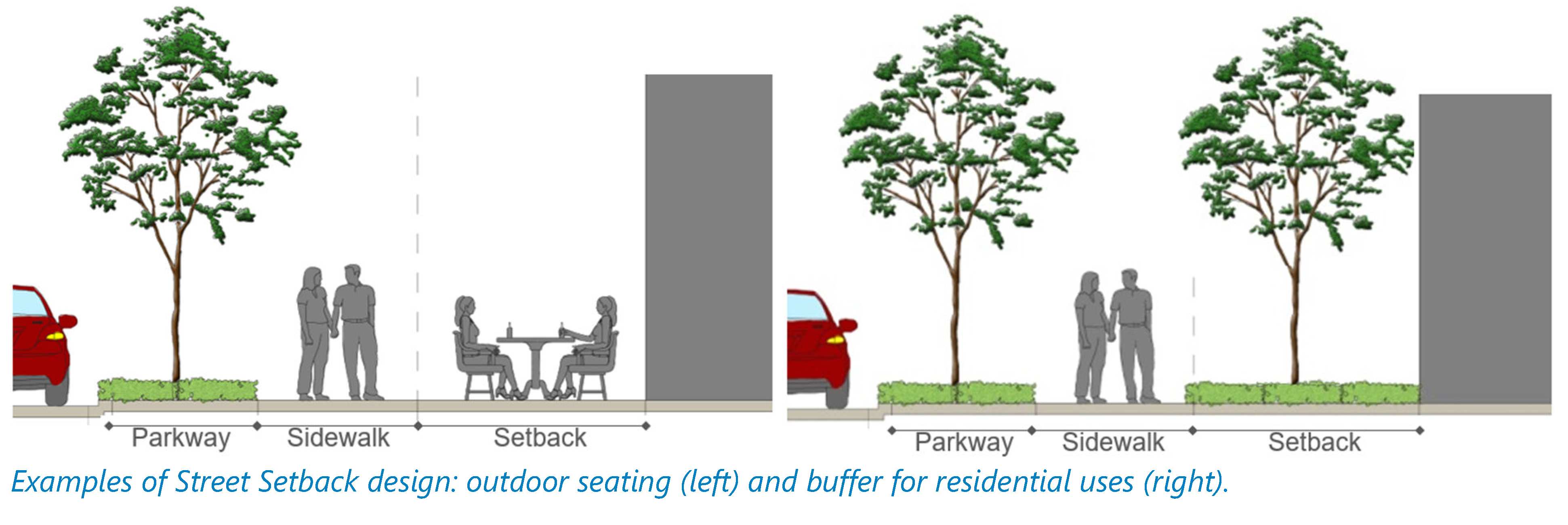
The following setback area standards shall be met:
a.
Elements such as balconies, bay windows, and similar elements may encroach into the front and street side setback provided they do not interfere with required or protected landscaping. Allowed encroachments shall not extend into the public right-of-way.
b.
Setback areas along streets shall be landscaped unless the setback needs to be paved to allow for pedestrian interaction (as an extension of the public sidewalk).
c.
Street furniture such as benches, trash receptacles, and/or bicycle racks may be installed within the setback area or within the parkway along local streets.
d.
Outdoor dining is permitted within the setback area as long as restaurants are allowed in the transect zone.
e.
Elements within the setback area (e.g., landscaping and other features) shall comply with the sight triangle requirements.
f.
No vehicular parking areas or drive aisles/lanes are allowed between the building and the street.
C.
Impervious surface area. To balance the desire for urban form and development with the need to prevent flooding within the form-based code area, a maximum impervious surface area (ISA) is established for each T-zone, as shown in section 113-4(d).
(Ord. No. O-11-2024, § 4, 4-16-2024)
Sec. 117-837. - Building design standards.
This section establishes standards for building design. The standards apply to all T-zones.
A.
Building typology. Form-based regulations use physical form, rather than separation of land uses, to shape the character of the area. Buildings within the form-based code area shall adopt one of the following building typologies based on the location of the property within one of the transect zones. The building typologies do not necessarily refer to the use of the building, but rather to the character of it. For instance, an office or multi-family development may only be allowed in a T-zone if the building has the appearance of a house. The list of permitted building typologies by transect is provided in Table XIV-3.
Table XIV - 3. Permitted Building Typology by Transect
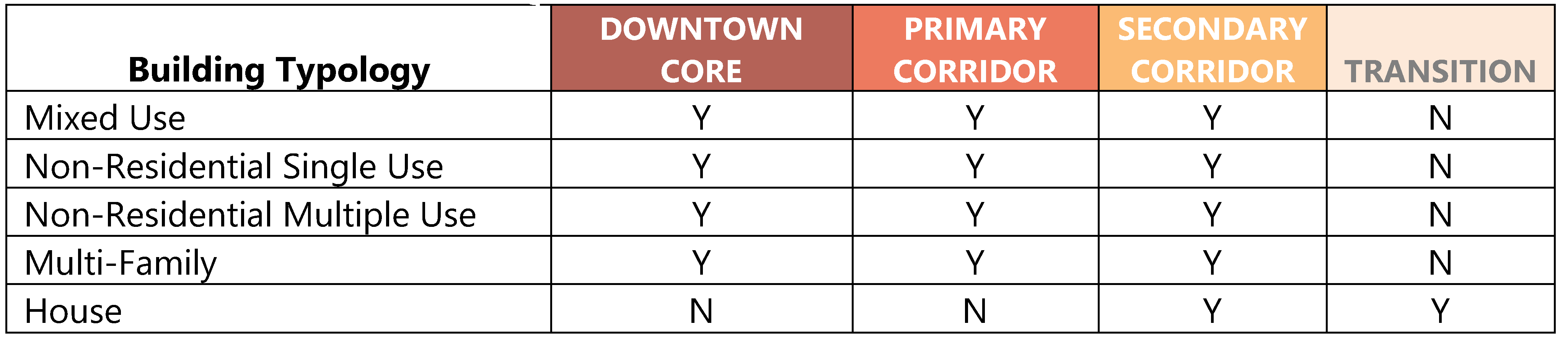
1.
Mixed-use building. A type of building designed for ground floor occupancy by retail, service, and/or office uses, with upper floors configured for office use or dwelling units. The ground floor must be designed for maximum pedestrian interaction (e.g., storefronts, outdoor cafes, etc.).
Figure XIV - 9. Mixed Use Buildings
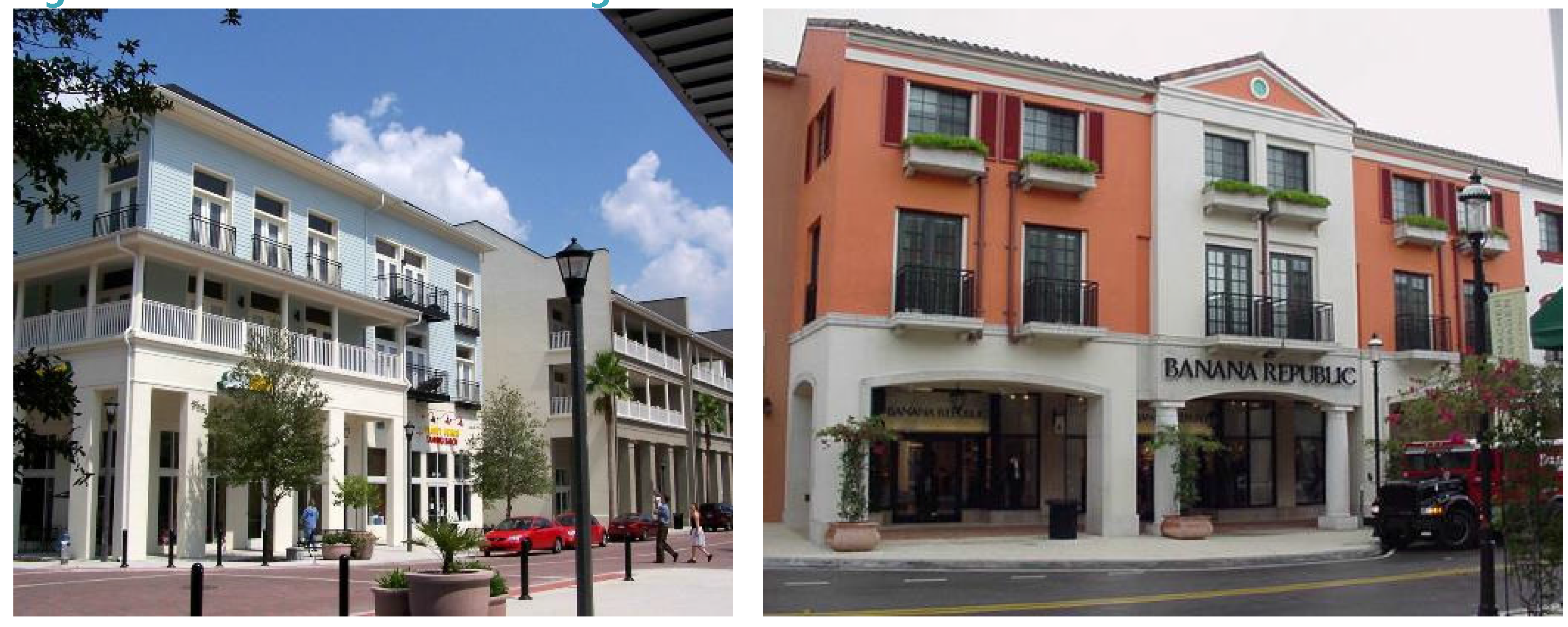
2.
Non-residential single use buildings. A type of building designed to accommodate stand-alone non-residential activities such as retail, banks, hotels, restaurants, offices, and service uses. Large scale buildings (e.g., big box retailers, movie theaters, wholesale stores), auto repair, drive-through facilities and service stations fall into this category and shall meet all site and building design requirements of this Code.
Figure XIV - 10. Non-Residential Single Use
Buildings
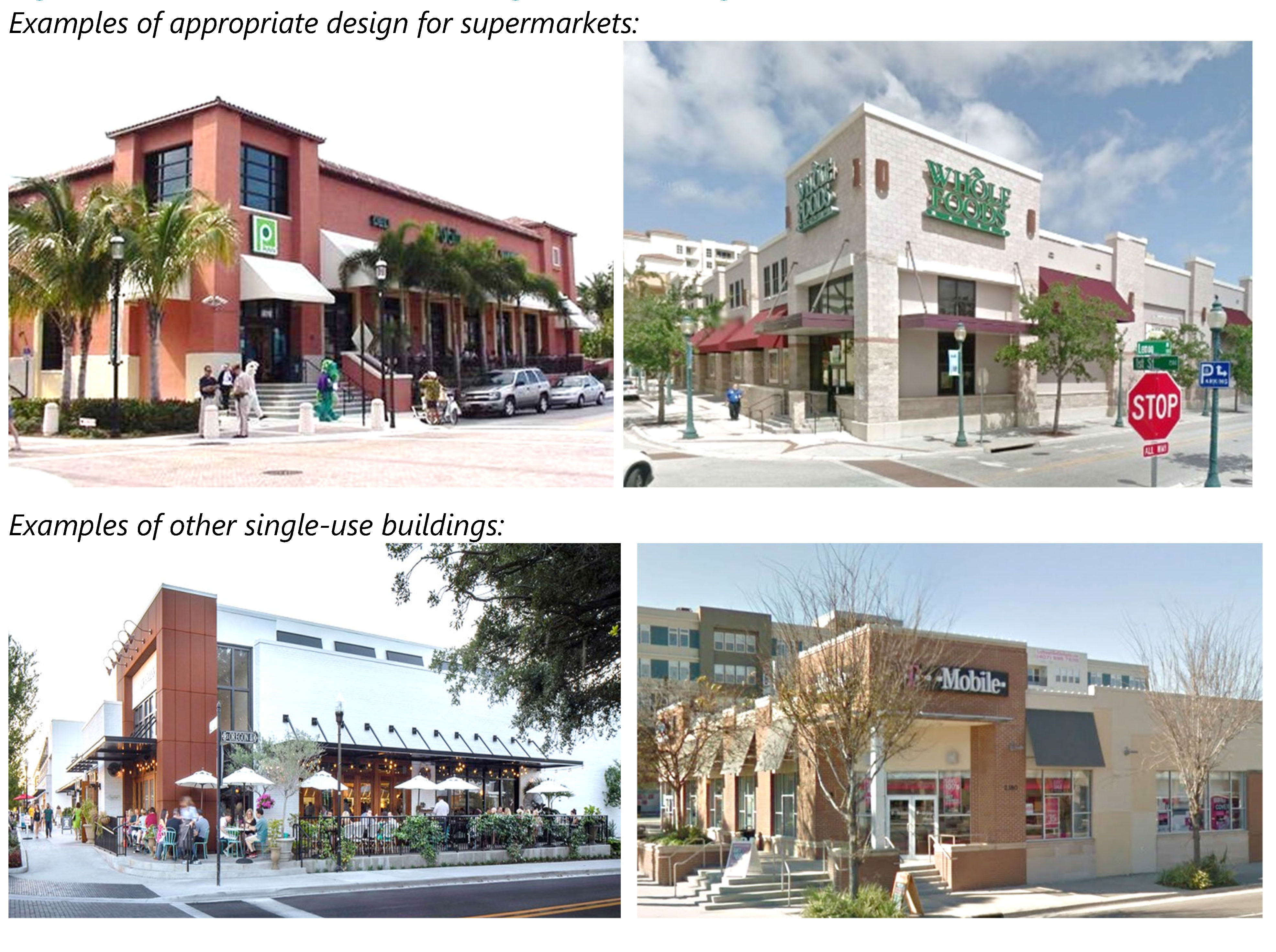
3.
Non-residential multiple tenant buildings. A type of building designed to accommodate multiple non-residential activities such as retail shopping centers with individual entrances.
Figure XIV - 11. Non-Residential Multiple Tenant Buildings
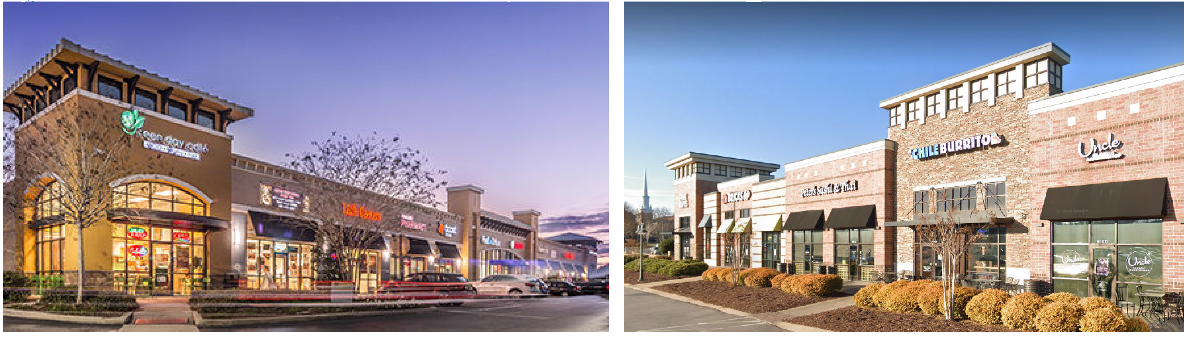
4.
Multi-family building. A type of building designed to accommodate townhouses, condominiums, and apartment uses.
Figure XIV - 12. Multi-Family Building Examples
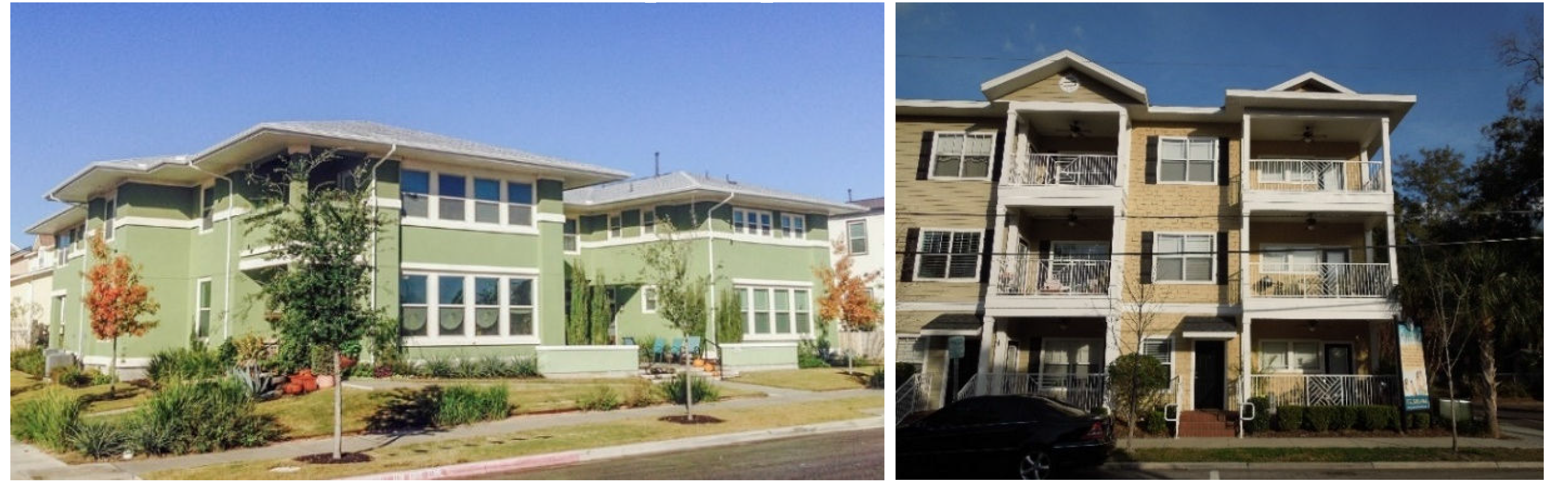
5.
House. A type of building designed to resemble a single-family dwelling that may be utilized for any use permitted by the transect zone. Regardless of the use, buildings with a house typology shall be designed as noted below:
a.
A porch or stoop shall be provided facing the street.
b.
Flat roofs are only allowed if they are combined with, and secondary to, sloped roofs.
c.
Garages shall be designed in one of two ways:
º Attached and recessed from the primary facade (not including porches, bays, or other minor projections) by a minimum of five feet, or
º Placed in the rear yard and accessed by either an alley or a side yard driveway.
d.
Garage frontage shall only be allowed for buildings that are used as residential single-family detached or two-family attached dwellings shall not comprise more than 50 percent of the building's front facade.
e.
Residential single-family detached and two-family attached dwellings featuring a house typology shall meet the following standards:
º Minimum required living area: 1,000 square feet together with an attached or detached garage of at least ten feet by 20 feet. Attached garages shall be architecturally integrated into the design of the dwelling and structurally connected.
º Maximum lot coverage: 35 percent
Figure XIV - 13. House Building Examples
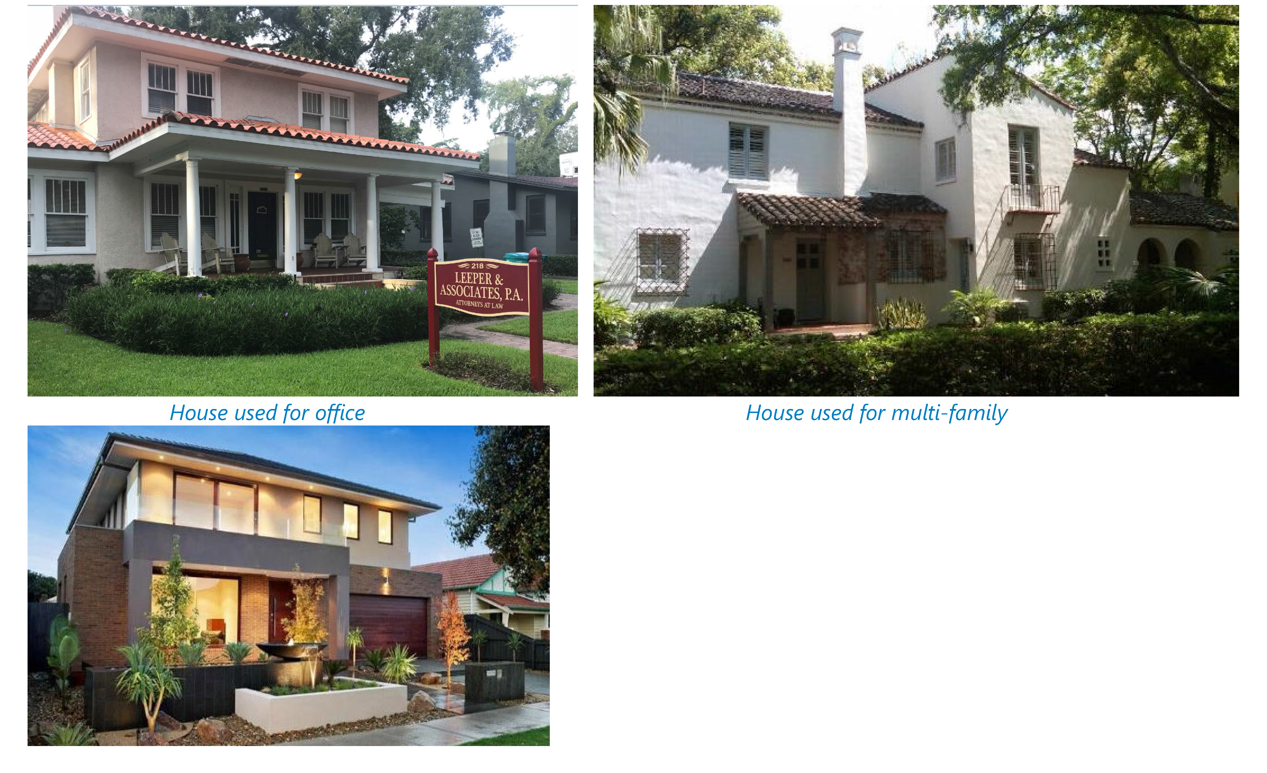
B.
Building massing. The purpose of the building massing requirements is to break down large volumes into smaller volumes grouped together.
1.
In no event shall buildings exceed a height to width ratio of 1:3 or 50 feet, whichever is less, without providing a substantial volume break which may consist of a projection or recess, a tower or bay, and/or an architecturally prominent entrance (see Figures XIV - 14 and XIV - 15). Vertical and horizontal projections and recesses shall have a minimum height, depth, and width of five feet.
2.
Roofs or assemblies of roofs shall also be articulated to reduce building mass. Roof heights shall vary using the parameters listed in subsection 1, above.
3.
Buildings on corner lots shall incorporate distinctive architectural treatments (e.g., corner entrance, tower) to emphasize their prominent location.
Figure XIV - 14. Example of Building Articulation Spacing
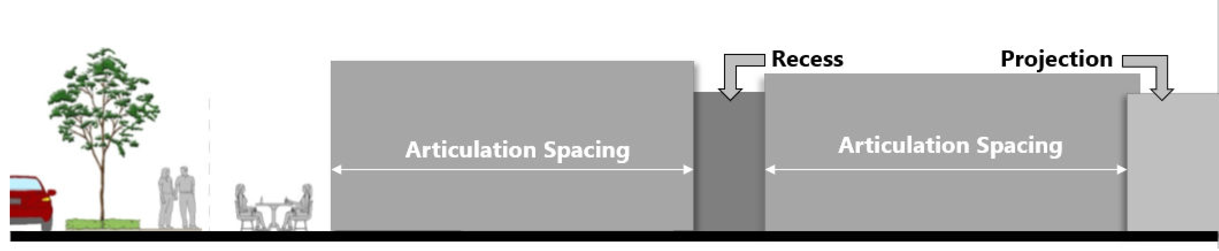
Figure XIV - 15. Massing
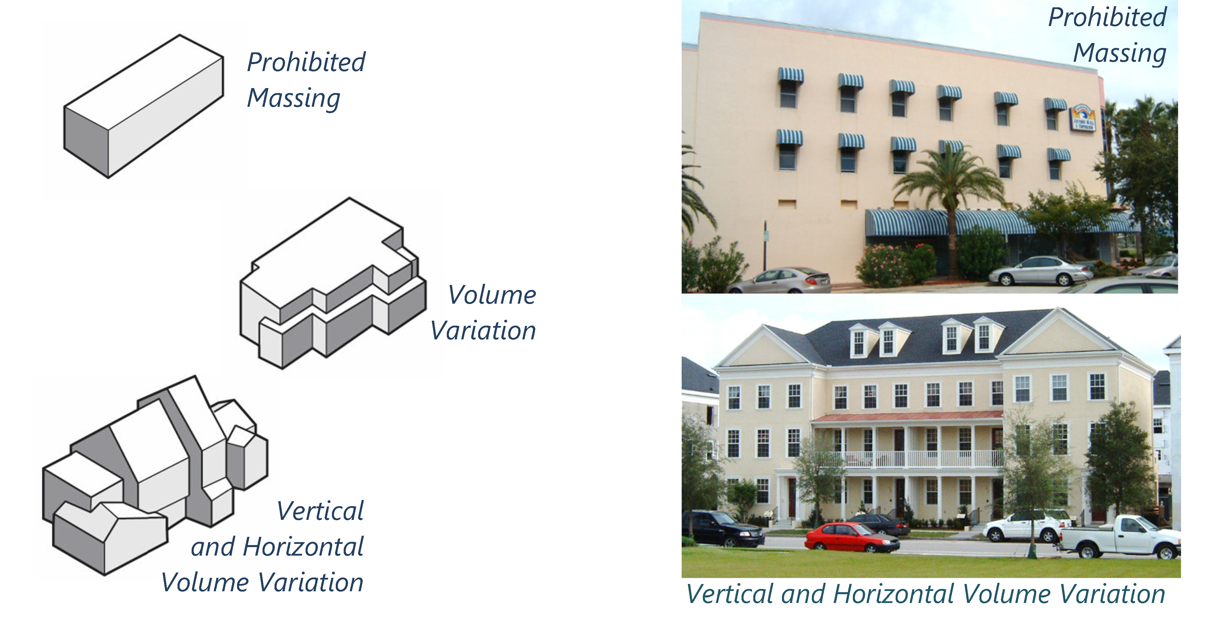
C.
Building and floor height. Table XIV-4 establishes the permitted building and floor height for each transect zone. The floor height requirements shall not apply to single family homes.
Table XIV - 4. Building and Floor Height Standards by Transect
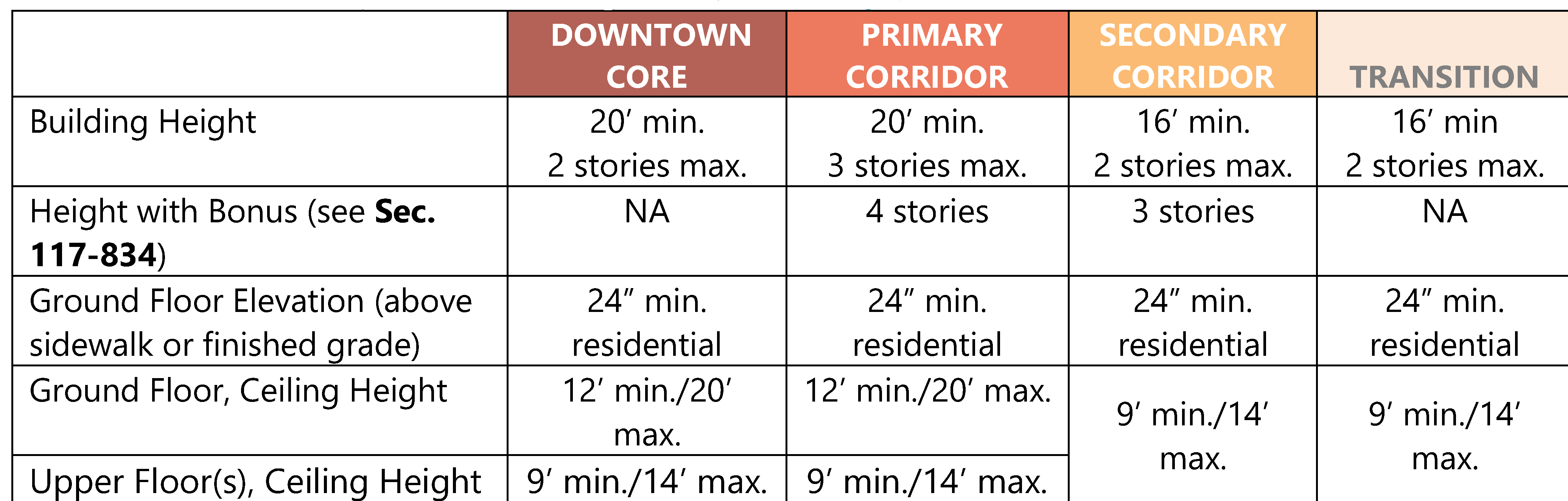
The following standards shall also apply:
1.
Whenever a site is split between two or more zones, each frontage must comply with the building height restrictions and such height may extend back to the midpoint of the block length along the secondary street where the height must be stepped down.
2.
Towers and cupolas extending above the roofline are generally intended to be visual landmarks and accentuate corners. If used, they shall not exceed a footprint of 30 feet by 30 feet and may extend up to ten feet above the designated height limit. See Figure XIV - 16.
3.
Floor height shall be measured from finished floor to finished ceiling. A single story exceeding the maximum floor height allowed shall be counted as two stories. Mezzanines extending beyond 33 percent of the floor area shall be counted as an additional story.
4.
Buildings spanning two or more transect zones may use the floor height standards required within each zone or the standards of the most intensive zone on the entire site.
Figure XIV - 16. Tower (left) and Cupola (right)
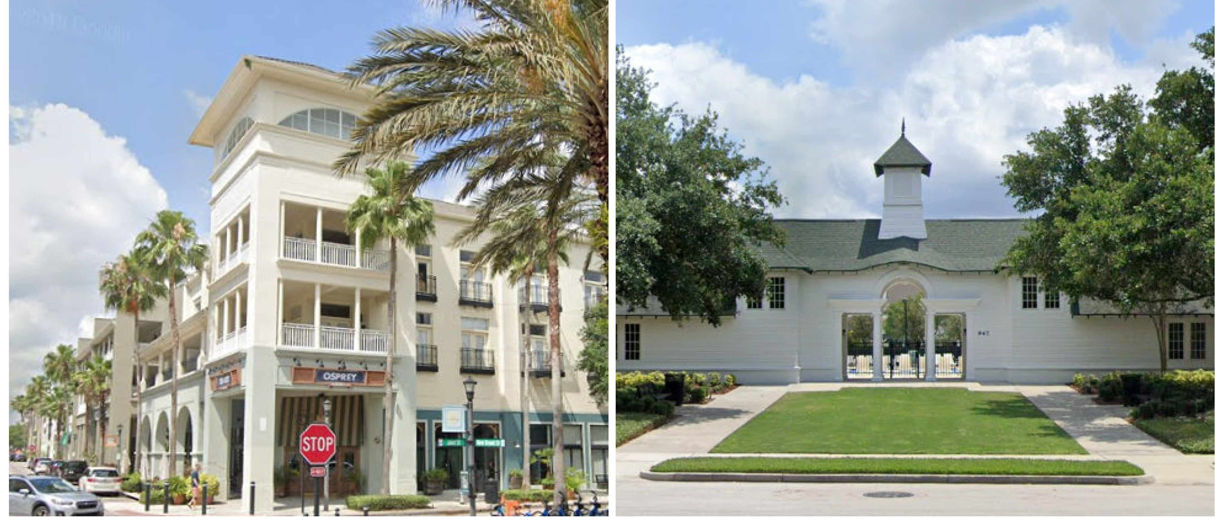
D.
Building frontage. The purpose of the building frontage requirements is to ensure facade continuity and activity along the street, in addition to avoiding large expanses of blocks that are not framed by buildings. The building frontage standards are stated in Table XIV - 5 as a proportion of the building width (within the minimum and maximum building setbacks) relative to the width of the development site measured along the property line along the street. Portions of the building facade outside the required building setbacks do not count as building frontage (see Figure XIV - 17).
Figure XIV - 17. Building Frontage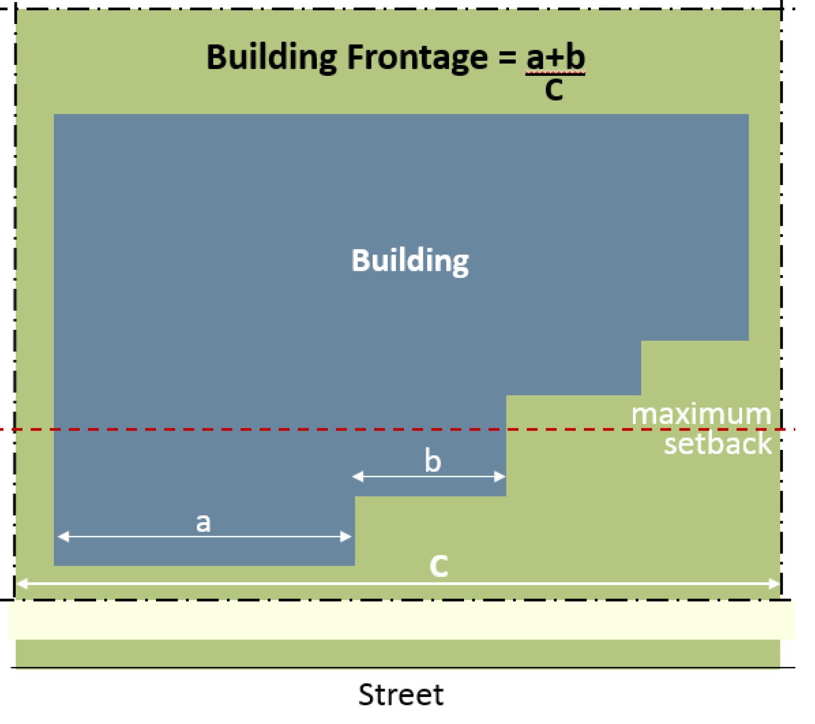
In the case of corner or multiple frontage lots, the frontage requirement shall be met along the highest priority street (per Figure XIV - 18). Along lower priority streets, the minimum building frontage shall be 30 percent.
Table XIV - 5. Building Frontage Requirements by Transect
![]()
Figure XIV - 18. Street Hierarchy
1.
Single family, duplex, live-work units, libraries, churches, public utility buildings, and schools (elementary, middle, and high) are not subject to the minimum frontage requirements.
2.
Gas stations, drive-through facilities, and other auto-oriented developments, if allowed per section 117-3, shall be designed to comply with the building frontage requirements (see also section 117-838 B).
3.
Developments with multiple street frontages may not meet the building frontage requirements along all sides. In those instances, the applicant may request a modification of standards. If approved, any street frontages that do not have buildings within the minimum and maximum required setbacks shall provide a street wall along the site frontage (excluding access points).
4.
In the event the proposed building is too small to meet the minimum building frontage requirement, the applicant shall have the option to set aside room on the site for future buildings that will, when added to the small building, meet the frontage provisions, as shown on Figure XIV - 19. No platting will be required, but the concept plan shall show the area available for future development and may not include any improvements other than a street wall delineating the site.
5.
In the case where the required building frontage cannot be met due to the need to provide vehicular access from the street, a gateway, arch, or similar feature shall be provided to preserve the block continuity and may be counted toward meeting the building frontage requirement, as shown on Figure XIV - 20.
6.
No maximum lot width is prescribed for development within some of the transect zones. However, the width of a lot shall not be justification for not meeting the building frontage requirements.
Figure XIV - 19. Exception to the Building Frontage
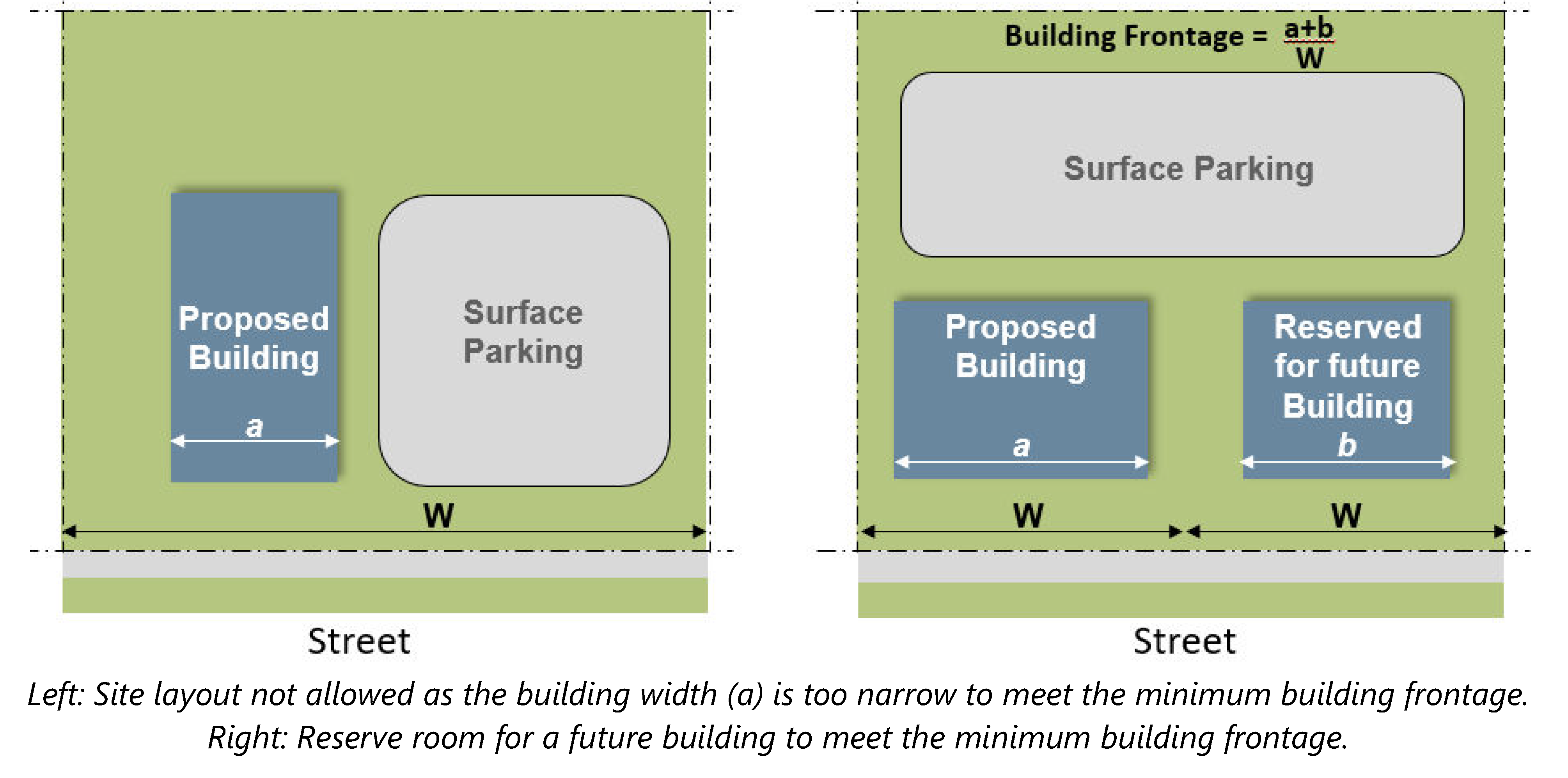
Figure XIV - 20. Gateway Feature
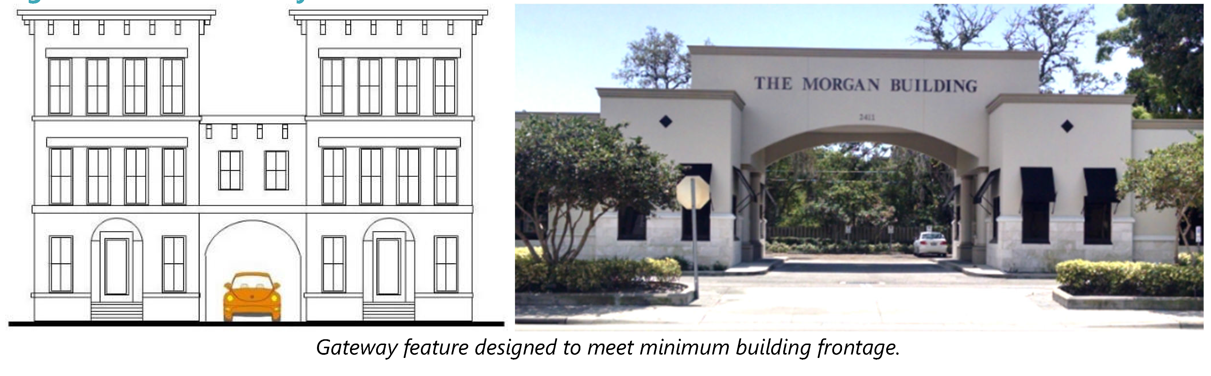
E.
Building frontage design. Building frontages (e.g., storefronts, arcades, galleries, stoops, forecourts, porches) addressed in the following subsections may be used as shown in Table XIV - 6 and shall conform to the standards contained in those subsections.
Table XIV - 6. Permitted Frontage Types by Transect
![]()
1 Stoops and forecourts are not allowed on Walnut Street from Palmetto to Orange Avenue.
1.
Storefronts. Storefront refers to the building facade designed to attract shoppers using display windows, entrances immediately adjacent to the sidewalk, awnings, canopies, and signage. While building style is not regulated within the form-based code area, storefronts have a detailed set of design requirements to ensure they function properly and integrate smoothly with the historic storefronts on Walnut Street. The following are the minimum requirements for storefronts along Walnut Street from Palmetto Avenue to Orange Avenue (optional/recommended for all other zones).
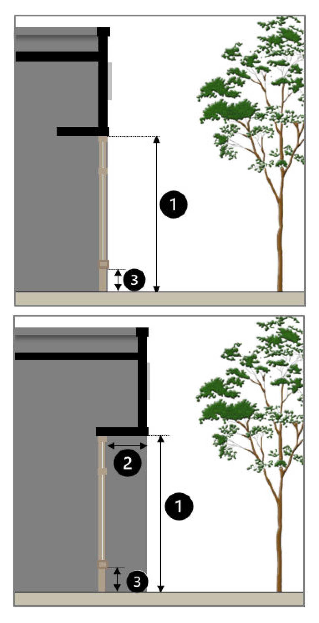
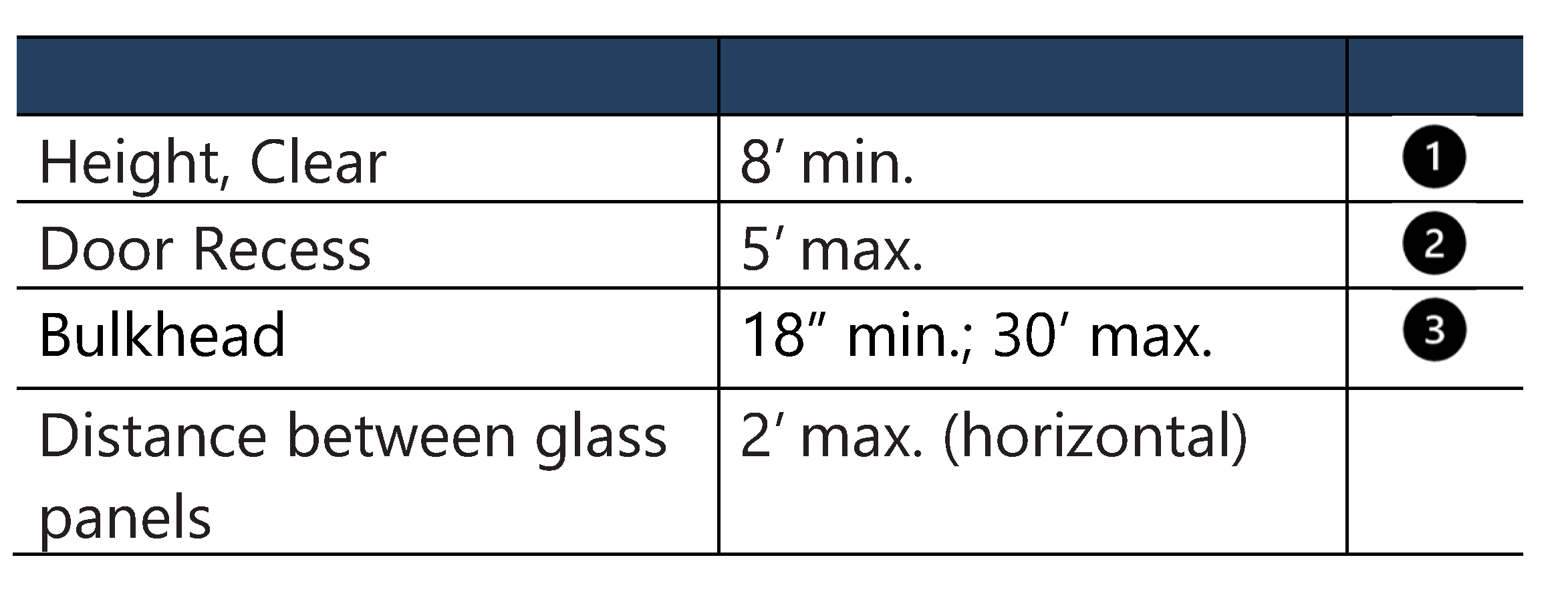
New storefronts and modifications to existing storefronts shall meet the following standards:
a.
Storefronts are allowed in the Downtown Core and Primary Corridor zones and required along Walnut Street from Palmetto Avenue to Orange Avenue.
b.
The storefronts shall be located between the minimum and maximum setbacks.
c.
Storefronts shall include all the elements listed in Figure XIV - 21. A canopy, arcade, or gallery may be used instead of the awning.
d.
Storefronts shall have an expression line (see Figure XIV - 21) above, between the first and second story.
e.
Storefront windows may not be made opaque by window treatments (except operable sunscreen devices within the interior space).
f.
Reflective and frosted glass is prohibited on storefronts.
g.
Storefront doors shall contain at least 60 percent transparent glass. Solid doors are prohibited.
h.
The design of the upper stories varies depending upon the architectural style of the building. However, the upper floor must have single or paired, vertically oriented windows with clearly defined sills and lintels, and a cornice topping the parapet if a flat roof is used.
Figure XIV - 21. Components of a Storefront
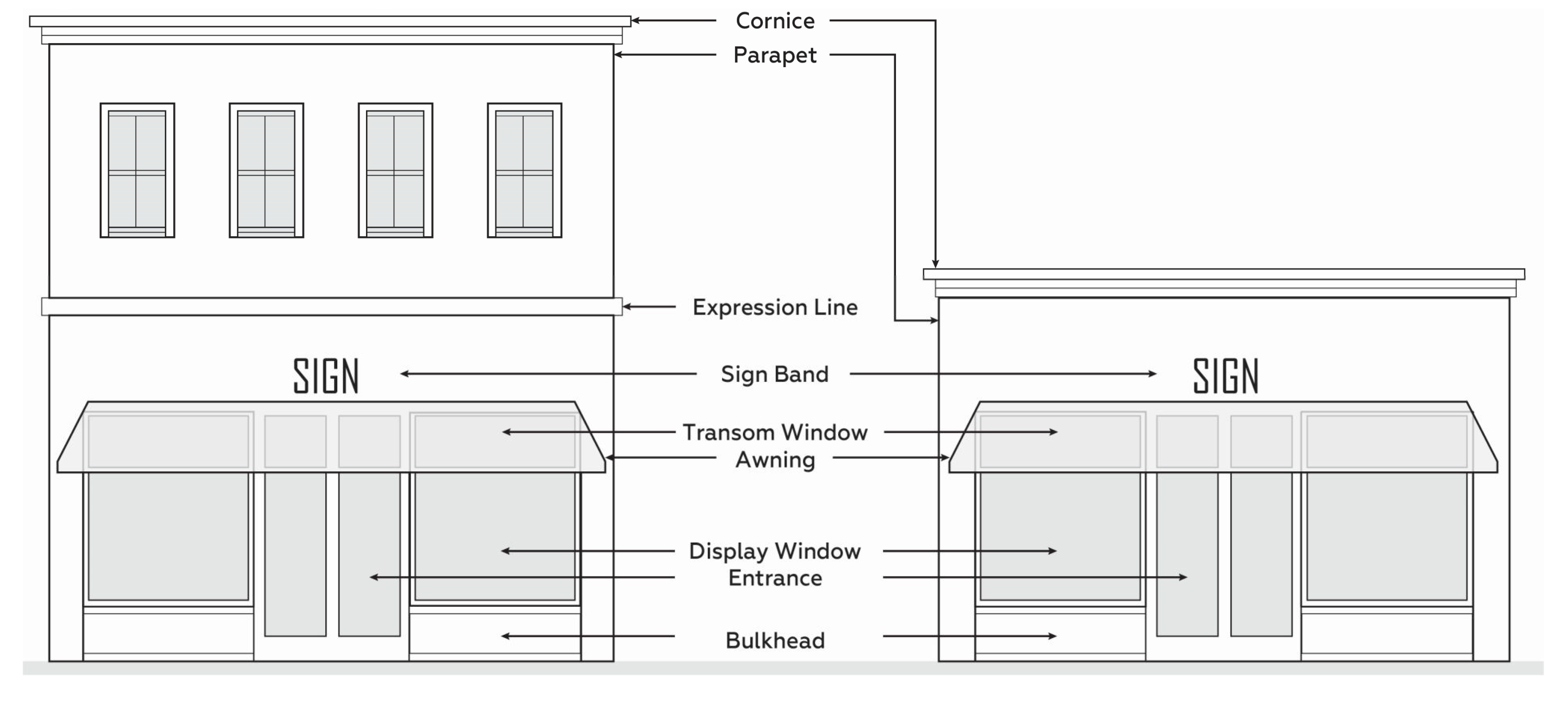
Figure XIV - 22. Examples of Storefronts
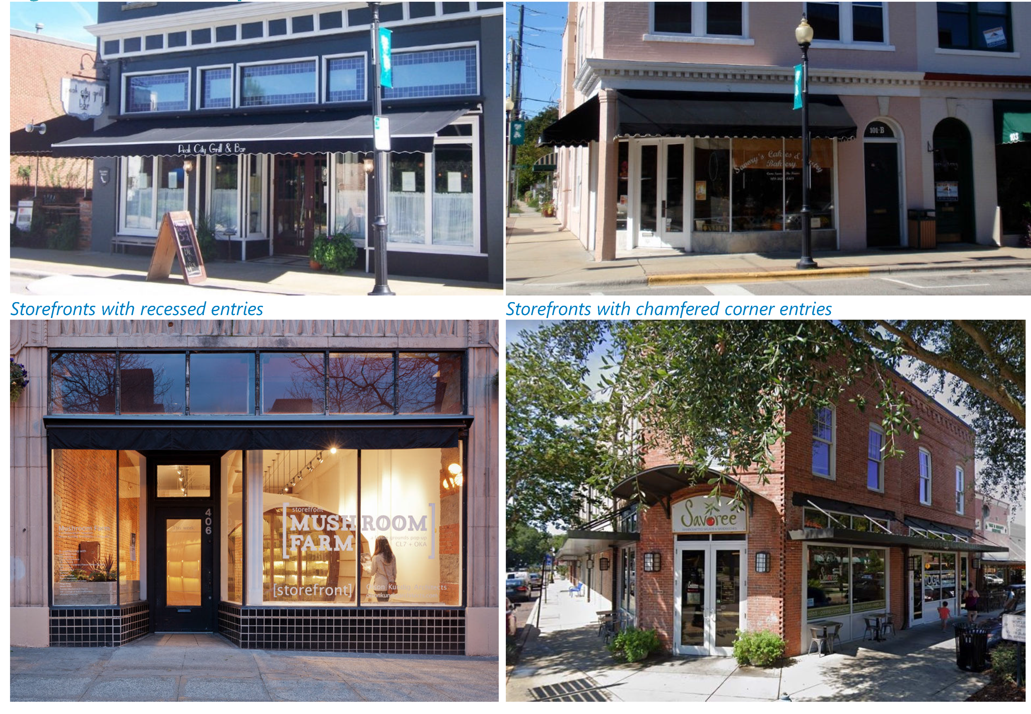
2.
Awnings and canopies. Awnings and canopies (flat cantilevered structures also known as marquees) may be used to accent windows and doors and to protect pedestrians from the elements. Table XIV - 6 notes the transect zones where they are allowed/encouraged. All new awnings and canopies shall meet the following standards.
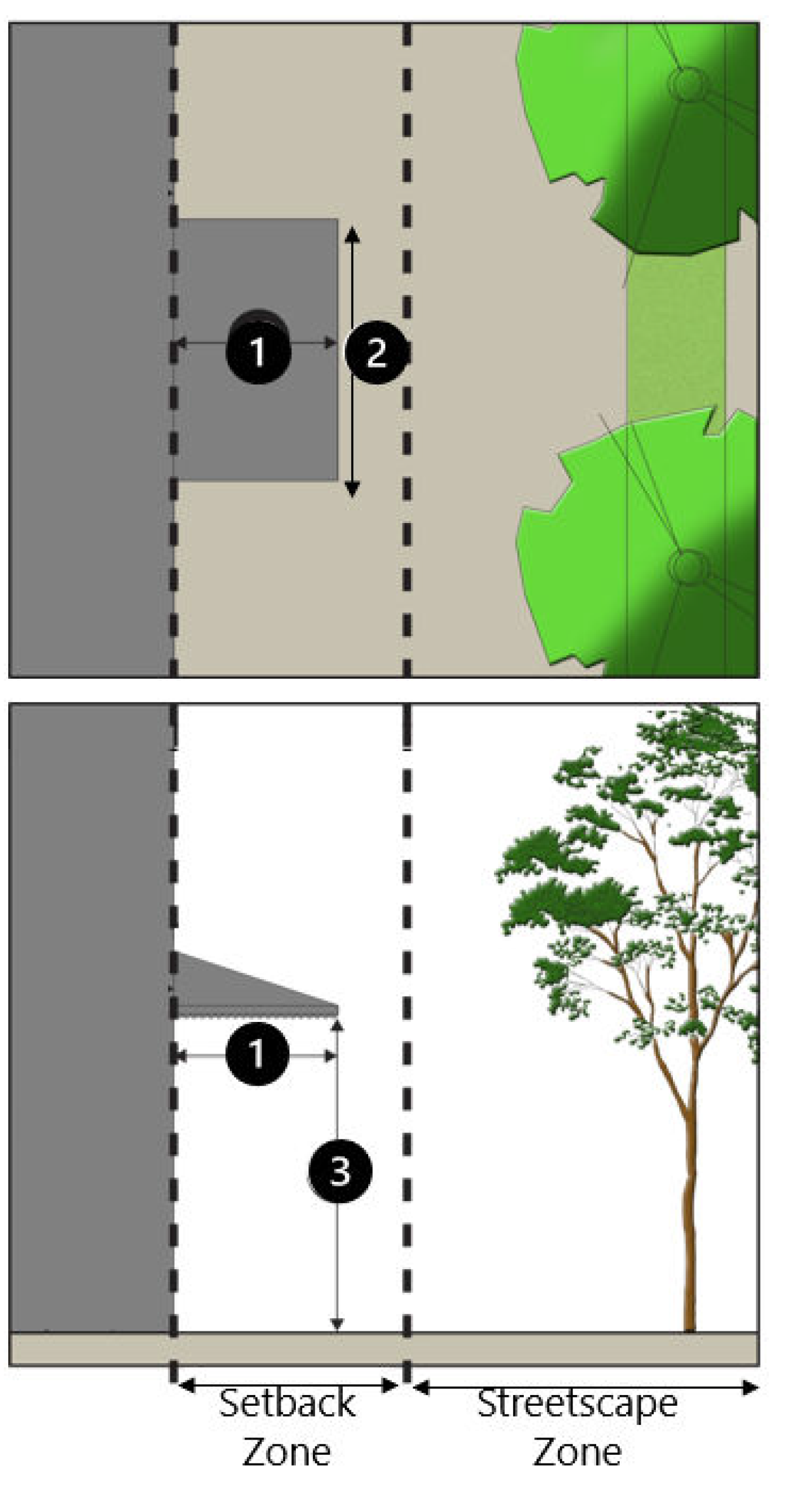
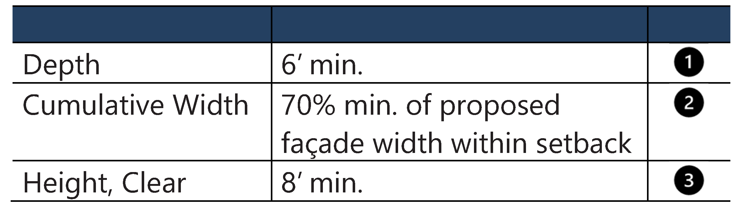
New awnings and canopies shall meet the following standards:
a.
Awnings and canopies shall not cover architectural elements such as cornices or ornamental features. Transom windows, however, may be covered.
b.
High-gloss materials, fabrics that resemble plastic, and aluminum shall not be permitted materials for awnings.
c.
Domed, bubble, and hoop style awnings are prohibited.
d.
Awnings should at minimum match the width of the window or door opening.
e.
Backlit awnings are not allowed.
f.
The highest point of a first-floor awning on a multi-story building shall not be higher than the midpoint between the top of the first story window and the bottom of the second story window sill.
g.
Awnings and canopies may extend over the right-of-way but shall not project closer than two feet from the vertical projection of the back of the curb.
Figure XIV - 23. Awnings (Left) and Canopies (Right)
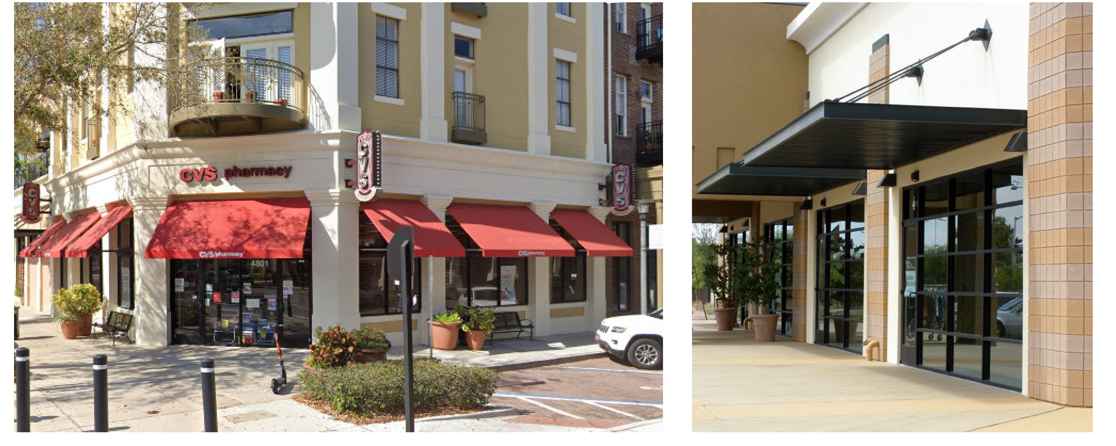
3.
Gallery. Galleries and arcades are colonnades extending along the full or partial frontage of a building. Unlike arcades, galleries lack habitable space above, and thus, appear lighter in nature. Galleries may extend over the sidewalk. Table XIV - 6 notes the transect zones where galleries are allowed/encouraged. When used, galleries shall meet the following standards.
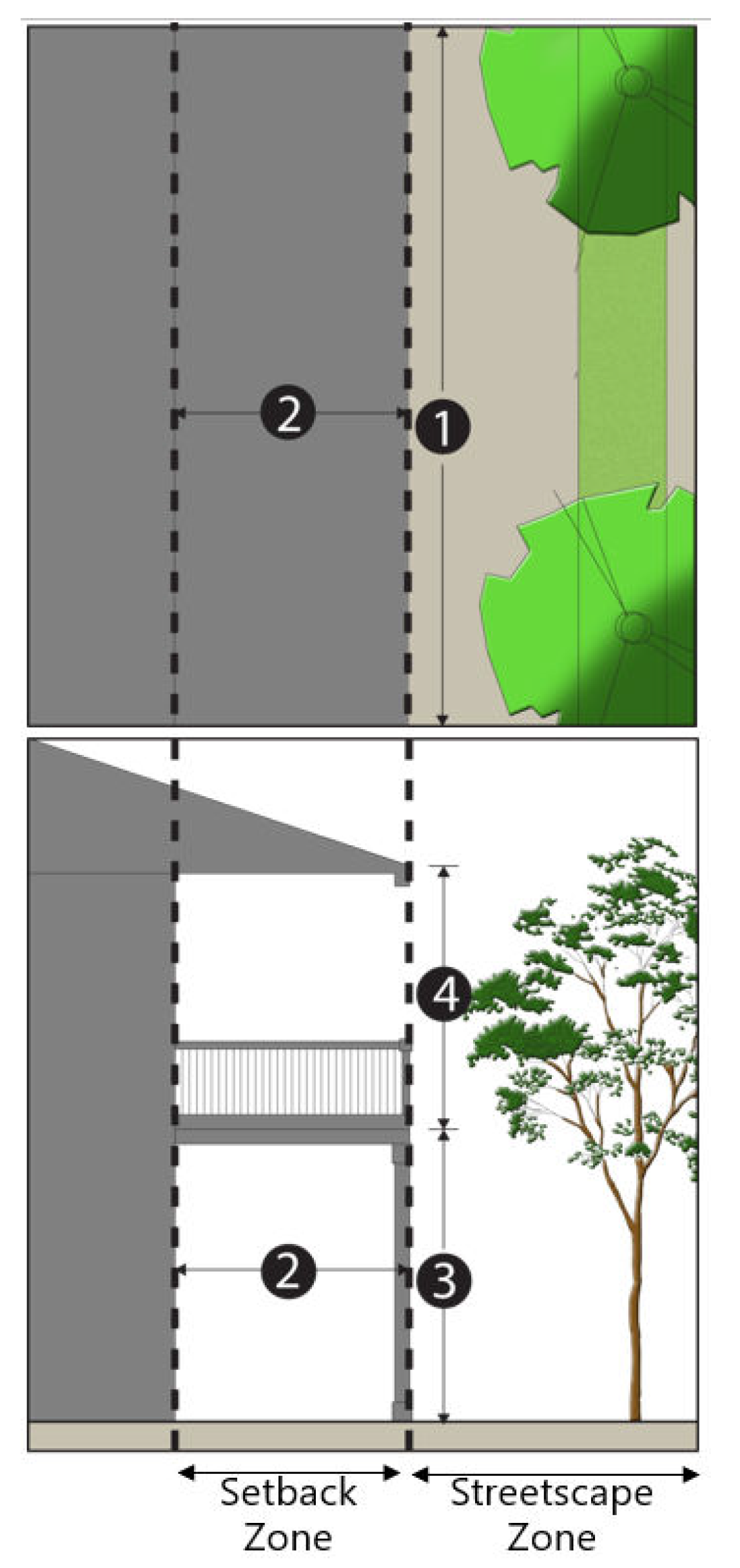
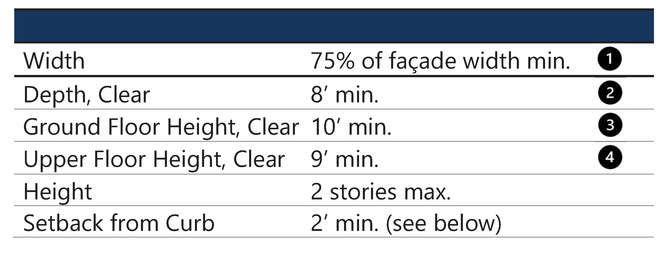
Galleries shall meet the following standards:
a.
Galleries extending over the sidewalk are subject to a right-of-way encroachment permit from the city. Along state roads, they are allowed to encroach only if FDOT allows it.
b.
Gallery openings shall correspond to storefront entrances.
c.
Galleries may be one or two stories.
Figure XIV - 24. Examples of Galleries

4.
Arcade. Arcades are colonnades extending along the full or partial frontage of a building and have habitable space above. Table XIV - 6 notes the transect zones where they are allowed/encouraged. All new arcades shall meet the following standards.
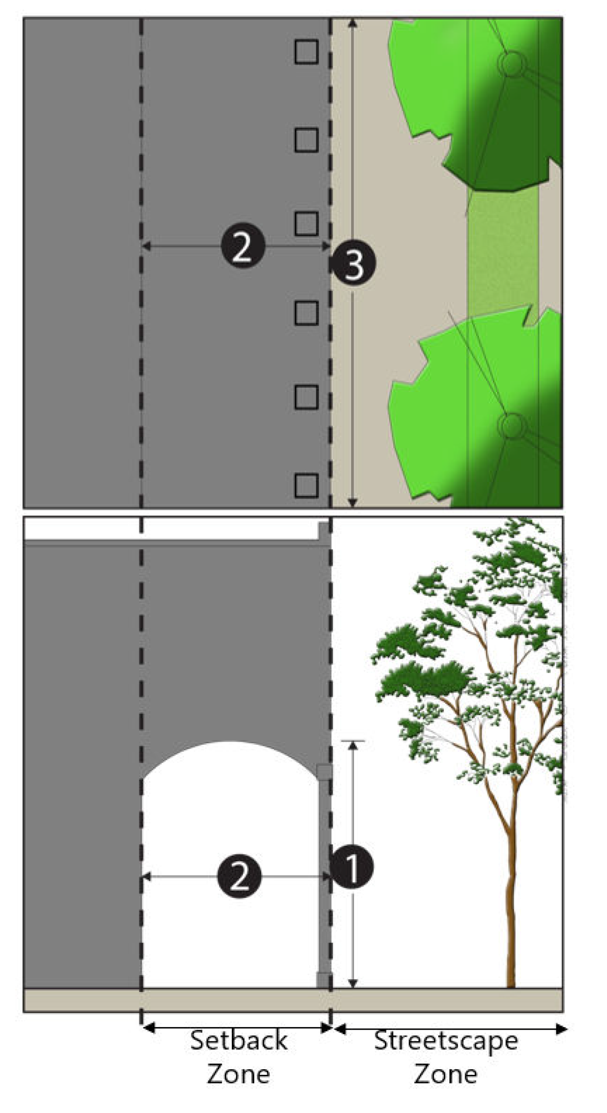
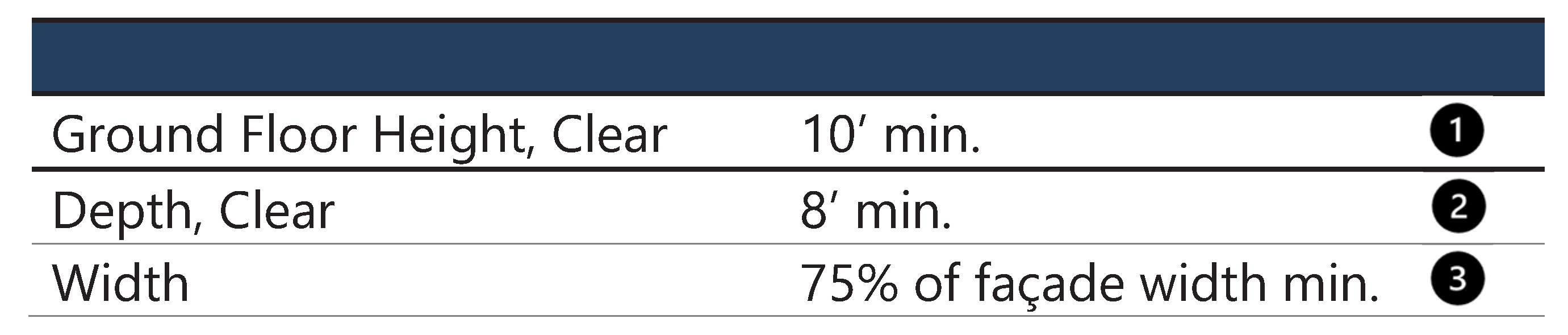
Arcades shall meet the following standards:
a.
Arcade openings shall correspond to storefront entrances.
b.
Arcades may not encroach into the public right-of-way.
Figure XIV - 25. Examples of Arcades
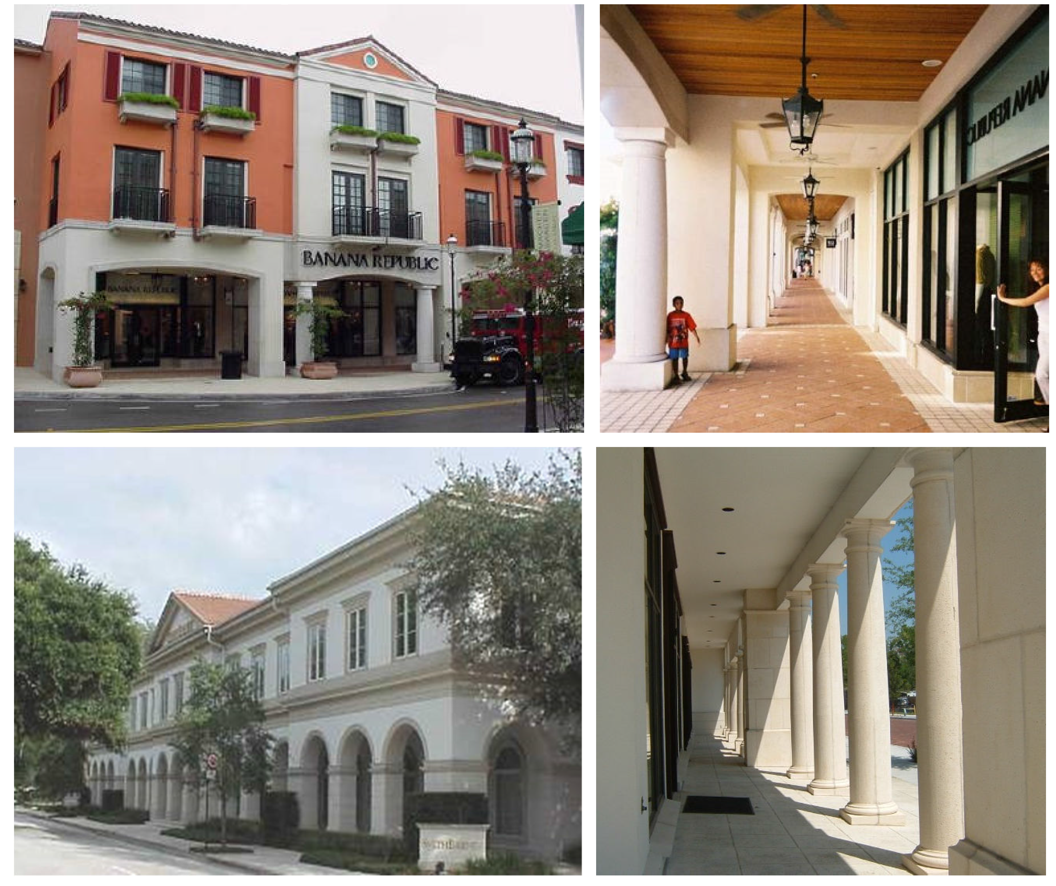
5.
Forecourt. A forecourt is a type of building frontage that has a portion of the facade recessed from the street to create a courtyard. This space can be used as an apartment or office entry court, garden space, or for outdoor seating or dining. Table XIV - 6 notes the transect zones where forecourts are allowed/encouraged. All new forecourts shall meet the following standards.
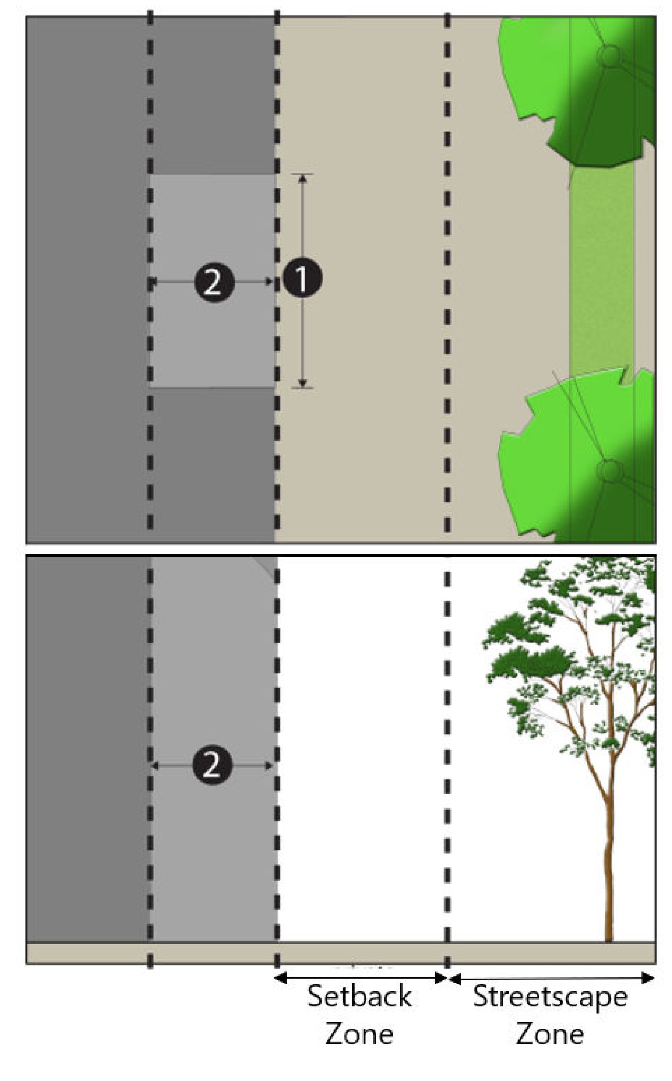
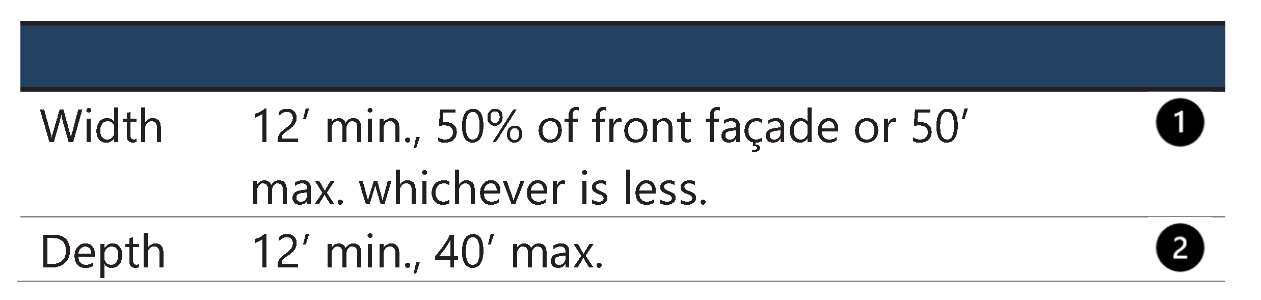
Forecourts shall meet the following standards:
a.
Forecourts may be landscaped or paved and enhanced with landscaping.
b.
Forecourts are not intended to be covered; however, awnings and umbrellas are allowed and encouraged.
c.
Forecourts meeting the requirements of this section shall be counted as building frontage to meet the requirements of section 117-837 D (Building frontage).
Figure XIV - 26. Examples of Forecourts
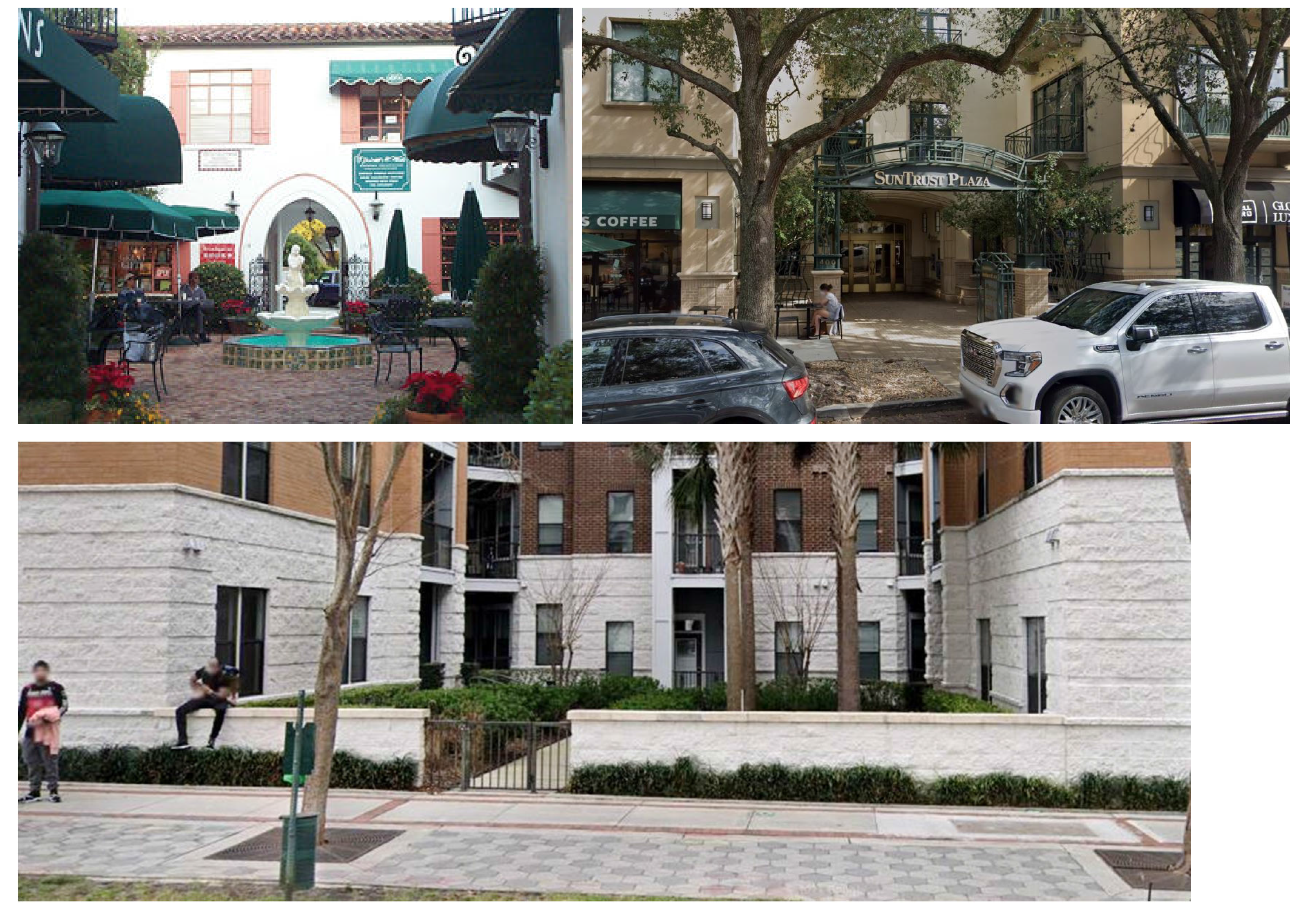
6.
Stoop. A stoop is a small platform and/or stairway at a building entrance, commonly covered by a secondary roof or awning.
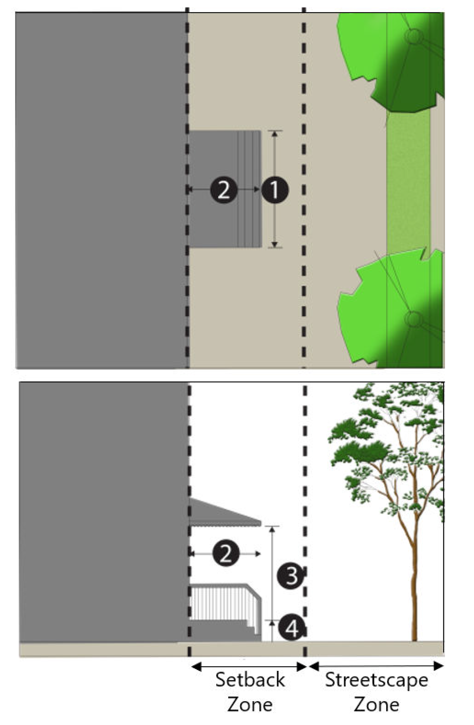
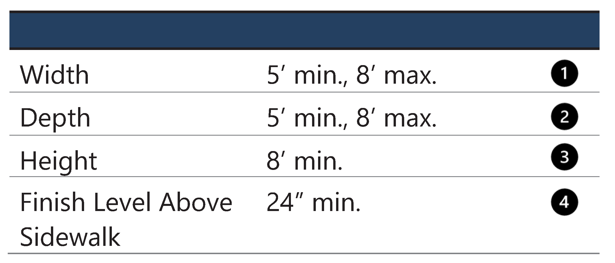
Stoops shall meet the following standards:
a.
Stoops are typically used in conjunction with residential and lodging uses but may also be used in conjunction with office uses.
b.
Stairs from the stoop may descend forward or to the side.
c.
Stoops may extend forward of the minimum setback line but shall not extend into the public right-of-way.
Figure XIV - 27. Examples of Stoops
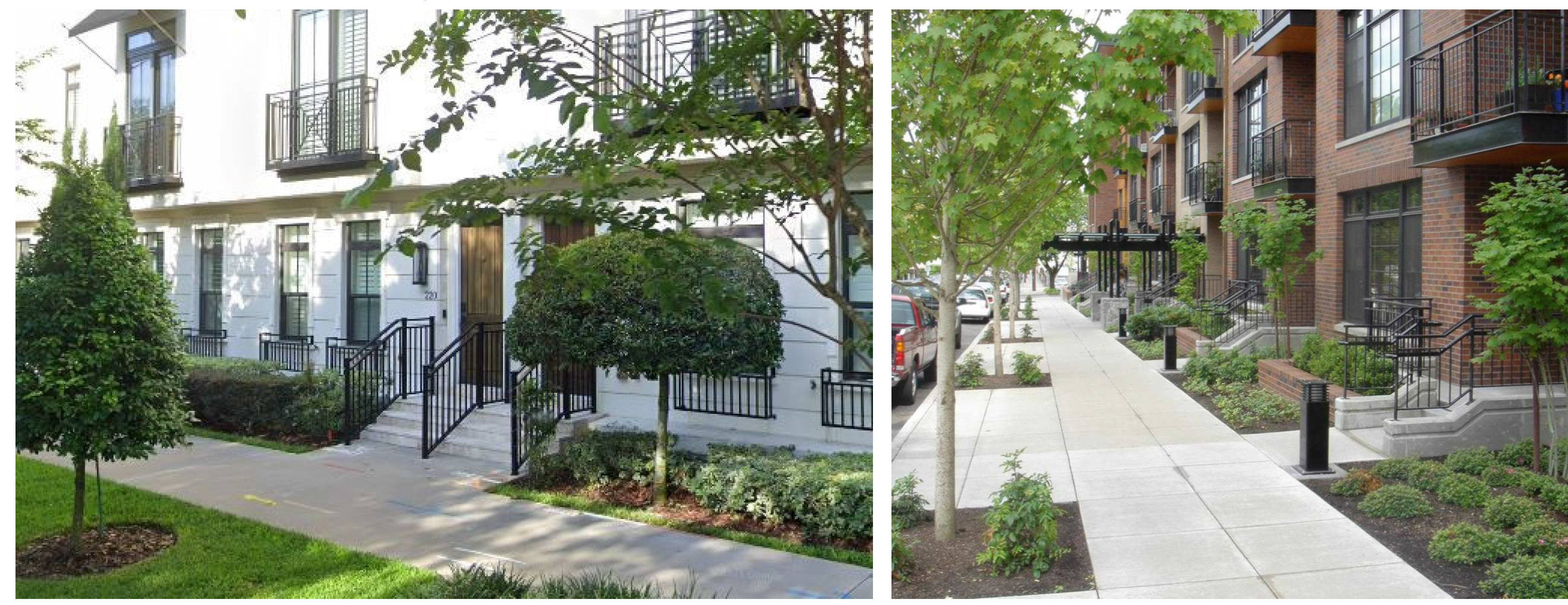
7.
Porch. A porch is a roofed space attached to the outside of an outer wall of a building and open on one or more sides. Porches may feature railings, a screen, or glass enclosure. Table XIV - 6 notes the transect zones where porches allowed/encouraged. All new porches shall meet the following standards.
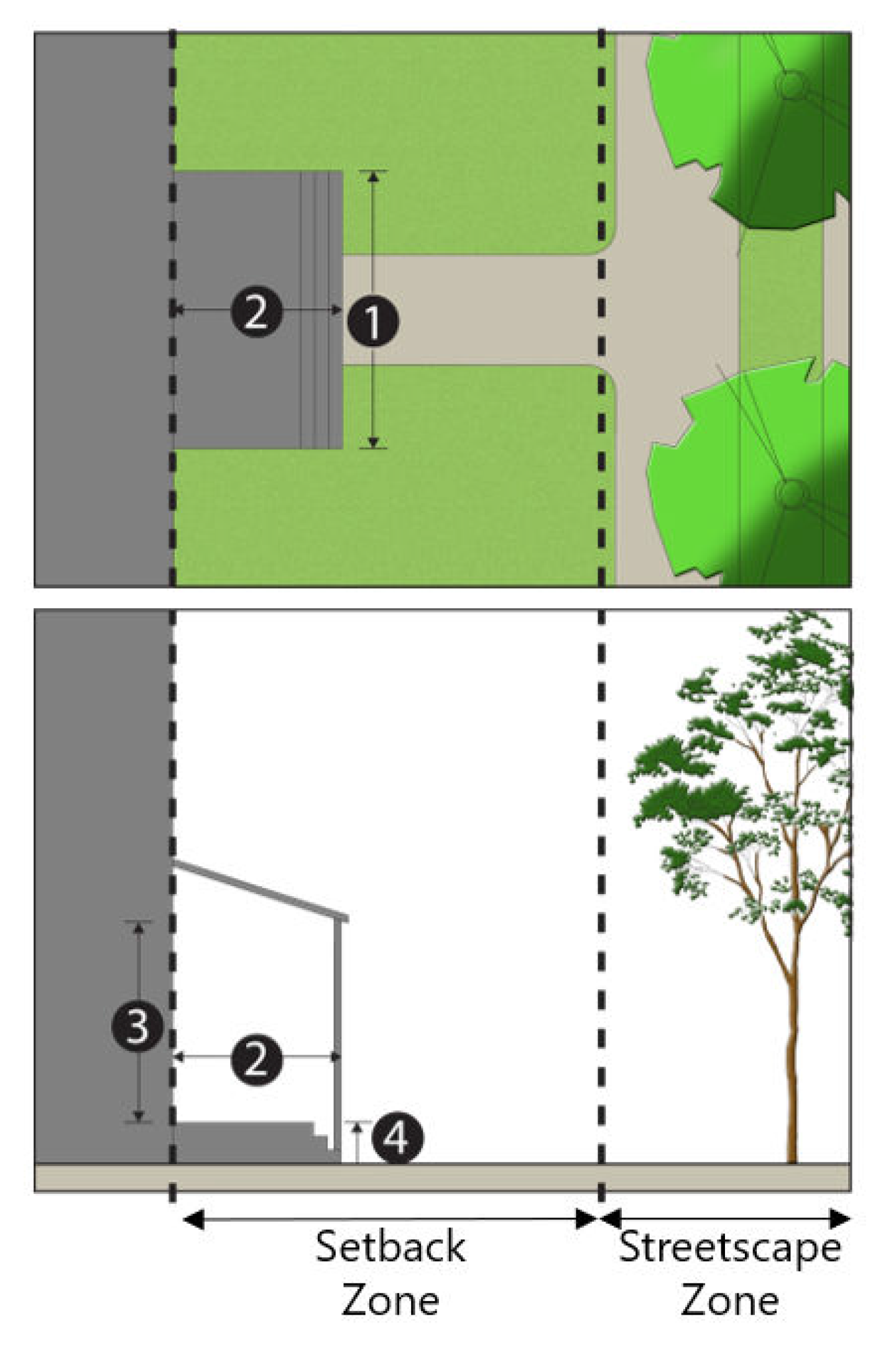
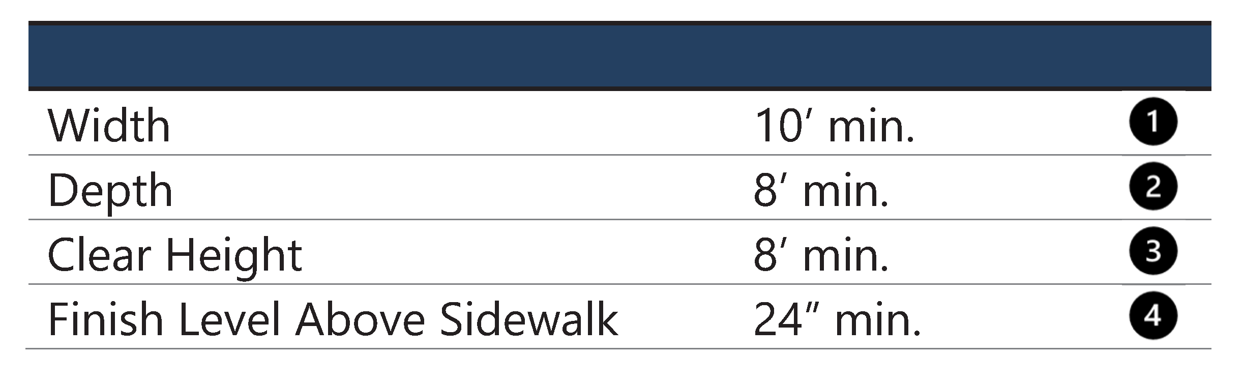
Porches shall meet the following standards:
a.
Stairs from the porch may descend forward or to the side.
b.
Porches may encroach into the setback but shall not extend into the public right-of-way.
c.
Porches may be open or enclosed. However, porches enclosed in glass or other solid materials may not encroach into the setback.
d.
Porches may be one or two stories.
Figure XIV - 28. Porches
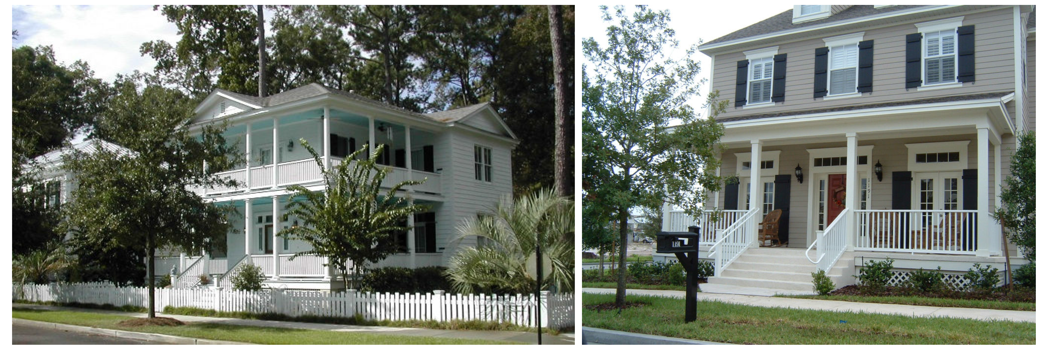
F.
Facade articulation. Facades facing a street or public space shall not exceed 20 horizontal feet and ten vertical feet (see Figure XIV - 29) without including at least one of the elements listed below. Landscaping and signs shall not be considered facade elements.
1.
Awning or canopy.
2.
Gallery, arcade, forecourt, stoop, or porch.
3.
A vertical or horizontal offset, column, band, cornice, or similar element with a minimum depth of six inches.
4.
Expression line between floors. Bands of colors without a change in plane or material shall not be used for architectural detail (Figure XIV - 30).
5.
Balcony.
6.
Window.
7.
Door.
8.
Any other treatment that meets the intent of this section and is approved during the review of the development plan.
Figure XIV - 29. Facade Articulation
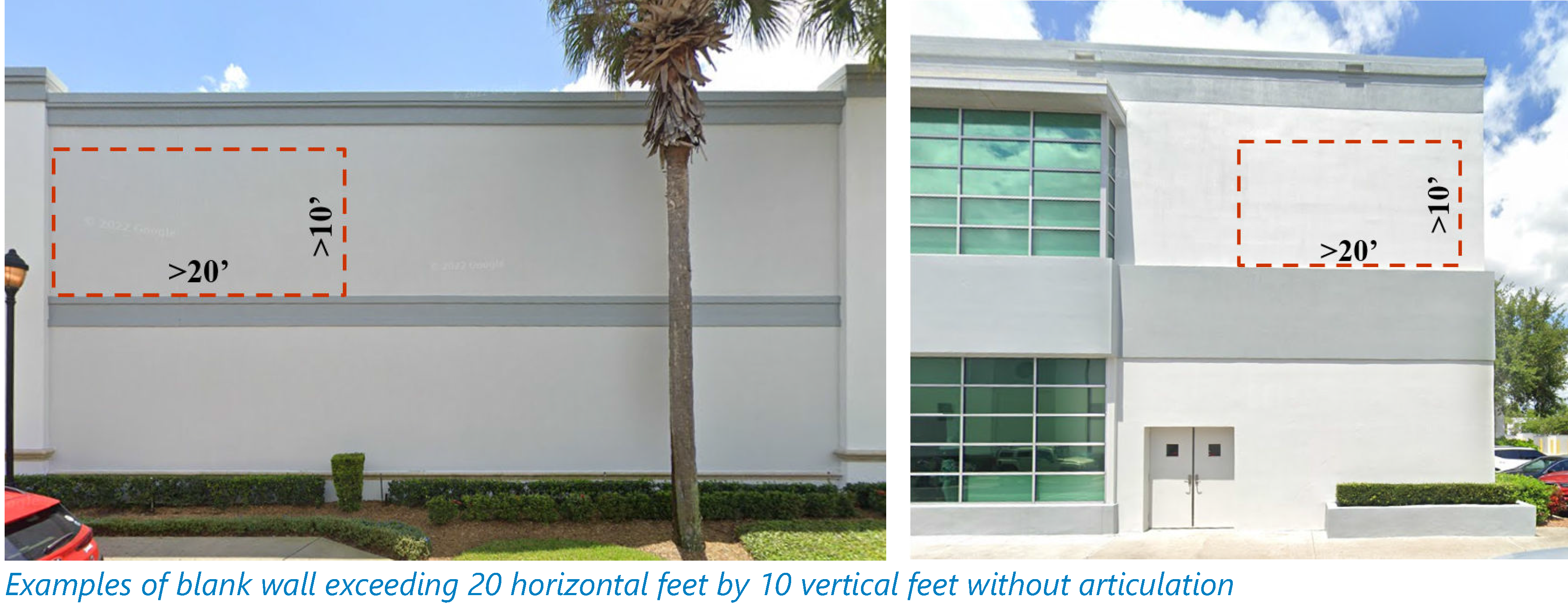
Figure XIV - 30. Color Bands
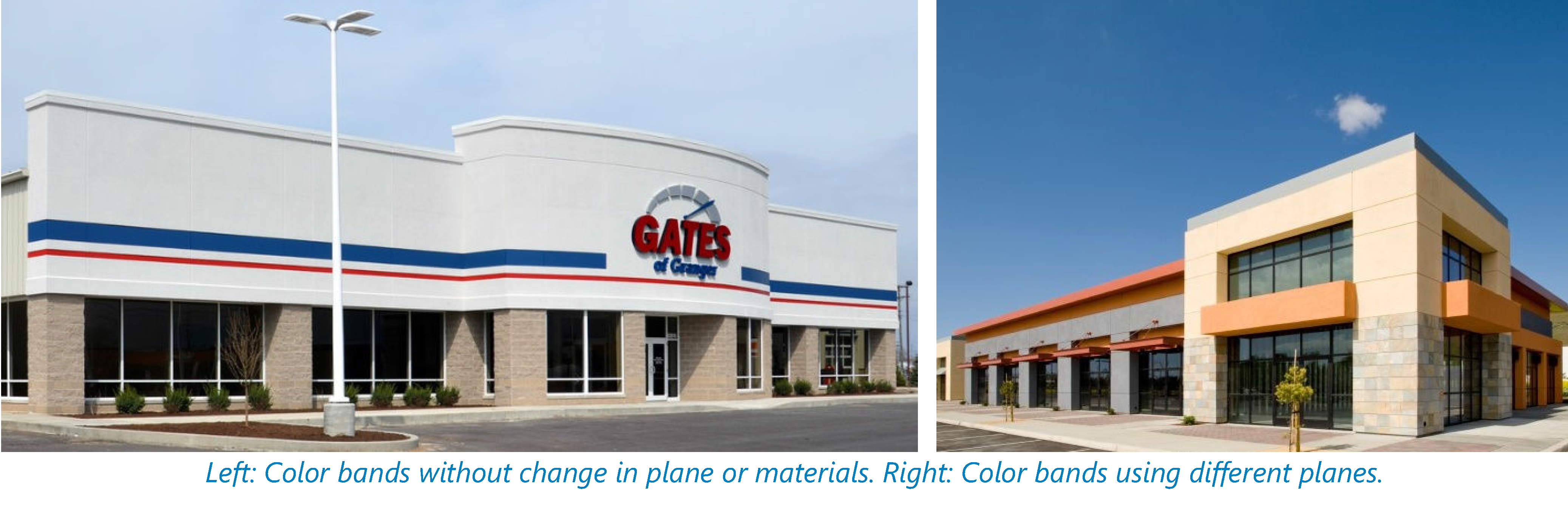
G.
Entrances.
1.
The primary entrance to every building must directly face a street or a forecourt (see section E.5 above). Additional building entrances are permitted. Corner lots shall orient the primary entrance to the highest priority street or may provide a corner entrance, if the corner is located at an intersection featuring the highest priority streets. See Figure XIV - 18 for street hierarchy.
2.
Public entry and exit doors which swing outward shall be recessed into the facade a minimum of three feet where the building abuts the sidewalk.
3.
Multifamily or multi-tenant buildings featuring a single entrance shall locate the entrance facing the right-of-way and the entrance shall be designed to stand out through the use of architectural features, a stoop, canopy, or similar elements (see Figure XIV - 31).
Figure XIV - 31. Prominent Single Entrances
4.
Buildings with multiple entrances (e.g., duplex, townhouses, multifamily) shall have at least one entrance facing the right-of-way (see Figure XIV - 32) or facing a forecourt (section E.5 above).
Figure XIV - 32. Multiple Entrances
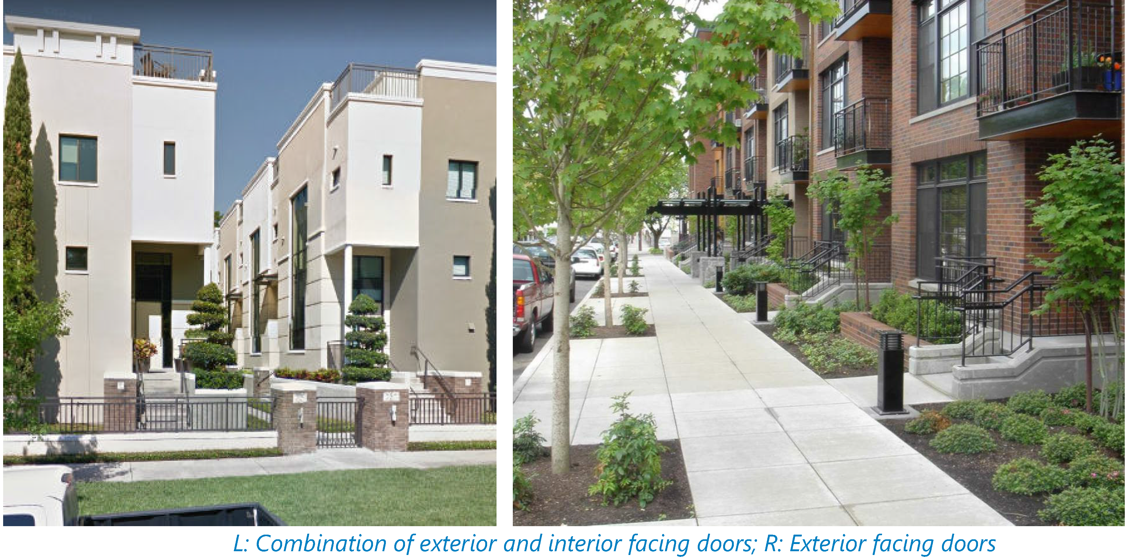
H.
Fenestration. All building facades fronting a street or public space shall meet the minimum fenestration requirements outlined in Table XIV - 7. Fenestration refers to the arrangement of windows and doors along a facade. The percentage of fenestration shall be calculated per floor and shall be a total percentage of windows and glass doors (represented in pink in Figure XIV - 33) along that portion of the facade.
Table XIV - 7. Fenestration Standards
1.
Glass block is not considered transparent and shall not count toward the minimum fenestration requirement.
2.
Interior shelves or furniture shall not fully or partially block windows used to meet the transparency and fenestration requirements.
Figure XIV - 33. Facade Fenestration
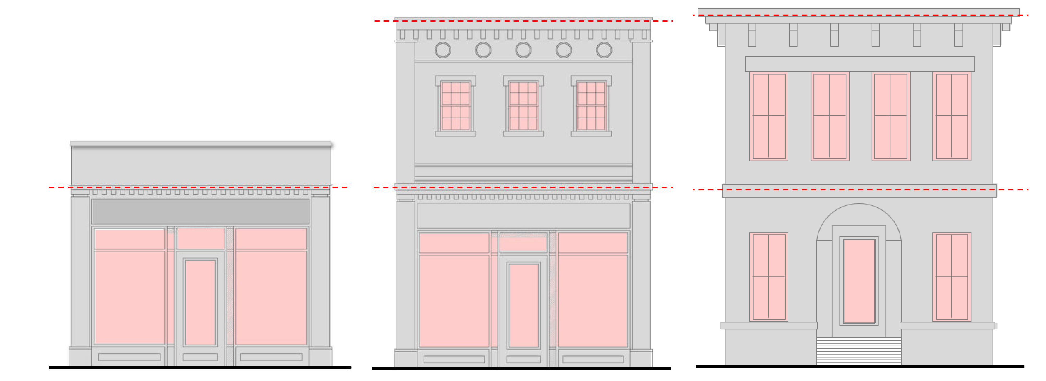
I.
Windows.
1.
Window openings shall include a structural lintel above to express the conveyance of building weight.
2.
Windows shall be vertically proportioned or subdivided to appear vertical.
3.
Windows and glass doors shall utilize clear glass with no less than 90 percent visible light transmission (VLT, percentage of light that passes through the window) for retail establishments, and 50 percent for office and residential uses.
4.
To provide clear views of merchandise in stores and enhance the pedestrian shopping experience, the first-floor windows of all retail buildings facing the street shall remain unblocked for at least 60 percent of the surface of the window.
J.
Building materials. Facade materials visible from the street shall be selected based on compatibility with the building style and neighborhood character.
1.
Prohibited facade materials: Cedar shakes, wood shingles, or shakes; metal/steel walls; corrugated or reflective metal panels (not intended to prohibit metal roofs or architectural accents); unfinished block, textured plywood, mirrored glass, plastic siding, tile (except as an architectural accent), chain link fencing, and polyurethane and polystyrene foam products (except as an architectural accent).
2.
Material changes.
a.
When materials are combined on a building facade horizontally, heavier materials shall occur below lighter materials.
b.
Changes from one material or color to another along the horizontal direction shall occur at "inside corner" transitions (Figure XIV - 34).
Figure XIV - 34. Material or Color Changes
c.
Changes in material or color along the vertical direction shall occur at a hard-edge "bump-out" transition which gives materials a surface to terminate against.
K.
Foundation screening. Foundations visible between the ground and the base of the building shall be screened with durable materials including painted lattice or brick, wood paneling, stucco, or stone. Additionally, shrubs shall be planted along this foundation line to soften the architectural edge.
L.
Accent lighting. For the purpose of this form-based code, accent lighting refers to strip/rope lights, string lights, and flood/spotlights used to highlight buildings/building features. Rope lights consist of a series of LED bulbs encased in a flexible, plastic tube. Strip lights consist of a flat flexible circuit board strip with closely spaced LED bulbs. String lights consist of small light bulbs hanging from a string, wire, or cable. Flood lights are broad-beamed lights designed to illuminate a specific area. Spotlights cast a narrow and focused beam of light on a specific area or object.
Figure XIV - 35. Permitted Accent Lights
1.
Accent lights outlining a building cornice or roof edge are permitted in all zones except the Downtown Core Zone. Lights used to outline windows, doors, or other facade features are prohibited throughout the form-based code area.
2.
Flashing or moving accent lights shall are prohibited.
3.
Lights that automatically change colors shall be programmed to change at intervals of less than once per hour.
4.
Up lights contribute to light pollution in the sky and shall be prohibited. Cut-off fixtures are required.
5.
Light intensity, measured at the edge of the lot at five feet above ground level, shall not exceed 3.0 foot-candles. Incandescent lights shall be limited to 75 watts per fixture, fluorescent lights to 20 watts per fixture, and LED lights to 15 watts per fixture.
6.
Any light source or lamp that emits more than 900 lumens shall be concealed or shielded with full cut-off style fixture with an angle not exceeding 90 degrees to minimize glare and unnecessary light diffusion onto adjacent properties and streets.
7.
Where existing light fixtures cause visible glare to residential uses or motorists on the adjoining public rights-of-way, the fixtures shall be either shielded, redirected, replaced, or removed to eliminate the nuisance.
8.
Accent lighting incorporated into a sign shall be counted as part of the sign.
9.
Security lighting is excluded from the provisions of this section.
Figure XIV - 36. Permitted Accent Lighting
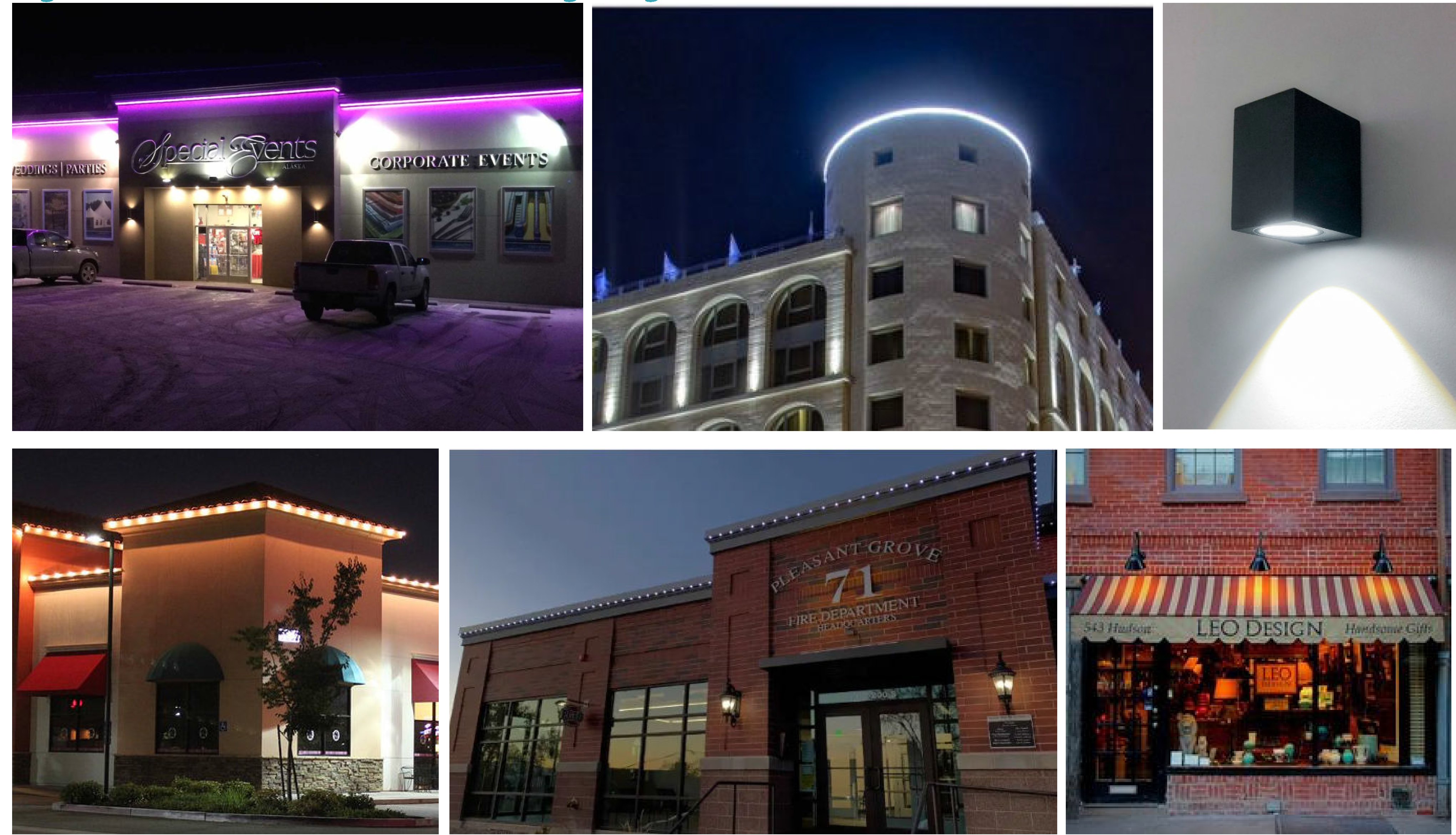
Figure XIV - 37. Prohibited Accent Lighting
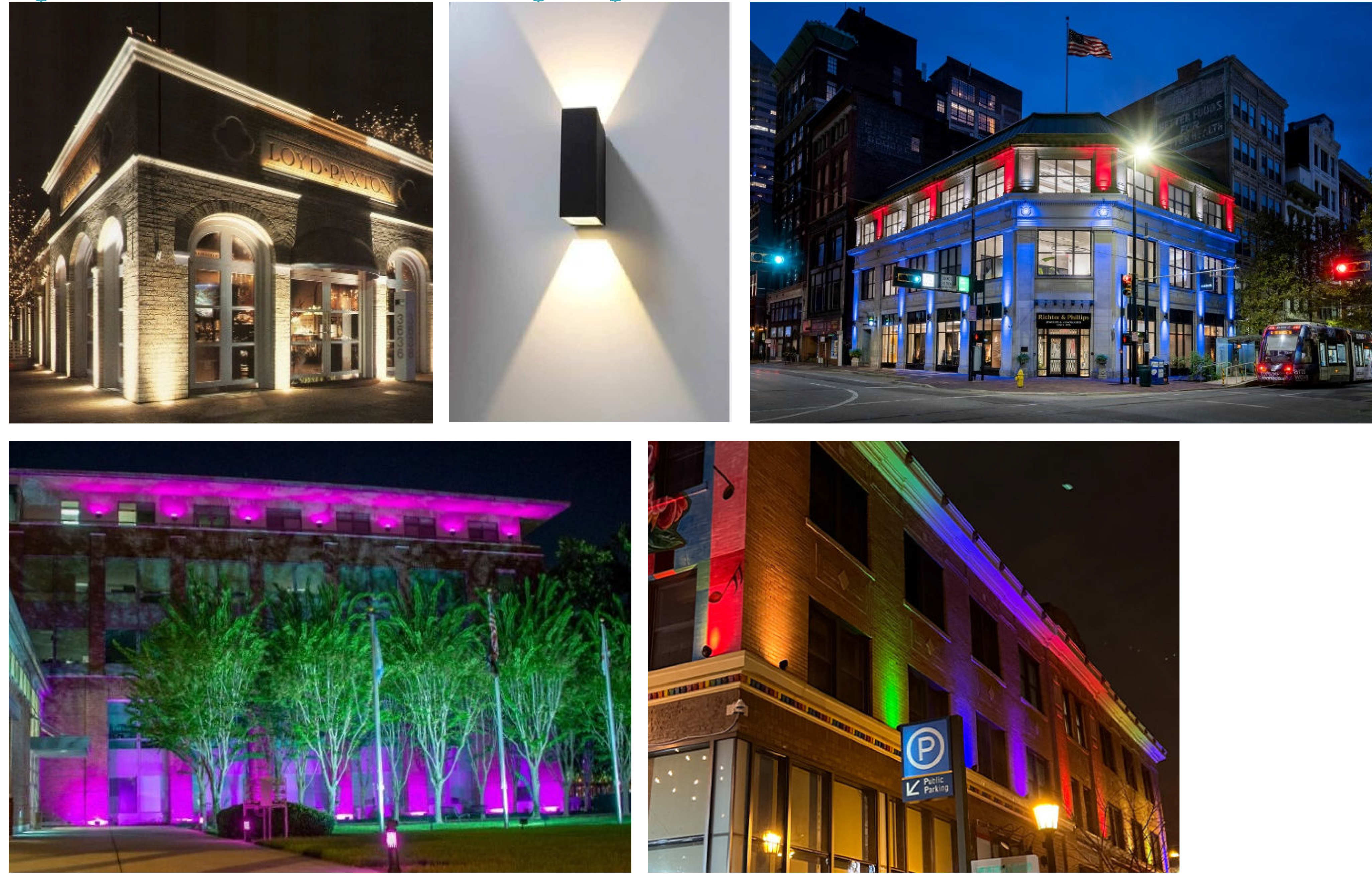
M.
Service areas and mechanical equipment. Mechanical equipment, for the purpose of this Code, shall include any heating, ventilation, and air conditioning (HVAC) or electrical machinery but also includes air compressors, hoods, mechanical pumps, exterior water heaters, water softeners, utility and telephone company transformers, meters or boxes, garbage cans, storage tanks, generators, geothermal wells, and similar elements. For the purpose of this Code, electric vehicle (EV) chargers are not deemed mechanical equipment.
1.
New development or major modifications as defined in section 117-831 B will require the placement of utility lines underground, where physically feasible.
2.
Service areas, waste disposal containers, mechanical equipment, loading docks/spaces, satellite dishes, air conditioning equipment and similar elements shall be located in the rear or to the side of buildings and screened from view from adjacent public rights-of-way and pedestrian walkways. Dumpsters must meet the standards of section 113-246(7) except that chain link fencing shall not be allowed. The enclosure shall be at least six feet high. Where possible, they shall be incorporated into the primary building design (Figure XIV - 38).
3.
Loading docks, overhead doors, and other service features shall not be located within view from residential buildings.
4.
Shared loading facilities between adjacent uses are acceptable provided they meet the minimum space size requirements of this land development code and are designed, located, and arranged to be usable by such uses. Share use agreement shall be required.
Figure XIV - 38. Service Area Screening
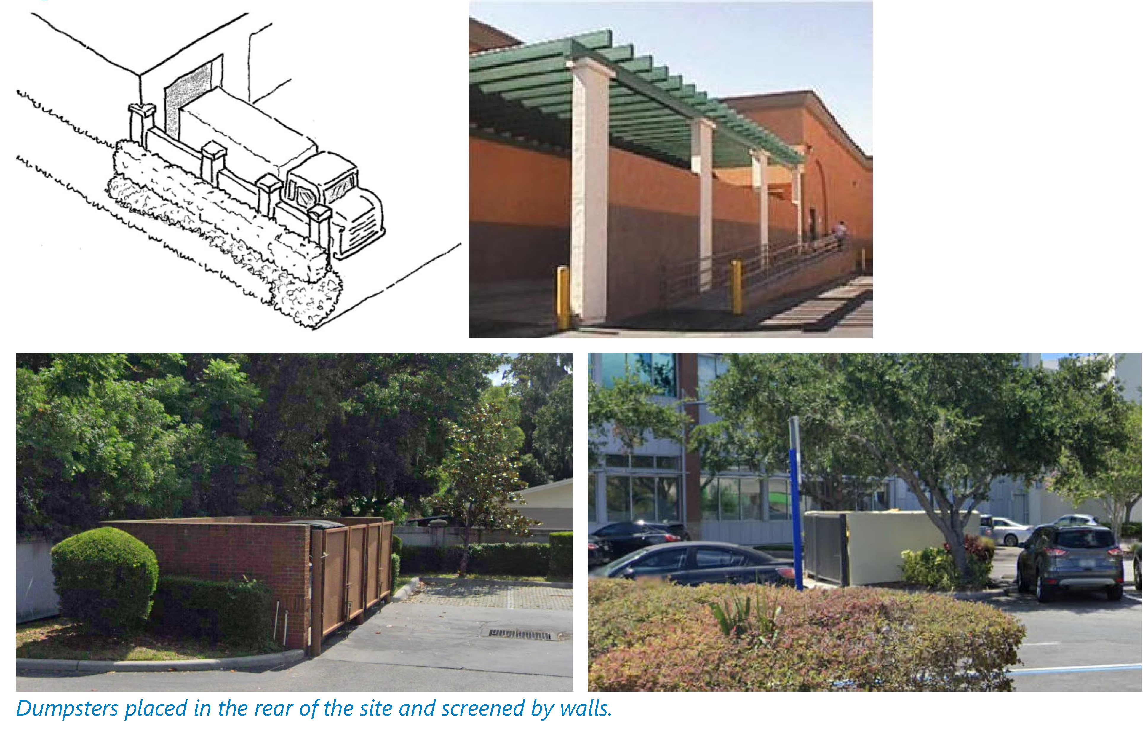
5.
If mechanical equipment needs to be located at-grade, and is visible from an adjacent street or sidewalk, it shall be inset into the building facade and screened with doors, a solid fence, or street wall (see Figure XIV - 39).
Figure XIV - 39. Mechanical Equipment Screening
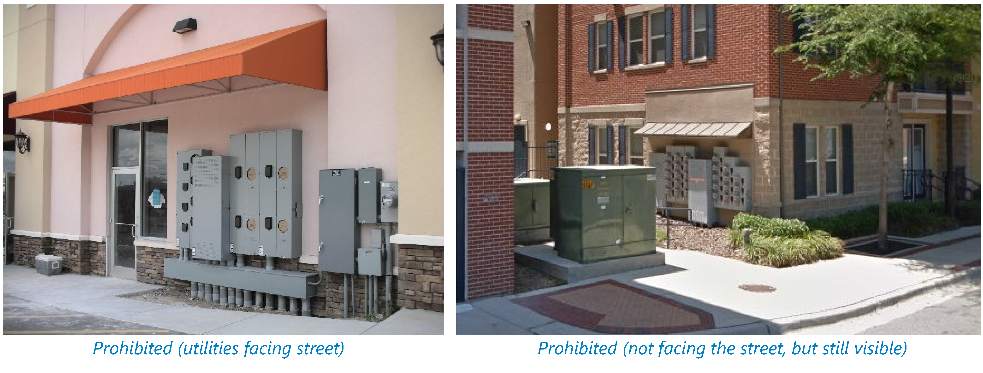
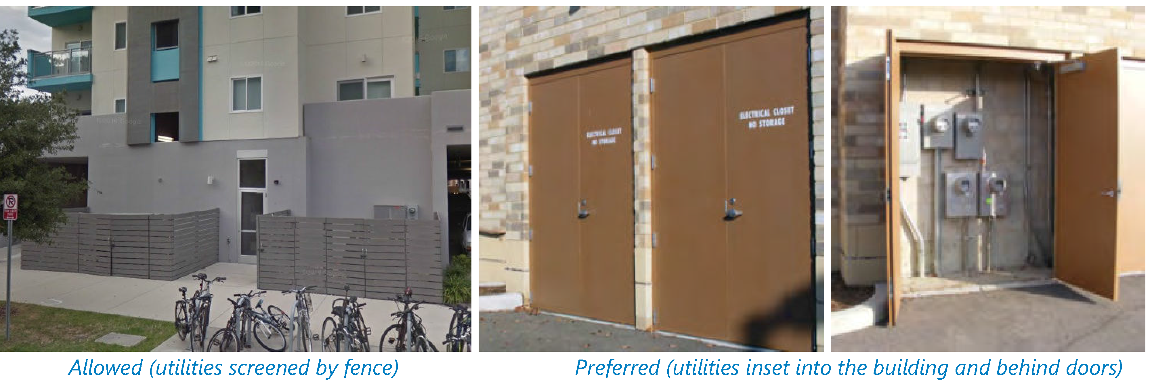
6.
Rooftop mechanical equipment shall be integrated into the overall mass of a building by screening it behind parapets or by recessing equipment into hips, gables, parapets, or similar features (see Figure XIV - 40).
7.
Rooftop equipment shall be set back from the edge of the roof by a distance at least equal to the height of the screening to minimize visibility from surrounding streets.
Figure XIV - 40. Rooftop Units Screening
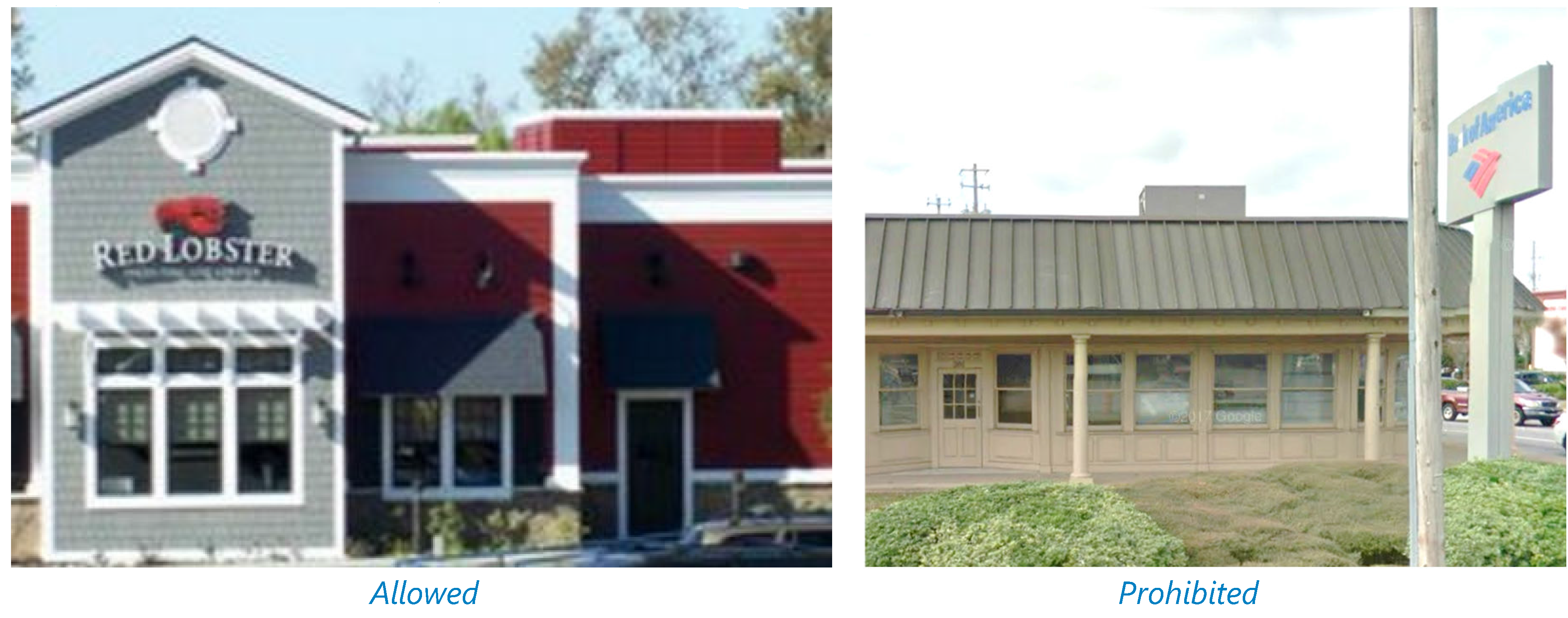
8.
Shopping cart storage shall be located inside the building or shall be screened by a four-foot wall consistent with the building architecture and materials.
(Ord. No. O-11-2024, § 4, 4-16-2024)
Sec. 117-838. - Supplemental site and building standards.
A.
Civic buildings. Civic buildings may include, but are not limited to, municipal buildings, religious facilities, libraries, schools, recreation facilities, and places of assembly. These buildings should represent landmarks of the community (see Figure XIV - 41). Therefore, they shall meet the transect zone standards except for the following provisions:
1.
The design and construction of civic buildings shall be of the highest quality to reflect the importance of these buildings within the community and with their function as landmarks in mind.
2.
The scale of civic buildings should typically be larger than surrounding buildings to be more prominent and visible across greater distances.
3.
Prominent roof forms and elements such as cupolas can visually extend the height of the building (not the number of stories). These features shall not exceed 20 feet above the T-zone's permitted height limit.
4.
No maximum setbacks shall be applied provided the front yard is not used for parking, driveways, or other vehicular use areas and instead is used for public gatherings.
5.
Floor-to-ceiling height and architectural details shall be proportionately larger than those of private buildings.
6.
Building design requirements may be waived provided the individual facades do not feature large expanses of blank walls and instead incorporate elements consistent with the style. A minimum fenestration of 40 percent shall be met per facade (not per floor) visible from the public right-of-way.
Figure XIV - 41. Examples of Civic Buildings that stand out as landmarks
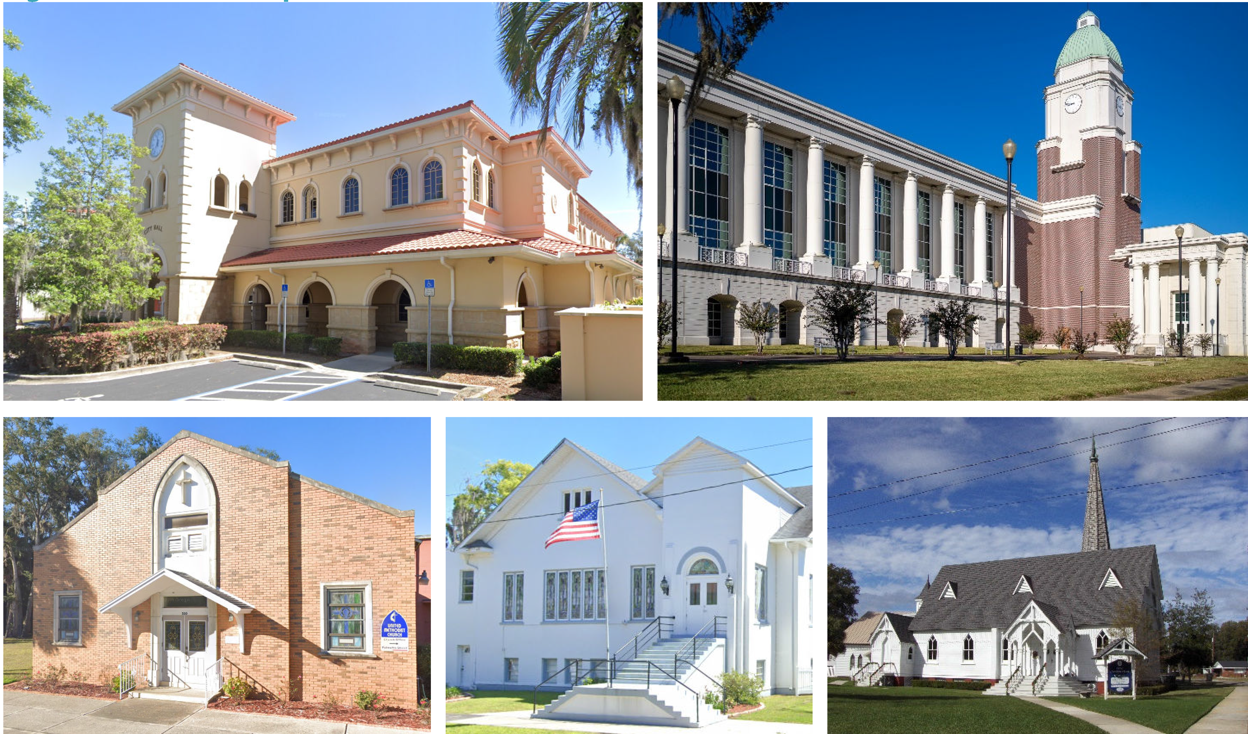
B.
Gasoline service stations. Gasoline service stations may be permitted as shown in section 117-3. However, all new and existing stations undergoing major modifications shall meet the standards of this article and the following provisions:
1.
A ground-floor convenience store or service building shall be located in the front of the site (see Figure XIV - 42) meeting the required setback of the T-zone. All pumps, parking and drive aisles, car wash, and service bays shall be located to the side (interior only) or rear of the main building.
Figure XIV - 42. Gas station
Orientation
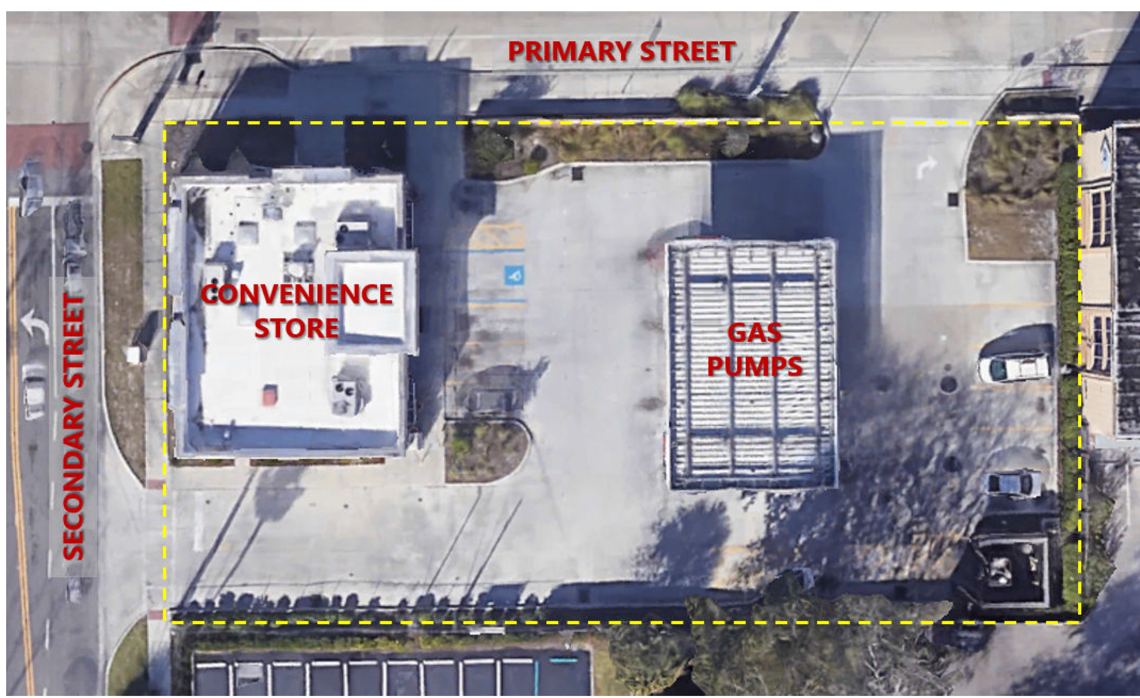
2.
A street wall shall be provided to screen vehicular use areas (see section 117-840 D for street wall standards).
3.
Accessory car wash structures shall not exceed 20 feet in height (excluding hip or gable roof, if used).
4.
Accessory car wash openings, service, and storage areas, and refuse enclosures shall be oriented away from public view.
5.
Lighted bands or tubes or applied bands of color (other than permitted as signage) are prohibited.
6.
Site lighting shall minimize direct and reflected glare and excess brightness. Therefore, only cut-off fixtures shall be allowed.
Figure XIV - 43. Service Station Examples
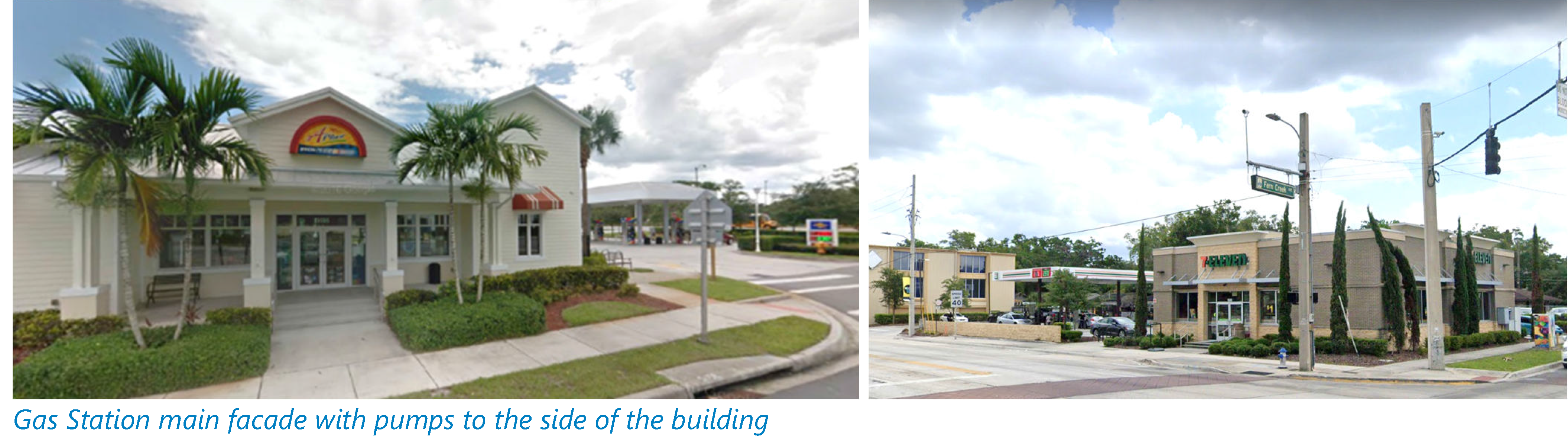
C.
Drive-through facilities. Drive-through facilities are auto-oriented and, therefore, may only be allowed within the form-based code area if they are listed in section 117-3 and meet the standards of this article, including the following:
1.
Drive-through lanes and windows shall be located along the side or rear of buildings, away from street frontages (see Figures XIV - 44 and XIV - 45). If the use is located within a building that has a parking garage, the drive through windows/bays shall be located within the garage (see Figure XIV - 46).
2.
Remote drive-through facilities (on a site separate from the principal use) shall be prohibited.
3.
Stacking lanes shall meet the requirements of section 113-136 (Standards for drive-up facilities).
Figure XIV - 44. Appropriately designed drive-through sites
Figure XIV - 45. Exterior Drive-Through Facilities
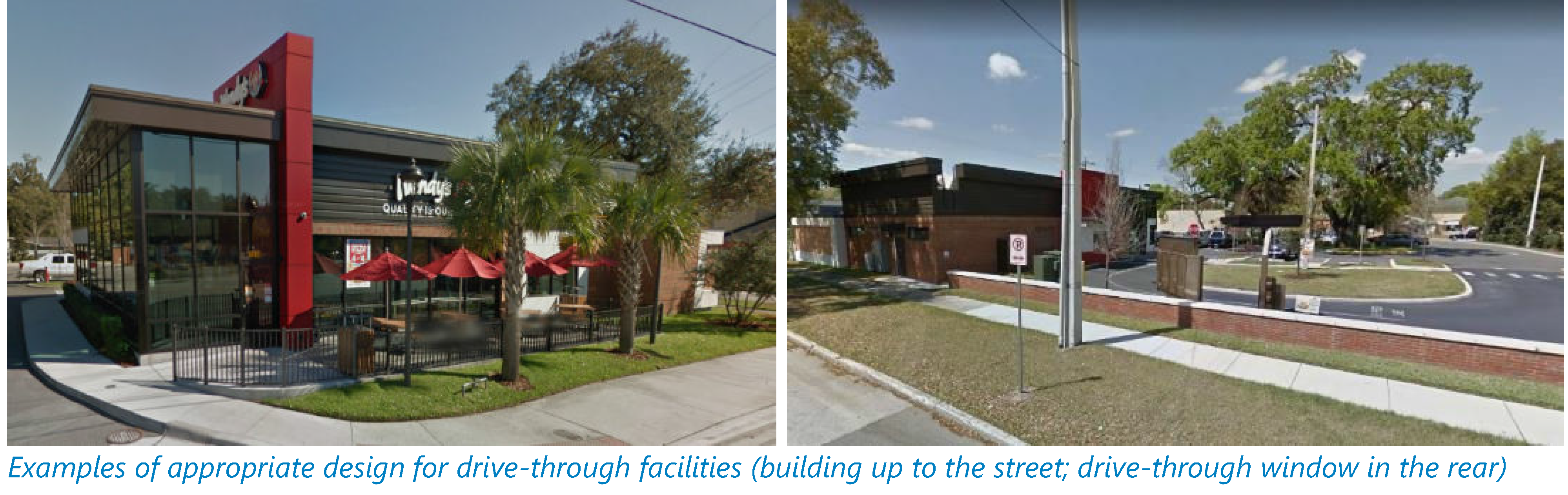
Figure XIV - 46. Interior Drive-Through Facilities
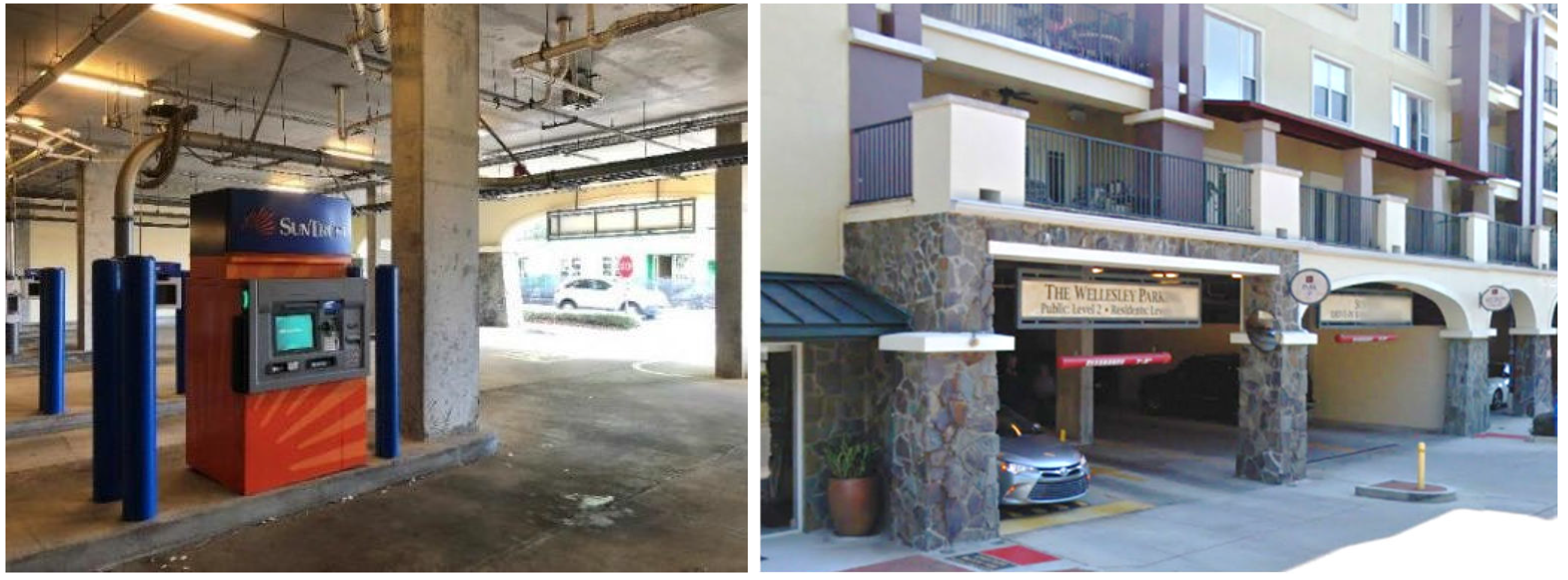
D.
Automobile uses. All principal and accessory structures used for automobile sales, rental, lease, or repair shall meet the setback and frontage requirements of this article, and shall be located and constructed in accordance with the following requirements:
1.
The building shall be located close to the street, meeting the setback standards. Vehicle display/storage shall be located to the side or rear of the building.
2.
Vehicle repair facilities are not permitted as accessory to any permitted use unless vehicle repair is allowed as a permitted use in the T-zone.
3.
Bay openings shall be located to the side or rear of the building (see Figure XIV - 47) and screened from adjacent single family residential districts.
Figure XIV - 47. Vehicle Repair Facility
4.
Vehicle display/storage areas should not be visible from the right-of-way and may instead be interior as depicted in Figure XIV - 48. If they are outdoors and visible from the public right-of-way, the vehicular display/storage areas shall be screened by a street wall (see section 117-840 D) for street wall standards).
Figure XIV - 48. Auto Sales, Rental, or Leasing Facilities
E.
Outdoor sales.
1.
Temporary sales. Businesses may receive a permit to use the adjoining/abutting sidewalk for temporary outdoor sales as an accessory use to their business subject to the following:
a.
The outdoor sales area shall abut the building.
b.
A minimum of five feet from the face of curb to the outdoor sales area shall remain unobstructed.
c.
The accessory outdoor sales use shall be identified as part of the required business tax receipt.
2.
Outdoor dining. Businesses may receive a permit to use adjoining/abutting sidewalks for outdoor dining, provided that:
a.
A minimum of five feet of the width within the public realm remains unobstructed.
b.
Nothing is permanently affixed to the sidewalk.
c.
The sidewalk is kept clean.
d.
Furniture and materials are brought inside at the end of each business day.
e.
The accessory use shall be identified as part of the required business tax receipt.
(Ord. No. O-11-2024, § 4, 4-16-2024)
Sec. 117-839. - Access, circulation and parking requirements
The intent of the following access, circulation, and parking standards is to encourage a balance between pedestrian-oriented development and necessary vehicle storage. Given the developed nature of the downtown, it has been challenging for property owners to redevelop their sites and meet the city's prior land development regulations, particularly regarding parking space requirements. The goal of this section is to balance flexibility and sufficiency in the provision of these facilities within the form-based code area.
A.
Access and circulation. Vehicular and pedestrian access and circulation shall be provided in accordance with chapter 113, division 4, and the following provisions:
1.
It is the intent of the city to minimize the number of curb cuts and driveways along Walnut Street, Orange Avenue, and Ferris Street. Therefore, new access driveways shall not be allowed along those streets, unless there is no alternative access.
2.
Sites shall be accessed from rear alleys where they exist or can be created or from secondary streets if the lot is located on a corner (see Figure XIV - 49).
Figure XIV - 49. Vehicular Site Access
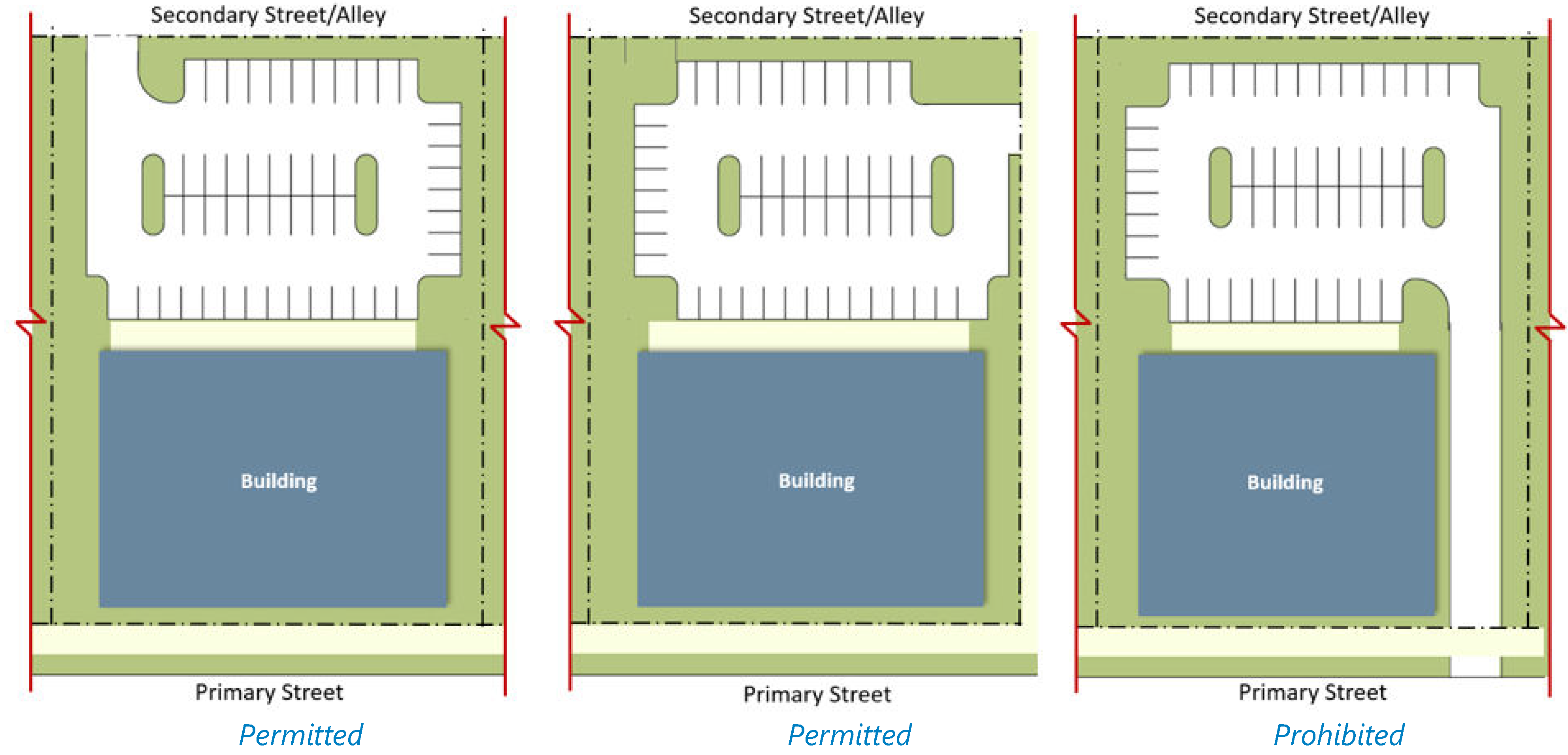
3.
If no rear alley or secondary street access is feasible, access shall be provided through neighboring properties utilizing cross-access easements (see Figure XIV - 50). Cross-access easements must be recorded prior to construction plan approval.
Figure XIV - 50. Joint Use Driveways/Cross-Access
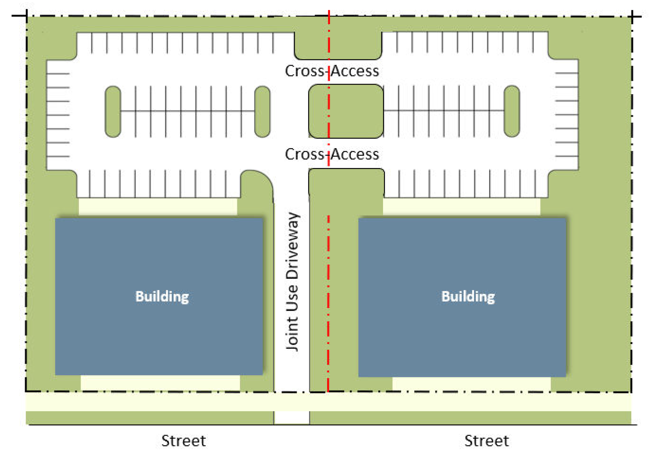
4.
If none of the allowed access options listed are feasible, access from the restricted streets shall be allowed.
5.
The width of vehicular access driveways in the form-based code area may be reduced to 20 feet for two-way traffic and ten feet for one-way traffic along local streets. No reductions may be approved for access driveways along Orange Avenue or Ferris Street.
6.
When connecting to adjacent properties through cross-access easements is not feasible, the proposed development shall still design the site to allow for future connections.
7.
Access driveways shall be designed in a way that pedestrians crossing on the sidewalk are safe. This may be achieved by using different colors for the driveway and the sidewalk.
8.
Circular drives are prohibited.
9.
Direct pedestrian access from the public sidewalk to the building shall be required for all development.
10.
Pedestrian connections between parking areas and the main building entrance shall also be provided. This may be achieved through pedestrian passageways (see Figure XIV - 51) or sidewalks around the building. Pedestrian walkways shall be a minimum of five feet wide.
Figure XIV - 51. Pedestrian Linkages
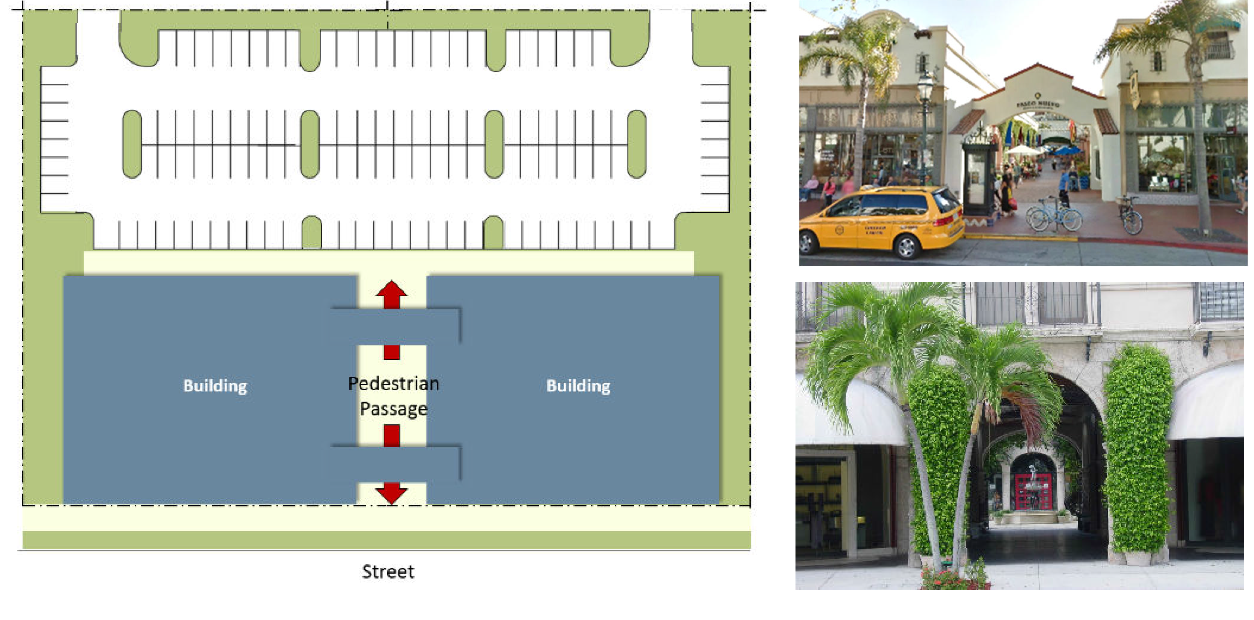
11.
Safe pedestrian connections shall be provided not only along the perimeter of the blocks but also throughout the interior of development sites (non-residential sites only).
12.
Pedestrian walkways within the development shall be differentiated from driving surfaces through a change in materials and/or grade elevation.
B.
Parking requirements.
1.
Number of spaces. Parking shall be provided for each use in accordance with the minimum requirements outlined by use in chapter 113, article III, except that:
a.
The applicant may submit a professional parking study showing the need for less spaces than required. The parking study shall be prepared by a professional engineer, architect, or American Institute of Certified Planning (AICP) planner and may use the following sources to justify the reduction: Urban Land Institute, Institute of Transportation Engineering, or other recognized industry standard. It may also include data collected from uses or combinations of uses which are the same or comparable to the proposed use.
b.
Parking stalls can be reduced to eight and one-half feet in width for up to 25 percent of the required parking spaces (not including ADA spaces) and shall be designated as "compact" at the head of the parking stall (closest to the drive aisle) using thermoplastic reflective paint that can be seen at night.
c.
If the provision of the required parking is not feasible, the applicant may elect to pay into a parking fund, if the city adopts such a program.
2.
Location. Required parking spaces shall be provided in the same lot as the use it serves. However, the following alternatives are also acceptable:
a.
Shared parking is permitted. The amount of parking required is calculated by adding the total number of spaces required by each separate use and dividing that total number by the appropriate factor from the sharing factor matrix (Figure XIV - 52) (e.g., the residential use requires ten spaces while the office portion requires 12 spaces. Independently they would require 22 spaces, but when divided by the sharing factor of 1.4, they would require only 16 spaces). The required number of handicap spaces cannot be reduced. When more than two uses share a parking facility, the lowest number shall be used.
Figure XIV - 52. Sharing Factor
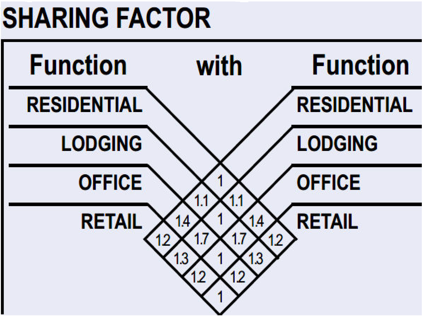
b.
On-street parking may also be counted towards the parking space requirement if at least 50 percent of the length of the space is located directly adjacent to the site. On-street parking shall remain open to the public and cannot be reserved or dedicated for private use.
c.
Satellite/off-site parking may also be allowed if located within one-quarter mile of the building's primary entrance. See section 113-160 for other requirements applicable to off-site parking.
The use of any of the parking alternatives identified in this subsection shall be subject to the filing of a deed restriction satisfactory to the city attorney ensuring that such off-street parking will be maintained in the future so long as a use or uses requiring such off-street parking or loading continue. If all or a portion of the parking required to serve a use is located on a property under different ownership, the city may require the execution of an agreement among the property owners involved as a precondition to approval of the requested parking alternative and may record such agreement in the title records of the properties involved.
3.
Visibility. Parking shall be located behind the primary building or, if rear parking is not feasible, to the side of the building. The location of parking to the side of the building, however, does not exempt the development from meeting the building frontage requirements of section 117-837 D. Parking lots located on the side of the building shall be masked from the street by a street wall (see section 117-840 D).
Figure XIV - 53. Parking Location
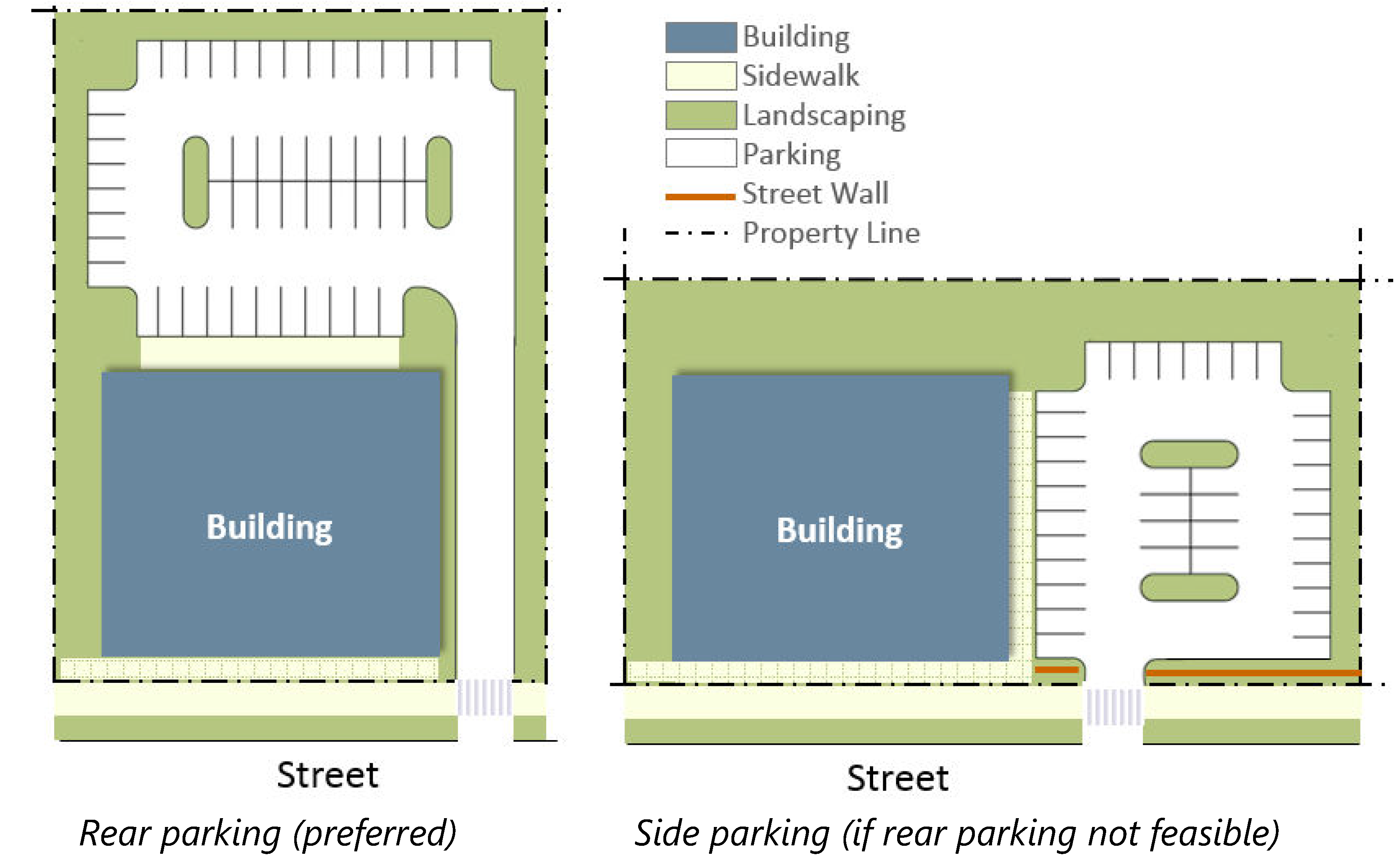
4.
Design.
a.
Surface parking areas adjacent to a street shall have at least the same setback as the building facade facing the same street and shall be screened by a street wall. See section 117-840 D for street wall requirements.
b.
Surface parking areas abutting other sites shall be set back the distance necessary to allow for the required perimeter landscaping required in section 113-244. However, parking areas designed to be shared by two or more property owners are not required to provide perimeter landscaping.
c.
Street facing garages for single family, duplex, triplex, or townhouse units shall be setback at least five feet from the building's front facade and shall not extend more than 50 percent of the facade width.
d.
Bicycle racks shall be provided in conjunction with non-residential and multi-family developments.
e.
Multi-family developments shall provide electric vehicle charging stations to eliminate the possibility of extension cords stretching from residences into parking areas.
f.
Parking spaces adjacent to an internal sidewalk or walkway shall use wheel stops at least two feet from the edge of the sidewalk so that the width of the sidewalk or walkway is not reduced to less than five feet due to the car overhang. If wheel stops are not used, the sidewalk must be widened by two feet (see Figure XIV - 54).
Figure XIV - 54. Parking Overhang
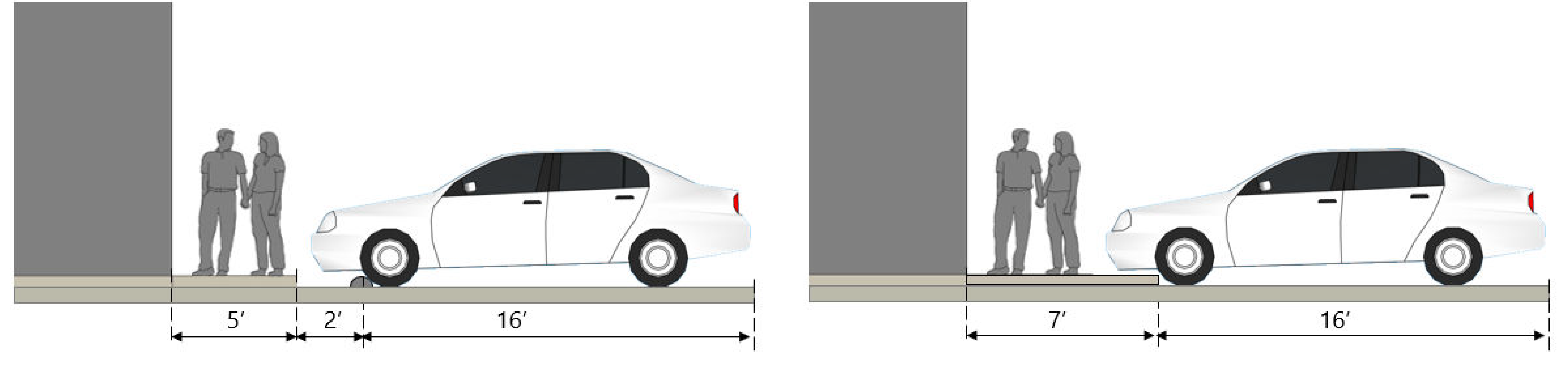
5.
Pervious surface. To mitigate the potential impact of additional impervious parking areas, if a parking area will have sporadic use as a parking lot, the applicant may request a waiver to use turf, block, bricks, pavers, gravel, millings, or an acceptable substitute to stabilize the required parking area, subject to the review and approval of the city. Pervious parking surfaces must comply with the following requirements:
a.
All required handicap parking spaces shall be designed as required by state law and shall be located to provide easy access to the building.
b.
The site must not contain soils rated low to medium as determined by the city or having steep slopes exceeding five percent.
c.
The millings or gravel shall cover the parking area to a minimum thickness of between two and four inches or as otherwise required by the city.
d.
Landscape timbers or a comparable substitute shall be used to outline and contain shifting surfaces.
e.
The owner or developer agrees to execute and record a maintenance agreement providing for maintenance, replacement, and repair of the parking area.
f.
The city may require maintenance of the area and replacement or repair of the parking surface upon inspection and identification of deficient thickness or irregularities in the surface.
g.
All parking areas shall be appropriately lit under all applicable provisions of this Code.
6.
Existing non-conforming parking facilities. There are several sites in the form-based code area with parking spaces that do not meet current code standards in terms of access, location, or size. In these instances, the following standards shall apply:
a.
In conjunction with the redevelopment of a site, parking facilities that are already located in front of a building that is not being moved or demolished may remain provided the design accommodates a public sidewalk and the parking spaces are determined to be safe by the city. If a public sidewalk cannot be accommodated, the on-street parking will need to be removed.
b.
Non-conforming curb cuts and driveways will only be required to meet the standards of this section if there is a major modification, as defined in section 117-831 B.
C.
Parking garages.
1.
The first floor of parking garages that front on a street shall be used for active uses (e.g., commercial, office, residential). The commercial uses may be located within a liner building, or as an integral part of the parking garage building (see Figure XIV - 55). Additionally, liner buildings may be attached or detached from the parking garage (see Figure XIV - 56).
2.
Parking garages and liner buildings shall meet the building design standards of Section 117-837.
3.
Direct access to parking garages shall not be provided from Walnut Street or Orange Avenue.
Figure XIV - 55. Parking Garages and Liner Buildings
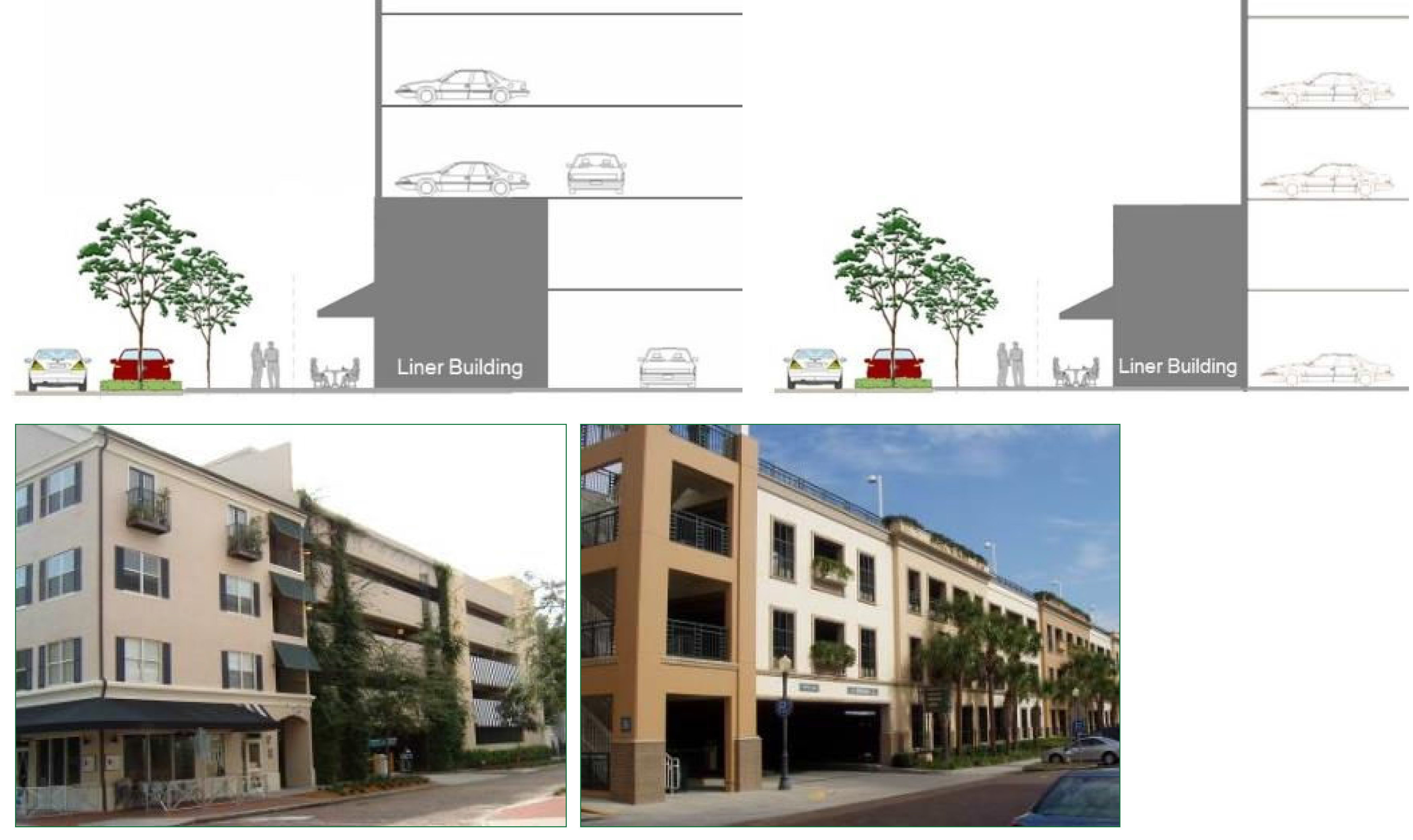
Figure XIV - 56. Liner Building Detached from Garage
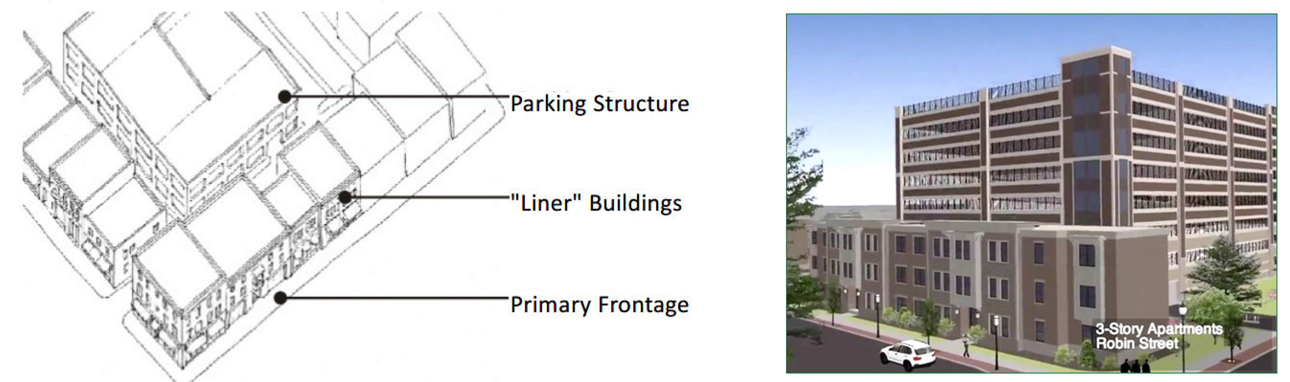
D.
Parking lot and pedestrian area lighting. Parking lot lighting shall meet the standards of section 113-160(d) and the following:
1.
The maximum height of any parking lot lighting pole shall be 15 feet.
2.
Light fixture cutoffs shall block no less than 85 percent of light projecting upward.
3.
The design, color, shape, style, and materials of the fixtures shall match or complement the style and materials of the buildings on the site.
4.
Parking lot light fixtures shall be designed so that light is directed onto the parking area and away from neighboring residential lots (e.g., house side shields). For residential conversions, no additional lighting shall be added that would change the character of the site.
5.
The location and species of trees shall be coordinated with the lighting plan so that the trees do not prevent the light from shining down (see Figure XIV - 57).
Figure XIV - 57. Lighting
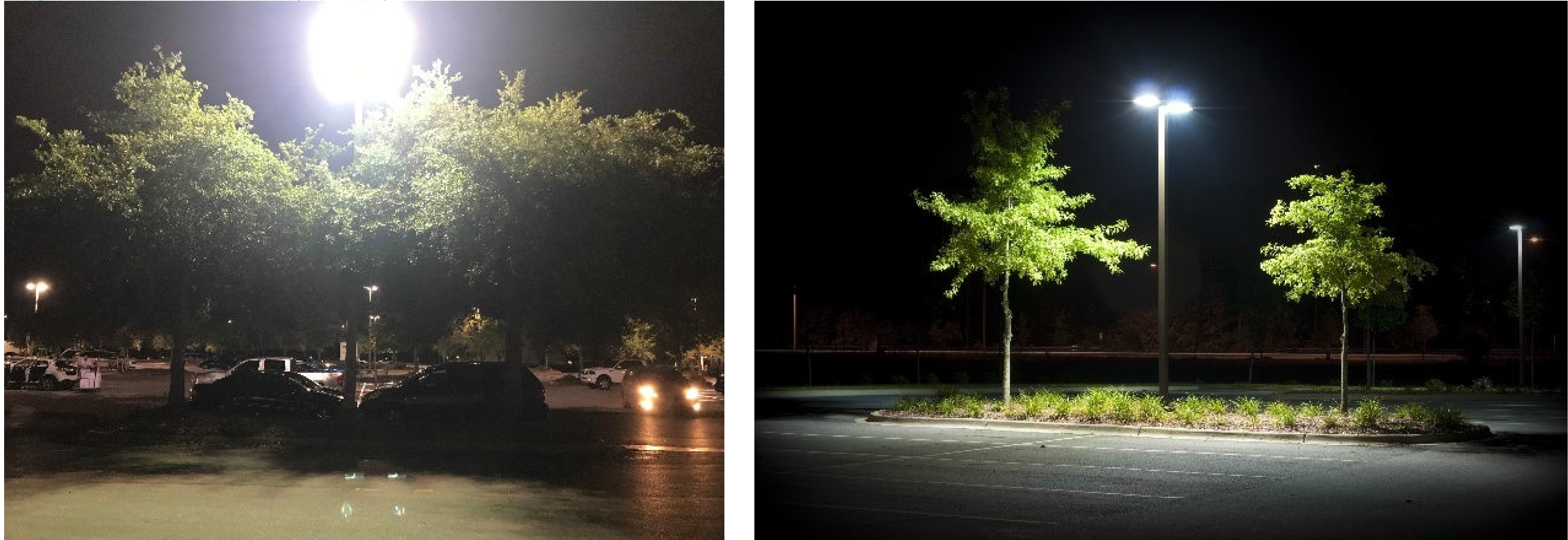
(Ord. No. O-11-2024, § 4, 4-16-2024)
Sec. 117-840. - Landscape, buffers and screening standards.
Landscaping, buffering and screening shall be provided in accordance with chapter 113, article VI (Landscaping), except for the following:
A.
Landscaping along the street and between parcels.
1.
The buildings in the form-based code area are intended to be actively engaged with the street. Therefore, the provisions of this article supersede the requirements of section 113-244(d) regarding buffers along the street.
2.
The landscape strip between parcels required by section 113-244 shall be five feet unless the site is adjacent to a single-family zoned property. In such cases, a ten-foot-wide landscaped buffer combined with a brick, stone or concrete block wall shall be required.
3.
No landscape strip shall be required between parking areas shared by adjacent parcels.
B.
Landscaping design.
1.
The use of grass shall be minimized and shall not be planted in strips less than five feet wide.
Figure XIV - 58. Planters
Adjacent to Buildings
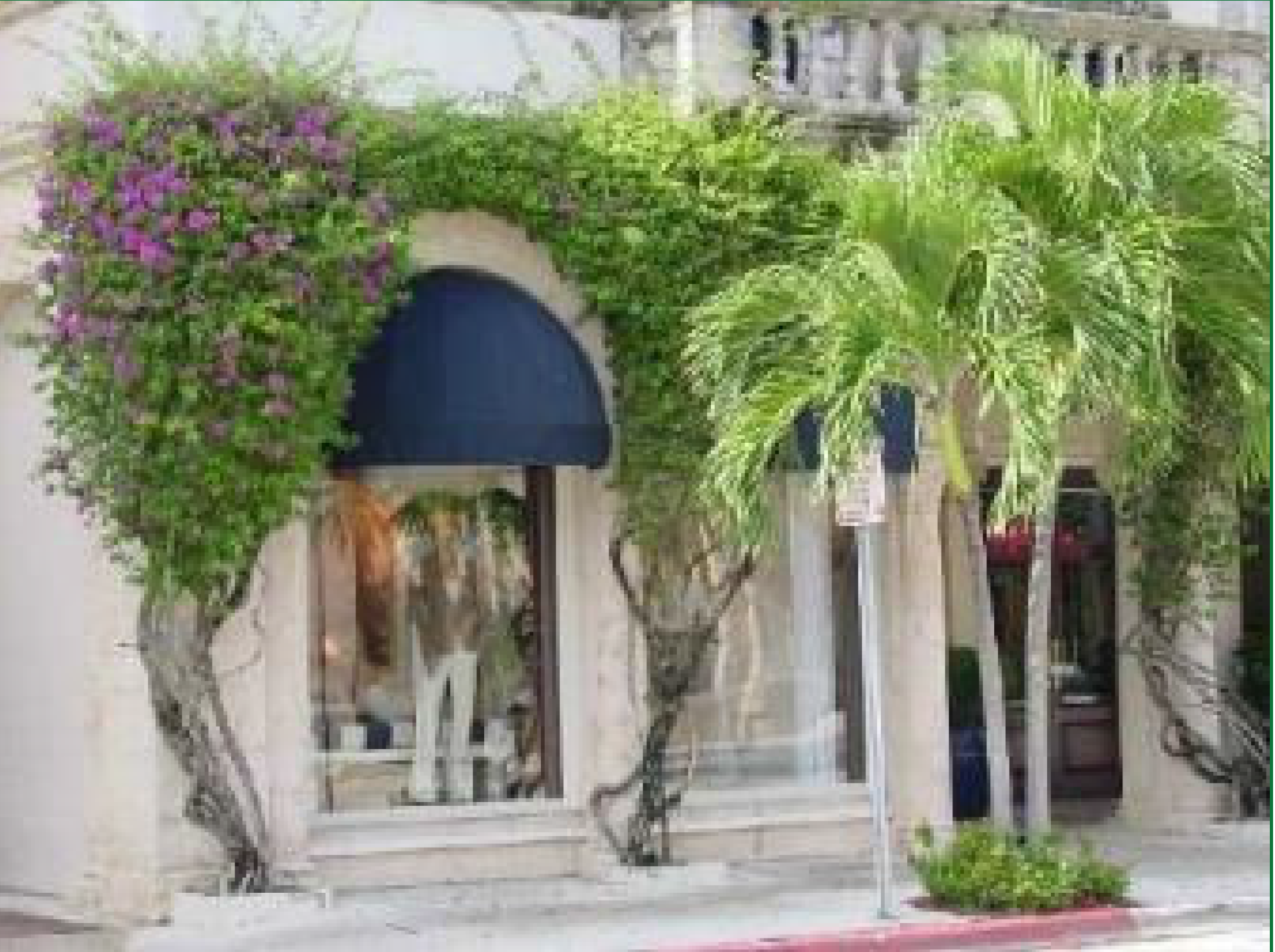
2.
The design of the landscape shall maximize the use of green infrastructure best management practices such as pervious paving, bioretention systems, rain gardens, bioswales, and stormwater planters to slow and treat stormwater runoff while providing multiple additional community benefits.
3.
For residential conversions in the Secondary Corridor and Transition Zones, the overall landscaping requirements for surface parking lots may be reduced through the modification of standards process (See section 117-832 B).
C.
Street trees. Street trees shall be provided along parkways and must comply with the following.
1.
Street trees shall be canopy trees and must be spaced every 50 feet on center.
2.
Planting pits and tree grates are typically used in mixed-use, urban areas with medium to high pedestrian traffic. Tree grates may be integrated within planting pits to protect root balls and prevent soil compaction. Grates shall be expandable for tree growth.
3.
Coordination will be required to integrate the placement of street trees, signage, and lighting to ensure that each element complements the other.
4.
Street trees along state roads (Orange Avenue and Ferris Street) shall be coordinated with FDOT.
5.
Tree species and placement shall avoid branches interfering with vehicle movements.
D.
Street walls. Freestanding street walls are intended to mask vehicular use areas (e.g., parking, drive aisles) from the street and to strengthen the spatial definition of the public realm. They are the only type of wall or fence permitted within the required front and street side yard setbacks.
1.
Street walls shall have a minimum height of two and one-half feet and a maximum height of five feet (measured from the elevation of the public sidewalk). The portion of the street wall above two and one-half feet shall be transparent (e.g., wrought iron or similar material). Street walls shall have columns/posts (one foot by one foot minimum) spaced every 24 feet (see Figure XIV - 59).
Figure XIV - 59. Street Wall Examples
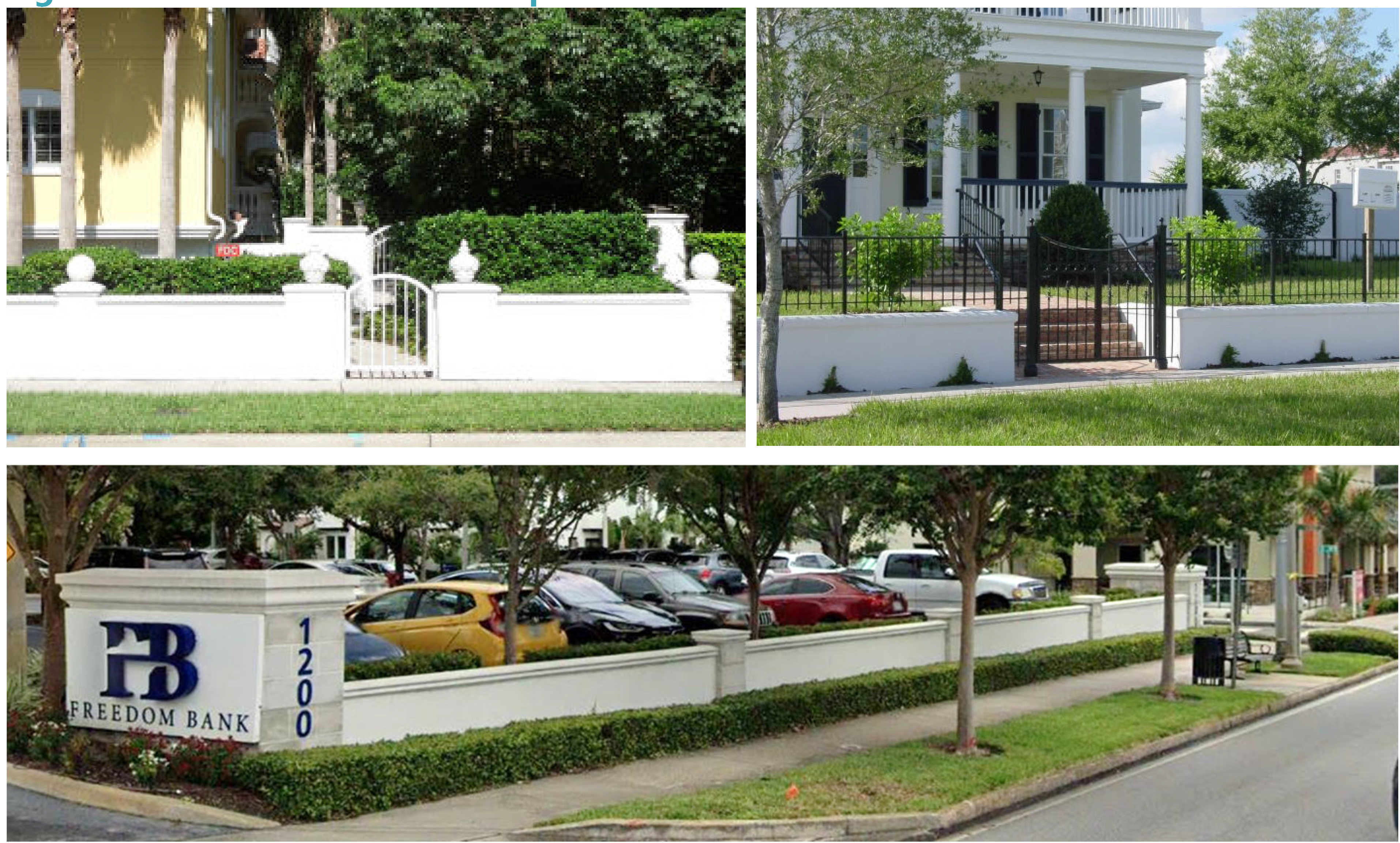
2.
Street walls shall have openings no larger than necessary to allow automobile and/or pedestrian access.
3.
Street walls shall be placed in line with the building facade facing the same street.
4.
Street walls shall not be permitted within the right-of-way.
5.
Street walls shall be constructed of wrought iron, brick, masonry, stone, powder-coated aluminum, or other decorative materials that complement the finish on the primary building. Chain link, wood and PVC street walls/fences shall be prohibited.
6.
The area in front of a street wall/fence shall include a landscaped strip with a minimum width of three feet (with ground cover, hedges, or shrubs). This landscape strip may be waived by the development services director if the area in front of the wall is needed to expand the public sidewalk (see Figure XIV - 60).
Figure XIV - 60. Street Wall Landscaping Examples

7.
The area between the street wall and on-site parking shall also include a three-foot wide landscape strip.
8.
Understory trees shall be planted in front or behind the street wall at a rate of one tree per 25 feet of wall length. The trees may be waived by the development services director if they conflict with the required or existing street trees.
(Ord. No. O-11-2024, § 4, 4-16-2024)
Sec. 117-841. - Stormwater management.
Like parking, it is difficult to comply with stormwater requirements within developed areas such as downtown. While the city can encourage applicants to use alternative methods for stormwater management, it is the regional agencies that establish the minimum regulations. An alternative to providing the required on-site stormwater facilities is a regional system. The city is considering the implementation of such a system. When the system is in place, all new development and major modifications will be required to connect to the master system. In the meantime, stormwater requirements must be met onsite or in shared facilities if approved by the approving authorities. The following standards are intended to integrate stormwater systems into the design of the site and to encourage the use of low impact development (LID) best management practices (BMP).
A.
Where site grading is necessary, it must be done sensibly to ensure that uses on the site can still interact with the public sidewalk. No site shall be elevated more than five steps above the sidewalk grade along the primary street and pedestrian access shall be provided. However, no steps, ramps, or railings shall be permitted to encroach into the public right-of-way.
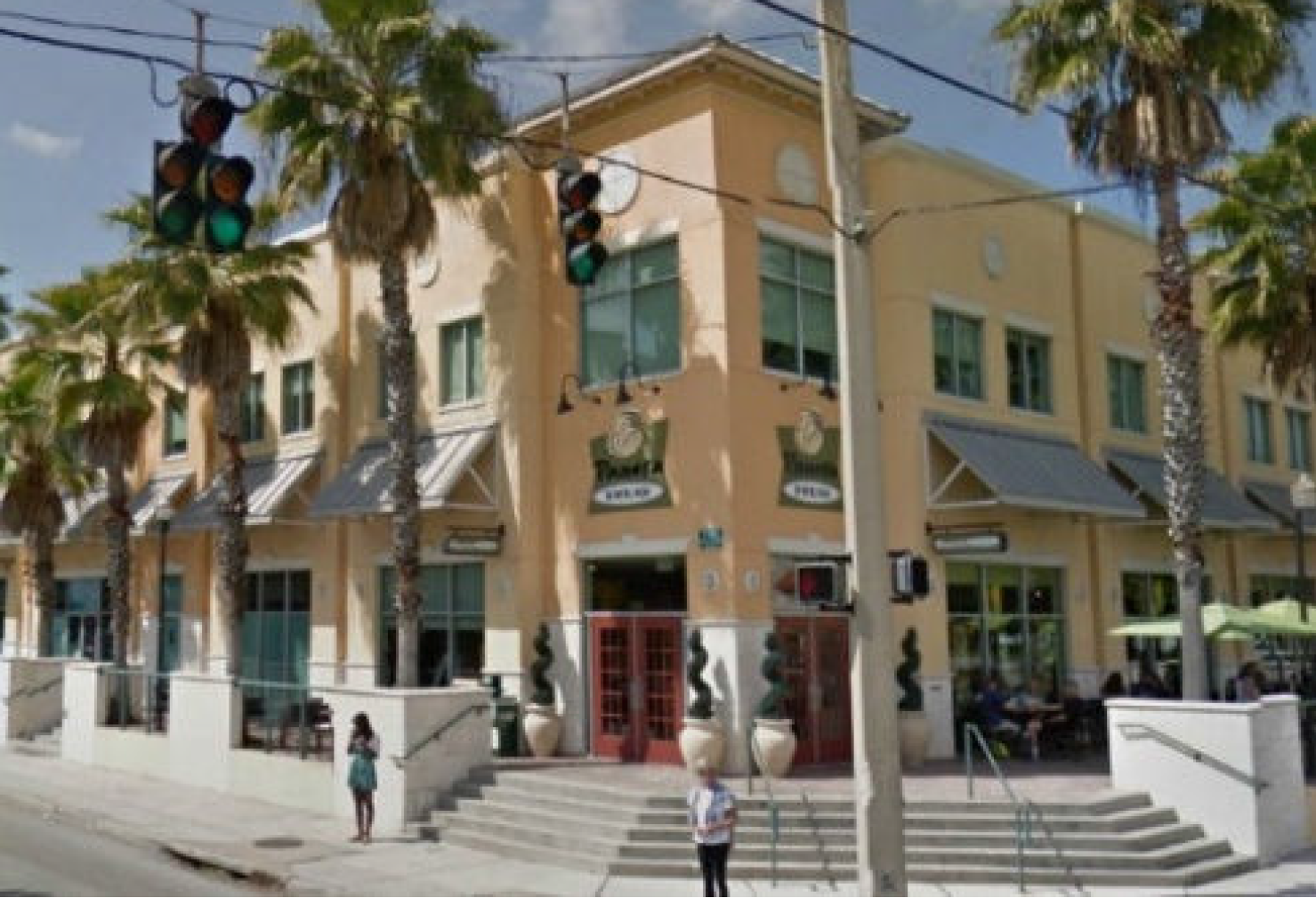
B.
Exfiltration shall be the preferred method for addressing stormwater. If traditional methods are used, the stormwater system shall be designed to function as a site amenity (e.g., giving the appearance of a stream; providing landscaping, sculptures, and/or walking trails along the edge; channeling the water through the development instead of relegating it to a hidden corner; etc.). Green roofs, rain gardens, rain cisterns, or other green or LID stormwater techniques may be considered site amenities for the purpose of this requirement.
C.
Where the St. Johns Water Management District or city regulations (see sections 117-788 C.3 and 113-223 B.12) require fencing around a stormwater facility, only ornamental metal fencing will be allowed.
D.
Green roofs shall be permitted for all building types.
E.
Bioretention systems, bioswales, tree filters, or other vegetated stormwater BMPs shall be used for treatment of stormwater runoff from streets, parking lots, plazas, and other impervious surfaces. These vegetated BMPs can include impermeable liners with underdrains to provide water quality treatment where infiltration is not technically feasible due to site contamination concerns.
F.
For new construction and major modifications, retention must be placed in the rear or side yard, not adjacent to the public right-of-way, unless it is integrated into the design and featured as a site amenity, and unless the site has multiple street frontages.
Figure XIV - 61. Alternative Stormwater Detention Facilities
G.
Pervious paving shall be permitted and is encouraged to reduce stormwater runoff volume (see section 117-839 B).
H.
Special detention areas such as parking lots, rooftops ("blue roofs"), parks, plazas, and fields are areas primarily designated for other uses but may be used for temporary infiltration and/or peak rate mitigation during storm events if the requirements herein are satisfied. Special detention areas shall be designed sensitive to land use context, public use requirements, and the following conditions:
1.
Temporary ponding storage areas must be located so that ponding will not significantly disrupt typical traffic (pedestrian/bicycle/vehicle) flow, and areas shall be adequately sloped towards outlets to ensure complete drainage after storm events.
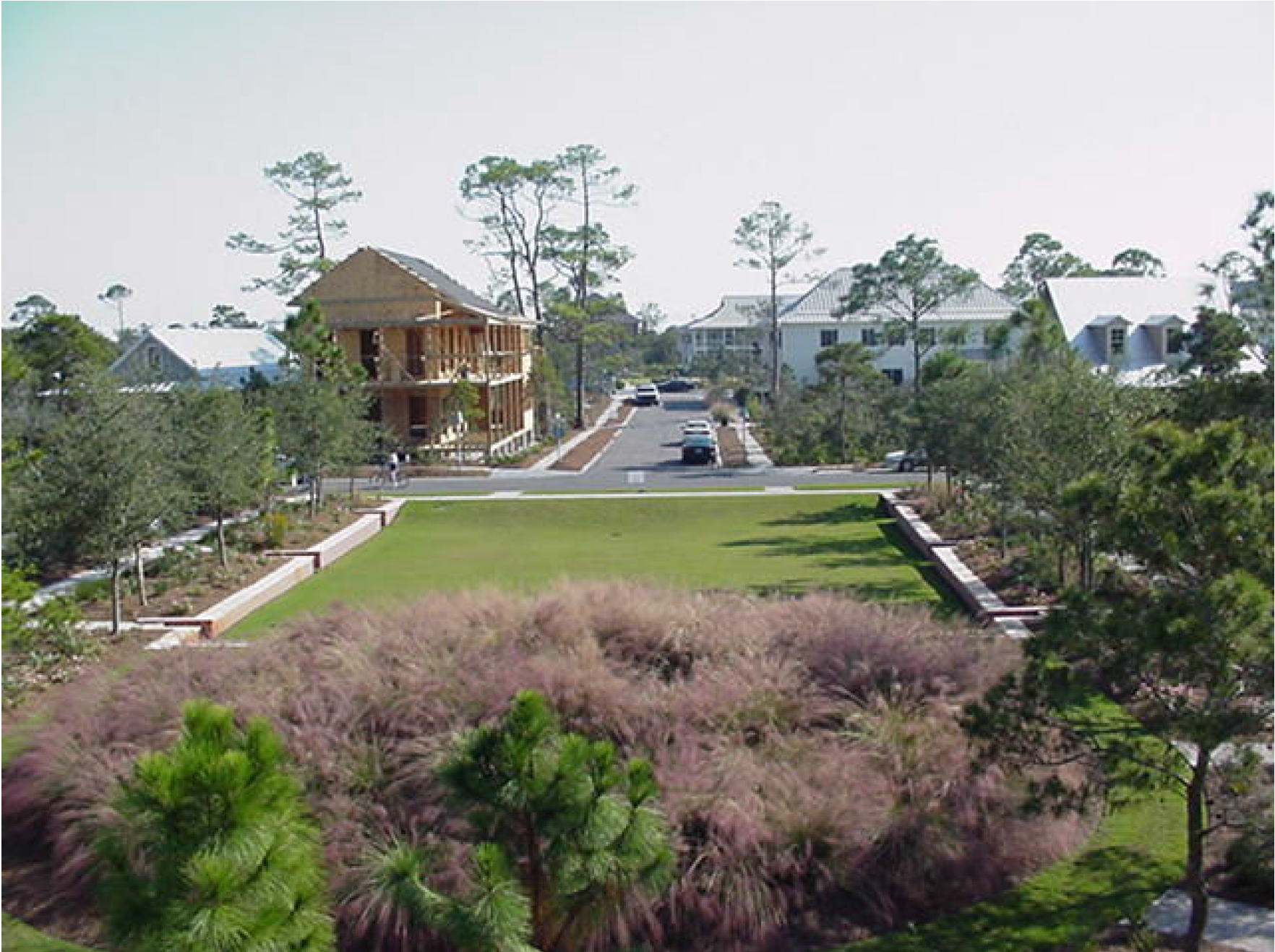
2.
Special detention areas shall be clearly identified as such and their primary use shall be restricted during storms.
3.
Emergency overflows shall be incorporated and designed to prevent excessive depths from occurring during extreme storm events or if the primary flow control structure/structures are clogged. In most cases, the depth of a pond shall not exceed 12 inches.
4.
Rooftop storage must consider structural support, HVAC requirements, waterproofing, emergency overflows, and all other building design considerations.
5.
Landscaping materials used for high-intensity public uses (e.g., community parks, athletic fields, greens, etc.) shall be located in areas of well-draining soils to guarantee public use is not compromised by excessively wet ground between rain events.
(Ord. No. O-11-2024, § 4, 4-16-2024)
Sec. 117-842. - Signs.
Development within the form-based code area shall comply with the sign standards of this section in addition to the dimensional standards contained in chapter 125 of the land development code. If any sign standards in this document disagree with the citywide sign code, the standards detailed in this document shall take precedent.
A.
Wall signs.
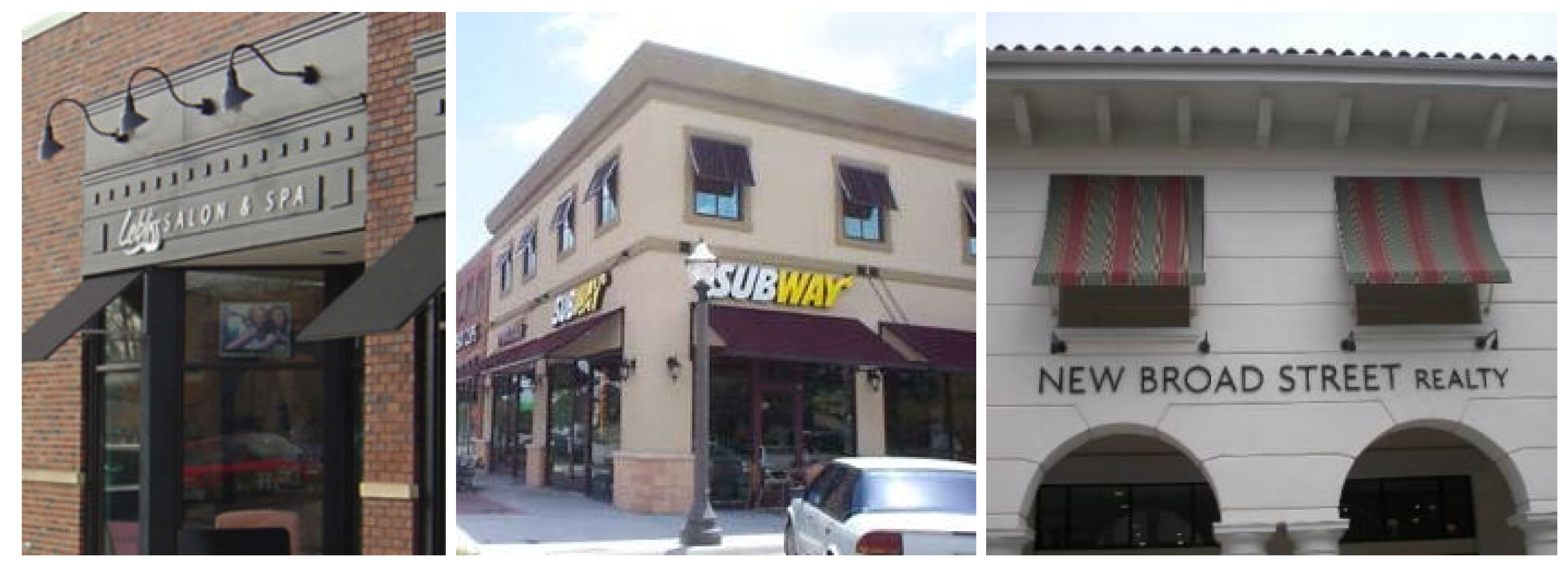
1.
Wall signs shall be either a panel or individual letters applied to the wall, shall not extend above the top of the wall where they are located, and in the case of two-story buildings, they shall be placed between the first and second floor windows. Cabinet signs and signs painted directly onto the facade are not allowed. Push through signs, however, are allowed.
2.
Wall signs shall not extend closer than two feet to the side edges of the facade.
B.
Projecting signs.
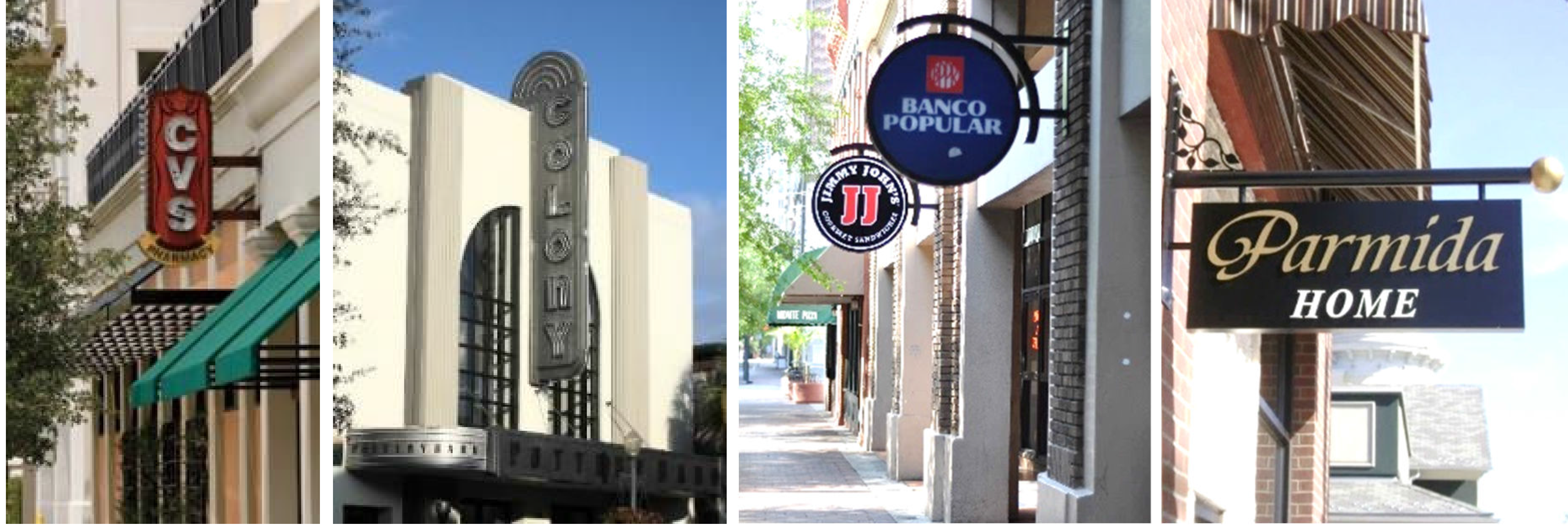
1.
Projecting signs may be read horizontally or vertically.
2.
The sign may extend into the front or street side building setback, and the sidewalk provided they are setback four feet from the curb and provide a nine-foot clearance over the sidewalk.
3.
Signs shall not obscure architectural details such as windows, cornice, decorative brickwork, and storefronts. No portion of a sign shall extend below the lowest point of the roof or above the top edge of the parapet of the building to which it is attached.
C.
Canopy signs.

1.
Canopy signs may be suspended from, attached to, supported from, or form a part of a canopy.
2.
The sign may extend into the front or street side building setback, and the sidewalk provided they are setback four feet from the curb and provide a nine-foot clearance over the sidewalk.
3.
Canopy signs shall not exceed 75 percent of the width of the canopy. They are allowed to be placed fully or partially above or below the edge of the canopy (see figure above), provided the sign consists of individual letters (as opposed to a panel). Canopy signs are also allowed to hang from the bottom of the canopy facing the street.
D.
Awning signs.
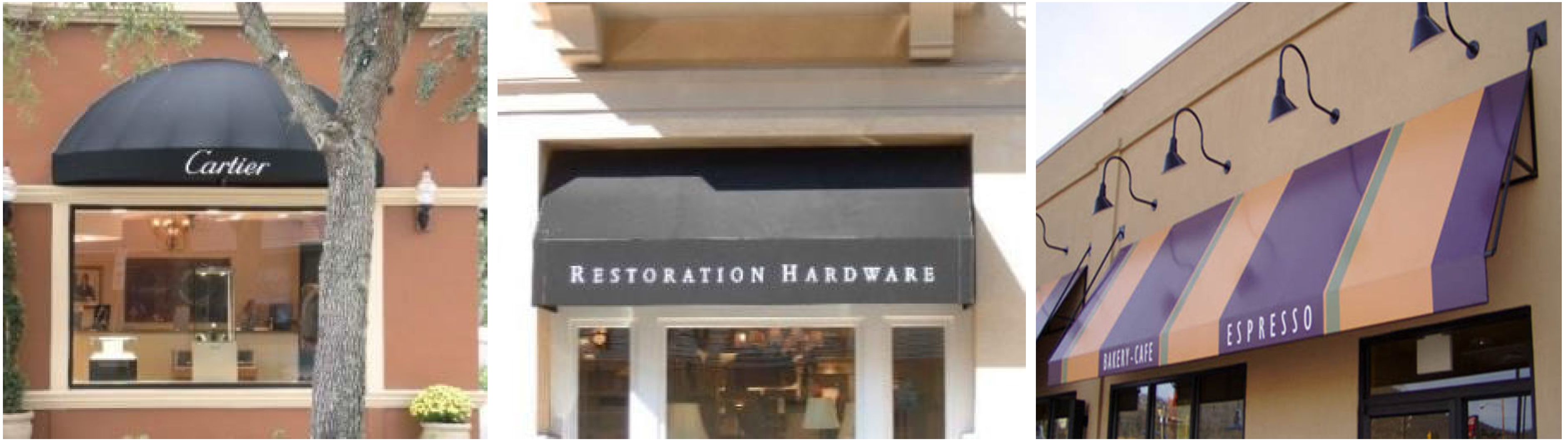
1.
Awning signs may be painted, silk-screened, stitched on, imprinted on, or otherwise applied directly onto the fabric of the awning.
2.
Awning signs may extend into the front or street side building setback, and the sidewalk provided they are setback four feet from the curb and provide a nine-foot clearance over the sidewalk.
3.
Awning signs may extend up to 75 percent of the width of the awning but shall not cover more than 30 percent of the surface of the awning facing the street.
4.
Awning signs are only allowed on the vertical portion of the awning. They are not allowed on the sloping or curved section.
E.
Hanging signs.
1.
Hanging signs placed under a canopy, awning, or arcade, perpendicular to the building facade, are not intended to be seen by motorists.
2.
Hanging signs shall provide a nine-foot clearance over the walkway.
3.
Hanging signs shall not count toward the maximum sign area allowed, provided they are placed under the awning or canopy, perpendicular to the building, and near the front door of the business. Such signs shall have an eight-foot minimum vertical clearance as measured from grade to the bottom of the sign, and a maximum height of two feet.
F.
Window signs.
1.
Window signs may be affixed to, or painted (silk screen, vinyl letters, gold leaf, hand painted or neon) on either the face of a window or glass door that leads to the exterior of the building.
2.
Window signs shall not occupy more than 25 percent of the glass window or door and may be allowed for first and second story businesses.
G.
Freestanding signs.
1.
Freestanding signs are only allowed where the building or street wall are located more than ten feet from the public sidewalk, regardless of the zone. Such signs shall meet the following standards (see Figure XIV - 62):
a.
The signs shall be consistent with the materials and colors of the building.
b.
Single or double supports are allowed.
c.
The sign shall not exceed six feet in height.
d.
The sign shall be no closer than five feet to the building.
Figure XIV - 62. Examples of Freestanding Signs
2.
Where the building and/or street wall are located within ten feet from the sidewalk, only street wall signs are allowed as follows.
a.
Street wall signs shall be placed flat on the street wall facing the street.
b.
The sign shall not exceed a maximum of 36 square feet.
c.
The sign shall not exceed a height of six feet measured from the ground (see Figure XIV - 63).
Figure XIV - 63. Street Wall Signs
H.
Additional standards.
1.
Signs shall not obscure architectural details such as windows, cornice, decorative brickwork, and storefronts. No portion of a sign shall extend below the lowest point of the roof or above the top edge of the parapet of the building to which it is attached.
2.
Signs may have interior or exterior illumination sources (see Figure XIV - 64). Signs with interior illumination are limited to individual letters or push-through lettering. There shall be no illuminated signs facing a single-family home. Existing cabinet signs that change messages shall have opaque backgrounds.
Figure XIV - 64. Permitted Sign Illumination

(Ord. No. O-11-2024, § 4, 4-16-2024)
Sec. 117-843. - Development bonuses.
The bonus program is established to encourage the location of higher density/intensity development at places where they will not have a negative impact on single-family residential sites, and to encourage the provision of amenities that would benefit the community as a whole. The density/intensity shall not exceed the maximum noted in the corresponding future land use category and the maximum building height noted in Table XIV - 4.
A.
Improvements eligible for bonuses.
1.
Vertical mixed-use. Developments that include a vertical mix of residential and commercial or office are entitled to the maximum building height allowed with the bonus. The development shall meet the definition of mixed-use (see section 101-5).
2.
Affordable housing. Developments with at least 25 percent of its residential units deemed affordable, as defined in section 105-7, are entitled to the maximum height allowed with the bonus. Such units will be subject to a land use restriction agreement with the city to ensure the units remain affordable for a period of no less than 30 years.
3.
Parking garages. If located below or above the residential, commercial or office space, the development is entitled to one additional floor for each floor of the parking garage, not to exceed the maximum allowed with the bonus. The parking garage shall meet the standards of section 117-839 C.
4.
Public open space and amenities. Developments that include a public open space (urban plaza or park) are entitled to one additional floor above the permitted base height for every 3,000 square feet of continuous public open space, not to exceed the maximum height allowed with a bonus. The urban plaza or park shall not be enclosed, shall be easily accessible by the public, include amenities (landscaping, hardscaping, and furnishing), and be privately-owned and maintained, but open to the public. The public open space shall not be located within required buffers.
Figure XIV - 65. Examples of Public Open Space
B.
Review and approval.
1.
Requests for bonuses do not require a separate application. They shall be noted on the site plan and shall be reviewed concurrently with the site plan to ensure all other requirements of the Code, including the requirements of this article, are met.
2.
Buildings utilizing the bonus system shall not be located within 100 feet from properties zoned for single-family residential use.
(Ord. No. O-11-2024, § 4, 4-16-2024)
Sec. 117-60. - Intent.
The residential low density land use, R-1 zoning category district is intended to provide for development of low density single-family detached housing areas and should be applied within the low density (zero to four units per acre) designated areas of the comprehensive plan.
(Code 2001, § 102-46; Ord. No. O-01-2000, § 3.02.02(I)(A)(1), 6-6-2000; Ord. No. O-08-2011, § 6, 12-6-2011)
Sec. 117-61. - Permitted uses.
The following are permitted uses in the residential low density land use, R-1 zoning category:
(1)
Single-family detached dwellings;
(2)
Golf courses and country clubs, with customary accessory uses;
(3)
Temporary buildings used for construction purposes, for a period not exceeding the duration of the building permit;
(4)
Customary accessory buildings and structures, including portable or temporary buildings, private garages and noncommercial greenhouses and workshops, provided they are located in the rear yard and are not closer than three feet to the rear property line, and meet the side yard requirements of the district;
(5)
Portable storage units for onsite storage meeting the requirements and conditions referenced in section 117-794.
(Code 2001, § 102-47; Ord. No. O-01-2000, § 3.02.02(I)(A)(2), 6-6-2000; Ord. No. O-08-2011, § 6, 12-6-2011)
Sec. 117-62. - Special exceptions.
The following are special exceptions in the residential low density land use, R-1 zoning category:
(1)
Home occupations.
(2)
Adult day care in compliance with requirements of the state, as per F.S. ch. 400, part V, as amended, and child care, in compliance with the requirements of the state, as per F.S. § 402.302, as amended.
(3)
Churches with their attendant education and recreational buildings and off-street parking areas.
(4)
Accessory buildings with heights in excess of 12 feet. The height of the accessory structure shall not exceed the height of the principal structure and must have architectural finishes compatible with the principal structure.
(5)
Single-family residential development on a flag lot as defined in section 101-5 and subject to the conditions set forth in section 101-60.
(Code 2001, § 102-48; Ord. No. O-01-2000, § 3.02.02(I)(A)(3), 6-6-2000; Ord. No. O-08-2011, § 6, 12-6-2011; Ord. No. O-02-2013, § 3, 2-19-2013; Ord. No. O-16-2020, § 4, 2-16-2021)
Sec. 117-63. - Density controls.
Density controls in the residential low density land use, R-1 zoning category shall be as follows:
(1)
Minimum required lot area: 7,000 square feet;
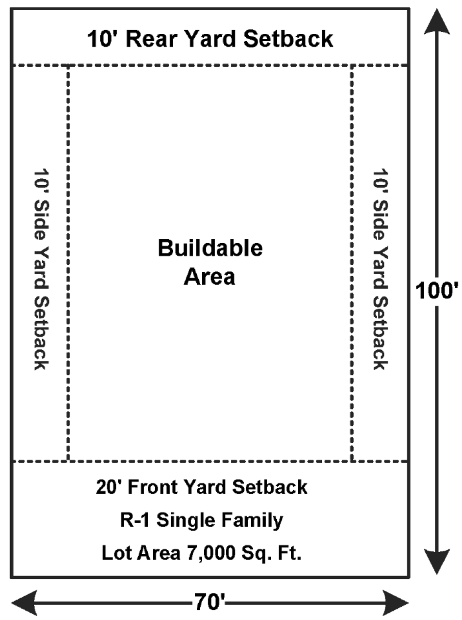
(2)
Minimum required lot width: 70 feet;
(3)
Minimum required front yard: 20 feet;
(4)
Minimum required rear yard: Ten feet;
(5)
Minimum required side yard: Ten feet;
(6)
Minimum living area: 1,250 square feet, together with an attached or detached enclosed garage of at least ten feet by 20 feet. Attached garages shall be architecturally integrated into the design of the dwelling and structurally connected;
(7)
Maximum lot coverage: 35 percent;
(8)
Maximum structure heights: 35 feet.
(Code 2001, § 102-49; Ord. No. O-01-2000, § 3.02.02(I)(A)(4), 6-6-2000; Ord. No. O-18-2004, § 1, 8-3-2004; Ord. No. O-38-2007, § 2, 12-18-2007; Ord. No. O-08-2011, § 6, 12-6-2011)
Sec. 117-70. - Intent.
The residential low density land use, R-1A zoning category district is intended to provide for development of low density single-family detached housing areas.
(Ord. No. O-21-2022, § 1, 3-7-2023)
Sec. 117-71. - Permitted uses.
The following are permitted uses in the residential low density land use, R-1A zoning category:
(1)
Single-family detached dwellings;
(2)
Golf courses and country clubs, with customary accessory uses;
(3)
Temporary buildings used for construction purposes, for a period not exceeding the duration of the building permit;
(4)
Customary accessory buildings and structures, including portable or temporary buildings, private garages and noncommercial greenhouses and workshops, provided they are located in the rear yard and are not closer than three feet to the rear property line, and meet the side yard requirements of the district;
(5)
Portable storage units for onsite storage meeting the requirements and conditions referenced in section 117-794.
(Ord. No. O-21-2022, § 1, 3-7-2023)
Sec. 117-72. - Special exceptions.
The following are special exceptions in the residential low density land use, R-1A zoning category:
(1)
Home occupations.
(2)
Adult day care in compliance with requirements of the state, as per F.S. ch. 400, part V, as amended, and child care, in compliance with the requirements of the state, as per F.S. § 402.302, as amended.
(3)
Churches with their attendant education and recreational buildings and off-street parking areas.
(4)
Accessory buildings with heights in excess of 12 feet. The height of the accessory structure shall not exceed the height of the principal structure and must have architectural finishes compatible with the principal structure.
(5)
Single-family residential development on a flag lot as defined in section 101-5 and subject to the conditions set forth in section 101-60.
(Ord. No. O-21-2022, § 1, 3-7-2023)
Sec. 117-73. - Density controls.
Density controls in the residential low density land use, R-1A zoning category shall be as follows:
(1)
Minimum required lot area: 5,000 square feet;
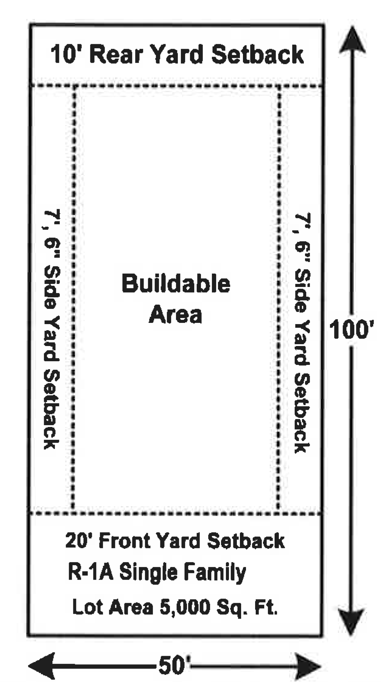
(2)
Minimum required lot width: 50 feet;
(3)
Minimum required front yard: 20 feet;
(4)
Minimum required rear yard: Ten feet;
(5)
Minimum required side yard: Seven feet, six inches;
(6)
Minimum living area: 1,250 square feet, together with an attached or detached enclosed garage of at least ten feet by 20 feet. Attached garages shall be architecturally integrated into the design of the dwelling and structurally connected;
(7)
Maximum lot coverage: 35 percent;
(8)
Maximum structure heights: 35 feet.
(Ord. No. O-21-2022, § 1, 3-7-2023)
Sec. 117-85. - Intent.
The residential medium density land use, R-2 zoning category is intended to provide for development of predominately single-family detached housing areas. Under certain conditions, attached single-family housing may be developed in this district. The residential medium density land use, R-2 zoning category is consistent with the medium density of four to eight dwelling units per acre as designated in the comprehensive plan.
(Code 2001, § 102-66; Ord. No. O-01-2000, § 3.02.02(I)(B)(1), 6-6-2000; Ord. No. O-08-2011, § 6, 12-6-2011)
Sec. 117-86. - Permitted uses.
The following are permitted uses in the residential medium density land use, R-2 zoning category: Any use permitted in the residential low density category (R-1 zoning category) meeting the density requirements of this category.
(Code 2001, § 102-67; Ord. No. O-01-2000, § 3.02.02(I)(B)(2), 6-6-2000; Ord. No. O-08-2011, § 6, 12-6-2011)
Sec. 117-87. - Special exceptions.
The following are special exceptions in the residential medium density land use, R-2 zoning category:
(1)
Special exceptions permitted in the residential low density category (R-1 zoning category).
(2)
Pre-schools.
(3)
Single-family attached dwellings, up to four units, subject to the approval of the site plan.
(4)
Single-family residential development on a flag lot as defined in section 101-5 and subject to the conditions set forth in section 101-60.
(Code 2001, § 102-68; Ord. No. O-01-2000, § 3.02.02(I)(B)(3), 6-6-2000; Ord. No. O-11-2002, § 1, 9-3-2002; Ord. No. O-12-2002, § 1(16), 9-3-2002; Ord. No. O-08-2011, § 6, 12-6-2011; Ord. No. O-16-2020, § 5, 2-16-2021)
Sec. 117-88. - Density controls.
(a)
Detached dwellings. The density controls for detached dwellings in the residential medium density land use, R-2 zoning category shall be as follows:
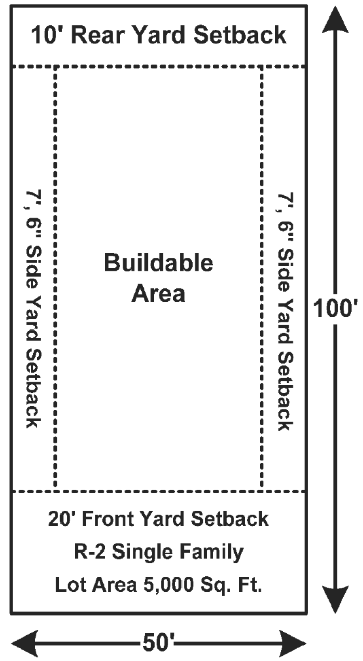
(1)
Minimum required lot area: 5,000 square feet;
(2)
Minimum required lot width: 50 feet;
(3)
Minimum required front yard: 20 feet;
(4)
Minimum required rear yard: Ten feet;
(5)
Minimum required side yard: Seven feet, six inches;
(6)
Minimum required living area: 1,000 square feet together with an attached or detached garage of at least ten feet by 20 feet. Attached garages shall be architecturally integrated into the design of the dwelling and structurally connected;
(7)
Maximum lot coverage: 35 percent;
(8)
Maximum structure height: 35 feet.
(b)
Attached dwellings. The density controls for attached dwellings in the residential medium density land use, R-2 zoning category shall be as follows:
(1)
Minimum required lot area:
a.
Two-family: 8,500 square feet;
b.
Three-family: 12,500 square feet;
c.
Four-family: 16,500 square feet;
(2)
Minimum required lot width:
a.
Two-family: 75 feet;
b.
Three-family: 100 feet;
c.
Four-family: 150 feet;
(3)
Minimum required front yard: 20 feet;
(4)
Minimum required side yard: Ten feet or ten percent of lot width, whichever is greater;
(5)
Minimum required rear yard: Ten feet;
(6)
Minimum required living area: 1,000 square feet;
(7)
Maximum lot coverage: 35 percent;
(8)
Maximum structure height: 35 feet.
(Code 2001, § 102-69; Ord. No. O-01-2000, § 3.02.02(I)(B)(4), 6-6-2000; Ord. No. O-18-2004, § 2, 8-3-2004; Ord. No. O-38-2007, § 3, 12-18-2007; Ord. No. O-08-2011, § 6, 12-6-2011)
Sec. 117-120. - Intent.
The residential high density, R-3 zoning category district is intended to provide for multiple-family housing areas with densities of eight to 12 dwelling units per acre. This district should be situated so that it is well served by public services and have direct access to collector street or major thoroughfares. Careful attention must be given to traffic generation from this district to minimize impact on single-family districts.
(Code 2001, § 102-86; Ord. No. O-01-2000, § 3.02.02(I)(C)(1), 6-6-2000; Ord. No. O-08-2011, § 6, 12-6-2011)
Sec. 117-121. - Permitted uses.
The following are permitted uses in the residential high density, R-3 zoning category:
(1)
Any use permitted in the residential medium density category (R-2 zoning category) meeting the density requirements;
(2)
Two-family dwellings;
(3)
Multiple-family residential structures, including apartments, cooperatives and condominiums having no commercial businesses connected therewith.
(Code 2001, § 102-87; Ord. No. O-01-2000, § 3.02.02(I)(C)(2), 6-6-2000; Ord. No. O-08-2011, § 6, 12-6-2011)
Sec. 117-122. - Special exceptions
The following are special exceptions in the residential medium density land use, R-3 zoning category:
(1)
Special exceptions permitted in the residential medium density category, R-2 zoning;
(2)
Off-street parking lots;
(3)
Nursing homes and convalescence facilities;
(4)
Mobile home parks or subdivisions, provided:
a.
Piers with adequate foundations shall be located a minimum often feet on center under the chassis of each unit;
b.
Organic material shall be removed from under each unit;
c.
Appropriate skirting shall be used around all coaches;
d.
A minimum of three tie-downs shall be provided for each unit with adequate anchoring, however, all tie-downs shall be provided on the unit shall be anchored;
e.
Each street shall be paved surface of a minimum of 22 feet in width curb-to-curb;
f.
Engineering design of all construction shall be approved by the city public works director;
g.
Individual laundry facilities shall be located within the main unit or within an approved utility structure;
h.
All utilities shall be provided underground;
i.
For a mobile or modular home subdivision, the design standard set forth in the city's subdivision regulations shall apply;
j.
The park or subdivision complies with all state and federal laws.
(5)
Group care homes.
(6)
Multifamily dwelling units without garages.
(7)
Single-family residential development on a flag lot as defined in section 101-5 and subject to the conditions set forth in section 101-60.
(Code 2001, § 102-88; Ord. No. O-01-2000, § 3.02.02(I)(C)(3), 6-6-2000; Ord. No. O-08-2011, § 6, 12-6-2011; Ord. No. O-06-2016, § 3, 6-7-2016; Ord. No. O-15-2020, § 3, 1-5-2021; Ord. No. O-16-2020, § 6, 2-16-2021)
Sec. 117-123. - Density controls.
Density controls in the residential high density, R-3 zoning category shall be as follows:
(1)
For single-family dwellings in the residential medium density, R-2 zoning category:
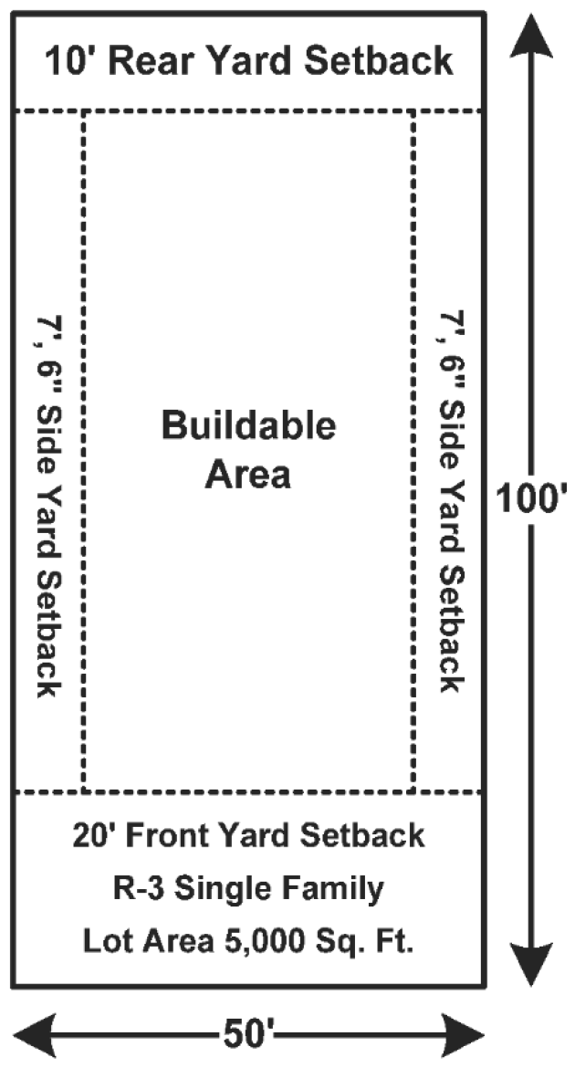
a.
Minimum required lot area: 5,000 square feet;
b.
Minimum required lot width: 50 feet;
c.
Minimum required front yard: 20 feet;
d.
Minimum required rear yard: Ten feet;
e.
Minimum required side yard: Seven feet, six inches;
f.
Minimum required living area: 1,000 square feet together with an attached or detached garage of at least ten feet by 20 feet. Attached garages shall be architecturally integrated into the design of the dwelling and structurally connected;
g.
Maximum lot coverage: 35 percent;
h.
Maximum structure height: 35 feet.
(2)
For two-family dwellings:
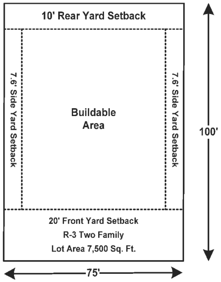
a.
Minimum required lot area: 7,500 square feet;
b.
Minimum required lot width: 70 feet;
c.
Minimum required front yard: 20 feet;
d.
Minimum required rear yard: Ten feet;
e.
Minimum required side yard: Seven feet, six inches; or ten percent of the lot width, whichever is greater;
f.
Minimum required living area: 700 square feet per family;
g.
Maximum lot coverage: 35 percent;
h.
Maximum structure height: 35 feet.
(3)
For multiple-family dwellings:
a.
Minimum required lot area: 7,500 square feet for the first two dwelling units and 2,700 square feet for each additional unit that is added;
b.
Minimum required lot width: 100 feet;
c.
Minimum required front yard: 30 feet;
d.
Minimum required rear yard: 20 feet for the first two stories. For each story in excess of two, the required rear yards shall be increased by five feet for each story so added;
e.
Minimum required side yard on each side of the structure: Not less than ten feet for the first two stories. For each story in excess of two, the required side yards shall be increased by five feet for each story so added;
f.
Minimum required living areas:
1.
Efficiency apartment: 800 square feet;
2.
One bedroom apartment: 800 square feet;
3.
Two bedroom apartment: 900 square feet;
4.
Three or more bedroom apartment: 900 square feet plus an additional 100 square feet for each bedroom over two bedrooms;
g.
Maximum lot coverage: 40 percent;
h.
Maximum structure height: 35 feet.
(4)
For mobile home parks and mobile home subdivisions:
a.
Minimum site area: Ten acres;
b.
Maximum gross density: Six units per acre;
c.
Minimum required site width: 100 feet on a public street;
d.
Minimum yard requirements: Front, 15 feet; side, 7.5 feet; rear, ten feet;
e.
Maximum site coverage: 40 percent;
f.
Maximum structure height: 35 feet.
(5)
All residential dwelling units shall have an attached or detached garage of at least ten feet by 20 feet. Attached garages shall be architecturally integrated into the design of the dwelling and structurally connected.
(Code 2001, § 102-89; Ord. No. O-01-2000, § 3.02.02(I)(C)(4), 6-6-2000; Ord. No. O-06-2007, § 1, 5-1-2007; Ord. No. O-38-2007, § 4, 12-18-2007; Ord. No. O-08-2011, § 6, 12-6-2011; Ord. No. O-15-2020, § 3, 1-5-2021)
Sec. 117-145. - Intent.
The residential riverfront land use category is intended to provide for multiple-family housing areas with densities of 12 to 20 dwelling units per acre. The development must have a minimum of ten acres and be located on the St. Johns River. It should be situated so that it is well served by public services and have direct access to a collector street or major thoroughfares. Careful attention must be given to traffic generation from this district to minimize impact on single-family districts.
(Code 2001, § 102-90; Ord. No. O-03-2013, § 2, 2-19-2013)
Sec. 117-146. - Permitted uses.
The following are permitted uses in the residential riverfront, RRF land use category:
(1)
Single-family attached and detached dwelling units;
(2)
Duplexes;
(3)
Multifamily dwelling units with or without garages;
(4)
Churches.
(Code 2001, § 102-91; Ord. No. O-03-2013, § 2, 2-19-2013; Ord. No. O-06-2016, § 4, 6-7-2016)
Sec. 117-147. - Accessory uses.
(a)
Commercial uses.
(1)
Permitted uses within the C-1 Zoning District;
(2)
Restaurants without drive through facilities.
(b)
Commercial use(s) shall be a part of a planned development in which not more than 15 percent of the gross floor area of the residential units (both single-family and multifamily) is devoted to a commercial use which is not otherwise permitted in the underlying use zone. For example, if 100-unit development contained homes that each had a gross floor area of 2,000 square feet, a commercial use that was no larger than 30,000 square feet could be permitted. In measuring the square footage of the commercial use all features such as setbacks, access, parking, drainage, and landscaping shall be included.
(c)
The commercial use areas shall be supportive of and/or complementary to the other uses within the planned unit development and scaled to meet the needs primarily of the residents of the project.
(d)
Building permits for commercial uses may be issued at the percentage of gross floor area of residential units that have received their certificate of occupancy as set forth in section 117-147(b).
(Ord. No. O-11-2021, 6-15-2021)
Editor's note— Ord. No. O-11-2021, adopted June 15, 2021, renumbered the former § 117-147 as § 117-148 and created a new § 117-147, as set out herein.
Sec. 117-148. - Development criteria.
Any development in the RRF land use category must meet the following development criteria.
(1)
Minimum acreage: Ten acres.
(2)
Maximum density: 20 units per acre.
(3)
Location: A portion of the parcel boundary must be on the St. Johns River.
(Ord. No. O-03-2013, § 2, 2-19-2013; Ord. No. O-11-2021, 6-15-2021)
Editor's note— Ord. No. O-11-2021, adopted June 15, 2021, renumbered the former § 117-148 as § 117-149.
Sec. 117-149. - PUD (planned unit development) required.
A PUD rezoning, in compliance with section 117-421, is required in order to develop each RRF parcel.
(Code 2001, § 102-92; Ord. No. O-03-2013, § 2, 2-19-2013; Ord. No. O-11-2021, 6-15-2021)
Editor's note— See editor's note at § 117-148.
Sec. 117-197. - Intent.
The residential professional offices land use (RPO), residential professional offices (RPO) zoning category district is intended to provide for professional offices of low intensity and design criteria which permits their location in close proximity to single-family districts. This district can serve as a transition district between low or medium density residential development and more intensive commercial development.
(Code 2001, § 102-126; Ord. No. O-01-2000, § 3.02.02(II)(A), 6-6-2000; Ord. No. O-08-2011, § 6, 12-6-2011)
Sec. 117-198. - Permitted uses.
The following are permitted uses in the residential professional offices land use (RPO), residential professional offices (RPO) zoning category:
(1)
Single-family detached and attached dwellings;
(2)
Home occupations;
(3)
Professional offices.
(Code 2001, § 102-127; Ord. No. O-01-2000, § 3.02.02(II)(A)(1), 6-6-2000; Ord. No. O-08-2011, § 6, 12-6-2011)
Sec. 117-199. - Conditions limiting permitted uses.
All of the permitted uses in the RPO district are limited by the following conditions:
(1)
No retail sales, display or storage of merchandise shall be permitted;
(2)
No vehicles other than passenger automobiles or trucks of not more than three-fourths-ton capacity shall be used;
(3)
No manufacture, repair or work of a mechanical nature of any kind shall be permitted and no machinery shall be used other than normal office equipment, such as, but not necessarily limited to, medical, dental and like equipment, including typewriters, calculators, computers, bookkeeping machines, etc.
(Code 2001, § 102-128; Ord. No. O-01-2000, § 3.02.02(II)(A)(2), 6-6-2000; Ord. No. O-08-2011, § 6, 12-6-2011)
Sec. 117-200. - Special exceptions.
Special exceptions in the residential professional office land use (RPO), residential professional offices (RPO) zoning category shall be those special exceptions permitted in the residential low density (R-1 zoning category) and residential medium density (R-2) zoning category districts and the following:
(1)
Clubs lodges and fraternal organizations;
(2)
Medical, dental clinics and hospitals;
(3)
Medical or dental laboratories; manufacture of prosthetic appliances, dentures, eyeglasses, hearing aids and similar products, including mercantile operations directly serving the facilities;
(4)
Adult day care in compliance with requirements of the state, as per F.S. ch. 400, part V, as amended, and child care, in compliance with the requirements of the state, as per F.S. § 402.302, as amended;
(5)
Churches;
(6)
Schools, colleges and universities;
(7)
Commercial production and service activities, such as:
a.
Retail outlets for the sale of food and drugs, leather goods and luggage, jewelry (including watch repair, but not pawn shops), art, cameras or photographic supplies (including camera repair), sporting goods, hobby shops and pet shops (but not animal kennels), musical instruments, television and radio (including repair incidental to sales), florist or gift shops, delicatessens, bake shops (but not wholesale bakeries), drugs and similar products, including medical marijuana treatment center dispensing facilities, and dry cleaning pickup stations, all not to exceed 25 percent of the gross floor area of which it is a part. The uses in this subsection are subject to the following limitations:
1.
Sale, display, preparation and storage shall be conducted within a completely enclosed building.
2.
No more than 2,500 square feet shall be used for the uses in subsection (7)a of this section.
3.
Products shall be sold only at retail.
4.
No sale, display or storage of secondhand merchandise shall be permitted.
b.
Restaurants, subject to the following conditions:
1.
Seating shall not exceed a capacity of 40; provided that seating may be unlimited where total floor area of the restaurant does not exceed ten percent of the total floor area of the building of which it is a part.
2.
Food is ordered from a menu and prepared and served on-premises only.
(Code 2001, § 102-129; Ord. No. O-01-2000, § 3.02.02(II)(A)(3), 6-6-2000; Ord. No. O-08-2011, § 6, 12-6-2011; Ord. No. O-03-2018, § 4, 5-15-2018)
Sec. 117-201. - Density controls.
Density controls in the residential professional offices land use (RPO), residential professional offices (RPO) zoning category shall be as follows:
(1)
Detached dwellings: As required in R-2 zoning category;
(2)
Attached dwellings: As required in R-2 zoning category;
(3)
Other permitted uses:
a.
Minimum required lot area: 6,000 square feet;
b.
Minimum required lot width: 50 feet;
c.
Minimum required front yard: 20 feet;
d.
Minimum required rear yard: Ten feet;
e.
Minimum required side yard: 7½ feet, or ten percent of the lot width, whichever is greater;
f.
Maximum floor area ratio: 0.2;
g.
Maximum structure height: 35 feet.
(4)
All residential dwelling units shall have an attached or detached garage of at least ten feet by 20 feet. Attached garages shall be architecturally integrated into the design of the dwelling and structurally connected.
(Code 2001, § 102-130; Ord. No. O-01-2000, § 3.02.02(II)(A)(4), 6-6-2000; Ord. No. O-38-2007, § 5, 12-18-2007; Ord. No. O-08-2011, § 6, 12-6-2011)
Sec. 117-226. - Intent.
The commercial medium intensity land use (CMI), C-1 neighborhood commercial zoning category district is intended to apply to commercial or service areas where small groups of selected establishments may be appropriately located to serve, within convenient travel distances, one of several neighborhoods. The district is not intended for use by heavy commercial or service establishments such as service stations, hotels, etc. The commercial establishments are limited to the following requirements:
(1)
Sale, display preparation and storage to be conducted within a completely enclosed building, and no more than 20 percent of floor space to be devoted to storage.
(2)
Products to be sold only at retail.
(Code 2001, § 102-146; Ord. No. O-01-2000, § 3.02.02(II)(B)(1), 6-6-2000; Ord. No. O-04-2005, § 1, 1-4-2005; Ord. No. O-08-2011, § 6, 12-6-2011)
Sec. 117-227. - Permitted uses.
The following are permitted uses in the commercial medium intensity land use (CMI), C-1 neighborhood commercial zoning category:
(1)
Any use permitted in the RPO, residential professional office category.
(2)
Retail and repair establishments limited to the following: antique shops, art supplies, barbershops and beauty shops, book and stationery shops, cameras and photographic supplies, cigar or smoke shops, clock shops, convenience stores (not including gas pumps), drapery shops, financial institutions without drive-through facilities, florist shops, funeral homes, gift shops, gun sales and repair, hobby and craft shops, interior decorating, jewelry stores, leather shops, locksmiths, luggage shops, office and/or business machines, office and/or business supplies, newsstands, opticians, paint and wallpaper stores, professional offices, shoe repair stores, tailor and/or dressmaker shops, watch repair.
(Code 2001, § 102-147; Ord. No. O-01-2000, § 3.02.02(II)(B)(2), 6-6-2000; Ord. No. O-08-2011, § 6, 12-6-2011)
Sec. 117-228. - Special exceptions.
The following are special exceptions in the commercial medium intensity land use (CMI), C-1 neighborhood commercial zoning category:
(1)
Adult day care in compliance with requirements of the state, as per F.S. ch. 400, part V, as amended, and child care, in compliance with the requirements of the state, as per F.S. § 402.302, as amended;
(2)
Convenience retail stores, with gas pumps;
(3)
Establishment of facilities for the retail sale of beer and wine off-premises;
(4)
Wholesaling from sample stocks only, provided no manufacturing or storage for distribution is permitted on-premises;
(5)
Hospitals;
(6)
Restaurants without drive-through facilities;
(7)
Retail outlets for the sale of food, drugs, including medical marijuana treatment center dispensing facilities, sundries and notions;
(8)
Residential dwelling units meeting the criteria of the R-2 zoning category;
(9)
Churches;
(10)
Automotive service establishments:
a.
Retail and service establishments for automotive service and repair and automobile parts store.
b.
The uses (excluding automobile sales) in this section are subject to the following limitations:
1.
Sale, repair (excluding automobile sales), service, and storage shall be conducted within a completely enclosed building.
2.
The building footprint used for the uses in this section shall not be larger than 2,500 square feet.
3.
A lot size of no more than 21,000 square feet shall be used for the uses in this section.
4.
The outdoor storage area is limited to 20 percent of the lot size, but no more than 40 percent of the building footprint of the principal structure.
5.
The outdoor storage area must be located in a fenced area with a visual barrier of not less than 85 percent opacity.
(Code 2001, § 102-148; Ord. No. O-01-2000, § 3.02.02(II)(B)(3), 6-6-2000; Ord. No. O-04-2005, § 2, 1-4-2005; Ord. No. O-08-2011, § 6, 12-6-2011; Ord. No. O-03-2018, § 4, 5-15-2018)
Sec. 117-229. - Density controls.
Density controls in the commercial medium intensity land use (CMI), C-1 neighborhood commercial zoning category shall be as follows:
(1)
Minimum required lot area: None;
(2)
Minimum required lot width: None;
(3)
Minimum required front yard: 25 feet;
(4)
Minimum required rear yard: Ten feet; if abutting a dedicated alley, only five feet are required;
(5)
Minimum required side yard: None, except 15 feet on corner lots and 15 feet on interior lots when abutting a residential zone;
(6)
Maximum floor area ratio (FAR): 0.25;
(7)
Maximum structure height: 35 feet.
(Code 2001, § 102-149; Ord. No. O-01-2000, § 3.02.02(II)(B)(4), 6-6-2000; Ord. No. O-10-2004, § 1, 5-18-2004; Ord. No. O-08-2011, § 6, 12-6-2011)
Sec. 117-252. - Intent.
The commercial high intensity (CHI), C-2 general commercial zoning category district is intended for intensive commercial uses which generally require a conspicuous and accessible location convenient to streets carrying large volumes of traffic.
(Code 2001, § 102-166; Ord. No. O-01-2000, § 3.02.02(II)(C)(1), 6-6-2000; Ord. No. O-08-2011, § 6, 12-6-2011)
Sec. 117-253. - Permitted uses.
The following are permitted uses in the commercial high intensive (CHI), C-2 general commercial zoning category:
(1)
Any use permitted in the C-1 district.
(2)
The following retail and service establishments and any determined similarly like or type uses not specifically described below: appliance and automobile sales, service, repair and rentals, automobile parts store, bait and tackle shops, bakeries, bicycle sales and service, billiards, boat and motor sales and service, bowling alleys, building supplies and materials, cabinet shops, carpet outlets, ceramic sales and studios, clothing shops, convenience stores with and without gas pumps, curio shops, dance, music, gymnastic studios, decorating studios and shops, department stores, drug sales including medical marijuana treatment center dispensing facilities, dry cleaners, electrical shops, financial institutions (including drive-through facilities), fruit and vegetable sales (retail, no packing), furniture stores, game rooms, grocery store, hardware stores, health spas, licensed masseurs, heating and air conditioning sales and service, hotels, motels, janitorial supplies, laundries and laundromats, meat markets, medical supplies, mobile home sales and service, motorcycle sales and service, nurseries, optical shops, pawn shops, pet shops, pet grooming, pool supplies, printing shops, rentals, restaurants, shoe stores, shopping centers, skating rinks, sporting goods stores, sundries and notions shops, television and radio sales and service, television and radio studios (excluding transmission equipment), theaters, tire sales and service, toy stores, upholstery shops, utility building sales, veterinarian clinics (within enclosed building), wearing apparel shops, well drilling and pump services;
(3)
Parking lots and commercial parking garages.
(4)
Outdoor sales of swimming pools, spas and hot tubs shall be a permitted use subject to the requirements of section 117-797.
(Code 2001, § 102-167; Ord. No. O-01-2000, § 3.02.02(II)(C)(2), 6-6-2000; Ord. No. O-08-2011, § 6, 12-6-2011; Ord. No. O-03-2018, § 4, 5-15-2018; Ord. No. O-23-2022, § 1-17-2023; Ord. No. O-10-2023, § 2, 3-21-2023)
Sec. 117-254. - Special exceptions.
The following are special exceptions in the commercial high intensive (CHI), C-2 general commercial zoning category:
(1)
Establishments or facilities for the retail sale and service of all alcoholic beverages for on-premises consumption;
(2)
Adult day care in compliance with requirements of the state, as per F.S. ch. 400, part V, as amended, and child care, in compliance with the requirements of the state, as per F.S. § 402.302, as amended;
(3)
Churches, with their attendant education and recreational buildings and off-street parking areas;
(4)
Hospital, sanitarium, nursing home, and similar uses;
(5)
Wholesale, warehouse or storage uses, to include mini-warehouse;
(6)
Building trades contractor with outside storage yard and heavy construction equipment;
(7)
Boatyards;
(8)
Light manufacturing, processing (including food processing but not slaughterhouse), packaging or fabricating;
(9)
Bulk storage yards, not including bulk storage of flammable liquids;
(10)
Race tracks for animals or vehicles;
(11)
Go-cart tracks and athletic complexes;
(12)
Bus passages, parcel pick-ups and terminals;
(13)
Fabricators (plumbing, electrical, mechanical and sheet metal);
(14)
Welding shops;
(15)
Residences connected to a business use permitted in this district, provided the dwelling has an attached or detached garage of at least ten feet by 20 feet;
(16)
Adult arcade amusement centers or electronic game promotion centers;
(17)
Palmist and psychic businesses.
(Code 2001, § 102-168; Ord. No. O-01-2000, § 3.02.02(II)(C)(3), 6-6-2000; Ord. No. O-38-2007, § 6, 12-18-2007; Ord. No. O-08-2011, § 6, 12-6-2011; Ord. No. O-02-2012, § 2, 4-3-2012; Ord. No. O-11-2013, § 2, 8-6-2013)
Sec. 117-255. - Density controls.
Density controls in the commercial high intensive (CHI), C-2 general commercial zoning category shall be as follows:
(1)
Minimum required lot area: None;
(2)
Minimum required lot width: None;
(3)
Minimum required front yard: 25 feet;
(4)
Minimum required rear yard: Ten feet; if abutting a dedicated alley, only five feet are required;
(5)
Minimum required side yard: None, except 15 feet on corner lots and 15 feet on interior lots when abutting a residential zone;
(6)
Maximum floor area ratio (FAR): 0.35;
(7)
Maximum structure height: 35 feet.
(Code 2001, § 102-169; Ord. No. O-01-2000, § 3.02.02(II)(C)(4), 6-6-2000; Ord. No. O-08-2011, § 6, 12-6-2011)
Sec. 117-274. - Intent.
The industrial (IND) land use category district is intended for light manufacturing, processing, storage and warehousing, wholesaling and distribution. Service and commercial activities relating to the character of the district are permitted. Location of this district must consider the provision of adequate public services, such as water, sewer, fire protection and availability to major highways, waterways and railroads. There are two zoning categories: M-1 light industrial, and M-2 heavy industrial.
(Code 2001, § 102-191; Ord. No. O-01-2000, § 3.02.02(III), 6-6-2000; Ord. No. O-08-2011, § 6, 12-6-2011)
Sec. 117-297. - Permitted uses.
The following are permitted uses in the M-1 light industrial district:
(1)
Wholesaling, warehousing, mini-warehousing, storage or distribution establishments and similar uses;
(2)
Light manufacturing, processing (includes food processing), packaging or fabricating;
(3)
Printing, lithographing, publishing or similar establishments;
(4)
Bulk storage yards, including bulk storage of flammable liquids and acids;
(5)
Outdoor storage yards and lots; provided such outdoor storage yard shall not be located closer than 25 feet to any public street and that such yard shall be completely enclosed by a solid fence or chain-link fence not less than eight feet high with an opacity of at least 85 percent, except for entrance and exit, and such openings shall be equipped with eight-foot high visual barrier gates; and provided, further, that this provision shall not permit wrecking yards (including automobile wrecking yards), junkyards or yards used in whole or in part for scrap or salvage operations or for processing, storage, display or sales of any scrap, salvage or secondhand building materials, junk automotive vehicles, or secondhand automotive parts;
(6)
Vocational, technical, trade or industrial schools and similar uses;
(7)
Clinics, in connection with industrial activity;
(8)
Miscellaneous uses, such as express office, telephone exchange, commercial parking lots and parking garages, motor bus or truck or other transportation terminal;
(9)
Radio or television broadcasting offices, studios, transmitters or antennas;
(10)
Railroad rights-of way, sidings, yards, etc.;
(11)
Pest control service establishments;
(12)
Research, experimental testing laboratories;
(13)
Offices.
(Code 2001, § 102-211; Ord. No. O-01-2000, § 3.02.02(III), 6-6-2000; Ord. No. O-08-2011, § 6, 12-6-2011)
Sec. 117-298. - Density controls.
Density controls in the M-1 light industrial district shall be as follows:
(1)
Minimum required lot area: None;
(2)
Minimum required lot width: 100 feet;
(3)
Minimum required front yard: 25 feet;
(4)
Minimum required rear yard: 20 feet;
(5)
Minimum required side yard: 15 feet;
(6)
Maximum floor area ratio (FAR): 0.60;
(7)
Maximum structure height (buildings): 55 feet;
(8)
Maximum accessory height (towers only): 85 feet.
(Code 2001, § 102-212; Ord. No. O-01-2000, § 3.02.02(III), 6-6-2000; Ord. No. O-06-2004, § 1, 4-7-2004; Ord. No. O-08-2011, § 6, 12-6-2011)
Sec. 117-330. - Intent.
The M-2 industrial district is intended to be for an industrial park. A variety of industrial and supported uses are allowed.
(Code 2001, § 102-231; Ord. No. O-01-2000, § 3.02.02(III), 6-6-2000; Ord. No. O-08-2011, § 6, 12-6-2011)
Sec. 117-331. - Permitted uses.
The following are permitted uses in the M-2 industrial district:
(1)
Any permitted uses in the M-1 zoning district;
(2)
Business and professional offices;
(3)
Storage and distribution facilities;
(4)
Packaging facilities;
(5)
Trucking facilities;
(6)
Material storage;
(7)
Storage trailers for sale or rental;
(8)
Food processing, storage and distribution;
(9)
Aviation and related facilities, storage and production;
(10)
Boat and ship manufacturing, distributions, sales and storage;
(11)
Manufacturing, sales and distribution of concrete products, plastic products, fiberglass products, wood products, gypsum products, and foam products;
(12)
Container manufacturing;
(13)
Metal fabrication shops;
(14)
Fuel sales and services;
(15)
Port and related activities.
(Code 2001, § 102-232; Ord. No. O-01-2000, § 3.02.02(III), 6-6-2000; Ord. No. O-08-2011, § 6, 12-6-2011)
Sec. 117-332. - Density controls.
Density controls shall be the same as the M-1 light industrial district.
(Code 2001, § 102-233; Ord. No. O-08-2011, § 6, 12-6-2011)
Sec. 117-333. - Special exceptions.
The following are permitted uses by exception in the M-2 industrial district:
(1)
Golf courses and pro shops;
(2)
Restaurants;
(3)
Timber growing; tree farming, nursery, and agricultural-related businesses;
(4)
Establishments or facilities for the retail sale and service of all alcoholic beverages for on-premises consumption.
(Code 2001, § 102-234; Ord. No. O-01-2000, § 3.02.02(III), 6-6-2000; Ord. No. O-08-2011, § 6, 12-6-2011)
Sec. 117-467. - Intent.
It is the intent of the gateway corridor zoning categories to promote the redevelopment of the U.S. Hwy. 17/S.R. 16 Corridor through flexibility in design and quality development while supporting the efficient use of land.
(Code 2001, § 102-460; Ord. No. O-31-2007, § 1(102-460), 11-6-2007; Ord. No. O-08-2011, § 6, 12-6-2011)
Sec. 117-488. - Boundary.
The geographical boundary of the gateway corridor zoning categories are depicted as shown on the map attached hereto labeled Exhibit A, and by reference made a part hereof.
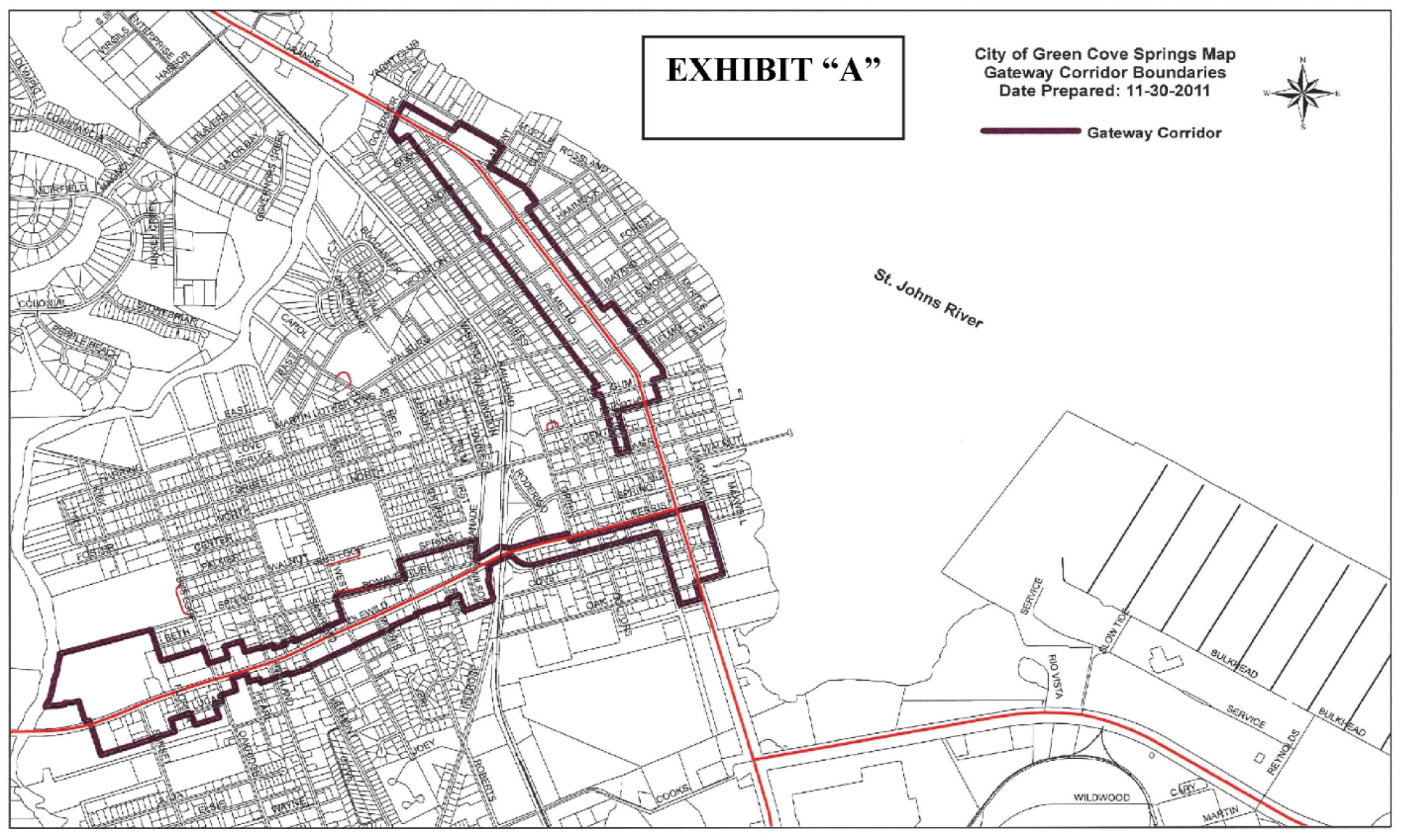
(Code 2001, § 102-476; Ord. No. O-31-2007, § 1(102-476), 11-6-2007; Ord. No. O-08-2011, § 6, 12-6-2011; Ord. No. O-05-2012, § 2, 7-3-2012)
Sec. 117-515. - Intent.
(a)
The gateway corridor residential zoning category is intended for all property located in the gateway corridor and designated as RLD (residential low density) and RMD (residential medium density) on the future land use map. The permitted uses, special exceptions, and density controls are R-1, single family residential, for the RLD (residential low density) property and R-2, single-family multifamily residential, for the RMD (residential medium density) property.
(b)
Where structures are in existence and situated in the gateway corridor residential zoning category at the time of the adoption of the ordinance from which this section is derived and are demolished or destroyed, the structures shall be allowed to be rebuilt to the same footprints and density as existed at the time of adoption of the ordinance from which this section is derived, provided the construction of the new structure meets current building codes.
(Code 2001, § 102-491; Ord. No. O-31-2007, § 1(102-491), 11-6-2007; Ord. No. O-08-2011, § 6, 12-6-2011)
Sec. 117-539. - Intent.
The gateway corridor neighborhood zoning category is intended for all property located in the gateway corridor and designated as RPO (residential professional office) or CMI (commercial medium intensity) on the future land use map.
(Code 2001, § 102-506; Ord. No. O-31-2007, § 1(102-506), 11-6-2007; Ord. No. O-08-2011, § 6, 12-6-2011)
Sec. 117-540. - Permitted uses.
The following and any determined similarly like or type uses not specifically described below are permitted uses in the gateway corridor neighborhood zoning category. All uses must be in a totally enclosed building:
(1)
Professional and storage offices;
(2)
Retail and repair establishments limited to the following: antique shops, art galleries or studios, art supplies, barbershops and beauty shops, book and stationery shops, cameras and photographic supplies, cigar or smoke shops, lock shops, convenience stores (not including gas pumps), drapery shops, financial institutions without drive-through facilities, florist shops, funeral homes, gift shops, gun sales and repair, hobby and craft shops, interior decorating, jewelry stores, leather shops, locksmiths, luggage shops, museums, office and/or business machines, office and/or business supplies, newsstands, opticians, paint and wallpaper stores, professional offices, shoe repair stores, tailor and/or dressmaker shops, watch repair and pawn shops;
(3)
Restaurants without drive-through facilities;
(4)
Retail outlets for the sale of food, drugs, including medical marijuana treatment center dispensing facilities, sundries and notions;
(5)
Single-family detached dwelling units;
(6)
Single-family attached dwellings, up to four units;
(7)
Churches;
(8)
Pre-school and child care centers; and
(9)
Home occupations.
(Code 2001, § 102-507; Ord. No. O-31-2007, § 1(102-507), 11-6-2007; Ord. No. O-08-2011, § 6, 12-6-2011; Ord. No. O-03-2018, § 4, 5-15-2018; Ord. No. O-14-2019, § 1, 11-5-2019)
Sec. 117-541. - Special exceptions.
Special exceptions are as follows:
(1)
Convenience retail stores with gas pumps;
(2)
Establishment of facilities for the retail sale of beer and wine off-premises;
(3)
Hospitals;
(4)
Restaurants with drive-through facilities;
(5)
Automotive service establishments:
a.
Retail and service establishments for automotive service and repair and automobile parts store.
b.
The permitted uses in section 117-540 (excluding automobile sales) are subject to the following limitations:
1.
Sale, repair (excluding automobile sales), service, and storage shall be conducted within a completely enclosed building.
2.
The building footprint used for the uses in this section shall not be larger than 2,500 square feet.
3.
Lot size of no more than 21,000 square feet shall be used for the uses in this section.
4.
Outdoor storage area is limited to 20 percent of the lot size, but no more than 40 percent of the building footprint of the principal structure.
5.
Outdoor storage area must be located in a fenced area with a visual barrier of not less than 85 percent opacity.
(6)
Single-family residential development on a flag lot as defined in section 101-5 and subject to the conditions set forth in section 101-60.
(Code 2001, § 102-508; Ord. No. O-31-2007, § 1(102-508), 11-6-2007; Ord. No. O-08-2011, § 6, 12-6-2011; Ord. No. O-16-2020, § 7, 2-16-2021)
Sec. 117-542. - Density controls.
Density controls in the gateway corridor neighborhood zoning category shall be as follows:
(1)
Detached dwellings. The density controls for detached dwellings in the gateway corridor neighborhood zoning category shall be as follows:
a.
Minimum required lot area: 5,000 square feet;
b.
Minimum required lot width: 50 feet;
c.
Minimum required front yard: Ten feet;
d.
Minimum required rear yard: Ten feet;
e.
Minimum required side yard: Five feet;
f.
Minimum required living area: 1,000 square feet with an enclosed garage of at least ten feet by 20 feet. Attached garages shall be architecturally integrated into the design of the dwelling and structurally connected; detached garages in the rear of the property are permitted;
g.
Minimum pervious surface: 40 percent;
h.
Maximum structure height: 35 feet;
i.
Maximum number of stories: Three.
(2)
Attached dwellings. The density controls for attached dwellings in the gateway corridor neighborhood zoning category shall be as follows:
a.
Minimum required lot area:
1.
Two-family: 8,500 square feet;
2.
Three-family: 12,500 square feet;
3.
Four-family: 16,500 square feet;
b.
Minimum required lot width:
1.
Two-family: 75 feet;
2.
Three-family: 100 feet;
3.
Four-family: 150 feet;
c.
Minimum required front yard: Ten feet;
d.
Minimum required side yard: Ten feet;
e.
Minimum required rear yard: Ten feet;
f.
Minimum required living area: 1,000 square feet;
g.
Minimum pervious surface: 30 percent;
h.
Maximum structure height: 35 feet;
i.
Maximum number of stories: Three.
(3)
Commercial and professional offices. The density controls for commercial and professional offices in the gateway corridor neighborhood zoning category shall be as follows:
a.
Minimum required lot area: None;
b.
Minimum required lot width: None;
c.
Minimum required front yard: Ten feet;
d.
Minimum required rear yard: Ten feet;
e.
Minimum required side yard: Ten feet;
f.
Minimum pervious surface: 30 percent;
g.
Maximum structure height: 35 feet. The maximum height may be increased to 50 feet. The building must be tiered back one foot for every foot over 35 feet;
h.
Maximum number of stories: Three.
(Code 2001, § 102-509; Ord. No. O-31-2007, § 1(102-509), 11-6-2007; Ord. No. O-08-2011, § 6, 12-6-2011)
Sec. 117-543. - Architectural requirements.
(a)
Architectural review shall be required for:
(1)
All new buildings;
(2)
Any building expansion greater than 40 percent of the square footage of the existing building;
(3)
The following uses are exempt from this section:
a.
Single-family residential dwellings;
b.
Churches.
(b)
Required materials include, but are not limited to:
(1)
Front, side and rear elevations of all proposed structures;
(2)
Types of building material to be used in construction for the primary building or buildings:
a.
Prohibited exterior materials shall include all corrugated metal or ribbed steel panel pre-fabricated structures.
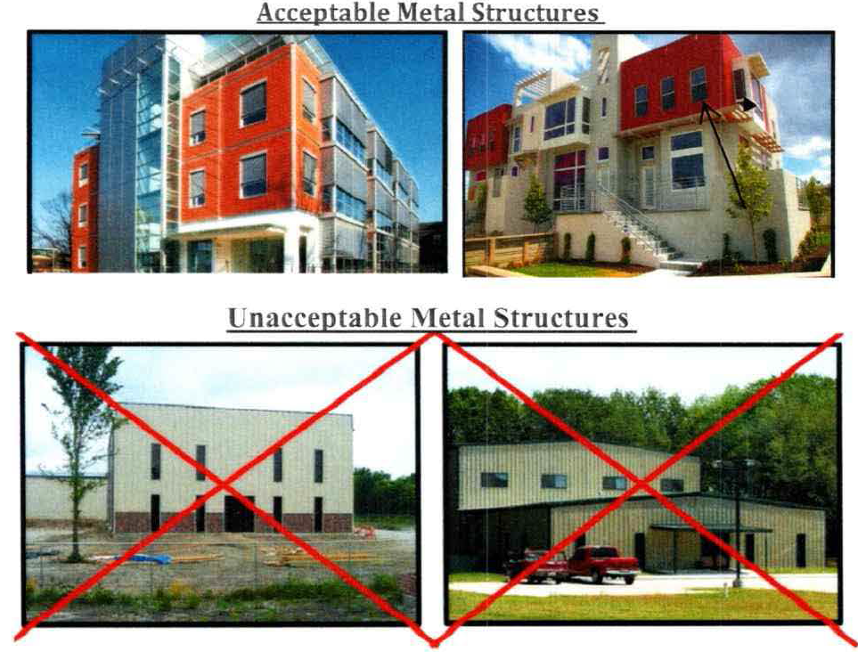
b.
Façade colors shall be low reflectance, subtle, neutral or earth tone colors. The use of high intensity colors, black or fluorescent colors shall be prohibited. Building trim and accented design elements may feature brighter colors including primary colors.
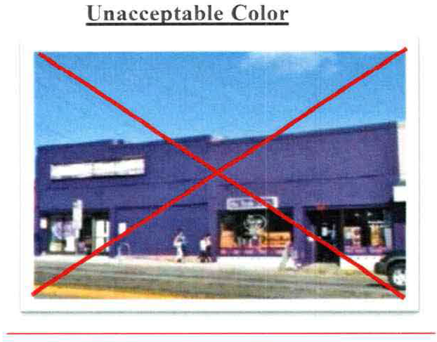
(c)
All building elevations that front on a street shall be considered primary façades. Corner or through lots shall have multiple primary façades.
(d)
Each primary façade shall have a building entry located on that façade.
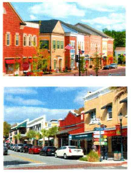
(e)
Each primary façade shall have a minimum of 20 percent transparency requirement, which is measured as the ratio of window area to the total façade area.
(f)
All glass on a building's base shall be clear and non-reflective, except in a case that translucent windows are provided to acquire LEED certification or in the case of non-commercial uses.
(g)
Roofs:
(1)
Roofs shall have a pitch between 5:12 and 12:12.
(2)
Flat roofs or roofs with a pitch below 5:12 shall include a parapet wall above a roof facing any public frontage. The parapet wall shall be a minimum of 24 inches high (measured above the roof).
(h)
Utilitarian functions:
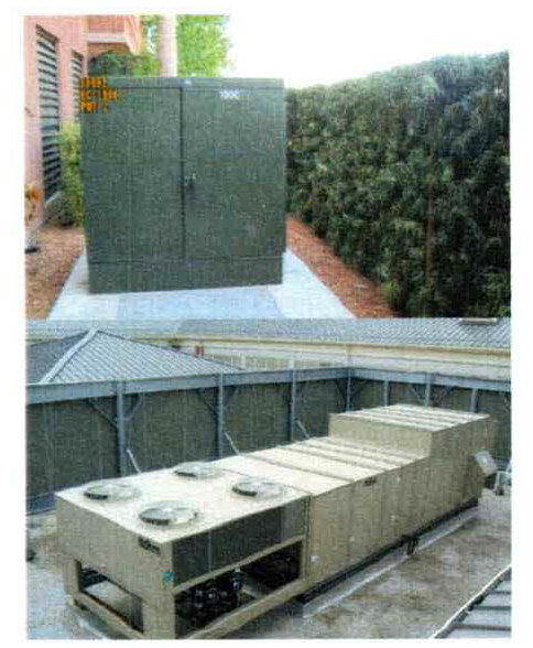
Items such as delivery and loading operations, HVAC equipment, trash compacting and collection, backflow preventers, meters and other utility and service functions shall be incorporated into the overall design of the building(s) and the landscaping. The visual and acoustic impacts of these functions along with all ground mounted mechanical, electrical and communications equipment shall be out of view from adjacent properties and public streets, and screening materials and landscape screens shall be architecturally compatible with and not inferior to the principal materials of the building.
(Ord. No. O-14-2019, § 2, 11-5-2019)
Sec. 117-563. - Intent.
The gateway corridor commercial (GCC) district zoning category is intended for all property located in the gateway corridor and designated as CHI (commercial high intensity) and INS (institutional) on the future land use map.
(Code 2001, § 102-521; Ord. No. O-31-2007, § 1(102-521), 11-6-2007; Ord. No. O-08-2011, § 6, 12-6-2011; Ord. No. O-05-2012, § 3, 7-3-2012)
Sec. 117-564. - Permitted uses.
The following and any determined similarly like or type uses not specifically described below are permitted uses in the gateway corridor commercial zoning category; all uses must be in a totally enclosed building:
(1)
Any use permitted in the gateway corridor neighborhood zoning category;
(2)
The following types of commercial establishments: appliance sales and rentals, bakeries, bicycle sales and service, billiards, art or ceramic sales and studios, clothing shops, curio shops, dance, music, gymnastic studios, decorating studios and shops, department stores, drug sales including medical marijuana treatment center dispensing facilities, dry cleaners, financial institutions (including drive-through facilities), furniture stores, game rooms, grocery related market or store, hardware stores, health spas, hotels, motels, medical supplies, optical shops, second hand retail shops, pet shops, pet grooming, printing shops, restaurants with or without outside seating, shoe stores, sporting goods stores, sundries and notions shops, television and radio sales and service, theaters, toy stores, veterinarian clinic, wearing-apparel shops, commercial retail packaging and mail service business, and skating rinks;
(3)
Professional offices;
(4)
Multifamily residential dwelling units;
(5)
Hospitals; and
(6)
Any lawful civic, cultural, governmental, public utilities, and public necessity uses.
(Code 2001, § 102-522; Ord. No. O-31-2007, § 1(102-522), 11-6-2007; Ord. No. O-08-2011, § 6, 12-6-2011; Ord. No. O-05-2012, § 4, 7-3-2012; Ord. No. O-03-2018, § 4, 5-15-2018; Ord. No. O-10-2020, § 2, 8-25-2020)
Sec. 117-565. - Special exceptions.
The following uses are special exceptions in the gateway corridor commercial zoning category:
(1)
Establishments or facilities for automobile parts, sales and services without use of an outdoor intercom or public address system or speakers, and no vehicle display racks that tilt vehicles in any way to show underside, unless they are located inside a show room.
(2)
Establishments or facilities for the retail sale and service of all alcoholic beverages for on-premises consumption.
(3)
Single-family detached dwelling units meeting the density requirements of the gateway corridor neighborhood zoning category.
(4)
Multifamily dwelling units without garages.
(5)
Single-family residential development on a flag lot as defined in section 101-5 and subject to the conditions set forth in section 101-60.
(6)
Outdoor sales of swimming pools, spas and hot tubs shall be a permitted use subject to the requirements of section 117-797.
(Code 2001, § 102-523; Ord. No. O-31-2007, § 1(102-523), 11-6-2007; Ord. No. O-08-2011, § 6, 12-6-2011; Ord. No. O-06-2016, § 5, 6-7-2016; Ord. No. O-10-2020, § 2, 8-25-2020; Ord. No. O-16-2020, § 8, 2-16-2021; Ord. No. O-23-2022, § 3, 1-17-2023)
Sec. 117-566. - Density controls.
Where structures are in existence and situated in the gateway corridor commercial zoning category at the time of the adoption of the ordinance from which this section is derived and are destroyed or demolished, the structures shall be allowed to be rebuilt to the same footprints as existed at the time of adoption of the ordinance from which this section is derived, provided the construction of the new structure meets current building codes and is consistent with the exterior of the damaged structure or adjoining structures. Density controls in the gateway corridor commercial (GCC) zoning category shall be as follows:
(1)
Commercial and professional offices:
a.
Minimum required lot area: None;
b.
Minimum required lot width: None;
c.
Minimum required front yard: Ten feet;
d.
Minimum required rear yard: Ten feet;
e.
Minimum required side yard: Ten feet;
f.
Minimum pervious surface: 20 percent;
g.
Maximum structure height: 54 feet. Maximum height may be increased to 70 feet. The building must be tiered back one foot for every foot over 54 feet;
h.
Maximum number of stories: Four.
(2)
Multiple family residential dwelling units:
a.
Minimum required lot area: 7,500 square feet for the first two dwelling units and 2,700 square feet for each additional unit that is added;
b.
Minimum required lot width: 100 feet;
c.
Minimum required front yard: Ten feet;
d.
Minimum required rear yard: Ten feet;
e.
Minimum required side yard on each side of the structure: Not less than five feet for the first two stories. For each story in excess of two, the required side yards shall be increased by five feet for each story so added;
f.
Minimum required living areas:
1.
Efficiency apartment: 750 square feet;
2.
One bedroom apartment: 800 square feet;
3.
Two bedroom apartment: 900 square feet;
4.
Three or more bedroom apartment: 900 square feet plus an additional 100 square feet for each bedroom over two bedrooms:
g.
Minimum pervious surface: 20 percent;
h.
Maximum structure height: 54 feet. Maximum height may be increased to 70 feet. The building must be tiered back one foot for every foot over 54 feet;
i.
Maximum number of stories: Four.
(Code 2001, § 102-524; Ord. No. O-31-2007, § 1(102-524), 11-6-2007; Ord. No. O-08-2011, § 6, 12-6-2011)
Sec. 117-596. - Generally.
Easements necessary for the orderly extension and maintenance of public utility systems shall be required by the city as a condition of site plan approval.
(Code 2001, § 102-536; Ord. No. O-31-2007, § 1(102-536), 11-6-2007; Ord. No. O-08-2011, § 6, 12-6-2011)
Sec. 117-626. - Generally.
Landscaping in the gateway corridor zoning categories shall meet the landscaping requirements of chapter 113, article VI or as per the following:
(1)
Alternative designs. Where natural features or spacing of existing driveways and roadways cause the access requirements of this Code to affect placement or planting of landscaped buffers or trees to be physically infeasible, alternate designs may be approved as part of the issuing of a final development order.
(2)
Exceptions.
a.
Shade trees located along the rights-of-way shall be live oak trees, unless the live oak tree would conflict with any utility lines;
b.
The required setback along the corridor shall promote safe pedestrian movement.
c.
The required landscape buffer along the right-of-way shall be met by either one of the following conditions:
1.
The roadway shall be separated from the back of the curb by a six-foot landscaped strip, a six-foot pedestrian walkway, then a six-foot landscaped strip. Building setback shall be calculated from the back of the curb; or
2.
Ten-foot landscaped strip along all rights-of-way.
(Code 2001, § 102-551; Ord. No. O-31-2007, § 1(102-551), 11-6-2007; Ord. No. O-08-2011, § 6, 12-6-2011)
Sec. 117-656. - Design guidelines.
Compliance with all land development regulations as adopted is required for all properties located within the corridor. In addition to the requirements of this Code, development in the gateway corridor zoning categories shall meet the following design guidelines:
(1)
Orient nonresidential uses to face the street with parking behind or to the sides of buildings or provide a street wall subject to the requirements set forth below:
a.
Street walls are freestanding walls that are intended to mask parking areas from the street and shall have a minimum height of three feet and a maximum height of six feet (measured from the elevation of the public sidewalk). The portion of the street wall three feet and below shall be solid (e.g. brick and masonry or similar material). The portion of the street wall above four feet shall be transparent (e.g., wrought iron or similar material). Street walls shall have columns/posts (one foot by one foot minimum) spaced every 24 feet.
b.
Street walls shall have openings no larger than necessary to allow automobile and/or pedestrian access.
c.
Street walls shall not be permitted within the right-of-way.
d.
Street walls shall be constructed of wrought iron, brick, masonry, stone, powder-coated aluminum, or other decorative materials that complement the finish on the primary building. Chain link, wood and PVC street walls/fences shall be prohibited.
e.
The area in front and behind the street wall/fences shall include a landscaped strip pursuant to the requirements forth in section 117-626 and section 113-244(d)(3).
f.
Street walls shall meet clear site line requirements set forth in section 113-76.
g.
Secure a special exception pursuant to the requirements set forth in section 101-352.
(2)
In lieu of meeting onsite parking requirements, the developer may enter into an agreement with the city to reduce the required on-street parking. The reduction of on-street parking shall be approved if the developer agrees to improve the adjoining rights-of-way with landscaping and on-street parking or provides the city with funds to provide additional public parking.
(3)
No commercial access, except for ingress and egress for office uses, shall be allowed on residential streets or streets where residential future land use categories exist. This includes access for service vehicles.
(4)
Commercial land uses facing residential land uses or future land use categories must be residential in character, with residential elevations or facades.
(5)
Density controls for buildings with both residential and commercial permitted uses and/or permissible by special exception shall be based on the density controls for the building use on the first story of the structure.
(6)
Improvements to offsite parking spaces to develop on-street parking shall be counted to meet the minimum parking requirements and to meet the minimum landscape area and pervious surface requirements.
(Code 2001, § 102-566; Ord. No. O-31-2007, § 1(102-566), 11-6-2007; Ord. No. O-08-2011, § 6, 12-6-2011; Ord. No. O-36-2023, § 1, 5-21-2024)
Sec. 117-686. - Generally.
(a)
Signage along and within the gateway corridor shall meet the requirements of chapter 125, as amended, with the exception that all ground signs be monument signs and that no more than one ground sign shall be permitted for each 200 feet of road, with a maximum of two ground signs for projects with over 400 feet of right-of-way.
(b)
Electronic signs are allowed and shall meet the requirements stated in chapter 125, as amended.
(Code 2001, § 102-581; Ord. No. O-31-2007, § 1(102-581), 11-6-2007; Ord. No. O-08-2011, § 6, 12-6-2011)
Sec. 117-687. - Special sign conditions.
Special conditions for signs within the gateway corridor neighborhood (GCN) and gateway corridor commercial (GCC) zoning categories are as follows: sandwich board signs are permitted in the designated gateway corridor neighborhood and gateway corridor commercial zoning categories as follows:
(1)
Sandwich board signs shall be permitted in the gateway corridor neighborhood and gateway corridor commercial zoning categories between 8:00 a.m. and 9:00 p.m.
(2)
Sandwich board signs shall be permitted only on the sidewalks in front of the business and may not be larger than 12 square feet and may contain two sign fronts.
(3)
Sandwich board signs shall not be located so as to be a hazard to pedestrian or automotive traffic.
(4)
Sandwich board signs shall obtain required approval and permitting before placement or use by a business in areas designated for their use.
(Code 2001, § 102-582; Ord. No. O-08-2011, § 6, 12-6-2011)
Sec. 117-718. - Generally.
Minimum parking requirements shall meet the requirements of section 113-157, except for the following:
(1)
Parking spaces shall be a minimum of nine feet by 18 feet;
(2)
Minimum number of parking spaces:
a.
Efficiency and one bedroom apartments: One space per unit;
b.
Two bedroom apartments: 1.5 spaces per unit;
c.
Three bedroom apartments: Two spaces per unit;
d.
Visitors: An additional 20 percent of spaces required;
e.
Commercial: One space per 333 square feet of non-storage area floor area.
(Code 2001, § 102-596; Ord. No. O-31-2007, § 1(102-596), 11-6-2007; Ord. No. O-08-2011, § 6, 12-6-2011)