
Gulfport City Zoning Code
ARTICLE V
- SCHEDULE OF DISTRICT REGULATIONS6
Editor's note— Section 5 of Ord. No. 93-14, adopted Oct. 5, 1993, repealed Art. V. Formerly, Art. V consisted of §§ 22-5.01—22-5.07, 22-5.09—22-5.14, and 22-5.16, which pertained to schedule of district regulations and derived from the following legislation:
Section 5 of Ord. No. 93-14 provided further for the addition of Art. V, §§ 22-5.01—22-5.14, as herein set out.
Sec. 22-5.01.- OS (open space) zoning district.
(a)
Purpose. The purpose of the OS (open space) zoning district shall be to locate and establish areas within the City of Gulfport which are uniquely suited for the conservation or preservation of open space and the natural environment, and for limited recreation usage.
(b)
Permitted principal uses and structures. The following principal uses and structures are permitted:
(1)
Land or water in its natural state for preservation.
(2)
Public park for passive recreation use, including picnic areas, playground equipment, pavilions, hiking trail, boardwalk, off-street parking and observation platform.
(c)
Conditional uses. The following uses may be permitted only upon review and specific approval thereof by the city council:
(1)
Drainage facilities;
(2)
Boat ramp or dock;
(d)
Minimum lot requirements. There are no specific requirements for this district.
(e)
Minimum green space requirement. No use shall exceed in impervious surface ratio (ISR) of 0.60.
(f)
Maximum building or structure coverage. The maximum building or structure coverage shall not exceed a floor area ratio (FAR) of 0.25.
(g)
Maximum building height. The maximum building height shall be forty-five (45) feet.
(h)
Minimum yard requirements and buffering. There are no specific requirements for this district.
(Ord. No. 93-14, § 5, 10-5-93; Ord. No. 96-21, § 1, 11-19-96; Ord. No. 2000-20, § 2, 10-3-00)
Sec. 22-5.02. - R-1A (single-family residential) zoning district.
(a)
Purpose. The purpose of the R-1A (single-family residential) zoning district shall be to locate and establish areas within the City of Gulfport which are suited for the development and maintenance of low-density residential living; to designate those uses and services deemed appropriate for location and development within said zoning district; and to establish such development standards and provisions as are necessary to ensure proper development in a low-density residential environment.
(b)
Permitted principal uses and structures. The following principal uses and structures are permitted:
(1)
Single-family dwelling.
(2)
Public park for passive recreation use, including picnic areas and playground equipment, not to exceed one and one-half (1.5) acres.
(c)
Conditional uses. There are no conditional uses permitted within this district.
(d)
Minimum lot requirements. All lots shall have a minimum of seven thousand five hundred (7,500) square feet and a minimum width of sixty (60) feet.
(e)
Minimum green space requirement. Minimum green space shall be no less than twenty (20) percent.
(f)
Maximum building coverage. The maximum building coverage shall not exceed forty (40) percent.
(g)
Maximum building height. The maximum building height shall be thirty (30) feet. No building shall have more than two (2) stories of living area.
(h)
Minimum yard requirements.
(1)
The front yard shall have a minimum depth of twenty-five (25) feet.
(2)
Each side yard shall have a minimum depth of six (6) feet.
(3)
The rear yard shall have a minimum depth of twenty-five (25) feet.
(Ord. No. 93-14, § 5, 10-5-93; Ord. No. 2000-20, § 3, 10-3-00)
Sec. 22-5.03. - R-1 (single-family residential) zoning district.
(a)
Purpose. The purpose of the R-1 single-family residential zoning district shall be to locate and establish areas within the City of Gulfport which are suited for the development and maintenance of single-family dwelling units in an urban density environment; to designate those uses and services deemed appropriate for location and development within said zoning district; and to establish such development standards and provisions as are necessary to ensure proper development in an urban density residential environment.
(b)
Permitted principal uses and structures. The following principal uses and structures are permitted:
(1)
Single-family dwelling;
(2)
Public park for passive recreation use, including picnic areas and playground equipment, not to exceed one and one-half (1.5) acres.
(c)
Conditional uses. The following uses may be permitted upon review and approval of the city council, provided that the total land area devoted to all such contiguous uses shall not exceed one and one-half (1½) acres, unless city council determines that all such contiguous uses are compatible and consistent with surrounding uses and the character of the area:
(1)
Church, including related educational and training facilities;
(2)
Civic or community organization (non-profit); and
(3)
School.
(d)
Minimum lot requirements.
(1)
Single-family dwelling lots shall have a minimum of five thousand (5,000) square feet and a minimum width of fifty (50) feet.
(2)
All other uses shall have lots of a minimum of ten thousand (10,000) square feet and width of eighty (80) feet.
(e)
Minimum green space requirement.
(1)
Residential use shall have a minimum green space of twenty (20) percent.
(2)
Nonresidential use shall have an impervious surface ratio (ISR) as provided in the comprehensive plan.
(f)
Maximum building coverage.
(1)
Maximum building coverage for residential use is forty (40) percent.
(2)
Nonresidential use shall not exceed a floor area ratio (FAR) as provided in the comprehensive plan.
(g)
Maximum building height. The maximum building height shall be thirty (30) feet. No building shall have more than two (2) stories of living area.
(h)
Minimum yard requirements.
(1)
The front yard shall have a minimum depth of twenty-five (25) feet.
(2)
Each side yard shall have a minimum depth of six (6) feet.
(3)
The rear yard shall have a minimum depth of twenty-five (25) feet.
(i)
Site plan review. All conditional uses shall be subject to the provisions of article VII and article VIII of this chapter.
(Ord. No. 93-14, § 5, 10-5-93; Ord. No. 2000-20, § 4, 10-3-00; Ord. No. 2002-01, § 1, 4-2-02; Ord. No. 2003-08, § 2, 4-1-03; Ord. No. 2012-06, § 1, 3-6-12)
Sec. 22-5.04. - R-2 (one/two-family residential) zoning district.
(a)
Purpose. The purpose of the R-2 residential zoning district shall be to locate and establish areas within the City of Gulfport which are suited for the development and maintenance of single-family and duplex dwelling units in an urban density environment; to designate those uses and services deemed appropriate for location and development within said zoning district; and to establish such development standards and provisions as are necessary to ensure proper development in an urban density residential environment.
(b)
Permitted principal uses and structures. The following principal uses and structures are permitted:
(1)
Single-family dwelling.
(2)
Duplex dwelling.
(3)
Public park for passive recreation use, including picnic areas and playground equipment, not to exceed one and one-half (1.5) acres.
(c)
Conditional uses. The following uses may be permitted upon review and approval of the city council, provided that the total land area devoted to all such contiguous uses shall not exceed one and one-half (1½) acres, unless city council determines that all such contiguous uses are compatible and consistent with surrounding uses and the character of the area:
(1)
Church, including related educational and training facilities;
(2)
Civic or community organization (non-profit);
(3)
School; and
(4)
Off-street parking lots in connection with a contiguous commercial use or mixed use, as provided in article VI of this chapter.
(d)
Minimum lot requirements.
(1)
Single-family dwelling lots shall have a minimum of five thousand (5,000) square feet and a minimum width of fifty (50) feet.
(2)
Duplex dwelling lots shall have a minimum of eight thousand seven hundred (8,700) square feet and minimum width of fifty (50) feet.
(3)
All other uses shall have lots of a minimum of ten thousand (10,000) square feet and width of eighty (80) feet.
(e)
Minimum green space requirement.
(1)
Residential use shall have a minimum green space of twenty (20) percent.
(2)
Nonresidential use shall not exceed an impervious surface ratio (ISR) as provided by the comprehensive plan.
(f)
Maximum building coverage.
(1)
Maximum building coverage for residential use shall be forty (40) percent.
(2)
Nonresidential use shall not exceed a floor area ratio (FAR) as provided by the comprehensive plan.
(g)
Maximum building height. The maximum building height shall be thirty (30) feet. No building shall have more than two (2) stories of living area.
(h)
Minimum yard requirements.
(1)
The minimum front yard depth shall be twenty-five (25) feet.
(2)
Each side yard shall have minimum depth of six (6) feet.
(3)
The minimum rear yard depth shall be twenty-five (25) feet.
(i)
Site plan review. All conditional uses shall be subject to the provisions of article VII and article VIII of this chapter.
(Ord. No. 93-14, § 5, 10-5-93; Ord. No. 2000-20, § 5, 10-3-00; Ord. No. 2002-01, § 2, 4-2-02; Ord. No. 2003-08, § 3, 4-1-03; Ord. No. 2012-06, § 2, 3-6-12)
Sec. 22-5.05. - R-3 (multiple-family residential) zoning district.
(a)
Purpose. The purpose of the R-3 (multiple-family residential) zoning district shall be to locate and establish areas within the City of Gulfport which are suited for the development and maintenance of low medium-density multiple-family residential areas properly served by community facilities and commercial service areas; to designate those uses and services appropriate for location and development within said zoning district; and to establish such development standards and provisions as are necessary to ensure proper development in a low medium-density residential environment.
(b)
Permitted principal uses and structures. The following principal uses and structures are permitted:
(1)
Single-family dwelling;
(2)
Duplex dwelling;
(3)
Multiple-family dwelling;
(4)
Public park for passive recreation use, including picnic areas and playground equipment, not to exceed one and one-half (1.5) acres.
(c)
Conditional uses. The following uses may be permitted upon review and approval of the city council, provided that the total land area devoted to all such contiguous uses shall not exceed one and one-half (1.5) acres, unless city council determines that all such contiguous uses are compatible and consistent with surrounding uses and the character of the area:
(1)
Church, including related educational and training facilities;
(2)
Civic or community organization (nonprofit);
(3)
Club or lodge;
(4)
Dormitories;
(5)
Assisted Living Facility;
(6)
Fraternity or sorority house;
(7)
Nursing or convalescent home;
(8)
School;
(9)
Day care center;
(10)
Off-street parking lots in connection with a contiguous commercial use, or mixed use, as provided in Article VI hereof.
(d)
Minimum lot requirements.
(1)
Single-family dwellings shall have a minimum lot size of five thousand (5,000) square feet and a minimum width of fifty (50) feet.
(2)
Duplex dwellings shall have a minimum lot size of eight thousand seven hundred (8,700) square feet and a minimum width of fifty (50) feet.
(3)
Multiple-family dwellings shall have a minimum lot size of thirteen thousand one hundred (13,100) square feet, with an additional four thousand three hundred fifty (4,350) square feet for each dwelling unit in excess of three (3), and a minimum width of seventy (70) feet.
(4)
Townhouse dwelling complexes shall have a gross lot area of two (2) acres, and gross lot width of two hundred forty (240) feet.
(5)
All other uses shall have a minimum lot size of ten thousand (10,000) square feet and a minimum width of eighty (80) feet.
(e)
Minimum green space requirement.
(1)
Residential use shall have a minimum green space of twenty (20) percent.
(2)
Nonresidential use shall not exceed an impervious surface ratio (ISR) as provided in the comprehensive plan.
(f)
Maximum building coverage.
(1)
Single-family and duplex dwelling(s) shall not exceed a maximum building coverage of forty (40) percent.
(2)
Multiple-family dwelling(s) shall not exceed a maximum building coverage of thirty (30) percent.
(3)
Nonresidential use shall not exceed a floor area ratio (FAR) as provided in the comprehensive plan.
(g)
Maximum building height.
(1)
Multiple-family dwelling(s) shall not exceed a maximum building height of forty-five (45) feet;
(2)
All single-family or duplex dwellings shall not exceed a maximum building height of thirty (30) feet and no building shall have more than two (2) stories of living area. All other uses shall not exceed a maximum building height of thirty (30) feet, unless authorized up to forty-five (45) feet as a conditional use herein.
(h)
Minimum yard requirements.
(1)
All uses, except multiple-family, shall have a minimum front yard depth of twenty-five (25) feet. Multiple-family dwelling(s) shall have a minimum front yard depth of thirty (30) feet.
(2)
Each side yard shall have a minimum depth of six (6) feet for all uses, except multiple-family. Multiple-family dwelling(s) shall have a minimum depth of ten (10) feet for each side yard.
(3)
All uses, except multiple-family, shall have a minimum rear yard depth of twenty-five (25) feet. Multiple-family dwelling(s) shall have a minimum rear yard depth of forty (40) feet.
(i)
Site plan review. Multiple-family dwellings and all conditional uses shall be subject to the provisions of article VII and article VIII of this chapter.
(Ord. No. 93-14, § 5, 10-5-93; Ord. No. 96-5, § 1, 5-21-96; Ord. No. 96-18, § 2, 10-1-96; Ord. No. 2000-20, § 6, 10-3-00; Ord. No. 2012-06, § 3, 3-6-12)
Sec. 22-5.06. - R-4 (high-rise multiple-family residential) zoning district.
(a)
Purpose. The purpose of the R-4 (high-rise multiple-family residential) zoning district shall be to locate and establish areas within the City of Gulfport which are suited for the development and maintenance of high-density multiple-family residential areas properly served by community facilities and commercial service areas; to designate those uses and services appropriate for location and development within said zoning district; and to establish such development standards and provisions as are necessary to ensure proper development in a high-density residential environment.
(b)
Permitted principal uses and structures. The following principal uses and structures are permitted:
(1)
Multiple-family dwelling;
(2)
Public park for passive recreation use, including picnic areas and playground equipment, not to exceed one and one-half (1.5) acres.
(c)
Conditional uses. The following may be permitted only upon review and approval of the city council:
(1)
Dormitories.
[(2)
Reserved.]
(d)
Minimum lot requirements.
(1)
Multiple-family dwelling lots shall have a minimum of seventeen thousand five hundred (17,500) square feet, with an additional four thousand three hundred fifty (4,350) square feet for each dwelling unit in excess of four (4), and a minimum width of one hundred (100) feet.
(2)
All other uses shall have minimum lots of ten thousand (10,000) square feet and a minimum width of eighty (80) feet.
(e)
Minimum green space requirement. Minimum green space shall be no less than thirty (30) percent.
(f)
Maximum building coverage.
(1)
Maximum building coverage for multiple-family dwelling(s) shall be thirty (30) percent.
(2)
All other uses shall have a maximum building coverage of forty (40) percent.
(g)
Maximum building height.
(1)
The maximum building height for multiple-family dwelling(s) shall be one hundred ten (110) feet;
(2)
All other uses shall have a maximum building height of thirty (30) feet. No building shall have more than two (2) stories of living area.
(h)
Minimum yard requirements.
(1)
The minimum front yard depth for multiple-family dwelling(s) shall be thirty (30) feet. All other uses shall have a minimum front yard depth of twenty-five (25) feet.
(2)
Side yard depth for multiple-family dwelling(s) shall be a minimum of fifteen (15) feet for one (1) yard and a combined minimum width of thirty-five (35) feet for both yards. All other uses shall have a minimum of six (6) feet for each side yard.
(3)
The minimum rear yard depth for multiple-family dwelling(s) shall be forty (40) feet. All other uses shall have a minimum rear yard depth of twenty-five (25) feet.
(i)
Site plan review. Multiple-family dwellings and all conditional uses shall be subject to the provisions of article VII and article VIII of this chapter.
(Ord. No. 93-14, § 5, 10-5-93; Ord. No. 2000-20, § 7, 10-3-00; Ord. No. 2012-06, § 4, 3-6-12)
Sec. 22-5.07. - R-MH (mobile home residential) zoning district.
(a)
Purpose. The purpose of the R-MH (mobile home residential) zoning district shall be to locate and establish areas within the City of Gulfport which are suited for the development and maintenance of mobile home residential areas, adequately served by community facilities and commercial service areas; to designate those uses and services appropriate for location and development within said zoning district; and to establish such development standards and provisions as are necessary to ensure proper development in a mobile home residential environment.
(b)
Permitted principal uses and structures. The following principal uses and structures are permitted:
(1)
Mobile home park, subject to the provisions of Article VI of this chapter;
(2)
Public park for passive recreation use, including picnic areas and playground equipment, not to exceed one and one-half (1.5) acres;
(3)
Private recreation, civic, or cultural facility, not to exceed one and one-half (1.5) acres.
(c)
Conditional uses. No conditional uses shall be permitted within this district.
(d)
Minimum lot requirements.
(1)
A mobile home park shall have a minimum of fifteen (15) acres and minimum width of one hundred sixty-five (165) feet adjoining a public street or highway.
(2)
All other uses shall have a minimum of ten thousand (10,000) square feet and a minimum width of eighty (80) feet.
(e)
Minimum green space requirement.
(1)
Residential use shall have a minimum green space of twenty (20) percent.
(2)
Nonresidential use shall not exceed an impervious surface ratio (ISR) as provided in the comprehensive plan.
(f)
Maximum building coverage.
(1)
Maximum building coverage for residential use shall be thirty-five (35) percent.
(2)
Nonresidential use shall not exceed a floor area ratio (FAR) as provided in the comprehensive plan.
(g)
Maximum building height. The maximum building height shall be thirty (30) feet. No building shall have more than two (2) stories of living area.
(h)
Minimum yard requirements.
(1)
The front yard shall have a minimum depth of fifteen (15) feet.
(2)
Each side yard shall have a minimum depth of seven (7) feet and six (6) inches.
(3)
The rear yard shall have a minimum depth of fifteen (15) feet.
(i)
Site plan review. All permitted uses shall be subject to the provisions of Article VII of this chapter.
(Ord. No. 93-14, § 5, 10-5-93; Ord. No. 2000-20, § 8, 10-3-00)
Sec. 22-5.08. - WRD (waterfront redevelopment district) zoning district.
(a)
Purpose. The purpose of the WRD (waterfront redevelopment district) zoning district is to establish development standards which will enhance redevelopment opportunities within the district and implement the City of Gulfport's adopted community redevelopment plan. The WRD zoning district is designed to be consistent with the community redevelopment district (CRD) land use category of the Gulfport Comprehensive Plan. The district is intended to encourage and promote the revitalization of the waterfront area and to maintain the unique characteristics of the area. This is to be achieved by allowing a wide variety of mixed uses, preserving existing residential neighborhoods and establishing development regulations which will promote reinvestment in the district.
(b)
Permitted principal uses and structures. Uses and structures permitted within the WRD zoning district and associated density (units per acre), intensity (floor area ratio, impervious surface ratio), and building height standards shall be consistent with the redevelopment area land use plan and maps contained in the City of Gulfport Waterfront Redevelopment Plan. The following shall be permitted uses and development standards applicable to each of the following areas of the WRD zoning district, as designated in the land use plan and maps of the waterfront redevelopment plan:
(1)
Commercial limited (CL) area.
a.
Permitted uses.
1.
Retail sales;
2.
Financial institution, including drive-in facilities;
3.
Transient accommodations;
4.
Personal or business services;
5.
Restaurant, without any drive-through facilities;
6.
Office, business or professional;
7.
Clinic;
8.
Commercial entertainment or recreation;
9.
Repair services;
10.
Multiple-family dwelling;
11.
Galleries, art studio, theater;
12.
Package store; accessory to retail sales only;
13.
Universities, colleges, academies and similar post-secondary educational facilities, including ancillary dormitories, student activity centers or lounges, and other such facilities integral to the use;
14.
Church;
15.
Medical marijuana dispensing facilities.
b.
Dimension regulations.
1.
Minimum lot area.
(a)
Multiple-family dwelling lots shall have thirteen thousand one hundred (13,100) square feet, with an additional four thousand three hundred fifty (4,350) square feet for each dwelling unit in excess of three (3), and a minimum lot width of seventy (70) feet;
(b)
No specific requirements have been established for all other uses.
2.
Minimum yard requirements.
(a)
The front yard shall have a minimum depth of twenty-five (25) feet.
(b)
Each side yard shall have a minimum depth of six (6) feet, provided that no side yard shall be required where a fire wall meeting all code requirements is provided.
(c)
For all uses, where an alley exists as a means of access to the rear of the property, no rear yard shall be required, and where no alley exists, a rear yard having a minimum depth of eight (8) feet shall be required.
c.
Maximum building height. The maximum building height shall be forty-five (45) feet.
(2)
Mixed use limited (MUL) area.
a.
Permitted uses.
1.
Single-family dwelling;
2.
Duplex dwelling;
3.
Artist studio, accessory to residential use only and subject to restrictions provided herein;
4.
Professional office, accessory to residential use only and subject to restrictions provided herein.
b.
Dimensional regulations.
1.
Minimum lot area.
(a)
Single-family dwelling lots shall have five thousand (5,000) square feet, with a minimum lot width of fifty (50) feet;
(b)
Duplex dwelling lots shall have eight thousand seven hundred (8,700) square feet, with a minimum lot width of fifty (50) feet.
2.
Minimum yard requirements.
(a)
The front yard shall have a minimum depth of twenty-five (25) feet;
(b)
Each side yard shall have a minimum depth of six (6) feet;
(c)
The rear yard shall have a minimum depth of twenty-five (25) feet.
c.
Maximum building height. The maximum building height shall be thirty (30) feet. No building shall have more than two (2) stories of living area.
(3)
Mixed use (MU) area.
a.
Permitted uses.
1.
Retail sales;
2.
Transient accommodations;
3.
Personal or business services;
4.
Restaurants, without any drive-through facilities;
5.
Office, business or professional, including public safety sub-station;
6.
Single-family or duplex dwelling;
7.
Multiple-family;
8.
Commercial entertainment or recreation;
9.
Gallery; art studio;
10.
Postal facility, accessory to retail sales use only;
11.
Club or lodge;
12.
Medical marijuana dispensing facilities;
13.
Stand-alone ground level parking lots.
b.
Conditional uses. The following uses shall be permitted only upon review and approval of the city council and with the following conditions:
1.
Package store.
(a)
All package stores shall be subject to regulations found in chapter 4 of the Code of Ordinances and supplemental regulations found in article VI of this chapter; and
(b)
All package stores shall be incidental to a permitted restaurant use. For purposes of this paragraph the sale of alcoholic beverages for consumption on or off premises shall not exceed fifty (50) percent or more of the gross revenue. At the request of the city, the records of the business shall be made available for examination to determine whether the sale, dispensing or consumption of alcoholic beverages is incidental to the principal use; and,
(c)
The conditional use shall run with the city approved original applicant for conditional use approval and shall not be transferable.
c.
Dimensional regulations.
1.
Minimum lot area.
(a)
Single-family dwelling lots shall have a minimum of five thousand (5,000) square feet, with a minimum lot width of fifty (50) feet;
(b)
Duplex dwelling lots shall have a minimum of eight thousand seven hundred (8,700) square feet, with a minimum lot width of fifty (50) feet;
(c)
Multiple-family dwelling lots shall have a minimum of thirteen thousand one hundred (13,100) square feet, with an additional four thousand three hundred fifty (4,350) square feet for each dwelling unit in excess of three (3), and a minimum lot width of seventy (70) feet;
(d)
No specific requirements have been established for all other uses provided that all applicable site development requirements are met.
2.
Minimum yard requirements.
(a)
The front yard shall have a minimum depth of twenty-five (25) feet for residential use. There shall be no minimum requirements for other uses, including the combination of residential and commercial in one (1) structure.
(b)
Each side yard shall have a minimum depth of six (6) feet, provided that no side yard shall be required where a fire wall meeting all code requirements is provided.
(c)
For all uses, where an alley exists as a means of access to the rear of the property, no rear yard shall be required, and where no alley exists, a rear yard having a minimum depth of eight (8) feet shall be required.
d.
Maximum building height. The maximum building height for single-family or duplex dwellings shall be thirty (30) feet and no building shall have more than two (2) stories of living area. All other uses shall have a maximum building height of forty-five (45) feet.
e.
Special criteria for mixed use developments.
1.
Mixed residential/commercial use development may be exempt from the proportionate share calculations in relation to the area of the parcel and may use any combination of allowable density for residential uses and FAR for nonresidential uses for mixed use development upon conditional site plan approval. They may also be granted a fifty (50) percent increase in allowable density in the mixed use (MU) category upon conditional site plan approval. Procedures and requirements for site plan review and approval shall be as set forth in article VII of this chapter. In order to qualify for the removal of the proportionate share requirement and to qualify for a density increase the following criteria must be met:
a.
The design meets the building design standards of section 22-6.13;
b.
The development is consistent with the massing, scale and architectural style of the surrounding development;
c.
The proposal meets the purpose of the waterfront area land use plan, and meets the purpose as stated in appendix G of the waterfront area redevelopment plan;
d.
For density increases, the site cannot be located within the coastal high hazard area (CHHA).
2.
Notwithstanding location in the CHHA, existing, legally permitted development with a density greater than ten (10) dwelling units per acre may retain that existing density as part of a mixed use project as provided in this chapter.
3.
Mixed use development shall have office and/or retail uses on the first floor and residential uses shall be allowed on the upper floors only.
4.
Transient accommodations shall not be included as part of a mixed use development.
5.
The maximum total FAR cannot exceed 0.90. Mixed residential/nonresidential development must use at least sixty (60) percent of the provided floor area for nonresidential uses. The remainder of the floor area may be used for residential uses up to fifteen (15) dwelling units per acre (includes a fifty (50) percent increase, if applicable).
For example, a mixed use development on a one-acre parcel could, through conditional use approval, build thirty-nine thousand two hundred four (39,204) square feet of floor area at a 0.90 FAR. A minimum of twenty-three thousand five hundred twenty-two (23,522) square feet of that floor area must be dedicated towards nonresidential uses. The remaining floor area may be used for up to fifteen (15) dwelling units per acre (if applicable).
(4)
Resort facilities (RF) area.
a.
Permitted uses.
1.
Single-family and duplex dwelling;
2.
Townhouse dwelling;
3.
Multiple-family dwelling;
4.
Transient accommodations;
5.
Restaurants, without any drive-through facilities;
6.
Tavern, accessory to transient accommodation use only;
7.
Municipal facilities;
8.
Private parking lot.
b.
Dimensional regulations.
1.
Minimum lot area.
(a)
Single-family and duplex dwelling lots shall have a minimum of eight thousand seven hundred (8,700) square feet, with a minimum lot width of fifty (50) feet;
(b)
Townhouse dwelling complex lots shall have a minimum gross lot area of one and one-half (1.5) acres, and gross lot width of one hundred seventy-five (175) feet;
(c)
Multiple-family dwelling lots shall have a minimum of thirteen thousand one hundred (13,100) square feet, with an additional four thousand three hundred fifty (4,350) square feet for each dwelling unit in excess of three (3), and minimum lot width of seventy (70) feet;
(d)
All other uses. There shall be no specific requirements for all other uses.
2.
Minimum yard requirements.
(a)
The front yard shall have a minimum depth of twenty-five (25) feet;
(b)
Each side yard shall have a minimum depth of six (6) feet;
(c)
The rear yard shall have a minimum depth of twenty-five (25) feet.
c.
Maximum building height. The maximum building height for single-family or duplex dwellings shall be thirty (30) feet and no building shall have more than two (2) stories of living area. All other uses shall have a maximum building height of forty-five (45) feet.
(5)
Residential low medium (RLM) area.
a.
Permitted uses.
1.
Single-family and duplex dwelling;
2.
Townhouse dwelling;
3.
Multiple-family dwelling;
4.
Public park or playground, or other public recreation or cultural facility;
5.
Private or nonprofit civic or community organization;
6.
Club or lodge;
7.
Assisted living facility (ALF), provided that the entire facility shall be outside the 100-year floodplain area;
8.
Day care center;
9.
Off-street parking lots as provided in article VI of this chapter;
10.
Universities, colleges, academies and similar post-secondary educational facilities, including ancillary dormitories, student activity centers or lounges, and other such facilities integral to the use;
11.
Church.
b.
Dimensional regulations.
1.
Minimum lot area.
(a)
Single-family dwelling lots shall have a minimum of five thousand (5,000) square feet, with a minimum lot width of fifty (50) feet;
(b)
Duplex dwelling lots shall have a minimum of eight thousand seven hundred (8,700) square feet, with a minimum lot width of fifty (50) feet;
(c)
Townhouse dwelling lots shall have a minimum gross lot area of one and one-half (1.5) acres and gross lot width of one hundred seventy-five (175) feet;
(d)
Multiple-family dwelling lots shall have a minimum of thirteen thousand one hundred (13,100) square feet, with an additional four thousand three hundred fifty (4,350) square feet for each dwelling in excess of three (3), and a minimum lot width of seventy (70) feet;
(e)
No specific requirements for all other uses have been established.
2.
Minimum yard requirements.
(a)
The front yard shall have a minimum depth of twenty-five (25) feet;
(b)
Each side yard shall have a minimum depth of six (6) feet;
(c)
The rear yard shall have a minimum depth of twenty-five (25) feet for residential uses. For all other uses, where an alley exists as a means of access to the rear of the property, no rear yard shall be required, and where no alley exists, a rear yard having a minimum depth of eight (8) feet shall be required.
c.
Maximum building height. The maximum building height for single-family or duplex dwellings shall be thirty (30) feet and no building shall have more than two (2) stories of living area. All other uses shall have a maximum building height of forty-five (45) feet.
(6)
Recreation/open space (R/OS) area.
a.
Permitted uses.
1.
Public recreation grounds or parks;
2.
Public beaches;
3.
Special events or other uses found by the community redevelopment agency to be compatible with the purpose of the redevelopment district and existing or permitted uses of adjacent properties.
b.
Dimensional regulations. No specific dimensional regulation requirements have been established for this area.
c.
Maximum building height. The maximum building height shall be forty-five (45) feet.
(7)
Public facilities (PF) area.
a.
Permitted uses.
1.
Any public use of property owned and operated by the City of Gulfport;
2.
Any use of property leased from the City of Gulfport, which use has been found by the city council to be compatible with the existing or permitted use(s) of adjacent properties;
3.
Special events or other uses found by the community redevelopment agency to be compatible with the purpose of the redevelopment district and existing or permitted uses of adjacent properties.
b.
Dimensional regulations. No specific dimensional regulation requirements have been established for this area.
c.
Maximum building height. The maximum building height shall be forty-five (45) feet.
(8)
Waterfront redevelopment overlay district (WROD) area.
a.
Purpose. The waterfront redevelopment overlay district (WROD) is primarily intended to allow for the conversion of residential structures to commercial and mixed use which meet the requirements herein. These conversions must retain a single-family residential appearance and be in character with the existing neighborhood.
New, non-residential construction within the overlay district must meet all the provisions contained herein. Any construction, remodeling or new development for commercial or mixed uses shall be single-family residential in character and shall conform to the building design standards for residential development in the conservation overlay district, as set forth in section 22-6.13.
Permitted and conditional uses within the WROD will be low traffic generators. Delivery/pick-up of goods by trucks with more than four (4) axles or greater than twenty-four (24) feet in length shall be limited to once per week in order to minimize truck traffic in the area. No pick-up or delivery of goods shall occur on the weekends. No more than two (2) pick-ups or deliveries of goods shall occur on weekdays other than those made by the business itself (i.e. delivery of flowers to a customer). Daily delivery of mail via a U.S. postal carrier, consistent with that received by single-family residential uses, is excluded from thresholds set forth herein.
b.
Applicability. The WROD augments, but does not otherwise replace the existing zoning district. The site development parameters provided herein supersede any other requirements contained elsewhere in this land development code. Where this section is silent regarding any such development parameters the user shall default back to the underlying zoning district. All parcels outside the area provided in this section are not affected by the contents herein.
c.
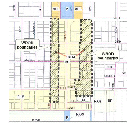
Boundary The WROD is applied in an area designated residential low medium (RLM) that is shown in the map below and is generally located parallel to Beach Boulevard from Shore Boulevard to 28th Avenue South, one-half block east of 56th Street South and one-half block west of 54th Street south. It includes the RLM area that runs parallel to the MU area along Beach Boulevard.
d.
Conditional uses. The uses listed below would be in addition to what is already permitted in the RLM district. These uses are conditional uses subject to site plan approval by the planning and zoning board and the community redevelopment agency. Procedures and requirements for site plan review and approval shall be as set forth in article VII of this chapter.
1.
Personal or business services other than medical (e.g. law, accountant, architectural/planning/engineering brokerage services and similar uses which meet the purpose of the WROD.
2.
Post office, accessory to retail sales only.
3.
Florist.
4.
Beauty/barber shop.
5.
Locksmith.
6.
Watch, clock, jewelry (sales and service).
7.
Photography studio.
8.
Tailor/seamstress.
9.
Art gallery/studio.
10.
Antique shops (indoor sales).
11.
Educational material sales (books, art supplies, music supplies, and similar educational materials).
12.
Bed and breakfast subject to the provisions of subsection 22-5.08(h) in the waterfront redevelopment zoning district.
13.
Additionally, other low traffic uses in the district will be allowed similar in character to the uses described above. Uses not listed above will be reviewed for approval for consistency with the "purpose" of the WROD during site plan review and also by the planning and zoning board and city council/community redevelopment agency.
e.
Prohibited uses. The uses listed below are prohibited from locating in the WROD.
1.
Restaurants.
2.
Bars, pubs and other businesses reliant on the sale of alcoholic beverages.
3.
Raves, dance clubs and other like assembly uses.
4.
Tattoo/body piercing establishments.
5.
Lingerie shops in conjunction with modeling services.
6.
Medical offices.
7.
Medical clinics.
8.
Dental services.
9.
Gun shops.
10.
Pawn shops.
11.
Other uses determined by staff to not be consistent with the purpose of the WROD, to not be compatible with the residential area, or which generate excessive traffic in the neighborhood.
f.
Parking. Off-street - A maximum of four (4) parking spaces shall be allowed on site. Parking shall be in the rear of the building whenever feasible. Alley access shall be utilized if available to the site. On-site parking shall be a pervious material such as mulch, shell or turf-block or a combination thereof with the exception of any handicap parking space. An existing driveway may be used for parking provided that no more than twenty (20) percent new, impervious material (of the existing driveway) is constructed with the exception of handicap parking and access thereto.
g.
Signs. All signs for conditional uses within the waterfront redevelopment overlay district shall be regulated as set forth in this section. All other signs shall be as set forth in article XVII of this chapter.
1.
Wall signs are permitted in the WROD. Signs are limited as defined herein.
a.
Only one (1) wall sign will be permitted, per business, on each lot used for commercial purposes in the RLM area of the waterfront redevelopment district described above and pursuant to the following criteria:
i.
The sign shall be limited to six (6) square feet in area;
ii.
The sign shall be located on private property;
iii.
The sign application shall include a graphic representation of the proposed sign, including all copy to be located thereon;
iv.
The sign shall be harmonious with the surrounding properties and maintain the integrity of the neighborhood. This shall apply to any lighted signs as well in order to ensure that the residential character of the street is maintained. Illuminated signs shall only he utilized during business hours of operation;
v.
The sign shall not be in violation of the provisions of article XVII of this chapter, pertaining to signs.
h.
Dimensional regulations. Same as RLM provisions in the waterfront redevelopment district (WRD) zoning district as they apply to single-family residential development.
i.
Height. Same as RLM provisions in the WRD zoning district as they apply to single-family residential development.
j.
Appearance.
1.
Mixed use or commercial conversions must retain a single-family residential appearance and be in character with the existing neighborhood. They shall relate to human scale.
2.
They must meet the building design standards for residential development in the conservation overlay district, as set forth in section 22-6.13. This shall include the remodeling of facades.
3.
Any construction or remodeling shall preserve the existing single-family residential character of the area.
4.
There shall be no outdoor storage of equipment, supplies, or vehicles other than those normally associated with single-family uses.
5.
Showcase windows are permitted as long as the structure remains residential in appearance. Showcase windows are limited to twenty-five (25) percent of the total facade area facing the street and will be subject to approval during the development review process. If showcase window(s) are utilized, a clear line of sight from the street shall also be provided.
(c)
Buffering requirements. Where the rear or side property line of a lot developed or proposed to be developed for a nonresidential use adjoins any residential zoning district, the mixed use limited area (MUL) or low medium residential area (RLM) of the WRD zoning district, or a public street adjoining any residential zoning district, or any of the foregoing areas of the WRD zoning district, suitable buffering shall be provided when and as required by the community redevelopment agency.
(d)
Public hearings. Whenever a public hearing is required by the provisions of this section the same shall be conducted by the community redevelopment agency as set forth herein and notice of said hearing shall be provided in accordance with this chapter.
(e)
Site plan and conditional use review. Within the waterfront redevelopment district, any change in lot, building or structure shall be subject to site plan review. Procedures and requirements for site plan review and approval shall be as set forth in article VII of this chapter. No site plan approval shall be required where the use of the subject property is single-family or duplex dwelling, both prior to and after any requested change in lot or structure. Conditional use review shall be conducted by the planning and zoning board and the community redevelopment agency by public hearing as provided herein, and shall also be subject to the review and approval requirements provided in article VIII and all other applicable provisions of this chapter.
(f)
Off-street parking and service requirements. The off-street parking provisions of article VI of this chapter shall apply in the waterfront redevelopment district, with the following exemptions:
(1)
Within existing buildings. Any change of use within an existing building located in the WRD zoning district, built or permitted prior to May 1, 2006 is not required to provide additional off-street parking to accommodate the change in use.
(2)
New buildings or additions. Off-street parking requirements for retail commercial and office uses permitted within the following areas may be reduced by the following percentages:
a.
Commercial limited area: Thirty (30) percent.
b.
Mixed use area: Thirty (30) percent.
c.
Resort facility area: Twenty (20) percent.
(3)
Commercial and mixed-use buildings meeting the optional design standards of subsection 22-6.13(h) shall be exempt from the off-street parking standards of article VI of this chapter.
(g)
Outdoor sales or displays. There shall be no outdoor sales or displays, or outdoor commercial recreation/entertainment in the waterfront redevelopment district, unless a special permit for the same has been approved as provided in article VI of this chapter.
(h)
Special criteria for bed and breakfast. The following criteria shall apply to all bed and breakfast establishments within the waterfront redevelopment district:
(1)
Guest rooms may share toilet and bathing facilities, however, in no instance shall the owner and guests have shared bathrooms.
(2)
The maximum number of rooms for guests shall be as follows:
(3)
Rentals shall be on a daily basis, only. The maximum stay for an individual guest shall be thirty (30) days in a 12-month period.
(4)
Changes to the gross floor area shall not be allowed unless it can be demonstrated that the change is only necessary to add a bathroom and will not alter the residential character of the building.
(5)
In addition to the parking required for the residence, one (1) parking space shall be provided for each guest room. The community redevelopment agency may vary the parking requirement based on site constraints including, but not limited to, small yards, inadequate space for parking, and the availability of on-street parking.
(i)
Special criteria for accessory artist studios and professional office in the mixed use limited area. The following special criteria shall apply to any accessory artist studio or professional office within the mixed use limited area of this zoning district:
(1)
No more than thirty (30) percent of the gross floor area of any dwelling shall be used for an accessory artist studio or professional office. Such occupation shall be conducted wholly within the dwelling or accessory structure;
(2)
No display of goods, or outside storage of equipment or materials used in the occupation shall be permitted;
(3)
No person shall be employed on the premises other than members of the family residing thereon.
(4)
The following occupations shall be permitted:
a.
Certified public accountant;
b.
Appraiser;
c.
Attorney;
d.
Architect;
e.
Broker, real estate, stock, securities and insurance;
f.
Draftsman;
g.
Engineer;
h.
Interior designer;
i.
Investment counselor.
(5)
Traffic generated by the occupation shall not exceed the metropolitan planning organization traffic generation standard for single-family dwelling use by more than twenty (20) percent.
(j)
Signs. All signs within the waterfront redevelopment district shall be regulated as set forth in Article XVII of this chapter and in accordance with the following:
(1)
The redevelopment district entry sign shall be exempt from regulations set forth in article XVII of this chapter;
(2)
The limitations provided in the following table shall supersede any restrictions provided in article XVII of this chapter to the contrary, as to the height, area or projection of signs within the waterfront redevelopment district:
*The type of freestanding sign permitted in this area is limited to a ground sign as defined herein.
**WROD signage is regulated in subsection 22-5.08(b)(8)g. of this chapter.
(3)
Notwithstanding the limitations on freestanding signs provided herein, the community redevelopment agency may authorize one (1) freestanding sign, per business, on each lot used for commercial purposes in the mixed use (MU) area of the waterfront redevelopment district (WRD), for any business that does not have its primary business building entrance door within seventy-five (75) feet of that lot's front yard property line, as measured along any point on said property to the primary business building entrance door of the business, pursuant to the following criteria:
a.
The sign shall be limited to six (6) square feet in area and six (6) feet in height;
b.
The sign shall be located on private property;
c.
The sign application shall include a graphic representation of the proposed sign, including all copy to be located thereon;
d.
The sign shall be a removable sign with a fixed permanent mounting at grade;
e.
The sign shall only be displayed between the hours of 8:00 a.m. and 12:00 a.m.;
f.
The sign shall be harmonious with the surrounding properties and maintain the integrity of the neighborhood;
g.
The sign shall not be in violation of the provisions of article XVII of this Code, pertaining to signs;
h.
The lot on which such sign shall be erected shall abut either Beach Boulevard or Shore Boulevard; and
i.
No alternative sign will adequately provide the subject business with exposure to pedestrian and automobile traffic on either Beach Boulevard or Shore Boulevard.
(4)
Waterfront redevelopment overlay district (WROD) signage is regulated in subsection 22-5.08(b)(8)g. of this chapter.
(k)
Nonconformities. Notwithstanding other provisions of this Code to the contrary, the community redevelopment agency may authorize additions, alterations, or other improvements to nonconforming uses or structures, based on a finding that any such improvements are compatible with surrounding uses and development trends.
(Ord. No. 93-14, § 5, 10-5-93; Ord. No. 94-1, § 1, 9-1-94; Ord. No. 95-14, §§ 0, 1, 1-2-96; Ord. No. 96-4, § 1, 3-5-96; Ord. No. 96-18, § 3, 10-1-96; Ord. No. 97-1, § 2, 1-21-97; Ord. No. 98-12, §§ 1, 2, 8-4-98; Ord. No. 99-11, § 1, 8-3-99; Ord. No. 2000-9, §§ 1, 2, 7-18-00; Ord. No. 2000-20, §§ 12—18, 10-3-00; Ord. No. 2002-15, § 1, 10-1-02; Ord. No. 2003-07, § 1, 4-1-03; Ord. No. 2003-08, § 1, 4-1-03; Ord. No. 2006-15, § 1, 7-18-06; Ord. No. 2007-03, § 11, 4-3-07; Ord. No. 2008-02, §§ 1—3, 3-18-08; Ord. No. 2010-02, §§ 2—4, 2-2-10; Ord. No. 2012-06, § 5, 3-6-12; Ord. No. 2012-23, § 1, 1-3-13; Ord. No. 2013-17, § 1, 11-19-14; Ord. No. 2017-13, § 2, 1-16-18; Ord. No. 2021-04, § 1, 10-19-21; Ord. No. 2021-16, § 1, 11-2-21)
Sec. 22-5.09. - CL-1 (commercial limited) zoning district.
(a)
Purpose. The purpose of the CL-1 (limited commercial) zoning district shall be to locate and establish areas within the City of Gulfport which are suited for the development and maintenance of limited commercial activities offering convenience goods and personal services to residents of the immediate neighborhood area; to encourage the grouping and interrelationship of established uses so as to permit a high level of pedestrian movement within the district; to designate those uses and services appropriate for location and development within said zoning district; and to establish such development standards and provisions as are necessary to ensure proper development and functioning of uses within the district.
(b)
Permitted principal uses and structures. The following uses and structures are permitted. There shall be no outdoor sales or displays, as provided herein, unless a special permit for the same has been approved.
(1)
Personal services;
(2)
Financial institution, including drive-through facilities;
(3)
Funeral home;
(4)
Transient accommodations;
(5)
Office, business or professional;
(6)
Restaurant;
(7)
Retail sales.
(8)
Medical marijuana dispensing facilities.
(c)
Conditional uses. The following uses shall be permitted only upon review and approval of the city council:
(1)
Day care center;
(2)
Single-family and duplex dwellings;
(3)
Multiple-family dwelling;
(4)
Publicly owned or operated building or use;
(5)
Repair service;
(6)
Clinic;
(7)
Towers, for telecommunication services, in accordance with article XXII hereof;
(8)
Drive-through facilities accessory to permitted uses.
(d)
Minimum lot requirements. No specific requirements have been established. Multiple-family dwellings shall be subject to the minimum lot requirements set forth in section 22-5.05 of this chapter.
(e)
Minimum green space requirement.
(1)
Residential use shall have a minimum green space of twenty-five (25) percent.
(2)
Nonresidential use shall not exceed an impervious surface ratio (ISR) as provided in the comprehensive plan.
(f)
Maximum building coverage.
(1)
Maximum building coverage for residential uses shall be forty (40) percent.
(2)
Nonresidential and mixed-use developments shall not exceed a floor area ratio (FAR) as provided in the comprehensive plan.
(g)
Maximum building height. The maximum building height for single-family or duplex dwellings shall be thirty (30) feet and no building shall have more than two (2) stories of living area. All other uses shall have a maximum building height of forty-five (45) feet.
(h)
Minimum yard requirements.
(1)
All uses shall have a minimum front yard of twenty-five (25) feet.
(2)
Each side yard shall have a minimum depth of six (6) feet, provided that no side yard shall be required where a fire wall meeting all code requirements is provided.
(3)
Where alleys exist as a means of access to the rear of properties, no rear yard is required. Where no alley exists, a rear yard having a minimum depth of eight (8) feet shall be provided.
(4)
Multiple-family dwelling shall be subject to the applicable yard requirements of section 22-5.05(i).
(i)
Site plan review. All permitted and conditional uses shall be subject to the provisions of article VII and article VIII of this chapter.
(j)
Outdoor sales and displays. There shall be no outdoor sales or displays in the CL-1 (Commercial Limited) zoning district unless a special permit for the same has been approved as provided in article VI of this chapter.
(Ord. No. 93-14, § 5, 10-5-93; Ord. No. 97-9, § 2, 6-3-97; Ord. No. 2000-20, § 9, 10-3-00; Ord. No. 2001-01, §§ 1, 3, 1-16-01; Ord. No. 2007-01, § 2, 1-16-07; Ord. No. 2012-06, § 6, 3-6-12; Ord. No. 2012-23, § 2, 1-3-13; Ord. No. 2016-08, § 1, 11-1-16; Ord. No. 2017-13, § 3, 1-16-18)
Sec. 22-5.10. - CL-2 (commercial retail) zoning district.
(a)
Purpose. The purpose of the CL-2 (commercial retail) zoning district shall be to locate and establish areas within the City of Gulfport which are suited for the development and maintenance of general retail, business, and personal service uses intended to serve the daily shopping and business needs of community requirements; to designate those uses and services appropriate for location and development within said zoning district; and to establish such development standards and provisions as are necessary to ensure proper development and functioning of uses within the district.
(b)
Permitted principal uses and structures. The following uses and structures are permitted. There shall be no outdoor sales or displays, as provided herein, unless a special permit for the same has been approved.
(1)
Retail sales;
(2)
Office, business or professional;
(3)
Personal services;
(4)
Public administrative service building;
(5)
Public safety facility; including a police or fire station;
(6)
Restaurant;
(7)
Commercial entertainment use or recreation use conducted entirely within an enclosed building;
(8)
Automotive washing establishment;
(9)
Church;
(10)
Civic or community organization; and
(11)
Funeral home.
(12)
Medical marijuana dispensing facilities.
(c)
Conditional uses. The following uses shall be permitted only upon review and approval of the city council:
(1)
Automotive service station;
(2)
Christmas tree sales (outside, seasonal);
(3)
Clinic;
(4)
Day care center;
(5)
Drive-through facilities accessory to permitted use;
(6)
Transient accommodations;
(7)
School, trade (vocational);
(8)
Tavern;
(9)
Package store;
(10)
Public park for passive recreation use, including picnic areas and playground equipment, not to exceed one and one-half (1.5) acres; and
(11)
Towers, for telecommunication services, in accordance with Article XXII hereof.
(d)
Minimum lot requirements. No specific minimum lot requirements have been established.
(e)
Minimum green space requirement. All uses shall not exceed an impervious surface ratio (ISR) as provided in the comprehensive plan.
(f)
Maximum building coverage. All uses shall not exceed a floor area ratio (FAR) as provided in the comprehensive plan.
(g)
Maximum building height. The maximum building height shall be forty-five (45) feet.
(h)
Minimum yard requirements.
(1)
The minimum front yard shall be ten (10) feet.
(2)
Each side yard shall have a minimum depth of six (6) feet, provided that no side yard shall be required where a fire wall meeting all code requirements is provided.
(3)
Where alleys exist as a means of access to the rear of properties, no rear yard is required. Where no alley exists, a rear yard having a minimum depth of eight (8) feet shall be provided.
(i)
Site plan review. All permitted and conditional uses shall be subject to the provisions of article VII and article VIII of this chapter.
(j)
Outdoor sales and displays. There shall be no outdoor sales or displays in the CL-2 (Commercial Retail) zoning district unless a special permit for the same has been approved as provided in article VI of this chapter.
(Ord. No. 93-14, § 5, 10-5-93; Ord. No. 97-9, § 3, 6-3-97; Ord. No. 97-20, §§ 1, 2, 10-7-97; Ord. No. 2001-01, §§ 2, 4, 1-16-01; Ord. No. 2012-06, § 7, 3-6-12; Ord. No. 2012-23, § 3, 1-3-13; Ord. No. 2017-13, § 4, 1-16-18)
Sec. 22-5.11. - CG (commercial general) zoning district.
(a)
Purpose. The purpose of the CG (commercial general) zoning district shall be to locate and establish areas within the City of Gulfport which are suited for the development and maintenance of general commercial facilities, said areas to be primarily located along established highways where a mixed pattern of commercial usage is substantially established; to designate those uses and services appropriate for location and development within said zoning district; and to establish such development standards and provisions as are necessary to ensure proper development and functioning of uses within the district.
(b)
Permitted principal uses and structures. The following principal uses and structures are permitted:
(1)
Retail sales;
(2)
Office, business or professional;
(3)
Personal service;
(4)
Any public use of property owned or operated by the city;
(5)
Indoor storage facilities;
(6)
Restaurant;
(7)
Commercial entertainment use or recreation use conducted entirely within an enclosed building;
(8)
Automotive sales (new cars or used car lot), including related repairs conducted entirely within an enclosed building;
(9)
Automotive service station;
(10)
Automotive washing establishment;
(11)
Vessel and marine supplies; repair and sales;
(12)
Warehouses;
(13)
Trade shop, including roofing, plumbing, electrical, and the like;
(14)
Medical marijuana dispensing facilities;
(15)
Medical marijuana treatment centers.
(c)
Conditional uses. The following uses shall be permitted only upon review and approval of the city council:
(1)
Wholesale sales;
(2)
Tavern;
(3)
Package store;
(4)
Distribution center;
(5)
Towers, for telecommunication services, in accordance with Article XXII hereof;
(6)
Day care center.
(d)
Minimum lot requirements. No specific minimum lot requirements have been established.
(e)
Minimum green space requirement. Residential equivalent and nonresidential use shall not exceed an impervious surface ratio (ISR) as provided in the comprehensive plan.
(f)
Maximum building coverage. Residential equivalent and nonresidential use shall not exceed a floor area ratio (FAR) as provided in the comprehensive plan.
(g)
Maximum building height. The maximum building height shall be forty-five (45) feet.
(h)
Minimum yard requirements.
(1)
The minimum front yard depth shall be ten (10) feet.
(2)
Each side yard shall have a minimum depth of six (6) feet, provided that no side yard shall be required where a fire wall meeting all code requirements is provided.
(3)
Where alleys exist as a means of access to the rear of properties, no rear yard is required. Where no alley exists, a rear yard having a minimum depth of eight (8) feet shall be provided.
(i)
Site plan review. All permitted and conditional uses shall be subject to the provisions of article VII and article VIII of this chapter.
(Ord. No. 93-14, § 5, 10-5-93; Ord. No. 97-9, § 4, 6-3-97; Ord. No. 98-7, § 1, 4-21-98; Ord. No. 2003-08, § 4—6, 4-1-03; Ord. No. 2012-06, § 8, 3-6-12; Ord. No. 2017-13, § 5, 1-16-18)
Sec. 22-5.12. - I (institutional) zoning district.
(a)
Purpose. The purpose of the I (institutional) zoning district shall be to locate and establish areas within the City of Gulfport which are suited for the development and maintenance of public, semi-public, and institutional uses, which are not owned or leased by the City of Gulfport; to designate those uses and services appropriate for location and development within said zoning district; and to establish such development standards and provisions as are necessary to ensure proper development and functioning of uses within the district.
(b)
Permitted principal uses and structures. The following principal uses and structures are permitted:
(1)
Universities, colleges, academies and similar facilities for learning, including dormitories, student centers and other facilities integral to the use;
(2)
Churches, including related education and training facilities;
(3)
Public and private elementary, middle and high schools;
(4)
Nonprofit social or community services;
(5)
Nursing homes;
(6)
Hospitals;
(7)
Civic or community organizations.
(c)
Conditional uses. The following uses shall be permitted only upon review and approval of the city council:
(1)
Alcoholic beverages sales for on premises consumption only, in conjunction with a fraternal organization, student center or school sponsored events;
(2)
Child day care; or
(3)
Cemeteries, without crematories.
(d)
Minimum lot requirements. The minimum lot requirements shall be ten thousand (10,000) square feet and a minimum width of eighty (80) feet.
(e)
Minimum green space requirement.
(1)
Residential uses shall have a minimum green space of thirty (30) percent.
(2)
Nonresidential use shall not exceed an impervious surface ratio (ISR) as provided in the comprehensive plan.
(f)
Maximum building coverage.
(1)
Residential uses shall have a maximum building coverage of forty (40) percent.
(2)
Nonresidential use shall not exceed a floor area ratio (FAR) as provided in the comprehensive plan.
(g)
Maximum building height. The maximum building height shall be forty-five (45) feet.
(h)
Minimum yard requirements.
(1)
The minimum front yard shall be twenty-five (25) feet.
(2)
The minimum side yard shall be six (6) feet for one yard and a combined minimum width of fifteen (15) feet for both yards.
(3)
The minimum rear yard depth shall be twenty-five (25) feet.
(i)
Site plan review. All permitted and conditional uses shall be subject to the provisions of article VII and article VIII of this chapter.
(Ord. No. 93-14, § 5, 10-5-93; Ord. No. 96-21, § 2, 11-19-96; Ord. No. 2000-20, § 10, 10-3-00; Ord. No. 2000-24, § 1, 11-7-00; Ord. No. 2012-06, § 9, 3-6-12)
Sec. 22-5.13. - P (public) zoning district.
(a)
Purpose. The purpose of the P (public) zoning district shall be to locate and establish areas within the City of Gulfport which are suited for the development and maintenance of public uses for properties owned by the City of Gulfport; to designate those uses and services appropriate for location and development within said zoning district; and to establish such development standards and provisions as are necessary to ensure proper development and functioning of uses within the district.
(b)
Permitted principal uses and structures. The following principal uses and structures are permitted:
(1)
Any public use of property owned or operated by the City of Gulfport;
(2)
Any use of property leased from the City of Gulfport, which use has been found by the city council to be compatible with the existing or permitted use(s) of adjacent properties;
(3)
Public park for passive recreation use, including picnic areas and playground equipment, not to exceed one and one-half (1.5) acres.
(c)
Conditional uses. The following uses shall be permitted only upon review and approval of the city council:
(1)
Towers, for telecommunication services, in accordance with Article XXII hereof.
(d)
Minimum lot requirements. The minimum lot requirements for all uses other than parks and open recreation areas, shall be ten thousand (10,000) square feet and a minimum width of eighty (80) feet.
(e)
Minimum green space requirement. Nonresidential use shall not exceed an impervious surface ratio (ISR) as provided in the comprehensive plan.
(f)
Reserved.
(g)
Maximum building coverage. Nonresidential use shall not exceed a floor area ratio (FAR) as provided by the comprehensive plan.
(h)
Maximum building height. The maximum building height shall be forty-five (45) feet.
(i)
Minimum yard requirements.
(1)
The minimum front yard depth shall be twenty-five (25) feet.
(2)
The minimum side yard shall be six (6) feet for one yard and a combined minimum width of fifteen (15) feet for both yards.
(3)
The minimum rear yard depth shall be twenty-five (25) feet.
(Ord. No. 93-14, § 5, 10-5-93; Ord. No. 97-9, § 5, 6-3-97; Ord. No. 2000-20, § 6, 10-3-00)
Sec. 22-5.14. - PUD (planned unit development) zoning district.
(a)
Purpose. The purpose of the PUD (planned unit development) zoning district shall be to provide opportunity, upon application and through the process of unified planning and coordinated development, for the creation of new neighborhood or community areas which, by virtue of their specialized nature and unique design, are not adaptable to regulation by the requirements of other zoning district classifications within this chapter. It is intended that the regulations and requirements applying to a PUD zoning district shall be sufficiently flexible in structure so as to encourage creative and imaginative design in planning and development. Where there are conflicts between the requirements set forth herein for a PUD zoning district and the general provisions of this chapter or other applicable codes of the Codes of the City of Gulfport, the requirements herein shall govern; provided, however, that development within a PUD zoning district shall not exceed standards within said other applicable codes.
(d)
Permitted principal uses and structures. No specific uses are designated herein. Uses permitted within a particular PUD zoning district shall be only those uses deemed by the city council to be fully compatible with each other, with the context of the proposed development as a whole and with the zoning and land use patterns of surrounding areas. The type, general location, and extent of all proposed uses shall be clearly designated as part of the general concept plan, and approval of said uses or types of uses as part of a rezoning amendment shall constitute the permitted land use requirements of a particular PUD zoning district to the same extent and degree as were said permitted uses specifically included in the context of this chapter. Any proposed change of approved land usage, shall require a rehearing and approval in accordance with the procedures herein established.
(c)
Conditional uses. No conditional uses shall be permitted within a PUD zoning district.
(d)
Accessory uses. Accessory uses shall be permitted only as specifically set forth within the approved general concept plan or as found by the city to be compatible with said plan.
(e)
Minimum lot requirements. A PUD zoning district shall include no less than ten (10) acres of contiguous land and shall be of such proportions as to properly accommodate all proposed uses in keeping with the general requirements of the city and the established policies and objectives of the comprehensive plan. There shall be no specific lot requirements for individual uses; provided, however, that the area designed for any particular use shall be of sufficient size and proportions so as to properly accommodate said use and to provide for adequate open area between it and an adjacent use. The density/intensity of use shall not exceed the requirements of the land use plan category assigned to the subject property.
(f)
Minimum green space requirement. A minimum of twenty (20) percent of total site area, less any area(s) devoted exclusively to nonresidential uses, shall be devoted to common open space and recreation areas. Said areas shall be exclusive of areas required for streets, off-street parking, setbacks at the periphery of the development, and necessary open spaces between buildings and other uses.
(g)
Maximum building coverage. The maximum combined area of building coverage by all residential, community, and recreation structures shall not exceed thirty (30) percent of the gross site area, excluding any portion of the site devoted exclusively to nonresidential uses; provided, however, that said maximum building coverage shall be forty (40) percent of the gross site area, excluding any portion devoted exclusively to nonresidential uses, where covered parking is included as an integral part of the residential structures. Where residential and nonresidential uses are combined within a single structure, the site area of said structure shall be included as part of the gross site area for purposes of calculating residential land coverage. Maximum building coverage for structures devoted to nonresidential usage shall be thirty (30) percent of that portion of the gross site area devoted to said nonresidential usage.
(h)
Maximum building height. The maximum height of structures within a PUD district shall be as specifically established by the city council in its approval action.
(i)
Yard requirements and buffering.
(1)
Where the PUD district adjoins any residential district, all portions of a structure shall be set back a distance equal to its total height from any private property within said residential district or a distance equal to one-half its height from any property line adjoining a street, right-of-way, or waterway; provided, that in no case shall said setback distance be less than thirty-five (35) feet.
(2)
Buffering shall be provided in accordance with the provisions of section 22-6.07 as specifically required by the city council in its approval action.
(j)
Conformance with city and countywide future land use plan. All development within this zoning district shall be in conformance with the city and countywide future land use plans and the standards for use, location, density, intensity and other standards contained therein, except where standards set by this district are more restrictive. No density or intensity averaging shall be permitted among separate land use categories.
(k)
Procedures on PUD amendments. The following steps shall be utilized in the application, review, and approval of a PUD rezoning petition:
(1)
Preapplication conference(s). The applicant or his authorized representative(s) shall confer with the chief building official and such other city official as may be requested to participate by the chief building official prior to filing an application for a change of zone to the PUD district. The purpose of said conference(s) shall be to permit the applicant to present an initial concept of the proposed development, to benefit from comment by the chief building official and other officials, and to receive any appropriate clarification concerning application requirements and review procedures to be followed.
(2)
Petition for rezoning; material to be submitted. A petition for PUD rezoning shall be submitted in accordance with the general rezoning requirements of this chapter. In addition, the materials submitted with the petition, or upon subsequent request by the chief building official, the planning and zoning board, or the city council, shall include all plans, maps, studies, and reports which may reasonably be required in order to make the findings and determinations called for in the particular case, with sufficient copies for necessary referrals and records. Minimum initial materials to be submitted shall include the following:
a.
A statement identifying the owners of all property within the area of the proposed district, together with evidence of the unified control of said entire area. If submitted by other than the current owner(s) of the property, the statement shall be accompanied by satisfactory evidence of the existence of purchase or lease agreement(s) or other appropriate instrument(s) to indicate current or future unified control of the property. The statement shall include agreement:
1.
That the proposed development shall be in accordance with the provisions of the petition for PUD rezoning and all materials submitted with the petition and supplied upon request, and in accordance with such specified modifications thereof as may be required by the city council and agreed to the petitioner;
2.
To provide acceptable surety bond, or letter of credit, or similar security to the city for each phase of the proposed development prior to the commencement of construction of such phase as to assure completion of such publicly owned and operated water lines, sewer lines, streets, or similar publicly owned and operated facilities required of petitioner by the amendment granting PUD zoning;
3.
To file with the city copies of any condominium prospectus and the corresponding letter of approval from the Florida Department of Business Regulation in order to ensure that provision will be made for the continuing operation and maintenance of all common facilities and open areas; and
4.
To bind all successors of petitioner to such agreement.
b.
A vicinity map at an appropriate scale showing the relationship of the property to the surrounding property and the street network.
c.
A written legal description and map for advertising of public hearing. The legal description shall contain the name, plat book, and page number(s) of any recorded subdivision comprising all or part of the property. The map shall be of suitable size or newspaper reproduction and shall clearly show the boundaries of the property, the existing zoning district(s) applying to the property, and the zoning district(s) applying to all adjacent properties.
d.
A survey map or maps at an appropriate scale, indicating boundaries, including dimensions; total area of all properties involved; ownership of all properties involved; ownership of adjacent properties; identification and location of all existing structures upon the property; identification and location of all rights-of-way, easements, utility lines, drainage, or other public or private structures existing upon or adjacent to the property.
e.
A general concept plan at appropriate scale showing the types, general grouping and massing arrangement of all proposed buildings; the uses or types of uses intended for each general grouping of buildings; the approximate total floor area and residential floor area of each general building grouping and of the total development; the total number of dwelling units proposed for each general building grouping and for the total development; the approximate location of all proposed streets, driveways, and parking and service areas (indicating number of parking spaces to be provided); and the location and character of proposed open spaces and recreation areas.
f.
A schematic traffic flow plan showing by approximate location the estimated volumes of peak-hour vehicular traffic movement throughout the property, and indicating its point(s) of access to egress from the property. (This requirement may be waived by the chief building official when it is determined that the proposed development is of such limited size so as to create no undue volumes of vehicular traffic movement.)
g.
A supportive report indicating the degree of compliance of the proposal with the city's comprehensive plan and including all other data, descriptions, or illustrative material necessary to supplement the required graphic materials. Any prepared market analysis or feasibility study shall be submitted as part of the supportive material. If applicable, a description of the proposed staging plan shall also be submitted describing the general geographic area and development components proposed for each project stage, and setting forth anticipated starting and completion date for each project stage.
(3)
Review by planning and zoning board. All application materials shall be submitted to the planning and zoning board for its review. The planning and zoning board may request the applicant to submit additional materials or data deemed reasonably necessary to its review of the proposed material. Following its review, the planning and zoning board shall submit within sixty (60) days its recommendations upon the proposed rezoning to the city council; including any additional requirements deemed necessary to ensure a proper development of the project.
(4)
Action by city council. Upon receipt of the recommendation of the planning and zoning board, the city council shall hold a public hearing on the petition in accordance with the requirements set forth in this chapter. Following the hearing, the city council shall:
a.
Grant the amendment as proposed;
b.
Grant with specific modifications agreed to by the petitioner; or
c.
Deny the amendment.
Such action shall include the plan and all instruments related thereto in the form and degree of completion reached at the time of announcement of the public hearing before the city council. If the city council grants the amendment, the development shall be in accordance therewith and with general PUD requirements existing at the time of amendment except as such requirements are modified in their application in the amending action. Said development shall conform to any order of priority or time limitations established by the city council in amendment as to beginning and completion of the development as a whole of specified stages. Before development may proceed, copies of any prospectus, letter of approval, or other assurance as may be reasonably required shall have been received by the city. If the city council grants the amendment, the subject property shall be designated PUD on the official zoning map.
(5)
Action following PUD rezoning. Following PUD rezoning, no building permit or certificate of occupancy shall be issued in the district until and unless final plans and reports have been submitted in such detail as necessary for determination of compliance with PUD regulations and requirements of other applicable city regulations or ordinances, and have been approved by the appropriate officer or agency as complying with all said regulations, requirements, and ordinances as applying generally at the time of the amendment or as modified by the city council in its amending actions. The applicant shall confer with the chief building official prior to final plan submission for any stage or project to determine the specific submission requirements for the particular stage or project involved. With respect to the general regulations and requirements of the PUD zoning district, as originally set forth or as modified by the city council in its rezoning action, the compliance therewith of final plans shall be reported in writing to the city council by the planning and zoning board, said report to be submitted within sixty (60) days following the initiation of review by the board. All such final plans shall be for the development as a whole or for stages and priorities approved by the city council in its rezoning action. No structure or use other than as indicated in approved final plans or reports shall be permitted. Upon its finding that final plan for any stage or project complies with all regulations and requirements of the PUD zoning district, the city council shall certify said finding by official action.
(6)
Changes in development plans. Modification of the concept development plan may be approved by the city council upon a finding by said body that said modification provides equivalent amenities to those set forth in the concept plan and reports approved by the city council and does not result in an overall increase in intensity of land use, density floor area, or ground coverage. Any proposed modification shall first have been reviewed by the planning and zoning board and reported thereon the city council within sixty (60) days following initiation of said review. The city council may also approve changes in the proposed staging of a development upon a finding that all public or private facilities and utilities required to service the proposed development stage may be properly provided and maintained in accordance with the revised construction schedule.
(7)
Expiration of time limits of PUD development. If development actions required in the rezoning amendment are not taken within any time limits set by the city council in its rezoning action, the planning and zoning board shall review the circumstances and recommend to the city council that:
a.
PUD zoning for the entire area be continued with revised time limits,
b.
PUD zoning be continued for part of the area with revised time limits, and the remainder be rezoned to appropriate classifications, or
c.
The entire area be rezoned from PUD to an appropriate classification.
Said recommendation shall include proposals for appropriate action in respect to any legal instruments involved in the case.
(Ord. No. 93-14, § 5, 10-5-93)
Sec. 22-5.15. - COD (conservation overlay) zoning district.
(a)
Purpose. The city has a unique character that has been created over years of development. The area that this section is intended to cover will be referred to as the conservation overlay district. Development of this area started in the early 1900's and continues to be a popular residential area. The original predominant housing types were single-story bungalow and cottage styles, many of which were built as vacation homes. These homes were small and have been built onto throughout the years. Currently, there are a number of housing types that have created an eclectic mix of styles that have been remodeled and added to by a diversity of property owners throughout the years. The eclectic nature of the conservation overlay district, created by a diversity of housing styles built at a human scale is the very thing that residents are concerned about protecting.
New development pressures and flood plain regulations have created a pattern of development that is inconsistent with the character of these neighborhoods. While this area of the city has attracted new residents because of the character, their desire to build larger homes, devoid of any architectural features or landscaping, next to smaller single story homes is actually leading to the demise of the very thing that attracts new residents to the conservation overlay district.
The desire to build homes with modern interior layouts has led to the use of readily available tract home construction plans. When built next to each other, using the same architectural style, same general footprint and with little to no landscaping, these designs give the appearance of a new subdivision as opposed to complementing the scale, diversity and maturity of the surrounding neighborhood. Two-story development can create an even greater sense of incompatibility if the design does not include attention to massing or scale. This becomes problematic, particularly with redevelopment of existing structures on smaller lots. Many times the only cost effective way to build an addition is to build up. Flood regulations require elevating structures, which in turn creates a home that is often out of scale with surrounding homes.
The citizenry of the area have voiced their concerns about incompatibility issues with new residential development. Based upon this urging, the city council instructed staff to develop a set of architectural standards that would still encourage redevelopment of the conservation overlay district while protecting the character of this unique part of the city. That character, being defined in part by homes built on a human scale, has created the small town atmosphere found in this area. Human scale is the relationship or proportion between the human form and a structure. Gulfport is in fact a small town and the preservation of that character in the older part of the city is of paramount importance not only to the homeowners within the conservation overlay district, but to the city as a whole.
These guidelines are not intended to limit creativity, rather they are established to act as a tool for site-specific design of new and redeveloped structures that recognize and enhance the character of the surrounding neighborhood. The shape of a house, its arrangement of doors and windows, its roof style, its architectural style all make up the character of a house and contribute to the collective appearance of the neighborhood.
(b)
Applicability. The COD (conservation overlay) zoning district regulations shall apply to all property within the district in addition to any other zoning district regulations applicable to said property. These regulations shall apply to all new single-family and multi-family development and redevelopment or remodeling of existing single-family and multi-family development within the district, as set forth herein.
(c)
Building design standards. Developments subject to the requirements of this section shall be subject to the building design standards of section 22-6.13.
(Ord. No. 2004-12, § 1, 12-1-04; Ord. No. 2021-16, § 2, 11-2-21)
Sec. 22-5.16. - 49th Street redevelopment master overlay district (49thMOD).
(a)
Purpose. The purpose of the 49thMOD (49th Street redevelopment master overlay district) is to establish development standards which will enhance redevelopment opportunities within the district and implement the city's adopted 49th Street corridor community redevelopment plan, herein referred to as the redevelopment plan. The 49thMOD is intended to be consistent with the community redevelopment district (CRD) land use category of the Gulfport Comprehensive Plan. The district is intended to encourage and promote the revitalization of the 49th Street corridor community redevelopment plan area and to maintain the unique characteristics of the area. This is to be achieved by allowing a wide variety of mixed uses, preserving existing residential neighborhoods and establishing development regulations which will promote reinvestment in the district.
(b)
Boundary. The 49thMOD follows the same boundaries as set forth in the redevelopment plan with the exclusion of areas with an institutional (I), public (P), or open space (OS) zoning district designation. The boundaries are generally as follows:
Starting at the intersection of the Pinellas Trail and 49th Street South south to Gulfport Boulevard South; west to 51st Street South; north to 20th Avenue South; west to 55th Street South; north to 18th Avenue South; east to 52nd Street South; north to the Pinellas Trail; east to beginning.
(c)
Applicability. The 49thMOD is comprised of three overlay districts: commercial/mixed use overlay district (CMUOD), live-work overlay district (LWOD) and the Tangerine Parkway overlay district (TPOD). The three overlay districts as they relate with the existing zoning districts are as follows:
The three (3) overlay districts augment but do not otherwise replace the existing zoning districts. The site development parameters provided herein supersede any other requirements contained elsewhere in this land development code. Where this section is silent regarding any such development parameters the user shall default back to the underlying zoning district. All parcels outside the area provided in this section are not affected by the contents herein. In addition, those parcels within the public (P), open space (OS) and institutional (I) zoning districts are also excluded from any of the regulations contained herein.
(d)
Permitted principal uses and structures. Uses and structures permitted within the 49thMOD and associated density (units per acre), intensity (floor area ratio, impervious surface ratio), and building height standards shall be consistent with the text, illustrations and maps within in the redevelopment plan. The following shall be permitted uses and development standards applicable to each of the following areas of the 49thMOD:
(1)
Commercial/mixed use overlay district (CMUOD) area.
a.
CMUOD purpose. The purpose of the CMUOD is to establish development standards which will enhance redevelopment opportunities within the district and implement the city's adopted 49th Street corridor community redevelopment plan. The CMUOD is intended to be consistent with the community redevelopment district (CRD) land use category of the Gulfport comprehensive plan and the adopted 49th Street corridor community redevelopment area plan. The district is intended to encourage and promote the revitalization of the 49th Street corridor community redevelopment area by allowing for a mix of nonresidential and mixed-use uses consistent with the commercial character of the area, the street configuration and design, as well as its operational characteristics.
b.
CMUOD boundary. The CMUOD generally includes those parcels directly along 49th Street South within the CG and CL-2 zoning districts.
c.
CMUOD permitted principal uses and structures. The following uses and structures are permitted in addition to those uses and structures as otherwise permitted by the underlying zoning districts.
1.
Creative industries (as defined in section 22-2.02, specific terms); and
2.
Mixed-use (as defined in section 22-2.02, specific terms): All permitted uses as combined with residential uses.
d.
CMUOD maximum building coverage.
1.
For nonresidential developments within the commercial general (CG) zoning district refer to the commercial general (CG) future land use plan classification within the comprehensive plan.
2.
For nonresidential developments within the commercial retail (CL-2) zoning district refer to the commercial limited (CL) future land use plan classification within the comprehensive plan.
3.
All mixed-use uses, regardless of zoning district, shall not exceed a FAR of 0.75.
e.
CMUOD minimum green space requirement:
1.
For parcels within the commercial general (CG) zoning district refer to the commercial general (CG) future land use plan classification within the comprehensive plan.
2.
For parcels within the commercial retail (CL-2) zoning district refer to the commercial limited (CL) future land use plan classification within the comprehensive plan.
f.
CMUOD maximum density.
1.
Temporary/tourist lodging: a maximum density of forty (40) units per acre; or
2.
Residential: a maximum density of twenty-four (24) dwelling units per acre (as part of a mixed-use development only); or
3.
Residential equivalent of forty-eight (48) beds per acre.
g.
CMUOD off-street parking and service requirements. The off-street parking provisions of article VI of this chapter shall apply in the CMUOD, with the following modifications:
1.
Mixed-use:
i.
Residential component: One and one-half (1.5) spaces per dwelling unit;
ii.
Non-residential component: Seventy (70) percent of the otherwise required parking requirement.
2.
For properties equal to or less than five thousand (5,000) square feet in area a maximum of four (4) parking spaces shall be allowed on site.
3.
Parking shall be in the rear of the building whenever feasible. Alley access shall be utilized if available to the site.
h.
CMUOD special criteria for mixed use developments.
1.
Mixed residential/commercial use development may be exempt from the proportionate share calculations in relation to the area of the parcel and may use any combination of allowable density for residential uses and FAR for nonresidential uses for mixed use development upon conditional site plan approval unless specified differently elsewhere in this section.
2.
Residential uses are only permitted as part of a mixed-use development;
3.
Mixed use development that has office and retail uses on the first floor and residential uses above shall be encouraged with the exception of retrofitting existing single-story buildings; however nonresidential uses shall be placed prominently in the front with residential uses in the rear.
4.
Temporary/tourist lodging may not be included as part of a mixed use development.
5.
Residential components of mixed-use developments shall not occupy more than forty (40) percent of the permitted maximum gross FAR of 0.75 nor less than thirty (30) percent of the maximum permitted density.
i.
Notwithstanding the minimum requirement for mixed use density set forth in section 5. above, nonresidential tenant spaces may have one (1) residential unit per business, however such space shall not occupy more than thirty (30) percent of the overall tenant space.
Example for mixed use calculations: A one-acre site will permit a maximum thirty-two thousand six hundred seventy (32,670) square feet of gross floor area. Nonresidential uses must occupy at least nineteen thousand six hundred two (19,602) square feet of that area. A minimum of seven (7) dwelling units up to twenty-four (24) dwelling units may be located within the remaining thirteen thousand sixty-eight (13,068) square feet.
(2)
Tangerine parkway overlay district (TPOD) area.
a.
TPOD purpose. The purpose of the TPOD (Tangerine Parkway overlay district) zoning district is to establish development standards which will enhance redevelopment opportunities within the district and implement the city's adopted 49th Street corridor community redevelopment plan. The TPOD zoning district is designed to be consistent with the community redevelopment district (CRD) land use category of the comprehensive plan and the adopted 49th Street corridor community redevelopment area plan. The district is intended to encourage and promote the revitalization of the 49th Street corridor community redevelopment area by allowing for a mix of residential and nonresidential uses consistent with the residential character of the area, the street configuration and design, as well as its operational characteristics. This is to be achieved by allowing a variety of mixed use/live-work and low intensity stand-alone nonresidential arrangements, preserving the existing residential character and scale of the existing neighborhood and establishing development regulations which will promote reinvestment in the district. New uses and conversions must retain a single-family residential appearance.
b.
TPOD boundary. The TPOD consists of those properties with frontage directly along Tangerine Parkway and within the R-2 and R-3 zoning districts.
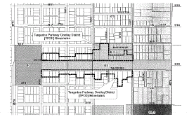
c.
TPOD permitted principal uses and structures. The following uses and structures are permitted in addition to those uses as otherwise permitted by the underlying zoning districts.
1.
Live-work (as defined in section 22-2.02, specific terms): The following uses as combined with a residential use where the principal operator of a business (as included in the list below) also maintains a portion of the building as a primary residence:
i.
Bed and breakfast subject to the provisions of section 22-5.16(i);
ii.
Professional office other than medical (e.g. law, accountant, architectural, planning, engineering, brokerage services and similar uses which meet the purpose of this district and are approved by the city);
iii.
Personal or business services such as beauty/barber shop, music studio/lessons, photography studio, tailor/seamstress, locksmith;
iv.
Low intensity retail sales and service such as florist, art gallery/studio, antique shops (indoor sales only), watch, clock, jewelry (sales and service);
v.
Creative industries (as defined in section 22-2.02, specific terms); and
vi.
Uses that are not specifically listed but which meet the purpose of this district and are approved by the city.
d.
TPOD special criteria for live-work uses.
1.
No more than fifty (50) percent of the gross floor area of any dwelling shall be used for a nonresidential use.
2.
Such occupation shall be conducted wholly within the dwelling or accessory structure.
3.
Traffic generated by the occupation shall not exceed the Metropolitan Planning Organization traffic generation standard for single-family dwelling use by more than twenty-five (25) percent.
4.
Any construction or remodeling shall be in keeping with the residential character of the area.
5.
Structures shall have a residential appearance, e.g. no commercial-style glass exterior doors or outdoor storage of equipment, supplies, or vehicles.
6.
Delivery/pick-up of goods by trucks with more than four axles or greater than twenty-four (24) feet in length shall be limited to once per week in order to minimize truck traffic in the area.
7.
No more than two pick-ups or deliveries of goods shall occur on weekdays other than those made by the business itself (i.e. delivery of flowers to a customer). Daily delivery of residential mail via a U.S. postal carrier, consistent with that received by single-family residential uses, is excluded from thresholds set forth herein.
8.
Showcase windows. See subsection k. below for appearance standards.
e.
TPOD conditional uses. The following uses and structures may be permitted as stand-alone uses as part of a conditional use approval process:
1.
Bed and breakfast subject to the provisions of subsection 22-5.16(i);
2.
Professional office other than medical (e.g. law, accountant, architectural, planning, engineering, brokerage services and similar uses which meet the purpose of this district and are approved by the city);
3.
Personal or business services such as beauty/barber shop, music studio/lessons, photography studio, tailor/seamstress, locksmith;
4.
Low intensity retail sales and service such as florist, art gallery/studio, antique shops (indoor sales only), watch, clock, jewelry (sales and service);
5.
Creative industries (as defined in section 22-2.02, specific terms); and
6.
Uses that are not specifically listed but which meet the purpose of this district and are approved by the city.
f.
TPOD minimum green space requirement:
1.
For parcels within the R-1 and R-2 zoning districts refer to the residential urban (RU) future land use plan classification within the comprehensive plan.
2.
For parcels within the R-3 zoning district refer to the residential low medium (RLM) future land use plan classification within the comprehensive plan.
g.
TPOD maximum building coverage:
1.
For parcels within the R-1 and R-2 zoning districts:
i.
Maximum building coverage for residential use is forty (40) percent.
ii.
Nonresidential use shall not exceed a floor area ratio (FAR) as provided within the residential urban (RU) future land use plan classification within the comprehensive plan.
2.
For parcels within the R-3 zoning district:
i.
Single-family and duplex dwelling(s) shall not exceed a maximum building coverage of forty (40) percent.
ii.
Multiple-family dwelling(s) shall not exceed a maximum building coverage of thirty (30) percent.
iii.
Nonresidential use shall not exceed a floor area ratio (FAR) as provided in the residential low medium (RLM) future land plan classification in the comprehensive plan.
h.
TPOD maximum density.
1.
For parcels within the R-1 and R-2 zoning districts refer to the residential urban (RU) future land use plan classification within the comprehensive plan.
2.
For parcels within the R-3 zoning district refer to the residential low medium (RLM) future land use plan classification within the comprehensive plan.
3.
Temporary lodging: Three (3) units per permitted dwelling unit.
Example a twenty thousand (20,000) square foot lot within the R-2 zoning district allows up to three (3) dwelling units at seven and one-half (7.5) dwelling units per acre. With one (1) dwelling unit allotted for the property owner two (2) excess dwelling units or six (6) overnight accommodation units would remain.
i.
TPOD site plan review. All permitted and conditional uses shall be subject to the provisions of article VII of this chapter.
j.
TPOD Off-street parking and service requirements. The off-street parking provisions of article VI of this chapter shall apply in the TPOD, with the following exemptions/modifications:
1.
Live-work: Two (2) spaces per dwelling unit.
k.
TPOD appearance.
1.
Mixed use, commercial conversions and new development must retain a single-family residential appearance and be in character with the existing neighborhood. They shall relate to human scale.
2.
Any construction or remodeling shall preserve the existing single-family residential character of the area.
3.
There shall be no outdoor storage of equipment, supplies, or vehicles other than those normally associated with single family uses.
4.
Showcase windows are permitted as long as the structure remains residential in appearance. Showcase windows are limited to twenty-five (25) percent of the total facade area facing the street and will be subject to approval during the development review process. If showcase window(s) are utilized, a clear line of sight from the street shall also be provided.
(3)
Live-work overlay district (LWOD) area.
a.
LWOD purpose. The purpose of the LWOD is to establish development standards which will enhance redevelopment opportunities within the district and implement the city's adopted 49th Street corridor community redevelopment plan. The LWOD is intended to be consistent with the community redevelopment district (CRD) land use category of the comprehensive plan and the adopted 49th Street corridor community redevelopment area plan. The district is intended to encourage and promote the revitalization of the 49th Street Corridor Community Redevelopment Area by allowing for a mix of residential and live-work uses consistent with the residential character of the area, the street configuration and design, as well as its operational characteristics.
b.
LWOD boundary. The LWOD contains all parcels within the R-1, R-2 and R-3 zoning districts with the exception of those parcels within the TPOD.
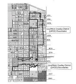
c.
LWOD permitted principal uses and structures. The following uses and structures are permitted in addition to those uses as otherwise permitted by the underlying zoning districts.
1.
Live-work (as defined in section 22-2.02, specific terms): The following uses as combined with a residential use where the principal operator of a business (as included in this list) also maintains a portion of the building as a primary residence:
i.
Professional office other than medical (e.g. law, accountant, architectural, planning, engineering, brokerage services and similar uses which meet the purpose of this district and are approved by the city);
ii.
Personal or business services such as beauty/barber shop, music studio/lessons, photography studio, tailor/seamstress, locksmith;
iii.
Creative industries (as defined in section 22-2.02, specific terms); and
iv.
Uses that are not specifically listed but which meet the purpose of this district and are approved by the city.
d.
LWOD special criteria for live-work uses.
1.
No more than thirty (30) percent of the gross floor area of any dwelling shall be used for a nonresidential use.
2.
Such occupation shall be conducted wholly within the dwelling or accessory structure;
3.
Traffic generated by the occupation shall not exceed the metropolitan planning organization traffic generation standard for single-family dwelling use by more than twenty (20) percent.
4.
Any construction or remodeling shall be in keeping with the residential character of the area.
5.
Structures shall have a residential appearance, e.g. no commercial-style glass exterior doors or outdoor storage of equipment, supplies, or vehicles.
6.
Delivery/pick-up of goods by trucks with more than four axles or greater than twenty-four (24) feet in length shall be limited to once per week in order to minimize truck traffic in the area.
7.
No more than two pick-ups or deliveries of goods shall occur on weekdays other than those made by the business itself (i.e. delivery of flowers to a customer). Daily delivery of residential mail via a U.S. postal carrier, consistent with that received by single-family residential uses, is excluded from thresholds set forth herein.
8.
No display of goods, sales or outside storage of equipment or materials used in the occupation shall be permitted;
9.
No person shall be employed on the premises other than members of the family residing thereon.
10.
Any construction or remodeling shall be in keeping with the residential character of the area. Structures shall have a residential appearance, e.g. no glass exterior doors or outdoor storage of equipment, supplies, or vehicles.
11.
Delivery of, or pick-up of goods by trucks will be low volume in order to minimize truck traffic in the area.
12.
No pick-up or delivery of goods shall occur on the weekends.
13.
No more than two pick-ups or deliveries of goods shall occur on weekdays.
14.
Showcase windows are prohibited.
e.
LWOD minimum green space requirement. Refer to R-1, R-2 and R-3 zoning district regulations.
f.
LWOD maximum building coverage. Refer to R-1, R-2 and R-3 zoning district regulations.
g.
LWOD maximum density.
1.
For parcels within the R-1 and R-2 zoning districts refer to the residential urban (RU) future land use plan classification within the comprehensive plan.
2.
For parcels within the R-3 zoning district refer to the residential low medium (RLM) future land use plan classification within the comprehensive plan.
h.
LWOD Off-street parking and service requirements: The off-street parking provisions of article VI of this chapter shall apply in the LWOD, with the following exemptions/modifications:
1.
Off-street—A maximum of four (4) parking spaces shall be allowed on site. Parking shall be in the rear of the building whenever feasible. Alley access shall be utilized if available to the site. On-site parking shall be a pervious material such as mulch, shell or turf-block or a combination thereof. An existing driveway may be used for parking provided that no more than twenty (20) percent new, impervious material (of the existing driveway) is constructed except for handicap parking and access thereto.
i.
LWOD appearance.
1.
Mixed use or commercial conversions must retain a single-family residential appearance and be in character with the existing neighborhood. They shall relate to human scale.
2.
Any construction or remodeling shall preserve the existing single-family residential character of the area.
3.
Any construction or remodeling shall preserve the existing single-family residential character of the area.
4.
There shall be no outdoor storage of equipment, supplies, or vehicles other than those normally associated with single family uses.
5.
Showcase windows are prohibited.
(e)
Existing nonconformities. Existing nonconforming uses may remain and be repaired/maintained as necessary but may not be expanded or improved at any given time to an extent equal to or greater than fifty (50) percent of the current assessed value of the principal structure per the county property appraiser's office or per a certified appraisal. Nonconforming buildings and uses which are damaged or destroyed to an extent greater than fifty (50) percent of the last assessed value of the building per the county property appraiser's office may not be reestablished. Existing single- and multi-family dwellings in the CMOUD are encouraged to be converted into nonresidential, mixed-use or live-work uses.
(f)
Public hearings. Whenever a public hearing is required by the provisions of this section the same shall be conducted by the city council as set forth herein and notice of said hearing shall be provided in accordance with this chapter.
(g)
Site plan and conditional use review. Within the 49thMOD, any change in lot building or structure shall be subject to site plan review and approval by the city council. Procedures and requirements for site plan review and approval shall be as set forth in article VII of this chapter, except that review and approval by the city council shall not be required. A public hearing shall be conducted by the city council as provided herein. No site plan approval shall be required where the use of the subject property is single-family or duplex dwelling, both prior to and after any requested change in lot or structure. Conditional use review shall be conducted by the planning and zoning board and the city council by public hearing as provided herein, and shall also be subject to the review and approval requirements provided in article VIII and all other applicable provisions of this chapter.
(h)
Outdoor sales or displays. Outdoor sales or displays as defined in article II, section 22-2.02, or outdoor commercial recreation/entertainment are allowed only as they are regulated within individual zoning districts. For permissible or conditional CMOUD uses, outdoor sales or displays, or commercial recreation/entertainment is only allowed with a special permit that has been approved by the city council. A special permit may be approved by the city council after conducting a public hearing as provided herein. The special permit shall be granted only upon a finding that the proposed use is compatible with surrounding uses and does not create any adverse effect on any surrounding property. The permit may be approved with conditions found necessary by the city council. The permit issued hereunder shall be valid for any period deemed appropriate by the city council. Nothing contained herein shall be construed to create any right in any property owner for the issuance or renewal of any special permit provided hereby. No notice and public hearing shall be required for special events organized or sponsored by the city. No special permit shall be required for artists working in public, so long as no product or service is offered or displayed for sale.
(i)
Special criteria for bed and breakfast. The following criteria shall apply to all bed and breakfast establishments within the 49thMOD:
(1)
Guest rooms may share toilet and bathing facilities, however, in no instance shall the owner and guests have shared bathrooms.
(2)
The maximum number of rooms for guests shall be as follows:
(3)
Rentals shall be on a daily basis only. The maximum stay for an individual guest shall be thirty (30) days.
(j)
Lighting.
(1)
Lighting and light fixtures shall be part of an overall design plan and their design and placement appropriate to the building to which they will serve.
(2)
Light fixtures shall be designed to respect enhance and contribute to the architectural style, detailing and elements of a building with regard to color, material, size, scale and shape.
(3)
Lighting shall illuminate without glare.
(4)
Light fixtures shall be cut-off lights where direct illumination is cut-off above forty (40) degrees below horizontal.
(5)
All outdoor light fixtures shall be located so that objects or land which are located beyond the boundaries of the parcel of land are not illuminated to an extent of producing more than a diffuse shadow.
(6)
Electrical wiring to all site lighting provided shall be underground.
(7)
Exterior lighting on properties within the LWOD and TPOD shall be residential in scope, scale and design.
(k)
Signs. All signs within the 49thMOD shall be regulated as set forth in article XVII of this chapter and in accordance with the following:
(1)
The sign application shall include a scaled, rendered graphic representation of the proposed sign, including all colors and materials and copy to be located thereon;
(2)
Any redevelopment district entry signs shall be exempt from regulations set forth in article XVII of this chapter;
(3)
The limitations provided in the following table shall supersede any restrictions provided in article XVII of this chapter to the contrary, as to the height, area or projection of signs within the 49thMOD:
(4)
Signs within the TPOD shall only be lighted between the hours of 8:00 a.m. and 9:00 p.m.
(5)
Signs within the LWOD area shall not be lighted.
(6)
Projecting signs count as an attached sign. They shall be installed with a minimum eight-foot clearance from the bottom of the sign to grade or the sidewalk. The sign face of double-faced projecting signs is calculated by measuring one (1) face of the sign only.
(7)
Buildings on corner lots within the CMUOD may have one attached sign per each building facade facing a street however; no attached sign shall exceed the maximum area otherwise permitted per facade.
(8)
The shape, size and area of attached signs shall be proportional to the space to which they are attached.
(9)
Sign application shall include a scaled, rendered graphic representation of the proposed sign, including all colors and materials and copy to be located thereon.
(10)
Signs shall be harmonious with the surrounding properties and maintain the integrity of the neighborhood and be designed as part of an overall theme that respect, enhance and contribute to the architectural style, detailing and elements of a building.
(11)
Signs shall not be in violation of the provisions of article XVII of this Code, pertaining to signs.
(12)
The following are prohibited:
a.
Box/cabinet style signs.
b.
Signs utilizing LED or any other electronic changeable copy.
c.
Signs painted directly on the facade of a building unless documented as historical by physical/historical, documentary and/or pictorial evidence.
d.
Attached signs that cover windows or other architectural features.
e.
Projecting signs higher than the top of second story windows.
f.
More than one awning/marquee, wall or projecting sign per business.
g.
Awning signs which are affixed to the awning material by adhesive-backed letters or other non-permanent methods.
h.
Window signs which are affixed by tape or other non-permanent methods.
i.
Changeable copy area greater than 25 percent of the sign area-
(Ord. No. 2010-09, § 2, 9-7-10)