
Hampton City Zoning Code
CHAPTER 8
SPECIAL DISTRICTS
Sec. 8-1. - Overall intent of Langley Flight Approach (LFA) Districts.
The purpose of the LFA Districts is to provide reasonable regulation of land use for properties under the flight path of Langley Air Force Base.
First, the LFA-1 and LFA-2 Districts provide reasonable land use regulations for those industrial and commercial uses which, by their nature, require large amounts of land but are minimally populated by either employees or customers.
Second, the LFA-1 and LFA-2 Districts provide significant protection to the flight operations at Langley Air Force Base by allowing, in that area nearest the centerline of the runway and the end of the runway, only those uses that are not disrupted by, nor disrupting to, the Base operations.
Third, the LFA-3, LFA-4, LFA-5 and LFA-6 Districts is to provide reasonable land use regulations for the portion of the flight approach to Langley Air Force Base west of Magruder Boulevard. The regulations limit the intensity of development, specifically the concentration of people living and working in the area within the flight approach, so that there is no negative impact on the flight operations at the Base, but also provide for a wide range of commercial and industrial activities, consistent with the City of Hampton's goals to develop the Magruder Corridor as an economically viable business center.
Sec. 8-2. - LFA-1 District—Langley Flight Approach Manufacturing.
(1)
Composition. LFA-1 contains those properties east of Magruder Boulevard and within the rectangle representing the Langley flight approach, fifteen hundred (1,500) feet on either side of the extended centerline of the runway, as it is defined in the Langley AFB Air Installation Compatibility Use Study, 1990, as amended.
(2)
Permitted uses. Uses shall be permitted as set forth in chapter 3—Uses Permitted.
(3)
Development standards.
(a)
Any use involving the use or storage of flammable or combustible materials shall conform to all pertinent requirements of chapter 14, article II, of the city code, the Fire Prevention Code.
(b)
No use shall be permitted in the LFA-1 District that has any of the following characteristics:
(i)
Releases into the air any substance that would impair visibility or otherwise interfere with the operation of aircraft, such as steam, dust or smoke;
(ii)
Produces fight emissions, either direct or indirect (reflective) that would interfere with pilot vision;
(iii)
Produces electronic emissions that would interfere with the aircraft communication systems or navigational equipment;
(iv)
Attracts concentrations of birds that would be hazardous to flight operations; or
(v)
Involves the use or storage of explosive materials.
(4)
Height. Structures shall be a maximum height of thirty (30) feet.
(5)
Setbacks.
(a)
Rights-of-way.
(i)
No improvements, with the exception of signs and approved access, may be constructed within fifty (50) feet of Magruder Boulevard or Commander Shepard Boulevard. A landscape plan consistent with the "City of Hampton Landscape Guidelines" for the setback shall be submitted for review and approval by the director of community development or his designee prior to the issuance of a building permit for the main structure.
(ii)
No improvements shall be constructed within ten (10) feet of any other existing or proposed public right-of-way.
(b)
Side yards. The side yard setback shall be a minimum of three (3) feet when not abutting an existing or proposed public right-of-way; however, if the side property line abuts a residential district, then there shall be a side yard the same as required in the residential district.
(c)
Rear yard. The rear yard setback shall be a minimum of three (3) feet when not abutting an existing or proposed public right-of-way; however, if the rear property line abuts a residential district, then there shall be a rear yard the same as required in the residential district.
(6)
Nonconforming uses. Given the nature of the LFA-1 District and its stated purpose, nonconforming uses in the district shall be regulated.
Notwithstanding the provisions of chapter 12, nonconforming uses shall not be permitted to expand beyond the square footage and lot area existing on September 9, 1992.
Sec. 8-3. - LFA-2 District—Langley Flight Approach Mixed Business and Manufacturing.
(1)
Composition. LFA-2 contains those properties located east of Magruder Boulevard between Commander Shepard Boulevard and Nettles Lane that are not within the rectangle representing the Langley flight approach, fifteen hundred (1,500) feet on either side of the extended centerline of the runway, as it is defined in the Langley AFB Air Installation Compatibility Use Study, 1990, as amended.
(2)
Permitted uses. Uses shall be permitted as set forth in chapter 3—Uses Permitted.
(3)
Development standards.
(a)
Any use involving the use or storage of flammable or combustible materials shall conform to all pertinent requirements of chapter 14, article II, of the city code, the Fire Prevention Code.
(b)
No use shall be permitted in the LFA-2 District that has any of the following characteristics:
(i)
Releases into the air any substance that would impair visibility or otherwise interfere with the operation of aircraft, such as steam, dust or smoke;
(ii)
Produces light emissions, either direct or indirect (reflective) that would interfere with pilot vision;
(iii)
Produces electronic emissions that would interfere with the aircraft communication systems or navigational equipment;
(iv)
Attracts concentrations of birds that would be hazardous to flight operations; or
(v)
Involves the use or storage of explosive materials.
(4)
Height. Structures shall have a maximum height of thirty (30) feet.
(5)
Setbacks.
(a)
Rights-of-way.
(i)
No improvements, with the exception of signs and approved access, may be constructed within fifty (50) feet of Magruder Boulevard or Commander Shepand Boulevard. A landscape plan consistent with the "City of Hampton Landscape Guidelines" for the setback shall be submitted for review and approval by the director of community development or his designee prior to the issuance of a building permit for the main structure.
(ii)
No improvements shall be constructed within ten (10) feet of any other existing or proposed public right-of-way.
(b)
Side yards. The side yard setback shall be a minimum of three (3) feet when not abutting an existing or proposed public right-of-way; however, if the side property line abuts a residential district, then there shall be a side yard the same as required in the residential district.
(c)
Rear yard. The rear yard setback shall be a minimum of three (3) feet when not abutting an existing or proposed public right-of-way; however, if the rear property line abuts a residential district, then there shall be a rear yard the same as required in the residential district.
(6)
Nonconforming uses. Given the nature of the LFA-2 District and its stated purpose, nonconforming uses in the district shall be regulated.
Notwithstanding the provisions of chapter 12, nonconforming uses shall not be permitted to expand beyond the square footage and lot area existing on September 9, 1992.
Sec. 8-4. - LFA-3 District—Langley Flight Approach Hampton Roads Center.
(1)
Composition. The LFA-3 District shall include use and density restrictions commensurate with the intent of the Langley Flight Approach Districts overall, incorporating appropriate regulations from the HRC-1 District to ensure the continuation of the Hampton Roads Center business park atmosphere.
(2)
Permitted uses. Uses shall be permitted as set forth in chapter 3—Uses Permitted.
(3)
Development standards.
(a)
Any use involving the use or storage of flammable or combustible materials shall conform to all pertinent requirements of chapter 14, article II, of the city code, the Fire Prevention Code.
(b)
No use shall be permitted in the LFA-3 District that has any of the following characteristics:
(i)
Releases into the air any substance that would impair visibility or otherwise interfere with the operation of aircraft, such as steam, dust or smoke;
(ii)
Produces light emissions, either direct or indirect (reflective) that would interfere with pilot vision;
(iii)
Produces electronic emissions that would interfere with the aircraft communication systems or navigational equipment;
(iv)
Attracts concentrations of birds that would be hazardous to flight operations; or
(v)
Involves the use or storage of explosive materials.
(c)
All uses, except food truck host sites, shall be conducted within a wholly enclosed building.
(4)
Building size regulations.
(a)
All uses, exclusive of storage areas, shall be subject to the following maximum building area per acre:
(i)
Retail, except furniture and appliance sales: maximum five thousand (5,000) gross square feet per acre.
(ii)
Furniture and appliance sales—maximum ten thousand (10,000) gross square feet per acre.
(iii)
Personal services maximum five thousand (5,000) gross square feet per acre.
(iv)
Manufacturing/processing/treatment 1, 2, 3, 4 and 5: maximum twelve thousand five hundred (12,500) gross square feet per acre.
(v)
Office: maximum seven thousand five hundred (7,500) gross square feet per acre.
(vi)
Banks: maximum six thousand two hundred fifty (6,250) gross square feet per acre.
(vii)
Private recreation centers: maximum five thousand (5,000) gross square feet per acre.
(viii)
Brokerage, storage, warehousing, or distribution centers: no maximum.
(b)
In addition to the limitations outlined above, all development shall conform to the following:
(i)
No building or group of buildings shall be erected or placed on a lot containing less than three and one-half (3½) acres, unless a lot of lesser area has been recorded prior to May 1, 1985.
(ii)
The minimum gross floor area of a building or a group of buildings on a lot shall be twenty-five thousand (25,000) square feet.
(5)
Height. Structures shall have a maximum height of sixty (60) feet.
(6)
Setback regulations.
(a)
Building setbacks.
(i)
For properties adjacent to the Magruder Boulevard right-of-way, the setback is a minimum of eighty (80) feet, or twice the building height, whichever is greater, from Magruder Boulevard.
(ii)
For properties adjacent to an interior Hampton Roads Center right-of-way, the setback is a minimum of sixty (60) feet, or twice the building height, whichever is greater, from that right-of-way.
(iii)
For any side yard not adjacent to said rights-of-way, the setback is a minimum of twenty (20) feet.
(iv)
For any rear yard not adjacent to said rights-of-way, the setback is a minimum of forty (40) feet.
(v)
There is a setback of twenty (20) feet if adjacent to any lake maintenance easement in Hampton Roads Center.
(b)
Setbacks for all other improvements, exclusive of entry ways:
(i)
No parking shall be located within eighty (80) feet of the Magruder Boulevard right-of-way.
(ii)
No parking shall be located within sixty (60) feet of the right-of-way of any interior Hampton Roads Center right-of-way.
(iii)
No parking shall be permitted within any other side or rear yard, as described in subsection 8-4(6)(a) above.
(iv)
No parking shall be permitted within twenty (20) feet of any lake maintenance easement in Hampton Roads Center.
(7)
Nonconforming uses. Given the nature of the LFA-3 District and its stated purpose, nonconforming uses in the district shall be regulated.
Notwithstanding the provisions of chapter 12, nonconforming uses shall not generally be permitted to expand beyond the square footage existing on September 9, 1992. However, if the specific use involved in the proposed expansion meets the general intent of this district, such expansion may be permitted according to the appropriate development limitations contained in this district.
(Ord. No. Z23-0006, 5-24-2023)
Sec. 8-5. - LFA-4 District—Langley Flight Approach Limited Business I.
(1)
Composition. The LFA-4 District shall include use and density restrictions as described below.
(2)
Permitted uses. Uses shall be permitted as set forth in chapter 3—Uses Permitted.
(3)
Development standards.
(a)
Any use involving the use or storage of flammable or combustible materials shall conform to all pertinent requirements of chapter 14, article II, of the city code, the Fire Prevention Code.
(b)
No use shall be permitted in the LFA-4 District that has any of the following characteristics:
(i)
Releases into the air any substance that would impair visibility or otherwise interfere with the operation of aircraft, such as steam, dust or smoke;
(ii)
Produces light emissions, either direct or indirect (reflective) that would interfere with pilot vision;
(iii)
Produces electronic emissions that would interfere with the aircraft communication systems or navigational equipment;
(iv)
Attracts concentrations of birds that would be hazardous to flight operations; or
(v)
Involves the use or storage of explosive materials.
(4)
Building size regulations.
(a)
All uses, exclusive of storage areas, shall be subject to the following maximum building area per acre:
(i)
Retail except furniture and appliance sales: maximum five thousand (5,000) gross square feet per acre.
(ii)
Furniture and appliance sales—maximum ten thousand (10,000) gross square feet per acre.
(iii)
Personal services: maximum five thousand (5,000) gross square feet per acre.
(iv)
Manufacturing/processing/treatment 1, 2, 3, 4 and 5: maximum twelve thousand five hundred (12,500) gross square feet per acre.
(v)
Office: maximum seven thousand five hundred (7,500) gross square feet per acre.
(vi)
Banks: maximum six thousand two hundred fifty (6,250) gross square feet per acre.
(vii)
Private recreation centers: maximum five thousand (5,000) gross square feet per acre.
(viii)
Brokerage, storage, warehousing, or distribution centers no maximum.
(5)
Height. Structures shall be a maximum height of sixty (60) feet.
(6)
Setback regulations.
(a)
Rights-of-way. No improvements shall be constructed within ten (10) feet of any existing or proposed public right-of-way.
(b)
Side yards. No improvements shall be constructed within three (3) feet of any side property line that is not abutting an existing or proposed public right-of-way; however, if the side property line abuts a residential district or the LFA-5 District, then there shall be a side yard the same as required in that district.
(c)
Rear yard. No improvements shall be constructed within three (3) feet of a rear property line that is not abutting an existing or proposed public right-of-way; however, if the rear property line abuts a residential district or the LFA-5 District, then there shall be a rear yard the same as required in that district.
(7)
Nonconforming uses. Given the nature of the LFA-4 District and its stated purpose, nonconforming uses in the district shall be regulated.
Notwithstanding the provisions of chapter 12, nonconforming uses shall not generally be permitted to expand beyond the square footage existing on September 9, 1992. However, if the specific use involved in the proposed expansion meets the general intent of this district, such expansion may be permitted according to the appropriate development limitations contained in this chapter.
Sec. 8-6. - LFA-5 District—Langley Flight Approach Limited Residential.
(1)
Composition. LFA-5 District shall include use restrictions that allow for the continuance of the existing residential development, but no expansion of that residential use.
(2)
Permitted uses. Uses shall be permitted as set forth in chapter 3—Uses Permitted.
(3)
Height. Structures shall be a maximum height of sixty (60) feet.
(4)
Setback regulations.
(a)
Front yard. The front yard setback shall be a minimum of thirty (30) feet.
(b)
Side yard. There shall be a side yard along each side of each building and the sum of the sides thereof shall be not less than twenty-five (25) percent of the lot's width measured at the building setback lines. The minimum width of any such side yard shall be ten (10) percent of the lot's width, except that if the total required width of the two (2) side yards is twenty-five (25) feet or more, one (1) need not be more than ten (10) feet in width. The side yard along the side street of a corner lot shall not be less than fifteen (15) feet.
(c)
Rear yard. There shall be a rear yard with a depth of not less than twenty (20) feet, provided if the depth of the lot is greater than seventy-five (75) feet, the required depth of the rear yards shall be increased by an amount equal to one-third (⅓) of the excess depth over seventy-five (75) feet; however, no such rear yard need be more than thirty-five (35) feet; and every rear yard shall extend to and be measured from the rearmost portion of the main building.
(5)
Nonconforming uses. Given the nature of the LFA-5 District and its stated purpose, nonconforming uses in the district shall be regulated.
Notwithstanding the provisions of chapter 12, nonconforming uses shall not generally be permitted to expand beyond the square footage existing on September 9, 1992. However, if the specific use involved in the proposed expansion meets the general intent of this district, such expansion may be permitted according to the appropriate development limitations contained in this chapter.
Sec. 8-7. - LFA-6 District—Langley Flight Approach Limited Business II.
(1)
Composition. The LFA-6 District shall include use and density restrictions as described below.
(2)
Permitted uses. Uses shall be permitted as set forth in chapter 3—Uses Permitted.
(3)
Development standards.
(a)
Any use involving the use or storage of flammable or combustible materials shall conform to all pertinent requirements of chapter 14, article II, of the city code, the Fire Prevention Code.
(b)
No use shall be permitted in the LFA-6 District that has any of the following characteristics:
(i)
Releases into the air any substance that would impair visibility or otherwise interfere with the operation of aircraft, such as steam, dust or smoke;
(ii)
Produces light emissions, either direct or indirect (reflective) that would interfere with pilot vision;
(iii)
Produces electronic emissions that would interfere with the aircraft communication systems or navigational equipment;
(iv)
Attracts concentrations of birds that would be hazardous to flight operations; or
(v)
Involves the use or storage of explosive materials.
(c)
The only movie theater permitted in LFA-6 is that theater on site plan 34-96, approved October 29, 1996 (regardless of ownership), or its substantially equivalent replacement. Such theater is limited to the square footage shown on this site plan; no expansion of this theater within the LFA-6 boundaries is permitted.
(d)
Notwithstanding subsection 8-7(4)(a) below, structures shown on site plan No. 47-96, approved August 7, 1997, that fall within the LFA-6 boundary shall be limited to the square footage shown on the site plan; expansion of these buildings within the LFA-6 boundaries is not permitted unless the expansion is for storage only. Any approved expansion for storage shall not be construed to allow any increase of allowable sales or service area within the LFA-6 boundary.
(4)
Building size regulations.
(a)
All uses, exclusive of storage areas, shall be subject to the following maximum building area per acre:
(i)
Retail, except furniture and appliance sales: maximum five thousand (5,000) gross square feet per acre.
(ii)
Furniture and appliance sales: maximum ten thousand (10,000) gross square feet per acre.
(iii)
Personal services: maximum five thousand (5,000) gross square feet per acre.
(iv)
Manufacturing/processing/treatment 1, 2, 3, 4 and 5: maximum twelve thousand five hundred (12,500) gross square feet per acre,
(v)
Office: maximum seven thousand five hundred (7,500) gross square feet per acre,
(vi)
Banks: maximum six thousand two hundred fifty (6,250) gross square feet per acre.
(vii)
Private recreation centers: maximum five thousand (5,000) gross square feet per acre.
(viii)
Brokerage, storage, warehousing, or distribution centers: no maximum.
(5)
Building height. Structures shall be a maximum height of sixty (60) feet.
(6)
Setback regulations.
(a)
Rights-of-way. No improvements shall be constructed within ten (10) feet of any existing or proposed public right-of-way.
(b)
Side yards. No improvements shall be constructed within three (3) feet of any side property line that is not abutting an existing or proposed public right-of-way.
(c)
Rear yard. No improvements shall be constructed within three (3) feet of a rear property line that is not abutting an existing or proposed public right-of-way.
(7)
Nonconforming uses. Given the nature of the LFA-6 District and its stated purpose, nonconforming uses in the district shall be regulated.
Notwithstanding the provisions of chapter 12, nonconforming uses shall not generally be permitted to expand beyond the square footage existing on September 9, 1992. However, if the specific use involved in the proposed expansion meets the general intent of this district, such expansion may be permitted according to the appropriate development limitations contained in this chapter.
Sec. 8-11. - Overall intent of Residential Transition (RT) Districts.
It is the intent of this article to establish reasonable standards that permit and control development along corridors of the city identified in the city's comprehensive plan as appropriate for residential transition uses. The plan recognizes the need to implement a new land use designation that provides a transition between major thoroughfares and adjacent low density residential areas. This land use category would allow the properties along these corridors to develop, or redevelop, in a manner that best utilizes their frontage and access without detrimental impacts on surrounding residential development, This article recognizes that this transition may be accomplished differently, depending upon the corridor affected and the desires and needs of the surrounding community, and therefore allows for separate Residential Transition Districts, should they be necessary.
Sec. 8-12. - RT-1 District—Residential Transition Todds Lane and Big Bethel Road.
(1)
Intent. RT-1 is intended to accomplish four (4) specific objectives identified in the Todds Lane/Big Bethel Road Corridors Study:
(a)
To create a district that serves as a buffer between single-family residential districts and major arterial streets;
(b)
To create a district that allows only uses compatible with single-family development, recognizing that these uses may be interspersed with residential development along the corridors;
(c)
To create a district that allows non-residential development, but which requires that development to maintain the existing residential scale along the corridors; and
(d)
To create a district that will not significantly increase traffic along the corridors, by allowing only those uses that generate no more than two and one-half (2½) times the total average daily traffic trips generated by single-family development, or eighty-eight (88) trips per acre.
The intent of the RT-1 District is to allow conversion of existing buildings or new construction in a manner that maintains the visual character and architectural scale of existing development within the area. It is also the intent of the RT-1 District to minimize visual and functional conflicts between residential and non-residential uses.
(2)
Uses permitted. Uses shall be permitted as set forth in chapter 3—Uses Permitted.
(3)
Height. Buildings shall be permitted up to a height of thirty-five (35) feet; however the height limit for any building may be increased to forty-five (45) feet when side yards of at least twenty-five (25) feet are provided.
(4)
Lot width. All newly created lots shall have a minimum frontage of one hundred twenty-five (125) feet.
(5)
Setback regulations. Improvements, as referenced in this section, shall include buildings, parking areas, and other site construction, but shall not include walls, fences or signs, With the exception of existing improvements, any improvements necessary for ingress and egress to the property, and any accessory structures, all improvements shall be located outside these setbacks:
(a)
Front. The front setback shall be at least thirty (30) feet; however lots recorded prior to adoption of this ordinance shall have a front setback equal to the average existing front yard on the block, with a minimum requirement of thirty (30) feet and a maximum requirement of sixty (60) feet.
(b)
Rear. The rear building setback shall be at least thirty-five (35) feet; however, all other improvements shall be set back at least thirty (30) feet.
(c)
Sides. The total of the two (2) side setbacks shall equal at least twenty-five (25) percent of the lot width; however, if that total exceeds fifty (50) feet, no more than fifty (50) feet shall be required.
(i)
If the total required side setback is less than fifty (50) feet:
(aa)
The minimum setback shall be ten (10) feet if not adjacent to any existing or proposed public right-of-way; and
(bb)
The minimum setback shall be fifteen (15) feet if adjacent to any existing or proposed public right-of-way.
(ii)
If the total required side setback equals fifty (50) feet, the minimum setback from any property line or existing or proposed public right-of-way shall be twenty-five (25) feet.
(6)
Accessory buildings or structures.
(a)
Accessory buildings or structures shall be permitted in the rear yards only.
(b)
Accessory buildings or structures shall be permitted within five (5) feet of any rear or side property line.
(c)
Accessory structures shall be permitted up to one thousand (1,000) square feet in total floor area, and may cover up to twenty (20) percent of the rear yard.
(d)
Height of accessory buildings or structures shall be governed by chapter 1, section 1-24.
(7)
Development standards. It is the intent of this section to ensure that the introduction of non-residential uses takes place without negatively impacting existing residential uses. Site development standards are intended to embody the qualities of single-family residential design and construction in terms of open space, lawns and plantings, light and air, convenience and privacy of nearby structures, and other amenities of residential areas.
(a)
Architectural standards:
(i)
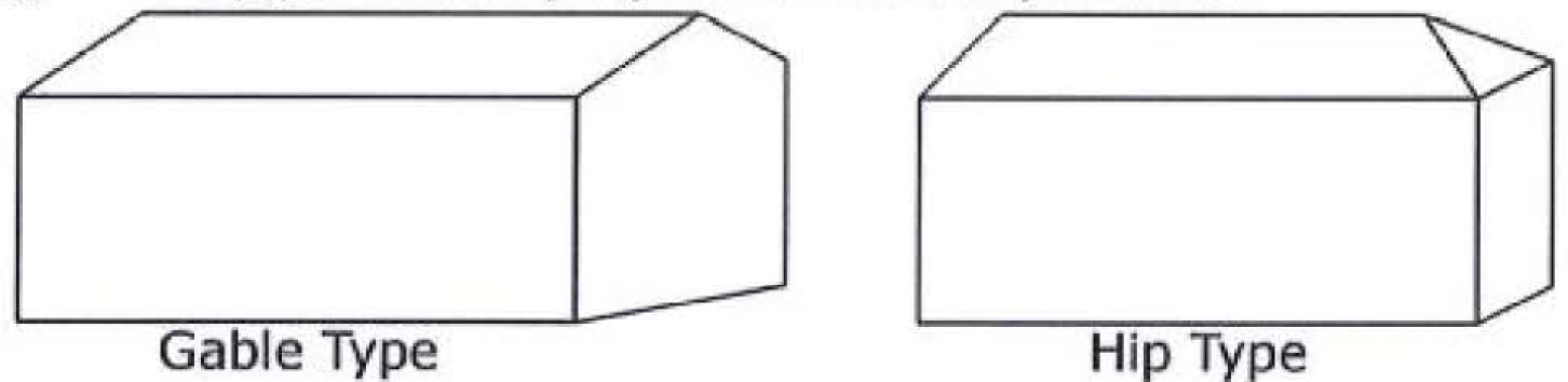
Only gable and hip-style roofs shall be permitted.
(ii)
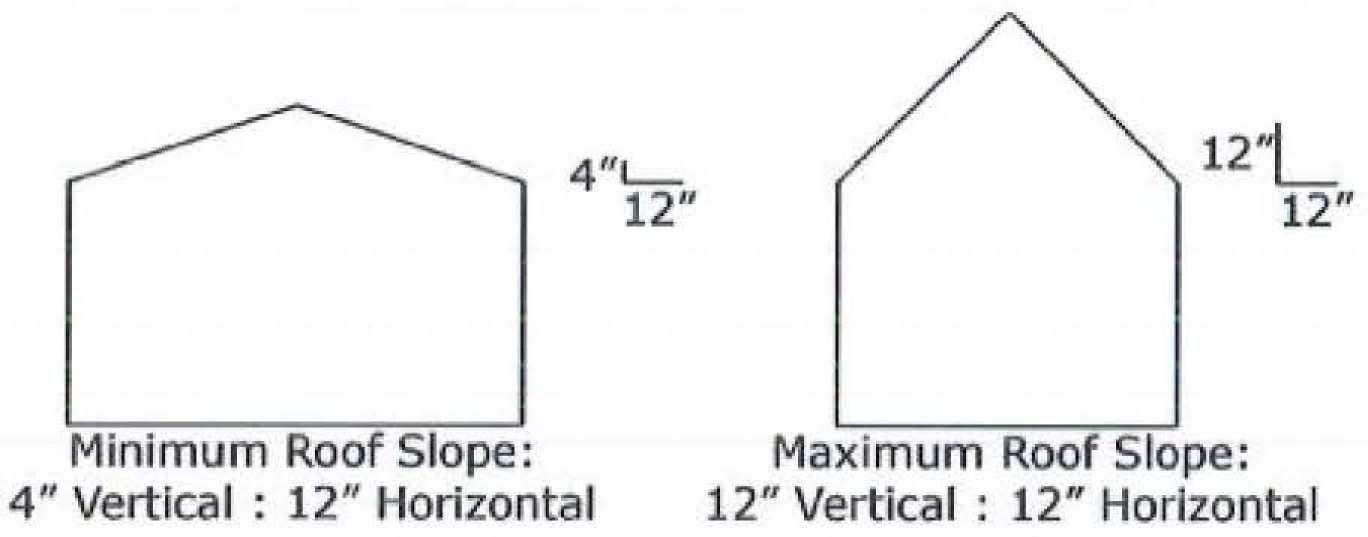
Roof pitch shall be a minimum of 1:3, horizontal to vertical, with a maximum of 1:1.
(iii)
Roofs shall be designed with at least one (1) change or break in plane within every sixty-foot segment. Vertical roof changes, porch roofs and dormers are
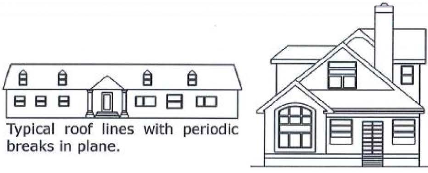
examples of acceptable plane changes.
(iv)
Roof materials shall be those typical in residential construction Existing buildings undergoing expansion shall use materials similar in color, size and texture to the existing roof materials. Standing seam metal roofs shall not be permitted unless required due to the expansion of an existing roof.
(v)
Building materials to be used for exterior finishes shall be those typical in residential construction. Concrete masonry units, precast concrete panels, vertical ribbed metal exteriors or highly reflective materials shall not be permitted unless required due to the expansion of an existing building. Existing buildings undergoing expansion shall use materials similar in color, size and texture to the existing building materials.
(vi)
Windows shall cover between ten (10) percent and fifty (50) percent of any exterior wall fronting on an existing or proposed public right-of-way. Existing buildings undergoing expansion shall preserve the existing proportion of exterior wall and glazing on any new walls that front on an existing or proposed public right-of-way.
(b)
Green area and landscape plan:
(i)
At least twenty (20) percent of the total lot area shall be maintained as green area.
(ii)
A landscape plan complying with the "City of Hampton Landscape Guidelines" shall be submitted to the director of the department of community development or his designee for review and approval prior to the issuance of a zoning permit.
(c)
All development proposals shall be accompanied by evidence to the planning director that traffic generated by the use does not exceed the prescribed limit of eighty-eight (88) trips per day, per acre.
(d)
All uses permitted shall be permitted up to a maximum building size of five thousand (5,000) square feet of floor area per acre, except that religious facilities, funeral homes, hospitals, sanitariums, convalescent or nursing homes, or adult care residences shall be permitted up to a maximum building size of twelve thousand (12,000) square feet of floor area per acre.
(e)
In order to maintain a residential scale of development, at least forty (40) percent of the total square footage of any building shall be on the ground floor.
(f)
The floor area of accessory structures, as permitted herein, shall not count toward the maximum floor areas in subsection 8-12(7)(d) above.
(8)
Fences and screens. Fences and screens shall be permitted as provided in chapter 1; however, when a nonresidential use abuts a residentially used or residentially zoned property and an improvement is located within five (5) feet of that joint property line, the non-residential use shall provide an opaque screen along that joint property line that is between three (3) feet and six (6) feet in height. In no case shall the fence height exceed four (4) feet in the front setback.
(9)
Consideration of rezoning applications. Within one (1) month of the adoption of this ordinance, and annually thereafter, the average daily traffic count and current traffic capacity shall be established for these road segments:
(a)
Big Bethel Road from the York County line to Interstate 64;
(b)
Big Bethel Road from Interstate 64 to Todds Lane;
(c)
Todds Lane from Cunningham Drive to Big Bethel Road; and
(d)
Todds Lane from Big Bethel Road to the Newport News city line.
Given the recommendations of the Todds Lane/Big Bethel Road Corridors Study with regards to increases in traffic, the planning director shall consider the relationship between current traffic counts and current traffic capacity. Additional RT-1 zoning may not be advisable if current counts already exceed capacity; a reasonable increase may be one (1) percent over existing counts if capacity exists. Such information shall be made part of any staff report to the planning commission and city council relative to a request for the RT-1 District.
Sec. 8-21. - Overall intent of Buckroe Bayfront (BB) Districts.
(1)
The Buckroe Bayfront Districts are intended to be a tool for implementation of the recommendations and policies of the Buckroe Master Plan (2005, as amended), guiding development, redevelopment, and revitalization activities in the Buckroe Bayfront area. Buckroe is a unique place in the Hampton Roads region with a neighborhood and architectural character that is an asset that must be protected and enhanced as new development becomes a part of the Buckroe community. Buckroe's character is based on its dual role as both a Chesapeake Bay beachfront community that draws visitors from areas beyond the neighborhood, and as a primarily single-family residential neighborhood in the City of Hampton. The Buckroe Master Plan (2005, as amended) provides the design principles that reflect these aspects of Buckroe's character, balancing between its two (2) roles and guiding the scale and location for new development and public improvements. The Buckroe Bayfront Districts are also intended to reinforce Buckroe's compact, walkable environment and promote a community design that is environmentally and economically sustainable.
(2)
The City of Hampton has been engaged in the revitalization of the Buckroe neighborhood since 1964 when the first of a series of redevelopment plans was generated. While the scale and nature of the proposed redevelopment in Buckroe has changed over time, the basic premise that the beach represents an asset that could be leveraged for new high quality development to spur revitalization in the greater Buckroe area has remained. The Buckroe Master Plan (2005, as amended) replaces these previous redevelopment plans and the Buckroe Bayfront Districts are a tool to achieve this longstanding objective of the city's efforts in Buckroe.
(3)
As permitted by the Code of Virginia § 15.2-2283 "Purpose of Zoning Ordinances," the Buckroe Bayfront Districts establish standards for development in Buckroe in order to:
(a)
Preserve and extend those elements of the Buckroe neighborhood which contribute to its neighborhood and architectural character through the design and placement of building types.
(b)
Enhance the quality of street spaces through building placement, massing, and design in order to create a safe environment that supports pedestrians, bicyclists, and drivers.
(c)
Create safe public streets, parks, and other areas by designing neighboring buildings to enhance an "eyes on the street/park" effect with windows and primary entrances facing onto public spaces.
(d)
Provide a degree of predictability to property owners and community residents regarding what may be built on land in the community while also allowing for some flexibility in the mixture of land uses.
(e)
Encourage a range of building types and sizes that will accommodate people at all stages of life and allow for an economically diverse community.
(f)
Facilitate the creation of a convenient, attractive, and harmonious community whose planning and architectural design will support long term value and economic stability in the greater Buckroe community.
(4)
There shall be five (5) Buckroe Bayfront Districts:
(i)
BB-1—Single Family Residential.
(ii)
BB-2—Mixed Residential.
(iii)
BB-3—Optional Mixed-Use.
(iv)
BB-4—Required Mixed-Use.
(v)
BB-5—Special.
(5)
Administration. Small variations in dimensional requirements, representing less than a five-foot change to required setbacks or a ten (10) percent change to area measurements, as appropriate, from any requirement described in the tables of "General Lot Standards," can be approved by the zoning administrator.
(6)
Green design.
(a)
In an effort to set the standard in a highly visible area, green design should be included in all public projects, including private development resulting from the sale of public land. Green design is also encouraged for private development on privately owned land.
(b)
Where green design is required, projects shall be designed and constructed to comply with green design standards prescribed for neighborhoods designed in accordance with the Leadership in Energy and Environmental Design Neighborhood Development (LEED-ND) green neighborhood development rating system, published by the United States Green Building Council, to achieve a LEED silver or higher rating.
(Ord. No. Z16-15, 9-14-2016)
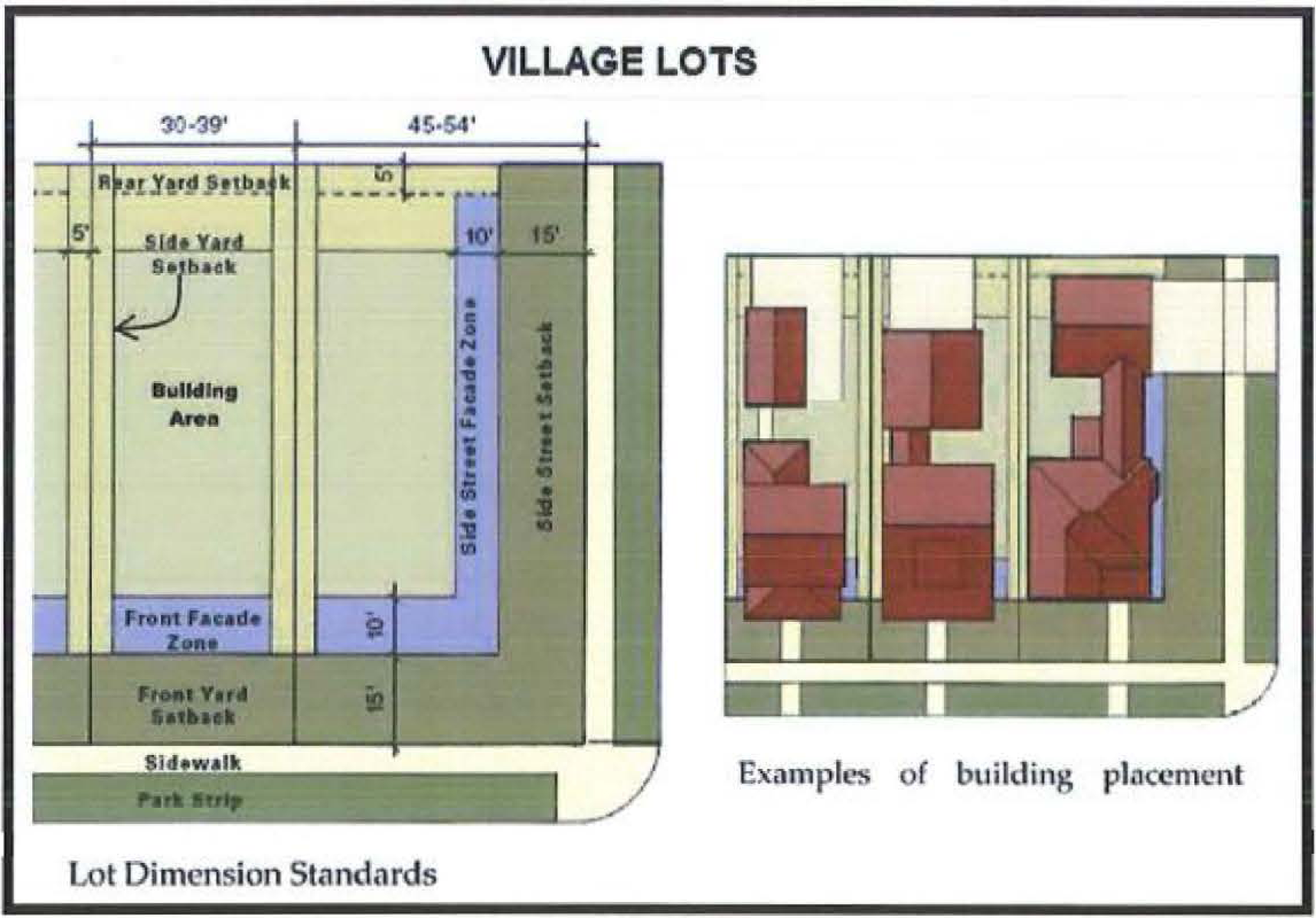
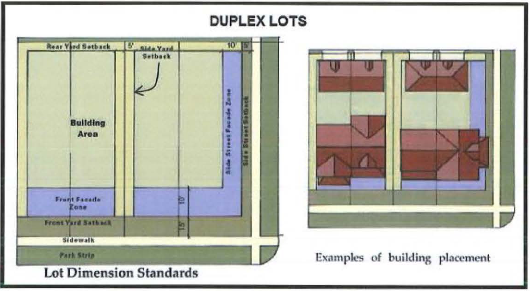
Sec. 8-22. - BB-1 District—Buckroe Bayfront Single Family Residential.
(1)
Permitted uses shall be as set forth in chapter 3—Uses Permitted. In addition, no use shall be permitted to have a drive-through.
(2)
The following lot types are permitted; in addition, to promote diversity and variety along residential blocks, no block face greater than three hundred (300) feet in length shall be composed of more than seventy-five (75) percent of the same lot type.
(a)
Village Lot.
(b)
Neighborhood Lot.
(c)
Estate Lot.
(d)
Duplex Lot.
(3)
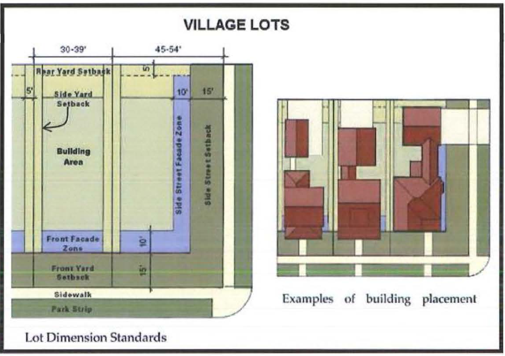
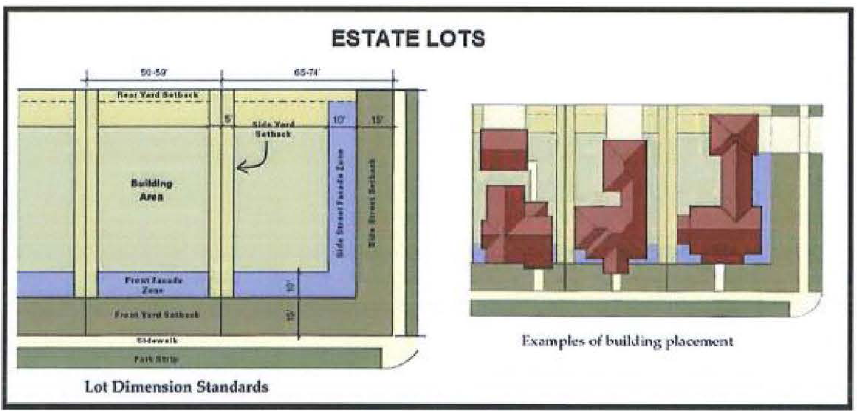
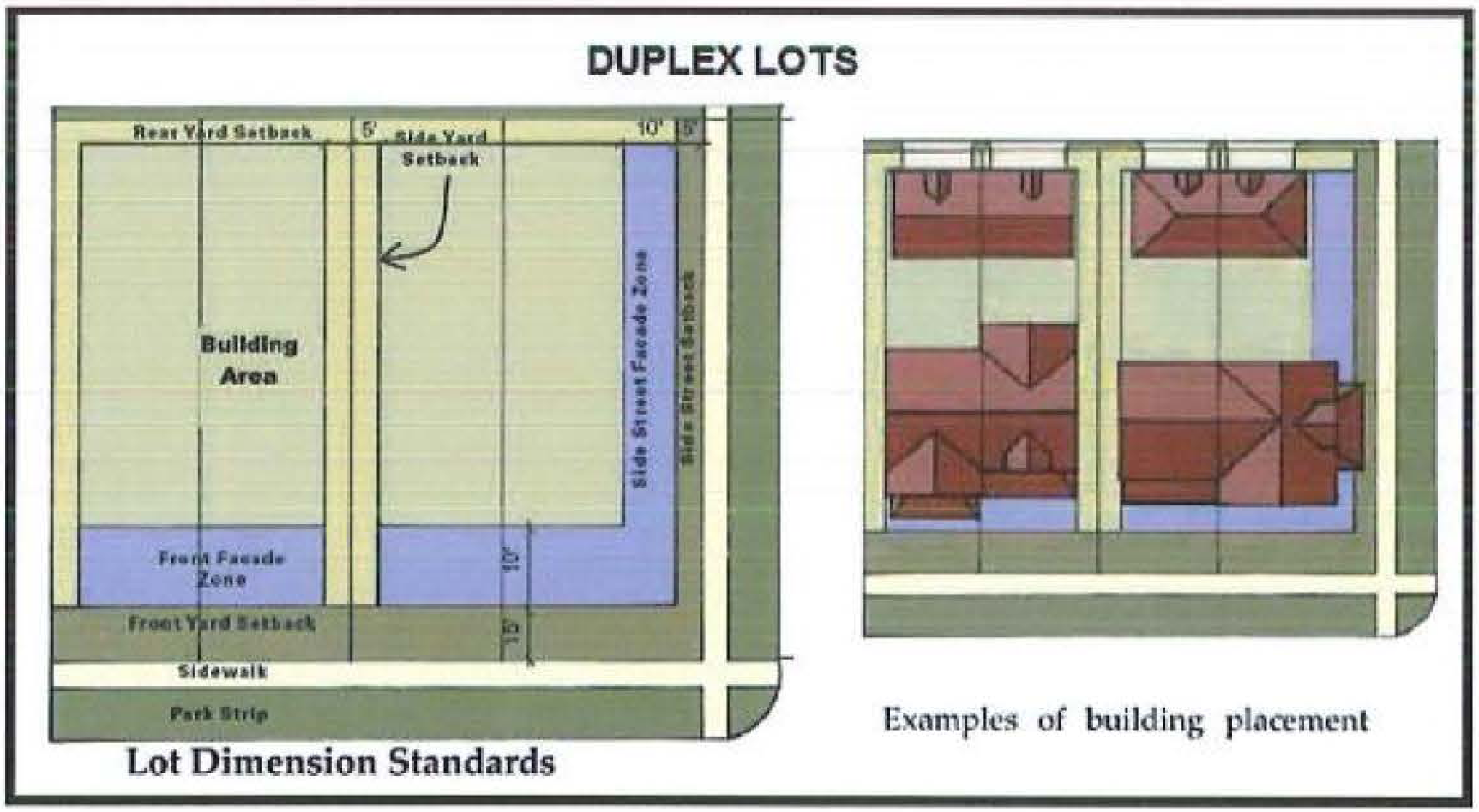
Table of Lot Standards. The following table describes the requirements for each lot type permitted. Lot widths are an allowable range; lot depth, interior side setback, rear setback, and façade zone coverage are minimum dimensions; street side setback and front setback are required build-to lines; the façade zone is a fixed required width; building coverage is a maximum. Small variations to the dimensional requirements found in this table can be allowed as per subsection 8-10(9) above. Flag lots are not permitted.

(4)
Development standards.
(a)
Variation. Adjacent buildings shall be visually distinct from each other. This distinction may be achieved by varying materials, architectural styles, massing, color, or lot type. At least two (2) of these elements must vary for each adjacent building along the same street frontage.
(b)
Streets and alleys.
(i)
If a lot is adjacent to only one (1) street, that street is considered the front street for that lot.
(ii)
If a lot is adjacent to two (2) streets, the narrower lot frontage shall be considered the front street and the wider lot frontage the side street.
(iii)
Alleys shall be created when it is physically feasible and in keeping with the recommendations of the Buckroe Master Plan (2005, as amended).
(c)
Height.
(i)
Total building heights will be measured in stories.
(ii)
Buildings shall not be taller than three (3) stories.
(iii)
Tower elements, cupolas, widow's walks, and similar building features may extend one (1) story above the allowable height for each lot type. These elements may only be used within the appropriate architectural style of building.
(iv)
The maximum floor height from floor-to-floor for first floor residential shall be fifteen (15) feet.
(v)
The maximum floor height from floor-to-floor for first floor commercial buildings shall be eighteen (18) feet.
(vi)
The maximum floor height from floor-to-floor (floor-to-ceiling on the top floor) on any story above the first shall be twelve (12) feet.
(vii)
Cathedral ceilings may be incorporated within the roof and shall not count toward floor height.
(viii)
Floors that exceed the above standards shall be counted as greater than one (1) story.
(d)
Architectural standards.
(i)
All buildings shall be consistent with one (1) of the architectural styles identified in the Buckroe Bayfront Pattern Book. Consistency will be determined based on adherence to the design elements of each of the primary building features identified in the pattern book including massing and composition, eave details and wall section, windows and doors, porches, and materials and applications.
(ii)
Primary access for all buildings shall be from a public street or open space. Primary access is not permitted from the parking area or alley. All street facing façades shall have an articulated primary access entrance.
(iii)
The following shall be located in rear yards or side yards not facing a public street or open space:
(aa)
Electrical utility meters.
(bb)
Air conditioning compressors.
(cc)
Irrigation and pool pumps.
(iv)
The following shall be located in rear yards only:
(aa)
Antennas.
(bb)
Permanent barbecues.
(cc)
Satellite dishes.
(v)
The following are prohibited:
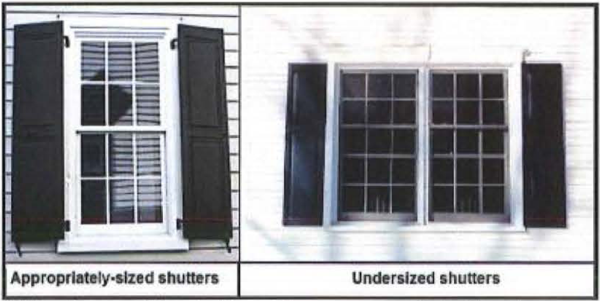
(aa)
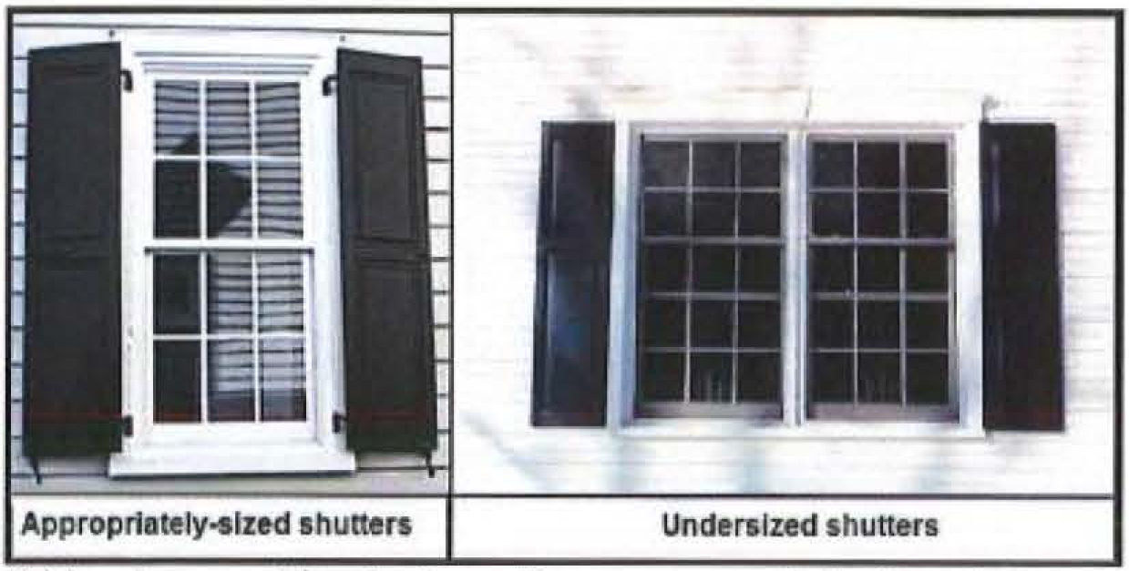
Undersized shutters (the shutter or shutters must be sized so as to equal the width that would be required to cover the window opening).
(bb)
Inoperable shutters (the purpose of shutters is to provide protection from storms).
(cc)
Shutters made of plastic.
(dd)
Reflective and/or bronze-tint glass.
(ee)
Plastic or PVC roof tiles.
(ff)
Backlit awnings.
(gg)
Glossy-finish awnings.
(hh)
Fences made of chain link, barbed wire, vinyl, plain wire mesh, or coated chain link.
(iv)
Where there is a building façade facing a park or street, the façade shall contain transparent windows covering from a minimum of twenty (20) percent to a maximum of seventy (70) percent of the wall area.
(5)
Accessory buildings or structures.
(a)
Accessory buildings or structures for residential uses may include a garage or covered parking, home occupation uses, storage space, and storage for trash receptacles.
(b)
The footprint of accessory buildings or structures shall not be larger than fifty (50) percent of the main building's footprint.
(c)
Accessory buildings or structures shall not be taller than the main roofline of the main building nor shall accessory structures be greater than two (2) stories regardless of the height of the main building.
(d)
Accessory buildings or structures larger than one hundred (100) square feet shall architecturally complement the main building with shared exterior materials, colors, and roof lines.
(e)
Accessory buildings or structures or trees on single-family lots shall be set back five (5) feet from the rear property line when adjacent to an alley.
(f)
Accessory dwelling units are permitted under the following conditions:
(i)
Accessory dwellings may only be located on a Village Lot, Neighborhood Lot, Estate Lot or Duplex Lot. There shall be no more than one (1) accessory dwelling unit per lot.
(ii)
Accessory dwellings must be a minimum of five hundred (500) square feet in floor area.
(iii)
The primary dwelling unit and accessory dwelling unit shall not be rented separately unless one (1) is owner occupied.
(6)
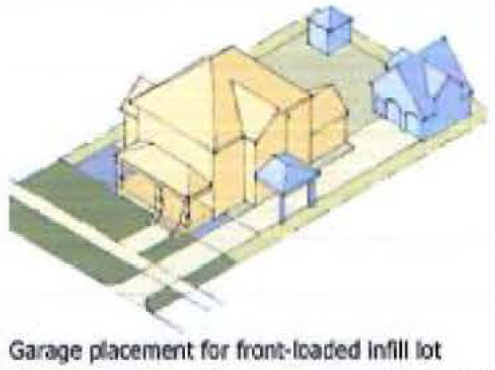
Parking shall be provided as described in chapter 11. In addition, parking shall be subject to the following standards:
(a)
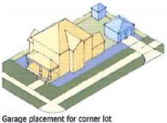
All parking shall be provided at the rear of the lot either via a rear alley or a driveway from the street
(b)
Where available, alleys shall be used to access parking, except in the case of single-family corner lots.
(c)
When alley access is not available, driveways in the area from the street to the rear line of the house shall be a maximum of ten (10) feet wide.
(d)
Single-family corner lot driveways shall be accessed from the side street and may be a maximum of fifteen (15) feet wide.
(Ord. No. Z15-15, 8-12-2015); Ord. No. Z16-15, 9-14-2016)
Sec. 8-23. - BB-2 District—Buckroe Bayfront Mixed Residential.
(1)
Permitted uses shall be as set forth in chapter 3—Uses Permitted. In addition, no use shall be permitted to have a drive-through.
(2)
The following lot types are permitted; in addition, to promote diversity and variety along residential blocks, no block face greater than three hundred (300) feet in length shall be composed of more than seventy-five (75) percent of the same lot type.
(a)
Village Lot.
(b)
Neighborhood Lot.
(c)
Estate Lot.
(d)
Duplex Lot.
(e)
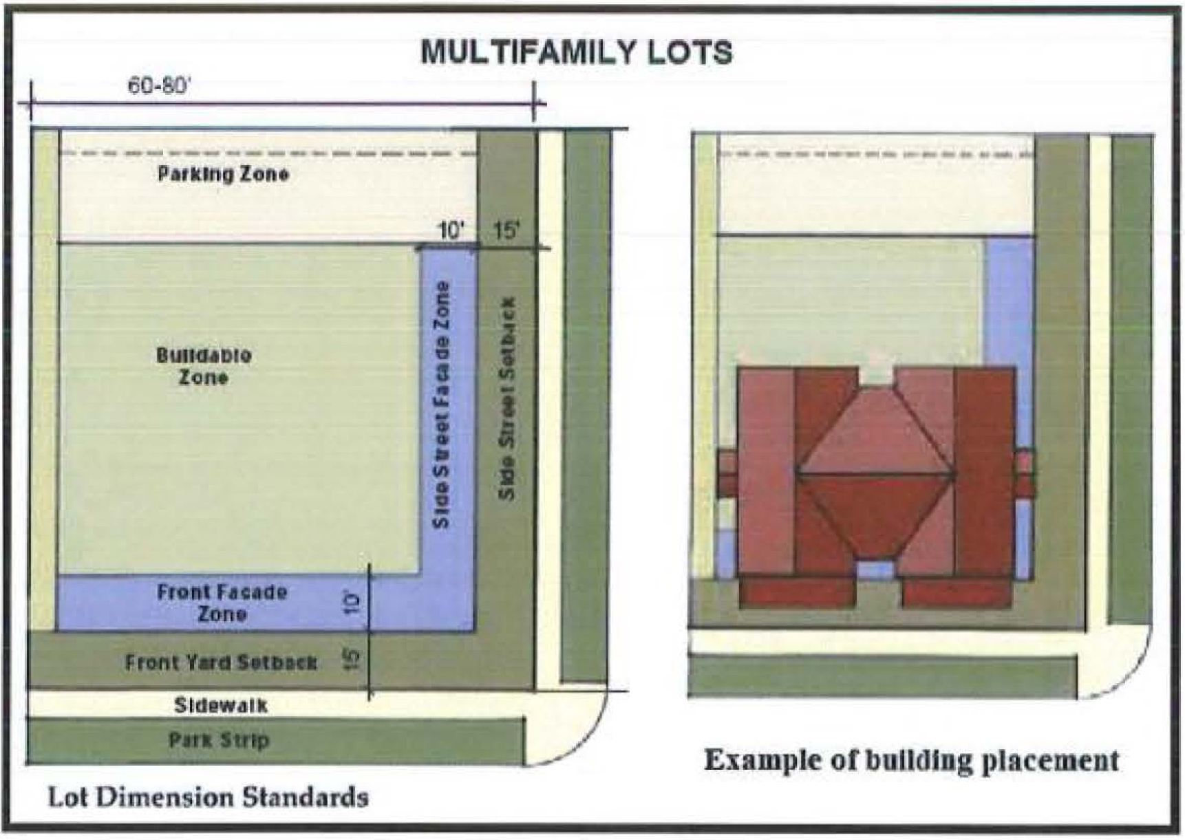
Multifamily Lot.
(3)
Table of Lot Standards. The following table describes the requirements for each lot type permitted. Lot widths are an allowable range; lot depth, interior side setback, rear setback, and façade zone coverage are minimum dimensions; street side setback and front setback are required build-to lines; the façade zone is a fixed required width; building coverage is a maximum. Small variations to the dimensional requirements found in this table can be allowed as per subsection 8-10(9) above. Flag lots are not permitted.

(4)
Development standards.
(a)
Variation. Adjacent buildings shall be visually distinct from each other. This distinction may be achieved by varying materials, architectural styles, massing, color, or lot type. At least two (2) of these elements must vary for each adjacent building along the same street frontage.
(b)
Streets and alleys.
(i)
If a lot is adjacent to only one (1) street, that street is considered the front street for that lot.
(ii)
If a lot is adjacent to two (2) streets, the narrower lot frontage shall be considered the front street and the wider lot frontage the side street.
(iii)
Alleys shall be created when it is physically feasible and in keeping with the recommendations of the Buckroe Master Plan (2005, as amended).
(c)
Height.
(i)
Total building heights will be measured in stories.
(ii)
Buildings shall not be taller than three (3) stories.
(iii)
Tower elements, cupolas, widow's walks, and similar building features may extend one (1) story above the allowable height for each lot type. These elements may only be used within the appropriate architectural style of building.
(iv)
The maximum floor height from floor-to-floor for first floor residential shall be fifteen (15) feet.
(v)
The maximum floor height from floor-to-floor for first floor commercial buildings shall be eighteen (18) feet.
(vi)
The maximum floor height from floor-to-floor (floor-to-ceiling on the top floor) on any story above the first shall be twelve (12) feet.
(vii)
Cathedral ceilings may be incorporated within the roof and shall not count toward floor height.
(viii)
Floors that exceed the above standards shall be counted as greater than one (1) story.
(d)
Architectural standards.
(i)
All buildings shall be consistent with one (1) of the architectural styles identified in the Buckroe Bayfront Pattern Book. Consistency will be determined based on adherence to the design elements of each of the primary building features identified in the pattern book including massing and composition, eave details and wall section, windows and doors, porches, and materials and applications.
(ii)
Primary access for all buildings shall be from a public street or open space. Primary access is not permitted from the parking area or alley. All street facing façades shall have an articulated primary access entrance.
(iii)
The following shall be located in rear yards or side yards not facing a public street or open space:
(aa)
Electrical utility meters.
(bb)
Air conditioning compressors.
(cc)
Irrigation and pool pumps.
(iv)
The following shall be located in rear yards only:
(aa)
Antennas.
(bb)
Permanent barbecues.
(cc)
Satellite dishes.
(v)
The following are prohibited:
(aa)
Undersized shutters (the shutter or shutters must be sized so as to equal the width that would be required to cover the window opening).
(bb)
Inoperable shutters (the purpose of shutters is to provide protection from storms).
(cc)
Shutters made of plastic.
(dd)
Reflective and/or bronze-tint glass.
(ee)
Plastic or PVC roof tiles.
(ff)
Backlit awnings.
(gg)
Glossy-finish awnings.
(hh)
Fences made of chain link, barbed wire, vinyl, plain wire mesh, or coated chain link.
(vi)
Where there is a building façade facing a park or street, the façade shall contain transparent windows covering from a minimum of twenty (20) percent to a maximum of seventy (70) percent of the wall area.
(5)
Accessory buildings or structures.
(a)
Accessory buildings or structures for residential uses may include a garage or covered parking, home occupation uses, storage space, and storage for trash receptacles.
(b)
The footprint of accessory buildings or structures shall not be larger than fifty (50) percent of the main building's footprint.
(c)
Accessory buildings or structures shall not be taller than the main roofline of the main building nor shall accessory structures be greater than two (2) stories regardless of the height of the main building.
(d)
Accessory buildings or structures larger than one hundred (100) square feet shall architecturally complement the main building with shared exterior materials, colors, and roof lines.
(e)
Accessory buildings or structures or trees on single-family lots shall be set back five (5) feet from the rear property line when adjacent to an alley.
(f)
Accessory dwelling units are permitted under the following conditions:
(i)
Accessory dwellings may only be located on a Village Lot, Neighborhood Lot, Estate Lot or Duplex Lot. There shall be no more than one (1) accessory dwelling unit per lot.
(ii)
Accessory dwellings must be a minimum of five hundred (500) square feet in floor area.
(iii)
The primary dwelling unit and accessory dwelling unit shall not be rented separately unless one (1) is owner occupied.
(6)
Parking shall be provided as described in chapter 11. In addition, parking shall be subject to the following standards:
(a)
Village, Neighborhood, Estate, and Duplex Lots:
(i)
All parking shall be provided at the rear of the lot either via a rear alley or a driveway from the street.
(ii)
Where available, alleys shall be used to access parking, except in the case of single-family corner lots.
(iii)
When alley access is not available, driveways in the area from the street to the rear line of the house shall be a maximum of ten (10) feet wide.
(iv)
Single-family corner lot driveways shall be accessed from the side street and may be a maximum of fifteen (15) feet wide.

(b)
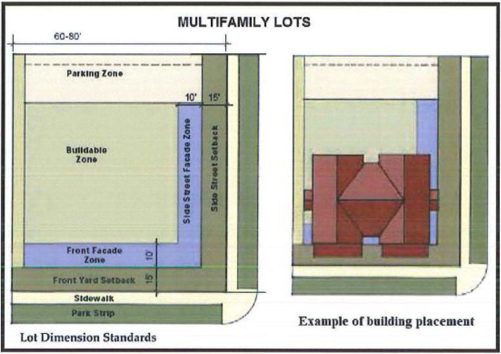
Multifamily Lots.
(i)
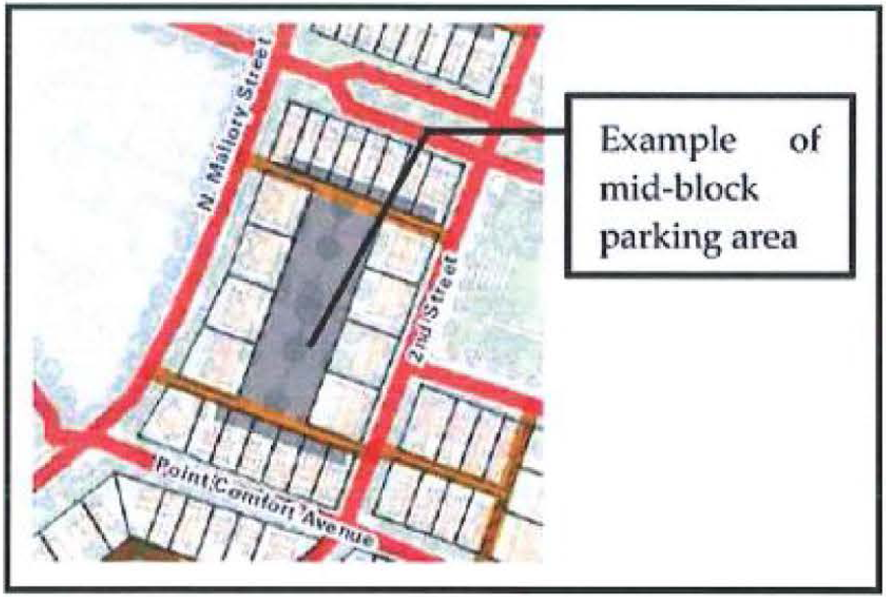
All off-street parking shall be in the mid-block area behind the main structures and all or a portion of such spaces may be provided as tuck-under parking on the ground floor but shall not be visible from the front street and shall be screened from the side street. All such parking areas shall be accessed via an alley and may be between two (2) alleys or the alley may serve as a central drive aisle for the parking area. Additionally, parking spaces may be aligned to allow double parking when the two (2) spaces are assigned to the same unit.
(Ord. No. Z15-15, 8-12-2015; Ord. No. Z16-15, 9-14-2016)
Sec. 8-24. - BB-3 District—Buckroe Bayfront Optional Mixed Use.
(1)
Permitted uses shall be as set forth in chapter 3-Uses Permitted. In addition, no use shall be permitted to have a drive-through.
(2)
The following lot types are permitted; in addition, to promote diversity and variety along residential blocks, no block face greater than three hundred (300) feet in length shall be composed of more than seventy-five (75) percent of the same lot type.
(a)
Village Lot.
(b)
Neighborhood Lot.
(c)
Estate Lot.
(d)
Duplex Lot.
(e)
Multifamily Lot.
(f)
Mixed Use Lot.
(3)
Table of Lot Standards. The following table describes the requirements for each lot type permitted. Lot widths are an allowable range; lot depth, interior side setback, rear setback, and façade zone coverage are minimum dimensions; street side setback and front setback are required build-to lines; the façade zone is a fixed required width; building coverage is a maximum. Small variations to the dimensional requirements found in this table can be allowed as per subsection 8-10(9) above. Flag lots are not permitted.


(4)
Development standards.
(a)
Variation. Adjacent buildings shall be visually distinct from each other. This distinction may be achieved by varying materials, architectural styles, massing, color, or lot type. At least two (2) of these elements must vary for each adjacent building along the same street frontage.
(b)
Streets and alleys.
(i)
If a lot is adjacent to only one (1) street, that street is considered the front street for that lot.
(ii)
If a lot is adjacent to two (2) streets, the narrower lot frontage shall be considered the front street and the wider lot frontage the side street.
(iii)
Alleys shall be created when it is physically feasible and in keeping with the recommendations of the Buckroe Master Plan (2005, as amended).
(c)
Height.
(i)
Total building heights will be measured in stories.
(ii)
Buildings shall not be taller than three (3) stories.
(iii)
Tower elements, cupolas, widow's walks, and similar building features may extend one (1) story above the allowable height for each lot type. These elements may only be used within the appropriate architectural style of building.
(iv)
The maximum floor height from floor-to-floor for first floor residential shall be fifteen (15) feet.
(v)
The maximum floor height from floor-to-floor for first floor commercial buildings shall be eighteen (18) feet.
(vi)
The maximum floor height from floor-to-floor (floor-to-ceiling on the top floor) on any story above the first shall be twelve (12) feet.
(vii)
Cathedral ceilings may be incorporated within the roof and shall not count toward floor height.
(viii)
Floors that exceed the above standards shall be counted as greater than one (1) story.
(d)
Architectural standards.
(i)
All buildings shall be consistent with one (1) of the architectural styles identified in the Buckroe Bayfront Pattern Book. Consistency will be determined based on adherence to the design elements of each of the primary building features identified in the pattern book including massing and composition, eave details and wall section, windows and doors, porches, and materials and applications.
(ii)
Primary access for all buildings shall be from a public street or open space. Primary access is not permitted from the parking area or alley. All street facing façades shall have an articulated primary access entrance.
(iii)
The following shall be located in rear yards or side yards not facing a public street or open space:
(aa)
Electrical utility meters.
(bb)
Air conditioning compressors.
(cc)
Irrigation and pool pumps.
(iv)
The following shall be located in rear yards only:
(aa)
Antennas.
(bb)
Permanent barbecues.
(cc)
Satellite dishes.
(v)
The following are prohibited:
(aa)
Undersized shutters (the shutter or shutters must be sized so as to equal the width that would be required to cover the window opening).

(bb)
Inoperable shutters (the purpose of shutters is to provide protection from storms).
(cc)
Shutters made of plastic.
(dd)
Reflective and/or bronze-tint glass.
(ee)
Plastic or PVC roof tiles.
(ff)
Backlit awnings.
(gg)
Glossy-finish awnings.
(hh)
Fences made of chain link, barbed wire, vinyl, plain wire mesh, or coated chain link.
(vi)
Where there is a building façade facing a park or street, the façade shall contain transparent windows covering from a minimum of twenty (20) percent to a maximum of seventy (70) percent of the wall area.
(5)
Accessory buildings or structures.
(a)
Accessory buildings or structures for residential uses may include a garage or covered parking, home occupation uses, storage space, and storage for trash receptacles.
(b)
The footprint of accessory buildings or structures shall not be larger than fifty (50) percent of the main building's footprint.
(c)
Accessory buildings or structures shall not be taller than the main roofline of the main building nor shall accessory structures be greater than two (2) stories regardless of the height of the main building.
(d)
Accessory buildings or structures larger than one hundred (100) square feet shall architecturally complement the main building with shared exterior materials, colors, and roof lines.
(e)
Accessory buildings or structures or trees on single-family lots shall be set back five (5) feet from the rear property line when adjacent to an alley.
(f)
Accessory dwelling units are permitted under the following conditions:
(i)
Accessory dwellings may only be located on a Village Lot, Neighborhood Lot, Estate Lot or Duplex Lot. There shall be no more than one (1) accessory dwelling unit per lot.
(ii)
Accessory dwellings must be a minimum of five hundred (500) square feet in floor area.
(iii)
The primary dwelling unit and accessory dwelling unit shall not be rented separately unless one (1) is owner occupied.
(6)
Parking shall be provided as described in chapter 11. In addition, parking shall be subject to the following standards:
(a)
Village, Neighborhood, Estate, and Duplex Lots.
(i)
All parking shall be provided at the rear of the lot either via a rear alley or a driveway from the street.
(ii)
Where available, alleys shall be used to access parking, except in the case of single-family corner lots.
(iii)
When alley access is not available, driveways in the area from the street to the rear line of the house shall be a maximum of ten (10) feet wide.

(iv)
Single-family corner lot driveways shall be accessed from the side street and may be a maximum of fifteen (15) feet wide.

(b)
Multifamily and Mixed Use Lots.
(i)
All off-street parking shall be in the mid-block area behind the main structures and all or a portion of such spaces may be provided as tuck-under parking on the ground floor but shall not be visible from the front street and shall be screened from the side street. All such parking areas shall be accessed via an alley and may be between two (2) alleys or the alley may serve as a central drive aisle for the parking area. Additionally, parking spaces may be aligned to allow double parking when the two (2) spaces are assigned to the same unit.
(Ord. No. Z15-15, 8-12-2015; Ord. No. Z16-15, 9-14-2016)
Sec. 8-25. - BB-4 District—Buckroe Bayfront Required Mixed Use.
(1)
Permitted uses shall be as set forth in chapter 3—Uses Permitted. In addition, no use shall be permitted to have a drive-through.
(2)
The following lot types are permitted:
(a)
Mixed Use Lot.
(3)
Table of Lot Standards. The following table describes the requirements for each lot type permitted. Lot widths are an allowable range; lot depth, interior side setback, rear setback, and façade zone coverage are minimum dimensions; street side setback and front setback are required build-to lines; the façade zone is a fixed required width; building coverage is a maximum. Small variations to the dimensional requirements found in this table can be allowed as per subsection 8-10(9) above. Flag lots are not permitted.
(4)
Development standards.
(a)
Variation. Adjacent buildings shall be visually distinct from each other. This distinction may be achieved by varying materials, architectural styles, massing, color, or lot type. At least two (2) of these elements must vary for each adjacent building along the same street frontage.
(b)
Streets and alleys.
(i)
If a lot is adjacent to only one (1) street, that street is considered the front street for that lot.
(ii)
If a lot is adjacent to two (2) streets, the narrower lot frontage shall be considered the front street and the wider lot frontage the side street.
(iii)
Alleys shall be created when it is physically feasible and in keeping with the recommendations of the Buckroe Master Plan (2005, as amended).
(c)
Height.
(i)
Total building heights will be measured in stories.
(ii)
Buildings shall not be taller than three (3) stories.
(iii)
Tower elements, cupolas, widow's walks, and similar building features may extend one (1) story above the allowable height for each lot type. These elements may only be used within the appropriate architectural style of building.
(iv)
The maximum floor height from floor-to-floor for first floor residential shall be fifteen (15) feet.
(v)
The maximum floor height from floor-to-floor for first floor commercial buildings shall be eighteen (18) feet.
(vi)
The maximum floor height from floor-to-floor (floor-to-ceiling on the top floor) on any story above the first shall be twelve (12) feet.
(vii)
Cathedral ceilings may be incorporated within the roof and shall not count toward floor height.
(viii)
Floors that exceed the above standards shall be counted as greater than one (1) story.
(d)
Architectural standards.
(i)
All buildings shall be consistent with one of the architectural styles identified in the Buckroe Bayfront Pattern Book. Consistency will be determined based on adherence to the design elements of each of the primary building features identified in the pattern book including massing and composition, eave details and wall section, windows and doors, porches, and materials and applications.
(ii)
Primary access for all buildings shall be from a public street or open space. Primary access is not permitted from the parking area or alley. All street facing façades shall have an articulated primary access entrance.
(iii)
The following shall be located in rear yards or side yards not facing a public street or open space:
(aa)
Electrical utility meters.
(bb)
Air conditioning compressors.
(cc)
Irrigation and pool pumps.
(iv)
The following shall be located in rear yards only:
(aa)
Antennas.
(bb)
Permanent barbecues.
(cc)
Satellite dishes.
(v)
The following are prohibited:
(aa)
Undersized shutters (the shutter or shutters must be sized so as to equal the width that would be required to cover the window opening).
(bb)
Inoperable shutters (the purpose of shutters is to provide protection from storms).
(cc)
Shutters made of plastic.
(dd)
Reflective and/or bronze-tint glass.
(ee)
Plastic or PVC roof tiles.
(ff)
Backlit awnings.
(gg)
Glossy-finish awnings.
(hh)
Fences made of chain link, barbed wire, vinyl, plain wire mesh, or coated chain link.
(vi)
Where there is a building façade facing a park or street, the façade shall contain transparent windows covering from a minimum of twenty (20) percent to a maximum of seventy (70) percent of the wall area.
(5)
Accessory buildings or structures.
(a)
The footprint of accessory buildings or structures shall not be larger than fifty (50) percent of the main building's footprint.
(b)
Accessory buildings or structures shall not be taller than the main roofline of the main building nor shall accessory structures be greater than two (2) stories regardless of the height of the main building.
(c)
Accessory buildings or structures larger than one hundred (100) square feet shall architecturally complement the main building with shared exterior materials, colors, and roof lines.
(6)
Parking shall be provided as described in chapter 11. In addition, parking shall be subject to the following standards:
(a)
Mixed use lots shall have all off-street parking in the mid-block area behind the main structures and all or a portion of such spaces may be provided as tuck-under parking on the ground floor but shall not be visible from the front street and shall be screened from the side street. All such parking areas shall be accessed via an alley and may be between two (2) alleys or the alley may serve as a central drive aisle for the parking area. Additionally, parking spaces may be aligned to allow double parking when the two (2) spaces are assigned to the same unit.
(Ord. No. Z15-15, 8-12-2015; Ord. No. Z16-15, 9-14-2016)
Sec. 8-26. - BB-5 District—Buckroe Bayfront Special.
(1)
Permitted uses shall be as set forth in chapter 3—Uses Permitted. In addition, no use shall be permitted to have a drive-through.
(2)
The following lot types are permitted:
(a)
Special Lot.
(3)
Table of Lot Standards. The following table describes the requirements for each lot type permitted. Lot widths are an allowable range; lot depth, interior side setback, rear setback, and façade zone coverage are minimum dimensions; street side setback and front setback are required build-to lines; the façade zone is a fixed required width; building coverage is a maximum. Small variations to the dimensional requirements found in this table can be allowed as per subsection 8-10(9) above. Flag lots are not permitted.
(4)
Development standards.
(a)
Variation. Adjacent buildings shall be visually distinct from each other. This distinction may be achieved by varying materials, architectural styles, massing, color, or lot type. At least two (2) of these elements must vary for each adjacent building along the same street frontage.
(b)
Streets and alleys.
(i)
If a lot is adjacent to only one (1) street, that street is considered the front street for that lot.
(ii)
If a lot is adjacent to two (2) streets, the narrower lot frontage shall be considered the front street and the wider lot frontage the side street.
(iii)
Alleys shall be created when it is physically feasible and in keeping with the recommendations of the Buckroe Master Plan (2005, as amended).
(c)
Height.
(i)
Total building heights will be measured in stories.
(ii)
Buildings shall not be taller than four (4) stories.
(iii)
Tower elements, cupolas, widow's walks, and similar building features may extend one (1) story above the allowable height for each lot type. These elements may only be used within the appropriate architectural style of building.
(iv)
The maximum floor height from floor-to-floor for first floor residential shall be fifteen (15) feet.
(v)
The maximum floor height from floor-to-floor for first floor commercial buildings shall be eighteen (18) feet.
(vi)
The maximum floor height from floor-to-floor (floor-to-ceiling on the top floor) on any story above the first shall be twelve (12) feet.
(vii)
Cathedral ceilings may be incorporated within the roof and shall not count toward floor height.
(viii)
Floors that exceed the above standards shall be counted as greater than one (1) story.
(d)
Architectural standards.
(i)
All buildings shall be consistent with one (1) of the architectural styles identified in the Buckroe Bayfront Pattern Book. Consistency will be determined based on adherence to the design elements of each of the primary building features identified in the pattern book including massing and composition, eave details and wall section, windows and doors, porches, and materials and applications.
(ii)
Primary access for all buildings shall be from a public street or open space. Primary access is not permitted from the parking area or alley. All street facing façades shall have an articulated primary access entrance.
(iii)
The following shall be located in rear yards or side yards not facing a public street or open space:
(aa)
Electrical utility meters.
(bb)
Air conditioning compressors.
(cc)
Irrigation and pool pumps.
(iv)
The following shall be located in rear yards only:
(aa)
Antennas.
(bb)
Permanent barbecues.
(cc)
Satellite dishes.
(v)
The following are prohibited:
(aa)
Undersized shutters (the shutter or shutters must be sized so as to equal the width that would be required to cover the window opening).
(bb)
Inoperable shutters (the purpose of shutters is to provide protection from storms).
(cc)
Shutters made of plastic.
(dd)
Reflective and/or bronze-tint glass.
(ee)
Plastic or PVC roof tiles.
(ff)
Backlit awnings.
(gg)
Glossy-finish awnings.
(hh)
Fences made of chain link, barbed wire, vinyl, plain wire mesh, or coated chain link.
(vi)
Where there is a building façade facing a park or street, the façade shall contain transparent windows covering from a minimum of twenty (20) percent to a maximum of seventy (70) percent of the wall area.
(5)
Accessory buildings or structures.
(a)
The footprint of accessory buildings or structures shall not be larger than fifty (50) percent of the main building's footprint.
(b)
Accessory buildings or structures shall not be taller than the main roofline of the main building nor shall accessory structures be greater than two (2) stories regardless of the height of the main building.
(c)
Accessory buildings or structures larger than one hundred (100) square feet shall architecturally complement the main building with shared exterior materials, colors, and roof lines.
(6)
Parking shall be provided as described in chapter 11. In addition, parking shall be subject to the following standards:
(a)
Special lots shall have all off-street parking in the mid-block area behind the main structures and all or a portion of such spaces may be provided as tuck-under parking on the ground floor but shall not be visible from the front street and shall be screened from the side street. All such parking areas shall be accessed via an alley and may be between two (2) alleys or the alley may serve as a central drive aisle for the parking area. Additionally, parking spaces may be aligned to allow double parking when the two (2) spaces are assigned to the same unit.
(Ord. No. Z15-15, 8-12-2015; Ord. No. Z16-15, 9-14-2016)
Sec. 8-31. - Overall intent of Hampton Roads Center (HRC) Districts.
The general purpose and intent of the HRC Districts is to promote a clearly superior level of development within Hampton Roads Center business parks relating to land uses, intensity of development, and aesthetic quality, than that which has been developed in the City of Hampton within the zoning classification of M-1, M-2, and M-3. The intent is also to permit development that allows Hampton to compete favorably with similar business parks within the Hampton Roads region.
Hampton Roads Center represents the commitment on the part of the City of Hampton to invest funds to provide sites for the needs of businesses in Hampton for the next ten (10) to twenty (20) years, thereby insuring the city's growth and allowing for a broader and more economically diverse tax base.
The objectives to be promoted by the HRC Districts are:
(1)
To promote Hampton's economic growth and business development;
(2)
To create a center of business and economic activity in Hampton;
(3)
To encourage high quality development consistent with the locational advantage inherent in Hampton Roads Center;
(4)
To allow for different types of development within Hampton Roads Center while avoiding detrimental uses and inconsistent siting of uses;
(5)
To permit accessory uses and business support functions that enhance the primary uses; and
(6)
To encourage a high level of quality in building design and construction, and in site landscaping.
(7)
To define the development standards necessary to successfully implement the Hampton Roads Center North Campus Master Plan as adopted by the Hampton Industrial Development Authority and the City Council.
(8)
To define the development standards necessary to implement the Hampton Roads Center West Master Plan, dated February 26, 1999.
Sec. 8-32. - HRC-1 District—Hampton Roads Center South.
(1)
Boundaries. The HRC-1 District shall include the area designated on the zoning map with the symbol HRC-1.
(2)
Principal uses. Uses shall be permitted as set forth in chapter 3—Uses Permitted.
(3)
Development standards. The uses permitted in this district shall be subject to the following special conditions:
(a)
Building coverage shall not exceed thirty (30) percent of the lot area; total improvements, including all buildings, shall not cover more than sixty (60) percent of the lot area. The remaining forty (40) percent shall be landscaped green area;
(b)
All uses, except food truck host sites, shall be conducted within a wholly enclosed building;
(c)
On any corner lot, there shall be no planting, shrubbery, or obstruction to vision more than three (3) feet higher than the curb level within twenty (20) feet of the intersection of any two (2) curb lines;
(d)
Fences shall not be permitted in any yard which abuts a public right-of-way. The use of electrified fences is prohibited; and
(e)
Noncommercial and commercial communication towers, and/or transmission antennas shall not be permitted within any front yard.
(4)
Lot area and building size.
(a)
No building or group of buildings shall be erected or placed on a lot containing less than three and one-half (3½) acres unless a lot of lesser area has been recorded prior to the passage of this ordinance.
(b)
The minimum gross floor area of a building or group of buildings on a lot shall be thirty-eight thousand five hundred (38,500) square feet.
(5)
Setbacks.
(a)
Building setbacks.
(i)
For property adjacent to Interstate 64, Hampton Roads Center Parkway, or Magruder Boulevard rights-of-way:
(aa)
The building shall be set back at least eighty (80) feet or twice the building height, not to exceed two hundred (200) feet from said rights-of-way;
(bb)
Any side yard not adjacent to said rights-of-way, shall be at least twenty (20) feet deep; and
(cc)
Any rear yard not adjacent to said rights-of-way shall be at least forty (40) feet deep.
(ii)
For property adjacent to an interior HRC right-of-way:
(aa)
The building shall be set back at least sixty (60) feet or twice the building height, not to exceed one hundred fifty (150) feet from said right-of-way;
(bb)
Any side yard not adjacent to said right-of-way shall be at least twenty (20) feet deep; and
(cc)
Any rear yard not adjacent to said right-of-way shall be at least forty (40) feet deep.
(iii)
No building shall be located within twenty (20) feet of any lake maintenance easement.
(b)
Setbacks for all other improvements, exclusive of entry ways.
(i)
No parking shall be located within eighty (80) feet of Interstate 64, Hampton Roads Center Parkway, or Magruder Boulevard rights-of-way.
(ii)
No parking shall be located within sixty (60) feet of the right-of-way of any interior HRC road.
(iii)
No parking shall be permitted within any other side or rear yard, as described above.
(iv)
No parking shall be permitted within twenty (20) feet of any lake maintenance easement.
(6)
Height. Buildings shall be a maximum of 120 feet in height.
(7)
Green areas.
(a)
A minimum of forty (40) percent of the land area of the lot shall be designated as green area for trees, shrubs and turf.
(b)
Minimum green area provided immediately adjacent to any existing or future public right-of-way shall be four (4) feet from front, twenty (20) feet from side and forty (40) feet from rear property lines.
(c)
Green areas within a parking area shall be no less than five (5) feet wide and contain at least sixty (60) square feet. No parking space shall be more than seventy (70) feet from a green area.
(Ord. No. Z16-01, 2-10-2016; Ord. No. Z23-0006, 5-24-2023)
Sec. 8-33. - HRC-2 District—Hampton Roads Center North.
(1)
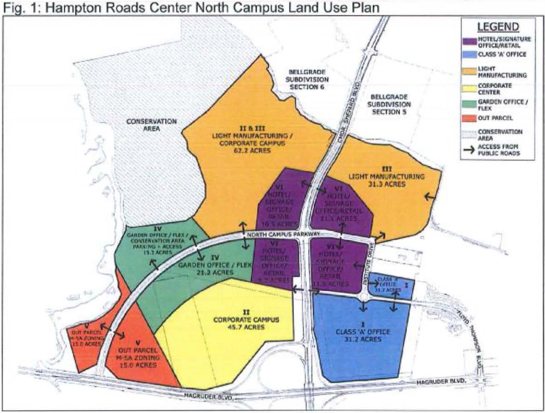
Boundaries. The HRC-2 District shall include the area designated on the zoning map with the symbol HRC-2. The HRC-2 District is comprised of subdistricts as depicted in Figure 1 (Hampton Roads Center North Campus Land Use Plan) for purposes of facilitating implementation of the HRCNC Master Plan. It shall be the responsibility of the IDA/DRC to steer individual uses to the appropriate use categories as identified in the master plan.
(2)
Permitted uses. Uses shall be permitted as set forth in chapter 3—Uses Permitted.
(3)
Development standards.
(a)
All construction within the HRC-2 District must be approved by the IDA/DRC prior to site plan approval.
(b)
Outdoor material and equipment storage must be screened so that it is not visible from any existing or proposed public right-of-way, and so that it is not visible from adjacent properties.
(c)
Building materials shall result in permanent and durable construction. Primary building materials shall be monochromatic (preferably earth tones) and shall be limited to brick, pre-cast concrete, natural stone, or architectural metal panels. Stucco, Exterior Insulating Finishing Systems (EIFS), corrugated metal or prefabricated/pre-engineered metal shall not be permitted as primary building materials.
(d)
All fences shall be wood, masonry or vinyl coated chain link; the use of electrified fences, barbed or razor wire, and chain link with slats anywhere on site is expressly prohibited.
(e)
Total lot coverage (building and improvements) shall not exceed seventy (70) percent of the total lot area; however, if the lot abuts a dedicated conservation area or stormwater management area that has a minimum dimension of at least fifty (50) feet, total lot coverage can be increased to seventy-seven (77) percent.
(f)
Alternatives to the above requirements may be considered by the IDA/DRC. Approval of alternatives shall be based on the committee's determination that the intent of the district, as stated in section 8-33 herein, is met.
(g)
Loading operations shall occur along the side and rear of buildings only. Loading areas shall be screened so that they are not visible from public rights of way and adjacent properties; however, no loading operations shall be visible from Magruder Boulevard, Commander Shepard Boulevard, or North Campus Parkway.
(4)
Lot size, building size, and height.
(a)
All lots shall be a minimum of two and one-half (2½) acres.
(b)
Buildings shall be a minimum of twenty thousand (20,000) square feet in size, with the following exceptions:
(i)
Accessory structures.
(ii)
Primary structures with the express approval of the IDA/DRC.
(c)
Buildings shall be a maximum of 120 feet in height.
(5)
Green area.
(a)
A minimum of thirty (30) percent of the total lot area shall be dedicated to green area; however, if the property abuts a dedicated conservation area or stormwater management area that has a minimum dimension of at least fifty (50) feet, this green area requirement may be reduced to twenty-three (23) percent.
(b)
Improvements permitted in required green areas are:
(i)
Signs.
(ii)
Decorative walls and fences.
(iii)
Security gates, guard houses, walls and fences.
(iv)
Fountains and decorative ponds.
(v)
Stormwater control structures and facilities.
(vi)
Pedestrian walks and trails, fitness stations.
(vii)
Gazebos, plazas, and observation areas.
(viii)
Landscape irrigation systems, controllers, and backflow devices.
(ix)
Public art and park identification features.
(x)
Lighting.
(xi)
Underground utilities.
(c)
The minimum green area depth requirements along public rights-of-way and other property lines are as follows:
(i)
Along Magruder Boulevard: Eighty (80) feet;
(ii)
Along Commander Shepard Boulevard:
(aa)
East of the intersection with the Virginia Power easement: Seventy-five (75) feet maintained as a landscape buffer;
(bb)
West of the intersection with the Virginia Dominion Power transmission line easement: A minimum of thirty (30) feet with an average of fifty (50) feet;
(iii)
Along North Campus Parkway, Floyd Thompson Boulevard and Institute Drive (as defined in the HRCNC Master Plan): A minimum of twenty (20) feet with an average of forty (40) feet;
(iv)
Along other existing or proposed public rights-of-way: Twenty (20) feet;
(v)
Along side and rear property lines not abutting an existing or proposed public right-of-way:
(aa)
If said property line abuts residentially zoned property: Thirty-five (35) feet maintained as an undisturbed buffer.
(bb)
In all other instances: Twenty (20) feet.
(vi)
Green area requirements in parking areas containing twenty (20) or more spaces are as follows:
(aa)
Ten (10) percent of the parking area (including drive aisles) shall be constructed and maintained as green area for the purpose of preserving existing and/or planting new trees and shrubs.
(bb)
Parking lot green areas shall be sized no less than ten (10) feet by eighteen (18) feet.
(vii)
All required green areas and buffers shall be landscaped in accordance with the "City of Hampton Landscape Guidelines".
(6)
Building setbacks. The minimum building setbacks from public rights-of-way and other property lines are as follows:
(a)
Magruder Boulevard: Twice the building height, but no less than eighty (80) feet and no more than one hundred (100) feet;
(b)
Commander Shepard Boulevard (east of the Virginia Dominion Power transmission line easement): Twice the building height, but no less than fifty (50) feet and no more than one hundred (100) feet;
(c)
North Campus Parkway, Floyd Thompson Boulevard, and Institute Drive (as defined in the HRCNC Master Plan): Twice the building height, but no less than forty (40) feet and no more than sixty (60) feet;
(d)
Other existing and proposed public rights-of-way: Forty (40) feet;
(e)
Side property lines not abutting an existing or proposed public right-of-way: Twenty (20) feet; however, if said property line abuts residentially zoned property: Thirty-five (35) feet; and
(f)
Rear property lines not abutting an existing or proposed public right-of-way: Thirty (30) feet; however, if said property line abuts residentially zoned property: Thirty-five (35) feet. Required building setbacks abutting residentially zoned property shall be maintained as undisturbed buffers.
(Ord. No. Z16-01, 2-10-2016)
Sec. 8-34. - HRC-3 District—Hampton Roads Center West.
(1)
Boundaries. Boundaries shall be as shown on the official zoning map of the City of Hampton.
(2)
Permitted uses. Uses shall be permitted as set forth in chapter 3—Uses Permitted.
(3)
Design review. All construction within the HRC-3 District must be approved by the Hampton Industrial Development Authority's Design Review Committee (IDA/DRC) prior to site plan approval. The IDA/DRC shall review all plans with respect to the standards outlined in this article to ensure the visual integrity and quality of the project.
(4)
Building and screening materials.
(a)
All exterior building materials shall result in permanent and durable construction. Except for interior courtyards, all exterior walls shall be constructed of brick or other high quality finished masonry, precast concrete panels, high quality metal panels, granite, glass, or materials of similar quality and durability. Other materials shall be used only as accent elements.
(b)
Primary building materials shall be monochromatic (preferably earth tones). Bright overall colors shall not be permitted as primary building colors, but may be used for accents.
(c)
Outdoor material and equipment storage shall be screened in accordance with the "City of Hampton Landscape Guidelines".
(d)
Loading docks and truck courts shall be screened in accordance with the "City of Hampton Landscape Guidelines".
(e)
All dumpsters visible from the eastern or southern district boundaries, or within fifty (50) feet of the northern or western district boundaries, shall be enclosed on three (3) sides by an opaque fence.
(f)
Fences adjacent to the Big Bethel Road right-of-way shall be located at the westernmost edge of the vegetated berm required under the provisions of the "City of Hampton Landscape Guidelines".
(5)
Height. Buildings shall be a maximum of fifty-five (55) feet in height.
(6)
Lot coverage. Total lot coverage within the HRC-3 District shall not exceed eighty (80) percent of the total district area. However, to allow for maximum flexibility with respect to individual lots within the district, the total lot coverage on any individual lot may be as high as ninety (90) percent of the individual lot area, so long as the district lot coverage is maintained at or below eighty (80) percent. Lot coverage includes buildings and all other improvements on the site, with the exception of lakes.
(7)
Setbacks.
(a)
All buildings:
(i)
Shall be set back at least fifty (50) feet from any existing or proposed public right-of-way.
(ii)
Shall be set back at least twenty (20) feet from any district boundary that is not an existing or proposed public right-of-way.
(iii)
Shall be set back at least ten (10) feet from all lake maintenance easements.
(iv)
With loading docks that face Big Bethel Road shall be set back at least three hundred (300) feet from the Big Bethel Road right-of-way.
(v)
With loading docks that face Interstate 64 shall be set back at least one hundred forty (140) feet from the Interstate 64 right-of-way,
(b)
All other improvements, with the exception of lakes:
(i)
Shall be set back at least fifty (50) feet from the Big Bethel Road right-of-way.
(ii)
Shall be set back at least twenty (20) feet from the Interstate 64 or North Park Lane rights-of-way.
(iii)
Shall be set back at least ten (10) feet from the western district boundary line.
(iv)
Shall be set back at least five (5) feet from the northern district boundary line.
(8)
Green areas.
(a)
A minimum of ten (10) percent of each lot and twenty (20) percent of the district area shall be retained as green space for trees, shrubs and turf.
(b)
The fifty (50) foot improvement setback along Big Bethel Road shall be retained as green space, which shall be counted toward the requirements of [subsection] (1) above. This green space shall be vegetated as set forth in the "City of Hampton Landscape Guidelines".
(c)
The twenty (20) foot improvement setbacks along North Park Lane and Interstate 64 shall be retained as green space, which shall be counted toward the requirements of [subsection] (1) above. This green space shall be vegetated as set forth in the "City of Hampton Landscape Guidelines".
(d)
All other required improvement setbacks shall be retained as green space, which shall be counted toward the requirements of subsection 8-34(8)(a) above.
(e)
All improvement setbacks shall be planted in compliance with the "City of Hampton Landscape Guidelines".
(f)
At least ten (10) percent of any parking lot designed for thirty (30) or more cars shall be retained as green space; this shall count toward the requirements of subsection 8-34(8)(a) above.
(g)
No row of parking spaces shall exceed one hundred forty-four (144) feet in length without a green space island. Such islands shall be a minimum of twelve (12) feet wide. This green area shall be counted toward the requirements of subsection 8-34(8)(f) above.
(h)
Whenever two (2) rows of parking spaces abut, the required green space islands shall be a minimum of twenty-four (24) feet wide.
(i)
A green space strip at least ten (10) feet wide shall be provide between buildings and parking areas except at plazas, points of entry to the building, and loading dock areas; this shall count toward the requirements in subsection 8-34(8)(a) above.
(9)
Lighting.
(a)
All lighting will be color corrected for true white, with allowances for modest amounts of blue or green.
(b)
Lighting levels will be determined by the recognized standard of the lighting industry, as specified in the "Lighting Handbook of the Illuminating Engineering Society."
(c)
Fixtures will be located to provide uniform illumination along drives and walkways and not cause glare or excessive spillage onto neighboring sites.
(d)
Light sources will be concealed and directed only to areas requiring illumination.
(e)
The use of high and low pressure sodium sources will not be allowed and use of incandescent sources will be limited to building entrances only.
(f)
Lighting in parking areas and truck courts will be pole mounted fixtures with a height of thirty-five (35) feet and provide a minimum lighting level of one-half (½) foot-candles.
(g)
All lighting in driveways, pedestrian walkways and plazas will be achieved with bollards not exceeding three and one-half (3½) feet in height and/or low surface mounted fixtures.
(h)
All special landscape areas and other accent elements will be illuminated with ground mounted, directed flood lights or low surface mounted fixtures.
(i)
Lighting fixtures should be comparable to those illustrated below:
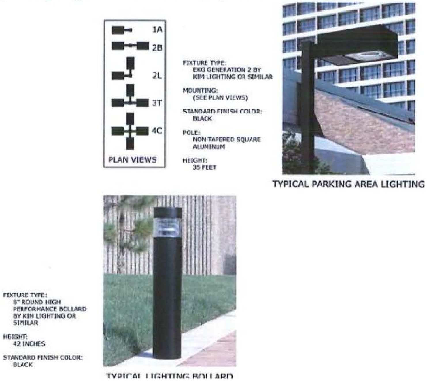
(10)
Owners' association. All owners of property within the HRC-3 District shall belong to a property owners' association. Such association shall be responsible for the maintenance of all commonly held property, to include, but not be limited to, private streets, utilities, lakes, green areas, and lighting. A copy of the association by-laws and covenants shall be submitted to the IDA/DRC for review as to compliance with this article and final copies filed with the Hampton Industrial Development Authority.
(Ord. No. Z16-01, 2-10-2016)
Sec. 8-41. - Overall intent of Downtown (DT) Districts.
The DT Districts are of special and substantial public interest because Downtown Hampton has served as the community's cultural, economic, and governmental center for over three hundred (300) years; because it has acquired a unique atmosphere and charm, by virtue of its history and the influence of waterfront activities, which is not duplicated in the city and which is worthy of preservation and enhancement; because it has been the target of an on-going redevelopment effort which has sought to provide such preservation and enhancement; and because a significant capital commitment has been made already by the community in an effort to improve the physical character of the area.
It is the intent of these regulations to continue and expand the guidance provided in the Old Hampton Redevelopment and Conservation Plan, as amended, for the preservation and enhancement of the historic character of Downtown Hampton; to protect against undesirable encroachment upon the district to encourage uses which are both compatible with past development and supportive of the character to be preserved; and to assure that new structures and uses within the district will maintain visual and functional harmony with past private development which has taken place within guidelines established by local public agencies.
It is also the intent of these regulations to implement the recommendations contained in the 2004 Downtown Hampton Master Plan, as amended, which encourages a vibrant, mixed use downtown that is intimately connected to the waterfront, surrounding neighborhoods, and its heritage and that maintains its existing charm and intimacy.
It is further intended that any site plan or other reviews required by these regulations shall be carried out in accordance with the objectives stated above, and that any required approvals shall not be withheld except where the proposed development is definably inappropriate or incompatible with such objectives.
(1)
Boundaries. The DT Districts shall include the area designated on the zoning map with the symbol DT-1 (Business), DT-2 (Waterfront), or DT-3 (Residential), as delineated on the following map:
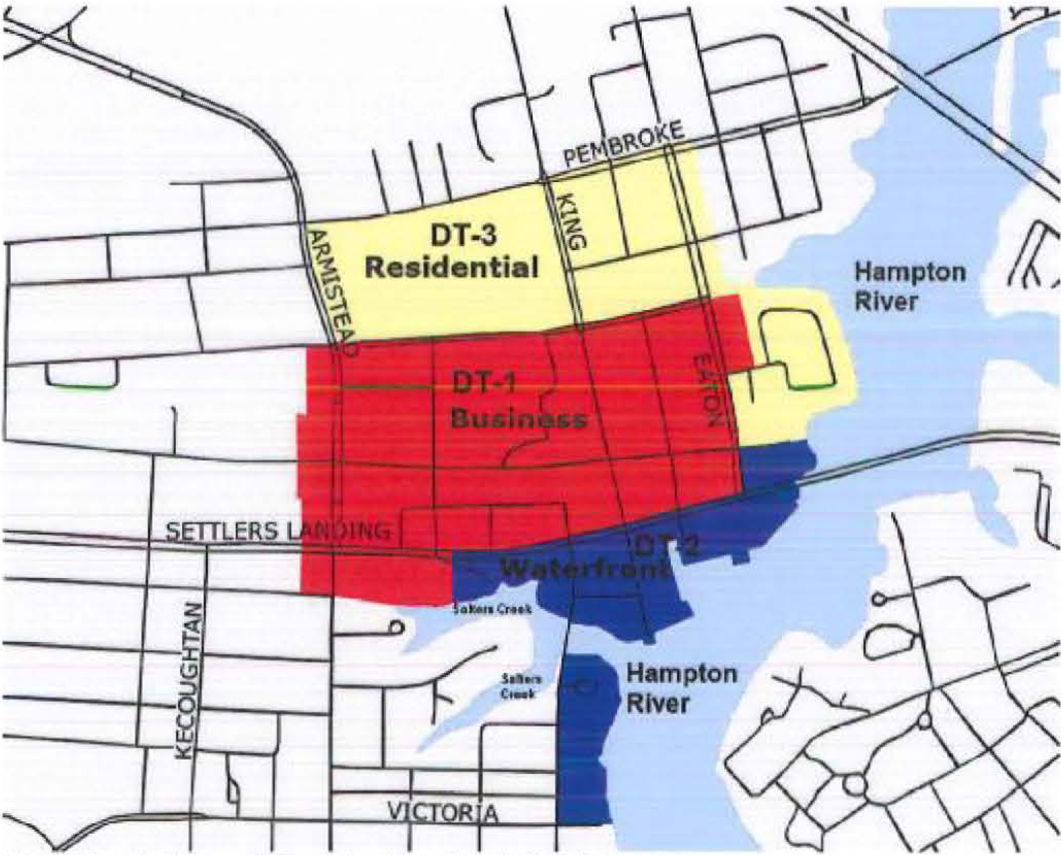
Sec. 8-42. - DT-1 District—Downtown Business.
(1)
Permitted uses. Uses shall be permitted as set forth in chapter 3—Uses Permitted.
(2)
Development and lot size standards.
(a)
Permitted retail sales, services, and office uses shall be conducted wholly within an enclosed building except for:
(i)
Bank, with drive-through
(ii)
Boat sales;
(iii)
Gas station;
(iv)
Outdoor dining, downtown;
(v)
Parking lot;
(vi)
Restaurant, including drive-through
(vii)
Rummage sale, temporary;
(viii)
Those uses authorized by a Special Event Permit issued pursuant to the Hampton City Code;
(ix)
Seasonal sales authorized by Section 34-7 of the City Code;
(x)
Food truck host sites;
(xi)
Outdoor play areas associated with Day Care 1, Commercial and Day Care 2, Commercial, which shall be permitted only within a physically defined and fenced area that is shown on the site plan; and
(xii)
Outdoor recreation areas associated with a physical recreational facility.
(b)
No more than fifty (50) percent of the floor area of any building shall be used for the storage of merchandise.
(c)
There shall be no minimum lot areas or lot dimensions.
(3)
Height.
(a)
For the purpose of this section, the height of buildings on land shall be determined as prescribed in chapter 2, provided that the base point for measurement may be raised to an elevation of eight and one-half (8½) feet above mean sea level if such base point is otherwise below this elevation. The maximum height of buildings in the DT-1 District shall be seventy-five (75) feet, except as follows:
(i)
The maximum height of buildings, any portion of which are located within one hundred fifty (150) feet of Kings Way between Lincoln Street and a point representing the southernmost right-of-way line of Queens Way and within one hundred fifty (150) feet of a point representing the westernmost right-of-way line of Wine Street and a line representing the easternmost right-of-way line of High Court Lane, shall be forty (40) feet.
(ii)
Except for buildings fronting on Kings Way or Queens Way as described above, the maximum height may be increased up to twenty (20) additional feet when parking facilities are incorporated into the building design. When one (1) full level of parking is provided in the building, the maximum height shall be eighty-five (85) feet; when two (2) full levels of parking are provided, the maximum height shall be ninety-five (95) feet.
(b)
For the purposes of this section, the maximum height of structures placed over the Hampton River or Salters Creek shall be thirty-five (35) feet or two (2) stories, whichever is shorter. This height shall be determined as prescribed in chapter 2, provided that the base point for measurement shall be an imaginary extension of the grade at the mean high water.
(4)
Setbacks. There shall be no minimum setbacks, except: A twelve-foot yard shall be required between the Hampton River or Salters Creek and any building, regardless of which yard shall front the body of water. This required yard shall be measured from the mean high water line, the water's edge of any existing or proposed bulkhead, or the landward edge of any existing or proposed riprap.
(Ord. No. Z15-23, 11-12-2015; Ord. No. Z23-0006, 5-24-2023; Ord. No. Z24-0003, 2-14-2024; Ord. No. Z24-0012, 5-8-2024)
Sec. 8-43. - DT-2 District—Downtown Waterfront.
(1)
Permitted uses. Uses shall be permitted as set forth in chapter 3—Uses Permitted.
(2)
Development and lot size standards.
(a)
Permitted retail sales, services, and office uses shall be conducted wholly within an enclosed building except for:
(i)
Bank, with drive-through
(ii)
Boat repair;
(iii)
Boat sales;
(iv)
Gas station;
(v)
Outdoor dining, downtown;
(vi)
Parking lot;
(vii)
Restaurant, including drive-through
(viii)
Rummage sale, temporary;
(ix)
Those uses authorized by a Special Event Permit issued pursuant to the Hampton City Code;
(x)
Seasonal sales authorized by Section 34-7 of the City Code;
(xi)
Food truck host sites;
(xii)
Outdoor play areas associated with Day Care 1, Commercial and Day Care 2, Commercial, which shall be permitted only within a physically defined and fenced area that is shown on the site plan; and
(xiii)
Outdoor recreation areas associated with a physical recreational facility.
(b)
No more than fifty (50) percent of the floor area of any building shall be used for the storage of merchandise.
(c)
There shall be no minimum lot areas or lot dimensions.
(3)
Height.
(a)
For the purpose of this section, the height of buildings on land shall be determined as prescribed in chapter 2, provided that the base point for measurement may be raised to an elevation of eight and one-half (8½) feet above mean sea level if such base point is otherwise below this elevation. The maximum height of buildings in the DT-2 District shall be as follows:
(i)
Forty-five (45) feet within any parcel bounded on one (1) or more sides by the Hampton River or Salters Creek, including areas east of Bridge Street and south of Rudd Lane, and areas east of South King Street and south of Settlers Landing Road.
(ii)
Fifty-five (55) feet within any parcel located within the Waterfront Area not included in subsection (i) above.
(b)
For the purposes of this section, the maximum height of structures placed over the Hampton River or Salters Creek shall be thirty-five (35) feet or two (2) stories, whichever is shorter. This height shall be determined as prescribed in chapter 2, provided that the base point for measurement shall be an imaginary extension of the grade at the mean high water.
(4)
Setbacks. There shall be no minimum setbacks, except: A twelve-foot yard shall be required between the Hampton River or Salters Creek and any building, regardless of which yard shall front the body of water. This required yard shall be measured from the mean high water line, the water's edge of any existing or proposed bulkhead, or the landward edge of any existing or proposed riprap.
(Ord. No. Z15-23, 11-12-2015; Ord. No. Z23-0006, 5-24-2023; Ord. No. Z24-0003, 2-14-2024; Ord. No. Z24-0012, 5-8-2024)
Sec. 8-44. - DT-3 District—Downtown Residential.
(1)
Permitted uses. Uses shall be permitted as set forth in chapter 3—Uses Permitted.
(2)
Lot size standards. Minimum lot area and lot dimensions in DT-3 shall be as prescribed in the district in which each use is first permitted.
(3)
Height.
(a)
For the purpose of this section, the height of buildings on land shall be determined as prescribed in chapter 2, provided that the base point for measurement may be raised to an elevation of eight and one-half (8½) feet above mean sea level if such base point is otherwise below this elevation. The maximum height of buildings in the DT-3 District shall be seventy-five (75) feet, except as follows:
(i)
The maximum height may be increased up to twenty (20) additional feet when parking facilities are incorporated into the building design. When one (1) full level of parking is provided in the building, the maximum height shall be eighty-five (85) feet; when two (2) full levels of parking are provided, the maximum height shall be ninety-five (95) feet.
(b)
For the purposes of this section, the maximum height of structures placed over the Hampton River or Salters Creek shall be thirty-five (35) feet or two (2) stories, whichever is shorter. This height shall be determined as prescribed in chapter 2, provided that the base point for measurement shall be an imaginary extension of the grade at the mean high water.
(4)
Setbacks. Setbacks shall be as prescribed in chapter 6, articles 2 through 5, where such density is first permitted.
Sec. 8-51. - Overall intent of Parks and Open Space (PO) Districts.
The PO Districts establish special classifications for certain parcels of land which are intended to be conserved and protected and/or used for recreational purposes.
Sec. 8-52. - PO-1 District—Parks and Open Space General.
(1)
Intent. The principal purposes of the PO-1 District are:
(a)
To conserve and protect open space, natural environmental features, and wildlife habitat;
(b)
To enhance the quality of life with provision of space for walking, passive and active recreation, and aesthetic enjoyment; and
(c)
To provide for recreational opportunities, where appropriate.
Designating these areas as such will raise the degree of assurance that designated open space and recreational areas will remain. It is intended to identify those parcels, relate them to the land use element of the city's adopted comprehensive plan and major elements of existing land use characteristics, and permit the greatest certainty regarding the character of potential uses of this public land.
(2)
Application of the district. To enable the district to operate in harmony with the plan for land use and populations embodied in these regulations, the PO-1 District shall be applied only to those lands owned or leased by the City of Hampton or any other governmental entity or political subdivision.
(3)
Permitted uses. Uses shall be permitted as set forth in chapter 3—Uses Permitted.
(Ord. No. Z16-07, 4-13-2016)
Sec. 8-53. - PO-2 District—Parks and Open Space Buckroe Beachfront.
(1)
Intent. Publicly-owned land at the Buckroe Beachfront is a special and unique public interest, in that it represents a unique and historical recreational and cultural asset to the Buckroe community, the City of Hampton, and the region as a whole. It is the intent of the PO-2 District to recognize the dual role that this property may serve in the future development of the Buckroe community, The fundamental and overriding role of this unique land asset is as public recreation and open space, in support of the enormous public use experienced by the Chesapeake Bay beachfront.
While the district placed emphasis on the protection of this asset for public recreation and open space, there is recognition of the possible role some of this property may play in serving as the impetus for improving the overall condition of the housing stock in the Buckroe community. This district establishes a special zoning classification for the publicly held and unimproved property adjacent to the Buckroe Beachfront Park. Although it is intended that this property be publicly held and utilized as open area in perpetuity, if the objectives to improve the Buckroe area's housing stock are not actualized, then activities to spur new development and encourage upgrades to the existing housing stock will be implemented. These activities may include amending this zoning classification of the subject property to permit its development, condemnation of adjacent properties, private acquisition, and assembly of land for redevelopment, demolition, etc. Amending the special zoning designation of the subject property should be considered only after all efforts to effect a positive change in the community's housing stock conditions prove to be futile and are exhausted.
(2)
Boundaries. The PO-2 District shall include the 3.28+ acres of city-owned property as shown on the official zoning map of the City of Hampton.
(3)
Permitted uses. Uses shall be permitted as set forth in chapter 3—Uses Permitted.
(4)
Changes to PO-2 District. The boundaries and/or permitted uses of the PO-2 District may be changed by the city council under the following conditions:
(a)
The condition of the Buckroe housing stock fails to meet the objectives outlined in the Buckroe Neighborhood Plan, adopted January 1995; or
(b)
Upon request by the Buckroe community in response to a specific development proposal.
Sec. 8-61. - Overall intent of Phoebus (PH) Districts.
The intent of this article is to define the development standards necessary to permit and encourage development which meets the recommendations of the Hampton Community Plan (2006, as amended) and Phoebus Master Plan (2007, as amended):
(a)
Implement standards requiring new construction to be contextually sensitive to the existing main street form of the development found in the core of Phoebus while providing opportunities for a variety of commercial and residential uses.
(b)
Establish development standards which create a safe and pedestrian-friendly environment.
(c)
Concentrate urban-scaled commercial development to best serve the local community and visitors alike.
(d)
Enhance downtown Phoebus to assert and reinforce its sense of place.
(e)
Enhance downtown Phoebus and its entrances as gateways to Fort Monroe.
(f)
Recognize and respect the neighborhood's listing on the National Register of Historic Places and Virginia Landmarks Register.
(g)
Provide assurance to owners and investors that future development will be appropriate for the character of Phoebus.
Sec. 8-62. - PH-1 District—Phoebus Urban Core.
(1)
Intent. The PH-1 District is intended to promote dense, pedestrian oriented, urban scale development with active street level uses that is in keeping with the historic development patterns of the mixed-use village center of Phoebus. PH-1 represents the most urban of the Phoebus Districts. The intent of this district's implementation is to encompass the key intersection of Mellen and Mallory Streets and neighboring blocks in support of the vision described in the Phoebus Master Plan (2007, as amended).
(2)
Uses permitted. Uses shall be permitted as set forth in Chapter 3 - Uses Permitted.
(3)
Development standards.
(a)
For any newly-created lot, the minimum lot depth shall be ninety (90) feet. Where the lot can potentially be accessed via an alley or similar right-of-way to the rear, the lot shall be created to provide such access.
(b)
Buildings in this district shall be subject to the following standards:
(c)
Setbacks.
(i)
Front. For buildings with ground floor commercial space, there shall be a maximum front setback of 0 (zero) feet unless one of the following optional pedestrian amenities is provided in accordance with the City of Hampton Pedestrian Amenity Design Standards, in which case the maximum shall be fifteen (15) feet:
(aa)
Courtyard.
(bb)
Outdoor seating area.
For buildings with residential uses on the ground floor, buildings may be setback no more than fifteen (15) feet from the property line.
This setback exists for the purpose of allowing for steps up to the minimum first finished floor height, porches, and ground level areas meeting the City of Hampton Pedestrian Amenity Design Standards, along with a pedestrian connection to the adjacent sidewalk.
(ii)
Side, adjacent to a public right-of-way. For buildings with ground floor commercial uses, there shall be a maximum setback of 0 (zero) feet unless one (1) of the following optional pedestrian amenities is provided in accordance with the City of Hampton Pedestrian Amenity Design Standards, in which case the maximum shall be fifteen (15) feet:
(aa)
Courtyard.
(bb)
Outdoor seating area.
For buildings with residential uses on the ground floor, buildings may be setback no more than fifteen (15) feet from the property line. This setback exists for the purpose of allowing for steps up to the minimum first finished floor height, porches, and ground level areas meeting the City of Hampton Pedestrian Amenity Design Standards, along with a pedestrian connection to the adjacent sidewalk.
In the case that the lot is not square, the building shall be placed so that the requirements of subsection 8-63(3)(c)(i) shall be met, and shall match the side, adjacent to a public right-of-way to the greatest extent practicable per the discretion of the Zoning Administrator, or designee, based upon lot, not preferred building, characteristics.
(iii)
Side, not adjacent to a public right-of-way. There shall be no minimum and no maximum setback, unless adjacent to a single-family or two-family residential district, in which case the minimum setback is five (5) feet.
(iv)
Rear. There shall be no required setback unless adjacent to a single- family or two-family residential zone, in which case there shall be a minimum setback of 10 (ten) feet.
(d)
Building footprint.
(i)
The maximum width of a building with ground floor commercial uses shall be fifty (50) feet.
(ii)
The maximum area of the footprint of the building, measured by the exterior perimeter of the foundation, shall be five thousand (5,000) square feet.
(e)
Façade composition.
(i)
A minimum of ninety (90) percent of the front setback line across the entire parcel must be occupied by the building façade, which has occupiable, wholly enclosed space directly behind and connected to it.
(ii)
Primary entrance location.
(aa)
The primary entrance to buildings shall directly face the adjacent public right-of-way.
(bb)
Primary entrances to buildings with lot frontage abutting Mellen Street or Mallory Street shall be located on Mellen Street or Mallory Street, whichever is applicable. Entrances may be angled to directly face an intersection which includes Mellen Street or Mallory Street to meet this requirement.
(iii)
Elevation of first floor.
Where there are residential uses on the ground floor, the first finished floor shall be a minimum of thirty (30) inches above the grade at the base of the steps or ramp approaching the entrance.
(iv)
Fenestration.
(aa)
Where ground floor commercial space fronts on a public right-of-way, a minimum of forty (40) percent of the first floor building façade containing the primary entrance shall be comprised of glass windows or glass doors that allow views at least four (4) feet into the interior building space.
(bb)
Where ground floor commercial space fronts on both Mellen Street and Mallory Street, a minimum of forty (40) percent of the building façade adjacent to Mellen Street and Mallory Street shall be comprised of glass windows or glass doors that allow views at least four (4) feet into the interior building space on both façades.
(cc)
Where ground floor residential space fronts on a public right-of-way, a minimum of twenty (20) percent of the first floor building façade shall be comprised of glass windows and/or glass doors.
(f)
Height.
(i)
All buildings shall be a maximum of fifty (50) feet in height.
(ii)
All buildings shall contain a minimum of two (2) stories of habitable/usable space with neither of the first two (2) floors providing less than fifty (50) percent of the gross square feet of the other floor.
(g)
Accessory structures and equipment.
(i)
Dumpsters, accessory structures, outdoor storage areas, and utility, stormwater, mechanical, or similar equipment shall be prohibited in the front yard on all lots and the side yard adjacent to public rights-of-way on corner lots.
(aa)
All dumpsters and compaction devices shall be fully screened by an enclosure constructed of durable materials.
(h)
If choosing to not meet the development standards as required by section 8-63(3) a use permit may be sought. Such a use permit shall be reviewed for conformance with adopted policies and achieving the intent of the PH-1 district to enhance the historically dense mixed-use development pattern of the Urban Core.
(4)
Parking. Parking shall be provided as described in chapter 11 herein.
(a)
Parking shall be prohibited in the area between the building and any adjacent public right-of-way, not to include any alleys and the following streets:
(i)
Lancer Street
(ii)
Williams Street
(iii)
Tennis Lane
(iv)
Larabee Lane
(b)
On waterfront properties, parking shall be prohibited between the building and the water feature.
(Ord. No. Z15-20, 10-14-2015; Ord. No. Z17-01, 8-9-2017; Ord. No. Z17-02, 12-13-2017; Ord. No. Z19-06, 1-9-2019)
Sec. 8-63. - PH-2 District—Phoebus Town.
(1)
Intent. The PH-2 District is intended to promote pedestrian oriented, urban scale development in keeping with the historic development patterns of the mixed-use village center of Phoebus. Unlike the Phoebus Urban Core, this district does not require ground floor commercial development and provides greater flexibility in the footprint of buildings. While not as dense as PH-1 and providing more flexibility, this district is intended to facilitate an expansion of a denser development pattern similar to that found in the historic mixed-use center of Phoebus.
(2)
Uses permitted. Uses shall be permitted as set forth in Chapter 3 - Uses Permitted.
(3)
Development standards.
(a)
For any newly-created lot, the minimum lot depth shall be ninety (90) feet. Where the lot can potentially be accessed via an alley or similar right-of-way to the rear, the lot shall be created to provide such access.
(b)
Buildings in this district shall be subject to the following standards:
(c)
Setbacks.
(i)
Front. For buildings with ground floor commercial space, there shall be a maximum front setback of zero (0) feet unless one of the following optional pedestrian amenities is provided in accordance with the City of Hampton Pedestrian Amenity Design Standards, in which case the maximum shall be fifteen (15) feet:
(aa)
Courtyard.
(bb)
Outdoor seating area.
For buildings with residential uses on the ground floor, buildings may be setback no more than fifteen (15) feet from the property line. This setback exists for the purpose of allowing for steps up to the minimum first finished floor height, porches, and ground level areas meeting the City of Hampton Pedestrian Amenity Design Standards, along with a pedestrian connection to the adjacent sidewalk.
(ii)
Side, adjacent to a public right-of-way. For buildings with ground floor commercial uses, there shall be a maximum setback of zero (0) feet unless one of the following optional pedestrian amenities is provided in accordance with the City of Hampton Pedestrian Amenity Design Standards, in which case the maximum shall be fifteen (15) feet:
(aa)
Courtyard.
(bb)
Outdoor seating area.
For buildings with residential uses on the ground floor, buildings may be setback no more than fifteen (15) feet from the property line. This setback exists for the purpose of allowing for steps up to the minimum first finished floor height, porches, and ground level areas meeting the City of Hampton Pedestrian Amenity Design Standards, along with a pedestrian connection to the adjacent sidewalk.
In the case that the lot is not square, meaning the sides that meet to form corners are not perpendicular, the building shall be placed so that the requirements of subsection 8-63(3)(c)(i) shall be met, and shall match the side, adjacent to a public right-of-way to the greatest extent practicable per the discretion of the Zoning Administrator, or designee, based upon lot, not preferred building, characteristics.
(iii)
Side, not adjacent to a public right-of-way. There shall be no minimum and no maximum setback, unless adjacent to a single-family or two-family residential district, in which case the minimum setback is five (5) feet.
(iv)
Rear. There shall be no required setback unless adjacent to a single-family or two-family residential zone, in which case there shall be a minimum setback of 10 (ten) feet.
(d)
Building footprint.
(i)
The maximum width of a building with ground floor commercial uses shall be seventy-five (75) feet. Width shall be measured at the front setback line.
(ii)
The maximum width of a building with ground floor townhouses or multifamily uses shall be one hundred seventy-five (175) feet. Width shall be measured at the front setback line.
(iii)
The maximum area of the footprint of a building, measured by the exterior perimeter of the foundation, shall be eight thousand (8,000) square feet.
(e)
Façade composition.
(i)
A minimum of seventy-five (75) percent of the front setback line across the entire parcel must be occupied by the building façade.
(ii)
Primary entrance location.
(aa)
The primary entrance to buildings shall directly face the adjacent public right-of-way.
(bb)
Primary entrances to buildings with lot frontage abutting Mellen Street or Mallory Street shall be located on Mellen Street or Mallory Street, whichever is applicable. Entrances may be angled to directly face an intersection which includes Mellen Street or Mallory Street to meet this requirement.
(iii)
Elevation of first floor.
Where there are residential uses on the ground floor, the first finished floor shall be a minimum of thirty (30) inches above the grade at the base of the steps or ramp approaching the entrance.
(iv)
Fenestration.
(aa)
Where ground floor commercial space fronts on a public right-of-way, a minimum of forty (40) percent of the first floor building façade containing the primary entrance shall be comprised of glass windows or glass doors that allow views at least four (4) feet into the interior building space.
(bb)
Where ground floor commercial space fronts on both Mellen Street and Mallory Street, a minimum of forty (40) percent of the building façade adjacent to Mellen Street and Mallory Street shall be comprised of glass windows or glass doors that allow views at least four (4) feet into the interior building space on both façades.
(cc)
Where ground floor residential space fronts on a public right-of-way, a minimum of twenty (20) percent of the first floor building façade shall be comprised of glass windows and/or glass doors.
(f)
Height.
(i)
All buildings shall be a minimum of eighteen (18) feet and a maximum of fifty (50) feet in height.
(g)
Accessory structures and equipment.
(i)
Dumpsters, accessory structures, outdoor storage areas, and utility, stormwater, mechanical, or similar equipment shall be prohibited in the front yard on all lots and the side yard adjacent to public rights-of-way on corner lots.
(aa)
All dumpsters and compaction devices shall be fully screened by an enclosure constructed of durable materials.
(h)
If choosing to not meet the development standards as required by section 8-63(3), a use permit may be sought. Such a use permit shall be reviewed for conformance with adopted policies and achieving the intent of the PH-2 district to enhance the mixed-use streetscape around the Urban Core.
(4)
Parking. Parking shall be provided as described in chapter 11 herein.
(a)
Parking shall be prohibited in the area between the building and any adjacent public right-of-way, not to include any alleys and the following streets:
i.
Lancer Street
ii.
Williams Street
iii.
Tennis Lane
iv.
Larabee Lane
(b)
On waterfront properties, parking shall be prohibited between the building and the water feature.
(Ord. No. Z19-07, 1-9-2019)
Sec. 8-64. - PH-3 District—Phoebus Commercial Transition.
(1)
Intent. The PH-3 District is intended to create edges of the pedestrian oriented Phoebus mixed-use center while being more accommodating to vehicles and auto oriented commercial.
(2)
Uses permitted. Uses shall be permitted as set forth in Chapter 3 - Uses Permitted.
(3)
Development standards.
(a)
For any newly-created lot, the minimum lot depth shall be ninety (90) feet. Where the lot can potentially be accessed via an alley or similar right-of-way to the rear, the lot shall be created to provide such access.
(b)
Buildings in this district shall be subject to the following standards:
(c)
Setbacks.
(i)
Front. For buildings with ground floor commercial space, there shall be a maximum front setback of forty-five (45) feet. For buildings with residential uses on the ground floor, buildings may be setback no more than fifteen (15) feet from the property line. This setback exists for the purpose of allowing for steps up to the minimum first finished floor height, porches, and ground level areas meeting the City of Hampton Pedestrian Amenity Design Standards.
(ii)
Side, adjacent to a public right-of-way. For buildings with ground floor commercial uses, there shall be a maximum setback of forty-five (45) feet. For buildings with residential uses on the ground floor, buildings may be setback no more than fifteen (15) feet from the property line. This setback exists for the purpose of allowing for steps up to the minimum first finished floor height, porches, and ground level areas meeting the City of Hampton Pedestrian Amenity Design Standards.
In the case that the lot is not square, means sides that meet to form a corner are not perpendicular, the building shall be placed so that the requirements of section 8-63(3)(c)(i) shall be met, and shall match the side, adjacent to a public right-of-way to the greatest extent practicable per the discretion of the Zoning Administrator, or designee, based upon lot, not preferred building, characteristics.
(iii)
Side, not adjacent to a public right-of-way. There shall be no minimum and no maximum setback, unless adjacent to a single-family or two-family residential district, in which case the minimum setback is five (5) feet.
(iv)
Rear. There shall be no required setback unless adjacent to a single-family or two-family residential zone, in which case there shall be a minimum setback of 10 (ten) feet.
(d)
Façade composition.
(i)
A minimum of fifty (50) percent of the front setback line across the entire parcel must be occupied by the building façade.
(ii)
Primary entrance location.
(aa)
The primary entrance to buildings shall directly face the adjacent public right-of-way.
(bb)
Primary entrances to buildings with lot frontage abutting Mellen Street or Mallory Street shall be located on Mellen Street or Mallory Street, whichever is applicable. Entrances may be angled to directly face an intersection which includes Mellen Street or Mallory Street to meet this requirement.
(iii)
Elevation of first floor. Where there are residential uses on the ground floor, the first finished floor shall be a minimum of thirty (30) inches above the grade at the base of the steps or ramp approaching the entrance.
(iv)
Fenestration.
(e)
Height.
(aa)
Where ground floor commercial space fronts on a public right-of-way, a minimum of thirty (30) percent of the first floor building façade containing the primary entrance shall be comprised of glass windows or glass doors that allow views at least four (4) feet into the interior building space.
(bb)
Where ground floor residential space fronts on a public right-of-way, a minimum of twenty (20) percent of the first floor building façade shall be comprised of glass windows and/or glass doors.
(i)
All buildings shall be a minimum of eighteen (18) feet and a maximum of fifty (50) feet in height.
(f)
Screening and connectivity.
(i)
Dumpsters, accessory structures, outdoor storage areas, and utility, stormwater, mechanical, or similar equipment shall be prohibited in the front yard on all lots and the side yard adjacent to public rights-of-way on corner lots.
(aa)
All dumpsters and compaction devices shall be fully screened by an enclosure constructed of durable materials.
(ii)
Regardless of the depth of any setback greater than zero (0) feet, a clear, direct pedestrian access shall be installed and maintained between the sidewalk in the directly adjacent public right-of-way and any public entrance facing that right-of-way. Where the pedestrian access crosses a drive aisle, the pedestrian path shall be made clear by using material that is different in color and texture or pattern than the drive aisle it crosses.
(g)
If choosing to not meet the development standards as required by section 8-63(3)(a) and/or (d), which pertain to dimensions and access to a new lot and building footprint, a use permit may be sought. Such a use permit shall be reviewed for conformance with adopted policies and achieving the intent of the PH-3 district to create edges to the Phoebus mixed-use center while being more accommodating to vehicles and auto oriented commercial.
(i)
Applications shall specify the requested dimensional changes and include to-scale drawings of the site layout, including but not limited to showing lot boundaries, building footprint, pedestrian and vehicular access, parking, and adjacent sidewalk or similar adjacent public features, as well as all facades, including location of doors, windows, architectural features, roof or parapet line, and building materials.
(Ord. No. Z19-08, 1-9-2019)
Sec. 8-67. - Overall intent of Fort Monroe (FM) Districts.
In 2005, the Defense Base Realignment and Closure Commission recommended that Fort Monroe cease to be used as an Army installation, resulting in the closure of the Fort in 2011. Portions of the Fort property were transferred to the National Park Service with the establishment by Presidential proclamation in 2011 of the Fort Monroe National Monument. Most of the remaining property at Fort Monroe is now controlled by the Fort Monroe Authority ("FMA") a political subdivision of the Commonwealth of Virginia. The FMA was created to manage the base closure and reuse process to include the transfer of some of the Commonwealth's Fort Monroe property to private ownership thereby making the property subject to the requirements of the City of Hampton's Zoning Ordinance.
Fort Monroe was designated a National Historic Landmark while serving as a military base in 1960. The property was listed on the National Register of Historic Places in 1966. Due to the historical significance of the Fort, a Programmatic Agreement ("PA") was prepared for the closure of the base as required by Section 106 of the National Historic Preservation Act. The PA for Fort Monroe includes the establishment of the Fort Monroe Historic Preservation Manual and Design Standards ("FM Design Standards"). The FM Design Standards serve as legally enforceable regulations administered by the FMA to ensure that the rehabilitation of existing buildings and construction of new buildings is compatible with the character of the historic landmark district. The FM Design standards include regulations typically found in municipal zoning ordinances such as building height and building set back.
The overall intent of the Fort Monroe ("FM") Districts is to define land use and development standards to implement the recommendations of the Hampton Community Plan (2006, as amended) and the Fort Monroe Land Use Plan (2016, as amended). It is also the intent of the FM Districts to recognize the FMA's obligations with respect to the FM Design Standards and to avoid duplication or conflict with these standards. As a result, the FM Districts do not include many of the development standards such as building height and setback found in other City of Hampton zoning districts.
(Ord. No. Z16-08, 4-13-2016)
Sec. 8-68. - FM-1 District—Inner Fort.
(1)
Intent. The intent of the FM-1 District is to protect the single-family character of the residential community within the Inner Fort while also promoting the enjoyment of the historical, recreational, cultural, and educational resources of the Fort Monroe National Monument, the Casemate Museum and related visitor attractions on Fort Monroe.
(2)
Uses permitted. Uses shall be permitted as set forth in Chapter 3—Uses Permitted.
(3)
Development standards. The FM Design Standards serve as legally enforceable regulations administered by the FMA to ensure that the rehabilitation of existing buildings and construction of new buildings is compatible with the character of the historic landmark district. The FM Design standards include regulations typically found in municipal zoning ordinances such as building height and setbacks.
(4)
Parking. Parking shall be provided as described in Chapter 11 herein.
(Ord. No. Z16-08, 4-13-2016)
Sec. 8-69. - FM-2 District—Historic Village.
(1)
Intent. The intent of the FM-2 District is to protect the character of the residential community within the Historic Village and to promote new residential development. The district also provides limited options for retail and employment uses in appropriate locations and buildings as identified in the Fort Monroe Land Use Plan (2016, as amended). These non-residential uses are intended to serve both residents of Fort Monroe and visitors. Non-residential uses are directed by use permit to specific locations to promote shared parking, minimize impacts on single-family residential uses, and to provide multiple options for the reuse of contributing historic structures that were built for commercial or institutional purposes.
(2)
Uses permitted.
(a)
Uses shall be permitted as set forth in Chapter 3—Uses Permitted.
(b)
Where required, use permits for non-residential uses (except day care 3) in the FM-2 District are directed to appropriate locations by the Fort Monroe Land Use Plan (2016, as amended).
(c)
Standard use permit conditions for non-residential uses listed as permitted by use permit in the FM-2 District in use groups "retail sales, services, and office;" "institutional;" "recreational;" "industrial;" and "utilities and transportation" shall comply with Chapter 14 of the zoning ordinance and may include but shall not be limited to the following:
(i)
Location of use and non-transferability of permit;
(ii)
Hours of operation;
(iii)
Building capacity;
(iv)
Sound;
(v)
Parking and circulation;
(vi)
Screening and buffering;
(vii)
Third-party promoters;
(viii)
Permit revocation;
(ix)
Permit nullification; and
(x)
Review of use after 12 months of operation.
(3)
Development standards.
The FM Design Standards serve as legally enforceable regulations administered by the FMA to ensure that the rehabilitation of existing buildings and construction of new buildings is compatible with the character of the historic landmark district. The FM Design standards include regulations typically found in municipal zoning ordinances such as building height and building set back.
(4)
Parking. Parking shall be provided as described in Chapter 11 herein.
(Ord. No. Z16-08, 4-13-2016)
Sec. 8-70. - FM-3 District—North Gate.
(1)
Intent. The intent of the FM-3 District is to promote employment uses on Fort Monroe through the re-use of existing buildings and new construction. The district also provides limited options for new single-family and multi-family development in appropriate locations as identified in the Fort Monroe Land Use Plan (2016, as amended). Residential uses are directed by use permit to specific locations to protect the character and value of these uses and to minimize encroachment into areas dominated by employment uses.
(2)
Uses permitted.
(a)
Uses shall be permitted as set forth in Chapter 3—Uses Permitted.
(b)
Where required, use permits for residential uses in the FM-3 District are directed to appropriate locations by the Fort Monroe Land Use Plan (2016, as amended).
(c)
Standard use permit conditions for residential uses listed as permitted by use permit in the FM-3 District in the use group "residential—1, 2, and multifamily" shall comply with Chapter 14 of the zoning ordinance and may include but shall not be limited to the following:
(i)
Location of use and non-transferability of permit;
(ii)
Parking and circulation;
(iii)
Screening and buffering;
(iv)
Permit revocation; and
(v)
Permit nullification.
(3)
Development standards. The FM Design Standards serve as legally enforceable regulations administered by the FMA to ensure that the rehabilitation of existing buildings and construction of new buildings is compatible with the character of the historic landmark district. The FM Design standards include regulations typically found in municipal zoning ordinances such as building height and building set back.
(4)
Parking. Parking shall be provided as described in Chapter 11 herein.
(Ord. No. Z16-08, 4-13-2016)
Sec. 8-71. - FM-4 District—Wherry Quarter.
(1)
Intent. The intent of the FM-4 District is to promote uses that support the enjoyment of the historical, recreational, cultural and educational resources of the Fort Monroe National Monument and other visitor attractions on Fort Monroe.
(2)
Uses permitted.
(a)
Uses shall be permitted as set forth in Chapter 3—Uses Permitted.
(3)
Development standards. The FM Design Standards serve as legally enforceable regulations administered by the FMA to ensure that the rehabilitation of existing buildings and construction of new buildings is compatible with the character of the historic landmark district. The FM Design standards include regulations typically found in municipal zoning ordinances such as building height and building set back.
(4)
Parking. Parking shall be provided as described in Chapter 11 herein.
(Ord. No. Z16-08, 4-13-2016)
Sec. 8-76. - Overall intent of Langley Business Park (LBP) District.
The general purpose and intent of this district is to promote the development of a mix of office, distribution, light manufacturing and support service uses within a modest campus setting. The central location of this district serves to support the commercial and high-tech interests located in the surrounding Magruder Corridor area including NASA Langley Research Center, Langley Speedway, and the business parks of Hampton Roads Center South, Central and North Campuses, along with long standing maritime interests in the area.
Specific objectives to be promoted by the establishment of the district include:
(a)
Provide business sites that will support the economic growth and diversification of Hampton's tax base.
(b)
Create a high quality, innovative, and adaptive environment capable of attracting and sustaining a diverse mix of businesses, including both skilled labor and professional, free from offensive operations.
(c)
Be inclusive of support service uses that support the day to day operations of base employers in the park.
(d)
Provide for diversity in the types of research, development, manufacturing and support commercial uses that are realistically free from offense.
(e)
Encourage business development that adheres to the recommendations of the Joint Land Use Study with Langley Air Force Base.
(1)
Boundaries. The LBP District shall include the area designated on the zoning map with the symbol "LBP."
(2)
Uses permitted. Uses shall be permitted as set forth in Chapter 3 - Uses Permitted.
(3)
Development standards.
(a)
All uses conducted outside of a building, including but not limited to outdoor material and equipment storage but excluding food truck host sites, shall be screened so that it is not visible from any existing or proposed public right-of-way, and so that it is not visible from adjacent properties.
(b)
All screening fences shall be opaque; the use of electrified fences, barbed or razor wire, and chain link with or without slats anywhere on site is expressly prohibited.
(c)
Loading operations shall occur along the side and rear of buildings only. Loading areas shall be screened so that they are not visible from public rights-of-way and adjacent properties; however, no loading operations shall be visible from Magruder Boulevard or Commander Shepard Boulevard.
(d)
Front yards and unfenced side yards which abut a street shall be landscaped in accordance with the "City of Hampton Landscape Guidelines."
(e)
Accessory buildings or structures shall not be located in the front yard.
(4)
Building height.
(a)
Buildings shall be a maximum of 120 feet in height.
(5)
Setbacks.
Minimum dimensions as follows:
(Ord. No. Z20-01, 1-8-2020; Ord. No. Z23-0006, 5-24-2023)