
Harlem City Zoning Code
ARTICLE II
ZONING DISTRICTS
Sec. 108-28.- District class and boundary provisions.
(a)
Classes of districts. For the purpose of this chapter the city is hereby divided into the following classes of districts or zones:
(b)
Rules governing district boundaries. Where uncertainty exists with respect to the boundaries of any aforementioned districts as shown on the zoning map, the following rules shall apply:
(1)
Unless otherwise indicated, the district boundaries are the centerlines of streets, railroad rights-of-way, streams, or such lines extended. Where district boundaries cut a block transversely or longitudinally, the line shall not cut through a lot, but shall coincide with the appropriate lot lines.
(2)
Where the district boundaries are indicated as approximately following the corporate limit, such corporate limit line shall be construed to be such boundary.
(3)
Where district boundaries are indicated as approximately parallel to the centerlines of streets or highways, such district shall be as indicated on the zoning map, except as stated in subsection (b)(1) of this section. If no distance is given, such dimensions shall be determined by the use of the scale as shown on the zoning map.
(Ord. No. 381, 4-10-2006; Ord. No. 2225, 11-28-2022)
Sec. 108-29. - Residential District (R-1A).
(a)
Permitted uses. Within the R-1A Residential Districts the following uses are permitted as a matter of right:
(1)
One single-family dwelling per lot, other than manufactured homes.
(2)
Public and private parks and open space, but excluding commercial facilities.
(3)
Public elementary and high schools, or private schools with a curriculum the same as ordinarily offered in public elementary and high schools, and having no rooms regularly used for housing or sleeping.
(4)
Churches, provided that:
a.
They are located on a major collector street;
b.
The buildings are placed not less than 50 feet from any property line;
c.
There is a planted buffer strip at least ten feet wide along the side and rear property lines;
d.
The building is used primarily for religious worship.
(5)
Customary incidental home occupations provided as permitted in this article (See sections 108-201 through 108-214).
(6)
Nursery schools or kindergartens, provided that there are at least 150 square feet of outdoor play area for each child and the play area is enclosed by a fence so as to adequately protect the children.
(7)
Electrical transformers or gas regulator stations, if essential for the service to the zoning district in which it is proposed to be located, provided that:
a.
The structures are placed not less than 50 feet from any property line;
b.
No vehicles or equipment are stored on the premises;
c.
The lot is suitably landscaped;
d.
There is a planted buffer strip at least ten feet wide along the side and rear property lines.
(8)
Railroad lines and passenger stations.
(b)
Accessory uses. In the R-1A district, the following accessory uses are permitted:
(1)
The keeping of not more than two non-transient roomers or boarders by a resident family.
(2)
Building or structures customarily accessory and incidental to a permitted use, including private garages and noncommercial greenhouses and workshops, provided they are located in the rear yard and not closer than 15 feet from side property line and 25 feet from rear property line.
(3)
Private recreational facilities, such as swimming pools, basketball courts and tennis courts.
(4)
Principal use advertising signs, as regulated in sections 108-239 through 108-244.
(5)
The raising of garden crops, vineyard crops, fruits or plants incidental to the residential use of the land.
(6)
Buildings, including accessory buildings, may occupy no more than 50 percent of a lot.
(7)
Accessory buildings cannot be attached to the main structure.
(Code 2004, § 152.025; Ord. No. 381, 4-10-2006)
Sec. 108-30. - Residential District (R-1B).
(a)
Permitted uses. Within the R-1B Residential District the following uses are permitted as a matter of right: any use permitted in the R-1A Residential District.
(b)
Accessory uses. In the R-1B district, the following accessory uses are permitted: any accessory use permitted in the R-1A Residential District.
(Code 2004, § 152.026; Ord. No. 381, 4-10-2006)
Sec. 108-31. - Residential District (R-2).
(a)
Permitted uses. In the R-2 district, the following uses are permitted as a matter of right:
(1)
Any use permitted in the R-1B Residential District.
(2)
Duplexes, one per lot.
(b)
Accessory uses. In the R-2 district, the following accessory uses are permitted: any accessory use permitted in the R-1A Residential District.
(Code 2004, § 152.027; Ord. No. 381, 4-10-2006)
Sec. 108-32. - Residential District (R-3).
(a)
Permitted uses. In the R-3 district, the following uses are permitted as a matter of right:
(1)
Any use permitted in the R-2 Residential District.
(2)
Apartment houses, provided that the following minimum standards are met:
a.
Lot size. The minimum lot size shall be five acres;
b.
Density. There shall be no more than five apartments per gross acre;
c.
Open space requirements; amenities. Not less than 25 percent of the gross acreage of the development shall be maintained as permanent open space. At least 50 percent of the required open space shall be accessible to residents. A minimum of 25 percent of the required open space shall be improved as active recreational facilities. Passive recreation, in compliance with adopted greenways and trails guidelines and plans, shall be provided. Parking and other paved surfaces, except patios and courtyards that are publicly accessible amenities, shall not count towards this open space requirement. All required amenities shall be installed before 50 percent of the overall development is completed;
d.
Material and design standards. Apartments shall comply with the following material and design standards:
1.
Exterior finishes shall be primarily horizontal wood or wood product siding, brick, stucco, stone or other decorative masonry product. Vinyl shall only be used in gables and/or soffits.
2.
Facades of each apartment house shall not replicate the facade of immediately adjacent apartment houses. At least 20 percent of the facade shall be of another permitted material than the primary material. Roofing is not included in the facade.
3.
Apartment houses shall utilize at least two of the following design features on the facade:
(i)
Gables;
(ii)
Recessed entries;
(iii)
Covered front porches;
(iv)
Pillars or posts;
(v)
Bay window with a minimum of 24-inch projection; or
(vi)
Dormers.
4.
Walls which face a street other than an alley shall contain at least 20 percent of the wall space in windows and/or doors.
e.
Application for approval. Applications for development shall be accompanied with the following:
1.
A plat of the land to be included in the total development showing all rights-of-way and easements affecting the property.
2.
The location of buildings and the number of stories contained in each.
3.
Architectural drawings of the proposed apartment houses.
4.
The preliminary location of water supply, sanitary and storm sewer systems.
5.
The location of all curb cuts, driving lanes and parking areas.
6.
The locations and type of all common areas (pedestrian walkways, open spaces, recreational uses) including a statement of the method to be used to ensure continued maintenance of such areas.
7.
The location and height of all walls, fences and screen plantings.
8.
A tabulation of the total area, number of apartments, and overall density per acre.
(3)
Boardinghouses.
(4)
Nursing care homes and hospitals.
(5)
Fraternal organizations and clubs not operated for profit, provided that:
a.
They are located on a major or collector street;
b.
The buildings are placed not less than 50 feet from any property line;
c.
There is a planted buffer strip of ten feet wide at least along the side and rear lot lines.
(6)
Build-to-rent single-family homes and single-family townhomes, defined as more than one single-family residence or townhome per lot, offered for rental only in a professionally managed, high-amenitized community, provided that the following minimum standards are met:
a.
Lot size. The minimum lot size shall be five acres;
b.
Density. There shall be no more than five single-family build-to-rent units or no more than five single-family build-to-rent to townhomes per gross acre;
c.
Unit width. The footprint area of a single-family residence plus side yards shall be no less than 25 feet. The footprint area of a single-family townhome shall be no less than 25 feet.
d.
Open space requirements; amenities. Not less than 25 percent of the gross acreage of the development shall be maintained as permanent open space (10,890 square feet per gross acre). At least 50 percent of the required open space shall be accessible to residents (5,445) square fee per gross acre). A minimum often percent of the required open space shall be improved as active recreational facilities (4,356 square feet per gross acre) with a maximum of 25 percent (10,890 square feet). Passive recreation, in compliance with adopted greenways and trails guidelines and plans, shall be provided. Parking and other paved surfaces, except patios and courtyards that are publicly accessible amenities, shall not count towards this open space requirement. All required amenities shall be installed before 50 percent of the overall development is completed.
Single-family build-to-rent homes and single-family build-to-rent townhomes shall utilize at least three of the following design features as active recreational facilities:
1.
Dog park with fencing (exterior amenity).
2.
Picnic area with bathroom (exterior amenity).
3.
Pool (club house amenity).
4.
Club house (club house amenity).
5.
Indoor gymnasium (club house amenity).
6.
Walking trail (exterior amenity)
7.
Active playground (exterior amenity)
e.
Material and design standards. Single-family build-to-rent units shall comply with the following material and design standards:
1.
Exterior finishes shall be primarily horizontal wood or wood product siding, brick, stucco, stone, or other decorative masonry product. Vinyl shall only be used in gables and/or soffits.
2.
Façades of each build-to-rent unit shall not replicate the façade of immediately adjacent build-to-rent units. At least 20 percent of the façade shall be of another permitted material than the primary material. Roofing is not included in the façade.
3.
Build-to-rent units shall utilize at least two of the following design features on the façade:
(i)
Gables;
(ii)
Recessed entries;
(iii)
Covered front porches;
(iv)
Pillars or posts;
(v)
Bay window with a minimum of 24-inch projection; or
(vi)
Dormers.
4.
Walls which face a street other than an alley shall contain at least 20 percent of the wall space in windows and/or doors.
f.
Streets.
1.
Streets shall be no less than 36 feet in width from curb-to-curb in order to allow for emergency vehicle access through vehicle parking on both sides of the street.
2.
Sidewalks shall be provided on both sides of all streets.
3.
Off-street overflow parking shall be required at a rate of one parking space for every ten residential units.
g.
Application for approval. Applications for development shall be accompanied with the following:
1.
A plat of the land to be included in the total development showing all rights-of-way and easements affecting the property.
2.
The location of the buildings and the number of stories contained in each.
3.
Architectural drawings of the proposed apartment houses.
4.
The preliminary location of water supply, sanitary and storm sewer systems.
5.
The location of all curb cuts, driving lanes and parking areas.
6.
The locations and type of all common areas (pedestrian walkways, open spaces, recreational uses) including a statement of the method to be used to ensure continued maintenance of such areas.
7.
The location and height of all walls, fences and screen plantings.
8.
A tabulation of the total area, number of apartments, and overall density per acre.
9.
The applicant development organization shall be identified, describing the unity of control and management of the single-family build-to-rent development.
10.
A project description shall be provided.
11.
The requirements of section 108-128, Build-to-rent single-family development requirements, apply to this type of development.
(b)
Accessory uses. In the R-3 district, the following accessory uses are permitted: any accessory use permitted in the R-2 Residential District.
(Code 2004, § 152.028; Ord. No. 381, 4-10-2006; Am. Ord. No. 467, 7-28-2014; Ord. No. 2120, 8-23-2020; Ord. No. 2222, 11-28-2022)
Sec. 108-33. - Townhouse Residential District (R-4).
(a)
Permitted uses. In the R-4 district, the following uses are permitted as a matter of right.
(1)
Any use permitted in the R-1 Residential Districts.
(2)
Townhouses.
(b)
Accessory uses. In the R-4 district, the following accessory uses are permitted: any accessory use permitted in the R-1 Residential District.
(c)
Intensity of use. In the R-4 district, the following minimum standards shall apply:
(1)
There shall be no minimum lot size or lot width in the R-4 district.
(2)
There shall be no maximum lot coverage in the R-4 district.
(3)
There shall be no minimum lot frontage in the R-4 district.
(4)
There shall be no more than five dwelling units per gross acre.
(d)
Building line setbacks. The minimum required setbacks for all buildings and structures from abutting street rights-of-way and side and rear property lines shall be as follows:
(1)
The minimum front building line setback from abutting street rights-of-way shall be 25 feet. When lots have double frontage, the required minimum setback shall be provided from both street rights-of-way.
(2)
The minimum side building line setback from each side property line shall be ten feet. An exception is when zero lot lines are appropriate in attached dwelling units.
(3)
The minimum rear building line setback from the rear property line shall be 25 feet.
(e)
Height restrictions. The maximum height for a building or structure shall be 35 feet.
(f)
Length restrictions. There shall be no continuous residential structures such as townhouses or attached dwellings containing more than five dwelling units.
(g)
Distance between buildings. No structure or building shall be erected within 20 feet of any other structure.
(h)
Parking requirements. All uses shall provide off-street parking as specified in section 108-275.
(i)
Open space requirements; amenities. Not less than 25 percent of the gross acreage of the development shall be maintained as permanent open space. At least 50 percent of the required open space shall be accessible to residents. A minimum of 25 percent of the required open space shall be improved as active recreational facilities. Passive recreation, in compliance with adopted greenways and trails guidelines and plans, shall be provided. Parking and other paved surfaces, except patios and courtyards that are publicly accessible amenities, shall not count towards this open space requirement. All required amenities shall be installed before 50 percent of the overall development is completed.
(j)
Material and design standards. Townhouses shall comply with the following material and design criteria:
(1)
Exterior finishes shall be primarily horizontal wood or wood product siding, brick, stucco, stone or other decorative masonry product. Vinyl shall only be used in gables and/or soffits.
(2)
Facades of each individual townhouse shall not replicate the facade of immediately adjacent townhomes. At least 20 percent of the facade shall be of another permitted material than the primary material. Roofing is not included in the facade.
(3)
Individual townhomes shall utilize at least two of the following design features on the facade:
a.
Gables;
b.
Recessed entries;
c.
Covered front porches;
d.
Pillars or posts;
e.
Bay window with a minimum of 24-inch projection; or
f.
Dormers.
(4)
Walls which face a street other than an alley shall contain at least 20 percent of the wall space in windows and/or doors.
(k)
Application for approval. All applications for development or a change of zoning to an R-4 district shall be accompanied by the following:
(1)
A plat of the land to be included in the total development showing all rights-of-way and easements affecting the property to be rezoned to an R-4 classification.
(2)
A plat of the lots and the boundaries thereof along with the square footage contained in each lot and the location and rights-of-way of proposed streets.
(3)
The location of buildings and the number of stories contained in each.
(4)
The preliminary location of water supply, sanitary and storm sewer systems.
(5)
The location of all curb cuts, driving lanes and parking areas.
(6)
The location and type of all common areas (pedestrian walkways, open spaces, recreational uses) including a statement of the method to be used to ensure continued maintenance of such areas.
(7)
The location and height of all walls, fences and screen plantings.
(8)
A tabulation of the total area, number of dwelling units, and overall density per acre.
(9)
Architectural drawings of the proposed townhomes.
(l)
Revision of plans after final approval. Any request to change an approval development plan which affects the intent and character of the development, the density or land use pattern, the location or dimension of streets, or similar changes, shall be approved by the city planning commission. A request for revision of the development plan shall be supported by a written statement of why the revisions are necessary or desirable.
(m)
Compliance with subdivision regulations. The development shall comply with the pertinent requirements of the subdivision regulations of the city.
(Code 2004, § 152.029; Ord. No. 381, 4-10-2006; Am. Ord. No. 466, 7-28-2014; Ord. No. 2119, 8-23-2021; Ord. No. 2222, 11-28-2022)
Sec. 108-33.1. - Tiny Home Residential Zone (TNY-R Zone).
(a)
Purpose and intent. The purpose and intent of the TNY-R zone is:
(1)
To provide for the preservation of open space as a nonstructural storm-water control and watershed protection measure;
(2)
To provide a residential zoning district that promotes environmentally sensitive uses of the land;
(3)
To encourage preservation of unique or sensitive natural resources such as waterways, wetlands, groundwater, floodplains, and wildlife habitat;
(4)
To reduce erosion and sedimentation by minimizing land disturbance and removal of vegetation in residential development;
(5)
To conserve scenic views;
(6)
To exclude uses capable of negatively impacting the environment;
(7)
To limit the intensity of uses that will detract from the traditional scale and scenic quality of the district; and
(8)
To provide a smaller residential construction process known as tiny homes on smaller lots so as to maximize environmental protection and also to provide enhanced means for enjoyment of the environment.
(b)
Permitted uses. In the TNY-R zone, the following uses only are permitted and as hereinafter specifically provided and allowed by this chapter:
(1)
Single-family dwellings constructed as tiny homes or larger homes of less than 800 square feet in heated area constructed per Appendix S of the International Residential Code as adopted and amended by the Georgia Department of Community Affairs;
(2)
Accessory buildings and structures, including private garages to accommodate not more than two cars; provided additional garage or implement shelters may be erected, maintained and used on sites of one acre or more, and provided that such structures shall not occupy any required yard space;
(3)
Private green houses, fruit trees, nut trees, vines, and other horticultural stock;
(4)
Agricultural crops, excluding commercial grown crops;
(5)
Privately owned open space and associated passive recreational facilities and structures;
(6)
Home occupations: internet related or artisan/craft skills that can be conducted within the bedroom area or study area of the residence;
(7)
The following signs:
a.
One unlighted sign not exceeding nine square feet in area with a maximum of three feet per side composed of wood or faux wood may be displayed; or
b.
Signs identifying persons engaged in construction on a site shall be permitted as long as construction is in progress.
(c)
Conditional permitted uses. In the TNY-P zone, the following uses may be permitted in accordance with the provisions contained in § 152.046, and if additional conditions, which may be required by the city council, are met:
(1)
Community farms for the growing of commercial agricultural products;
(2)
Public utility lines, fire, or water tower, utility sub-station; or
(3)
Public dock or boathouse.
(d)
Height. No building in the TNY-R zone shall exceed a height of 35 feet.
(e)
Front yard. Every lot in a TNY-R zone shall have a front yard which has a depth not less than 35 feet.
(f)
Side yards. In the TNY-R zone every lot shall have side yards as follows:
(1)
Lots shall have a side yard on each side of the main building which side yard has a width not less than ten feet.
(2)
Corner lots shall have the following side yards:
a.
On the side which adjoins another lot, the side yard shall be the same as that required on any lot.
b.
On the side street the width of the required side yard shall be the same as the front yard requirement (35 feet).
(g)
Placement of buildings. Placement of buildings on any lot shall conform to the following:
(1)
Lots.
a.
No building shall occupy any portion of a required yard.
b.
Any building, any portion of which is used for human habitation, shall observe a distance from any side lot line the equivalent of the required side yard on such lot and from the rear property line a distance of 20 percent of the depth of the lot, not to exceed 50 feet.
c.
The distance between buildings used for human habitation and accessory buildings shall be a minimum of 20 feet.
d.
A non-dwelling accessory building may build to the rear lot line of the required side yard, provided if the lot rears upon an alley such accessory building shall maintain a distance of not less than ten feet from the rear lot line and may build to within 20 feet of the side lot line.
(2)
Corner lots.
a.
No building shall occupy any portion of a required yard.
b.
The distance between buildings used for human habitation and accessory buildings shall be a distance of 20 feet.
c.
Any building, any portion of which is used for human habitation, shall observe a distance from the rear property line of 20 feet.
d.
On corner lots, an accessory building may build to the rear lot line not less than 20 feet from the rear line of such lot.
(h)
Area. The minimum required area of a lot in the TNY-R zone shall not be less than one-fifth acre, or 8,712 square feet.
(i)
Lot area per dwelling. The lot area per dwelling unit shall be not less than the minimum required lot area.
(j)
Lot width. In the TNY-R zone, every lot created after the effective date of this section shall maintain a width of not less than 50 feet at the rear line of the required front yard.
(k)
Permissible lot coverage. All buildings including accessory buildings and structures shall not cover more than 15 percent of the area of the lot.
(l)
Off-street parking requirements. Off-street parking shall only be allowed for recreational vehicles to be parked behind the tiny home. All building development shall provide for the parking of two vehicles in an enclosed structure. Vehicles parked behind the tiny home shall be stored within an enclosed structure. Non-resident vehicles shall be parked on the driveway of the development.
(m)
Riparian buffer requirement. All TNY-R subdivisions within this district shall meet the following requirements:
(1)
An undisturbed natural vegetative buffer shall be maintained along both banks of streams and along all impoundments, as measured from the top of the bank of the width of at least 75 feet, and a minimum width of 50 feet. All land disturbing activity is prohibited within the buffer unless a variance is granted in accordance with city codes.
(2)
A minimum setback of 200 feet must be maintained for individual sewage disposal systems on lots adjacent to streams and wetlands as defined above and be permitted by the health department.
(n)
Site analysis map requirement. Concurrent with the submission of a site sketch plan, as outlined in the city subdivision regulations, codified as chapter 155, a site analysis map shall be submitted. The purpose of the site analysis map is to ensure that the important site features have been adequately identified prior to the creation of the site design. The preliminary site analysis map shall include the following features:
(1)
Property boundaries;
(2)
All streams, rivers, lakes, wetlands and other hydrologic features;
(3)
Topographic contours of no less than two-foot intervals;
(4)
General site hydrology;
(5)
Tree survey including all trees with a diameter at breast height of six inches;
(6)
General soil types;
(7)
Existing roads and structures;
(8)
Riparian buffers; and
(9)
Critical habitat, archeological and historical sites.
(o)
Single family residential standards. All single-family residences must meet the following standards in the TNY-R district:
(1)
The roof shall be covered with asphalt composition shingles, metal roofing, or tile materials. Plastic panels are prohibited unless a part of a solar panel.
(2)
The exterior wall shall be material similar to traditional site-built housing. These materials may include clapboards, simulated clapboards such as conventional vinyl or metal siding, wood shingles, shakes, stucco, brick, brick veneer, concrete block, or similar materials, but shall not include smooth, ribbed or plastic panels.
(3)
The minimum floor area shall be 800 square feet.
(4)
Site development shall be installed so as to provide for wheelchair accessible construction to take place.
(5)
All principal structures shall be placed on a permanent foundation. For the purposes of this section, a permanent foundation shall mean a concrete slab, concrete footers, foundation wall, piling or post construction which complies with the city building code.
(6)
Construction shall conform with Appendix S of the International Residential Code as adopted and amended by the Georgia Department of Community Affairs.
(7)
All structures must meet wind loading requirements of the Federal Emergency Management Agency and the ICC-IBC and IRC Codes.
(8)
No recreational vehicles or mobile homes shall be permitted as the primary residential structure in the TNY-R zone.
(p)
Walking areas. Walking paths along all streets and connecting to all common areas shall be constructed at the time of street development. Walking paths complimentary to the environmental theme of the development will be considered.
(q)
Common areas. Common areas for the development shall be an essential component of infrastructure development and shall include parks, pocket parks, amphitheaters, community gardens, natural areas, playgrounds, and plazas.
(Ord. No. 1902, 2-25-2019)
Editor's note— Ord. No. 1902, adopted February 25, 2019, added provisions to the Code, but did not specify manner of inclusion. Therefore, at the discretion of the editor, said provisions have been designated as § 108-33.1, as set out herein.
Sec. 108-34. - Professional District (P-1).
Permitted uses. In the P-1 Professional District, the following uses are permitted as a matter of right:
(1)
Any use permitted in the R districts.
(2)
Physicians, lawyers, accountants, engineers, architects and similar professional people who may occupy an entire building or group of buildings. Veterinarians are specifically excluded from the P-1 district.
(3)
Businesses which are incidental to the above professional practices, such as pharmacies, optical sales and the like.
(Code 2004, § 152.030; Ord. No. 381, 4-10-2006)
Sec. 108-35. - Downtown Business District (B-1).
Permitted uses. In the B-1 Downtown Business District, the following uses are permitted as a matter of right:
(1)
Any retail business or service including the incidental production of products sold at retail on the premises, provided that the production area does not occupy more that 20 percent of the total floor area nor employ more than five persons.
(2)
Professional offices.
(3)
Hotels, offices and banks.
(4)
Indoor theaters.
(5)
Public uses and structures.
(6)
Off-street parking lots and parking garages.
(7)
Bed and breakfasts.
(8)
Loft apartments.
(Code 2004, § 152.031; Ord. No. 381, 4-10-2006)
Sec. 108-36. - Local Business District (B-2).
Permitted uses. In the B-2 Local Business District, the following uses are permitted as a matter of right:
(1)
Any retail business or service customarily serving residential neighborhoods or oriented to the highways.
(2)
Gasoline service stations, provided that all structures, including storage tanks, shall be placed not less than 30 feet from any property line. No storage tank shall be permitted above ground. Points of access and egress shall be located not less than 25 feet from the nearest intersecting street lines. Gasoline pumps must be located to side or back or property.
(3)
Funeral homes.
(4)
Bus terminals.
(5)
Drive-in theaters.
(6)
Automobile sales lots and repair garages.
(Code 2004, § 152.032; Ord. No. 381, 4-10-2006)
Sec. 108-37. - General Business District (B-3).
Permitted uses. In the B-3 General Business District, the following uses are permitted as a matter of right:
(1)
Any use permitted in the B-2 district.
(2)
Any retail business or service customarily oriented to the highways.
(Code 2004, § 152.033; Ord. No. 381, 4-10-2006)
Sec. 108-38. - Industrial District (I-1).
(a)
Definition. For the purposes of this section, the term "light industry" shall be defined as a use engaged in the manufacture, predominantly from previously prepared materials, of finished products or parts, including processing, fabrication, assembly, treatment and packaging, where such manufacture takes place in a totally enclosed building. Uses that manufacture, distribute or warehouse for distribution nuclear materials or substantial quantities of hazardous materials shall not be classified as light industry.
(b)
Permitted uses. In the I-1 Industrial District, the following uses are permitted as a matter of right:
(1)
Light industries, provided that they shall not cause injurious or obnoxious noise, vibration, smoke, gas, fumes, odor, dust, fire hazard, or other objectionable conditions. Industries shall be required to prove their conformity with such conditions.
(2)
Any establishment which provides supplies and/or services primarily to commercial and industrial customers, such as janitorial services, sign shops, packaging or shipping service, locksmith or printing, lithographing, engraving, photocopying, blueprinting, publishing and binding establishments.
(3)
Public utility structures/cell towers.
(4)
Radio stations and transmission towers.
(c)
Accessory uses. In the I-1 district, the following accessory uses are permitted: warehouses, truck terminals, and storage.
(Code 2004, § 152.034; Ord. No. 381, 4-10-2006)
Sec. 108-39. - Agricultural District (A-1).
(a)
Permitted uses. In the A-1 Agricultural District, the following uses are permitted as a matter of right:
(1)
Agriculture.
(2)
Forestry.
(3)
Such uses incidental to agriculture and forestry and necessary for their maintenance.
(4)
Public utility structures and community facilities.
(5)
Farming and such uses as relate to farming such as the storing, boarding, and raising of animals and other livestock.
(6)
Structures for horses, cows, or other livestock shall not be located closer than 100 feet of any property line.
(7)
No more than one cow, or other type of livestock shall be kept per acre of land.
(b)
Accessory uses. In the A-1 Agricultural District, the following accessory uses are permitted:
(1)
The keeping of not more than two non-transient roomers or boarders by a resident family.
(2)
Buildings or structures customarily accessory and incidental to a permitted use, including private garages and noncommercial greenhouses and workshops, provided they are located in the rear yard and not closer than five feet to any lot line.
(3)
Private recreational facilities, such as swimming pools, basketball courts, and tennis courts.
(4)
Principal use advertising signs, as regulated in sections 108-239 through 108-244.
(Code 2004, § 152.035; Ord. No. 381, 4-10-2006; Ord. No. 2004, 7-27-2020)
Sec. 108-40. - Planned Unit Development District (PUD).
(a)
Permitted uses. The PUD Planned Unit Development District is established to permit greater flexibility and more creative and imaginative design for the development of residential, commercial and industrial areas than may be possible in the other zoning districts created in this article. The PUD district is intended to promote a harmonious variety of housing choices, a higher level of amenities and preservation of natural qualities of open spaces. Within the PUD district, a variety of housing types and land uses may be permitted in an orderly relationship to one another and to existing land uses, as well as with due regard to comprehensive planning within the city. The PUD district may be permitted only in areas where public water and sewer are available.
(b)
Approval. All lot and structure requirements in the PUD district, unless otherwise noted, shall be subject to the city council's approval; however, the minimum lot size shall be no smaller than 9,000 square feet. The city council may approve exceptions to the minimum lot area and frontage for corner lots which do not access off the arterial street, but access off a collector street. Listed below are other district requirements:
(1)
Open space shall be required for all land development and infill proposals occurring on five or more acres of land. No less than 20 percent of the total acreage of the site shall be set aside as permanent open space in accordance with the mandatory legal provisions that are set forth in this section. None of the of open space requirement may utilize land needed for drainage and retention. The interior of cul-de-sacs may be developed as open space provided that the curbs of the cul-de-sac are marked as no parking by red paint and fire truck turning radii are maintained.
(2)
All streets shall have sidewalks that are no less than five feet in width installed on both sides and be ADA compliant, and have a landscaping strip between the sidewalk and curb. Within the required sidewalk landscaping strip, the land developer or the landowner shall install pedestrian lighting fixtures at intervals of 50 feet, on center. Such pedestrian lighting fixtures shall be 14 feet in height, coated in black paint and shall be approved by the community development director.
(3)
All land development and infill proposals occurring on five or more acres of land shall establish a property owners' association. Membership within the property owners' association shall be mandatory for all landowners and their successors in interest. The documents establishing the property owners' association shall be recorded with the clerk of the superior court of the county, and shall also be submitted to the city prior to the issuance of any certificate of occupancy. The mandatory property owners association, at a minimum, shall be responsible for the maintenance of common areas and open space as follows.
(c)
Additional requirements for planned unit development (PUD) districts. The following provisions shall apply to the PUD district:
(1)
Preapplication conference. Before submitting an application for a PUD district, the applicant shall confer with the community development director obtain information and guidance before incurring substantial expense in the preparation of plans, surveys or other data.
(2)
Application. An applicant desiring to establish a PUD district shall provide, upon request, two copies of a master development plan, indicating the following:
a.
The name, address and telephone number of the owner and the person or entity that prepared the concept plan/special area plan;
b.
Boundaries of the entire property, with bearings and distances of the perimeter property lines;
c.
Current zoning;
d.
Total area of the property in acres;
e.
Scale and north arrow, with north, to the extent feasible, oriented to the top of the plat and on all supporting graphics;
f.
Vicinity map;
g.
Banks of streams, lakes and other water bodies;
h.
Delineation of any floodplain designated by FEMA, United States Geological Survey, or the city; the delineation of any jurisdictional wetlands, as defined by section 404 of the Federal Clean Water Act;
i.
Location and extent of any significant historic or archaeological feature, grave, object or structure marking a place of burial, if known, and a statement indicating how the proposed development will preserve the feature and provide access to it during and after construction;
j.
A delineation of all existing structures and whether they will be retained or demolished;
k.
Property development density and lot sizes for each dwelling unit type;
l.
Designation of minimum lot areas and yards;
m.
Location and amount of development, by type of use;
n.
Building use, location, square footage, density and building height for all parcels of land;
o.
Off-street parking and loading space areas, points of access to the public rights-of-way and motor vehicular circulation patterns within the subject property;
p.
Areas to be held in joint ownership, common ownership or control and the proposed method of control and management of these areas;
q.
Indication that the property is served by public water and sewer or private and location of all existing or proposed utility easements having a width of ten feet or more;
r.
Conceptual plans for drainage with approximate location and estimated size of all proposed stormwater management facilities and a statement as to the type of facility proposed;
s.
Location and width of required transitional buffers at external site boundaries;
t.
Location, where applicable, of proposed trails, recreation areas, parks, schools, libraries, churches and other public or community uses, facilities or structures on the site or adjacent to the site;
u.
Location and approximate extent (in acres) of open space and recreation facilities;
v.
Public rights-of-way, any required or proposed improvements to the public rights-of-way and delineation of the existing centerline of all streets abutting the property, including dimensions from the existing centerline to the edge of the pavement and to the right-of-way;
w.
Width of right-of-way and paved sections of all internal streets and sidewalks. In addition, a landscaping plan including a tree survey indicating caliper size of existing canopy;
x.
A landscaping plan including a tree survey indicating caliper size of existing canopy. Pines shall be omitted; and
y.
Seal and signature of the professional person preparing the plan.
(Code 2004, § 152.036; Ord. No. 381, 4-10-2006; Am. Ord. No. 395, 5-21-2007; Am. Ord. No. 1714, 9-25-2017; Ord. No. 2222, 11-28-2022)
Sec. 108-41. - Downtown Commercial Overlay District.
(a)
Function. The function of the overlay district is to increase the uses of properties within the boundary by extending additional uses if the requirements herein are met. All uses of the underlying zone are permitted unless this section prohibits them. This overlay shall come into effect on any new development, addition or modification that involves at least 25 percent of the total square footage of the exterior walls. Improvements less than 25 percent may apply for a code compliance certificate (CCC) as well. For infrastructure or other improvements if the cost equals 25 percent of the assessed value by the county tax assessor's office, then a code compliance certificate (CCC) is required. The city reserves the right to waive any requirements of the underlying zone as a part of this overlay for conformity purposes as a part of the CCC process.
(b)
Process.
(1)
Improve the quality of life for area residents through the economic benefits that support a healthy and sustainable economy, which include improved community services and amenities, new jobs and business opportunities, stable property values, strong diversified local economies, a balanced mix of uses, and appealing storefronts and public spaces.
(2)
Maintain and create a vital historic downtown and neighborhoods that accommodate present-day lifestyles while remaining strongly grounded in their cultural heritage.
(3)
Develop and nurture a successful and sustainable local tourism industry by incorporating the principles established by The National Trust for Historic Preservation, which focus on quality and authenticity; preserve and protect resources; make sites and programs come alive; find the appropriate fit between community and tourist needs; and collaborate with partners.
(4)
Protect, share, and enhance locally or regionally significant cultural, historic and natural resources that may include places, artifacts, landscapes, architecture, ecological systems, archeological sites, indigenous and emerging communities, products including arts and crafts, folklore, events, lifestyles, and traditions that authentically represent the culture and heritage of past and present communities.
(5)
Manage the impacts of tourism on local infrastructure by planning for and providing adequate parking, transportation routes, accommodations, services, amenities and public open spaces.
(6)
Ensure that historic character and quality is protected and enhanced by requiring that both modified historic structures and new development are compatible with the community's character.
(7)
Ensure that compatibility exists between new construction and existing historic buildings.
(8)
Create a unified development plan for corridors of both commercial and residential usage.
(9)
To improve and upgrade infrastructure and provide services to potential new commercial businesses located within the city.
(10)
To promote unemployment rates decreasing for city residents.
(11)
To assist in preserving the small town character of the city as an asset in attracting commercial and residential development which fits the character of the city and increase the population base to attract commercial development.
(12)
To assist in continuing commercial development and incorporate building and site design guidelines. To promote pedestrian features from the downtown center character area. To preserve historic residential structures for office and neighborhood retail.
(c)
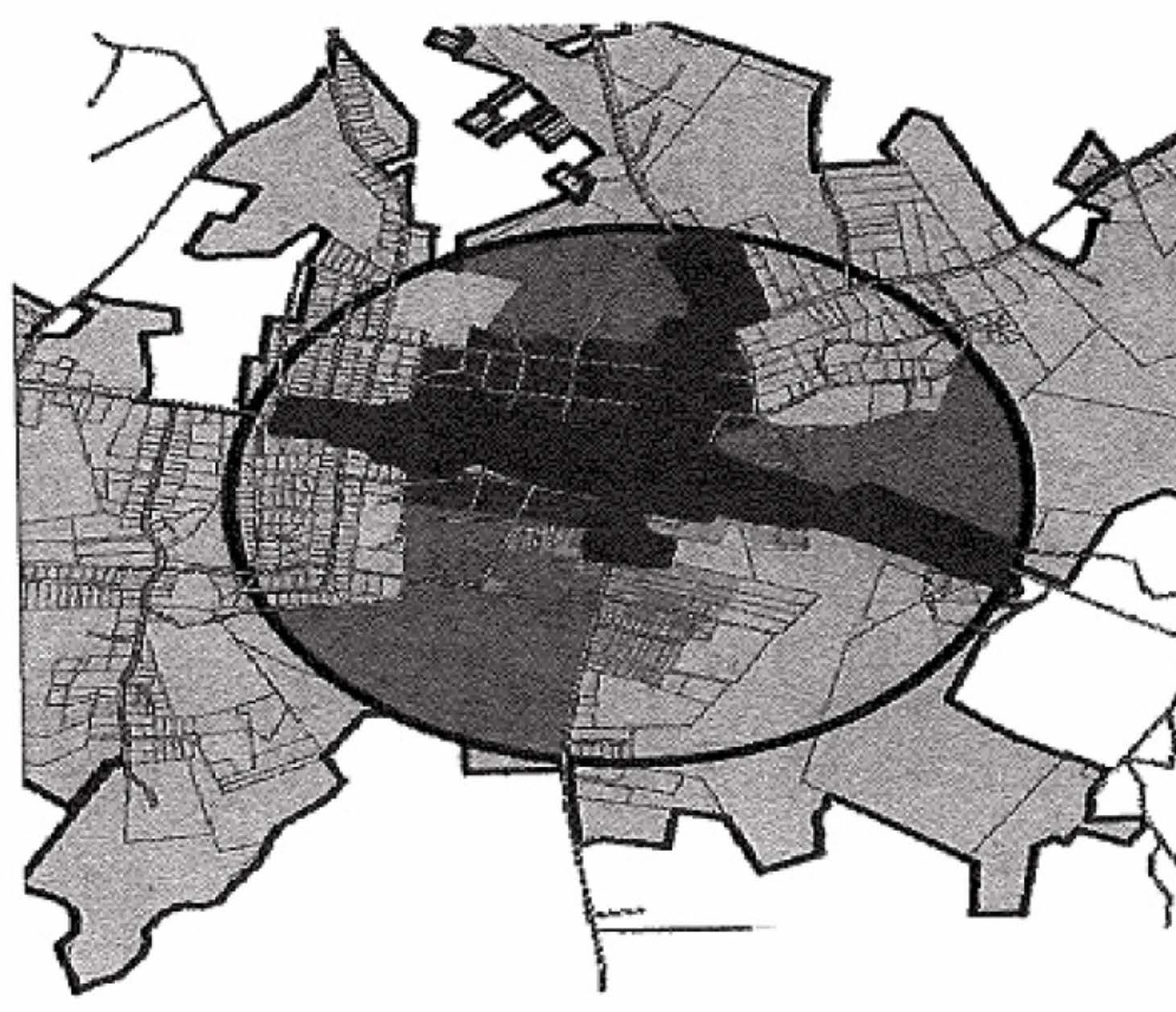
Boundaries. The location and boundaries of the Harlem Commercial Overlay District are established as shown on the map entitled "Zoning Map, City of Harlem," as amended. This map is a visual representation of the district and may not be precise; the city maintains a list of all parcels within the district for inspection. The district shall extend a minimum of 300 from the centerline of Louisville Street and Milledgeville Road in each direction unless it terminates on a property line boundary.
(d)
General regulations.
(1)
Land use. All uses shall comply with the minimum regulations of the underlying zoning district. All uses permitted in the underlying district, including uses permitted subject to use permits, are similarly permitted in the Harlem Commercial Overlay District, except as provided herein. Where the regulations for the overlay district differ from those of the underlying zoning the more restrictive regulations shall apply except for those that have an underlying residential zone. In the granting of use permits the decision-making body must find that the proposed use is compatible with the overall intent of the overlay district.
(2)
Review procedure and criteria. Development proposals shall be evaluated by the community development director with the overall intent of the following Harlem Commercial Overlay District objectives with the major components of the CCC review being buildings, sidewalks, landscaping and lighting:
a.
Encouraging the optimum development of land along Milledgeville Road and Louisville Street in the city, thus promoting the development of a commercial center, with a downtown area and transitional areas.
b.
All buildings, whether public or private or non-profit, within the district shall be subject to a CCC review, prior to any exterior site demolition or construction or building facade additions, improvements, or renovations and prior to application for any building permit for such activities. The purpose of a CCC is to ensure compliance with the requirements set forth in this section. A CCC application shall include a site plan, building floor plans, sidewalk plan, landscape plan, lighting plan, and elevations, drawn to scale, and shall be approved by the community development director or his designee.
c.
As a part of the CCC, open space development and maintenance agreements, paving in parking areas other than asphalt and concrete, reduction of parking requirements, off-site parking, shared parking, angled on-street parking, curb cuts, new streets, sidewalk area improvements including special or decorative paving and plantings and street furniture location and type shall be reviewed and the addition of street lights as specified by the city.
d.
When an existing building that is more than 50 years old is being renovated, and where such building is not within a local historic district, architectural drawings of the proposed renovation and details of the subject architectural feature must be provided to the city.
e.
For property with an underlying zoning classification of residential and under the 25 percent improvement criteria this overlay may still be applied for. However, without obtaining a CCC the only permitted uses for residentially zoned property shall be for small site retail and service near dense residential neighborhoods. Some uses which are not retail or service in nature may also be allowed so that a variety of uses may locate in existing buildings to promote historic preservation. Development is intended to be pedestrian-oriented. These uses are only permissible subject to basic review by the community development director.
f.
Every effort shall be made to preserve existing mature trees with a height greater than 50 feet and a trunk caliper greater than ten inches at four feet above grade. For the purposes of protecting an existing mature shade tree, an applicant may request an administrative variation from regulations, subject to CCC requirements and conditioned to a site plan which demonstrates that provisions shall be made to implement an alternate design which meets the intent of this overlay.
g.
A CCC applicant shall receive a response from the city within 15 days of the date that a completed application is submitted. The application fee shall be in accordance with the city's fee schedule then in effect.
(3)
Permitted uses. The following are permitted uses:
a.
Retail commercial;
b.
Banks;
c.
Restaurants;
d.
Professional services;
e.
Underlying zone uses;
f.
Eating establishments;
g.
Bed and breakfasts;
h.
Loft apartments, townhomes, condos; and
i.
Funeral homes.
(4)
Prohibited uses. The following are prohibited uses:
a.
Exterior and outside storage;
b.
Communication towers;
c.
Liquor package stores;
d.
Adult entertainment; or
e.
Manufacturing.
(5)
Conditional uses. The following are conditional uses and require approval within the CCC:
a.
Auction houses;
b.
Hotels and motels;
c.
Businesses associated with agriculture;
d.
Auto repair shops and auto sales;
e.
Drive-through facilities;
f.
Mini-warehouses;
g.
Roadside stands and produce markets;
h.
Fuel stations;
i.
Home business uses;
j.
Brewery and micro pubs;
k.
Health related services; or
l.
Tattoo parlors.
(6)
Landscape requirements.
a.
All landscape requirements shall be subject to a CCC.
b.
Historic lighting should be used throughout the project along roads. The lights shall be evenly spaced. The city has a preferred specification for lights: Washington postlite LED acrylic acorn style. The streetlight shall be cast aluminum finial and prismatic glass reflector, mounted on a 14-foot, four-inch diameter fluted post. Fixture and post to be black finish.
c.
Tree and plant selection. The following list constitutes the official street tree species for the city. No species other than those included in this list may be planted as street trees without written permission of the city tree board. The spacing of street trees will be in accordance with the three species size classes listed in subsection (d)(6)c.1—3 of this section, and no trees may be planted closer together than the following: small trees, 30 feet; medium trees, 40 feet; and large trees, 50 feet; except in special plantings designed or approved by a landscape architect.
1.
Small trees. Apricot, Bradford pear, crabapple, flowering peach, golden rain tree, hawthorn, Japanese lilac tree, purpleleaf plum, redbud, serviceberry, soapberry.
2.
Medium trees. Basswood, English oak, green ash, hackberry, honey locust (thornless), Japanese pagoda tree, linden, Osage orange (male, thornless), pecan, persimmon, red mulberry fruitless, male, red oak, river birch, sassafras, white poplar.
3.
Large trees. Bur oak, cottonwood (cottonless, male), Kentucky coffee tree, London sycamore, silver maple, sugar maple, sycamore.
(7)
Buffers.
a.
Required landscape strips. No lot shall hereafter be developed with less than the minimum required landscape strip for the specific use as shown in section 108-68, table IV, when abutting a public or private street.
b.
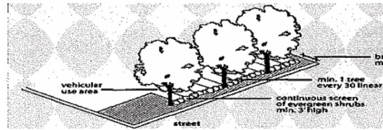
Landscape strip design standards. Landscape strips shall be planted with trees, shrubs, grass, or groundcover, except for those areas that are mulched. Landscaping shall be planted throughout and shall not appear as a single row of plantings. Landscape strips shall not contain structures, accessory uses, parking of any kind, stormwater detention facilities, fences of any kind, patios, or displays of commercial stock. Berms and retaining walls as part of an overall landscaping plan, signs as permitted in this article, driveways required to access the property, pedestrian-oriented facilities, and underground utilities are permitted within the landscape strip.
c.
Waiver of landscape strip requirements. The front landscape strips required by this section may be waived for lots which abut one or more developed properties on the same side of the street and which contain a structure that is setback less than ten feet from the right-of-way.
d.
Required buffers. No lot shall hereafter be developed with less than the minimum required buffer along a side or rear property line when abutting property containing a single-family dwelling or manufactured home, for the specific use as shown in table IV.
e.
Buffer specifications. Any buffer required by this section shall be natural vegetation, undisturbed except for approved access and utility crossings, and replanted where sparsely vegetated, with evergreen trees and/or shrubs to form an opaque screen that will provide a visual buffer throughout all seasons. Buffers shall be designed to provide privacy and security and to give adequate protection to adjacent neighbors from lights, sounds, and other potential nuisances. Buffers shall be planted with landscaping throughout and shall not appear as a single row of plantings. The length of any required buffers shall not extend closer than 15 feet to any public right-of-way in order to preserve vision clearance.
f.
Structural buffer design standards. When commercial construction abuts residential property, a minimum six-foot tall wooden slat fence must be installed. Fences and walls shall present a finished and decorative appearance to the abutting property and shall be located in such a manner to preserve existing vegetation.
g.
Reduction of buffer. A required buffer may be reduced by as much as 30 percent through the site plan review process for multifamily, institutional, residential living facilities, places of worship, schools, daycare centers, and other institutional uses if screening is provided by installing a minimum six-foot high solid wooden fence or masonry wall within the required buffer.
h.
Sign requirements. Signs shall comply with section 108-241. In addition, monument signs shall be preferred on Milledgeville Road composed of a brick foundation or frame and an approved material for the face of the sign.
(8)
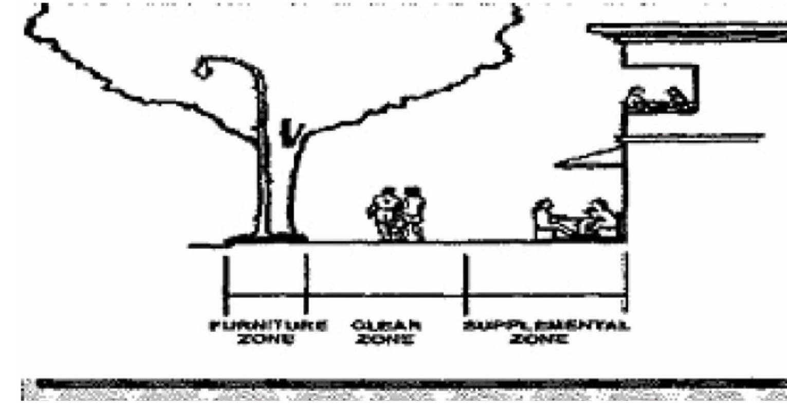
Sidewalk area and street requirements.
a.
Any paving, including concrete, special or decorative paving, within the sidewalk landscape zone, sidewalk clear zone, or sidewalk supplemental zone shall continue across any intervening driveway.
b.
Dead-end and cul-de-sac streets are prohibited.
c.
A sidewalk area shall be located along all streets and shall consist of a sidewalk landscape zone with street trees, an unobstructed sidewalk clear zone, and a supplemental zone. The city may issue a supplemental encroachment permit for businesses to use area within if it keeps with the downtown atmosphere and is pedestrian friendly.
d.
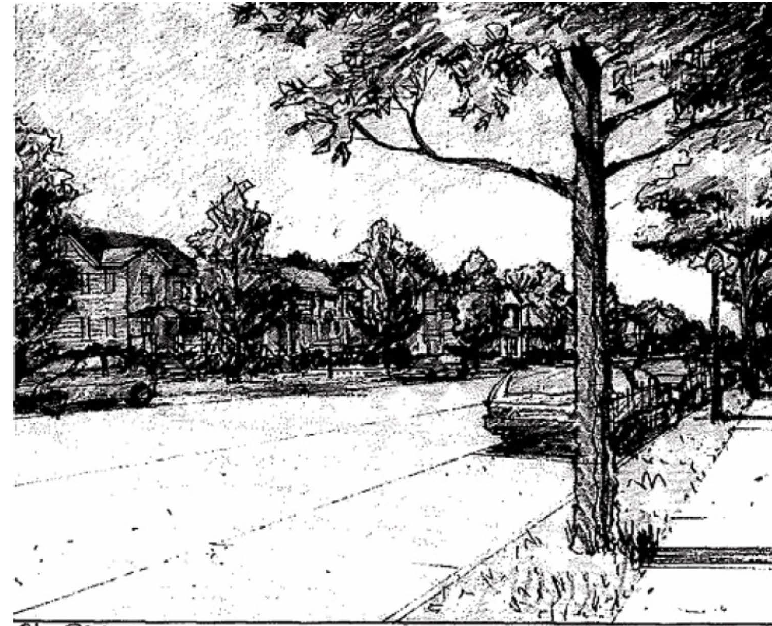
Street trees are required. Street trees shall be planted a maximum of 50 feet on center and spaced an equal distance between streetlights and in line with stripes of parallel parking spaces. All newly planted trees shall be a minimum caliper of 3½ inches measured 12 inches above ground, shall be limbed up to a minimum height of seven feet and shall have a minimum mature height of 40 feet. Trees planted in front of storefront treatments shall be limbed up to a minimum height of ten feet and have a minimum mature height of 50 feet. Trees shall have a minimum planting area of 40 square feet.
e.
All street furniture and pavers, where installed, and all street trees shall have a location and type subject to approval by the city, including, but not limited to, the following: benches, waste receptacles, bicycle racks, newspaper stands, tree grates, and streetlights. Tree grates shall be a minimum of eight feet by five feet. Decorative street lights shall be placed a maximum of 50 feet on center and shall be spaced an equal distance.
f.
Sidewalk specifications shall be as follows: All sidewalks shall be at least six feet wide and four inches thick, except where automobile driveways cross the same, in which case the sidewalks shall be at least six inches in thickness for residential driveways and at least eight inches in thickness for commercial driveways for that portion used as the driveway; that part of the driveway extending from the curb to the sidewalk shall also be at least six inches in thickness for residential driveways and eight inches in thickness for commercial driveways. In the downtown area, the use of brick pavers may be required for conformity with existing designs. All ADA requirements shall be observed.
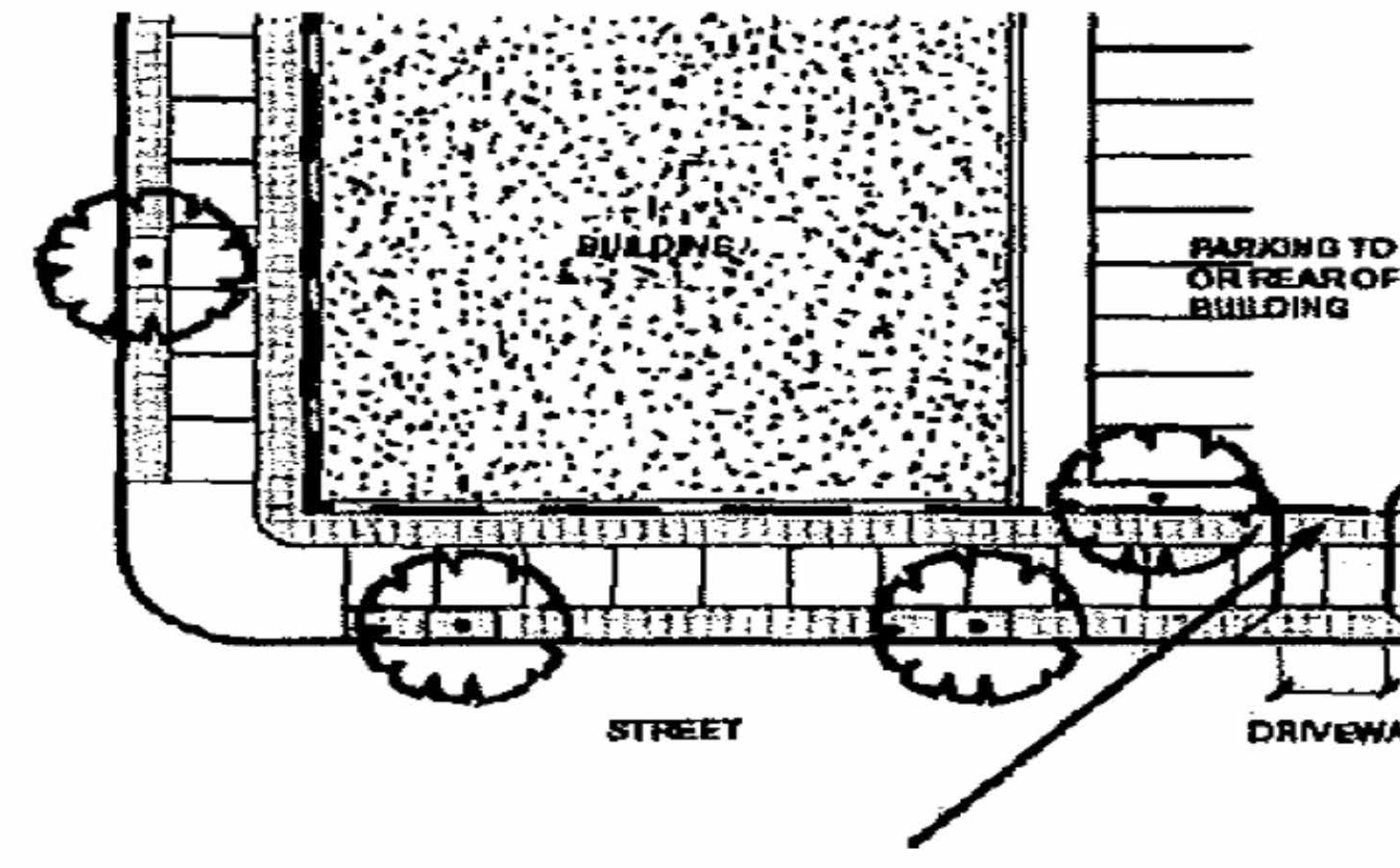
Sidewalk paving material continues across intervening driveways
Sidewalk paving material continue across intervening driveways.
(9)
Building requirements.
a.
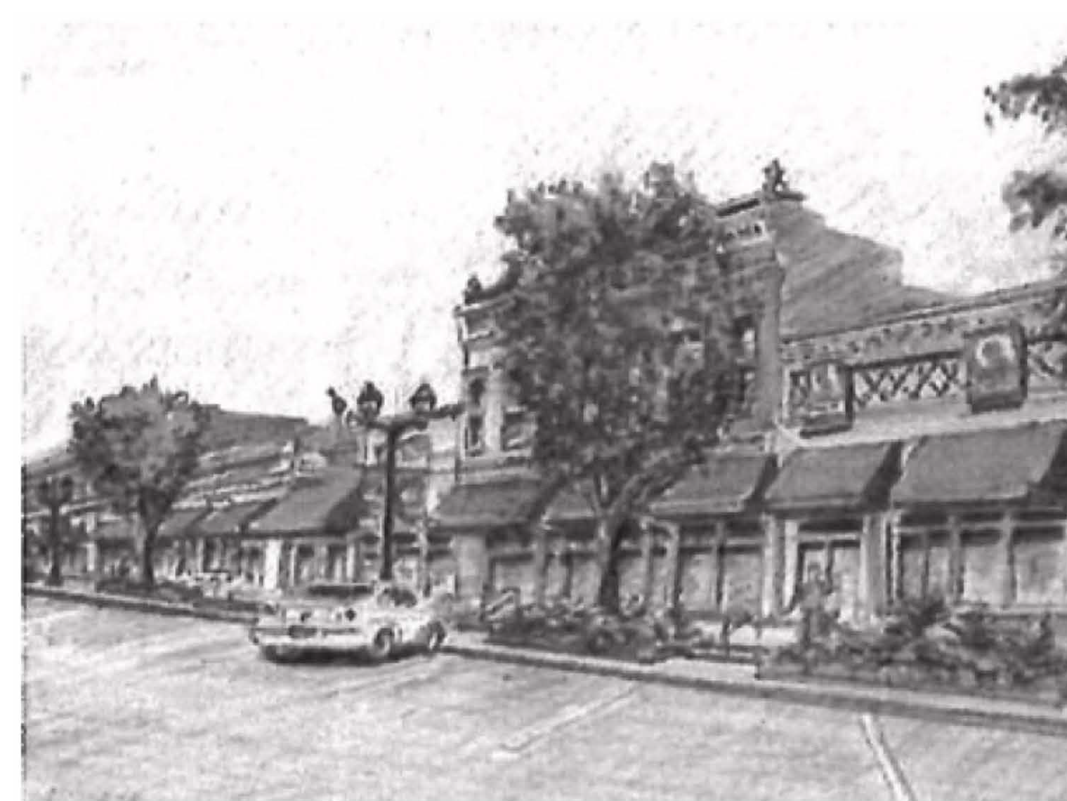
Along the street facade of all new and renovated buildings and structures the following shall apply:
1.
Where an individual use has a street facade on more than one street, such entrance requirement shall apply along a storefront street, or when on other streets, such requirement shall apply along the higher order of streets in the order of arterial, collector or local street. Where both streets are the same order, entrance orientation may be to either street. Where an historic structure is being renovated, such entrance locations may reflect those of such historic structure. Under this section, any addition or expansion that is 25 percent or less does not fall under the definition of the term "new structures." The front facade of the building shall be as close to the sidewalk supplemental zone as possible unless the building has a residential facade.
2.
All main buildings or primary structures shall be designed by an architect registered in the state.
3.
All commercial, industrial, institutional buildings (churches, schools and the like) and all non-residential buildings, to include all incidental and accessory buildings, shall be constructed of brick, stucco or textured masonry block. The exterior insulation and finish systems (EIFS) shall not be used on the exterior of commercial, industrial, institutional buildings (churches, schools and the like) and all non-residential buildings, to include all incidental and accessory buildings. Any addition or expansion that is 25 percent or less to an existing building, can be of material that is of the same grade currently on the existing facade. Only one such exception for a building expansion of 25 percent shall be permitted per year. The community development director may issue permits for expansion of 25 percent or less to an existing building.
4.
Awnings shall be of fabrics, canvas, fixed metal, or similar material. Internally lit awnings and canopies that emit light through the awning or canopy material are prohibited.
5.
Blank, windowless walls are prohibited on exteriors facing the street. All building stories with the exception of storefront treatment shall have windows and doors that equal a minimum of 30 percent and maximum of 60 percent of the total facade area with each story being calculated independently.
6.
All windows shall be vertically shaped with a height greater than the width, including display windows but not transoms.
7.
Glass panels in windows and storefronts shall be clear and unpainted, and shall not be tinted such that views into the building are obstructed, with the exception of transoms, which may be prism glass.
8.
Entry facade window trim shall not be flush with the exterior wall and shall have a minimum relief of one-quarter inch from the exterior wall.
9.
Doors and windows that operate as horizontal sliders are prohibited except where renovating an historic building with this window type.
10.
Window frames shall be recessed a minimum of two inches from the exterior facade.
11.
Stoops and entry-level porches shall not be enclosed with screen wire or glass.
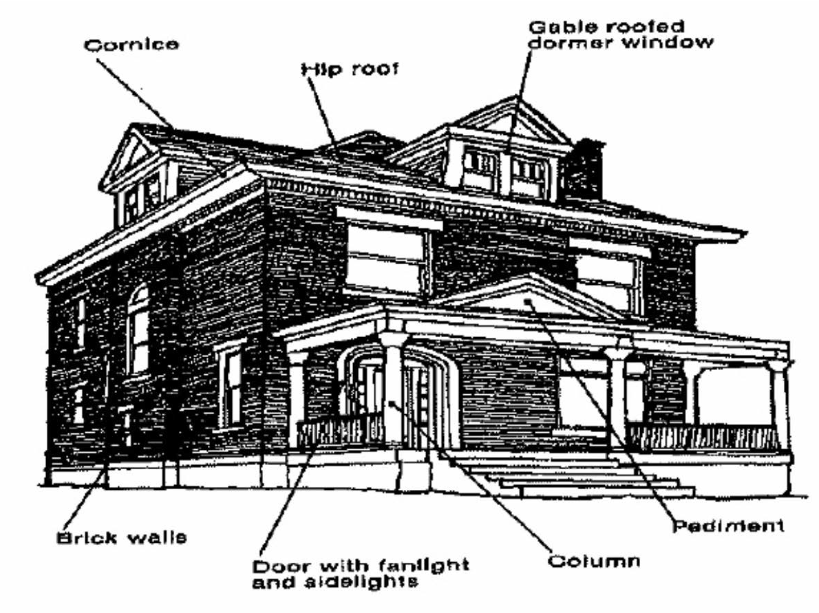
12.
Porch and arcade columns shall be a minimum width of eight inches.
13.
Residential porches shall be covered and have a minimum depth of five feet, a minimum length of six feet and a minimum area of 40 feet.
14.
Exterior entry steps shall have enclosed risers.
15.
Parking structures shall conceal automobiles from visibility; shall have the appearance of a horizontal storied building on all levels; shall be faced in brick, stone, cast stone, poured-in-place rubbed concrete, or pre-cast concrete faced in or having the appearance of brick or stone.
16.
The minimum building height as measured along the build-to line shall be 18 feet.
17.
All buildings shall have street facades with continuous storefront treatment or residential treatment.
18.
The proposed design for all commercial, institutional buildings (churches, schools and the like) and all non-residential buildings, to include all incidental and accessory buildings, shall be submitted for review and approval to the community development director and the design shall comply with the applicable building regulations and design guidelines as adopted by the city council.
(10)
Yard, height, area and density requirements.
a.
All development must conform to the requirements of the underlying zoning classification.
b.
Parking lots in front of buildings shall be prohibited. Side parking shall be permissible in certain areas of the district.
c.
Setbacks shall not be required for new non-residential building construction.
d.
Street access to motorized golf carts shall be preferred when appropriate.
(11)
Parcels located in city historic districts.
a.
Property located within a local historic district shall obtain a CCC if required within this section prior to making an application with the historic preservation commission for a certificate of appropriateness.
b.
Pertaining to building material requirements as set forth by an approved COA, the community development director hall revise the CCC if necessary for compliance for historic preservation recommendations.
(e)
Administration.
(1)
Appeals.
a.
Any person who alleges there is an error in, or who is aggrieved by a decision of the community development director and/or interpretation of this article, may file an appeal with the city manager stating the grounds for such appeal.
b.
The planning commission is hereby authorized to hear and be the final arbitrator of appeals of the community development director findings.
c.
An appeal from a ruling of the community development director shall stay all proceedings in furtherance of the action being appealed. The commission may affirm, overrule or modify, in whole or in part, the rulings of the city manager. In cases where an appeal is granted, the commission shall have all necessary powers of the community development director and may issue building permits and land use permits, or direct the issuance of building permits and land use permits not otherwise inconsistent with this article and any other code, resolution, or ordinance adopted by the city council.
(2)
Waiver of requirements. The city reserves the right to waive any or all of these requirements in situations where an emergency or act of nature has occurred and triggered the enforcement of this article.
(3)
Modifications. It is understood that every development is unique and that the spirit of this land use section is to enhance the commercial corridor of the city. In cases where the enforcement of this section creates unsatisfactory results or lessens the quality of the project, minor modifications of the regulations herein may be issued by the community development director.
(Code 2004, § 152.037; Ord. No. 1707, 6-27-2017)
Sec. 108-42. - Conservation Preservation Residential Zone (CP-R Zone).
(a)
Purpose and intent. The purpose and intent of the CP-R zone is:
(1)
To provide for the preservation of open space as a nonstructural stormwater control and watershed protection measure;
(2)
To provide a residential zoning district that promotes environmentally sensitive uses of the land;
(3)
To encourage preservation of unique or sensitive natural resources such as waterways, wetlands, groundwater, floodplains, and wildlife habitat;
(4)
To reduce erosion and sedimentation by minimizing land disturbance and removal of vegetation in residential development;
(5)
To conserve scenic views;
(6)
To exclude uses capable of negatively impacting the environment;
(7)
To limit the intensity of uses that will detract from the traditional scale and scenic quality of the district; and
(8)
To provide a residential density of approximately one dwelling unit per two acres.
(b)
Permitted uses. In the CP-R zone, the following uses only are permitted and as hereinafter specifically provided and allowed by this article:
(1)
Single-family dwellings;
(2)
Accessory buildings and structures, including private garages to accommodate not more than four cars; provided additional garage or implement shelters may be erected, maintained and used on sites of five acres or more, and provided that such structures shall not occupy any required yard space;
(3)
Private green houses, fruit trees, nut trees, vines, and other horticultural stock;
(4)
Agricultural crops, excluding commercial grown crops;
(5)
Stands for the display of agricultural products raised on the premises shall generally conform to the provisions set forth in section 108-114. Any applicable state license in addition to city occupational tax certificate shall be required;
(6)
Privately owned open space and associated passive recreational facilities and structures;
(7)
The following animals, under the following conditions: horse, provided:
a.
No horses shall be maintained on a lot or parcel containing less than two acres;
b.
No more than one horse per acre shall be maintained;
c.
All horses shall be for personal use only; and
d.
No stall or barn shall be kept or maintained within 200 feet of any window or door of any neighboring building used for human habitation nor within 300 feet of any portion of a required yard space or adjoining property if such property is devoted to a use other than agriculture and shall observe a setback of at least 50 feet from the property line;
(8)
Day nurseries where daycare is provided for not more than six children and said nursery is duly licensed;
(9)
Home occupations: home barber and beauty parlors and professional use including internet businesses;
(10)
The following signs:
a.
One unlighted sign not exceeding 12 square feet in area with a maximum of four feet per side composed of wood or faux wood may be displayed; or
b.
Signs identifying persons engaged in construction on a site shall be permitted as long as construction is in progress.
(c)
Conditional permitted uses. In the CP-P zone, the following uses may be permitted in accordance with the provisions contained in section 108-45 and if additional conditions, which may be required by the city council, are met:
(1)
Farms for the growing of commercial agricultural products;
(2)
Public utility lines, fire, or water tower, utility sub-station; or
(3)
Public dock or boathouse.
(d)
Height. No building in the CP-R zone shall exceed a height of 35 feet.
(e)
Front yard. Every lot in a CP-R zone shall have a front yard which has a depth not less than 35 feet.
(f)
Side yards. In the CP-R zone every lot shall have side yards as follows:
(1)
Lots shall have a side yard on each side of the main building which side yard has a width not less than 20 feet.
(2)
Corner lots shall have the following side yards:
a.
On the side which adjoins another lot, the side yard shall be the same as that required on any lot.
b.
On the side street the width of the required side yard shall be the same as the front yard requirement (35 feet).
(g)
Placement of buildings. Placement of buildings on any lot shall conform to the following:
(1)
Lots.
a.
No building shall occupy any portion of a required yard.
b.
Any building, any portion of which is used for human habitation, shall observe a distance from any side lot line the equivalent of the required side yard on such lot and from the rear property line a distance of 20 percent of the depth of the lot, not to exceed 50 feet.
c.
The distance between buildings used for human habitation and accessory buildings shall be a minimum of 20 feet.
d.
A non-dwelling accessory building may build to the rear lot line of the required side yard, provided if the lot rears upon an alley such accessory building shall maintain a distance of not less than ten feet from the rear lot line and may build to within 20 feet of the side lot line.
(2)
Corner lots.
a.
No building shall occupy any portion of a required yard.
b.
The distance between buildings used for human habitation and accessory buildings shall be a distance of 20 feet.
c.
Any building, any portion of which is used for human habitation, shall observe a distance from the rear property line of 20 feet.
d.
On corner lots, an accessory building may build to the rear lot line not less than ten feet from the rear line of such lot.
(h)
Area. The minimum required area of a lot in the CP-R zone shall not be less than two acres, or 87,120 square feet.
(i)
Lot area per dwelling. The lot area per dwelling unit shall be not less than the minimum required lot area.
(j)
Lot width. In the CP-R zone, every lot created after the effective date of the ordinance from which this section is derived shall maintain a width of not less than 100 feet at the rear line of the required front yard.
(k)
Permissible lot coverage. All buildings including accessory buildings and structures shall not cover more than 15 percent of the area of the lot.
(l)
Off-street parking requirements. Shall be in accordance with section 108-275.
(m)
Riparian buffer requirement. All conservation subdivisions within this district shall meet the following requirements:
(1)
An undisturbed natural vegetative buffer shall be maintained along both banks of streams and along all impoundments, as measured from the top of the bank of the width of at least 75 feet, and a minimum width of 50 feet. All land disturbing activity is prohibited within the buffer unless a variance is granted in accordance with city codes.
(2)
A minimum setback of 200 feet must be maintained for individual sewage disposal systems on lots adjacent to streams and wetlands as defined above and be permitted by the health department.
(n)
Site analysis map requirement. Concurrent with the submission of a site sketch plan, as outlined in the city subdivision regulations, codified as chapter 114, a site analysis map shall be submitted. The purpose of the site analysis map is to ensure that the important site features have been adequately identified prior to the creation of the site design. The preliminary site analysis map shall include the following features:
(1)
Property boundaries;
(2)
All streams, rivers, lakes, wetlands and other hydrologic features;
(3)
Topographic contours of no less than two-foot intervals;
(4)
General site hydrology;
(5)
Tree survey including all trees with a diameter at breast height of six inches;
(6)
General soil types;
(7)
Existing roads and structures;
(8)
Riparian buffers; and
(9)
Critical habitat, archeological and historical sites.
(o)
Single-family residential standards. All single-family residences must meet the following standards in the CP-R district:
(1)
All structures including the primary structure and accessory structures shall be constructed with a pitched roof having a pitch of three in 12 or greater.
(2)
The roof shall be covered with asphalt composition shingles, metal roofing, or tile materials. Plastic panels are prohibited unless a part of a solar panel.
(3)
The exterior wall shall be material similar to traditional site-built housing. These materials may include clapboards, simulated clapboards such as conventional vinyl or metal siding, wood shingles, shakes, stucco, brick, brick veneer, concrete block, or similar materials, but shall not include smooth, ribbed or plastic panels.
(4)
The minimum horizontal dimension of the structure shall be 24 feet.
(5)
The minimum floor area shall be 1,600 square feet.
(6)
All principal structures shall be placed on a permanent foundation. For the purposes of this section, a permanent foundation shall mean a concrete slab, concrete footers, foundation wall, piling or post construction which complies with the city building code.
(7)
All structures must meet wind loading requirements of the Federal Emergency Management Agency and the ICC-IBC and IRC codes.
(Code 2004, § 152.038; Ord. No. 1708, 8-28-2017)
Sec. 108-42.1. - Senior Community Mixed Use District.
(a)
Purpose. The purpose of the Senior Community Mixed Use District (SC-MUD) is to advocate the creation and preservation of a distinct and visually harmonious community of choice that is compact, mixed-use and pedestrian friendly; and supports patterns of urbanization that are stimulating, safe and ecologically sustainable. It is further the purpose of this district to introduce urban planning techniques that will repair and transform the auto centric patterns of suburbia that produced unimaginative housing subdivisions, big box stores and a proliferation of parking areas into a complete community that is sustainable and more than capable of accommodating a diversity of income levels, building types, modes of transportation and open space. To this end, and as expressed in the comprehensive land use plan, this district seeks to enable, encourage and implement land development patterns that will purposefully integrate dwellings with open space, offices, schools and stores, resulting in the manifestation of a distinct and visually harmonious community of choice that is wholesome, sustainable and healthy.
(b)
Intent. The intent of this district is to create and to preserve a visually harmonious and orderly community that is compact, mixed-use and pedestrian friendly wherein:
(1)
An interconnected network of streets disperses traffic and reduce the length of automobile trips, while encouraging walking and bicycling as healthy and sustainable forms of transportation and recreation;
(2)
A diversity of uses enables a variety of economic, recreational, retail and residential activity;
(3)
The ordinary activities of daily living occur within walking, motorized vehicle and bicycling distance of most dwellings, allowing independence to those who do not drive automobiles, while expanding the transportation options that are available to those who do drive automobiles;
(4)
A range of housing types and price levels [to] accommodate diverse ages and incomes;
(5)
A range of open space [to] accommodate various community recreational purposes; and
(6)
Architecture and landscape designs grown from local topography, history, climate and building technique.
(7)
This district is envisioned for usage within parcels that have a nexus with a state highway or other commercial corridor.
(c)
Definitions. This division provides definitions for terms in this section that are either technical in nature or that may not reflect common usage of the term. Terms requiring interpretation specific to this section are as follows:
Frontage line. A property line bordering either a street or an open space. The exterior walls of a building facing a frontage line defines the public realm, and is therefore more regulated than the exterior walls facing other property lines.
Frontage line principal. The property line that is designated to bear the measure of the minimum lot width.
Frontage line secondary. The property line that is not designated as the principal frontage line.
Main open space. The primary outdoor gathering place for a community.
Mixed-use building. A building that provides a vertical mix of uses, with the first floor(s) supplied with nonresidential uses and the upper floor(s) occupied with residential uses.
Residential uses. May be apartments or for sale as condominiums, townhomes and detached single family homes or duplexes.
(d)
Streetscape standards.
(1)
General.
a.
All streets are intended for comingled use by vehicular, pedestrian and bicycle traffic, and to provide access to lots and open space.
b.
All streets shall intersect with, or terminate at, other streets in order to form a network. Cul-de-sacs shall only be permitted to accommodate natural environmental conditions that are specific to the site such as:
1.
A protected habitat;
2.
A protected wetland;
3.
A riparian corridor; or
4.
Surface water bodies.
c.
1.
All streets shall have sidewalks that are no less than five feet in width installed on both sides and be ADA compliant.
2.
In no such case shall any sidewalk be greater than 25 feet in width, unless approved by the city manager or his/her designee. Sidewalks may include areas for golf cart/motorized vehicle usage.
d.
1.
All streets shall have a sidewalk landscaping strip that is no less than four feet in width between the travel lane and the sidewalk.
2.
Stamped concrete shall be prohibited along all streets.
(2)
Specific to arterial and collector streets.
a.
The posted vehicle speed for all new arterial streets shall not exceed 35 miles per hour. Collector streets shall be 30 miles per hour.
b.
Bicycles are a sustainable and viable mode of transportation and recreation in the city. In furtherance of promoting bicycling as a sustainable and viable mode of transportation in the city, arterial streets with sufficient paving width to accommodate safe movement of bicyclists shall provide dedicated bicycle lanes that will satisfy the following:
1.
All such dedicated bicycle lanes shall be separated from vehicular travel and/or parking lanes by striped pavement markings which function as a buffer; and
2.
All such dedicated bicycle lanes shall be no less than five feet in width.
c.
Within the required sidewalk landscaping strip, the land developer or the land owner shall install pedestrian lighting fixtures at intervals of 50 feet, on center. Such pedestrian lighting fixtures shall be 14 feet in height, coated in black paint and shall be approved by the city manager or his/her designee.
d.
Within the required sidewalk landscaping strip, the introduced species of street trees shall be limited to the following:
1.
Red Oaks;
2.
Bur Oaks;
3.
Southern sugar maple;
4.
Green Ash; or
5.
Additional species if approved by city manager or designee.
e.
All street trees shall be planted on center within the required sidewalk landscaping strip, and equidistant (25 feet) between pedestrian lighting fixtures unless smaller trees are approved and given additional specifications. All street trees shall have a caliper no less than two inches at the time of planting, and shall be warranted by the land developer or the land owner for at least two years.
(3)
Specific to alleys.
a.
1.
All alleys shall be private.
2.
An easement shall also be provided, and recorded within the deed covenants/restrictions that will allow access for emergency personnel, public safety personnel, public works personnel, et cetera.
b.
All alleys shall provide continuous access between two streets.
c.
All alleys shall be internal to the land development or infill proposal.
d.
All alleys shall be constructed, and paved with surface materials that are similar to the surface materials used to pave all streets.
(4)
Specific to multi-purpose trails. Multi-purpose trails shall be provided to connect open space with the built environment.
a.
With the exception of golf carts, the use of motorized vehicles shall be prohibited.
b.
Multi-purpose trails shall require an easement of no less than 30 feet in width.
c.
The maximum grade of multi-purpose trails shall be six percent.
d.
Multi-purpose trails shall require a pavement width of ten feet.
e.
Shoulders having a minimum width of five feet, and either mulched or planted with grass, shall be provided on both sides of the multi-purpose trail.
(e)
Lot dimensions and building height standards.
(1)
Unless specified otherwise in this section, each newly platted lot shall front at least one street. The portion of each newly platted lot fronting a street, unless specified otherwise in this section, shall be designated as its principal frontage line.
a.
For a newly platted lot sharing a property line with more than one street, one property line shall be designated as its principal frontage line, and the other property lines shall be designated as secondary frontage lines. Principal selection shall be determined based on surrounding neighborhood but may be altered based on existing topography or lot dimension.
b.
For all newly platted lots, the principal pedestrian entrance shall be on a principal frontage line.
(2)
Each newly platted lot shall be dimensioned according to Table 1-A and Table 1-B.
TABLE 1-A. RESIDENTIAL LOT DIMENSIONS.
TABLE 1-B. NONRESIDENTIAL AND MIXED-USE LOT DIMENSIONS.
(3)
The height for all buildings shall be in accordance with Table 2. The following shall also apply: In no such case shall any building that exceeds 35 feet in height be within 75 feet of any building that is 35 feet in height or less. This distance shall be measured from the nearest property line of any building proposed to exceed 35 feet in height or less.
TABLE 2. BUILDING HEIGHT
(f)
Principal uses.
(1)
General.
a.
Residences: Residential development shall be limited to providing housing for individuals age 55 and older in accordance with the Fair Housing Act. No person under age 55 shall be permitted to reside within the grounds of the development more than seven days and no more than 30 total days per calendar year, unless said person is the spouse or primary caregiver of an individual age 55 or older who lives within the development.
b.
Principal uses shall be governed by the text approved by council.
c.
The residential density shall not exceed three dwellings per gross acre. Density bonuses shall be awarded based in accordance with the provisions at the end of this chapter.
d.
The nonresidential density shall not exceed 10,000 square feet of gross leasable floor per acre calculated based on total project size.
e.
Open space shall be required for all land development and infill proposals occurring on five or more acres of land. No less than 20 percent of the total acreage of the site shall be set aside as permanent open space in accordance with the mandatory legal provisions that are set forth in this section. Up to 25 percent of open space requirement may utilize land needed for drainage and retention. However, remaining open space shall not use more natural area.
f.
Unless otherwise specified in this section, all permitted principal uses shall be conducted within enclosed buildings.
(2)
Specific to detached single-family dwellings. Unless specified otherwise in this section, the minimum finished floor area for a detached single-family dwelling shall be at least 1,400 square feet heated and cooled.
(3)
Specific to townhouse dwellings.
a.
The minimum finished floor area for each townhouse dwelling shall satisfy the following:
1.
Two bedrooms: 1,000 square feet;
2.
Three bedrooms: 1,150 square feet; and
3.
Four bedrooms: 1,200 square feet.
b.
Each townhouse dwelling shall be properly equipped with a sprinkler system to be approved by the county fire marshal, and shall also be pre-wired for fire detection and an alarm system.
(4)
Specific to multi-family dwellings.
a.
The minimum finished floor area for each multi-family dwelling shall satisfy the following:
1.
One bedroom: 850 square feet;
2.
Two bedrooms: 1,000 square feet;
3.
Three bedrooms: 1,150 square feet; and
4.
Four bedrooms: 1,200 square feet.
b.
Each multi-family dwelling shall be properly equipped with a sprinkler system to be approved by the county fire marshal, and shall also be pre-wired for a security system.
c.
Stairways shall be internal to all multi-family buildings.
(5)
Specific to nonresidential uses.
a.
Each nonresidential use shall have no less than 1,000 square feet of gross leasable floor area.
b.
Stairways shall be internal to all nonresidential buildings.
(6)
Specific to mixed-use buildings.
a.
Density calculations.
1.
The residential density for mixed-use buildings shall be expressed in terms of dwellings per gross acre, and the nonresidential density for mixed-use buildings shall be expressed in terms of gross leasable floor area per net acre. The density for all residential uses shall not exceed three dwellings per gross acre plus any bonuses; and the density for all nonresidential uses shall not exceed 10,000 square feet of gross leasable floor area per gross acre.
2.
All residential uses shall be considered as equivalent to multi-family dwellings.
b.
Prohibitions.
1.
With the exception of pedestrian entrances and lobbies to residential uses only, in no case shall any residential uses be permitted on the first floor.
2.
The integration of residential and nonresidential uses on the same floor, within the same building, shall be prohibited.
c.
Additional standards and limitations.
1.
Uses shall be mixed such that at no time will residential uses be located below nonresidential uses.
2.
Stairways shall be internal to all mixed-use buildings.
(7)
Specific to open space.
a.
The permitted uses of open space shall be limited to the following only:
1.
Natural area. A natural area is a type of open space that is exposed to the open sky, and is made available for learning purposes and unstructured recreation. A natural area shall consist of natural environmental conditions to include, but shall not be limited to, lakes, meadows, ponds, natural rock outcroppings, reservoirs, riparian corridors, steep slopes, wildlife ecosystems, woodlands and all other similar natural characteristics and natural features. Natural areas may be independent of streets and buildings, and are encouraged to follow the lineal and natural trajectories of riparian corridors, wildlife corridors and woodlands. All natural areas shall be naturalistically disposed. Open shelters may be provided only if constructed from any combination of indigenous rock, natural stone or natural wood exterior finish material. All natural areas shall be accessed and traversed with pedestrian paths and/or bicycle trails that are constructed from environmentally sensitive or permeable surfaces to be approved by the city manager or his/her designee. There shall be no minimum or maximum size.
2.
Park. A park is a type of open space that is exposed to the open sky and is made available for unstructured or structured recreation. A park shall be spatially defined on at least two of its sides with a street or a building. A park may be formally, or naturalistically disposed, with any combination of flowering plants, grass lawns, natural rock outcroppings, shrubbery and trees. Seating benches and litter receptacles that are of commercial quality shall be required for each park. Open shelters may be provided only if constructed from any combination of indigenous rock, natural stone or natural wood exterior finish material. Parks are encouraged to follow the lineal and natural trajectories of riparian corridors and woodlands. Where provided, all parks shall be no less than one acre in size, but no greater than ten acres in size.
3.
Playground. A playground is a type of open space that is exposed to the open sky, and is specifically made available for the recreation of children. A playground may be fenced, and may also include an open shelter that is constructed from any combination of indigenous rock, natural stone or natural wood exterior finish material. Playgrounds shall be confined to primarily residential environments, and may be included within natural areas and parks. There shall be no minimum or maximum size for playgrounds.
4.
Plaza. A plaza is a type of open space that is exposed to the open sky and is made available for unstructured recreation, programmed activities and civic purposes. All plazas shall be spatially defined on all sides with a street or a building containing nonresidential uses on the first floor. Plazas shall be formally disposed with any combination of flowering plants, grass lawns, shrubbery and trees; and public art in the form of a monument, statue, water feature or water fountain shall also be provided in the geographic center of the open space in further support of pedestrian activity. Seating benches and litter receptacles that are of commercial quality shall also be required for all plazas. A minimum of 50 percent and a maximum of 75 percent of the total area of a plaza, excluding sidewalks adjoining streets, shall be hard surfaced. Where provided, all plazas shall be at least one-quarter of an acre in size, but no greater than five acres in size.
5.
Pocket park. A pocket park is a type of open space that is exposed to the open sky, and is made available for unstructured recreation. A pocket park shall be spatially defined on all sides with a street or a building. Pocket parks shall be naturalistically disposed with any combination of flowering plants, grass lawns, natural rock outcroppings, shrubbery and trees. Where provided, all pocket parks shall be no less than one-quarter of an acre in size, but no greater than one-half acre in size.
b.
In no such case shall a principal building be more than 1,000 feet from a required, or a provided open space. This distance shall be measured from the nearest property line of said principal building to the nearest edge of such open space.
c.
With the exception of plazas, pedestrian paths, and bicycle trails, no more than 15 percent of the required, or provided open space, shall consist of impermeable surfaces, to include parking and loading space areas.
1.
Community center. A community center is a facility designed to provide quality of life experiences, educational programs, exercise opportunities, meeting spaces, art & craft development areas, and restaurant space for groups of residents as they may assemble.
(8)
Additional limitations and standards for specific uses.
a.
Gasoline stations with convenience stores.
1.
Gasoline station canopies and pumps shall not be within 500 feet of a residential building. This distance shall be measured from the nearest property line of the gasoline station with a convenience store to the nearest property line of any residential building. Furthermore, NAICS 44711 shall be adhered to.
2.
All lighting shall be shielded to direct light and glare onto the lot where the gasoline station with a convenience store is located.
b.
Housing developments for older persons (senior housing).
1.
All senior access regulations as developed by the United States Department of Housing and Urban Development and augmented by the Georgia Department of Community Affairs shall be included in all developments in this category.
c.
Retail and restaurant establishments.
1.
Restaurants shall front onto a street classified as a collector or arterial.
2.
Alcoholic beverages shall only be sold as part of a full-service meal.
d.
Automotive parts and repairs. Minor automotive repair and maintenance shall be allowed pursuant to NAICS 44131. Major repair and service shall be prohibited as defined in NAICS 8111.
e.
Automotive sales. All structures associated with sales shall follow the same requirements as set forth in § 152.040. Further requirements are set forth in NAICS 441110.
(g)
Accessory uses.
(1)
General. Accessory uses customarily incidental and subordinate to the principal building and located on the same lot, shall be permitted.
(2)
Location. Accessory structures shall be located in the rear yard only.
(3)
Additional architectural standards.
a.
Accessory structures shall match the architectural aesthetic of the principal building.
b.
Accessory structures shall be enclosed or shaded with a pitched roof.
(4)
Additional limitations and standards for home occupations. A home occupation shall be clearly secondary in use to:
a.
A detached single-family dwelling; or
b.
A townhome, and
c.
Shall only consist of interior operations and not utilize lot area.
(h)
Special use permits. Certain uses within this district may require the approval of a special use permit.
(i)
Housing mix.
(1)
At least 85 percent of the residential mix shall be allocated towards the construction of detached single-family dwellings; and
(2)
No greater than 15 percent of the residential mix shall be allocated towards the construction of townhouses, condominiums, duplexes or similar dwellings.
(j)
Property owners' associations.
(1)
All land development and infill proposals occurring on five or more acres of land shall establish a property owners' association. Membership within the property owners' association shall be mandatory for all land owners and their successors in interest. The documents establishing the property owners' association shall be recorded with the clerk of the superior court of Columbia County, and shall also be submitted to the city prior to the issuance of any certificate of occupancy. The mandatory property owner's association, at a minimum, shall be responsible for the maintenance of common areas and open space as follows:
(2)
Common areas. The mandatory property owners' association shall be responsible for the maintenance of all common areas, to include the following:
a.
Alleys;
b.
Amenity areas;
c.
Buffers;
d.
Fencing;
e.
Landscaping;
f.
Opaque walls; and
g.
Parking and loading areas.
(3)
Open space. The mandatory property owners' association shall be responsible for the maintenance of all required open space. The instrument for the permanent protection of all required open space shall incorporate restrictions on the uses of open space that are contained in this district, as well as any further restrictions found necessary by the city manager or his/her designee to provide for the adequate long-term protection of open space consistent with the intent of this district. All required open space shall be permanently protected in accordance with one of the following legal mechanisms;
a.
A permanent conservation easement that is in favor of one of the following; if the entity accepting the easement is not the city, then a third party right of enforcement in favor of the city shall be included in the easement:
1.
A land trust or similar conservation-oriented nonprofit organization with legal authority to accept such easements. The organization shall be bona fide and in perpetual existence, and the conveyance of such instruments shall contain an appropriate provision for transfer in the event the organization becomes unable to carry out its functions.
2.
A governmental entity with an interest in pursuing the goals compatible with the purpose and intent of this chapter.
b.
As set forth in O.C.G.A. § 44-5-60(c), as amended, a permanent or restrictive covenant for conservation purposes in favor of a governmental entity.
c.
An equivalent legal tool that provides for permanent protection and is approved by the city attorney.
(k)
Architectural standards. In furtherance of the purpose and the intent of this district, the architectural standards herein specify the configurations and techniques for building elevations, openings, roofs and other architectural elements. These architectural standards are intended to produce visual compatibility among disparate building types and uses. Because urban quality is enhanced by architectural coherence, but is not necessarily dependent on it, the provisions of these architectural standards range from liberal to strictly deterministic. To this end, the architectural aesthetic of all new buildings, and the restoration and renovation of all existing buildings, shall satisfy the following:
(1)
The principal pedestrian entrance providing access into each first-floor use shall be architecturally distinguished from the other portions of the building elevation through the incorporation of accentual lighting fixtures, awnings, door patterns, glass and/or other similar architectural elements.
(2)
Blank, and unarticulated exterior walls shall be prohibited. Exterior walls facing frontage lines shall be architecturally modulated to reduce the scale of the building to human scaled proportions, and to provide for visual interest. To accomplish this, variations in architectural modulations shall occur at intervals that are no greater than 40 feet in distance.
(3)
The exteriors of all buildings shall express the construction techniques and the structural constraints of traditional and long-lasting building wall materials. With the exception of openings for doors and windows, the schedule of exterior finish materials for all buildings within this district shall be limited to: brick, cementitious board (fiber cement board panels and planks), indigenous rock, natural stone, natural wood shake, natural wood shingles, natural wood siding and/or Portland cement plaster and lathe systems (stucco).
(l)
Sign standards.
(1)
In addition to the regulations below all signage shall conform with § 152.168.
(2)
Specific to primary ground signs.
a.
Residential primary ground signs.
1.
With the exception of the sign face(s) only, all residential primary ground signs shall be made of brick, rock, stone, or painted wood.
2.
Sign faces on residential primary ground signs shall be made of painted wood or metal.
3.
Sign faces made of cardboard, foam, paper, plastic, unpainted wood, or similar materials are prohibited.
b.
Nonresidential primary ground signs.
1.
With the exception of the sign face(s) only, all nonresidential primary ground signs shall be made of brick, rock, or stone.
2.
Sign faces on residential primary ground signs shall be made of painted wood or metal.
3.
Sign faces made of cardboard, foam, paper, plastic, unpainted wood, or similar materials are prohibited.
4.
Nonresidential primary ground signs shall not exceed 12 feet in height.
(m)
Screening standards.
(1)
Detention facilities and ponds. All detention facilities and ponds shall be appropriately screened from pedestrian view from all frontage lines and off-street parking and loading areas. Except for detention facility and pond entrances, all detention facilities and ponds shall be enclosed with an opaque wall that is not less than four feet in height, and that is constructed from an indigenous rock or a natural stone finish material. A black vinyl chain link fence may also be used to satisfy the detention facility and pond visual screening requirement, provided that the black vinyl chain link fence is not less than four feet in height, and is also completely screened by dense evergreen vegetation or trees that are no less than four feet in height at the time of planting and will effectively screen the black vinyl chain link fence and facility. All detention facilities and ponds shall also satisfy the following:
a.
Unless specified otherwise in this section, in no case shall detention facilities and ponds be permitted in front yards.
b.
In no case shall any detention facility or pond be located within 100 linear feet of any principal residential building. This distance shall be measured from the nearest property line boundary of any such residential building to the nearest point of the detention facility or pond, including the required visual screening materials.
c.
In lieu of the detention facility and pond screening requirements, the land developer or the land owner may incorporate detention facilities and ponds into the required landscaping plan for the site as a community amenity or a water feature, in which case, any such detention facilities and ponds may be placed in the front yard, and shall not be subject to the visual screening requirements specified herein.
(2)
Mechanical service elements. All mechanical service elements such as air conditioning units, communications equipment, condensers, exhaust vents, generators, HVAC mechanical equipment systems or other related elements that are located at finished grade shall be completely screened from all frontage lines and off-street parking and loading areas with either dense evergreen hedges, or an opaque wall constructed from a brick, indigenous rock or natural stone finish material that is of an appropriate height and matches the architectural aesthetic of the building.
(3)
Off-street parking and loading areas. All off-street parking areas shall be appropriately screened from all frontage lines with dense evergreen hedges or an opaque wall constructed from a brick, indigenous rock or natural stone finish material that matches the architectural aesthetic of the building. All dense evergreen hedges and opaque walls shall be a minimum of 30 inches in height and a maximum of 42 inches in height, unless otherwise approved by the city manager or his/her designee.
(4)
Loading dock and service areas. All loading dock and service areas shall be located in the rear yard only. All loading dock and service areas shall be screened from abutting properties with landscaping to include any combination of dense evergreen vegetation, natural rock outcroppings, and trees or an opaque wall constructed from a brick, indigenous rock or natural stone finish material that matches the architectural aesthetic of the building. All such screening shall be of an appropriate height to conceal loading dock and service areas from view.
(5)
Underground utilities. All utilities shall run underground. The city manager or his/her designee may approve an exception to this provision if subsurface rock or other unique physical hardship makes such installation infeasible. If an exception is approved by the city manager or his/her designee, then all utilities shall be placed in the rear yard only.
(n)
Landscaping standards.
(1)
All front yards shall either be planted in sod, or naturalistically disposed with landscaping consisting of trees and any combination of flowering plants, grass lawns, natural rock outcroppings or shrubbery.
(2)
Fences shall be made from a natural wood finish material that is oiled, painted, stained or varnished or from wrought iron that matches the architectural aesthetic of the principal building (or an equivalent or a superior finish material that faithfully simulates the aesthetic appearance and construction quality of natural wood). Fences that are provided for the front yard shall not exceed four feet in height, and fences provided for the rear and side yards shall be a minimum of four feet in height and a maximum of eight feet in height, unless otherwise approved by the city manager or his or her designee.
(3)
Garden walls shall be made from a brick, indigenous rock or natural stone finish material that matches the architectural aesthetic of the principal building. A garden wall may be made from dense evergreen hedges as well. All gates in garden walls shall be made from either a natural wood finish material or wrought iron. Gates shall be no larger than necessary to allow automobile or pedestrian access. The height of all garden walls shall satisfy the following:
a.
Garden walls that are provided for front yards shall be no less than three feet in height, and no taller than six feet in height, unless otherwise approved by the city manager or his or her designee in order to allow interior occupants to secure increased privacy for front yards.
b.
Garden walls that are provided for rear and side yards shall be no less than six feet in height, and no taller than eight feet in height, unless otherwise approved by the city manager or his or her designee in order to allow occupants to secure increased privacy for rear and side yards.
(4)
Mass grading for the construction of detached single-family dwellings shall be prohibited. Rather, all grading for the construction of detached single-family dwellings shall follow the natural contours of the lot to minimize human disruptions and visual disruptions to the topography, and to create the impression of a matured landscape.
(5)
Land development shall be prohibited on slopes that are in excess of 25 percent.
(6)
Where required due to the natural environmental conditions of the site, all retaining walls shall be faced with a brick, indigenous rock or natural stone finish material. Retaining walls that are greater than four feet in height shall be appropriately screened from pedestrian view from all frontage lines and parking areas with dense evergreen plantings.
(7)
All on-site lakes, ponds, reservoirs and other similar bodies of water, and riparian corridors, shall remain exposed and open to the sky, undisturbed by intrusive human activity, and incorporated into the landscaping plan for the site or special area plan as a community amenity.
(o)
Parking standards.
(1)
Parking calculations.
a.
Each detached single-family dwelling shall be assigned at least two parking spaces located side-by-side and covered in a garage.
b.
1.
Each townhouse/condo dwelling shall be assigned at least two parking spaces located side-by-side.
2.
All parking spaces for townhouse dwellings shall be covered in a garage.
c.
Each duplex, quadplex or other single-story multi-family dwelling shall be assigned at least one, but no more than three parking spaces.
(2)
Parking locations. Parking spaces for detached single-family dwellings may be located in the front, rear or side yards on a surfaced area.
(3)
On-street parking.
a.
On-street parking is prohibited within 25 feet of street intersections.
b.
On-street parking may be provided on either one side, or both sides of the street with a minimum street width of 24 feet.
c.
The use of "bump-ins" shall be preferred in order to provide for on-street parking that is not located in the travel lanes.
(4)
Shared parking. Shared parking shall be calculated according to the provisions in § 152.194.
(5)
Bicycle parking.
a.
All bicycle racks shall be capable of securing bicycles with at least two points of contact.
b.
All bicycle racks shall be securely anchored to the ground.
(6)
Specific to garages.
a.
1.
Garages may either be attached or detached from a dwelling.
2.
All detached garages shall match the architectural aesthetic of the dwelling.
b.
Garages with access openings facing a street shall be set back a minimum of ten feet from the front building elevation of the principal building.
c.
Garages with access openings facing an alley shall be setback a minimum of ten feet from the alley edge of pavement.
d.
Garage doors shall have decorative designs that match the architectural aesthetic of the dwelling.
e.
In no such case shall any garage door with access openings facing frontage lines exceed ten feet in width.
f.
Golf carts shall be stored inside garages and garages shall be designed and constructed to accommodate golf carts.
(7)
Specific to parking lots.
a.
Pedestrian entrances to all parking lots shall be directly from a frontage line.
b.
Parking lots shall be screened from all frontage lines.
(p)
Procedure for review.
(1)
Pre-application conference. Prior to filing an application for a land disturbance permit, the applicant should schedule a conference with the city manager or his/her designee to discuss the standards and procedures that apply.
(2)
Concept plan application. The applicant shall prepare a concept plan, and submit an application with said concept plan to the city manager or his/her designee on a form provided by the department. The concept plan shall represent the conceptual design of the property to be developed, and all contiguous property that is within the property developer's ownership or control. Concept plans shall include the following information:
a.
Statement of intent. A written narrative describing the proposed development and explaining how it meets the purpose and intent of this chapter and the city comprehensive plan.
b.
Concept plan. All applications shall be accompanied by the required copies of a plan drawn to a designated scale no smaller than one-inch equals 100 feet, and certified by a professional engineer, landscape architect or land surveyor licensed by the state, presented on a sheet having a maximum size of 24 inches by 36 inches, and one and one-half inch by 11-inch reduction of the plan. If presented on more than one sheet, match lines shall clearly indicate where the several sheets join. Such plat shall contain the following information:
1.
The name, address and telephone number of the owner and the person or entity that prepared the concept plan/special area plan;
2.
Boundaries of the entire property, with bearings and distances of the perimeter property lines;
3.
Current zoning;
4.
Total area of the property in acres;
5.
Scale and north arrow, with north, to the extent feasible, oriented to the top of the plat and on all supporting graphics;
6.
Vicinity map;
7.
Banks of streams, lakes and other water bodies;
8.
Delineation of any floodplain designated by FEMA, United States Geological Survey, or the city; the delineation of any jurisdictional wetlands, as defined by Section 404 of the Federal Clean Water Act;
9.
Location and extent of any significant historic or archaeological feature, grave, object or structure marking a place of burial, if known, and a statement indicating how the proposed development will preserve the feature and provide access to it during and after construction;
10.
A delineation of all existing structures and whether they will be retained or demolished;
11.
Property development density and lot sizes for each dwelling unit type;
12.
Designation of minimum lot areas and yards;
13.
Location, character and amount of development, by type of use;
14.
Building use, location, square footage, density and building height for all parcels of land;
15.
Off-street parking and loading space areas, points of access to the public rights-of-way and motor vehicular circulation patterns within the subject property;
16.
Areas to be held in joint ownership, common ownership or control and the proposed method of control and management of these areas;
17.
Indication that the property is served by public water and/or sewer or private water and/or septic field and location of all existing or proposed utility easements having a width of ten feet or more;
18.
Conceptual plans for drainage with approximate location and estimated size of all proposed storm-water management facilities and a statement as to the type of facility proposed;
19.
Location and width of required transitional buffers at external site boundaries;
20.
Location, where applicable, of proposed trails, recreation areas, parks, schools, libraries, churches and other public or community uses, facilities or structures on the site or adjacent to the site;
21.
Location and approximate extent (in acres) of open space and recreation facilities;
22.
Public rights-of-way, any required or proposed improvements to the public rights-of-way and delineation of the existing centerline of all streets abutting the property, including dimensions from the existing centerline to the edge of the pavement and to the right-of-way;
23.
Width of right-of-way and paved sections of all internal streets and sidewalks. In addition, a landscaping plan including a tree survey indicating caliper size of existing canopy;
24.
A landscaping plan including a tree survey indicating caliper size of existing canopy. Pines shall be omitted; and
25.
Seal and signature of professional person preparing the plan.
(3)
Concept plan review. The city manager or his/her designee shall review the concept plan with respect to its conformity to each of the standards and requirements of this section, and shall prepare a written report documenting the approval or disapproval of the concept plan within ten working days of receipt of the complete concept plan. This report shall document the reasons for disapproval, if disapproved.
(4)
Approval.
a.
If approved, the project shall be forwarded on to the planning and zoning commission. All development on the subject property shall conform to the approved concept plan once enacted by the city council.
b.
Concept plans shall be valid for no more than 180 days from the date of approval. If development plans for the subject property are not submitted within said time period, then the concept plan shall be void.
(5)
Resubmission. If the concept plan is disapproved, the development proposal shall not proceed until the applicant submits a revised concept plan that meets the standards of this section, and addresses the reasons for disapproval in a manner that is satisfactory to the city manager or his/her designee.
(q)
Density bonus.
(1)
Calculation. Shall be awarded as a percentage of the gross allowable density. For example, if the gross density was 150 developable dwellings a ten percent bonus would net 15 additional dwellings for a total density of 165 dwellings. Each bonus may result in an increase up to ten percent. No more than three or 30 percent total shall be awarded.
(2)
Considerations. The following items if achieved can result in awards of net density. No more than three bonuses can be awarded per project:
a.
Exceeding open space requirements by 20 percent;
b.
Providing at least 50 percent of all dwellings with rear entry garages;
c.
Exceeding the landscape requirements by planting 30 percent more trees;
d.
Incorporating multi-use trails throughout project and link or provide future link for outside paths;
e.
Providing 20 percent more than the required parking spaces in residential areas;
f.
Inclusion of alleys in 50 percent of dwellings;
g.
Prohibition of any residential improvements in floodplains or wetlands;
h.
Exceeding the average lot size by 20 percent; or,
i.
Providing active senior living amenities and services including, but not limited to, styling salons, restaurants, wellness centers, targeted active lifestyle amenities, dining opportunities, community mini-garden options, event options, targeted health care services for seniors (including rehabilitation services), indoor swimming pool, aerobics rooms, bowling lanes, performing arts center, dancing ball room, and libraries.
(Ord. No. 1902, 2-25-2019)
Editor's note— Ord. No. 1902, adopted February 25, 2019, added provisions to the Code, but did not specify manner of inclusion. Therefore, at the discretion of the editor, said provisions have been designated as § 108-42.1, as set out herein.
Sec. 108-43. - Sustainable Community Mixed Use District.
(a)
Purpose. The purpose of the Sustainable Community Mixed Use District (MUD) is to advocate the creation and preservation of a distinct and visually harmonious community of choice that is compact, mixed-use and pedestrian friendly; and supports patterns of urbanization that are stimulating, safe and ecologically sustainable. It is further the purpose of this district to introduce urban planning techniques that will repair and transform the auto centric patterns of suburbia that produced unimaginative housing subdivisions, big box stores and a proliferation of parking areas into a complete community that is sustainable and more than capable of accommodating a diversity of income levels, building types, modes of transportation and open space. To this end, and as expressed in the comprehensive land use plan, this district seeks to enable, encourage and implement land development patterns that will purposefully integrate dwellings with open space, offices, schools and stores, resulting in the manifestation of a distinct and visually harmonious community of choice that is wholesome, sustainable and healthy.
(b)
Intent. The intent of this district is to create and to preserve a visually harmonious and orderly community that is compact, mixed-use and pedestrian friendly wherein:
(1)
An interconnected network of streets disperse traffic and reduce the length of automobile trips, while encouraging walking and bicycling as healthy and sustainable forms of transportation and recreation;
(2)
A diversity of uses enables a variety of economic, recreational, retail and residential activity;
(3)
The ordinary activities of daily living occurs within walking and bicycling distance of most dwellings, allowing independence to those who do not drive, while expanding the transportation options that are available to those who do drive;
(4)
A range of housing types and price levels accommodate diverse ages and incomes;
(5)
A range of open spaces accommodate various community recreational purposes; and
(6)
Architecture and landscape designs grown from local topography, history, climate and building technique.
(7)
This district is envisioned for usage within parcels that have a nexus with a state highway or other commercial corridor.
(c)
Definitions. The following words, terms and phrases, when used in this section, shall have the meanings ascribed to them in this subsection, except where the context clearly indicates a different meaning:
Frontage line means a property line bordering either a street or an open space. The exterior walls of a building facing a frontage line defines the public realm, and is therefore more regulated than the exterior walls facing other property lines.
Frontage line, principal, means the property line that is designated to bear the measure of the minimum lot width.
Frontage line, secondary, means the property line that is not designated as the principal frontage line.
Main open space means the primary outdoor gathering place for a community.
Mixed-use building means a building that provides a vertical mix of uses, with the first floor supplied with nonresidential uses and the upper floor occupied with residential uses.
Residential uses mean apartments or for sale as condominiums, townhomes and detached single-family homes or duplexes.
(d)
Streetscape standards.
(1)
General.
a.
All streets are intended for comingled use by vehicular, pedestrian and bicycle traffic, and to provide access to lots and open space.
b.
All streets shall intersect with, or terminate at, other streets in order to form a network. Cul-de-sacs shall only be permitted to accommodate natural environmental conditions that are specific to the site such as:
1.
A protected habitat;
2.
A protected wetland;
3.
A riparian corridor; or
4.
Surface waterbodies.
c.
Sidewalk width.
1.
All streets shall have sidewalks that are no less than five feet in width installed on both sides and be ADA compliant.
2.
In no such case shall any sidewalk be greater than 25 feet in width, unless approved by the community development director.
d.
Sidewalk landscaping strip.
1.
All streets shall have a sidewalk landscaping strip that is no less than four feet in width between the travel lane and the sidewalk.
2.
Stamped concrete shall be prohibited along all streets.
(2)
Specific to arterial and collector streets.
a.
The posted vehicle speed for all new arterial streets shall not exceed 35 miles per hour. Collector streets shall be 30 miles per hour.
b.
Bicycles are a sustainable and viable mode of transportation and recreation in the city. In furtherance of promoting bicycling as a sustainable and viable mode of transportation in the city, arterial streets with sufficient paving width to accommodate safe movement of bicyclists shall provide dedicated bicycle lanes that will satisfy the following:
1.
All such dedicated bicycle lanes shall be separated from vehicular travel and/or parking lanes by striped pavement markings which function as a buffer; and
2.
All such dedicated bicycle lanes shall be no less than five feet in width.
c.
Within the required sidewalk landscaping strip, the land developer or the landowner shall install pedestrian lighting fixtures at intervals of 50 feet, on center. Such pedestrian lighting fixtures shall be 14 feet in height, coated in black paint and shall be approved by the community development director.
d.
Within the required sidewalk landscaping strip, the introduced species of street trees shall be limited to the following:
1.
Red oaks;
2.
Bur oaks;
3.
Southern sugar maple;
4.
Green ash; or
5.
Or additional species if approved by the community development director or his designee.
e.
All street trees shall be planted on center within the required sidewalk landscaping strip, and equidistant (25 feet) between pedestrian lighting fixtures unless smaller trees are approved and given additional specifications. All street trees shall have a caliper no less than two inches at the time of planting, and shall be warranted by the land developer or the landowner for at least two years.
(3)
Specific to alleys.
a.
All alleys shall be private. An easement shall also be provided, and recorded within the deed covenants/restrictions that will allow access for emergency personnel, public safety personnel, public works personnel, et cetera.
b.
All alleys shall provide continuous access between two streets.
c.
All alleys shall be internal to the land development or infill proposal.
d.
All alleys shall be constructed, and paved with surface materials that are similar to the surface materials used to pave all streets.
(4)
Specific to multi-purpose trails. Multi-purpose trails shall be provided to connect open space with the built environment.
a.
With the exception of golf carts, the use of motorized vehicles shall be prohibited.
b.
Multi-purpose trails shall require an easement of no less than 30 feet in width.
c.
The maximum grade of multi-purpose trails shall be six percent.
d.
Multi-purpose trails shall require a pavement width of ten feet.
e.
Shoulders having a minimum width of five feet, and either mulched or planted with grass, shall be provided on both sides of the multi-purpose trail.
(e)
Lot dimensions and building height standards.
(1)
Unless specified otherwise in this section, each newly platted lot shall front at least one street. The portion of each newly platted lot fronting a street, unless specified otherwise in this section, shall be designated as its principal frontage line.
a.
For a newly platted lot sharing a property line with more than one street, one property line shall be designated as its principal frontage line, and the other property lines shall be designated as secondary frontage lines. Principal selection shall be determined based on surrounding neighborhood but may be altered based on existing topography or lot dimension.
b.
For all newly platted lots, the principal pedestrian entrance shall be on a principal frontage line.
(2)
Each newly platted lot shall be dimensioned according to table 1-A and table 1-B.
TABLE 1-A. RESIDENTIAL LOT DIMENSIONS
TABLE 1-B. NONRESIDENTIAL AND MIXED-USE LOT DIMENSIONS
(3)
The height for all buildings shall be in accordance with table 2. The following shall also apply: In no such case shall any building that exceeds 35 feet in height be within 75 feet of any building that is 35 feet in height or less. This distance shall be measured from the nearest property line of any building proposed to exceed 35 feet in height or less.
TABLE 2. BUILDING HEIGHT
(f)
Principal uses.
(1)
General.
a.
Principal uses shall be governed by the text approved by council.
b.
The residential density shall not exceed three dwellings per gross acre. Density bonuses shall be awarded based in accordance with the provisions at the end of this chapter.
c.
The nonresidential density shall not exceed 10,000 square feet of gross leasable floor per acre calculated based on total project size.
d.
Open space shall be required for all land development and infill proposals occurring on five or more acres of land. No less than 20 percent of the total acreage of the site shall be set aside as permanent open space in accordance with the mandatory legal provisions that are set forth in this section. Up to 25 percent of open space requirement may utilize land needed for drainage and retention. However, remaining open space shall not use more natural area.
e.
Unless otherwise specified in this section, all permitted principal uses shall be conducted within enclosed buildings.
(2)
Specific to detached single-family dwellings. Unless specified otherwise in this section, the minimum finished floor area for a detached single-family dwelling shall be at least 1,400 square feet heated and cooled.
(3)
Specific to townhouse dwellings.
a.
The minimum finished floor area for each townhouse dwelling shall satisfy the following:
1.
Two bedrooms: 1,000 square feet;
2.
Three bedrooms: 1,150 square feet; and
3.
Four bedrooms: 1,200 square feet.
b.
Each townhouse dwelling shall be properly equipped with a sprinkler system to be approved by the county fire marshal, and shall also be pre-wired for fire detection and an alarm system.
(4)
Specific to multifamily dwellings.
a.
The minimum finished floor area for each multifamily dwelling shall satisfy the following:
1.
One bedroom: 850 square feet;
2.
Two bedrooms: 1,000 square feet;
3.
Three bedrooms: 1,150 square feet; and
4.
Four bedrooms: 1,200 square feet.
b.
Each multifamily dwelling shall be properly equipped with a sprinkler system to be approved by the county fire marshal, and shall also be pre-wired for a security system.
c.
Stairways shall be internal to all multifamily buildings.
(5)
Specific to nonresidential uses.
a.
Each nonresidential use shall have no less than 1,000 square feet of gross leasable floor area.
b.
Stairways shall be internal to all nonresidential buildings.
(6)
Specific to mixed-use buildings.
a.
Density calculations.
1.
The residential density for mixed-use buildings shall be expressed in terms of dwellings per gross acre, and the nonresidential density for mixed-use buildings shall be expressed in terms of gross leasable floor area per net acre. The density for all residential uses shall not exceed three dwellings per gross acre plus any bonuses; and the density for all nonresidential uses shall not exceed 10,000 square feet of gross leasable floor area per gross acre.
2.
All residential uses shall be considered as equivalent to multifamily dwellings.
b.
Prohibitions.
1.
With the exception of pedestrian entrances and lobbies to residential uses only, in no case shall any residential uses be permitted on the first floor.
2.
The integration of residential and nonresidential uses on the same floor, within the same building, shall be prohibited.
c.
Additional standards and limitations.
1.
Uses shall be mixed such that at no time will residential uses be located below nonresidential uses.
2.
Stairways shall be internal to all mixed-use buildings.
(7)
Specific to open space.
a.
The permitted uses of open space shall be limited to the following only:
1.
Natural area. A natural area is a type of open space that is exposed to the open sky, and is made available for learning purposes and unstructured recreation. A natural area shall consist of natural environmental conditions to include, but shall not be limited to, lakes, meadows, ponds, natural rock outcroppings, reservoirs, riparian corridors, steep slopes, wildlife ecosystems, woodlands and all other similar natural characteristics and natural features. Natural areas may be independent of streets and buildings, and are encouraged to follow the lineal and natural trajectories of riparian corridors, wildlife corridors and woodlands. All natural areas shall be naturalistically disposed. Open shelters may be provided only if constructed from any combination of indigenous rock, natural stone or natural wood exterior finish material. All natural areas shall be accessed and traversed with pedestrian paths and/or bicycle trails that are constructed from environmentally sensitive or permeable surfaces to be approved by the community development director or his designee. There shall be no minimum or maximum size.
2.
Park. A park is a type of open space that is exposed to the open sky and is made available for unstructured or structured recreation. A park shall be spatially defined on at least two of its sides with a street or a building. A park may be formally or naturalistically disposed, with any combination of flowering plants, grass lawns, natural rock outcroppings, shrubbery and trees. Seating benches and litter receptacles that are of commercial quality shall be required for each park. Open shelters may be provided only if constructed from any combination of indigenous rock, natural stone or natural wood exterior finish material. Parks are encouraged to follow the lineal and natural trajectories of riparian corridors and woodlands. Where provided, all parks shall be no less than one acre in size, but no greater than ten acres in size.
3.
Playground. A playground is a type of open space that is exposed to the open sky, and is specifically made available for the recreation of children. A playground may be fenced, and may also include an open shelter that is constructed from any combination of indigenous rock, natural stone or natural wood exterior finish material. Playgrounds shall be confined to primarily residential environments, and may be included within natural areas and parks. There shall be no minimum or maximum size for playgrounds.
4.
Plaza. A plaza is a type of open space that is exposed to the open sky and is made available for unstructured recreation, programmed activities and civic purposes. All plazas shall be spatially defined on all sides with a street or a building containing nonresidential uses on the first floor. Plazas shall be formally disposed with any combination of flowering plants, grass lawns, shrubbery and trees; and public art in the form of a monument, statue, water feature or water fountain shall also be provided in the geographic center of the open space in further support of pedestrian activity. Seating benches and litter receptacles that are of commercial quality shall also be required for all plazas. A minimum of 50 percent and a maximum of 75 percent of the total area of a plaza, excluding sidewalks adjoining streets, shall be hard surfaced. Where provided, all plazas shall be at least one-quarter of an acre in size, but no greater than five acres in size.
5.
Pocket park. A pocket park is a type of open space that is exposed to the open sky, and is made available for unstructured recreation. A pocket park shall be spatially defined on all sides with a street or a building. Pocket parks shall be naturalistically disposed with any combination of flowering plants, grass lawns, natural rock outcroppings, shrubbery and trees. Where provided, all pocket parks shall be no less than one-quarter of an acre in size, but no greater than one-half acre in size.
b.
In no such case shall a principal building be more than 1,000 feet from a required, or a provided open space. This distance shall be measured from the nearest property line of said principal building to the nearest edge of such open space.
c.
With the exception of plazas, pedestrian paths, and bicycle trails, no more than 15 percent of the required, or provided open space, shall consist of impermeable surfaces, to include parking and loading space areas.
(8)
Additional limitations and standards for specific uses.
a.
Gasoline stations with convenience stores.
1.
Gasoline station canopies and pumps shall not be within 500 feet of a residential building. This distance shall be measured from the nearest property line of the gasoline station with a convenience store to the nearest property line of any residential building. Furthermore, North American Industry Classification System (NAICS) 44711 shall be adhered to.
2.
All lighting shall be shielded to direct light and glare onto the lot where the gasoline station with a convenience store is located.
b.
Housing developments for older persons (senior housing).
1.
Notwithstanding any provision for housing developments for older persons to the contrary, at least 75 percent of each building elevation for all dwellings and buildings shall be finished in any combination of brick, indigenous rock or natural stone as specified herein, with each building elevation being calculated independently.
2.
Outdoor storage is prohibited.
c.
Retail and restaurant establishments.
1.
Restaurants shall front onto a street classified as a collector or arterial.
2.
Alcoholic beverages shall only be sold as part of a full service meal.
d.
Automotive parts and repairs. Minor automotive repair and maintenance shall be allowed pursuant to North American Industry Classification System (NAICS) 44131. Major repair and service shall be prohibited as defined in NAICS 8111.
e.
Automotive sales. All structures associated with sales shall follow the requirements as set forth in NAICS 441110.
(g)
Accessory uses.
(1)
General. Accessory uses customarily incidental and subordinate to the principal building and located on the same lot, shall be permitted.
(2)
Location. Accessory structures shall be located in the rear yard only.
(3)
Additional architectural standards.
a.
Accessory structures shall match the architectural aesthetic of the principal building.
b.
Accessory structures shall be enclosed or shaded with a pitched roof.
(4)
Additional limitations and standards for home occupations. A home occupation shall be clearly secondary in use to a detached single-family dwelling or a multifamily dwelling, and shall only consist of interior operations and not utilize lot area.
(h)
Special use permits. Certain uses within this district may require the approval of a special use permit.
(i)
Housing mix.
(1)
At least 85 percent of the residential mix shall be allocated towards the construction of detached single-family dwellings; and
(2)
No greater than 15 percent of the residential mix shall be allocated towards the construction of townhouses, condominiums, duplexes or similar multifamily dwellings.
(j)
Property owners' associations. All land development and infill proposals occurring on five or more acres of land shall establish a property owners' association. Membership within the property owners' association shall be mandatory for all landowners and their successors in interest. The documents establishing the property owners' association shall be recorded with the clerk of the superior court of the county, and shall also be submitted to the city prior to the issuance of any certificate of occupancy. The mandatory property owners association, at a minimum, shall be responsible for the maintenance of common areas and open space as follows:
(1)
Common areas. The mandatory property owners' association shall be responsible for the maintenance of all common areas, to include the following:
a.
Alleys;
b.
Amenity areas;
c.
Buffers;
d.
Fencing;
e.
Landscaping;
f.
Opaque walls; and
g.
Parking and loading areas.
(2)
Open space. The mandatory property owners' association shall be responsible for the maintenance of all required open space. The instrument for the permanent protection of all required open space shall incorporate restrictions on the uses of open space that are contained in this district, as well as any further restrictions found necessary by the community development director or his designee to provide for the adequate long-term protection of open space consistent with the intent of this district. All required open space shall be permanently protected in accordance with one of the following legal mechanisms:
a.
A permanent conservation easement that is in favor of one of the following; if the entity accepting the easement is not the city, then a third party right of enforcement in favor of the city shall be included in the easement:
1.
A land trust or similar conservation-oriented nonprofit organization with legal authority to accept such easements. The organization shall be bona fide and in perpetual existence, and the conveyance of such instruments shall contain an appropriate provision for transfer in the event the organization becomes unable to carry out its functions.
2.
A governmental entity with an interest in pursuing the goals compatible with the purpose and intent of this article.
b.
As set forth in O.C.G.A. § 44-5-60(c), as amended, a permanent or restrictive covenant for conservation purposes in favor of a governmental entity.
c.
An equivalent legal tool that provides for permanent protection and is approved by the city attorney.
(k)
Architectural standards. In furtherance of the purpose and the intent of this district, the architectural standards herein specify the configurations and techniques for building elevations, openings, roofs and other architectural elements. These architectural standards are intended to produce visual compatibility among disparate building types and uses. Because urban quality is enhanced by architectural coherence, but is not necessarily dependent on it, the provisions of these architectural standards range from liberal to strictly deterministic. To this end, the architectural aesthetic of all new buildings, and the restoration and renovation of all existing buildings, shall satisfy the following:
(1)
The principal pedestrian entrance providing access into each first floor use shall be architecturally distinguished from the other portions of the building elevation through the incorporation of accentual lighting fixtures, awnings, door patterns, glass and/or other similar architectural elements.
(2)
Blank, and unarticulated exterior walls shall be prohibited. Exterior walls facing frontage lines shall be architecturally modulated to reduce the scale of the building to human scaled proportions, and to provide for visual interest. To accomplish this, variations in architectural modulations shall occur at intervals that are no greater than 40 feet in distance.
(3)
The exteriors of all buildings shall express the construction techniques and the structural constraints of traditional and long-lasting building wall materials. With the exception of openings for doors and windows, the schedule of exterior finish materials for all buildings within this district shall be limited to: brick, cementitious board (fiber cement board panels and planks), indigenous rock, natural stone, natural wood shake, natural wood shingles, natural wood siding and/or Portland cement plaster and lathe systems (stucco).
(l)
Sign standards.
(1)
In addition to the regulations below all signage shall conform with section 108-242.
(2)
Specific to primary ground signs.
a.
Residential primary ground signs.
1.
With the exception of the sign faces only, all residential primary ground signs shall be made of brick, rock, stone, or painted wood.
2.
Sign faces on residential primary ground signs shall be made of painted wood or metal.
3.
Sign faces made of cardboard, foam, paper, plastic, unpainted wood, or similar materials are prohibited.
b.
Nonresidential primary ground signs.
1.
With the exception of the sign faces only, all nonresidential primary ground signs shall be made of brick, rock, or stone.
2.
Sign faces on residential primary ground signs shall be made of painted wood or metal.
3.
Sign faces made of cardboard, foam, paper, plastic, unpainted wood, or similar materials are prohibited.
4.
Nonresidential primary ground signs shall not exceed 12 feet in height.
(m)
Screening standards.
(1)
Detention facilities and ponds. All detention facilities and ponds shall be appropriately screened from pedestrian view from all frontage lines and off-street parking and loading areas. Except for detention facility and pond entrances, all detention facilities and ponds shall be enclosed with an opaque wall that is not less than four feet in height, and that is constructed from an indigenous rock or a natural stone finish material. A black vinyl chain link fence may also be used to satisfy the detention facility and pond visual screening requirement, provided that the black vinyl chain link fence is not less than four feet in height, and is also completely screened by dense evergreen vegetation or trees that are no less than four feet in height at the time of planting and will effectively screen the black vinyl chain link fence and facility. All detention facilities and ponds shall also satisfy the following:
a.
Unless specified otherwise in this section, in no case shall detention facilities and ponds be permitted in front yards.
b.
In no case shall any detention facility or pond be located within 100 linear feet of any principal residential building. This distance shall be measured from the nearest property line boundary of any such residential building to the nearest point of the detention facility or pond, including the required visual screening materials.
c.
In lieu of the detention facility and pond screening requirements, the land developer or the landowner may incorporate detention facilities and ponds into the required landscaping plan for the site as a community amenity or a water feature, in which case, any such detention facilities and ponds may be placed in the front yard and shall not be subject to the visual screening requirements specified herein.
(2)
Mechanical service elements. All mechanical service elements such as air conditioning units, communications equipment, condensers, exhaust vents, generators, HVAC mechanical equipment systems or other related elements that are located at finished grade shall be completely screened from all frontage lines and off-street parking and loading areas with either dense evergreen hedges, or an opaque wall constructed from a brick, indigenous rock or natural stone finish material that is of an appropriate height and matches the architectural aesthetic of the building.
(3)
Off-street parking and loading areas. All off-street parking areas shall be appropriately screened from all frontage lines with dense evergreen hedges or an opaque wall constructed from a brick, indigenous rock or natural stone finish material that matches the architectural aesthetic of the building. All dense evergreen hedges and opaque walls shall be a minimum of 30 inches in height and a maximum of 42 inches in height, unless otherwise approved by the community development director or his designee.
(4)
Loading dock and service areas. All loading dock and service areas shall be located in the rear yard only. All loading dock and service areas shall be screened from abutting properties with landscaping to include any combination of dense evergreen vegetation, natural rock outcroppings, and trees or an opaque wall constructed from a brick, indigenous rock or natural stone finish material that matches the architectural aesthetic of the building. All such screening shall be of an appropriate height to conceal loading dock and service areas from view.
(5)
Underground utilities. All utilities shall run underground. The community development director or his designee may approve an exception to this provision if subsurface rock or other unique physical hardship makes such installation infeasible. If an exception is approved by the community development director or his designee, then all utilities shall be placed in the rear yard only.
(n)
Landscaping standards.
(1)
All front yards shall either be planted in sod, or naturalistically disposed with landscaping consisting of trees and any combination of flowering plants, grass lawns, natural rock outcroppings or shrubbery.
(2)
Fences shall be made from a natural wood finish material that is oiled, painted, stained or varnished or from wrought iron that matches the architectural aesthetic of the principal building (or an equivalent or a superior finish material that faithfully simulates the aesthetic appearance and construction quality of natural wood). Fences that are provided for the front yard shall not exceed four feet in height, and fences provided for the rear and side yards shall be a minimum of four feet in height and a maximum of eight feet in height, unless otherwise approved by the community development director or his designee.
(3)
Garden walls shall be made from a brick, indigenous rock or natural stone finish material that matches the architectural aesthetic of the principal building. A garden wall may be made from dense evergreen hedges as well. All gates in garden walls shall be made from either a natural wood finish material or wrought iron. Gates shall be no larger than necessary to allow automobile or pedestrian access. The height of all garden walls shall satisfy the following:
a.
Garden walls that are provided for front yards shall be no less than three feet in height, and no taller than six feet in height, unless otherwise approved by the community development director or his designee in order to allow interior occupants to secure increased privacy for front yards.
b.
Garden walls that are provided for rear and side yards shall be no less than six feet in height, and no taller than eight feet in height, unless otherwise approved by the community development director or his designee in order to allow occupants to secure increased privacy for rear and side yards.
(4)
Mass grading for the construction of detached single-family dwellings shall be prohibited. Rather, all grading for the construction of detached single-family dwellings shall follow the natural contours of the lot to minimize human disruptions and visual disruptions to the topography, and to create the impression of a matured landscape.
(5)
Land development shall be prohibited on slopes that are in excess of 25 percent.
(6)
Where required due to the natural environmental conditions of the site, all retaining walls shall be faced with a brick, indigenous rock or natural stone finish material. Retaining walls that are greater than four feet in height shall be appropriately screened from pedestrian view from all frontage lines and parking areas with dense evergreen plantings.
(7)
All on-site lakes, ponds, reservoirs and other similar bodies of water, and riparian corridors, shall remain exposed and open to the sky, undisturbed by intrusive human activity, and incorporated into the landscaping plan for the site or special area plan as a community amenity.
(o)
Parking standards.
(1)
Parking calculations.
a.
Each detached single-family dwelling shall be assigned at least two parking spaces located side-by-side and covered in a garage.
b.
Townhouse/condo dwelling.
1.
Each townhouse/condo dwelling shall be assigned at least two parking spaces located side-by-side.
2.
All parking spaces for townhouse dwellings shall be covered in a garage.
c.
Each duplex, quadplex or other single story multifamily dwelling shall be assigned at least one, but no more than three parking spaces.
(2)
Parking locations. Parking spaces for detached single-family dwellings may be located in the front, rear or side yards on a surfaced area.
(3)
On-street parking.
a.
On-street parking is prohibited within 25 feet of street intersections.
b.
On-street parking may be provided on either one side, or both sides of the street with a minimum street width of 24 feet.
(4)
Shared parking. Shared parking shall be calculated according to the provisions in section 108-275.
(5)
Bicycle parking.
a.
All bicycle racks shall be capable of securing bicycles with at least two points of contact.
b.
All bicycle racks shall be securely anchored to the ground.
(6)
Specific to garages. Garages may either be attached or detached from a dwelling.
a.
All detached garages shall match the architectural aesthetic of the dwelling.
b.
Garages with access openings facing a street shall be set back a minimum of ten feet from the front building elevation of the principal building.
c.
Garages with access openings facing an alley shall be setback a minimum of ten feet from the alley edge of pavement.
d.
Garage doors shall have decorative designs that match the architectural aesthetic of the dwelling.
e.
In no such case shall any garage door with access openings facing frontage lines exceed ten feet in width.
(7)
Specific to parking lots.
a.
Pedestrian entrances to all parking lots shall be directly from a frontage line.
b.
Parking lots shall be screened from all frontage lines.
(p)
Procedure for review.
(1)
Pre-application conference. Prior to filing an application for a land disturbance permit, the applicant should schedule a conference with the community development director to discuss the standards and procedures that apply.
(2)
Concept plan application. The applicant shall prepare a concept plan, and submit an application with said concept plan to the community development director on a form provided by the department. The concept plan shall represent the conceptual design of the property to be developed, and all contiguous property that is within the property developer's ownership or control. Concept plans shall include the following information:
a.
Statement of intent. A written narrative describing the proposed development and explaining how it meets the purpose and intent of this article and the city comprehensive plan.
b.
Concept plan. All applications shall be accompanied by the required copies of a plan drawn to a designated scale no smaller than one inch equals 100 feet, and certified by a professional engineer, landscape architect or land surveyor licensed by the state, presented on a sheet having a maximum size of 24 inches by 36 inches, and one½ inch by 11-inch reduction of the plan. If presented on more than one sheet, match lines shall clearly indicate where the several sheets join. Such plat shall contain the following information:
1.
The name, address and telephone number of the owner and the person or entity that prepared the concept plan/special area plan;
2.
Boundaries of the entire property, with bearings and distances of the perimeter property lines;
3.
Current zoning;
4.
Total area of the property in acres;
5.
Scale and north arrow, with north, to the extent feasible, oriented to the top of the plat and on all supporting graphics;
6.
Vicinity map;
7.
Banks of streams, lakes and other water bodies;
8.
Delineation of any floodplain designated by FEMA, United States Geological Survey, or the city; the delineation of any jurisdictional wetlands, as defined by section 404 of the Federal Clean Water Act;
9.
Location and extent of any significant historic or archaeological feature, grave, object or structure marking a place of burial, if known, and a statement indicating how the proposed development will preserve the feature and provide access to it during and after construction;
10.
A delineation of all existing structures and whether they will be retained or demolished;
11.
Property development density and lot sizes for each dwelling unit type;
12.
Designation of minimum lot areas and yards;
13.
Location, character and amount of development, by type of use;
14.
Building use, location, square footage, density and building height for all parcels of land;
15.
Off-street parking and loading space areas, points of access to the public rights-of-way and motor vehicular circulation patterns within the subject property;
16.
Areas to be held in joint ownership, common ownership or control and the proposed method of control and management of these areas;
17.
Indication that the property is served by public water and/or sewer or private water and/or septic field and location of all existing or proposed utility easements having a width of ten feet or more;
18.
Conceptual plans for drainage with approximate location and estimated size of all proposed stormwater management facilities and a statement as to the type of facility proposed;
19.
Location and width of required transitional buffers at external site boundaries;
20.
Location, where applicable, of proposed trails, recreation areas, parks, schools, libraries, churches and other public or community uses, facilities or structures on the site or adjacent to the site;
21.
Location and approximate extent (in acres) of open space and recreation facilities;
22.
Public rights-of-way, any required or proposed improvements to the public rights-of-way and delineation of the existing centerline of all streets abutting the property, including dimensions from the existing centerline to the edge of the pavement and to the right-of-way;
23.
Width of right-of-way and paved sections of all internal streets and sidewalks.
24.
A landscaping plan including a tree survey indicating caliper size of existing canopy. Pines shall be omitted; and
25.
Seal and signature of professional person preparing the plan.
(3)
Concept plan review. The community development director shall review the concept plan with respect to its conformity to each of the standards and requirements of this section, and shall prepare a written report documenting the approval or disapproval of the concept plan within ten working days of receipt of the complete concept plan. This report shall document the reasons for disapproval, if disapproved.
(4)
Approval.
a.
If approved, the project shall be forwarded on to the planning and zoning commission. All development on the subject property shall conform to the approved concept plan once enacted by the city council.
b.
Concept plans shall be valid for no more than 180 days from the date of approval. If development plans for the subject property are not submitted within said time period, then the concept plan shall be void.
(5)
Resubmission. If the concept plan is disapproved, the development proposal shall not proceed until the applicant submits a revised concept plan that meets the standards of this section, and addresses the reasons for disapproval in a manner that is satisfactory to the community development director or his designee.
(q)
Density bonus.
(1)
Calculation. Density bonus shall be awarded as a percentage of the gross allowable density. For example, if the gross density was 150 developable dwellings a ten percent bonus would net 15 additional dwellings for a total density of 165 dwellings. Each bonus may result in an increase up to ten percent. No more than three or 30 percent total shall be awarded.
(2)
Considerations. The following items, if achieved, can result in awards of net density. No more than three bonuses can be awarded per project:
a.
Exceeding open space requirements by 20 percent;
b.
Providing at least 50 percent of all dwellings with rear entry garages;
c.
Exceeding the landscape requirements by planting 30 percent more trees;
d.
Incorporating multi-use trails throughout project and link or provide future link for outside paths;
e.
Providing 20 percent more than the required parking spaces in residential areas;
f.
Inclusion of alleys in 50 percent of dwellings;
g.
Prohibition of any residential improvements in floodplains or wetlands; or
h.
Exceeding the average lot size by 20 percent.
(Code 2004, § 152.039; Ord. No. 1709, 8-28-2017)
Sec. 108-44. - Table of uses.
Sections 108-45 and 108-46 indicate whether specific land uses are unconditionally permitted or permitted only with a conditional use permit from the planning commission. The planning commission, or its designee, shall determine, upon written request, whether or not any use not listed in the table of uses is similar in character to a described use for the purpose of applying the district regulations and conditions. (See sections 108-400 through 108-403 for the conditional use application procedure.)
(Code 2004, § 152.045)
Sec. 108-45. - Table of uses; residential.
Note: "P" is a permitted use, "X" is a use not permitted, "CU" is conditional use and "N/A" is not applicable.
(Code 2004, § 152.046; Ord. No. 381, 4-10-2006; Am. Ord. No. 454, 7-15-2013; Am. Ord. No. 468, 7-28-2014; Ord. No. 1809, 5-24-2018; Ord. No. 2404, 10-28-2024)
Sec. 108-46. - Table of uses; commercial.
Note: "P" is a permitted use, "X" is a use not permitted, "CU" is conditional use and "N/A" is not applicable.
(Code 2004, § 152.047; Ord. No. 381, 4-10-2006; Am. Ord. No. 428, 4-20-2009; Am. Ord. No. 455, 7-15-2013; Am. Ord. No. 457, 10-15-2013; Am. Ord. No. 468, 7-28-2014; Am. Ord. No. 477, 1-26-2015; Am. Ord. No. 479, 1-26-2015; Am. Ord. No. 488, 1-25-2016; Ord. No. 1803, 3-26-2018; Ord. No. 1805, 5-24-2018)