High Springs City Zoning Code
ARTICLE III
SPECIAL DISTRICTS
Sec. 3.01.01. - Intent.
It is the intent of the Land Development Code to permit creation of Special Public Interest districts in accordance with the procedures of section 3.02.03 in the following circumstances:
(1)
In general, areas officially designated as having special and substantial public interest in protection of existing or proposed character, or of principal views of, from, or through the areas;
(2)
Surrounding individual buildings or sites where there are special and substantial public interest in protecting such buildings and their visual environment; or
(3)
In other cases where special and substantial public interests require modification of otherwise applicable zoning regulations, or repeal and replacement of such regulations, for the accomplishment of the special public purposes for which the special public district is established.
Sec. 3.01.02. - Relationship to Comprehensive Plan.
It is further intended that such districts and the regulations adopted for them shall be in accord with, and promote the purposes set out in, the Comprehensive Plan and other officially adopted plans of the city and shall encourage land use and development in substantial accord with the physical design objectives set out therein.
Sec. 3.02.01. - Purpose and intent.
BE IT ORDAINED by the City Commission of the City of High Springs, Florida, that it is hereby declared as a matter of public policy that the historical, cultural, archaeological, aesthetic, and architectural heritage of High Springs are among the most valued and important assets and that the preservation of this heritage is essential to the promotion of the health, prosperity, education, understanding and appreciation of historical properties as well as the general welfare of the people. Therefore, this Ordinance is intended to:
(1)
Provide for the identification, designation, protection, preservation and rehabilitation of historic properties and historic districts which represent distinctive elements of the city's history and to participate in federal and state programs to do the same; and
(2)
Stimulate revitalization of the business districts and historic neighborhoods and to protect and enhance local historical attractions to tourists and thereby promote and stimulate business through a democratic process; and
(3)
Enhance the opportunities for federal, state and local tax benefits under relevant provisions of federal, state and local law; and
(4)
Foster civic pride in the accomplishments of the past; and
(5)
Stabilize and improve property values, and enhance the property tax base of the City of High Springs, by encouraging improvement of designated historic properties and historic districts; and
(6)
Provide a review process for the continued preservation and appropriate development of the city's resources.
Sec. 3.02.02. - Scope of regulation.
This ordinance is intended to and shall govern and be applicable to all property located in the City of High Springs. In all zoning districts within the boundaries of a designated historic property or historic district, the regulations for both the zoning district and the designation shall apply. Whenever there is conflict between the regulations of the zoning district and the regulations of the designation, the more restrictive shall apply.
Sec. 3.02.03. - Creation of a local register of historic places.
The local register is hereby established as a means of identifying and classifying various trees, landmarks, buildings, structures and districts as historic. These shall be referred to as sites or landmarks.
Sec. 3.02.04. - Criteria.
To qualify as a local historic property or historic district, individual properties or groups of properties must have significant character, interest or value as part of the historical, cultural, archaeological, aesthetic, or architectural heritage of the city, state or nation, and
A site may be placed on the local register if it:
(1)
Has significant character, interest or value, as part of the development, heritage or cultural characteristics of the city, state or nation; or is associated with the life of a person significant in the past; or
(2)
Is the site of a historic event with a significant effect upon society; or
(3)
Exemplifies the cultural, political, economic, social or historic heritage of the community; or
(4)
Portrays the environment in an era of history characterized by distinctive architectural style; or
(5)
Embodies those distinguishing characteristics of an architectural type or engineering specimen; or
(6)
Contains elements of design, detail, materials or craftsmanship which represent a significant innovation; or
(7)
Is a part of or related to a distinctive area that should be developed or preserved according to a plan based on a historic or architectural motif; or
(8)
Represents an established and familiar visual feature of the city due to its unique location or singular physical characteristic; or
(9)
Has yielded, or may be likely to yield, information important in prehistory or history.
Sec. 3.02.05. - Criteria considerations.
Certain properties which include cemeteries, birthplaces, properties owned by religious institutions, or used for religious purposes, structures that have been moved from their original locations, properties commemorative in nature and properties that have achieved significance within the last 50 years, will not normally be considered for designation. However, such properties may qualify if they are integral parts of districts that do meet the criteria, or if they fall within the following categories:
(1)
A religious property deriving primary significance from architectural or artistic distinction of historical importance.
(2)
A building or structure removed from its location but which is primarily significant for architectural value, or is the surviving structure most importantly associated with an historic event or person.
(3)
A birthplace or grave of a historical figure of outstanding importance if there is no other appropriate site or building directly associated with his/her productive life.
(4)
A cemetery which derives its primary significance from graves of persons of transcendent importance, from age, distinctive design features, or from association with historic events.
(5)
A property primarily commemorative in intent if design, age, tradition, or symbolic value has invested it with its own historical significance.
(6)
A property or district achieving significance within the past 50 years if it is of exceptional importance.
(7)
A property listed in the National Register of Historic Places.
Sec. 3.02.06.01. - Initiation.
Designation of a historic property or historic district which meet the criteria for designation may be initiated by the historic board, or upon recommendation of its staff, city commission, any private or public organization in the city, or any city board. Alternately, owners may seek designation of their property; or, for districts, owners within the proposed district may seek designation.
Sec. 3.02.06.02. - Designation of properties or districts (national, state, local).
(1)
Nomination to the local register, or request for amendment or removal, may be by:
(a)
The city commission;
(b)
The historic preservation board; or
(c)
The owner.
(2)
The historic preservation board may promulgate (create) an application form to require such proof of ownership, photographs and other information as may be relevant in consideration of the application.
(3)
The historic preservation board may conduct a hearing at which the applicant and members of the public may be heard. On the basis of the hearing, the historic preservation board shall make a specific recommendation to the city commission to approve, approve with amendments, or deny the application for nomination, amendment or removal to/from the local register.
(4)
Before making a decision on the nomination, the city commission shall review the historic preservation board recommendation and conduct a formal public hearing.
Sec. 3.02.06.03. - Classification of structures and buildings.
(1)
Structures and buildings will be divided into two classes:
(a)
Contributing. Those structures and buildings identified in the High Springs Local Register.
(b)
Noncontributing. Those structures and buildings, within the historic district, not listed in the High Springs Local Register.
Sec. 3.02.06.04. - Notification of owner.
Where someone other than the property owner nominates a property or district for designation, the board will notify the owner of the historic board's intent to designate and mail a copy of the designation report at least 15 days prior to a public hearing on the historic board's designation.
Sec. 3.02.06.05. - Notification of city agencies.
When a nomination form is filed, the historic board shall notify appropriate building and zoning departments, and any other city agency that may be affected by the proposed designation.
Sec. 3.02.06.06. - Public notification of hearing.
A public hearing must be held no sooner than 15 days, and within 60 days after the filing of a designation report. Owners of record, and adjacent property owners shall be notified of the public hearing by certified mail to the party's last known address. Notice shall also be published at least ten days prior to the hearing in a newspaper of general circulation within the city. Owners shall be given an opportunity at the public hearing to object to the proposed designation. If objecting in writing, a notarized statement must be submitted at least ten days prior to the nomination being considered at the public hearing.
Sec. 3.02.06.07. - Public hearing.
The board may present testimony or documentary evidence of its own or may solicit expert testimony to establish a record regarding the historical and architectural importance of the proposed property. The board shall afford to the owner of the property reasonable opportunity to present testimony or documentary evidence regarding the historical and architectural importance of the proposed designation. Any interested party may present testimony or documentary evidence regarding the proposed designation at the public hearing, and may submit to the Board documentary evidence prior to the hearing. The owner of the property proposed for designation shall be afforded the right of representation by counsel and reasonable opportunity to cross examine witnesses presented by others.
Sec. 3.02.06.08. - Suspension of permits during pendency of nomination to local register.
No permit for the alteration, reconstruction, relocation or demolition of a site shall be issued during the pendency of consideration of the site for nomination to the local register, except to permit the alteration, reconstruction, relocation or demolition under such terms and conditions as they would be permitted if the structure were already placed on the local register.
Sec. 3.02.06.09. - Appeals.
A property owner aggrieved by the designation shall have the right to appeal the designation to the city commission by filing a written notice within 30 days with the city clerk. Within 30 days of the date of filing the appeal, or the first city commission meeting scheduled, whichever is latest in time, the city commission shall hear the appeal and issue a final decision.
Sec. 3.02.06.10. - Removal of designation.
Application may be made for the removal of a property from the local register, and the same procedure shall be employed as in the designation of properties under this section.
Sec. 3.02.06.11. - Notification of designation.
Within 30 days following the designation, the owners and occupants of each designated historic property or resource located within a designated historic district, shall be given written notification of such designation which notice shall apprise said owners and occupants of the necessity of obtaining a certificate of appropriateness prior to undertaking any material change to the appearance of the historic property or resource within the historic district. A notice sent via the United States mail to the last-known owner of the property shown on the City of High Springs tax roll and a notice sent via United States mail to the address of the property to the attention of occupant shall constitute legal notification to the owner and occupant under this ordinance.
Sec. 3.02.06.12. - Notification of other agencies regarding designation.
The commission shall notify all necessary agencies within the City of High Springs of the ordinance for designation, including the local historical organization.
Sec. 3.02.06.13. - Recording of designation.
The board shall provide the clerk of the circuit court with all designations for the purpose of recording such designation and the clerk of the circuit court shall thereupon record the designation according to law.
Sec. 3.02.07.01. - Historic marker.
The board is authorized to issue and place a city approved standard sign or marker on or near the property indicating that the property has been so designated.
Sec. 3.02.07.02. - Long-term preservation.
Upon designation, the board, with the owner, may prepare a plan for the long-term preservation of the landmark.
Sec. 3.02.07.04. - Incentives.
Designated properties shall be eligible for the following incentives:
(1)
Designated properties shall be eligible for any financial assistance set aside for historic preservation projects by the city, the State of Florida, or the Federal Government, provided they meet the requirements of those financial assistance programs.
(2)
The board shall encourage and assist in the nomination of eligible income-producing properties to the National Register in order to make available to those property owners the investment tax credits for certified rehabilitations pursuant to the Tax Reform Act of 1986 and any other programs offered through the National Register.
(3)
Designated properties may be eligible for administrative variances or other forms of relief from applicable building codes as follows:
a.
Repairs, alterations and additions necessary for preservation or rehabilitation of designated properties or continued use of a building may be made without conformance to the technical requirements of the Florida Building Code when the proposed work has been issued a certificate of appropriateness by the board provided that:
I.
The restored building will be no more hazardous based on consideration of life, fire and sanitation safety than it was in its original condition; and
II.
Plans and specifications are sealed by a Florida registered architect or engineer, if required by the building official.
(4)
Owners of designated properties which have received a certificate of appropriateness may be eligible for variances involving setbacks, lot width, depth, area requirements, land development regulations, height limitations, open space requirements, parking requirements, and other similar zoning variances not related to a change in use of the property. Variances will be granted upon a showing that:
a.
The variance will be in harmony with the general appearance and character of the community; and
b.
The variance will not be injurious to the public health, safety or welfare.
(5)
Designated properties may be utilized to satisfy required setbacks, buffer strips or open space up to the maximum area required by development regulations. Conservation of historic, cultural or archaeological resources shall qualify for any open space requirements mandated by development regulations.
(6)
Acreage associated with designated properties preserved within the boundaries of the project shall be included in calculating the project's permitted density.
Sec. 3.02.08.01. - Certificate of appropriateness—When required.
(1)
No building, structure, appurtenance, improvement or landscape feature within the city, which has been designated a historic site, will be erected, altered, restored, renovated, excavated, relocated or demolished until a certificate of appropriateness regarding any exterior architectural features, landscape features, or site improvements has been approved in accordance with the requirements of this section. (Excluding signs)
(2)
A certificate of appropriateness shall be required for the erection, alteration, restoration, renovation, excavation, relocation, or demolition of any building, structure or appurtenance in any historic district established by the city under the procedure specified in this section.
(3)
A certificate of appropriateness shall be required for any material change in existing walls, fences, sidewalks, or construction of new walls, fences or sidewalks in any designated historic district.
Sec. 3.02.08.02. - Certificate of appropriateness—Review guidelines.
The purpose of establishing guidelines in the review of an application for certificate of appropriateness is not only to preserve the old buildings and structures themselves, but also to preserve the antiquity of the entire historic district. It is not the intent to limit new construction to any one period or architectural style, but to preserve the integrity of historic buildings and to insure harmony of any new work constructed in the vicinity. Harmony or incompatibility should be evaluated in terms of the appropriateness of materials, scale, size, height, placement, and use of new buildings or structures in relationship to existing buildings and structures and to the setting thereof. To that end, the following criteria are hereby established:
(1)
Criteria for renovation/new construction. In considering a certificate of appropriateness related to relocation or new construction, the Secretary of Interiors Standards for Rehabilitation and Guidelines for Rehabilitating Historic Buildings and the following criteria shall be applied:
a.
Height—Is the height visually/historically compatible with adjacent buildings?
b.
Proportion of facade—Is the proportion of the width to the height of the front elevation compatible with buildings and places to which it is visually/historically related?
c.
Proportion of openings within facility—Is the relationship of the width of the windows, etc., in a building compatible with buildings and places to which it is visually/historically related?
d.
Rhythm of solids to voids in front facades—Is the rhythm of solids to voids compatible with buildings and places to which it is visually/historically related?
e.
Rhythm of buildings—Is the relationship of the buildings or structures to open spaces and adjoining buildings compatible with the buildings and places to which it is visually/historically related?
f.
Rhythm of entrance and/or porch projection—Is the relationship of entrances and projections compatible with the buildings and places to which they are visually/historically related?
G,
Relationship of materials, texture and color—Is the relationship of materials, texture and color of the facade compatible with the predominate materials used in the buildings to which it is visually/historically related?
h.
Roof shapes—Is the roof shape compatible with buildings to which it is visually/historically related?
i.
Walls of continuity—Do appurtenances of the building such as walls, fences, landscape masses, etc., form cohesive walls of enclosure along the street to insure compatibility with the buildings and places to which they are visually/historically related?
j.
Scale of building—Is the size and mass of the building and structure in relation to open space, windows, door openings, porches, balconies, etc., compatible with the buildings and places to which it is visually/historically related?
k.
Directional expression of front elevation—Is the directional character of the building compatible with buildings and places to which it is visually/historically related?
(2)
Criteria for relocation of contributing structures or buildings. In addition to the guidelines provided in section 3.03.08.02(1)a.—k. above, relocations shall be guided by the following factors:
a.
What historic character and aesthetic interest does the building, structure or object contribute to its present setting?
b.
Are there definite plans for the area to be vacated and what will be the effect of those plans on the character of the surrounding area?
c.
Can the building, structure or object be moved without significant damage to its physical integrity?
d.
Is the proposed relocation area compatible with the historical and architectural character of the building, structure or object?
Sec. 3.02.09. - Demolitions.
An applicant wishing to demolish a designated property has the responsibility of proving that the demolition is necessary and shall present adequate evidence on the need for demolition. The board shall take into account the situation and resources of the applicant in terms of the requirements for information provided by the applicant, and in the case of economic hardship of an owner-occupied residential building, may provide assistance in compiling necessary data, should the owner so desire.
(1)
The applicant shall explore alternatives to demolition and shall demonstrate this exploration to the board. These shall include alternative approaches to land use, relocation of the landmark, and incorporation of the landmark into proposed redevelopment. The board may negotiate with the applicant to see if an alternative can be found. The board may also ask interested individuals and organizations for assistance in seeking an alternative to demolition.
(2)
The board shall study the question of economic hardship for the applicant and shall determine whether the designated landmark can be put to reasonable beneficial use without the approval of the demolition application. For income-producing property, the board shall also determine whether the applicant can obtain a reasonable rate of return from the existing property.
Sec. 3.02.09.01. - Criteria for demolition of contributing structures and buildings.
(1)
What is the historic or architectural significance of the building, structure or object to be demolished?
(2)
What is the importance of the building, structure or object to the ambiance of the district?
(3)
How difficult would it be to reproduce such a building, structure or object because of its design, texture, material, detail or unique location?
(4)
Is the building, structure or object a unique example of its kind in the neighborhood, county or region?
(5)
Are there definite plans for reuse of the property if the proposed demolition is carried out, and what effect would those plans have on the surrounding area?
(6)
Can reasonable measures be taken to save the building, structure or object from collapse?
(7)
Is the building, structure or object capable of earning reasonable economic return on its value?
Sec. 3.02.09.02. - Demolition by government agencies.
Government agencies having the authority to demolish unsafe buildings shall receive notice of designation of historic properties and historic districts. The board shall be deemed an interested party and shall be entitled to receive notice of any public hearings conducted by said government agency regarding demolition of any designated property. The board may make recommendations and suggestions to the government agency and the owner(s) relative to the feasibility of and the public interest in preserving the designated property.
Sec. 3.02.10. - Required maintenance.
Owners of historic properties and contributing resources within historic districts shall not allow their buildings to deteriorate by failing to provide ordinary maintenance or repair.
(1)
Such conditions as broken windows, doors, openings in walls, missing siding, and missing or severely damaged roof coverings which allow the elements and vermin to enter, the deterioration of a building's structural system shall constitute failure to provide ordinary maintenance or repair.
Sec 3.04.01. - General standards for highway enhancement zones.
These regulations shall be construed as an overlay district specifically modifying existing standards and imposing new or revised standards within the highway enhancement zone.
Sec 3.04.01.01. - Establishment of the highway enhancement zone overlay district.
The "HE" district is intended to provide enhanced controls over landscaping, setbacks, architectural controls, and green-space requirements for the main roadways through, and entrances to, the city.
Sec. 3.04.01.02. - Intent of the highway enhancement zone overlay district.
The city has established highway enhancement zones at each entrance to the city. These buffer zones have additional sign restrictions, landscape requirements, special setbacks, architectural controls, and specified green-space requirements. The highway enhancement zone is an overlay to these areas and is distinct from the land-use designation for the area. These buffer zones apply to all land use designations that fall within the overlay).
Sec. 3.04.01.03. - Delineation of highway enhancement zones.
The Highway Enhancement Zone overlay applies to the roads listed below. The Highway Enhancement Zone extends 300 feet from each side of the right-of-way of the highway. Reference Map 21.18.3.1.
HE Zone 1: US 441 from Alachua
HE Zone 2: US 41/441 from Columbia County
HE Zone 3: US 27 from Columbia County (to NW 16th Street)
HE Zone 4: US 27 (NW 16th Street to NW 9th Street)
HE Zone 5: US 27/41 from Newberry (to SW 10th Avenue)
HE Zone 6: US 27/41 (SW 10th Avenue to SW 5th Avenue
HE Zone 7: (A) CR 340 from US 27 to NW 250
th
Terr
(B) CR 340 from NW 250
th
Terr to County Line
CR 340/Poe Springs Road from Gilchrist County
HE Zone 8: CR 236/North Main Street
HE Zone 9: US 441 Downtown
Sec. 3.04.02.01.01. - Front yard setbacks.
For purposes of this regulation, any portion of a property fronting on a major roadway listed in section 3.04.01.03 above shall be considered to be a front yard. The front yard setback for each HE Zone is established by Table 3.04.01. If the zoning classification of the property requires a greater front yard setback, the greater setback shall apply.
Table 3.04.01 Required Front Yard Setbacks
Sec. 3.04.02.01.02. - Construction within front yard setbacks.
Permitted uses within the front yard setback required by the highway enhancement zone include entrance driveways, sidewalks, signs (subject to the restrictions defined herein) and required landscaping. Parking lots and circulation drives shall not be permitted within the front yard setback. Detention ponds shall not be located unless an applicant can demonstrate that the detention is of a design (1) that can be functionally and aesthetically integrated into the landscaping scheme and (2) that can obtain a permit from the SRWMD without a requirement for security fencing.
Sec. 3.04.03.01. - Purpose.
These standards are intended to provide developers with guidelines for creating safer, efficient, pedestrian-friendly projects with human-scale orientation, while discouraging large, nondescript buildings and "unfriendly" pedestrian design, limited landscaping, and vast non-shaded parking lots. As a basis for developing such guidelines, the citizens of the City of High Springs and visitors alike will benefit from enhanced design, which accomplishes the following activities:
(1)
To encourage large, single building construction with definition that has the appearance of multiple buildings rather than enormous warehouses with unbroken, blank walls. Good design encourages clearly defined entryways, articulated roof lines to prevent monotony, pedestrian amenity areas, and concealment of unsightly mechanical structures from public view.
(2)
To encourage efficient, pedestrian-oriented design which effectively resolves the incompatibility between pedestrians and motorists, while providing interconnectivity between buildings, parking areas and other internal/external components.
(3)
To encourage parking lot design that meets vehicular needs, while providing a safer, efficient comfortable pedestrian flow.
(4)
To encourage adequate landscaping that allows large buildings and their components to blend with their surroundings, while providing screening and shade for the public benefit.
(5)
To encourage enhanced lighting and signage design, to avoid forms of nuisance and intrusiveness into adjacent areas, while enhancing public safety.
Sec. 3.04.03.02. - Architectural guidelines.
(1)
All new buildings, renovations or add-on construction shall be designed to have an exterior appearance of conventionally built structures on walls facing parallel or front side from public roads. Exterior surfaces must include either: stucco, plaster, glass, stone, brick, wood, or decorative masonry to be considered as conventional treatment. (No more than 60 percent may be visible metal.)
(2)
The use of trim bands, wing walls, parapets, fascias, entry recess design elements, pop-outs, reveals, copings, covered entries, and window walls are examples of design features that are encouraged to enhance the appearance of new construction or renovated buildings.
(3)
Any exposed walls along portions of any building that will be used for vehicular uses such as loading/unloading, or drive-through or walk-up windows, shall be treated with design features appropriate to the overall design of the building.
(4)
Large wall or roof areas exposed to view from the street or right-of-way shall be designed with architectural relief through the use of various materials, varying setbacks, accent colors, and landscaping.
Sec. 3.04.03.02.01. - Pedestrian circulation.
Commercial projects shall be pedestrian oriented through design features that enhance pedestrian safety, efficiency and connectivity with a clear definition between vehicular areas and pedestrian walkways.
Sec. 3.04.03.02.02. - Sidewalks.
Pedestrian connectivity between the project building entrances and parking areas, public sidewalks and out parcel buildings shall be clearly indicated through the use of landscaped areas and sidewalks which are made of materials such as scored concrete, pavers, or bricks. All projects building sides with customer entrances shall include such a sidewalk along the full length of each facade.
Sec. 3.04.03.02.03. - Off-street parking and loading requirements.
Except as otherwise required in these regulations, all development within the HE zone shall comply with section 21.06 of the LDC.
Sec 3.04.03.02.04. - Location of parking.
Off-street parking is prohibited in required front or corner side setbacks. The maximum walking distance to a pedestrian entrance to an off-street parking facility, including shared parking facilities, shall be 500 lineal feet from the principal building entrance served by the parking.
Sec. 3.04.04.01. - Minimum pervious surface.
A minimum of 25 percent of the land area within the HE zone shall be pervious. Areas qualifying under this requirement shall include (1) landscaped pervious surfaces within the front, side and rear yards, (2) landscaped pervious surfaces within parking areas and (3) other landscaped areas within the site. Areas designated for stormwater detention/retention may be credited toward satisfying the 25 percent standard only after all front yard requirements, buffering requirements and parking lot landscaping requirements have been satisfied.
Sec. 3.04.04.02. - Tree preservation.
All development shall comply with the tree preservation requirements prescribed in article VII of this LDC.
Sec. 3.04.04.03. - Front yard landscaping.
Within the HE zone, all development, except residential, shall meet the following landscape requirements:
(1)
Areas zoned as "C1", "C2" or "C3" shall meet the requirements for a "broken buffer" as described in article VII of the LDC.
(2)
Areas zoned as "I" shall meet the requirements for a "partially opaque buffer" as described in section 7.05.10(1)a. of the LDC.
These requirements shall apply to all yards adjoining the major roadway and to all front or side yards of public roadways intersecting the major roadway to a distance of 150 feet from the intersection of the rights-of-way.
Sec. 3.04.04.04. - Landscaping of side and rear yards.
Landscaping within the side and rear yards within the HE zone shall meet all buffering and landscaping requirements prescribed in Part 7.05.00 of the LDC.
Sec. 3.04.04.05. - Landscaping requirements within parking areas.
Wherever off-street parking facilities are provided, such off-street parking facilities shall conform to the minimum landscaping requirements outlined below:
(1)
For parking areas located within 100 feet of the right-of-way line of any public street or located between the primary building and the public street, every ten spaces shall be designed with 400 square feet of landscaping to be placed in medians or islands. Otherwise, every ten spaces shall be designed with 200 square feet of landscaping to be placed in medians or islands.
(2)
No more than ten spaces shall be continuous without landscaping; grouping of landscaped islands is encouraged to promote the healthy growth of larger trees. Alternative designs may be approved, but in no case shall the total required landscaping area be decreased.
(3)
Each separate landscaped area shall contain a minimum of 200 square feet and shall have a minimum dimension of at least ten feet, and shall include at least one canopy tree, with the remaining area adequately landscaped with shrubs, ground cover, or other landscaping material. The total number of trees shall not be less than one for each 200 square feet or fraction thereof of required landscaping.
(4)
Trees shall be a minimum of one inch in diameter as measured six inches above the ground, and eight feet in height immediately after planting. Trees shall not be planted closer than two feet to public roads or other public works.
Sec. 3.04.04.06. - Maintenance of landscaping required.
Required landscaped areas shall be properly maintained (to include an irrigation system, replanting of dead or damaged vegetation, and pruning of healthy vegetation) and continued so long as the main use continues. Failure to maintain the landscaped area as required herein shall be a violation of this LDC.
Sec. 3.04.05. - Exterior lighting.
Exterior lighting design shall enhance security of pedestrians and motorists alike. All pedestrian walkways and parking spaces shall be adequately lighted through the use of individual or combination lighting features such as standard luminaire, street lamp, and/or bollard types of fixtures. Lighting shall be designed according to the following standards.
Sec. 3.04.05.01. - Maximum height.
Exterior light sources such as luminaries or lampposts shall not exceed 20 feet in height. Shielded light sources may not exceed 35 feet in height.
Sec. 3.04.05.02. - Illumination.
All lighting shall be designed to minimize the spillage onto adjacent non-compatible land uses. Non-shielded fixtures are permitted and maximum illumination factor of five-foot candles. Shielded fixtures are permitted a maximum illumination factor of 12-foot candles.
Sec. 3.04.05.03. - Location design.
Lighting sources (interior or exterior) shall be shielded from vehicular travel lanes so that glare to motorists is minimized.
Sec. 3.04.05.04. - Exterior illumination.
Exterior illumination shall be engineered for public safety and not impact adjacent properties to an extent greater than is necessary to address the safety issue. Lighting plans may be required by the administrator, and extensive lighting systems justified by appropriate study at the applicant's expense.
Sec. 3.04.05.05. - Outdoor storage and sales.
Outdoor storage (including seasonal storage trailers) and sales shall be permitted in designated areas only, as approved during site plan review, and shall be screened from view from residential land districts and uses through landscaping and/or other design features.
Sec. 3.04.06. - Signs.
Except as otherwise specified in this regulation, the sign requirements contained in article VIII of the LDC shall apply.
Sec. 3.04.06.01. - Ground signs permitted.
Ground Signs shall conform to the requirements of article VIII of the LDC.
Sec. 3.04.06.02. - Building signs.
Building signs shall conform to the requirements of article VIII of the LDC.
Sec. 3.04.06.03. - Relationship of sign to building features.
A building sign shall not extend beyond any edge of the surface to which it is attached, nor disrupt a major architectural feature of the building.
Sec. 3.04.07.01. - Definition.
Any new commercial retail building, whose total gross leasable area equals or exceeds 25,000 square feet, specifically, mercantile uses, and/or shopping center uses.
Sec. 3.04.07.02. - Additional development standards.
The following additional standards shall be required for all large retail projects:
(1)
Facades/detail features. No uninterrupted and/or unadorned length of any portion of the facade shall exceed 100 linear feet (this measurement shall not apply to the backs of buildings that are not visible to the public). Interruptions of such continuous lengths of the facade shall include wall plane projections and/or recesses, and one or more architectural features such as pilasters; columns; canopies/porticos; arcades, colonnades, and/or parapets. All facades shall include repeating patterns such windows, color changes, texture changes, material module changes, and/or surface modeling changes.
(2)
Materials. Unfinished concrete panels, prefabricated steel panels, or similar non-glass, smooth faced panels shall not be exposed. (No more than 60 percent may be unfinished metal.)
(3)
Entryways. Customer entrances shall be clearly defined and include at least two of the following features: Canopies/porticos, overhangs, recesses/projections, arcades, raised above-the-doorway cornice parapets, peaked roof forms, arches, outdoor patios, display windows, integrated architectural details such as tile work, moldings, planters or wing walls, and/or landscaped sitting areas. The non-customer/loading areas shall be screened from public view with a landscaped buffer approved during site plan review.
(4)
Flat roof lines, rooftop equipment, and heating, ventilating, and air conditioning (HVAC) units shall be effectively concealed from any facade view by adjacent land uses of lesser intensity, and public right-of-way.
(5)
Pedestrian amenity area. Large retail projects shall include design features such as pedestrian amenity areas, which include well landscaped sitting areas with design components such as seating elements and/or other amenities in shaded areas. A minimum of four benches, or other similar amenity, shall be provided at each customer entrance/pedestrian amenity area.
(6)
Parking lot design. Vast, unbroken parking lots are prohibited. Parking areas shall be designed so that no more than 100 spaces of the total required spaces are part of a clearly defined grouping of spaces. Such groups shall be broken into individual lots and/or clearly separated by well landscaped or weather-protected pedestrian walkways, significant landscape or geographic features, and/or by design components of the proposed building(s). Separations shall be no less than eight feet in width at any point. No required parking space shall be located further than 500 feet from the nearest customer entrance.
(7)
Foundation landscaping shall be required for at least 50 percent of each facade length located along a public right-of-way, parking area, or which includes a customer entrance. Such landscaping shall be incorporated into a minimum of a five-foot wide landscaped bedding area located between, and in addition to the required building sidewalk and the first vertical wall of the building facade. Large commercial planters or alternative designs may be used to meet these criteria.
(8)
Access driveway. Main access driveways from the public right-of-way into the proposed development shall be completely separated from any parking area and/or pedestrian walkway by a landscaped island, not including intersection and walkways.
(9)
Signage. Signage shall be designed as part of a complete system, and may be approved as part of the overall site plan, without acquiring a separate permit.
Sec. 3.04.07.03. - Additional standards for convenience stores, gas service stations and commercial facilities with drive-through facilities.
Gas pumps, pick-up windows, drive-in teller windows and other similar facilities shall not be located between the primary building and any public right-of-way.
Sec. 3.04.08. - Vehicular access and cross access.
To facilitate vehicular movement within commercial areas and to reduce congestion on major roadways, the following standards shall apply in all HE zones:
(1)
The access standards prescribed in section 3.04.00 shall apply in all HE zones.
(2)
All properties located in areas zoned C2 or C3 shall convey a cross access easement to adjoining properties at a location to be determined by the city during the site plan review process.
(3)
No access to any public highway or street shall be located closer than 100 feet of the intersection of another public street.
(4)
Joint or shared access with adjoining properties is encouraged to minimize the number of access points to major roads. The city may require joint or shared access to align access points with median breaks on divided highways.
Sec. 3.05.01. - General standards.
These regulations shall be construed as an overlay district specifically modifying existing standards and imposing new or revised standards within the Downtown Development District.
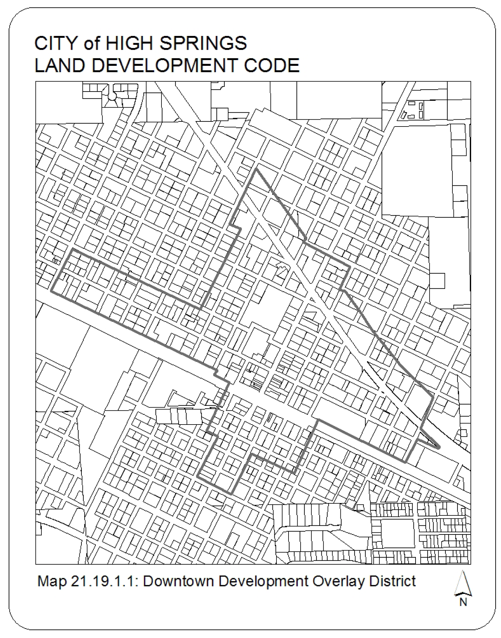
Sec. 3.05.01.01. - Establishment of the Downtown Development Overlay District.
The "Downtown Development Overlay District" is established for the purposes of this ordinance. The delineation of this district is shown on Map 21.19.1.1.
Sec. 3.05.01.02. - Intent of the Downtown Development Overlay District.
The "Downtown Development District" is intended to enhance and protect the unique character and ambiance of the community while promoting its positive development and redevelopment. These design guidelines are intended not only to preserve old buildings, but also to preserve the antiquity of the historic center of High Springs. It is not the intent to limit new construction to any one period or style but to preserve the integrity of historic buildings and to insure harmony of any new work constructed in the vicinity. All new construction and renovation within the downtown development district shall be designed in harmony the dominant architectural style within the block where it is located.
Sec. 3.05.02. - General architectural guidelines.
The general architectural guidelines for the Downtown Development Overlay District are derived from the community's historical heritage. Two dominant types of architecture reflect this history: (1) a commercial architecture generally found along Main Street and in the business core and (2) a residential architecture common to the remainder of the downtown district. The guidelines for each type are derived from the "National Register of Historic Places". New development and renovation adhering to these guidelines shall be presumed to be compatible and appropriate. Deviations or alternatives to these guidelines shall require review to determine appropriateness within the district.
Sec. 3.05.02.01. - Commercial architecture.
Commercial architecture is described as "masonry vernacular buildings". These structures are mainly constructed of brick and are one to two stories in height. Decorative details are sparse and relegated to the entranceway, the windows of the second story and the roof cornice. Commercial buildings have very simple, if any, embellishment at the cornice or roof line.
Sec. 3.05.02.02. - Residential architecture.
Residential type buildings are dominated by the "wood frame vernacular" architectural style. Generally one to two stories in height and mounted on brick piers. Gable and hip roofs are common and most houses employ weatherboard or drop siding. Porches are a common feature usually extending the full length of the facade.
For purposes of this ordinance, "residential architecture" refers to a building type or style. This term is not intended to refer nor to restrict the use of structures. Such use shall be in accordance with the zoning district in which a property is located.
Sec. 3.05.02.03. - Determination of appropriateness.
All new construction and renovation within the Downtown Development Overlay District shall require a "certificate of appropriateness" in accordance with the requirements of article XI of this LDC.
Sec. 3.05.03.01. - Build-to-lines.
To achieve the objectives of this ordinance, new development within the Downtown Development District shall adhere to build-to-lines prescribed in this ordinance. These build-to-line standards shall supersede the setback standards prescribed for existing zoning.
The primary building developed on each property shall adhere to the following build-to-lines:
(1)
In no event shall a primary building be constructed at a distance from the street right-of-way adjoining its front yard than the setback distance prescribed by the zoning classification of the property.
(2)
The build-to-line for properties fronting on US Hwy 441 shall be 15 feet.
(3)
The build-to-line for all other areas shall be determined by the following criteria:
a.
The build-to-line shall match the dominant building line of the "contributing" structures existing within the block where the property is located. In the event, the building line of "contributing" buildings is varied; the building line of the "contributing" structure closest to the right-of-way shall be established as the build-to-line.
b.
If no "contributing" structure exists within the block, the build-to-line shall match the dominant building line of the existing structures within the block where the property is located. In the event, the building line of existing buildings is varied; the building line of the existing structure closest to the right-of-way shall be established as the build-to-line.
c.
The city commission may establish build-to-lines for each block. Once established this standard will prevail for the area designated.
Sec. 3.05.03.02. - Parking.
(1)
On-street parking encouraged. On-street parking spaces adjoining a property may be credited toward meeting the off-street parking requirements of this LDC provided such spaces are improved to standards established by the city.
(2)
Off-street parking restricted. Off-street parking may not be placed in front or side yards fronting on public streets nor between buildings and a public street.
(3)
Landscaping required. No less than ten percent of the land area devoted to off-street parking shall be landscaped.
(4)
Historic preservation exemption. The preservation of any property that has been placed on the local register of historic places or that is located in the historic district and contributes to the historic character of the district, shall be grounds for a grant of a reduction in, or complete exemption from, the parking requirements in this section. The reduction or exemption needed to allow a viable use of the historic structure shall be granted unless a severe parking shortage or severe traffic congestion will result.
(5)
Downtown exemption. The parking requirements set forth in section 3.05.03.02 shall not apply to Blocks 12, 13, 15 and 16 of G. E. Foster Addition to High Springs as per Plat Book A, Page 6 of the Public Records of Alachua County. (Section 21.10 LDC)
(6)
Tree protection exemption. The required parking may be reduced by not greater than ten percent or two spaces (whichever is greater) where necessary to protect existing trees.
Sec. 3.05.03.03. - Tree preservation.
Development within the Downtown Development District shall adhere to the tree preservation requirements prescribed in article VII of this Code.