
Hillsdale City Zoning Code
ARTICLE III
- DISTRICT REGULATIONS
DIVISION 2. - R-1 ONE-FAMILY RESIDENTIAL DISTRICTS[5]
Editor's note— Ord. No. 2018-002, adopted July 16, 2018, amended division 2 in its entirety to read as herein set out. Former division 2, §§ 36-171—36-174, pertained to R-1—R-3 one-family residential districts, and derived from the Code of 1979, §§ 17.08.010—17.08.040.
DIVISION 7. - DOWNTOWN BUSINESS DISTRICT[6]
Editor's note— Ord. No. 2021-03, adopted December 6, 2021, amended the title of division 7 to read as herein set out. The former division 7 title pertained to the downtown form-based district. Ord. No. 2017-003, adopted November 6, 2017, amended division 7 in its entirety to read as herein set out. Former division 7, §§ 36-271—36-279, pertained to the B-2 central business district, and derived from the Code of 1979, §§ 17.16.010—17.16.040; Ord. No. 2007-5, adopted December 17, 2007; Ord. No. 2008-10, adopted October 20, 2008; Ord. No. 2013-5, Adopted November 4, 2013; Ord. No. 2014-7, adopted July 21, 2014; Ord. No. 2015-4, adopted March 16, 2015 and Ord. No. 2015-013, adopted September 8, 2015.
DIVISION 9. - I-1 INDUSTRIAL DISTRICT[7]
Editor's note— Ord. No. 2018-007, adopted November 5, 2018, amended division 9 in its entirety to read as herein set out. Former division 9, §§ 36-311—36-315, pertained to the I-1 light industrial district, and derived from the Code of 1979, §§ 17.20.010—17.20.050.
DIVISION 13. - PRD PLANNED REDEVELOPMENT DISTRICT[8]
Editor's note— Ord. No. 2005-7, adopted July 18, 2005, amended the Code by the addition of provisions designated as §§ 17.23.010—17.23.080. These provisions have been redesignated as §§ 36-386—36-393, at the editor's discretion in order to preserve the format of the Code.
DIVISION 14. - PUD PLANNED UNIT DEVELOPMENT DISTRICT[9]
Editor's note— Ord. No. 2005-8, adopted July 18, 2005, amended the Code by the addition of provisions designated as §§ 17.11.010—17.11.070; however said provisions have been redesignated as §§ 36-395—36-401 at the editor's discretion in order to preserve the format of the Code.
DIVISION 15. - C-1 COLLEGE DISTRICT[10]
Editor's note— Ord. No. 2005-13, adopted Nov. 21, 2005, amended the Code by the addition of provisions designated as 36-424—36-430; however, said provisions have been redesignated as §§ 36-403—36-409 at the editor's discretion in order to preserve the format of the Code.
DIVISION 16. - SCHEDULE OF REGULATIONS[11]
Editor's note— By the addition of Ord. Nos. 2005-7, 2005-8, and 2005-13, former div. 13, §§ 36-401—36-403, has been redesignated as div. 16, §§ 36-411—36-413.
Sec. 36-141.- Areas generally.
For the purpose of convenience, the city is divided into areas which are placed on maps as provided in this chapter.
(Code 1979, § 17.06.010)
Sec. 36-142. - Zoning districts.
For the purpose of this chapter, the city is divided into the following zoning districts:
(Code 1979, § 17.06.020; Ord. No. 2018-003, 7-16-2018)
Sec. 36-143. - Zoning maps.
The boundaries of the zoning districts established by the zoning ordinance are shown on a map or series of maps designated the "official zoning map." The official zoning map including all notations, references, data and other information shown therein, is adopted and made a part of this zoning ordinance as fully as if it were contained within the pages of this zoning ordinance.
(1)
Location. The official zoning map is filed in the planning department of the City of Hillsdale.
(2)
Updates. The Hillsdale City Planning Commission is responsible for updating the official zoning map to reflect amendments adopted by the Hillsdale City Council.
(3)
Zoning district boundaries. Where uncertainty exists with respect to the boundaries of the various districts, the following rules shall apply:
a.
The district boundaries are public rights-of-way including either streets, places or alleys unless otherwise shown; where the districts designated on the official zoning map are approximately bounded by street, road, place or alley lines, the same shall be construed to be the boundary of the district.
b.
Where the district boundaries are not otherwise indicated and where the property has been or may hereafter be divided into blocks and lots, the district boundaries shall be construed to be the lot lines; where districts designated on the official zoning map are approximately bounded by lot lines, the same shall be construed to be the boundary of the districts, unless otherwise indicated on the official zoning map.
c.
Where physical or natural features existing on the ground are at variance with those shown on the official zoning map, or in other circumstances not covered by rules a. and b. above, the zoning administrator shall interpret the boundaries.
d.
Any dispute in the determination of the zoning district boundaries shall be heard by the zoning board of appeals.
(Code 1979, § 17.06.030; Ord. No. 2017-002, 11-6-2017; Ord. No. 2020-2, 7-6-2020; Ord. No. 2021-01, 3-1-2021; Ord. No. 2021-02, 4-5-2021; Ord. No. 2022-01, 5-16-2022; Ord. No. 2023-05, 7-17-2023; Ord. No. 2024-02, 1-16-2024; Ord. No. 2025-04, 7-21-2025)
Sec. 36-144. - District boundaries.
Where uncertainty exists with respect to the boundaries of any of the districts established in this chapter as shown on the zoning map, the following rules shall be applied:
(1)
Where district boundaries are indicated as approximately following the centerline of streets or highways, street lines or highway right-of-way lines, such centerlines, street lines, or highway right-of-way lines shall be construed to be the boundaries.
(2)
Where district boundaries are so indicated that they are approximately parallel to the centerline of streets, or the centerlines of right-of-way lines of highways, such district boundaries shall be construed as being parallel thereto and at such distances therefrom as indicated on the zoning map. If no such distance is given, such dimension shall be determined by the use of the scale shown on the zoning map.
(3)
Where district boundaries are so indicated that they approximately follow the lot lines, such lot lines shall be construed to be boundaries.
(4)
Where the boundary of a district follows a railroad line, such boundaries shall be deemed to be located midway between the main tracks of the railroad line.
(5)
Where the boundary of a district follows a stream, lake or other body of water, the boundary line shall be deemed to be at the limit of the jurisdiction of the city unless otherwise indicated.
(6)
Where the boundary of a district follows a subdivision boundary line, such boundary line shall be construed to be the district boundary line.
(7)
Where unzoned property may exist, or where, due to the scale lack of detail or illegibility of the zoning map accompanying the ordinance codified in this chapter, there is any uncertainty, contradiction, or confliction as to the intended location of any district boundaries shown thereon, interpretation concerning the exact location of district boundary lines shall be determined, upon written application or, upon its own motion, by the board of appeals.
(Code 1979, § 17.06.040)
Sec. 36-145. - Flood hazard area mapping disputes.
(a)
Where disputes arise as to the location of the flood hazard area boundary or the limits of the floodway, the zoning board of appeals shall resolve the dispute and establish the boundary location. In all cases, the decision of the zoning board of appeals shall be based upon the most current floodplain studies issued by the Federal Emergency Management Agency. Where Federal Emergency Management Agency information is not available, the best available floodplain information shall be utilized.
(b)
Where a dispute involves an allegation that the boundary is incorrect as mapped and Federal Emergency Management Agency floodplain studies are being questioned, the zoning board of appeals shall modify the boundary of the flood hazard area or the floodway only upon receipt of an official letter of map amendment issued by the Federal Emergency Management Agency.
(c)
All parties to map dispute may submit technical evidence to the zoning board of appeals.
(Code 1979, § 17.06.045)
Sec. 36-146. - Vacated areas.
Whenever any street, alley or other public way within the city shall be vacated, such street, alley, or other public way or portion thereof shall automatically be classified in the same zone district as the property to which it attaches.
(Code 1979, § 17.06.050)
Sec. 36-147. - Annexed areas.
Any area annexed to the city shall immediately upon such annexation be automatically classified as an R-3 district, until a zoning map for the area has been adopted by the council. The planning commission shall recommend appropriate zoning for such area within six months after the annexation has taken place.
(Code 1979, § 17.06.060)
Sec. 36-148. - Landscaping, greenbelt and screening.
Intent. The intent of sections 36-148 through 36-152 is to promote the public's health, safety, and general welfare by minimizing noise, air, and visual pollution; improving the appearance of off-street parking and other vehicular use areas; requiring buffering between incompatible land uses; regulating the appearance of property abutting public rights-of-way; protecting and preserving the appearance, character, and value of the community and its residential neighborhood areas; preventing soil erosion and soil depletion; and promoting soil water retention.
(Code 1979, § 17.06.070; Ord. No. 2016-003, 3-7-2016)
Sec. 36-149. - Requirements.
(a)
Application. This section shall apply as the minimum requirements for all uses, where site plan review is required. Where landscaping, greenbelt, and screening requirements are imposed elsewhere in this chapter, the strictest requirements shall apply. No site plan shall be approved unless the site plan shall show landscaping, greenbelt, and screening consistent with the requirements set forth in this section.
(b)
All areas shall be landscaped and shall meet the following standards:
(1)
No synthetic plant materials, such as artificial grass, shrubs, trees or flowers, shall be used to fulfill any landscaping requirements.
(2)
Berms, whenever utilized, shall be designed and landscaped to minimize erosion. Berms adjacent to public rights-of-way shall have a slope of not greater than three to one, unless designed as part of a retaining wall.
(3)
All landscaping materials shall consist of healthy specimens, compatible with local climate, soil characteristics, drainage and water supply. All plant material shall be reasonably resistant to drought and disease. Non-nursery derived stock shall not be used to satisfy the requirements of this subsection.
(4)
Grass or other living plants shall be primary ground cover in required landscape areas. Both sod planting and seeding are acceptable.
(5)
Ground covers other than grass shall be planted in required areas to provide complete coverage within two growing seasons. Vines shall not be used adjacent to pedestrian areas.
(6)
Unless otherwise specified, materials such as river rock, cobble, boulders, paving stones, patterned concrete, bark and wood chips shall be limited to small areas and shall not exceed 25 percent of the required landscape area. All such ground covers shall be at least two inches deep. Loose gravel, less than three-inch minimum aggregate size, shall not be used in areas abutting public streets or sidewalks.
(7)
Maintenance shall include all reasonable and regular irrigation, weeding, fertilizing and pruning. Plant materials which show signs of insects, pests, diseases and/or damage shall be appropriately treated. Dead plant materials shall be replaced immediately or as soon as practical under the seasonal conditions existing and according to the approved site plan. The developer and subsequent owner shall be responsible for maintaining all on-site landscaping.
(8)
Plant materials and their minimum size requirements shall be installed in accordance with article X of this chapter.
(9)
Landscaping plans may be submitted to the zoning officer for technical review and to the planning commission for approval within 90 days after final approval of the site plan. Plans may be submitted as an amendment to the site plan, thereby not requiring an additional review fee. On projects in excess of two acres, the developer may file a phased plan for completing the landscaping pursuant to the standards of this subsection.
(Ord. No. 2016-003, 3-7-2016)
Sec. 36-150. - Landscaping.
(a)
Upon any improvement for which a site plan is required, landscaping shall be required to meet the guidelines listed below:
(1)
For the R-1, RD-1, RM-1 and C-1 districts, a minimum of 25 percent of the site shall be in landscaped open space. The open space shall be landscaped with one evergreen tree or shrub for every 1,000 square feet, or portion thereof, plus one small or large deciduous tree or shrub for every 2,000 square feet, or portion thereof. Plant materials existing on the site prior to development may be included as part of the requirement. Any trees removed for development may not be included as part of such requirement. Ground cover or lawn is required in all landscaped areas. (See article X, plant material of this chapter for appropriate uses of plant materials.)
(2)
For permitted and special approval uses in the B-1, B-3, I-1 and I- districts, a minimum of 15 percent of the site shall be in landscaped open space with one evergreen tree or shrub for every 1,000 square feet, or portion thereof, plus one small or large deciduous tree for every 2,000 square feet, or portion thereof. Plant materials existing on the site prior to development may be included as part of the requirement. Any trees removed for development may not be included as part of such requirement. Thirty percent of the required open space shall be between the roadway and the building. Buildings on corner lots shall have 60 percent of the required open space between the building and the roadway. Whenever feasible, a portion of the landscaping shall be placed adjacent to the buildings. Landscaping of an adjacent right-of-way may be included in the requirement if it is maintained by the adjacent property owner. Parking lots in all business and industrial zones which are adjacent to a residentially zoned district shall be fully screened from that residential district through the use of decorative walls, fences, or landscaping. (See article X, plant material of this chapter for appropriate uses of plant materials.)
(3)
B-2 parcels in which the building occupies 90 percent or more of the lot shall be exempt from the landscape requirement. For all other B-2 parcels, ten percent of the site shall be in landscaped open space with one evergreen tree or shrub for every 1,000 square feet, or portion thereof, plus one small or large deciduous tree or shrub for every 2,000 square feet, or portion thereof. Plant materials existing on the site prior to development may be included as part of the requirement. Any trees removed for development may not be included as part of such requirement. Ground cover or lawn is required in all landscaped areas. (See article X, plant material of this chapter for appropriate uses of plant materials.)
(4)
PRD parcels shall adopt the requirements consistent with the intended use.
(5)
For PRF parcels, a minimum of 80 percent of the site shall be in landscaped open space. The open space shall be landscaped with one evergreen tree or shrub for every 1,000 square feet, or portion thereof, plus one small or large deciduous tree or shrub for every 2,000 square feet, or portion thereof. Plant materials existing on the site prior to development may be included as part of the requirement. Any trees removed for development may not be included as part of such requirement. Ground cover or lawn is required in all landscaped areas. (See article X, plant material of this chapter for appropriate uses of plant materials.)
(b)
Greenbelt between land uses.
(1)
Upon any improvement for which a site plan is required, a greenbelt shall be constructed to create a visual screen along a boundary, alley, or street which is adjacent to residentially zoned or used property. In addition, greenbelt shall be constructed along any boundary between single-family unattached housing developments and single-family attached housing developments or multifamily housing developments, for which a site plan is required. In addition, within all districts, except R-1 (single-family), a greenbelt shall be constructed along a boundary, alley or street which is adjacent to a more restrictive zoning district;
(2)
The minimum width of the required greenbelt shall be ten feet, except in the office, business and industrial districts where the minimum width shall be 20 feet. However, wider greenbelt may be required, within any zoning district, at the discretion of the city.
(c)
Parking lot landscaping.
(1)
Landscaped areas shall be required at the perimeter of parking lots of 16 spaces or greater. Parking lots in all office, business and industrial zones which are adjacent to a residentially zoned district shall be fully screened from that residential district through the use of decorative walls, fences, or landscaping;
(2)
Strips of ten or more continuous spaces may be allowed by planning commission approval, providing each end of the row has a minimum of 50 square feet of landscaped area, exclusive of concrete curbing. Variations may be determined by the planning commission for design and traffic flow. There shall be a minimum of one tree for every ten parking spaces;
(3)
Minimum three-foot wide landscape strips (unobstructed by vehicle overhangs) shall be provided between paved parking surfaces and buildings, fences, and property lines wherever possible. Trees and shrubs shall be planted clear of the vehicle overhang area;
(4)
All parking lot surfaces not needed for ingress, egress, parking or driveways shall be landscaped.
(d)
Front yard landscaping. A greenbelt with a minimum width determined by the front yard setback of its zoning classification shall be located between the abutting right-of-way of a public street, freeway, or major thoroughfare, and shall be landscaped per the requirements in section 36-150 applicable to its zoning classification access ways from public rights-of-way through required greenbelts shall be permitted.
(e)
Site landscaping. In addition to any landscape greenbelt and/or parking lot landscaping required by this section, ten percent of the site area, excluding existing thoroughfare right-of-way, shall be landscaped. Areas used for storm drainage purposes, such as unfenced drainage courses or retention areas in front or side yards, may be included as a portion of the required landscaped area, but shall not exceed five percent of the site area.
(f)
All plant materials shall follow the minimum standards set forth in article X of this chapter.
(Ord. No. 2016-003, 3-7-2016; Ord. No. 2022-02, 9-19-2022)
Sec. 36-151. - Commercial dumpsters.
(a)
Commercial dumpsters shall be screened on all sides with an opaque or solid fence or wall, and a gate at least as high as the container, but no less than six feet in height, and shall be constructed of material which is compatible with the architectural materials used in the site development.
(b)
Containers shall be consolidated to minimize the number of collection sites, and located so as to reasonably equalize the distance from the building they serve.
(c)
Containers and enclosures shall be located away from public view insofar as possible.
(d)
Containers and enclosures shall be situated so that they do not cause excessive nuisance or offense to occupants of nearby buildings.
(e)
Concrete pads of appropriate size and construction shall be provided for containers or groups of containers having a capacity of six 30-gallon cans or more. Aprons shall be provided for loading of bins with capacity of 1.5 cubic yards or more.
(f)
For storage of recyclable materials, the enclosure area and pad size shall be increased to amply accommodate the extra materials and their containers.
(g)
All commercial dumpsters shall be equipped with lids.
(h)
Screening and gates shall be of durable construction, and fences, walls, footings, slabs, and curbs shall meet single state construction code requirements. Gates shall be constructed of heavy gauge metal or of a heavy gauge metal frame or wood frame with covering of wood or other suitable material. Gates shall be secured with sturdy hinges or sliders, and latches. If the enclosure is situated directly adjacent to parking spaces or drives, it shall be protected at its base by concrete curb blocks or concrete filled pipe bumpers. See Illustration.
(Ord. No. 2016-003, 3-7-2016)
Sec. 36-152. - Bioretention/rain gardens.
(a)
Summary.
(b)
Sizing calculations.
(1)
For underdrained BMP, follow criteria for "constructed filter."
(2)
Bioretention/rain gardens may be sized for channel protection or water quality treatment. Use the methods outlined in "calculating storage volumes and release rates" to calculate the required volumes.
a.
Subtract the volume infiltrated by the BMP during the infiltration period to determine the required storage volume of the BMP. The infiltration volume is calculated as:
Vinf = Design infiltration rate (inches per hour) × 6 hours × infiltration area (square feet) × 1/12 unit conversion
b.
Use the design infiltration rate of the underlying soil from field permeability tests or Table 5.
c.
The infiltration period is the time when the bed is receiving runoff and is capable of infiltrating at the design rate, which is conservatively estimated as six hours (SEMCOG, 2008).
(3)
Bioretention/rain gardens may be able to provide flood control for small drainage areas. Use one of the methods outlined in "calculating storage volumes and release rates, flood control, retention" to calculate the required storage volume.
(4)
Channel protection and water quality volumes may be included in the flood control volume.
(5)
Calculate the minimum infiltration area required to drain the required storage volume in the specified drawdown time using the design infiltration rate of the underlying soil from field permeability tests or Table 5.
A = [Vs / (i x td)] x 12
Where: A = minimum infiltration area (square feet) Vs = storage volume (cubic feet) i = design infiltration rate of soil (inches per hour) td = maximum allowable drawdown time (hours) 12 = factor to convert inches to feet.
(6)
Total drawdown time shall be no more than 72 hours. Depth of surface ponding shall be no more than 9 inches and drain within 24 hours.
(7)
Surface ponding depth may be increased up to 18 inches for bioretention areas.
(8)
The bottom area of the BMP shall be used as the infiltration area.
(9)
Calculate the storage volume of the BMP.
Average bed area (square feet) = [Area at design high water depth (square feet) + bottom area (square feet)] / 2
Surface storage volume (cubic feet) = Average bed area (square feet) x design high water depth (feet)
Subsurface storage volume (cubic feet) = Length (feet) × width (feet) × depth (feet) × void ratio of material
Total storage volume (cubic feet) = Surface storage volume (cubic feet) + subsurface storage volume (cubic feet)
(c)
Design requirements.
(1)
Siting.
a.
Soil borings are required as outlined in "soils investigation."
1.
A minimum of four feet is required between the bottom of bioretention/raingardens capable of infiltration and the highest known groundwater elevation.
2.
A minimum of two feet is required between the bottom of lined or underdrained bioretention/rain gardens and the highest known groundwater elevation.
3.
An underdrain shall be provided for design infiltration rates of the underlying native soil less than 0.50 inches per hour, or if bioretention/rain garden will be lined.
4.
Void ratio for the amended soil material shall be based on the USDA soil textural class and effective water capacity in Table 5. A maximum design value of 0.30 shall be used for the void ratio of the amended soil material. A maximum design value of 0.40 shall be used for the void ratio of stone.
b.
Setbacks shall be as follows:
1.
Adjacent property line: Ten feet.
2.
Building foundation: Ten feet.
3.
Private well: Fifty feet.
4.
Public well: Two hundred feet from Type I or Type IIa wells, 75 feet from Type IIb or Type III wells (Safe Drinking Water Act, Act 399, PA 1976).
5.
Septic system drainfield: Fifty feet.
(2)
Sizing and configuration.
a.
General.
1.
The bottom shall be flat to encourage uniform ponding and infiltration.
2.
Minimum bottom width shall be three feet.
3.
Bioretention/rain gardens located in areas with steep slopes shall be terraced to minimize earth disturbance and maximize infiltration area.
4.
Care must be taken during the excavation and finishing process to make sure that soil compaction does not occur.
5.
Bioretention/rain gardens located in areas of existing soil contamination shall be lined to prevent infiltration.
6.
Underdrains shall have a four-inch minimum pipe diameter.
7.
All underground pipes shall have clean-outs accessible from the surface.
8.
Pipe slopes shall have a minimum slope of one percent.
9.
Side slopes shall not be steeper than 3:1 (H:V), unless landscape retaining walls are used.
10.
An observation well shall be provided for each bioretention/rain garden.
b.
Rain gardens.
1.
A landscape plan shall be provided.
(3)
Inlet design.
a.
Inlet pipes shall require energy dissipation. Riprap protection or equivalent erosion control measures shall be used where the velocity exceeds four feet per second up to a maximum allowable design velocity of 10 feet per second.
b.
Pretreatment is required for each inlet and for overland flow entering the bioretention/rain garden.
(4)
Emergency overflow.
a.
All bioretention/rain gardens must have a provision for overflow at the high water level.
(5)
Materials.
a.
Amended soil material shall consist of 18 to 48 inches of the following materials, evenly mixed: Compost: 30—50 percent; Sand: 20—40 percent; Topsoil: 20—30 percent (maximum clay content of topsoil shall be 20 percent).
1.
Alternative mix designs with ratios outside of the limits provided will be considered with justification.
2.
The soil mix shall have a pH between 5.5 and 7.5.
b.
Stone shall consist of clean, uniformly graded course aggregate.
c.
A nonwoven geotextile fabric shall be placed between the amended soil and the stone, when a stone layer is used.
d.
When used, impermeable liner shall have a maximum permeability of 1 × 10 -7 centimeters per second certified by the manufacturer.
e.
Plant selection shall consider exposure and tolerance to salt, sediment and pollutants, and the design depth of surface storage. Native species are encouraged.
1.
Bioretention: Plugs and seed.
2.
Rain gardens: Container stock.
f.
Mulch shall be applied after planting.
1.
Bioretention: Straw mulch or mulch blanket shall be uniformly applied and tacked.
2.
Rain gardens: Shredded hardwood mulch shall be uniformly applied to a depth of two to three inches.
(6)
Access.
a.
Inspection and maintenance access to the bioretention/rain garden shall be provided.
(d)
Design schematics.
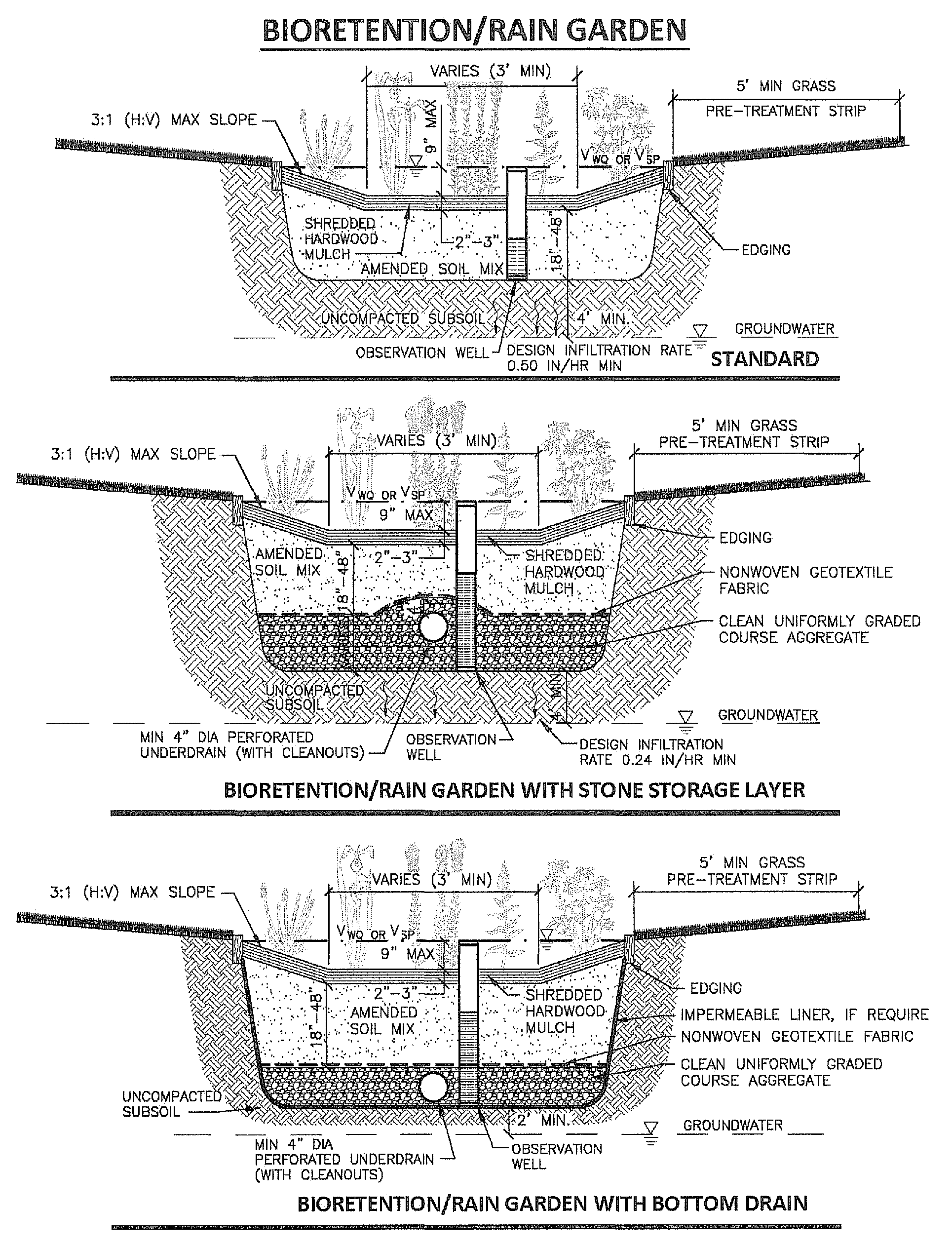
Table 5 — Design Infiltration Rates by USDA Soil Texture Class
1 Source: Appendix D.13, Table D.13.1, Maryland Stormwater Design Manual, Maryland Department of Environment, 2000. (Rawls, Brakensiek and Saxton, 1982.)
2 Source: Table 2, Site Evaluation for Stormwater Infiltration (1002), Wisconsin Department of Natural Resources, Conservation Practice Standards, 2004. (Rawls, 1998.) Note: Values are reduced by approximately a factor of 2 from those given in Table D.13.1.
Minimum allowable infiltration rate.
Soil textures with design infiltration rates less than 0.50 inches per hour are deemed not suitable for infiltration BMPs.
Soils with design infiltration rates as low as 0.24 inches per hour (medium loam) may be used for LID and small site BMPs if suitable supplemental measures are included in the design. Supplemental measures may include subsoil amendment, or underdrain placed at the top of the storage bed layer.
Figure 1 — USDA Soil Textural Triangle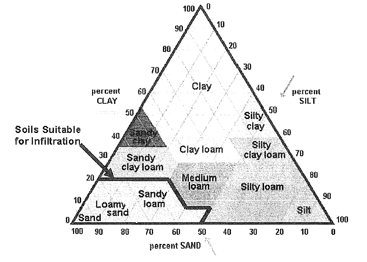
(Ord. No. 2016-003, 3-7-2016)
Sec. 36-171.- Generally.
The R-1 one-family residential districts are designed to be composed of low density residential home development. The regulations in this division are intended to stabilize, protect and encourage the residential character of the district and prohibit activities not compatible within such districts. Development in the R-1 one-family residential district is limited to single-family dwellings plus such other uses as schools, parks, churches and certain public facilities which serve residents of such districts.
(Ord. No. 2018-002, 7-16-2018)
Sec. 36-172. - Principal uses permitted.
In one-family residential districts, no building or land shall be used and no building shall be erected except for one or more of the following specified uses, unless otherwise provided in this chapter:
(1)
One-family detached dwellings;
(2)
A state-licensed residential facility when required by section 36 of Public Act No. 207 of 1921 (MCL 125.583b);
(3)
Publicly owned and operated libraries, parks, parkways and recreational facilities;
(4)
Public, parochial and private schools offering courses in general education and not operated for profit;
(5)
Accessory buildings and uses customarily incidental to any of the above permitted uses.
(Ord. No. 2018-002, 7-16-2018)
Sec. 36-173. - Uses subject to special conditions.
The following uses shall be permitted in all one-family residential districts after review and approval of the site plan by the planning commission (or zoning administrator, whichever is indicated), subject to the conditions imposed in this section for each use:
(1)
Utility and public service buildings and uses, without storage yards, when operating requirements necessitate the locating of the facilities within the district in order to serve the immediate vicinity. Further, no building and/or structure shall be located in any required front or side yard.
(2)
Colleges, universities and other such institutions of higher learning, public and private, offering courses in general, technical, or religious education and not operated for profit, all subject to the following conditions:
a.
The proposed site shall have frontage on an existing street having a right-of-way of at least 66 feet in width. All ingress and egress to and from the site shall be directly from and onto the 66-foot wide street.
b.
No building other than a structure for residential purposes shall be closer than 30 feet to any property line.
(3)
Churches, cemeteries, public, private and parochial intermediate and/or secondary schools offering courses in general education, not operated for profit and other facilities normally incidental thereto, subject to the following conditions:
a.
The proposed site shall have frontage on an existing street having a right-of-way of at least 66 feet in width. All ingress and egress to and from the site shall be directly from and onto the 66-foot wide street.
b.
The principal buildings on the site shall be set back from abutting properties zoned for residential use not less than 30 feet.
c.
Buildings of greater than the maximum height allowed in division 16 of this article may be allowed provided front, side and rear yards are increased above the minimum requirements by one foot for each foot of building that exceeds the maximum height allowed.
d.
Wherever the off-street parking area is adjacent to land zoned for residential purposes, a continuous and obscuring wall four feet six inches in height shall be provided along the sides of the parking area adjacent to the residentially zoned land. The wall shall be further subject to the provisions of article IX of this chapter.
(4)
Institutional recreation centers, not operated for profit, and nonprofit swimming pool clubs, subject to the following conditions:
a.
As a condition to the original granting of such permit and the operation of such nonprofit swimming pool club as a part of the application, the applicant shall obtain from 100 percent of the freeholders residing or owning property within a 150-foot radius immediately adjoining any property line of the site herein proposed for development a written statement of waiver addressed to the city council recommending that such approval be granted. Also, approval from 51 percent of the homeowners within 1,000 feet shall be received in writing.
b.
In those instances where the proposed site is not to be situated on a lot or lots of record, the proposed site shall have one property line abutting a major thoroughfare, and the site shall be so planned as to provide ingress and egress directly onto the thoroughfare.
c.
Front, side and rear yards shall be at least 50 feet wide, except on those sides adjacent to nonresidential districts, and shall be landscaped in trees, shrubs, grass and terrace areas. All such landscaping shall be maintained in a healthy condition. There shall be no parking or structures permitted in these yards, except for required entrance drives and those walls or fences used to obscure the use from abutting residential districts.
d.
Buildings of greater than the maximum height shall be allowed, provided front, side and rear yards are increased above the minimum requirements by one foot for each foot of building that exceeds the maximum height allowed.
e.
Whenever a swimming pool is constructed under this chapter, the pool area shall be provided with a protective fence, six feet in height, and entry shall be provided by means of a controlled gate or turnstile.
f.
Off-street parking shall be provided so as to accommodate at least one-fourth of the member families and/or individual members. Bylaws of the organization shall be provided to the planning commission in order to establish the membership involved in computing parking requirements.
g.
All storm and sanitary sewer plans shall be provided, and shall be reviewed and approved by the city engineer prior to the issuance of a building permit.
h.
The off-street parking and general site layout and its relationship to all adjacent lot lines shall be reviewed by the planning commission, who may impose any reasonable restrictions or requirements so as to ensure that contiguous residential areas will be adequately protected.
(5)
Private stable, for not more than one horse on a lot where the lot is not less than two acres in area; and provided further, that for each additional horse stabled thereon, one acre of land shall be provided. In no instance shall a horse be confined nearer than 75 feet to any adjacent property line, and all confinement areas or stables shall in all instances be located in the rear yard. No horse shall be allowed to run at large.
(6)
Accessory buildings and uses customarily incident to any of the above permitted uses.
(7)
Farms. The keeping of horses, donkeys, mules, ponies, cattle, sheep, poultry and other domestic animals or birds other than house pets, shall be permitted in connection with the farm use as an accessory use of a one-family and two-family residence established and existing on the premises where such animals, poultry, or birds are to be kept subject to the following conditions:
a.
A minimum area of two full acres, exclusive of required setback from lot lines, shall be provided for not more than one such animal kept on the premises; and provided further, that for each additional animal kept thereon, one additional adjoining acre of land shall be provided.
b.
An accessory building to be used as a private stable, barn, chicken coop, or similar type building shall be no less than 75 feet from any lot line and no less than 85 feet from any dwelling located on an adjoining lot.
c.
The animals, poultry or birds shall be confined in a suitable fenced area, paddock or suitable building, in such a manner that they may not approach any closer than 75 feet from any lot line and no closer than 85 feet from any dwelling, including residences on abutting parcels or lots.
d.
Stables, barns and other similar accessory buildings shall be kept clean and manure shall be treated and handled in such a manner as to control odor and flies and shall be screened from view.
e.
All confinement areas, stables, barns and other similar accessory buildings shall, in all instances, be located in the rear yard.
f.
Premises having a greater density of animals per acre than permitted under this subsection (7) shall be considered nonconforming uses and shall be allowed to continue; provided, however, that such nonconforming use shall be subject to article XI of this chapter and the applicable sections of such article.
(8)
Child care facility, as defined in section 36-6, for the care of one or more minor children in other than a private home, subject to the following conditions and restrictions:
A designated outdoor play area shall be required which complies with state licensing rules. The outdoor play area must be located in the rear yard, as defined in section 36-6, and be enclosed by a fence at least four feet in height.
Signs, as defined in section 26-2, shall be allowed in accordance with the regulations applicable to the zoning district in which the property is located.
(9)
Bed and breakfast and short term rentals according to the requirements of sections 36-436 and 36-437.
(Ord. No. 2018-002, 7-16-2018)
Sec. 36-174. - Area and bulk requirements.
See division 16 of this article limiting the height and bulk of buildings, the minimum size of lot permitted by land use, and the maximum density permitted in one-family residential districts.
(Ord. No. 2018-002, 7-16-2018)
Sec. 36-191.- Generally.
The RD-1 one-family and two-family residential district is designed to be composed of certain medium density areas representing a compatible commingling of one-family and two-family dwellings and certain open areas where similar residential development appears likely to occur. The regulations in this division are intended to stabilize and protect the essential characteristics of the RD-1 one-family and two-family residential district and prohibit activities not compatible with a residential neighborhood. Development in the RD-1 one-family and two-family residential district is limited to single-family and two-family dwellings plus such other uses as schools, parks, churches and certain public facilities which serve residents of the district.
(Code 1979, § 17.09.010)
Sec. 36-192. - Principal uses permitted.
In a one-family and two-family residential district, no building or land shall be used and no building shall be erected except for one or more of the following specified uses, unless otherwise provided in this chapter:
(1)
All principal uses permitted in the one-family residential district;
(2)
Two-family dwellings;
(3)
All uses subject to special conditions permitted in the one-family residential districts, after review and approval of the site plan by the planning commission and subject to the same conditions imposed thereon pursuant to section 36-173.
(Code 1979, § 17.09.020)
Sec. 36-193. - Uses subject to special conditions.
The following uses in a RD-1 one-family and two-family residential district shall be permitted after review and approval of the site plan by the planning commission, or zoning administrator, whichever is indicated, subject to the conditions imposed in this section for each use:
(1)
Family day care home, as defined in section 36-6, the in-home care of one to six or fewer minor children subject to the following conditions:
a.
No dormitory facilities shall be provided or permitted.
b.
There shall be no drop-off or pick-up of children between the hours of 12:30 a.m. and 4:30 a.m. in the RD-1 district.
c.
A designated outdoor play area shall be required which complies with state licensing rules. The outdoor play area must be located in the rear yard, as defined section 36-6.
d.
Absolutely no signs, as defined in section 26-2, shall be allowed except to the extent they are otherwise specifically allowed in this residential district.
e.
No family day care home may commence operations until and unless the zoning administrator first approves of occupancy, which approval shall be subject to the applicant providing him or her proof of compliance with all of the following:
1.
Registration of said operation with the city as a family day care home;
2.
Licensure by the state for the operation of a family day care home;
3.
Submission to and compliance with other requirements and restrictions established in this division and other applicable inspections required under the property maintenance code adopted by the city;
4.
Compliance with all other requirements and restrictions established in this division and other applicable provisions of this chapter.
(2)
Group day care home, as defined in section 36-6, for the care of seven to 12 minor children subject to the following conditions and restrictions:
a.
No dormitory facilities shall be provided or permitted.
b.
The group day care may not operate between the hours of 8:00 p.m. and 5:00 a.m. in the RD-1 district.
c.
A designated outdoor play area shall be required which complies with state licensing rules. The outdoor play area must be located in the rear yard, as defined in section 36-6, and be enclosed by a fence a minimum of three feet in height.
d.
The outdoor play area must be located in the rear yard, as defined in section 36-6, and be enclosed by a fence that is a minimum of three feet in height.
e.
The lot size of the property upon which a group day care home is to be established must be a minimum of 8,400 square feet.
f.
On-site parking shall be provided for each employee of the group day care, in addition to any other required parking requirements.
g.
Absolutely no signs, as defined in section 26-2, shall be allowed except to the extent they are otherwise specifically allowed in this residential district.
h.
No group day care home may commence operations until and unless:
1.
The planning commission first reviews and approves the group day care site plan at a public hearing to be held after not less than 15 days' written prior notice of said hearing is provided to each property owner owning property within 400 feet of the subject property as measured from any of its boundary lines;
2.
The zoning administrator first approves of occupancy, which approval shall be subject to the applicant providing him or her proof of compliance with all of the following:
i.
Registration of said operation with the city as a group day care home;
ii.
Licensure by the state for the operation of a group day care home;
iii.
Submission to and compliance with other requirements and restrictions established in this division and other applicable inspections required under the property maintenance code adopted by the city;
iv.
Compliance with all other requirements and restrictions established in this division and other applicable provisions of this chapter.
(Code 1979, § 17.09.030)
Sec. 36-211.- Generally.
The RM-1 multiple-family residential district is designed to provide sites for multi-family and multiple-tenant dwelling structures, and related uses, which will generally serve as zones of transition between the nonresidential districts and the one-family and two-family residential districts. The multiple-family residential district is further provided to serve the limited needs for the apartment and multiple-tenant types of units in an otherwise low density, residential community, whether occupied permanently or on a transitory or seasonal basis, or for a limited duration, such as, by way of example, a school term, participation in or attendance at a seminar, or other similar determinable period.
(Code 1979, § 17.10.010; Ord. No. 2014-5, 7-21-2014)
Sec. 36-212. - Principal uses permitted.
In an RM-1 multiple-family residential district, no building or land shall be used and no buildings shall be erected except for one or more of the following specified uses, unless otherwise provided in this chapter:
(1)
All principal uses permitted in the one-family and two-family residential districts with the lot areas, yards, and floor area requirements equal to at least the requirements of the one-family and two-family residential district;
(2)
Multiple-family dwellings, where public sewer and water are available;
(3)
Accessory building and uses customarily incident to any of the above permitted uses.
(Code 1979, § 17.10.020; Ord. No. 2014-5, 7-21-2014)
Sec. 36-213. - Uses subject to special conditions.
The following uses shall be permitted in the RM-1 multiple-family residential districts after review and approval of the site plan by the planning commission or zoning administrator, whichever is indicated, subject to the conditions imposed in this section for each use:
(1)
Nursery schools, day nurseries and child care centers (not including dormitories); provided, that for each child so cared for, there is provided and maintained a minimum of 100 square feet of outdoor play area. Such play space shall have a total minimum area of at least 1,000 square feet, and shall be fenced or screened from any adjoining land with planting. Any use permitted herein shall not be permitted in the interior of any residential block.
(2)
General hospitals, except those for criminals and those solely for the treatment of persons who are mentally ill or have contagious diseases, when the following conditions are met:
a.
The proposed site shall have at least one property line abutting a street having a right-of-way of at least 66 feet in width.
b.
The minimum required distance of any main or accessory building from building lot lines or streets, whichever is closer, shall be at least 40 feet for front, the maximum height allowed at the 40-feet setback shall be 60 feet; the minimum required distance of any main or accessory building from building lot lines or streets, whichever is closer, may be reduced to 25 feet for front, rear and side yards but only if:
1.
Parking is not permitted in any front, rear or side yard;
2.
The front, rear and side yards shall remain as a greenbelt and be landscaped to create an appropriate buffer;
3.
Building façade elevations are submitted to and approved by the planning commission; and
4.
No main or accessory structure may exceed 50 feet in height.
c.
Ambulance and delivery areas shall be obscured from all residential view with an obscuring wall or fence six feet in height. Ingress and egress to and from the site shall be from and to a street having a right-of-way of at least 66 feet in width.
d.
All ingress and egress to the off-street parking area for guests, employees and staff as well as any other users of the facilities shall be directly from and to a street having a right-of-way of at least 66 feet in width.
e.
All off-street nonresidential parking shall comply with the provisions of section 36-148 and article VIII.
(3)
Convalescent homes not to exceed a height of two stories when the following conditions are met: The site shall be so developed as to create a land-to-building ratio on the lot or parcel whereby for each one bed in the convalescent home there shall be provided not less than 1,500 square feet of open space. The 1,500 square feet of land area per bed shall provide for landscape setting, off-street parking service drives, loading space, yard requirements, employee facilities, and any space required for accessory uses. The 1,500 square foot requirement is over and above the building coverage area.
(4)
Housing for the elderly, not to exceed a height of two stories, when the following conditions are met:
a.
A planned development consisting of at least five acres with cottage dwellings, and/or apartment-type dwelling units and common services containing but not limited to central dining rooms, recreational rooms, central lounge and workshop;
b.
All dwellings shall consist of at least 350 square feet per unit;
c.
The maximum extent of development shall not exceed 15 dwelling units per acre and total coverage shall not exceed 25 percent for all buildings, including dwelling units and related service buildings.
(5)
Offices for any of the following occupations: executive, administrative and professional occupations when the following conditions are met:
a.
The proposed site shall have at least one property line abutting a street having a right-of-way of at least 66 feet in width.
b.
Off-street parking shall be provided for patients, clients, employees and staff in accordance with the requirements of section 36-600(d).
c.
All ingress and egress to and from off-street parking areas required in this section as well as to the site for any other purpose shall be directly from and to a street having a right-of-way of at least 66 feet in width.
d.
Front, side and rear setback requirements for new construction shall be in accordance with those requirements established there for RM-1, multiple-family residential districts in division 16 of this article.
(6)
Bed and breakfast operations, subject to the following conditions:
a.
The bed and breakfast operation shall be conducted entirely within the main dwelling unit on the premises, which dwelling unit shall contain a minimum of 3,000 square feet and be located on a lot of not less than 20,000 square feet in area. The dwelling unit shall not be altered so as to increase the space available for the bed and breakfast operation.
b.
A bathroom shall be provided on each floor where bed and breakfast sleeping rooms are provided and there shall be one bathroom for every four bed and breakfast sleeping rooms.
c.
There shall be provided a minimum of one parking space plus one for each bed and breakfast room.
d.
There may be one unanimated, non-illuminated identification sign attached to the dwelling unit of not more than two square feet in size.
e.
During such times as the bed and breakfast operation is being conducted, the premises shall not be used for any other permitted use or use subject to special conditions, other than as a single-family dwelling unit. The facilities provided on the premises shall be exclusively for the use of bed and breakfast guests and residents of the dwelling unit.
(7)
Accessory buildings and uses customarily incident to any of the above uses.
(8)
Family day care home, as defined in section 36-6, the in-home care of minor children subject to the following conditions:
a.
No dormitory facilities shall be provided or permitted.
b.
A designated outdoor play area shall be required which complies with state licensing rules. The outdoor play area must be located in the rear yard, as defined in section 36-6.
c.
Absolutely no signs, as defined in section 26-2, shall be allowed except to the extent they are otherwise specifically allowed in this residential district.
d.
No family day care home may commence operations until and unless the zoning administrator first approves of occupancy, which approval shall be subject to the applicant providing him or her proof of compliance with all of the following:
1.
Registration of said operation with the city as a family day care home;
2.
Licensure by the state for the operation of a family day care home;
3.
Submission to and compliance with other requirements and restrictions established in this division and other applicable inspections required under the property maintenance code adopted by the city;
4.
Compliance with all other requirements and restrictions established in this division and other applicable provisions of this chapter.
(9)
Group day care home, as defined in section 36-6, the in-home care of seven to 12 minor children subject to the following conditions and restrictions:
a.
No dormitory facilities shall be provided or permitted.
b.
A designated outdoor play area shall be required which complies with state licensing rules. The outdoor play area must be located in the rear yard, as defined in section 36-6, and be enclosed by a fence a minimum of three feet in height.
c.
Absolutely no signs, as defined in section 26-2, shall be allowed except to the extent they are otherwise specifically allowed in this residential district.
d.
No group day care home may commence operations until and unless the zoning administrator first approves of occupancy, which approval shall be subject to the applicant providing him or her proof of compliance with all of the following:
1.
Registration of said operation with the city as a group day care home;
2.
Licensure by the state for the operation of a group day care home.
(Code 1979, § 17.10.030; Ord. No. 2008-14, 12-15-2008; Ord. No. 2014-5, 7-21-2014)
Sec. 36-214. - Area and bulk requirements.
See division 16 of this article limiting the height and bulk of buildings, the minimum size of lot permitted by land use, and the maximum density permitted in the RM-1 multiple-family residential district.
(Code 1979, § 17.10.040)
Sec. 36-231.- Generally.
The O-1 office district is designed to accommodate uses such as offices, banks and funeral homes, which can serve as transitional areas between residential and commercial districts. The O-1 office district will provide greater protection to existing single-family homes located in areas that are becoming less desirable for single-family residential use. Multiple dwellings may be allowed in the O-1 office district under certain conditions and subject to the approval of the site plan by the planning commission.
(Code 1979, § 17.12.010; Ord. No. 2015-2, 3-16-2015)
Sec. 36-232. - Uses permitted.
In an O-1 office district, no building or land shall be used and no building shall be erected except for one or more of the following specified uses, unless otherwise provided in this chapter:
(1)
Offices for any of the following occupations: Executive, administrative and professional including real estate and insurance.
(2)
Professional offices of doctors, dentists, chiropractors, osteopaths, and similar or allied professions.
(3)
Banks, not including drive-in facilities.
(4)
Libraries, post offices and governmental office buildings and public utility offices, but not including storage yards, transformer stations, exchanges, or substations.
(5)
Funeral homes (mortuaries).
(6)
Churches.
(7)
Clinics.
(8)
Private clubs and lodges.
(9)
Business schools.
(10)
Other uses similar to the above uses.
(11)
Accessory structures and uses customarily incidental to the above permitted uses.
(Code 1979, § 17.12.020; Ord. No. 2015-2, 3-16-2015)
Sec. 36-233. - Required conditions.
Required conditions in the O-1 office district shall be as follows:
(1)
No interior display shall be visible from the exterior of the building.
(2)
The outdoor storage of goods or materials shall be prohibited irrespective of whether or not they are for sale.
(3)
Warehousing or indoor storage of goods or material beyond that normally incidental to the above permitted uses shall be prohibited.
(Code 1979, § 17.12.030; Ord. No. 2015-2, 3-16-2015)
Sec. 36-234. - Uses permissible on special approval.
The following uses shall be permitted in the O-1 office district subject to the review and approval of the site plan by the planning commission or zoning administrator, whichever is indicated, and subject to the conditions imposed in this section for each use:
(1)
Multiple family dwellings and multiple-tenant dwellings subject to the following conditions:
a.
Compliance with the requirements applicable to multiple-family and multiple-tenant dwellings in sections 36-211, 36-212, and 36-411 of Hillsdale's Code of Ordinances.
b.
Provided, that any multiple family dwelling or multiple-tenant dwellings to be proposed within a single block between two existing office and/or commercial uses-obtains approval from the planning commission.
(2)
One-family, two-family and multiple-family residential dwelling units within an office building subject to the approval of the city council, after a recommendation is received from the planning commission or 30 days after a recommendation is requested by the council and subject to the following conditions:
a.
Dwelling units shall not be located on the ground floor;
b.
The council may impose any required setback and/or performance standards so as to ensure public health, safety and general welfare;
c.
A minimum of one parking space shall be provided for each dwelling unit. Parking shall be provided on site, or within a 600-foot radius of the building it is intended to serve, measured from the nearest point of the building with the nearest point of the off-street parking lot.
d.
A minimum rear yard setback of 30 feet shall be provided for new construction.
(3)
Family day care home, as defined in section 36-6, the in-home care of one to six or fewer minor children subject to the following conditions:
a.
No dormitory facilities shall be provided or permitted.
b.
A designated outdoor play area shall be required which complies with state licensing rules. The outdoor play area must be located in the rear yard, as defined in section 36-6, and be enclosed by a fence of at least four and one-half feet in height.
c.
Signs, as defined in section 26-2, shall be allowed in accordance with the regulations applicable to zone district in which the property is located.
d.
No family day care home may commence operations until and unless the zoning administrator first approves of occupancy, which approval shall be subject to the applicant providing him or her proof of compliance with all of the following:
1.
Registration of said operation with the city as a family day care home;
2.
Licensure by the state for the operation of a family day care home;
3.
Submission to and compliance with other requirements and restrictions established in this division and other applicable inspections required under the property maintenance code adopted by the city;
4.
Compliance with all other requirements and restrictions established in this division and other applicable provisions of this chapter.
(4)
Group day care home, as defined in section 36-6, the in-home care of seven to 12 minor children subject to the following conditions and restrictions:
a.
No dormitory facilities shall be provided or permitted.
b.
A designated outdoor play area shall be required which complies with state licensing rules. The outdoor play area must be located in the rear yard, as defined in section 36-6, and be enclosed by a fence at least four and one-half feet in height.
c.
Signs, as defined in section 26-2, shall be allowed in accordance with the regulations applicable to the zone district in which the property is located.
d.
No group day care home may commence operations until and unless the zoning administrator first approves of occupancy, which approval shall be subject to the applicant providing him or her proof of compliance with all of the following:
1.
Registration of said operation with the city as a group day care home;
2.
Licensure by the state for the operation of a group day care home;
3.
Submission to and compliance with other requirements and restrictions established in this division and other applicable inspections required under the property maintenance code adopted by the city;
4.
Compliance with all other requirements and restrictions established in this division and other applicable provisions of this chapter.
(5)
Child care facility, as defined in section 36-6, for the care of one or more minor children in other than a private home, subject to the following conditions and restrictions:
a.
All conditions and restrictions as are applicable to a group day care home pursuant to subsection (4) of this section.
b.
A designated outdoor play area shall be required which complies with state licensing rules. The outdoor play area must be located in the rear yard, as defined in section 36-6, and be enclosed by a fence at least four and one-half feet in height.
c.
Signs, as defined in section 26-2, shall be allowed in accordance with the regulations applicable to zone district in which the property is located.
(Code 1979, § 17.12.040; Ord. No. 2015-2, 3-16-2015)
Sec. 36-235. - Area and bulk requirements.
See division 16 of this article limiting height and bulk of buildings and the minimum size of lot by permitted land use in the O-1 office district.
(Code 1979, § 17.12.050; Ord. No. 2015-2, 3-16-2015)
Sec. 36-251.- Generally.
The B-1 local business district is designed solely for the convenience shopping of persons residing in adjacent residential areas to permit only such uses as are necessary to satisfy those limited basic shopping and/or service needs which by their very nature are not related to the shopping pattern of the central business district.
(Code 1979, § 17.14.010; Ord. No. 2015-3, 3-16-2015)
Sec. 36-252. - Uses permitted.
In a B-1 local business district, no building or land shall be used and no building shall be erected except for one or more of the following specified uses, unless otherwise provided in this chapter:
(1)
Any generally recognized retail business which supplies commodities on the premises for persons residing in adjacent residential areas, such as but not limited to groceries, meats, dairy products, baked goods or other foods, drugs, dry goods, clothing and notions, or hardware.
(2)
Any personal service establishment which performs services on the premises for persons residing in adjacent residential areas, such as but not limited to repair shops (watch, radio, television, shoe, etc.), tailor shops, beauty parlors, or barber shops.
(3)
Banks, post offices and other governmental office buildings.
(4)
Professional offices of doctors, dentists, chiropractors, osteopaths, and similar or allied professions.
(5)
Offices for any of the following occupations; executive, administrative and professional.
(6)
Other uses similar to the above uses.
(7)
Self-service laundry and/or dry cleaning establishment.
(8)
Accessory structures and uses customarily incidental to the above permitted uses.
(Code 1979, § 17.14.020; Ord. No. 2015-3, 3-16-2015)
Sec. 36-253. - Required conditions.
(a)
All business establishments in the B-1 local business district shall be retail or service establishments dealing directly with consumers. All goods produced on the premises in the B-1 local business district shall be sold at retail on premises where produced.
(b)
All business, servicing or processing, except for off-street parking or loading, in the B-1 local business district shall be conducted within a completely enclosed building.
(Code 1979, § 17.14.030; Ord. No. 2015-3, 3-16-2015)
Sec. 36-254. - Uses permissible on special approval.
The following uses shall be permitted in the B-1 local business district subject to the review and approval of the site plan by the planning commission or zoning administrator, whichever is indicated, and subject to the conditions imposed in this section for each use:
(1)
Gasoline service station for the sale of gasoline, oil and minor accessories only, and where no repair work is done other than incidental service, but not including steam cleaning or undercoating.
a.
The curb cuts for ingress and egress to a service station shall not be permitted at such locations that will tend to create traffic hazards in the streets immediately adjacent thereto. Entrances shall be no less than 25 feet from a street intersection, measured from the road right-of-way, or from adjacent residential districts.
b.
The minimum lot area shall be 10,000 square feet, and so arranged that ample space is available for motor vehicles which are required to wait.
(2)
Publicly owned buildings, public utility buildings, telephone exchange buildings, electric transformer stations and substations, gas regulator stations with service yards, but without storage yards.
(3)
Family day care home, as defined in section 36-6, the in-home care of one to six or fewer minor children subject to the following conditions:
a.
No dormitory facilities shall be provided or permitted.
b.
A designated outdoor play area shall be required which complies with state licensing rules. The outdoor play area must be located in the rear yard, as defined in section 36-6, and be enclosed by a fence of at least four and one-half feet in height.
c.
Signs, as defined in section 26-2, shall be allowed in accordance with the regulations applicable to zone district in which the property is located.
d.
No family day care home may commence operations until and unless the zoning administrator first approves of occupancy, which approval shall be subject to the applicant providing him or her proof of compliance with all of the following:
1.
Registration of said operation with the city as a family day care home;
2.
Licensure by the state for the operation of a family day care home;
3.
Submission to and compliance with other requirements and restrictions established in this division and other applicable inspections required under the property maintenance code adopted by the city;
4.
Compliance with all other requirements and restrictions established in this division and other applicable provisions of this chapter.
(4)
Group day care home, as defined in section 36-6, the in-home care of seven to 12 minor children subject to the following conditions and restrictions:
a.
No dormitory facilities shall be provided or permitted.
b.
A designated outdoor play area shall be required which complies with state licensing rules. The outdoor play area must be located in the rear yard, as defined in section 36-6, and be enclosed by a fence at least four and one-half feet in height.
c.
Signs, as defined in section 26-2, shall be allowed in accordance with the regulations applicable to the zone district in which the property is located.
d.
No group day care home may commence operations until and unless the zoning administrator first approves of occupancy, which approval shall be subject to the applicant providing him or her proof of compliance with all of the following:
1.
Registration of said operation with the city as a group day care home;
2.
Licensure by the state for the operation of a group day care home;
3.
Submission to and compliance with other requirements and restrictions established in this division and other applicable inspections required under the property maintenance code adopted by the city;
4.
Compliance with all other requirements and restrictions established in this division and other applicable provisions of this chapter.
(5)
Child care facility, as defined in section 36-6, for the care of one or more minor children in other than a private home, subject to the following conditions and restrictions:
a.
All conditions and restrictions as are applicable to a group day care home pursuant to subsection (4) of this section.
b.
A designated outdoor play area shall be required which complies with state licensing rules. The outdoor play area must be located in the rear yard, as defined in section 36-6, and be enclosed by a fence at least four and one-half feet in height.
c.
Signs, as defined in section 26-2, shall be allowed in accordance with the regulations applicable to zone district in which the property is located.
(6)
Any combination of one or more one-family and multiple-tenant family units, subject to the following requirements:
a.
All dwelling units shall meet the defined requirements of section 36-6, apartments.
b.
A minimum of one parking space shall be provided for each dwelling unit. Parking shall be provided on site, or within a 600-foot radius of the building it is intended to serve, measured from the nearest point of the building with the nearest point of the off-street parking lot.
c.
Dwelling units and accessory buildings related to residential uses shall not be permitted on the ground floor.
d.
Compliance with the requirements applicable to multiple-family residential districts contained in sections 36-211, 36-212, and 36-411 of Hillsdale's Code of Ordinances.
(Code 1979, § 17.14.040; Ord. No. 2015-3, 3-16-2015)
Sec. 36-255. - Area, bulk and yard setback requirements.
See division 16 of this article limiting height and bulk of buildings, and the minimum size of lot by permitted land use in the B-1 local business districts.
(Code 1979, § 17.14.050; Ord. No. 2015-3, 3-16-2015)
Sec. 36-271.- Purpose.
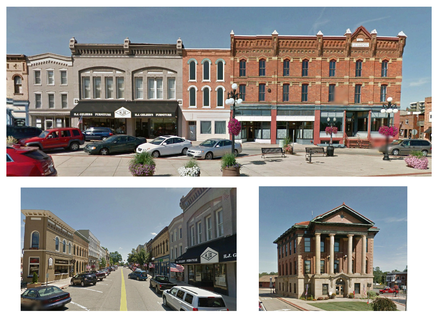
The Hillsdale Downtown Business District is a departure from traditional zoning in that it focuses less on the use of a parcel and more on the preservation of the City's character as it is expressed in its built form. To do this, development standards are integrated with public realm standards and include form regulations which are intended to support the re-creation and expansion of the City's successful downtown built environment. Key elements include architectural standards, mixed uses by right, diversity among travel modes, residential accommodation in the downtown, and a parking strategy organized by district rather than by parcel.
(Ord. No. 2017-003, 11-6-2017; Ord. No. 2021-03, 12-6-2021)
Sec. 36-272.01. - Text and diagrams.
The text and diagrams in the Downtown Business District address the location and extent of land uses, implement the vision articulated in the Hillsdale Placemaking process, and express community intentions regarding urban form and design. These expressions may differentiate neighborhoods, districts, and corridors, provide for a mixture of land uses and housing types within each, and provide specific measures for regulating relationships between buildings, and between buildings and outdoor public areas, including streets.
(Ord. No. 2017-003, 11-6-2017; Ord. No. 2021-03, 12-6-2021)
Sec. 36-272.02. - Regulated uses.
Regulated uses are identified for each zone either as a Permitted Use (P) or a use requiring a conditional use permit (CUP). All CUP uses must address the general standards listed below. If the CUP has additional standards over and above the general standards the special provision column references that specific section of the zoning ordinance. All uses will require the submission of a site plan pursuant to division 2 of the City of Hillsdale Zoning Ordinance.
(Ord. No. 2017-003, 11-6-2017; Ord. No. 2021-03, 12-6-2021)
Sec. 36-272.03. - General standards.
The planning commission shall review each application for the purpose of determining that each proposed use meets the following standards, and in addition, shall find adequate evidence that each use on the proposed location will:
(1)
Be designed, constructed, operated, and maintained so as to insure that public services and facilities affected by a proposed land use or activity will be capable of accommodating increased service and facility loads caused by the land use or activity, to protect the natural environment and conserve natural resources and energy, to insure compatibility with adjacent uses of land, and to promote the use of land in a socially and economically desirable manner.
(2)
Be designed to protect: natural resources; the health, safety, welfare, and social and economic well-being of those who will use the development under consideration; residents and landowners immediately adjacent to the proposed land use or activity; and the community as a whole.
(3)
Be related to the valid exercise of the police power and purposes which are affected by the proposed use or activity.
(4)
Be necessary to meet the intent and purpose of the zoning ordinance; be related to the standards established in the ordinance for the land use or activity under consideration; and be necessary to insure compliance with those standards.
(5)
Meet the standards of other governmental agencies where applicable, and ensure that the approval of these agencies has been obtained or is assured.
(6)
Meet the intent of the Hillsdale Placemaking Plan to provide harmonious streetscapes and consistent architecture.
(Ord. No. 2017-003, 11-6-2017; Ord. No. 2021-03, 12-6-2021)
Sec. 36-272.04. - Splicing.
The downtown business district focuses attention on the development and form of public and private properties and spaces within the area designated on the regulating plan referenced in section 36-272.05. Requirements regarding site development standards such as parking, lighting, and encroachments included in this division will take precedence over the general requirements contained in the City of Hillsdale Zoning Ordinance. The Downtown Business District will replace the following Sections of the City of Hillsdale Zoning Ordinance:
Division 7 — B-2 Downtown Form-Based District.
All other provisions of the City of Hillsdale Zoning Ordinance remain intact and valid.
(Ord. No. 2017-003, 11-6-2017; Ord. No. 2021-03, 12-6-2021)
Sec. 36-272.05. - Properties currently developed and occupied.
The regulating plan encompasses properties that have been developed under the current City of Hillsdale Zoning Ordinance. These properties may not comply with the dimensional and form requirements of the downtown business district and will not be considered as nonconforming. If the property changes occupancy after the effective date of the ordinance from which this division is derived it will be required to comply with the applicable section of this division except section 36-274 "Lot and building placement." If the property is demolished, redeveloped, or vacant it will be required to comply with all of the provisions of this division.
(Ord. No. 2017-003, 11-6-2017; Ord. No. 2021-03, 12-6-2021)
Sec. 36-273. - Regulating plan.
A regulating plan connects the regulations in the business code to the specific lots and rights-of-way they govern. This is similar to the zoning map of a use-based code. However, the primary purposes of a regulating plan are quite different from a conventional zoning map: Addressing the intensity of development rather than use, and prescribing a quality public realm rather than proscribing incompatible uses. Therefore, its function is quite distinct. The intent of the Hillsdale Downtown Business District is to preserve the historic built form of the community core, and to establish a functional and aesthetic linkage between the traditional downtown and the campus of Hillsdale College. Because the locus of each of these goals is within the public realm, this code has been developed to maximize its impact there. The public right-of-way is the organizing principle within each category. Therefore, the regulating category which applies to each lot or parcel is determined by the right-of-way adjacent to its front lot line. This method promotes a cohesive experience on both sides of the public space, the right-of-way.
(Ord. No. 2017-003, 11-6-2017; Ord. No. 2021-03, 12-6-2021)
Sec. 36-274. - Lot and building placement.
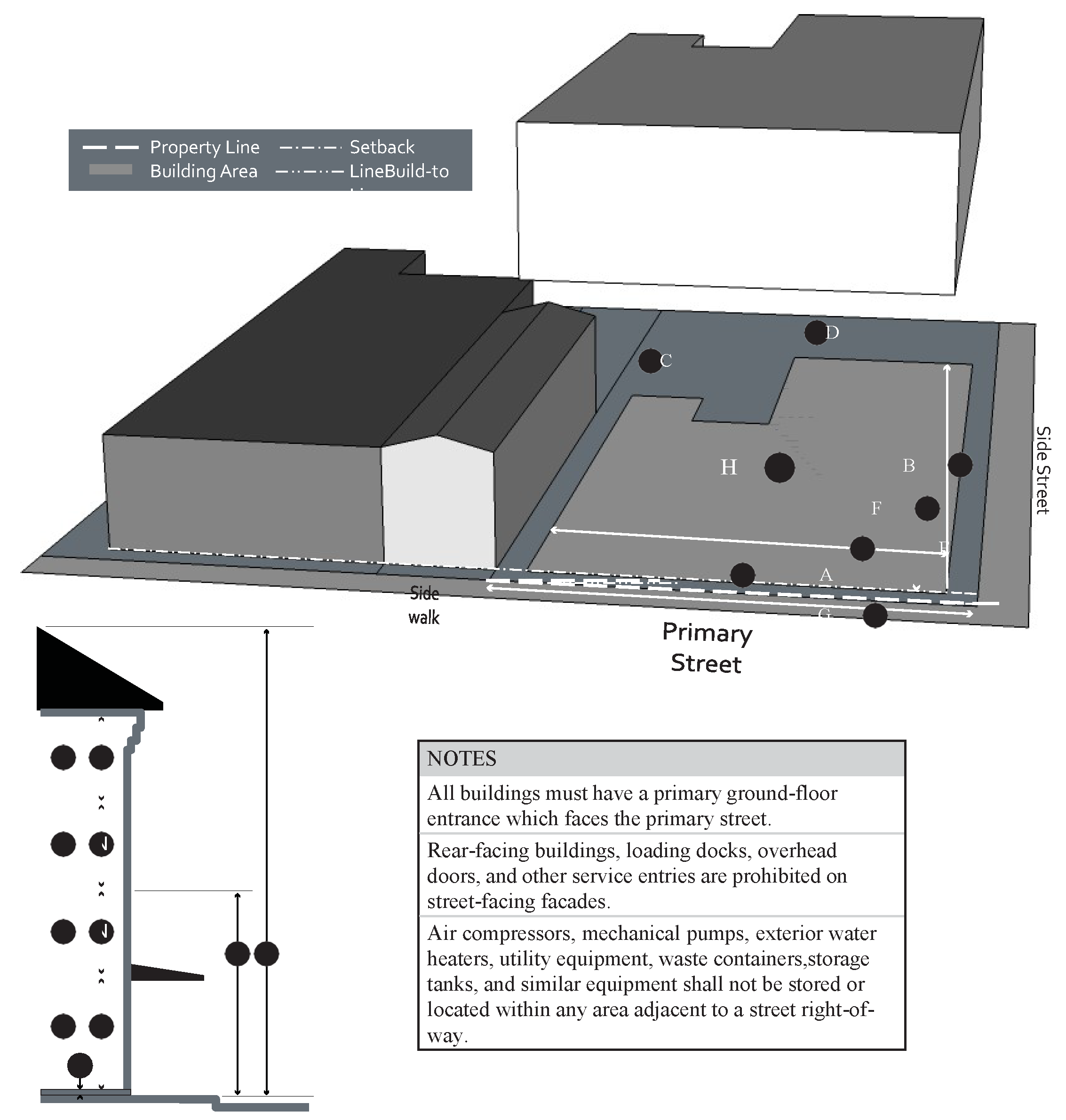
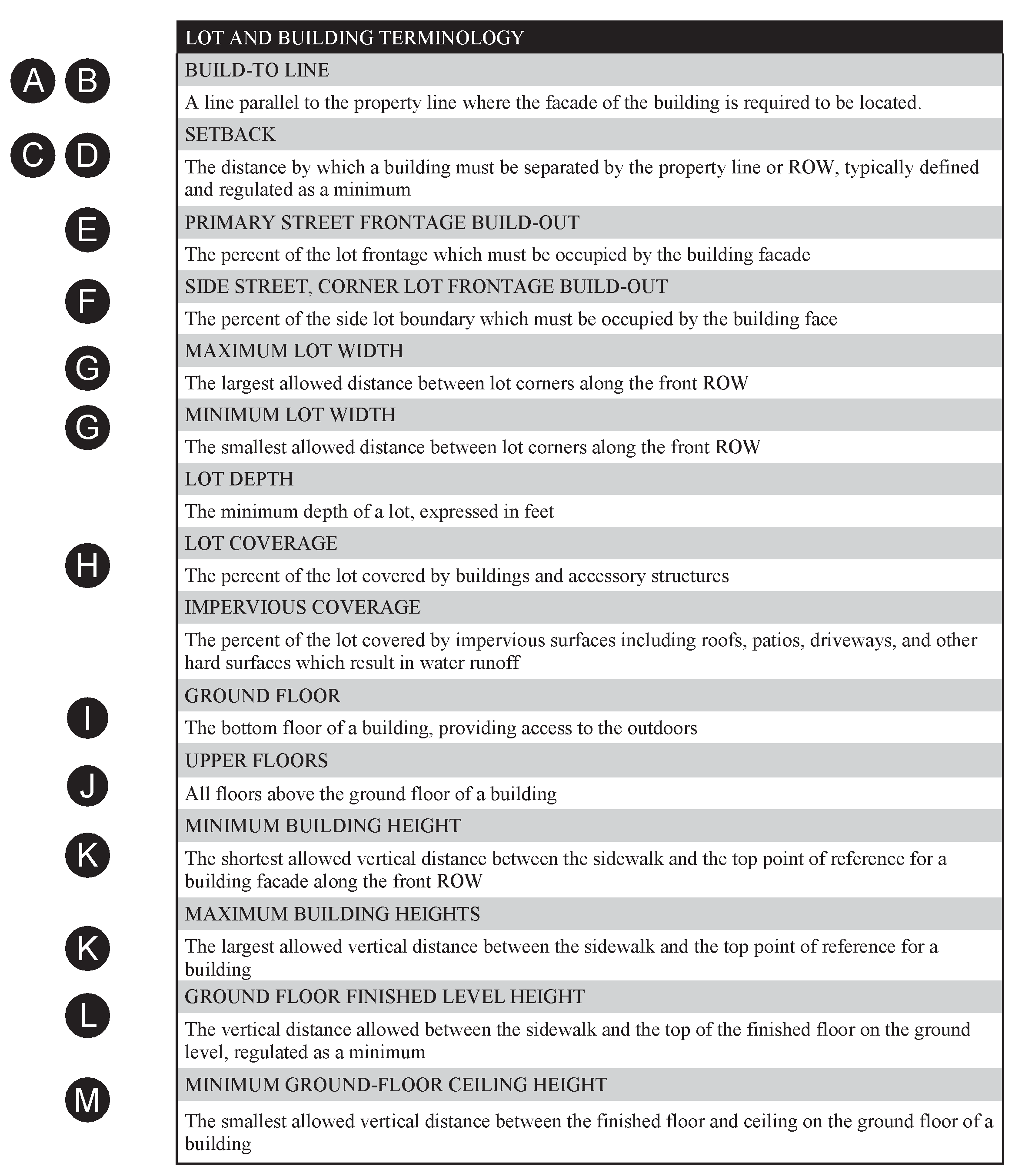
(Ord. No. 2017-003, 11-6-2017; Ord. No. 2021-03, 12-6-2021)
Sec. 36-275.01. - Downtown core (DC).
Purpose. The downtown core category is designed to foster a mix of commercial, institutional, and residential uses that are accessible by multiple modes to serve the community as a whole.
Distinguishing Characteristics. Retail, workplace, and civic activities mixed with attached housing types such as apartments and live/work units.
General Character. Predominantly attached buildings, landscaping within the public right-of-way, substantial pedestrian activity.
(Ord. No. 2017-003, 11-6-2017; Ord. No. 2021-03, 12-6-2021)
Sec. 36-275.02. - Downtown edge (DE).
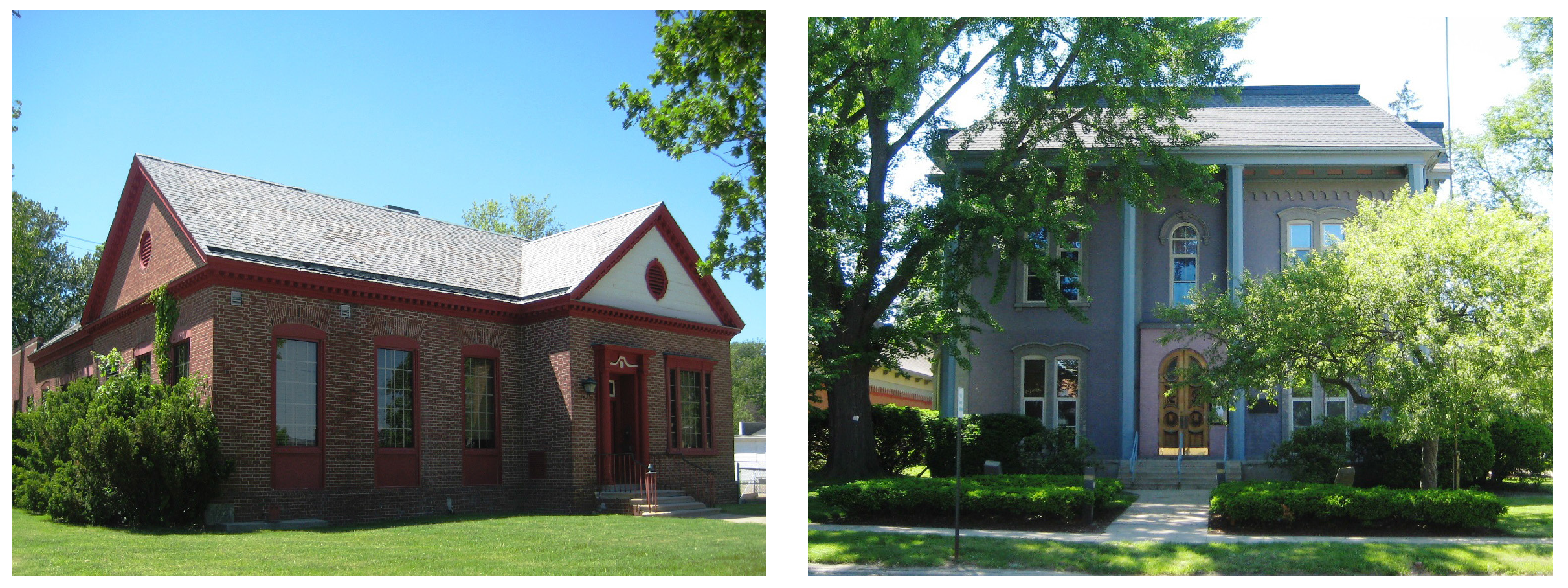
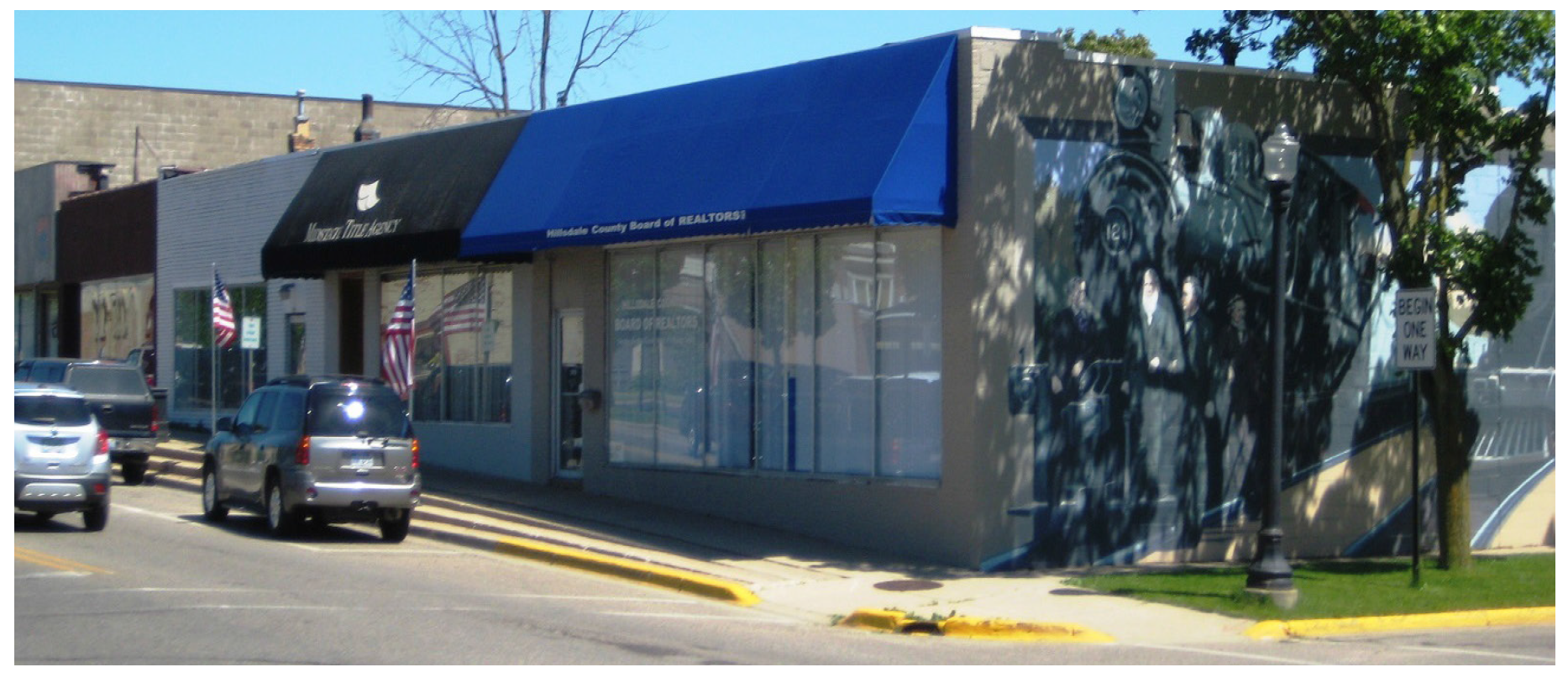
Purpose. The downtown edge category provides a mix of commercial, office, and residential uses, integrated into the existing built form. It serves as a transition between the intensely developed Downtown Core and the residential neighborhoods.
Distinguishing characteristics. Retail and workplace activities mixed with detached and attached housing types such as townhomes and mansion apartments; limited off-street parking.
General character. Midsize detached buildings which may have more than one unit and/or more than one use; balance between landscape and buildings; presence of pedestrian amenities such as sidewalks and pedestrian scale lighting.
(Ord. No. 2017-003, 11-6-2017; Ord. No. 2021-03, 12-6-2021)
Sec. 36-276. - Regulated uses.
Regulated uses are identified for each category either as a permitted use (P) or another relevant designation. If a use is blank with no designation or not listed, the use is not permitted in that zone. All uses requiring a CUP must address the standards in this code. If the CUP invokes additional standards, the special provision column references that specific section of the zoning ordinance.
(Ord. No. 2017-003, 11-6-2017; Ord. No. 2021-03, 12-6-2021)
Sec. 36-277.01. - Facade components and materials.
(a)
Customer entrances. Each side of a building facing a public street shall include at least one customer entrance, except that no building shall be required to provide entrances on more than two sides of the structure that face public streets.
Buildings shall have clearly defined, highly visible customer entrances that include no less than three of the following design features:
(b)
Windows and transparency. A minimum of 75 percent of the ground floor story front facade between one foot and eight feet above the sidewalk shall be comprised of transparent, non-reflective windows into the nonresidential space.
A minimum of 30 percent of the upper story facade measured floor-to-floor shall have transparent, non-reflective, vertically oriented windows.
(c)
Facade ornamentation. All visible elevations shall include decorative features such as cornices, pilasters, and friezes.
(d)
Facade massing. Front facades 60 feet wide or wider shall incorporate wall offsets of at least two feet in depth (projections or recesses) a minimum of every 40 feet. Each required offset shall have a minimum width of 20 feet.
Any section along the build-to line which is not defined by a building must be defined by a three feet six inches masonry screen wall which is set back five feet from the build-to line. In the case of an existing parking lot, the screening wall can be located adjacent to the sidewalk. The area between the build-to line and the setback should be landscaped as possible.
(e)
Roofs. Flat roofs shall have three-dimensional cornice treatments.
All roof-based mechanical equipment, as well as vents, pipes, antennas, satellite dishes, and other roof penetrations (with the exception of chimneys), shall be located on the rear elevations or screened with a parapet wall having a three-dimensional cornice treatment so as to minimize the visual impact.
(f)
Building materials. Durable and traditional building materials shall be used, with an explicit preference for brick construction. Fluted concrete masonry units and scored concrete masonry unit block, although not considered traditional building materials, may be used but shall not exceed 25 percent of the surface square footage of any portion of the building exposed to a public right-of-way, or customer access or parking area.
Materials such as exterior insulation finish system (EIFS), concrete panels, and panel brick are not considered durable and traditional building materials, and shall not be used.
(Ord. No. 2017-003, 11-6-2017; Ord. No. 2021-03, 12-6-2021)
Sec. 36-277.02. - Private facades.
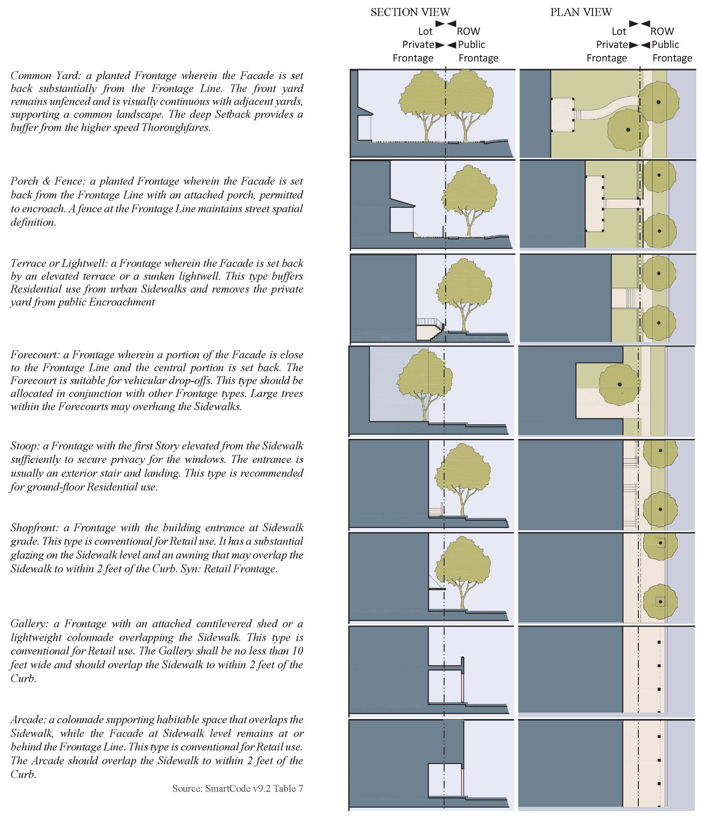
(Ord. No. 2017-003, 11-6-2017; Ord. No. 2021-03, 12-6-2021)
Sec. 36-278.01. - Canopies and awnings.
Canopies and awnings may be required and may encroach over the build-to line.
(Ord. No. 2017-003, 11-6-2017; Ord. No. 2021-03, 12-6-2021)
Sec. 36-278.02. - Sidewalk amenities.
In the downtown core district, privately owned and provided sidewalk amenities such as benches, tables, chairs, signs, and plants are permitted to add convenience, charm, and character to the district, pursuant to section 36-279 outlining standards for permitting and approval, and for appeals.
(Ord. No. 2017-003, 11-6-2017; Ord. No. 2021-03, 12-6-2021)
Sec. 36-278.03. - Landscaping.
Landscaping shall be provided pursuant to section 36-150.
(Ord. No. 2017-003, 11-6-2017; Ord. No. 2021-03, 12-6-2021)
Sec. 36-278.04. - Lighting.
Streetlights shall be of a general type specified by the city.
Wall pack lighting shall be used only on the rear or side of the building to illuminate exits and loading facilities.
Parking lot lighting pole height, including luminaire, shall not exceed the height of the building or 20 feet, whichever is less, and shall be confined within the parking area.
Lighting shall be shielded from residential districts and driver visibility on thoroughfares.
(Ord. No. 2017-003, 11-6-2017; Ord. No. 2021-03, 12-6-2021)
Sec. 36-278.05. - Commercial dumpsters.
Commercial dumpsters shall be sited in accordance with section 36-151, commercial dumpsters.
(Ord. No. 2017-003, 11-6-2017; Ord. No. 2021-03, 12-6-2021)
Sec. 36-278.06. - Signs.
Signage shall be provided pursuant to chapter 26 of the Hillsdale Municipal Code.
(Ord. No. 2017-003, 11-6-2017; Ord. No. 2021-03, 12-6-2021)
Sec. 36-278.11. - Parking location.
Parking shall conform to article VIII, Off-Street Parking and Loading, except where indicated.
Parking is not permitted between the right-of- way and the building facade. For parking which is adjacent to the building, the Front Setback is measured from the front of the building, traveling toward the rear of the lot.
Where a parking lot abuts an interior and/or common property line, the property owner shall provide a cross access easement for the purpose of connecting adjacent parking lots.
Parking lot landscaping shall be installed pursuant to section 36-150(c). Bioretention/rain gardens pursuant to section 36-152 may also be considered.
Loading space shall be provided in the rear yard in the ratio of at least ten square feet per front foot of building and shall be computed separately from the off-street parking requirements. Where an alley exists or is provided at the rear of buildings, the rear building setback and loading requirements may be computed from the center of the alley.
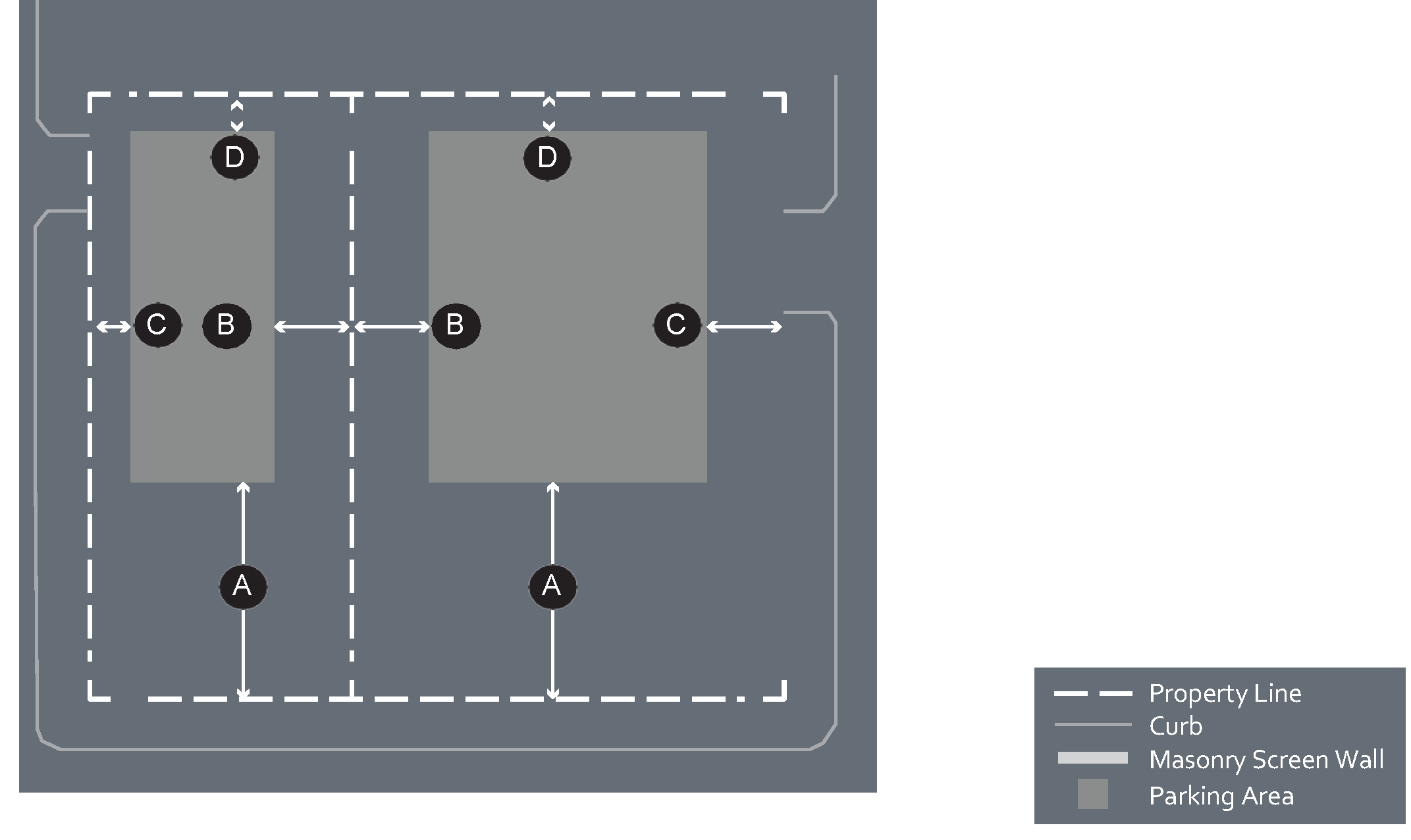
Sec. 36-278.12. - Required parking.
Uses specified in this section supersede section 36-600.
;adv=6;(Ord. No. 2017-003, 11-6-2017; Ord. No. 2021-03, 12-6-2021)
Sec. 36-278.13. - Shared parking.
Parking calculations: When two functions share parking facilities, the sum of their individual parking requirements is divided by the Shared Parking Factor to determine the Effective Parking Requirement. For example, if 12 spaces are needed for a residential development and 32 spaces are needed for a retail development, this amount would be summed to equal 44. This number would be divided by 1.2, according to the chart below, to produce an effective parking requirement of 36.6, or 37 parking spaces. This section supersedes section 36-595.
(Ord. No. 2017-003, 11-6-2017; Ord. No. 2021-03, 12-6-2021)
Sec. 36-278.21. - Thoroughfare types.
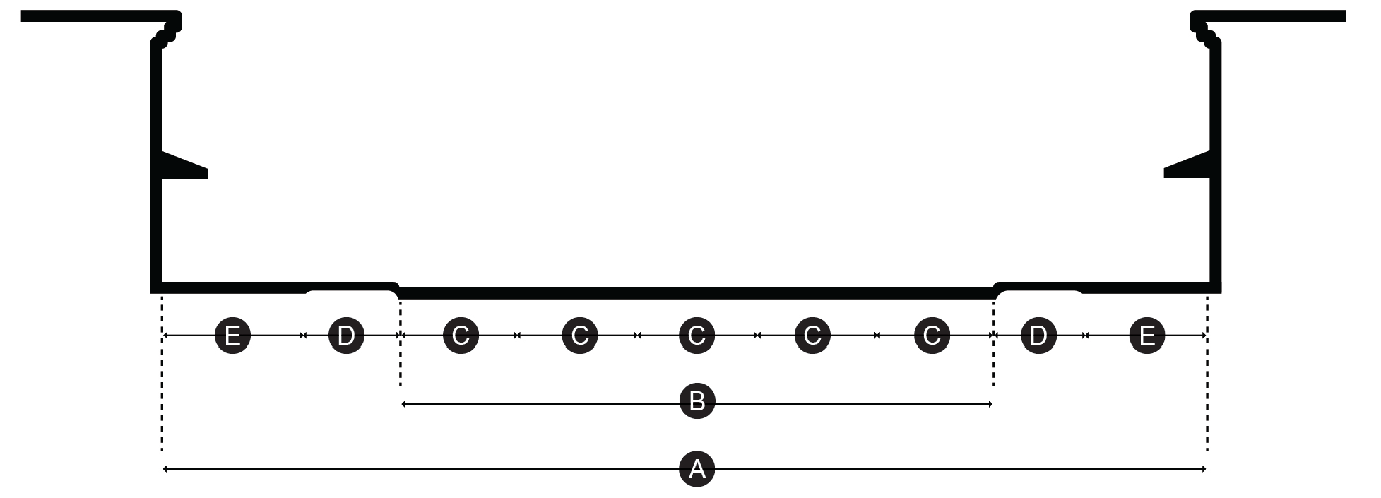
Street Terminology
Right-of-way (ROW) width: A
The measurement across a thoroughfare of the area under control or ownership of the Michigan Department of Transportation, Hillsdale County Road Commission, or private property owner.
Curb face to curb face width: B
The distance across a thoroughfare between the vertical faces of the curb, typically intended for vehicles, including any on-street parking, planting strips, and gutters.
Traffic and parking lanes: C
The number and width of areas designated for vehicular travel, not including bicycle lanes.
Planting zone: D
The area of the ROW used for street trees and flowers as well as low impact development stormwater features, such as rain gardens. In some instances, this zone can be used for outdoor dining, depending on surface materials.
Pedestrian Zone: E
The area used for pedestrian movement, dedicated to sidewalks and outdoor cafes.
Thoroughfare type: Main Street.
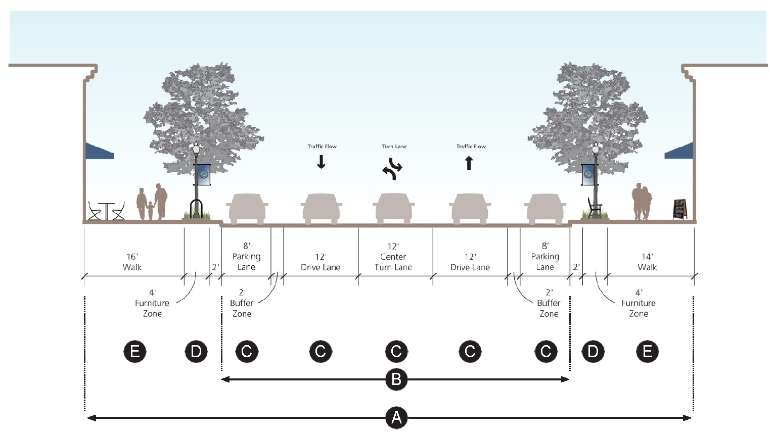
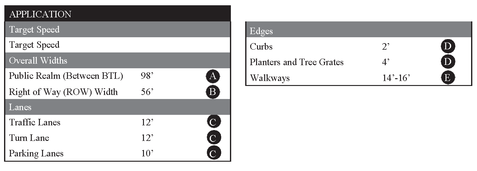
Thoroughfare type: Urban Center.
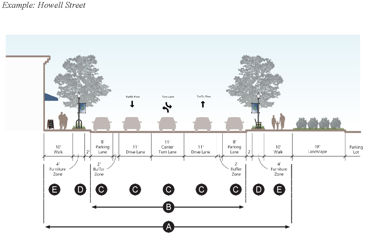
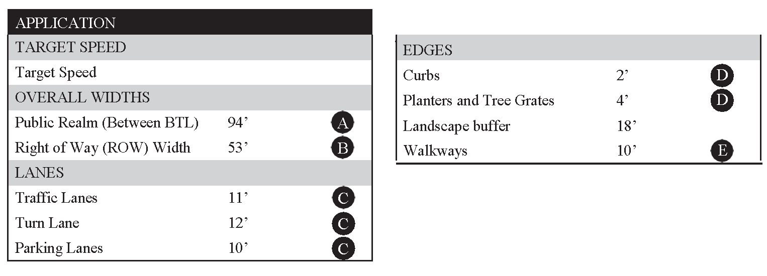
Thoroughfare type: Urban Residential.
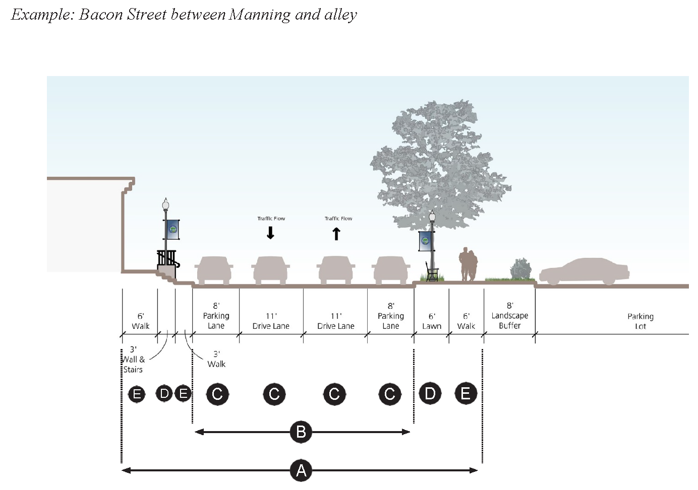
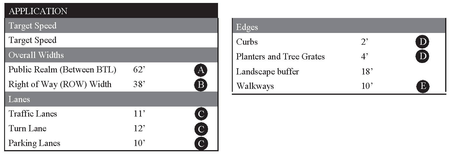
(Ord. No. 2017-003, 11-6-2017; Ord. No. 2021-03, 12-6-2021)
Sec. 36-278.22. - Civic spaces.
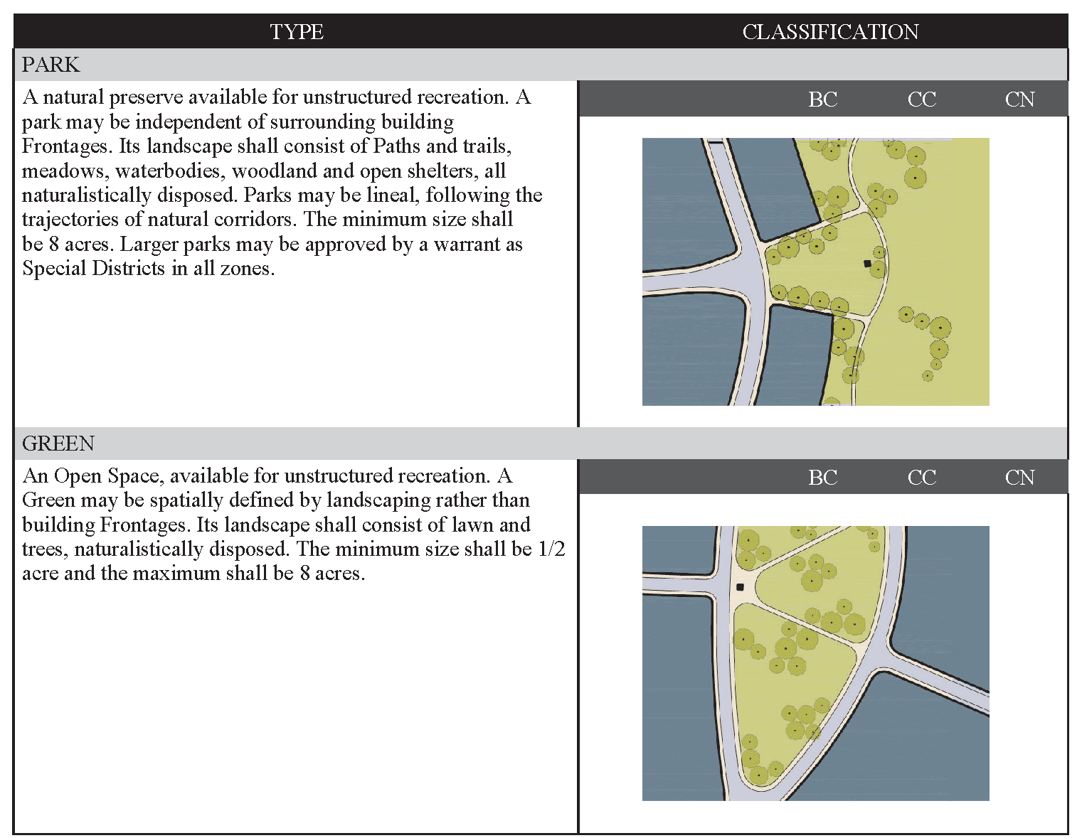
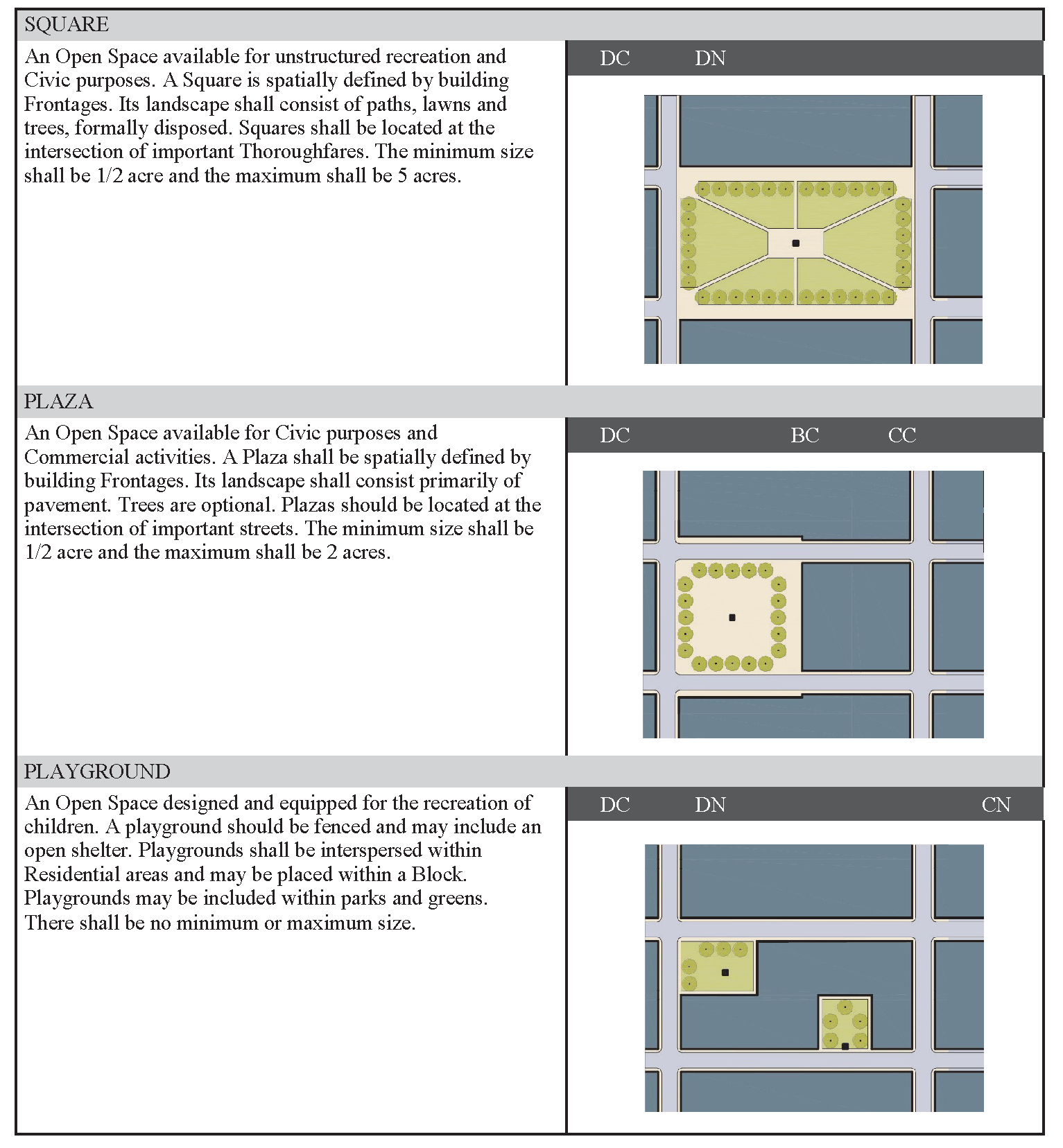
(Ord. No. 2017-003, 11-6-2017; Ord. No. 2021-03, 12-6-2021)
Sec. 36-279.01. - Application process.
(a)
An application for a permit pursuant to this article must be submitted to the zoning administrator for approval and contain the following information:
(1)
The name, address, and contact information of both the applicant and the business.
(2)
The name, address and contact information of the property owner if other than the applicant.
(3)
A site plan showing the proposed location of outdoor sale items, the proposed location and number of benches, tables, chairs, desks, signs, plants, artworks, waste receptacles or other similar amenities, and the location and number of all related equipment, such as, by way of example, outdoor electrical outlets, umbrellas, and railings.
(4)
The proposed area of occupancy including square feet and dimensions, and the location of existing grates, hydrants, trees, shrubs, and other public items.
(5)
The proposed clear path to accommodate pedestrian traffic and circulation through and within the use area by customers and members of the general public.
(6)
If the sale of alcohol is proposed, a copy of approval from the Michigan State Liquor Control Commission.
(7)
A signed agreement committing and requiring the applicant:
a.
To provide proof of public liability and property damage insurance with coverage that is satisfactory to the City of Hillsdale and with limits of liability of not less than a single limit of $300,000.00, with the city designated therein as a named insured, to be and remain in force for the duration of the permitted use of the city's sidewalk and right-of-way, such proof to be provided at the time of execution of the agreement.
b.
To agree that it will defend, indemnify, and hold the City of Hillsdale harmless from all damages, claims, demands, causes of action, lawsuits, attorney fees and related expenses, as a result of actual or claimed personal injury, including death, property damage or other damage or loss of any kind or nature which is or is claimed to arise out of or because of the use of the city's sidewalk or right-of-way by the negligence, gross negligence, or intentional act of applicant or any of its agents, servants, employees, guests, vendors, invitees, contractors, and members of the public, and whether caused in part by negligence of the city, its employees, agents, servants, or representatives.
c.
To agree to repair any damage caused to the sidewalk or right-of-way as a result of the placement of any permitted item or the operation of a permitted business or other activity on a sidewalk or within any other part of the right-of-way at the applicant's expense.
d.
To represent and covenant that it does not discriminate against any employee or applicant for employment, and shall not discriminate against any member of the general public that will participate in the event it is staging under this agreement, or any other member of the public because of race, color, religion, national origin, age, height, weight, marital status or other legally protected class.
(b)
The zoning administrator shall review the application for compliance with the ordinance for approval/disapproval. If determined to be in compliance, the zoning administrator or his designee shall approve the issuance of the permit; if determined to be in substantial but not complete compliance, approve the issuance of the permit subject to restrictions; or if determined to be substantially non-compliant, disapprove and deny the issuance of the permit, as the circumstance requires.
(c)
Permits must be applied for annually and all activities or other actions taken under them shall adhere to all specifications of the City of Hillsdale CBD Sidewalk Use Ordinance and the terms and restrictions contained within the permit. Failure to do so will result in the Zoning Administrator notifying the permit holder of a violation, either in writing or verbally. If the violation is designated as a safety hazard, it shall be corrected and rectified within the 24-hour period next following notification. All violations that are not designated as safety violations shall be corrected and rectified within the 72-hour period next following notification. If any violation is not corrected and rectified within the time specified, the permit in question shall automatically become void and of no further force or effect, and all items placed on the sidewalk and all business or other activities taken pursuant to it shall be immediately removed and terminated.
(Ord. No. 2017-003, 11-6-2017; Ord. No. 2021-03, 12-6-2021)
Sec. 36-279.02. - Appeals.
Appeals involving the interpretation or application of these rules, the imposition of restrictions, and the denial of a permit, may be taken to the zoning board of appeals under such provisions and process as prescribed in section 36-84 of the Hillsdale Municipal Code.
(Ord. No. 2017-003, 11-6-2017; Ord. No. 2021-03, 12-6-2021)
Sec. 36-291.- Generally.
The B-3 general business district is designed to furnish areas served typically by the central business district with a variety of automotive services and retail activities incompatible with the uses and with the pedestrian movement in such central business district. The B-3 general business districts are characterized by more diversified business types and are often located so as to serve passerby traffic.
(Code 1979, § 17.18.010; Ord. No. 2015-5, 3-16-2015)
Sec. 36-292. - Principal uses permitted.
In a B-3 general business district, no building or land shall be used and no building shall be erected except for one or more of the following specified uses, unless otherwise provided in this chapter:
(1)
Any retail business or service establishment permitted in a B-2 central business district as a principal use permitted.
(2)
New automobile sales or showroom.
(3)
Bus passenger stations.
(4)
Funeral homes (mortuaries).
(5)
Automobile car wash, when completely enclosed in a building.
(6)
Private clubs or lodge halls.
(7)
Governmental offices or other governmental uses, public utility offices, exchanges, transformer stations, pump stations and service yards, but not including outdoor storage.
(8)
Clinics.
(9)
Retail cold storage establishments.
(10)
Self-service laundry and dry cleaning establishments.
(11)
Bowling alleys.
(12)
Pool or billiard parlor or club.
(13)
Greenhouses, nurseries and garden centers.
(14)
Other uses which are similar to the above uses.
(15)
Accessory structures customarily incidental to the above permitted uses.
(Code 1979, § 17.18.020)
Sec. 36-293. - Uses subject to special conditions.
The following uses shall be permitted in the B-3 general business district after review and approval of the site plan by the planning commission or zoning administrator, whichever is indicated, subject to the conditions herein imposed for each use:
(1)
Outdoor sales space for the exclusive sale of secondhand automobiles or house trailers, subject to the following:
a.
All lighting shall be shielded from adjacent residential districts.
b.
Ingress and egress to the outdoor sales area shall be at least 60 feet from the intersection of any two streets measured from the street right-of-way.
c.
A four-foot-six-inch obscuring wall or fence must be provided when abutting or adjacent districts are zoned for residential use.
d.
No major repair or major refinishing shall be done on the lot.
(2)
Outdoor sales space for the exclusive sale of non-consignment items, excluding livestock, subject to the following:
a.
Size requirements. The outdoor sales or display area shall not exceed ten percent of the gross floor area of the principal building.
b.
Location requirements. All sales activity and the display of merchandise shall be limited to the area specified on an approved plan. No sales activity or display shall be permitted in the street right-of-way or any required setback area.
c.
Surface. Sales and display areas shall be provided with a permanent, paved surface of asphalt, concrete or similar paving materials and shall be graded and drained so as to dispose of all surface water.
d.
Plan. The submission and approval of a site plan to the planning commission.
(3)
Motel, subject to the following:
a.
Provided that it can be demonstrated that ingress and egress do not conflict with adjacent business uses.
b.
A four-foot-six-inch obscuring wall or fence must be provided where abutting or adjacent districts are zoned for residential use.
c.
No kitchen or cooking facilities are to be provided, with the exception of units for the use of the manager or caretaker.
d.
Each unit shall contain not less than 250 square feet of floor area.
(4)
Business in the character of a drive-in or open-front store, subject to the following:
a.
A setback of at least 60 feet from the right-of-way line of any existing or proposed street must be maintained.
b.
Ingress and egress points shall be located at least 60 feet from the intersection of any two streets.
c.
All lighting shall be shielded from adjacent residential districts.
d.
A four-foot-six-inch obscuring wall or fence must be provided where abutting or adjacent to a residential district. The height of the wall shall be measured from the surface of the ground.
(5)
Commercially used outdoor recreational space for children's amusement parks or miniature golf courses, subject to the following:
a.
Children's amusement park must be fenced on all sides with a four-foot wall or fence.
b.
Adequate parking shall be provided off the road right-of-way and shall be fenced with a four-foot-six-inch wall or fence where adjacent to the use.
(6)
Automobile service and/or repair stations for sale of gasoline, oil and minor accessories only, and subject to the following:
a.
The curb cuts for ingress and egress to a service station shall not be permitted at such locations that will tend to create traffic hazards in the streets immediately adjacent thereto. Entrances shall be no less than 25 feet from a street intersection, measured from the road right-of-way, or from adjacent residential districts.
b.
The minimum lot area shall be 10,000 square feet, and so arranged that ample space is available for motor vehicles which are required to wait.
c.
There shall be provided, on those sides abutting or adjacent to a residential district, a four-foot-six-inch obscuring wall. The height of the walls shall be measured from the surface of the ground.
d.
All lighting shall be shielded from adjacent residential districts.
e.
Major engine and body repair, steam cleaning and undercoating when conducted on the site shall be within a completely enclosed building. The storage of wrecked automobiles on the site shall be obscured from public view. No automobile or vehicle of any kind shall be stored in the open for a period exceeding one week.
f.
All restroom doors shall be shielded from adjacent streets and residential districts.
(7)
Lumber yards subject to the following:
a.
The use is primarily for the storage and sale of retail goods.
b.
No manufacturing, processing, planing, or milling operations are permitted.
(8)
Family day care home, as defined in section 36-6, the in-home care of one to six or fewer minor children subject to the following conditions:
a.
No dormitory facilities shall be provided or permitted.
b.
A designated outdoor play area shall be required which complies with state licensing rules. The outdoor play area must be located in the rear yard, as defined in section 36-6, and be enclosed by a fence of at least four and one-half feet in height.
c.
Signs, as defined in section 26-2, shall be allowed in accordance with the regulations applicable to zone district in which the property is located.
d.
No family day care home may commence operations until and unless the zoning administrator first approves of occupancy, which approval shall be subject to the applicant providing him or her proof of compliance with all of the following:
1.
Registration of said operation with the city as a family day care home;
2.
Licensure by the state for the operation of a family day care home;
3.
Submission to and compliance with other requirements and restrictions established in this division and other applicable inspections required under the property maintenance code adopted by the city;
4.
Compliance with all other requirements and restrictions established in this division and other applicable provisions of this chapter.
(9)
Group day care home, as defined in section 36-6, the in-home care of seven to 12 minor children subject to the following conditions and restrictions:
a.
No dormitory facilities shall be provided or permitted.
b.
A designated outdoor play area shall be required which complies with state licensing rules. The outdoor play area must be located in the rear yard, as defined in section 36-6, and be enclosed by a fence at least four and one-half feet in height.
c.
Signs, as defined in section 26-2, shall be allowed in accordance with the regulations applicable to the zone district in which the property is located.
d.
No group day care home may commence operations until and unless the zoning administrator first approves of occupancy, which approval shall be subject to the applicant providing him or her proof of compliance with all of the following:
1.
Registration of said operation with the city as a group day care home;
2.
Licensure by the state for the operation of a group day care home;
3.
Submission to and compliance with other requirements and restrictions established in this division and other applicable inspections required under the property maintenance code adopted by the city;
4.
Compliance with all other requirements and restrictions established in this division and other applicable provisions of this chapter.
(10)
Child care facility, as defined in section 36-6, for the care of one or more minor children in other than a private home, subject to the following conditions and restrictions:
a.
All conditions and restrictions as are applicable to a group day care home pursuant to subsection (8) of this section.
b.
A designated outdoor play area shall be required which complies with state licensing rules. The outdoor play area must be located in the rear yard, as defined in section 36-6, and be enclosed by a fence at least four and one-half feet in height.
c.
Signs, as defined in section 26-2, shall be allowed in accordance with the regulations applicable to zone district in which the property is located.
(11)
Adult bookstores, adult motion picture theaters, cabarets, and massage parlors (adult entertainment establishment as defined in section 8-222), subject to the following:
a.
No adult entertainment establishment may be established, operated, or maintained within the B-3 general business zoning district except on a parcel or lot having a lot line boundary that is directly contiguous to an I-1 light industrial zoning district;
b.
No adult entertainment establishment may be established, operated, or maintained within 500 feet of an R-1, R-2, R-3, RD-1, or RM-1 residential zoning district;
c.
No adult entertainment establishment may be established, operated, or maintained within 500 feet of a church, state-licensed daycare, public library, public park (including publicly owned paths and trails), preschool, elementary, middle or high school, or other educational facility;
d.
No adult entertainment establishment may be established, operated or maintained within 500 feet of any other adult entertainment establishment;
e.
Compliance or noncompliance with the 500-foot minimum distance established in subsection (10)b of this section shall be determined by a measurement that consists of the shortest straight line possible between a point on the line of the parcel or lot on which the adult entertainment establishment is proposed and a point on the district boundary line of the nearest adjacent R-1, R-2, R-3, RD-1, or RM-1 residential zoning district;
f.
Compliance or noncompliance with the 500-foot minimum distance established in subsections (10)c and (10)d of this section shall be determined by a measurement that consists of the shortest straight line possible between a point on the line of the parcel or lot on which the adult entertainment establishment is proposed and a point on the nearest parcel or lot on which a church, state-licensed daycare, public library, public park (including publicly owned paths and trails), preschool, elementary, middle school or high school, other educational facility, or other adult entertainment establishment is located;
g.
The license granted for the establishment, operation, and/or maintenance of an adult entertainment establishment under this subsection (10) may be revoked or suspended in the event any owner or licensee of said establishment or any other operator, employee, agent, or patron of said establishment engages or participates in or suffers the promotion, offer or solicitation of acts of prostitution or other lewd or lascivious conduct on the premises. The acts necessary to support such revocation or suspension may be shown to have occurred by a preponderance of the evidence. No criminal charge need be brought or conviction obtained based on, resulting or arising from any such conduct as a prerequisite to such revocation or suspension;
(12)
Any combination of one or more one-family and multiple-tenant family units, subject to the following requirements:
a.
All dwelling units shall meet the defined requirements of section 36-6, apartments.
b.
A minimum of one parking space shall be provided for each dwelling unit. Parking shall be provided on site, or within a 600-foot radius of the building it is intended to serve, measured from the nearest point of the building with the nearest point of the off-street parking lot.
c.
Dwelling units and accessory buildings related to residential uses shall not be permitted on the ground floor.
d.
Compliance with the requirements applicable to multiple-family residential districts in sections 36-211, 36-212, and 36-411 of Hillsdale's Code of Ordinances.
(Code 1979, § 17.18.030; Ord. No. 2008-12, 12-8-2008; Ord. No. 2015-5, 3-16-2015)
Sec. 36-294. - Area and bulk requirements.
See division 16 of this article limiting the height and bulk of buildings and minimum size of lot by permitted land use in the B-3 general business district.
(Code 1979, § 17.18.040; Ord. No. 2015-5, 3-16-2015)
Sec. 36-311.- Generally.
The I-1 industrial district is designed so as to primarily accommodate wholesale and warehouse activities, and industrial operations whose external physical effects are restricted to the area of the district and in no manner affect in a detrimental way any of the surrounding districts. The I-1 district is so structured as to permit, along with any specified uses, the manufacturing, compounding, processing, packaging, assembly and/or treatment of raw, finished or semi-finished products from previously prepared material.
(Ord. No. 2018-007, 11-5-2018)
Sec. 36-312. - Principal uses permitted.
In an I-1 industrial district, no land or building shall be used and no building shall be erected except for one or more of the following uses as described in section 36-311, unless otherwise provided in this chapter:
(1)
All uses shall be conducted wholly within a completely enclosed building, or within a designated area enclosed on all sides except the front with a six-foot obscuring fence or solid wall. The fence or wall shall be completely obscuring on those sides where abutting or adjacent to districts zoned for residential use.
(2)
All public utilities, including buildings, necessary structures, storage yards and other related uses.
(Ord. No. 2018-007, 11-5-2018)
Sec. 36-313. - Uses subject to special conditions.
The following uses shall be permitted in an I-1 industrial district, after review and approval of the site plan by the planning commission or zoning administrator, whichever is indicated, subject to the conditions imposed in this section for each use:
(1)
Restaurants, other places serving food or beverage, or other businesses which in the opinion of the planning commission are intended to serve the convenience needs of persons working in the industrial district subject to the regulations applicable to such uses.
(2)
Child care facility, as defined in section 36-6, for the care of one or more minor children in other than a private home. A designated outdoor play area shall be required which complies with state licensing rules. The outdoor play area must be located in the rear yard, as defined in section 36-6, and be enclosed by a fence at least four feet in height.
(3)
An educational facility which is a trade or vocational.
(4)
The use of a lot for the sale or lease of new or used automobiles, trailers, boats, farm machinery or equipment, recreational vehicles, lawn furniture, playground equipment or garden supplies, which meets all of the following conditions:
a.
Each point of vehicular ingress and egress to the lot shall be not less than 60 feet from the intersection of any two streets.
b.
Any repair or refinishing which is done on the lot shall be done within the confines of an enclosed structure.
(5)
A motor vehicle repair station.
(6)
A walk-in clinic for district related medical testing and the treatment of minor injuries shall be permitted in the I-1 industrial district. Each point of ingress or egress shall be directly onto a principal or minor street.
(7)
A structure which is used by a governmental entity.
(Ord. No. 2018-007, 11-5-2018)
Sec. 36-314. - Required conditions.
Any use established in the I-1 district after the effective date of the ordinance codified in this chapter shall be operated so as to comply with the performance standards set forth in article VII of this chapter.
(Ord. No. 2018-007, 11-5-2018)
Sec. 36-315. - Area and bulk requirements.
See division 16 of this article limiting the height and bulk of buildings and the minimum size of lot by permitted land use in the I-1 industrial district.
(Ord. No. 2018-007, 11-5-2018)
Sec. 36-331.- Generally.
The I-2 heavy industrial district is designed primarily for manufacturing, assembling and fabrication activities, including large scale or specialized industrial operations, whose external physical effects will be felt to some degree by surrounding districts. The I-2 district is so structured as to permit the manufacturing, processing, and compounding of semifinished or finished products from raw materials.
(Code 1979, § 17.22.010)
Sec. 36-332. - Principal uses permitted.
In an I-2 heavy industrial district, no land or building shall be used and no building shall be erected except for one or more of the following specified uses, unless otherwise provided in this chapter:
(1)
Any principal use first permitted in an I-1 district.
(2)
Heating and electric power generating plants, and all necessary uses.
(3)
Any production, processing, cleaning, servicing, testing, repair or storage of materials, goods, or products which shall conform with the performance standards set forth in article VII of this chapter, except such uses as specifically excluded from the city by ordinance.
(4)
Junkyards, provided such are entirely enclosed within a building or within an eight-foot obscuring wall, and provided further, that one property line abuts a railroad right-of-way. There shall be no burning on the site and all industrial processes involving the use of equipment for cutting, compressing, or packaging shall be conducted within a completely enclosed building.
(5)
Incineration of garage or refuse when conducted within an approved and enclosed incinerator plant.
(6)
Any of the following production or manufacturing uses, not including storage of finished products; provided that they are located not less than 500 feet distant from any residential district and not less than 200 feet distant from any other district:
a.
Blast furnace, steel furnace, blooming or rolling mill;
b.
Manufacture of corrosive acid or alkali, cement, lime, gypsum, or plaster of Paris;
c.
Petroleum or other inflammable liquids, production, refining, or storage;
d.
Smelting of copper, iron, or zinc ore;
e.
Slaughterhouses when conducted within a completely enclosed building.
(7)
Any other use which shall be determined by the board of appeals, after recommendation from the planning commission, to be the same general character as the above permitted uses in this section. The board of appeals may impose any required setback and/or performance standards so as to ensure public health, safety, and general welfare.
(8)
Accessory buildings and uses customarily incidental to any of the above permitted uses.
(Code 1979, § 17.22.020)
Sec. 36-333. - Area, bulk and yard setback requirements.
See division 16 of this article limiting the height and bulk of buildings, the minimum size of lot by permitted land use in the I-2 heavy industrial district.
(Code 1979, § 17.22.030)
Sec. 36-351.- Generally.
The P-1 vehicular parking district is intended to permit the establishment of areas to be used solely for off-street parking of private passenger vehicles as a use incidental to a principal use. The P-1 vehicular parking district will generally be provided by petition or request to serve a use district which has developed without adequate off-street parking facilities.
(Code 1979, § 17.24.010)
Sec. 36-352. - Uses permitted.
Premises in the P-1 vehicular parking district shall be used only for an off-street vehicular parking area and shall be developed and maintained subject to such regulations as are provided in this division.
(Code 1979, § 17.24.020)
Sec. 36-353. - Limitation of use.
Uses in the P-1 vehicular parking district shall be limited as follows:
(1)
The parking area shall be accessory to, and for use in connection with, one or more business or industrial establishments, or in connection with one or more existing professional or institutional office buildings or institutions.
(2)
The parking area shall be used solely for parking of private passenger vehicles, for a period of not more than one day.
(3)
No signs of any kind, other than signs designating entrances, exits and conditions of use, shall be maintained on such parking areas.
(4)
No building other than those for shelter of attendants shall be erected upon premises, and they shall not exceed 15 feet in height.
(5)
No commercial repair work or service of any kind, or sale, or display thereof shall be conducted in such parking area.
(6)
Such parking lots shall be contiguous to an O-1, B-1, B-2, B-3, I-1, or I-2 district. Parking areas may be approved when adjacent to the districts, or on the end of a block where such areas front on a street which is perpendicular to that street servicing the district. There may be a private driveway or public street or public alley between such P-1 district and such O-1, B-1, B-2, B-3, I-1, or I-2 districts.
(7)
Applications for P-1 district rezoning shall be made to the city clerk by submitting a layout of the area requested showing the intended parking plan.
(Code 1979, § 17.24.030)
Sec. 36-354. - Yards.
(a)
Where the P-1 district is contiguous to a residentially zoned district which has a common frontage on the same block with residential structures, or wherein no residential structures have yet been erected, there shall be a setback equal to the required residential setback for the residential district, or a minimum of 25 feet, or whichever is the greater. The required wall in the P-1 vehicular parking district shall be located on this minimum setback line.
(b)
Where the P-1 district is contiguous to side lot lines of premises within a residentially zoned district, the required wall shall be located at least five feet from the side lot line opposite the residential unit or vacant residential lot.
(Code 1979, § 17.24.040)
Sec. 36-355. - Development and maintenance.
P-1 off-street parking districts shall be developed and maintained in accordance with article VIII, division 3, of this chapter.
(Code 1979, § 17.24.050)
Sec. 36-371.- Purpose.
The PRF park and recreational facilities district and regulations are intended to provide an appropriate zoning classification for specified governmental, civic and recreational facilities where a separate zoning district is deemed appropriate. This division is also intended to protect public and quasi-public facilities from encroachment of certain other uses, and to ensure compatibility with adjoining residential uses. One or more of the facilities are also permitted in one or more of the other zoning districts within the city. Governmental agencies that are exempt from municipal zoning by state or federal statute are encouraged to comply with the standards set forth in this division to the greatest extent possible.
(Code 1979, § 17.25.010)
Sec. 36-372. - Definitions.
The following words, terms and phrases, when used in this division, shall have the meanings ascribed to them in this section, except where the context clearly indicates a different meaning:
Park means and includes public parks and open spaces; public gardens; public playgrounds; public swimming pools; public beaches; public lake accesses; and may also include private parks, gardens, playgrounds or other similar uses.
Public means and refers to a building, structure, service or use that is owned, operated, leased by or otherwise exclusively controlled by a governmental or educational entity or agency which is open to use by the general public on a nonprofit basis, either with or without a fee.
Recreational means and includes public ball fields; public skating rinks; public pedestrian and nonmotorized bicycle trails and paths; public nonprofit golf courses without residential dwellings; driving ranges or restaurant; banquet or food service; and other similar public recreational areas and uses, but excluding:
(1)
Courses, trails, paths or tracks for use by motorized off-road or other wheeled, motorized vehicles;
(2)
Nonmotorized bicycle race courses, race trails, race paths or race tracks; and
(3)
Firearm and archery ranges.
(Code 1979, § 17.25.020)
Sec. 36-373. - Principal permitted uses.
In the PRF park and recreational facilities district, no building or land shall be erected, altered, moved, or maintained or used except for park or recreational uses as defined in this chapter, and/or for:
(1)
Essential public services as defined in section 36-6, or uses as defined in section 36-372.
(2)
Buildings, structures and accessory uses customarily incidental to any principal permitted use.
(Code 1979, § 17.25.030)
Sec. 36-374. - Site plans and impact assessments; principal permitted uses.
In the PRF park and recreational facilities district a site plan demonstrating compliance with all applicable provisions of this chapter shall be submitted and be subject to the approval of the planning commission as a prerequisite to the establishment of each proposed principal permitted use. An impact assessment may also be required by the planning commission as a prerequisite to the establishment of a proposed principal permitted use as it deems necessary.
(Code 1979, § 17.25.040)
Sec. 36-375. - Uses subject to special conditions.
The following uses shall be permitted in the PRF park and recreational facilities district subject to compliance with all applicable provisions of this chapter and such other special conditions as are required by the planning commission:
(1)
Public fountains, or public sculptures and other public art forms.
(2)
Public farmer and/or craft shows or markets.
(3)
Public stadiums, public amphitheaters, public band shells or stages.
(4)
Public campgrounds, public canoe liveries or public docks.
(5)
Public golf courses with associated residential dwellings, driving ranges, restaurant/banquet or food service.
(6)
Public miniature golf courses.
(7)
Public facilities for snow skiing, tobogganing and/or sledding.
(8)
Buildings, structures, concessions and other accessory uses that are customarily incidental to any of the above-described uses.
(9)
Nature centers, or educational facilities for the study of outdoor sciences.
(Code 1979, § 17.25.050)
Sec. 36-376. - Site plans and impact assessments; uses subject to special conditions.
A site plan demonstrating compliance with all applicable provisions of this chapter shall be submitted and be subject to the approval of the planning commission as a prerequisite to the establishment of each proposed use subject to special conditions in the PRF park and recreational facilities district. In addition:
(1)
An impact assessment may also be required by the planning commission as a prerequisite to the establishment of a use subject to special conditions as the planning commission deems necessary.
(2)
The planning commission may require compliance with such additional special conditions as are determined necessary to protect the health, safety and welfare of the general public and to ensure compatibility of the proposed special use with adjoining zoning districts.
(Code 1979, § 17.25.060)
Sec. 36-377. - Area and bulk requirements.
See division 16 of this article limiting the height and bulk of buildings and the minimum size of lot by permitted land use in the PRF park and recreational facilities district.
(Code 1979, § 17.25.070)
Sec. 36-378. - Parking areas.
All off-street parking areas in the PRF park and recreational facilities district shall comply with the provisions of division 11 of this article and section 36-148. Requirements for off-street parking shall be determined by section 36-600.
(Code 1979, § 17.25.080)
Sec. 36-379. - Lighting.
Flood lighting or other lighting of playfields, buildings, scoreboards and parking areas in the PRF park and recreational facilities district shall be located and designed to shield the light source from adjoining residences; and general lighting shall be extinguished from the hours of 11:00 p.m. to 7:00 a.m. Special events may be granted a longer lighting period as allowed by the planning commission.
(Code 1979, § 17.25.090)
Sec. 36-380. - Signs.
Signs in the PRF park and recreational facilities district shall comply with the provisions of section 26-33 as a nonresidential use. Interior illumination of signs in the PRF park and recreational facilities district may be allowed upon review of planning commission.
(Code 1979, § 17.25.100)
Sec. 36-386.- Generally.
(1)
Relationship to comprehensive land use plan. This district permits and controls the redevelopment of sites and existing buildings, in a manner that satisfies the goals, objectives, land use plan, and comprehensive development plan contained within the comprehensive land use plan.
(2)
Need for flexibility. This district may be used when another district would not provide sufficient flexibility to ensure that desirable and compatible development would occur. This district may also be used in circumstances where compatibility and context issues cannot be resolved by the use of a more traditional zoning district. These flexible development standards are necessary to address special conditions with regard to land use, setbacks, yards, building height and special traffic, policing, or landscaping issues.
(3)
Mixed-use encouraged. The PRD encourages mixed-uses that would otherwise not be allowed in combination by this zoning ordinance. Mixed-land uses may occur in the same building (e.g., retail on ground floor, office space above) or in different buildings sited on the same lot or parcel (e.g., freestanding child day care center located on the same parcel as an office building). Active uses such as retail, restaurants, cultural and public spaces are encouraged on the ground floor. In certain circumstances, less intensely developed areas that are characterized by single uses rather than a mix of uses may also be developed using the PRD classification.
(4)
Relationship to Zoning Act. The planned redevelopment district (PRD) is designed to accomplish the objectives of the division through a land development project review process based on the application of site planning criteria to achieve integration of the proposed land development project with the characteristics of the area in which it is proposed, as authorized in Section l25.584b [sic], planned unit development.
(Ord. No. 2005-7, § 17.23.010, 7-18-2005)
Sec. 36-387. - Eligibility criteria.
To be eligible for PRD approval, the applicant must demonstrate that each of the following criteria will be met:
(1)
Unified control of property. The proposed development shall be under single ownership or control, excepting leasehold or tenancy interests under a rental agreement, such that there is a single entity having responsibility for completing the project in conformity with the PRD regulations.
(2)
Minimum size. The PRD site shall be a minimum of two acres. The planning commission may approve submission of an application for a PRD on fewer acres provided that the proposal substantially achieves the general purposes of the PRD, as noted in section 36-386, and otherwise meets the eligibility criteria of this section.
(3)
Comprehensive land use plan. The property proposed for the PRD shall be located in an area designated as "mixed-use" by the future land use plan of the comprehensive land use plan.
(4)
Approval. The planning commission may approve submission of an application for a PRD outside of the areas noted in subsection (3) above, provided that the application meets the following criteria:
(a)
The proposed project is generally consistent with the general purpose of the PRD; and
(b)
The proposed project use is generally consistent with the goals, objectives, land use plan, and comprehensive development plan for the area in which the use is proposed.
(Ord. No. 2005-7, § 17.23.020, 7-18-2005)
Sec. 36-388. - Uses permitted.
Permitted uses are as follows:
(1)
Any principal use permitted in the B-2 central business district, section 36-272.
(2)
Any principal use permitted in the RM-1, multiple-family residential district, section 36-212. Area and bulk requirements contained in section 36-214 and division 16 regarding height and bulk of buildings, minimum lot size permitted by land use and maximum density permitted shall apply, unless otherwise provided for in this chapter.
(3)
The following conditional uses in accordance with the requirements of article V of this chapter:
(a)
Off-street parking, surface or structured;
(b)
Auditorium, concert hall, and theater;
(c)
Library;
(d)
Nightclub, except adult cabaret;
(e)
Bowling alley, skating rink, pool and billiard hall;
(f)
Transit centers, train and bus stations;
(g)
Museum;
(h)
Sports and entertainment arena;
(i)
Medical center, including hospital, rehabilitation center, and clinic, with administrative offices;
(j)
Research institution;
(k)
Drive-in and drive-through uses;
(1)
Automobile rental establishment;
(m)
Automobile service establishments;
(n)
Automobile showrooms;
(o)
Hotel;
(p)
Light industrial uses, including:
1.
Assembly, production, manufacturing, storage, warehousing or sale of food, textile products, electronics, furniture and fixtures, paper, clay, glass or fabricated metal; and
2.
Printing, publishing and allied industries.
(4)
Uses not listed, subject to the following:
(a)
The planning commission may determine that a use not listed is similar in nature and intensity to a permitted use or permitted with approval use, based upon the following:
1.
The use is generally consistent with the general purpose of the PRD;
2.
The use will not impair the present or potential use of other properties within the same district in the vicinity;
3.
That the use has no greater potential impact on surrounding properties than those listed in the district, in terms of aesthetics, traffic generated, noise, potential nuisances, and other effects related to health, safety and welfare.
4.
That the use is consistent with the goals, objectives, land use plan, and comprehensive development plan for the area in which the use is proposed.
(5)
Notwithstanding the density limitations imposed pursuant to the preceding subsection (2), the city council, after review and recommendation of the planning commission, may determine whether additional residential units are appropriate and, if so, the total number of such additional residential units that may be permitted based on the following standards:
(a)
Unusual costs incurred in the redevelopment of deteriorating areas.
(b)
Unusual costs incurred in the following:
1.
Landscaping—Such as streetscape, open space and plazas, use of existing landscape, pedestrian ways, bicycle paths.
2.
Siting—Such as topography, view, sun orientation, circulation pattern, physical environment, variance in building setbacks, and building groups (clustering).
3.
Design features—Such as street sections, harmonious use of materials, parking areas, broken by landscape features, and varied use of house types.
(Ord. No. 2005-7, § 17.23.030, 7-18-2005)
Sec. 36-389. - Design requirements.
(1)
Intent:
(a)
The following design requirements are intended to deal with the complexities inherent in creating mixed-use projects. The comprehensive land use plan promotes the restructuring of many of the city's existing commercial concentrations and older industrial buildings into compact, walkable, mixed-use centers. The plan advocates incorporating housing, shopping, jobs and services, and providing attractive alternatives to travel by car into mixed-use developments.
(b)
These regulations guide the physical form of the mixed-use project in order to resolve concerns and abate design issues that might occur with the co-location of different uses in the same project. These concerns and design issues may occur within a project or along its boundaries with surrounding neighborhoods or commercial areas.
(c)
In order to achieve the purposes of the comprehensive land use plan, a wide variety of uses are permitted in the planned redevelopment district. The following requirements describe undesirable as well as desirable traits and development measures that will ensure compatibility.
(d)
These design requirements shall be utilized in a final site plan that is in compliance with the conditions contained in division 2 of article II of this chapter, and section 36-148 shall be submitted to the planning commission prior to issuance of any building/zoning permits for proposed redevelopment, and shall not be used as criteria to establish said PRD district. Requirements for rezoning shall be addressed in the application process in accordance with section 36-390.
(2)
Modifications: Upon application and after receiving a recommendation from the planning commission, the city council may modify any of the design requirements of this section after finding that all of the following conditions exist:
(a)
Existing site conditions, including, but not limited to surrounding land uses, topography, soils, and/or other significant natural features physically preclude or prevent compliance with the requirements of this section without a substantial adverse effect on those features. Any such features shall be clearly identified and described in the application for any requested modification.
(b)
The justification of any modification is not due solely to financial considerations, which, upon approval of the requested modification would provide a financial benefit. However, this does not preclude the city council from modifying the requirements where the applicant demonstrates that the project would be rendered financially unsound or that the requirement is unnecessarily burdensome in relation to the benefit gained.
(c)
That no other reasonable design alternatives are available that would comply with the requirements of this section.
(d)
That the request for modification was reviewed by the planning/zoning administrator, city engineer, director of public safety, director of public services, director of public utilities, or any other person or official designated by the city council.
(3)
Building design requirements:
(a)
Building massing and form:
1.
New buildings shall generally respect the existing development patterns for height of buildings within the area they are constructed. No building shall exceed 55 feet in height or four stories, whichever is lower, provided that the city council may approve greater heights when the nature of use requires a higher building.
2.
Height may be restricted to less than 55 feet where the city council finds that a lesser height would be more compatible with existing development patterns and building heights in the vicinity of the PRD district.
3.
Long walls: When building walls for new main buildings are 100 feet or greater in length, design variations must be applied to assure that the building is not monotonous in appearance. Acceptable variations include, but are not limited to the following:
a.
Recess and projections along the building facade. Variations in depth should be a minimum of ten feet;
b.
Architectural details or features;
c.
Enhanced ornamentation around building entryways;
d.
Landscaping;
e.
Streetscape elements;
f.
Variations in building height.
(b)
Architectural lighting:
1.
Exterior building lighting may be used to accentuate building design by highlighting architectural details and features, without resulting in excessive light and glare.
2.
All architectural lighting shall be shown on the final site plan.
(c)
Building surfaces: Innovative materials are encouraged provided they appear similar in quality, texture, finish, and dimension to those used traditionally in the neighborhood.
(d)
Existing buildings:
1.
As physical changes and improvements are made to existing buildings, the heritage, history, and architecture of those structures are worthy of preservation and reused whenever possible. To this end, the planning commission may recommend and the city council may make those modifications deemed necessary to encourage the preservation of these structures. (See subsection (2) of this section.)
2.
Whenever practical, facade renovations shall not destroy or cover original details of a building, unless sufficiently deteriorated to be beyond reasonable repair. The building inspection department shall be required to certify that reasonable repair is not feasible.
(4)
Walkways: Continuous pedestrian walkways shall be provided from the public sidewalk or rights-of-way to the customer entrance of all main buildings. Walkways shall connect with points of pedestrian activity such as, but not limited to, transit stops and street crossings.
(5)
Fences:
(a)
Fences located within 15 feet of the front property line may not exceed four feet in height.
(b)
Barbed or razor wire, and electrified fences are prohibited.
(c)
Fencing located within the front yard must be transparent, as determined under section 36-685. On double frontage lots, both frontages shall be considered front yards.
(6)
Bicycle amenities:
(a)
Bicycle parking for commercial, residential and mixed-uses should be conveniently located. Placement of bike racks shall be located so as to minimize conflicts with pedestrian travel.
(b)
Bicycle parking shall be by bike rack or locker-type parking facilities unless otherwise specified and shall be designed to allow either a bicycle frame or wheels to be locked to a structure attached to the pavement.
(7)
Parking and loading areas:
(a)
All uses located within the PRD zone shall provide off-street parking as required in division 2 of article VIII, except as may be modified by this subsection.
(b)
For all uses, parking requirements shall be 50 percent of that calculated in section 36-600.
(c)
Off-street parking lot design shall comply with division 3 of article VIII of the Hillsdale Municipal Code.
(d)
On-street parking directly fronting the lot and public parking within a 300-foot radius of the property shall count toward fulfilling the parking requirement of that lot.
(e)
Shared parking is encouraged for nonresidential uses. Where formal shared parking arrangements are made, the individual calculation of the required spaces may be reduced by up to 25 percent with planning commission approval.
(f)
New parking shall not be located between the front facade of a building and the street. Parking areas shall be located to the rear and/or side of buildings and on the interior of blocks. Access to rear or side parking areas may be through the frontage.
(g)
New parking structures may abut street intersections provided the ground floor contains floor area devoted to a principal use (other than parking) along its public street frontages in accordance with subsection (i), below.
(h)
For multiple-family uses all off-street parking places shall be to the side or the rear of the building.
(i)
Driveways shall provide a clear vision triangle, per the standards of the city's traffic safety code, at access points.
(j)
Parking structures:
1.
Parking structures shall be designed with floor area devoted to a principal use (other than parking) along its public street frontages, except for those areas necessary for entrances and exits.
2.
The planning commission may recommend and the city council may waive this requirement if it is demonstrated that the requirement is impractical for the location of the parking structure or if providing such uses would be inconsistent with the development character of the area, as expressed in the comprehensive land use plan.
3.
Where parking is provided for the entire structure, the structure shall have an architecturally articulated facade designed to screen the parking area.
(k)
Loading areas shall comply with the applicable provisions of division 4 of article VII of this chapter.
(l)
Parking landscaping shall comply with section 36-148.
(8)
General landscaping and screening requirements shall comply with section 36-148.
(9)
Signs:
(a)
Signs within the redevelopment project shall comply with the requirements of chapter 26, and be subject to review according to use or applicable district
(b)
The planning commission may approve signs that exceed the limitations of chapter 26; provided a sign plan is first submitted and approved for the redevelopment project as a whole, and the planning commission finds that additional signs or sign area is needed to adequately identify individual uses in a mixed-use project.
(10)
Lighting: Except for lighting in a public right-of-way, all exterior lighting must be hooded or shielded.
(11)
Other requirements:
(a)
All setbacks, lot sizes, and other applicable yard and lot requirements will be recommended by the planning commission and set by the city council for each PRD application, as determined by the submitted development plan.
(b)
Compatibility. The planning commission shall recommend and the city council shall consider appropriate transitions in landscaping, use, building height and massing, and density at the perimeter of any planned redevelopment district.
(c)
Lighting and radiation. No project or use shall emit undesirable levels of electromagnetic, microwave, ultrasonic, laser or other radiation.
(d)
Reflective surfaces. The use of highly reflective surfaces, including reflective glass and reflective metal roofs, is prohibited. This prohibition does not apply to solar panels.
(e)
Outside storage. No project or use shall store products outside. Any outside display shall be recommended by the planning commission and specifically approved by the city council as part of the PRD application.
(Ord. No. 2005-7, § 17.23.040, 7-18-2005)
Sec. 36-390. - Application and review procedure.
(1)
The owner or group of landowners may make application for a change of zone to a PRD district. The petitioner proposing to change the zone district to PRD shall show proof of control through deed or other legal or equitable interest.
(2)
If one or more uses are proposed that require approval to be permitted, the application shall include all of the information required under article V of this chapter.
(3)
The development plan required under this section shall show the proposed development of the entire property involved in the application. For phased developments, each phase shall be planned such that if later phases are not implemented, the initial phase(s) shall be consistent with the provisions of this article and shall not detract from the feasibility of developing the remaining portion of the subject PRD area in an appropriate and desirable manner.
(4)
Application for a PRD shall consist of the following minimum requirements:
(a)
A fully completed application form, as supplied by the planning department;
(b)
Payment of a fee, as established from time to time by the city council;
(c)
Proof of ownership or control through deed or other legal or equitable interest excluding leases and rental agreements;
(d)
Any materials deemed necessary by the planning department to demonstrate compliance with the standards of section 36-391;
(e)
Nine copies of a proposed development plan, including one digital copy if available, drawn to a scale sufficient to clearly show the following minimum items. The planning/zoning administrator may waive individual items if he deems them unnecessary:
1.
The location and size of all buildings, structures and the use of each;
2.
Public walkways, pedestrian and bicycle amenities;
3.
Utilities, drainage and easements in sufficient detail to determine the feasibility of infrastructure solutions;
4.
Public streets, private streets, marginal access streets, acceleration and deceleration lanes, and drives;
5.
Elevation drawings sufficient to show the architectural solution of all buildings;
6.
Use plan specifying generic uses desired including parking areas in the project; and
7.
General reference to landscaped and open space areas of the plan.
(5)
Application review. The department of public safety, city engineer, planning/zoning administrator, director of public services, and director of public utilities or their authorized representatives shall review the application. The PRD shall meet all city requirements for:
(a)
Fire and emergency vehicle access and hydrant locations.
(b)
Utility service, storm drainage and street layout.
(c)
Traffic safety and parking lot design.
(d)
Public facilities.
(6)
The planning commission shall conduct a public hearing, in accordance with the requirements of division 4 of article II of this chapter. Following the public hearing, the planning commission shall forward its recommendation to the city council for approval, approval with conditions, or denial regarding the zoning change and the PRD development plan. In making its recommendation, the planning commission shall consider the review standards of section 36-391 and document the reasons for the recommendation in its minutes.
(7)
If one or more conditional uses are proposed, the application for the use(s) shall be reviewed by the planning commission in accordance with the procedures of article V of this chapter. A separate public hearing shall be required, but may be conducted at the same time as the PRD hearing. The permitted with approval use shall not be valid unless the city council approves the PRD development plan and rezoning.
(8)
The city council shall review the recommendation of the planning commission and, approve, approve with conditions, or deny the application, as appropriate. If approved, the development plan shall be considered an integral part of the zone change. The city council shall consider the recommendation of the planning commission and may base their decision on the review standards of section 36-391 and document the reasons for the decision in its minutes.
(9)
Upon approval by the city council, the zoning map shall be changed to reflect the location of the PRD after the effective date of the rezoning.
(Ord. No. 2005-7, § 17.23.050, 7-18-2005)
Sec. 36-391. - Review standards.
In making its recommendation the planning commission shall, and in making its final decision the city council may, consider the following review standards:
(1)
The PRD application is in substantial compliance with the general purpose of the PRD of section 36-386.
(2)
The PRD meets all of the eligibility criteria of section 36-387.
(3)
All uses within the PRD are to be conducted in a manner that does not interfere with the reasonable use and enjoyment of adjacent properties or adjacent rights-of-way.
(4)
The PRD is not injurious to the use and enjoyment of property in the immediate vicinity for the purposes permitted, nor will it substantially diminish or impair property values within the neighborhood, or the character of the natural environment.
(5)
The establishment, maintenance, location and operation of the PRD shall not be detrimental to or endanger the public health, safety or general welfare.
(6)
In addition, the planning commission shall find that the review standards of article V of this chapter for any proposed conditional uses are also satisfied.
(Ord. No. 2005-7, § 17.23.060, 7-18-2005)
Sec. 36-392. - Additional conditions and requirements.
(1)
In acting upon a PRD application, the planning commission may recommend, and they may impose, additional conditions relating both to the physical and operational aspects of the PRD that are reasonably necessary to protect the public interest and will assure:
(a)
Protection of natural resource, the health, safety and welfare and social and economic well-being of those who use the PRD project and owners and occupants of surrounding property.
(b)
Compliance with section 36-386, general purpose of the PRD district, and section 36-391, review standards for PRD developments.
(2)
To insure compliance with the requirements of the PRD and any conditions recommended by the planning commission that are imposed the city council may require that a cash deposit, certified check, irrevocable bank letter of credit, or surety bond acceptable to the city covering the estimated cost of improvements associated with the PRD be submitted prior to the issuance of a building permit for any part of the PRD project. Procedures for submission and use of the submitted instrument shall be in accordance with the requirements of the City and Village Zoning Act, Act 207 of 1921, as amended.
(3)
Time limit for approval.
(a)
Construction of the approved PRD development plan must be initiated and substantially underway within two years from the effective date of the rezoning. This time limit may be extended one year upon written application to the planning commission prior to the expiration of the approval.
(b)
With a multiple-phase PRD, beginning construction of a phase shall preserve the approval even though the total PRD may be a number of years from completion, provided that consecutive phases must be started within two years of completion of the previous phase.
(c)
If construction has not begun within these time limits, the planning commission may commence rezoning proceedings to an appropriate zone classification. The planning director shall make a recommendation to the planning commission as to appropriate classification.
(Ord. No. 2005-7, § 17.23.070, 7-18-2005)
Sec. 36-393. - Amendments to approved PRDs.
(1)
Following the adoption of the PRD development plan and rezoning by the city council, minor changes in the location of uses, buildings, structures, streets, parking areas, or in the extent of structural coverage or open space may be authorized by the planning commission without additional public hearings.
(2)
The planning commission may, at its discretion, elect to hold a public hearing on any deviation from the adopted PRD site plan.
(3)
A minor change shall be considered one or more of the following:
(a)
Change in the building size, up to five percent in total floor area.
(b)
Movement of buildings or other structures by not more than ten feet.
(c)
Replacement of plant material specified in the landscape plan with comparable materials of an equal or greater size.
(d)
Changes in building materials to a comparable or higher quality.
(e)
Changes in floor plans that do not alter the character of the use.
(f)
Changes required by outside agencies such as the county, state, or federal departments.
(4)
Should the planning commission determine that a change is not minor; the applicant shall follow the procedures of section 36-390 and request an amendment to the approved development plan. The rezoning of the PRD shall not be affected.
(Ord. No. 2005-7, § 17.23.080, 7-18-2005)
Sec. 36-395.- Generally.
The PUD planned unit development district is intended to permit and control the development of preplanned areas for compatible use of land. This district may be used to develop land to enhance the environment by providing open space, preserve or provide woodlots, water frontage and active and passive recreation areas by allowing flexibility for private development. This district may also be used in those situations where the use of another district would not provide sufficient control to ensure that a desirable and compatible development would occur. A mixture of housing types and nonresidential service and commercial uses not otherwise allowed in combination by this division and which may require a special treatment with regard to setbacks, yards, height and special traffic, policing, or landscaping may also be allowed. This district shall meet the spirit and intent of the comprehensive land use plan and the zoning ordinance.
(Ord. No. 2005-8, § 17.11.010, 7-18-2005)
Sec. 36-396. - Uses permitted.
Permitted uses in a PUD are as follows:
(1)
Uses allowed in the R-l through RM-l residential zoning districts:
R-1 through R-3: One-family residential districts.
RD-1: One-family and two-family residential district.
RM-1: Multiple-family residential district.
(2)
Uses allowed in the 0-1 office district; B-1, local business district; and B-3, general business district that are specifically approved for a project at the time of final approval.
(3)
A combination of the uses enumerated in subsections (1) and (2) above.
(Ord. No. 2005-8, § 17.11.020, 7-18-2005)
Sec. 36-397. - Standards.
The following standards shall apply:
(1)
The planned unit development provisions of this division shall apply to a tract of land with a minimum area of ten acres. The planning commission may approve a tract of less than ten acres if the proposed land use meets one or more of the following criteria:
(a)
Reflects the purpose of section 36-395;
(b)
Furthers the goals of the comprehensive land use plan;
(c)
Allows flexible development of otherwise undevelopable property when using conventional design solutions;
(d)
Allows land uses deemed essential where adequate land area is not available.
The petitioner proposing to change the zone district to PUD shall show proof of control through deed or other legal or equitable interest other than an option to purchase or a tenancy pursuant to a lease or rental agreement. The development plan required under this provision shall show the proposed development of the entire district.
(2)
The total number of dwelling units allowed in a project shall be determined by multiplying the gross acreage of a project area, less the acreage used by nonresidential uses, by the following densities as established in the Comprehensive Land Use Plan for the City of Hillsdale. The following schedule shall be observed:
Units per Gross Acre
Additional residential units may be permitted if appropriate, according to the following standards:
(a)
Unusual costs incurred in the redevelopment of deteriorating areas.
(b)
Unusual costs incurred in the following:
1.
Landscaping—Such as streetscape, open space and plazas, use of existing landscape, pedestrian ways, bicycle paths.
2.
Siting—Such as topography, view, sun orientation, circulation pattern, physical environment, variation in building setbacks, and building groups (clustering).
3.
Design features—Such as street sections, harmonious use of materials, parking areas broken by landscape features, and varied use of house types. The city council, after recommendation of the planning commission, shall determine, based on the above standards, whether additional residential units are appropriate and the total number of said additional units.
(3)
Total ground area occupied by all buildings and structures may not exceed 35 percent of the total ground area of the PUD. The total ground areas shall be computed in acres and square feet within the boundaries of the PUD, and shall include public and private rights-of-way.
(4)
No building shall exceed 45 feet in height, provided that the planning commission may allow greater heights when the PUD district is adjacent to a zoning district that allows a greater height or when greater open spaces, setbacks, topography or nature of use would warrant. Height may be restricted to less than 45 feet where the planning commission finds that a lesser height would be more compatible with existing development patterns in the vicinity of the PUD district or where a lesser height is recommended by the comprehensive land use plan for the area.
(5)
No building, structure or parking area may be erected closer than 25 feet from any PUD zoning district line, provided that the planning commission may, after a public hearing, determine that a greater setback, not to exceed 150 feet, should be required, or provided that where a setback in excess of 25 feet is recommended by the comprehensive land use plan, the planning commission shall be guided by such recommendation. The planning commission may waive some or all of the 25-foot setback to a ten-foot minimum for a building, structure or parking area if such setback is found not to be of significant benefit to adjacent property, to be inappropriate or otherwise unnecessary, provided that, the planning commission may reduce the setback for fences beyond the ten feet.
(6)
All uses located within the PUD zone shall provide off-street parking as required in division 2 of article VIII of this chapter. If it is established that the proposed uses will not generate this need for parking, the planning commission may approve a lesser amount.
(7)
The stages of a PUD use development shall be so scheduled that, if later stages of the development are not implemented, the initial stage(s) shall be consistent with the provisions of this division and shall not detract from the feasibility of developing the remaining portion of the subject PUD area in an appropriate and desirable manner.
(8)
Any development of a commercial area under these provisions shall be designed in a manner to eliminate strip commercial and encourage freestanding uses as a matter of right. The development shall be architecturally pleasing and shall complement the total plan in a mixed-use development. Such commercial area shall provide physical protection for adjacent uses of a less intense nature.
(9)
The establishment, maintenance, location and operation of the PUD project shall not be detrimental to or endanger the public health, safety or general welfare.
(10)
The PUD project shall not be injurious to the use and enjoyment of property in the immediate vicinity for the purposes permitted, nor substantially diminish or impair property values within the neighborhood, or the value of the natural environment.
(Ord. No. 2005-8, § 17.11.030, 7-18-2005)
Sec. 36-398. - Conditions.
The planning commission, in acting upon a PUD project may impose additional conditions relating both to the physical and operational aspects of a project which are reasonably necessary to protect the public interest and assure:
(1)
Protection of natural resource, the health, safety and welfare and social and economic wellbeing of those who use the PUD project and owners and occupants of surrounding property.
(2)
Compliance with section 36-395, general purposes of the PUD district, and section 36-397, standards for PUD developments.
(3)
Provision of security in the form of cash, letter or credit, or performance bond to assure completion of any improvements required as a condition of approval of the use.
(Ord. No. 2005-8, § 17.11.040, 7-18-2005)
Sec. 36-399. - Procedure of requesting a PUD zone.
(1)
The petitioner as defined in section 36-397, showing proof of control of a parcel of land, situated in an area not developed, or developed land proposed for redevelopment, may make application for a change of zone to a PUD district. Such application, along with the material required by division 4 of article II of this chapter, shall be accompanied by a proposed development plan which shall include the following:
(a)
A topographic map showing existing contour lines at five-foot intervals.
(b)
A plot plan, to scale, which will show the following:
1.
The location and size of all buildings, structures and the use of each;
2.
All nonenclosed areas;
3.
Utilities, drainage and easements in sufficient detail to determine feasibility;
4.
Public streets, private streets, marginal access streets, acceleration and deceleration lanes, drives, parking and loading areas;
5.
All landscape treatment, including walls, fences, greenbelts, monuments, fountains, berms and ground cover; and
6.
Size, location and design of all signs.
(c)
A detailed statement outlining the reasons for using the PUD zone and uses proposed for the land. This statement shall include a schedule of development for the project and a statement regarding procedures to be established to maintain any open areas, private streets and parking areas.
(d)
Typical elevation drawings showing architectural solution of all buildings.
(e)
Where excavation or extreme movement of dirt is involved, final contours shall be shown on subsection (a) above.
Said plan shall have preliminary review by the department of public safety, city engineer, department of public services, planning/zoning administrator, and the director of public utilities or an authorized representative. The review function of each department shall be:
Department of public safety—Access for police, fire and emergency vehicles and location of fire hydrants.
City engineer—Feasibility for utility service, drainage and streets.
Department of public services—Traffic flow and access to existing public roads.
Planning/zoning administrator—Zoning and overall design as the project relates to adjacent properties.
Director of public utilities—Utility easements and/or rights-of-way, access and availability of public utilities.
(2)
Final procedures. When the planning commission has fulfilled the requirements of division 4 of article II of this chapter, it shall forward the zone change to the city council. The city council shall, in accordance with division 4 of article II of this chapter, consider and, if appropriate, adopt a final development plan which shall enumerate the proposed uses and scheduling of development and the detail of the location of structures, streets, parking areas, landscaping and typical elevations of structures. The adoption of the plan and the zone change that it requires shall be considered an amendment to and an integral part of the zoning ordinance.
(Ord. No. 2005-8, § 17.11.050, 7-18-2005)
Sec. 36-400. - Minor deviations.
Minor changes in the location and siting of buildings, structures, streets or parking areas or in the extent of structural coverage or open space after adoption of the PUD district by the city council maybe authorized by the planning commission without additional public hearings if required by engineering or other circumstances not foreseen at the time the final plan was approved. The planning commission may, in its discretion, decide to hold a public hearing on any deviation from the adopted PUD site plan. No change or cumulative change brought about by a series of minor deviations may cause any of the following:
(1)
A change in the use or character of the development;
(2)
An increase of more than five percent in overall coverage of structures, or five percent in overall floor space;
(3)
An increase in density of dwelling units;
(4)
An increase in the problems of traffic circulation and public utilities;
(5)
A reduction of more than five percent in approved open space;
(6)
A reduction of off-street parking and loading space;
(7)
A reduction in required pavement widths; or
(8)
A reduction of more than five percent in structural setbacks from the PUD boundary.
(Ord. No. 2005-8, § 17.11.060, 7-18-2005)
Sec. 36-401. - Construction of a PUD.
Construction of a planned unit development pursuant to sections 36-396 through 36-399 must be started within two years from the effective date of rezoning. This time limit may be extended one year upon application to the planning commission if it is demonstrated that substantial progress in being made in the detailing of plans and securing of financing. With a multiple-phase PUD, beginning construction of a phase shall satisfy the requirement even though the total PUD may be a number of years from completion; provided that consecutive phases must be started within two years of completion of the previous phase. If construction has not begun within these time limits, the planning commission may commence rezoning proceedings to an appropriate zone classification. The planning director shall make a recommendation to the planning commission as to appropriate classification.
(Ord. No. 2005-8, § 17.11.070, 7-18-2005)
Sec. 36-403.- Intent.
The college district is intended to be reserved for those uses associated with the operation of colleges or universities. The buildings are typically large and not necessarily similar to other districts or uses. Grouping of these unique structures and college related uses will provide for a more harmonious, efficient and convenient educational center.
(Ord. No. 2005-13, § 36-424, 11-21-2005)
Sec. 36-404. - Principal permitted uses.
In a college district, no building or land shall be used and no building shall be erected except for one or more of the following specified uses:
(1)
All uses permitted and uses permitted subject to special conditions in a RM-1, multiple-family residential district, and meeting the requirements as set forth in said district with the exception of hospitals which shall be expressly prohibited from this district.
(2)
All college facilities (classroom/laboratory/research facilities, administration facilities, college health centers, sports facilities, including fields and courts, auditoriums, libraries, museums, cafeterias, agricultural facilities, parking lots and garages, maintenance facilities).
(3)
Studios for professional work or teaching of fine arts, interior decorating, photography, music, drama or dancing.
(4)
Accessory uses customarily incidental to any of the above permitted uses and located on campus such as services for employees and other persons normally associated with permitted uses.
(Ord. No. 2005-13, § 36-425, 11-21-2005)
Sec. 36-405. - Uses subject to special conditions.
The following uses shall be permitted after review and approval of the site plan by the planning commission, subject to the conditions imposed in this section for each use:
(1)
Barber shops and beauty salons subject to the following conditions:
(a)
All off street parking areas shall comply with the provisions of section 36-148 and article VIII.
(b)
Lighting shall be located and designed to shield the light source from adjoining residences.
(c)
Signs and other forms of display must comply with section 26-39 of this Code.
(Ord. No. 2005-13, § 36-426, 11-21-2005)
Sec. 36-406. - Parking areas.
All off-street nonresidential parking shall comply with the provisions of section 36-148 and article VIII.
(Ord. No. 2005-13, § 36-427, 11-21-2005)
Sec. 36-407. - Area and bulk requirements.
See section 36-401 limiting the height and bulk of buildings and the minimum size of lot by permitted land use.
(Ord. No. 2005-13, § 36-428, 11-21-2005)
Sec. 36-408. - Lighting.
All lighting shall be designed to shield the light source from any adjoining residences. Flood lighting or other lighting of playfields, and scoreboards shall be extinguished by 12:00 midnight. Special events may be granted a longer lighting period as allowed by the city manager.
(Ord. No. 2005-13, § 36-429, 11-21-2005)
Sec. 36-409. - Signs.
Signs shall comply with the provisions of section 26-33 for residential and prescribed uses, and section 26-39 for college purposes and subject to the provisions of this section. Interior illumination maybe allowed upon review of the planning commission.
(1)
Signs located at sports complex, intramural or recreational sports buildings and athletic fields within the college district may contain a reference to sponsorship by commercial entities of athletic buildings, structures, scoreboards, equipment or events within the copy of a changeable copy sign.
(a)
Signs may also provide information regarding activities and events of nonprofit organizations whether or not such activities will be held at the facility.
(b)
Signs may be print style or contain digital changeable copy.
(Ord. No. 2005-13, § 36-430, 11-21-2005)
Sec. 36-411.- Limitations on height, bulk, density and area by land use.
Notes:
(a)
In those instances where public sewers are not provided, all lot areas per dwelling unit shall equal at least 12,000 square feet. See sections 36-401 and 36-403 regarding exceptions as to lot area and density controls.
(b)
In an RM-1 multiple-family residential district, the total number of rooms as defined in section 36-6, in buildings consisting of more than four dwelling units shall meet the apartment definition in section 36-6.
(c)
Every lot on which a main building consisting of more than four dwelling units is erected shall be provided with a 40-foot setback on each exterior side of such lot. Each setback shall be increased by one foot for each ten feet or part thereof by which the length of the structure exceeds 40 feet in overall dimension along the adjoining lot line.
In all RM-1 multiple-family residential districts, the minimum distance between any two buildings shall not be less than the allowable distance as designated by the State of Michigan Single Construction Code. Parking shall not cover more than 30 percent of the area of any required yard, or any minimum distance between buildings. Properties must follow the landscape requirements as listed in chapter 36, sections 36-148—36-152.
(d)
See definitions under section 36-6. All row houses, terraces and other such multiple-type structures shall comply with the floor area requirements under apartments.
(e)
No side yards are required along the interior side lot lines, except as otherwise specified in the single state construction code. On the exterior side yard which borders on a residential district, there shall be provided a setback of not less than ten feet on the side or residential street. If walls of structures facing such interior side lot lines contain windows or other openings, side yards of not less than ten feet shall be provided.
(f)
Where an alley exists or is provided at the rear of buildings, the rear building setback and loading requirements may be computed from the center of the alley.
(g)
The maximum percentage of coverage shall be determined by the use and the provisions of required off-street parking, loading and unloading, and required yards.
(h)
Parking shall be permitted in the front yard after approval of the parking plan layout and points of access by the planning commission. The setback shall be measured from the nearest side of existing and/or proposed right-of-way lines, whichever is greater.
(i)
The maximum height of a structure in the B-2 district shall not exceed 12 feet above the property immediately adjacent. Any proposed structure over 50 feet tall shall require approval of the city planning commission.
(j)
No building shall be closer than 50 feet to the outer perimeter (property line) of such district when the property line abuts any residential district.
(k)
Side yards abutting upon a street and across from other industrial districts shall be provided with a setback of at least 20 feet.
(l)
Planned developments involving five acres or more under one ownership shall be subject to the approval of the board of appeals, after public hearing, regarding modifications with respect to height regulations. In approving an increase in structure height, the board of appeals shall require that all yards shall at least equal in their depth the height of the structure.
(m)
A minimum four-foot-six-inch obscuring wall or fence shall be provided on those sides of the property abutting land zoned for residential use.
(n)
Parking shall be permitted on the side yard after approval of the parking plan layout and points of access by the planning commission.
(o)
All storage shall be in the rear yard and shall be completely screened with an obscuring wall or fence not less than six feet high, or with a chain-link type fence and a greenbelt planting so as to obscure all view from any adjacent district or public street.
(p)
Commercial parcels resulting from land divisions must have a minimum of 104-foot-zero-inch street frontage. Refer to HMC, Chapter 18 and Land Division Act MCL 560.101 et seq.
(q)
Residential parcels resulting from land divisions must have a minimum of 66-foot-zero-inch street frontage. Refer to HMC, Chapter 18 and Land Division Act MCL 560.101 et seq.
(Code 1979, § 17.28.010; Ord. No. 2005-14, 11-21-2005; Ord. No. 2014-6, 7-21-2014; Ord. No. 2016-005, 6-6-2016; Ord. No. 2018-004, 7-16-2018; Ord. No. 2025-02, 5-5-2025)
Sec. 36-412. - Subdivision open space plan.
The intent of this section is to permit one-family, and one-family and two-family, residential subdivisions to be planned as a comprehensive unit, allowing therefore certain modifications to the standards as outlined in section 36-401 to be made in R-1, one-family and RD-1 one-family and two-family residential districts, when the following conditions are met:
(1)
The lot area in all one-family and two-family residential districts may be reduced by 20 percent; provided, that the population density shall be no greater than if the land area to be subdivided were developed in the minimum square foot lot areas as required under R-1 and RD-1 districts. In accomplishing the 20 percent lot reduction, no lot width in an R-1 and RD-1 residential district shall be reduced by more than five feet. All calculations shall be predicated upon these districts having the following number of dwelling units per acre, including streets:
(2)
For each square foot of land gained under the provisions of subsection (1) of this section within a residential subdivision through the reduction of lot size below the minimum requirements as outlined in section 36-401, equal amounts of land shall be dedicated to the subdivision. These dedications shall be either rights in fee or easement, and retained as open space for park, recreation and related uses. All lands dedicated in fee or easement shall meet the requirements of the city council.
(3)
The area to be dedicated for public park and recreation purposes only shall in no instance be less than four acres, and shall be in a location and shape approved by the planning commission in reviewing the proposed subdivision plat. The land shall be so graded and developed as to have natural drainage.
(4)
In approving the application of subdivision open space plan technique, the planning commission must be cognizant of the following objectives:
a.
To provide a more desirable living environment by preserving the natural character of open fields, stands of trees, brooks, topography and similar natural assets;
b.
To encourage developers to use a more creative approach in the development of residential areas;
c.
To encourage a more efficient, aesthetic and desirable use of open area while recognizing a reduction in development costs, and by allowing the developer to bypass natural obstacles in the site.
(5)
This plan for reduced lot sizes shall only be permitted if it is mutually agreeable to the council and the subdivider or developer.
(6)
Under this open space approach, the developer or subdivider shall dedicate the total park area (see subsection (2) of this section) at the time of filing of the final plat on all or any portion of the plat.
(Code 1979, § 17.28.020; Ord. No. 2016-005, 6-6-2016; Ord. No. 2025-02, 5-5-2025)
Sec. 36-413. - Averaged lot sizes.
The intent of this section is to permit the sub-divider or developer to vary the lot sizes and lot widths so as to at least average the minimum size of lot per unit as required in section 36-401 for each one-family and two-family residential district. If this option is selected the following conditions shall be met:
(1)
In meeting the average minimum lot size the subdivision shall be so designed as not to create lots of widths less than 66 feet.
(2)
The technique of averaging minimum lot size shall be acceptable only in those instances wherein the entire preliminary plat, which has received the approval of the city, is carried through to a final plat and is then recorded in its totality. Recording of portions of a preliminary plat shall not be acceptable under this option.
(3)
All computations showing lot area and the average area resulting through this technique shall be indicated on the print of the preliminary plat.
(4)
The combining of features of section 36-401 and this section may be carried out. The planning commission shall determine in their review of the preliminary plat that the full intent of section 36-401 and this section has been met.
(Code 1979, § 17.28.030; Ord. No. 2016-005, 6-6-2016; Ord. No 2018-05, 7-16-2018)
Sec. 36-414. - Permitted and special conditional uses.
The following uses are permitted (P), or subject to special conditions (S) within the zoning districts. Conditional uses require approval by the planning commission to the procedures of sections 36-61 through 36-65:
Permitted and Conditional Uses
(Ord. No. 2015-005, 6-6-2016)
Sec. 36-415.- Purpose.
The purpose of the technology overlay district (TOD) is to promote development of research and technology-related businesses, limited light manufacturing and assembly and other businesses and uses that are compatible with and supportive of technology-related businesses in TOD zones within the city. The TOD is further intended to allow, through the special use process, limited commercial and retail uses.
(Ord. No. 2012-8, 11-5-2012)
Sec. 36-416. - Standards and special requirements.
Uses of buildings and other structures and land located within the TOD are subject to the regulations contained within the underlying zoning classification, as well as the additional requirements imposed by the TOD. In cases where the provisions of the TOD conflict with the regulations of the underlying zoning classification, the provisions of the TOD shall be controlling.
(Ord. No. 2012-8, 11-5-2012)
Sec. 36-417. - TOD definition and location.
A TOD is defined as an area within the City of Hillsdale, described and established by ordinance, that overlays but does not change any area that it covers, in which principal and special uses are allowed that promote and support development of research and technology-related businesses, limited light manufacturing and assembly and other businesses and uses that are compatible with and supportive of technology-related businesses in TOD zones, subject to compliance with the application, site plan review procedures, restrictions and other applicable provisions of this division.
(Ord. No. 2012-8, 11-5-2012)
Sec. 36-418. - Principal permitted uses.
The following are permitted uses in the TOD, subject to compliance with the application, site plan review procedures, restrictions and other applicable provisions of this ordinance.
(1)
Technology centers.
(2)
Data storage centers.
(3)
Government technology centers.
(4)
Office research complexes.
(5)
Data processing programming and software.
(6)
Broadcasting and production studios.
(7)
Life sciences and medical labs.
(8)
Research and design, engineering.
(9)
Computer design and development.
(10)
Information processing centers.
(11)
Light manufacturing/light assembly.
(12)
Municipal/essential services.
(13)
Parks and recreational facilities.
(14)
Vocational and training centers.
(Ord. No. 2012-8, 11-5-2012)
Sec. 36-419. - Special uses.
In addition to the principal permitted uses, the following special uses are allowed, subject to compliance with the application, site plan procedures, restrictions and other applicable provisions of this article:
(1)
Retail uses that are related to or supportive of the developer's operation or staff that are housed within the same structure as the developer, which retail uses occupy and use ten percent or less of the facility.
(2)
Offices that directly support existing/proposed technology based development that is located within the same facility.
(3)
Services that directly support existing/proposed technology based development that is located within the same facility.
(4)
Children's day care services.
Sec. 36-420. - Prohibited uses.
The following uses are prohibited in the TOD:
(1)
Uses that emit smoke, soot, or noxious fumes or odors, excepting smoke or odors that are typically associated with cafeterias and food service establishments.
(2)
Uses that create or cause vibrations on or beyond the property lines that endanger the health, welfare, or safety of the public or constitute a public nuisance.
(3)
Outside storage of material, supplies or products unless located within an approved storage area that is constructed and landscaped so as to be shielded and not observable from any other lot or public street right-of-way.
(4)
Retail and service establishments unless otherwise specifically allowed as special uses.
(5)
Uses that produce or create heat or glare from operations unless the operation is conducted entirely within an enclosed, roofed building and the heat and glare produced or created are not discernible at or beyond the property line; provided that exterior lighting for walks, parking lots and other security related purposes shall be exempt from this provision.
(Ord. No. 2012-8, 11-5-2012)
Sec. 36-421. - Required conditions.
(1)
Truck service areas and overhead truck loading/unloading doors shall be totally screened from view from any public right-of-way, including freeway right-of-way, and adjacent properties, except for required driveway access. Such screening shall, be accomplished by the courtyard design of the principal building itself, by a solid ornamental wall of a design, construction and materials similar to that of the principal building, or by an earth berm and plantings, or combination thereof.
(2)
Screening, ornamental walls, berm and plantings shall conform to design standards/guidelines as separately approved by the planning commission; provided, however that the planning commission may waive said requirements, in whole or in part, where truck parking/loading and unloading areas are abutting a railroad, light or heavy industrial district or another TOD or where the adjacent freeway right-of-way or adjacent property or buildings are of a higher elevation than the subject property, and, as a result, the total enclosure from view of such truck loading, unloading and parking areas would result in peculiar or exceptional practical difficulties to or exceptional undue hardship upon the owner of the subject property. The waiver granted shall not be any greater than necessary to relieve the practical difficulty or undue hardship.
(3)
Minimum front, side and rear yard setbacks for buildings, maximum building heights, and parking for all uses permitted under this district shall be as provided and required in section 36-411.
(4)
Off-street parking and loading/unloading space shall be as provided and required in article VIII, chapter 36 of this division. Required parking shall be computed based upon amount of floor area utilized for various purposes, provided that a floor plan indicating such uses, and usable floor space, as defined, is graphically and statistically shown on site plan.
(5)
Landscaping throughout the site shall be provided as required in section 36-148 of this chapter.
(6)
Uses permitted or allowed shall not be located on property sharing a common boundary with property zoned for R-1, R-2, R-3, RD-1 or RM-1 district use unless at least one of the following conditions is satisfied:
a.
The respective properties are separated by a public right-of-way;
b.
A landscaped berm of not less than six nor more than ten feet in height satisfying the standards of section 36-148 is constructed and maintained on the TOD property between the use and the adjacent residentially zoned property;
c.
The abutting or adjacent residentially zoned property is recommended in the master plan for uses other than residential; or
d.
The abutting residentially zoned property is being used for industrial, commercial or office type use.
(Ord. No. 2012-8, 11-5-2012)
Sec. 36-422. - Development standards.
(1)
Signage shall be limited to a single identification sign or kiosk (identification sign) in the front yard that lists only the names of the occupant/tenants of the development. The dimensions of an identification sign shall not exceed four feet in height or six feet in length and may be raised from the ground by a post system no more than two feet for an overall height that does not exceed six feet. The center of the identification sign shall be at optimum viewing height to a person seated in an automobile and shall be located at least twenty feet from the front lot line. Identification sign materials, lettering, etc., shall be consistent and compatible with the architecture of the development. Changeable copy signs are not permitted.
(2)
Informational signs (informational signs) that do not exceed two feet in height or two feet in length are allowed to provide directional information for, by way of example, office entrances, employee parking, vehicle entry/exit directions, visitor parking and delivery. Informational signs may be raised from the ground by a post system to an optimum viewing height for a person seated in an automobile. Informational sign materials, lettering, etc., shall be consistent and compatible with the architecture of the development. Changeable copy signs are not permitted.
(3)
Parking and driveway areas shall be paved.
(4)
Buildings shall be designed to reflect the intent of this zone district. Plans for all proposed buildings shall be initially submitted to the planning commission in accordance with provisions of section 36-423 for its review. All proposed structures shall comply with design standards/guidelines as set forth by the planning commission.
(5)
All storage of materials and/or wastes shall be within approved buildings and/or enclosed by a sight-obscuring fence or wall as approved by the planning commission. Such storage building(s), fence(s) or wall(s) shall be architecturally compatible with the primary building(s) on the property, and be in compliance with the design standards/guidelines of the park.
(6)
Imaginative designs, landscaping and visual treatments are encouraged. If, in the opinion of the commission, the developer's design meets such criteria, a ten percent lot coverage bonus will be awarded.
(7)
All approved submissions will be considered and included as part of the permit application and issuance.
(Ord. No. 2012-8, 11-5-2012)
Sec. 36-423. - Application, contents and permit issuance or denial.
Applications for development within the TOD shall be accompanied by a boundary survey, architectural drawings, elevations, landscape plan, a site plan, site engineering, and if application is by the property owner's agent, written designation of the agent's name, address, and authority.
(1)
The property owner or his agent ("the applicant") shall meet with the zoning administrator to explain the development proposed, discuss procedures and obtain an application form.
(2)
The applicant shall file the completed application form, together with the required exhibits and the filing fee, with the zoning administrator.
(3)
The zoning administrator shall transmit the application to the planning commission for review, determination, and recommendation to the zoning administration for approval, denial or conditioned approval or conditioned denial of the application.
(4)
The planning commission shall review and determine whether the proposed development complies with the intent and all applicable requirements of the TOD and its provisions, including without limitation those pertaining to the appearance and arrangement of buildings, off-street parking, lighting, landscaping, ingress and egress, drainage, signs and other improvements within the five business days next following completion of its review and determination, the planning commission shall provide the zoning administrator with its findings, determination and recommendations for approval, denial or conditioned approval or conditioned denial of the application for a permit.
(5)
Within five business days following receipt of the planning commission's decision, the zoning administrator shall issue a permit, issue a conditioned permit, or deny issuance of a permit to the applicant in accordance with the planning commission's findings, determination and recommendation.
(Ord. No. 2012-8, 11-5-2012)