
Hitchcock City Zoning Code
ARTICLE IV
ZONING DISTRICTS
Sec. 156.61.- Establishment of zoning districts and boundaries.
For the purpose of regulating and restricting the use of land and the erection, construction, reconstruction, altering, moving, or use of buildings and structures, the corporate area of the City of Hitchcock is divided into zoning districts, as follows:
Sec. 156.62. - Official zoning district map.
The location and boundaries of the various zoning districts are shown on the official zoning district map. The Zoning Official is responsible for custody of the map and will promptly make any changes approved by the City Commission. The provisions of an ordinance establishing a district, amending a district classification, or amending a district boundary controls over any conflicting information shown on the official zoning district map. The official zoning district map, together with all notations, references and other information shown thereon and all amendments thereto, shall be as much a part of this Chapter as if fully set forth and described herein. The official zoning district map, properly attested, is on file in the office of the Zoning Official and is fully accessible to the public during normal business hours.
Sec. 156.63. - Interpretation of district boundaries.
Where uncertainty exists with respect to the boundaries of any of the districts shown on the official zoning district map, the following rules apply:
1.
Where district boundaries are so indicated that they approximately follow the center lines of streets or highways, the street center lines or highway rights-of-way lines are construed to be the boundaries;
2.
Where district boundaries are so indicated that they approximately follow lot lines, the lot lines are construed to be the boundaries;
3.
Where district boundaries are so indicated that they are approximately parallel to street center lines or street right-of-way lines, such district boundaries shall be construed as being parallel thereto and at such distance therefrom as indicated on the zoning map. If no distance is given, such dimension shall be determined by the use of the scale on said zoning map or by the ordinance establishing the district boundaries;
4.
On unsubdivided land or when a district boundary follows no identifiable feature, the location of district boundaries shall be determined by the ordinance establishing the district boundaries or by using the map scale appearing on the official map, unless the district line is indicated by dimensions printed on the official map, in which case the printed dimensions shall control;
5.
Where streets or alleys on the ground differ from streets or alleys shown on the zoning map, the streets or alleys on the ground control; and
6.
The Zoning Official shall interpret the district boundaries in cases of conflict or question.
Sec. 156.64. - Compliance with district regulations.
No building or structure shall be erected, constructed, enlarged, reconstructed or altered for use nor shall any building, structure or land be used or changed in such a way that it does not comply with all the district regulations established by this Chapter for the district in which the building or structure or land is located.
Sec. 156.65. - New and unlisted uses.
If the Zoning Official determines that a proposed use is not listed, or if there is ambiguity as to its proper classification within the respective zoning districts, the Zoning Official shall make an official determination as to the appropriate district or districts for the use. This decision may be appealed by an applicant to the Board of Adjustment for a final determination as to the appropriate district for the use to be located. In the event the determination requires a text amendment, the proposed use must be sent to the Planning and Zoning Board and City Commission for their consideration and action in accordance with the procedures for amending the text of these zoning regulations.
Sec. 156.66. - Classification of annexed areas.
Within sixty (60) days following the annexation of territory into the corporate limits of the City, the Planning and Zoning Board shall initiate proceedings to establish permanent zoning classifications for all of the area annexed. Pending completion of such proceedings, the annexed territory shall be classified as "AR" Agricultural Residential District. Such temporary zoning classification shall remain in effect only until the City Commission establishes the permanent zoning classification. The procedure for establishing the permanentzoning classification of annexed territory shall be as prescribed by V.T.C.A., Local Government Code ch. 211, and this Chapter. The zoning classification or classifications assigned to newly annexed territory shall be appropriate to its existing use and consistent with the City's Land Use and Development Policies.
Sec. 156.67. - District-use matrix.
Land and structures in each zoning district may only be used for the listed uses specified as a permitted use in that district as shown in Attachment 1 - District-Use Matrix. In interpreting the District-Use Matrix:
1.
A blank rectangle below a zoning district designation indicates that the corresponding listed land use is prohibited in that district.
2.
An "X" in a rectangle below a zoning district designation indicates that the corresponding listed land use is permitted in that district.
Sec. 156.68. - Height and area matrix.
The height of structures, lot areas, dimensions and coverage, and yards and setbacks are regulated for each zoning district. Except as provided in Article 6, the permitted minimum and/or maximum measures are specified in Attachment 2 - Height and Area Matrix.
(Ord. No. 2022-028, § 1, 11-14-22)
Sec. 156.69. - Agricultural Residential "AR" District.
(A)
The zoning of property as "AR" Agricultural Residential is intended to provide for the maintenance of agricultural land in such use or the transition of agricultural or undeveloped land to conventional detached single-family dwellings at a density not exceeding one dwelling unit per acre. Property zoned "AR" should include existing large lots, unplatted tracts of land, areas where adequate public facilities are not available to support higher density urban development, and areas that are appropriate for large lot development given the surrounding land use and zoning. The "AR" district also includes large areas of marsh that are unlikely to be developed for urban uses given the limitations of federal and state environmental regulations.
(B)
Permitted Uses. No building, structure, or land shall be used, and no building or structure shall be erected, constructed, reconstructed, moved or altered except for one (1) or more of the uses identified below, subject to all applicable provisions of these zoning regulations.
1.
Accessory residential uses, as provided in Article 7, Accessory and Temporary Uses.
2.
Agricultural uses and accessory agricultural uses, subject to all provisions of Chapter 90, Animals, of the City's Code of Ordinances.
3.
Churches and other religious organizations, including accessory facilities.
4.
Conventional detached single-family residences.
5.
Home occupations incidental to a residential permitted use.
6.
Parks and recreation facilities, including assembly facilities.
7.
Private recreational facilities owned and operated by or on behalf of a residential subdivision or development.
8.
Specific Uses permitted pursuant to Article 5 hereof.
(C)
Height and Area Regulations. The maximum height of buildings and structures, the minimum dimensions of lots, setbacks for yards and parking lots, and the minimum lot area per dwelling unit shall be as follows, except as otherwise provided in Article 6, Supplemental Regulations:
1.
Minimum lot area: One (1) acre.
2.
Maximum height of structures: Two and one-half (2-1/2) stories, maximum thirty-five (35) feet from finished grade, subject to development and performance standards.
3.
Minimum yards:
a.
Front: Fifty (50) feet.
b.
Side: Twenty-five (25) feet.
c.
Corner: Thirty (30) feet.
d.
Rear: Fifty (50) feet.
4.
Minimum lot width: One hundred twenty five (125) feet.
(D)
Development and performance standards.
1.
No off-street parking area or driveway for permitted nonresidential uses shall be within twenty (20) feet of a lot line of property zoned "AR".
2.
Permitted nonresidential structures located at least twenty-five (25) feet from a residential property line may increase height at a ratio of one (1) foot for each additional two (2) feet of setback.
3.
Uses that are proposed for the benefit of or as an amenity to a rural subdivision and not for use by the general public, such as neighborhood pools and clubhouses, shall be located adjacent to a collector street.
4.
Each dwelling, at the time of issuance of a certificate of occupancy, shall have permanent screening around its perimeter to screen from view any openings in the foundation, e.g. pier and beams. All screening materials shall be of durable quality, shall be compatible in appearance with the dwelling, and shall allow for adequate ventilation and drainage.
(E)
Minimum and habitable square footage. The minimum habitable square footage for property zoned AR shall be not less than 1,000 square feet exclusive of porches, garages or carports.
(Ord. No. 2020-012, 7-20-20)
Sec. 156.70. - Single Family Residential "SFR" District.
(A)
The zoning of property as "SFR" Single Family Residential is intended to provide for conventional detached single-family dwellings. The purpose of the "SFR" district is to provide for development of standard low-density residential developments in areas where adequate public facilities exist and where residential development is appropriate given the surrounding land uses and neighborhood.
(B)
Permitted uses. No building, structure, or land shall be used, and no building or structure shall be erected, constructed, reconstructed, moved or altered except for one (1) or more of the uses identified below, subject to all applicable provisions of these zoning regulations.
1.
Accessory residential uses, as provided in Article 7, Accessory and Temporary Uses.
2.
Agricultural uses or accessory agricultural uses on lots of one (1) acre or more, subject to all provisions of Chapter 90, Animals, of the City's Code of Ordinances.
3.
Conventional detached single-family residences.
4.
Home occupations incidental to a residential permitted use.
5.
Parks and recreation facilities, including assembly facilities.
6.
Private recreational facilities owned and operated by or on behalf of a residential subdivision or development.
7.
Specific Uses permitted pursuant to Article 5 hereof.
(C)
Height and area regulations. The maximum height of buildings and structures, the minimum dimensions of lots, setbacks for yards and parking lots, and the minimum lot area per dwelling unit shall be as follows, except as otherwise provided in Article 6, Supplemental Regulations:
1.
Minimum lot area: Six thousand (6,000) square feet per dwelling unit.
2.
Maximum height of structures: Two and one-half (2-1/2) stories, maximum thirty-five (35) feet from finished grade, subject to development and performance standards.
3.
Minimum yards:
a.
Front: Twenty-five (25) feet.
b.
Side: Six (6) feet.
c.
Corner: Twenty-five (25) feet
d.
Rear: Twenty-five (25) feet.
4.
Minimum lot width: Sixty (60) feet.
Sixty (60) feet corner lot.
5.
Minimum lot depth: One hundred (100) feet.
(D)
Accessory buildings:
1.
Front setback: Attached accessory buildings shall have a front setback that is not less than the principal structure. Detached accessory buildings shall be located to the rear or to the side of the principal structure and in no case shall any part of an accessory building be located within the required front yard setback.
2.
Side setbacks: Except for corner lots, detached accessory buildings shall not be less than six feet from any side lot line when the accessory building is located in the rear yard; otherwise, a detached accessory building shall observe the same side setbacks as specified for the principal structure.
3.
Rear setback: Accessory buildings shall not be less than eight (8) feet from the rear lot line as measured from the rear lot line to the accessory building provided that the required setback may be reduced to five (5) feet when adjacent to an alley.
4.
Easements: Accessory buildings shall not be placed within any easement on the property.
5.
Height: Accessory buildings shall not exceed a maximum height of twenty (20) feet.
6.
Coverage: Accessory buildings shall not occupy more than thirty (30) percent of a required rear yard.
(E)
Development and performance standards.
1.
Where a lot within the "SFR" district abuts railroad rights-of-way, a high pressure oil or gas line, an arterial street or highway, or a nonresidential district or use, the minimum lot depth shall be one hundred fifty (150) feet. The Planning and Zoning Board may require a lot depth not to exceed one hundred seventy-five (175) feet, and in the case of a side yard abutting the above features may require a lot width not to exceed two hundred (200) feet.
2.
Agricultural accessory structures shall be located no closer than fifty (50) feet from any lot line.
3.
No off-street parking area or driveway for permitted nonresidential uses shall be within twenty (20) feet of a lot line of property zoned "SFR".
4.
Permitted nonresidential structures located at least twenty-five (25) feet from a residential property line may increase height at a ratio of one foot for each additional two feet of setback.
5.
Uses that are proposed for the benefit of or as an amenity to a standard low-density subdivision and not for use by the general public, such as neighborhood pools and clubhouses, shall be located adjacent to a collector roadway and within the interior of the subdivision.
6.
Each residential dwelling unit is hereby required to have a garage or some enclosed, lockable area for storage of lawn equipment, bicycles, and other storage items. Such garage or enclosed storage area shall be permanently affixed to the land. The minimum floor space for a storage area which is not designed to enclose or house an automobile shall be eighty (80) square feet.
7.
Skirting is required around all crawl spaces of a structure to prevent access; ventilation must be provided.
(F)
Minimum habitable square footage for the primary dwelling structure. The minimum habitable square footage for property zoned SFR shall be not less than 1,000 square feet exclusive of porches, garages, or carports. See section 156.118 for information regarding accessory dwelling units.
(G)
Accessory equipment requirements. Air conditioning compressors, swimming pool pumps, generators, and similar accessory equipment, or structures shall observe all front and exterior side yard setbacks specified for the zoning district in which the property is located. A minimum interior side building setback of three feet shall be observed, unless otherwise approved by the Building Department in accordance with all city adopted codes.
(Ord. No. 2020-012, 7-20-20; Ord. No. 2022-027, § 1, 11-14-22)
Sec. 156.71. - High Density Residential "HR" District.
(A)
The zoning of property as "HR" High Density Residential is intended for various types of residential development, including conventional single- and two-family residences and multiple-family dwellings such as duplexes, triplexes, town homes, condominiums, and apartments. The purpose of the "HR" district is to provide for residential developments in a higher density setting, while ensuring livability, property values, open space, design quality and landscaping, and the safety and general welfare of its residents. This district allows development up to eighteen (18) units per acre.
(B)
Permitted uses. No building, structure, or land shall be used, and no building or structure shall be erected, constructed, reconstructed, moved or altered except for one (1) or more of the uses identified below, subject to all applicable provisions of these zoning regulations.
1.
Accessory residential uses, as provided in Article 7, Accessory and Temporary Uses.
2.
Churches and other religious organizations, including accessory facilities.
3.
Conventional detached single-family residences.
4.
Multiple-family dwellings such as triplexes, townhouses, condominiums, and apartments.
5.
Parks and recreation facilities, including assembly facilities.
6.
Private recreational facilities owned and operated by or on behalf of a residential subdivision or development.
7.
Two-family dwellings.
8.
Specific Uses permitted pursuant to Article 5 hereof.
(C)
Conventional detached single-family residences. The height, area, and accessory building regulations and standards for development and performance applicable to conventional detached single-family residences shall be as set forth in Section 4-10, Single Family Residential "SFR."
(D)
Height and area regulations. The maximum height of buildings and structures, the minimum dimensions of lots, setbacks for yards and parking lots, and the minimum lot area per dwelling unit for two-family dwellings, condominiums, and multiple-family dwellings shall be as follows, except as otherwise provided in Article 6, Supplemental Regulations:
1.
Minimum lot area: Two thousand four hundred twenty (2,420) square feet per dwelling unit. For two-family dwellings, three thousand six hundred (3,600) square feet per dwelling unit.
2.
Maximum height of structures: Three (3) stories, maximum forty-five (45) feet from finished grade, subject to development and performance standards. For two-family dwellings, two and one-half (2-1/2) stories, maximum thirty-five (35) feet from finished grade.
3.
Minimum yards:
a.
Front: Twenty-five (25) feet.
b.
Side: Ten (10) feet.
c.
Corner: Twenty (20) feet.
d.
Rear: Twenty-five (25) feet.
4.
Lot coverage: Sixty (60) percent of lot area, including principal and accessory buildings.
5.
Minimum separation between principal buildings: Fifteen (15) feet.
(E)
Accessory buildings. Two-family dwellings, condominiums, and multiple-family dwellings.
1.
Front setback: Attached accessory buildings shall have a front setback that is not less than the principal structure. Detached accessory buildings shall be located to the rear or to the side of the principal structure and in no case shall any part of an accessory building be located within the required front yard setback.
2.
Side setbacks: Detached accessory buildings shall observe the same side setbacks as specified for the principal structure.
3.
Rear setback: Accessory buildings shall observe the same rear yard setback as specified for the principal structure.
4.
Easements: Accessory buildings shall not be placed within any easement on the property.
5.
Height: Accessory buildings shall not exceed a maximum height of thirty (30) feet.
6.
Coverage: Accessory buildings shall not occupy more than thirty (30) percent of a required rear yard.
(F)
Development and performance standards.
1.
Where a lot within the "HR" district abuts railroad rights-of-way, a high pressure oil or gas line, an arterial street or highway, or a nonresidential district or use, the minimum lot depth shall be one hundred fifty (150) feet. The Planning and Zoning Commission may require a lot depth not to exceed one hundred seventy-five (175) feet, and in the case of a side yard abutting the above features may require a lot width not to exceed two hundred (200) feet.
2.
Multiple-family dwellings with more than ten (10) units shall have an on-site manager or post and maintain in a conspicuous place in such dwelling a legible sign identifying the owner and managing agent, together with the residence and business addresses and telephone numbers of the owner and managing agent. Where the owner is a corporation, the sign shall contain the business telephone numbers of the corporation.
3.
The minimum living area of apartments shall be six hundred fifty (650) square feet for single-story apartment units plus two hundred fifty (250) square feet for each additional story.
4.
High-density residential developments shall have frontage and main access directly on an arterial or a collector street.
5.
High-density residential developments shall have a minimum of ten (10) percent of the net site area as common area such as a playground, tennis court, swimming pool, exercise path, or natural preserve area, for use by all persons who reside on the premises.
6.
Uses that are proposed for the benefit of or as an amenity to a high-density residential development and not for use by the general public, such as common areas, pools and clubhouses, shall be located within the interior of the development.
7.
Pedestrian circulation systems (sidewalks and walkways) within high-density residential developments shall be located and designed to provide adequate pedestrian access within the development and to adjacent parcels.
8.
No off-street parking area or driveway shall be within twenty (20) feet of a lot line of property zoned "AR" or "SFR".
9.
All multiple-family dwellings shall provide a solid screen fence or wall of wood or masonry construction not less than seven feet in height along all rear and side property lines that are common to property zoned "AR" or "SFR". All side fences must be set back a minimum of 25 feet from the front property line. Screening shall not be required where similar screening exists on the abutting residential property. A barrier fence shall not be allowed along the front of the property.
10.
Each residential dwelling unit is hereby required to have some enclosed, lockable area for storage of bicycles and other storage items. Such enclosed storage area shall be roofed and sided to match the main structure.
11.
Each dwelling, at the time of issuance of a certificate of occupancy, shall have permanent screening around its perimeter to screen from view any openings in its foundation, e.g. pier and beams. All screening materials shall be of durable quality, shall be compatible in appearance with the dwelling, and shall allow for adequate ventilation and drainage.
(Ord. No. 2012-930, § 1, 1-23-12)
Sec. 156.72. - Manufactured Home "MH" District.
(A)
The zoning of property as "MH" Manufactured Home is intended for the development of a Manufactured Home Subdivision or Manufactured Home Community meeting all requirements of this Chapter and the City's Code of Ordinances, and any applicable state law. The purpose of the "MH" district is to allow for a means of affordable housing within a well-managed, compatible and cohesive manufactured home environment.
(B)
Permitted uses. No building, structure, or land shall be used, and no building or structure shall be erected, constructed, reconstructed, moved or altered except for one (1) or more of the uses identified below, subject to all applicable provisions of these zoning regulations.
1.
Home occupations incidental to a residential permitted use.
2.
Manufactured homes.
3.
Parks and recreation facilities, including assembly facilities.
4.
Private recreational facilities owned and operated by or on behalf of a Manufactured Home Subdivision or Manufactured Home Community.
5.
Specific Uses permitted pursuant to Article 5 hereof.
(C)
Height and area regulations. The maximum height of buildings and structures, the minimum dimensions of lots, setbacks for yards and parking lots, and the minimum lot area per dwelling unit for manufactured homes shall be as follows, except as otherwise provided in Article 6, Supplemental Regulations:
1.
Minimum area for a Manufactured Home Subdivision or Manufactured Home Community: Four (4) acres, with not less than four (4) manufactured home lots.
2.
Minimum lot area: Five thousand seven hundred fifty (5,750) square feet per manufactured home unit.
3.
Minimum lot width: Fifty (50) feet.
4.
Minimum lot depth: One hundred fifteen (115) feet.
5.
Maximum height of structures: Two and one-half (2-1/2) stories, maximum thirty-five (35) feet from finished grade.
6.
Spacing: Manufactured homes shall be located not less than twenty (20) feet from any exterior wall to the closest exterior wall of the nearest manufactured home. The distance from a manufactured home to a common area or street shall be not less than twenty-five (25) feet.
7.
Minimum yards:
a.
Front: Fifteen (15) feet.
b.
Side: Ten (10) feet.
c.
Corner: Fifteen (15) feet.
d.
Rear: Ten (10) feet.
(D)
Development and performance standards.
1.
All manufactured homes shall be served with sanitary sewer, water, and electrical power.
2.
A greenbelt/landscape buffer of not less than twenty-five (25) feet in width shall be located along all Manufactured Home Community or Manufactured Home Subdivision boundary lines. Such greenbelt/landscape buffer shall be continuously maintained and shall be devoted exclusively for common open space and landscaping.
3.
All manufactured homes, whether within a Manufactured Home Community or a Manufactured Home Subdivision, shall comply with the tie-down and skirting requirements of § 153.04 of the City's Code of Ordinances.
4.
Each Manufactured Home Community may include one (1) permanent residential structure for the occupancy of the Community's owner or operator as specified in § 153.20 of the City's Code of Ordinances.
5.
Each manufactured home unit within a Manufactured Home Subdivision shall be placed on a proper foundation. Each manufactured home unit within a Manufactured Home Community shall be placed on a hard surfaced pad as required by § 153.61(A)(3) of the City's Code of Ordinances.
6.
Each Manufactured Home Community shall comply with the requirements of § 153.66 of the City's Code of Ordinances regarding provision of a perimeter fence or dense vegetative screening at least six (6) feet in height along all rear and side property lines. Such fence or screening shall not be required where similar fencing or screening exists on the abutting properties. Each Manufactured Home Subdivision shall comply with the same perimeter fencing/screening requirements.
7.
Each Manufactured Home Community shall comply with the requirements of § 153.74 of the City's Code of Ordinances regarding provision of an enclosed storage area for each manufactured home unit.
8.
Each Manufactured Home Community shall comply with the requirements of § 153.75 of the City's Code of Ordinances regarding provision of adequate recreation areas and facilities. Lots for common facilities shall be of such size to meet the minimum setbacks established in this section, and such that no more than fifty (50) percent of the common lot is covered by building area, exclusive of parking.
9.
Each Manufactured Home Subdivision or Manufactured Home Community may have a sign at each of its entrances, bearing its name. The signs shall be of a monument style, shall not exceed five (5) feet in height, and shall not exceed forty (40) square feet in area. Such signs shall not be electrical; provided, however, lighting from the base of the sign shall be allowed. Illumination shall not cause glare or other nuisance on any adjacent property.
Sec. 156.73. - Neighborhood Commercial "NC" District.
(A)
The zoning of property as "NC" Neighborhood Commercial is intended to provide for small-scale, limited-impact retail and office businesses. The uses permitted within the "NC" district are meant to be compatible with nearby residential areas and serve the retail and personal service needs of nearby residents. The nature of the permitted uses and scale of buildings are intended to blend with adjacent and nearby properties without causing adverse impacts.
(B)
Permitted uses. No building, structure, or land shall be used, and no building or structure shall be erected, constructed, reconstructed, moved or altered except for one (1) or more of the uses identified below, subject to all applicable provisions of these zoning regulations.
1.
Antique, camera and book stores.
2.
Bakeries.
3.
Barber and beauty shops.
4.
Coin-operated laundries.
5.
Dry cleaning shops, customer pick-up and delivery only.
6.
Florist shops.
7.
Libraries.
8.
Membership organizations.
9.
Museums and galleries.
10.
Offices, including medical, legal, professional and other similar office uses.
11.
Parks and recreation facilities, including assembly facilities.
12.
Post offices.
13.
Restaurants, not including drive-through or drive-in service or the sale of alcoholic beverages for consumption on the premises.
14.
Shoe repair shops.
15.
Studios - art, teaching, dance, music, drama, photography.
16.
The above uses are not intended to be all-inclusive. Additional commercial and noncommercial uses may be permitted, which are similar, have comparable impact on adjacent property, and correspond with the purpose and restrictions of this district.
17.
Specific Uses permitted pursuant to Article 5 hereof.
(C)
Height and area regulations. The maximum height of buildings and structures, the minimum dimensions of lots, and setbacks for yards and parking lots shall be as follows, except as otherwise provided in Article 6, Supplemental Regulations:
1.
Minimum lot area: Nine thousand (9,000) square feet.
2.
Maximum height of structures: Two (2) stories, maximum thirty-five (35) feet from finished grade.
3.
Minimum yards:
a.
Front: Twenty-five (25) feet.
b.
Side: Ten (10) feet or ten (10) percent of the lot width, whichever is greater.
c.
Corner: Twenty (20) feet.
d.
Rear: Ten (10) feet.
Twenty-five
(25) feet when adjacent to a residential district.
4.
Minimum Lot Width: Seventy-five (75) feet.
Eighty-five
(85) feet corner lot.
5.
Minimum Lot Depth: One hundred (100) feet.
6.
Minimum parking lot setback: Ten (10) feet from street right-of-way.
Ten (10) feet from property lines of any commercial or industrial district.
Fifteen (15) feet from property line when adjacent to a residential district.
(D)
Development and performance standards.
1.
Artificial lighting used to illuminate the premises and/or signage shall be directed away from adjacent residential properties.
2.
No merchandise shall be stored or displayed outside a building, and no equipment or vehicles, other than passenger vehicles, shall be stored outside a building.
3.
A development allowable in this district shall provide a solid screen fence or wall of wood or masonry construction not less than seven feet in height along all rear and side property lines that are common to property zoned "AR, "SFR", "HR" and "MH". All side fences must be set back a minimum of 25 feet from the front property.
(Ord. No. 2012-930, § 2, 1-23-12)
Sec. 156.74. - General Commercial "GC" District.
(A)
The zoning of property as "GC" General Commercial is intended to provide for a variety of commercial uses including wholesale sales and services, general retail and service businesses, and office uses. This district is primarily intended for use in high-traffic areas adjacent to arterial streets and highways and is appropriate for high-volume commercial centers.
(B)
Permitted uses. No building, structure, or land shall be used, and no building or structure shall be erected, constructed, reconstructed, moved or altered except for one (1) or more of the uses identified below, subject to all applicable provisions of these zoning regulations.
1.
All uses permitted in the "NC" district.
2.
Appliance and home furnishing stores.
3.
Automotive sales, new or used, leasing, service and repair shops, including parts supply stores and auto bodywork shops.
4.
Banks, credit unions, and other depository institutions.
5.
Boat and recreational vehicle (RV) storage, sales, leasing and service.
6.
Bowling alleys and other entertainment centers.
7.
Car washes.
8.
Cemeteries, funeral homes, mortuaries, and crematories.
9.
Child day care services.
10.
Churches and other religious organizations, including accessory facilities.
11.
Commercial printing shops.
12.
Commercial and nonprofit parks and recreation facilities, including assembly facilities and sports and recreation clubs.
13.
Computer stores and related services.
14.
Convenience stores (with or without gasoline sales).
15.
Dry cleaning services.
16.
Equipment rental and leasing establishments.
17.
Flea markets.
18.
Food stores, all types.
19.
Gasoline service stations, including mechanical repair.
20.
General merchandise stores, including department and variety stores.
21.
Golf courses, including miniature courses and golf driving ranges.
22.
Hardware stores.
23.
Hospitals, clinics, or sanitariums.
24.
Hotels, motels, rooming and boarding houses, and other lodging places.
25.
Liquor stores.
26.
Lumber and building material dealers-retail.
27.
Office buildings, all types.
28.
Parks and recreation facilities, including assembly facilities.
29.
Pawn shops, in accordance with the Texas Pawnshop Act (Article 5069-51.01, et seq. Vernon's Texas Civil Statutes).
30.
Plumbing shops.
31.
Radio and television broadcasting stations or studios.
32.
Repair shops, miscellaneous.
33.
Restaurants, including drive-through or drive-in service and the sale of alcoholic beverages for consumption on the premises.
34.
Retail nurseries.
35.
Retail stores, not elsewhere classified.
36.
Storage facilities.
37.
Taxidermies.
38.
Theaters.
39.
Upholstery shops, not including furniture manufacturing facilities.
40.
Veterinary clinics and kennels, excluding outdoor runs and provided that no building or kennel shall be closer than fifty (50) feet to any residential district.
41.
Video stores.
42.
Water bottling operations.
43.
Wholesaling and warehousing establishments, limited to uses that are similar and no more objectionable than the uses enumerated in this district.
44.
The above uses are not intended to be all-inclusive. Additional commercial and noncommercial uses may be permitted, which are similar, have comparable impact on adjacent property, and correspond with the purpose and restrictions of this district.
45.
Specific Uses permitted pursuant to Article 5 hereof.
(C)
Height and area regulations. The maximum height of buildings and structures, the minimum dimensions of lots, and setbacks for yards and parking lots shall be as follows, except as otherwise provided in Article 6, Supplemental Regulations:
1.
Minimum lot area: Nine thousand (9,000) square feet.
2.
Maximum height of structures: Three (3) stories, maximum forty-five (45) feet from finished grade, subject to development and performance standards.
3.
Minimum yards:
a.
Front: Twenty-five (25) feet.
b.
Side: Ten (10) feet or ten (10) percent of the lot width, whichever is greater.
Twenty (20) feet when adjacent to a residential district.
Buildings over twenty (20) feet in height shall set back an additional one (1) foot for each additional two (2) feet in height.
c.
Corner: Twenty-five (25) feet.
d.
Rear: Ten (10) feet.
Twenty-five (25) feet when adjacent to a residential district.
Buildings over twenty (20) feet in height shall set back an additional one (1) foot for each additional two (2) feet in height.
4.
Lot coverage: Forty (40) percent of lot area, including principal and accessory buildings.
5.
Minimum lot width: Seventy-five (75) feet.
Eighty-five (85) feet corner lot.
6.
Minimum lot depth: One hundred (100) feet.
7.
Minimum parking lot setback: Fifteen (15) feet from street right-of-way.
Ten (10) feet from property lines of properties in commercial and industrial districts.
Twenty (20) feet when adjacent to a residential district.
(D)
Development and performance standards.
1.
Hotels and motels shall not contain less than two hundred (200) square feet of floor area in each living unit and shall have at least one (1) complete bathroom for each room or suite of rooms.
2.
Except as authorized by Section 7-5, Outdoor sales; Section 7-6, Outdoor displays of merchandise; and Section 7-7, Special events, in Article 7, Accessory and Temporary Uses, no merchandise shall be stored or displayed outside a building, and no equipment or vehicles, other than passenger vehicles, shall be stored outside a building.
3.
Artificial lighting used to illuminate the premises and/or signage shall be directed away from adjacent residential properties.
4.
Customary passenger vehicles, trailers, recreational vehicles, motor vehicles and other motorized machinery and equipment for sale or lease may be displayed on an unlimited basis outside a building on a paved display area or lot, provided that the display area shall not be placed within a required parking/paving setback area and shall not reduce the capacity of a parking lot below that required by this Chapter for the use.
5.
A development allowable in this district shall provide a solid screen fence or wall of wood or masonry construction not less than seven feet in height along all rear and side property lines that are common to property zoned "AR", "SFR", "HR" and "MH". All side fences must be set back a minimum of 25 feet from the front property line. Screening shall not be required where similar screening exists on the abutting residential property. A barrier fence shall not be allowed along the front of the property.
6.
Order boxes for drive-up and drive-through service associated with a restaurant shall be located a minimum of thirty (30) feet from property zoned "AR", "SFR", "HR" and "MH".
7.
Permitted uses involving the sale of alcoholic beverages shall comply with all requirements of Chapter 110, Alcoholic Beverages, of the City's Code of Ordinances, including provisions regarding required permits, hours of sale and minimum distance from churches, public hospitals, schools and other educational institutions.
8.
Pawn shops shall comply with all requirements of Chapter 115, Pawnbrokers; Junk and Secondhand Dealers, of the City's Code of Ordinances, including provisions regarding required licenses and minimum distance from certain specified property uses.
(Ord. No. 2012-930, § 3, 1-23-12)
Sec. 156.75. - General Industrial "GI" District.
(A)
The zoning of property as "GI" General Industrial is intended to provide for a wide variety of light and heavy industrial uses including office warehousing, manufacturing, and product assembly. Most activities shall occur inside a building, however, outside storage of materials and displays may be permitted subject to performance standards.
(B)
Permitted uses. No building, structure, or land shall be used, and no building or structure shall be erected, constructed, reconstructed, moved or altered except for one (1) or more of the uses identified below, subject to all applicable provisions of these zoning regulations.
1.
Agricultural related mill products - manufacturing.
2.
Apparel and other finished products - manufacturing.
3.
Boat and recreational vehicle (RV) storage, sales, leasing and service.
4.
Bottling operations.
5.
Chemical and allied products.
6.
Churches and other religious organizations, including accessory facilities.
7.
Drugs and pharmaceutical products manufacturing.
8.
Electrical appliances and equipment manufacturing.
9.
Electronic components and accessories - manufacturing.
10.
Equipment sales, leasing and service.
11.
Food and kindred product manufacturing.
12.
Furniture and fixtures manufacturing.
13.
General building contractors, including heavy construction contractors.
14.
General warehousing and storage.
15.
Industrial machinery and equipment, including transportation.
16.
Laboratories, medical and dental.
17.
Leather product manufacturing.
18.
Linen suppliers.
19.
Lumber and building materials yards.
20.
Lumber and wood products manufacturing.
21.
Machinery, equipment and supplies - wholesale distribution.
22.
Measuring, analyzing, and controlling instruments; photographic, medical and optical goods; watches and clocks - manufacturing.
23.
Motor freight transportation and warehousing facilities.
24.
Oil field equipment storage and sales.
25.
Paper and allied paper products.
26.
Parks and recreation facilities, including assembly facilities.
27.
Petroleum products, (bulk) storage and dispensing.
28.
Printing and publishing industries.
29.
Research and testing services.
30.
Stone, clay, and glass products - manufacturing, storage and distribution.
31.
Storage facilities.
32.
Textile mill products - manufacturing.
33.
Tobacco products - manufacturing.
34.
Transportation - freight and cargo.
35.
Trucking and other courier services.
36.
Veterinary clinics and kennels with outdoor runs, provided that no kennel or building shall be closer than fifty (50) feet to any residential district.
37.
Welding and machine shops.
38.
Wholesale and warehouse distribution centers.
39.
Wholesale trade - Durable goods: furniture, lumber and construction materials, commercial equipment and supplies, electrical goods, hardware, and miscellaneous durable goods.
40.
Wholesale trade - Non-durable goods: paper products; drugs; apparel; groceries and related products; beer, wine, and distilled alcoholic beverages; and miscellaneous non-durable goods.
41.
The above uses are not intended to be all-inclusive. Additional industrial uses may be permitted, which are similar, have comparable impact on adjacent property, and correspond with the purpose and restrictions of this district.
42.
Specific Uses permitted pursuant to Article 5 hereof.
(C)
Height and area regulations. The maximum height of buildings and structures, the minimum dimensions of lots, setbacks for yards and parking lots shall be as follows, except as otherwise provided in Article 6, Supplemental Regulations:
1.
Minimum lot area: Twenty thousand (20,000) square feet.
2.
Maximum height of structures: Three (3) stories, maximum forty-five (45) feet from finished grade, subject to development and performance standards.
3.
Minimum yards:
a.
Front: Forty (40) feet.
b.
Side: Twenty (20) feet or ten (10) percent of the lot width, whichever is greater.
Thirty (30) feet when adjacent to a residential district.
Buildings over twenty (20) feet in height shall set back an additional one (1) foot for each additional two (2) feet in height.
c.
Corner: Twenty-five (25) feet.
d.
Rear: Twenty-five (25) feet.
Forty (40) feet when adjacent to a residential district.
Buildings over twenty (20) feet in height shall set back an additional one (1) foot for each additional two (2) feet in height.
4.
Lot coverage: Fifty (50) percent of lot area, including principal and accessory buildings.
5.
Minimum lot width: One hundred (100) feet.
6.
Minimum lot depth: Two hundred (200) feet.
7.
Minimum parking lot setback: Fifteen (15) feet from street right-of-way.
Ten (10) feet from property lines of any commercial or industrial district.
Twenty-five (25) feet when adjacent to a residential district.
(D)
Development and performance standards.
1.
Permitted structures located at least fifty (50) feet from all property lines may increase height at a ratio of one (1) foot for each additional two (2) feet of setback.
2.
Artificial lighting used to illuminate the premises and/or signage shall be directed away from adjacent residential properties.
3.
Materials and equipment not offered for sale or rent may be stored outside if within an area that is 100 percent screened on all sides from public view.
4.
Customary passenger vehicles, trailers, recreational vehicles, motor vehicles and other motorized machinery and equipment for sale or lease may be displayed on an unlimited basis outside a building on a paved display area or lot, provided that the display area shall not be placed within a required parking/paving setback area and shall not reduce the capacity of a parking lot below that required by this Chapter for the use.
5.
A development allowable in this district shall provide a solid screen fence or wall of wood or masonry construction not less than seven feet in height along all rear and side property lines that are common to property zoned "AR", "SFR", "HR", "MH", "NC", and "GC". All side fences must be set back a minimum of 25 feet from the front property line. Screening shall not be required where similar screening exists on the abutting residential property.
6.
All uses and activities permitted in this district shall conform to the environmental standards of noise, vibration, smoke emissions, odors, toxic or noxious matter, nuclear radiation, electromagnetic radiation and interference, and heat or glare, as provided in Article 6, Supplemental Regulations.
(Ord. No. 2012-930, § 4, 1-23-12)
Sec. 156.76. - Planned development district—PD.
(A)
Purpose. This district is created to accommodate planned associations of uses developed as integral land use units, either of single-family and multifamily residential, mixed residential and commercial uses, or industrial and commercial uses. It is designed to permit flexibility and encourage a more creative, efficient, and aesthetically desirable design and placement of buildings, open spaces, circulation patterns, and parking facilities in order to best utilize the special features of topography, size, or shape. Although more flexible than standard zoning districts, PD districts shall include features rendering them superior in design to standard districts and shall in no instance be utilized with the intent of circumventing the standard zoning regulations. Development of a PD district includes an expectation to incorporate nature-based solutions as sustainable planning, design, environmental management, and engineering practices that weave natural features or processes into the built environment to build a more resilient community.
(B)
Zoning application process. The creation of a PD district shall be initiated by the submittal of a standard zoning application. In addition to the information normally required in an application, the applicant shall provide a list of permitted land uses or identify a standard zoning district in the city that has the same permitted uses as the proposed PD. This land use information will be included in an ordinance which is required for rezoning of the property. The decision by the commission and council to approve the ordinance/rezoning shall be predicated on the following:
(1)
Conformance with the city's comprehensive plan;
(2)
The general compatibility of the proposed uses with surrounding uses and zoning districts;
(3)
Attributes of the property lending it to PD zoning. These attributes normally include relatively large size (in no case less than ten acres) and prominent location (on a major road or waterway, for example) and may also include other unique physical characteristics.
(4)
Specific incorporation of low impact development/nature-based solutions that provide enhanced flood protection and increased open space with aesthetic appeal and recreational opportunities.
(C)
Development plan approval process. In order for creation of a PD district to occur, a development plan must first be submitted to the city. This may be done simultaneously with the rezoning application or separately. The plan must receive a recommendation from the Planning and Zoning Commission and approval by the City Council in order to move forward through the typical building permit process. Approval or disapproval of a plan shall be based on its possession or lack of elements rendering it superior in design compared to what would be required in a standard zoning district. At a minimum, the following information must be provided in the submittal:
(1)
Statement of project intent.
(2)
General land use and/or site plan.
(3)
FEMA special flood hazard area designation(s).
(4)
Engineered drainage studies including detention requirements.
(5)
Environmental study documenting the impact of the development on the coastal wetlands and its inhabitants.
(6)
Lot size and coverage calculations.
(7)
Property setback specifications.
(8)
Driveway and parking locations.
(9)
Fencing and screening wall locations, if applicable.
(10)
Dumpster locations and screening provisions, if applicable.
(11)
Pedestrian amenities and special features such as trails and bike paths.
(12)
Lighting plan and/or provisions.
(13)
Landscape plan and provisions, including trees, shrubs for parking lot screening, green space, and parking setbacks.
(14)
Building elevations, if applicable.
(15)
Building design criteria, including requirements for exterior materials and fenestration.
(16)
Definition of community association responsible for maintenance of common areas.
(17)
Signage plan and requirements.
(18)
Definitions.
(D)
Expiration. An approved PDD site plan shall lapse and be of no further force and effect if a final subdivision plat is not submitted for approval by the Planning and Zoning Commission within three years of the date of adoption of the PDD site plan by City Council. Upon application, the City Council may grant one extension of this time limit of up to two years. The failure to initiate development by filing a final subdivision plat within the approved time period shall void the PDD site plan, and no building permits shall be issued, and no utility connections shall be made until a new or revised PDD site plan has been resubmitted and approved. In the case of a PDD which is divided into phases, each section following the first phase to be developed must be initiated by the submission to the Community Development Director of a final subdivision plat for that phase, for approval by the Planning and Zoning Commission and the City Council, within three years of the date of approval by the City Council of the final subdivision plat for the previous phase. Failure to initiate development of a second or later phase within this time period shall void the PDD site plan with respect to the undeveloped phases, but development may continue in previously initiated phases. An applicant may seek to reinstitute a PDD site plan or to otherwise rezone property with an expired site plan by submitting an application for a zoning amendment as provided in Article III, Chapter 155 of this Code.
(E)
Additional PD district regulations.
(1)
Apartment developments in a PD district shall meet the following requirements:
(a)
Maximum of 180 units/14 units per acre.
(b)
Each apartment unit will have enclosed storage for at least one conventional motor vehicle.
(c)
Exterior not less than 95 percent masonry exclusive of doors and windows. In this section, masonry means brick, stone, cementitious stucco, or a combination thereof. Hardi-board and/or Hardi-plank do not qualify as masonry. Masonry shall not be painted.
(2)
Developers of condominiums shall provide the zoning official with documentation of the recorded condominium declaration prior to the occupation of any units in the development.
(3)
Utilities:
(a)
All privately owned utilities shall be placed underground.
(b)
All publicly owned utilities (electrical, telephone, cable TV ext.) will be installed along the rear lot line whenever possible.
(Ord. No. 2022-008, § 2(App. A), 5-4-22; Ord. No. 2023-015, § 1, 7-31-23)
Sec. 156.77. - Downtown mixed-use district.
(A)
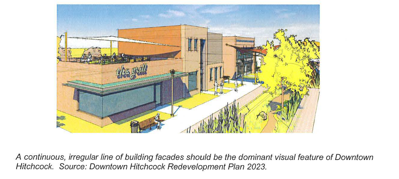
The Downtown Mixed-Use District is intended to implement the goals of the City of Hitchcock Downtown Redevelopment Plan. The Downtown Mixed-Use District is intended to be the most densely developed area of the community with the greatest building coverage and the least amount of private development devoted to off-street parking and landscaping. It is also intended to be an area highly conducive to pedestrian activity. Building facades should be the dominant visual feature of individual streets with groups of buildings comprising discernable blockfaces or vertical framing of the street space. Blockfaces, are evidenced by limited contrast and variation in setbacks depths; building heights and shapes; and spacing between buildings. The majority of parking in the Downtown Mixed-Use District is accommodated on-street within shared public parking areas or inside and rear lot areas of individual properties.
(B)
Permitted uses (to be included in a combined district table).
(C)
Height and area requirements.
(D)
Urban design standards.
(1)
Site arrangement.
(a)
Building placement and design.
i.
Principal structures. Principal structures shall be placed within the minimum and maximum setbacks established in Section 156.77 (C), to define the street edge and pedestrian environment.
a.
Buildings shall be placed and arranged to provide physical definition to streets, pedestrian pathways and interior plazas and courts.
b.
Loading and service areas shall be grouped internally on the site, organized along shared service alleys or roadways wherever possible, and screened from view utilizing landscaping and/or fencing.
c.
External mechanical systems shall be incorporated into the building architecture and/or screened from public view.
ii.
Garages. All attached or detached garages shall be placed towards the rear of a building except on a corner, where a side entrance may also be allowed. These may be accessed via privately controlled lanes and alleyways. Attached or detached garages shall be placed towards the rear of a building except on a corner, where a side entrance may also be allowed. These may be accessed via privately controlled lanes and alleyways.
(b)
Building orientation.
i.
All buildings shall face the nearest principal street as measured from the lot line to the nearest building edge and have clearly delineated entryways that are also street-facing.
ii.
The main building entrance shall be on the side of the building with the narrowest street frontage. Exceptions will be made for buildings designed to have corner entrances.
iii.
The façade treatment required in Subsection 2, Building Form and Detailing, of corner buildings shall completely wrap the building on all street-facing sides.
(c)
Parking.
i.
Parking Minimums: the minimum parking requirement for buildings fronting onto Highway 6 is one space per every 250 square feet of leasable commercial space. There is no minimal parking requirement elsewhere in the Downtown Mixed-Use District.
ii.
Parking Maximums: notwithstanding the individual use-specific minimum requirements of Section 156.140, the maximum amount of surface parking in the Downtown Mixed-Use District shall not exceed one space per 250 square feet of leasable commercial space.
iii.
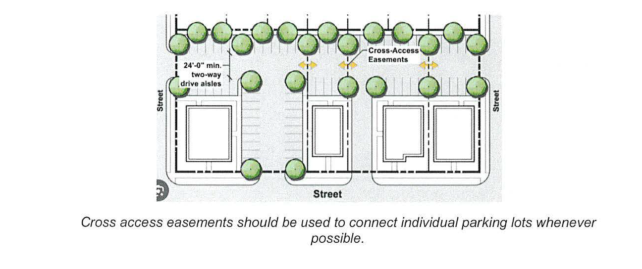
Except for along State Highway 6, any off-street must be accessed from either a secondary street or alleyway only. Exceptions will be made for access driveways on principal streets when said driveways provide rear or side-lot access to shared, connected parking areas of at least ten or more spaces and where a cross-access easement has been recorded. Driveways along principal streets must be spaced no less than 100 feet apart.
iv.
Parking lots shall be paved and lit pursuant to Section 156.143 and include pedestrian amenities such as trash receptacles and designated pedestrian pathways.
v.
Parking areas shall be connected whenever possible through the use of cross-access easements.
vi.
Any parking lot with more than 20 spaces shall have one tree for every ten spaces. Any parking lot with more than 20 spaces shall have one tree for every ten spaces. These trees shall be placed along the side or rear lot lines or in landscape islands within the parking lot. The Zoning Official or his/her designee may waive this requirement in situations where this is physically impractical due to existing site constraints, or where underground stormwater detention is installed. Parking lot landscaping may count toward the general site landscaping requirements of section g. (Landscaping and Buffering) below.
(d)
Vehicular access.
i.
Driveway locations on non-principal streets shall be spaced such that they are at least ten feet from any adjacent driveway.
ii.
Driveway locations on principal streets shall be spaced at least 100 feet apart subject to the additional terms of (D)(1)(c) iii above.
iii.
Shared driveways are allowed.
iv.
Subject to the conditions of (D)(1)(c) iii above, only one driveway approach or opening shall be permitted on each street frontage, of each premises. At locations where driveways are not shared with an adjoining property, each driveway shall be placed in such a way as to not impede the visual clearance to access the public street.
v.
Access to attached and detached garages shall be from the rear of a building only, except if the property is located on a corner lot and the side street may be used for access.
(e)
Drive-throughs. Drive-throughs are prohibited in the Downtown Mixed-Use District.
(f)
Service area screening.
i.
Service areas, garbage receptacles, utility meters, and mechanical and electrical equipment shall be screened from public view and located for convenient access by service vehicles.
ii.
Screening of these areas shall be integrated into the overall building and landscape design.
(g)
Landscaping and buffering.
i.
For parcels along Highway 6 frontage, landscaping is required in the front setback and the side street setback and shall include one tree for every 40 linear feet of frontage. Twenty percent of the land area located within the front yard or street yard setback area shall be landscaped with native, drought-tolerant, perennial plant material and appropriately mulched. The remainder of the area shall be maintained with turf grasses or additional native, drought-tolerant plant material but may not be filled completed with mulch material.
ii.
Table XXX, Landscape Standards below, provides general standards for development in this zoning district on properties less than five acres in lot area.
| Table XXX Landscape Standards | Figure XXX, Landscape Standards | |
| Min. Landscape Surface Ratio (LSR) | 5% 1 |  |
| Min. Canopy Trees per 40' of Street Frontage (Tree wells where applicable) 2, 3, 4 | 1 | |
| Min. Width of Streetside Parking Lot Perimeter Landscape Strip | 3-feet | |
| TABLE NOTES:
1
Tree wells in the public right-of-way may count toward the LSR with the approval of
the Public Works Director.
2
For corner lots, applies to both frontages.
3
The resulting number of trees shall be rounded up to the nearest whole number. For
example, a corner lot with 30 feet of frontage on one street and 140 feet frontage
on another requires 7 canopy trees.
4
The Public Works Director may reduce or waive this requirement in cases where trees
are impractical or may pose a public safety hazard.
Canopy trees must be a minimum 3" caliper at planting. | ||
(h)
Pedestrian amenities.
i.
Street furniture. Public seating, trash receptacles, and directional kiosks shall be of uniform design and provided throughout the district as approved by the Zoning Official or his/her designee. Street trees, landscaping, weather protection, public art, street furniture, and other pedestrian amenities in public rights-of-way and plazas shall provide a minimum passable sidewalk width of five feet.
ii.
Sidewalks. Sidewalks shall connect to existing perimeter sidewalks and to all building entrances; parking courts, garages, or structures; civic spaces; and any other pedestrian destinations.
iii.
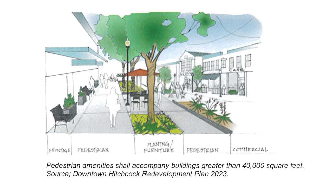
Outdoor amenities. Building or buildings that have a gross floor area greater than 40,000 square feet shall set aside an area equivalent to ten percent of the total building footprint for outdoor amenities. All amenities shall be installed by the developer at time of site re/development and maintained by the property owner.
a.
Eligible features. The applicant shall provide outdoor amenities that include any one or a combination of the following:
1.
Shaded plaza or patio area providing seating;
2.
Shaded outdoor dining;
3.
Water feature;
4.
Landscaped green area with seating;
5.
Outdoor playground area; or
6.
Shaded public art area.
(2)
Building form and detailing.
(a)
Building size, shape, and height.
i.
No single building shall exceed 100 feet in width or 45 feet in height;
ii.
Insets or projections of at least two feet deep (two-foot return) and ten feet in length shall extend the full height of a building for every 40 feet in building length or width.
(b)
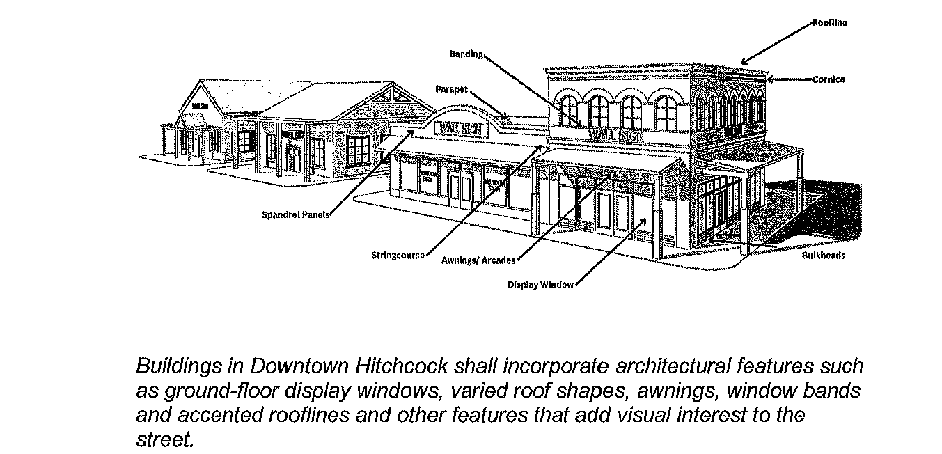
Façades. Building façades shall be architecturally treated to create a visually distinct building base, middle, and top and include at least three of the following elements:
i.
Window-bands, canopies, parapets, spandrel panels, decorative brackets, pilasters, cornices and articulated rooflines;
ii.
Variations in building heights or rooflines;
iii.
Material changes for different building planes or elements;
iv.
Accents through the use of moldings, sills, cornices, awnings, or spandrels, extruded window bands, decorative brackets; or
v.
Other façade features, such as an arcades, breezeways, galleries, oriel or bay windows, pavilions, pergolas, porches, porticos, projecting vestibules or recessed entryways.
(c)
Awnings, canopies, arcades, encroachments.
i.
All principal-street facing building elevations shall be equipped with either awnings above the first floor, or recessed ground floor arcades extending the full length of the building. Arcades must be indented at least four feet back from the main façade plane (four-foot overhang). All awnings must be constructed of durable materials, be non-retractable, and be permanently affixed to the façade surface.
ii.
Awnings and canopies shall not extend more than five feet from the façade of the building.
iii.
Awnings and canopies shall be attached to the building façade and shall not extend vertical support structures into the ground plane.
iv.
Awnings and canopies shall maintain a minimum of eight feet of vertical clearance from the ground plane.
v.
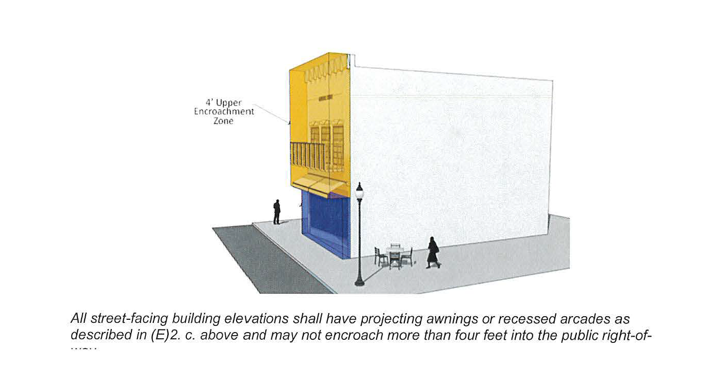
Encroachments. The City Engineer or Director of Public Works may permit, by recorded license agreement, encroachments into the public right-of-way if the encroachment:
a.
Does not extend more than four feet into the right-of-way and has an elevation of at least eight feet above grade.
b.
The encroachment does not impact the general functionality of the public sidewalk; and
c.
The encroachment does not make the sidewalk noncompliant with the requirements of the Americans with Disabilities Act (ADA).
d.
The encroachment does not create unsafe clearances from other elements of the right-of-way (e.g., street lighting, landscaping, vehicular movement, etc.).
(d)
Entryways.
i.
Each building shall have a clearly visible entrance with either an overhang, recess or projection over the door or another design element approved by the Planning Official.
ii.
Doorways adjacent to a public right-of-way shall be set back so that doors do not swing into a right-of-way.
(e)
Windows and doors.
i.
The front façade and side street façade of any new building shall be comprised of at least 40 percent windows and doors. Highly reflective glass, dark-tinted glass, or other types of glass that are intended to obscure the transparency shall be prohibited.
ii.
All windows and doors shall be trimmed with decorative details such as: sills, ledges, lintels, transoms and raised or recessed framing of at least two inches wide.
(f)
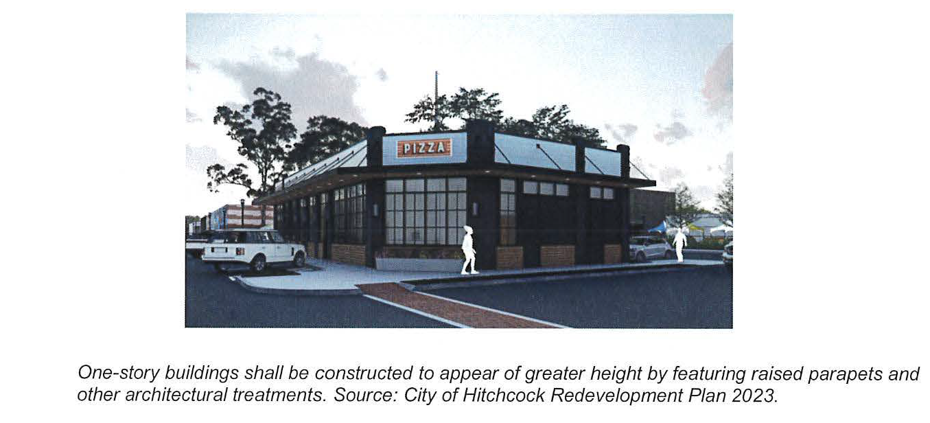
One-Story buildings. In the Downtown Mixed-Use District, buildings that are functionally one-story shall be constructed to appear of greater height in relation to the street. This can be achieved through raised parapets; the use of an intermediate cornice line to separate the ground floor and the upper level; or in limited cases, the use of pitched or gabled roofs.
(g)
Wrap-around (four-sided) design.
i.
Except for the percentage of window and door openings, all building elevations visible from public rights-of-way should feature similar quality materials, colors, and architectural elements as the main façade.
ii.
All outside mechanical equipment and dumpster areas shall be incorporated into the architecture of the main building and/or screened with the same wall treatment materials as the principal structure.
(h)
Roof shape.
i.
Low-slope, membrane roofs with parapets are the preferred roof type in the Downtown Mixed-Use District.
ii.
Where building parapets or roof lines extend for greater than 50 feet, changes in roof height, projection or angle is required.
iii.
Pitched, gable, and shed roofs are only acceptable when:
a.
The façade below the roof is greater than 22 feet in height.
b.
The roof is not draining into the side of a façade of greater height or onto a lower roof.
c.
The width from the eave to the center ridgeline is less than 25 feet.
d.
Used for entries, canopies, or pediment elements.
(3)
Signs and lighting.
(a)
Signs.
i.
Signs are considered as part of the architecture of the building and should not overwhelm or detract from the building design by their size, placement, shape, and material quality.
ii.
Multiple-tenant buildings and complexes shall develop a Master Sign Program to minimize the potential visual conflicts and competition among tenant signs
iii.
Permitted signs.
a.
Signs appropriate to the Downtown Mixed-Use District include: stenciled window signs, hand-painted and flush-mounted wall signs, spandrel panel signs, hanging or projected medallion (pendant) signs, awning signs, manual changeable copy signs and marquee signs. On-building signage must not exceed 200 cumulative square feet in total area.
b.
Directional signs limited to two per premises shall be permitted and shall be limited to six square feet each with a maximum height of four feet.
c.
Freestanding signs shall be limited to monument signs only with a permitted size that shall be no more than 48 square feet in area and ten feet in height
d.
Sandwich board signs are permitted provided they are removed after every business day.
iv.
Number of Signs Permitted: Two signs per establishment facade, provided there shall be no more than one of any single type per establishment façade
v.
Maximum sign area: No sign shall exceed the following maximum surface area.
a.
Pedestrian signs: Four square feet.
b.
Window signs: Twenty-five percent of the window area to which the sign is permanently attached.
c.
All other permitted signs: The total area of all other signs added together shall not exceed 20 percent of the first-floor building facade surface area to which they are associated. In no case shall signs exceed 200 cumulative square feet in total area.
vi.
Maximum height:
a.
Monument Signs: Six feet.
b.
Wall Signs: Shall not project above the building facade on which they are attached.
c.
Awning, canopy or marquee signs: Shall not extend above, below, or beyond the awning, canopy, or marquee to which they are attached.
vii.
Illumination:
a.
Permanent signs may be internally or externally illuminated.
viii.
Prohibited signs:
a.
Roof signs.
b.
Interior box-lit (or cabinet) signs.
c.
Pole or pylon signs.
d.
Electronic message boards.
| Table XXX
Allowed Attached Permanent Signs | |
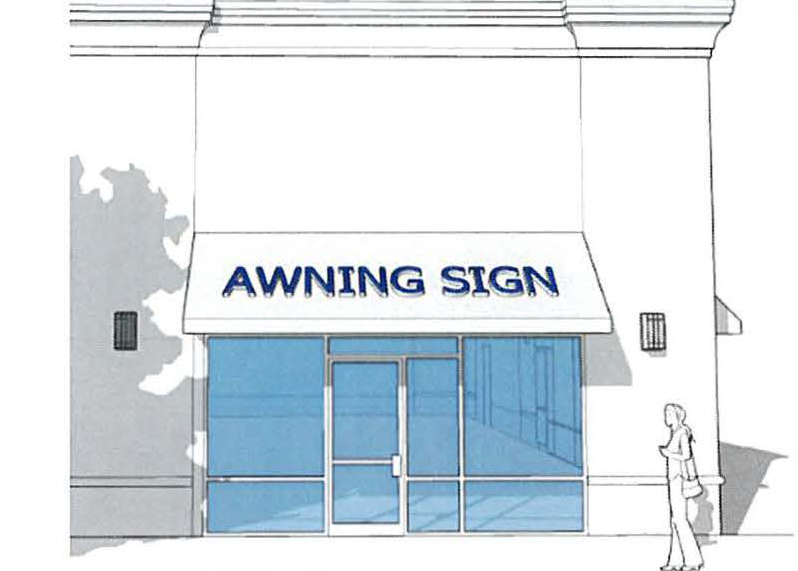 | |
| Awning Signs
| |
| Number Allowed | 1 per building front or per storefront for a multi-tenant building |
| Maximum Area | 5 s.f. per linear ft. of awning or canopy length |
| Maximum Height | 8 ft. above grade |
| Illumination | External |
| Other Standards | N/A |
| Canopy (or Over-Canopy) Sign
| |
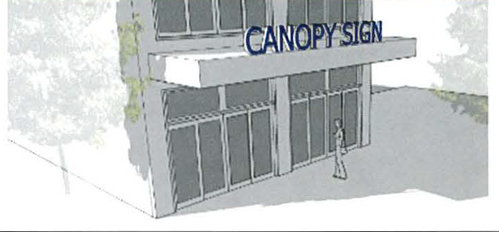 | |
| Number Allowed | 1 per building front or per storefront for a multi-tenant building |
| Maximum Area | 50% of canopy width |
|
Minimum Height
(copy above sign) | 2 feet |
| Illumination | External or Internal |
| Other Standards | N/A |
| Hanging Signs | |
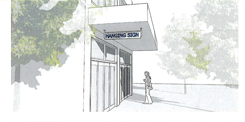 | |
| Number Allowed | 1 per building |
| Maximum Area | 6 s.f. |
| Maximum Height | 8 feet above grade |
| Illumination | Indirect illumination only |
| Other Standards |
1. Not extend within 2 ft. of the curb line.
2. May be suspended under a marquee sign or under a canopy or awning. |
| Marquee Signs
| |
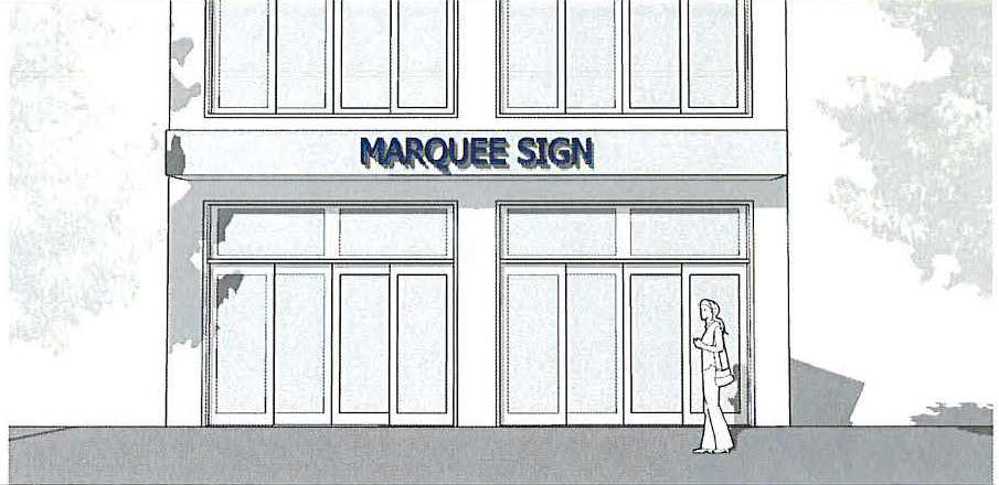 | |
| Number Allowed | 1 per street facing façade |
| Maximum Area | 50 s.f. per side; 100 s.f. total |
| Maximum Height | 4 ft. from lowest point of marquee to highest point, excluding any ornamentation supported directly by the marquee |
| Minimum Clearance | 8 ft. above grade |
| Illumination | Down lighting only; only the changeable copy area may be internally illuminated |
| Other Signs | If used, then a wall sign is prohibited on same facade |
| Other Standards |
1. May not project more than 6 ft. from the building; may require an encroachment permit.
2. Sign may be on up to three sides of a marquee. |
| Projecting Signs | |
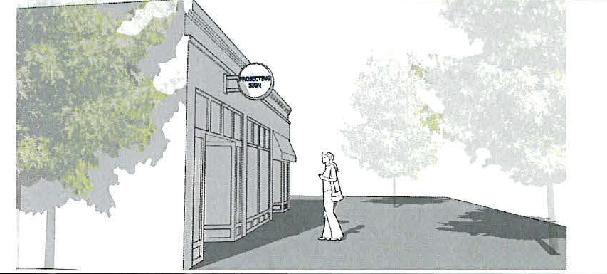 | |
| Number Allowed | 1 per building or 1 per 20 ft. of building frontage if multiple occupants. |
| Maximin Area | 1 s.f. for each linear foot of building frontage |
| Maximum Distance from Building Wall to Farthest Part of Sign | No more than half the distance from the building facade into the public right-of-way. |
| Minimum Clearance | 8 ft. above sidewalk or walkway and 20 ft. above adjacent public or private street. |
| Illumination | Internal or External (down lighting only). |
| Other Signs | If used, then a wall sign is prohibited on same façade. |
| Wall Signs
| |
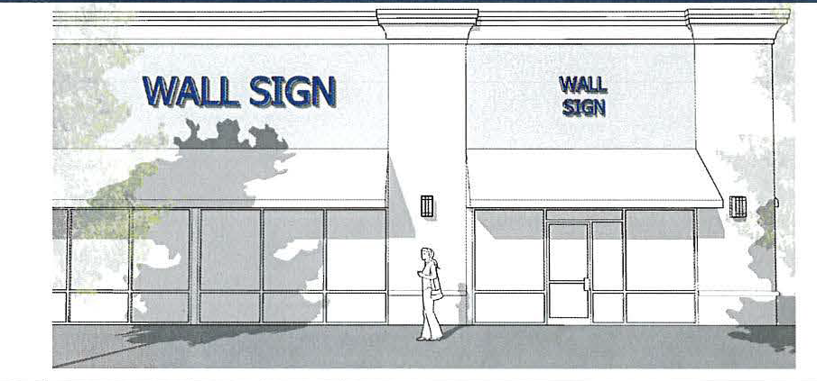 | |
| Number Allowed | 1 per building facade or tenant (multi-tenant bldg.); Maximum 2 per building. |
| Maximum Area | Total sign area shall not exceed 1.5 s.f. for each foot of linear frontage; a 2nd wall sign shall not exceed 0.5 s.f. per linear frontage. |
| Maximum Height | The eave line or the bottom of the second story windowsill, whichever is lower. |
| Illumination | Indirect lighting only. |
| Other Standards |
1. No wall sign shall project more than 18 inches from the building wall.
2. No wall sign or its supporting structure shall cover any window or part of a window. |
| Window Signs | |
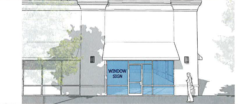 | |
| Number Allowed | 1 per commercial window. |
| Maximum Area | 15% of window area, or 9 sq. ft., whichever is less. |
| Illumination | Indirect or internal lighting; light shall be turned off when off-business hours. |
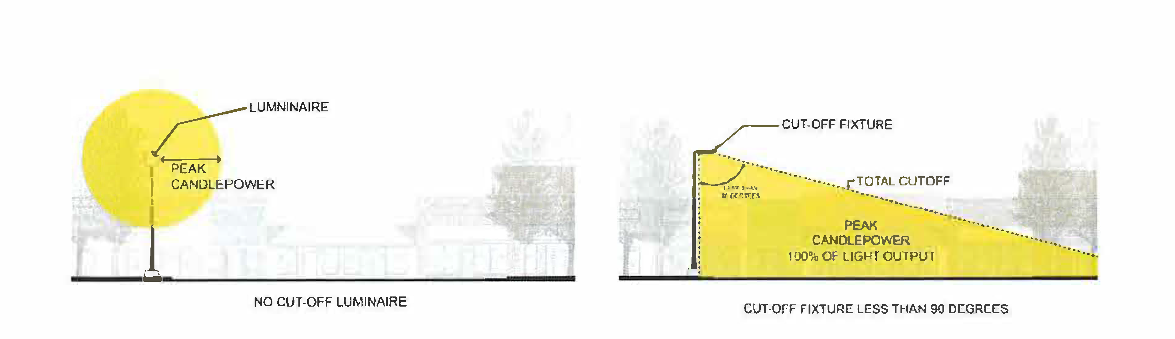
(b)
Lighting.
i.
As shown in Exhibit XXXX below, all wall mounted accent lighting within the Downtown Mixed-Use District shall be shielded or directed downward to prevent light shining beyond the property lines of the property on which the lighting fixtures are located.
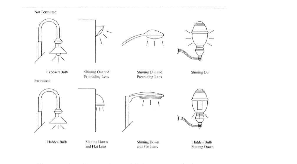
ii.
As shown in Exhibit XXXX below, to minimize glare and diffusion of light onto adjacent properties, all pole mounted lights within the Downtown Mixed-Use District shall either use hooded, cut-off fixtures that project downward at under a 90-degree angle from the light source or have a maximum footcandle strength of 0.5.
(Ord. No. 2024-03, § 1, 2-19-24)