
Independence City Zoning Code
ARTICLE 9
- SPECIAL PURPOSE AND OVERLAY ZONING DISTRICTS
14-910 - ARTS, ARTS DISTRICT[1]
Editor's note— (Ord. No. 17642)
14-911 - DFD, DRUMM FARM DISTRICT[2]
Editor's note— (Ord. No. 18129)
14-900-01 - Special purpose districts
14-900-01-A.
Purpose. Special purpose zoning districts are tools for dealing with special situations or accomplishing special planning and zoning goals. Special purpose districts are base zoning district classifications and not overlay other district classifications.
14-900-01-B.
Establishment. Special purpose zoning districts may be established, amended or removed only in accordance with the zoning map amendment procedures of Article 14-701.
14-900-02 - Overlay districts
14-900-02-A.
Purpose. As with special purpose districts, overlay zoning districts are tools for dealing with special situations or accomplishing special planning and zoning goals. Unlike special purpose districts, overlay districts are not base zoning classifications. As the name implies, overlay districts are "over-laid" on base zoning district classifications to alter some or all of the regulations that apply in the underlying, base zoning district.
14-900-02-B.
Establishment. Overlay zoning districts may be established, amended or removed only in accordance with the zoning map amendment procedures of Article 14-701.
14-900-02-C.
Interpretation. Overlay zoning district regulations apply in combination with underlying (base) zoning district regulations and all other applicable standards of this development ordinance. When overlay district standards conflict with standards that otherwise apply in the underlying, base zoning district, the regulations of the overlay zoning district govern. All applicable regulations of the underlying base zoning district apply to property in an overlay zoning district unless otherwise expressly stated.
14-901-01 - Intent and applicability
14-901-01-A.
Intent. The Historic Downtown Square district ("HSQ") is a special-purpose zoning classification intended to preserve and enhance the unique character of the City's historic square area. It aims to create a vibrant, artistic, safe, and bustling downtown filled with new residents, thriving eateries, and entertainment where friends and family can enjoy their surroundings. This district is an active center of living and commerce, showcasing the history and architecture unique to Independence.
14-901-01-B.
Application. The HSQ district establishes standards that vary from the underlying base zoning. If the provisions of the district are inconsistent with Chapter 14 of Independence's Code of Ordinances, the provisions of this district apply. If the provisions of the district are inconsistent with a Historic overlay district ("HD"), the provisions of the historic overlay district apply. Existing Planned Unit Development ("PUD") districts are exempt from the HSQ overlay district standards. However, new PUD districts shall comply with the HSQ district.
a)
Façade Changes. Compliance with this article applies to façade changes to existing buildings.
b)
New Development. Compliance with this article applies to all new buildings constructed within this district.
c)
Enlargements and Expansions. Full compliance with this article applies only to the exterior enlargement or expansion area.
d)
Change of Use or Occupancy. Compliance with use standards applies whenever the use or occupancy of a property changes.
e)
Signs. Compliance with the sign standards in the HSQ district and any standards of Article 14-504 that are not inconsistent with this section apply when a sign permit is required.
14-901-01-C.
Approvals. The Director will process applications for façade changes, new development, enlargements, expansions, change of use or occupancy, and signs that conform fully with the standards in this section through the procedures of Sections 14-705 and 14-708 of the Unified Development Ordinance. However, applications that require additional reviews and approvals (including Planning Unit Development, Historic Overlay District review, variances, and special use permits) must comply with the procedures set forth in Article 7.
14-901-01-D.
Exemptions. The Director may approve of deviations and exemptions from the standards of this district provided alternative compliance meets the intent of the HSQ district.
(Ord. No. 19724, § 2, 9-15-2025)
14-901-02 - Allowed uses
14-901-02-A.
Use Table. The column of Table 901-1 lists the groups, categories and types allowed and are further defined in Article 14-200. Uses are allowed in the HSQ district in accordance with Table 901-1, below.
14-901-02-B.
Sub-District Descriptions. Map 901-1 delineates the district boundaries of the Historic Square District and is considered to be part of the official Zoning Map.
a)
Historic Square. This sub-district is intended to preserve and reinforce the traditional pattern of development within and directly adjacent to the downtown square. This district emphasizes active first-floor commercial activities.
b)
Downtown Transition. This sub-district is intended to enable a variety of commercial, mixed-use, and residential uses in a compact, walkable setting. The design standards within this district are more flexible to accommodate a broader range of uses, including for adaptive reuse.
c)
Downtown Neighborhood. This sub-district provides an opportunity to allow a range of compact, "middle" housing types such as townhomes, walkups, and compact single-family homes to support access to the goods and services offered by adjacent areas. This sub-district is residential in nature and reinforces the walkability of the area.
Map 901-1. Allowed Uses: Subdistrict Map
14-901-02-C.
Permitted Uses. Uses identified with a "P" are permitted as-of-right in the subject zoning district, subject to compliance with all other applicable standards of this development ordinance. Principal uses must be within structures that meet the definition of a "building", and may not be permitted within mobile homes, camper trailers, or portable facilities on skids, wheels, or other moveable devices.
14-901-02-D.
Permitted Uses with Minimum Use Standards. Uses identified with a "C" are permitted as-of-right, subject to compliance with the use standards referenced in the right column of Table 901-1, and all other applicable standards of this development ordinance.
14-901-02-E.
Special Uses. Uses identified with an "S" may be allowed if reviewed and approved in accordance with the special use procedures of Article 14-704.
14-901-02-F.
Prohibited Uses. Uses not listed and those identified with a "—" in are expressly prohibited.
14-901-02-G.
Supplemental Standards. The "Supplemental Standards" column of Table 901-1 identifies use-specific standards that apply to some uses. Compliance with those standards is required.
(Ord. No. 19724, § 2, 9-15-2025)
14-901-03 - Mixed-use and nonresidential development standards
14-901-03-A.
Development Standards—Generally. The development standards of this section apply to all development within the HSQ district, except for residential buildings of 12 units or less. Residential buildings of 12 units or less shall comply with Section 14-901-04. The lot and building standards are determined based upon the property's proximity to the historic square. Properties that abut the Historic Square frontage area must comply with the associated standards set forth in Table 901-2 below.
Map 901-2. Frontage Areas Map
14-901-03-B.
Frontage and Setback Exceptions and Adjustments. The following exceptions apply to all development within the HSQ district:
a)
All Projections. Any projections over public rights of way or any similar area designed for pedestrian circulation, such as bay windows, balconies, canopies, chimneys, eaves, cornices, open fire escapes, egress wells, or other non-foundational overhangs, may extend up to four feet from the foundation and encroach into the setback, but no closer than three feet from any lot line. Projections shall be at least eight feet above the grade, and in no case within five feet of any curb for a street, access drive, or other area designed for vehicles. All projections shall receive approval from the appropriate entity prior to installation.
b)
Utility Equipment. Ground-mounted mechanical equipment, meters, and utility boxes accessory to the building may be in the side or rear setback provided that it extends no more than six feet from the principal building, no closer than three feet to the lot line, and is screened from public right-of-way by structures or landscape. These limitations do not apply to any utility structures, otherwise authorized to be in easements or rights-of-way, subject to the design standards of those specific authorizations.
c)
Entrances. Entrances such as porticos, stoops, or unenclosed porches may extend up to six feet into the required front setback. Entrances shall not encroach on any easement; encroachments must ensure a minimum of five feet of passable sidewalk width.
d)
Usable Open Space Frontage. Usable open space along the lot frontage, including patios, courtyards, outdoor recreational areas, and outdoor entertainment venues, shall conform to the site design standards in Section 14-901-05-C.
14-901-03-C.
Height Exceptions and Adjustments. The following are exceptions to the height limits in Table 901-2:
a)
Building elements integral to the design and construction of the building, such as parapet walls and false mansards, may extend up to six feet above the roof deck of a flat roof.
b)
Architectural features such as chimneys, ornamental towers or spires, and similar accessory features that are cumulatively less than 20 percent of the building footprint must match the building height.
c)
Functional and mechanical equipment such as elevator bulkheads, cooling towers, smokestacks, roof vents or other equipment may be built up to their necessary height in accordance with building codes, provided they are screened according to the standards of this section.
d)
Accessory site structures (such as flag poles, monuments, or water towers) may have a height limit of 50 feet but shall be setback at least one-third its height from the property line.
14-901-03-D.
Ground-Floor Transparency. Buildings shall have the percentage of openings specified in Table 901-2 based on the following:
a)
The transparent façade must be comprised of windows between two and ten feet above the sidewalk or transparent doors that allow clear views of indoor space or product display area.
b)
The bottom of any window or product display window used to satisfy these transparency requirements may not be more than two feet above the adjacent sidewalk.
c)
Transparent facades must be comprised of clear, non-reflective windows.
d)
Display windows that do not provide views into the interior of the building may be counted towards satisfying up to 50 percent of the minimum transparency requirements, if they are internally illuminated and are at least two feet in depth.
e)
On corner lots, the ground-floor transparency requirement applies along the front of the building; any building wall abutting or facing an exterior lot line shall have a minimum transparency of 30 percent.
14-901-03-E.
Doors and Entrances.
a)
Primary entrances shall provide direct public access from the adjacent rights-of-way. Properties abutting the Historic Square frontage must provide at least one primary entrance on that frontage.
b)
On corner lots, corner entrances are required unless waived by the Director.
c)
Building entrances may include doors to individual shops or businesses, lobby entrances, entrances to pedestrian-oriented plazas or courtyard entrances to a cluster of shops or businesses.
d)
Buildings that abut an alleyway must have at least one secondary entrance per building.
e)
The entrance width may not exceed 12 feet or five percent of the building's street-facing facade width. The entrance depth may not exceed the entrance width; and the entrance may not exceed two stories in height.
f)
A principal entrance shall be marked by one or a combination of elements:
1.
A single-story architectural emphasis such as canopies, porticos, overhangs, or arches.
2.
Display windows that frame and emphasize the entry.
3.
Architectural details such as tile work or other similar material changes.
4.
Integral planters or wing walls associated with a recessed or projecting entry court or plaza that integrates more formal landscape and hardscape designs.
14-901-03-F.
Façade Composition and Articulation.
a)
Façades shall be broken into smaller components, establishing a base, body, and top of the building, by one or a combination of the following techniques at intervals specified in Table 901-2:
1.
Blank walls and wall planes shall be broken up clearly with elements that add architectural interest and variety, such as projections of at least one foot, recesses, offsets, windows, painted features, or blank window openings trimmed with frames, sills or lintels.
b)
Façade Composition. Table 901-3 establishes Primary Materials ("PM"), Secondary Materials ("SM"), and Prohibited Materials ("—"). Primary Materials are allowed on all stories of a structure. Secondary Materials may be used as accent on the first story and shall not exceed 30% of the first story façade. Permitted secondary materials may be used on the second story and above of a structure or for the required building elements. In addition to the allowed materials of Table 901-3, the following standards shall apply:
1.
When a specific material cannot be readily classified, the Director is authorized to determine the most similar, thus most appropriate, material based the appearance, durability, method of installation, and location of the material. The Director may also reference relevant information provided by the International Building Code.
2.
Preservation or restoration of original facade materials is desired in existing structures. Applied 'faux' facades or other not permitted non-original materials are not desired.
3.
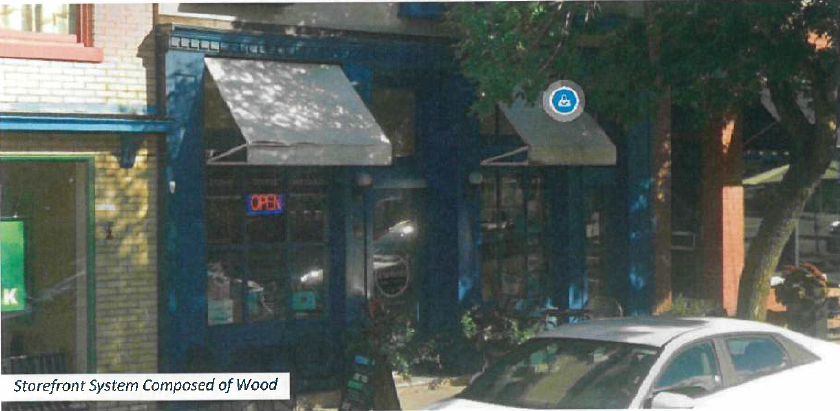
Wood and metal may encompass more than 30% of a first-floor façade when used in a clearly articulated first-floor storefront system.
4.
Painting masonry shall be considered on a case-by-case basis. The Director may consider relevant information when making the decision.
(Ord. No. 19724, § 2, 9-15-2025)
14-901-04 - Residential development standards
14-901-04-A.
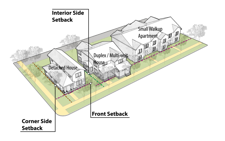
Residential Buildings. Permitted residential buildings of 12 units or less in the HSQ district must comply with the lot and building standards of Table 901-4, except as otherwise expressly provided. Rules for measuring compliance with the lot and building standards established in Table 901-4 and applicable exceptions to the standards can be found in Article 14-202. The Residential Building Types are defined below:
a)
Detached House—Small Lot. A residential building designed for one primary dwelling unit on a lot that is more compact than conventional standards.
b)
Townhome. An attached residential unit that is part of a multi-unit building designed to accommodate three to eight dwelling units. Each unit is separated by a common sidewall with a side-by-side configuration, and each has its own private entrance.
c)
Two-Unit House. A residential building designed to accommodate two primary dwelling units, with an outward design, scale and appearance similar to a Detached House. Variants of this type are primarily based on context, and how the frontage is designed to be compatible with the neighborhood character. They include side-by-side, up-down, or front-back configurations.
d)
Multi-Unit House. A residential building designed to accommodate two to four dwelling units. They include side-by-side, walkup, or front-back configurations.
e)
Apartments—Small Walkup. A small scale, multi-unit residential building designed on a small or moderate-sized lot in an urban neighborhood or mixed-use stetting composed of 12 units or less per building. The building is accessed by a common lobby entrance at building frontage and arranged to integrate into the block structure of a neighborhood.
14-901-04-B.
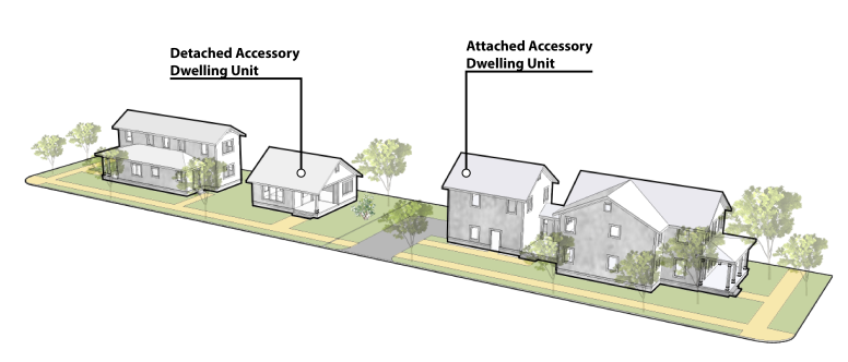
Accessory Dwelling Units ("ADU"). Where permitted, secondary dwelling units accessory to the principal residential use are subject to the following standards:
a)
One accessory dwelling unit is allowed per lot.
b)
ADUs shall be located within the principal building (such as an attic or basement apartment), or within an existing detached accessory building.
c)
The accessory dwelling shall not exceed 50% of the living area of the principal dwelling unit, or 1,200 square feet, whichever is less.
d)
Accessory dwelling units must meet all city building codes.
e)
The property owner shall occupy either the principal or accessory dwelling as their permanent residence. A certificate of occupancy shall be issued by the city prior to use as a dwelling unit.
f)
The accessory dwelling shall be clearly subordinate to the principal dwelling through the location of parking, access, building entrances and other design features that accommodate the dwelling. Only one entrance to the ADU may be visible from the front street. For the purpose of this regulation, the front street shall be defined as the street on which the primary structure is addressed. Exterior stairways shall not be constructed on the front of the primary structure.
g)
The design of the ADU shall be consistent with the design of the primary structure and shall maintain the style, appearance and character of the main building, and shall use matching materials, colors, window style, and comparable roof appearance.
h)
No additional parking spaces are required. A maximum of one additional off-street parking space may be provided for the ADU and shall be paved.
i)
The ADU shall comply with all standards for health and life safety codes, building codes, as well as zoning codes as adopted by the City, except as provided in this chapter.
j)
The ADU may be served by the existing primary structure's sewer and water connections and water meter, provided the services are adequate. The water meter size shall not be increased for the purpose of serving the ADU. This provision may be waived by the Director if water and sewer connections are determined to be inadequate.
k)
The land on which the ADU is located shall not be subdivided or otherwise segregated in ownership from the primary structure or the land on which the primary structure is located.
l)
Detached ADUs are considered accessory structures and shall comply with the regulations set forth in 14-400 - Accessory Uses and Structures.
(Ord. No. 19724, § 2, 9-15-2025)
14-901-05 - Site design standards
14-901-05-A.
Vehicle Parking Facilities. Where the construction, expansion, or alteration of parking occurs, the following standards shall apply:
a)
Understated Parking Required. Parking facilities shall not directly abut the same street as the primary entrance of principle buildings within the HSQ district. Any off-street parking provided must be located behind, within, or under the building. When the depth of the lot is insufficient to meet these requirements, parking facilities may be located to the side of the building, provided that it does not occupy more than 30 percent of the lot's primary street frontage and is screened according to the standards provided in Section 14-901-06.
b)
Vehicle Access. Access drives, when provided, must be taken from alleys or secondary streets, not abutting the Downtown Square frontage where available. Access may come from the primary street if the Director finds that no access alternatives exist. Driveways and access points shall be a minimum of 20 feet in width, or include two access points of at least ten feet in width, to accommodate two-way vehicle circulation. Alternative access plans may be approved administratively by the Director when topographical or site conditions constraints exist. Alternative access plans must provide equivalent circulation and traffic mitigation as the requirements above and not obstruct pedestrian access or flow along the street frontage.
c)
Off-Street Parking Minimums. No off-street parking is required for nonresidential uses less than 4,000 s.f. Residential buildings of 12 units or more are required to provide off-street parking at a rate of 0.5 spaces per unit, unless the residential units are located inside a building that fronts on the Historic Square frontage
d)
Off-Street Parking Maximums. Where off-street parking is required, no use shall provide more than 150% of the minimum parking ratios provided in Section 14-501-13, unless documented evidence of actual parking demand based on studies of similar uses in similar contexts is accepted by the Director.
e)
On-Street Parking Credit. All on-street parking within 600 feet of any lot frontage shall count towards the parking requirement at a rate of 0.33 space for every one on-street spaces. In situations where on-street parking does not extend more than 100 feet beyond the subject property, on street parking abutting the lot may count towards the parking requirement at a rate of 0.67 spaces for every one space. The street must be paved, with sidewalks that are ADA accessible. An on-street parking space shall not be counted if it is restricted in its use as a designated loading, taxi, or other special use zone or if parking is prohibited for more than five hours in any 24-hour period.
f)
Public Parking Credit. Any parcel with boundaries within 1,000 feet of a public parking area may reduce the required vehicle parking at a rate of one space for every two required parking spaces.
g)
Shared Parking. Required parking may be reduced for any site containing multiple uses, or for adjacent sites with different uses, to reflect different peak parking periods associated with the uses. Any shared parking arrangement shall require an agreement among all landowners participating in the agreement to ensure access, joint use, maintenance, and other operational issues. The agreement shall be recorded with each participating property. A shared agreement may also be approved based on a joint parking study for the sites and uses demonstrating adequate parking during peak hours for all parties to the agreement.
h)
Bike Parking. All on-site bicycle parking may reduce the required vehicle parking at a rate of one space for every four bicycle parking spaces up to a maximum of 15% of the required vehicle parking.
14-901-05-B.
Alleys. An alley is a narrow accessway typically provided at the rear of residential lots and commercial areas, providing necessary vehicular access to garages or other parking areas. Alleys also support service accommodations, such as utilities, drainage, and trash pick-up. Newly constructed alleys shall be at least 18 feet wide to accommodate slow moving two-way vehicular access and emergency vehicles. Lots abutting alleys may include pedestrian-oriented improvements and modifications to the space, subject to the following standards:
a)
Entrances facing an alley may be designed as storefronts, incorporating the elements pertaining to façade design standards of Table 901-2. Rear setback requirements may be adjusted to accommodate usable open spaces, subject to the standards of 14-901-05-C.
b)
Lights may be installed at a minimum of 14 feet above the pavement and include an accessible shut-off switch for emergencies.
c)
Landscaping elements containing noninvasive plant species are encouraged but shall not encroach into the alley's right-of-way. Plants shall not damage masonry or paving surfaces.
d)
Signs must comply with 14-901-07 Signs.
e)
Movable seating may encroach up to four feet into the alleyway during tenant business hours. Seating must be easily movable to maintain vehicular and emergency access, and must not encroach within the right-of-way outside business hours.
f)
Temporary use and closure of public alleys shall require a special event permit by the City of Independence.
14-901-05-C.
Usable Open Spaces. Table 901-5 provides minimum required open space standards for new buildings. The setback requirements may be adjusted to accommodate usable open spaces along a streetscape or alleyway, such as patios, courtyards, outdoor recreational areas, and outdoor entertainment venues. Open spaces must follow the following site design standards:
a)
Open space must directly abut the streetscape or an alley.
b)
Open space shall not exceed 30% of the total lot frontage.
c)
Open space shall be at least 15 feet in all directions. Open space shall not exceed 20,000 square feet.
d)
Open space may be used for dining, gathering, recreation, or similar uses. Open space shall not be used for outdoor storage. Outdoor uses shall be accessory to the principal use.
e)
Open space may be enclosed with a permanent rail or wall constructed of metal, masonry, or wood, not exceeding 36 inches in height. Enclosed usable open spaces may include an entry along the perimeter to accommodate public access of at least 36 inches wide.
f)
Open space shall be designed as active social space and shall not be interpreted as vehicular use areas such as parking or loading facilities, landscape areas, or stairways.
g)
At a minimum, open space shall be designed to include two of the following elements: Movable furniture; interactive art installation; planters with seasonal or ornamental plantings; water element such as a fountain; shade elements.
(Ord. No. 19724, § 2, 9-15-2025)
14-901-06 - Streetscape, landscaping and screening
14-901-06-A.
Sidewalks. Sidewalks are required for all developments and must be constructed in accordance with the Public Works Manual.
a)
Sidewalks are required to be constructed and shall be at least ten feet wide, and include a clear walking path at least five feet wide, a pedestrian buffer zone between the building frontage and the walking path, and a planting zone for street between the walking path and the curb. Part of the sidewalk width may be located on private property. The sidewalk dimension shall be measured from back of curb to building facades or parking lot screening and other landscaping.
b)
When the existing sidewalk width is less than 12 feet, structures shall be allowed no closer than 12 feet from the back of the curb. The required sidewalk width may be reduced by approval of the Director, based on the historic building setback line of existing adjacent building(s) within the Historic Square frontage or a historic district. In no case shall the setback be reduced below nine feet from the back of the curb unless on-street parking exists between the building and the street.
c)
When the existing sidewalk width is greater than the bare minimum of 12 feet, the sidewalk environment shall be designed to meet functional and aesthetic goals. New development shall not reduce or encroach upon the existing sidewalk width.
d)
A clear distance (unobstructed width) of at least five feet is required for all sidewalks along public streets.
14-901-06-B.
Street Trees. Street trees are required along all city streets in HSQ district. Larger projects which require modifications to the public sidewalks abutting the parcel boundaries must install street trees when reconstructing the public right-of-way. Where the public sidewalk is reconstructed, the following standards apply:
a)
One tree shall be provided for every 25 to 40 feet street frontage. This requirement is measured and calculated for each individual street frontage, not from an overall street frontage for the development. The Director may approve a master street tree plan that varies from this requirement to allow for driveways, utilities, and intersection visibility requirements.
b)
Larger shade trees with spreading canopies or branches are desirable where possible. Species of street trees within the public rights-of-way shall comply with Section 14-503-17 and Section 13.02.011 of the City Code.
c)
Street trees shall be planted between the curb and the walking path of the sidewalk. When automobile traffic lanes are immediately adjacent to the curb, new street trees must be planted at least three feet from the edge of the roadway.
d)
Street trees, tree grates and other landscaping shall be maintained and irrigated by the adjacent property owner. If the adjacent property owner fails to maintain the adjacent street trees and other landscaping, the City may perform the required tree and other landscaping work at the abutting property owner's expense If overhead power lines are present, street trees shall be limited to a mature height of 25 feet to avoid conflict with utility lines and maintenance crews.
e)
Where tree grates are installed, they shall be ADA compliant and have a similar size and material as tree grates found in adjacent developments.
14-901-06-C.
Screening, Fencing and Walls. Uses and development in the HSQ district are subject to other standards including the following:
a)
Mechanical/Utility Equipment. Dumpsters shall not be visible from the public right-of-way. Dumpsters and ground level mechanical/utility equipment must be in the rear yard or can be in the side yard if setback ten feet from street. Access for dumpsters and mechanical/utility equipment may be shared with any access for required parking. Mechanical equipment on roofs must be screened from the ground level of nearby streets and residential areas. Mechanical equipment shall be screened by extended parapet walls or other roof forms that are integrated with the architecture of the building. Cell phone transmission equipment shall be blended in with the design of roofs.
b)
Fencing and Freestanding Walls. Fencing and freestanding walls shall be between 36 and 72 inches in height, and shall be fabricated using steel, iron, concrete, stone, or brick. Fences must meet or exceed 80 percent transparency. Barbed-wire, razor wire, metal sheeting, wood picket, stockade, chain link fencing, or similar materials are prohibited fencing materials in the HSQ district. The finished side of the fence or wall shall face the adjacent property or the street.
c)
Retaining Walls. Retaining walls shall not exceed 48 inches in height and must be constructed of brick, precast concrete, cast-in-place concrete-textured, stone or cast stone.
d)
Screening for Unbuilt Frontages. For any non-building portion of the lot frontage, or where buildings are setback more than 20 feet and the setback does not include Usable Open Space, additional trees shall be planted along the property line at the same interval to fill the void with vertical landscape elements. Any vehicular parking area permitted within 30 feet of the street shall be screened from the street edge with a two and one-half foot to four-foot wall or ornamental fence complementing the materials of the building, a dense landscape hedge, or a combination of both.
(Ord. No. 19724, § 2, 9-15-2025)
14-901-07 - Signs
14-901-07-A.
Sign Types and Allowances. All signage must receive approval of a sign permit, and shall comply with the following standards:
14-901-07-B.
Monument Signs. Monument signs are prohibited, unless on a lot with a minimum of 100 feet of frontage or the site is an official local or national historic landmark or a contributing building within an official local or national historic district. Where permitted, monument signs shall comply with the following standards:
a)
Monument signs shall not exceed 20 square feet in area and four feet in height.
b)
On interior lots, monument signs shall be set back a minimum of five feet from the property line. On corner lots, monument signs shall be set back a minimum of ten feet from the property line or a distance back as necessary to meet sight triangle restrictions as determined by the city's traffic engineer.
c)
The sign must be attached to or incorporated into a freestanding wall or retaining wall.
d)
When attached to a wall or fence, monument signs shall not project more than three inches from the face of the wall or fence.
e)
Monument signs shall be set upon a solid base of material and constructed of primary materials matching the principal building. The area surrounding the monument sign shall be landscaped.
14-901-07-C.
Wall Signs. Wall signs shall be permanently attached to the building and parallel to its surface, and shall comply with the following:
a)
Wall signs shall be die cut and/or channel letter signs.
b)
Signs located on the ground level of the building shall be pin-mounted.
c)
Raceway-mounted channel letter signs are allowed on the second story and above.
d)
Raceways shall be painted or designed to match the material on which the sign is affixed.
14-901-07-D.
Roof Signs.
a)
Supporting structure for a roof sign must comply with all applicable engineering and code requirements.
b)
Roof signs shall be die cut and/or channel letter signs. Supporting structures must consist of the fewest number of supporting members without embellishments.
c)
Roof signs are permitted on buildings if the top of the highest portion of the roof is at least 30 feet above grade.
d)
The maximum horizontal dimension of a roof sign may not exceed 50 percent of the width of the wall it most closely parallels or 20 feet, whichever is less. The maximum height of a roof sign and its supporting structure may not exceed six feet, measured from the elevation of top of the highest parapet to the top of the sign. Roof signs shall not be constructed of wood.
14-901-07-E.
Historical Signs. Historical wall signs, hand-painted signs, neon signs, and projecting signs that advertise closed or off-site businesses may remain and shall not count toward any signage requirements if established more than 25 years from the date of application. Historical signs may be removed and reinstalled for restoration. Historical signs may be replicated if the new sign is the same size and material. Retention of historical signs must receive approval by the Heritage Commission. In no case shall a pylon sign be considered a historical sign.
(Ord. No. 19724, § 2, 9-15-2025)
14-902-01 - Purpose
The /PUD, Planned Unit Development overlay district regulations are intended to:
14-902-01-A.
Ensure development that is consistent with the comprehensive plan;
14-902-01-B.
Ensure that development can be conveniently, efficiently and economically served by existing and planned utilities and services;
14-902-01-C.
Allow design flexibility that results in greater public benefits than could be achieved using conventional zoning district regulations;
14-902-01-D.
Preserve natural, historic and cultural resources; and
14-902-01-E.
Promote attractive and functional residential, nonresidential and mixed-use developments that are compatible with surrounding areas.
14-902-02 - Procedure
PUDs must be reviewed and approved in accordance with the procedures of Article 14-703.
14-902-03 - Effect of other development ordinance standards
Except as expressly authorized by the regulations of this section and approved as part of a PUD plan (in accordance with the procedures of Section 14-703), all of the standards of this development ordinance apply to development within a PUD district.
14-902-04 - Standards eligible for modification
Unless otherwise expressly approved by the City Council as part of the PUD approval process, PUDs are subject to all applicable standards of this development ordinance. The City Council is authorized to approve PUDs that deviate from strict compliance with specified standards if they determine that the resulting development provides a greater level of public benefit than would normally be expected for projects developed under conventional zoning district standards.
14-902-04-A.
Allowed Uses. A list of uses to be allowed in a PUD must be approved as part of the PUD approval process. Regardless of the underlying zoning, the City Council may approve a mix of use types within a PUD as a means of accommodating mixed-use developments and developments with a range of housing and commercial options.
14-902-04-B.
Lot Size. The minimum lot area and width size standards of the base zoning district may be reduced as part of the PUD approval, provided that lot sizes must be adequate to safely accommodate all proposed buildings and site features.
14-902-04-C.
Residential Density. The maximum allowable residential density of the base zoning district may be increased by up to 30 percent if the City Council determines that such an increase is warranted to support the public benefit likely to result from the proposed development and such density increase can be supported by existing and planned public facilities and services.
14-902-04-D.
Setbacks. The minimum setback standards of the base zoning district may be reduced as part of the PUD approval, provided that:
1.
Buildings located along any PUD district boundary that is adjacent to an R zoning district must be set back a distance at least equal to the height of the proposed building or a depth equal to the setback requirement of the abutting R district, whichever is greater; and
2.
All exterior walls of detached buildings within the PUD must be separated by a minimum distance of 10 feet.
14-902-04-E.
Height. The City Council may allow an increase in allowable building heights if the City Council determines that such an increase is warranted to support the public benefit likely to result from the proposed development. No building height increases are allowed within 100 feet of the outer perimeter of the PUD.
14-902-04-F.
Parking and Loading. Off-street parking and loading requirements may be reduced when the City Council determines that decreased requirements are in keeping with projected parking and loading demand of the PUD.
14-902-04-G.
Streets. Alternatives to otherwise "standard" street cross-sections and designs may be approved when the City Council determines that such alternative designs would better the context of the proposed development while still providing a safe and efficient circulation system.
14-902-05 - Additional requirements and standards
14-902-05-A.
Unified Control. No application for a PUD will be accepted or approved unless all of the property included in the application is under unified ownership or a single entity's control.
14-902-05-B.
Zoning Map. Approved PUDs must be identified on the zoning map by appending the map symbol "/PUD" as a suffix to the base zoning district classification, as in "R-4/PUD" or "C-1/PUD."
14-903-01 - Purpose
The /U, Underground district is an overlay zoning classification established for the following purposes:
14-903-01-A.
To accommodate and permit the reasonable use of underground space;
14-903-01-B.
To protect other properties and persons from adverse effects caused by underground activities; and
14-903-01-C.
To protect the health, safety and welfare of persons in or around /U districts.
14-903-02 - Establishment of district
14-903-02-A.
The /U district may be established when either of the following conditions exists:
1.
Where usable underground space exists; or
2.
Where subsurface-located material intended to be extracted exists that adjoins an existing /U district or where the surface land at the entrance has an I zoning classification.
14-903-02-B.
The /U zoning classification may be established, amended or removed only in accordance with rezoning procedures of Article 14-701. The only difference is that the /U district provisions apply only to the subsurface area and do not affect the zoning classification of the land surface above the /U district.
14-903-03 - Uses
The following uses are permitted by right in the /U district:
14-903-03-A.
Any use permitted by right, permitted by right with minimum use standards, or by special use permit in the zoning district controlling the surface property at the primary entrance (that having the most traffic) to the underground space is permitted in the /U district under the same terms as apply to the surface district.
14-903-03-B.
When not allowed by the surface zoning classification, extraction may be allowed by special use permit in accordance with Article 14-704.
14-903-03-C.
Other allowed uses may be allowed in the subject /U district by the City Council at the time the /U district is established, provided that such use is not otherwise prohibited by the building code, fire code or other relevant City ordinance.
14-903-04 - Standards and requirements
Underground space in the /U district is subject to the following standards and requirements:
14-903-04-A.
Building Permits. Building permits are required to develop a habitable underground building and to qualify for a certificate of occupancy.
14-903-04-B.
Access. Access to underground uses must be by means only of nonresidential zoning districts.
14-903-04-C.
Safety. In order to qualify for building permits or certificates of occupancy, the owners or operators of underground space must have on file with the City a certificate by a registered professional engineer regarding the structural integrity of the underground space. Such certificate may provide for exceptions or conditions that apply as a condition of building permit approval.
14-903-04-D.
Screening. All above-ground ventilation equipment and utility installations must be screened from view of streets and adjacent R-zoned lots by landscaping or structures that are architecturally compatible with surrounding development.
14-904-01 - Applicability
The /SC, Special Sign Character Overlay district may by established within the City of Independence to allow special street graphic displays that are in keeping with the unique architectural character, or visual environment of an area.
14-904-02 - Purpose
The purposes of /SC districts are:
14-904-02-A.
To allow flexibility in the regulation of street graphics;
14-904-02-B.
To ensure street graphics compliment and or preserve the character of special areas within the City where standard sign regulations would result in inappropriate signage; and
14-904-02-C.
To encourage interesting, creative and unique approaches to the design of street graphics.
14-904-03 - Street graphic defined
For the purpose of this article the term "street graphic" means a lettered, numbered, symbolic, pictorial, or illuminated visual display designed to identify, announce, direct, or inform that is visible from a public right-of-way.
14-904-04 - Zoning map
14-904-05 - Effect of /SC district designation
Special regulations pertaining to street graphics may be adopted by the City Council for each /SC district established. The special regulations may be more or less restrictive than the applicable sign regulations established for the base zoning district, and in the event of conflict with the base zoning regulations, the /SC district regulations will govern.
14-904-06 - Graphics plans for /SC districts
14-904-06-A.
The special regulations may provide for a graphics plan to be approved by the Planning Commission and must contain:
1.
A narrative describing the objectives of the special character district;
2.
A narrative describing any special street graphic standards or requirements to be imposed on street graphics within the special character district;
3.
Visual representations of the lettering, illumination, color, height, size and placement of graphics mounted on buildings; and
4.
Visual representations of the lettering, illumination, color, height and location of ground street graphics.
14-904-06-B.
The Planning Commission may approve a street graphics plan for a /SC district, and amend an approved plan, if the design standards and illustrations contained in the plan are consistent with the purposes of this article and the character of the /SC district.
14-904-06-C.
Upon approval of a Street Graphics Plan for a /SC district, no sign permit may be issued, except in conformity with the special regulations of the /SC district and the approved Street Graphics Plan.
(Ord. No. 17713)
14-904-07 - Modification of existing standards
The Master Street Graphics Plan may be approved, and amended, by the Planning Commission with elements that exceed the permitted height, area, number and/or other limitations specified in the base district regulations upon finding that:
14-904-07-A.
The development site contains unique or unusual physical conditions such as topography, proportion, size or relation to a public street that would limit or restrict normal sign visibility;
14-904-07-B.
The proposed or existing development exhibits unique characteristics of land use, architectural style, site location, physical scale, historical interest or other distinguishing features that represent clear variation from conventional development; or,
14-904-07-C.
The proposed signage incorporates special design features such as logos, emblems, murals or statuaries that are integrated with building architecture.
14-904-08 - Appeals
Decisions by the Planning Commission with regard to the approval of a street graphics plan may be appealed to the City Council. Appeals must be filed in writing with the Community Development Director within 15 calendar days of the Planning Commission's action. The Council shall have the right to affirm or overrule the decision of the Planning Commission.
(Ord. No. 17713)
14-905-01 - Purpose
The /PED, Pedestrian Overlay district is intended to preserve and enhance the character of pedestrian-oriented areas and, in turn, to promote street level activity, economic vitality and pedestrian safety and comfort.
14-905-02 - Designation as a pedestrian street
14-905-02-A.
Pedestrian streets must be identified on the official zoning map.
14-905-02-B.
The pedestrian street designation may be established or removed only in accordance with the rezoning procedure of Article 14-701-02.
14-905-03 - Applicability
14-905-04 - Building placement
14-905-04-A.
Buildings must abut the sidewalk or be located within five feet of the sidewalk along exterior lot lines.
14-905-04-B.
These building placement standards do not apply to public plazas or parks or recessed building entries.
14-905-04-C.
Recessed building entries are subject to the following standards:
1.
The entrance width may not exceed 12 feet or five percent of the building's street-facing facade width;
2.
The entrance depth may not exceed the entrance width; and
3.
The entrance may not exceed two stories in height.
Figure 900-4
14-905-05 - Ground-floor transparency
14-905-05-A.
At least 60 percent of the street-facing building facade between four feet and ten feet above the sidewalk must be comprised of clear, non-reflective windows that allow views of indoor commercial space or product display areas. On corner lots, this 60 percent transparency requirement applies only along the designated pedestrian street.
14-905-05-B.
Display windows that do not provide views into the interior of the building may be counted towards satisfying up to 50 percent of the minimum transparency requirements, provided they are internally illuminated and are at least two feet in depth.
14-905-05-C.
The bottom of any window or product display window used to satisfy these transparency requirements may not be more than four feet above the adjacent sidewalk.
Figure 900-5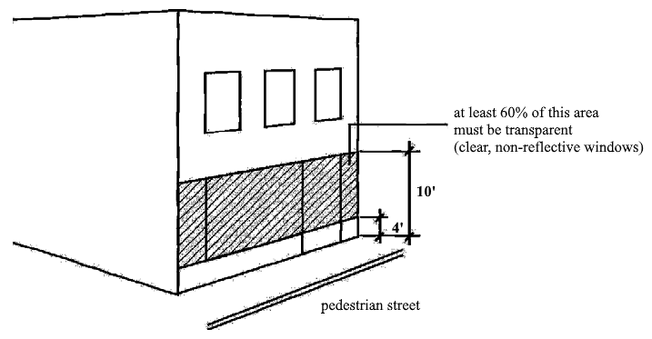
14-905-06 - Doors and entrances
14-905-06-A.
Buildings must have a primary, working entrance door facing the primary street. Entrances at building corners may be used to satisfy this requirement.
14-905-06-B.
Building entrances may include doors to individual shops or businesses, lobby entrances, entrances to pedestrian-oriented plazas or courtyard entrances to a cluster of shops or businesses.
Figure 900-6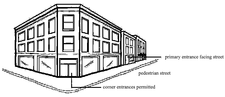
14-905-07 - Parking
14-905-07-A.
No off-street parking is required for nonresidential uses unless such uses exceed 10,000 square feet of gross floor area, in which case off-street parking must be provided for the floor area in excess of 10,000 square feet. (See Article 14-501 for off-street parking ratios)
14-905-07-B.
Any off-street parking that is provided must be located behind the building or within or under the building.
14-905-07-C.
When the depth of the lot is insufficient to permit required parking to the rear of the building, parking may be located to the side the side of the building, provided that it does not occupy more than 50 percent of the subject lot's primary street frontage.
14-905-08 - Driveways and vehicle access
Driveways and vehicle access, when provided, must come from an alley or secondary street if either is present.
14-905-09 - Prohibited uses/activities
The following uses and activities are prohibited:
14-905-09-A.
Drive-in or drive-through facilities;
14-905-09-B.
Gasoline and fuel stations;
14-905-09-C.
Vehicle sales and service uses that involve servicing of automobiles, trucks or larger motor vehicles or that involve any outdoor storage or display; and
14-905-09-D.
Residential storage warehouses.
14-906-01 - Purpose
The /CD, Conservation Overlay District is intended to:
14-906-01-A.
Recognize and protect the physical character of neighborhoods that exhibit unique development and building patterns;
14-906-01-B.
Encourage neighborhood investment in the form of construction and development that conforms to the size, orientation, and setting of existing buildings in the neighborhood;
14-906-01-C.
Foster development and redevelopment that is compatible with the scale and physical character of original buildings in the neighborhood through the use of development/design standards and guidelines;
14-906-01-D.
Ensure a stabilized tax base; and,
14-906-01-E.
To promote natural and cultural assets.
14-906-02 - Criteria for designation of conservation districts
The Heritage Commission shall, upon such investigation as it deems necessary, make a determination as to whether a group of contiguous buildings or structures, landscape elements, or any integrated combination thereof meet one or more of the following criteria:
14-906-02-A.
Was developed at least 50 years ago and retains distinctive architectural and historical characteristics that are worthy of conservation, but which has less historical, architectural or cultural significance than a Historic District;
14-906-02-B.
Has a recognized neighborhood identity and character by virtue that it possesses unifying distinctive elements of either exterior features or by environmental characteristics that create an identifiable setting, character, or association;
14-906-02-C.
Has a relationship to an identifiable urban or neighborhood center or historic area where preservation of this relationship is determined to be critical to the protection of such center or historic area;
14-906-02-D.
Owing to its unique location or singular physical characteristics, represents an established and familiar visual feature or development pattern of the neighborhood, community or City.
14-906-03 - Effect
The /CD is an overlay zoning classification that establishes additional restrictions and standards on buildings and structures permitted by the underlying zoning district. In the event of conflict between the overlay zoning district regulations and the regulations of the underlying zoning district, the overlay zoning regulations govern. In all other cases, both the overlay zoning and underlying zoning regulations apply.
14-906-04 - Uses
The use regulations of the underlying zoning district govern. The /CD overlay does not impose any additional use restrictions.
14-906-05 - Development/design standards
In establishing a /CD overlay, the Heritage Commission is authorized to propose and the City Council is authorized to adopt, district-specific development and design standards to guide development and redevelopment within the subject /CD district. When development and design standards have been approved, each application for new construction or alteration of an existing building within the designated /CD must comply with those standards. When there are conflicts between the standards of the underlying base zoning district and adopted /CD district design/development standards, the /CD design/development standards will govern.
14-906-06 - Establishment of district
/CD zoning districts are established in accordance with the rezoning procedures of Article 14-701, except as modified by the following provisions.
14-906-06-A.
An application to establish a /CD district may be initiated by the Heritage Commission, owner of record, or the City Council.
14-906-06-B.
Applications may also be initiated by petition when signed by at least 51 percent of the property owners within the proposed district.
14-906-06-C.
The Heritage Commission must submit a written recommendation to the City Council regarding the creation of /CD districts.
14-906-06-D.
The Heritage Commission is responsible for reviewing /CD zoning applications for compliance with the selection criteria of Section 14-906-02 and for recommending development/design standards and guidelines for the district.
14-906-06-E.
The City Council is responsible for making a final decision to approve or deny the /CD zoning district and the applicable standards and guidelines for the district.
14-906-07 - Nomination for designation of conservation districts
Property owners within a proposed district may request initiation by the Heritage Commission or City Council for consideration of a historic or conservation district nomination. Nomination of a potential historic or conservation district may also be initiated by the Heritage Commission or the City Council.
Nominations for designation of historic or conservation districts shall be made to the Heritage Commission and may be submitted by a member of the Heritage Commission, owner of record of the nominated property, or the City Council, or any other person or organization with the consent of the owners of at least 51 percent of the affected parcels in the proposed district, exclusive of all publicly owned property, streets and alleys. Rescission of any signature on the petition to designate a property within a district must be submitted in writing to the Historic Preservation Division in the Community Development Department no later than 15 days prior to the public meeting of the Heritage Commission. Any request for rescission after that date will be considered invalid and the signature of consent will remain.
Once a district is nominated for designation, at least two public meetings shall be held for information gathering and discussion. Upon determination to proceed with the district nomination, a designation report shall be prepared and submitted for review during a public hearing by the Heritage Commission. All affected property owners within a proposed historic or conservation districts shall be initially notified of this meeting for consideration of the potential designation via regular mail. All further notification of public hearings shall be posted at City Hall.
(Ord. No. 19506, § 1, 12-4-2023)
14-906-08 - Procedure
Upon receipt of an application for /CD zoning or upon initiation of a /CD zoning application by the City Council or Heritage Commission, the following procedures apply:
14-906-08-A.
Unless otherwise expressly stated, the rezoning procedures of Article 14-700 apply.
14-906-08-B.
A recommendation must be made by the Heritage Commission to the City Council concerning all /CD zoning applications.
14-906-08-C.
Public hearings on /CD zoning applications must be held by the City Council.
14-906-08-D.
The Heritage Commission must adopt, by resolution, a recommendation that /CD district zoning be approved or denied. The Heritage Commission's recommendation must be in the form of a resolution and be submitted to the City Council. The resolution must be accompanied by a staff report and all other related supporting documentation.
1.
An explanation of the how the area meets the selection criteria contained in Section 14-906-02;
2.
A map showing the recommended boundaries of the /CD district.
14-906-08-E.
Following the public hearing by the Heritage Commission, the City Council shall hold a new evidence only public hearing as provided in Section 14-700 of the City Code.
(Ord. No. 19506, § 1, 12-4-2023)
14-906-09 - Interim control
No building permit shall be issued by the Building Department for alteration, construction, demolition or removal of a nominated landmark or of any property or structure within a nominated Historic District or Conservation District from the date of the meeting of the Heritage Commission at which a nomination form is first presented until the final disposition of the nomination through a negative recommendation by the Heritage Commission or by the vote of the City Council. During this period the City Council may authorize such alteration, construction, demolition or removal when it adopts a formal resolution declaring that the proposed work is necessary for public health, welfare or safety. During this period the applicant for the permit shall have the opportunity to explain to the City Council the reasons why the permit should be issued promptly. In no event shall the delay be for more than 180 days.
(Ord. No. 19506, § 1, 12-4-2023)
14-907-01 - Purpose
The /HD, Historic Overlay district is intended to help with the protection, enhancement, and perpetuation of places, districts, sites, buildings, structures, and other features having a special historical, architectural, cultural or aesthetic interest or value. The /HD Overlay district is further intended to:
14-907-01-A.
stimulate revitalization and preservation of the residential, civic and business areas;
14-907-01-B.
promote economic progress through heritage tourism;
14-907-01-C.
provide for the designation, protection, preservation, rehabilitation, and restoration of historic districts and properties; and
14-907-01-D.
facilitate the City's efforts to participate in federal or state historic preservation programs.
14-907-02 - Effect
The /HD is an overlay zoning classification that establishes additional restrictions and standards on those uses permitted by the underlying zoning district. In the event of conflict between the overlay zoning district regulations and the regulations of the underlying zoning district, the overlay zoning regulations govern. In all other cases, both the overlay zoning and underlying zoning regulations apply.
14-907-03 - Uses
The use regulations of the underlying zoning district govern. The /HD district does not impose any additional use restrictions.
14-907-04 - Development/design standards
In establishing an /HD district, the Heritage Commission is authorized to propose and the City Council is authorized to adopt, district-specific development and design standards to guide development and redevelopment within the subject /HD district. When development and design standards have been approved, each application for new construction or alteration of an existing building within the designated /HD must comply with those standards. When there are conflicts between the standards of the underlying base zoning district and adopted /HD district design/development standards, the /HD design/development standards will govern.
(Ord. No. 19506, § 2, 12-4-2023)
14-907-05 - Nomination for designation of historic districts
Nominations for designation of historic districts shall be made to the Heritage Commission and may be submitted by a member of the Heritage Commission, owner of record of the nominated property, or the City Council, or any other person or organization with the consent of the owners of at least 51 percent of the affected parcels in the proposed district, exclusive of all publicly owned property, streets and alleys. Rescission of any signature on the petition to designate a property within a district must be submitted in writing to the Historic Preservation Division in the Community Development Department no later than 15 days prior to the public meeting of the Heritage Commission. Any request for rescission after that date will be considered invalid and the signature of consent will remain.
Once a district is nominated for designation, at least two public meetings shall be held by the City staff for information gathering and discussion. Upon determination to proceed with the district nomination, a designation report shall be prepared and submitted for review during a public hearing by the Heritage Commission.
All affected property owners within proposed historic districts shall be initially notified by City staff of this meeting for consideration of the potential designation via regular mail. The mailed notice shall include the date, time and place of the Heritage Commission meeting and a general description of the request. All further notification of public hearings shall be posted at City Hall.
(Ord. No. 19506, § 2, 12-4-2023)
14-907-06 - Criteria for designation of historic districts
The Heritage Commission shall be guided in its deliberations on or about designation of historic properties by the National Register Criteria for Evaluation (36 CFR Part 60). The criteria set forth to establish historically designated properties shall be made available to the public upon request. The Heritage Commission shall upon such investigation as it deems necessary, make a determination as to whether a nominated property, building, structure or area possesses integrity of location, design, setting, materials, workmanship, feeling, and association and:
14-907-06-A.
Is associated with events that have made a significant contribution to the broad patterns of the City's history; or,
14-907-06-B.
Is associated with the lives of persons significant in the City's past;
14-907-06-C.
Embodies the distinctive characteristics of a type, period, or method of construction, use of indigenous materials, or represents the work of a master, or possesses high artistic values, or represents a significant and distinguishable entity whose components may lack individual distinction;
14-907-06-D.
Have yielded, or may be likely to yield, information important in prehistory or history;
14-907-06-E.
Displays character, interest, or value as part of the development, heritage, or cultural characteristics of the community, county, region, state, or nation;
14-907-06-F.
The location as a site is significant to the local, county, region, state, or national event;
14-907-06-G.
Identification with a person(s), family, or group who significantly contributed to the development of the community, county, region, state, or nation;
14-907-06-H.
Is identified as the work of a master builder, designer, architect, or landscape architect whose individual work has influenced the development of the community, county, region, state, or nation;
14-907-06-I.
Embodies elements of design, detailing, materials, or craftsmanship which renders it architecturally significant;
14-907-06-J.
Embodies design elements that make it structurally or architecturally innovative or unique;
14-907-06-K.
Its unique location or singular physical characteristics makes it an established or familiar visual feature;
14-907-06-L.
Its character displays a particularly fine or unique example of a utilitarian building or structure, including, but not limited to, farmhouses, barns, retaining walls, gas stations or other commercial buildings, with a high level of integrity or architectural significance;
14-907-06-M.
Is associated with a cemetery with local, regional, state or nationwide significance or displays an exceptional craftsmanship, unique material(s), location, and/or site improvements such as retaining walls or topographical features; and/or,
14-907-06-N.
Is listed on the National Register of Historic Places.
14-907-07 - Report and recommendation of Heritage Commission
14-907-07-A.
Generally. The Heritage Commission shall, within 60 days from the receipt of a completed nomination in proper form as determined by the Historic Preservation Manager, hold a public hearing on the proposal. Public notice of the hearing shall be given, including posting on the property or within the proposed district. Written notice shall be given to the owners of property under consideration for designation, as outlined below. Written notice under this article shall be considered sufficient when it is mailed to the owner of record. The Heritage Commission shall adopt, by resolution, a recommendation that the nominated district does or does not meet the criteria for designation. The resolution shall be accompanied by supporting documentation, including, but not limited to, a staff report and designation report.
If the recommendation for historic designation is approved, it shall be an amendment to the zoning district map which creates a designation using the boundaries as proposed in the staff report. The designation shall be /HD for Historic Districts.
14-907-07-B.
Notification. The Preservation Division shall mail notices prior to the public hearing. The mailed notices shall be sent to all owners of record of the affected property and include the date, time and place of the public hearing and a general description of the request.
(Ord. No. 19506, § 2, 12-4-2023)
14-907-08 - Notification of determination by Heritage Commission
Notice of the determination by the Heritage Commission, including a copy of all supporting documentation shall be sent to the owners of record and to the nominator within seven calendar days following a determination of the Heritage Commission as to whether or not the nominated property meets the criteria for designation. Regarding designation of a historic district, a copy of the documentation shall also be made available to the owners of all property within a nominated Historic District upon request.
14-907-09 - Reserved
Editor's note— Ord. No. 19506, § 2, adopted Dec. 4, 2023, repealed § 14-907-09, which pertained to action by Planning Commission and derived from the 2020 Code.
14-907-10 - Action by City Council
The City Council shall act after receiving the recommendation of the Heritage Commission that the nominated Historic District be designated and that the zoning district map be amended. The City Council shall hold a new evidence only public hearing as provided in Section 14-700 of the City Code. The Designation Ordinance shall include a legal description of the boundaries of the proposed district, information on the significance of the property or properties, a statement of significance for the designation, and information about any specific features being protected. The establishment of the overlay district shall not affect other zoning rules and regulations for the property which remain in full force and effect. The Council may approve or disapprove the proposed ordinance and the amendment to the zoning district map.
After the decision of the Council, the City Clerk shall provide written notification of the action of the City Council to the nominator and the owner(s) of record of the nominated property. The notice shall include a copy of the designation ordinance and the zoning map amendment passed by the City Council and shall be sent within 15 calendar days of the City Council action. In the case of a denial by the City Council, a nomination for designation may not be resubmitted for one calendar year from the date of denial.
(Ord. No. 19506, § 2, 12-4-2023)
14-907-11 - Amendment or rescission of designation
Designation may be amended or rescinded upon petition to the Heritage Commission and compliance with the same procedure and according to the same criteria set forth herein for designation.
When an amendment is proposed to expand an existing designation, only the consent of the property owners in the proposed expansion area will be considered for the amendment. The process for expansion of a designation shall follow the procedures of a new designation as stated in Section 14-907.
Failure to be designated by the City Council for listing in the Local Register of Historic Places is not necessarily a finding that the property or district proposed for such designation is lacking in any historical, cultural, or architectural significance.
14-907-12 - Certificate of appropriateness
A certificate of appropriateness issued by the Historic Preservation Manager or the Heritage Commission shall be required before the following activities are permitted:
14-907-12-A.
Issuance of any demolition permit;
14-907-12-B.
Issuance of a special use permit to determine effect of use on any landmark or property located within a Historic District;
14-907-12-C.
Actions affecting the exterior architectural appearance of a building, structure, or object or any landscape features, including walls, brick streets, and curbs that were defined in the ordinance designating any landmark or property within a Historic District including:
1.
Any construction or alteration, in whole or in part, which requires a permit from the City.
2.
Construction, alteration, or demolition, in whole or in part, not requiring a permit, but affecting an exterior architectural feature(s), that is defined in the ordinance designating the landmark or Historic District and as stated in the Certificate of Appropriateness Approval Matrix, as amended from time to time. Such matrix is available on the City's website or from the Historic Preservation Division.
3.
Any construction, alteration, or demolition in whole or in part proposed by the City of Independence or any of its agencies or departments, for a landmark or a building or structure located within a Historic District and which affects a significant exterior architectural feature(s) that is defined in the designating ordinance or which would require a building permit if undertaken on privately-owned property.
4.
Any public improvements and land acquisition projects by the City of Independence or any of its agencies or departments within 300 feet of any landmark, Historic District or Conservation District boundary.
14-907-12-D.
Relocation of a building or structure effecting any landmark or property within a Historic District. Actions shall include removal, re-orientation, or re-positioning of a building or structure from a site and the placement of a building or structure on a site.
14-907-12-E.
The erection or placement of any permanent sign on an individually designated site or within a designated historic district.
14-907-12-F.
Removal of existing front yard trees on an individually designated site or within a designated historic district.
14-907-13 - Applications for certificates of appropriateness
14-907-13-A.
Application for a certificate of appropriateness shall be made on a form available in the office of the Community Development Department. Such form may require submittal of plans, drawings, elevations, specifications, materials, and photographs of the property and adjacent properties. Applications for certificates of appropriateness that are not eligible for administrative review and applications for certificates of appropriateness that are appealed to the Heritage Commission must be accompanied by a filing fee as required by the City schedule of fees and charges, as amended. An application for a certificate of appropriateness shall not be considered complete until the information requested on the application form has been submitted and been reviewed and approved for sufficiency by the Historic Preservation Manager. No certificate of appropriateness shall be issued until approved by the Historic Preservation Manager or the Heritage Commission.
14-907-13-B.
Applicants are encouraged to request a pre-application meeting with the Historic Preservation staff prior to submittal of a certificate of appropriateness application. The following shall apply in accordance with the application review process:
1.
Approvals or denials of applications can only be obtained by an official Commission action.
2.
An applicant may request reconsideration of an application upon presentation of new evidence within 30 days of written receipt of the denial in writing. No additional fee will be required to submit new evidence or to appeal the finding to the City Council.
3.
In all cases the Commission has the following options:
(a)
Approve the application based on the facts presented;
(b)
Approve the application with conditions;
(c)
Deny the application based on the facts presented; or,
(d)
Continue the case to the next regular or special meeting.
If the application is continued to another meeting and the applicant fails to appear at the second meeting when the item is called and held over to the end of the agenda and called again, and the applicant has not requested a continuance, then the application shall be considered to be withdrawn.
4.
Request for approval of any project subject to the control of the Commission shall contain ten copies to include, but is not limited to, the following information:
(a)
Site plan;
(b)
Survey;
(c)
Color rendering;
(d)
Photos;
(e)
Elevations; and,
(f)
Any additional information that may be necessary for the Commission to make an informed decision as determined by City staff.
5.
Certificate of Appropriateness applications shall contain signatures by the property owner that are not over one year old. Changes to the applications and/or attached petitions must be submitted no later than 20 calendar days prior to the public hearing.
6.
Requirements for review of proposed modifications are listed on the Certificate of Appropriateness Approval Matrix as adopted by the Heritage Commission and revised by the Commission from time to time. Any modification eligible for administrative review and denied by staff may be appealed to the Heritage Commission and must be heard within 30 days of the issuance of administrative denial in writing.
14-907-14 - Determination by the Heritage Commission
14-907-14-A.
After giving notice to the applicant and Public Notice, the Heritage Commission shall hold a public hearing on each application within 30 calendar days of the filing of a complete application as determined by the Historic Preservation Manager. The Heritage Commission shall utilize both the City's Historic Preservation Design Guidelines, as adopted and amended by approval of the Heritage Commission, as well as the Secretary of Interior's Standards as a basis for their determination. The Commission shall approve, approve with modifications, disapprove, or continue each application within 45 calendar days of the filing of a complete application, and Preservation Staff shall provide written notification of its decision including conditions associated with the decision to the applicant within seven calendar days after determination.
14-907-14-B.
The certificate of appropriateness shall become void unless work commences within six months of the date of issuance and is completed within 18 months of the date of issuance, or unless a request for an extension has been approved by the issuing authority. Extensions may be granted due to adverse weather or other circumstances delaying the work.
14-907-14-C.
In the case of a denial of a certificate of appropriateness, the Commission may grant a rehearing of an application. The request for re-hearing must include new evidence to be introduced for consideration and must be submitted to the Commission within 30 calendar days of the date of notification of the Commission's original determination. Only one application for a rehearing may be made in any case. Any rehearing will require the presence of the applicant, property owner, or authorized agent.
14-907-15 - Standards for review for issuing certificates of appropriateness
14-907-15-A.
In considering an application for a certificate of appropriateness for properties which have been designated as architecturally/historically significant landmarks, or which have been designated as significant or contributing properties in Historic Districts, the following guidelines based on the Secretary of the Interior's Standards for Rehabilitation (36 CFR Part 68) shall be followed. The Commission shall also use any specific design guidelines that it has adopted and shall further consider architectural style, design, integrity, relationship to the architect/builder, orientation, scale, massing, context, texture, profile, age, association, materials and color of materials.
1.
Every reasonable effort shall be made to provide a compatible use for a property which requires minimal alteration of the building, structure or site and its environment or to use a property for its originally intended purpose.
2.
The distinguishing original qualities or character of a building, structure or site and its environment shall not be destroyed. The removal or alteration of any historic material or distinctive architectural features should be avoided when possible. Distinctive stylistic features, historic material or examples of skilled craftsmanship original to the quality or character of a building or structure shall be retained or, when necessary replicated in-kind.
3.
All buildings, structures and sites shall be recognized as products in their own time. Alterations that have no historical basis, such as the addition of conjectural features, and which seek to create an earlier or alternate appearance are not acceptable. Changes which may have taken place in the course of time and have become historic in their own right based upon age or significance and represent evidence of the history and development of a building, structure or site and its environment shall be retained. Alterations which seek to create a false sense of history or development shall be avoided.
4.
Whenever possible, new additions or alterations to structures shall be done in such a manner that if such additions or alterations were to be removed in the future, the essential form and integrity of the building or structure would be unimpaired.
5.
Every reasonable effort shall be made to protect and preserve archaeological resources effected by, or adjacent to any project.
14-907-16 - Standards for review for issuing certificates of appropriateness for demolition
Demolition of designated landmarks or property within designated historic or conservation districts, in whole or in part, is not permitted. Exceptions are allowed only if a building or structure has been damaged by natural disaster, fire, or structural deterioration, if there is reasonable proof that would not be economically or physically feasible to rehabilitate. Alternate exceptions include the loss of a building or structure's integrity, craftsmanship, and age to merit preservation as determined on a case by case basis by the Heritage Commission.
The Commission may grant a certificate of appropriateness for demolition which may provide for a delayed effective date for up to six months from the date of the Commission's action. The effective date of the certificate will be determined by the Commission based on the relative significance of the building or structure and the probable time required to arrange a possible alternative to demolition. In general, the Commission may delay the demolition of a designated contributing historic building(s) or structure(s) for up to six months.
During the demolition delay period, the Commission may take such steps as it deems necessary to preserve the building(s) or structure(s) concerned. Such steps may include, but are not limited to, consultation with community groups, public agencies, and interested citizens, recommendations for acquisition of property by public or private bodies or agencies, and exploration of the possibility of relocating one or more of the building(s) or structure(s) or other features.
14-907-16-A.
In considering applications for a certificate of appropriateness for demolition the Heritage Commission shall determine and consider:
1.
The property's significance and integrity;
2.
The integrity of the streetscape and surrounding neighborhood;
3.
The grounds for the proposed demolition and data supporting said reason, including but not limited to, a structural stability report prepared by a licensed professional engineer, written justification, and a site plan and elevations for proposed infill, if applicable.
4.
Whether every reasonable effort has been made to rehabilitate, reuse, or relocate the property; and,
5.
The proposed reuse of the parcel and compatibility of proposed infill. Any applicant seeking permission to demolish a historic building or structure shall submit evidence that the site will be used for a new structure or building and will not be left vacant unless the site will be incorporated into development of adjoining contributing property.
6.
Whether the property has sustained damage by a natural or man-made disaster and whether or not the building sustained irreparable structural damage;
7.
Whether the property has been declared substandard or a dangerous building by the Building Official;
8.
Whether the property owner made a reasonable effort to preserve the building through rehabilitation, leasing for rehabilitation, sale, or relocation of the building for rehabilitation;
9.
Whether provisions have been made by the owner for architectural salvage of significant features to be retained or offered to interested individuals or groups?
10.
Whether every effort has been made to incorporate the building into the redevelopment proposals, if applicable or whether an attempt was made to relocate the building or structure to another site for rehabilitation;
11.
Whether retention and rehabilitation of the building represent an economic hardship to the owner; and,
12.
Whether the property owner has been cited for previous code violations including demolition by neglect.
13.
Whether the demolition has a detrimental impact upon the historical, architectural, cultural, or economic character of the district or community in general.
14-907-16-B.
In considering an application for a certificate of appropriateness for properties which have been designated as part of Conservation Districts or have been classified as "non-contributing" properties in a Historic District, the Heritage Commission shall use the following guidelines:
1.
New construction or additions to buildings shall be to a height roughly equal to the average height of existing buildings on the streetscape. New construction that greatly varies in height from other buildings in the immediate vicinity shall be considered inappropriate.
2.
The scale, massing, and orientation of proposed buildings or additions to existing buildings shall be compatible with older buildings in the immediate vicinity.
3.
The emphasis on horizontality or verticality shall be compatible with the character of buildings in the immediate area.
4.
New construction or alterations must follow the existing setback pattern for residential dwellings or structures and shall maintain the same entry height as neighboring buildings.
5.
The sense of entry of primary entrance locations shall be compatible with existing patterns in the streetscape.
6.
Roof forms of new buildings and alterations should duplicate the existing or traditional roof shapes, pitches and materials found in the area.
14-907-16-C.
In considering an application for a certificate of appropriateness for relocation, the Heritage Commission shall consider the following:
1.
When a building or structure is to be moved from a landmark site or a Historic District or Conservation District, the factors to be considered shall include: the possibility that the building or structure may be demolished in its present location, the contribution that the building or structure makes in its present location and the effect of the new location on the historical and architectural qualities of the building or structure.
2.
When an application is made for moving a building or structure to a landmark site or a Historic District or Conservation District, the factors to be considered shall include the architectural and historical integrity and craftsmanship of the building or structure, the impact on the site and area to which the building or structure will be moved, and the possibility that the building or structure may be demolished in its present location.
3.
For all applications, the Heritage Commission shall evaluate the evidence submitted on the feasibility of successfully moving the building or structure.
14-907-17 - Certificate of economic hardship
14-907-17-A.
If a certificate of appropriateness is denied, the applicant may submit an application for a Certificate of Economic Hardship on a form prepared by City staff. Said application shall be filed within 15 calendar days from the date of denial by the Heritage Commission. The Heritage Commission shall schedule a public hearing within 30 calendar days after receiving a completed application as determined by the Historic Preservation Manager and shall provide public notice in the same manner as outlined in this article. Any person may testify at the hearing concerning economic hardship.
14-907-17-B.
The Heritage Commission may solicit expert testimony, and it shall require that the applicant for a certificate of economic hardship make submissions justifying the application to include any or all of the following information before the Commission makes a determination on the application:
1.
Estimate of the cost of the proposed construction, alteration, demolition, or removal and an estimate of any additional costs that would be incurred to comply with the recommendations of the Heritage Commission for changes necessary for the issuance of a certificate of appropriateness;
2.
A report from a licensed engineer or architect with experience in rehabilitation as to the structural soundness of any buildings or structures on the property and their suitability for rehabilitation;
3.
Estimated market value of the property in its current condition; after completion of the proposed construction, alteration, demolition, or removal; after any changes recommended by the Heritage Commission; and, in the case of a proposed demolition, after renovation of the existing property for continued use;
4.
In the case of a proposed demolition, an estimate from a licensed architect or contractor, appraiser, or other real estate professional experienced in rehabilitation as to the economic feasibility of rehabilitation or reuse of the existing building or structure on the property;
5.
Amount paid for the property, the date of purchase, and the party from whom purchased, including a description of the relationship, if any, between the owner of record or applicant and the person from whom the property was purchased, and any terms of financing between the seller and buyer;
6.
If the property is income-producing, the annual gross income from the property for the previous two years, itemized operating and maintenance expenses, and depreciation for the previous two years; and annual cash flow before and after debt service, if any, during the same period;
7.
All appraisals obtained within the previous two years by the owner or applicant in connection with the purchase, financing, or ownership of the property;
8.
Any listing of the property for sale or rent, price asked and offers received, if any, within the previous two years;
9.
Assessed value of the property according to the two most recent assessments;
10.
Real estate taxes for the previous two years;
11.
Form of ownership or operation of the property, whether sole proprietorship, for-profit or not-for-profit corporation, limited partnership, joint venture, or other;
12.
Information about plans prepared for the property, if a building or structure is demolished, including material on the timing and financing of the new construction; and,
13.
Any other information considered necessary by the Heritage Commission to make a determination as to whether the property does yield or may yield a reasonable economic return to the owner.
14.
Documentation that all financial incentives for historic preservation have been explored prior to the submission of an application for economic hardship.
14-907-18 - Determination of economic hardship
The Heritage Commission shall review all the evidence and information required of an applicant on a case-by-case basis for a certificate of economic hardship and other evidence submitted to be part of the record.
The Heritage Commission shall make a determination, within 45 calendar days of receipt of the completed application, whether the denial of a certificate of appropriateness has deprived, or will deprive, the owner of the property of reasonable use of, or a reasonable economic return on the property.
If the Heritage Commission makes a finding of economic hardship; it shall grant a certificate of economic hardship and give its approval for the work as proposed by the applicant. This approval from the Commission shall not relieve the applicant from complying with the requirements of other City ordinances and regulations.
If the Commission does not make a finding of economic hardship, it shall disapprove the application, and the applicant shall not receive a certificate of appropriateness for the work requested. Written notice of determinations under this section shall be provided in the same manner as required by Section 14-907-13.
In making a determination of economic hardship, the Commission shall consider evidence showing that the owner or applicant failed to maintain or protect the property, or performed or permitted any acts to the detriment of the property and this evidence may be used as basis to reject allegations of economic hardship.
14-907-19 - Appeals
Owners who have been denied a certificate of appropriateness or a certificate of economic hardship for their property may appeal to the City Council. Appeals shall be filed within 15 calendar days from the date of denial of the certificate of appropriateness by the Heritage Commission, or if an application has been filed for a certificate of economic hardship, the appeal shall be filed within 15 calendar days from the date of denial of the certificate of economic hardship, which shall include an appeal of the denial of the certificate of appropriateness. The City Council shall act within 30 calendar days after receiving the appeal. The City Council shall hold a new evidence only public hearing as provided in Section 14-700 of the City Code. The City Council may approve or disapprove the decision of the Heritage Commission, which decision shall be based solely upon the record.
14-907-20 - Violation and penalty
Any person who knowingly carries out or causes to be carried out any work in violation of the article shall be required to restore the subject improvements, building, site, structure, or landscape feature, to its appearance prior to the violation or in accordance with a certificate of appropriateness as mandated by the Heritage Commission. The owner of a building or property where a violation of any provision of this article has been committed, or shall exist, or the lessee of an entire building, an entire property or the part of a building where such violation has been committed, or shall exist, shall be guilty of a misdemeanor punishable by a fine of not less than $10.00 and not more than $100.00 for each and every day that such violation continues. If the offense is willful, on conviction thereof, the punishment shall be a fine of not less than $100.00 nor more than $250.00 for each and every day that such violation continues.
Upon issuance of a stop work order for work initiated without first obtaining a certificate of appropriateness, the property owner shall incur a double permit fee upon submittal of a request for a building permit.
14-907-21 - Stop work orders
All work performed pursuant to a certificate of appropriateness or a certificate of economic hardship shall conform to the provision of such certificate. Whenever any work is being done contrary to the provisions of a certificate or whenever work is being done without a required certificate, the Building Official shall order the work stopped by notice in writing served on any person engaged in doing or causing such work to be done. Any such person shall forthwith stop such work until authorized by the Building Official to proceed with the work. The Building Official shall promptly notify the staff of the Heritage Commission of the action being taken.
The Historic Preservation Manager may ask the Building Official to issue a stop work order if they have reason to believe that work is not being performed pursuant to a required certificate, but the Building Official is solely responsible for making the determination in this subsection. The City may apply for an injunction to enforce its stop work order.
14-907-22 - Maintenance and repair
The owner and the tenant of a landmark or a property in a Historic District or a Conservation District shall keep in good repair: (1) All of the exterior portions of such building or structure; and (2) All interior portions thereof which, if not so maintained, may cause such building or structure to deteriorate, or to become damaged or otherwise to fall into a state of disrepair. The purpose of this provision is to prevent a person from forcing the demolition of a building or structure by neglecting it and by permitting damage to it through weather or vandalism.
Ordinary maintenance and repairs may be undertaken without a certificate of appropriateness provided this work does not change the exterior appearance of the landmark or the building or structure in any Historic District or a Conservation District.
In any case where the Building Official determines that there are emergency conditions dangerous to life, health or property affecting a landmark or a property in a Historic District or a Conservation District, the Building Official may order the repair of these conditions without the approval of the Heritage Commission. The Building Official shall promptly notify the staff of the Heritage Commission of the action being taken.
The provisions of this section shall be in addition to all other provisions of State and City ordinance laws, and regulations requiring buildings or structures to be kept in good repair.
14-907-23 - Demolition by neglect
14-907-23-A.
The Code Compliance Division of the City of Independence Health Department shall keep a record of all building maintenance code violations addressed as properties identified as a historic landmark or which is located within a Historic or Conservation District. A listing of these records will be provided to the Historic Preservation Manager on a weekly basis. Additionally, Code Compliance will notify the Historic Preservation Manager of designated properties that display signs of demolition by neglect or of any repairs that appear to have been initiated without a certificate of appropriateness (COA).
14-907-23-B.
The Historic Preservation Manager will determine whether there is a need for a COA to correct violations identified by Code Compliance. The Historic Preservation Manager will institute the appropriate approval process and conduct the steps that may be necessary to mitigate any work that was not completed according to the Secretary of the Interior's Standards. The Historic Preservation Manager shall ensure that all work initiated without a COA will be reviewed administratively or by the Heritage Commission and that the project shall not proceed until such time as the work has received approval and is completed according to any conditions imposed on the approval. The Code Compliance Division will be notified of these additional requirements and provide the property owners with appropriate timeframes to correct the violations.
14-907-23-C.
Any person who knowingly carries out or causes to be carried out any work in violation of the article shall be required to restore the subject improvements, building, site, structure, or landscape feature, to its appearance prior to the violation or in accordance with a certificate of appropriateness as mandated by the Heritage Commission. he owner of a building or property where a violation of any provision of this article has been committed, or shall exist, or the lessee of an entire building, an entire property or the part of a building where such violation has been committed, or shall exist, shall be guilty of a misdemeanor punishable by a fine of not less than $10.00 and not more than $100.00 for each and every day that such violation continues. If the offense is willful, on conviction thereof, the punishment shall be a fine of not less than $100.00 nor more than $250.00 for each and every day that such violation continues.
(Ord. No. 17713)
14-907-24 - Continuation of prior designations and decisions
All existing designations of historic property by the Heritage Commission and all decisions of the Heritage Commission that were made before the adoption of this article pursuant to prior legislation shall remain in full force and effect, unless acted upon under the provisions of this article.
14-907-25 - Development standards for new construction/addition (or improvements) in conjunction with a CoA
14-907-25-A.
For the purpose of this section, exterior architectural features will include, but are not limited to, the following:
1.
The architectural style, scale, general design, and general arrangement of the building's exterior;
2.
The type and texture of building material; and
3.
The type and style of all roofs, windows, doors, and signs.
4.
The following shall only be moved, reconstructed, altered, or maintained, in accordance with this chapter, in a manner that will preserve the historical and architectural character of the building, structure, site or district:
(a)
Buildings, structures, and appurtenances.
(b)
"Appurtenances" include, but are not limited to, stone walls, fences, light fixtures, steps, paving, sidewalks, and signs.
5.
In considering proposals for alterations to the exterior of historic buildings and structures and in applying development and preservation standards, the documented, original design of the building will be considered, among other factors.
6.
A historic site, or building, structure, site, improvement, or appurtenance within a historic district shall be altered, restored, preserved, repaired, relocated, demolished, or otherwise changed in accordance with the Secretary of the Interior's Standards for Rehabilitation, as amended from time to time.
7.
Relocation of historic buildings and structures to other sites shall not take place unless it is shown that their preservation on their existing or original sites is not consistent with the purposes of this section or would cause undue economic hardship to the property owner.
8.
Demolition of historic sites, archaeological sites, or buildings, structures, improvements, and appurtenances within historic districts or are individually listed will be regulated by review of the Heritage Commission.
9.
The construction of new buildings or structures, or the relocation, alteration, reconstruction, or major repair or maintenance of a non-contributing building or structure within a designated historic district shall meet the same compatibility standards as any material change in the exterior appearance of any existing non-contributing building, structure, or appurtenance in a designated historic district. It shall be generally compatible with the form, proportion, mass, configuration, building material, texture, and location of historic buildings, structures, or sites adjoining or reasonably approximate to the non-contributing building, structure, or site.
10.
All improvements to buildings, structures, and appurtenances within a designated historic district shall be visually compatible. Visual compatibility shall be complimentary in comparison or relation to the height of existing structures and buildings.
(a)
Height: The height of proposed buildings or modifications shall be visually compatible in comparison or relation to the height of existing structures and buildings.
(b)
Front Facade Proportion: The front facade of each building or structure shall be visually compatible with and in direct relationship to the width of the building and to the height of the front elevation of other adjacent or adjoining buildings within a historic district.
(c)
Proportion of Openings (Windows and Doors): The openings of any building within a historic district shall be visually compatible with the openings exemplified by the prevailing historic architectural styles within the district. The relationship of the width of windows and doors to the height of windows and doors among buildings within the district shall be visually compatible.
(d)
Rhythm of Solids to Voids; Front Facades: The relationship of solids to voids in the front facade of a building or structure will be visually compatible with the front facades of historic buildings or structures within the district.
(e)
Rhythm of Buildings on Streets: The relationship of buildings to open space between them and adjoining buildings shall be visually compatible with the relationship between historic sites, buildings, or structures within a historic district.
(f)
Rhythm of Entrance and/or Porch Projections: The relationship of entrances and porch projections to the sidewalks of a building shall be visually compatible with the prevalent architectural styles of entrances and porch projections on historic sites, buildings, and structures within a historic district.
(g)
Relationship of Materials and Texture: The relationship of materials and texture of the facade of a building shall be visually compatible with the predominant materials used in the historic sites, buildings, and structures within a historic district.
(h)
Roof Shapes: The roof shape of a building or structure shall be visually compatible with the predominant materials used in the historic sites, buildings, and structures within a historic district.
(i)
Scale of a Building: The size of a building, the building mass in relation to open spaces, windows, door openings, balconies, and porches shall be visually compatible with the building size and building mass of historic sites, buildings, and structures within a historic district.
(j)
Orientation: A building shall be visually compatible with the buildings, structures, and sites in its directional character, whether vertical, horizontal, or non-directional.
11.
Visual compatibility standards will be further discussed in greater detail in the Truman Heritage Design Guidelines. Said manual was developed as a guide to assist property owners as they seek to nominate their properties for designation as a historic landmark or to designate an area within the City as a historic district.
14-907-26 - /HD districts established
The following /HD districts are established and have design guidelines in place:
Figure 900-7
Truman Neighborhood
Historic Preservation Overlay District Boundaries
(Ord. No. 18210)
14-907-27 - Interim control
No building permit shall be issued by the Building Department for alteration, construction, demolition or removal of a nominated landmark or of any property or structure within a nominated Historic District or Conservation District from the date of the meeting of the Heritage Commission at which a nomination form is first presented until the final disposition of the nomination through a negative recommendation by the Heritage Commission or the Planning Commission or by the vote of the City Council. During this period the City Council may authorize such alteration, construction, demolition or removal when it adopts a formal resolution declaring that the proposed work is necessary for public health, welfare or safety. During this period the applicant for the permit shall have the opportunity to explain to the City Council the reasons why the permit should be issued promptly. In no event shall the delay be for more than 180 days.
14-908-01 - Nomination for designation of landmarks
Nominations for designation of landmarks (/HL) shall be made to the Heritage Commission and may be submitted with the written consent of the owner(s) of record of a subject property by a member of the Heritage Commission, owner of record of the nominated property, the City Council, or any other person or organization.
14-908-02 - Criteria for designation of landmarks properties
The Heritage Commission shall be guided in its deliberations on or about designation of historic properties by the National Register Criteria for Evaluation (36 CFR Part 60). The criteria set forth to establish historically designated properties shall be made available to the public upon request. The Heritage Commission shall upon such investigation as it deems necessary, make a determination as to whether a nominated property, building, structure or area possesses integrity of location, design, setting, materials, workmanship, feeling, and association and:
14-908-02-A.
Is associated with events that have made a significant contribution to the broad patterns of the City's history; or,
14-908-02-B.
Is associated with the lives of persons significant in the City's past;
14-908-02-C.
Embodies the distinctive characteristics of a type, period, or method of construction, use of indigenous materials, or represents the work of a master, or possesses high artistic values, or represents a significant and distinguishable entity whose components may lack individual distinction;
14-908-02-D.
Have yielded, or may be likely to yield, information important in prehistory or history;
14-908-02-E.
Displays character, interest, or value as part of the development, heritage, or cultural characteristics of the community, county, region, state, or nation;
14-908-02-F.
The location as a site is significant to the local, county, region, state, or national event;
14-908-02-G.
Identification with a person(s), family, or group who significantly contributed to the development of the community, county, region, state, or nation;
14-908-02-H.
Is identified as the work of a master builder, designer, architect, or landscape architect whose individual work has influenced the development of the community, county, region, state, or nation;
14-908-02-I.
Embodies elements of design, detailing, materials, or craftsmanship which renders it architecturally significant;
14-908-02-J.
Embodies design elements that make it structurally or architecturally innovative or unique;
14-908-02-K.
Its unique location or singular physical characteristics makes it an established or familiar visual feature;
14-908-02-L.
Its character displays as a particularly fine or unique example of a utilitarian building or structure, including, but not limited to, farmhouses, barns, retaining walls, gas stations or other commercial buildings, with a high level of integrity or architectural significance;
14-908-02-M.
Is associated with a cemetery with local, regional, state or nationwide significance or displays an exceptional craftsmanship, unique material(s), location, and/or site improvements such as retaining walls or topographical features; and/or,
14-908-02-N.
Is listed on the National Register of Historic Places.
14-908-03 - Report and recommendation of Heritage Commission
The Heritage Commission shall, within 60 days from the receipt of a completed nomination in proper form as determined by the Historic Preservation Manager, hold a public hearing on the proposal. Public notice of the hearing shall be given, including posting on the property. Written notice shall be given to the owner(s) of the property under consideration for designation. Written notice under this section shall be considered sufficient when it is mailed to the owner of record. The Heritage Commission shall adopt by resolution a recommendation that the nominated landmark does or does not meet the criteria for designation. The resolution shall be accompanied by supporting documentation, including, but not limited to, a staff report and designation report.
If the recommendation for historic designation is approved, it shall be an amendment to the zoning district map which creates a designation using the boundaries as proposed in the staff report. The designation shall be /HL for individual landmark properties.
(Ord. No. 19506, § 3, 12-4-2023)
14-908-04 - Notification of determination by Heritage Commission
Notice of the determination by the Heritage Commission, including a copy of all supporting documentation shall be sent to the owners of record of a nominated landmark and to the nominator within seven calendar days following a determination of the Heritage Commission as to whether or not the nominated property meets the criteria for designation.
14-908-05 - Reserved
Editor's note— Ord. No. 19506, § 3, adopted Dec. 4, 2023, repealed § 14-908-05, which pertained to action by Planning Commission and derived from the 2020 Code.
14-908-06 - Action by City Council.
14-908-06-A.
The City Council shall act within 60 calendar days after receiving the recommendation of the Heritage Commission that the nominated landmark property be designated and that the zoning district map be amended. The City Council shall hold a new evidence only public hearing as provided in Section 14-700 of the City Code. The designation ordinance shall include a legal description of the boundaries of the landmark, information on the significance of the property, a statement of significance for the designation, and information about any specific features being protected. The establishment of the overlay district shall not affect the other zoning rules and regulations for the property that shall remain in full force and effect. The Council may approve or disapprove the proposed ordinance and the amendment to the zoning district map.
14-908-06-B.
After the decision of the Council, the City Clerk shall provide written notification of the action of the City Council by regular mail to the nominator and the owner(s) of record of the nominated property. The notice shall include a copy of the designation ordinance and the zoning map amendment passed by the City Council and shall be sent within 15 calendar days of the City Council action. In the case of a denial by the City Council, a nomination for designation may not be resubmitted for one calendar year from the date of denial.
(Ord. No. 19506, § 3, 12-4-2023)
14-908-07 - Certificate of appropriateness for /HL properties
Refer to Sections 14-907-12 through 14-907-19 for information concerning the certificate of appropriateness process, request for consideration of economic hardship, and applicable Development Standards that apply to all individually listed Historic Landmark (/HL) properties as referenced in the list below.
14-908-08 - /HL properties established
The following /HL districts are established landmark properties:
Truman Heritage District Home and Neighborhood
Palestine Missionary Baptist Church—138 East Farmer
Owens-McCoy House—410 West Farmer
Twyman/McGuire/Harper House—803 West Waldo
Bullene Choplin House—702 North Delaware
Bryant House—519 South Main
Hughes Childers House—801 South Main
Pitcher Hinde Johnson House—627 South Liberty
Porter Chiles House—522 West Maple
Noel House—409 North Pleasant
Prewitt Wright House—611 Maple
Lobb Cemetery—2515 Lobb Cemetery Road
Vaile Mansion—1500 North Liberty
Bingham-Waggoner Estate—313 W. Pacific
Missouri Pacific/Truman Depot—1111 W. Pacific
1827 Log Courthouse—107 West Kansas
Woodlawn Cemetery—701 South Noland
Pioneer Spring Cabin Site—201 North Dodgion
Chicago & Alton Depot—318 West Pacific
Fire House #1—223 North Main
Truman Memorial Building—416 West Maple
Kirby-Kille House—9867 East Winner Road
Ginger Rogers Birthplace—100 West Moore
Woodson/Sawyer House—1604 W. Lexington
Hiram Young Community Service Center—501 Dodgion
Raasch House—9725 East Winner Road
Schowengerdt/Walker House—13407 East 35th Street S.
Silver Heart Inn—1114 South Noland Road
(Ord. No. 17713; Ord. No. 19506, § 3, 12-4-2023)
14-908-09 - Interim control
No building permit shall be issued by the Building Department for alteration, construction, demolition or removal of a nominated landmark or of any property or structure within a nominated Historic District or Conservation District from the date of the meeting of the Heritage Commission at which a nomination form is first presented until the final disposition of the nomination through a negative recommendation by the Heritage Commission or the Planning Commission or by the vote of the City Council. During this period the City Council may authorize such alteration, construction, demolition or removal when it adopts a formal resolution declaring that the proposed work is necessary for public health, welfare or safety. During this period the applicant for the permit shall have the opportunity to explain to the City Council the reasons why the permit should be issued promptly. In no event shall the delay be for more than 180 days.
14-909-01 - Purpose
The /PW, Parkway Overlay district regulations are intended to:
14-909-01-A.
Preserve open space and park-like land are deemed essential to quality of life and the general health and welfare in the City of Independence, Missouri;
14-909-01-B.
Preserve the appearance and functionality of any parkways as intended and designed;
14-909-01-C.
Promote attractive and functional residential, nonresidential and mixed-use developments that are compatible with surrounding areas;
14-909-01-D.
Adoption of appropriate limitations on land adjacent to, and in close proximity to, a parkway will enhance the public interest.
14-909-02 - Applicability
A Parkway shall be defined as a thoroughfare street or any part thereof by the City Thoroughfare Plan with at least two travel lanes in each direction generally separated by green open space as a median and characterized by features such as a wide median, sidewalks, bicycle paths, landscaping, and access restrictions. A parkway will function as an arterial street to transport traffic and shall have limited drive and intersection connections. The designation as a parkway shall only be granted by the City.
14-909-03 - Regulations
Properties along a designated parkway shall be subject to the following regulations:
14-909-03-A.
Aboveground utility locations.
14-909-03-B.
There shall be no above ground utilities within 500 feet of a Parkway right-of-way, except for perpendicular crossing of high-voltage transmission lines when necessary.
14-909-03-C.
Parking areas.
14-909-03-D.
Parking areas adjacent to a Parkway right-of-way shall be set back at least 50 feet from the edge of the Parkway right-of-way, shall be screened by buildings, plant materials and natural shaped berms, and shall utilize plantings to break up large areas of pavement.
14-909-03-E.
Uses and structures prohibited within 100 feet.
14-909-03-F.
The following uses and structures shall not be located within 100 feet of a Parkway right-of-way:
1.
Trash dumpsters;
2.
Fences or walls, except those which are determined to be architecturally and aesthetically compatible with the parkway design; and
3.
Drive-through lanes for fast-food businesses.
14-909-03-G.
The following uses and structures shall not be located within 250 feet of a Parkway right-of-way:
1.
Billboards and free-standing signs, except for ground or monument signs;
2.
Outdoor storage;
3.
Trash dumpsters other than those enclosed in masonry structures;
4.
Unscreened loading docks and loading areas, unless located on the side of a building opposite the parkway;
5.
Buildings not having the similar architectural treatment on all four sides.
14-909-03-H.
Prohibited Businesses within 250 Feet. The following businesses shall not be located within 250 feet of a Parkway right-of-way:
1.
Self or mini-storage;
2.
New or used car dealerships;
3.
Vehicle repair including but not limited to engine repair and body shops;
4.
Service (gasoline) stations;
5.
Convenience stores;
6.
Pawn shops and short term loan service businesses;
7.
Businesses holding licenses as retailer of intoxicating liquor, non-intoxicating beer, malt liquor or light wine in the original package or by the drink;
8.
Adult businesses; or
9.
Gambling establishments, including those licensed by the State of Missouri.
14-910-01 - Purpose
The ARTS district is a special purpose zoning classification that is intended to encourage the preservation and enhancement of arts-related uses. The district is also intended to preserve and enhance the area as a center for a variety of retail, business services, housing and office uses and to promote a strong pedestrian character and scale throughout the district through the use of consistent sidewalks, landscaping and business signage. Utilizing the existing scale of structures, new structures and buildings will provide the opportunity to create a focus for revitalization and promotion of the cultural and artistic environment.
14-910-02 - Applicability
The regulations in this section apply to all property in the ARTS district.
14-910-02-A.
Uses. Uses are allowed in the ARTS district in accordance with Table 910-1 below.
14-910-02-B.
Permitted Uses. Uses identified with a "P" in Table 910-1 are permitted as-of-right, subject to compliance with all other applicable standards of this development ordinance.
14-910-02-C.
Permitted Uses with Minimum Use Standards. Uses identified with a "C" in Table 910-1 are permitted as-of-right, subject to compliance with the Use Standards referenced in the right column of Table 910-1, and all other applicable standards of this development ordinance.
14-910-02-D.
Special Uses. Uses identified with an "S" in Table 910-1 may be allowed if reviewed and approved in accordance with the special use procedures of Article 14-704.
14-910-02-E.
Prohibited Uses. Uses not listed and those identified with a "—" in Table 910-1 are expressly prohibited.
14-910-02-F.
Uses Standards. The "Use Standards" column of Table 910-1 identifies use-specific standards that apply to some uses. Compliance with such standards is required. Variances to use standards are prohibited.
(Ord. No. 17832)
14-910-03 - Sign requirements
Signs are allowed in the ARTS district in accordance with Table 910-2 below:
14-910-03-A.
Alternative Signs. As an alternate to the sign requirements in Table 910-2, any property owner in the ARTS district can seek approval of any sign regulated by this section and Section 14-504-14-H in accordance with Section 14-904-06.
14-910-03-B.
Prohibited Signs. The following signs are expressly prohibited:
1.
Portable signs;
2.
Signs on trees and benches; and
3.
Inflatable signs.
14-910-03-C.
Signs as Art. Signs or murals used as art that meets the following criteria and can be shown to support the intent of this section are exempt from the sign requirements set forth within this section.
1.
The sign is not used as advertisement;
2.
The sign is structurally safe;
3.
The sign meets all other applicable codes;
4.
Signage should not block windows or entranceways, nor obstruct normal pedestrian circulation in and out of a building, or creating a "blind" spot for traffic or pedestrians; and
5.
The signs must be in general good repair and fully functioning if the sign includes lights or animation.
(Ord. No. 19737, § 1, 10-20-2025)
14-910-04 - Nonresidential design standards
14-910-04-A.
Applicability.
New Development. The regulations in this section apply to all new building construction.
Existing Buildings. The regulations in this section to all renovation, remodeling, expansion of an existing building, or reconstruction of a damaged or destroyed building when:
1.
The cost of the renovation, remodeling, expansion or reconstruction is greater than 50 percent of the current-year Jackson County market valuation or
2.
Structural facade renovation will be done.
Exemptions. Painting and ordinary maintenance/repair are exempted from the regulations in this section.
14-910-04-B.
Facade Materials. All buildings and other structures shall be constructed of brick, stone, glass or other material compatible to the district approved through the administrative adjustment procedures of Section 14-706-01. The following materials are not allowed:
1.
Painted concrete block;
2.
Aluminum or vinyl siding;
3.
Precast concrete panels;
4.
Painting previously unpainted brick with the exception of murals identified in Section 14-910-03-C; and
5.
Wood siding.
14-910-04-C.
Entrance Standards.
1.
Buildings must have a primary, working entrance door facing the primary street. Entrances at building corners may be used to satisfy this requirement.
2.
Building entrances may include doors to individual shops or businesses, lobby entrances, entrances to pedestrian-oriented plazas or courtyard entrances to a cluster of shops or businesses.
3.
Recessed building entrances are subject to the following standards:
a.
The entrance width may not exceed 12 feet;
b.
The entrance depth may not exceed the entrance width; and
c.
The entrance may not exceed two stories in height.
Figure 910-1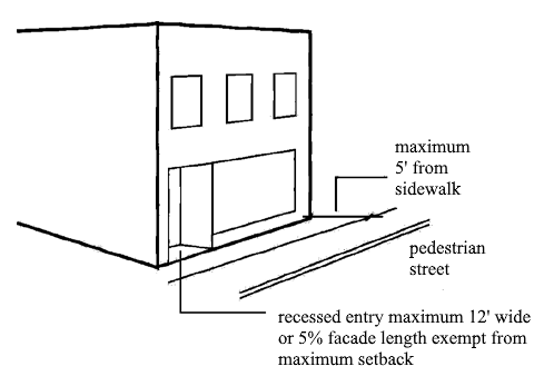
14-910-04-D.
Facade Transparency.
1.
At least 60 percent of the street-facing facade between three feet and ten feet above the sidewalk must be comprised of clear, non-reflective windows that allow views of indoor commercial space or product display areas. On corner lots, this transparency requirement applies along the front of the building.
2.
Display windows that do not provide views into the interior of the building may be counted towards satisfying up to 60 percent of the minimum transparency requirements, provided that they are internally illuminated and are at least two feet in depth.
3.
The bottom of any window or product display window used to satisfy these requirements may not be more than four feet above the adjacent sidewalk.
4.
Upper Level Windows. A minimum of 15 percent of the building's facade area above the first floor shall consist of transparent material.
5.
Street Side or Rear Facade Windows. A minimum of 15 percent of the building's rear faced [facade] facing a public right-of-way, parking area, or open space shall consist of transparent material.
6.
Reflective Glass. Tinted or reflective glass that blocks more than 40 percent of incident visible light is prohibited.
Figure 910-2
14-910-04-E.
Setbacks. No building shall be set back more than five feet from a sidewalk, except for residential structures. Residential structures shall comply with the front setback requirements as provided in Section 14-505-06-D. There are no interior setbacks required.
14-910-04-F.
Height. No building shall exceed 115 percent or be less than 85 percent of the average height of the buildings on the two nearest developed lots on either side of the subject lot. In no case shall a building height exceed 45 feet.
14-910-04-G.
Awnings and Canopies.
1.
Materials. Awnings and canopies shall be constructed of durable, protective, and water repellant materials. Vinyl and fiberglass awnings/canopies are prohibited.
2.
Lighting. Backlit or internal illuminated awnings/canopies are prohibited.
3.
Length. Awnings shall be no longer than a single storefront.
4.
Color. Awning colors shall be compatible with the overall color scheme of the facade from which it projects. Solid colors or subtle striped patterns are preferred.
5.
Projection. Awnings are allowed to project to within two feet of the curb line.
6.
Minimum Clearance. A minimum clearance of eight feet from finished grade to the bottom of the awning is required.
14-910-04-H.
Roofs and Parapets.
1.
Rooflines shall mimic or complement the character or design of the rooflines of the two nearest developed lots on either side of the subject lot.
2.
Sloped roofs are not allowed unless the roof form is concealed by a parapet on all sides of the building.
14-910-04-I.
Utility Areas and Mechanical Equipment Screening.
1.
Utility areas, mechanical equipment, and screening will be designed so that they do not detract from the aesthetic appeal of the district.
2.
Materials. The screening of exterior trash, storage areas, service yards, loading areas, and mechanical equipment must use the same materials, color and/or style as the primary building in order to be architecturally compatible with the primary building.
3.
Roof Equipment. All roof equipment shall be screened from public view using parapet walls equal to the height of the unit(s) or individual screen walls incorporating similar detailing, features, and colors used in the building.
4.
Ground Mounted Equipment. All ground mounted equipment shall be screened from public view with materials used on the exterior of the building or other alternative acceptable to the Community Development Director. Building mounted equipment, including but not limited to, vents, meters and flues, shall match or complement the permanent color of the adjacent building wall.
5.
Screening. All exterior trash and loading areas, and service yards shall be screened in accordance with Sections 14-503-08 and 14-503-09.
14-910-04-J.
Parking.
1.
No off-street parking is required for nonresidential uses unless such uses exceed 10,000 square feet of gross floor area, in which case off-street parking must be provided for the floor area in excess of 10,000 square feet. (See Article 14-501 for off-street parking ratios)
2.
Any off-street parking that is provided must be located behind the building or within or under the building.
3.
When the depth of the lot is insufficient to permit required parking to the rear of the building, parking may be located to the side of the building, provided that it does not occupy more than 30 percent of the subject lot's primary street frontage and is set back at least seven feet from the right-of-way. Existing parking areas shall be exempted from this requirement.
(Ord. No. 17727; Ord. No. 17832)
14-910-05 - Prohibited activities
The following uses and activities are expressly prohibited in the ARTS district:
1.
Outdoor storage of goods or materials.
14-910-06 - Other applicable regulations
Uses and development in the ARTS district are subject to other standards including the following:
1.
Landscaping and Screening. The regulations of Section 14-503, excluding Sections 14-503-08 and 14-503-09, do not apply.
2.
Sidewalks. Sidewalks are required on both sides of all streets or in the context of the district. Any sidewalk required shall be installed in accordance with the Design and Construction Manual.
3.
Accessory Uses and Structures. The regulations of Section 14-400 apply.
(Ord. No. 19485, § 1, 9-18-2023)
14-911-01 - Purpose
The Drumm Farm District (hereafter DFD or district) is a special purpose zoning classification that is intended to allow the planned growth of Drumm Farm to preserve, enhance, and ensure the unique character of the Drumm Farm area.
14-911-01-A.
Definitions. The following definitions apply to the DFD only:
Community Center. A type of public use that is primarily for recreational, sports, social or multi-purpose uses for private use for those living in the DFD and those invited or are renting buildings in the DFD.
Domestic Animals. Animals that are kept for non-farm, and non-commercial purposes, typically as a family or individual pet. Domestic animals include, but are not limited to dogs and cats. Refer to Chapter 3, Article 3 of the City Code for the licensing and control regulations for dogs and cats.
Family Home Care. A type of residential use provided in licensed foster homes for children, generally age 0—18, who have been abused or neglected and placed in the custody of the State or private placement, or children in need of care. This term includes the living of foster parents and their biological and adopted children, as well as foster children.
Farm Animals. Animals that are livestock or fowl as defined by Chapter 3, Article 1, Section 3.01.001 Definitions.
Farmers Market Shelter. An accessory use structure that is mostly open, that has a solid floor and roof, and is used for the display and sales of agricultural and associated goods, as well as inclement weather shelter, school bus shelter, or rentable shelter. It may also include internal lighting, internal power, enclosed restrooms, and enclosed storage area. Additionally, it may have moveable/closeable doors that enclose the shelter for inclement weather. Manufactured food products prepared on-site or off-site, and prepared under the USDA food preparation standards, are allowed to be sold at the Farmers Market. Private vendors are allowed to sell products in association with events in the DFD.
Gymnasium. A type of public use that is primarily focused on sports and recreation in an enclosed building, for private or rental use.
Independent Living Care. A type of residential use for homeless or aging out of foster care youth, generally age 17 to 22, with the purpose of providing a living environment, a planned transition towards self-sufficiency, and the life skills to live independently.
Landscaped and Natural Open Space. Landscaped and natural open space shall be provided. At least 50 percent of the DFD shall be landscaped and natural open space. Landscaped and natural open space is undedicated open space that shall include all areas not in building or drive. Landscaped and natural open space shall include all areas of open field, farm fields, animal grazing areas, pasture, athletic fields, natural areas, landscape beds, gardens, orchards, trails, sidewalks and pedestrian paving areas, landscape site amenities and features, open pavilions, gazebos, and playgrounds.
Open Area. The undeveloped area of the DFD that excludes roads, buildings, parking, playgrounds, walks, accessory structures and the central campus area within the loop road.
Special Needs Living. A type of residential use for care provided to children age generally 0—18 who have a mental, emotional, or physical disability or a psychological or physical addiction. Also includes the living of parents and their biological and adopted children, as well as foster children, and/or special needs living.
The Counseling Center. A type of commercial use that provides individual and family therapy for children, birth families and foster families as well as psychiatric services as needed for on-site and off-site users.
Transitional Living Care. A type of residential use for homeless or aging out of foster care youth, generally age 17 to 22, with the purpose of providing a living environment, a planned transition towards Independent Living Care, and the life skills to live independently.
Unit. Used in conjunction with residential densities, a unit refers to a single family dwelling. In the case of special needs, transitional, or independent living, it refers to a single bedroom, which may have individual or shared kitchen, recreational, living, study or restrooms. These units may be grouped together in the same structure, or mixed in the same structure.
14-911-02 - Use regulations
14-911-02-A.
Use Table. Uses allowed in the DFD are indicated in Table 911-1, below.
14-911-02-B.
Use Classification System. For the purpose of this development ordinance, uses are classified into "use groups", "use categories", and "specific use types". These are described and defined in Article 14-200. In addition, the uses unique to the DFD are defined in Section 14-911-01-A. The column of Table 911-1 lists the groups, categories and types allowed.
14-911-02-C.
Permitted Uses. Uses defined with a "P" in Table 911-1, below are permitted uses as-of-right in the subject zoning district, subject to compliance with all other applicable standards of this development ordinance.
14-911-03 - Residential density
The maximum number of residential units is as follows:
•
Single Family Dwellings (Detached House/Family Home Care) = 24.
•
Special Needs Living Units = 24.
•
Independent Living Units = 24.
•
Transition Living Units = 24.
Residential units may be mixed in the same building.
14-911-04 - Floor area limitations by use for nonresidential uses
The following nonresidential uses have limitations in floor area. Uses not listed below but are a permitted use, per Table 911-1, shall have no floor area restriction. Additionally, several specific uses below are not restricted. These are shown for clarification.
•
Counseling Center—Uses:
◦
Counseling Center — 50,000 sf.
◦
Career Training — 50,000 sf.
•
Agriculture Uses:
◦
Agriculture (all) — Not Restricted.
◦
Animals (all) — Not Restricted.
◦
Accessory Buildings, Barns, Loafing Sheds, Lean-to's, Sheds, Greenhouses and associated Out-buildings — Not Restricted.
•
Retail Uses:
◦
Farmers Market — 10,000 sf.
◦
Rental for Parties and Functions — Not Restricted.
◦
Goods, agriculture, and food products produced on site — 10,000 sf.
◦
Goods compatible with sales of goods produced on site — 10,000 sf.
◦
Catering — Not Restricted.
◦
Country Store — 10,000 sf.
◦
Eating and Drinking Establishments — 10,000 sf.
•
Office Uses:
◦
Office and associated uses for management of the facility — Not Restricted.
◦
Office Lease/Rental — 20,000 sf.
•
Open Space and Recreation Uses:
◦
Community Center — Permitted use up to 50,000 square feet of building area, and a special use over 50,000 square feet.
◦
Gymnasium — Permitted use up to 25,000 square feet of building area, and a special use over 25,000 square feet.
◦
Other uses — Not Restricted.
•
Accessory Uses:
◦
Barns and Sheds — Not Restricted.
◦
Existing Cellular Tower — Not Restricted.
◦
Historic Smokehouse — Not Restricted.
◦
Covered Recreation Areas — Not Restricted.
◦
Accessory Structures — Not Restricted.
14-911-05 - Lot and building standards
The area governed by the DFD is identified as a single lot. Subdivision of that lot is not required for development, open space dedication, or construction. All residential and nonresidential development in the DFD must comply with the building standards below, except as expressly provided. Rules for measuring compliance with the building standards established below, and applicable exceptions to the standards can be found in Article 14-202. All existing buildings are exempt from these standards. These standards apply only to new buildings and development within the district.
The single lot of the DFD shall conform to the following lot standards:
•
Lot Size:
◦
Minimum lot area (SF) — N/A.
◦
Minimum lot area per unit (SF) — N/A.
◦
Minimum lot width (LF) — N/A.
•
Minimum Building Exterior Setback—Lee's Summit Road Frontage — N/A.
•
Minimum Interior Side Setback — 10 feet.
•
Minimum Interior Rear Setback — 10 feet.
•
Minimum Building Separation — 10 feet from any adjacent building.
•
Maximum Building Height — No new structure may be taller than 45 feet from the grade at the main entrance to the building, to the top most ridgeline of the roof. Accessory architectural elements (chimneys, turrets, etc.) may be no taller than five feet above the ridgeline of the building.
•
Minimum Dedicated Open Space Required — None
All existing conditions are exempt from these standards. These standards apply only to new development.
14-911-06 - Animals
In the DFD, the domestic, non-farm animal, other use category of Section 14-200-07-D shall not apply. Animal uses and standards are defined as domestic animals, Sections 14-911-01-A and 14-911-06-A, and farm animals Sections 14-911-01-A and 14-911-06-B.
14-911-06-A.
Domestic Animals. The raising and keeping of domestic animals is allowed with up to two domestic animals may be kept on premises per single family dwelling.
14-911-06-B.
Farm Animals. The raising and keeping of farm animals is allowed in the DFD. The following table, Table 911-2, defines the types and number of farm animals that are allowed. For the purposes of Section 3.02.005, the DFD shall be considered an agricultural use with the number of animals and fowl limited to the amount listed in Table 911-2 below. The numbers of farm animals allowed are based upon the number of acres of open area, as defined in Section 14-911-01-A, Definitions.
14-911-06-C.
Bees. Bees or beehives shall be permitted in the DFD.
14-911-07 - Site development standards
The following site development standards apply to the DFD:
14-911-07-A.
Drives. In order to preserve the rural character of the DFD, the following standards apply to drives constructed in the DFD. Drives may be constructed to allow for pedestrian and vehicular access to buildings and uses within the DFD.
1.
All drives shall be private drives. All drives shall be a minimum of 20 feet wide.
2.
Private drives without curbs are allowed.
3.
Primary drives shall be constructed of either asphalt or concrete.
4.
Access roads and drives to agricultural uses may be constructed of gravel. All gravel drives shall be a minimum of 20 feet wide.
5.
Driveways to residential uses shall be a minimum of 10 feet wide.
14-911-07-B.
Parking. In order to preserve the rural character of the DFD, the following standards apply to parking constructed in the district. The calculation of parking ratios by use is not required.
1.
Parking is permitted on all drives.
2.
A minimum of one off-street parking shall be provided for each detached house/family home care dwelling at the dwelling location.
3.
A parking lot shall be provided off of the main loop drive to accommodate the visitor parking needs.
4.
Standards for the design of parking lots in Section 14-501 shall apply to all parking lots developed in the district.
5.
Up to a maximum of 200 parking stalls may be provided for nonresidential on-site uses.
6.
The majority of nonresidential parking stalls shall be located in a centrally located parking lot per Section 14-911-07-B-3, above. Up to 50 percent of the maximum number of stalls for nonresidential uses may be located throughout the district.
7.
Up to a maximum of 20 parking stalls may be provided for the Farmers Market use. Farmers Market stall numbers are included in the maximum parking allowed per Section 14-911-07-B-5.
8.
Curbs are not required but may be used for the exterior edge of parking lots. Interior parking stalls in parking lots are not required to have curbs or wheel stops. Wheel stops for on or off street parking are not required. Parking lot interior landscape islands are required to have curbs.
9.
Storm Water design for parking lots may be surface drainage or underground drainage systems with storm drainage inlets, or a combination of the two.
14-911-07-C.
Landscaping and Open Space. The regulations of this article are intended to protect and preserve the rural landscape character of the DFD; to provide landscape adjacent to structures to enhance the architecture of the structure and the setting; minimize the potential for negative effects of development within the district.
1.
Existing Trees. The existing tree size, quantity, cover and canopy are an important natural feature that reinforces the rural character of the DFD. Existing trees shall be given consideration when making design and development decisions. Efforts shall be made to protect and preserve healthy existing trees. Diseased or damaged trees, not in the natural stream corridors, shall be treated if possible, or removed to help protect the other healthy trees and structures on site.
2.
Street Tree Plantings. Street tree plantings are not required in the district but are encouraged. Street trees may be planted along drives as desired to create rhythm and shade. There are no restrictions for number, spacing, or species for street trees.
3.
Parking Lots. All parking lots constructed or expanded in the DFD shall be per Sections 14-503-05 and 14-503-06, with the following exceptions:
a.
A berm is not required around the parking lot perimeter per Section 14-503-05-C.
b.
Required perimeter parking lot landscape may be placed in random groupings within 100 feet of the parking lot perimeter edge to better fit the existing rural character of the district.
c.
Interior parking lot landscape is required. Interior landscaped islands are only required to be located at the end of aisles and rows. Mid-row parking islands are discouraged to allow for the dual use of parking lots for hard play surfaces for basketball, kickball, and other games requiring a hard court or play field surface.
d.
Interior parking lot landscape requirements are as follows: One tree and three shrubs are required for every 20 spaces within the parking lot. These must be located first in the end aisle and row end cap islands, with the excess added to the perimeter of the parking lot to increase the perimeter screening of the parking lot. A minimum of one tree and three shrubs or two trees and six shrubs per double end cap island, must be provided in every island provided.
e.
Existing trees saved by modifications to a typical parking lot layout shall be allowed to be counted towards the interior parking lot landscape requirements. For each 1" DBH for each existing tree saved shall count as ½" of required interior landscape trees. Minimum tree and shrub requirements in islands must still be met.
4.
Bufferyards. The existing golf course shall be considered the buffer from all surrounding uses to the north, west and south. Bufferyards are not required on the east side of the DFD.
5.
Screening. Screening is not required in the district.
6.
Plant Materials. Landscape plant materials shall conform to Sections 14-503-15, 14-503-16, 14-503-17 and 14-503-18. Additionally, native grasses, wild flowers, and native shrub plantings are allowed to be used. Industry standard maintenance practices for the maintenance of quality native grasses, wildflowers and native shrubs shall be allowed.
7.
Landscape Plans. Landscape plans are required only with the construction of parking lots and nonresidential buildings.
8.
Landscape Maintenance. Landscape maintenance shall be per Section 14-503-21, with the following exceptions:
a.
Irrigation is only required for new construction. Irrigation is only required for establishment of plant material for a period of one year.
b.
Agricultural uses are exempt from Section 14-503-21.
14-911-07-D.
Signs. Unless otherwise specified in this section, signs in the DFD shall conform to Section 14-504 for applicable standards.
1.
Allowed Signs. The following signs are allowed in the DFD:
2.
Time Limits for Temporary Banners. A single banner may be up for a maximum of 30 days, before being down for 5 days. Banners may be up for a total of 150 days per calendar year.
14-911-07-E.
Accessory Structures. Accessory structures are permitted in conjunction with the uses allowed in the DFD. Accessory structures must conform to the use standards in the district.
1.
Accessory structures must be of a secondary importance and clearly incidental to the existing primary buildings.
2.
Accessory structures shall be constructed of durable building materials.
3.
Accessory structures must be set back a minimum of 50 feet from Lee's Summit Road, and ten feet from all other property boundaries.
4.
Accessory structures must have a minimum building separation of ten feet from other buildings. Exception: Any accessory building used as a parking garage for a residence may be closer than ten feet, if layout, proximity, access, utility conflicts or other obstructions require.
5.
Accessory structures may not exceed 45 feet in height. Exception: wireless telecommunication facilities, agricultural windmills and windmill power generation facilities may exceed the maximum height, as described in this chapter.
6.
Accessory structures do not have building coverage limitations.
7.
Accessory structures may be located in front of main buildings.
14-911-07-F.
Fences. In order to preserve the rural and campus like character and condition of the DFD, fencing is allowed, but is not required. The following regulations apply to fences constructed within the DFD:
1.
Lee's Summit Road Property Boundary. Split rail, cross rail, or other non-opaque, decorative fencing is allowed. Fencing may be constructed at the property line. Chain link, barbed wire, or other industrial style fencing is not allowed. Farm, animal and/or livestock control fencing including electric animal control fencing is allowed, provided it is set back 100 feet from the right-of-way of Lee's Summit Road if it is non-ornamental, or may be at the property line if it is behind the allowed ornamental fencing, as indicated above. It must be attached to the property side of the ornamental fence.
2.
All other Property Boundaries. Split rail, cross rail, or other non-opaque decorative fencing is allowed. Chain link fencing is not allowed. Farm, animal and/or livestock control fencing is allowed, including electric animal control fencing. Fencing may be constructed at the property line.
3.
Electrical animal control fencing must have caution/warning signs that clearly indicates the fence as such.
14-911-07-G.
Sidewalks. Sidewalks are not required, except as required to meet egress, fire safety and ADA requirements. Sidewalks are encouraged.
14-911-07-H.
Building Materials. In order to preserve the rural character of the existing property and to ensure that future construction is compatible with the existing character of the DFD, the following general materials are allowed to be used in exterior building construction. The design standards of Sections 14-505 and 14-506 shall not apply to this district.
1.
Siding, Cladding, and Overall Building Material. Exterior finish materials shall be masonry (brick and/or stone) in combination with stucco and wood siding. Segmented, horizontal wood siding, tongue and groove wood siding and board and batten siding as traditionally seen on wood framed farm buildings is appropriate. Limestone, if used, is appropriate when used as a part of the building base or foundation however, stone cladding over large portions of a surface is not appropriate. Stone, manufactured stone, architectural cast stone, is allowed as an accent material only. Concrete block is prohibited on facades but may be used for the interior structure of walls. When utilizing brick masonry, the brick should be similar to the existing color, hue, intensity and style of brick that currently exists on Swinney and Beals Halls.
2.
Architectural Detailing. Architectural detailing shall be required on buildings at a similar level as existing buildings. Architectural detailing shall be masonry as well as wood. Wood detailing shall be painted white to watch the existing buildings in the DFD to maintain consistency and reinforce the existing character of the DFD.
3.
Roofing. An effort should be made to achieve consistency in roofing material, utilizing similar style, materials, or color, where possible. New roofing materials may be allowed based upon new technology, longevity, energy efficiency, safety, life cycle costs, and appearance. Wood shingles are not allowed except on the existing smokehouse structure.
4.
Doors and Windows. Doors and windows types shall be reflective of the existing windows and doors on site. Doors and windows shall be of a trim color to match the architectural detailing color.
5.
Accessory Buildings. Accessory buildings may be made by any approved material as described in Section 14-911-07H-1-4, above and are not required to be constructed of masonry. Additionally, they may also be made of metal siding and/or metal roofing. All metal, including roofs shall be painted or galvanized to be compatible with the existing character of Drumm Farm, and to prevent rust and visible aging of the metal surfaces.
6.
Existing Materials. Existing building, facade, roof and trim materials currently being utilized on site are an acceptable building material for future development in the DFD.
14-911-08 - Natural resource preservation
Per Section 14-500-02-C.1.d, the DFD shall be considered not applicable for the standards of Section 14-500.
14-911-09 - Relief from standards
Waivers or modifications of Drumm Farm District standards may be approved through the administrative adjustment procedures of Section 14-706-01.
14-912-01 - Purpose
The West Central Independence Overlay District hereafter referred to as "WCIOD", is an overlay district that is intended to promote robust and sustainable mixed-income neighborhoods within the West Central Independence Overlay District boundaries. The district is intended to sustain great neighborhoods that are safe, walkable and include a mixture of densities and designs encouraging interaction and pride. Art is integrated into the overlay infrastructure to enhance neighborhoods, encourage economic revitalization, and nurture artistic contributions to the City and region. The overlay is to help establish a mixed-income area with art-related businesses as well as live/work units and traditional residences integrated in a manner that maintains the residential character of the area.
(Ord. No. 19618, § 1, 10-21-2024)
14-912-02 - Applicability
The regulations in this section apply to all property in the WCIOD district. The WCIOD overlays the base City of Independence zoning and provides additional flexibility in zoning and restrictions. Refer to Article 14-900-02: UDO Overlay Districts. If there is a conflict between the base zoning district and the WCIOD, the WCIOD takes precedence with the exception of the ARTS District zoning of Section 14-910. The ARTS District zoning of Section 14-910 supersedes the WCIOD zoning policy.
14-912-02-A.
Use Table. Uses are allowed in the WCIOD district in accordance with Table 912-A below.
14-912-02-B.
Permitted Uses. Uses identified with a "P" in Table 912-A are permitted as-of-right, subject to compliance with all other applicable standards of this development ordinance.
14-912-02-C.
Conditional Uses. Uses identified with a "C" in Table 912-A are permitted as-of-right, subject to compliance with the use standards referenced in the right column of Table 912-A, and all other applicable standards of this development ordinance.
14-912-02-D.
Special Uses. Uses identified with an "S" in Table 912-A may be allowed if reviewed and approved in accordance with the special use procedures of Article 14-704.
14-912-02-E.
Prohibited Uses. Uses identified with a "—" in Table 912-A are expressly prohibited.
14-912-02-F.
Use Standards. The "use standards" column of Table 912-A identifies use-specific standards that apply to some uses. Compliance with such standards is required.
(Ord. No. 19618, § 1, 10-21-2024)
14-912-03 - Residential design standards
WCIOD residential design standards promote quality housing and neighborhood design while offering opportunities to build density in areas that may otherwise be difficult to develop. No final inspection or certificate of occupancy will be approved until the structure is confirmed to be in accordance with Section 14-912-03-A and B standards.
14-912-03-A.
Minimum Floor Area for Single-Family Detached Houses. All single-family detached houses shall enclose a floor area of not less than 500 square feet for a single-story structure, and 700 square feet for structures of more than one story, and be in compliance with the lot and building standards listed in Section 14-912-03-B.
14-912-03-B.
Lot and Building Standards. All development in WCIOD must comply with the lot and building standards of Table 912-B and Table 912-C, except as otherwise expressly provided. Rules for measuring compliance with the lot and building standards established in Table 912-B, Table 912-C, and applicable exceptions to the standards can be found in Section 14-202.
Notes to Table 912-B:
*[1]
When a structure has a height of fewer than 20 feet and is adjacent to an R-zoned lot, the rear setback shall be 7.5 feet.
*[2]
When a structure has a height of 20 feet or more and is adjacent to an R-zoned lot, the rear setback shall be 12 feet.
Notes to Table 912-C:
*
Requests for more than 1 ADU must be reviewed and approved through the Special Use Permit process outlined in Section 14-704.
(Ord. No. 19618, § 1, 10-21-2024)
14-912-04 - Accessory dwelling unit regulations
Accessory dwelling units (ADUs) are allowed in the WCIOD as outlined below:
14-912-04-A.
Definition.
ACCESSORY DWELLING UNIT (ADU) means a dwelling unit that is incidental to and located on the same lot as a single-family residence that provides complete independent living facilities for one or more persons.
14-912-04-B.
Where Allowed. The ADU shall be located on a lot with a single-family residence and that has a R-District base zoning.
14-912-04-C.
ADU Size—Maximum/Minimum. The maximum floor area for a detached or newly constructed attached accessory dwelling unit shall be 900 square feet. An attached ADU utilizing an existing structure can be larger than 900 square feet in accordance with the special use procedures of Section 14-704. The minimum floor area for an accessory dwelling unit shall be 300 square feet.
14-912-04-D.
Number of ADUs. Refer to Table 912-C.
14-912-04-E.
Distance from Primary Residence. The minimum distance between the detached accessory dwelling unit and the primary single-family residence shall be five feet.
14-912-04-F.
Required Setbacks. Accessory dwelling units detached from the primary single-family residence shall comply with the interior and exterior setbacks in Section 14-912-03.
14-912-04-G.
Design Standards. The appearance, exterior finish materials, roof pitch, roof shape, trim, eaves, window orientation, and dimensions must be the same or visually match those of the structure on the lot. Design standard exceptions must be reviewed and approved through Section 14-706-01.
14-912-04-H.
Height. Accessory dwelling units detached from the primary single-family residence shall comply with the height requirements in Table 912-B.
14-912-04-I.
Parking. One off-street parking space shall be provided for an accessory dwelling unit. In the event a required parking space is eliminated to accommodate an accessory dwelling unit, off-street parking shall be provided on the lot in accordance with the parking ratios of Section 14-501-05.
14-912-04-J.
Sale of Units. The accessory dwelling unit shall not be sold separately from the principal residence.
14-912-04-K.
Short-Term Lodging. The accessory dwelling unit shall not be rented for periods of less than 30 days unless approved as a bed and breakfast in accordance with Section 14-420.
14-912-04-L.
Rental Occupancy. Any accessory dwelling unit or single-family residence that is not owner-occupied shall be subject to the Rental Ready Program of Chapter 4 of the City Code unless it is unoccupied.
14-912-04-M.
Owner Occupancy. The legal property owner of the lot shall be required to reside in either the primary residence or an accessory dwelling unit located on the lot, except for temporary absences not to exceed a combined total of six months in a calendar year. ADU and single-family residences cannot be rented at the same time. Exceptions to this requirement may be submitted by non-profit entities to the Community Development Director. The Community Development Director may approve the exception if reasonable documentation is submitted.
14-912-04-N.
Building Code. All ADUs shall comply with the currently adopted International Residential Code appendix related to "Tiny Houses."
14-912-04-O.
Notice to Neighboring Property Owners. All contiguous property owners shall receive 15 days notice of the plan to build an ADU. If more than 50 percent of contiguous property owners file a letter of protest with the City during the 15 day timeframe, the proposed ADU shall be treated under Section 14-912-02-D Special Uses.
(Ord. No. 19618, § 1, 10-21-2024)
14-912-05 - Home occupation
A principal dwelling and/or an accessory dwelling unit may be used for a home-based business in accordance with the standards of Section 14-400-03.
(Ord. No. 19618, § 1, 10-21-2024)
14-912-06 - Cottage neighborhood cluster
14-912-06-A.
Definition.
COTTAGE NEIGHBORHOOD CLUSTER means a planned community that consists of a grouping of 3—12 smaller square footage residences, often around a courtyard or common open outdoor space commonly designed to maximize space and encourage time spent in a community space.
14-912-06-B.
Purpose.
1.
The purpose of a cottage neighborhood cluster design is to:
a.
Encourage a stronger sense of community and security among nearby neighbors while preserving personal privacy;
b.
Promote a variety of housing choices to meet the needs of a population diverse in age, income, household composition, and individual needs; especially small households (one to three-person households);
c.
Seek to balance projected population growth with the community goal of preventing sprawling development and to this end examine opportunities to use land more efficiently for housing.
d.
Encourage affordability, innovation, and variety in housing design and site development while ensuring compatibility with surrounding land uses;
e.
Encourage the creation of more usable space for residents of the development through flexibility in density and lot standards.
f.
Maximize resident/pedestrian-oriented outdoor spaces and minimize the impact of automobile traffic and parking.
14-912-06-C.
Allowed Uses.
1.
The allowed uses within the cottage neighborhood cluster shall be single-family detached dwellings, duplex dwellings, carriage houses, live/work units, community buildings, temporary real estate sales office/model home, and vehicle parking lots and structures. The cottage neighborhood cluster shall comply with Table 912-A.
14-912-06-D.
Site Requirements.
1.
Cottage Neighborhood Cluster Size.
a.
There shall be a minimum of three dwellings with a maximum of 12 dwellings per cluster.
b.
There shall be no limit to the number of clusters.
2.
Lot and Building Standards.
a.
All cottage neighborhood clusters shall comply with Section 14-912-03.B.
3.
Maximum Coverage for All Impervious Surfaces.
a.
There shall be no maximum impervious coverage, provided that stormwater is approved in accordance with the City's Design and Construction Manual.
4.
Dwelling Size.
a.
The maximum dwelling size shall be limited to 2,000 square feet and the minimum dwelling size shall be no less than 300 square feet.
14-912-06-E.
Approval Process. A cottage neighborhood cluster or a development greater than one cottage neighborhood cluster shall be reviewed and approved in accordance with the design parameters of Section 14-912-06-F, the procedure of Section 14-703, 14-912-06-E-1 and 14-912-06-E-2. If there is a conflict between the WCIOD and Section 14-703, the WCIOD takes precedence.
1.
Within Section 14-703, replace "Planned Unit Development (PUD)" with "Cottage Neighborhood Cluster (CNC)".
2.
A cottage neighborhood cluster is not required to follow criteria 14-703-05-H-2 of the Planned Unit Development Review Criteria for approval.
14-912-06-F.
Design Parameters.
1.
Common Open Spaces in Cottage Neighborhood Clusters.
a.
Intent. Open space that is commonly owned and managed by all owners of a cottage neighborhood is a key feature in fostering community. It is intended that it be adequately sized and centrally located with individual dwelling entrances oriented towards the open space.
b.
Size. A minimum of 400 square feet per dwelling unit of common open space is required in each cottage neighborhood cluster. Buildings serving all residents in a cottage neighborhood cluster may be included in the required area. Parking areas, spaces between buildings of 15 feet or less in width, private spaces, and driveways do not qualify as common open spaces.
2.
Private Open Space.
a.
Intent. A sense of community requires the right balance of personal privacy. Private open space is an essential component of this balance. A 'front' yard creates a buffer between public and private spaces, while a 'side' or 'back' yard offers increased seclusion.
b.
Size. Each residential unit shall be provided with a minimum of 200 square feet of usable private open space, such open space requirements may be met with a combination of front, side, or rear yard locations.
3.
Front Porch.
a.
Intent. A covered front porch is a key element in fostering neighborly connections. Offering surveillance of public space. Its placement, size, relation to interior and public spaces, and the height of railings are all factors in achieving these intents.
b.
Location. Every dwelling shall have a covered front porch oriented toward the common open space or street. The porch shall be open on at least two sides and shall not be enclosed.
c.
Size. The covered porch shall be greater than 70 square feet in area, with a minimum dimension of six feet.
d.
Use. Front Porches are intended as supplementary living space, not storage space, as well as shelter from the weather for entering and exiting the dwelling; therefore, overnight storage shall not be allowed.
4.
Street-Facing Facades.
a.
Intent. The facades of buildings facing the street contribute to the neighborhood by including attractive design details such as windows, front doors, porches, siding, and trim.
b.
All Street-facing facades of dwellings shall avoid blank walls or appear to "turn their backs" to the street. Such facades shall include one or more of the following:
i.
Porches;
ii.
Windows, including bay windows;
iii.
Dormers;
iv.
Changes in exterior siding material or paint color;
v.
Building modulation with a depth measuring at least one foot.
5.
Privacy Between Dwellings.
a.
Intent. Having a next-door house or apartment peering into your own can be uncomfortable and claustrophobic; therefore, arrange openings to preserve privacy.
b.
Dwellings shall be designed so that no window peers into the living space of adjacent dwellings closer than 20 feet apart. This may be accomplished by:
i.
'Nesting' dwellings with open and closed sides: the open side may have windows facing its own side yard or rear yard, while the closed side may have high windows, translucent windows, or skylights to bring in ample light while preserving privacy;
ii.
Zero lot line dwellings (duplex) with no side windows;
c.
The side yard of a dwelling may be fully used to the face of the neighboring building through landscape easements or other means.
6.
Community Amenities.
a.
Intent. Shared elements are direct amenities of living in a cottage neighborhood. Beyond these benefits, these common amenities foster connections among neighbors and strengthen their sense of community.
b.
Every Cottage Neighborhood Cluster shall consider but not be limited to the following elements shared and managed by residents of that cluster;
i.
Barbeque, pizza oven, campfire circle, or outdoor terrace;
ii.
Picnic shelter or gazebo
iii.
Tool and general storage shed;
iv.
Heated commons building, with optional bathroom and kitchenette, for meetings, card games, movie nights, potlucks, exercise, etc.
v.
Vegetable garden or flower garden or a mixture of both;
vi.
Shop space;
vii.
Community kitchen/dining room, living room, library;
viii.
Childcare room and/or playground;
ix.
A water feature such as a fountain, pool, hot tub, or koi pond;
7.
Parking.
a.
Intent. Cars do not need to dominate our pedestrian spaces. Parking areas should be located so their visual presence is minimized, and associated noise or other impacts do not intrude into public spaces.
b.
Parking requirements:
i.
Dwellings under 900 square feet: One space per unit.
ii.
Dwellings between 901—2,000 square feet: Two spaces per unit.
c.
Parking requirements shall be considered on the scale of the overall development, rather than on a lot-by-lot basis. Parking requirements may be met along access alleyways.
d.
The primary strategy for designated parking shall be along access alleyways. Driveways off streets are discouraged: where there is no reasonable alternative, such driveways shall be minimized.
i.
Detached parking structures serving multiple dwellings shall be limited to ten single-car bays. If this parking structure is enclosed, then maximum width of each door 12 feet wide.
ii.
In a cottage neighborhood cluster, consider locating parking so that residents and guests walk through the shared open space rather than entering the dwelling through an attached parking structure. This arrangement increases the opportunities for neighbor-to-neighbor contacts.
iii.
Where dwellings must have parking structures located off a street, such parking structures must be set back from the front façade by a minimum of one foot. If this parking structure is enclosed, then maximum width of each door is 12 feet wide. and have a maximum of one garage door up to 12 feet wide.
e.
Storage of items within a parking structure that precludes the use of vehicle parking is prohibited.
f.
Head-in surface parking areas for more than two cars shall be:
i.
Prohibited in the front yard setback area;
ii.
Screened from public streets and adjacent residential uses by landscaping or architectural screening.
8.
Storage.
a.
Intent. Every household has storage needs for items such as bicycles, camping gear, hand tools, snow tires, suitcases, and the like.
b.
Every dwelling shall have a minimum of 40 square feet of covered storage space outside the heated living area. This space may be located in a basement, a garage if it does not preclude vehicle parking, or in a storage shed that is attached or detached.
9.
Refuse and Recycling.
a.
Intent. Garbage and recycling are necessary elements in residential living. Storage of these containers shall be located so their visual and odorous impact on adjacent properties is minimized.
10.
Fences.
a.
Intent. Fences can define and express personal space and add to the quality of public space, but fences can also be offensive barriers.
i.
Fences should be used in private personal spaces.
ii.
The maximum height is not to exceed 72 inches.
iii.
Fencing is visually cohesive in cottage neighborhood community
(Ord. No. 19618, § 1, 10-21-2024)