
Iron County Unincorporated
City Zoning Code
City Zoning Code
CHAPTER 17
59 - GEOLOGIC CONDITIONS5
Editor's note— Section 1 of Ord. No. 2011-8, adopted Nov. 28, 2011, amended Ch. 17.59 in its entirety to read as herein set out. Former Ch. 17.59 pertained to the same subject matter and derived from Ord. No. 2010-11, adopted Dec. 20, 2010.
17.59.010 - Purposes.
This chapter applies to the development of those lands in unincorporated Iron County that are known or suspected to contain one or more of the geologic hazards herein regulated. Such areas are known as geologic study areas. Where a proposed development activity is located within a geologic study area, an investigation is often required, as outlined later in this chapter. Property mapped as being within a geologic study area may or may not contain a geologic hazard—such determination will be the result of the investigation process required herein. This chapter and the regulations and restrictions contained herein are adopted and enacted for the following purposes:
A.
To minimize the potential of geologic hazards adversely affecting public and private property, safety, health and welfare.
B.
To identify and to educate all development professionals, landowners, and potential purchasers of the presence and risks of geologic hazards—including the hazards of surface-fault rupture, mass wasting (landslide, rock fall, and debris flow), liquefaction, land subsidence, and earth fissures; and to establish minimum standards and methods for evaluating these hazards when development is proposed in these areas. This stated purpose does not absolve a developer, landowner, or potential purchaser from the responsibility to conduct their own due diligence and research.
C.
To ensure that decisions relating to geologic hazards are based on unbiased professional, scientific and engineering information provided by those with the proper licensing and expertise in the matter.
(Ord. No. 2011-8, § 1(Exh. A), 11-28-2011)
17.59.020 - Definitions.
The following words and phrases, as used in this chapter, mean:
Acceptable and Reasonable Risk: A level of risk at which it is expected that there will be no loss of life or significant injury to occupants, no release of hazardous or toxic substances, and no more than minimal structural damage (i.e., physically and economically reasonable to repair) to critical infrastructure, critical facilities, or to structures designed for human occupancy, in the event that the anticipated geologic hazard were to occur.
Activity Class of a Fault: The level of activity of a surface fault based on the time of most recent movement. Holocene activity class means movement of a fault that has broken the ground surface in approximately the past ten thousand years (Shown as "<15,000 years" on the U.S. Quaternary Fault and Fold database); late quaternary activity class means movement of a fault that has broken the ground surface in approximately the past one hundred thirty thousand years; and, quaternary activity class means movement of a fault that has broken the ground surface in approximately the past 2.6 million years.
Alluvial Fan: A fan-shaped deposit formed by deposition from a stream as it exits the mountains, slows, and spreads onto the flatter plain.
Alluvial-Fan Surface, Active: An alluvial-fan surface where the fan building processes of flooding, debris flow, sediment deposition, and erosion are active or potentially active during storm or snowmelt events. Active portions of the fan have generally shallow stream channels, often braiding into several channels that distribute alluvium broadly across the fan surface. Active alluvial-fan surfaces receiving periodic sedimentation are typically rough (numerous boulders and cobbles at the surface) and support sparse vegetation.
Alluvial-Fan Surface, Inactive: An alluvial-fan surface where the fan building processes are no longer active. Inactive fan surfaces are stable and usually marked by well-developed soil and plant succession. Stream channels are generally single strand, incised below the inactive fan surface, and associated with a flat low floodplain terrace. Floods along channels on inactive alluvial-fan surfaces behave as normal riverine floods.
Buildable Area: That portion of a site, lot, or parcel that is entitled to contain the proposed improvement (e.g., complies with zoning and building setbacks); and, either will not be impacted by a geologic hazard, or has all identified geologic hazards mitigated to an acceptable and reasonable risk. Any mitigation necessary to deem a geologically hazardous area as "buildable" must be based on an approved geologic-hazard report and engineered methods. Contrast to "nonbuildable area".
Critical Facilities/Infrastructure: Buildings, infrastructure, and other structures that represent a substantial hazard to human life in the event of failure, or which are designated as "essential facilities." Critical facilities include, but are not limited to, occupancy category III or IV structures, as defined in the International Building Code (IBC, Table 1604.5, p. 307; International Code Council, 2009).
Debris Flow: A fast-moving slurry of rock, soil, organic material, and water transported down a channel and onto an alluvial fan. The term as used in this chapter includes the sedimentation flows and processes technically classified as debris flows (greater than sixty percent sediment), hyperconcentrated flows (twenty to sixty percent sediment), and stream flows (less than twenty percent sediment) which are associated with debris-flow and hyperconcentrated-flow hazards. Stream-flow hazards that are not associated with debris-flow or hyperconcentrated-flow hazards are not included in this definition, but are regulated through the flood damage prevention ordinance (Chapter 15.12, Iron County Code) and drainage regulations (e.g., Section 17.40.020, Iron County Code).
Development: For purposes of this chapter, development includes the installation and construction of roads, utility lines/conveyances, subdivision improvements, buildings, structures, and physical improvements accessory to any of these uses.
Earth Fissure: A linear tension crack in the ground that extends upward from the groundwater table and is a direct result of land subsidence caused by groundwater depletion. The surface expression of earth fissures may range from less than a yard to several miles long and from less than half an inch to tens of feet wide. Earth fissures change runoff/flood patterns, break buried pipes and utilities, cause infrastructure to collapse, provide a direct conduit to the groundwater table for contaminants, and may pose a life-safety hazard. Earth fissures can quickly erode into sinkholes/gullies when washed out by surface runoff, and some, such as the Enoch-Graben-West fissure, can experience vertical offset.
Engineering Geologist: A Utah-licensed geologist, who, through education, training, and experience practices in the field of engineering geology. The term "geologist" as used in this chapter specifically refers to an engineering geologist qualified to study the specific geologic hazard(s) identified. For purposes of this chapter, the engineering geologist in principal charge of the investigation shall have a minimum of five years of experience in a responsible position in the field of engineering geology either in Utah or in a state with similar geologic hazards.
Engineering Geology: The application of the geologic sciences to engineering practice for the purpose of assuring that the geologic factors affecting the location, design, construction, operation and maintenance of engineering works are recognized and adequately provided for in the interest of the public health, safety and welfare.
Essential Facilities: A subset of "critical facilities", essential facilities include the infrastructure and facilities intended to remain operational in the event of an adverse geologic event or natural disaster. They include, but are not limited to, those uses listed under occupancy category IV in Table 1604.5 of the International Building Code.
Fault: A fracture in the earth's crust forming a boundary between rock or soil masses that have moved relative to each other, due to tectonic forces. When the fracture extends to the earth's surface, it is known as a surface-fault rupture, or fault trace.
Fault Setback: An area on either side of a fault within which critical facilities and structures designed for human occupancy are not permitted.
Fault Scarp: A steep slope or cliff formed by movement along a fault.
Fault Trace, or Surface-Fault Rupture: The intersection of a fault plane with the ground surface, often present as a fault scarp, or detected as a lineament.
Fault Zone: A corridor of variable width along one or more fault traces, within which deformation has occurred.
Geologic Evaluation: The review of a geologic study area to determine the hazard potential relative to the proposed development, and to verify the need for geologic studies and reports. Geologic evaluations are performed by engineering geologists, or geotechnical engineers with input from engineering geologists, as specified in Section 17.59.040.
Geologic Hazard: Includes surface-fault rupture, mass wasting (landslides, rock falls, debris flows), liquefaction, land subsidence, earth fissures and other geologic processes that present a significant risk to life or real property. This chapter addresses those geologic hazards determined most likely to occur in Iron County, with the exception of earthquake ground shaking, flooding not associated with alluvial fans, and problem soils. Ground shaking, although related to and considered in the evaluation of several of the other geologic hazards, is regulated primarily for its impacts to buildings and structures through the seismic requirements of the building code. Flooding is primarily addressed through the Iron County Flood Damage Prevention Ordinance. Regulations pertaining to development in areas of problem soils are found in the subdivision and building codes, and are not duplicated in this chapter.
Geologically Hazardous Area: An area that, because of its susceptibility to a geologic hazard, is not suitable for the siting of structures designed for human occupancy or critical facilities, consistent with public health or safety concerns, unless the hazard is mitigated to an acceptable and reasonable level.
Geologic Study Area: A potential geologically hazardous area, within which geologic-hazard investigations are required prior to development.
Geologist: See "Engineering Geologist".
Geotechnical Engineer: A professional, Utah-licensed engineer who, through education, training and experience, is competent in the field of geotechnical engineering. For purposes of this chapter, the geotechnical engineer shall have either:
1.
A graduate degree in civil engineering, with an emphasis in geotechnical engineering; or a B.S. degree in civil engineering with twelve semester hours of post B.S. credit in geotechnical engineering, or course content closely related to evaluation of geologic hazards from an accredited college or university; or
2.
Five full years of experience in a responsible position in the field of geotechnical engineering in Utah, or in a state with similar geologic hazards and regulatory environment, and experience demonstrating the engineer's knowledge and application of appropriate techniques in participating in geologic hazards studies.
Geotechnical Engineering: The investigation and engineering evaluation of earth materials including soil, rock, and manmade materials and their interaction with earth retention systems, foundations, and other civil engineering works. The practice involves the fields of soil mechanics, rock mechanics, and earth sciences and requires knowledge of engineering laws, formulas, construction techniques, and performance evaluation of engineering.
Governing Body: The Iron County legislative body, or a designee of the Iron County legislative body.
Hazard Mitigation: An action taken to avoid, minimize, or compensate for the risk to human life and public and private property from identified hazards.
Hydrocompaction: Where the ground subsides due to unconsolidated soils becoming saturated with water and losing their structural strength (soil bonds being dissolved by water), and the ground compacting under the weight above.
Land Subsidence: The elevation of the ground surface being lowered due to changing soil and/or groundwater conditions. Land subsidence occurs in portions of Iron County, like many areas of the arid southwest, due to groundwater extraction exceeding the rate of recharge. The pumping and resulting removal of groundwater from the pore spaces of the valley-fill alluvium (unconsolidated gravel, sand, silt, and clay) reduces pore-water pressure and allows the drained alluvium to compress and the ground surface to subside. Compaction within the aquifer appears to occur primarily in the silt and clay layers and is commonly expressed as permanent land subsidence, which reduces aquifer capacity and may result in the development of earth fissures.
Land Use Authority: The person, board, commission, agency, or other body designated by the local legislative body to act upon a land use application.
Landslide: The downslope movement of a mass of soil, surficial deposits, or bedrock. It may include a continuum of geologic processes such as landslides, earth-flows, debris flows, debris avalanches, and rock falls.
Liquefaction: A process by which certain water-saturated soils (typically sand) lose bearing strength because of earthquake-related ground shaking and subsequent increase of groundwater pore pressure. Liquefaction may induce ground failure, including lateral spreads and flow-type landslides.
Iron County: The Iron County engineer, Iron County planner, Iron County zoning administrator, Iron County building official, Iron County administrator, county commission, land use authority, or other Iron County employee or designee.
Nonbuildable Area, Due to Geologic Hazard: An area that contains a geologic hazard that presents an unreasonable and unacceptable risk, such that the siting of structures designed for human occupancy, critical facilities, and other specified development improvements are prohibited in that area through the authority of this chapter. Contrast to "buildable area".
Problem Soil and Rock: Geologic materials having characteristics that make them susceptible to volumetric changes, collapse, hydrocompaction, subsidence, or other engineering geologic problems.
Reviewing Official: The building official if related to a building permit, and the land use authority if related to a land use application.
Rock Fall: A rock, or mass of rocks, that has detached from a cliff or other steep slope and moves down a slope by falling, rolling, sliding, toppling, or bouncing.
Setback, Geologic Hazard: An area subject to risk from a geologic hazard, within which construction of critical facilities and structures designed for human occupancy are not permitted.
Slope Stability: The resistance of a natural or artificial slope or other inclined surface to failure from landslide; technically the ratio of resisting forces to the ratio of driving forces. Slope stability is expressed as a "factor of safety". Slope stability is to be assessed under both static and dynamic (earthquake-induced) conditions.
Structure Designed for Human Occupancy: Any building or structure containing a habitable space, or classified as an "assembly", "business", "educational", "factory and industrial", "institutional", "mercantile", or "residential" occupancy classification under the adopted International Building Code.
Subsidence: The lowering or sinking of the ground due to physical changes in the underlying soil. Subsidence is a geologic hazard in Iron County primarily due to hydrocompaction and groundwater withdrawal in excess of recharge.
Surface Faulting: The propagation of an earthquake-generated fault rupture to the ground surface, which displaces the surface and forms a scarp.
Talus: Accumulated rock fragments lying at the base of a cliff or a steep rocky slope.
(Ord. No. 2011-8, § 1(Exh. A), 11-28-2011)
17.59.030 - General provisions.
A.
Geologic Study Areas. This chapter applies to the development of those lands in unincorporated Iron County that are known or suspected to contain one or more of the geologic hazards herein regulated. Such areas are known as geologic study areas. Where a proposed development activity is located within a geologic study area, an investigation and report of the hazard(s) is required, except as limited herein.
The following methods shall be used to determine whether a proposed development is within a geologic study area. In the event there is a known or readily apparent geologic hazard in the area of a proposed development that is not shown on a geologic hazard map, the geologic hazard nevertheless exists and the area shall be considered a geologic study area as if it were mapped.
1.
Surface-Fault Ruptures: The "Quaternary Fault and Fold Database of the United States", published by the U.S. Geological Survey, is to be used as the primary source of fault information for Iron County. The fault locations, fault activity classes (geologic age), and other supplementary information contained therein shall be the standard upon which a surface-fault-rupture study must be based, unless more detailed and accurate scientific information becomes available.
Areas along holocene activity class faults (shown as "<15,000 years" and newer on the U.S. Quaternary Fault and Fold database) constitute surface-fault-rupture study areas for all critical facilities, subdivisions, and structures designed for human occupancy. Areas along late quaternary activity class faults constitute surface-fault-rupture study areas for all critical facilities and subdivisions of more than four lots. Faults of the quaternary activity class constitute surface-fault-rupture study areas for critical facilities only. If the activity class of a quaternary fault is not specified, it shall be considered to be of the holocene activity class, unless scientific data demonstrates otherwise. Fault zones with multiple fault traces shall be considered to be the activity class of the most recent fault trace.
For well-defined surface faults, the surface-fault-rupture geologic study area extends five hundred feet on the downthrown side of the fault and two hundred fifty feet on the upthrown side of the fault, except when two hundred fifty feet does not extend to the top of the scarp, in which case the study area on the upthrown side shall extend to five hundred feet. Where multiple faults exist within a fault zone, the study area is to include all land between the faults, as well as the specified five hundred-foot and two hundred fifty-foot adjacent areas. Distances are measured horizontally from the surface fault.
For a buried or approximately located fault (dotted or dashed line on the fault map), the study area extends one thousand feet to each side of the mapped location of the fault.
2.
Landslide/Slope Instability: As stated, in Guidelines for Evaluating Landslide Hazards in Utah, UGS Circular 92, 1996, "Landslide hazards involve both natural and development-induced variables". For this reason, landslide geologic study areas include both areas that are hazardous in their natural state (i.e., landslides and landslide susceptible slopes) and areas that may become hazardous if development does not properly consider the geologic limitations of the site (e.g., steep slopes). Specifically, geologic study areas for landslide/slope instability hazards include:
a.
Until more detailed geologic maps are available and adopted by resolution, all lands identified as "deep or unclassified landslides"; "shallow landslides"; "lateral spread and/or flow failures"; "landslides undifferentiated from talus and/or colluvial deposits"; and "landslides and/or landslides undifferentiated from talus, colluvial, rock fall, glacial, and soil-creep deposits", on Utah Geologic Survey Map 246DM (Elliott and Harty, 2010), or any update thereto; and
b.
All slopes that may be affected or created by the proposed development, which meet any of the following:
i.
Cut and/or fill slopes steeper than, or equal to, two horizontal to one vertical.
ii.
Natural slopes steeper than, or equal to, four horizontal to one vertical.
iii.
Natural and cut slopes with potentially adverse geologic conditions (e.g., bedding, foliation, or other structural features that are potentially adverse to the stability of the slope).
iv.
Natural and cut slopes that include a geologic hazard, such as a landslide, irrespective of the slope height or slope gradient.
v.
Buttresses and stability fills.
3.
Rock Fall: Rock-fall geologic study areas are not mapped in Iron County at this time, but include locations at the base of rock and talus slopes that are susceptible to rock fall—evidence of past rock falls being the primary indictor. A twenty-two-degree shadow angle, extending from the base of the rock-fall source area, as depicted in the following diagram, shall be used to define the extent of a rock-fall geologic study area. (Note: Shadow angle is dependent on the type of rock involved, and the rock-fall hazard area determined by the geologist may be more or less than that captured by the twenty-two-degree shadow angle used to define the study area. However, twenty-two degrees is relatively conservative, and is deemed sufficient to capture most rock-fall hazard situations.)
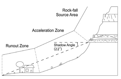
A rock-fall geologic study area consists of three components: (1) a rock source, in general defined by bedrock geologic units that exhibit relatively consistent patterns of rock-fall susceptibility throughout the study area, (2) an acceleration zone, where rockfall debris detached from the source gain momentum as it travels downslope—this zone often includes a talus slope, which becomes less apparent with decreasing relative hazard and is typically absent where the hazard is low, and finally (3) a runout zone (rock-fall shadow zone), which includes gentler slopes where boulders have rolled or bounced beyond the base of the acceleration zone. (Source of diagram and above paragraph: Geologic Hazards and Adverse Construction Conditions, St. George—Hurricane Metropolitan Area, Washington County, Utah, by Lund, Knudsen, Vice, and Shaw, 2008. UGS Special Study 127.)
4.
Debris Flows: The FEMA Flood Insurance Rate Maps for Iron County identify the 100-year floodplains that are on active alluvial fans (see definition), through the use of the labels "(Alluvial Fan Flooding)" and "(Alluvial Flooding)". The alluvial fans of Braffits Creek and Summit Creek are currently the only alluvial fans in the county with these labels. Fiddler's Canyon has had debris flow basins and channel improvements such that debris-flow flooding is expected to be maintained within the mapped 100-year floodplain. Therefore, for the Braffits Creek, Summit Creek, and Fiddler's Canyon alluvial fans, debris-flow study areas include the 100-year floodplains identified on the FEMA Flood Insurance Rate Maps, and only those areas.
There are also active alluvial fans within the county that have not been mapped by FEMA. Until more detailed mapping is available and adopted by resolution, the information found on the thirty-minute by sixty-minute geologic maps of the Utah Geological Survey (the Interim Cedar City and Draft Panguitch 30' x 60' Quadrangles, as referenced in Section 17.59.160) are to be used to identify debris-flow study areas outside of the Braffits Creek, Summit Creek, and Fiddler's Canyon alluvial fans. Outside of these three areas, if a property is within one of the following geologic units and within two miles of the mouth of the canyon/ravine that feeds the alluvial fan, it is within a debris-flow study area. The included geologic units are Qa1, Qaf1, Qaf2, Qat1, Qat2, Qap1, Qap2, QTap3, and QTaf3. The mouth of the canyon/ravine is where the erosional process of the stream has historically transitioned into a depositional process to form the alluvial fan, and does not extend above the geologic units herein listed.
5.
Liquefaction: Liquefaction geologic study areas include areas with unconsolidated quaternary geologic units of stream and terrace alluvium, alluvial deposits, eolian deposits, or colluvial deposits, which contain groundwater within fifty feet of the surface. Generally these are the areas at the lower elevations of the Cedar, Parowan, and Beryl valleys. Until more detailed mapping is available and adopted by resolution, the generalized map "Iron County Ground Water", produced by Iron County GIS, shall be the reference document for identifying liquefaction geologic study areas.
Liquefaction study areas require the preparation of a geologic report for the development of critical facilities, utility lines/conveyances, commercial and industrial structures, attached housing, and proposed subdivisions.
An individual geologic report is not required for the construction of a single-family detached house or structure accessory thereto. However, for sites within a liquefaction study area, a geotechnical engineer shall consider liquefaction potential in any geotechnical report required by Section 15.06.030, Iron County Code.
6.
Land Subsidence and Earth Fissures: An area has been identified by the Utah Geological Survey in Cedar Valley where land subsidence resulting from groundwater mining has occurred. A similar area of subsided ground area about one hundred square miles in size has been identified in Escalante Valley near Beryl Junction (Lund and others, 2005). Land subsidence in both areas has resulted in the formation of earth fissures. The earth fissures are in the Escalante Valley in the area of Beryl Junction (Lund and others, 2005); in the Cedar Valley in locations north and west of Quichapa Lake, and within and north of Enoch City; and, in the Parowan Valley near the southwest end of the Little Salt Lake playa (DuRoss, 2004). Other earth fissures are likely to be discovered as the hazard is further investigated. The Utah Geological Survey has completed a study on the matter for parts of the Cedar Valley under a contract with the Central Iron County Water Conservancy District (Knudsen and others, Sept. 2010, Investigation of Land Subsidence and Earth Fissures in Cedar Valley, Iron County, Utah: Utah Geological Survey, 114 p.), and plans to conduct further investigations and analysis. Those investigations and analysis are expected to lead to greater understanding of land subsidence and earth fissure hazards, their risk to certain areas of the county, and identification of defined geologic study areas for land subsidence and earth-fissure hazards.
For the purpose of this chapter, earth-fissure study areas include those lands on basin-fill deposits (not bedrock) within known subsiding areas which are within one-half mile of an earth fissure that has been verified by the Utah Geological Survey. Iron County shall maintain a map of such fissures, updating it as additional fissures are discovered.
Earth-fissure study areas require the preparation of a geologic report for the development of critical facilities, utility lines/conveyances that are pressurized or carry liquids, commercial and industrial structures, residential dwellings, and proposed subdivisions.
Proposed development in areas of land subsidence located outside of earth-fissure study areas does not require the preparation of a geologic report for the construction of a single-family dwelling or structures accessory thereto, but otherwise a geologic report is required for development of precisely leveled, long base-line infrastructure (e.g., sewer mains, pipelines, and canals) and proposals that are heavily dependent thereon (e.g., small-lot subdivisions and large wastewater generators). In such cases, the situation shall be evaluated for the impact of ongoing subsidence on the proposed infrastructure.
B.
Geologic/Geotechnical Report Required with Subdivision Application. Where a proposed subdivision development is located within a geologic study area of Iron County, an engineering geologic report (geologic report) or geotechnical report shall be submitted with the application when specified in this chapter. A subdivision application for development in a geologic study area shall not be considered complete for review without the required report. A minor subdivision may utilize the "short process" in Section 17.59.035 for review of geologic conditions required by this chapter.
If a geologic or geotechnical report was recently completed for an area that includes the subject property, and the report addresses the applicable geologic hazard(s) and contemplated development activity, an additional report is likely not required. In such case, the previous report shall be reviewed for adequacy and applicable recommendations by the professional that prepared it, and a summary thereof submitted with the permit application. If the previous report is not adequate, then a new report, or supplement to the previous report, shall be submitted.
C.
Buildable Areas. The creation of every lot proposed in a subdivision must have a buildable area, as defined herein, that is of sufficient area and dimensions for the intended use(s). Any area determined to be nonbuildable due to the presence of a geologic hazard shall be identified in sufficient detail by the geologic professional (geologist or geotechnical engineer, depending on the type of hazard) so as to provide regulatory guidance to the county, landowner, and developer. The boundary between a buildable and nonbuildable area shall be identified by the geologic professional on a scalable map and in the field (e.g., ground staked). The buildable area boundary and nonbuildable area(s) shall be identified on the subdivision plat.
Any mitigation necessary to provide a buildable area must be completed at such time and in such manner as specified in the accepted professional report; provided, all mitigation must be completed prior to acceptance of the subdivision (e.g., final plat sign off).
The county may require notice of the geologic hazards, completed geological/geotechnical reports, and any accompanying restrictions, to be placed on subdivision plat or other recorded documents.
D.
Minimum Requirements. The standards set forth in this chapter are minimum requirements. The more complex the geologic conditions, the more potentially complex the evaluation and recommendations of the hazard report. More complex projects may require more detailed and in-depth evaluations than the minimum standards outlined herein to accomplish the stated purposes of this chapter. The requirements of this chapter shall not supersede other, more stringent, requirements that may be required by other codes or regulatory agencies.
E.
Exemptions. The following actions are exempt from the provisions of this chapter:
1.
The maintenance and repair of existing public utility lines, public utility structures, and communication facilities;
2.
The construction, addition, or remodel of any single-family residential building and/or accessory structure/appurtenance upon a legal lot of record where a building permit is required, and regulated in Section 15.06.030;
3.
Any agricultural activity, or directly associated activity, or operation within an agricultural protection area, conducted using sound agricultural practices unless that activity or operation bears a direct relationship to public health or safety;
4.
Any building, or structure that is not designed for human occupancy (see definition of "Structure designed for human occupancy"), or classified as a critical facility; and, which is not anticipated to significantly increase the geologic-hazard risk to other properties if the potential or identified geological event were to occur. This determination shall be made by the reviewing official with jurisdiction over the development action. The reviewing official may require a statement from a qualified professional indicating that the proposal meets the conditions of this exemption. Examples may include some, but not all, residential accessory buildings, utility structures, agricultural storage structures, signs, etc. In order for this exemption to be granted, the owner must certify in writing that they have been made aware that the proposed development is within a geologic study area and that they understand the hazards associated therewith;
5.
Any aboveground utility line not classified as an essential facility, which is not anticipated to significantly increase the geologic-hazard risk to other properties if the potential geologic event were to occur. Transmission lines and collection/distribution lines servicing essential facilities do not qualify for this exemption;
6.
Grading, filling or excavation activity not associated with construction requiring a building permit, not likely to increase the danger of the geologic hazard to any property and/or all grading, filling or excavation for the project will not exceed eighty cubic yards, and/or not exceed a five-foot cut or fill. Examples of potentially exempt actions include vested mining activities, most agricultural and road maintenance activities, and flood channel maintenance.
7.
The activity cannot be regulated due to a state or federal preemption.
F.
No Geologic Hazard Found/Map Corrections. When a geologic study area is indicated by a map referenced by this chapter, and it is agreed upon by the applicant's geological consultant (geologist or geotechnical engineer) and the county that, based on geologic information, the hazard feature does not exist, further geologic review is not required and the map shall be corrected to remove the subject property from the geologic study area. Such map corrections shall be noted in a file and accompanied by the geologic information made to justify the change.
(Ord. No. 2011-8, § 1(Exh. A), 11-28-2011)
17.59.035 - Short process for minor subdivisions and excavation/grading activities in geologic study areas.
When all of the requirements of this section will be met, as determined by the Iron County zoning administrator, a complete geologic report, as outlined in Section 17.59.070, need not be submitted; the scoping meeting specified in Section 17.59.060 is not required; and, the standards of safety specified in Section 17.59.050 do not need to be demonstrated. The statements, conclusions, recommendations, and other requirements outlined in this section will be sufficient for the purposes of this chapter, provided they are based on an adequate study of the geologic hazard(s).
The zoning administrator is authorized to develop and utilize an application form for the process outlined in this section. The plans and documentation demonstrating compliance with this section shall be submitted for review to the Iron County zoning administrator with a nonrefundable one hundred dollar review fee. Development authorization granted pursuant to this section constitutes a "Geologic-Hazard Development Authorization—Short Process". Iron County shall keep a record of all such authorizations granted.
When minor subdivision and/or grading, filling or excavation activities are proposed in a landslide/slope instability geologic study area, and the project is not otherwise subject to geologic review through a major subdivision review/authorization; and, the amount of grading, filling or excavation for the project will exceed eighty cubic yards, and/or exceed a five-foot cut or fill, the property owner/developer shall comply with the requirements of this section (short process), prior to commencing the minor subdivision review, and/or grading, filling or excavation activities.
If the property was previously reviewed under this chapter, this short process review may not be required. In such cases, see the last paragraph of Section 17.59.030(B), regarding compliance with prior geologic recommendations and requirements.
A.
The property must be a legal lot or parcel, or a minor subdivision development. The zoning administrator may request the applicant to provide the necessary deed(s)/plat(s) in order for him/her to make this determination.
B.
A geotechnical report must be provided when required by Section 15.06.030(B), Iron County Code, or other authority of the building official. Compliance with the recommended mitigation methods of the report (e.g., over-excavation, compaction, compaction testing, and drainage control), and with applicable building code soil bearing and foundation requirements, shall be demonstrated.
C.
If the proposed disturbance is located in a surface-fault, landslide/slope-instability, rock-fall, debris-flow, or earth-fissure geologic study area, a geologic evaluation of the site and surrounding area must be conducted by an engineering geologist (see Section 17.59.040(C)), to identify the presence or absence of any geologic hazards that may affect the property. A statement that is prepared, signed and sealed by the geologist must be provided, which contains the findings of the geological evaluation, any geologic mitigation needed, and identification of the suitable (geologically safe) location(s) on the lot for the proposed structure or improvement. Any mitigation of a geologic hazard that is recommended by the geologist must be implemented, including placement of the structure/improvement in a recommended location.
D.
If the proposed disturbance is located within a landslide/slope instability geologic study area, provide a signed and sealed statement from a qualified geotechnical engineer (see Section 17.59.040(D)), verifying that the slope stability of the proposed location of the structure or improvement will equal or exceed a 1.1 dynamic and 1.5 static factor of safety upon completion of the development provided, for existing landslides, where measured residual-strength parameters and advanced computer modeling are used, a static factor of safety of 1.3 is acceptable. The statement shall clearly identify any conditions or required mitigation methods necessary to provide such slope stability.
E.
Provide a signed and sealed statement from a Utah licensed structural engineer stating that he or she has reviewed the geologic/geotechnical statement(s) and geotechnical report, and that he or she has designed the structure or improvement in accordance with the recommendations of such to account for any identified geologic or geotechnical hazards in accordance with applicable International Building/Residential Code standards.
F.
Provide written verification from the preparer(s) of the written statements requested in C., D., and E., above, of their liability insurance for professional errors and omissions in the amount of one million dollars, or one hundred twenty-five percent of the market value of the improvement, whichever is greater. The insurance policy must be in effect on the date of issuance of the building permit or development authorization.
G.
Any areas restricted from development due to the recommendation of the geologist or geotechnical engineer shall be clearly identified and staked in the field, and shall not be disturbed during construction.
H.
If the hazard is verified, the property owner(s) shall sign an acknowledgement that they are aware that the site is within a geologically hazardous area, that they have read the statements/reports required herein, and that they agree to abide by the recommendations thereof. The acknowledgement must be submitted with the building permit application.
I.
Comply with all other applicable land use, building, and fire codes, including those pertaining to slope restrictions.
J.
After issuance of a permit and prior to footing placement, an excavation inspection report shall be submitted by the geologist or geotechnical engineer to the building official, which verifies that the proposed building or improvement is located in accordance with their recommendation. In addition, the building official may require, at any time prior to issuance of a final inspection, written verification from the geotechnical or structural engineer that the structure/improvement conforms to the recommendations of the reports and designs.
(Ord. No. 2011-8, § 1(Exh. A), 11-28-2011)
17.59.040 - Responsibility for geologic and geotechnical studies and reports.
A.
Studies of geologic hazards often involve both geology and geotechnical engineering. Geologic studies shall be performed under the direct supervision of a Utah-licensed geologist who by training and experience is qualified to study the specific geologic hazard(s) identified. Geotechnical engineering studies shall be performed under the direct supervision of a Utah-licensed professional geotechnical engineer. Specifically, this shall mean that the applicable professionals to study each of the geologic hazards shall be as follows:
1.
Landslide/Slope Instability Studies: In the case of landslide/slope instability hazards, an engineering geologist shall provide appropriate input to the geotechnical engineer with respect to the potential impact of the geology, stratigraphy, and hydrologic conditions on the stability of the slope. The shear strength and other geotechnical earth material properties shall be evaluated by the geotechnical engineer. Qualified engineering geologists and geotechnical engineers may assess and quantitatively evaluate slope stability. However, the geotechnical engineer shall perform all design stability calculations. Ground motion parameters for use in seismic stability analysis may be provided by either the engineering geologist or geotechnical engineer.
2.
Debris-Flow Studies: Geologic evaluations of debris-flow hazards must be performed by a qualified engineering geologist. A qualified geotechnical engineer must sign and seal all studies that include engineering design of mitigation measures.
3.
Surface-Fault-Rupture Studies: Surface-fault-rupture hazard studies are to be performed by a qualified engineering geologist.
4.
Rock-Fall Studies: Geologic evaluations of rock-fall hazards must be performed by a qualified engineering geologist. A qualified geotechnical engineer must sign and seal all studies that include engineering design of mitigation measures.
5.
Liquefaction Studies: The investigation of liquefaction hazards requiring a geologic report (see Section 17.59.030(A)(5)) is to be an interdisciplinary practice. The site investigation report must be prepared by a qualified geotechnical engineer, competent in the field of seismic hazard evaluation and mitigation.
Because of the differing expertise and abilities of engineering geologists and geotechnical engineers, the scope of the site investigation report for a project may require that both types of professionals prepare and review the report, each practicing in the area of their expertise. Involvement of both a qualified engineering geologist and geotechnical engineer is intended to provide greater assurance that the hazard is properly identified, assessed, and mitigated.
Liquefaction-hazard analyses are the responsibility of the geotechnical engineer, although the engineering geologist should be involved in the application of screening criteria (verifying conditions are suitable for liquefaction) and the general geologic site evaluation to map the likely extent of liquefiable deposits and shallow groundwater. Engineering properties of earth material shall be evaluated by the geotechnical engineer. The performance of a quantitative liquefaction-hazard analysis resulting in a numerical factor of safety and quantitative assessment of settlement and liquefaction-induced permanent ground displacement shall be performed by geotechnical engineers. The geotechnical engineers shall develop all mitigation and design recommendations. Ground motion parameters for use in quantitative liquefaction-hazard analyses may be provided by either the engineering geologist or geotechnical engineer.
6.
Earth-Fissure and Land-Subsidence Studies: Earth-fissure and land-subsidence-hazard studies are to be performed by a qualified engineering geologist.
B.
Type of Report Required. Studies required to be performed by a geologist shall include preparation of an engineering geologic report (geologic report), as specified in Section 17.59.070. In the case of a geologic hazard requiring review by a geotechnical engineer only (i.e., some liquefaction studies), an engineering geologic report is not required—a complete geotechnical report on the hazard is sufficient.
C.
Qualifications of the Geologist. The evaluation of geologic hazards is a specialized discipline within the practice of geology requiring technical expertise and knowledge of techniques not commonly used in other geologic investigations. Therefore, geologic-hazard investigations involving geologic studies shall be conducted, signed, and sealed by a professional geologist, as defined in Section 17.59.020. Qualifications shall be provided to Iron County upon request. Inadequate credentials and applicable experience of the preparer shall be grounds for the county to reject any geologic study, report, statement, recommendation, inspection, or other work product.
D.
Qualifications of the Geotechnical Engineer. The geotechnical engineer shall meet the qualifications of a "geotechnical engineer", as defined in Section 17.59.020. Qualifications shall be provided to Iron County upon request. Inadequate credentials and applicable experience of the preparer shall be grounds for the county to reject any geologic study, report, statement, recommendation, inspection, or other work product.
(Ord. No. 2011-8, § 1(Exh. A), 11-28-2011)
17.59.050 - Standards of safety.
Minimum standards of safety are hereby established for the following geologic hazards:
A.
Landslide/Slope Instability: Both of the following minimum factors of safety shall be demonstrated in landslide/slope instability geologic study areas. The minimum slope-stability factors of safety are:
1.
For static slope-stability analysis, a factor of safety of 1.5; provided, for existing landslides, where measured residual-strength parameters and advanced computer modeling are used, a factor of safety of 1.3 may be accepted.
2.
For seismic slope-stability analysis, a factor of safety of 1.1 or greater.
The above factors of safety shall be based on an appropriate calculation method, such as those recommended in the following publication, or equivalent:
Blake, T.F., Hollingsworth, R.A., and Stewart, J.P., editors, 2008, Recommended procedures for implementation of DMG Special Publication 117, Guidelines for analyzing and mitigating landslide hazards in California: Los Angeles, California, Southern California Earthquake Center, 110 p., 1 appendix.
The above publication is currently available on the "External Publication" page of the Utah Geological Survey website (http://geology.utah.gov/ghp/consultants/outside_pubs.htm).
B.
Surface-Fault Rupture. Minimum building setbacks from identified normal faults shall be based on the greater of the setbacks obtained from either the Salt Lake County fault setback calculation method, or the minimum distances from Table 1, as presented in UGS publication MP 03-6, Guidelines for Evaluating Surface-Fault Rupture Hazards In Utah (see page 4 for Table 1, and pages 8-9 for the Salt Lake County setback calculation method). Setbacks from other types of faults shall be based on the recommendation of the licensed professional geologist.
C.
Debris Flow. No subdivision development for structures designed for human occupancy or critical facilities shall be located on an active alluvial fan unless the debris-flow hazard to the structure has been mitigated to an acceptable and reasonable risk level (defined term), without increasing the hazard to other properties. The construction of a debris basin(s) sized to accommodate the calculated debris flow is the most common mitigation method. Refer to Giraud, R.E., 2005.
D.
Liquefaction. No subdivision development for essential facilities shall occur in any area determined to have a moderate, high, or very high risk of liquefaction, except when no other site in a lower risk area is suitable. The rating of the hazard shall be made by a qualified geotechnical engineer competent in the field of seismic-hazard evaluation and mitigation, and be based on a geologic study of the site. If construction of an essential facility will occur in an area with a moderate, high, or very high liquefaction risk, the geologic report shall be prepared by a geologist and geotechnical engineer.
In the case of proposed subdivisions, the county may require the following, or similar, construction methods to be utilized for single-family detached houses in areas thought to have a high or very high liquefaction risk. (Based on Building Code Policy of Newport Beach, CA):
1.
Tie all pad footings with grade beams.
2.
Have the bottom of all footings be at least twenty-four inches below grade.
3.
On continuous footings, install at least two #5 steel bars at the top and bottom.
4.
Make floor slabs on grade at least five inches thick, and reinforce with #4 steel bars at twelve inches on center, midway into the depth of the slab.
5.
Dowel the footing to the slab with #4 steel bars at twenty-four inches on center.
6.
If the soil material is sand, mix the top five feet of soil with cement (two sacks per cubic yard) and compact in place; or, replace soil to a depth of five feet with imported material approved by a soils engineer.
7.
Provide a twelve-inch thick structural mat foundation.
8.
Post-tension the slab and foundation.
9.
Do not utilize caissons or pile foundations.
E.
Rock Fall. No subdivision development for structures intended for human occupancy or critical facilities shall be located in a rock-fall hazard area unless the hazard is mitigated to an acceptable and reasonable risk level.
F.
Land Subsidence and Earth Fissure. No subdivision development for structures designed for human occupancy or critical facilities shall be located within a specified distance from an existing fissure, or projection of an existing fissure, as recommended by the engineering geologist performing the study.
Proposed in-ground pressurized or fluid-carrying infrastructure serving the proposed project shall not cross an existing fissure, or projection of an existing fissure, unless constructed or retrofitted to withstand the hazard, and provisions are in place to resolve any problems, such as contamination of the ground water or explosion risk, if a break were to occur.
Mitigation of an active land-subsidence hazard will follow the requirements of the geologic study regarding the specific conditions of the site.
(Ord. No. 2011-8, § 1(Exh. A), 11-28-2011)
17.59.060 - Scoping meeting.
Depending on the complexity of the geologic condition(s) of an area, the investigation and review process may range from relatively straightforward to extremely complex. The more complex geologic hazards, such as large landslides, may involve several steps of review, including a geologic evaluation, preliminary geotechnical-engineering evaluations, detailed geotechnical-engineering evaluations, and peer review. Geologic hazards requiring review by a geologist are typically more complex than those reviewed by geotechnical engineers, and therefore shall be subject to the following requirements for scoping.
If a geologist plans to do less than a complete study of the geologic hazard that may impact the development, they must provide justification and attend a scoping meeting as described below. If a full study is planned, the scoping meeting is optional. Informal discussions/updates outside the context of the scoping meeting are also encouraged.
Iron County will be represented in the scoping meeting by the county engineer, building official, zoning administrator, and county planner, which together form a committee to recommend to the applicant and reviewing official whether the proposed scope of work of the geological review is adequate to identify and characterize the risk of the hazard to the proposed development, and constitutes a professional standard of care. The decision of this committee as to the adequacy of the proposed scope of work is nonbinding. Provided, when the building permit application, subdivision application, zoning request, or other land use action is before the reviewing official with the accompanying results of the study, the reviewing official will consider the geologic report presented, and whether the extent of the report followed the committee's recommendation. If the reviewing official finds the extent of the geologic report inadequate, it is grounds for denial of the building permit, land use application, or other development authorization.
The scoping meeting is to be held after the geologist has performed a preliminary geologic evaluation. The purpose of the scoping meeting is for the applicant and their geologist to meet with Iron County representatives to evaluate the geologist's geologic evaluation and intended investigative approach. At this meeting the applicant shall present a work plan that includes locations of anticipated geologic hazards and locations of proposed exploratory excavations, such as trenches, borings, and CPT soundings, which meet acceptable standards of practice, and specifications of this chapter. The investigation approach shall allow for flexibility due to unexpected site conditions. Field findings may require modifications to the work plan.
Iron County may acquire a qualified consultant to assist in the scoping determination, and charge the applicant for the cost of the consultant's services to the county.
(Ord. No. 2011-8, § 1(Exh. A), 11-28-2011)
17.59.070 - Geologic and geotechnical reports.
Except as provided in Section 17.59.035, any applicant requesting approval for development within a geologic study area shall submit to Iron County five paper copies and one electronic copy of a site-specific geologic report or site-specific geotechnical report, as appropriate, which relates specifically to the type of geologic hazard(s) present on the site. The report shall meet the submittal requirements of this chapter, and be reviewed accordingly.
Geologic reports shall follow the guidelines presented in Guidelines for Preparing Engineering Geologic Reports in Utah (Utah Section of the Association of Engineering Geologists [AEG], 1986, or as subsequently amended). As noted in the publication, all elements of the guidelines should be considered during the preparation and review of the geologic reports. The degree of detail and scale of site geologic mapping should appropriately reflect the geologic complexity of the site.
A.
Geologic reports shall be site-specific and identify all known or suspected potential geologic hazards that may affect the subject property, whether previously identified or not.
B.
All geologic reports shall include the professional's qualifications, and the professional's original signature and seal. Geologic reports coprepared by a geotechnical engineer and geologist must include both professionals' qualifications, original signatures, and seals.
C.
Geologic reports shall include the following items:
1.
A geologic vicinity map, at an appropriate scale (typically 1:24,000) and with references, showing the general surface geology (landslides, alluvial fans, etc), bedrock geology where exposed, bedding attitudes, faults, other geologic structural features, and location of any geologic hazards.
2.
A detailed site geologic map and geologic cross section(s), at a scale equal to or more detailed than 1 inch = 100 feet, to illustrate local geologic structure. The site geologic map shall include locations of trenches, test pits, borings, etc., and site-specific geologic mapping performed as part of the geologic-hazard investigation, including boundaries and features related to any geologic hazards, topography, and drainage. The site geologic map must show the location and boundaries of the property, geologic hazards, recommended setback distances from the hazards, and recommended locations for structures. Buildable and nonbuildable areas shall be clearly identified.
3.
Trench and test pit logs, when applicable, prepared in the field and presented in the geologic report at a scale equal to or more detailed than 1 inch = 5 feet.
4.
Boring logs, when applicable, prepared with standard geologic and engineering nomenclature.
5.
An evaluation of aerial photographs, oblique aerial photographs, and DEMs derived from detailed topography and/or LiDAR or InSAR for the potential presence of geologic hazards.
6.
Listing of aerial photographs used, technical references with citations, and other supporting information, as applicable.
7.
Information regarding historical groundwater highs and lows must be indicated in the report. Any vegetation or surface features that indicate perennially wet conditions or surface creep shall be identified on the site geologic map and discussed in the report.
8.
Conclusions and recommendations, clearly supported by adequate data included in the report, that summarize the characteristics of the geologic hazards, and that address the potential effects of the geologic conditions and geologic hazards on the proposed development and occupants thereof, particularly in terms of risk and potential damage.
9.
Any specific recommendations for additional or more detailed studies.
10.
An evaluation of whether or not mitigation measures are required, including an evaluation of multiple mitigation options, and a recommendation of which method(s) should be used. When identifying proper hazard-mitigation methods, the following shall be considered, with avoidance of the hazard as first priority. A combination of hazard-mitigation methods may be necessary:
a.
Avoid the hazard (e.g., locate the development improvement outside of the geologically hazardous area, do not take any action that would create or increase the magnitude of a geologic hazard);
b.
Minimize the hazard potential to an acceptable level by limiting the degree or magnitude of a development action;
c.
Eliminate or reduce the hazard to an acceptable level—utilize accepted engineering methods to remove, rehabilitate, repair, or restore the affected hazard area to a safe condition;
d.
Adapt to the hazard by designing/engineering structures or improvements to survive a hazard event;
e.
Avert the hazard by using structural devices to capture or direct a hazard occurrence to a designated location where it will do no harm (e.g., dams and levees).
11.
Design or performance criteria for engineered mitigation measures, with all supporting calculations, analyses, modeling or other methods, and assumptions.
12.
Final design plans and specifications for engineered mitigation signed and stamped by a qualified geotechnical, civil and/or structural engineer, as appropriate. (Note: If the geologic report is submitted with a land use application that is reviewed prior to the construction or building plans [e.g., preliminary plat or conditional use permit], the engineering level design and calculations of the improvement do not need to be submitted until after a land use approval is obtained and construction approval is requested. However, the methods must still be identified.)
13.
A statement regarding the suitability of the site for the proposed development from a geologic-hazard perspective.
D.
Hazard-Specific Report Guidelines. Hazard-specific report guidelines are available for surface-fault rupture, landslide/slope instability, and debris-flow hazards. The guidelines were developed by the Utah Geological Survey and are to be used as a supplement to the general report guidelines listed above. They are available on the UGS website (http://geology.utah.gov/ghp/consultants/rpt_guidelines.htm).
1.
Surface-fault rupture reports shall contain the items listed in the "Report Guidelines" section of the following publication:
Christenson, G.E., Batatian, L.D., and Nelson, C.V., 2003, Guidelines for evaluating surface-fault-rupture hazards in Utah: Utah Geological Survey Miscellaneous Publication 03-6, 14 p.
2.
Landslide/slope instability reports shall contain the items listed in the "Report Guidelines" section of the following publication:
Hylland, M.D., 1996, Guidelines for evaluating landslide hazards in Utah: Utah Geological Survey Circular 92, 16 p.
3.
Debris-flow reports shall contain the items listed in the "Report Guidelines" section of the following publication:
Giraud, R.E., 2005, Guidelines for the geologic evaluation of debris-flow hazards on alluvial fans in Utah: Utah Geological Survey Miscellaneous Publication 05-6, 16 p.
(Ord. No. 2011-8, § 1(Exh. A), 11-28-2011)
17.59.090 - Review of geologic and geotechnical reports.
The following provisions apply to the review of geologic and geotechnical reports required by this chapter. They do not apply to the review of statements submitted pursuant to the requirements of Section 17.59.035(B) through (G).
A.
Iron County shall critically review any proposed development that requires preparation and review of a geologic or geotechnical report to determine the possible risks to the safety of persons, property and Iron County infrastructure from geologic hazards. The typical geologic hazard review process is illustrated through the flowchart found in Exhibit A, "Typical Geologic Conditions Review Process."
B.
Iron County shall critically review each geologic and geotechnical report and, if necessary, require additional investigation and clarification. Iron County may request other experts to review the report and provide recommendations as to the adequacy of the report and proposed mitigation, the costs for which shall be incurred entirely by the applicant.
C.
Iron County will complete each review in a reasonable period. Contingent on the geologic complexity of the project, reviews of geologic reports should be completed in forty-five days. Reviews of geotechnical reports will typically take much less time.
D.
All direct costs associated with the review of a geologic report shall be paid by the applicant, as set forth in Section 17.59.120. Review of a geologic report is often an iterative process, and may require more than one review or field visit, depending on the quality of submittals, complexity of the proposal, etc.
E.
Iron County shall retain a copy of each geologic/geotechnical report in the project file.
F.
In reviewing the geologic/geotechnical report, Iron County shall determine whether the report complies with all of the following standards:
1.
The report has been prepared by qualified professionals, as defined herein;
2.
The report adequately defines the geologic hazard(s) and associated level of geologic risk to public or private property, safety, health, or welfare, whether off site or on site;
3.
The report demonstrates that for the proposed development the identified geologic hazards can be mitigated to a level where the risk to human life and damage to property are reduced to an acceptable and reasonable level, in a manner which will not violate applicable federal, state, or local statutes, ordinances or regulations; or, the report recommends nonbuildable areas where such cannot be demonstrated; and
4.
The geologist/geotechnical engineer has included with the geologic/geotechnical report a mitigation plan, as necessary, to reduce the risk from any geologic hazard regulated by this chapter to an acceptable and reasonable level. If ongoing maintenance or precautionary measures are necessary, the mitigation plan shall identify the proposed method for ensuring that such maintenance or precautionary measures are conducted. All acceptable mitigation methods must be reasonable and practical to implement and shall not require frequent, ongoing maintenance by the property owners.
G.
Iron County may require the following to ensure that the purposes and standards of this chapter are met:
1.
Require peer review to verify the work meets a professional standard of care, and/or to determine whether the mitigation measures recommended in the report are adequate. The qualifications required of the person(s) to conduct the peer review are the same as required to perform the study.
2.
Based on the recommendations of the geologic report or peer review, impose specific mitigation requirements, require buildable and nonbuildable areas to be delineated, limit slope grading, require disturbed areas to be revegetated, etc.
3.
Prior to authorizing any development, ensure that the developer has reviewed and is committed to following the recommendations of the geologic/geotechnical report. If there are grading and construction plans for the development (e.g., subdivision proposals), the plans shall be signed and sealed by the licensed professional engineer and the geologist/geotechnical engineer that prepared the geologic/geotechnical report(s) to verify that their recommendations have been appropriately incorporated.
4.
Dictate the installation of monitoring equipment and seasonal monitoring of surface and subsurface geologic conditions and groundwater levels.
5.
Specify work windows or time schedules for completion of the mitigation and phasing of development.
6.
Require grading plans, which shall include at least the following:
a.
Maps of existing and proposed contours;
b.
The existing and proposed slopes for each graded area;
c.
The existing and proposed drainage patterns;
d.
The location and depth of all proposed cuts and fills;
e.
A description of the methods to be employed to achieve stabilization and compaction;
f.
The location and capacities of proposed drainage structures and erosion control measures, based on maximum runoff for a 100-year storm;
g.
The location of existing buildings or structures on or within one hundred feet of the site, which could be affected by the proposed grading and construction;
h.
A plan for the monitoring and documentation of testing, field inspections, and reporting to Iron County; and
i.
Twenty-four-hour contact information.
7.
Require the submittal of as-built grading plans, which shall be prepared, signed and sealed by the licensed professional engineer and the geologist/geotechnical engineer that prepared the geologic/geotechnical report(s) to verify that their recommendations have been appropriately incorporated and that building locations are approved, prior to the issuance of a building permit.
If any of the above seven items are to be required, it shall be so specified no later than during the review of the report. Efforts shall be made to identify necessary requirements as early in the review process as possible.
H.
If the geologic or geotechnical report fails to meet the standards of this chapter, or if the reviewing official determines additional information is needed pursuant to this subsection, the applicant will be given a reasonable time period to expand or correct the report. The time period, beginning when the request for additional information is relayed to the applicant, shall be no less than ninety days, nor more than one hundred eighty days, as determined by the reviewing official. Failure to provide the additional information within the time period specified shall result in expiration of the application.
(Ord. No. 2011-8, § 1(Exh. A), 11-28-2011)
17.59.100 - Compliance with the recommendations of the geologic/geotechnical report and conditions of the development authorization.
Unless specified otherwise by the reviewing official, all recommendations of the geologic/geotechnical report and the conditions of the development authorization, including those specified during the review process of Section 17.59.090, are to be fully implemented during construction of the proposed development.
To ensure compliance, the following actions shall occur, unless specified otherwise by the reviewing official:
A.
The geologist and/or geotechnical engineer that prepared the geologic/ geotechnical report(s) must be on site, at the cost of the applicant, during the applicable phases of construction—particularly during grading/excavation phases, deep foundation installation, and the construction of any retaining structures.
B.
No final inspection shall be approved, no public improvement shall be accepted, no certificate of occupancy shall be issued, and no performance bond shall be released until the geologist/geotechnical engineer who signed the geologic/geotechnical report(s) certifies, in writing, that the completed improvements and structures conform to the descriptions and requirements contained in said report, and that all the required inspections were made and approved by the geologist and/or geotechnical engineer that signed said report(s).
(Ord. No. 2011-8, § 1(Exh. A), 11-28-2011)
17.59.110 - Appeals.
An applicant may appeal a decision made under the provisions of this chapter only after the reviewing official has issued a final decision on the application. The appeal shall set forth the specific grounds or issues upon which the appeal is based. The appeal shall be submitted in writing to Iron County in accordance with the appeal provisions of this title and Utah State Code.
An applicant who appeals the interpretation or administration of this geologic conditions ordinance in a land-use decision may utilize the provisions of Section 17-27a-703 UCA, relating to a panel of experts to serve as the appeal authority for purposes of determining the technical geologic aspects of the appeal. The decision on the associated land-use appeal shall still be made by the otherwise specified appeal authority, based on the decision of the panel of geologic experts. A joint hearing before the panel of geologic experts and the appeal authority is authorized and recommended.
(Ord. No. 2011-8, § 1(Exh. A), 11-28-2011)
17.59.115 - Exceptions.
Any exception to the requirements of this chapter is to be considered through the variance process of Chapter 17.64, and/or the constitutional takings review of Chapter 17.80.
Nothing within this chapter shall preclude Iron County from developing and adopting alternative geologic regulations for specific geological locations, provided the purposes of this chapter are maintained.
(Ord. No. 2011-8, § 1(Exh. A), 11-28-2011)
17.59.120 - Fees.
A.
Scoping Meeting Fee. The fee to attend a scoping meeting with the county is seventy-five dollars, plus any cost for the county to acquire the services of a qualified consultant to assist in the scoping determination. Payment for the cost of the qualified consultant shall be made directly from the applicant to the consultant.
B.
Application Fees.
1.
The application fee for review of a required geologic study shall be the amount of costs actually incurred by the county. A deposit shall be paid by the applicant prior to the review of a required geologic report in the amount of two hundred fifty dollars when the geologic report appears relatively straightforward to the county, and nine hundred dollars when the county believes that the geologic report and subsequent review will be complex or lengthy. Costs will be billed or refunded based on actual time and expenses incurred. Any amount due in excess of the initial deposit shall be paid by the applicant prior to receiving the requested development authorization.
2.
The application fee for review of a required geologic or geotechnical study that is not associated with a building permit is seventy-five dollars.
C.
Peer Review. The county may require peer review of studies, as set forth in this chapter. In such case, the applicant shall retain a qualified geologist/geotechnical engineer as appropriate to the type of geologic hazard(s) identified and be solely responsible for the costs thereof. Payment of such peer review consultant(s) shall be the direct responsibility of the applicant.
D.
Appeal Fee. The appeal fee is established as the actual costs incurred by the county, provided if there are costs for a geologic panel pursuant to Section 17.27a.703(2) UCA, the county will contribute fifty percent of the cost of the panel. The appellant is responsible for one hundred percent of all other associated costs.
(Ord. No. 2011-8, § 1(Exh. A), 11-28-2011)
17.59.130 - Warning and disclaimer.
The geologic study areas designated herein represent only those potentially hazardous areas known to Iron County and should not be construed to include all possible potential hazard areas. This chapter and the geologic study areas may be amended as new information becomes available. The provisions of this chapter do not in any way assure or imply that areas outside the geologic study areas are free from the possible adverse effects of geologic hazards. This chapter shall not create any liability on the part of Iron County, any Iron County officer, Iron County reviewer, or Iron County employee thereof for any damages from geologic hazards that result from reliance on this chapter or any administrative requirement or decision lawfully made hereunder.
(Ord. No. 2011-8, § 1(Exh. A), 11-28-2011)
17.59.140 - Conflicting regulations.
In cases of conflict between the provisions of this chapter and the zoning ordinance, building code, subdivision ordinance, or any other ordinance of Iron County, the most restrictive provision shall apply.
(Ord. No. 2011-8, § 1(Exh. A), 11-28-2011)
17.59.150 - Iron County geologic-hazard acknowledgement.
Property owners receiving a permit or approval for development regulated by this chapter and within an identified landslide/slope instability, debris-flow, surface-fault rupture, rock-fall, liquefaction, land-subsidence, or earth-fissure hazard area (not just a study area) shall sign a geologic-hazard acknowledgement statement. The document shall be a county-approved form, which states that the property owner(s) acknowledge that the property is located in a geologically hazardous area, that they have received and read the geologic/geotechnical report(s) for the property, and that they agree to abide by the recommendations of the report(s).
Subdivision plats shall delineate where these geologic hazards, related setbacks, and nonbuildable areas are located in the subdivision.
(Ord. No. 2011-8, § 1(Exh. A), 11-28-2011)
17.59.160 - References.
This chapter represents a compilation of material from a variety of sources. A review of these sources will provide the reader with additional knowledge and understanding of the geologic hazards and review procedures summarized herein. These sources include:
Association of Engineering Geologists, Utah Section, 1986, Guidelines for preparing engineering geologic reports in Utah: Utah Geological and Mineral Survey Miscellaneous Publication M, 2 p., available online at http://geology.utah.gov/ghp/consultants/rpt_guidelines.htm.
Biek, Robert F., et. al., 2010, Interim Geologic Map of the West Part of the Panguitch 30' x 60' Quadrangle, Garfield, Iron and Kane Counties, Utah: Utah Geological Survey Open File Report 577, scale 1:65,000.
Blake, T.F., Hollingsworth, R.A., and Stewart, J.P., editors, 2008, Recommended procedures for implementation of DMG Special Publication 117, Guidelines for analyzing and mitigating landslide hazards in California: Los Angeles, California, Southern California Earthquake Center, 110 p., 1 appendix, available online at http://www.conservation.ca.gov/cgs/shzp/webdocs/Documents/sp 117.pdf.
Christenson, G.E., Batatian, L.D., and Nelson, C.V., 2003, Guidelines for evaluating surface-fault-rupture hazards in Utah: Utah Geological Survey Miscellaneous Publication 03-6, 14 p., available online at http://geology.utah.gov/ghp/consultants/rpt_guidelines.htm.
DuRoss, C.B., and Kirby, S.M., 2004, Reconnaissance investigation of ground cracks along the western margin of Parowan Valley, Iron County, Utah: Utah Geological Survey Report of Investigation 253, 17 p., available online at http://geology.utah.gov/ghp/consultants/pubs/iron.htm.
Elliott, Ashley H., and Harty, Kimm M., 2010, Landslide Maps of Utah: Utah Geological Survey Map 246DM, Scale 1:100,000, available online at http://geology.utah.gov/maps/geohazmap/iron.htm.
International Code Council, 2009, International building code: Country Club Hills, Illinois, 868 p. 2009, International residential code: Country Club Hills, Illinois, 675 p.
Lund, W.R., Knudsen, T.R., Vice, G.S., and Shaw, L.M., 2008, Geologic hazards and adverse construction conditions, St. George—Hurricane metropolitan area, Washington County, Utah: Utah Geological Survey Special Study 127, 105 p., available online at http://geology.utah. gov/maps/geohazmap/washington.htm.
Lund, W.R., DuRoss, C.B., Kirby, S.M., McDonald, G.N., Hunt, G., and Vice, G.S., 2005, The origin and extent of earth fissures in Escalante Valley, southern Escalante Desert, Iron County, Utah: Utah Geological Survey Special Study 115, 30 p., available online at http://geology.utah.gov/ghp/consultants/pubs/iron.htm.
Giraud, R.E., 2005, Guidelines for the geologic evaluation of debris-flow hazards on alluvial fans in Utah: Utah Geological Survey Miscellaneous Publication 05-6, 16 p., available online at http://geology.utah.gov/ghp/consultants/rpt_guidelines.htm.
Hylland, M.D., 1996, Guidelines for evaluating landslide hazards in Utah: Utah Geological Survey Circular 92, 16 p., available online at http://geology.utah. gov/ ghp/consultants/rpt_guidelines.htm.
Morgan County, March 2010, Morgan County geologic hazards ordinance (incl. Appendices), Draft Version, and Adopted Version (June 2010).
Peter D. Rowley, et. al., 2006, Interim Geologic Map of the Cedar City 30' x 60' Quadrangle, Iron and Washington Counties, Utah: Utah Geological Survey Open File Report 476DM, scale 1:100,000, available online at http://geology.utah.gov/maps/geomap/30x60/index.htm.
Utah Geological Survey, Geologic Hazards Program, Feb. 2010, Utah State Office of Education—Geologic-hazard report guidelines and review checklist for new Utah public school buildings: Utah State Office of Education, available online at http://geology.utah.gov/ghp/consultants/rpt_guidelines.htm.
U.S. Geological Survey, 2010, Quaternary fault and fold database of the United States: available online at http://earthquake.usgs.gov/hazards/qfaults/.
(Ord. No. 2011-8, § 1(Exh. A), 11-28-2011)
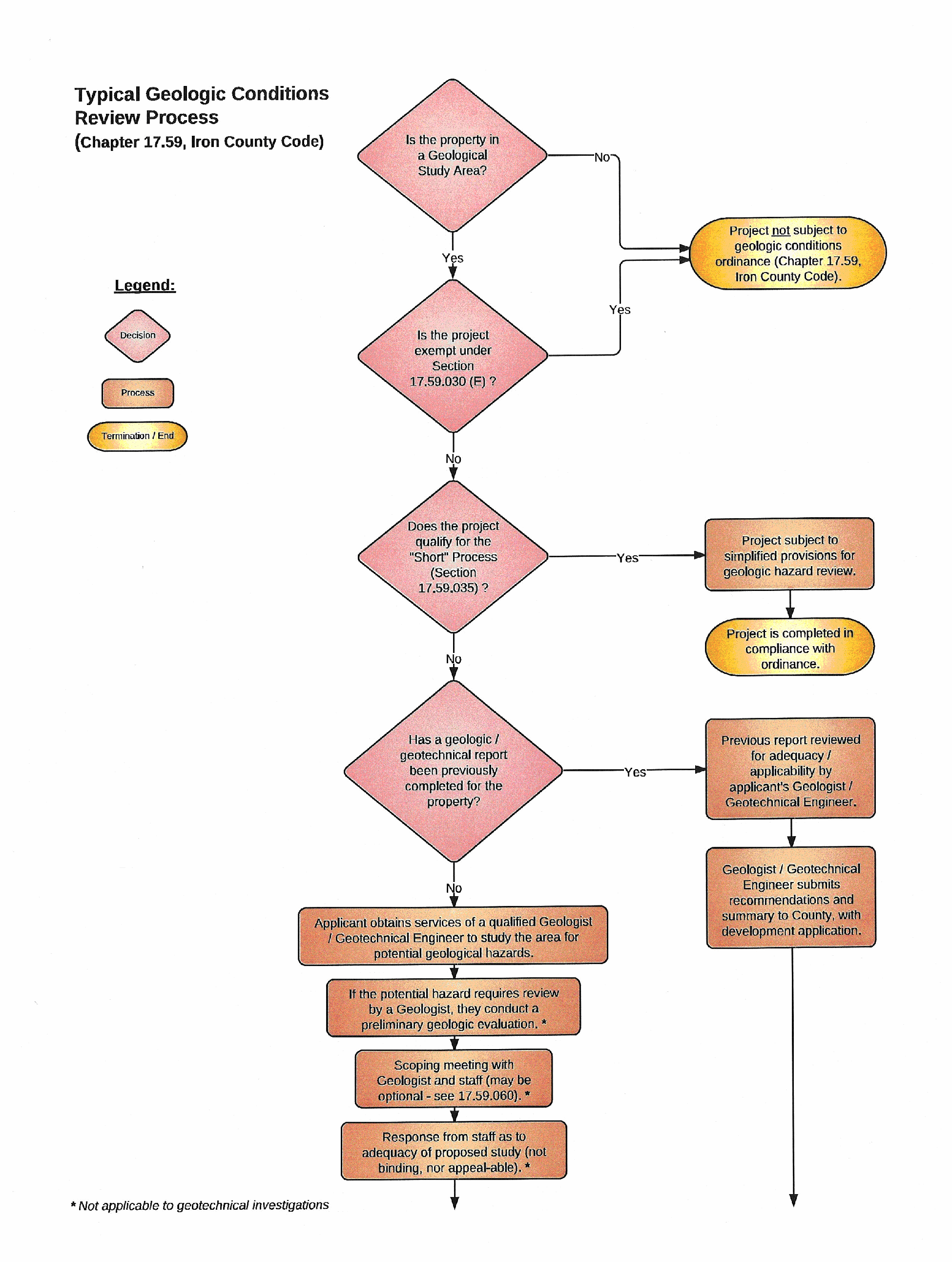
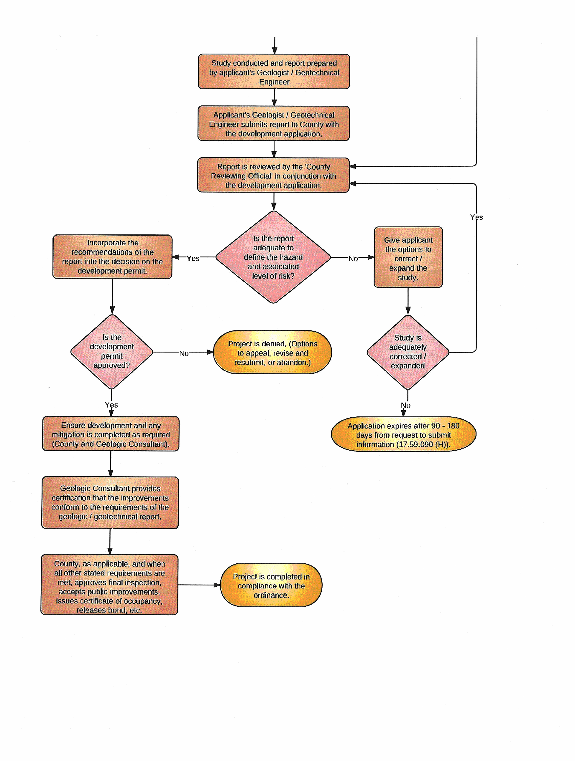
(Ord. No. 2011-8, § 1(Exh. B), 11-28-2011)