
Islamorada City Zoning Code
ARTICLE 30
V SCHEDULE OF DISTRICT USE AND DEVELOPMENT STANDARDS
DIVISION 30-V-3 NONCONFORMITIES
Cross reference(s)—Buildings and building regulations, ch. 6.
DIVISION 30-V-4 ACCESSORY USES AND STRUCTURES
Cross reference(s)—Buildings and building regulations, ch. 6.
DIVISION 30-V-8 TEMPORARY USES INCLUDING PUBLIC ASSEMBLIES
Editor's note(s)—Ord. No. 08-01, § 1, adopted Jan. 10, 2008, amended art. V, div. 8, in its entirety to read as herein set out. Former art. V, div. 8, entitled "Temporary Uses", §§ 30-881—30-885, pertained to similar subject matter and derived from Ord. No. 02-09, §§ 1(5.7.1—5.7.5), adopted Jan. 24, 2002.
13-17
15-09
16-16
17-09
17-10
15-07
15-13
16-09
19-07
19-20
22-01
23-09
17-05
16-06
14-07
12-07
13-15
19-16
19-19
19-17
21-04
12-05
16-01
16-10
13-16
17-12
18-02
15-08
19-18
Sec 30-681 Purpose; Uses Generally; Districts Established
- Purpose. In order to ensure that all development is consistent with the goals and objectives of the comprehensive plan, it is necessary and proper to establish a series of zoning districts to establish use and bulk regulations that control the use of land in each district consistent with this chapter. All development within each zoning district shall be consistent with the purposes stated for that district in this division.
- Uses generally.
- No structure or land in the village shall hereafter be developed, used or occupied unless expressly authorized in a zoning district in this division.
- Uses not specifically listed herein as a permitted or conditional use are prohibited, unless the director of planning and development services determines by written interpretation that the proposed use exhibits similar characteristics to a listed permitted use, in which case the proposed use shall be permitted in the same manner as the use with similar characteristics.
- Accessory uses as permitted within each zoning district shall be consistent with the definition of accessory uses as set forth in division 4 of this article.
- Districts established. In order to implement the goals and objectives of the comprehensive plan, the zoning districts are hereby established in this division.
Section 30-682
Native Residential (NR) Zoning District
Section 30-683
Residential Estate (RE) Zoning District
Section 30-684
Residential Single-Family (R1) and (R1M) Zoning District
Section 30-685
Residential Mobile Home (RMH) Zoning District
Section 30-686
Residential Duplex (R2) Zoning District
Section 30-687
Residential Triplex (R3) Zoning District
Section 30-688
Residential Fourplex (R4) Zoning District
Section 30-689
Multifamily (MF) Zoning District
Section 30-690
Mobile Home Park (MH) Zoning District
Section 30-691
Settlers Residential (SR) Zoning District
Section 30-692
Village Center (VC) Zoning District
Section 30-693
Tourist Commercial (TC) Zoning District
Section 30-694
Commercial Fishing (CF) Zoning District
Section 30-695
Marine Use (MR) Zoning District
Section 30-696
Highway Commercial (HC) Zoning District
Section 30-697
Neighborhood Commercial (NC) Zoning District
Section 30-698
Industrial (I) Zoning District
Section 30-699
Conservation (C) Zoning District
Section 30-700
Tavernaero Airstrip (TA) Zoning District
Section 30-701
Public and Semi-Public Services (PS) Zoning District
Section 30-702
Recreation (R) Zoning District
Section 30-703
Mariculture (M) Zoning District
- Summary of minimum required setbacks. The following table summarizes the minimum setback requirements of this division.
TABLE 30-684(d) SUMMARY OF MINIMUM REQUIRED SETBACKSSetbacks
Front yard
Side yard
Rear yard
Zoning Districts
Front yard
Reduced
Each side/combined total
Street side yard
Interior side yard
Not on shoreline(4)
Accessory structures(5)
NR
25
20(1)
5/15
10
5
20
5
RE
25
20(1)
5/15
10
5
20
5
R1/R1M
25
20(1)
5/15
10
5
20
5
RMH
10
—
5/15(3)
10
5
20
5
R2
25
20(1)
5/15
10
5
20
5
R3
25
—
10/20
10
10
20
5
R4
25
—
10/20
10
10
20
5
MF
25
20(1)
5/15
10
5
20
5
MH
25
—
5/15
10
5
20
5
SR
25
20(1)
5/15
10
5
20
5
VC
15
varies(2)
—
10 or buffer width(2)
5
10
—
TC
25
varies(2)
—
10 or buffer width(2)
10
20
—
CF
25
—
5/15
10
5
20
—
MR
25
varies(2)
—
10 or buffer width(2)
10
20 or 50(6)
—
HC
20
varies(2)
—
10 or buffer width(2)
5
20
—
NC
20
varies(2)
—
10 or buffer width(2)
5
20
—
I
25
—
10/20
10
10
25
—
C
25
—
10/20
10
10
20
—
TA
25
20(1)
5/15
10
5
20
5
PS
25
—
5/15
10
5
20
—
R
20
—
5/15
10
5
20
—
M
25
—
5/15
10
5
20
—
(1) With a five-foot-wide Class B bufferyard installed running the length of the frontage
(2) Reduced to minimum bufferyard width (see division 6 of this article) only for covered unenclosed areas, outdoor seating areas, balconies, roof overhangs, walkways, stairways and entryways
(3) If property has a width less than 50 feet, the minimum required setback is five feet on each side
(4) For rear yard setback on shoreline, see article VII, division 2 of this chapter
(5) Limited to 15 feet in height; one canopy tree per 50 feet of rear property line required within rear yard setback
(6) For all structures with over 50% of structure designated for residential dwelling units, setback shall be 50 feet from all shorelines having depth of at least 4 feet MLW
(Ord. No. 02-22, § 1(5.1.1), 1-31-2002; Ord. No. 05-17, § 1, 9-1-2005)
Sec 30-682 Native Residential (NR) Zoning District
- Purpose and intent.
- The purpose of the native residential (NR) zoning district is to provide the highest degree of protection for large residential tracts supporting or having the potential for restoration of high and moderate quality hammock, wetlands, beach or berm, to ensure the perpetuation of species reliant upon native habitat.
- This zoning district is established within the Residential Conservation (RC) FLUM category.
- Permitted uses.
- Single-family dwelling unit;
- Caretaker's cottage, provided that native species habitat restoration is undertaken consistent with article VII, division 4 of this chapter;
- Accessory uses and structures, including a guesthouse accessory to a single-family dwelling unit and limited to 500 square feet; and
- Collocation on existing wireless facility.
- Uses reviewed as a minor conditional use.
- Homeowners' park and associated facilities;
- Infrastructure and municipal utility facilities; and
- Replacement of existing wireless facility.
- Uses reviewed as a major conditional use. None.
- Site development standards.
- Minimum lot area: One acre.
- Maximum building height: 35 feet.
- Maximum developable lot coverage: 30 percent of total lot coverage for cumulative structures and uses.
- Setbacks:
- Front yard: 25 feet. Front yard setback may be reduced to 20 feet where a five-foot-wide Class B bufferyard is installed running the length of the frontage.
- Side yard: A minimum of five feet on each side for a minimum combined total of 15 feet for both sides.
- Street side yard: Minimum ten feet.
- Interior side yard: Minimum five feet.
- Rear yard not on shoreline: Minimum 20 feet.
Accessory structures limited to 15 feet in height may be permitted within the rear yard setback, provided that a five-foot rear yard setback is maintained and a minimum of one canopy tree per 50 feet of rear property line is planted within the 20-foot rear yard setback. - Rear yard on shoreline: See article VII, division 2 of this chapter.
- Floor area: Maximum floor area for principal structures: Not applicable.
- Density: One dwelling unit plus one caretaker's cottage per four acres.
- Open space: See article VII, division 4 of this chapter.
- Landscape requirements: See division 6 of this article.
- Parking requirements: Two spaces per single-family dwelling unit, 1.5 spaces per dwelling unit for multifamily development.
(Ord. No. 02-22, § 1(5.1.2), 1-31-2002; Ord. No. 02-29, § 7, 11-21-2002; Ord. No. 11-06, § 2, 1-13-2011)
Sec 30-683 Residential Estate (RE) Zoning District
- Purpose and intent.
- The purpose of the residential estate (RE) zoning district is to identify existing residential estates, and vacant estate properties designated for residential uses.
- This zoning district is established within the Residential Low (RL) FLUM category.
- Permitted uses.
- Single-family dwelling unit;
- Caretaker's cottage; and
- Accessory uses and structures, including a guesthouse accessory to a single-family dwelling unit and limited to 500 square feet.
- Uses reviewed as a minor conditional use.
- Homeowners' park and associated facilities; and
- Infrastructure and municipal utility facilities.
- Uses reviewed as a major conditional use. None.
- Site development standards.
- Minimum lot area: 0.5 acres.
- Maximum building height: 35 feet.
- Maximum developable lot coverage: 50 percent of total lot coverage for cumulative structures and uses.
- Setbacks:
- Front yard: 25 feet. Front yard setback may be reduced to 20 feet where a five-foot-wide Class B bufferyard is installed running the length of the frontage.
- Side yard: A minimum of five feet on each side for a minimum combined total of 15 feet for both sides.
- Street side yard: Minimum ten feet.
- Interior side yard: Minimum five feet.
- Rear yard not on shoreline: Minimum 20 feet.
Accessory structures limited to 15 feet in height may be permitted within the rear yard setback, provided that a five-foot rear yard setback is maintained and a minimum of one canopy tree per 50 feet of rear property line is planted within the 20-foot rear yard setback. - Rear yard on shoreline: See article VII, division 2 of this chapter.
- Floor area: Maximum floor area for principal structures: Not applicable.
- Density: One dwelling unit plus one caretaker's cottage per two acres.
- Open space: See article VII, division 4 of this chapter.
- Landscape requirements: See division 6 of this article.
- Parking requirements: See division 7 of this article.
(Ord. No. 02-22, § 1(5.1.3), 1-31-2002; Ord. No. 02-29, § 7, 11-21-2002; Ord. No. 11-06, § 2, 1-13-2011)
Sec 30-684 Residential Single-Family (R1) And (R1M) Zoning District
- Purpose and intent.
- The purpose of the residential single-family (R1) and (R1M) zoning district is to accommodate homes, homeowners' parks, and open space in single-family residential neighborhoods located in subdivisions and on streets where the primary land use is single-family residential. On lots fronting U.S. 1, this zoning district shall also accommodate deed restricted affordable housing of up to four units. All lots within this zoning district are platted or legally recorded.
- This zoning district is established within the Residential Medium (RM) FLUM category.
- Permitted uses.
- Single-family detached dwelling unit;
- Multifamily attached or detached single-family deed restricted affordable housing of up to four dwelling units on lots fronting U.S. 1;
- Where an "M" sub-district designator is indicated, only dwelling units of masonry construction; and
- Accessory uses and structures, excluding guesthouses.
- Uses reviewed as a minor conditional use.
- Homeowners' park and associated facilities;
- Infrastructure and municipal utility facilities; and
- Park.
- Uses reviewed as a major conditional use. None.
- Site development standards.
- Minimum lot area: 4,500 square feet for a single-family detached dwelling unit; 6,000 square feet for two attached or detached deed restricted affordable housing dwelling units; 9,000 square feet for three attached or detached deed restricted affordable housing dwelling units; and 12,000 square feet for four attached or detached deed restricted affordable housing dwelling units.
- Maximum building height: 35 feet.
- Maximum developable lot coverage: Not applicable.
- Setbacks:
- Front yard: 25 feet. Front yard setback may be reduced to 20 feet where a five-foot-wide Class B bufferyard is installed running the length of the frontage.
- Side yard: A minimum of five feet on each side for a minimum combined total of 15 feet for both sides.
- Street side yard: Minimum ten feet.
- Interior side yard: Minimum five feet.
- Rear yard not on shoreline: Minimum 20 feet.
Accessory structures limited to 15 feet in height may be permitted within the rear yard setback, provided that a five-foot rear yard setback is maintained and a minimum of one canopy tree per 50 feet of rear property line is planted within the 20-foot rear yard setback. - Rear yard on shoreline: See article VII, division 2 of this chapter.
- Floor area: Maximum floor area for principal structures: Not applicable.
- Density: One dwelling unit per lot except up to four deed restricted affordable housing dwelling units per lot fronting U.S. 1 pursuant to the minimum lot area standard for this zoning district.
- Open space: See article VII, division 4 of this chapter.
- Landscape requirements: See division 6 of this article.
- Parking requirements: See division 7 of this article.
(Ord. No. 02-22, § 1(5.1.4), 1-31-2002; Ord. No. 05-24, § 1, 12-15-2005; Ord. No. 11-06, § 2, 1-13-2011)
Sec 30-685 Residential Mobile Home (RMH) Zoning District
- Purpose and intent.
- The purpose of the residential mobile home (RMH) zoning district is to accommodate existing mobile homes on platted or legally recorded lots and to allow for the conversion to single-family detached dwelling units.
- This zoning district is established within the Residential Medium (RM) FLUM category.
- Permitted uses.
- Single-family detached dwelling unit;
- Mobile home; and
- Accessory uses and structures, excluding guesthouses.
- Uses reviewed as a minor conditional use.
- Homeowners' park and associated facilities;
- Infrastructure and municipal utility facilities; and
- Park.
- Uses reviewed as a major conditional use. None.
- Site development standards.
- Minimum lot area: Not applicable.
- Maximum building height: 35 feet.
- Maximum developable lot coverage: Not applicable.
- Setbacks:
- Front yard: Ten feet.
- Side yard:
- If the property has a width less than 50 feet and does not have a street side yard, the setback is five feet on each side.
- If the property has a width 50 feet or greater and does not have a street side yard, the setback is a minimum of five feet on each side for a minimum combined total of 15 feet for both sides.
- Street side yard: Minimum ten feet.
- Interior side yard: Minimum five feet.
- Rear yard not on shoreline: Minimum 20 feet.
Accessory structures limited to 15 feet in height may be permitted within the rear yard setback, provided that a five-foot rear yard setback is maintained and a minimum of one canopy tree per 50 feet of rear property line is planted within the 20-foot rear yard setback. - Rear yard on shoreline: See article VII, division 2 of this chapter.
- Floor area: Maximum floor area for principal structures: Not applicable.
- Density: One dwelling unit per lot.
- Open space: See article VII, division 4 of this chapter.
- Landscape requirements: See division 6 of this article.
- Parking requirements: One space per mobile home pad or two spaces per single-family detached dwelling unit.
(Ord. No. 02-22, § 1(5.1.5), 1-31-2002; Ord. No. 11-06, § 2, 1-13-2011)
Sec 30-686 Residential Duplex (R2) Zoning District
- Purpose and intent.
- The purpose of the residential duplex (R2) zoning district is to accommodate existing, lawfully permitted, single-family dwelling units and attached duplexes located in duplex residential neighborhoods, and to allow for new single-family dwelling units and duplexes as infill on vacant lots.
- This zoning district is established within the Residential Medium (RM) FLUM category.
- Permitted uses.
- Single-family dwelling unit;
- Duplex; and
- Accessory uses and structures, excluding guesthouses.
- Uses reviewed as a minor conditional use.
- Homeowners' park and associated facilities; and
- Infrastructure and municipal utility facilities.
- Uses reviewed as a major conditional use. None.
- Site development standards.
- Minimum lot area: 5,000 square feet.
- Maximum building height: 35 feet.
- Maximum developable lot coverage: Not applicable.
- Setbacks:
- Front yard: 25 feet. Front yard setback may be reduced to 20 feet where a five-foot-wide Class B bufferyard is installed running the length of the frontage.
- Side yard: A minimum of five feet on each side for a minimum combined total of 15 feet for both sides.
- Street side yard: Minimum ten feet.
- Interior side yard: Minimum five feet.
- Rear yard not on shoreline: Minimum 20 feet.
Accessory structures limited to 15 feet in height may be permitted within the rear yard setback, provided that a five-foot rear yard setback is maintained and a minimum of one canopy tree per 50 feet of rear property line is planted within the 20-foot rear yard setback. - Rear yard on shoreline: See article VII, division 2 of this chapter.
- Floor area: Maximum floor area for principal structures: Not applicable.
- Density: Up to two dwelling units per lot.
- Open space: See article VII, division 4 of this chapter.
- Landscape requirements: See division 6 of this article.
- Parking requirements: See division 7 of this article.
(Ord. No. 02-22, § 1(5.1.6), 1-31-2002; Ord. No. 11-06, § 2, 1-13-2011)
Sec 30-687 Residential Triplex (R3) Zoning District
- Purpose and intent.
- The purpose of the residential triplex (R3) zoning district is to provide opportunities along U.S. 1 for construction of triplex multifamily developments primarily on lots that are predominantly scarified or disturbed, whereby the upland location of the parcels will help ensure housing affordability over the long term.
- This zoning district is established within the Residential Medium (RM) FLUM category.
- Permitted uses.
- Three attached deed restricted affordable dwelling units; and
- Accessory uses and structures, excluding guesthouses.
- Uses reviewed as a minor conditional use.
- Homeowners' park and associated facilities; and
- Infrastructure and municipal utility facilities.
- Uses reviewed as a major conditional use. None.
- Site development standards.
- Minimum lot area: 12,000 square feet.
- Maximum building height: 35 feet.
- Maximum developable lot coverage: Not applicable.
- Setbacks:
- Front yard: Minimum 25 feet.
- Side yard: A minimum of ten feet on each side.
- Street side yard: Minimum ten feet.
- Interior side yard: Minimum ten feet.
- Rear yard not on shoreline: Minimum 20 feet.
Accessory structures limited to 15 feet in height may be permitted within the rear yard setback, provided that a five-foot rear yard setback is maintained and a minimum of one canopy tree per 50 feet of rear property line is planted within the 20-foot rear yard setback. - Rear yard on shoreline: See article VII, division 2 of this chapter.
- Floor area: Maximum floor area for principal structures: Not applicable.
- Density: Three dwelling units per lot.
- Open space: See article VII, division 4 of this chapter.
- Landscape requirements: See division 6 of this article.
- Parking requirements: See division 7 of this article.
(Ord. No. 02-22, § 1(5.1.7), 1-31-2002; Ord. No. 11-06, § 2, 1-13-2011)
Sec 30-688 Residential Fourplex (R4) Zoning District
- Purpose and intent.
- The purpose of the residential fourplex (R4) zoning district is to provide opportunities along U.S. 1 for construction of triplex and fourplex multifamily developments primarily on lots that are predominantly scarified or disturbed, whereby the upland location of the parcels will help ensure housing affordability over the long term.
- This zoning district is established within the Residential Medium (RM) FLUM category.
- Permitted uses.
- Three or four attached deed restricted affordable dwelling units; and
- Accessory uses and structures, excluding guesthouses.
- Uses reviewed as a minor conditional use.
- Homeowners' park and associated facilities; and
- Infrastructure and municipal utility facilities.
- Uses reviewed as a major conditional use. None.
- Site development standards.
- Minimum lot area: 16,000 square feet.
- Maximum building height: 35 feet.
- Maximum developable lot coverage: Not applicable.
- Setbacks:
- Front yard: Minimum 25 feet.
- Side yard: A minimum of ten feet on each side.
- Street side yard: Minimum ten feet.
- Interior side yard: Minimum ten feet.
- Rear yard not on shoreline: Minimum 20 feet.
Accessory structures limited to 15 feet in height may be permitted within the rear yard setback, provided that a five-foot rear yard setback is maintained and a minimum of one canopy tree per 50 feet of rear property line is planted within the 20-foot rear yard setback. - Rear yard on shoreline: See article VII, division 2 of this chapter.
- Floor area: Maximum floor area for principal structures: Not applicable.
- Density: Four dwelling units per lot.
- Open space: See article VII, division 4 of this chapter.
- Landscape requirements: See division 6 of this article.
- Parking requirements: See division 7 of this article.
(Ord. No. 02-22, § 1(5.1.8), 1-31-2002; Ord. No. 11-06, § 2, 1-13-2011)
Sec 30-689 Multifamily (MF) Zoning District
- Purpose and intent.
- The purpose of the multifamily (MF) zoning district is to accommodate existing condominiums, townhouses and apartments within the village, and to provide opportunities for new multifamily residential housing.
- This zoning district is established within the Residential High (RH) FLUM category.
- Permitted uses.
- Two to four dwelling units;
- Accessory uses and structures, excluding docking facilities and guest houses; and
- Collocation on existing wireless facility.
- Uses reviewed as a minor conditional use.
- Docking facility;
- Five or more dwelling units;
- Homeowners' park and associated facilities;
- Infrastructure and municipal utility facilities;
- Residential institutional uses;
- Attached wireless facility; and
- Replacement of existing wireless facilities.
- Uses reviewed as a major conditional use. Stealth wireless facility.
- Site development standards.
- Minimum lot area: Not applicable.
- Maximum building height: 35 feet.
- Maximum developable lot coverage: Not applicable.
- Setbacks:
- Front yard: 25 feet. Front yard setback may be reduced to 20 feet where a five-foot wide Class B bufferyard is installed running the length of the frontage.
- Side yard: A minimum of five feet on each side for a minimum combined total of 15 feet for both sides.
- Street side yard: Minimum ten feet.
- Interior side yard: Minimum five feet.
- Rear yard not on shoreline: Minimum 20 feet.
Accessory structures limited to 15 feet in height may be permitted within the rear yard setback, provided that a five-foot rear yard setback is maintained and a minimum of one canopy tree per 50 feet of rear property line is planted within the 20-foot rear yard setback. - Rear yard on shoreline: See article VII, division 2 of this chapter.
- Floor area: Maximum floor area for principal structures: Not applicable.
- Density: Up to six dwelling units per acre or up to 12 dwelling units per acre with TDRs or up to 15 deed restricted affordable housing dwelling units per acre.
- Open Space: See article VII, division 4 of this chapter.
- Landscape requirements: See division 6 of this article.
- Parking requirements: See division 7 of this article.
(Ord. No. 02-22, § 1(5.1.9), 1-31-2002; Ord. No. 05-17, § 1, 9-1-2005; Ord. No. 06-25, § 1, 12-14-2007; Ord. No. 11-06, § 2, 1-13-2011)
Sec 30-690 Mobile Home Park (MH) Zoning District
- Purpose and intent.
- The purpose of the mobile home park (MH) zoning district is to accommodate existing mobile home parks and to allow for conversion of lawfully permitted mobile homes to affordable housing that is less vulnerable to damage from severe weather events.
- This zoning district is established within the Residential High (RH) FLUM category.
- Permitted uses.
- Mobile home;
- Recreational vehicles pursuant to F.S. ch. 513; and
- Accessory uses and structures, excluding docking facilities and guesthouses.
- Uses reviewed as a minor conditional use.
- Homeowners' park and associated facilities;
- Docking facility;
- Infrastructure and municipal utility facilities; and
- Off-site redevelopment as a deed restricted affordable housing unit.
- Uses reviewed as a major conditional use. Redevelopment of multifamily housing dwelling units, including townhouses, condominiums and apartments, providing that each unit is a deed restricted affordable dwelling unit prohibiting vacation rental uses.
- Site development standards.
- Minimum lot area: Not applicable.
- Maximum building height: 35 feet.
- Maximum developable lot coverage: Not applicable.
- Setbacks:
- Front yard: Minimum 25 feet.
- Side yard: A minimum of five feet on each side for a minimum combined total of 15 feet for both sides.
- Street side yard: Minimum ten feet.
- Interior side yard: Minimum five feet.
- Rear yard not on shoreline: Minimum 20 feet.
Accessory structures limited to 15 feet in height may be permitted within the rear yard setback, provided that a five-foot rear yard setback is maintained and a minimum of one canopy tree per 50 feet of rear property line is planted within the 20-foot rear yard setback. - Rear yard on shoreline: See article VII, division 2 of this chapter.
- Floor area: Maximum floor area for principal structures: Not applicable.
- Density: Up to six dwelling units per acre, or up to 12 dwelling units per acre with TDRs or up to 15 deed restricted affordable housing dwelling units per acre.
- Open space: See article VII, division 4 of this chapter.
- Landscape requirements: See division 6 of this article.
- Parking requirements: One space per mobile home pad or recreational vehicle space.
(Ord. No. 02-22, § 1(5.1.10), 1-31-2002; Ord. No. 06-25, § 1, 12-14-2006; Ord. No. 11-06, § 2, 1-13-201)
Sec 30-691 Settlers Residential (SR) Zoning District
- Purpose and intent.
- The purpose of the settlers residential (SR) zoning district is to protect the unique residential character of the pre-FIRM single-family neighborhoods within and adjacent to the Upper Matecumbe village activity center.
- This zoning district is established within the Mixed Use (MU) and Residential Medium (RM) FLUM categories.
- Permitted uses.
- Single-family dwelling unit;
- Multifamily attached dwelling units consistent with comprehensive plan policy 1-2.1.4; and
- Accessory uses and structures, including a guesthouse accessory to a single-family dwelling unit and limited to 500 square feet.
- Uses reviewed as a minor conditional use.
- Homeowners' park and associated facilities; and
- Infrastructure and municipal utility facilities.
- Uses reviewed as a major conditional use. None.
- Site development standards.
- Minimum lot area: Not applicable.
- Maximum building height: 35 feet.
- Maximum developable lot coverage: Not applicable.
- Setbacks:
- Front yard: 25 feet. Front yard setback may be reduced to 20 feet where a five-foot-wide Class B bufferyard is installed running the length of the frontage.
- Side yard: A minimum of five feet on each side for a minimum combined total of 15 feet for both sides.
- Street side yard: Minimum ten feet.
- Interior side yard: Minimum five feet.
- Rear yard not on shoreline: Minimum 20 feet.
Accessory structures limited to 15 feet in height may be permitted within the rear yard setback, provided that a five-foot rear yard setback is maintained and a minimum of one canopy tree per 50 feet of rear property line is planted within the 20-foot rear yard setback. - Rear yard on shoreline: See article VII, division 2 of this chapter.
- Floor area: Maximum floor area for principal structures: Not applicable.
- Density: One dwelling unit per lot in the Residential Medium (RM) FLUM category or up to six dwelling units per acre in the Mixed Use (MU) FLUM category; however, on commercially developed parcels of land in the Mixed Use (MU) FLUM category, the density requirements for affordable housing provided herein shall not exceed 15 deed restricted affordable housing dwelling units per acre, regardless of any nonresidential floor area or FAR, or market rate residential dwelling units.
- Open space: See article VII, division 4 of this chapter.
- Landscape requirements: See division 6 of this article.
- Parking requirements: See division 7 of this article.
(Ord. No. 02-22, § 1(5.1.11), 1-31-2002; Ord. No. 06-25, § 1, 12-14-2006; Ord. No. 11-06, § 2, 1-13-2011)
Sec 30-692 Village Center (VC) Zoning District
- Purpose and intent.
- The purpose of the village center (VC) zoning district is to recognize and enhance the vitality of the core, mixed use business centers. In this zoning district, integrated business and residential uses shall be permitted, while requiring bufferyards and other mitigation techniques to ensure a smooth transition where these parcels interface with residential land uses. Businesses in this district promote walk-up traffic and are conducive to enhancing pedestrian-related facilities.
- This zoning district is established within the Mixed Use (MU) FLUM category.
- Permitted uses. The following uses are permitted uses if they do not contain a drive-in or drive-through component.
- Single-family dwelling units of 25 dwelling units or less, except the conversion of existing hotels or motels to single-family dwelling units is not permitted;
- Multifamily attached dwelling units of 25 dwelling units or less, except the conversion of existing hotels or motels to multifamily attached dwelling units is not permitted;
- Deed restricted affordable dwelling units of 25 dwelling units or less, except the conversion of existing hotels or motels to dwelling units is not permitted;
- Accessory uses and structures, excluding guesthouses;
- Brewpub less than 1,500 square feet;
- Community center;
- Fire station;
- Library;
- Municipal parking;
- Police station;
- Restaurants less than 1,500 square feet;
- Hotels or motels of 25 rooms or less;
- Collocation on existing wireless facility;
- Outdoor storage and display areas on vacant lots fronting US1 pursuant to article VI, division 8 of this chapter.
- Low/medium intensity office, retail, and service use 3,000 square feet or less, limited to:
- Professional services including accountant, administrative and management services, architect, engineer, counselor, interior designer, investment agent, lawyer, and other similar professions;
- Antique shop;
- Art gallery;
- Auditorium or public assembly hall;
- Bakery;
- Bait and tackle shop;
- Bicycle shop;
- Boat rental and sales;
- Bonding company;
- Bookstore;
- Brokerage office;
- Camera shop;
- Clothing store;
- Conference center;
- Courier service;
- Delicatessen (no tables);
- Government office;
- Day care center;
- Department store;
- Drugstore;
- Electronics store;
- Employment service;
- Fishing, diving and sailing shops/instruction;
- Florist;
- Food store, including retail sales of fresh and frozen fish, crustaceans and mollusks;
- Gift shop;
- Gym;
- Hardware store;
- Hobby shop;
- Interior decorator;
- Jewelry store;
- Laundry;
- Liquor store;
- Locksmith;
- Medical office;
- Movie theater (indoors);
- Museum;
- Office supplies and service;
- Recording/broadcasting studio;
- Salon;
- Spa;
- Studio school including art, sculpture, dance, drama and like instruction;
- Veterinary office / animal hospital;
- Video/ DVD rental;
- Visitor center; and
- Walk-up bank.
- Uses reviewed as a minor conditional use. The following uses are reviewed as minor conditional uses provided that they do not contain a drive-in or drive-through component.
- Any permitted use of 3,001 to 5,000 square feet, except restaurants;
- Hotels or motels having more than 25 rooms and less than 50 rooms;
- Any permitted residential use greater than 25 dwelling units, except that hotels and motels shall not be considered a residential use;
- Brewpubs of 1,500 to 3,000 square feet;
- Community pier or public dock;
- Docking facility;
- Homeowners' park and associated facilities;
- Infrastructure and municipal utility facilities;
- Restaurants of 1,500 to 5,000 square feet;
- Attached wireless facility; and
- Replacement of existing wireless facility.
- Manufacture, assembly, repair, maintenance and storage of commercial fishing traps and nets.
- Private membership club.
- Parking as an accessory use to a private membership club pursuant to Sec. 30-852 (a)(1).
- Uses reviewed as a major conditional use.
- Any permitted use of 5,001 to 10,000 square feet, including restaurants;
- Bars, taverns, and drinking places 10,000 square feet or less;
- Brewpubs of 3,001 to 5,000 square feet;
- Convenience store with or without fuel sales;
- Marina redevelopment;
- Redevelopment of existing outdoor storage and display areas;
- Stealth wireless facility; and
- Any use listed above as a permitted or minor conditional use, or a major conditional use listed herein, provided that the use contains a drive-in or drive-through component.
- Site development standards.
- Minimum lot area: Not applicable.
- Maximum building height: 35 feet.
- Maximum developable lot coverage: Not applicable.
- Setbacks:
- Front yard: Minimum 15 feet. Front yard setback may be reduced to the minimum required bufferyard width pursuant to division 6 of this article only for covered unenclosed areas, outdoor seating areas, balconies, roof overhangs, walkways, stairways and entryways.
- Street side yard: Minimum ten feet, or the required bufferyard width pursuant to division 6 of this article, whichever is less.
- Interior side yard: Minimum five feet.
- Rear yard: Minimum ten feet.
- Rear yard on shoreline: See article VII, division 2 of this chapter.
- Floor area: Maximum floor area for principal structures: 0.35 FAR.
- Density: Up to six dwelling units per acre, or up to 12 dwelling units per acre with TDRs or up to 15 deed restricted affordable housing dwelling units per acre; however, on commercially developed parcels of land, the density requirements for affordable housing provided herein shall not exceed 15 deed restricted affordable housing dwelling units per acre, regardless of any nonresidential floor area or FAR, or market rate residential dwelling units.
- Open space: See article VII, division 4 of this chapter.
- Landscape requirements: See division 6 of this article.
- Parking requirements: See division 7 of this article.
- Maximum principal building size: The maximum nonresidential floor area for a principal structure shall be 10,000 square feet or the maximum intensity (floor area ratio) allowable pursuant to this section, whichever is less.
(Ord. No. 02-22, § 1(5.1.12), 1-31-2002; Ord. No. 02-29, § 7, 11-21-2002; Ord. No. 05-13, § 1, 7-28-2005; Ord. No. 06-25, § 1, 12-14-2006; Ord. No. 07-10, § 1, 5-10-2007; Ord. No. 09-01, § 6, 1-22-2009; Ord. No. 09-03, § 2, 3-12-2009; Ord. No. 10-01, § 3, 1-14-2010)
Sec 30-693 Tourist Commercial (TC) Zoning District
- Purpose and intent.
- The purpose of the tourist commercial (TC) zoning district is to accommodate existing tourist lodging, tourist attractions and supportive facilities.
- This zoning district is established within the Mixed Use (MU) FLUM category.
- Permitted uses. The following uses are permitted uses if they do not contain a drive-in or drive-through component.
- Single family dwelling units of 25 dwelling units or less, except the conversion of existing hotels or motels to single-family dwelling units is not permitted;
- Deed restricted affordable housing dwelling units of 25 dwelling units or less, except the conversion of existing hotels or motels to dwelling units is not permitted;
- Hotels and motels with 25 rooms or less;
- Recreational equipment rental;
- Restaurants less than 1,500 square feet;
- Brewpubs less than 1,500 square feet; and
- Accessory uses and structures, excluding guesthouses.
- Uses reviewed as a minor conditional use. The following uses are reviewed as minor conditional uses provided that they do not contain a drive-in or drive-through component.
- Any permitted residential use, greater than 25 dwelling units, except that motels and hotels shall not be considered a residential use;
- Bars, taverns and drinking places less than 5,000 square feet;
- Brewpubs of 1,500 to 3,000 square feet;
- Commercial recreational facility less than 5,000 square feet;
- Community pier or public dock;
- Docking facility;
- Hotels or motels having more than 25 rooms and less than 50 rooms;
- Infrastructure and municipal utility facilities;
- Restaurants of 1,500 to 3,000 square feet; and
- Attached wireless facility.
- Outdoor storage and display areas on lots fronting US1 pursuant to article VI, division 8 of this chapter, as an accessory use to a permitted principle use.
- Uses reviewed as a major conditional use.
- Hotels or motels having 50 rooms or more;
- Brewpubs of 3,001 to 5,000 square feet;
- Commercial recreational uses of 5,000 square feet or greater;
- Marina redevelopment;
- Restaurants of 3,001 to 5,000 square feet;
- Stealth wireless facility;
- Outdoor storage and display areas on lots not fronting US1 pursuant to article VI, division 8 of this chapter, as an accessory use to a permitted principle use;
- Boat Dealership as an accessory use to a marina; and
- Any use listed above as a permitted or minor conditional use, or a major conditional use listed herein, provided that the use contains a drive-in or drive-through component.
- Site development standards.
- Minimum lot area: Not applicable.
- Maximum building height: 35 feet.
- Maximum developable lot coverage: Not applicable.
- Setbacks:
- Front yard: Minimum 25 feet. Front yard setback may be reduced to the minimum required bufferyard width pursuant to division 6 of this article only for covered unenclosed areas, outdoor seating areas, balconies, roof overhangs, walkways, stairways and entryways.
- Street side yard: Minimum ten feet, or the required bufferyard width pursuant to division 6 of this article, whichever is less.
- Interior side yard: Minimum ten feet.
- Rear yard: Minimum 20 feet.
- Rear yard on shoreline: See article VII, division 2 of this chapter.
- Floor area: Maximum floor area for principal structures: 0.25 FAR or 0.35 FAR with TDRs or with working waterfronts pursuant to article IV, division 17 of this chapter.
- Density: Up to six dwelling units per acre, or up to 12 dwelling units per acre with TDRs, or up to 15 deed restricted affordable housing dwelling units per acre; however, on commercially developed parcels of land, the density requirements for affordable housing provided herein shall not exceed 15 deed restricted affordable housing dwelling units per acre, regardless of any nonresidential floor area or FAR, or market rate residential dwelling units.
- Open space: See article VII, division 4 of this chapter.
- Landscape requirements: See division 6 of this article.
- Parking requirements: See division 7 of this article.
- Maximum principal building size: The maximum nonresidential floor area for a principal structure shall be 10,000 square feet or the maximum intensity (floor area ratio) allowable pursuant to this section, whichever is less.
(Ord. No. 02-22, § 1(5.1.13), 1-31-2002; Ord. No. 02-29, § 7, 11-21-2002; Ord. No. 05-13, § 1, 7-28-2005; Ord. No. 06-25, § 1, 12-14-2006; Ord. No. 09-01, § 6, 1-22-2009; Ord. No. 09-03, § 2, 3-12-2009; Ord. No. 10-01, § 3, 1-14-2010)
Sec 30-694 Commercial Fishing (CF) Zoning District
- Purpose and intent.
- The purpose of the commercial fishing (CF) zoning district is to protect the commercial fisheries in the village by designating lands for the continued use of commercial fishers while minimizing aesthetic and environmental impacts, and impacts on residential properties adjacent to or across a canal from the commercial fishing use.
- This zoning district is established within the Mixed Use (MU) future land use category.
- Permitted uses.
- Docking, loading, and unloading of commercial fishing vessels;
- Manufacture, assembly, repair, maintenance and storage of commercial fishing traps and nets; and
- Uses and structures accessory to commercial fishing, such as bait fish tanks.
- Uses reviewed as a minor conditional use.
- Single-family dwelling units;
- Deed restricted affordable housing dwelling units;
- The following commercial retail, low and medium intensity uses, may be permitted as a minor conditional use provided there is no displacement of existing commercial fishing dockage or area, and the goods and services are related to the commercial fishing industry:
- Accessory office use;
- Accessory wholesale and retail fresh fish;
- Commercial fishery suppliers;
- Commercial retail;
- Docking facility;
- Fuel sales limited to a boat fueling facility;
- Infrastructure and municipal utility facilities;
- Marine (re)upholstery;
- Processing and packaging of fish and fish products.
- Restaurants limited to 1,500 square feet in size, or less than 50 percent of the intensity allowable pursuant to this chapter, whichever is less; and
- Brewpubs limited to 1,500 square feet in size, or less than 50 percent of the intensity allowable pursuant to this chapter, whichever is less.
- Private membership club.
- Uses reviewed as a major conditional use. None.
- Site development standards.
- Minimum lot area: Not applicable.
- Maximum building height: 35 feet.
- Maximum developable lot coverage: Not applicable.
- Setbacks:
- Front yard: Minimum 25 feet.
- Side yard: A minimum of five feet on each side for a minimum combined total of 15 feet for both sides.
- Street side yard: Minimum ten feet.
- Interior side yard: Minimum five feet.
- Rear yard: Minimum 20 feet.
- Rear yard on shoreline: See article VII, division 2 of this chapter.
- Floor area: Maximum floor area for principal structures: 0.25 FAR or 0.35 FAR with working waterfronts, pursuant to article IV, division 17 of this chapter.
- Density: Up to two dwelling units per acre, or up to 15 deed restricted affordable housing dwelling units per acre; however, on commercially developed parcels of land, the density requirements for affordable housing provided herein shall not exceed 15 deed restricted affordable housing dwelling units per acre, regardless of any nonresidential floor area or FAR, or market rate residential dwelling units.
- Open space: See article VII, division 4 of this chapter.
- Landscape requirements: See division 6 of this article.
- Parking requirements: See division 7 of this article.
- Maximum principal building size: The maximum nonresidential floor area for a principal structure shall be 10,000 square feet or the maximum intensity (floor area ratio) allowable pursuant to this section, whichever is less.
(Ord. No. 02-22, § 1(5.1.14), 1-31-2002; Ord. No. 02-29, § 7, 11-21-2002; Ord. No. 06-25, § 1, 12-14-2006; Ord. No. 09-01, § 6, 1-22-2009)
Sec 30-695 Marine Use (MR) Zoning District
- Purpose and intent.
- The purpose of the marine use (MR) zoning district is to establish and conserve areas suitable for maritime uses such as boat repair and storage and other water dependent manufacturing and service uses. Accessory uses such as restaurants, tackle shops and outfitting shops, so as to ensure the long-term economic viability of the principal uses, may also be permitted.
- This zoning district is established within the Mixed Use (MU) future land use category.
- Permitted uses.
- Bait and tackle sales;
- Fishing, diving and sailing shops/instruction;
- Marine (re)upholstery;
- Sales and rentals of marine vessels and related marine equipment;
- Ship's store; and
- Accessory uses and structures, excluding guesthouses.
- Uses reviewed as a minor conditional use.
- Single-family dwelling unit;
- Multifamily attached dwelling units;
- Deed restricted affordable dwelling unit;
- Docking facility;
- Boat barn;
- Outdoor storage of marine vessels and related marine equipment consistent with outdoor storage and display regulations provided for within article VI, division 8 of this chapter; except that subsections 30-1374(b)(4) and 30-1374(b)(8) shall not apply;
- Infrastructure and municipal utility facilities;
- Attached wireless facility;
- Restaurants limited to 3,000 square feet in size or less than 50 percent of the intensity allowable pursuant to this chapter, whichever is less;
- Brewpubs limited to 3,000 square feet in size, or less than 50 percent of the intensity allowable pursuant to this chapter, whichever is less; and
- Manufacture, assembly, repair, maintenance and storage of commercial fishing traps and nets.
- Private membership club.
- Uses reviewed as a major conditional use.
- Boat repair facility;
- Mariculture;
- Marina redevelopment; and
- Repair and service of marine vessels and related marine equipment.
- Site development standards.
- Minimum lot area: Not applicable.
- Maximum height: 35 feet for any structure or outdoor storage except boat towers, sails, masts, outriggers or other similar features as determined by the director of planning and development services.
- Maximum developable lot coverage: Not applicable.
- Setbacks:
- Front yard: 25 feet. Front yard setback may be reduced to the minimum required bufferyard width pursuant to division 6 of this article only for covered unenclosed areas, outdoor seating areas, balconies, roof overhangs, walkways, stairways and entryways.
- Street side yard: Minimum ten feet, or the required bufferyard width pursuant to division 6 of this article, whichever is less.
- Interior side yard: Minimum ten feet.
- Rear yard: Minimum 20 feet.
- Rear yard on shoreline: See article VII, division 2 of this chapter.
- Residential uses: For all structures with over 50 percent of the structure designated for dwelling units, the setback shall be 50 feet from all shorelines having a depth of at least four feet MLW.
- Floor area: Maximum floor area for principal structures: 0.25 FAR or 0.35 FAR with TDRs or with working waterfronts pursuant to article IV, division 17 of this chapter.
- Density: Up to six dwelling units per acre or up to 15 deed restricted affordable housing dwelling units per acre; however, on commercially developed parcels of land, the density requirements for affordable housing provided herein shall not exceed 15 deed restricted affordable housing dwelling units per acre, regardless of any nonresidential floor area or FAR, or market rate residential dwelling units.
- Open space: See article VII, division 4 of this chapter.
- Landscape requirements: See division 6 of this article.
- Parking requirements: See division 7 of this article.
- Maximum principal building size: The maximum nonresidential floor area for a principal structure shall be 10,000 square feet or the maximum intensity (floor area ratio) allowable pursuant to this section, whichever is less.
(Ord. No. 02-22, § 1(5.1.15), 1-31-2002; Ord. No. 02-29, § 7, 11-21-2002; Ord. No. 06-25, § 1, 12-14-2006; Ord. No. 09-01, § 6, 1-22-2009; Ord. No. 09-16, § 2, 9-24-2009; Ord. No. 10-01, § 3, 1-14-2010)
Sec 30-696 Highway Commercial (HC) Zoning District
- Purpose and intent.
- The purpose of the highway commercial (HC) zoning district is to accommodate existing businesses along U.S. 1 and to provide opportunities for new commercial retail shops and services that typically are auto dependent and are used by people on less than a weekly basis, or to accommodate the building and service trades. Single-family or multifamily residential uses and educational uses are an option to commercial use.
- This zoning district is established within the Mixed Use (MU) FLUM category.
- Permitted uses. The following uses are permitted uses if they do not contain a drive-in or drive-through component.
- Single family dwelling unit on vacant parcels in lieu of non-residential development pursuant to comprehensive plan policy 1-2.4.3;
- Deed restricted affordable dwelling unit developments of 25 dwelling units or less, except the conversion of existing hotels or motels to dwelling units is not permitted;
- Accessory uses and structures, excluding guest houses;
- Brewpubs less than 1,500 square feet;
- Restaurants less than 1,500 square feet;
- Microbrewery less than 3,000 square feet;
- Low/medium intensity office, retail and service establishments, less than 3,000 square feet, limited to:
- Animal hospital;
- Bakery;
- Boat sales and service;
- Bowling center;
- Building supply store;
- Carwash;
- Commercial recreational facility;
- Courier service;
- Cultural or community center;
- Day care center;
- Delicatessen (no tables);
- Dive shop;
- Electronics store;
- Exterminator service;
- Farmers' market;
- Fence sales and installation;
- Food store;
- Funeral home;
- Furniture repair, (re)upholstery, and sales;
- Garden center;
- Gym;
- Hardware store;
- Home furnishing, design and decorating services and retail sales;
- Appliance repair;
- Landscape services;
- Laundry and dry cleaning;
- Locksmith;
- Medical offices and supplies;
- Movie theater (indoors);
- Office supply;
- Pool sales and service;
- Salons;
- Professional services including accountant, administrative and management services, architect, engineer, counselor, interior designer, investment agent, lawyer, and other similar professions;
- Recording/broadcasting studio;
- Sewing supply and service;
- Tackle/fishing shop;
- Visitor center; and
- Video rental.
- Outdoor storage and display areas on vacant lots fronting US1 pursuant to article VI, division 8 of this chapter.
- Uses reviewed as a minor conditional use. The following uses are reviewed as minor conditional uses provided that they do not contain a drive-in or drive-through component.
- Any permitted residential use greater than 25 dwelling units, except that hotels and motels shall not be considered a residential use;
- Any permitted use of 3,000 to 5,000 square feet, except restaurants;
- Brewpubs of 1,500 to 3,000 square feet;
- Docking facility;
- Infrastructure and municipal utility facilities;
- Plant nursery;
- Restaurants of 1,500 to 3,000 square feet;
- Self-service storage facility (indoor); and
- Attached wireless facility.
- Private membership club.
- Uses reviewed as a major conditional use.
- Any permitted use greater than 5,000 square feet, except restaurants;
- Bars, taverns, and drinking places;
- Brewpubs greater than 3,000 square feet;
- Convenience store with or without fuel sales;
- Marina redevelopment;
- Restaurants greater than 3,000 square feet;
- Outdoor storage and display areas on lots not fronting US1 pursuant to article VI, division 8 of this chapter;
- Schools; and
- Any use listed above as a permitted or minor conditional use, or a major conditional use listed herein, provided that the use contains a drive-in or drive-through component.
- Site development standards.
- Minimum lot area: Not applicable.
- Maximum building height: 35 feet.
- Maximum developable lot coverage: Not applicable.
- Setbacks:
- Front yard: Minimum 20 feet. Front yard setback may be reduced to the minimum required bufferyard width pursuant to division 6 of this article only for covered unenclosed areas, outdoor seating areas, balconies, roof overhangs, walkways, stairways and entryways.
- Street side yard: Minimum ten feet, or the required bufferyard width pursuant to division 6 of this article, whichever is less.
- Interior side yard: Minimum five feet.
- Rear yard: Minimum 20 feet.
- Rear yard on shoreline: See article VII, division 2 of this chapter.
- Floor area: Maximum floor area for principal structures: 0.25 FAR or 0.35 FAR with TDRs or with working waterfronts pursuant to article IV, division 17 of this chapter.
- Density: One dwelling unit per acre or up to 15 deed restricted affordable housing dwelling units per acre; however, on commercially developed parcels of land, the density requirements for affordable housing provided herein shall not exceed 15 deed restricted affordable housing dwelling units per acre, regardless of any nonresidential floor area or FAR, or market rate residential dwelling units.
- Open space: See article VII, division 4 of this chapter.
- Landscape requirements: See division 6 of this article.
- Parking requirements: See division 7 of this article.
- Maximum principal building size: The maximum nonresidential floor area for a principal structure shall be 10,000 square feet or the maximum intensity (floor area ratio) allowable pursuant to this section, whichever is less.
(Ord. No. 02-22, § 1(5.1.16), 1-31-2002; Ord. No. 02-29, § 7, 11-21-2002; Ord. No. 05-13, § 1, 7-28-2005; Ord. No. 06-08, § 1, 4-27-2006; Ord. No. 06-25, § 1, 12-14-2006; Ord. No. 09-01, § 6, 1-22-2009; Ord. No. 09-03, § 2, 3-12-2009; Ord. No. 10-01, § 3, 1-14-2010)
Sec 30-697 Neighborhood Commercial (NC) Zoning District
- Purpose and intent.
- The purpose of the neighborhood commercial (NC) zoning district is to provide a compact commercial area designed and intended to allow for a mix of residential, office and local retail sales servicing the daily needs of local residents within convenient traveling distance.
- This zoning district is established within the Mixed Use (MU) FLUM category.
- Permitted uses. The following uses are permitted uses if they do not contain a drive-in or drive-through component.
- Single-family dwelling unit;
- Attached deed restricted affordable dwelling units;
- Accessory uses and structures, excluding guesthouses;
- Low/medium intensity retail, service and office uses, 2,500 square feet or less, limited to:
- Medical office;
- Professional services including accountant, administrative and management services, architect, engineer, counselor, interior designer, investment agent, lawyer, and other similar professions;
- Studio school including art, sculpture, dance, drama and like instruction;
- Bakery;
- Day care center;
- Delicatessen (no tables);
- Drugstore;
- Fishing, diving and sailing shop/instruction;
- Florist;
- Food store;
- Gym;
- Interior decorator;
- Laundry;
- Liquor store;
- Office supply and service; and
- Salon.
- Outdoor storage and display areas on vacant lots fronting US1 pursuant to article VI, division 8 of this chapter.
- Uses reviewed as a minor conditional use. The following uses are reviewed as minor conditional uses provided that they do not contain a drive-in or drive-through component.
- Commercial fishing uses;
- Community pier or public dock;
- Brewpubs limited to 1,500 square feet in size, or less than 50 percent of the intensity allowable pursuant to this chapter, whichever is less;
- Docking facility;
- Existing commercial fishing operations;
- Infrastructure and municipal utility facilities;
- Walk-up bank;
- Attached wireless facility;
- Restaurants, limited to 1,500 square feet in size, or less than 50 percent of the intensity allowable pursuant to this chapter, whichever is less; and
- Manufacture, assembly, repair, maintenance and storage of commercial fishing traps and nets.
- Private membership club.
- Uses reviewed as a major conditional use.
- Convenience stores with or without fuel sales.
- Outdoor storage and display areas on lots not fronting US1 pursuant to article VI, division 8 of this chapter;
- Any use listed above as a permitted or minor conditional use, or a major conditional use listed herein, provided that the use contains a drive-in or drive-through component.
- Site development standards.
- Minimum lot area: Not applicable.
- Maximum building height: 35 feet.
- Maximum developable lot coverage: Not applicable.
- Setbacks:
- Front yard: Minimum 20 feet. Front yard setback may be reduced to the minimum required bufferyard width pursuant to division 6 of this article only for covered unenclosed areas, outdoor seating areas, balconies, roof overhangs, walkways, stairways and entryways.
- Street side yard: Minimum ten feet, or the required bufferyard width pursuant to division 6 of this article, whichever is less.
- Interior side yard: Minimum five feet.
- Rear yard: Minimum 20 feet.
- Rear yard on shoreline: See article VII, division 2 of this chapter.
- Floor area: Maximum floor area for principal structures: 0.25 FAR or 0.35 FAR with TDRs or with working waterfronts pursuant to article IV, division 17 of this chapter.
- Density: Up to six dwelling units per acre, or up to 12 dwelling units per acre; with TDRs, or up to 15 deed restricted affordable housing dwelling units per acre; however, on commercially developed parcels of land, the density requirements for affordable housing provided herein shall not exceed 15 deed restricted affordable housing dwelling units per acre, regardless of any nonresidential floor area or FAR, or market rate residential dwelling units.
- Open space: See article VII, division 4 of this chapter.
- Landscape requirements: See division 6 of this article.
- Parking requirements: See division 7 of this article.
- Maximum principal building size: The maximum nonresidential floor area for a principal structure shall be 10,000 square feet or the maximum intensity (floor area ratio) allowable pursuant to this section, whichever is less.
(Ord. No. 02-22, § 1(5.1.17), 1-31-2002; Ord. No. 02-29, § 7, 11-21-2002; Ord. No. 06-25, § 1, 12-14-2006; Ord. No. 09-01, § 6, 1-22-2009; Ord. No. 09-03, § 2, 3-12-2009; Ord. No. 10-01, § 3, 1-14-2010)
Sec 30-698 Industrial (I) Zoning District
- Purpose and intent.
- The purpose of the industrial (I) zoning district is to provide appropriate locations for light industrial activities, including research and development, assemblage, processing, packaging and temporary storage or distribution of goods, storage and limited use of heavy equipment, and to provide for commercial uses not compatible with residential uses.
- This zoning district is established within the Industrial (I) FLUM category.
- Permitted uses.
- Caretaker's cottage;
- Accessory uses and structures, excluding guesthouses;
- Collocation on existing wireless facility;
- Low/medium intensity uses, 5,000 square feet or less;
- Adult entertainment establishment;
- Artisan's workshop;
- Automobile, boat repairs, sales and servicing;
- Carpentry shop;
- Funeral home;
- Lease and wholesale equipment supply and servicing;
- Machine shop;
- Metalwork shop;
- Microbrewery;
- Recording studio;
- Warehousing and indoor storage;
- Winery; and
- Accessory uses and structures.
- Uses permitted as a minor conditional use.
- Assemblage and/or packaging;
- Construction, contractors or trades yards including equipment rental;
- Infrastructure and municipal utility facilities;
- Laboratory;
- Research and development center;
- Attached wireless facility;
- Replacement of existing wireless facility;
- Stealth wireless facility; and
- Any use listed above as a permitted use 5,001 to 10,000 square feet.
- Uses permitted as a major conditional use.
- Boat repair facility;
- Crematorium;
- Mariculture;
- Recycling center;
- New wireless facility;
- Outdoor storage and display areas pursuant to article VI, division 8 of this chapter; and
- Any use listed above as a permitted use, provided that the use is greater than 10,000 square feet.
- Site development standards.
- Minimum lot area: Not applicable.
- Maximum building height: 35 feet.
- Maximum developable lot coverage: Not applicable.
- Setbacks:
- Front yard: Minimum 25 feet.
- Side yard: A minimum of ten feet on each side.
- Street side yard: Minimum ten feet.
- Interior side yard: Minimum ten feet.
- Rear yard: Minimum 25 feet.
- Rear yard on shoreline: See article VII, division 2 of this chapter.
- Floor area: Maximum floor area for principal structures: 0.25 FAR.
- Density: One caretaker's cottage per lot.
- Open space: See article VII, division 4 of this chapter.
- Landscape requirements: See division 6 of this article.
- Parking requirements: See division 7 of this article.
- Maximum principal building size: The maximum nonresidential floor area for a principal structure shall be 10,000 square feet or the maximum intensity (floor area ratio) allowable pursuant to this section, whichever is less.
(Ord. No. 02-22, § 1(5.1.18), 1-31-2002; Ord. No. 02-29, § 7, 11-21-2002)
Sec 30-699 Conservation (C) Zoning District
- Purpose and intent.
- The purpose of the conservation (C) zoning district is to ensure the longterm preservation, and restoration of environmentally sensitive natural resource systems.
- This zoning district is established within the Conservation (C) FLUM category.
- Permitted uses.
- The off-site transfer of density in the amount of 0.25 per acre pursuant to article IV, division 12 of this chapter.
- Collocation on existing wireless facility.
- Fences on property line(s) adjacent to a roadway or within ten feet of property line(s) adjacent to a roadway provided that:
- The fence shall be limited to six feet in height;
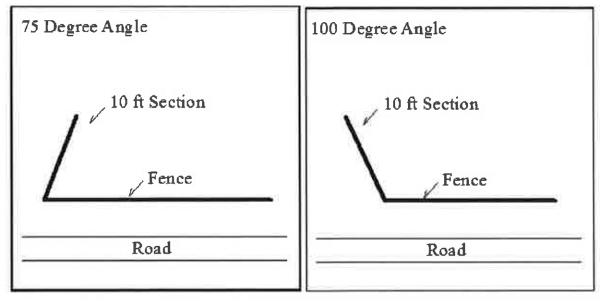
- The fence shall run parallel to the adjacent roadway except for a generally perpendicular section at an angle at the terminal end(s) for a distance of no more than ten linear feet;
- The fence shall not require clearing of any tropical hardwood hammock or Class I habitat; and
- All other criteria within division 7, article V of this chapter is met.
- Passive recreational uses including, but not limited to, trails and walkways.
- Uses permitted as a minor conditional use.
- Infrastructure and municipal utility facilities;
- Replacement of existing wireless facility.
- Uses permitted as a major conditional use. None.
- Site development standards.
- Minimum lot area: Not applicable.
- Maximum building height: 35 feet.
- Maximum developable lot coverage: Not applicable.
- Setbacks:
- Front yard: Minimum 25 feet.
- Side yard: A minimum of ten feet on each side.
- Street side yard: Minimum ten feet.
- Interior side yard: Minimum ten feet.
- Rear yard: Minimum 20 feet.
- Rear yard on shoreline: See article VII, division 2 of this chapter.
- Floor area:
- Maximum floor area for principal structures: Not applicable.
- Maximum cumulative floor area for accessory structures: Not applicable.
- Density: Not applicable.
- Open space: See article VII, division 4 of this chapter.
- Landscape requirements: See division 6 of this article.
- Parking requirements: See division 7 of this article.
(Ord. No. 02-22, § 1(5.1.19), 1-31-2002)
Sec 30-700 Tavernaero Airstrip (TA) Zoning District
- Purpose and intent.
- The purpose of the Tavernaero Airstrip (TA) zoning district is to allow for the accommodation of aircraft parking as a permitted primary land use on single-family residential properties adjacent to Tavernaero Airstrip.
- This zoning district is established within the Airport (A) FLUM category.
- Approach zones shall be clear of obstruction above a glide path of 20:1 from the ends of each usable runway. When the approach zone to any runway crosses a road, the glide path must pass at least 15 feet above the edge of the nearest traffic lane.
- No development approval or building permit shall be granted for the construction of any structure to be located within this district which when built would constitute an airspace obstruction that would cause a minimum obstruction altitude, a minimum descent altitude, or a decision height to be changed or a threshold to be displaced, or interfere with the required approach glide slope.
- Permitted uses.
- Single-family dwelling unit of masonry construction;
- Accessory uses and structures, excluding guesthouses;
- Airstrip;
- Aircraft hangars or storage accessory to the airstrip; and
- Storage of aircraft accessory to a residential use.
- Uses permitted as a minor conditional use.
- Homeowners' park and associated facilities;
- Infrastructure and municipal utility facilities; and
- Private flight instruction as a home occupation.
- Uses permitted as a major conditional use. None.
- Site development standards.
- Minimum lot area: 4,500 square feet.
- Maximum building height: 35 feet.
- Maximum developable lot coverage: Not applicable.
- Setbacks:
- Front yard: 25 feet. Front yard setback may be reduced to 20 feet where a five-foot-wide Class B bufferyard is installed running the length of the frontage.
- Side yard: A minimum of five feet on each side for a minimum combined total of 15 feet for both sides.
- Street side yard: Minimum ten feet.
- Interior side yard: Minimum five feet.
- Rear yard not on shoreline: Minimum 20 feet.
Accessory structures limited to 15 feet in height may be permitted within the rear yard setback, provided that a five-foot rear yard setback is maintained and a minimum of one canopy tree per 50 feet of rear property line is planted within the 20-foot rear yard setback. - Rear yard on shoreline: See article VII, division 2 of this chapter.
- Floor area: Maximum floor area for principal structures: Not applicable.
- Density: One dwelling unit per lot.
- Open space: See article VII, division 4 of this chapter.
- Landscape requirements: See division 6 of this article.
- Parking requirements: Two spaces per single-family dwelling unit.
(Ord. No. 02-22, § 1(5.1.20), 1-31-2002; Ord. No. 02-29, § 7, 11-21-2002; Ord. No. 11-06, § 2, 1-13-2011)
Sec 30-701 Public And Semi-Public Services (PS) Zoning District
- Purpose and intent.
- The purpose of the public and semi-public services (PS) zoning district is to accommodate existing public and semi-public services, facilities and uses, whether owned or managed by a by a federal, state, county or municipal agency, by an individual or corporation or by a public/private partnership, while ensuring that potential impacts on adjacent properties are mitigated.
- This zoning district is established within the Residential High (RH), Mixed Use (MU), Public and Semi-Public Services (PS) and Industrial (I) FLUM categories.
- Permitted uses.
- Caretaker's cottage;
- Accessory uses and structures;
- Hurricane or emergency shelter;
- Collocation on existing wireless facility;
- Arts and cultural facility;
- Civil defense facility;
- Domestic violence center;
- Detention facility;
- Emergency medical and ambulance services;
- Fire station;
- Government offices;
- Houses of worship and religious facilities;
- Infrastructure and municipal utility facilities;
- Police station; and
- Residential-institutional uses.
- Uses permitted as a minor conditional use.
- Community pier or public dock;
- Docking facility;
- Health related institutions including care facility and supportive health care dwelling units;
- Hospital complex;
- Recycling center;
- Rehabilitation center;
- Sports arena;
- Attached wireless facility;
- Replacement of existing wireless facility; and
- Stealth wireless facility.
- Uses permitted as a major conditional use.
- Helipad;
- Schools;
- New wireless facility; and
- Outdoor storage and display areas pursuant to article VI, division 8 of this chapter.
- Site development standards.
- Minimum lot area: Not applicable.
- Maximum building height: 35 feet.
- Maximum developable lot coverage: Not applicable.
- Setbacks:
- Front yard: Minimum 25 feet.
- Side yard: A minimum of five feet on each side for a minimum combined total of 15 feet for both sides.
- Street side yard: Minimum ten feet.
- Interior side yard: Minimum five feet.
- Rear yard: Minimum 20 feet.
- Rear yard on shoreline: See article VII, division 2 of this chapter.
- Floor area: Maximum floor area for principal structures: 0.25 FAR or 0.35 FAR with TDRs.
- Density: One dwelling unit per lot, or up to 12 dwelling units per acre for residential-institutional uses.
- Open space: See article VII, division 4 of this chapter.
- Landscape requirements: See division 6 of this article.
- Parking requirements: See division 7 of this article.
- Maximum principal building size: The maximum nonresidential floor area for a principal structure shall be 10,000 square feet or the maximum intensity (floor area ratio) allowable pursuant to this section, whichever is less.
(Ord. No. 02-22, § 1(5.1.21), 1-31-2002; Ord. No. 02-29, § 7, 11-21-2002)
Sec 30-702 Recreation (R) Zoning District
- Purpose and intent.
- The purpose of the Recreation (R) Zoning District is to accommodate recreational facilities, supportive services and uses, and village support services and uses.
- This zoning district is established within the Recreation (RO) and Mixed Use (MU) FLUM categories.
- Permitted uses.
- Park;
- Food concession limited to 500 square feet;
- Non-motorized watercraft rental;
- Fitness and recreational facilities;
- Accessory uses and structures excluding a docking facility; and
- Collocation on existing wireless facility.
- Uses permitted as a minor conditional use.
- Docking facility;
- Government offices and supportive facility;
- Infrastructure and municipal utility facilities;
- Park maintenance facility;
- Attached wireless facility;
- Replacement of existing wireless facility; and
- Stealth wireless facility.
- Uses permitted as a major conditional use.
- Helipad;
- Marina redevelopment;
- New wireless facility;
- Chamber of commerce office and supportive facility; and
- Visitor center.
- Site development standards.
- Minimum lot area: Not applicable.
- Maximum building height: 35 feet.
- Maximum developable lot coverage: Not applicable.
- Setbacks:
- Front yard: Minimum 20 feet.
- Side yard: A minimum of five feet on each side for a minimum combined total of 15 feet for both sides.
- Street side yard: Minimum ten feet.
- Interior side yard: Minimum five feet.
- Rear yard: Minimum 20 feet.
- Rear yard on shoreline: See article VII, division 2 of this chapter.
- Floor area: Maximum floor area for principal structures: 0.15 FAR.
- Density: Not applicable.
- Open space: See article VII, division 4 of this chapter.
- Landscape requirements: See division 6 of this article.
- Parking requirements: See division 7 of this article.
- Maximum principal building size: The maximum nonresidential floor area for a principal structure shall be 10,000 square feet or the maximum intensity (floor area ratio) allowable pursuant to this section, whichever is less.
(Ord. No. 02-22, § 1(5.1.22), 1-31-2002; Ord. No. 02-29, § 7, 11-21-2002; Ord. No. 05-07, § 1(5.1.22), 5-19-2005; Ord. No. 12-3, § 2, 3-22-2012)
Sec 30-703 Mariculture (M) Zoning District
- Purpose and intent.
- The purpose of the mariculture (M) zoning district is to designate land for mariculture operations, including the growing and shipping of fresh fish and crustaceans.
- This zoning district is established within the Mariculture (M) and Industrial (I) FLUM categories.
- Permitted uses.
- Caretaker's cottage; and
- Accessory uses and structures, excluding guesthouses.
- Uses permitted as a minor conditional use.
- Docking facility;
- Educational training facility related to marine sciences;
- Infrastructure and municipal utility facilities;
- Mariculture and aquaculture;
- Attached wireless facility.
- Uses permitted as a major conditional use. None.
- Site development standards.
- Minimum lot area: Not applicable.
- Maximum building height: 35 feet.
- Maximum developable lot coverage: Not applicable.
- Setbacks:
- Front yard: Minimum 25 feet.
- Side yard: A minimum of five feet on each side for a minimum combined total of 15 feet for both sides.
- Street side yard: Minimum 10 feet.
- Interior side yard: Minimum five feet.
- Rear yard: Minimum 20 feet.
- Rear yard on shoreline: See article VII, division 2 of this chapter.
- Floor area: Maximum floor area for principal structures: 0.25 FAR.
- Density: One dwelling unit per lot.
- Open space: See article VII, division 4 of this chapter.
- Landscape requirements: See division 6 of this article.
- Parking requirements: See division 7 of this article.
- Maximum principal building size: The maximum nonresidential floor area for a principal structure shall be 10,000 square feet or the maximum intensity (floor area ratio) allowable pursuant to this section, whichever is less.
(Ord. No. 02-22, § 1(5.1.23), 1-31-2002)
Sec 30-731 Intent And Purpose
It is the intent and purpose of this division to permit defined nonconformities within the village on a managed basis, while managing any adverse impacts on the village's conforming uses and structures, as provided below:
- There may exist lots, structures, or uses of land, water and structures, which were lawful before the regulations in this chapter were adopted or amended, but which would be prohibited, regulated, or restricted under the terms of this chapter or any future amendments to this chapter. It is the village's intent to permit these nonconformities to continue until they are voluntarily removed or removed as required by this chapter. Further, it is the intent that nonconformities shall not be replaced, relocated, enlarged, expanded, intensified, or extended unless the nonconformity is brought into conformance with current regulations or unless an administrative variance approval is obtained for such change in conformance with the criteria in this division.
- The village's intent is to avoid undue hardship for property owners. Therefore, nothing in this chapter shall be deemed to require a change in the plans, construction, or designated use of any building or property which was lawful prior to the effective date of the regulations in this chapter. If a building or property could not have been legally issued a building permit at the time of its construction pursuant to the regulations in effect at the time of the construction, then nothing in this division shall now render such building or construction lawful. In addition, nothing in this chapter shall be deemed to require a change in the plans, construction, or designated use of any property for which a site plan or conditional use was lawfully approved prior to the effective date of adoption or amendment of the regulations in this chapter, if such approval has not yet expired. Any such approved plan or use may be amended by approval of the director, provided the degree of nonconformity with this chapter is not increased.
- If the nonconformity is located in an area of special flood hazard, the village's floodplain regulations should also be consulted for restrictions on the ability to maintain or change the nonconformity.
(Ord. No. 02-11, § 1(5.2.1), 1-24-2002; Ord. No. 17-6, § 4, 4-20-2017)
Sec 30-732 Definitions
The following words, terms and phrases, when used in this division, shall have the meanings ascribed to them in this section, except where the context clearly indicates a different meaning:
Nonconforming characteristic of a nonconforming use means a sign, off-street parking or off-street loading, or other matter pertaining to the use of land, water, structures, and premises that is lawfully existing on the effective date of the regulations in this chapter (or of any amendment which renders such characteristic nonconforming), which does not comply with all of the requirements of this chapter as they may be amended. Height shall expressly not be considered a nonconforming characteristic of a nonconforming use.
Nonconforming sign. See article VI, division 10 of this chapter for treatment of nonconforming signs.
Nonconforming structure means any structure (other than a sign) lawfully existing on the effective date of the regulations in this chapter (or of any amendment which renders such structure nonconforming), which does not comply with restrictions on lot area, lot coverage, height, setbacks, location on the lot, or any such requirements of this chapter as they may be amended (other than use regulations).
Nonconforming use means any use lawfully being made of any land, water or structure (other than a sign) on the effective date of the regulations in this chapter (or of any amendment which renders such use nonconforming), which does not comply with all of the requirements of this chapter as they may be amended. The casual, temporary, or illegal use of land or structures, or land and structures in combination, shall not be sufficient to establish the existence of a nonconforming use or to create rights in the continuance of such use.
Nonconformity means a nonconforming use, a nonconforming characteristic of a conforming use, or a nonconforming structure.
Substantial damage means damage of any origin sustained by a structure whereby the cost of restoring the structure to its before-damaged condition would equal or exceed 50 percent of the market value of the structure before the damage occurred.
Substantial improvement means any repair, reconstruction, rehabilitation, addition, or improvement of a structure, the cost of which equals or exceeds 50 percent of the market value of the structure before the "start of construction" of the improvement. This term includes structures that have incurred "substantial damage," regardless of the actual repair work performed. This term does not, however, include either:
- Any project for improvement of a structure to correct existing violations of state or village health, sanitary, or safety code specifications which have been identified by the village code official and which are the minimum necessary to assure safe living conditions; or
- Any alteration of a "historic structure", provided that the alteration will not preclude the structure's continued designation as a "historic structure."
(Ord. No. 02-11, § 1(5.2.2), 1-24-2002; Ord. No. 07-30, § 2, 11-29-2007)
Cross reference(s)—Definitions generally, § 1-2.
Sec 30-733 Repairs And Maintenance Of Nonconforming Structures And Structures Containing Nonconforming Uses; Resumption Of Nonconformity After Damage Or Destruction With Conditional Use Approval
- Repairs and maintenance of any nonconforming structure (or portion of a structure) and of any structure containing nonconforming uses may be made, provided the structure is not enlarged to increase the nonconformity.
- If any such structure (or portion of a structure) becomes physically unsafe or unlawful due to lack of repairs or maintenance, and is declared by the duly authorized village official to be unsafe or unlawful by reason of physical condition, it shall not thereafter be restored, repaired, or rebuilt except in conformity with the regulations of the zoning district in which it is located.
- If any such structure (or portion of a structure) becomes physically unsafe or unlawful as a result of damage or destruction, the nonconforming use may be resumed only if it meets the criteria specified in section 30-741 and obtains an administrative variance permit in accordance with the procedures of section 30-222.
(Ord. No. 02-11, § 1(5.2.3), 1-24-2002)
Sec 30-734 Nonconforming Use Of Land Or Water Without Structures
Any nonconforming use of land or water (without structures) in the village may be continued so long as it remains otherwise lawful, provided it meets all of the following requirements:
- The nonconforming use shall not be:
- Moved in whole or part to an adjacent property not already containing such use; or
- Altered or intensified by adding additional nonconforming uses within the confines of the property containing such nonconforming use.
- If the nonconforming use ceases for any reason (except when governmental action impedes access to the premises) for a period of more than 180 consecutive days, any subsequent use of such land or water shall conform to the applicable portions of this chapter.
- The land or water which contains the nonconforming use shall not be divided.
- Structures which can be used for the nonconforming use shall not be added to the land or water devoted to the nonconforming use.
- It is the intent of this section to permit the continuance and resumption of working waterfront uses which have been in operation since December 6, 2001, regardless of the timeframes set forth in this chapter or zoning district standards. A determination as to the dates of operation shall be at the sole discretion of the director of planning and development services.
(Ord. No. 02-11, § 1(5.2.4), 1-24-2002; Ord. No. 09-01, § 7, 1-22-2009)
Sec 30-735 Nonconforming Use Of Structure
Any nonconforming use of a structure (or structure and land or water in combination) in the village may be continued so long as it remains otherwise lawful, provided it meets all of the following requirements:
- The nonconforming use shall not be enlarged, extended, constructed, reconstructed, moved (other than a historic structure listed in the National Register of Historic Places or the Florida Inventory of Historic Places), or structurally altered except for the purpose of changing the use to a use permitted in the zoning district in which it is located, unless meets the criteria specified in section 30-741 and an administrative variance permit is obtained pursuant to section 30-222. The structure containing the nonconforming use shall not be divided or enlarged unless the nonconforming use is discontinued.
- The nonconforming use shall not be extended to occupy any additional structure on the same lot or parcel not used for such nonconforming use at the time the nonconformity was established.
- Notwithstanding subsections (a) and (b) of this section, if the nonconforming use is a single-family residential use, then the structure may be permitted to be enlarged, extended, constructed, reconstructed, moved, or structurally altered as long as the number of dwelling units in the structure is not thereby increased.
- The nonconforming use may be extended throughout any part of the structure which was manifestly arranged or designed for such use at the effective date of adoption or amendment of the regulations in this chapter. Any nonconforming use which occupied a portion of the structure not originally designed or intended for such use shall not be extended to any other part of the structure.
- The nonconforming use may be changed to another nonconforming use of the same character, or to a more restricted but nonconforming use, if no structural alterations are made and if the director of the planning and development services department finds that:
- The proposed nonconforming use is equally or more appropriate to the zoning district than the existing nonconforming use; and
- The relationship of the structure to surrounding properties is such that adverse effects on occupants, neighboring properties, or environmental resources will not be greater than if the existing nonconforming use is continued.
- Any structure in or on which the nonconforming use is replaced by a permitted use shall thereafter conform to the use regulations for the zoning district in which such structure is located, and the former nonconforming use shall not thereafter be resumed nor shall any other nonconforming use be permitted.
- If the nonconforming use discontinues for any reason (except where governmental action impedes access to the premises) for a period of more than 365 consecutive days, any subsequent use shall conform to the regulations for the zoning district in which the use is located.
- A nonconforming use that is a regulated adult use shall be governed by article VI, division 2 of this chapter.
- It is the intent of this section to permit the continuance and resumption of working waterfront uses which have been in operation since December 6, 2001, regardless of the timeframes set forth in this chapter or zoning district standards. A determination as to the dates of operation shall be at the sole discretion of the director of planning and development services.
(Ord. No. 02-11, § 1(5.2.5), 1-24-2002; Ord. No. 09-01, § 7, 1-22-2009)
Sec 30-736 Nonconforming Manufactured Home, Mobile Home Or Recreational Vehicle On Individual Lot Or In Nonconforming Mobile Home Park
- Whenever a manufactured home, mobile home or recreational vehicle located on an individual lot in a zoning district not permitting such use is removed from the lot for a continuous period of more than 365 days and does not receive a development approval during that period, such nonconforming use of the lot shall not thereafter be resumed.
- Whenever a manufactured home, mobile home or recreational vehicle is removed from a nonconforming manufactured or mobile home park for a continuous period of more than 365 days and does not receive a development approval during that period, the nonconforming use of that portion of such nonconforming park shall not thereafter be resumed.
(Ord. No. 02-11, § 1(5.2.6), 1-24-2002)
Sec 30-737 Nonconforming Density
Where the nonconforming nature of a residential use is due to excessive density, structural additions, repairs, replacement and the construction of additional structures shall be permitted if:
- The resulting density does not exceed the previously existing nonconforming density; and
- The use and the structures are brought into compliance with all other requirements of this chapter, as they may be amended, excepting any height restrictions.
(Ord. No. 02-11, § 1(5.2.7), 1-24-2002)
Sec 30-738 Nonconforming Characteristic Of A Conforming Use
If a characteristic of a conforming use is made nonconforming by the regulations in this chapter as adopted or amended, no change shall thereafter be made in such characteristic of use which increases its nonconformity. Changes may be made which do not increase, or which decrease, such nonconformity. Height shall expressly not be considered a nonconforming characteristic of a conforming use.
(Ord. No. 02-11, § 1(5.2.8), 1-24-2002; Ord. No. 07-30, § 3, 11-29-2007)
Sec 30-739 Nonconforming Structure
Any nonconforming structure (or portion thereof) in the Village may be continued so long as it remains otherwise lawful, provided it meets all of the following requirements:
- Enlargement or extensions to nonconforming structures shall be allowed, provided that:
- The improvement complies with chapter 6, article III, Floodplain Management Standards;
- A nonconforming use is not located in the nonconforming structure; and
- The nonconformity is not further increased.
- Should such structure be moved for any reason for any distance whatever, other than as a result of governmental action, it shall thereafter conform to the regulations for the zoning district in which it is located after it is moved.
- Notwithstanding subsections (a) and (b) of this section, enlargements or alterations to a nonconforming historic structure listed in the National Register of Historic Places or the Florida Inventory of Historic Places shall be permitted provided that a certificate of appropriateness for the enlargement or alteration has been obtained as required by this chapter.
- Substantially damaged or destroyed nonconforming structures may be reconstructed within the pre-destruction footprint provided that:
- Compliance with all required setbacks would result in a structure with a lesser floor area than the pre-destruction structure of reasonable configuration, as determined by the director of planning and development services;
- There is proof that the reconstruction will not cause negative impacts on environmental resources; and
- Provided that the structure complies with chapter 6, article III, Floodplain Management Standards.
- Damage or destruction of nonconforming structures in the Commercial Fishing (CF) or Marine Use (MR) zoning districts: Nonconforming structures in which commercial fishing or water dependent uses have been in continuous operation since December 6, 2001, may be rebuilt even if 100% destroyed, provided that they are rebuilt in the same building footprint and the pre-existing commercial fishing or water dependent use is reestablished, and provided that the structure complies with chapter 6, article III, Floodplain Management Standards. A determination as to the continuity of the use shall be at the sole discretion of the director of planning and development services.
(Ord. No. 02-11, § 1(5.2.9), 1-24-2002; Ord. No. 09-01, § 7, 1-22-2009)
Sec 30-740 Changes In Tenancy, Ownership Or Management
Changes in tenancy, ownership or management of a nonconformity are permitted, provided there is no change in the nature or character of such nonconformity.
(Ord. No. 02-11, § 1(5.2.10), 1-24-2002)
Sec 30-741 Criteria For Administrative Variance For Specified Changes To Nonconformities
- Notwithstanding the foregoing, an administrative variance permit may be obtained for the following changes to nonconformities, if the criteria specified in this section are met:
- Expansion of a nonconforming nonresidential use;
- Resumption of a nonconforming use following damage or destruction;
- Reduction of required setbacks for a damaged or destroyed water dependent use.
- The applicant shall submit a completed application for an administrative variance permit pursuant to section 30-222. The director of the planning and development services department shall determine whether the application should be subject to a public hearing.
- The criteria for granting an application for an administrative variance permit to allow expansion of a nonconforming nonresidential use following damage or destruction shall be as follows:
- The use is consistent with the community character; and
- The application for the expansion or resumption of a nonconforming use demonstrates sufficient mitigation of impacts, including but not limited to nuisance impacts on surrounding residential properties, impacts on community character, environmental impacts, traffic impacts, and impacts on buffering.
- Granting an application for an administrative variance permit to replace a damaged or destroyed nonconforming water-dependent use in the same footprint, which requires a reduction in a shoreline or other setback, shall require proof that the reduction in setbacks will not cause negative impacts on environmental resources.
(Ord. No. 02-11, § 1(5.2.11), 1-24-2002)
Sec 30-761 Intent And Purpose
It is the intent and purpose of this division to permit defined accessory uses and structures within the village on a managed basis, while managing any adverse impacts on the village's principal uses and structures.
(Ord. No. 02-07, § 1(5.3.1), 1-24-2002)
Sec 30-762 Definitions
The following definitions shall apply to this division:
Accessory use or accessory structure means a use or structure that:
- Is subordinate to and serves a principal use or structure;
- Is subordinate in area, extent and purpose to the principal use or structure served;
- Contributes to the comfort, convenience or necessity of occupants of the principal use or structure served; and
- Is located on the same lot or on contiguous lots under the same ownership as the principal use or structure, except as otherwise provided for in section 30-766(c) and (d). Accessory uses include the utilization of yards for home gardens, provided that the produce of the garden is for noncommercial purpose; however, in no event shall an accessory use or structure be construed to authorize a use or structure not otherwise permitted in the district in which it is located, and in no event shall an accessory use or structure be established prior to the principal use to which it is accessory. Home occupations are separately regulated in article VI, division 3 of this chapter, and shall not be considered accessory uses or structures. Accessory uses and structures may not, in the aggregate, exceed 99 percent of the square footage of the combined principal uses and structures to which they relate.
Adjacent land means a parcel of land sharing a boundary with another parcel of land. For purposes of article V, division 4 of this chapter an intervening road, right-of-way, or easement shall not destroy the adjacency of the two parcels. Notwithstanding the foregoing, U.S. 1 and intervening canals shall destroy the adjacency of the two parcels.
Caretaker's unit means an affordable housing unit allowed as an accessory use on Residential Low (RL) or Residential Conservation (RC) properties.
Guesthouse means a structure located on the same parcel as a dwelling unit which does not contain kitchen facilities, is limited to one bathroom, and is used for additional sleeping quarters for non-paying guests of the occupants of the dwelling unit.
(Ord. No. 02-07, § 1(5.3.2), 1-24-2002)
Cross reference(s)—Definitions generally, § 1-2.
Sec 30-763 Accessory Uses And Structures Permitted In All Zoning Districts
An accessory use or structure shall be permitted in any zoning district of the village provided it meets the definition of accessory use or structure, and meets the requirements of the zoning district in which it is located. This section shall not override or substitute for any other section of this chapter that requires another type of permit, certification or approval for the use or structure.
(Ord. No. 02-07, § 1(5.3.3), 1-24-2002)
Sec 30-764 Accessory Uses Or Structures In Mixed Use Future Land Use Category
On parcels designated Mixed Use in the Future Land Use Element of the comprehensive plan, each accessory use or structure shall be evaluated with regard to the principal use to which it relates. For example, for a structure containing a dwelling unit and a retail use, the balcony for the dwelling unit shall be evaluated to determine if it is accessory to the dwelling unit, and the shed for the retail use shall be evaluated to determine if it is accessory to the retail use.
(Ord. No. 02-07, § 1(5.3.4), 1-24-2002)
Sec 30-765 Guesthouses And Caretaker's Units In Residential Future Land Use Map Category
- Guesthouses may be located in specified zoning districts as accessory to the principal dwelling unit, but shall not exceed 500 square feet.
- Caretaker's units shall be permitted accessory to a principal dwelling unit in the Residential Low (RL) and Residential Conservation (RC) category of the Future Land Use Element of the comprehensive plan.
(Ord. No. 02-07, § 1(5.3.5), 1-24-2002; Ord. No. 02-29, § 8, 11-21-2002)
Sec 30-766 Permit For Accessory Use Or Structure
- Application. If an applicant seeks to add an accessory use or structure to an existing principal use or structure, the applicant shall submit a completed application for an accessory use or structure to the planning and development services department, in the form prescribed by that department, pursuant to the procedures of section 30-212.
- Form of review. The director shall review the site plan for the existing use or structure, determine whether the proposed accessory use or structure requires conditional use review, and notify the applicant of his determination. If no conditional use review is required, then the application shall be processed as an amendment pursuant to the site plan procedures of section 30-215.
- Accessory use or structure on separate parcel of land. If the application is for an accessory use or structure to be located on a parcel of adjacent land to the parcel containing the existing use or structure, the applicant shall offer either:
- A unity of title, in a form acceptable to the village attorney, unifying the two parcels; or
- A restrictive covenant eliminating any principal use of the contiguous parcel, running in favor of the village and in a form acceptable to the village attorney.
- Docks. Docks may be permitted as an accessory structure located on a vacant lot that was either platted or divided in such a manner as to be unsuitable for single-family development, provided the following conditions are met:
- The dock lot shall be used only by the owners of a single-family residence located on property no further than 100 feet from the dock lot.
- The dock lot shall not be made available for rental to any person.
- A restrictive covenant must be placed on the parcel for accessory uses and structures only.
- The canal adjacent to the dock lot shall have a minimum width of 40 feet.
- The dock lot shall contain at least a Class A bufferyard along all street frontages and side yards.
- No boat ramps, dry dock facilities, gasoline or fuel pumps or parking facilities are permitted accessory uses to the lot.
(Ord. No. 02-07, § 1(5.3.6), 1-24-2002; Ord. No. 02-29, § 8, 11-21-2002)
Sec 30-767 Fences
Fences may be allowed as accessory uses within any zoning district, without a preexisting principal use, pursuant to division 9 of this article.
(Ord. No. 02-07, § 1(5.3.7), 1-24-2002)
Sec 30-768 Nonconforming Accessory Uses And Structures
No nonconforming accessory use or accessory structure shall continue after the principal structure or use is terminated, unless the structure or use conforms to the provisions of the zoning district in which it is located; provided that, if the principal use or structure is destroyed, the accessory use may continue if the principal use is replaced within 365 days.
(Ord. No. 02-07, § 1(5.3.8), 1-24-2002)
Sec 30-769 Applicability Of Impact Fees To Accessory Uses And Structures
Accessory uses and structures, other than caretaker units and guesthouses, are exempt from the payment of impact fees if they do not include a dwelling unit or if they do not increase the intensity of the use.
(Ord. No. 02-07, § 1(5.3.9), 1-24-2002)
Sec 30-791 Generally
- Definitions. The following words, terms, and phrases, when used in this chapter, shall have the meanings ascribed to them in this section, except where the context clearly indicates a different meaning:
Artificial light and artificial lighting mean light emanating from any human-made device.
Cut-off means fixtures or lighting where light is projected downward from the horizontal plane. Also see definition of fully shielded.
Fixture means the assembly that holds a lamp and may include an assembly housing, a mounting bracket or pole socket, a lamp holder, a ballast, a reflector or mirror, and a refractor or lens.
Floodlight means a light fixture designed to direct its output in a specific direction with a reflector formed from the glass envelope of the lamp itself. Such lamps are typically so designated by the manufacturers.
Footcandle (fc) means a measure of light falling on a given surface. One footcandle is equal to the amount of light generated by one candle shining on a square foot surface one foot away.
Frosted globe fixtures means industry treated fixtures that are frosted as to be translucent such that the lamp cannot be clearly perceived and emitted light is diffuse in nature.
Fully shielded fixture means an outdoor light fixture shielded or constructed in such a manner that light emitted by the fixture is not projected above the horizontal plane of the fixture. The lamp or any optical part shall be recessed within a fully opaque housing and should not be visible from the sides of the fixture or above.
Gasoline and service canopies means a roofed, open, drive-through structure, which may or may not be independent of a building, designed to provide temporary shelter for vehicles and their occupants while making use of a business's services.
Glare means the effect produced by a light source within the visual field that is sufficiently brighter than the level which the eyes are adapted, to cause annoyance, discomfort, or reduction or loss of vision.
High intensity lamp means lamps emitting greater than 2,000 lumens.
Indirectly illuminated means illuminated as a result of glowing elements, lamps, globes, or reflectors of an artificial light source which is not visible but creates light trespass onto the beach, night sky, or adjacent property.
Lamp means the component of a fixture that produces the light.
Light-emitting surface means the element of a lighting fixture that is the point of origin of the lumens emitted by the fixture.
Light pollution means general sky glow caused by the scattering of artificial light in the atmosphere.
Light trespass means light emitted by a fixture that shines beyond set boundaries, usually the property line of the parcel on which the light fixture is located.
Low intensity lamp means lamps emitting 1,000 lumens or less.
Lumen means a quantitative unit measuring the amount of light emitted by a light source. The bulb strengths set forth in this table are for reference purposes only. Actual wattages and lumen output should be obtained from the manufacturer.
TABLE 1. COMMON LUMEN OUTPUTSMedium intensity lamp means lamps emitting greater than 1,000 lumens and less than 2,000 lumens.Lamp Type
Common Wattages
Approximate Output (lumens)
Intensity (Based on Lumen Output)
Incandescent
100
1501,200
2,000Medium
HighFluorescent
16
28600
1,500Low
MediumMetal halide
70
175
2503,400
12,000
15,000High
High pressure sodium
70
150
2505,000
13,500
23,500High
Low pressure sodium
35
904,000
11,100High
Negative light trespass means light emitted by a fixture that shines beyond set boundaries, such that it causes negative impacts beyond that boundary such as glare or the illumination of turtle nesting habitat.
Primary play area. The primary play area shall be designated as the immediate court, field, pool, stage, or other area where the sporting activity or performance is being conducted.
Residential semi-shielded fixtures means residential fixtures designed specifically for outdoor residential uses utilizing low intensity lamps. These fixtures may be labeled as shielded but have open, cut-out, or less than opaque lenses that allow light trespass. Although not fully shielded, the majority of light is still projected downward from the top of the fixture.
Roadway lighting means permanent outdoor luminaries that are specifically intended to illuminate roadways for automotive vehicles.
Security lighting means lighting intended to reduce the risk (real or perceived) of harm to persons or property. Lighting is directional as to illuminate the area to be secured. This may include but is not limited to structure entrances, pathways, and parking areas. Security lighting shall not include decorative or landscape lighting. Security lighting is generally applied in commercial and industrial areas. Areas to be secured are illuminated so that the intruder is visible to either the occupants of the structures or observers from surrounding areas.
Spotlight means a light fixture having a narrow beam.
Tinted glass means any glass treated to achieve an industry-approved, inside-to-outside light transmittance value of 45 percent or less. Such transmittance is limited to the visible spectrum (400-700 nanometers) and is measured as the percentage of light that is transmitted through the glass. - Purpose. The regulations and requirements set forth in this division are intended to promote and protect public health, safety and general welfare and promote the preservation of natural nighttime outdoor environment by regulating artificial lighting. In particular this division is intended to limit glare and light pollution to ensure adequate safety, night vision, and comfort. In addition, this division seeks to prevent the negative environmental impacts of light pollution on natural shorelines, especially those recognized as turtle nesting beaches.
- Responsibility. The owner of the property on which the lighting is placed, and the lighting contractor, shall each be held responsible for adherence to the regulations set forth in this division. In addition to the standards set forth within this division, nonresidential lighting shall also adhere with the applicable provisions of article VI, division 10 of this chapter.
- Applicability.
- Types of activities affected. The provisions of this division shall regulate outdoor lighting and light trespass from indoor lighting where it may negatively impact turtle nesting habitat. The review of the proposed outdoor lighting shall be by site plan review in accordance with the applicable provisions of article IV, division 2 of this chapter and shall apply to all proposed development, redevelopment, buildings, and structures that require an electrical permit for the installation of fixtures. Existing lighting shall be brought into compliance pursuant to the requirements set forth in this division.
- Types of activities not affected. A permit shall not be required for normal maintenance activities provided they do not result in an increase to a higher intensity lamp, constitute a substantial improvement to a nonconforming fixture or support, or negatively impact turtle nesting habitat. Replacement of existing light fixtures not falling under the aforementioned affected activities shall not require a permit but shall comply with the regulations set herein regarding fixture placement, height, intensity and shielding.
- Nonconforming lighting.
- Lighting located on a shoreline recognized as turtle nesting habitat shall be brought into compliance prior to the start of the 2002 turtle nesting season.
- Lighting that is determined by the building official or his designee to constitute a safety or traffic hazard or that creates negative light trespass shall be brought into compliance upon request pursuant to the Village Code.
- Low intensity dock lighting pursuant to this division and reflective markers shall be installed on all open water docks within six months of the effective date of this division. Dock lighting shall be installed at 100-foot intervals and reflective navigational markers shall be installed at 50-foot intervals.
- Notwithstanding any contrary provisions of this division, neon outlining of buildings and structures lawfully existing as of August 28, 2000, shall be allowed to continue provided the neon outlining is maintained in safe and neat working order. Notwithstanding this provision, all neon outlining shall be brought into compliance when there is a substantial improvement to the structure or property on which the neon outlining is located or within five years from the effective date of this division. No new neon outlining, nor the extension or expansion of neon outlining, shall be permitted.
- All other lighting shall be brought into compliance pursuant to subsections (d)(1) and (2) of this section or when there is a substantial improvement to the structure or property on which the lighting is located.
- Application for permit. Applications shall include a site plan and inventory containing the following information:
- Manufacturer's catalog cuts (where available) and output specification (lumen output) for each proposed fixture.
- Proposed mounting height of all exterior fixtures.
- The aiming direction and scope of illumination for any spotlights or floodlights.
- Any other information deemed necessary and relevant by the director of planning and development services.
- Prohibited lighting. The following lighting is prohibited:
- Attention-getting light devices pursuant to this chapter, except where used by federal, state or local authority.
- Lights that create a traffic hazard.
- Mercury vapor lamps, with the exception of fluorescent lamps.
- Lighting not requiring permit.
- Lighting required by a state or federal agency. Any lighting required by state or federal regulatory agencies shall be exempt from the provisions set herein.
- Emergency lighting. Fire, police, rescue, or repair personnel needing light for emergency situations are exempt from these provisions.
- Torches and other non-electrical lighting. Torches and other non-electrical lighting shall be permitted provided such lighting does not create negative light trespass onto adjacent properties.
- Permitted lighting. Outdoor lighting may be allowed as permitted under this division as an accessory use within any land use district. Lighting may be permitted without a lawfully established principal use for the lighting of roadways or sidewalks as installed by a public agency or other authorized party for the purposes of public health or safety. Lighting of private property by an individual without a lawfully established principal use may only be permitted as a minor conditional use.
(Ord. No. 01-17, § 1(5.4.1), 11-8-2001; Ord. No. 02-19, § 1(5.4.1), 2-21-2002)
Sec 30-792 Requirements
- Location of lighting.
- Location near streets, driveways and bicycle path intersections. All lighting shall be located and designed in a manner to prevent light trespass and glare to vehicle, bicycle and pedestrian traffic.
- Setback from property lines. All light fixtures shall be set back a minimum of five feet from any front, side or back property line except where attached to fences or docking facilities as regulated under this division.
- Attachment to fences. Light fixtures may be permitted to be attached to a fence, provided that:
- Light fixtures are spaced a minimum of 16 feet apart or are located directly adjacent to a gated entry;
- The fixtures shall not extend greater than two feet above the maximum permitted height of the fence;
- The fixtures are designed such that no lamp component is visible from the horizontal plane. Frosted globe fixtures may be used, however in no case shall fully exposed lamps or fixtures with clear glass globes or side panels be permitted;
- A maximum of one low intensity lamp is installed per fixture; and
- Light trespass does not fall on adjacent properties or the edge of the roadway pavement.
- Fixture height.
- Measurement. The height of a fixture shall be considered to be the vertical distance measured from the top of the fixture or supports to the finished ground elevation of the site. In no event may excess fill be used to raise the height above the existing grade.
- Wall-mounted fixtures. Wall-mounted lighting fixtures shall be no taller than the associated structure.
- Ground-mounted fixtures. Ground-mounted lighting fixtures, including their supports, shall not exceed 25 feet in height in any nonresidential area, nor 12 feet in any residential area, or as otherwise regulated under this division.
- Shielding requirements. All light fixtures, unless expressly exempted, shall be fully shielded in such a way as to direct all light towards the earth's surface and away from reflective surfaces. Light fixture must be placed in such a manner that no light-emitting surface is visible from any residential area or public/private roadway, walkway, trail or other public way when viewed at ground level.
- Illumination levels. The purpose of the lighting standards set forth in this section is to provide illumination levels appropriate for the visual task, while recognizing the need to reduce glare, light pollution, and nuisance impacts. The following levels are set as the maximum permissible and should not be design goals. Design should be kept to the lowest level possible to achieve appropriate lighting for the use. For locations and facilities not specified herein, the director of planning and development services may set acceptable levels of illumination based on recognized lighting standards.
- Maximum illumination at property line. Maximum illumination levels at the property line shall be set as follows:
Property Borders
Maximum Illumination (footcandles)
Open water/Any
0.2
Canals and basins/Any
0.5
Conservation/Any
0.5
Residential/Residential
0.5
Residential/Commercial
0.5
Commercial/Commercial
1.0
Other street/Any
1.0
Major street/Any
1.5
- Maximum illumination levels for immediate use area. Maximum illumination levels for the immediate use area shall be set as follows:
Use
Maximum Illumination (footcandles)
Residential:
Security lighting
2.0
All other
1.0
Nonresidential:
Parking area
2.0
Gasoline and service canopy
15.0
Outdoor sales areas
5.0
Outdoor seating areas
7.0
Security lighting
2.0
Building facade and landscape lighting
1.0
Pedestrian areas and walkways
0.5
Village activity centers
2.0
Shoreline:
Turtle nesting habitat May 1—October 31
0.5
Turtle nesting habitat remaining year/All other
1.0
Recreational and special lighting:
All
As approved
- Maximum illumination at property line. Maximum illumination levels at the property line shall be set as follows:
- Hours of operation. For nonresidential lighting, full lighting may continue until 10:00 p.m. or until the close of the establishment, whichever is later. Any lighting after this time shall be confined to the minimum security lighting necessary for the property. This provision shall not apply to the lighting of legally permitted signs.
- Maintenance. All lighting fixtures, including their lamps, supports, and anchors, shall be maintained in safe working order and present a neat, clean appearance.
- Light measurement. Light levels shall be measured in footcandles with a direct-reading portable light meter. Measurement of newly installed high intensity fixtures shall receive a light loss factor of 25 percent when adjusting for lamp lumen depreciation and fixture dirt depreciation as the system ages. Property border illumination measurements shall be made at the property line of the property upon which the light to be measured is generated, or at an appropriate distance landward of the mean high-water line for shoreline lighting requirements. Immediate use area illumination measurements shall be made at appropriate points within the use area.
- Lighting in residential areas.
- Residential fixtures. Residential semi-shielded fixtures may be used in conjunction with low intensity lamps provided a majority of the light is projected downward from the top of the fixture. Frosted globe fixtures may also be used in residential areas in conjunction with low intensity lamps. In no case shall fully exposed lamps or fixtures with clear glass globes or side panels be permitted. High intensity fixtures shall not be used in residential areas.
- Security lighting. All fixtures using medium intensity lamps shall be fully shielded. Sensor-controlled lights shall be preferred to provide security lighting.
- Building facades and landscaping lighting. Light fixtures must be placed in such a manner that no light-emitting surface is visible from any residential area or public/private roadway, walkway, trail or other public way when viewed at ground level. High intensity lamps shall not be used.
- Spotlights. Shielded spotlights may be used to illuminate opaque wall surfaces and landscape features provided:
- The fixture is located a horizontal distance no greater than 15 feet from the wall or feature;
- The fixture is mounted no more than two feet in height;
- The focal point of the fixture is no greater than eight feet in height; and
- The angle of the fixture from the ground shall not exceed 45 degrees.
- Sconces. Sconces and similar fixtures where no lamp component is visible but light is projected upward may be used when located beneath an opaque awning or canopy structure which prevents light from being directed into the night sky.
- Spotlights. Shielded spotlights may be used to illuminate opaque wall surfaces and landscape features provided:
- Lighting in nonresidential areas.
- Parking area lighting. Facilities utilizing floodlights shall not arrange the light in such a way that it will shine towards roadways or shorelines, into the night sky, or onto adjacent property. Floodlights must maintain a minimum 45-degree downward angle and be fully shielded.
- Gasoline and service canopies. Gasoline and service canopies shall recess all lights and provide diffusers which do not extend below the surface of the canopy. Upon approval of the director of planning and development services, existing gasoline and service canopies may meet this requirement by fully shielding fixtures, or recessing them behind a mansard or other structure as to prevent negative light trespass. Awnings shall only be backlit in accordance with section 30-1434(c)(2).
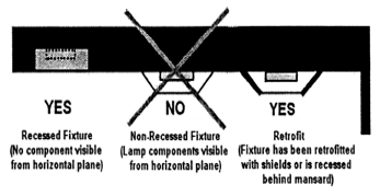
- Outdoor sales areas.
- Lighting for outdoor sales areas shall be configured to provide adequate lighting during regular nighttime business hours but shall not be designed as an attention-getting or advertisement device.
- Facilities utilizing floodlights shall not arrange the light in such a way that it will shine towards roadways or shorelines, into the night sky, or onto adjacent property. Floodlights must maintain a minimum 45-degree downward angle and be fully shielded.
- Outdoor seating areas.
- Lighting for permitted outdoor seating areas shall be configured to provide adequate lighting during regular nighttime business hours while preserving the natural nighttime environment.
- Floodlights and high intensity bulbs shall not be used for the illumination of outdoor seating areas.
- Low-mounted wall fixtures, low bollards, and ground-level fixtures of four feet or less shall be used unless the applicant presents sufficient justification to the satisfaction of the director of planning and development services.
- Low intensity decorative lighting contributing to the theme of the establishment and surrounding uses may be permitted as determined by the director of planning and development services provided the fixtures do not cause negative light trespass.
- Security lighting.
- All fixtures shall be fully shielded.
- Sensor-controlled lighting shall be preferred.
- Building facades and landscaping lighting. Light fixtures must be placed in such a manner that no light-emitting surface is visible from any residential area or public/private roadway, walkway, trail or other public way when viewed at ground level. High intensity lamps shall not be used.
- Spotlights. Shielded spotlights may be used to illuminate opaque wall surfaces and landscape features provided:
- The fixture is located a horizontal distance no greater than 15 feet from the wall or feature.
- The fixture is mounted no more than two feet in height.
- The focal point of the fixture is no greater than eight feet in height.
- The angle of the fixture from the ground shall not exceed 45 degrees.
- Sconces. Sconces and similar fixtures where no lamp component is visible but light is projected upward may be used when located beneath an opaque awning or canopy structure which prevents light from being directed into the night sky.
- Entrance lighting. Businesses may install two low intensity decorative light fixtures not meeting the requirements for fully shielded fixtures adjacent to the primary customer entrance for the structure. In no case shall fully exposed lamps of fixtures with clear glass globes or side panels be permitted. Lighting shall be located as to prevent negative light trespass onto adjacent properties or roadways. Lighting shall not qualify as security lighting and shall be subject to the hours of operation requirements pursuant to this division. Any security lighting shall be provided by fully shielded fixtures pursuant to this division.
- Spotlights. Shielded spotlights may be used to illuminate opaque wall surfaces and landscape features provided:
- Pedestrian areas and walkways.
- Low and medium intensity lamps only. Frosted globe fixtures may also be used in conjunction with low intensity lamps.
- With the exception of low intensity frosted globe fixtures, all fixtures must be fully shielded.
- Fixture height shall not exceed 12 feet.
- Village activity centers. Period or architectural fixtures: As approved by the director of planning and development services, decorative fixtures not meeting the requirements for fully shielded lighting may be substituted provided that:
- Lighting contributes to the comfortable and inviting atmosphere of the village activity center and encourages nighttime pedestrian use;
- High intensity lamps shall not be used;
- Fixtures using clear glass globes or side panels shall not be permitted. Frosted globe fixtures may only be used in conjunction with low intensity lamps;
- Mounting height may not exceed 15 feet; and
- The fixtures shall be located to prevent light trespass and minimize nuisance impact to adjacent property owners or motorists.
- Parking area lighting. Facilities utilizing floodlights shall not arrange the light in such a way that it will shine towards roadways or shorelines, into the night sky, or onto adjacent property. Floodlights must maintain a minimum 45-degree downward angle and be fully shielded.
- Lighting for publicly owned outdoor recreation and performance facilities. For facilities at which the primary use is of a recreational nature, the following requirements shall be set in addition to those provided under nonresidential lighting. Restaurants, resorts, and other facilities providing recreational activities or live performance as an accessory activity shall meet the nonresidential requirements for that use. Any additional lighting that may be required for privately owned outdoor recreation or performance facilities must obtain minor conditional use approval.
Primary play area: Recreational facilities shall use fully shielded fixtures in a configuration necessary to provide adequate lighting for the safe operation of the recreational activity. Height restrictions shall not apply. Every effort should be made to reduce negative light trespass onto adjacent roadways and properties. Artificial lighting may continue after 10:00 p.m. only to conclude a scheduled event.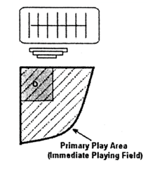
- Lighting along shorelines. For purposes of this division "shoreline" shall include altered shoreline, unaltered shoreline, canal, basin and beach as defined within the Village Code. Shoreline lighting requirements where more restrictive shall take precedence over other standards provided in this division. Lighting located on or within 300 feet line-of-sight of shorelines identified by the village or other regulatory agency as potential or active turtle nesting habitat shall comply with all provisions of this chapter and article VII, division 3 of this chapter regarding turtle nesting habitat.
- Fixtures. Exterior fixtures shall be designed and positioned so that:
- The point source of light or any reflective surface of the light fixture is not directly visible from the shoreline;
- All fixtures are set back a minimum of 20 feet from unaltered shorelines not identified as potential or active sea turtle nesting beaches and ten feet from altered shorelines and are positioned such that the shoreline area is not directly or indirectly illuminated except as otherwise permitted within this division.
- All fixtures within line-of-sight of the shoreline shall be fully shielded through shields, louvers, baffles or other cut-off features, shall be equipped with low intensity bulbs and shall not in any manner illuminate the shoreline area.
- All light fixtures shall be mounted as low in elevation as possible through the use of low-mounted wall fixtures, low bollards, and ground-level fixtures. No ground-mounted light structure shall exceed four feet in height.
- Specific use lighting.
- Decorative lighting. Floodlights, uplights, or spotlights for decorative and accent purposes that are directly visible from the shoreline, or which indirectly or cumulatively illuminate the shoreline, shall not be permitted.
- Functional lighting. Exterior lights used expressly for safety or security purposes shall be limited to the minimum number and configuration required to achieve their functional roles. The use of motion detector switches that keep lights off except when approached and that switch lights on for the minimum duration possible shall be used unless the applicant presents sufficient justification to the satisfaction of the director of planning and development services.
- Parking areas. Low intensity lighting shall be used in parking areas within line-of-sight of the shoreline. Such lighting shall comply with all other shoreline lighting provisions. In addition, parking area lighting, and any roadway lighting, shall be shielded from the shoreline through the use of ground-level barriers. Ground-level barriers shall not interfere with marine turtle nesting or hatchling emergence.
- Window tinting. Tinted glass shall be installed on all new or replacement windows and glass doors of single- or multiple-story structures within line-of-sight of a shoreline identified by the village or other regulatory agency as turtle nesting habitat where a wall surface is comprised of 50 percent glass or greater or the location of any glass area or architectural features creates a potential for negative light trespass onto the shoreline.
- Dock lighting. Dock lighting shall be limited to the minimum number and configuration necessary for safety and navigation purposes. Low intensity and/or solar-powered lighting shall be used unless the applicant presents sufficient justification to the satisfaction of the director of planning and development services. Docking facilities located on shorelines recognized as turtle nesting habitat shall only be permitted amber colored lighting. One additional low or medium intensity light may be permitted for the security of boats or accessories provided the light is positioned at the boat and away from adjacent properties, the fixture is fully shielded, and the fixture is equipped with a motion detector switch that keeps the light on for the minimum duration possible.
- Fixtures. Exterior fixtures shall be designed and positioned so that:
- Special lighting.
- Lighting for special events. Entities conducting an outdoor event pursuant to a public assembly permit may erect temporary outdoor lighting as approved through the permit. Permits may be granted for events not requiring a public assembly permit but wishing to erect temporary outdoor lighting. Temporary lighting permits shall not be granted for properties containing turtle nesting habitat from May 1 through October 31 of each year.
- Roadway lighting. All light fixtures installed by public agencies, their agents, or contractors for the purpose of illuminating public streets are otherwise exempt from these provisions with the exception of lighting installed adjacent to turtle nesting areas.
- Flag lighting. One low or medium intensity shielded spotlight may be permitted for the illumination of the American or Florida state flag provided it is positioned such that the light does not shine towards any adjacent street or property.
- Pools and fountains. Underwater lighting fixtures used for the illumination of swimming pools and fountains are exempt from the shielding standards set forth in this division provided they do not create negative light trespass onto adjacent properties, shorelines or roadways.
(Ord. No. 01-17, § 1(5.4.2), 11-8-2001; Ord. No. 02-19, § 1(5.4.2), 2-21-2002)
Sec 30-793 Waivers
- The director of planning and development services may grant a waiver from any of the provisions or requirements of this division whereby:
- The minimum lighting adequate for the intended purpose is used, giving full consideration to safety, energy conservation, reducing glare and minimizing light trespass;
- There are special circumstances relating to the property or use;
- The granting of the request would not negatively impact property owners in the vicinity;
- The applicant has demonstrated that there are no viable solutions within the provisions of this division; and
- There will be no adverse impact on any animal species listed as threatened or endangered.
- Waivers shall be processed in the same manner as an administrative variance pursuant to section 30-222.
(Ord. No. 01-17, § 1(5.4.3), 11-8-2001; Ord. No. 02-19, § 1(5.4.3), 2-21-2002)
Sec 30-811 Purpose
- The purpose of this division is to provide regulations for the installation and maintenance of landscaping and to preserve and maintain natural vegetation and habitat. Implementation of these requirements reduces stormwater runoff, reduces water consumption, reduces impervious surface area, conserves energy, increases the tree canopy and decreases ambient temperatures, and enhances the aesthetic appearance and value of the village, thereby promoting the public health and general welfare.
- The installation of landscaping and the preservation of native vegetation are integral to the prevention of water and air pollution. The root systems of trees hold and consolidate soil and other loose earthen materials, thereby helping to prevent erosion, reducing non-point-source water pollution and maintaining the continued vitality of natural habitats for the propagation and protection of wildlife, birds, game, fish and other aquatic life. Removal of trees increases surface runoff, which contributes to water pollution. The preservation of existing vegetation, the selection of appropriate native and site suitable plant materials, the removal of invasive exotic vegetation, and appropriate maintenance can achieve water conservation.
(Ord. No. 02-12, § 1(5.5.1), 1-24-2002)
Sec 30-812 Definitions
The following words, terms and phrases, when used in this division, shall have the following meanings:
Applicator means any person who applies fertilizer on turf and/or landscape plants.
Best management practices means turf and landscape practices, or combination of practices based on research, field-testing, and expert review, determined to be the most effective and practicable on-location means, including economic and technological considerations, for improving water quality, conserving water supplies and protecting natural resources.
Canopy tree means a tall tree that usually has one vertical stem or main trunk that naturally develops a more or less distinct and elevated crown and provides at maturity a minimum shade crown of 30 feet in diameter.
Clear trunk means the point above the root ball along the vertical trunk or trunks of a tree at which lateral branching or fronds begin.
Clearing means the clearing of land, including the removal of more than 500 square feet of vegetation, and includes the trimming of mangroves to the extent allowed by law. Clearing is a development activity as defined by this chapter.
Clearing and grubbing means the clearing of land, including clearing or removal of vegetation, and including any significant disturbances of vegetation or substrate (soil) manipulation. Clearing and grubbing are development activities as defined by this chapter.
Code enforcement officer means any authorized agent or employee of the village whose duty it is to ensure compliance with the Code.
Diameter at breast height (dbh) means, for the purposes of this chapter, a tree diameter as measured from the base of the tree, taken at approximately four feet above the surrounding grade.
Fertilize, fertilizing, or fertilization means the act of applying fertilizer to turf, specialized turf, or landscape plants.
Fertilizer means any substance or mixture of substances that contains one or more recognized plant nutrients and promotes plant growth, or controls soil acidity or alkalinity, or provides other soil enrichment, or provides other corrective measures to the soil.
Ground cover means plant material that normally reaches a maximum height of not more than 18 inches.
Guaranteed analysis means the percentage of plant nutrients or measures of neutralizing capability claimed to be present in a fertilizer.
Hedge means an evenly spaced planting of shrubs to form a compact, dense, visually opaque living barrier or screen.
Historic tree means a tree that has been determined by the village council to be of notable historic interest because of its age, type, size or historic association and has been so designated as part of the official records of the village.
Institutional applicator means any person, other than a private, non-commercial or a commercial applicator (unless such definitions also apply under the circumstances), that applies fertilizer for the purpose of maintaining turf and/or landscape plants. Institutional applicators shall include, but shall not be limited to, owners, managers, or employees of public lands, schools, parks, religious institutions, utilities, industrial or business sites and any residential properties maintained in condominium and/or common ownership.
Invasive exotic species means plant species that reduce the integrity of native plant community composition and function as identified and categorized on annual basis by the Florida Keys invasive exotics task force (FKIETF). The species include but are not limited to: Australian Pine (spp. Casuarina), Brazilian Pepper (Schinus terebinthifolius), Latherleaf (Colubrina asiatica), Lead Tree (Leucaena leucocephala), Oyster Plant (Rhoeo spathacea, R. discolor, Tradescantia spathacea) and Melaleuca (Melaleuca quinquinerva). Sapodilla (Manilkara zapota) shall be excluded from this definition. The list and category of these species shall be included in the Landscape Manual as discussed in this division.
Landscaping material means the following or a combination thereof, such as, but not limited to: grass, ground covers (not including pavers), shrubs, vines, hedges, trees or palms, and other materials such as rocks, pebbles, sand and topsoil expressly used for aesthetic purposes.
Low maintenance zone means an area a minimum of ten feet wide adjacent to surface waters which is planted and managed in order to minimize the need for fertilization, watering, mowing, etc.
Major street means U.S. 1, S.R. 905 and Old Highway for the purposes of this division.
Mulch means an organic material such as wood chips, pine straw or bark placed on the soil to reduce evaporation, prevent erosion, control weeds, enrich the soil and lower soil temperature.
Natural area means an area identified on an approved site plan containing natural vegetation, which will remain undisturbed when the property is fully developed.
Nuisance tree means any tree that is causing damage to structures or that poses a threat to health and safety of a property owner.
Prohibited application period means the time period during which a Flood Watch or Warning, or a Tropical Storm Watch or Warning, or a Hurricane Watch or Warning is in effect for any portion of the county, issued by the National Weather Service, or if heavy rain is likely.
Prohibited landscape activity.
- Prohibited landscape activity means:
- Improper pruning that reduces the height or spread of a tree that has not attained a height or spread of 30 feet, by altering the dominant stem within the tree crown to such a degree as to remove the natural canopy of the tree; or
- Improper pruning that leaves stubs, or splitting of limb ends; or
- Peeling, stripping or channeling of bark; or the removal of bark to the extent that, if a line is drawn at any height around the circumference of the tree, over one-third of the length of the line falls on portions of the tree where bark no longer remains; or
- Using climbing spikes, nails or hooks, except for purposes of total tree removal or as specifically permitted by American National Standards Institute (ANSI A-300) as the same may be amended from time to time; or
- Destroying the natural habit of growth which causes irreparable damage and permanent disfigurement to a tree such that, even with regrowth, the tree will never regain the original characteristics of its tree species, or is a danger to the public or property; or
- Improper pruning that results in flat-cutting the top or sides of a tree, to sever the leader or leaders or to prune a tree by stubbing off mature wood, except where removal of a branch is necessary to protect public safety.
- Exceptions:
- The removal of diseased or dead portions of a tree (such as palm fronds) or the removal of interfering, obstructing or weak branches shall not constitute a prohibited landscape activity under this section.
- Trimming necessary to prevent interference with or obstruction of streetlights, stop signs or traffic signals, if accomplished by the standards of the American National Standards Institute (ANSI A-300).
- Pruning or removal that has received a development permit.
- Removal of invasive exotic species pursuant to the requirements of section 30-822.
Prune means the removal of dead, dying, diseased, weak or objectionable branches in a manner consistent with the American National Standards Institute (ANSI A-300) standards as incorporated herein, and as may be amended from time to time.
Regionally important plant species means those native plant species identified as endemic, uncommon, or rare either in the village's regionally important plant species list maintained by the department of planning and development services or as identified by the Center for Plant Conservation, the Florida Natural Areas Inventory, or the Florida Committee on Rare and Endangered Plants and Animals.
Restricted application period means June 1 to September 30 annually.
Root ball means the root system of a tree or plant bound with burlap into an earthen ball usually for transport purposes.
Saturated soil means a soil in which the voids are filled with water. Saturation does not require flow.
Shrub means a bushy, woody plant, usually with several permanent stems, and usually not over ten feet in height at its maturity.
Slow release, controlled release, timed release, slowly available, or water insoluble nitrogen means nitrogen in a form which delays its availability for plant uptake and use after application, or which extends its availability to the plant longer than a reference rapid or quick release product.
Specimen tree means any tree with a diameter at breast height that is 75 percent of the record tree of the same species for the state or greater than or equal to 18 inches, whichever comes first.
Surface waters as defined by the Florida Department of Environmental Protection (Fla. Admin. Code 62-340) means waters on the surface of the earth, contained in bunds created naturally or artificially, including the Atlantic Ocean, bays, bayous, sounds, estuaries, lagoons, lakes, ponds, impoundments, rivers, streams, springs, creeks, branches, sloughs, tributaries, canals, and ditches.
Threatened and endangered plant species means plant species listed as such under the provisions of the Endangered Species Act, 16 USC 1531 et seq., F.S. § 581.185, or the Florida Endangered and Threatened Species Act, F.S. § 372.072.
Topsoil means a medium composed of naturally occurring mineral particles and organic matter that provides physical, chemical and biological properties necessary for plant growth.
Tree means any living, self-supporting woody perennial plant which at maturity attains a trunk diameter of at least three inches or more when measured at a point 4 1/2 feet above ground level and which normally attains an overall height of at least 15 feet, usually with one main stem or trunk and many branches.
Understory tree means a tree or palm that normally attains an overall height between ten to 25 feet at maturity, which provides the mid-level landscaping within the specified height range.
Vehicular use area (VUA) means an area used for parking, loading and vehicular access for any property not occupied by a single-family residence.
(Ord. No. 02-12, § 1(5.5.2), 1-24-2002)
Cross reference(s)—Definitions generally, § 1-2.
Sec 30-813 Applicability
- This division shall apply to all development for which a complete application for site plan review is required pursuant to section 30-215(b) of this chapter.
- No land which abuts U.S. 1, S.R. 905 or Old Highway, or has a boundary between two different zoning districts, shall hereafter be developed unless a scenic corridor, bufferyard or street tree is provided in accordance with the requirements of this division.
- Parcels of land containing existing development and nonconforming landscaping, scenic corridors, bufferyards or street trees shall be brought into compliance as a condition of development permits issued for accessory structures, increases in impervious area, change in use, or substantial improvement pursuant to the following criteria:
- Development of principal structures or accessory structure(s) greater than 200 square feet shall require any nonconforming landscaping to be brought into compliance with this division. The maximum landscaping that can be established shall be installed, given the existing buildings and required drives, as determined by the director of planning and development services.
- The director of planning and development services may allow up to 50 percent of the required vegetation to be located outside of the landscape area on the property in order to reach the minimum vegetation standard. If all the required vegetation cannot be located on-site as determined by the director of planning and development services, then the applicant shall provide the required landscape material for off-site mitigation pursuant to article VII, division 4 of this chapter.
- If the width available is less than 50 percent of the minimum width required for a zoning district bufferyard, then a minimum six-foot solid fence shall be located on the inner side of the bufferyard.
- Existing development shall not require meeting the native species ratio set forth in this division, if mature non-invasive vegetation exists on the parcel sufficient to meet the standards of this division.
- A landscape plan meeting the criteria set forth in section 30-827 shall accompany all site plans required pursuant to section 30-215(b).
- Landscaping required by this division or this chapter shall be shown on the submitted site plan when a landscape plan is not required.
(Ord. No. 02-12, § 1(5.5.3), 1-24-2002; Ord. No. 02-29, § 9, 11-21-2002; Ord. No. 06-05, § 1, 3-23-2006)
Sec 30-814 Scenic Corridor And Major Street Bufferyards
All development, except for accessory structures specifically allowed in this chapter, on any property greater than 10,000 square feet with frontage on U.S. 1, S.R. 905 or Old Highway, designated as moderate or high quality hammock, saltmarsh or wetlands and vegetated with plants native to the Florida Keys shall be developed so that a scenic corridor buffer is established. All other development of land which fronts on U.S. 1, S.R. 905 or Old Highway shall provide a major street buffer as provided in table 30-814 below.
TABLE 30-814
Zoning District | Major Street Buffer | Scenic Corridor |
Native Residential (NR) | F | F |
Residential Estate (RE) | E | F |
Residential Single-Family (R1, includes R1M) | D | D |
Residential Mobile Home (RMH) | D | D |
Residential Duplex (R2) | D | D |
Residential Triplex (R3) | D | D |
Residential Fourplex (R4) | D | D |
Multifamily (MF) | D | E |
Mobile Home Park (MH) | D | D |
Settler's Residential (SR) | C | D |
Village Center (VC) | B | D |
Tourist Commercial (TC) | B | D |
Commercial Fishing (CF) | D | E |
Marine Use (MR) | C | E |
Highway Commercial (HC) | B | E |
Neighborhood Commercial (NC) | B | D |
Industrial (I) | E | F |
Conservation (C) | F | F |
Tavernaero Airport (TA) | N/A | N/A |
Public and Semi-Public Services (PS) | C | F |
Recreation (R) | D | E |
Mariculture (M) | E | F |
(Ord. No. 02-12, § 1(5.5.4), 1-24-2002; Ord. No. 02-29, § 9, 11-21-2002; Ord. No. 10-01, § 4, 1-14-2010)
Sec 30-815 Bufferyard Standards
- Each of the buffers required in this division shall be installed in accordance with the standards set forth herein (see table 30-815) and the Landscape Manual prepared by the planning and development services department. Existing native vegetation takes priority and satisfies this requirement.
- The illustrations contained in the Landscape Manual shall specify the number of plants required per 100 linear feet along the property line and the minimum quantities of plant material contained in the table below. To determine the total number of plants required, the length of the property boundary or street frontage shall be divided by 100 and multiplied by the number of plants shown in the illustrations.
- Any buffer area that overlaps another buffer area shall be subtracted from the total to avoid double counting. The arrangement and installation of plants shall be consistent with the criteria contained in section 30-821.
- For properties with frontage on both U.S. 1 and Old Highway: the major street bufferyard requirements shall be reduced 50 percent along Old Highway unless otherwise required in this chapter.
- Accessory structures such as fences, signs, and driveways may be permitted within a required bufferyard pursuant to the criteria set forth in this chapter.
- Driveways permitted within a required bufferyard, residential and nonresidential, shall be subject to the following criteria:
- Driveways shall only be permitted within a required bufferyard to provide access from the frontage street.
- Driveways shall be oriented perpendicular to the frontage street and required front bufferyard.
- Driveways shall not be permitted within more than one required bufferyard.
- Driveways shall only be permitted within a required bufferyard abutting the frontage street.
- Driveways within a required bufferyard shall not be wider than the minimum requirements per section 30-855.
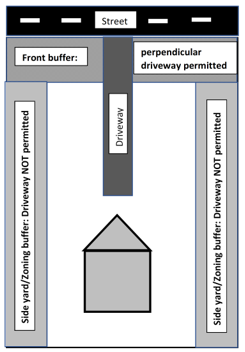
- Buffer areas utilizing public right of way shall meet the criteria set forth in section 30-819. The director may specify specific vegetation species and quantities to provide buffering as intended in this article.
TABLE 30-815. BUFFERYARD STANDARDSWidth (feet)
Canopy Trees Required
Understory Trees Required
Shrubs Required
Berm (3 Feet)
Class A
5
2
—
15
10
2
—
10
Class B
5
3
1
10
10
2.5
1
8
15
2
0.5
6
Class C
10
5
2
20
15
4.5
2
18
20
4
2
16
Class D
20
6.5
3.5
28
25
6
3
25
30
5.5
3
22
Class E
30
12
6
36
40
10
5
30
Yes
50
9
5
25
Yes
Class F
75
25
15
50
Yes
100
10
5
30
Class G
10
2
5
40
(Ord. No. 02-12, § 1(5.5.5), 1-24-2002; Ord. No. 02-29, § 9, 11-21-2002; Ord. No. 10-01, § 4, 1-14-2010)
Sec 30-816 Zoning District Boundary Bufferyards
- Bufferyards required by section 30-813 between zoning district boundaries shall be provided in accordance with table 30-816:
TABLE 30-816. ZONING DISTRICT BUFFERYARDSNR
RE
R1-2
R3-4
RMH
TA
MF
MH
SR
VC
NC
HC
TC
CF
MR
I
C
PS
R
M
NR
—
D
D
E
D
—
E
C
D
E
E
E
E
G
E
D
A
B
B
D
RE
D
—
B
C
B
—
C
C
B
D
D
D
D
G
D
D
A
B
B
D
R1-2
D
B
—
B
—
B
B
C
B
D
D
D
D
G
D
D
A
B
B
D
R3-4
E
C
B
—
B
B
A
C
C
C
C
C
C
G
C
D
A
B
B
D
RMH
D
B
—
B
—
B
B
C
B
D
D
D
D
G
D
D
A
B
B
D
TA
—
—
B
B
B
—
—
—
—
—
D
D
—
—
D
D
A
B
B
—
MF
E
C
B
A
B
—
—
C
C
C
D
D
D
G
D
D
A
B
B
D
MH
C
C
C
C
C
—
C
—
B
B
B
B
D
C
B
B
A
B
B
—
SR
D
B
B
C
B
—
C
B
—
D
D
D
D
G
D
D
A
B
B
D
VC
E
D
D
C
D
—
C
B
D
—
—
—
—
G
—
C
A
A
A
C
NC
E
D
D
C
D
D
C
B
D
—
—
—
—
G
—
C
A
A
A
C
HC
E
D
D
C
D
D
C
B
D
—
—
—
—
G
—
C
A
A
A
C
TC
E
D
D
C
D
—
D
D
D
—
—
—
—
G
—
D
A
B
B
D
CF
G
G
G
G
—
G
C
G
G
G
G
G
—
G
C
A
B
B
C
MR
E
D
D
C
D
D
C
B
D
—
—
—
—
G
—
C
B
B
B
C
I
D
D
D
D
D
—
D
—
D
C
C
C
D
C
C
—
D
D
E
D
C
A
A
A
A
A
A
A
A
A
A
A
A
A
A
B
D
—
B
A
D
PS
B
B
B
B
B
B
B
B
B
A
A
A
B
B
B
D
B
—
B
B
R
B
B
B
B
B
B
B
B
B
A
A
A
B
B
B
E
A
B
—
C
M
D
D
D
D
D
—
D
—
D
C
C
C
D
C
C
D
D
B
C
—
- Where a district boundary runs along a canal, the following rules apply:
- No buffer is required if the specified buffer is an A or B buffer.
- All other buffers shall be reduced as follows:
C to A
D to B
E to C
F to D
G to A
- Where there are existing mangroves along a canal or basin, a mangrove fringe may count towards the bufferyard requirements provided a restrictive covenant running with the land is filed containing a conservation easement for the width of the fringe.
- Where a Class E or F land use buffer is required, each side shall be responsible for 50 percent of the required buffer area and required vegetation.
- Where either side of the boundary is developed, all existing canopy trees, shrubs or understory trees within ten feet of the property line may be counted up to 50 percent of the required plant material, required buffer area and required vegetation.
(Ord. No. 02-12, § 1(5.5.6), 1-24-2002; Ord. No. 02-29, § 9, 11-21-2002; Ord. No. 10-01, § 4, 1-14-2010)
Sec 30-817 Street Trees And Other Landscaping Requirements
- All street fronts not required to provide a scenic corridor or major street bufferyard shall plant trees pursuant to this section.
- The number of trees shall be equal to at least one canopy tree per 50 feet of street frontage provided that in no event will less than one canopy tree be provided for every lot. Existing natural native vegetation takes priority and satisfies this requirement.
- The variety and species of canopy trees shall be determined according to a list of native species maintained by the planning and development services department.
- Minimum size for street trees shall be a minimum eight feet in overall height, unless reduced in writing by the director of planning and development services.
- Drainfields shall be planted with shallow root grasses, shrubs or vines at one-foot centers.
(Ord. No. 02-12, § 1(5.5.7), 1-24-2002)
Sec 30-818 Off-Street Parking Landscaping
All off-street parking areas containing more than six spaces and located in one of the zoning districts listed in this section shall be landscaped in accordance with the standards set out in this section. All off-street parking planting areas outlined in Table 30-818 are exclusive of bufferyard requirements. Landscaping required shall be installed in accordance with the standards set forth in this division and the Landscape Manual prepared by the director of planning and development services and referred to in section 30-826.
TABLE 30-818. OFF-STREET PARKING LANDSCAPING STANDARDS
Zoning District | Planting Area/24 Spaces (square feet) | Plants/Planting Area |
Village Center (VC) | 1,500 | 5—Canopy |
Mobile Home Park (MH) | 1,000 | 3—Canopy |
- Interior parking landscape islands. Interior parking landscape areas shall have the following dimensional requirements:
- Islands must be located no further apart than every ten parking spaces and at the terminus of all rows of parking. However, islands directly abutting building facades may have an average spacing of ten parking spaces, provided that no islands are more than 14 parking spaces apart.
- Islands in parking areas shall have minimum landscaped areas of nine feet in width and 16 feet in length. Each island shall include at least one canopy tree.
- Apart from islands, no landscaped area shall have any dimension less than five feet.
- A minimum of 75 percent of trees installed in parking islands shall be canopy trees.
- Landscaped areas abutting front-end parking shall require protection from vehicular encroachment by placing curbing or car stops at least two feet from the edge of such landscaped areas. Other landscaped areas abutting curved or angular drives shall be curbed.
- Off-street parking landscaping standards.
- Landscaping standards for off-street parking areas are set out in the diagrams contained in the Landscape Manual.
- All landscape material shall conform to the size and types specified in section 30-821 and the Landscape Manual. The number of square feet of planting area shall apply to every 24 spaces, with fractional areas providing a proportional amount.
(Ord. No. 02-12, § 1(5.5.8), 1-24-2002; Ord. No. 02-29, § 9, 11-21-2002; Ord. No. 10-01, § 4, 1-14-2010)
Sec 30-819 Planting In Right-Of-Way
All vegetation placed within the right-of-way shall be breakaway, with mature trunk diameters of four inches or less measured six inches above the ground. In general, vegetation within the right-of-way shall be placed within five feet of the property line, unless expressly permitted by the village or the state department of transportation. Additional conditions may apply for vegetation placed within the right-of-way as determined by the state department of transportation or the village. Accessways shall be permitted in accordance with the Village Code from the public rights-of-way through all such landscaping to service the parking or vehicular use areas.
(Ord. No. 02-12, § 1(5.5.9), 1-24-2002)
Sec 30-820 Clear Sight Distance For Landscaping Adjacent To Public Right-Of-Way And Points Of Access
- When a driveway intersects a public right-of-way, or when the subject property abuts the intersection of two or more public rights-of-way, all landscaping within the visibility triangle shall provide unobstructed cross-visibility at a level between 36 inches and eight feet and must be located so as not to create a traffic hazard.
- Trees or palms, adjacent to the right-of-way, shall be maintained in such a manner that no limbs or foliage extend into the cross-visibility area.
- Existing vegetation shall be maintained consistent with the criteria set forth in subsection (a) of this section.
(Ord. No. 02-12, § 1(5.5.10), 1-24-2002)
Sec 30-821 Materials And Installation Criteria For Required Landscaping
- The arrangement of plant material shall be determined by the developer consistent with this division, unless otherwise required in this chapter.
- Plant material shall be healthy and free of disease, and shall be installed with sufficient organic material to ensure survival.
- Plant species identified as a Category I or II invasive exotic species shall not be planted.
- Plants shall be of the following minimum sizes: Canopy trees shall have a minimum of three inches dbh or eight feet in height. Understory trees shall be a minimum of six feet in height. Shrubs shall be a minimum of three feet in height. The director of planning and development services may reduce the height requirement 50 percent for rare native plant species.
- Growth of plant material at maturity shall be considered prior to planting, where future conflicts such as views, signs, overhead and underground utilities, lighting, fire access, drainage and traffic circulation might arise.
- No one species of tree shall exceed 50 percent of the minimum number of trees required. Neither existing trees nor trees in excess of the minimum number required shall be subject to this limitation.
- Seventy-five percent of the plant material used to satisfy landscaping requirements shall be native species.
- All berms installed pursuant to this division or to retain stormwater shall be planted with ground cover, shrubs or sod. Berms provided to meet buffer provisions shall be planted with a continuous hedge.
- All canopy trees installed within six feet of public infrastructure shall utilize a root barrier system, as approved by the village operations director.
- Owners of properties that require a Class D or greater bufferyard shall file a bond with the director of planning and development services in the amount of ten percent of the value of the plant material. If the plant material survives one year the bond shall be returned to the owner.
- Spacing. Trees shall be installed in accordance with the following spacing requirements:
- Canopy trees shall be located a minimum of ten feet away from structures and 15 feet from other canopy trees.
- Understory trees shall be located a minimum of five feet away from structures, and ten feet from other trees.
- Palms shall be located a minimum of three feet from structures and three feet from other palms and ten feet from other trees.
- Trees and palms which are in excess of the minimum number required may be spaced closer to each other.
- Trees shall be planted no closer to an impervious area than half of the minimum size of the required planting area for the particular tree species (in accordance with item (7) below).
- Where a conflict in spacing or canopy spread occurs between required trees and existing offsite or onsite trees, the requirements of this section may be modified as determined by the director of planning.
- Each tree shall have pervious area surrounding it sufficient to support the species, as determined by the planning department. Minimum planting areas are as follows:
- Canopy tree. Two hundred twenty-five square feet with 15 feet the smallest dimension, except when used in parking area peninsulas/islands.
- Understory tree. Ninety square feet with eight feet the smallest dimension.
- Small tree. Sixty-four square feet with eight feet the smallest dimension.
- Single-stem palms with typical DBH at maturity of 12 inches or greater. Twenty-five square feet with five feet the smallest dimension.
- Clustering palms/palms with typical DBH at maturity of less than 12 inches. Nine square feet with three feet the smallest dimension.
- Plant Materials.
- Quality. Plant materials used in accordance with the provisions of this section of the code shall conform to the standards for Florida Number One, or better, as provided for in the most current edition of "Grades and Standards for Nursery Plants," parts I and II, State of Florida Department of Agriculture and Consumer Services. Sod shall be clear and visibly free of weed, pests and diseases. Sod pieces shall be neatly mowed. Damage and breakage shall not occur when pieces are picked up by one end.
- Plant ball sizes. Ball sizes on all plant material shall conform to or exceed the minimum standards as noted in the most current edition of "American Standards for Nursery Stock," prepared by the American Association of Nurserymen.
- Use of site specific plant material. Plants used in the landscape design pursuant to this section of the code shall be to the greatest extent appropriate to the soil and other environmental conditions in which they are to be planted.
- Shrubs and hedges. When used as a hedge, shrubs shall be full to base, planted and maintained so as to form a continuous, unbroken solid, visible screen within a maximum of one year after time of planting.
- Finished grades of landscape areas. Finished grade of landscape areas shall be at or below the grade of adjacent VUA or public sidewalks, except for mounding or other surface aesthetics. Grade shall be designed to receive roof and surface runoff and to assist irrigation of plantings and then any overflow routed as necessary underground. Mounding or other surface aesthetics shall not inhibit or defeat intended rainwater capture, retention or percolation from a VUA.
- Stabilization. All trees and palms shall be securely guyed, braced, or staked at the time of planting until established. The use of nails, wire, rope, or other methods which damage the tree or palm are prohibited. Trees and palms that remain upright at the time of planting without the aid of stabilization materials are exempt from this requirement. All stabilization materials shall be removed after a maximum period of one year from the date of CO. All plants shall be installed with the top of the root ball even with the soil grade.
(Ord. No. 02-12, § 1(5.5.11), 1-24-2002)
Sec 30-822 Invasive Exotic Vegetation
- The eradication of Category I invasive exotic vegetation is required on all sites as a condition of development. The director of planning and development services may limit this requirement to the removal of not less than 25 percent of the total mature invasive vegetation for proposed development of structures of less than 200 square feet or fences of less than 250 linear feet.
- The eradication of Category II invasive exotic vegetation shall be a condition for a new principal structure, replacement or substantial improvement (including a substantial increase in the size) of the principal structure. The eradication of Category II invasive exotic vegetation shall also be a condition for development when the total area permitted for accessory structures exceeds 50 percent of the allowed area for accessory structures.
- Privately owned natural areas and contiguous lots under the same ownership shall be included in this requirement.
- The removal of five or less invasive shrubs or trees within a period of 90 days shall not require a development permit. Removal of more than five invasive plant species or removal that would result in clearing and grubbing shall require a development permit and shall be accompanied by a vegetation survey unless waived or limited by the director of planning and development services.
(Ord. No. 02-12, § 1(5.5.12), 1-24-2002; Ord. No. 06-05, § 1, 3-23-2006)
Sec 30-823 Removal Or Pruning Of Vegetation
- Removal of any native tree equal or greater than three and one-half inches in diameter at breast height, eight feet in overall height, or the removal of any vegetation in required open space areas, bufferyards, hammock, wetland, or beach berm habitat communities shall require a development permit. Removal of vegetation in the above habitat communities shall be subject to the provisions contained in article VII of this chapter.
- Non-native palms shall not require a permit for relocation or removal provided they are not part of any required landscaping.
- The director of planning and development services may issue a written waiver to this requirement for the removal of five or less non-native species that are not part of required landscaping.
- All pruning shall adhere to practices and principles set by the National Arborists Association as contained in the Landscape Manual prepared by the planning and development services department pursuant to section 30-826.
- Nuisance trees may be removed pursuant to a development permit if, in the determination of the director of planning and development services, they pose a threat to health, safety or welfare of a property owner. Nuisance trees shall be transplanted or mitigated pursuant to article VII, division 4 of this chapter, with species suitable for the site as determined by the director of planning and development services.
- A native tree may be removed only when an applicant has demonstrated to the village that the proposed or existing developments, including residentially zoned properties, cannot be located on the site without the removal of the tree, and that there is no practical way to avoid tree removal. In determining if the applicant may remove trees pursuant to a tree removal development permit, the village shall consider at a minimum the following:
- The applicant has made every reasonable effort to incorporate existing trees and to minimize the number of trees removed;
- The trees proposed to be removed are the minimum number necessary; and the trees proposed to be removed are of poor quality and appearance, are damaging existing improvements, are creating ongoing safety problems for existing development, or are growing in too close proximity to other trees to permit normal growth and development of affected trees consistent with good forestry practices;
- The applicant must relocate the trees to be removed. If relocation is not a viable solution, an applicant shall replace removed trees. If it is determined that an applicant cannot relocate nor replace removed trees, the applicant shall pay the appropriate fee. If the applicant cites tree health, structure, or safety as the need for removal, the director of planning may require a written assessment from a Certified Arborist to support the determination.
(Ord. No. 02-12, § 1(5.5.13), 1-24-2002)
Sec 30-824 Designation Of Historic Trees
The director of planning and development services may recommend from time to time the designation of certain trees located within the village as locally significant or historic trees. The village manager shall review such recommendation and add thereto his own comments and recommendations, and the matter shall be presented to the village council for its determination. The village council shall consider the report of the planning and development services department and the recommendation of the village manager and shall either accept, modify or deny the recommendation. The village council shall designate by resolution, pursuant to a public hearing in accordance with article IV, division 2 of this chapter, those trees it deems appropriate as historic trees.
(Ord. No. 02-12, § 1(5.5.14), 1-24-2002)
Sec 30-825 Maintenance Requirements
All owners of land or their agents shall be responsible for the maintenance of all landscaping. Landscaping shall be maintained in a good condition so as to present a healthy, neat and orderly appearance at least equal to the original installation and shall be mowed or trimmed in a manner and at a frequency so as not be detract from the appearance of the general area. In improving the aesthetic qualities of the community, trees contribute greatly to the quality of the environment through carbon dioxide absorption and oxygen generation, air purification by precipitation of dust particles, transpiration, reduction of heat by transpiration and the creation of shade. Landscaping shall be maintained to minimize property damage and public safety hazards, including removal of living, dead or decaying plant material, and removal of low hanging branches. Landscaping shall be maintained in accordance with the following standards:
- Replacement requirements. An owner is responsible to ensure that vegetation, which is required by this division or a previous code, is replaced if such vegetation dies or is abused. Preserved vegetation which dies following the issuance of the certificate of occupancy or completion shall be replaced with equivalent living material or trees.
- Maturation of trees. The extent of the positive contributions of required trees is a function of the size rather than of the planting area in which the tree is planted. In recognition of the contributions made by trees to the objectives of this chapter, trees shall be allowed to mature to their full natural height and size.
- Trees outside development area. Trees located outside approved development areas shall be left in place and maintained.
- Root pruning. Root systems shall be pruned if they show evidence of destroying public or private property, as determined by the building official or operations director.
- Prohibited landscape activity. Trees altered by a prohibited activity shall not be counted toward fulfilling minimum landscape requirements and shall be replaced. This prohibition does not apply to invasive exotic vegetation.
- Tree pruning.
- Trees shall be pruned in accordance with the American National Standards Institute guidelines. If the pruning violates these standards and causes tree removal, a permit for tree removal shall be obtained from the village pursuant to this division.
- Any pruning performed without conformance to the American National Standards Institute shall be subject to enforcement by the village. All tree pruners who provide services in the village shall hold a valid occupational license in the county.
- Utility companies shall comply with the hazard pruning standards and the crown reduction standards of the American National Standards Institute, as may be amended from time to time.
- The removal of diseased or dead portions (such as palm fronds) of a tree or the removal of an interfering, obstructing or weak branch such that the tree will not be a threat to public safety or to adjacent property shall be permitted without a permit. Pruning to reduce or eliminate interference with or obstruction of streetlights, stop signs or traffic signals is an example of an allowed pruning activity.
(Ord. No. 02-12, § 1(5.5.15), 1-24-2002)
Sec 30-826 Landscape Manual
The planning and development services department shall prepare, and from time to time revise, a Landscape Manual, which shall provide an illustrative interpretation of the standards, plant lists and a suggested guide for landscaping. The manual shall include pruning standards established by the American National Standards Institute as amended from time to time and incorporated herein by reference.
(Ord. No. 02-12, § 1(5.5.16), 1-24-2002)
Sec 30-827 Landscape Plans Required
A landscape plan shall be submitted with the site plan for consideration by the planning department. The landscape plan shall be signed and sealed by a Florida registered landscape architect unless otherwise waived by the director of planning and development services. The landscape plan shall conform to the guidance provided in the Islamorada Landscape Manual and shall at a minimum contain the following:
- Minimum scale equivalent to the site plan.
- Existing trees with a unique number assigned to each tree.
- A tree survey table with the following information listed by tree number corresponding to the numbered existing trees on the plan view:
- Common and scientific species name;
- Diameter at breast height
- Tree condition;
- Proposed disposition (remain, relocate or remove);
- Dollar value of specimen trees calculated in accordance with section 30-1615.
- Existing trees and shrubs and site improvements on abutting properties within ten feet of the property lines. This information may be obtained from aerial photographs and approximate locations based on field visits.
- The location and outline of proposed buildings and site improvements including landscaping, paving, utilities, rights-of-way and final elevations. Proposed landscape trees and shrubs should be shown according to approximate size after five years of growth following installation.
- Existing site improvements to remain including buildings, paving, utility rights-of-way and elevations.
- A table of data indicating required quantities and provided quantities of proposed plant material.
- Plant material listed according to corresponding code requirement, gross and net acreage, number of trees to remain, number of trees to be relocated, number of trees to be removed and square footage of vehicular use areas.
- Proposed plant materials by botanical and common names, quantities, sizes, and spacing.
- Site lighting locations.
- Existing and proposed water bodies, wetlands, swales, and/or retention ponds.
- Planting details and planting specifications.
- Visual depiction and delineation of the areas on the site attributed towards each applicable requirement of this article.
- Such other information that may be required to give a complete understanding of the proposed plan including methods for preserving existing trees to remain, and a graphic rendering of the proposed landscaping.
Sec 30-828 Fertilization Standards
The purpose of this section is to provide regulations for the proper use of fertilizers by any applicator; require proper training of commercial and institutional fertilizer applicators; establish training and licensing requirements; establish a prohibited application period; and specify allowable fertilizer application rates and methods, fertilizer-free zones, low maintenance zones, and exemptions.
The standards set forth in this section require the use of best management practices, which provide specific management guidelines to minimize negative secondary and cumulative environmental effects associated with the misuse of fertilizers. These secondary and cumulative effects can impact natural and constructed stormwater conveyances, creeks, canals, estuaries and other water bodies. Collectively, these water bodies are an asset critical to the environmental, recreational, cultural and economic well-being of village residents and the health of the public. Overgrowth of algae and vegetation hinder the effectiveness of flood attenuation provided by natural and constructed stormwater conveyances. Regulation of nutrients, including both phosphorous and nitrogen contained in fertilizer, will help improve and maintain water and habitat quality.
- Applicability. These standards shall be applicable to and shall regulate any and all applicators of fertilizer and areas of application of fertilizer, unless such applicator is specifically exempted by the provisions of this section.
- No applicator shall apply fertilizers containing nitrogen and/or phosphorous to turf and/or landscape plants during the prohibited application period, or to saturated soils. In addition, fertilizer containing nitrogen or phosphorous shall not be applied to turf or landscape plants during the restricted application period, which is defined as June 1 to September 30 annually.
- Fertilizer shall only be applied to actively growing turf and/or landscape plants.
- Fertilizer containing nitrogen or phosphorous shall not be applied before seeding or sodding a site, and shall not be applied for the first 30 days after seeding or sodding, except when hydro-seeding for temporary or permanent erosion control in an emergency situation, or in accordance with the stormwater pollution prevention plan for that site.
- Fertilizer shall not be applied within 15 feet of any pond, creek, lake, canal, shoreline, or wetland as defined by the Florida Department of Environmental Protection (F.A.C. 62-340) or from the top of a seawall. Newly planted turf and/or landscape plants may be fertilized in this Zone only for a 60 day period beginning 30 days after planting if needed to allow the plants to become well established. It shall be a violation of this section to allow direct deposition of nutrients into the water.
- A voluntary ten foot low maintenance zone is strongly recommended, but not mandated, from any pond, creek, lake, canal, shoreline, wetland, or from the top of a seawall. A swale/berm system is recommended for installation at the landward edge of this low maintenance zone to capture and filter runoff. No mowed or cut vegetative material may be deposited or left remaining in this zone or deposited in the water. Care should be taken to prevent the over-spray of aquatic weed products in this zone.
- Fertilizers applied to turf and/or landscape plants shall be applied in accordance with directions provided by F.A.C. Rule 5E-1.003(2), Labeling Requirements for Urban Turf Fertilizers.
- Nitrogen or phosphorous fertilizer shall not be applied to turf or landscape plants except as provided in (g) above for turf, or in UF/IFAS recommendations for landscape plants, vegetable gardens, and fruit trees and shrubs, unless a soil or tissue deficiency has been verified by an approved test.
- Fertilizer shall be applied to turf and/or landscape at the lowest rate necessary. Nitrogen shall not be applied at an application rate greater than 0.7 lbs of readily available nitrogen per 1,000 square feet at any one time based on the soluble fraction of formulated fertilizer, with no more than one pound total nitrogen 1,000 square feet applied at any one time, and not to exceed the nitrogen recommendations set forth below on an annual basis:
Grass species
Maximum N application rate
(lbs/1,000 sq ft/Year)Bahiagrass
4
Bermudagrass
7
Centipedegrass
3
St. Augustinegrass
6
Zoysia
4.5
- No phosphorous fertilizer shall be applied to existing turf and/or landscape plants at application rates which exceed 0.25 pounds phosphorous per 1,000 square feet per application nor exceed 0.50 pounds phosphorous per 1,000 square feet per year.
- The nitrogen content of fertilizer applied to turf or landscape plants within the village shall contain at least 50 percent slow release, controlled release, timed release, slowly available, or water insoluble nitrogen per guaranteed analysis label.
- Fertilizers labeled for sports turf at golf courses, parks, and athletic fields within the village shall have the following:
- Directions for use not to exceed rates recommended in the document titled SL191 "Recommendations for N, P, K and Mg for Golf Course and Athletic Field Fertilization Based on Mehlich I Extractant", dated March 2007.
- Directions for use in accordance with the recommendations in "BMP's for the Enhancement of Environmental Quality on Florida Golf Courses", published by the Florida Department of Environmental Protection, dated October 2012. This does not exempt applicators at these sites from the required basic green industry BMP training.
- Spreader deflector shields are required when fertilizing via rotary (broadcast) spreaders. Deflectors must be positioned such that fertilizer granules are deflected away from all impervious surfaces, fertilizer-free zones and water bodies, including wetlands.
- Fertilizer shall not be applied, spilled, or otherwise deposited on any impervious surfaces. Any fertilizer applied, spilled, or deposited, either intentionally or accidentally, on any impervious surface shall be immediately and completely removed to the greatest extent practicable. Fertilizer released on an impervious surface must be immediately contained and either legally applied to turf or any other legal site or returned to the original or other appropriate container. In no case shall fertilizer be washed, swept, or blown off impervious surfaces into stormwater drains, ditches, conveyances or water bodies.
- In no case shall grass clippings, vegetative material, and/or vegetative debris be washed, swept, or blown off into stormwater drains, ditches, conveyances, water bodies, wetlands, or sidewalks or roadways. Any material that is accidentally so deposited shall be immediately removed to the maximum extent practicable.
- All commercial and institutional applicators of fertilizer shall abide by and successfully complete the six-hour training program in the "Florida-friendly Best Management Practices for Protection of Water Resources by the Green Industries" offered by the Florida Department of Environmental Protection through the University of Florida Extension "Florida-Friendly Landscapes" program, or an approved equivalent.
- Private, non-commercial applicators are required to follow the recommendations of the University of Florida IFAS Florida Yards and Neighborhoods program when applying fertilizers.
- All commercial applicators of fertilizer shall abide by and successfully complete training and continuing education requirements in the "Florida-friendly Best Management Practices for Protection of Water Resources by the Green Industries," offered by the Florida Department of Environmental Protection through the University of Florida IFAS "Florida-Friendly Landscapes" program, or an approved equivalent program, prior to obtaining a business tax certificate or equivalent for any category of occupation which may apply any fertilizer to turf and/or landscape plants. Commercial fertilizer applicators shall provide proof of completion of the program.
- All commercial applicators of fertilizer shall have and carry in their possession at all times when applying fertilizer, evidence of certification by the Florida Department of Agriculture and Consumer Services as a commercial fertilizer applicator per F.A.C. 5E-14.117(18).
- All businesses applying fertilizer to turf and/or landscape plants (including but not limited to residential lawns, golf courses, commercial properties, and multi-family and condominium properties) must ensure that at least one employee has a "Florida-friendly Best Management Practices for Protection of Water Resources by the Green Industries" training certificate prior to the business owner obtaining a local business tax certificate or equivalent. Owners for any category of occupation which may apply any fertilizer to turf and/or landscape plants shall provide proof of completion.
- Violation of any provision of this article shall be subject to the following penalties:
- First violation. Written notification and education on regulations.
- Second violation. $50.00.
- Third violation. $100.00.
- Fourth and subsequent violation(s). $500.00 increasing 10-fold with each subsequent violation.
- Each violation of this section within a 365-day period, beginning the date of the first violation, shall constitute a separate offense. The village may take any other appropriate legal action, including but not limited to emergency injunctive action, to enforce the provisions of this article.
- The provisions set forth in this section shall not apply to the following:
- Bona fide farm operations as defined in the Florida Right to Farm Act, F.S. § 823.14 provided that fertilizers are applied in accordance with the appropriate best management practices manual adopted by the state department of agriculture and consumer services, office of agricultural water policy for the crop in question;
- Other properties not subject to or covered under the Florida Right to Farm Act that have pastures for grazing livestock provided that fertilizers are applied in accordance with the appropriate best management practices manual adopted by the state department of agriculture and consumer services, office of agricultural water policy for the crop in question;
- Any lands used for bona fide scientific research including, but not limited to, research on the effect of fertilizer use on urban stormwater, water quality, agronomics, or horticulture.
Sec 30-851 Generally
- Definitions. The following words, terms and phrases, when used in this division, shall have the following meanings ascribed to them, except where the context clearly indicates a different meaning:
Accessible means a site, building, facility, or portion thereof that complies with the guidelines of the Florida Accessibility Code.
Accessible route means a continuous unobstructed path connecting access aisles, curb ramps, crosswalks at vehicular ways, walks, ramps, and lifts.
Driveway means a private roadway providing access for vehicles to a parking space, dwelling unit, or structure on a property.
Loading space means a defined area not in a street, aisle, or alley located on the same lot as the use served, providing for the standing, loading, and unloading of service vehicles.
Off-street parking spaces means a defined area not in a street, aisle, or alley for the purpose of providing parking for operable passenger vehicles for residents, customers, patrons and employees.
Pedestrian access aisle means an accessible pedestrian space between parking spaces that provides appropriate clearance. - Purpose. It is the intent and purpose of this division to uniformly regulate the development of off-street parking, loading, and driveways for both public and private uses. It is also the intent to provide adequate parking and safe vehicle movements while minimizing any detrimental effects to adjacent properties, to surrounding neighborhoods and to the environment.
- Responsibility. The owner of the property on which off-street parking, loading, and driveways are placed shall be responsible for adherence to the regulations set forth in this division.
- Applicability.
- This division shall apply to all development for which a complete application for site plan review is required pursuant to this chapter.
- Pursuant to the requirements of this division, in the event of the construction of an addition to an existing building, or in the event of a change in use, and prior to the issuance of a certificate of occupancy or certificate of completion, the property shall comply with this division.
- This division applies to a discontinued use within a building or structure which, as of the effective date of this division, has remained unoccupied.
- No structure or use shall be permitted or constructed unless off-street parking and loading spaces are provided in compliance with the provisions of this division.
- When a structure is enlarged or increased in capacity, or when a change in use occurs, additional parking and loading spaces shall be provided in compliance with the provisions of this division.
- General regulations.
- Requirements for uses not specifically listed herein shall be determined by the director of planning and development services based upon the requirements for comparable uses and upon the particular characteristics of the use.
- Fractional space requirements shall be rounded up to the next whole space.
- For properties containing more than one use, the number of required parking spaces is the cumulative number of spaces for all uses with the exception of approved shared parking.
- The required minimum number of parking and loading spaces shall be reserved for parking purposes and shall not be converted to other uses, unless otherwise authorized in this chapter.
- Parking and loading areas, associated driveways and vehicle maneuvering areas shall be maintained to preserve their intended function and to prevent nuisances or hazards to people, surrounding properties and public rights-of-way.
- Parking and loading areas including driveways and vehicular maneuvering areas shall have clearly defined boundaries, meaning, at a minimum, the existence of a distinct edge to the material used to delineate the parking area, such that the area where the parking is permitted is clearly distinguished from the area where the parking is not permitted.
- Newly constructed or enlarged parking areas, including driveways and vehicular maneuvering areas, shall have sufficient provisions to retain stormwater on-site.
- No parking or loading area may be constructed, added to, or altered (except for routine repairs that do not alter the parking area's size or configuration) until a development approval has been obtained.
- No curb cut or driveway entrance in the street right-of-way shall be constructed unless a permit has first been obtained from the village or the state department of transportation with the coordination of the village.
- Except for residential uses or public purposes, parking and loading spaces shall be located or served by a driveway that requires no backing movements or other maneuvering within a street right-of-way other than an alley. In no case shall a parking or loading space require backing movements or other maneuvering directly onto the U.S. 1 right-of-way.
- Required parking spaces shall not be used for the storage of vehicles or materials, or for the parking of service vehicles used in conducting the business or use.
- A site plan pursuant to article IV, division 2 of this chapter shall accompany an application for a building permit.
(Ord. No. 02-10, § 1(5.6.1), 1-24-2002)
Sec 30-852 Off-Street Parking
- Location of required parking.
- Off-street parking spaces shall be located on the same lot as the building, structure, or use which they serve, and within the same zoning district, except where the director of planning and development services may, by means of a covenant or other acceptable means, allow part of the off-street parking spaces for nonresidential purposes to be located on a lot other than the lot occupied by the building, structure, or use. If the site of the served use and the location of the required parking are not contiguous, the parking area shall be within 500 feet of the front entrance to the building, structure, or use, as measured by a safe and convenient pedestrian route.
- The edge of parking areas shall be set back a minimum of five feet from the front property line(s).
- Parking areas shall be sited to minimize environmental impacts and may not be sited over drainfields or retention swales.
- Design standards for off-street parking.
- Except for boat ramp and oversized vehicle parking spaces, all off-street parking spaces shall have a length of not less than 18 feet with a minimum width of 8 1/2 feet exclusive of passageways, maneuvering space, and driveways. All boat ramp and oversized vehicle parking spaces shall have a minimum length of 40 feet with a minimum width of ten feet. Parallel parking spaces shall have a length no less than 24 feet with a minimum width of nine feet.
- Access aisle requirements shall be designed in accordance with the following criteria: Each required parking space shall have direct and unrestricted access to an aisle of the following minimum width:
Angle of Parking (degrees)
Aisle Depth (1 Row of Parking)
Aisle Depth (2 Rows of Parking)
0
12 feet
24 feet
45
14 feet
14 feet
60
18 feet
19 feet
90
20 feet
22 feet
- Paved parking spaces shall be striped and include a wheel stop, except for parallel spaces which shall only be striped. All other parking spaces shall each provide a wheel stop.
- Required parking spaces.
- Bicycle spaces.
- Minimum requirement. One bicycle rack for parking bicycles shall be provided by all nonresidential development projects.
- Credit for required parking spaces. To encourage the use of bicycles by providing safe and convenient places to park, racks for parking bicycles may substituted for up to five percent of vehicular parking spaces required pursuant to section 30-852(c)(2). For every three bicycle parking spaces installed as a bicycle rack in accordance with this subsection, the number of required vehicular parking spaces shall be reduced by one space, up to a maximum of ten vehicular parking spaces. The minimum credit shall be rounded up to at least one vehicular parking space, even if five percent of required vehicular parking spaces would result in less than one vehicular space. A minimum of three vehicular parking spaces shall be required to qualify for the credit. Bicycle parking shall not be substituted for ADA accessible spaces, loading spaces, boat ramp spaces, or oversized vehicle parking spaces. Existing vehicular parking spaces may be converted to take advantage of this provision. The bicycle parking credit may be utilized in combination with the shared parking and parking demand study options in section 30-852(d), in order to further reduce the amount of required parking without the need for a variance.
- Number of parking spaces. No development permit shall be issued for any dwelling unit, or for any addition to or expansion of any use, unless the number of parking spaces is provided as follows:
Use
Required Parking Spaces
Single-family residence
2.0
Mobile home parks
1.0 per pad
Multifamily developments
2.0 per dwelling unit
Hotels
1.0 per room
Commercial (low, medium, and high intensity):
Retail
3.0 per 1,000 gross floor area
Food stores/carryout food sales
5.0 per 1,000 gross floor area
Other
3.0 per 1,000 gross floor area
Outdoor sales
1.0 per 1,500 square feet of land
Office:
Bank
4.0 per 1,000 gross floor area
Medical/dental office
1.0 per employee plus 1.0 per exam room
Other
3.0 per 1,000 gross floor area
Restaurant (sit-down or drive-in/fast food)
15.0 per 1,000 gross floor area, plus 1.0 per 3 chairs in the outdoor seating area
Bars/lounges
10.0 per 1,000 gross square feet of floor area
Bowling alley
3.0 per bowling lane
Theaters/churches/auditoriums/and public assembly halls
0.3 per seat
Library/museum
3.0 per 1,000 gross square feet of floor area
Industrial:
Warehousing
1.0 per 1,000 gross square feet of floor area
Other
1.5 per 1,000 gross square feet of floor area
Institutional
1.5 per 1,000 gross square feet, plus 1 per bed
Marinas:
Wet slip
0.20 per slip
Live-aboard slip
1.0 per slip
Dry slip
0.20 per slip
Commercial fishing, 6 or less passenger capacity
1.0 per berth
Party boat, more than 6-passenger capacity
0.5 per person
Boat ramps in conjunction with other uses other than single-family residences
2.0 per ramp
- Credit for short-term boat parking. To permit a reduction in the total number of vehicular parking spaces required pursuant to section 30-852(c)(2), an optional credit of one vehicular parking space for every boat slip and/or dockage designated as short-term boat parking shall be available where all of the following conditions are met:
- One or more of the following uses are located on a property containing a docking facility or a marina: restaurant, fuel sales, ships store, bait and tackle shop and/or convenience store; and
- All boat slips and/or dockage for short-term boat parking have been designated on an approved site plan; and
- The designated boat slips and/or dockage for short-term boat parking shall not also serve as live-aboard slips, commercial fishing berths, charter/guide boat berths or party boat berths; and
- The designated boat slips and/or dockage for short-term boat parking shall have a minimum length of 20 feet and a minimum width of eight feet.
- Bicycle spaces.
- Shared parking.
- Purpose. The purpose of the shared parking option is to permit a reduction in the total number of parking spaces which would otherwise be required in instances where two or more uses on the same lot or separate lots are to share the same parking spaces because their peak parking demands do not occur at the same time.
- Condition on development approval. If the shared parking option is used to calculate the amount of required parking spaces, then the approved development permit shall have a condition that any change in the occupancy or use of any of the principal uses intended to be served by the shared parking shall require development approval by the director of planning and development services to ensure sufficient parking is available.
- Calculation of shared parking requirements. Notwithstanding the provisions of subsection (c)(2) for individual land uses, when any land or building is used for two or more distinguishable purposes as listed below, the shared parking option may be used to determine the minimum amount of parking required. Under the shared parking option, the minimum total number of required parking spaces for said land or building shall be determined by the following procedure:
- Multiply the minimum parking requirement for each individual use as set forth in subsection (c) by the appropriate percentage as set forth in the table below for each of the five designated time periods.
- Add the resulting sums for each of the five vertical columns in the table.
- The minimum parking requirement is the highest sum among the five columns resulting from the calculation in subsection (c) above. Time periods not covered in the table below may be ignored for the purposes of calculating shared parking.
NIGHTTIME
WEEKDAY
WEEKEND
Midnight— 6:00 a.m.
Day
9:00 a.m.—
4:00 p.m.Evening
6:00 p.m.—
MidnightDay
9:00 a.m.—
4:00 p.m.Evening
6:00 p.m.—
MidnightSpecific Use Categories
Marinas
5%
70%
10%
100%
20%
Residential
100%
60%
90%
80%
90%
Office/Industrial
5%
100%
10%
10%
5%
Churches
5%
25%
50%
100%
50%
Commercial Retail
5%
60%
90%
100%
70%
Drinking and Eating/Entertainment/Recreation (Theaters, bowling alleys, meeting halls)
10%
40%
100%
80%
100%
Hotel
75%
75%
100%
75%
100%
All Others
100%
100%
100%
100%
100%
- The director may reduce the required parking requirements based on a parking demand study approved by the director. The methodology for conducting the study shall be submitted for review and approval by the director and shall include, but not be limited to the week and day the study will be conducted, the number of days and duration of the study, and the time intervals and locations for data collection. The study shall be reviewed by the director, and he shall, at his discretion, determine whether the parking study supports the basis for the parking reduction request.
- Accessible off-street parking. Property that serves the public as clients, guests, or employees shall provide accessible parking in accordance with F.S. ch. 553, the American Disabilities Act Accessibility Guidelines for Buildings and Facilities (ADAAG), and the Florida Accessibility Code, as amended from time to time.
(Ord. No. 02-10, § 1(5.6.5), 1-24-2002; Ord. No. 02-29, § 10, 11-21-2002; Ord. No. 09-01, § 8, 1-22-2009; Ord. No. 10-01, § 5, 1-14-2010; Ord. No. 13-08, § 2, 2-14-2-2013)
Sec 30-853 Off-Street Loading
- Location of required loading.
- Required loading areas shall be located on the same property as the building, structure, or use which they serve and not on any public right-of-way or other property.
- The edge of a loading space shall be set back a minimum of ten feet from the front property line.
- Design standards for loading. All loading spaces shall be designed and constructed in compliance with the following requirements:
- An off-street loading space shall be an area at grade level directly accessible from a street or alley without entering or crossing any other required loading space, and shall be arranged for the convenient and safe ingress and egress by a vehicle.
- No area provided to meet the off-street parking requirements shall be deemed to meet the requirements of this section for off-street loading.
- Each loading space shall have a minimum of 14 feet of vertical clearance.
- Loading spaces shall be provided as follows, except where otherwise permitted by the director of planning and development services:
Use
Gross Floor Area
Loading and Unloading Spaces
Minimum Size of Space (feet)
Office
10,000—99,999
1.0
10 × 25
Other non-residential uses
(including commercial and
industrial)10,000—19,999
20,000—49,999
50,000+1.0
2.0
3.010 × 25
10 × 50
10 × 50
(Ord. No. 02-10, § 1(5.6.4), 1-24-2002; Ord. No. 13-08, § 2, 2-14-2013)
Sec 30-854 Landscaping For Off-Street Parking
All off-street parking areas shall provide parking landscaping and island treatments in accordance with this chapter.
(Ord. No. 02-10, § 1(5.6.5), 1-24-2002)
Sec 30-855 Driveways
- Driveways shall be sited to minimize environmental impacts and may not be sited over drainfields or retention swales.
- Driveways to off-street parking in residential zoning districts shall meet the following criteria:
- The driveway width shall be no less than 12 feet unless further restricted elsewhere in this chapter;
- The driveway shall be setback a minimum of five feet from the side property lines;
- Stormwater run-off from the driveway shall be retained on-site;
- A minimum clearance height of 18 feet shall be maintained; and
- In no event shall any parked vehicle obstruct or impede the safe circulation of traffic on the right-of-way.
- Driveways to off-street parking and loading areas for nonresidential zoned properties shall be designed and constructed to facilitate the flow of traffic, and provide maximum safety of traffic access and egress and maximum safety for pedestrians and vehicular traffic on-site. The number of driveways shall be limited to the minimum that will allow the property to accommodate the traffic to be anticipated. Driveways on nonresidential properties shall be developed and constructed to comply with the following requirements:
- One-way driveways shall be no less than 12 feet in width and not more than 20 feet in width. Two-way driveways shall be no less than 24 feet in width and not more than 36 feet in width. Deviations from these standards shall require a site-specific study and design prepared by a state registered professional engineer. Driveway connections to U.S. 1 shall be designed in conformance with state department of transportation standards. Driveways shall be clearly and permanently marked and defined through the use of rails, fences, walls, curbs, or other barriers or markers on the frontage not occupied by the driveway;
- Driveways on the same lot frontage shall be separated by a minimum length of 30 feet;
- In the case of a corner lot, driveways shall be located not closer than 30 feet to the intersecting street lines;
- The access to driveways from a street shall be located not closer than 15 feet to the side lot line, except that a common driveway to two adjacent properties with width not exceeding 24 feet may be provided at a common lot line; and
- Driveways shall have a paved apron that leads from the street to the driveway that is consistent with the permitted driveway width.
(Ord. No. 02-10, § 1(5.6.6), 1-24-2002; Ord. No. 13-08, § 2, 2-14-2-2013)
Sec 30-856 Parking Of Trailers, Recreational Vehicle Type Units And Heavy Equipment
- The following vehicles shall not be parked for storage or overnight purposes on any public right-of-way or on private property except within a completely enclosed garage within residential zoning districts (R1, R1M, R2, R3, R4, RMH, SR or MF):
- Trailers or wagons of more than 5,000 pounds gross vehicle weight;
- Recreational vehicle type units, as defined in F.S. § 320.01, in excess of 45 feet in length;
- Heavy equipment vehicles including, but not limited to, backhoes, bulldozers, front loaders or dump trucks; except equipment directly related to permitted onsite construction activities.
- Only one recreational vehicle type unit, as defined in F.S. § 320.01, shall be permitted on any one lot located in a residential zoning district as an accessory use. Trailers, wagons, and recreational vehicle type units, as defined in F.S. § 320.01, as referred to in this section may only be parked on the same lot after the principal structure is erected and has received a certificate of occupancy.
- Trailers of less than one-ton capacity, including all pleasure boat trailers regardless of capacity, collapsible and camping trailers may be parked on private property in any zoning district provided that such trailers are parked only within the areas in which the principal building, accessory buildings, or the parking of vehicles is permitted.
- All trailers and recreational vehicle type units, as defined in F.S. § 320.01, shall be parked in accordance with all setback requirements of this chapter.
- Trailers and recreational vehicle type units, as defined in F.S. § 320.01, that are parked for storage pursuant to the provisions of this section shall not be used as a place of habitation.
- All vehicles must be registered in the name of the occupant of the property where they are parked, unless they are within a permitted outdoor storage area. In no case shall this provision apply to parking of less than 24 hours.
- Temporary storage units shall only be allowed pursuant subject to the requirements of division 8 "Temporary Uses Including Public Assemblies".
(Ord. No. 05-20, § 2(5.6.7), 9-15-2005)
Sec 30-857 Clear Sight Triangle
- All driveways and street intersections shall provide clear sight triangles in both directions as follows and as more fully set forth in the following table and in Figure 30-857.1. The clear sight triangle shall extend beyond the right-of-way line to the edge of the roadway pavement as illustrated in Figure 30-857.1.* "A" is the distance from the edge of pavement of the street to the point on the intersecting driveway or street at which clear sight distance is required. "A" is located along both edges of pavement of the intersecting driveway or street.
Distances in feet
Type of Street
A*
B**
U.S. 1
15
70
Old Highway
8
35
Local Streets
3
15
** "B" is the distance measured along the right-of-way line of the street, from the edge of pavement of the intersecting driveway or street to the point where an oncoming vehicle must be visible.
Figure 30-857.1 Clear Sight Triangle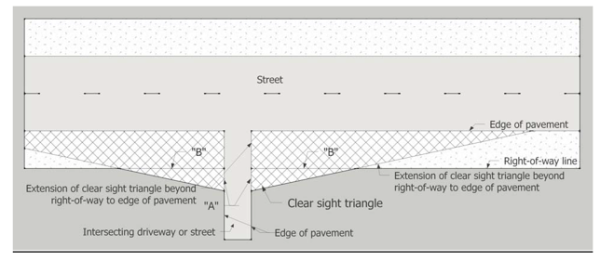
- The village may alter the clear sight triangle. Such alteration is contingent on unusual site topography, proposed site design features and other unique circumstances pertaining solely to the site and surrounding properties. The village shall make written findings that the alteration does not constitute a traffic or pedestrian safety hazard.
- Street lights, power poles, traffic signs, or similar street fixtures less than one-foot wide or other objects above ten feet in height above the adjacent street elevation shall be allowed in the clear sight triangle unless the village determines that, individually or cumulatively, they would pose a public safety hazard. The director may authorize other objects in the clear sight triangle which do not comply with this standard upon determining that they would not pose a risk to public safety.
Sec 30-881 Intent And Purpose
It is the intent and purpose of this division to permit defined temporary uses within the village on a controlled, time-limited basis, while controlling any adverse impacts on the village's permanent uses.
(Ord. No. 08-01, § 1, 1-10-2008; Ord. No. 12-09, § 1, 8-9-2012)
Sec 30-882 Definitions
The following words, terms and phrases, when used in this division, shall have the meanings ascribed to them in this section, except where the context clearly indicates a different meaning:
Nonresidential zoning district means property located within the following zoning districts: village center (VC), tourist commercial (TC), commercial fishing (CF), marine use (MR), highway commercial (HC), neighborhood commercial (NC), industrial (I), public and semi-public services (PS), conservation (C), recreation (R) and mariculture (M).
Public assembly means a gathering, whether indoor or outdoor, which is designed to be attended by members of the general public, with or without an admission charge.
Recreational vehicle (RV) means a vehicle designed as temporary living quarters for recreational, camping or travel use, which either has its own mode of power or is mounted on or drawn by another vehicle. Recreational vehicles, when traveling on the public roadways of this state, must comply with the length and width provisions of F.S. § 316.515, as that section may hereafter be amended. Recreational vehicles also include travel trailers, camping trailers, truck campers, motor homes, private motor coaches, van conversions, park trailers, and fifth wheel trailers, as defined by F.S. ch. 320. No permanent additions, such as but not limited to Florida rooms, shall be permitted.
Residential zoning district means property located within the following zoning districts: native residential (NR), residential estate (RE), residential single-family (R1) and (R1M), residential mobile home (RMH), residential duplex (R2), residential triplex (R3), residential fourplex (R4), multifamily (MF), mobile home park (MH) and settlers residential (SR).
Temporary emergency housing means recreational vehicles (RVs) or travel trailers (or similar approved sheltering units) used for temporary occupancy in response to natural or manmade disasters, including, but not limited to, hurricanes and tropical storms, where such RVs or travel trailers (or other approved sheltering units) are provided to residents or relief workers as part of emergency relief efforts.
Temporary use means those uses that are required for a defined period of time during the construction phase of permitted development or uses that are uniquely temporary or seasonal in nature, including but not limited to holiday tree and decoration sales, seasonal sales of farm produce, temporary emergency shelters, sidewalk sales, construction project offices, storage, or sales offices for the marketing of the property upon which or near where they are located, model homes, flea markets, arts and crafts bazaars, art shows, and seminar/educational events, whether for profit or otherwise. Events and gatherings located within Founder's Park are governed by regulations available through the village clerk and are not governed by this division.
Regulations herein govern both temporary uses and public assemblies and the term "temporary use" used herein includes "public assembly."
(Ord. No. 08-01, § 1, 1-10-2008; Ord. No. 12-09, § 1, 8-9-2012)
Sec 30-883 Temporary Uses Permitted In All Zoning Districts
If not already provided for as a permitted or conditional use by this chapter, a temporary use shall be a permitted use in any zoning district of the village provided it meets the criteria set forth in this division. This section shall not override or substitute for any other section of this chapter that requires another type of permit, certification or approval.
(Ord. No. 08-01, § 1, 1-10-2008; Ord. No. 12-09, § 1, 8-9-2012)
Sec 30-884 Criteria For Temporary Uses And Public Assemblies
A temporary use permit may be issued to the owner, tenant or legal occupant of any property located within the village. The director of planning and development services may permit a temporary use provided the proposed use meets the following criteria:
- The temporary use must be compatible with the surrounding uses.
- The temporary use shall not generate noise, vibration, glare, fumes, odors, or electrical interference beyond what normally occurs in the applicable zoning district.
- If the temporary use is to be held in a residential zoning district and is anticipated to draw 100 or more people at any given time, then it must be approved by the director of planning and development services.
- If the temporary use is to be held in a non-residential zoning district and is anticipated to draw 250 or more people at any given time, then it must be approved by the village manager.
- Any temporary use involving the temporary closure of rights-of-way in any zoning district shall be approved by the village manager.
- If the temporary use is an event, then it may be permitted for a period of time not to exceed three days. Other temporary uses shall propose a maximum time limit based on the minimum amount of time needed to conduct the permitted activity. Regardless of the expiration date on the temporary use permit, construction-related temporary uses shall be removed prior to issuance of the final certificate of occupancy or certificate of completion.
- No more than two temporary use permits may be issued at any given time to the same applicant, unless approved by the village manager.
- The same location on private property may not receive a temporary use permit more than three times within a calendar year, unless approved by the village manager.
(Ord. No. 08-01, § 1, 1-10-2008; Ord. No. 12-09, § 1, 8-9-2012)
Sec 30-885 Permit
- Applications for temporary use permits shall be submitted in a form specified by the planning and development services department for reviewing the application, and shall be accompanied by a fee as established from time to time by the village council to defray the actual cost of processing the application. The procedures of section 30-212 shall be followed, except as provided herein. The completed application shall be submitted as follows:
- Temporary uses in residential zoning districts anticipated to draw 100 or more people at any given time shall submit an application no less than 30 days prior to the event.
- Temporary uses in non-residential zoning districts anticipated to draw 250 or more people at any given time shall submit an application no less than 45 days prior to the event.
- Temporary uses anticipated to involve temporary closure of rights-of-way shall submit an application no less than 60 days prior to the event.
- The village manager reserves the ability to waive the application submittal timeline under unique circumstances including but not limited to funeral services and emergency related cleanup activities.
- The following information shall be required of all persons making application for a temporary use permit:
- Name and address of applicant.
- Name, address and written permission of the property owner if different than the applicant.
- Legal description of the property where the temporary use is to be conducted.
- Scaled sketch plan of the property where the temporary use is to be conducted, the location of the temporary use, and the surrounding areas which will be impacted by the temporary use, including without limitation, traffic patterns, parking and any pedestrian areas nearby.
- A short description of the nature and type of temporary use.
- Information on signage, parking, traffic circulation, fire prevention, insurance, security and police coverage, vendors, and health certificates, where applicable and if requested by the director of planning and development services. If off-site parking is to be used, then written permission from the owner of the property on which parking is proposed shall be included.
- The estimated number of persons expected to attend the use.
- If the event is anticipated to take place on village properties or rights-of-way, an indemnification and hold-harmless agreement shall be submitted in a form approved by the village attorney.
- Any additional information reasonably requested by the village manager or designee necessary to evaluate the impact on the community, infrastructure and citizens.
- In addition to the items required in subsection (b) of this section, the applicant shall provide evidence of current insurance showing the village as a named insured and reflecting insurance in amounts and type as determined by the village manager. For temporary uses that are anticipated to draw 250 or more people at any given time, the applicant may be required to submit a bond or other security agreement, requiring and ensuring that the property be kept clean of all trash and debris, during and immediately after the temporary use.
- Upon a determination that the criteria contained in this division have been met, the director of the planning and development services department shall provide the applicant and adjacent property owners no less than ten days' notice by certified U.S. mail, return receipt requested, of the village's intent to issue the permit.
- In issuing a temporary use permit, the director of planning and development services may prescribe appropriate conditions and safeguards as are necessary to protect the public interest and ensure harmony with the intent and purpose of this chapter. If an applicant fails to meet such conditions, if the use becomes a nuisance, or if any provision of this Code is violated by the use, then the temporary use permit may be revoked by the village manager upon providing the applicant with written notice of the revocation. If the use endangers the public health or safety then the village manager shall revoke the permit immediately. The applicant may appeal the revocation of the temporary use permit to the village council.
- No temporary use permit issued pursuant to this division shall be transferable, assignable, or otherwise alienable.
- No temporary use permit shall be required if the use is part of a construction or other project by, or on behalf of the village.
- A temporary use permit shall only be granted based on a written determination by the director of planning and development services that the proposed use meets all of the criteria set forth in this division, and all other applicable requirements contained in this chapter.
- The director may require that a temporary use application be subject to village council approval.
- A temporary use permit may be denied on the basis of a potential adverse impact on public health or safety or due to any potentially unreasonable burdensome or negative impact to the affected area.
(Ord. No. 08-01, § 1, 1-10-2008; Ord. No. 12-09, § 1, 8-9-2012)
Sec 30-886 Temporary Emergency Housing
- Purpose and intent. It is the purpose of this section to provide regulations that allow for the relaxation of the use prohibitions in chapter 30, Land Use Regulations, article IV Administrative Procedures, division 11 Building Permit Allocation System, and division 8 Temporary Uses Including Public Assemblies, to provide regulatory authority to allow temporary emergency housing, not subject to the Building Permit Allocation System, for temporary occupancy by residents displaced by natural or manmade disaster damage or by relief workers involved in reconstruction activities following the declaration of a state of local emergency by the village mayor due to a natural or manmade disaster.
- Timeframe to submit an application for temporary emergency housing. An application in a form specified by the planning and development services department for temporary emergency housing pursuant to section 30-886 shall be submitted by April 30, 2018.
- Placement of temporary emergency housing on single-family parcels. Notwithstanding the provisions of chapter 30, Land Use Regulations, Article IV Administrative Procedures, Division 11 Building Permit Allocation System, and Division 8 Temporary Uses Including Public Assemblies, temporary emergency housing may be placed on a single-family parcel for temporary occupancy by residents of the same parcel who have been displaced by natural or manmade disaster damage subject to the following conditions:
- A lawfully established dwelling unit (i.e., a previously permitted house) existed and it has sustained sufficient damage from the disaster so as to make the dwelling unit uninhabitable, as determined by verifiable photographic evidence provided by the owner to the village building department, and/or an inspection by an official from a federal or state governmental relief agency, the village building department or the village code compliance department;
- A no-fee emergency permit must be issued for the placement of the temporary emergency housing, which will be linked to the building permit issued for damage repair to the house:
- The village's director of planning and building official must approve the unit's siting location on the parcel; and
- Connection to the village's centralized wastewater treatment system is required or, alternatively, a department of health permit or other proof of authorized and continuous on-site disposal of wastewater shall be approved by the village building official and director of planning.
- A building permit must be issued for repair of damages caused by the storm to make the house habitable within 90 days of placement of the temporary emergency housing;
- Only one temporary emergency housing unit may be placed on the single-family parcel;
- The temporary emergency housing unit may remain on the property for a period not to exceed 180 days from the date of building permit issuance or until the final inspection or certificate of occupancy is issued on the repairs made to the dwelling unit, whichever comes first.
- A maximum of up to two additional 180-day extensions may be granted by the building official if she/he determines that good cause has been shown for the need for an extension.
- Expiration of the building permit for damage repairs shall require immediate removal of the temporary emergency housing unit from the site;
- Occupants of the temporary housing must comply with all mandatory hurricane evacuation requirements; and
- No clearing or filling of environmentally sensitive lands may occur as a result of a temporary emergency housing unit.
- Nothing shall prevent the village or any state or federal authority to terminate without notice the authority to keep any temporary emergency housing units otherwise authorized should it be deemed required for the public safety.
- Placement of temporary emergency housing on a nonresidential, mixed-use, mobile home park or on publicly-owned parcel(s). Notwithstanding the provisions of chapter 30, Land Use Regulations, article IV Administrative Procedures, division 11 Building Permit Allocation System and division 8 Temporary Uses Including Public Assemblies, temporary emergency housing may be placed on a nonresidential, mixed use, mobile home park or publicly-owned parcel(s) excluding lands designated for conservation and resource protection, for temporary occupancy by persons displaced by the storm damage, subject to the following conditions:
- A no-fee emergency permit must be issued for the placement of the temporary emergency housing:
- The village's building official and director of planning must approve a site plan indicating the location of the temporary emergency housing unit(s) on the parcel through the building permit process. Water and electrical demands will be reviewed; and
- Connection to the village's centralized wastewater treatment system is required or, alternatively, a department of health permit or other proof of authorized and continuous on-site disposal of wastewater shall be approved by the village building official and director of planning.
- The temporary emergency housing unit may remain on the property for a period not to exceed 180 days from the date of permit issuance. A maximum of up to two additional 180-day extensions may be granted by the building official if she/he determines that good cause has been shown for the need for an extension.
- Occupants of the temporary housing must comply with all mandatory hurricane evacuation requirements.
- No clearing or filling of environmentally sensitive lands may occur as a result of a temporary emergency housing unit.
- Nothing shall prevent the village or any state or federal authority to terminate without notice the authority to keep any temporary emergency housing units otherwise authorized should it be deemed required for the public safety.
- A no-fee emergency permit must be issued for the placement of the temporary emergency housing:
Sec 30-887 Temporary Outdoor Storage Following A Natural Or Manmade Disaster
Notwithstanding the provisions of chapter 30, Land Use Regulations, article IV Administrative Procedures, division 8 Temporary Uses Including Public Assemblies, and article VI, Specific Use Restrictions, division 8 Outdoor Storage and Display, temporary outdoor storage for purposes of recovery and restoration following the declaration of a state of local emergency by the village mayor due to a natural or manmade disaster, may be permitted on a temporary basis on parcels subject to the following conditions:
- A state of emergency has been declared by the village mayor.
- A complete application in a form specified by the planning and development services department for temporary outdoor storage shall be submitted by April 30, 2018.
- The temporary use shall be limited to 365 days from the date of approval of the temporary use permit for outdoor storage.
- The temporary use shall be located on a parcel within a non-residential zoning district.
- The temporary storage area shall be secured with a minimum six-foot chain link fence with fabric screening and shall be maintained so as to present a neat, clean and orderly appearance.
- Storage or staging of debris is strictly prohibited.
- No clearing or filling of environmentally sensitive lands may occur as a result of a temporary outdoor storage.
- Nothing shall prevent the village or any state or federal authority to terminate without notice the authority to keep any temporary storage area otherwise authorized should it be deemed required for the public safety.
Sec 30-911 Generally
- Definitions. The following words, terms, and phrases, when used in this division, shall have the following meanings ascribed to them, except where the context clearly indicates a different meaning:
Breakaway vegetation means trees, shrubs, or other vegetation with mature trunk diameters less than or equal to four inches measured six inches above the ground.
Fence and fencing mean any freestanding wall or barrier constructed of rock, logs, posts, boards, chain link, wire, stakes, rails, aluminum, PVC, cast metal, masonry or other similar materials or combinations thereof. Materials used for landscaping shall not be considered to constitute a fence unless used with the purpose of creating a barrier between properties or dividing an individual property.
Hazardous fence materials and attachments include barbed wire, razor wire, concertina, broken glass, spikes, nails, electrical fencing and any other material or attachment designed to inflict pain or injury to any person or animal. Finishes or attachments of a clearly decorative nature (i.e., fleur-de-lis caps) shall not be considered to constitute a hazardous attachment. - Purpose. The regulations and requirements set forth in this division are intended to promote and protect public health, safety and general welfare by limiting the height and obtrusive placement of fences and freestanding walls.
- Responsibility. The owner of the property on which the fence is placed, and the fence contractor, shall each be held responsible for adherence to the regulations set forth in this division.
- Applicability.
- Types of activities affected. This division shall apply to any person who erects, constructs, enlarges, moves, or modifies any fence, or causes such to be done.
- Types of activities not affected. General maintenance, including repainting, cleaning or other normal maintenance not requiring the removal, replacement or modification of structural components, shall not require a permit. A permit shall not be required for the placement of materials used to delineate accessory uses or structures or landscape features provided they do not exceed 36 inches in height, and are not used with the purpose of creating a barrier between properties or dividing an individual property, and do not require the use of masonry or other structural components.
- Nonconforming fences. Any fences not conforming to the provisions of this division that are legally existing upon the effective date of this division shall be allowed to continue until such a time as:
- The fence is replaced; or
- Fifty percent or more of the linear run of the fence is damaged or destroyed; or
- The fence is determined to constitute a hazard to pedestrian, bicycle or vehicular traffic, the safety of public or private property, or the public.
- Application for permit. A building permit shall be required for the construction, replacement or repair of any fence. All applications shall include plans indicating the specific location, material, type and height of the proposed fence. Where a fence buffer is required, the location of the required vegetation shall be indicated on the site plan. Upon application and issuance of a building permit, except as indicated, the fences set forth in this division are permitted. Additional requirements may apply.
- Measurement of fence height. Fence height shall be measured from the top portion of the fence to the finished ground elevation. Fill shall not be used to artificially raise the height of the fence. Any attachments shall be included in the calculation of fence height unless specifically provided for within this division.
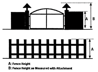
- Removal of prohibited fencing. Prohibited fencing shall be removed within 90 days of the effective date of this division.
(Ord. No. 01-21, § 1(5.9.1), 12-13-2001)
Sec 30-912 Requirements
- Location of fences.
- Location near streets, driveways, and bicycle path intersections. No fence shall be erected which is located or designed in such a manner as to create a safety hazard by obstructing the vision of pedestrians, cyclists, or motorists traveling on or entering streets, driveways, or bikepaths, as determined by the director of planning and development services. For the purposes of this division, visibility triangles shall be established to provide an area of clear sight for the safe and adequate view of vehicles and pedestrians at street intersections or street and driveway intersections. Fences may be placed within the visibility triangle only as permitted within this division.
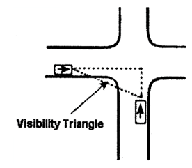
- Location near wetlands or water bodies. No fence shall be placed so as to extend into or through any wetland or water body, or extend beyond the mean high-tide line on any property. On beaches identified as threatened or endangered species habitat, no fence shall be permitted.
- Setback from property lines. Setback requirements shall not apply to fences eight feet in height or less. Notwithstanding this requirement, no fence exceeding six feet in height shall be placed adjacent to any roadway.
- Blocking access. In no event shall fences be approved if they restrict fire and emergency access to individual or adjacent properties.
- Location near streets, driveways, and bicycle path intersections. No fence shall be erected which is located or designed in such a manner as to create a safety hazard by obstructing the vision of pedestrians, cyclists, or motorists traveling on or entering streets, driveways, or bikepaths, as determined by the director of planning and development services. For the purposes of this division, visibility triangles shall be established to provide an area of clear sight for the safe and adequate view of vehicles and pedestrians at street intersections or street and driveway intersections. Fences may be placed within the visibility triangle only as permitted within this division.
- Use. Fences may be allowed as accessory uses within any land use district. Fences may be permitted without a legally existing principal use for purposes of upland security as permitted under this division.
- Construction.
- Compliance with Building Code. All fences shall comply with the appropriate detailed provisions of the Building Code.
- Clearing for fences. Limited clearing and grubbing (hereafter referred to as "clearing") to allow construction of protective fences and gates may be permitted if the following design Standards are met:
- Any necessary clearing is clearly stated on the building permit application.
- No clearing shall occur within Class I habitat.
- Limited clearing shall not remove vegetation that would provide for the minimum Bufferyard requirements unless fully mitigated.
- Prior to the issuance of a clearing permit a vegetative survey or biological inspection is required for properties containing Class II habitat to ensure that limited clearing or construction activities will not negatively impact the habitat.
- Maintenance. It is the responsibility of the owner of the property where a fence is erected to maintain the structure in good repair at all times. If a fence is found to be in a deteriorated condition or in need of repair, including but not limited to broken or missing structural components, or the fence is substantially less than perpendicular to the grade, the property owner may be ordered to repair, replace, or remove the fence. Such order shall be issued by the building official or his designee pursuant to the Village Code.
- Fence material.
- Exposed surfaces. Fences may be constructed of rocks, logs, posts, boards, chain link, wire, rails, aluminum, PVC, masonry components, recycled plastic lumber, cast metal, or other similar materials or combination of materials.
- Facing. All fences shall be constructed with the finished surface facing the exterior of the property with support posts placed to the inside, except in cases where the fence posts are an integral part of the fence design.
- Mixed materials. Fences constructed of mixed permitted materials (i.e., masonry with an iron picket attachment) shall be permitted provided that the total height does not exceed the maximum height permitted for the fence.
- Prohibited materials. Hazardous fence materials or attachments are prohibited except where used for security purposes at military or detention facilities.
- Height. In general, fences shall not exceed eight feet in height except as follows:
- Adjacent to roadways. No fence shall be placed on a property adjacent to a roadway exceeding six feet in height.
- Visibility triangle. No solid fence shall be located within a visibility triangle exceeding three feet in height or in any other way obstructing clear sight of vehicles and pedestrians utilizing streets and sidewalks. Fences meeting the general height requirements may be placed within the visibility triangle provided that the fence design provides adequate open space to allow visibility, to be determined by the director of planning and development services.
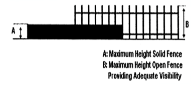
- Athletic activities.
- When it is necessary to use a fence to contain tennis courts or other similar athletic activities on residential properties, the fence may exceed eight feet to a maximum of 12 feet, and shall be designed not to impair visibility. Setback requirements shall apply.
- Upon approval of the director of planning and development services, fences for athletic and recreational activities located on nonresidential properties may exceed eight feet to a height appropriate to safely contain the particular athletic activity. The fence shall be designed not to impair visibility and shall be subject to the setback requirements of the zoning district in which it is located. In general this height shall not exceed 12 feet. In no case shall the height exceed 25 feet.
- Property without principal use. Where a fence is constructed on a property without a lawfully established principal use, the fence shall not exceed the height established within this division.
- Fence buffer standards.
- Fences adjacent to roadways. Fences located adjacent to roadways shall install and maintain a fence buffer pursuant to this section. The following flow chart illustrates fence bufferyard requirements for fences located adjacent to roadways.
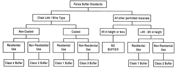
- Required vegetation. The following table illustrates vegetation requirements for each class fence buffer.The number of plants required is per 100 linear feet. Canopy and understory trees shall be a minimum of six feet in height and shrubs shall be a minimum of three feet in height.
Fence Buffer
Within Setback
Within Right-of-way
Class 1
1 canopy, 2 understory, 20 shrubs
3 breakaway understory, 20 shrubs
Class 2
3 canopy, 2 understory, 30 shrubs
5 breakaway understory, 20 shrubs
Class 3
4 canopy, 2 understory, 30 shrubs
6 breakaway understory, 30 shrubs
Class 4
2 canopy, 5 understory, 30 shrubs
7 breakaway understory, 40 shrubs
Class 5
5 canopy, 2 understory, 40 shrubs
7 breakaway understory, 40 shrubs
- Location of fence buffer vegetation. For chainlink and wire type fencing all required vegetation shall be placed to the exterior of the fence. For fences constructed of all other permitted materials a minimum of 70 percent of the required vegetation shall be placed to the exterior of the fence. The arrangement of plants shall be evenly distributed along the entire length of the fence except a maximum of one 20-foot access point for each 75 feet of property frontage, unless otherwise approved by the director of planning and development services. Vegetation shall not be placed as to obstruct the visibility triangle requirements. In no instance shall vegetation be placed within the right-of-way without the express written consent of the state department of transportation or the village department of public works. An indemnification agreement shall be required.
- Vegetation within right-of-way. Where any portion of the fence buffer is placed within the right-of-way the fence buffer standards for "within right-of-way" contained in subsection (g)(2) of this section shall apply. All vegetation placed within the right-of-way shall be breakaway, with mature trunk diameters of four inches or less measured six inches above the ground. In general, vegetation within the right-of-way shall be placed within five feet of the property line, unless expressly permitted by the director of public works. Additional conditions may apply for vegetation placed within the right-of-way as determined by state department of transportation or director of public works.
- In conjunction with other required bufferyards. Required fence buffers may be applied toward any additional required bufferyard requirements. Any fence buffer vegetation that overlaps a required major street or zoning district bufferyard shall be subtracted from the total to avoid double counting.
- Fences adjacent to roadways. Fences located adjacent to roadways shall install and maintain a fence buffer pursuant to this section. The following flow chart illustrates fence bufferyard requirements for fences located adjacent to roadways.
- Columns without arches. Entry columns that exist without an arch shall be considered a part of the fence and shall not be considered an attachment to the fence. The entry columns shall comply with the maximum height as established within this division. The entry columns shall be spaced a minimum of 20 feet apart unless otherwise approved by the village fire chief.
- Attachments.
- Lighting. Light fixtures may be permitted to be attached to a fence, provided that:
- Light fixtures are spaced a minimum of 16 feet apart or are located directly adjacent to a gated entry;
- The fixtures shall not extend greater than two feet above the maximum permitted fence height;
- The fixtures are designed such that no lamp component is visible from the horizontal plane. Frosted globe fixtures may be used, however in no case shall fully exposed lamps or fixtures with clear glass globes or side panels be permitted;
- A maximum of one low intensity lamp is installed per fixture; and
- Light trespass does not fall upon adjacent properties or roadways.
- Columns and arches. Entry columns and arches may be added to fences adjacent to an entrance provided that:
- They are spaced a minimum of 20 feet apart;
- They provide a minimum 15-foot height and width clearance for the passage of emergency and delivery vehicles unless another conforming accessway is available or the village fire chief approves an alternative design and accessway.
- They do not exceed 18 feet in height; and
- Approval of the village fire chief shall be required.
- Lighting. Light fixtures may be permitted to be attached to a fence, provided that:
- Other attachments. Other decorative attachments may be permitted upon the approval of the director of planning and development services provided they are spaced a minimum of eight feet apart, are permanently and securely fastened, and do not extend greater than two feet above the maximum permitted height for the fence.
(Ord. No. 01-21, § 1(5.9.2), 12-13-2001; Ord. No. 02-29, § 11, 11-21-2002; Ord. No. 06-17, § 1, 8-31-2006)
Sec 30-925 Intent And Purpose
It is the intent and purpose of this division to permit temporary storage units within the village on a controlled, time-limited basis, while controlling any adverse impacts on the village's permanent uses.
(Ord. No. 05-20, § 3(5.8.1), 9-15-2005)
Sec 30-926 Definitions
See section 30-32.
(Ord. No. 05-20, § 3(5.8.2), 9-15-2005)
Sec 30-927 Temporary Storage Units Permitted
A temporary storage unit shall be permitted in any zoning district of the village provided it meets the criteria set forth in this division. This section shall not override or substitute any other permit, certification or approval required by any other section of this chapter.
(Ord. No. 05-20, § 4(5.8.3), 9-15-2005)
Sec 30-928 Criteria For Temporary Storage Units
A temporary storage unit permit may be issued to the owner, tenant or lessee of any property located within the village. The planning and development services director may permit a temporary storage unit provided the temporary storage unit meets the following criteria:
- Placement. Temporary storage units may be permitted as a temporary structure in any zoning district subject to the following provisions:
- Shall not exceed either a maximum of two temporary storage units per half acre or three temporary storage units per lot whichever is less;
- On residential properties, the maximum size of a temporary storage unit shall be ten feet wide, 30 feet long and nine feet high;
- Shall only be located in scarified areas of the property;
- Shall be setback a minimum of five feet from any property line and may not be located within the clear site triangle;
- Shall not be stacked;
- Shall not be located in the right-of-way;
- Shall not be modified by adding windows, electrical, plumbing or mechanical improvements and/or used as habitable space; and
- Shall not be used to store solid waste, debris, recyclable materials, or used to store materials or goods for property other than at the site where the unit is located;
- Shall be secured with tie downs as approved by the building official.
- Time limit.
- The maximum time for the temporary storage unit to remain on the property shall be 30 consecutive days with a maximum of two permits per year per lot if not in conjunction with an active building permit for construction as specified in this subsection.
- Temporary storage units may be permitted in conjunction with an active building permit for construction and may be allowed on-site for a duration not to exceed one year from the date of issuance of the building permit for the temporary storage unit. Temporary storage units shall be removed prior to any final inspection for the building permit or issuance of a certificate of occupancy.
- The time periods set forth in this subsection may be extended by the building official, for up to three times, providing the applicant can show good cause and providing that each extension does not exceed more than 30 consecutive days. Good cause shall mean emergencies and situations where there exists a reasonable risk or threat to life and property damage if the extension is not granted.
- Maintenance and prohibition of hazardous materials. The temporary storage unit shall be maintained in good condition, free from evidence of deterioration, rust, holes or breaks. When not in use the temporary storage unit shall be kept locked. The owner, supplier or tenant shall ensure that no hazardous substances shall be stored or kept in the temporary storage unit.
- Existing units. Temporary storage units, as listed in the 2005 Temporary Storage Unit Inventory, and not having received an official approval, may continue subject to division 3, Nonconformities, providing the following:
- The units are not located within any required setback, bufferyard, or parking area;
- The units are not connected to electric or water utilities;
- The units are registered with the village manager, or designee, within 60 days of the effective date of this division and renewed annually thereafter. New or unregistered units shall be subject to all requirements of this division;
- These structures or vehicles shall not constitute nonresidential floor area and may not be redeveloped or replaced as such;
- This division shall not apply to structures that have received an official approval such as a building permit for installation as a permanent structure;
- Each unit shall be secured with tie downs as approved by the building official; and
- Each unit shall be screened with native vegetation so as to not be visible from any major street as defined in this chapter.
- Inspections. The village may inspect the contents of any temporary storage unit at any reasonable time to ensure that it is not in violation of any of the criteria set forth in this section.
- Violations. It shall be unlawful for any person to place or permit the placement of a temporary storage unit on a site without obtaining a temporary storage unit permit.
- Liability. Notwithstanding any provision to the contrary, the supplier and property owner shall be jointly and separately liable for any violation under this section.
- Penalties. A violation of this section, as may be amended, may be enforced by issuance of a citation, summons, notice to appear in front of the code compliance hearing officer, by filing an action in civil court for injunctive relief or any other lawful means.
(Ord. No. 05-20, § 3(5.8.4), 9-15-2005)
Sec 30-929 Temporary Storage Unit Permits
- The applicant shall submit a completed application for a temporary storage unit permit to the planning and development services department prior to the delivery or use of a temporary storage unit.
- The following information shall be required of all persons making application for a temporary storage unit:
- Name and address of applicant;
- Name, address and written permission of the property owner if different than the applicant;
- Legal description of the property where the temporary storage unit is to be placed;
- Scaled sketch plan of the property where the temporary storage unit is to be placed, the location of the temporary storage unit, and the surrounding areas which will be impacted by the temporary storage unit; and
- A short description of the nature and type of temporary storage unit, dimensions and materials to be stored.
- In issuing a temporary storage unit permit, the director of planning and development services may prescribe appropriate conditions and safeguards as are necessary to protect the public interest and ensure harmony with the intent and purpose of this chapter. If an applicant fails to meet such conditions, if the temporary storage unit becomes a nuisance, or if any provision of the village code is violated by the temporary storage unit, the temporary storage unit permit may be revoked by the village manager upon providing the applicant with written notice of the revocation. If the use endangers the public health or safety, then the village manager shall revoke the permit immediately. The applicant may appeal the revocation of the temporary storage unit to the village council.
- No temporary storage unit permit issued pursuant to this division shall be transferable, assignable, or otherwise alienable.
- No temporary storage unit permit shall be required if the temporary storage unit is part of a construction project by or for the village.
- A temporary storage unit permit shall only be granted based on a written determination by the director of planning and development services that the proposed use meets all of the criteria set forth in this division, and all other applicable requirements contained in this chapter.
- The director may require that a temporary storage unit permit be subject to village council approval.
(Ord. No. 05-20, § 3(5.8.5), 9-15-2005)
Sec 30-930 Setback Encroachments
- Every part of every required front, side, rear, shoreline and marine turtle nesting setback shall remain unoccupied and unobstructed from grade upward except as or as indicated within article VII Environmental Regulations or as provided herein:
- Roof overhangs, cornices, chimneys, eaves, sills and belt courses may extend into any required setback area, provided that any such setback encroachment shall not exceed three feet or one-third of the width of the required setback, whichever is less, and a minimum setback of five feet from any side yard shall be maintained.
- Awnings and canopies, which are attached to a principal building and well-maintained, may extend into any required setback, provided that any such setback encroachment shall not exceed five feet or one-third the width of the required setback, whichever is less.
- Boats, boat trailers, camper trailers or recreational vehicle storage. In all zoning districts, accessory storage of such vehicles shall be within the front, side or rear yards. No such vehicle shall be utilized as a dwelling unit and shall be screened with native vegetation from view of any adjoining property.
- Balconies may encroach up to five feet or one-third the width of the required setback, whichever is less.
- Carports may encroach within five feet of any front or rear setback, provided that such structures shall be attached to or abut a principal building, shall be open on at least two sides, shall be supported by posts or columns and shall extend over a paved driveway which connects to an adjacent street or alley. Carports associated with single-family residences may not exceed a total of 400 square feet and may have a maximum width of 20 feet and a maximum depth of 20 feet. Carports must be harmonious with the principal structure to which they are associated and maintained.
- Chickee and Tiki Huts may be permitted in all residential zoning districts provided that such structures shall maintain a minimum setback of five feet from any side or rear lot line, and shall not exceed a maximum height of 15 feet. Chickee and Tiki huts are prohibited within the front yard and such structures shall be open on all sides, with the exception of supporting posts, and have an unobstructed, clear space between the edge of the roof covering and the grade.
- Driveways may be permitted within the required setback, pursuant to the requirements set forth in section 30-855;
- Landscaping, bufferyards, scenic corridors, street trees, stormwater retention areas and swales pursuant to the requirements set forth in chapter 30, Land Development Regulations.
- Mechanical equipment or decks may encroach up to four feet into any required side yard or rear yard setback, provided that at least one side yard maintains a minimum continuous unobstructed width of five feet. Mechanical equipment must be located at the minimum finished floor elevation required for the principal structure to which they are associated and must be screened with native vegetation from ground view of surrounding and adjacent properties. Window air conditioning units may encroach up to 18 inches into any required setback.
- Porte-cocheres may encroach to within 13 feet of any front yard setback, provided that such structures are constructed of masonry or with a design compatible with the principal structure, shall be opened on three sides, shall be a maximum length of 20 feet, and shall have a roof with a pitch equal to or greater than that of the principal structure with matching materials. The porte-cochere shall not exceed 30 percent of building core frontage in width or 16 feet in height or be screened or enclosed in any manner. It shall provide an unobstructed, clear space of not less than nine feet between the grade and the underside of the roof of the porte-cochere.
- Gazebos and pergolas may be permitted within all residential zoning districts provided that such structures shall maintain a minimum setback of five feet from any side or rear lot line, shall not exceed 144 square feet in gross floor area, shall not exceed a height of 15 feet. Placement of such structures within the front yard is prohibited.
- Bay windows may extend into any required setback area no more than either three feet or one-third the width of the required setback, whichever is less, and shall maintain a minimum setback of five feet from any side yard, provided that such structure shall not exceed 20 square feet in gross floor area or seating area.
- Outdoor kitchens may be permitted within all residential zoning districts, provided that such structure shall maintain a minimum setback of five feet from any side or rear lot line, shall not exceed 144 square feet in gross floor area, and are prohibited in the front yard. Outdoor kitchens may be open-aired or roofed. The design of an outdoor kitchen must be aesthetically pleasing and harmonious with the principal structure to which they are associated.
- Exterior staircases may encroach into any front, side or rear yard setback up to five feet, provided any such staircase is only for ground floor access to the principal structure, and a minimum setback of five feet from any side yard shall be maintained. Exterior staircases that encroach into a setback shall not be enclosed, shall not provide access to a second floor living area and may not extend to the roof of the principal structure. The design of exterior staircases must be aesthetically pleasing and harmonious with the principal structure to which they are associated.
- Fish cleaning stations shall not exceed 15 square feet and shall maintain a minimum setback of six inches from any side yard. Fish cleaning stations shall not extend beyond the edge of an associated dock pursuant to section 30-1548(c).
- Storage structures and utility sheds are prohibited within the front yard, and are required to maintain a minimum distance of five feet from any rear yard lot line. Such structures must be located so as to meet the requisite side yard setbacks prescribed to the zoning district in which it is located. Only one storage structure or utility shed may be permitted per property and such structure shall not exceed 15 feet in height.
- Walkways up to five feet in width may be permitted within a required setback.