
Jacksonville Beach City Zoning Code
ARTICLE VII
SITE DEVELOPMENT STANDARDS
Sec. 34-700. - Applicability.
Off-street parking and loading spaces shall be provided for all uses in accordance with the requirements of this division. Expansions of and changes to existing land uses shall also comply with such requirements.
Sec. 34-701. - Interpretation of standards.
In interpreting the provisions of this division, the following standards shall apply:
(a)
Floor area. For the purpose of computing parking and loading requirements that are based on the amount of floor area in a building, gross floor area shall be used.
(b)
Fractions and rounding. When calculations used in determining the number of required parking and loading spaces result in fractional requirements, any fractions of less than one-half (½) shall be disregarded and any fraction of one-half (½) or more shall be rounded to the next highest whole number.
(c)
Seating-based standards. For the purpose of computing parking and loading requirements that are based on seating, the parking requirements shall be based on the total number of patron seats shown on the seating diagram submitted pursuant to the Jacksonville Beach Life Safety Code.
(d)
Multiple use building. Developments containing three (3) or fewer uses shall provide off-street parking and loading in an amount equal to the sum of the requirements for the individual uses unless a shared parking plan is approved pursuant to section 34-705.
(e)
Unlisted uses. If a use is not specifically listed in the schedule of off-street parking space requirements of section 34-706, the planning and development department shall apply the off-street parking space requirements of the most closely related use or best practices based on available parking trends and analysis for similar uses.
Sec. 34-702. - Design standards.
(a)
Spaces. The minimum dimensions of off-street parking and loading spaces shall be as follows:
(1)
Off-street parking: Nine (9) feet by seventeen (17) feet.
(2)
Parallel parking: Nine and one-half (9½) feet by twenty (20) feet.
(3)
Parking for the handicapped: Twelve (12) feet by seventeen (17) feet, plus a five-foot wide clear area (the clear area may be combined with the clear area for an adjacent handicapped space).
(4)
Off-street loading: Twelve (12) feet by forty (40) feet.
(5)
Bicycle parking: For off-street parking lots containing ten (10) or more spaces, one (1) parking space may be converted to a bicycle parking area.
(6)
Compact spaces: Eight (8) feet by sixteen (16) feet.
(7)
Motorcycle spaces: Four (4) feet by eight (8) feet.
(8)
Golf cart spaces: Five (5) feet by ten (10) feet.
(b)
Parking aisles. The minimum required dimensions of off-street parking aisles shall be based on the angle of the parking stalls to the aisle as follows:
Table 34-702.1
Figure 34-702.1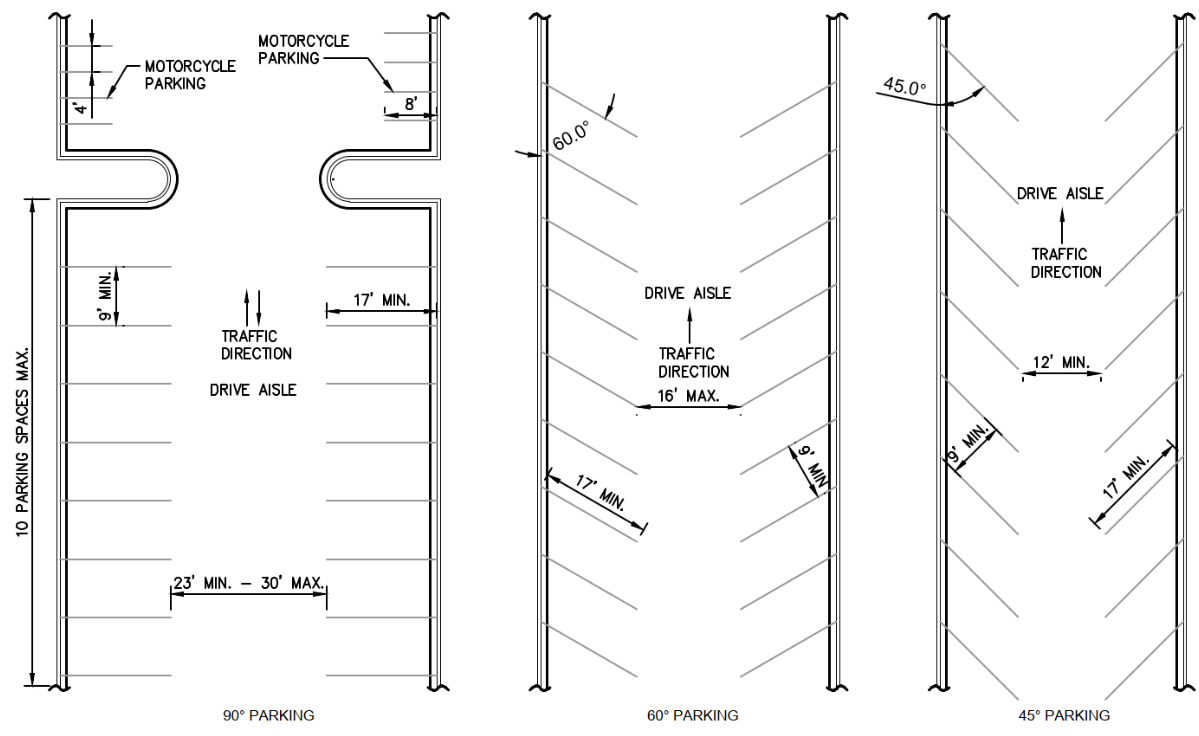
(c)
Turning and maneuvering space. Off-street turning and maneuvering space shall be provided for each lot so that no vehicle shall be required to back onto a public street or alley, with the exception of single-family structures, townhouses, or individual multiple-family structures with attached garages or carports.
(d)
Parking area setbacks. Off-street parking areas shall be located at least ten (10) feet from any corner and five (5) feet from any established right-of-way or property line (excluding attached dwelling units) unless otherwise stated in the LDC. However, no setbacks are required for driveways relative to interior property lines between townhouse lots, or between a driveway and its connection to a right-of-way for vehicular access. Below ground parking garages on oceanfront lots are exempt from setback requirements, provided that they shall be constructed no closer than three (3) feet from any property line, shall be completely roofed and covered, and such roof or cover shall not be elevated more than six (6) inches above the crown of the abutting street.
(e)
Curbs and wheel stops. Curbing or wheel stops shall be provided within off-street commercial parking and loading areas to prevent any part of the vehicle from encroaching upon public rights-of-way, landscape areas or adjacent property. Curbing or wheel stops shall be installed at least five (5) feet from any property line. The requirements provided herein are not applicable to driveways for single-family residences and townhouses.
(f)
Construction standards. Off-street parking and loading areas and the vehicular access way thereto shall be paved, striped and landscaped. Required parking and parking space access in residential parking areas may include turf block, permeable pavers or other similar materials, not including gravel. All landscaping shall be in accordance with section 34-745. The requirements provided herein for striping and landscaping are not applicable to driveways for single-family residences and townhouses.
(g)
Lighting. If off-street parking areas are lighted, lighting shall be designed and installed in a manner that will prevent harsh glare or excessive light from spilling onto adjacent property and streets. The amount of illumination projected onto a residentially zoned property or use from another property may not exceed 0.3 footcandles measured at ten (10) feet from the property line onto the adjacent residential property.
Sec. 34-703. - Location of parking facilities.
Parking spaces for all uses shall be located on the same site (parcel) as the principal structure or use unless off-site parking is approved pursuant to section 34-704. However, handicapped spaces (ADA) may be located within the city's right-of-way upon approval from the public works department.
Sec. 34-704. - Off-site parking.
If required parking spaces cannot be reasonably provided on the same site (parcel) as the principal use, the planning and development department may approve plans to provide required off-site parking if the following requirements are met:
(a)
Location. The nearest boundary of any off-site parking area shall not be located more than three hundred (300) feet from the primary entrance of the principal use served.
(b)
Zoning. Off-site parking areas shall be located on lots zoned to permit the principal use being served by the required parking, except that required parking for any residential use may be located in a nonresidential district.
(c)
Exclusive use. An off-site parking area may not be used for any purpose other than parking for the principal use.
(d)
Deed restrictions. A deed restriction dedicating the off-site parking area for use in conjunction with the principal use shall be prepared and recorded with the deed of both properties. The deed restriction shall specify that the parcel or parcels shall remain as off-street parking for as long as the principal use remains, and shall contain a legal description of the property occupied by the principal use. Evidence of the recording of the deed restriction shall be provided before any construction permit is issued.
(e)
Signs. No signs other than one (1) identification sign and traffic directional sign shall be permitted on the off-site parking lot. Such identification sign shall indicate the name and location of the principal use served by the off-site parking area, and shall not exceed three (3) feet in height and four (4) square feet in area.
(f)
Application: Off-site parking may be considered shared parking follow the application guidelines set forth in section 34-705.
Sec. 34-705. - Shared parking.
The planning and development director or designee may authorize a reduction in the number of required parking spaces for a mixed-use development or for uses which are located near one another and which have different peak parking demands and operating hours. Shared parking arrangements shall be subject to the following requirements.
(a)
Application. An application for shared parking shall include a description of the use, a development plan complying with the requirements of section 34-571 and section 34-573, a trip generation report, and a parking study and other information deemed necessary by the planning and development department.
(b)
Location. All shared parking shall be located in an area providing reasonable accessibility to all uses which it is intended to serve.
(c)
Agreements. In cases where the uses for which shared parking is requested are located on lots under different ownership, proof of a long-term lease agreement and deed recordings shall be required and shall be subject to review by the city attorney.
(d)
Standards. In determining whether to approve a reduction for shared parking, the following shall be considered:
(1)
Characteristics of each use and projected peak parking demand, including hours of operation;
(2)
Potential reductions in vehicle movements afforded by multi-purpose use of spaces by employees, customers or residents; and
(3)
Potential improvements in access, design, open space preservation and circulation.
Sec. 34-706. - Off-street parking space requirements.
Off-street parking spaces shall be provided in accordance with the following minimum standards. The Central Business District (CBD) contains a separate set of minimum parking standards as shown in Table 34-706.2 and a parking exemption area, as illustrated in Exhibit 34-706.1. The CBD is also subject to a fifty (50) percent parking requirement discount, in addition to the allowable parking reductions as set forth in section 34-707. All other zoning districts shall follow the minimum parking standards in Table 34-706.1. Except as provided herein, in no case shall any business or office use provide fewer than three (3) off-street parking spaces, and meet ADA parking requirements. Required off-street parking spaces for a residential use may be provided through garage and/or driveway parking spaces.
Reductions in the required amount of parking or additional increases in parking, beyond the allowed, shall require a variance and parking demand analysis.
Table 34-706.1 below outlines the applicable parking requirements for all zoning districts, except CBD and approved RD districts that are located within the boundaries of the CBD.
Table 34-706.1. Parking Space Requirements
Table 34-706.2 below outlines all parking requirements only within the CBD or any approved RD districts that are located within the boundaries of the CBD.
Existing non-residential and non-hotel properties located within the Downtown Incentive Zone (DIZ) parking exemption area that have primary or secondary frontage on First Street North within the designated parking exemption area shall be exempt from any requirements that would require creation of new on-site parking facilities otherwise required by these land development regulations.
Table 34-706.2 below outlines the applicable parking space requirements within the CBD.
Table 34-706.2. CBD Parking Space Requirements
*If parking is located within the DIZ parking exemption area, the following criteria below applies:
Parking exemption area means the area bordered by the boardwalk, Second Street North, 1st Avenue North, and 6th Avenue North that meet the following criteria:
(1)
Existing non-residential and non-hotel properties located within the Downtown Incentive Zone (DIZ) parking exemption area that have primary and/or secondary frontage on First Street North within the designated parking exemption area shall be exempt from any requirements that would require creation of new on-site vehicle parking facilities otherwise required by these land development regulations. Bike parking shall be required per Table 34-707.1, where feasible, as determined by the planning and development director.
(2)
Existing approved Redevelopment District: RD zoning districts are not eligible for parking exemption area exemptions.
Exhibit 34-706.1: DIZ Parking Exemption Area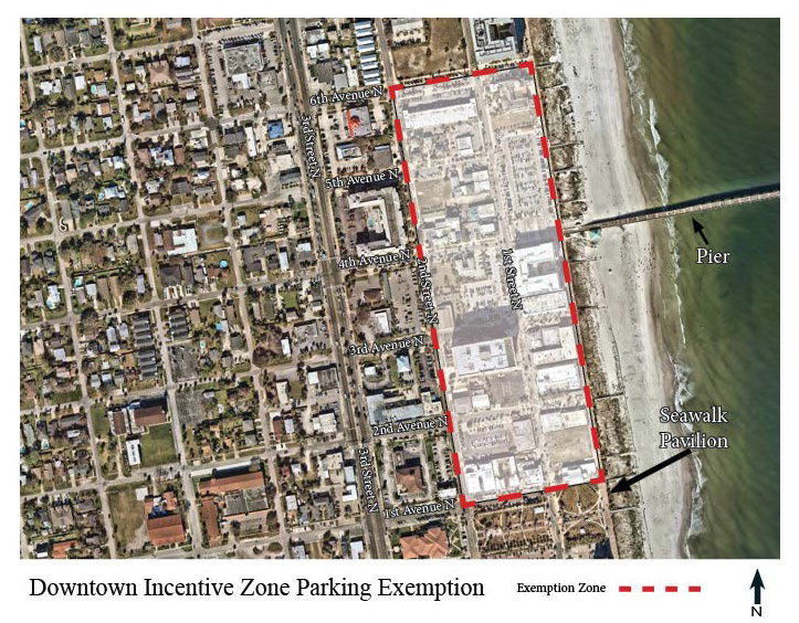
Sec. 34-707. - Optional off-street parking reductions for commercial uses.
Commercial uses, as classified by section 34-706, are eligible for a reduction in the required number of off-street parking spaces in accordance with the below. Restaurant uses are only eligible if they are in the Central Business District (CBD).
Table 34-707.1 Off-Street Parking Reductions
Sec. 34-708. - Parking for disabled persons.
(a)
Provision of spaces. Parking spaces for disabled persons shall be reserved and posted in all commercial and industrial zoning districts and in any other zoning districts where use is open to the public.
(b)
Location of spaces. Parking spaces for disabled persons shall be conveniently located near entrances. Ramps to sidewalks shall be provided and conveniently located in relationship to parking spaces. These spaces may also be located within the city's right-of-way upon approval from the public works department.
(c)
Number of spaces. The required number of parking spaces for disabled persons shall be as follows:
Table 34-708.1
Provided, however, when parking spaces are leased at such parking facilities, the number of parking spaces for disabled persons shall be increased or decreased based on demonstrated and documented need. A minimum of four (4) parking spaces for disabled persons shall be provided at a physical restoration rehabilitation center or hospital.
Sec. 34-709 - Payment in lieu of off-street parking.
(a)
Purpose. In lieu parking contributions are hereby authorized by the establishment of a fee to be paid to the City of Jacksonville Beach. Said fee is a required condition of approval for relief from the off-street parking requirements set forth in section 34-706 of this chapter for properties located within the central business district: CBD or a redevelopment district: RD. Such payments will allow the City of Jacksonville Beach to acquire land, finance, design, construct, and carry out maintenance and repairs to public parking facilities; and to perform other necessary and desirable actions to provide public off-street parking facilities.
(b)
General provisions.
(1)
In lieu of providing the parking spaces required by this chapter, the owner of a building or use requiring off-street parking spaces shall, upon approval by the planning and development department, of an application for relief from said requirements, pay to the City of Jacksonville Beach the established amount per parking space that is not to be provided.
(2)
The amount per space to be paid in lieu of providing required off-street parking shall be administratively reviewed and established on an annual basis. Factors to be considered when establishing the amount of the funds to be contributed per "in lieu" space are:
a.
Current construction cost of a comparable parking structure, as determined by the city's public works department ("A").
b.
Current cost of annual maintenance of a single parking space within a comparable parking structure ("B");
c.
Number of off-street parking spaces to be waived ("C").
d.
The total fee for payment in lieu of parking ("D") will be calculated as follows: (A + B) × C = D.
(3)
In the event that the planning and development department approves an application for relief from an off-street parking requirement for all or a portion of the required number of parking spaces in the central business district: CBD or redevelopment district: RD, such relief shall be granted only upon the condition that the applicant make payment to the City of Jacksonville Beach in accordance with the provisions of this section for the number of spaces waived.
(4)
Any off-street parking requirement met in this manner shall not require the payment of an additional fee, unless a change in use of the land generates an additional parking requirement. In such case, the applicant may choose to provide the additional required off-street parking or provide in lieu payment for the required additional parking.
(5)
All funds received in lieu of parking spaces shall be placed in a separate parking improvement fund to be used solely to acquire land, finance, design, construct, and carry out maintenance and repairs to public parking facilities; and to perform other necessary and desirable actions to provide public off-street parking facilities. Payment of such funds does not guarantee the construction of any spaces in a particular area of the central business district or within any particular period of time. In-lieu parking payments are solely an alternative means of satisfying the applicant's obligation to provide off-street parking in accordance with this division. Funds paid to the city as a fee in lieu of parking shall not be refundable for any reason.
(6)
Payment of in lieu fees must be made to the city at the time of issuance of the applicable building permit, or within six (6) months of the approval of the in lieu payment, whichever comes first.
(7)
Nothing herein shall be deemed to require the city to undertake the acquisition, construction, expansion, or development of any particular off-street parking facility.
Sec. 34-710. - Off-street loading space requirements.
(a)
Number of spaces. Uses which normally require the receipt or distribution of a large volume of materials or merchandise by vehicles, excluding uses in the CBD, including but not limited to hospitals, institutions, motels, commercial, wholesale, industrial or similar uses, shall provide off-street loading spaces in the following amounts:
Table 34-710.1
(b)
Location and size of spaces. Each off-street loading space shall have direct access to an alley or street and shall have the following minimum dimensions: Length—Forty (40) feet; width—Twelve (12) feet; height (if space is covered)—Fourteen (14) feet.
Sec. 34-716. - Accessory uses and structures.
Accessory uses and structures are permitted in all zoning districts provided that such uses and structures are customarily incidental and clearly subordinate to a permitted use and, unless otherwise provided, are located on the same lot (or contiguous lot in the same ownership) as the permitted use. Where a building or portion thereof is attached to a building or structure containing such principal use, such building or portion thereof shall be considered as a part of a principal building and not an accessory building. The accessory structure shall be connected to the main dwelling by way of an enclosed air-conditioned connection, not a breezeway, where the accessory use can be heated, cooled, has ventilation, and the proper utility connections. The main dwelling and accessory structure shall have a maximum distance between the two structures no more than ten (10) feet. Accessory uses shall not involve operations or structures not in keeping with the character of the zoning district where they are located and shall be subject to the following requirements.
(a)
Setbacks. Detached accessory structures shall observe the following setback requirements from adjacent property lines:
(1)
Generally. Detached accessory structures excluding temporary structures may be located in a required rear yard but shall be no closer than five (5) feet from any interior lot line. Street side and front yard setbacks shall be maintained on corner lots for the full length and width of the lot.
(2)
Equipment. Air conditioning compressors or other equipment designed to serve the main structure may be located in any required rear yard but shall not project more than three (3) feet into any required yard in a residential district.
(3)
Walkways. Walkways may connect to primary and/or detached accessory structures, driveways, and public sidewalks, and may be located in a required front, side, or rear yard area, but shall be setback a minimum of two (2) feet from any exterior property line, except for interior property lines between individual townhouse lots for which no setback is required.
(4)
Oceanfront lots. A detached accessory building may be constructed in the required setback area of the front yard of any oceanfront lot provided that the following conditions are met:
a.
The accessory building shall not extend beyond the width of the principal building.
b.
The accessory building shall not exceed fifteen (15) feet in height above grade.
c.
The accessory building shall not exceed six hundred twenty-five (625) square feet in ground floor area of the enclosed area only.
d.
A landscape buffer strip with a minimum width of fifteen (15) feet from the front or rear property line shall be established and maintained, exclusive of required walks and driveways.
(b)
Household pets. Household pets, like cats, dogs, hamsters, or birds, along with related doghouses and pens, are a permitted accessory use to residential uses in all zoning districts, provided the number of such pets over six (6) months in age shall not exceed three (3), and the keeping of four (4) or more dogs, six (6) months of age or older, shall be considered a kennel. Hens as household pets are limited to five (5) where permitted upon lands in the city.
(c)
Residential accessory uses. Accessory uses and structures in any residential zoning district excluding ADU's shall include non-commercial greenhouses, gardens, detached garages and carports, piers, docks, and boat houses or shelters, utility sheds and workshops, swimming pools, tennis courts, private golfing facilities, barbecue pits, non-commercial antenna structures for television and radio, children's playhouses or play equipment, and similar uses or structures which:
(1)
Do not exceed fifteen (15) feet in height,
(2)
The combined ground floor area of all enclosed, detached accessory use buildings shall not exceed six hundred twenty-five (625) square feet,
(3)
Do not involve the conduct of business of any kind;
(4)
Are of a nature not likely to attract visitors in larger numbers than would normally be expected in a residential neighborhood; and
(5)
Do not involve operations or structures not in keeping with the character of the residential neighborhood.
(d)
Pools. Private swimming pools, as regulated herein, shall be any pool, lake or open tank located either above or below the existing finished grade of the site, not located within a completely enclosed building, and exceeding one hundred fifty (150) square feet in surface area and two (2) feet in depth, designed, used or intended to be used for personal (not for profit) swimming or bathing purposes. Residential pools are for residential use only, they may not be used for commercial uses as applicable with the Florida Building Code.
(1)
General. A private swimming pool shall be allowed in any residential zoning district as an accessory use only if it fully complies with the following standards:
a.
The pool shall be used solely for the enjoyment of the occupants of the principal use on the property or their guests.
b.
The pool shall be located, designed, operated, and maintained so as not to interfere with the rights of the adjoining properties.
c.
The pool shall not be located in any required front yard forward of the front plain of the house nor encroach into any required side yard.
d.
The pool shall be constructed and enclosed in compliance with the requirements set forth in the Florida Building Code as adopted or amended by the city.
(2)
Oceanfront lots. Below ground swimming pools and a related pump house no more than fifteen (15) feet in height may be constructed in the required front and rear yards if a landscape buffer strip is provided and maintained, with a minimum width of fifteen (15) feet from the property line, exclusive of required walks and driveways.
(3)
Screen enclosures. A screen enclosure constructed around and over a swimming pool may be constructed within five (5) of the rear property line if not attached to the primary structure. The screen enclosure shall meet the side setback requirements applicable to the zoning district.
(4)
Screening of dumpster/solid waste container areas. All solid waste containers, including, but not limited to, compactors and dumpsters, shall be located and designed so as not to be visible from the view of adjacent streets and properties. If screening is required to eliminate the visibility of a container from adjacent streets and properties, then the type of screening used shall be determined based on the proposed location of the solid waste container, existing site conditions, and the type and amount of existing vegetation on the site. All solid waste containers shall meet the standards set forth by the public works department.
Sec. 34-717. - Alcoholic beverage establishments.
Alcoholic beverage establishments shall be subject to the following supplementary standards.
(a)
Proximity to churches and schools. An establishment, where permitted, which provides primarily for the consumption of alcoholic beverages on the premises shall not be located within five hundred (500) feet of a school or church measured from main entrance to main entrance (portal to portal) by the most direct pedestrian route. Hotels with one hundred (100) or more rooms and restaurants with a seating capacity of one hundred twenty (120) or more may be located closer than five hundred (500) feet to a school or church. Restaurants located in the Downtown Incentive Zone with seating capacities of fifty (50) or more may be located closer than five hundred (500) feet to a school or church. Religious organizations that are not the primary use within a shopping center are exempt from the alcoholic beverage distance requirement.
(b)
Proximity to other alcoholic beverage establishments. An establishment whose primary activity involves the consumption of alcoholic beverages on the premises shall not be located within five hundred (500) feet of a similar existing establishment, measured from main entrance (portal to portal) by the most direct pedestrian route. Hotels with one hundred (100) or more rooms, restaurants with seating capacities of one hundred twenty (120) or more and businesses wherein the sale of alcoholic beverages is only incidental to the principal use may be located closer than five hundred (500) feet to another establishment serving alcoholic beverages for consumption on the premises. Restaurants located in the Downtown Incentive Zone with seating capacities of fifty (50) or more may be located closer than five hundred (500) feet to another establishment serving alcoholic beverages for consumption on the premises.
(1)
An establishment, that is already in existence and not abandoned, whose primary activity involves the consumption of alcoholic beverages on the premises and is considered legal non-conforming, only within the Central Business District (CBD) can be rebuilt, repaired, or renovated so long as the gross square footage does not increase.
Sec. 34-718. - Child day care services.
Child day care services, including day nurseries, kindergartens and child care centers, shall provide proof of state licensure in addition to the following conditions:
(a)
Lot area. The minimum lot area shall be not less than seven thousand five hundred (7,500) square feet except for lots of record platted prior to the adoption of the LDC.
(b)
Outdoor play area. A fenced outdoor play area, which complies with all applicable state requirements, shall be provided in the rear yard.
(c)
Compliance with state standards. All facilities, operation and maintenance shall meet all applicable city and state regulations for such use.
(d)
Capacity. Shall follow Florida State requirements and licensure requirements for centers with over five children.
(e)
Parking. An adequate number of parking spaces shall be provided for employees and business owners, as well as a sufficient drop off area for children.
Sec. 34-719. - Compatibility setbacks.
Where a commercial or industrial zoning district is adjacent to the side yard of a residential zoning district, the side yard adjacent to the residential zoning district shall not be less than the minimum side yard requirement of the adjoining residential zoning district, and the front yard of the commercial or industrial zoning district shall not be less than that of an adjacent residential zoning district for a distance of three hundred (300) feet from the common property line or the termination of the block, whichever is less.
Sec. 34-720. - Corner visibility.
On a corner lot in all zoning districts, no fence, wall, hedge, planting, or structure shall be erected, placed, planted, or allowed to grow in such a manner as to obstruct vision between a height of two and one-half (2 ½) feet and eight (8) feet above the centerline grades of the intersecting streets in the area bounded by the right-of-way lines of such corner lots and a line joining points along said right-of-way lines fifteen (15) feet from the point of intersection (in the CBD this length shall be reduced to ten (10) feet. In addition to these requirements, landscaping within sight visibility triangles shall be governed by the standards of section 34-745(g).
Figure 34-720.1: Corner Visibility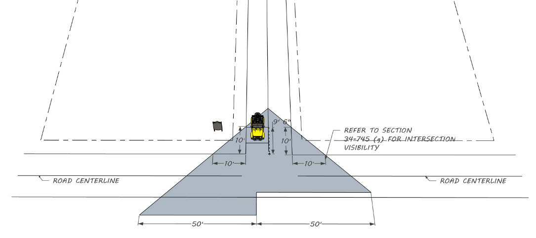
Sec. 34-721. - Essential public services.
Essential public services may be permitted by conditional use in any zoning district where they are not otherwise permissible. Essential public services include duly organized fire/rescue units and are otherwise limited to certain installations of water, sewer, gas, telephone or electrical systems. This division shall not be deemed to permit the location in a zoning district of such major installations as electrical or gas generating plants, sewage treatment plants, water pumping or aeration facilities and other similar major installations, unless such facilities were constructed or actual physical construction was started prior to the adoption of the LDC. The following supplementary standards shall apply to such uses:
(a)
This division shall not be deemed to permit the erection of structures for commercial activities such as sales of related merchandise or collection of bills in zoning districts from which such activities would otherwise be prohibited.
(b)
Within the limits of their proposed function, the architecture and landscaping shall be harmonious with the surrounding neighborhood.
Sec. 34-722. - Fences.
All fences are required to receive approval by the planning and development department and submit for a building permit. All fences shall comply with section 34-720 corner visibility.
(a)
Residential zoning districts fences. The following are fence regulations in residential zoning districts:
(1)
Materials. All fences in residential zoning districts shall be constructed such as pressure treated wood, composite wood, PVC wood, metal, or masonry. Barbed wire and chainlink fences are not permitted.
(2)
Height. The fence height in a residential district shall be a maximum of six (6) feet and located within the property boundaries. Additionally, fences shall not be taller than four (4) feet in a designated front yard and shall be setback at least two (2) feet from the right of way.
a.
A fence located in a side or rear yard, except rear yards of oceanfront lots in the RS-1 zoning district, may be constructed at a height not to exceed eight (8) feet provided that the following requirements are met:
1.
All fences installed pursuant to this subsection shall be constructed of pressure treated wood, composite wood, PVC wood, or masonry. In no case shall fences constructed of chainlink wire fabric be permitted to exceed six (6) feet in height.
2.
Any portion of said fence in excess of six (6) feet in height shall meet the following:
i.
Limited to up to two (2) feet above the allowed six (6) feet.
ii.
The additional height shall be composed of either lattice or slats to allow visibility and air flow above six (6) feet.
d.
Side and rear yard fences on single-family residential uses that are immediately adjacent to an established commercial or industrial use may be built to a height not to exceed eight (8) feet and may be constructed without twenty-five (25) percent of the aggregate surface area being open, even when the property is separated by an intervening alley. A fence in the rear yard of any oceanfront lot in an RS-1 zoning district shall not exceed three and one-half (3½) feet in height.
(3)
Impairment of visibility at intersections prohibited. Clear sight distance shall be maintained at the intersections of streets, alleys, and curbcuts in accordance with section 34-745(g).
(4)
Enclosure of swimming pool. All swimming pools shall be enclosed by a fence of not less than four (4) feet in height equipped with a gate which shall have a self-closing and self-locking device for keeping the gate securely closed at all times when not in actual use. The fence and gate shall not be required if entry to the pool by any person other than those residing or renting sleeping quarters on the property containing the pool is prevented by a wall, buildings, structures, or any other substitute devices so long as the degree of protection is not less than the protection afforded by the fence, gate, and latch described herein.
Figure 34-722.1: Fences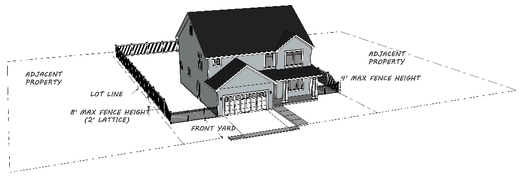
(b)
Commercial fences.
(1)
Material; use of barbed wire. Fences shall be constructed of wood, masonry, chain link wire or other materials approved by the planning and development department. Barbed wire shall not be permitted in residential zoning districts. When permitted, barbed wire shall be located at the top of the fence, being not less than six (6) feet in height. If installed so that the barbed wire inclines outward, no portion may encroach into an adjacent property.
(2)
Height restrictions.
a.
Except as provided for in this division or as modified by the other provisions of the LDC, all fences in and around the front yard of any lot shall not exceed four (4) feet.
b.
An eight-foot, nonopaque chainlink fence may be erected along the property line of any recreational facility owned or leased by a school, church, or unit of government.
c.
Chainlink fences for public or private tennis courts shall not be required to comply with height regulations. Windscreens may be installed provided that visibility at intersections of public rights-of-way is not impaired. Fences for private tennis courts shall be constructed within the required setbacks for accessory uses in the particular zoning district in which the fence is located.
d.
Government and public properties shall not be held to the standards for height and therefore the height restriction shall not apply.
(3)
Security fences.
a.
An eight-foot high security fence may be installed in the front, side and rear yard of any government use or essential public service facility in any zone, provided that a clear sight distance as required by sections 34-720 and 34-745(g) is maintained. Any barbed wire shall be located at the top of the fence. If installed so that the barbed wire inclines outward, no portion may encroach into an adjacent property.
b.
A six-foot high non-opaque chainlink fence may be installed for security purposes in the front yard of any lot which is adjacent to vacant parcels. As a condition to receipt of a permit, any fence constructed in accordance with the provisions of this paragraph shall be removed after the block or tract is seventy-five (75) percent developed. All residential lots must meet the residential standards for design in accordance with each zoning district in article VI.
c.
Impairment of visibility at intersections prohibited. Clear sight distance shall be maintained at the intersections of streets, alleys, and curbcuts in accordance with section 34-745(g).
d.
Approval by the planning and development department required. All fences are to be approved by the planning and development department.
e.
Fences to be maintained and repaired. All fences shall be maintained in a good state of repair and structurally sound condition, including but not limited to, painting and repainting; replacement of missing, decayed, corroded, or damaged component parts. Failure to so maintain and repair said fence may result in the fence being declared a nuisance and abated in accordance with the provisions of Chapter 19 of the Jacksonville Beach Code.
Sec. 34-723. - General requirements for yards.
(a)
Obstructions. Every part of a required yard shall be open from its lowest point to the sky, as measured from the exterior bearing or non-bearing walls, columns or supports to the property line except for the projection of chimneys, flues, eaves or architectural embellishments, provided, however, that none of the above projections shall encroach into the required setback more than twenty-four (24) inches or in the case of eaves, thirty (30) inches.
(b)
Double frontage (through) lots. On double frontage (through) lots, the required front yard shall be provided on each street.
(c)
Fire escapes, stairways and balconies. Fire escapes, stairways, or balconies may intrude two (2) feet into the required front or rear yards and two (2) foot into the required side yard. These structures shall not intrude into the required side yards unless there is at least a ten (10) foot required side yard setback.
Figure 34-723.1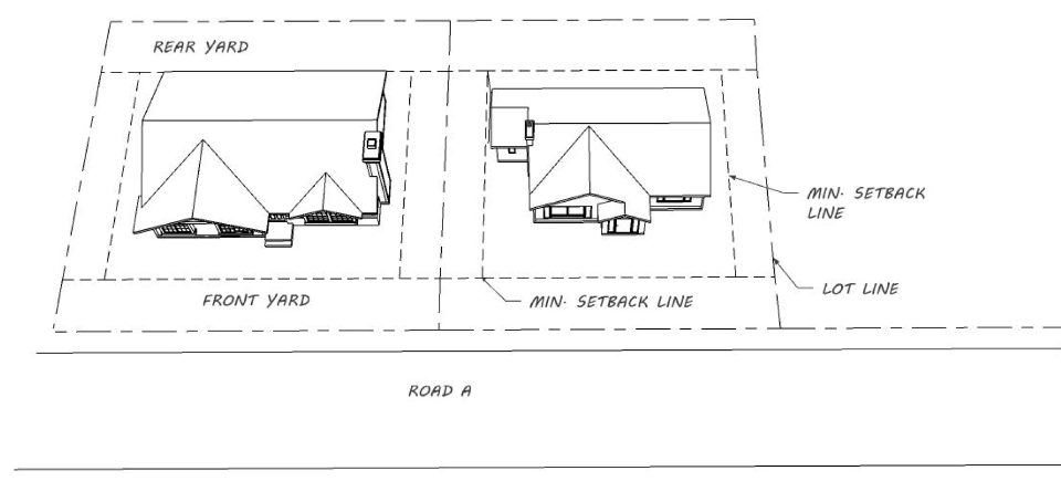
Figure 34-723.2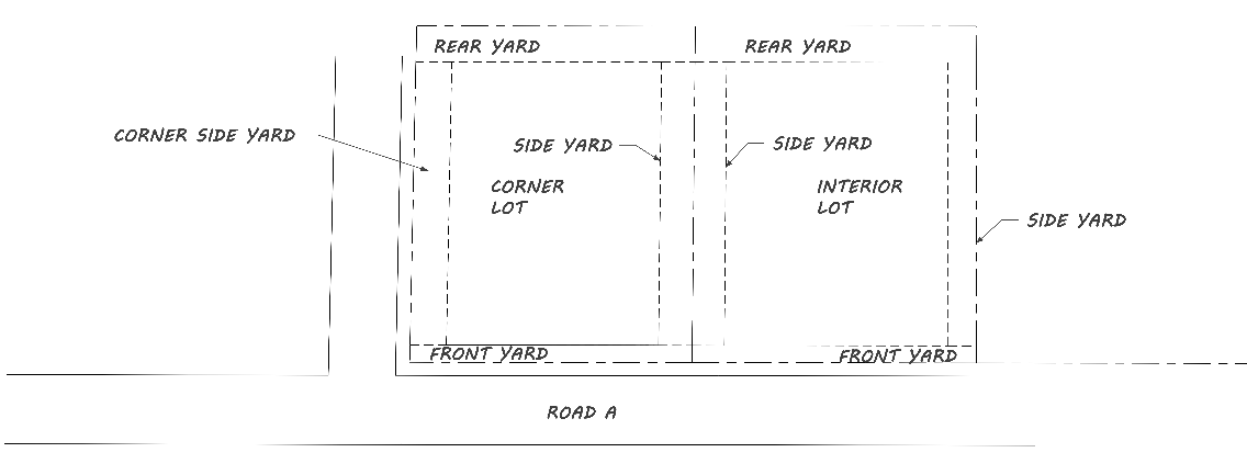
Figure 34-723.3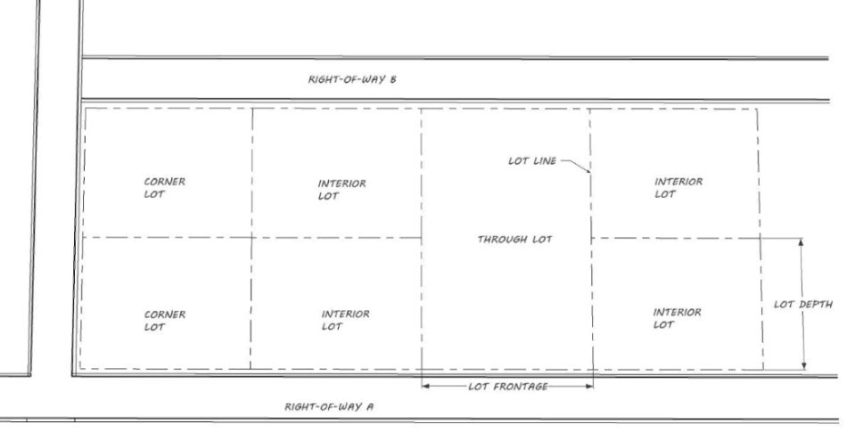
Sec. 34-724. - Height limit exemptions.
The zoning district height limitations contained in article VI, zoning districts, do not apply to spires, belfries, cupolas, flag poles, antennas, water tanks, fire towers, cooling towers, ventilators, chimneys, radio and television towers, elevator hoist ways, not intended for human occupancy.
Sec. 34-725. - Home-based businesses.
(a)
Location. Home-based businesses shall be permitted in all residential zoning districts. In any instance where a dwelling unit is used to conduct a home-based business consistent with the following requirements, a business tax receipt shall be required.
(b)
Generalrequirements. When permitted, home-based businesses shall be conducted in accordance with the following provisions and with any other restrictions that are contained within the individual residential zoning district regulations:
(1)
Home-based businesses must be secondary to the use of the dwelling for residential purposes and shall not change the character of the dwelling unit thereof.
(2)
The owner of the business must reside at the address registered for the home-based business. No more than two (2) additional employees or contractors who do not reside at the address shall be engaged in the home-based business; however, additional remote employees that do not work on-site are allowed.
(3)
As viewed from the street, the use of the residential property shall be consistent with the uses of the residential areas that surround the property. External modifications made to the residence to accommodate a home-based business shall conform to the residential character and architectural aesthetics of the neighborhood.
(4)
No equipment or process shall be used in any home-based business that creates any more noise, vibration, glare, fumes, odors, or electrical interference than that which is allowed at other residential properties.
(5)
No home-based business shall generate or attract unsafe, excessive, or hazardous vehicular or pedestrian traffic to the residence.
(6)
Home-based businesses cannot conduct any retail transactions in any accessory building.
(7)
Vehicles and trailers used in connection with the home-based business shall be legally parked and shall not be within the right-of-way or over a sidewalk. Heavy equipment cannot be parked or stored visible from the street or neighboring property.
(8)
The need for parking generated by the home-based business shall not be more than would normally be expected at a similar residence where no business is conducted.
(9)
The home-based business activities comply with any relevant City of Jacksonville Beach regulations with respect to signage.
Sec. 34-726. - Medical marijuana treatment center dispensing facilities and pharmacies.
(a)
Medical marijuana treatment center dispensing facilities.
(1)
Proximity. A medical marijuana treatment center dispensing facility may not be located within five hundred (500) feet of the real property that comprises a public or private elementary school, middle school, or secondary school, pursuant to F.S. § 381.986(11)(c).
(2)
Hours of operation. A medical marijuana treatment center dispensing facility may not operate between the hours of 9:00 p.m. and 7:00 a.m., as set forth in F.S. § 381.986(8)(f)(4).
(b)
Pharmacies.
(1)
Hours of operation. A pharmacy may not operate between the hours of 9:00 p.m. and 7:00 a.m.
(2)
[Exemption.] A pharmacy operating legally before the date of adoption is exempt from complying from the above restriction related to hours of operation.
Sec. 34-727. - Outdoor restaurants and bars.
In addition to the standards applicable to all conditional uses, as stated in section 34-553, and in addition to the regulations of the zoning district in which the restaurant or bar is located, outdoor restaurants and bars that are permitted or allowed in any zoning district shall be subject to the following limitations and conditions:
(a)
The unenclosed, outdoor area of the restaurant or bar shall be accessory to and under the same ownership or control as the restaurant or bar that is operated within a totally and permanently enclosed building located on the same lot.
(b)
The area of unenclosed, outdoor customer service area of a restaurant shall not exceed fifty (50) percent of the total gross enclosed area of the restaurant. The area of unenclosed outdoor bar shall not exceed twenty-five (25) percent of the total enclosed area of the bar. Existing outdoor seating areas shall not be expanded without first receiving conditional use approval.
(c)
Required parking spaces shall be provided for the unenclosed, outdoor customer service area outside of the permanently enclosed building at the same ratio as is required for the permanently enclosed area of the restaurant or bar. Parking is not required for outdoor restaurant areas for the first two hundred fifty (250) square feet or less.
(d)
The outdoor customer service area may be used to compute the minimum seating or customer service area required to qualify for a special food service restaurant's (SFS) alcoholic beverage license. For any establishment selling alcoholic beverages for on-site consumption, the outdoor customer service area shall be enclosed by a minimum forty-two (42) inches high wall or fence. The wall or fence shall be constructed of wood, metal (Except chain link), plastic, or other similar material. No rope, chains or cables of any kind shall be permitted.
(e)
Buffering must be provided around outdoor restaurant or bar areas when immediately adjacent to residential uses. At a minimum, a solid six-foot tall fence should be installed between the commercial and residential uses, or a thirty-six (36) inch diameter pot by a minimum of twenty-four (24) inches high should be provided every five (5) lineal feet of outdoor restaurant area immediately adjacent to a residential use. The plant species should be at least two (2) times as high as the height of the pot.
(f)
No animals except service dogs shall generally be permitted within an approved outdoor restaurant or bar seating area. However, pursuant to F.S. § 509.233, other dogs may be allowed in an outdoor restaurant area upon approval of a dogs in outdoor dining area permit application.
(g)
The planning commission is authorized to establish hours of operation for conditional use outdoor restaurant and bar seating areas as a means to ensure their compatibility with surrounding land uses.
(h)
If an approved outdoor restaurant or bar area violates any of the standards set forth in this section, or any other conditions placed on their approval by the planning commission, the violation shall be referred to the special magistrate for a hearing. Upon finding that such a violation exists, the special magistrate may apply penalties as provided by law, including revocation of the conditional use approval for that outdoor seating area. Whenever the approval for a conditional use outdoor bar or restaurant seating area is revoked for a particular establishment, a conditional use application for outdoor bar or restaurant seating shall not be considered for any portion of that establishment for a period of two (2) years after the date of revocation.
Sec. 34-728. - Storage and parking of commercial vehicles, recreational vehicles, and repair of vehicles in residential zoning districts.
For the dual purpose of preserving attractive residential areas within the city and promoting safe, unimpeded traffic circulation throughout such areas, the following supplemental parking restrictions shall apply:
(a)
Within a street right-of-way. The following vehicles shall not be parked or stored on any public street right-of-way or approved private street easement contiguous to a residentially zoned property or residentially used property in an RD or PUD district:
(1)
Any boat or boat trailer.
(2)
Any hauling trailer.
(3)
Any of the following recreational vehicles: Travel trailers, motor homes and camping trailer.
(4)
Any semi-trailer truck or cab.
(5)
Any commercial vehicle which measures in excess of twenty (20) feet in total body length, seven (7) feet in total width or seven (7) feet in total height, including appurtenances, equipment or cargo.
(b)
Within the setback area from a street right-of-way. The following vehicles shall not be parked or stored, in whole or part, within the required setback area from a street right-of-way or approved private street easement on residentially zoned property or residentially used property in an RD or PUD district:
(1)
No more than two (2) boats per residential lot
(2)
Any boat which measures in excess of twenty (20) feet in length.
(3)
Any hauling trailer (except trailers mounted with boats twenty (20) feet or less in length).
(4)
Any of the following recreational vehicles: Travel trailers, motor homes and camping trailers.
(5)
Any semi-trailer truck or cab.
(6)
Any commercial vehicle which measures in excess of twenty (20) feet in total body length, seven (7) feet in total width or seven (7) feet in total height, including appurtenances, equipment or cargo.
(c)
On any residentially zoned property or residentially used property in an RD or PUD district. No garbage truck, pump-out truck, chemical truck, gasoline truck, fuel oil truck or similar vehicle designed to transport wastes or hazardous or noxious materials shall be parked or stored in any residentially zoned property or residentially used property in an RD or PUD district.
(d)
Occupation. The trailer or camper shall not be occupied, except for the purpose of repair or maintenance, at any time during the parking or storage. The term "occupied" for the purpose of this division shall include but not be limited to electrical connections (permanent or drop cord), water and sewer connections (flexible or permanent hose), telephone connections (permanent or extension) or personal occupancy of any kind (day or night).
(e)
Routine repairs and maintenance. There shall not be major repairs and maintenance to oversized and other registered vehicles, except for minor repairs or maintenance (for up to 48 hours), at any time during such storage or parking, but the body of a truck type camper may be removed from the truck or other vehicle.
(f)
Permit required for temporary occupancy of travel trailer, motor home or camping trailer. Any owner desiring to temporarily occupy any travel trailer, motor home or camping trailer which has been or is to be stored or parked as permitted in section 34-728(b) must apply to the planning and development department for a city permit for temporary occupancy. No such permit for temporary occupancy shall be issued for a period in excess of thirty (30) consecutive calendar days and in no event shall such permit be issued for a total in excess of thirty (30) calendar days during any calendar year for the same property. Permits for temporary occupancy shall be issued only for trailers or campers stored or parked on property with a primary residential use, which is owned by the owner of the trailer or camper being stored or parked, and where there is active permitted construction taking place at the occupied residence. Such permit shall be valid only for the term stated on the permit.
(g)
Enforcement. The preceding parking restrictions shall be enforced in accordance with the terms of article XII, division 1 and the following:
(1)
The parking restrictions shall not apply to commercial vehicles during the actual performance of a service at the premises where it is parked.
(2)
The parking restrictions shall not apply to the loading, unloading or cleaning of vehicles provided such act is fully completed in forty-eight (48) hours.
(3)
The parking of vehicles, boats and trailers in residentially zoned property or residentially used property in an RD or PUD district shall be subject to these parking restrictions regardless of the date such parking commenced, and shall not be deemed an allowable nonconforming use within the meaning of section 34-1101 of this LDC.
Sec. 34-729. - Personal wireless service facilities.
(a)
Purpose and legislative intent. Federal and state laws recognize the city's authority to regulate the placement, construction, and modification of personal wireless service facilities. The city recognizes that personal wireless service facilities play an important and complex role in the community. The intent of this section is to ensure that the placement, construction or modification of personal wireless service facilities is consistent with the city's land use policies and balances the community needs.
(b)
Hierarchy of personal wireless service facility preferences. The city has established the hierarchy set forth below for personal wireless service facilities, with (1) being the most preferred and (3) being the least preferred. More preferred facilities require fewer approvals and are subject to fewer restrictions.
(1)
An antenna located on or in an existing building, whether or not a co-location (see section 34-729(a)(2), (3) and (5)).
(2)
The co-location of an antenna on an existing freestanding facility (see section 34-729(a)(4)).
(3)
Freestanding facilities (see section 34-729(b)).
(c)
Prohibited personal wireless service facilities. Self-supporting lattice towers, guyed towers, and all freestanding facilities not meeting the requirements of section 34-729(b) are prohibited.
(d)
Priority determination. If the proposed personal wireless service facility is not one of the two highest priorities listed, a detailed explanation and technical justification shall be provided as to why each of the higher priority facilities was not selected. This must include documentation that any existing personal wireless service facility (whether owned by the applicant or not) located within a two-mile radius of the proposed location is physically and/or technically unable to support collocation of additional personal wireless service equipment, that the existing facility is insufficient, or that the existing facility does not meet the engineering requirements of the applicant.
(e)
Generally applicable review procedures and timeframes.
(1)
The planning and development department shall notify the applicant for a personal wireless service facility within twenty (20) days after the date the application is submitted as to whether the application is, for administrative purposes only, properly completed and has been properly submitted in accordance with the requirements of the City Code and Land Development Code. An application for personal wireless service facility is deemed properly completed and properly submitted when it is verified that the information contained within the application is true, accurate, and contains all applicable information needed to make a determination as to the merits of the request. Such notification shall indicate with specificity any deficiencies that, if cured, could make the application properly completed. Upon resubmission of information to cure the stated deficiencies, the city shall again have twenty (20) days to notify the applicant of any remaining deficiencies that must be cured. If the applicant does not cure the deficiencies within thirty (30) days, the application shall be considered withdrawn and closed.
(2)
An application is deemed submitted or resubmitted on the date the application is received by the city. If the city does not notify the applicant that the application is not completed in compliance with this Zoning Code within twenty (20) days after the date the application is initially submitted or resubmitted, the application is deemed, for administrative purposes only, to be properly completed and properly submitted.
(3)
Applications for a collocation of small wireless facilities shall be processed in accordance with chapter 28, section 28-76 of the Code of Ordinances of the City of Jacksonville Beach, Florida. Applications for new personal wireless service facilities, including freestanding facilities, shall be processed within ninety (90) days after an application has been properly completed and properly submitted; provided, however, that applications for new utility poles that qualify under said chapter 28, section 28-76 shall be processed in accordance with the time frames set forth in section 28-76.
(4)
The timeframes stated in this subsection may be extended or tolled by mutual agreement of the city and applicant.
(5)
The final decision approving or denying an application shall be in writing and supported by "substantial evidence" pursuant to the Communications Act, 47 U.S.C. § 332(c)(7)(B)(iii) and shall comply with the provisions of Land Development Code article VII, division 2, section 34-729.
(6)
Applications must demonstrate that no portion of any abutting, adjoining, or nearby residentially zoned property will be exposed to radio frequency (RF) emissions exceeding the federal safety limits for RF emissions. When installation has been completed for any personal wireless service facility, a post-construction RF energy testing study must be conducted by the applicant and submitted to the city within thirty (30) days following receipt of a certificate of completion for the installation demonstrating that the personal wireless service facility complies with this provision and all federal safety standards for RF energy exposure.
(f)
[Placement and operation of temporary personal wireless service facilities during a declared emergency.] During a declared emergency within the city, the city manager is authorized to allow the placement and operation of temporary personal wireless service facilities within any zoning district for a period not to exceed ninety (90) days. Placement and operation of temporary personal wireless service facilities beyond the ninety-day limit may be granted by the city council if deemed necessary for the health, safety, and welfare of the public due to extended disruption in services after a declared emergency.
Sec. 34-730. - Personal wireless service facility development standards.
(a)
Antennas.
(1)
An application for an antenna, whether or not a collocation, shall include the following information:
a.
The name of the applicant;
b.
Whether the applicant is an individual, partnership, limited partnership, limited liability corporation, professional corporation, professional association, governmental entity, or some other type of legal group or association;
c.
A complete, thorough and accurate description of the proposed antenna, including an elevation drawing of the proposed antenna showing the view from north, east, west and south;
d.
The type of existing building or structure on which the antenna is proposed to be located;
e.
Certification that the proposed antenna will comply with applicable Federal Aviation Administration requirements under 14 C.F.R. § 77, as amended, and evidence of proper Federal Communications Commission licensure, or other evidence of Federal Communications Commission authorized spectrum use;
f.
The proposed use of the antenna;
g.
The proposed location of the antenna with a map in sufficient detail to indicate the location with precision;
h.
Written, notarized authorization from the property owner, if different from applicant, that authorizes the installation of the facilities;
i.
The zoning/land use designation of the site for the proposed antenna;
j.
The height of the proposed antenna;
k.
Where applicable, a lighting plan, that is consistent with all federal, state and local requirements;
l.
Documentation that the proposed antenna and any appurtenances will withstand wind speeds as set forth in the Florida Building Code;
m.
A plan detailing the steps to visually blend the proposed antenna with surrounding buildings, facilities and features;
n.
The estimated timeframe for constructing and/or locating the antenna, and any ancillary equipment.
(2)
An antenna classified as an initial (rather than collocation) antenna, located on a rooftop, a rooftop antenna platform, or the exterior of a building shall meet the following minimum criteria:
a.
It is located in a building with a height in excess of four (4) stories in a C-1, C-2, CBD, or RM-2 zoning district.
b.
It is located on a rooftop of an existing building in excess of forty (40) feet in height, a rooftop antenna platform located on a roof of an existing building in excess of forty (40) feet in height, or the exterior of an existing building in excess of forty (40) feet in height.
c.
The height of the antenna shall not exceed twenty (20) feet above the highest point of the building; and
d.
The antenna shall be camouflaged. An antenna shall be deemed to be camouflaged if the antenna and any ancillary equipment are concealed from view by way of enclosure or through a blending of the antenna and ancillary equipment with the architectural design and appearance, color and scale of the building to which it is attached.
(3)
An antenna located inside a building is permitted provided it is not visible from any surrounding properties or roadways and no portion of the antennae is recognizable or discernible from the exterior of the building. Architectural features concealing the antennae must be consistent with the architecture of the building to which they are attached. The architectural features shall not exceed the height restrictions for the zoning district in which they are located, except as allowed by this Code. The setback for any architectural features concealing an antenna from any residentially zoned property must be at least one (1) foot for every foot in height of the architectural features (dwellings located on the same parcel as the antenna are excluded).
(4)
An antenna classified as a collocation located on an existing freestanding facility not owned by the city shall meet the following minimum criteria:
a.
The antenna does not increase the height of the freestanding facility to which it is to be attached, except as allowed in section 34-730(b), as measured to the highest point of any part of the freestanding facility or any existing antenna attached to the freestanding facility;
b.
The applicant shall include proof of consent of the owner of the freestanding facility for inclusion of the antenna on the freestanding facility.
c.
The ground space area, if any, previously approved for equipment enclosures and ancillary facilities is not increased; and
d.
The antenna and its ancillary facilities meet all requirements as established in section 34-730(b).
(5)
An antenna classified as a collocation located on an existing building shall meet the following minimum criteria:
a.
The height of the antenna does not exceed twenty (20) feet above the highest point of the building;
b.
The ground space area, otherwise known as the compound, if any, previously approved for equipment enclosures and ancillary facilities is not increased;
c.
The antenna and its ancillary facilities are of a design and configuration consistent with any applicable structural or aesthetic design requirements and any requirements for location on the building for initial antennas;
(6)
If only a portion of an application for a personal wireless service facility classified as a collocation does not meet the requirements of subsections (4) or (5) above, the noncompliant portion of the collocation application shall be reviewed as an initial antenna, under subsection (2) and the compliant remainder of the collocation application shall be reviewed in accordance with subsections (4) or (5), as applicable. A collocation application that complies with subsections (4) or (5), except that it is proposing to increase the equipment ground compound approved in the original site plan for equipment enclosure and ancillary facilities by no more than a cumulative amount of four hundred (400) square feet or fifty (50) percent of the original ground equipment enclosure size, whichever is greater, may continue to be reviewed as a collocation.
(7)
Standards applicable to all antennas.
a.
All antennas must be at least thirty (30) feet from ground level.
b.
An antenna and its ancillary facilities must meet all applicable requirements of the Florida Building Code.
c.
The antenna equipment shelter/cabinet must have a sign in close proximity which is readable from a distance of at least five feet, in accordance with FCC regulations, which notes the owner of the equipment and the name and telephone number of the person to contact to report an emergency or situation when notification is warranted.
d.
All additional requirements of state, federal and local law must be adhered to.
(8)
The review and approval of an application for an antenna under this section is by building permit review, except as an initial installation where existing buildings are proposed to be architecturally modified to conceal an antennae. Existing buildings that are proposed to be architecturally modified to conceal antennae must follow the development plan approval process.
(b)
Freestanding facilities.
(1)
Freestanding facilities and their ancillary equipment shall be approved by development plan review and building permit granted by the planning and development department only on property owned by the City of Jacksonville Beach or the Duval County School Board, with a contract approved by the respective owner, on city energy substation properties (active or inactive), in city parks and facilities, including the golf course and cemeteries, on public school properties, and in public rights-of-way in commercial or industrial zoning districts, provided the following criteria are met:
a.
The freestanding facility shall be designed so as to mimic a structure or natural feature that could reasonably be found and/or blend with the surrounding area, such as a light fixture or tree.
b.
Ancillary equipment must meet the following criteria:
1.
Shall be no wider than seven (7) feet;
2.
Shall be no longer than thirteen (13) feet;
3.
Shall not exceed the height limitations for mechanical equipment as provided by this Zoning Code;
4.
May be located within a required side or required rear yard, provided, that it shall be no closer than ten (10) feet to any lot line;
5.
Shall be included in lot coverage and non-open space calculations for the site, including the pad;
6.
Shall be located on a concrete pad, unless required to be elevated due to FEMA regulations;
7.
Shall be screened from view by landscaping, architectural features, or a combination of both, and designed in a manner which minimizes nuisance impacts, such as noise and odor. Screening shall be at least equal to the height of the ancillary equipment on all sides and shall be maintained in good order; and
8.
Shall be set back from any existing residential dwelling at least one (1) foot for every foot in height of the facility (dwellings located on the same parcel as the structure are excluded), as measured from the base of the structure containing the antennae to nearest property line of the residential dwelling(s).
c.
The top of any freestanding facility and ancillary equipment shall not exceed fifty (50) feet in height.
d.
For any freestanding facility that utilizes lighting, the lights must meet all applicable federal, state, and local regulations regarding shielding of lighting to protect sea turtles.
e.
The freestanding facility, its components, ancillary equipment, and screening must be maintained in good order. Failure to maintain the freestanding facility, its components, ancillary equipment, and screening shall constitute a violation of this chapter.
(2)
The development plan application for a freestanding facility shall include the following information:
a.
The name of the applicant(s) and whether each applicant is an individual, partnership, limited partnership, limited liability corporation, professional corporation, professional association, governmental entity, or some other type of legal group or association;
b.
A complete and accurate description of the proposed freestanding facility, including scale elevation drawings of the proposed freestanding facility;
c.
If applicable, documentation of any contract, license, lease, letter of understanding, agreement in principle, or other type of agreement with a personal wireless service provider for use of the freestanding facility and a summary of the agreement or arrangement;
d.
The proposed location of the freestanding facility together with both a legal description of the location, and a map in sufficient detail to indicate the location with precision;
e.
Proof that the property owner, if different from applicant, authorizes the installation of the facilities.
f.
The zoning/land use designation for the proposed freestanding facility;
g.
The height of the proposed freestanding facility;
h.
The projected collapse zone certification that in the event of fall or collapse of the freestanding facility, said freestanding facility would not damage or negatively impact the real or personal property of the surrounding property owners;
i.
Documentation demonstrating compliance with the provisions of state statute and city Codes;
j.
A detailed plan for landscaping any ancillary ground equipment, in such a manner that the landscaping will shield the equipment from the view of adjoining parcels and/or public rights-of-way, noting that the landscaping shall be native, xeriscape plants only;
k.
A detailed preventive maintenance program that meets minimum maintenance program standards for which the applicant is to remain solely responsible. The city will not be responsible for monitoring the maintenance program;
l.
Certification that the proposed equipment will comply with applicable Federal Aviation Administration requirements under 14 C.F.R. § 77, as amended, and evidence of proper Federal Communications Commission licensure, or other evidence of Federal Communications Commission authorized spectrum use;
m.
The estimated timeframe for completion for the location and/or construction or modification of each of the freestanding facilities and any ancillary equipment;
n.
The identity and location of any landline backhaul network to each freestanding facility location, if applicable;
o.
Whether the applicant, within a two-mile radius of the proposed location, has ever had any permit (or similar or equivalent authorization) revoked, rescinded, canceled or terminated which authorized the placement, construction, and/or modification of personal wireless service facilities, and, if so, what were the reasons surrounding such revocation;
p.
The proposed equipment shall not interfere with or obstruct public safety telecommunications facilities in accordance with the applicable rules of the Federal Communications Commission; and
q.
All applicable provisions of the City Code, the Land Development Code and the Florida Building Code shall be met.
(3)
In evaluating development plan and building permit applications for a freestanding facility, in addition to compliance with section 34-573, standards (a) through (i), the planning and development department shall consider and evaluate the above application criteria and the following, with the intent of balancing the reasonable allowance of a freestanding facility to provide personal wireless service in the area with the protection of the aesthetics of the area from adverse visual impacts:
a.
The proposed location of the freestanding facility, including the zoning/land use designation of the site and abutting properties;
b.
The proposed height of the freestanding facility;
c.
The number and location of freestanding facilities and structures over forty (40) feet in height already existing within a five hundred-foot radius of the proposed freestanding facility;
d.
The distance of the proposed freestanding facility to the nearest single-family residence measured from the freestanding facility to the boundary of the nearest single-family residence;
e.
The proposed aesthetics of the freestanding facility and whether it visually blends in with surrounding buildings, structures and existing vegetation;
f.
The potential impacts on property values of nearby or surrounding single-family properties.
(4)
Upon granting development plan and building permit approval for the construction of a freestanding facility, the city reserves the right to inspect placement, construction and modification of such freestanding facility and ancillary equipment for the life of the facility. Any modification, relocation, rebuilding, repairing, in any way without the issuance of all applicable approvals and permits will be deemed a violation of the permit and result in the removal of the freestanding facility and ancillary equipment.
(5)
Removal of a freestanding facility and ancillary equipment. The city may require, upon notice with a reasonable opportunity to cure, the immediate removal of a freestanding facility and ancillary equipment if:
a.
It has been abandoned for a period in excess of six (6) months;
b.
It falls into such a state of disrepair that it becomes an unsafe structure or becomes a public nuisance;
c.
It is modified, relocated, or rebuilt without the issuance of all applicable approvals and permits.
(c)
Communications antennae on structures in C-1, CBD and RM-2 zoning districts. Communications antennae and related equipment may be located as accessory structures on principle structures in commercial, limited: C-1, Central business district: CBD, and Residential, multiple-family: RM-2 zoning districts including, but not limited to, buildings, water towers, and essential public utility structures, subject to the following conditions:
(1)
No portion of the communications facility, including all antenna and equipment components, may extend more than twenty (20) feet above the structure on which it is located.
(2)
Facility components shall be located, designed, and screened or otherwise treated to blend with the existing natural or built surroundings so as to reduce visual impacts to the extent feasible considering the technological requirements of the proposed communications service and the need to be compatible with neighboring uses and the character of the community.
(3)
Proof, in writing, must be submitted with building permit application materials that the facility conforms with regulations of the Federal Communications Commission (FCC) and Federal Aviation Administration (FAA), and that the existing structure is structurally capable to accept the proposed facility.
(4)
No communications facility shall be designed and or sited such that it poses a potential hazard to humans, on-site improvements, or surrounding properties.
Sec. 34-731. - Short-term vacation rentals.
(a)
Applicability. This section shall apply to short-term vacation rentals as defined in article III.
(b)
Short-term vacation rental minimum requirements. Short-term vacation rentals shall be permitted in all zoning districts where residential use is a permitted or conditional use provided they are in compliance with this section. No person shall rent or lease all or any portion of a dwelling unit as a short-term vacation rental as defined in article III without initially and on a continuing basis:
(1)
Obtaining a short-term vacation rental registration certificate from the City of Jacksonville Beach pursuant to this section;
(2)
Obtaining a county business tax receipt from the Consolidated City of Jacksonville / Duval County pursuant to its ordinances, as may be amended;
(3)
Obtaining a local business tax receipt from the City of Jacksonville Beach pursuant to Chapter 15 of the Code of Ordinances, as may be amended;
(4)
Obtaining a Florida Department of Revenue certificate of registration for purposes of collecting and remitting sales surtaxes, transient rental taxes, and other taxes as may be required by law;
(5)
Obtaining a Florida Department of Business and Professional Regulation license as a transient public lodging establishment; and
(6)
Maintaining an active account with Duval County Tax Collector for the purpose of collecting and remitting tourist development taxes and other taxes as may be required by law.
(7)
As demonstrated through an affidavit:
a.
Maintaining initial and ongoing compliance with short-term vacation rental standards contained herein;
b.
Maintaining compliance with the Florida Fire Prevention Code, Florida Building Code, and F.S. § 509.215; and
c.
Maintaining compliance with any local, state, and federal laws, regulations, and standards as may be applicable or amended including Florida Administrative Code Chapters 61C (Division of Hotels and Restaurants) and 69A (Division of State Fire Marshal), as may be amended.
(c)
Short-term vacation rental standards. The following standards shall govern the use of any short-term vacation rental as a permitted use:
(1)
Maximum occupancy. Maximum occupancy shall be limited to two (2) persons per bedroom plus two (2). Under no condition shall maximum occupancy exceed twelve (12) occupants per short-term vacation rental unit. For the purpose of calculating maximum occupancy, only individuals over the age of twenty-four (24) months shall be included.
(2)
Parking standards. Minimum off-street parking shall be equal to the maximum occupancy as defined in section 34-731(c)(1) divided by four (4). Where four (4) equates to one (1) parking space per four (4) transient occupants. All fractions shall be rounded to the next higher whole number. At no time shall parking block a sidewalk or designated urban trail. Off-street parking standards shall be as defined in article VII, division 1, parking and loading standards of the City of Jacksonville Beach Land Development Code. All short-term vacation rental properties with legal nonconforming parking shall be grandfathered for two (2) parking spaces. Grass parking is only permitted on short-term vacation rental properties with legal nonconforming parking where paved parking is not available. Garage spaces shall count if the space is open and available and the transient occupants are given vehicular access to the garage. A maximum of four (4) cars may be parked at any given short term vacation rental property at one time.
(3)
Solid waste handling and containment. Short-term vacation rentals shall supply the approved solid waste collection container pursuant to the city's franchise agreement. All customers receiving residential and small commercial solid waste collection service pursuant to the city's solid waste franchise contract shall place garbage, rubbish, or, refuse receptacles and all other items at the curbside, unless the franchisee has agreed to provide a special service collection at another location. Solid waste handling and containment is subject to the requirements and provisions contained in chapter 27 of the City's Code of Ordinances.
(4)
Minimum short-term vacation rental lease agreement wording. The short-term vacation rental lease agreement, where applicable, shall contain the minimum information as provided for in subsection 34-731(h).
(5)
Minimum short-term vacation rental information required postings. The short-term vacation rental shall be provided with posted material as required pursuant to subsection 34-731(i).
(6)
Designation of a short-term vacation rental responsible party. A responsible party must be designated that is capable of meeting the duties required pursuant to subsection 34-731(g) and shall be required.
(7)
Advertising. Any advertising of the short-term vacation rental unit shall conform to information included in the short-term vacation rental registration certificate and property's approval, particularly as it pertains to maximum occupancy. A statement stating that "it is unlawful for a sexual offender or sexual predator to occupy this residence in violation of F.S. § 775.215, Florida Statutes precluding such residency within 1,000 feet of any school, child care facility, park, or playground."
(8)
Other standards. Any other standards contained within the City of Jacksonville Beach Code of Ordinances and chapter 34, Land Development Code, to include, but not limited to, noise limits, setbacks, stormwater, and similar provision shall be applicable.
(d)
Short-term vacation rental registration certificate. To verify compliance with these short-term vacation rental standards, any property owner who wishes to use his or her dwelling unit as a short-term vacation rental must first apply for and receive a short-term vacation rental registration certificate from the City of Jacksonville Beach. The following requirements further apply:
(1)
The short-term vacation rental registration certificate shall be renewed annually for as long as the unit is used as a short-term vacation rental.
(2)
Short-term vacation rental registration certificates may be issued as a single or collective registration certificate.
(3)
An annual single or collective short-term vacation rental registration certificate fee shall be paid in an amount as determined by resolution of the City Council of the City of Jacksonville Beach.
(4)
Short-term vacation rental registration certificate fees shall be implemented to cover the costs of administration of the short-term vacation rental registration certificate, inspection, and enforcement programs.
(5)
Short-term vacation rental certificates must be posted on the inside of the window of the unit that is located closest to the front door, facing outward.
(6)
Failure to comply with any of the requirements of this section shall be grounds for revocation or suspension of the short-term vacation rental registration certificate in accordance with the requirements contained herein.
(e)
Application for a short-term vacation rental registration certificate. Each property owner seeking initial issuance, annual renewal, transfer of ownership, or modification of a short-term vacation rental registration certificate shall submit a City of Jacksonville Beach short-term vacation rental application in a form specified by the city, along with an application fee in an amount as determined by resolution of the City Council of the City of Jacksonville Beach.
(1)
A complete application for initial, transfer of ownership, or modification of a short-term vacation rental registration certificate shall demonstrate compliance with the short-term vacation rental standards above through the following submittals:
a.
A completed application with required documentation and all applicable fees.
b.
A signed and notarized affidavit from the property owner or property manager confirming compliance with the following:
1.
Verification that the required short-term rental postings shall be provided in all units to rental occupants.
2.
Verification that the short-term vacation rental lease agreement, where applicable, is in compliance with the required lease terms of this ordinance.
3.
Verification that the property has the appropriate amount of on-site vehicular parking in compliance with the code.
4.
Verification that all required local, county and state licenses, certificates and taxes have been obtained and complied with.
(2)
Registration certificate renewals or transfers. A short-term vacation rental registration certificate holder must apply annually for a renewal of the registration certificate by October 1 of each year. If no changes have occurred since the issuance of the most recent short-term vacation rental registration certificate, no additional submittals are required to accompany the renewal or transfer of a short-term vacation rental registration certificate application.
(3)
Modification of short-term vacation rental registration certificate. An application for modification of a short-term vacation rental registration certificate is necessary where any of the following apply:
a.
The gross square footage of the short-term vacation rental unit has increased; or
b.
The number of bedrooms is proposed to increase; or
c.
The occupancy is otherwise proposed to increase.
d.
If an inspection of a modification to a short-term vacation rental registration certificate is required, the modification in usage or occupancy may not occur until after successful inspection; however, pending such successful inspection the current registration certificate shall remain valid.
(f)
Initial and routine compliance inspections of short-term vacation rentals.
(1)
An inspection of the short-term vacation rental unit for compliance with this section is required prior to issuance of an initial short-term vacation rental registration certificate.
a.
The local fire official or designee shall perform all inspections and be allowed entry as permitted or required under this section or by section 10-3.04 and section 10-3.05, City of Jacksonville Beach Code of Ordinances.
b.
If violations are found, all violations must be corrected and the short-term vacation rental unit must be reinspected prior to issuance of the initial short-term vacation rental registration certificate.
(2)
Once issued, a short-term vacation rental unit must be properly maintained in accordance with the short-term vacation rental standards as defined in the section and may be reinspected at the time of transfer of ownership, modification, or upon receipt of complaint related to noncompliance with the Florida Fire Prevention Code, Florida Building Code, and F.S. § 509.215.
a.
For an inspection, all violations must be corrected and reinspected within thirty (30) calendar days.
b.
Failure to correct inspection deficiencies in the timeframe provided shall result in the suspension of the short-term vacation rental registration certificate until such time as the violation(s) is/are corrected and reinspected.
(3)
The inspections shall be made by appointment with the short-term vacation rental responsible party.
a.
If the inspector(s) has made an appointment with the short-term vacation rental responsible party to complete an inspection and the short-term vacation rental responsible party fails to admit the inspector(s) at the scheduled time, the owner shall be charged a "no show" fee in an amount as determined by resolution of the City Council of the City of Jacksonville Beach to cover the inspection expense incurred.
(4)
If the inspector(s) is denied admittance by the short-term vacation rental responsible party or if the short-term vacation rental unit is not passed in at least three (3) attempts to complete an initial or subsequent inspection, the inspector(s) shall provide notice of failure of inspection to the owner address as listed on the most recent short-term vacation rental registration certificate or as listed on the Duval County Property Appraiser database.
a.
For an initial inspection, the notice of failure of inspection results in the registration certificate not being issued.
b.
For a subsequent inspection, the notice of failure of inspection is considered a violation pursuant to subsection 34-731(f)(2) above and is subject to enforcement as provided herein.
(g)
Short-term vacation rental responsible party.
(1)
The purpose of the short-term vacation rental responsible party is to respond to routine inspections, nonroutine complaints, and any other more immediate problems related to the short-term vacation rental of the property.
(2)
The property owner or licensed agent may serve in this capacity or shall otherwise designate a short-term vacation rental responsible party to act on their behalf.
(3)
Any person eighteen (18) years of age or older may be designated by the owner or licensed agent provided they can perform the duties listed in subsection 34-731(g)(4) below.
(4)
The duties of the short-term vacation rental responsible party, whether the property owner or licensed agent, are as follows:
a.
Be available, within a twenty-five (25) mile radius, at the listed phone number twenty-four (24) hours a day, seven (7) days a week and capable of handling any issues arising from the short-term vacation rental use;
b.
If necessary, be willing and able to come to the short-term vacation rental unit within one (1) hour following notification from an occupant, the owner, or an official of the City of Jacksonville Beach to address issues related to the short-term vacation rental.
c.
Be authorized to receive service of any legal notice on behalf of the owner for violations of this section;
d.
Be able to produce copies of the executed rental or lease agreement for current transient occupants, as needed by local authorities; and
e.
Otherwise monitor the short-term vacation rental unit at least once weekly to assure continued compliance with the requirements of this section.
(5)
A property owner may change his or her designation of a short-term vacation rental responsible party temporarily or permanently. However, there shall be only one (1) short-term vacation rental responsible party for each short-term vacation rental at any given time. To change the designated short-term vacation rental responsible party, the property owner shall notify the City of Jacksonville Beach in writing on a form provided by the city for that purpose before any change in the designated short-term vacation rental responsible party.
(h)
Short-term vacation rental lease agreement minimum provisions. The rental or lease agreement must contain the following minimum information:
(1)
Maximum occupancy of the short-term vacation rental unit as permitted on the short-term vacation rental registration certificate;
(2)
The total number of vehicles allowed for the short-term vacation rental unit not to exceed the number of off-street parking spaces available as designated on the short-term vacation rental registration certificate; and
(3)
A statement that all transient occupants must evacuate from the short-term vacation rental upon posting of any evacuation order issued by local, state, or federal authorities.
(4)
An executed copy of each lease agreement shall be maintained by the designated responsible party and made available for review by city fire, police, building or code enforcement officials upon request.
(5)
A statement stating that "it is unlawful for a sexual offender or sexual predator to occupy this residence in violation of F.S. § 775.215, precluding such residency within 1,000 feet of any school, child care facility, park, or playground."
(i)
Required short-term vacation rental postings:
(1)
On the back of or next to the main entrance door or on the refrigerator there shall be provided as a single page document the following information:
a.
The name, address, and phone number of the short-term vacation rental responsible party;
b.
The maximum occupancy of the unit;
c.
Notice that quiet hours are to be observed between 10:00 p.m. and 7:00 a.m. daily or in compliance with any and all city regulations;
d.
The maximum number of vehicles that can be parked at the unit along with the location of the off-street parking spaces;
e.
The days of solid waste pick-up and recycling;
f.
Notice of sea turtle nesting season restrictions and sea turtle lighting usage as applicable;
g.
The emergency numbers for local police and fire; and
h.
The location of the nearest hospital.
(j)
Offenses and violations.
(1)
Noncompliance with any provision of this section or its subsections shall constitute a violation of the City of Jacksonville Beach Code of Ordinances.
(2)
Separate violations. Each day a violation exists shall constitute a separate and distinct violation, except that occupancy violations shall be governed by subsection 34-731(j)(1).
(k)
Remedies/enforcement. Violations of this section shall be subject to penalties as part of a progressive enforcement program with the primary focus on compliance and compatibility with adjoining properties, versus penalties and legal actions. To accomplish a safe and effective vacation rental program it is vital that a short-term vacation rental responsible party is responsive and responsible in the management of the property for compliance with this section. Code enforcement activities will be in accordance with F.S. ch. 162 and the City of Jacksonville Beach Code of Ordinances.
(1)
Warnings. Warnings shall be issued for first time violations and a reasonable time to correct the violation will be given. Such warnings may include notice to other agencies for follow up by such agencies, such as the department of business and professional regulation, the department of revenue, the Duval County Tax Collector, and the Duval County Property Appraiser, as applicable. Noncompliance with a correction compliance period shall result in the issuance of notice of violation or a citation as stated in section 34-1201.
(2)
Fines. Fines per violation shall be as provided in F.S. § 162.09, as may be amended, for per day, repeat, and irreparable or irreversible in nature violations.
(3)
Enforcement proceedings. Prosecution of code violations shall utilize Part 1 of F.S. ch. 162. The city code enforcement special magistrate shall be authorized to hold hearings, assess fines, and order other relief as provided in City of Jacksonville Beach Code of Ordinances, chapter 2, article VI.
(4)
Additional remedies. Nothing contained herein shall prevent the City of Jacksonville Beach from seeking all other available remedies which may include, but is not limited to, injunctive relief, liens, and other civil and criminal penalties as provided by law, as well as referral to other enforcing agencies.
Sec. 34-732. - Temporary structures and offices.
Temporary structures and offices shall be subject to the following standards, and shall be reviewed and approved by the Building Official:
(a)
Construction office and storage. A mobile home, trailer, portable building, or storage structure may be permitted in any zoning district when used as a temporary office or shelter for materials or tools incidental to construction or development of the premises upon which the temporary office or shelter is located or within a half-mile radius of the site, provided appropriate permits for such construction have been issued and development has been diligently pursued. Such use of a temporary office or shelter shall not be permitted for more than one (1) month after the completion of construction or development. It cannot be used as permanent office space or for residential use.
(b)
Public use. Any agency of local, municipal, state or federal government may utilize a mobile home, trailer or portable building for temporary public purposes in any zoning district, provided such use shall not include a residential use.
(c)
Sales office. A mobile home may be used as a sales office on a mobile home sales lot in any zoning district permitting such use.
Sec. 34-741. - Purpose and intent.
The purpose and intent of this division is to promote the health, safety, welfare and general wellbeing of existing and future residents of Jacksonville Beach through the establishment of minimum standards for the preservation of natural plant communities, the installation of landscaping and the protection of trees on public and private property within the City of Jacksonville Beach. The specific objectives of this division are as follows:
(a)
To promote and improve the aesthetic integration of natural and manmade environments in order to reduce the harmful effects of development and use on vegetation, and thereby improve the quality of life through the abatement of noise, glare, dust and air pollution;
(b)
To promote the conservation of energy through the preservation and planting of trees, thereby reducing heat gain in or on buildings or paved areas by shading and by removal of heat from the air through evapotranspiration; and
(c)
To promote the conservation of limited freshwater resources by encouraging the preservation and planting of natural or uncultivated areas and by increasing permeable areas which contribute to groundwater recharge and stormwater runoff retardation.
Sec. 34-742. - Applicability.
This division shall apply to all development within the City of Jacksonville Beach unless specifically exempted by the provisions of this division. The provisions of this division shall also apply to the expansion of any existing development, including all land in government use, when the value of the total expansion is equal to fifty (50) percent of the assessed value of the existing use, according to the Duval County Property Appraiser, or when total square footage of a structure is increased by fifty (50) percent or more.
Sec. 34-743. - Exemptions.
The following development shall be exempt from the standards of this division:
(a)
Vehicular use areas within or on top of a building (i.e. parking garages or within a building). Vehicular use areas consisting exclusively of parking areas entirely within or on top of a building shall be exempt from the provisions of this division.
(b)
Bona fide agricultural production. Bona fide agricultural production (as defined in Florida State Statutes) activities shall be exempt from the provisions of this division.
Sec. 34-744. - Site clearing and tree protection standards.
(a)
Site clearing and tree protection requirements. No person, directly or indirectly, shall engage in site clearing or cut down, remove, damage or destroy, or authorize the removal, damage or destruction of any protected tree as defined in the LDC or shall commit or authorize any act which physically causes the clearing of a site or destruction of any protected tree, such as damage inflicted upon the root system by heavy equipment or by changes to the existing grade, without first having obtained a site clearing and tree removal permit pursuant to section 34-744(d).
(b)
Exemptions to site clearing and tree protection standards. The following protected trees are exempt from the site clearing and tree protection requirements of section 34-744(a):
(1)
Any of the following species or sub-species of trees are not protected trees under this division:
Pine, except cedar trees.
Palm trees, unless planted to meet a requirement of an approved landscape plan.
(2)
Invasive species may be removed and are exempt from site clearing and tree protection standards.
(3)
Any tree located in botanical gardens or in state approved or government nurseries and groves which are grown for sale or public purpose.
(4)
Any tree that poses imminent danger to the public health, welfare, or safety; any tree that is diseased or weakened by age, weather, storm, fire, or act of God; or any tree which is likely to cause injury or damage to persons, buildings, or other improvements. The planning and development department may require a written certification of the need to remove such a tree or trees from a person having the expertise to provide the same prior to authorizing such removal.
(c)
Temporary suspension of site clearing and tree protection requirements. During a period of emergency, per state statutes, such as a hurricane, flood or other natural disaster, the requirements of this division may be temporarily waived by the planning and development department, so that private or public work to restore the city will in no way be hampered.
(d)
Site clearing and tree removal permits. Prior to the issuance of any permit for construction, improvement, paving or surfacing under the provisions of the LDC, a site clearing and tree removal permit must be applied for at the planning and development department and approved by the planning and development department pursuant to the procedures and standards of this division.
(1)
Application contents. In addition to the information required for a development plan submitted pursuant to section 34-586 et seq., of the LDC, the plans submitted with the site clearing and tree removal permit application shall include the following information:
a.
A survey showing the location and identification by common name and diameter at breast height (DBH) of protected trees to be removed, relocated, or retained, including any trees being preserved for credit under the provisions of section 34-744(f) and a listing of protected trees by type and size which provides a summary of the removal and replacement proposal. Inclusion of the botanical names of the protected trees on the survey is desirable but is not required.
b.
In preserve areas where groups of trees are to remain and no soil is to be disturbed, the trees may be identified by general species.
c.
A statement explaining why any protected trees are to be removed or relocated.
d.
Site clearing and tree removal plans for developments of all types, except construction of a single-family residential dwelling on a lot less than one-half (½) acre in size. Site clearing and tree removal plans and permit applications for single-family residential construction on lots of less than one-half (½) acre in size may be prepared by the owner.
(2)
Inspections. Compliance with the intent of this division shall be verified by inspections prior to development plan approval, during construction and following installation of landscaping.
(3)
Standards for issuance of permits. The issuance of a site clearing and tree removal permit by the planning and development department shall be based on consideration of the following standards.
a.
The necessity to remove trees which pose a safety hazard to pedestrian or vehicular traffic or threaten to cause disruption to public services or which pose a safety hazard to buildings.
b.
The necessity to remove diseased trees or trees weakened by age, weather, storm, fire or acts of God or which are likely to cause injury or damage to people, buildings or other improvements on a lot or parcel of land;
c.
The proposed landscaping, including plans whereby the applicant has planted or will plant perennial vegetative cover to replace those trees or natural landscape areas which are proposed to be cleared;
d.
The topography of the site and the effect of tree removal on erosion, soil retention and the diversion or increased flow of surface water;
e.
The necessity to remove trees in order to construct proposed improvements to allow access around the proposed structure for construction equipment, access to the building site for construction equipment, or essential grade changes;
f.
The extent of any damage or hardship to the applicant resulting from a denial of the requested permit;
g.
The species and size of the trees proposed for removal, and whether the tree to be removed is an exceptional specimen tree.
(e)
Tree removal and trimming on public property.
(1)
Permits required. Any person who intends to remove, prune, or otherwise disturb any protected tree on a public easement or right-of-way shall first obtain a permit from the public works department. All work shall be conducted in strict accordance with the National Arborist Association Pruning Standards for Shade Trees and The American National Standards for Tree Care Operations (ANSI #Z133.1).
(f)
Replacement of protected trees. Protected trees which are identified for removal on a site clearing and tree removal permit application shall be replaced with new planted trees or transplanted trees, all called replacement trees. The following standards shall govern replacement of protected trees.
(1)
Tree replacement formula.
a.
For protected trees being removed, the replacement shall be at least equal to one-third (⅓) of the total diameter at breast height (DBH) being removed.
b.
All Live Oaks (other oaks may be approved by the planning and development department and specimen trees shall be replaced with at least one (1) inch in diameter for each one (1) inch of DBH removed.
(2)
Replacement credit for preserved trees. Existing protected trees may be used to satisfy the tree replacement requirements of section 34-744(f) and the landscape requirements of section 34-745, provided that the protected trees satisfy the following conditions.
a.
An area within the dripline of the tree or trees at least one (1) foot in diameter for each one (1) inch of DBH shall be preserved in a pervious state.
b.
All trees shall be protected in accordance with tree and landscape protection standards of section 34-744(g), and shall be healthy and free of damage and insect infestations potentially lethal to the tree.
(3)
Replacement tree species and size. Replacement trees shall meet the tree and landscape material standards of section 34-745(d). If multi-trunked trees are used as replacement trees, the total caliper of the two (2) largest trunks shall equal the re- placement caliper.
(4)
Dead, diseased and deteriorated trees. No replacement will be required for removed protected trees which are determined to be dead or deteriorated as a result of age, insects, disease, storm, fire, lightning or other natural acts. Written notification of such determination by a certified Arborist must be provided prior to any action.
(5)
Tree protection trust fund. If the planning and development department determines that the site cannot accommodate the total required replacement trees because of insufficient planting area, then the applicant shall provide shade trees based on the current market price and a contribution to the tree protection trust fund to compensate for those replacement trees which cannot be accommodated. Such contributions shall be used to fund public tree planting projects, such as Adopt-A-Tree programs. For every two (2) inches, or fraction thereof, of replacement trees requiring compensation, the contribution shall be the retail price of a two (2) inch caliper oak as determined by the planning and development department, based on a report by a certified Arborist.
(g)
Protection of trees during construction. All protected trees, preserved understory vegetation, and trees retained for tree credit pursuant to section 34-744(f)(2), shall be protected from injury during any land clearing and construction process in the following manner:
(1)
A temporary barrier shall be constructed to prevent disturbance of the soil a minimum of six (6) feet from the trunk at any point. The barriers shall remain in place throughout construction.
(2)
The developer shall not cause or allow the cleaning of equipment, storage or disposal of materials or waste materials such as paints, solvents, asphalt, concrete, mortar, or any other material that may endanger the health of trees or vegetation within the drip line of protected trees.
(3)
The protected area shall be maintained at its original grade with no trenching or cutting of any roots, and there shall be no storage of fill or compaction of soil. In no event shall motorized vehicles or equipment be allowed to park on or traverse that area within the drip line of protected trees, nor shall any dirt or other materials be stored within the barriers.
(4)
No attachment, wires (other than protective guy wires), signs or permits shall be fastened to a tree.
(5)
The Urban Tree Foundation publishes tree protection best practice guidelines.
Sec. 34-745. - Landscape standards.
(a)
Tree planting and preservation requirements. The following tree planting and preservation standards shall apply to all development. They may be used to satisfy, in whole or in part, the landscape requirements for off-street parking and vehicular use area landscape buffers (section 34-745(b)(4)), the landscape requirements for the interior of parking and vehicular use areas (section 34-745(c)) and any of the other special landscape requirements of this division.
Residential Uses:
(1)
Residential lot. One (1) shade tree (minimum of two (2) inches in caliper and ten (10) feet in height) shall be planted or preserved for every three thousand (3,000) square feet of a residential lot or fraction thereof. No more than ten (10) new trees shall be required to be planted on any residential lot that is to be developed for one (1) single-family dwelling, one (1) two-unit townhome residential structure as a result of this provision.
(2)
Residential subdivision. For residential subdivisions (3 or more dwelling units) the following shall apply:
a.
There shall be a perimeter landscaping hedge surrounding the development. The required hedge shall be at least three (3) gallon container grown or equivalent balled and burlap material of a variety which has a minimum mature height between four (4) to twelve (12) feet. Hedges shall be planted and maintained to form a continuous, unbroken, solid visual screen within a maximum of one (1) year after time of planting.
b.
One (1) shade tree (minimum of two (2) inches in caliper and ten (10) feet in height) shall be planted or preserved for every three thousand (3,000) square feet of a residential lot or fraction thereof. Fifty (50) percent of all trees required to be planted or preserved shall be shade trees.
(3)
Multi-family residential use. For townhomes (three (3) or more units) and multi-family uses the following shall apply:
a.
There shall be a perimeter landscaping hedge surrounding the entire development. The required hedge shall contain a minimum mature height between four (4) to twelve (12) feet. Hedges shall be planted and maintained to form a continuous, unbroken, solid visual screen within a maximum of one (1) year after time of planting.
b.
One (1) tree (minimum of two (2) inches in caliper and ten (10) feet in height) shall be planted or preserved for every six thousand (6,000) square feet over the entire parcel. Fifty (50) percent of all trees required to be planted or preserved shall be shade trees.
(4)
Oceanfront residential. Oceanfront residential parcels shall comply with the tree planting and preservation requirements of section 34-745 and section 34-615(e)(3)c.3., section 34-616(e)(3)c., and section 34-617(e)(3)c. Salt tolerant landscaping and trees shall be used (See Table 34-745.1). Fifty (50) percent of all trees required to be planted or preserved shall be shade trees.
Commercial Uses:
(1)
Nonresidential lot/ Mixed Use.
a.
One (1) tree (minimum of two (2) inches in caliper and ten (10) feet in height) shall be planted or preserved for every six thousand (6,000) square feet of a nonresidential lot or fraction thereof. Fifty (50) percent of all trees required to be planted or preserved in nonresidential zoning districts shall be shade trees.
b.
Where a setback is required, those areas shall include a landscaped strip within this required setback area. Within this strip a hedge of at least two (2) feet in height is required upon planting. Hedges shall be planted and maintained to form a continuous, unbroken, solid visual screen within a maximum of one (1) year after time of planting. If the parcel is located along the ocean, salt tolerant landscaping and trees shall be used (See Table 34.745.1).
Industrial Uses (I-1):
(1)
One (1) tree (minimum of two (2) inches in caliper and ten (10) feet in height) shall be planted or preserved for every ten thousand (10,000) square feet of an industrial lot or fraction thereof. Fifty (50) percent of all trees required to be planted or preserved in industrial zoning districts shall be shade trees.
(2)
Where a setback is required, those areas shall include a landscaped strip within this required setback area. Within this strip a hedge of at least two (2) feet in height is required upon planting. Hedges shall be planted and maintained to form a continuous, unbroken, solid visual screen within a maximum of one (1) year after time of planting. If the parcel is located along the ocean, salt tolerant landscaping and trees shall be used (See Table 34-745.1).
(b)
Compatibility landscape buffers.
(1)
Applicability. A compatibility landscape buffer shall be required to be installed in the following areas.
a.
Protection of single-family uses. A compatibility landscape buffer shall be installed adjacent to the property line of a multi-family, commercial or industrial site where the property line abuts an RS-1, RS-2 or RS-3 zoning district or a developed single-family or townhome land use and such zoning districts or land uses are not separated by an intervening street or alley.
b.
Screening of junkyards and outdoor theaters. A compatibility landscape buffer shall be installed adjacent to the property line of a junkyard or outdoor theater site where the property line abuts a residential zoning district or land use and such zoning districts or land uses are not separated by an intervening street or alley, and along the street frontage of a junkyard or outdoor theater site.
(2)
Compatibility buffer standards. A compatibility landscape buffer shall consist of a landscape buffer strip with a minimum width of ten (10) feet, and a one hundred (100) percent opaque screen with a minimum height of six (6) feet shall be installed within the landscape buffer area to create a visual barrier.
a.
Hedges and living barriers. If a hedge is planted as a screen, plantings shall be thirty-six (36) inches at the time of planting and no greater than thirty-six (36) inches on center.
b.
Non-living barriers. If a non-living barrier is used to satisfy the screening requirements of this subsection, a minimum of one (1) shrub shall be installed for every five (5) linear feet of barrier and shall be planted on the residential or street side of the barrier.
(3)
Landscape buffers for vehicle use areas adjacent to residential uses. When multi-family or nonresidential off-street parking areas or other vehicular use areas abut single-family residential uses or properties, that portion of such area not entirely screened by an intervening structure shall be separated by a landscaped buffer at least ten (10) feet in width. The landscape buffer shall contain an opaque screen composed of either living plant materials or durable non-living materials, such as fences or walls and trees (see the section below). Required screens and barriers shall have a minimum height of six (6) feet and shall be located on the parking lot side of the landscape buffer. When located on side yard, such screen shall be reduced to four (4) feet in height within ten (10) feet of its intersection within the street right-of-way line.
a.
Visual barriers. All living plant materials within landscape buffers adjacent to residential uses shall be planted in a manner which will form a visual barrier with a minimum height of at least thirty (30) inches upon planting. Such barriers shall attain the required height of six (6) feet within twenty-four (24) months under normal growing conditions. If a barrier of non-living materials is used in-lieu of a hedge to satisfy the landscape buffer requirements, such barrier shall not exceed four (4) feet in height for the side yard.
b.
Trees. A minimum of one (1) tree shall be planted for every twenty-five (25) linear feet of landscape buffer adjacent to a residential use. Each such tree shall be planted in at least twenty-five (25) square feet of planting area with a minimum dimension of at least five (5) feet. Grouping of trees in larger, naturally landscaped islands is encouraged.
(4)
Off-street parking and vehicular use area landscape buffers (not adjacent to residential uses).
a.
Landscape buffers adjacent to public rights-of-way. A landscaped area at least five (5) feet in width shall be located between off-street parking areas and abutting rights-of-way. Wheel stops or curbing shall be used to assure that this five (5) foot strip is not overhung by car bumpers.
i.
This landscaped area shall include one (1) shade tree for every twenty-five (25) linear feet of frontage (minimum of two (2) inches in caliper and ten (10) feet in height).
ii.
In addition, a hedge of at least two (2) feet in height upon planting shall be placed along the parking lot side of the landscaped strip. If a barrier of non-living materials is used in-lieu of a hedge to satisfy the landscape buffer requirements of section 34-745(b)(1), such barrier shall not exceed four (4) feet in height. One (1) shrub for every four (4) linear feet of barrier shall be planted abutting all barriers. Required shrubs may be clustered rather than spaced evenly. Required shrubs shall be planted along the street side of such barrier within the required landscape buffer.
iii.
The remainder of the required landscape buffer shall be landscaped with grass, ground cover, or other landscape treatment. Turf grasses shall not comprise more than forty (40) percent of the pervious area.
(c)
Interior landscaping of parking and vehicular use areas. Off-street parking and vehicular use areas containing more than ten (10) parking spaces or more than two thousand (2,000) square feet of surface area shall provide pervious interior landscape area equal to at least ten (10) percent of the total paved area. For larger areas containing more than thirty (30) parking spaces or more than ten thousand (10,000) square feet of surface area shall provide pervious interior landscape area equal to at least twenty (20) percent of the total paved area.
(1)
Landscape islands. Each separate interior landscaped area shall contain a minimum of one hundred (100) square feet of area and shall be at least five (5) feet in width. A minimum of one (1) shade tree shall be planted for every one hundred (100) square feet of interior landscaping. Where shade trees are not attainable (such as coastal areas or near overhead electric lines), two (2) understory or three (3) palms shall replace one (1) shade tree. The remainder of the required landscape area shall be planted with shrubs, ground cover or other approved tree and landscape materials. Fleet parking fields shall be exempt from providing landscape islands.
(2)
Curbing and wheel stops. All interior landscaping shall be protected from vehicle encroachment by curbing or wheel stops.
(3)
Location of landscape areas. Interior landscape areas shall be located in a manner which will divide or interrupt the broad expanse of paving within parking and vehicular use areas. Landscaped areas shall subdivide parking areas containing a maximum of twenty (20) spaces, provided that no more than ten (10) spaces shall be in an uninterrupted row.
(4)
Modification of interior landscape requirements. In vehicular use areas where the strict application of this subsection would seriously limit the function of said area, the required landscaping may be located near the perimeter of the paved area. Such required interior landscaping which is relocated shall be in addition to the perimeter landscaping requirements.
(d)
Tree and landscape material standards.
(1)
Tree and plant quality. Plant materials used to satisfy the provisions of this division shall conform to or exceed the minimum standards for Florida Number 1, as provided in the most current edition of Grades and Standards for Nursery Plants, Parts I and II, prepared by the State of Florida Department of Agriculture and Consumer Services. Another accepted standard may be used if it equals or exceeds the quality of Florida Number 1.
Trees and plants used in landscape design pursuant to this division shall, to the greatest extent possible, be drought tolerant; appropriate for the ecological setting in which they are to be planted; have non-invasive growth habits; encourage low-maintenance and high-quality landscape design; be commercially available; and be otherwise consistent with the purpose and intent of this division.
(2)
Tree and plant species list. A list of suitable tree species is contained in the table below.
Table 34-745.1
(3)
Tree crown. Trees used to satisfy the requirements of this division shall be species having an average mature spread of crown of fifteen (15) feet or more. Trees having an average mature spread of crown less than fifteen (15) feet may be substituted by grouping trees to create the equivalent of a fifteen-foot crown spread.
(4)
Tree diameter and height. All newly planted trees used to satisfy the requirements of this division shall have a minimum two (2) inch DBH and a minimum height of ten (10) feet immediately upon planting.
(5)
Palm trees. Each group of three (3) palms shall be considered one (1) tree for the purpose of these regulations. In the case of species of palms which characteristically grow in clumps, each clump shall be considered to be one (1) tree. Palm trees used to satisfy the requirements of this division shall have a minimum height of eight (8) feet from ground level to base of palm fronds.
(6)
Specimen palms. Additional tree credit for the use of palm species such as Phoenix Canariensis and Phoenix Dactylifera or other certain ornamental palms may be approved at the discretion of the planning and development director.
(7)
Shrubs and hedges. Shrubs required for screening off-street parking areas from adjacent properties shall be no less than three (3) gallon container grown or equivalent balled and burlap material of a variety which has a minimum mature height between four (4) to twelve (12) feet. Hedges, when required, shall be planted and maintained to form a continuous, unbroken, solid visual screen within a maximum of one (1) year after time of planting. All other shrubs and dwarf shrubs used as an accent ground cover may vary in size depending on the type of plant material and the desired effect.
(8)
Mulch. Mulch shall be temporarily applied to areas not immediately covered by ground cover. Mulch may be used as a permanent ground treatment in those landscape designs where ground cover or grass is inappropriate, such as preservation areas. Where mulch is intended to be installed permanently, it shall be a minimum three (3) inch depth at installation and shall be renewed and maintained as required.
(9)
Ground cover. Ground cover used in lieu of grass shall be planted to present a finished appearance and reasonably complete coverage within three (3) months after planting. Low maintenance ground cover materials are encouraged in lieu of grasses. Native ground cover such as dune sunflower are the preferred material.
(10)
Grass. Grass may be sodded, plugged, sprigged or seeded except that solid sod shall be used in swales or other areas subject to erosion. Where seed is sown during its dormant season, a winter grass shall be sown for immediate effect and protection until coverage is achieved. Grass sod shall be clean and reasonably free of weeds and noxious pests or disease.
(11)
Earthwork. Earth berms shall be of variable height and slope. Swales and ponds shall be permitted for on-site retention of stormwater provided they are approved by the city's planning and development department.
(e)
Maintenance of landscaped areas. Maintenance and upkeep of all landscaping and landscaped areas required by this division shall be the responsibility, jointly and severally, of owners, tenants, or agents, if any. Landscaping and landscaped areas shall present a neat, healthy, and orderly appearance and shall be kept free from refuse and debris. Dead or dying plant materials shall be removed and replace by materials meeting the requirements of the original landscaping plan as approved.
(f)
Irrigation. Adequate irrigation of landscaped areas shall be provided for the first full growing season and continue thereafter as necessary to maintain required vegetation in good and healthy condition. Irrigation systems shall conform to following standards.
(1)
All landscaped areas shall be provided with a readily available water supply with at least one (1) hose bib within seventy-five (75) feet of the plants to be maintained. The use of non-potable water for irrigation purposes shall be encouraged.
(2)
Irrigation systems shall be continuously maintained in working order and shall be designed so not to overlap water zones or to water impervious areas.
(3)
No irrigation system shall be installed or maintained abutting any public street which causes water from the system to spurt onto the roadway or to strike passing vehicular traffic.
(4)
The use of grey or re-used water and irrigation quality effluent shall be encouraged as a means of irrigation as required by the utility department.
(5)
No irrigation system shall be required for an area set aside for xeriscaping.
(g)
Landscaping near corners and intersections. Trees and landscaping shall comply with the corner visibility triangle requirements of section 34-720 in addition to the following requirements.
(1)
When a driveway or accessway intersects a public right-of-way, clear unobstructed cross visibility shall be provided within the sight triangle formed by such intersection. The sight triangle shall be measured from the point of intersection, ten (10) feet along the driveway and then ten (10) feet along the right-of-way, with the third side being a line connecting the two (2) points. Cross visibility within the sight triangle shall be unobstructed between the height of two and one-half (2½) feet and eight (8) feet measured from the top of the nearest curb or edge of the road- way, whichever is closer to the visibility triangle. Trees within such areas shall have their limbs and foliage trimmed in a manner that no limb or foliage will extend into the cross-visibility area.
Figure 34-745.1: Sight Visibility Triangle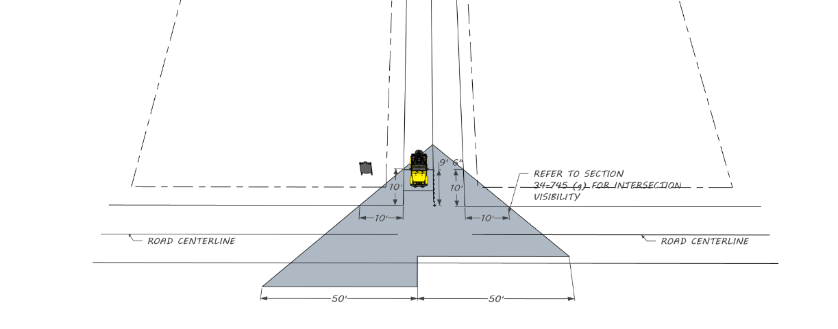
(2)
To ensure proper visibility at the intersection of driveways with public rights-of-way, only properly trimmed trees as previously stated, ground cover type plants or dwarf plants which do not exceed twenty-four (24) inches in height, utility poles, street lights and sign standards or supports shall be allowed within the sight triangle.
(3)
Landscaping Standards Table.
Table 34-745.2
The purpose of this table is to provide a quick summary of the required landscaping standards for each use. There are more detailed requirements for each individual use in section 34-745.
*Oceanfront parcels shall use salt tolerant landscaping and trees as listed in Table 34-745.1.
Sec. 34-751. - Purpose, intent and scope.
It is the purpose of this division to promote the public health, safety and general welfare through reasonable, consistent and non-discriminatory sign standards. The sign regulations in this division are designed and intended to meet the statutory requirement that this municipality adopts land development regulations that regulate signage, a requirement set forth in F.S. § 163.3202(f). The sign regulations in this division are not intended to censor speech or to regulate viewpoints, but instead are intended to regulate the adverse secondary effects of signs that may impact aesthetics, sense of place, quality of life, and/or safety. The sign regulations are designed to serve substantial governmental interests and, in some cases, compelling governmental interests such as traffic safety and warning signs of threats to bodily injury or death.
This division regulates signs, as defined in this Land Development Code, which are placed on private property or on property owned by public agencies including the city and over which the city has zoning authority. This division is not intended to extend its regulatory regime to objects that are not traditionally considered signs for purpose of government regulation.
To preserve and promote the city as a desirable community in which to live, vacation and do business, a pleasing, visually attractive environment is of foremost importance. The regulation of signs within the city is a highly contributive means by which to achieve this desired end.
These sign regulations have been prepared with the intent of enhancing the visual environment of the city and promoting its continued well-being, and are intended to:
(a)
Encourage the effective use of signs as a means of communication in the city;
(b)
Maintain and enhance the aesthetic environment and the city's ability to attract sources of economic development and growth;
(c)
Improve pedestrian and traffic safety;
(d)
Minimize the possible adverse effect of signs on nearby public and private property;
(e)
Foster the integration of signage with architectural and landscape designs;
(f)
Lessen the visual clutter that may otherwise be caused by the proliferation, improper placement, illumination, animation, excessive height, and excessive size (area) of signs which compete for the attention of pedestrian and vehicular traffic;
(g)
Allow signs that are compatible with their surroundings and aid orientation, while precluding the placement of signs that contribute to sign clutter or that conceal or obstruct adjacent land uses or signs;
(h)
Encourage and allow signs that are appropriate to the zoning district in which they are located;
(i)
Establish sign size in relationship to the scale of the lot, street frontage, and building on which the sign is to be placed or to which it pertains;
(j)
Preclude signs from conflicting with the principal permitted use of the site and adjoining sites;
(k)
Regulate signs in a manner so as to not interfere with, obstruct the vision of or distract motorists, bicyclists or pedestrians;
(l)
Except to the extent expressly preempted by state or federal law, ensure that signs are constructed, installed and maintained in a safe and satisfactory manner, and protect the public from unsafe signs;
(m)
Preserve, conserve, protect, and enhance the aesthetic quality and scenic beauty of all districts of the city;
(n)
Allow for traffic control devices consistent with national standards and whose purpose is to promote highway safety and efficiency by providing for the orderly movement of road users on streets and highways, and that notify road users of regulations and provide warning and guidance needed for the safe, uniform and efficient operation of all elements of the traffic stream;
(o)
Protect property values by precluding, to the maximum extent possible, sign types that create a nuisance to the occupancy or use of other properties as a result of their size, height, illumination, brightness, or movement;
(p)
Protect property values by ensuring that sign types, as well as the number of signs, are in harmony with buildings, neighborhoods, and conforming signs in the area;
(q)
Regulate the appearance and design of signs in a manner that promotes and enhances the beautification of the city and that complements the natural surroundings in recognition of this city's reliance on its natural surroundings and beautification efforts in retaining economic advantage for its resort community, as well as for its major subdivisions, shopping centers and industrial parks;
(r)
Enable the fair and consistent enforcement of these sign regulations;
(s)
Promote the use of signs that positively contribute to the aesthetics of the community, are appropriate in scale to the surrounding buildings and landscape, and advance the city's goals of quality development;
(t)
Provide standards regarding the non-communicative aspects of signs, which are consistent with city, county, state and federal law;
(u)
Provide flexibility and encourage variety in signage, and create an incentive to relate signage to the basic principles of good design; and
(v)
Assure that the benefits derived from the expenditure of public funds for the improvement and beautification of streets, sidewalks, public parks, public rights-of-way, and other public places and spaces, are protected by exercising reasonable controls over the physical characteristics and structural design of signs
(w)
Improve the pedestrian scale and experience within the city.
Sec. 34-752. - Definitions.
The definitions in article III shall apply to this division. Any term or phrase not defined therein shall have its commonly understood meaning.
Cross reference— Definitions—General, § 34-41.
Sec. 34-753. - Applicability.
This division does not pertain and is not applicable to:
(a)
A sign, other than a window sign, located entirely inside the premises of a building or enclosed space.
(b)
A sign on a car, other than a prohibited vehicle sign or signs.
(c)
A statutory sign.
(d)
A traffic control device sign.
(e)
Any sign not visible from a public street, sidewalk or right-of-way or from a navigable waterway or body of water; except that the foregoing does not exempt a sign for a commercial use that is visible from an abutting residential use.
Sec. 34-754. - Prohibited signs.
The signs and sign types listed below are prohibited within the city limits and shall not be erected, operated or placed on any property. Any lawfully existing permanent sign structure or sign type that is among the prohibited signs and sign types listed below shall be deemed a nonconforming sign subject to the provisions of section 34-760, nonconforming signs.
(a)
Abandoned signs; discontinued signs.
(b)
Animated signs.
(c)
Attached signs that are taller than the wall of the building to which the sign is attached.
(d)
Attached signs that exceed two hundred fifty (250) square feet in sign area.
(e)
Billboards; off-site commercial signs.
(f)
Bandit signs; snipe signs.
(g)
Flashing signs.
(h)
Floodlights and beacon lights, except when required by the Federal Aviation Administration.
(i)
Freestanding or ground signs, including any ground mounted monument signs, which are higher than sixteen (16) feet.
(j)
Freestanding or ground signs that exceed two hundred (200) square feet in sign area.
(k)
Holographic display signs.
(l)
Moving, twirling, or swinging signs, including multi-prism and tri-vision signs.
(m)
Pavement markings, except for official traffic control markings and building address markings required by law.
(n)
Flutter signs, feather signs, streamers, balloons, wind signs, wind activated banners, cold air inflatables, pennants and other fixed aerial signage used for commercial advertising.
(o)
Permanent pole signs, unless allowed within certain zoning districts pursuant to this division.
(p)
Portable signs, except for A-frame and T-frame signs as allowed herein.
(q)
Revolving signs; rotating signs.
(r)
Roof signs.
(s)
Signs within a sight visibility triangle, as described in subsection 34-745(b)(4)a. herein, that obstruct a clear view of pedestrian or vehicular traffic.
(t)
Signs attached to a seawall, dock, buoy, tie pole or pier; other than warning signs and safety signs.
(u)
Signs in, on, or over the public right-of-way; other than fixed projecting signs in the Central Business District (CBD) and the Redevelopment zoning district (RD), traffic control device signs, bus stop informational signs, warning signs; safety signs, vertical streetlight banners, A-frame signs, T-frame signs, and awning or attached canopy signs over a public right-of-way as allowed in this division.
(v)
Signs in or upon any river, bay, lake, or other body of water within the limits of the city; except government regulatory signs, warning signs, and safety signs.
(w)
Signs located on real property without the permission of the property owner.
(x)
Signs nailed, fastened, affixed to, or painted on any tree or part thereof (living or dead), or other vegetation.
(y)
Signs, other than traffic control device signs, that use the word "stop" or "danger," or present or imply the need or requirement of stopping or the existence of danger, or which are a copy or imitation of traffic control device signs and which are adjacent to the right-of-way of any road, street, or highway.
(z)
Signs that are not effectively shielded as to prevent beams or rays of light from being directed at any portion of the traveled public rights-of-way thereby creating a potential traffic or pedestrian hazard or a nuisance to inhabitants of an adjacent neighborhood. No sign shall be so illuminated that it interferes with the effectiveness of, or obscures an official traffic sign, device, signal, or wildlife.
(aa)
Signs that contain any food or other substance that attracts large numbers of birds or other animals and causes them to congregate on or near the sign.
(bb)
Signs that emit sound, vapor, smoke, odor, or gaseous matter.
(cc)
Signs that obstruct, conceal, hide or otherwise obscure from view any traffic control device sign or official traffic signal.
(dd)
Wall wrap signs.
(ee)
Vehicle sign or signs with a total sign area in excess of twenty (20) square feet on any vehicle, and
(1)
The vehicle is not "regularly used in the conduct of the business," and
(2)
The vehicle is visible from a street right-of-way within fifty (50) feet of the vehicle, and
(3)
The vehicle is parked for more than two (2) consecutive hours in any twenty-four (24) hour period within fifty (50) feet of any street right-of-way, and
(4)
A vehicle shall not be considered "regularly used in the conduct of the business" if the vehicle is used primarily for advertising, and
(5)
This provision is not to be construed as prohibiting the identification of a firm or its principal products on a vehicle operating during the normal hours of business; and which is currently licensed, insured and operable; provided, however, that no such vehicle shall be parked on public or private property with signs attached or placed on such vehicle primarily for the purpose of advertising a business establishment or firm or calling attention to the location of a business establishment or firm.
Sec. 34-755. - General provisions for signs.
The following general sign provisions shall apply to this division and to all lawful conforming and nonconforming signs, unless otherwise indicated.
(a)
Measurement of sign size (sign area). The area of a sign is measured or calculated as follows:
(1)
Background panel signs. Sign copy that is mounted, affixed, or painted on a background panel or area distinctively painted, textured or constructed as a background for the sign copy, is measured as that area contained within the sum of the smallest rectangles, squares, triangles, parallelograms, circles or ellipses that will enclose both the sign copy and the background.
(2)
Background surface signs. The area of a sign consisting of copy mounted as individual letters or graphics against a wall, fascia, or parapet of a building surface or another surface, that has not been painted, textured, or otherwise altered to provide a distinctive background for the sign copy, is measured as the sum of the smallest rectangles, squares, triangles, parallelograms, circles or ellipses that will enclose each word, graphic or discrete visual element in the total sign.
(3)
Illuminated background signs. The area of a sign with copy mounted, affixed, or painted on an illuminated surface or illuminated element or a building or structure, is measured as the entire illuminated surface or illuminated element which contains sign copy.
(4)
Double-faced signs. If a sign has two (2) display faces, and the interior angle between the two (2) faces is thirty (30) degrees or less, then the sign area is one sign face only; however, if the two (2) faces are of different sizes or shapes, then the larger is used. If the sign has two (2) display faces, and the interior angle between the two (2) faces is greater than thirty (30) degrees, then the sign area is the sum of the areas of the two (2) faces.
(5)
Multi-faced signs. If a sign has three (3) or more faces, then the sign area is equal to fifty (50) percent of the aggregate area of all sign faces. The area of each face shall be determined according to subsection (1) or (2) of this section, as applicable.
(6)
Sculptural and nonplanar signs. The area of a spherical, free form, sculptural or other nonplanar sign is fifty (50) percent of the sum of the areas, using only the four (4) vertical sides of the smallest four-sided polyhedron which will completely enclose the entire sign structure.
(b)
Measurement of sign height.
(1)
The height of a freestanding sign shall be measured as the vertical distance from the average finished grade of the ground below the sign excluding any filling, berming, mounding or excavating solely for the purposes of increasing the height of the sign, to the top edge of the highest portion of the sign. The maximum height allowed for a freestanding sign, however, shall not include any architectural embellishment provided the embellishment does not exceed thirty-six (36) inches at the base of the sign and eighteen (18) inches at the top of the sign.
(2)
For the purposes of this section, average finished grade shall be considered the lower of (a) the lowest elevation where the base of the sign meets ground level; or (b) the top of the curb of the nearest public street adjoining the property upon which the sign is erected, or (c) the grade of the land at the principal entrance to the lot on which the sign is located.
(c)
Sign illumination for temporary signs and permanent signs.
(1)
Sign illumination is prohibited for temporary signs.
(2)
Permanent sign on a parcel in residential use. A permanent sign located on a parcel in residential use in any zone may not be separately or specially illuminated, unless otherwise specified in this division.
(3)
Permanent sign on a parcel in nonresidential use. A permanent sign on a parcel in nonresidential use may be illuminated by internal illumination, internal indirect (halo) illumination, or lit by external indirect illumination, unless otherwise specified in this division. However, a permanent sign may not be illuminated in a manner that leaves the illumination device exposed to public view except with the use of neon tubing as provided in subsection (8) of this section.
(4)
Internal illumination. Outdoor internally illuminated signs, including but not limited to awning/canopy signs, cabinet signs (whether freestanding or building mounted), changeable copy panels or service island signs, shall be constructed with an opaque background and translucent letters or other graphical elements, or with a colored background and lighter letters or graphics.
(5)
External indirect illumination. Externally lit signs are permitted to be illuminated only with steady, stationary, down directed and shielded light sources directed solely onto the sign. Light bulbs or tubes (excluding neon), used for illuminating a sign, shall not be visible from the adjacent public rights-of-way or residential properties.
(6)
Illumination of signs adjacent to single-family residential uses. No sign located within fifty (50) feet of a property with a single-family use or zoned for a single-family use shall be internally illuminated.
(7)
Any portion of the sign face or sign structure that is illuminated shall count against the total square footage of allowable sign area.
(8)
Neon.
a.
Exposed neon. Exposed neon tube illumination is not permitted in residential zones, or for residential uses in any zone. It is allowed in all other places, unless otherwise specified.
b.
Neon borders. Neon illumination used as a sign copy projection, border, frame or other embellishment of sign copy shall not be included in the total size or area of the sign, provided the measured area of any such projection or detailed embellishment does not exceed twelve (12) square feet in area, or twenty-five (25) percent of the sign display face area, whichever is greater. If neon embellishments exceed these limits, then the embellishments shall be included and counted as part of the permitted sign area for the use.
(d)
Viewpoint neutrality.
(1)
Notwithstanding anything in this division to the contrary, no sign or sign structure shall be subject to any limitation based upon the viewpoint of the message contained on such sign or displayed on such sign structure.
(e)
Substitution of noncommercial speech for commercial speech.
(1)
Notwithstanding anything contained in this division to the contrary, any sign erected pursuant to the provisions of this division may, at the option of the owner, contain a non-commercial message in lieu of a commercial message and the noncommercial copy may be substituted at any time in place of the commercial copy. The noncommercial message (copy) may occupy the entire sign face or any portion thereof. The sign face may be changed from a commercial message to a noncommercial message or from one noncommercial message to another non-commercial message; provided, however, that there is no change in the size, height, setback or spacing criteria contained in this division.
(f)
Consent of legal owner of property.
(1)
No sign may be displayed without the consent of the legal owner of the property on which the sign is mounted or displayed. For purposes of this policy, "owner" means the holder of the legal title to the property and any party and person holding a present legal right to possession, control, or use of the property.
(g)
Signs on public property.
(1)
Any sign installed or placed on public property, except in conformance with the requirements of this division, shall be deemed illegal and shall be forfeited to the public and subject to confiscation. In addition to other remedies hereunder, the city shall have the right to recover from the owner or person placing such sign the cost of removal and disposal of such sign. The foregoing shall not apply to temporary A-frame signs and T-frame signs as allowed pursuant to the conditions and limitations set forth herein.
(h)
Signs that obstruct means of egress.
(1)
No sign shall be erected so as to obstruct any fire escape, required exit, window, or door opening intended as a means of egress.
(i)
Signs that interfere with ventilation openings.
(1)
No sign shall be erected that interferes with any opening required for ventilation.
(j)
Signs must maintain clearance from utilities and shall not interfere with surface and underground water or with drainage.
(1)
Signs shall maintain a minimum distance of six (6) feet horizontal clearance and twelve (12) feet overhead clearance from electrical conductors and from all communications equipment or lines. Signs and their supporting structures shall maintain clearance from and noninterference with all surface and underground facilities and conduits for water, sewage, electricity, or communications equipment or lines. Sign placement shall not interfere with surface or underground water or with natural or artificial drainage.
(k)
Signs shall not be attached to certain property and shall not impair roof access.
(1)
Signs shall not be attached to standpipes, gutters, drains or fire escapes. Signs shall not be installed so as to impair access to a roof.
(l)
Signs declared a nuisance and repair; signs presenting immediate peril to public health or safety.
(1)
The building official may order the repair of signs declared a nuisance, and with or without notice may cause any structurally unsafe or structurally insecure sign to be immediately removed if in his or her professional judgment and professional opinion the sign presents an immediate peril to the public health or safety.
(m)
Street address signs.
(1)
For each parcel and for each tenant space, one (1) sign for the official street address shall be displayed for public safety and to serve as visible street address for delivery of mail and official governmental notification.
a.
For a single-family residential use, the street address sign shall be a minimum of four (4) inches in height and not exceed two (2) square feet in sign area.
b.
For a multi-family or non-residential use, the street address sign shall be a minimum of six (6) inches in height and shall not exceed four (4) square feet in sign area.
c.
The street address sign in a residential use may be externally illuminated and in a non-residential use may be externally or internally illuminated.
(n)
Flagpoles and flags; flag brackets, flag stanchions and flags.
(1)
Flagpoles and flags. For each parcel and development site in residential use with one (1) principal structure, one (1) flagpole may be installed and two (2) flags may be displayed per flagpole. For each parcel and development site that is over one-half (½) acre in size and is in nonresidential use, up to three (3) flagpoles may be installed and up to two (2) flags may be displayed per flagpole. A flag shall not exceed twenty-four (24) square feet in size.
a.
Flag brackets, flag stanchions, and flags. For each principal structure on a parcel, up to two (2) flag brackets or stanchions may be attached or placed for the display of flags. A flag displayed from a flag bracket or a flag stanchion shall not exceed twenty-four (24) square feet in size.
b.
For the purpose of determining the size of a flag, only one side of the flag shall be counted as the display surface.
c.
Flags on parcels in non-residential use may be externally illuminated.
(o)
Noncommercial onsite parking space signs.
(1)
Parking space signs identifying parking spaces necessary for traffic safety, regulation, control and circulation. A parking space sign shall carry no commercial message and shall not exceed two (2) square feet of sign face per sign. Parking space signs shall be allowed on each parcel having multiple parking spaces onsite. One such sign shall be allowed for each parking space. The maximum height for a freestanding or an attached parking space sign shall be six (6) feet.
(p)
Signs at service station islands.
(1)
For service stations, one (1) double-sided sign or two (2) single-sided signs are allowed per island. Such signs shall not exceed four (4) square feet per side and shall not be mounted higher than eight (8) feet. Such signs shall not be mounted on any bollard or barrier designed to protect equipment from damage. Such signs may not be illuminated.
(2)
For service stations, one (1) canopy sign may be installed for each canopy side facing a public street or driveway. A canopy sign shall not exceed ten (10) square feet and shall not be mounted higher than the top of the canopy itself. A canopy sign may be internally illuminated. The square footage of all canopy signs on a canopy shall be counted against the maximum square footage of allowed wall signage for any building wall sign on the same parcel.
(q)
Monument signs.
(1)
Monument signs for single occupant or tenant buildings.
a.
One (1) monument sign is allowed for each single occupant or tenant building. The maximum size of a monument sign shall be the lesser of: (1) one hundred (100) square feet, or (2) one (1) square foot of sign area for each one (1) linear foot of road frontage along the street toward which the monument sign is oriented. The maximum height of the monument sign shall be ten (10) feet, and the maximum width of the monument sign shall be twelve (12) feet. Up to fifty (50) percent of the sign surface of the monument sign may consist of a changeable copy sign; provided, however, that the sign copy cannot be changed more frequently than once in a twenty-four (24) hour time period. The monument sign may be illuminated.
b.
Monument signs for multiple occupant or tenant developments. One (1) monument sign is allowed for each multiple occupant or tenant development inclusive of a shopping center. The maximum size of the monument sign shall be the lesser of: (1) two hundred (200) square feet, or (2) one (1) square foot of sign area for each one (1) linear foot of road frontage along the street toward which the monument sign is oriented for the first one hundred (100) feet of frontage plus one-fourth (¼) square foot of sign area for each additional linear foot of the aforesaid road frontage. The maximum height of the monument sign shall be sixteen (16) feet, and the maximum width of the monument sign shall be twelve and one-half (12½) feet. Up to fifty (50) percent of the sign surface of the monument sign may consist of a changeable copy sign; provided, however, that the sign copy cannot be changed more frequently than once in a twenty-four (24) hour time period. The monument sign may be illuminated.
c.
Monument signs at entrances to single-family and multi-family developments. One (1) monument sign is allowed at each point of ingress or egress from or to a single-family development and from or to a multi-family development. The maximum size of a monument sign shall not exceed twenty-four (24) square feet in size and shall not exceed six (6) feet in height. The twenty-four (24) square feet of sign area may be split equally between two monument signs located on each side of the entry or exit street. The monument sign shall be located on a landscaped island or lawn area protected from vehicular contact, and shall not encroach into any corner sight visibility triangle required pursuant to section 34-720. The sign may be internally or indirectly illuminated.
d.
Monument sign for a parcel in educational, religious or public use. In addition to any monument sign allowed above, one (1) permanent monument sign may be allowed for a parcel in educational, religious or public use. The sign shall not exceed thirty-two (32) square feet in sign area and shall not exceed eight (8) feet in height. The sign may be illuminated. However, this additional monument sign shall not be allowed if there is an additional permanent wall sign on the same parcel.
(r)
Wall signs.
(1)
One (1) wall sign is allowed for each face of a building or part of a building that is occupied by a permitted or conditional non-residential use. The size (area) of the wall sign for an occupant or a tenant shall be the lesser of: (i) two hundred fifty (250) square feet, or alternatively (ii) one (1) square foot per one (1) linear foot of building frontage for a single occupant building or one (1) square foot per one (1) linear foot of building frontage for the occupant or tenant space in a multi-tenant development, each as measured on the street toward which the wall sign is oriented. A wall sign shall not extend higher than the building wall to which it is attached. Up to fifty (50) percent of the wall sign surface may consist of a changeable copy sign; provided, however, that the sign copy of the changeable copy sign shall not change more than once in any twenty-four (24) hour time period. The wall sign shall not project more than twelve (12) inches from the wall. If the wall sign projects more than two and one-half (2 ½) inches from the wall, the wall sign shall be mounted so that the bottom of the wall sign is at least nine (9) feet above ground at finished grade below the wall sign. The wall sign may be illuminated.
(2)
In addition to any wall sign allowed above, one (1) permanent wall sign may be allowed for a parcel in educational, religious or public use. The wall sign shall not exceed thirty-two (32) square feet in sign area and shall not exceed eight (8) feet in height. The wall sign may be illuminated. However, this additional permanent wall sign shall not be allowed if there is an additional monument sign on the same parcel.
(s)
Wall signs at restaurants.
(1)
In addition to any other wall sign allowance, a restaurant shall be allowed one (1) wall sign installed within twenty (20) feet of its main entrance. The wall sign shall not exceed six (6) square feet in area and shall not exceed six (6) feet in height. The wall sign may be illuminated.
(t)
Drive-through lane signs.
(1)
For a drive-through establishment, an additional menu sign is allowed for each drive-through lane provided that such sign does not exceed forty (40) square feet in size and does not exceed eight (8) feet in height. The additional menu sign may be internally illuminated and may emit sound only as part of a business transaction. Any sounds emitted must comply with Chapter 18 of the Code of Ordinances of the City of Jacksonville Beach.
(u)
Umbrella signs.
(1)
For each table in an outside seating area for a licensed business establishment, one (1) umbrella sign per umbrella is allowed. An umbrella sign shall not exceed three (3) square feet in area and shall not exceed eight (8) feet in height. An umbrella having an umbrella sign shall be mounted on or in the table or in an umbrella holder adjacent to the table. A sign permit is not required for an umbrella sign.
(v)
Awning signs.
(1)
For each awning, one (1) sign is allowed. The awning sign shall not exceed an area greater than twenty (20) percent of the surface area of the awning or canopy. The total square footage of the awning sign shall count toward the maximum square footage of the wall sign area allowed for a parcel or a tenant. An awning sign may be internally illuminated.
(w)
Canopy signs.
(1)
For each canopy, one sign is allowed. Except for the sign area limitation for canopy signs at service station islands, a canopy sign shall not exceed an area greater than twenty (20) percent of the surface area of the canopy. The total square footage of the canopy sign shall count toward the maximum square footage of the wall sign area allowed for a parcel or a tenant. A canopy sign may be internally illuminated.
(x)
Changeable copy signs.
(1)
As part of a permitted monument sign or wall sign, a changeable copy sign, manual or electronic (LED), may be installed. The changeable copy sign shall not exceed fifty (50) percent of allowable area of the monument sign or wall sign. The changeable copy sign shall not exceed ten (10) feet in height when installed as a part of a monument sign for a single occupant or tenant building. The changeable copy sign shall not exceed sixteen (16) feet in height if part of the monument sign is for a multiple occupant or tenant building. A changeable copy sign that is a part of wall sign shall not be installed higher than the wall of the building. The sign copy on a changeable copy sign shall not be changed more than once every twenty-four (24) hours. Changeable copy signs may be internally illuminated.
(y)
Projecting signs.
(1)
For buildings in the Central Business District (CBD) or a Redevelopment District (RD), one (1) projecting sign is allowed for each ground floor occupant or tenant space. The projecting sign shall be attached to the building frontage on the street or driveway on which the sign is located. The maximum size of the projecting sign shall be the lesser of (1) sixteen (16) square feet or (2) one (1) square foot per linear foot of occupant or tenant building frontage on the street or private driveway on which it is located; however, the square footage of a projecting sign shall count toward the maximum square footage of wall signage allowed for the building. The maximum thickness of the sign face of a projecting sign shall not exceed twenty-four (24) inches when such sign is of solid construction. A projecting sign shall have a minimum vertical clearance of nine (9) feet, and shall not be mounted higher than the wall of the building. A projecting sign that extends over a sidewalk in the public right-of-way shall be limited to a projection distance not to exceed two-thirds (⅔) of the width of the sidewalk. A projecting sign may be illuminated.
(z)
Window signs.
(1)
Window signs are permitted provided that the window sign may not cover more than twenty-five (25) percent of the area of any window. Window signs may be internally illuminated. A sign permit is not required for a window sign.
(aa)
Door signs.
(1)
Door signs are permitted provided that the door sign may not cover more than twenty-five (25) percent of the area of any door. Door signs shall not be illuminated. A sign permit is not required for a door sign.
(bb)
A-frame signs.
(1)
A-frame signs are permitted only in commercial zoning districts at properties with a commercial use and shall follow the same criteria as the Commercial Business District (CBD), with the exception that A-frame signs outside the CBD zoning district may not be placed on a public sidewalk, public property or city right-of-way.
Sec. 34-756. - Temporary and permanent signs allowed in zoning districts.
The signage rights and responsibilities for temporary signs and permanent signs shall be determined by the provisions of section 34-755, general provisions for signs, and by the sign provisions for the zoning districts as set forth below in section 34-757.1, temporary signs allowed in zoning districts, and section 34-757.2, permanent signs allowed in zoning districts.
However, in connection with residential uses in nonresidential zoning districts and nonresidential uses in residential zoning districts, the signage rights and responsibilities applicable to any particular use shall be determined as follows:
(a)
In a residential zoning district where a nonresidential use is allowed, whether as a matter of right or by way of a conditional use permit or other process with stated criteria governing the allowance of the nonresidential use, the nonresidential use shall be treated as if it was located in a zoning district where the nonresidential use would be allowed, either as a matter of right or subject to a conditional use permit or other process with stated criteria governing the allowance of the nonresidential use; and
(b)
In a nonresidential zoning district where a residential use is allowed, the residential use shall be treated as if it was located in the residential zoning district where that type of use would be allowed as a matter of right.
Sec. 34-757.1. - Temporary signs allowed in zoning districts.
Within its zoning districts and subject to any applicable provisions with section 34-755, general provisions for signs, the city shall allow temporary signs that meet the criteria and limitations set forth in Table 34-757.1a and Table 34-757.1b, shown below.
A government sign shall not require a sign permit and shall be allowed in all zoning districts on public property and public rights-of-way unless otherwise provided herein. However, the foregoing shall have no impact on any separate requirements established by state statute for building permits, electrical permits or other statutory permits.
A temporary sign displayed on a window surface must be displayed on the inside of the window surface, shall cover no more than twenty-five (25) percent of the window surface, and shall not be illuminated.
Table 34-757.1a. CBD Zoning District
Table 34-757.1b. All Zoning Districts
1
The number of temporary commercial signs per parcel shall be no more than two (2) signs; however, no more than one (1) temporary commercial sign per parcel may be a banner sign and a temporary commercial banner sign is limited to a maximum duration of display of no more than thirty (30) days per calendar year per parcel.
2
The square footage limitation is per side for a back-to-back sign. For example, a four (4) square foot limitation means that there is a limit of four (4) square feet of surface area per side of a back-to-back sign, and an aggregate limit of eight (8) square feet is allowed if the sign is a back-to-back temporary sign.
3
Not applicable to signs displayed on flagpoles.
4
Minimum sign setbacks do not apply to wall signs. Except as set forth in Table 34-757.1a for A-frame signs and T-frame signs, all temporary signs are prohibited on public property and from public rights-of-way.
5
Not applicable to signs displayed on flagpoles.
6
There is no limit to the number of separate messages that may appear on the allowable surface(s) of any temporary sign. The maximum aggregate surface area allowed is subject to circumstances that may reduce the maximum aggregate surface area allowable on some parcels.
Sec. 34-757.2. - Permanent signs allowed in zoning districts.
Within its zoning districts and subject to any applicable provisions within section 34-755, general provisions for signs, the city shall allow permanent signs that meet the criteria and limitations set forth in the subsections below. Unless otherwise provided herein, a permanent sign shall require a sign permit; however, a government sign on public property or public rights-of-way shall not require a sign permit and shall be allowed in all zoning districts on public property or public rights-of-way unless otherwise provided herein. The foregoing shall have no impact on separate requirements established by state statute for building code permits or other code permits.
(1)
Single-Family Residential Zoning Districts (RS-1, RS-2, RS-3). Within Single-Family Residential Zoning Districts (RS-1, RS-2, RS-3) and subject to the provisions with section 34-755, general provisions for signs, the city shall allow permanent signs that meet the criteria and limitations set forth in Table 34-757.2a below.
Table 34-757.2a. Single-Family Residential Zoning Districts (RS-1, RS-2, RS-3)
(2)
Multi-Family Residential Zoning Districts (RM-1, RM-2). Within Multi-Family Residential Zoning Districts (RM-1, RM-2) and subject to any applicable provisions within section 34-755, general provisions for signs, the city shall allow permanent signs that meet the criteria and limitations set forth in Table 34-757.2b below.
Table 34-757.2b. Multi-Family Residential Zoning Districts (RM-1, RM-2)
(3)
Commercial Zoning Districts (CPO, C-1, C-2, CS). Within Commercial Zoning Districts (CPO, C-1, C-2, CS) and subject to any applicable provisions within section 34-755, general provisions for signs, the city shall allow permanent signs that meet the criteria and limitations set forth in Table 34-757.2c below.
Table 34-757.2c. Commercial Zoning Districts (CPO, C-1, C-2, CS)
(4)
Central Business Zoning District (CBD). Within the Central Business Zoning District (CBD) and subject to any applicable provisions within section 34-755, general provisions for signs, the city shall allow permanent signs that meet the criteria and limitations set forth in Table 34-757.2d below.
Table 34-757.2d. Central Business Zoning District (CBD)
(5)
Industrial Zoning District (I-1). Within the Industrial Zoning District (I-1) and subject to any applicable provisions within section 34-755, general provisions for signs, the city shall allow permanent signs that meet the criteria and limitations set forth in Table 34-757.2e below.
Table 34-757.2e. Industrial Zoning District (I-1)
(6)
Redevelopment Zoning District (RD). Within the Redevelopment Zoning District (RD) and subject to any applicable provisions within section 34-755, general provisions for signs, the city shall allow permanent signs that meet the criteria and limitations set forth in Table 34-757.2f below.
Table 34-757.2f. Redevelopment Zoning District (RD)
(7)
Planned Unit Development Zoning District (PUD). Within its Planned Unit Development Zoning District (PUD) and subject to any applicable provisions within section 34-755, general provisions for signs, the city shall allow permanent signs that meet the criteria and limitations set forth in Table 34-757.2g below.
Table 34-757.2g. Planned Unit Development Zoning District (PUD)
Sec. 34-758. - Building permits.
It shall be unlawful for any person or business or the person in charge of the business to erect, construct, alter or maintain a sign structure, as defined in the Florida Building Code, without first obtaining a building permit from the city in accordance with the provisions of the Florida Building Code and applicable law. Permit fees for a building permit shall be paid in accordance with the applicable city fee schedules. The requirement of a building permit under the Florida Building Code is separate and independent of the requirement for a sign permit under this division.
Sec. 34-759. - Sign permits.
Temporary signs do not require a sign permit.
Unless exempt from permitting, no permanent sign shall be erected, altered, relocated, maintained or displayed until a sign permit is obtained from and the appropriate fee paid to the city. The sign permit is in addition to any building permit required to be obtained pursuant to the provisions of the Florida Building Code.
(a)
No sign permit shall be issued for the erection of a prohibited sign.
(b)
A sign lawfully erected may be repainted or have ordinary and customary repairs performed, including replacement of plastic or glass panels, without a sign permit; however, if such sign is to be structurally altered in any manner, a new sign permit shall be required and the altered sign must meet all requirements of this division and this Code.
(c)
Exceptions from permitting. Temporary signs shall not require a sign permit. Unless identified in the tables in section 34-757.2 as not requiring a sign permit and unless otherwise excepted from requiring a sign permit such as a government sign, all permanent signs shall require a sign permit. However these exemptions in no way waive any requirement set forth in the Florida Building Code; or any limitation or restriction on the number, size, height, setback, placement or duration of such signs under this division, or any limitation or restriction under any other applicable law or regulation.
(d)
Permits are required for change of sign copy to a nonconforming sign. A changing of the copy of a sign is permitted to a nonconforming sign, as long as no changes are made to the sign's height, size, location, or structure. Permits are not required for any change of copy on a conforming sign or changeable copy sign.
(e)
Sign permit applications. A sign permit application for a permanent sign as may be required by this division shall be prepared and submitted on forms available by the planning and development department. The sign permit application is in addition to any building permit application required by the Florida Building Code. The applicant shall furnish the following information on or with the sign permit application form:
(1)
Name, address, telephone number, and e-mail address (if available) of the person making application for the permit. If the applicant is anyone other than the property owner, the applicant shall provide written authorization from the property owner permitting the installation of the sign.
(2)
Name, address, telephone number, and e-mail address (if available) of the property owner. If the owner is an entity other than an individual, list the contact person's name.
(3)
Name, address, telephone number, and e-mail address (if available) of the business tenant, if applicable. If the tenant is an entity other than an individual, list the contact person's name.
(4)
Name, address, telephone, e-mail address (if available), and license number of the contractor, if applicable. If the contractor is an entity other than an individual, list the contact person's name.
(5)
Address and legal description of the property upon which the sign is to be located. The legal address may be located on a certified boundary survey.
(6)
Lot frontage on all streets and public rights-of-way.
(7)
Indicate in feet and inches the location of the sign in relation to property lines, public rights-of-way, easements, overhead utility lines, other utility facilities and equipment, buildings and other signs on the property.
(8)
Freestanding signs, including monument signs, shall require an accurate boundary survey signed and sealed by a land surveyor or engineer licensed in Florida showing the proposed location of the sign.
(9)
For all wall mounted signs, the facade elevation with dimensions, drawn to scale. Windows and doors and other openings shall be delineated and their dimensions given.
(10)
Sign dimensions and elevation, drawn to scale.
(11)
Maximum and minimum height of the sign measured from finished grade.
(12)
Dimensions of the supporting members of the sign.
(13)
Sign illumination, specifying illumination type, placement, and intensity.
(14)
Two (2) copies of the plans, specifications, calculations and details, signed and sealed as required by the Florida Building Code; and specifications documenting the applicable windload and electrical specifications, if applicable, meeting the minimum requirements of the applicable Electric Code.
(15)
Number, type, location and surface area of all existing signs on the same property.
(16)
Landscape plan, as applicable.
(17)
Notarized signature of applicant. If the value of construction is two thousand five hundred dollars ($2,500.00) or greater, a certified copy of notice of commencement shall be required prior to permit issuance.
(f)
Sign construction specifications.
(1)
Florida Building Code. Construction and erection of signs shall be in accordance with the structural requirements set forth in the Florida Building Code.
(2)
National Electrical Code. Signs having electrical connections of any kind shall be wired in accordance with the National Electrical Code.
(3)
Inspections. Any sign having an electrical connection shall be permitted, inspected and approved by the electrical inspector prior to its completion. All sign structures shall be inspected and approved by the building official. The inspection point shall be selected by the building official. All excavations for concrete sign support bases shall be inspected and approved by the building official prior to the pouring of concrete.
(4)
Support requirements. The supporting members of all signs shall be free of any external bracing such as guy wires or cables. All supporting columns shall be designed as integral or architectural features of the sign.
(5)
Materials. Paper or cardboard signs and cloth or plastic fabric banners may only be used in conjunction with a special event as provided herein. However, paper or cardboard signs may be used for indoor window or election signs, when such are allowed.
(6)
Construction standards. All signs shall be installed and constructed in a professional and workmanlike manner; and shall be maintained in good and safe structural condition and good physical appearance. All exposed structural components shall be painted, coated, or made of rust inhibitive material.
(g)
Design requirements. All signs and sign structures, except temporary signs and prohibited signs (billboards and off-premises signs), shall be subject to the design requirements below.
(1)
Monument signs. Monument sign structures may extend above the allowable height and/or permitted horizontal dimension for the purposes of architecturally embellishing and enhancing the appearance of the sign structure. Such extensions shall not exceed thirty-six (36) inches for the base, eighteen (18) inches at the top of the sign, or twelve (12) inches for each vertical side of the sign.
(2)
Tenant panels in monument signs. All tenant panels in a monument sign, including those added to an existing sign structure, shall be constructed of similar materials and illuminated by a similar method.
(3)
Wall signs. Wall signs shall not be installed to cover windows, doors, or other types of fenestration.
(4)
Sign work. Sign work on all permanent signs shall ensure that all the letter strokes are vertically plumb or evenly slanted, and with alignment true and horizontally level.
(5)
Manufactured signs. All manufactured signs requiring a sign permit shall have a permanent and visible weatherproof identification plate affixed to the sign exterior. The plate shall identify (1) the name of the manufacturer, (2) the date of installation, (3) the sign permit number, and (4) the electric permit number (if any) with the input VA (Volt Amperes) at full load for electric.
(h)
Sign permit application review.
(1)
The sign application is not required to describe the content of the sign.
(2)
For fueling stations, the pricing signage shall follow the Florida State Statues requirements.
(3)
An applicant shall submit a sign permit application for a permanent sign to the planning and development department, building inspection division, or such other office as may be designated by the city. The sign permit application shall be reviewed for a determination of whether the proposed sign meets the applicable requirements of this division and any applicable zoning law of the City of Jacksonville Beach as set forth in the City of Jacksonville Beach's Code of Ordinances.
(4)
An approval, an approval with conditions, or disapproval by the planning and development department shall be deemed the final decision of the city upon the application.
(5)
In the case of an approval with conditions or a disapproval, including a disapproval by lapse of time as described herein, an applicant may ask for reconsideration of the decision once, on the grounds that the planning and development department may have overlooked or failed to consider any fact(s) that would support a different decision.
a.
A written request for reconsideration accompanied by such additional fact(s) that address the deficiencies that the applicant may wish the planning and development department to consider, shall be filed with the planning and development department within fourteen (14) calendar days after the date of the written decision. No fee shall be required for a request for reconsideration.
b.
Upon the timely filing of a request for reconsideration, the decision of the planning and development department or designee shall be deemed stayed and not a final decision, until the request for reconsideration is decided. The request for reconsideration shall be decided within fourteen (14) business days of receipt. Such decision shall be in writing and shall include a statement of the reason(s) for the decision.
(6)
If an application is deemed incomplete, the applicant may either take steps to submit a complete application or challenge the city's decision by seeking judicial review by the Circuit Court of the Fourth Judicial Circuit in and for Duval County, or by any other court of competent jurisdiction, filed in accordance with the requirements of law, seeking such appropriate remedy as may be available.
(i)
Sign permit fees. Before issuance of a permit, the planning and development department shall collect the necessary sign permit fees. The sign permit fees shall be as designated by resolution of the city council.
(j)
Inspection. The planning and development department may make or require any inspections to ascertain compliance with the provisions of this division and the Land Development Code.
(k)
Revocation of sign permit. If the work under any sign permit is proceeding in violation of this division, the Land Development Code, or the Florida Building Code, or should it be found that there has been any false statement or misrepresentation of a material fact in the application or plans on which the sign permit was based, the permit holder shall be notified of the violation. If the permit holder fails or refuses to make corrections within ten (10) days, it shall be the duty of the planning and development department to revoke such sign permit and serve notice upon such permit holder. Such notice shall be in writing and signed by the planning and development department. It shall be unlawful for any person to proceed with any part of work after such notice is issued.
Sec. 34-760. - Nonconforming signs.
All signs that are lawfully in existence or are lawfully erected and that do not conform to the provisions of this division are declared nonconforming signs. Nonconforming signs shall be removed within five years of the adoption of this updated Land Development Code. It is the intent of this division to recognize that the eventual elimination of nonconforming signs as expeditiously and fairly as possible is as much a subject of health, safety, and welfare as is the prohibition of new signs that would violate the provisions of this division. It is also the intent of this division that any elimination of nonconforming signs shall be effected so as to avoid any unreasonable invasion of established property rights.
(a)
Legal nonconforming signs:
(1)
A legal nonconforming sign is a sign that lawfully existed at the time of the enactment of this division that does not conform to the regulations as specified in this division.
(2)
A legal nonconforming sign may continue to be utilized only in the manner and to the extent that it existed at the time of the adoption of this division or any amendment thereof.
(3)
A legal nonconforming sign may not be altered in any manner not in conformance with this division. This does not apply to reasonable repair and maintenance of the sign or to a change of copy provided that by changing the copy structural alterations are not required.
(4)
Any building permit for a change of use, or an addition, alteration, or improvement valued at more than fifty (50) percent of the fair market value of the structure or building for work at locations where any nonconforming sign exists shall specify and require that such nonconforming signs located within the boundaries of the development site, and within the limits of the applicant's control, shall be brought into conformance with the provisions of this division, provided that if the nonconforming sign is a type of sign that is prohibited under section 34-754, prohibited signs in all zoning districts, it shall be removed.
(5)
Legal nonconforming signs that are located on a parcel of property that is severed from a larger parcel of property and acquired by a public entity for public use by condemnation, purchase or dedication may be relocated on the remaining parcel without extinguishing the legal nonconforming status of that sign provided that the nonconforming sign:
a.
Is not increased in area or height to exceed the limits of the zoning district in which it is located;
b.
Remains structurally unchanged except for reasonable repairs or alterations;
c.
Is placed in the most similar position on the remaining property that it occupied prior to the relocation; and
d.
Is relocated in a manner so as to comply with all applicable safety requirements. After relocation pursuant to this subsection, the legal nonconforming sign shall be subject to all provisions of this section in its new location.
(b)
Signs rendered nonconforming:
(1)
Except as provided in this section, a nonconforming sign may continue in the manner and to the extent that it existed at the time of the adoption, amendment or annexation of the division that rendered the sign nonconforming. This section shall not prohibit reasonable repairs and alterations to nonconforming signs unless the sign is brought into compliance.
(2)
A nonconforming sign shall not be re-erected, relocated or replaced unless it is brought into compliance with the requirements of this division. An existing monument sign that conforms to the size and height limitations set forth herein, but is otherwise nonconforming, may be relocated a single time to another location on the same parcel.
(3)
Any nonconforming sign shall be removed or rebuilt in full conformity to the terms of this division if it is damaged or allowed to deteriorate to such an extent that the cost of repair or restoration is fifty (50) percent or more of the cost of replacement of such sign, or if the sign is deemed unsafe by the building official.
(4)
Any nonconforming pole sign shall be replaced when there is a change of use or tenant.
(c)
Signs for a legal nonconforming use:
(1)
New or additional signs for a nonconforming use shall not be permitted.
(2)
A nonconforming sign for a nonconforming use that ceases to be used for a period of sixty (60) consecutive days or is replaced by a conforming use, shall be considered a prohibited sign and shall be removed or brought into conformance upon establishment of a conforming use.
(d)
Signs discontinued:
(1)
Sign structures that remain vacant, unoccupied or devoid of any message, or display a message pertaining to a time, event or purpose that no longer applies, for a period of one hundred eighty (180) days, shall be deemed to be discontinued.
(2)
A nonconforming sign deemed discontinued shall immediately terminate the right to maintain such sign.
(3)
After a sign structure has been deemed discontinued, it shall be the responsibility of the property owner or the property owner's authorized agent to remove the discontinued sign and to patch and conceal any and all damage to any other structure resulting from removal of the sign.
(4)
Removal of a discontinued nonconforming sign shall include all sign support components, angle irons, poles, and other remnants of the discontinued sign, that are not currently in use, or proposed for immediate reuse as evidenced by a sign permit application for a permitted sign.
(e)
Unsafe signs:
(1)
If the building official determines any sign or sign structure to be in an unsafe condition, he/she shall immediately notify, in writing, the owner of such sign who shall correct such condition within forty-eight (48) hours.
a.
If the sign that is determined to be unsafe by the building official is a nonconforming sign, it shall be removed and not repaired within the timeframe outlined below but may be replaced with a conforming sign with proper application and approval by planning and development department.
(2)
If the correction has not been made within forty-eight (48) hours, the building official may have the sign removed if it creates a danger to the public safety or have any necessary repairs or maintenance performed at the expense of the sign owner or owner or lessee of the property upon which the sign is located.
Sec. 34-761. - Miscellaneous provisions.
(a)
Maintenance of sign location. For a sign requiring a sign permit, weeds and grass shall be kept cut in front of, behind, underneath, and from around the base of the sign for a minimum distance of ten (10) feet from the sign base, and there shall be no rubbish or debris within ten (10) feet of the sign base or underneath the sign.
(b)
Ingress and egress signs. For safety purposes and for traffic circulation purposes, permanent ingress and egress signs to a parcel are permitted provided the same do not exceed four (4) square feet in size and no more than three (3) feet in height. Such signs shall not require a permit.
Sec. 34-762. - Penalties.
Penalties for violation of this division shall be as provided in section 34-1204; however, notwithstanding anything in the LDC or in the Jacksonville Ordinance Code to the contrary, a penalty for a violation of this division shall be limited to civil penalties only and shall not extend to any criminal penalty including but not limited to incarceration.
Sec. 34-763. - Severability.
(a)
Generally. If any part, section, subsection, paragraph, subparagraph, sentence, phrase, clause, term, or word of this division is declared unconstitutional by the valid judgment or decree of any court of competent jurisdiction, the declaration of such unconstitutionality shall not affect any other part, section, subsection, paragraph, subparagraph, sentence, phrase, clause, term, or word of this division.
(b)
Severability where less speech results. Without diminishing or limiting in any way the declaration of severability set forth above in subsection (a), above, or elsewhere in this division, the Jacksonville Beach Code of Ordinances, or any adopting ordinance, if any part, section, subsection, paragraph, subparagraph, sentence, phrase, clause, term, or word of this division is declared unconstitutional by the valid judgment or decree of any court of competent jurisdiction, the declaration of such unconstitutionality shall not affect any other part, section, subsection, paragraph, subparagraph, sentence, phrase, clause, term, or word of this division, even if such severability would result in a situation where there would be less speech, whether by subjecting previously exempt signs to permitting or otherwise.
(c)
Severability of provisions pertaining to prohibited signs. Without diminishing or limiting in any way the declaration of severability set forth above in subsection (a), above, or elsewhere in this division, the Jacksonville Beach Code of Ordinance, or any adopting ordinance, if any part, section, subsection, paragraph, subparagraph, sentence, phrase, clause, term, or word of this division or any other law is declared unconstitutional by the valid judgment or decree of any court of competent jurisdiction, the declaration of such unconstitutionality shall not affect any other part, section, subsection, paragraph, subparagraph, sentence, phrase, clause, term, or word of this division that pertains to prohibited signs, including specifically those signs and sign types prohibited and not allowed under section 34-754, prohibited signs, of this division. Furthermore, if any part, section, subsection, paragraph, subparagraph, sentence, phrase, clause, term, or word of section 34-754 is declared unconstitutional by the valid judgment or decree of any court of competent jurisdiction, the declaration of such unconstitutionality shall not affect any other part, section, subsection, paragraph, subparagraph, sentence, phrase, clause, term, or word of section 34-754 thereby ensuring that as many prohibited sign types as may be constitutionally prohibited continue to be prohibited.
(d)
Severability of prohibition on billboards. If any part, section, subsection, paragraph, subparagraph, sentence, phrase, clause, term, or word of this division and/or any other Code provisions and/or laws are declared invalid or unconstitutional by the valid judgment or decree of any court of competent jurisdiction, the declaration of such unconstitutionality shall not affect the prohibition on billboards as contained in this division or in the Jacksonville Beach Code of Ordinances.
Sec. 34-771. - Stormwater management.
(a)
Purpose and intent. The purpose of this division is to manage stormwater drainage within of the City of Jacksonville Beach in order to maintain and enhance the public health, safety, and welfare through the control of runoff volume and treatment of stormwater runoff for the protection of surface water and groundwater quality, and the control and prevention of erosion, sedimentation, and flooding by providing standards for the design, construction, operation and maintenance of stormwater management systems in conformance with best overall management practices.
This division is intended to implement the goals, objectives, and policies of the Comprehensive Plan of the City of Jacksonville Beach, and to be consistent with the applicable policies and regulations of regional, state and federal agencies regarding stormwater management. It is also intended to allow landowners reasonable use of their property while promoting the following objectives:
(1)
Protecting the quality and quantity of ground and surface waters.
(2)
Perpetuating recharge of the groundwater system;
(3)
Reducing erosion loss of topsoil and subsequent sedimentation of surface water bodies.
(4)
Preventing loss of life and property damage due to runoff from any foreseeable rainfall event.
(b)
Applicability. This division shall apply within the incorporated area of the City of Jacksonville Beach, Florida. A permit will be required for new stormwater discharge facilities or modifications to existing discharge facilities consistent with requirements defined by St. Johns River Water Management District (SJRWMD) as defined herein. This provision shall not affect the city's authority to require corrective action whenever a stormwater management facility causes or contributes to violations of water quality and flood control standards.
(c)
Procedures.
(1)
No person may subdivide land, initiate construction activity, make any substantial change in land contour lines, alter drainage or stormwater runoff, or construct a stormwater management system without first satisfying the requirements contained in this division and applicable regional, state and federal regulations, and obtaining approval from the public works department. The following activities may potentially alter or disrupt existing stormwater runoff patterns, and as such, will, unless exempt pursuant to section 34-771(e), require a permit prior to initiation of any development.
a.
Clearing and/or draining of land for development purposes;
b.
Clearing and/or draining of properties;
c.
Converting undeveloped lands to nonagricultural uses;
d.
Subdivision of land where road improvements are required;
e.
Alteration of land and/or the construction of a structure and/or a change in the size of one (1) or more structures.
f.
Any alteration to existing facilities which create an increase in required capacity.
g.
Depositing any fill onto properties.
(2)
Development plans submitted for approval shall show all areas retained in a pervious condition and their past development treatment. All infrastructure associated with stormwater management facilities shall be shown in sufficient detail to enable a determination to be made of their holding capacity and all pipe runs shall be shown with details concerning material direction slope of (degree of fall) and point of connection to off-site drainage systems. Capacity and/or throughput potential must meet the requirements of section 34-771(e)(1)a. through d.
(3)
The planning and development department will certify compliance with these provisions upon receipt of approval by the public works department.
(4)
No connection shall be made to off-site drainage systems until approval has been received from the owner of the system (either city, county, or state government).
(d)
Exemptions. The following development shall be exempt from the terms of this division.
(1)
The construction, replacement, alteration, or maintenance of a single-family residence and accessory structures, where clearing and drainage does not adversely impact adjacent properties by creating additional runoff.
(2)
The clearing of land, which is to be used solely for, recreation, agriculture (only properties protected under the Right to Farm Act), or open space provided no disruption of natural surface waters or impoundment of surface water will result. This exemption will not apply where clearing and drainage may directly or indirectly impact areas defined as conservation/protected areas pursuant to the comprehensive plan.
(e)
Standards for stormwater management systems.
(1)
General.
a.
A stormwater management system is a network of infrastructure and practices designed to manage and control stormwater runoff. Stormwater systems are typically implemented to minimize flooding, protect water quality, and minimize erosion.
A typical stormwater system consists of various components, which may consist of:
1.
Storm drains: These are underground pipes or open channels that collect and convey stormwater from streets, parking lots, and other surfaces to a designated discharge point, such as a ditch, canal, or river.
2.
Inlet structures: These are structures located at the surface level that capture stormwater into the collection and conveyance system. Inlet structures typically include catch basins, curb inlets, and grates.
3.
Detention and retention ponds: These are basins designed to temporarily store stormwater runoff. Detention ponds attenuate and slowly release stormwater into the outfall boundaries. Retention ponds attenuate one hundred (100) percent of the captured runoff and release it into the ground via percolation or infiltration over time.
4.
Erosion and sediment control measures: These are techniques and best practices that are implemented during construction of land improvements to prevent/minimize erosion and the transport of sediment into stormwater systems and surface waters. Examples include silt fences, hay bales, sediment basins, and floating turbidity curtains.
5.
Maintenance and management practices: Regular maintenance of stormwater infrastructure is essential to ensure its proper functioning. This may involve cleaning storm drains, removing debris and trash, and inspecting and repairing infrastructure as needed.
b.
The general design and performance requirements of this division shall meet all of the standards of the following documents, unless stricter standards are stated herein. These documents are incorporated herein as part of the LDC by reference:
1.
Drainage Manual, Florida Department of Transportation.
2.
Chapter 62-25, Florida Administrative Code, Regulations of Stormwater Discharge.
3.
Chapter 40C, Rules of the St. Johns River Water Management District.
4.
National Pollutant Discharge System rules of the U.S. Environmental Protection Agency.
c.
Innovative approaches to stormwater management shall be encouraged and the concurrent control of erosion, sedimentation and flooding shall be mandatory. The public works department reserves authority in approving alternate methods of meeting the objectives of these guidelines and regulations on a demonstration by the applicant that similar results can be achieved by the proposed alternate method.
d.
All stormwater management systems constructed or modified under development orders issued by Jacksonville Beach authorities shall be in accordance with the following:
1.
Major outfall facilities (trunk storm sewers, canals, waterways, natural drainage features and culverts of major outfalls) shall be designed and constructed to accommodate a twenty-five-year, twenty-four-hour frequency storm with a minimum time of concentration of zero minutes.
2.
Major components of stormwater management systems in new residential subdivisions shall be designed and constructed to accommodate a twenty-five-year, twenty-four-hour frequency storm.
3.
Stormwater management systems for development other than new residential subdivisions shall be designed and constructed to accommodate a ten-year, twenty-four-hour frequency storm, with a minimum time of concentration of ten (10) minutes.
4.
In existing developed areas where stormwater facilities are retrofitted, and in which standard treatment methods are impractical, appropriate Best Management Practices, as described in the Florida Land Development Manual: A Guide to Sound Land and Water Management (DER, 1988), shall be utilized.
5.
Stormwater treatment shall be provided for a volume equivalent to either retention or detention with filtration, of the run-off from the first one (1) inch of rainfall over the area of the entire site pursuant to Chapter 62-25, Florida Administrative Code. No discharge from any stormwater facility shall cause or contribute to a violation of water quality standards as provided in Section 62-302.500 of the Florida Administrative Code.
(2)
Minimum information required for plan review and permitting. The application shall be in a form established by the planning and development department and made available to the public. In addition to the information and exhibits to be provided pursuant section 34-571 of the LDC, the applicant shall provide the city with sufficient information to ensure compliance with this division and the LDC, and shall include the following information:
a.
A map of the development that shows the following information:
1.
Existing topography of the development at one (1) foot contour intervals and existing spot elevations so that the existing drainage patterns can be clearly established. Additional off-site topographical information (such as existing roadway crown and edge of pavement elevation) may be needed to adequately identify drainage patterns. Also identified on this plan shall be the identification of the classification of the receiving basin, name of the water body and/or stream to which the development contributes;
2.
The time of concentration for water to move from the most distant point to the receiving basin;
3.
The drainage boundary of the area of any lands outside the development limits contributing runoff to the development;
4.
Soil types on-site, including soil conservation service hydrologic classification;
5.
Proposed construction phase(s) of the development (if applicable);
b.
Engineering calculations and methodologies along with a description of the proposed stormwater management plan, including basin locations, conveyance type and functional description (retention, detention, combination, etc.).
c.
Proposed development drainage boundaries showing direction of flows, areas of each basin, percentage of each of soil classifications with boundaries, and off-site drainage areas that will contribute flow to the site.
d.
Locations of stormwater retention/detention facilities, including size, design capacity, high water elevation, side slopes, depth of pond and retained/detained runoff volumes;
e.
Off-site easements for stormwater management facilities that will be required when either of the following conditions exist:
1.
The discharge is into any built facility for which the City of Jacksonville Beach does not have either drainage easement or right-of-way;
2.
The discharge is into a natural system such that the rate or character (i.e., sheet flow versus concentrated flow) of the flow at the property line has been changed. The easement will be required to a point at which natural conditions are duplicated;
f.
Location and size of internal storm drainage facilities;
g.
Detailed grading plan with sufficient spot elevations to determine the direction of flow;
h.
Inlet locations and corresponding contributing watershed boundaries;
i.
Erosion and sedimentation control plan;
j.
Pre-development and post-development runoff characteristics, including runoff curve numbers and/or runoff coefficients;
k.
Soil reports that includes borings, water table encountered and estimation of the seasonal high water table. The soils analysis must be submitted by a qualified geotechnical engineer, professional geologist, or soil scientist. Soil borings must be performed to a depth of at least ten (10) feet below the proposed basin bottom;
l.
Stage-storage discharge relationships of any storage areas, such as, retention or detention facilities used;
m.
Drawdown curve of calculations for retention or detention facilities to substantiate design;
n.
Identify any temporary construction that may affect the on-site and/or offsite stormwater management system prior to completion of the development;
o.
A statement designating the entity that will be responsible for the operation and maintenance of the stormwater management system. A copy of the restrictive covenants for the establishment of a homeowner's association or property owner's association must be submitted, if applicable.
p.
A certification signed by the engineer, licensed in the State of Florida, responsible for the design that will read as follows:
"I hereby certify that the design of the Stormwater Management System for the development known as _______ (development name) meets all of the requirements and has been designed substantially in accordance with the City of Jacksonville Beach Stormwater Management Regulations, section 34-771 of the City of Jacksonville Beach Land Development Code."
q.
A maintenance plan for the stormwater management system must be submitted with the construction plans and is subject to approval of the public works department. This plan must be incorporated in the restrictive covenants.
(3)
Alternatives to on-site control. Improvements to city stormwater management facilities may be provided by an applicant in lieu of on-site storage upon recommendation by the public works department and approval of the city council, particularly in areas where individual properties cannot meet the established standards on-site because of soil limitations or other constraints that may exist.
(4)
Erosion and sedimentation control of stormwater management facilities.
a.
The banks of all stormwater management facilities which are open and unpaved shall be stabilized with either grass or sod. The following minimum requirements shall be met:
1.
The bottom of dry retention and detention basins must be seeded and mulched. The seeding mix must provide both long term vegetation and rapid growth seasonal vegetation. Side slopes of dry basins steeper than 3:1 must have the sod stapled or pinned. Basin side slopes flatter than 3:1 may be seeded and mulched or sodded.
2.
Wet detention basins shall provide sodded banks to the proposed normal water surface. Pond banks with slopes steeper than 4:1 shall be stake sodded and shall require fencing consistent with the St. Johns River Water Management District Applicant's Handbook Volume II, Section 2.6.1 FAC.
3.
Erosion protection at the outlet of all drainage structures must be provided. For outlet velocities greater than three (3) feet per second an energy dissipation device must be installed; such as riprap, baffles or stilling basins.
4.
A strip of sod must be placed around the perimeter of all headwalls, endwalls, and mitered end installations.
5.
During construction, provision must be made to minimize disturbance to and compaction of dry retention and detention basin bottoms.
b.
Special design standards for residential development stormwater management systems: Drainage basins must be located within common areas, or recreation areas and not within platted building lots, and reasonable access to drainage basins must be provided. This access must be identified as common area or easement with a minimum width of ten (10) feet.
Sec. 34-772. - Flood hazard area.
(a)
Administration.
(1)
General.
a.
Title. These regulations shall be known as the Floodplain Management Ordinance of the City of Jacksonville Beach, Florida, hereinafter referred to as "this ordinance."
b.
Scope. The provisions of this ordinance shall apply to all development that is wholly within or partially within any flood hazard area, including but not limited to the subdivision of land; filling, grading, and other site improvements and utility installations; construction, alteration, remodeling, enlargement, improvement, replacement, repair, relocation or demolition of buildings, structures, and facilities that are exempt from the Florida Building Code; placement, installation, or replacement of manufactured homes and manufactured buildings; installation or replacement of tanks; placement of recreational vehicles; installation of swimming pools; and any other development.
c.
Intent. The purposes of this ordinance and the flood load and flood resistant construction requirements of the Florida Building Code are to establish minimum requirements to safeguard the public health, safety, and general welfare and to minimize public and private losses due to flooding through regulation of development in flood hazard areas to:
1.
Minimize unnecessary disruption of commerce, access and public service during times of flooding;
2.
Require the use of appropriate construction practices in order to prevent or minimize future flood damage;
3.
Manage filling, grading, dredging, mining, paving, excavation, drilling operations, storage of equipment or materials, and other development which may increase flood damage or erosion potential;
4.
Manage the alteration of flood hazard areas, watercourses, and shorelines to minimize the impact of development on the natural and beneficial functions of the floodplain;
5.
Minimize damage to public and private facilities and utilities;
6.
Help maintain a stable tax base by providing for the sound use and development of flood hazard areas;
7.
Minimize the need for future expenditure of public funds for flood control projects and response to and recovery from flood events; and
8.
Meet the requirements of the National Flood Insurance Program for community participation as set forth in the Title 44 Code of Federal Regulations, Section 59.22.
d.
Coordination with the Florida Building Code. This ordinance is intended to be administered and enforced in conjunction with the Florida Building Code. Where cited, ASCE 24 refers to the edition of the standard that is referenced by the Florida Building Code.
e.
Warning. The degree of flood protection required by this ordinance and the Florida Building Code, as amended by this community, is considered the minimum reasonable for regulatory purposes and is based on scientific and engineering considerations. Larger floods can and will occur. Flood heights may be increased by man-made or natural causes. This ordinance does not imply that land outside of mapped special flood hazard areas, or that uses permitted within such flood hazard areas, will be free from flooding or flood damage. The flood hazard areas and base flood elevations contained in the flood insurance study and shown on flood insurance rate maps and the requirements of Title 44 Code of Federal Regulations, Sections 59 and 60 may be revised by the Federal Emergency Management Agency, requiring this community to revise these regulations to remain eligible for participation in the National Flood Insurance Program. No guaranty of vested use, existing use, or future use is implied or expressed by compliance with this ordinance.
f.
Disclaimer of liability. This ordinance shall not create liability on the part of the City Council of the City of Jacksonville Beach or by any officer or employee thereof for any flood damage that results from reliance on this ordinance or any administrative decision lawfully made thereunder.
(2)
Applicability.
a.
General. Where there is a conflict between a general requirement and a specific requirement, the specific requirement shall be met.
b.
Areas to which this ordinance applies. This ordinance shall apply to all flood hazard areas within the City of Jacksonville Beach, as established in section 34-772(a)(2)c. of this ordinance.
c.
Basis for establishing flood hazard areas. The Flood Insurance Study for Duval County, Florida and Incorporated Areas as amended, and all subsequent amendments and revisions, and the accompanying flood insurance rate maps (FIRM), established by the Federal Emergency Management Agency (FEMA) and all subsequent amendments and revisions to such maps, are adopted by reference as a part of this ordinance and shall serve as the minimum basis for establishing flood hazard areas. Studies and maps that establish flood hazard areas are on file at City Hall in the Planning and Development Department, 11 North 3rd Street.
d.
Submission of additional data to establish flood hazard areas. To establish flood hazard areas and base flood elevations, pursuant to section 34-772(a)(5) of this ordinance the floodplain administrator may require submission of additional data. Where field surveyed topography prepared by a Florida licensed professional surveyor or digital topography accepted by the community indicates that ground elevations:
1.
Are below the closest applicable base flood elevation, even in areas not delineated as a special flood hazard area on a FIRM, the area shall be considered as flood hazard area and subject to the requirements of this ordinance and, as applicable, the requirements of the Florida Building Code.
2.
Are above the closest applicable base flood elevation, the area shall be regulated as special flood hazard area unless the applicant obtains a letter of map change that removes the area from the special flood hazard area.
e.
Other laws. The provisions of this ordinance shall not be deemed to nullify any provisions of local, state or federal law.
f.
Abrogation and greater restrictions. This ordinance supersedes any ordinance in effect for management of development in flood hazard areas. However, it is not intended to repeal or abrogate any existing ordinances including but not limited to Land Development Regulations, Zoning Ordinances, Stormwater Management Regulations, or the Florida Building Code. In the event of a conflict between this ordinance and any other ordinance, the more restrictive shall govern. This ordinance shall not impair any deed restriction, covenant or easement, but any land that is subject to such interests shall also be governed by this ordinance.
g.
Interpretation. In the interpretation and application of this section, all provisions shall be:
1.
Considered as minimum requirements;
2.
Liberally construed in favor of the governing body; and
3.
Deemed neither to limit nor repeal any other powers granted under state statutes.
(3)
Duties and powers of the flood plain administrator.
a.
Designation. The planning and development director, or designee, is designated as the floodplain administrator. The floodplain administrator may delegate performance of certain duties to other employees.
b.
General. The floodplain administrator is authorized and directed to administer and enforce the provisions of this ordinance. The floodplain administrator shall have the authority to render interpretations of this ordinance consistent with the intent and purpose of this ordinance and may establish policies and procedures in order to clarify the application of its provisions. Such interpretations, policies, and procedures shall not have the effect of waiving requirements specifically provided in this ordinance without the granting of a variance pursuant to section 34-772(a)(7) of this ordinance.
c.
Applications and permits. The floodplain administrator, in coordination with other pertinent offices of the community, shall:
1.
Review applications and plans to determine whether proposed new development will be located in flood hazard areas;
2.
Review applications for modification of any existing development in flood hazard areas for compliance with the requirements of this ordinance;
3.
Interpret flood hazard area boundaries where such interpretation is necessary to determine the exact location of boundaries; a person contesting the determination shall have the opportunity to appeal the interpretation;
4.
Provide available flood elevation and flood hazard information;
5.
Determine whether additional flood hazard data shall be obtained from other sources or shall be developed by an applicant;
6.
Review applications to determine whether proposed development will be reasonably safe from flooding;
7.
Issue floodplain development permits or approvals for development other than buildings and structures that are subject to the Florida Building Code, including buildings, structures and facilities exempt from the Florida Building Code, when compliance with this ordinance is demonstrated, or disapprove the same in the event of noncompliance; and
8.
Coordinate with and provide comments to the building official to assure that applications, plan reviews, and inspections for buildings and structures in flood hazard areas comply with the applicable provisions of this ordinance.
d.
Substantial improvement and substantial damage determinations. For applications for building permits to improve buildings and structures, including alterations, movement, enlargement, replacement, repair, change of occupancy, additions, rehabilitations, renovations, substantial improvements, repairs of substantial damage, and any other improvement of or work on such buildings and structures, the floodplain administrator, in coordination with the building official, shall:
1.
Estimate the market value, or require the applicant to obtain an appraisal of the market value prepared by a qualified independent appraiser, of the building or structure before the start of construction of the proposed work; in the case of repair, the market value of the building or structure shall be the market value before the damage occurred and before any repairs are made;
2.
Compare the cost to perform the improvement, the cost to repair a damaged building to its pre-damaged condition, or the combined costs of improvements and repairs, if applicable, to the market value of the building or structure;
3.
Determine and document whether the proposed work constitutes substantial improvement or repair of substantial damage; and
4.
Notify the applicant if it is determined that the work constitutes substantial improvement or repair of substantial damage and that compliance with the flood resistant construction requirements of the Florida Building Code and this ordinance is required.
e.
Modifications of the strict application of the requirements of the Florida Building Code. The floodplain administrator shall review requests submitted to the building official that seek approval to modify the strict application of the flood load and flood resistant construction requirements of the Florida Building Code to determine whether such requests require the granting of a variance pursuant to section 34-772(a)(7) of this ordinance.
f.
Notices and orders. The floodplain administrator shall coordinate with appropriate local, state, and federal agencies for the issuance of all necessary notices or orders to ensure compliance with this ordinance.
g.
Inspections. The floodplain administrator shall make the required inspections as specified in section 34-772(a)(6) of this ordinance for development that is not subject to the Florida Building Code(including buildings, structures and facilities exempt from the Florida Building Code). The floodplain administrator shall inspect flood hazard areas to determine if development is undertaken without issuance of a permit.
h.
Other duties of the floodplain administrator. The floodplain administrator shall have other duties, including but not limited to:
1.
Establish, in coordination with the building official, procedures for administering and documenting determinations of substantial improvement and substantial damage made pursuant to section 34-772(a)(3)d of this ordinance;
2.
Require that applicants proposing alteration of a watercourse notify adjacent communities and the Florida Division of Emergency Management, State Floodplain Management Office, and submit copies of such notifications to the Federal Emergency Management Agency (FEMA);
3.
Require applicants who submit hydrologic and hydraulic engineering analyses to support permit applications to submit to FEMA the data and information necessary to maintain the flood insurance rate maps if the analyses propose to change base flood elevations, flood hazard area boundaries, or floodway designations; such submissions shall be made within six (6) months of such data becoming available;
4.
Review required design certifications and documentation of elevations (such as elevation certificates or as-builts) prepared and certified by a Florida licensed profession surveyor specified by this ordinance and the Florida Building Code and this ordinance to determine that such certifications and documentations are complete;
5.
Notify the Federal Emergency Management Agency when the corporate boundaries of the City of Jacksonville Beach are modified; and
6.
Advise applicants for new buildings and structures, including substantial improvements, that are located in any unit of the Coastal Barrier Resources System established by the Coastal Barrier Resources Act (Pub. L. 97-348) and the Coastal Barrier Improvement Act of 1990 (Pub. L. 101-591) that federal flood insurance is not available on such construction; areas subject to this limitation are identified on Flood Insurance Rate Maps as "Coastal Barrier Resource System Areas" and "Otherwise Protected Areas."
i.
Floodplain management records. Regardless of any limitation on the period required for retention of public records, the floodplain administrator shall maintain and permanently keep and make available for public inspection all records that are necessary for the administration of this ordinance and the flood resistant construction requirements of the Florida Building Code, including flood insurance rate maps; letters of change; records of issuance of permits and denial of permits; determinations of whether proposed work constitutes substantial improvement or repair of substantial damage; required design certifications and documentation of elevations specified by the Florida Building Code and this ordinance; notifications to adjacent communities, FEMA, and the state related to alterations of watercourses; assurances that the flood carrying capacity of altered watercourses will be maintained; documentation related to appeals and variances, including justification for issuance or denial; and records of enforcement actions taken pursuant to this ordinance and the flood resistant construction requirements of the Florida Building Code. These records shall be available for public inspection at the offices of the Planning and Development Department, 11 North 3rd Street.
(4)
Permits.
a.
Permits required. Any owner or owner's authorized agent (hereinafter "applicant") who intends to undertake any development activity within the scope of this ordinance, including buildings, structures and facilities exempt from the Florida Building Code, which is wholly within or partially within any flood hazard area shall first make application to the floodplain administrator, and the building official if applicable, and shall obtain the required permit(s) and approval(s). No such permit or approval shall be issued until compliance with the requirements of this ordinance and all other applicable codes and regulations has been satisfied.
b.
Floodplain development permits or approvals. Floodplain development permits or approvals shall be issued pursuant to this ordinance for any development activities not subject to the requirements of the Florida Building Code, including buildings, structures and facilities exempt from the Florida Building Code. Depending on the nature and extent of proposed development that includes a building or structure, the floodplain administrator may determine that a floodplain development permit or approval is required in addition to a building permit.
c.
Buildings, structures, and facilities exempt from the Florida Building Code. Pursuant to the requirements of federal regulation for participation in the National Flood Insurance Program (44 C.F.R. Sections 59 and 60), floodplain development permits or approvals shall be required for the following buildings, structures and facilities that are exempt from the Florida Building Code and any further exemptions provided by law, which are subject to the requirements of this ordinance:
1.
Railroads and ancillary facilities associated with the railroad.
2.
Nonresidential farm buildings on farms, as provided in F.S. § 604.50.
3.
Temporary buildings or sheds used exclusively for construction purposes.
4.
Mobile or modular structures used as temporary offices.
5.
Those structures or facilities of electric utilities, as defined in F.S. § 366.02, which are directly involved in the generation, transmission, or distribution of electricity.
6.
Chickees constructed by the Miccosukee Tribe of Indians of Florida or the Seminole Tribe of Florida. As used in this paragraph, the term "chickee" means an open-sided wooden hut that has a thatched roof of palm or palmetto or other traditional materials, and that does not incorporate any electrical, plumbing, or other non-wood features.
7.
Family mausoleums not exceeding two hundred fifty (250) square feet in area which are prefabricated and assembled on site or preassembled and delivered on site and have walls, roofs, and a floor constructed of granite, marble, or reinforced concrete.
8.
Temporary housing provided by the department of corrections to any prisoner in the state correctional system.
9.
Structures identified in F.S. § 553.73(10)(k), are not exempt from the Florida Building Code if such structures are located in flood hazard areas established on flood insurance rate maps.
d.
Application for a permit or approval. To obtain a floodplain development permit or approval the applicant shall first file an application in writing on a form furnished by the community. The information provided shall:
1.
Identify and describe the development to be covered by the permit or approval.
2.
Describe the land on which the proposed development is to be conducted by legal description, street address or similar description that will readily identify and definitively locale the site.
3.
Indicate the use and occupancy for which the proposed development is intended.
4.
Be accompanied by a site plan or construction documents as specified in section 34-772(a)(5) of this ordinance.
5.
State the valuation of the proposed work.
6.
Be signed by the applicant or the applicant's authorized agent.
7.
Give such other data and information as required by the floodplain administrator.
e.
Validity of permit or approval. The issuance of a floodplain development permit or approval pursuant to this ordinance shall not be construed to be a permit for, or approval of, any violation of this ordinance, the Florida Building Codes, or any other ordinance of this community. The issuance of permits based on submitted applications, construction documents, and information shall not prevent the floodplain administrator from requiring the correction of errors and omissions.
f.
Expiration. A floodplain development permit or approval shall become invalid unless the work authorized by such permit is commenced within one hundred eighty (180) days after its issuance, or if the work authorized is suspended or abandoned for a period of one hundred eighty (180) days after the work commences. Extensions for periods of not more than one hundred eighty (180) days each shall be requested in writing and justifiable cause shall be demonstrated.
g.
Suspension or revocation. The floodplain administrator is authorized to suspend or revoke a floodplain development permit or approval if the permit was issued in error, on the basis of incorrect, inaccurate or incomplete information, or in violation of this ordinance or any other ordinance, regulation or requirement of this community.
h.
Other permits required. Floodplain development permits and building permits shall include a condition that all other applicable state or federal permits be obtained before commencement of the permitted development, including but not limited to the following:
1.
The St. Johns River Water Management District; F.S. § 373.036.
2.
Florida Department of Health for onsite sewage treatment and disposal systems; F.S. § 381.0065 and Chapter 64E-6, F.A.C.
3.
Florida Department of Environmental Protection for construction, reconstruction, changes, or physical activities for shore protection or other activities seaward of the coastal construction control line; F.S. § 161.141.
4.
Florida Department of Environmental Protection for activities subject to the Joint Coastal Permit; F.S. § 161.055.
5.
Florida Department of Environmental Protection for activities that affect wetlands and alter surface water flows, in conjunction with the U.S. Army Corps of Engineers; Section 404 of the Clean Water Act.
6.
Federal permits and approvals.
(5)
Site plans and construction documents.
a.
Information for development in flood hazard areas. The site plan or construction documents for any development subject to the requirements of this ordinance shall be drawn to scale and shall include, as applicable to the proposed development:
1.
Delineation of flood hazard areas, floodway boundaries and flood zone(s), base flood elevation(s), and ground elevations if necessary for review of the proposed development.
2.
Where base flood elevations, or floodway data are not included on the FIRM or in the flood insurance study, they shall be established in accordance with section 34-772(a)(5)b.2 or section 34-772(a)(5)b.3 of this ordinance.
3.
Where the parcel on which the proposed development will take place will have more than fifty (50) lots or is larger than five (5) acres and the base flood elevations are not included on the FIRM or in the flood insurance study, such elevations shall be established in accordance with section 34-772(a)(5)b.1 of this ordinance.
4.
Location of the proposed activity and proposed structures, and locations of existing buildings and structures; in coastal high hazard areas, new buildings shall be located landward of the reach of mean high tide.
5.
Location, extent, amount, and proposed final grades of any filling, grading, or excavation.
6.
Where the placement of fill is proposed, the amount, type, and source of fill material; compaction specifications; a description of the intended purpose of the fill areas; and evidence that the proposed fill areas are the minimum necessary to achieve the intended purpose.
7.
Delineation of the coastal construction control line or notation that the site is seaward of the coastal construction control line, if applicable.
8.
Extent of any proposed alteration of sand dunes or mangrove stands provided such alteration is approved by the Florida Department of Environmental Protection.
9.
Existing and proposed alignment of any proposed alteration of a watercourse.
The floodplain administrator is authorized to waive the submission of site plans, construction documents, and other data that are required by this ordinance but that are not required to be prepared by a registered design professional if it is found that the nature of the proposed development is such that the review of such submissions is not necessary to ascertain compliance with this ordinance.
b.
Information in flood hazard areas without base flood elevations (approximate Zone A). Where flood hazard areas are delineated on the FIRM and base flood elevation data have not been provided, the floodplain administrator shall:
1.
Require the applicant to include base flood elevation data prepared in accordance with currently accepted engineering practices.
2.
Obtain, review, and provide to applicants base flood elevation and floodway data available from a federal or state agency or other source or require the applicant to obtain and use base flood elevation and floodway data available from a federal or state agency or other source.
3.
Where base flood elevation data and floodway data are not available from another source, where the available data are deemed by the floodplain administrator to not reasonably reflect flooding conditions, or where the available data are known to be scientifically or technically incorrect or otherwise inadequate:
i.
Require the applicant to include base flood elevation data prepared in accordance with currently accepted engineering practices; or
ii.
Specify that the base flood elevation is three (3) feet above the highest adjacent grade at the location of the development, provided there is no evidence indicating flood depths have been or may be greater than three (3) feet.
4.
Where the base flood elevation data are to be used to support a letter of map change from FEMA, advise the applicant that the analyses shall be prepared by a Florida licensed engineer and/or Florida licensed professional surveyor in a format required by FEMA, and that it shall be the responsibility of the applicant to satisfy the submittal requirements and pay the processing fees.
c.
Additional analyses and certifications. As applicable to the location and nature of the proposed development activity, and in addition to the requirements of this section, the applicant shall have the following analyses signed and sealed by a Florida licensed engineer for submission with the site plan and construction documents:
1.
For development activities proposed to be located in a regulatory floodway, a floodway encroachment analysis that demonstrates that the encroachment of the proposed development will not cause any increase in base flood elevations; where the applicant proposes to undertake development activities that do increase base flood elevations, the applicant shall submit such analysis to FEMA as specified in section 34-772(a)(5)d of this ordinance and shall submit the conditional letter of map revision, if issued by FEMA, with the site plan and construction documents.
2.
For development activities proposed to be located in a riverine flood hazard area for which base flood elevations are included in the flood insurance study or on the FIRM and floodways have not been designated, hydrologic and hydraulic analyses that demonstrate that the cumulative effect of the proposed development, when combined with all other existing and anticipated flood hazard area encroachments, will not increase the base flood elevation more than one (1) foot at any point within the community. This requirement does not apply in isolated flood hazard areas not connected to a riverine flood hazard area or in flood hazard areas identified as Zone AO or Zone AH.
3.
For alteration of a watercourse, an engineering analysis prepared in accordance with standard engineering practices which demonstrates that the flood-carrying capacity of the altered or relocated portion of the watercourse will not be decreased, and certification that the altered watercourse shall be maintained in a manner which preserves the channel's flood-carrying capacity; the applicant shall submit the analysis to FEMA as specified in section 34-772(a)(5)d of this ordinance.
4.
For activities that propose to alter sand dunes or mangrove stands in coastal high hazard areas (Zone V), an engineering analysis that demonstrates that the proposed alteration will not increase the potential for flood damage.
d.
Submission of additional data. When additional hydrologic, hydraulic or other engineering data, studies, and additional analyses are submitted to support an application, the applicant has the right to seek a letter of map change from FEMA to change the base flood elevations, change floodway boundaries, or change boundaries of flood hazard areas shown on FIRMs, and to submit such data to FEMA for such purposes. The analyses shall be prepared by a Florida licensed engineer and/or Florida licensed professional surveyor in a format required by FEMA. Submittal requirements and processing fees shall be the responsibility of the applicant.
(6)
Inspections.
a.
General. Development for which a floodplain development permit or approval is required shall be subject to inspection.
b.
Development other than buildings and structures. The floodplain administrator shall inspect all development to determine compliance with the requirements of this ordinance and the conditions of issued floodplain development permits or approvals.
c.
Buildings, structures, and facilities exempt from the Florida Building Code. The floodplain administrator shall inspect buildings, structures and facilities exempt from the Florida Building Code to determine compliance with the requirements of this ordinance and the conditions of issued floodplain development permits or approvals.
d.
Building, structures, and facilities exempt from the Florida Building Code, lowest floor inspection. Upon placement of the lowest floor, including basement, and prior to further vertical construction, the owner of a building, structure or facility exempt from the Florida Building Code, or the owner's authorized agent shall submit to the floodplain administrator:
1.
If a design flood elevation was used to determine the required elevation of the lowest floor, the certification of elevation of the lowest floor prepared and sealed by a Florida licensed professional surveyor; or
2.
If the elevation used to determine the required elevation of the lowest floor was determined in accordance with section 34-772(a)(5)b.3.(ii) of this ordinance, the documentation of height of the lowest floor above highest adjacent grade, prepared by the owner or the owner's authorized agent.
e.
Buildings, structures, and facilities exempt from the Florida Building Code, final inspection. As part of the final inspection, the owner or owner's authorized agent shall submit to the floodplain administrator a final certification of elevation of the lowest floor or final documentation of the height of the lowest floor above the highest adjacent grade; such certifications and documentations shall be prepared as specified in section 34-772(a)(6)d of this ordinance.
f.
Manufactured homes. The building official shall inspect manufactured homes that are installed or replaced in flood hazard areas to determine compliance with the requirements of this ordinance and the conditions of the issued permit. Upon placement of a manufactured home, certification of the elevation of the lowest floor shall be submitted to the building inspection division.
(7)
Violations.
a.
Violations. Any development that is not within the scope of the Florida Building Code but that is regulated by this ordinance that is performed without an issued permit, that is in conflict with an issued permit, or that does not fully comply with this ordinance, shall be deemed a violation of this ordinance. A building or structure without the documentation of elevation of the lowest floor, other required design certifications, or other evidence of compliance required by this ordinance or the Florida Building Code is presumed to be a violation until such time as that documentation is provided.
b.
Authority. For development that is not within the scope of the Florida Building Code but that is regulated by this ordinance and that is determined to be a violation, the floodplain administrator is authorized to serve notices of violation or stop work orders to owners of the property involved, to the owner's agent, or to the person or persons performing the work.
c.
Unlawful continuance. Any person who shall continue any work after having been served with a notice of violation or a stop work order, except such work as that person is directed to perform to remove or remedy a violation or unsafe condition, shall be subject to penalties as prescribed by law.
(8)
Definitions.
a.
General.
1.
Scope. Unless otherwise expressly stated, the following words and terms shall, for the purposes of this section, have the meanings shown in this section.
2.
Terms defined in the Florida Building Code. Where terms are not defined in this ordinance and are defined in the Florida Building Code, such terms shall have the meanings ascribed to them in that code.
3.
Terms not defined. Where terms are not defined in this ordinance or the Florida Building Code, such terms shall have ordinarily accepted meanings such as the context implies.
b.
Definitions.
Alteration of a watercourse. A dam, impoundment, channel relocation, change in channel alignment, channelization, or change in cross-sectional area of the channel or the channel capacity, or any other form of modification which may alter, impede, retard or change the direction and/or velocity of the riverine flow of water during conditions of the base flood.
Appeal. A request for a review of the floodplain administrator's interpretation of any provision of this ordinance or a request for a variance.
ASCE 24. A standard titled Flood Resistant Design and Construction that is referenced by the Florida Building Code. ASCE 24 is developed and published by the American Society of Civil Engineers, Reston, VA.
Base flood. A flood having a 1-percent chance of being equaled or exceeded in any given year. [Also defined in FBC, B, Section 1612.2.] The base flood is commonly referred to as the "100-year flood" or the "1-percent-annual chance flood."
Base flood elevation. The elevation of the base flood, including wave height, relative to the National Geodetic Vertical Datum (NGVD), North American Vertical Datum (NAVD) or other datum specified on the Flood Insurance Rate Map (FIRM). [Also defined in FBC, B, Section 1612.2.]
Basement. The portion of a building having its floor subgrade (below ground level) on all sides. [Also defined in FBC, B, Section 1612.2.]
Coastal construction control line. The line established by the State of Florida pursuant to F.S. § 161.053, and recorded in the official records of the community, which defines that portion of the beach-dune system subject to severe fluctuations based on a 100-year storm surge, storm waves or other predictable weather conditions.
Coastal high hazard area. A special flood hazard area shall consist of the area below the elevation of the Category 1 storm surge line as established by a Sea, Lake, and Overland Surges from Hurricanes (SLOSH) computerized storm surge model (F.S. § 163.3178(2)(h)) as depicted in the 2050
Design flood. The flood associated with the greater of the following two areas: [Also defined in FBC, B, Section 1612.2.]
1.
Area with a floodplain subject to a 1-percent or greater chance of flooding in any year; or
2.
Area designated as a flood hazard area on the community's flood hazard map, or otherwise legally designated.
Design flood elevation. The elevation of the "design flood," including wave height, relative to the datum specified on the community's legally designated flood hazard map. In areas designated as Zone AO, the design flood elevation shall be the elevation of the highest existing grade of the building's perimeter plus the depth number (in feet) specified on the flood hazard map. In areas designated as Zone AO where the depth number is not specified on the map, the depth number shall be taken as being equal to two (2) feet. [Also defined in FBC, B, Section 1612.2.]
Development. Any man-made change to improved or unimproved real estate, including but not limited to, buildings or other structures, tanks, temporary structures, temporary or permanent storage of equipment or materials, mining, dredging, filling, grading, paving, excavations, drilling operations or any other land disturbing activities.
Encroachment. The placement of fill, excavation, buildings, permanent structures or other development into a flood hazard area which may impede or alter the flow capacity of riverine flood hazard areas.
Existing building and existing structure. Any buildings and structures for which the "start of construction" commenced before March 15, 1977. [Also defined in FBC, B, Section 1612.2.]
Existing manufactured home park or subdivision. A manufactured home park or subdivision for which the construction of facilities for servicing the lots on which the manufactured homes are to be affixed (including, at a minimum, the installation of utilities, the construction of streets, and either final site grading or the pouring of concrete pads) is completed before March 15, 1977.
Expansion to an existing manufactured home park or subdivision. The preparation of additional sites by the construction of facilities for servicing the lots on which the manufactured homes are to be affixed (including the installation of utilities, the construction of streets, and either final site grading or the pouring of concrete pads).
Federal Emergency Management Agency (FEMA). The federal agency that, in addition to carrying out other functions, administers the National Flood Insurance Program.
Flood or flooding. A general and temporary condition of partial or complete inundation of normally dry land from: [Also defined in FBC, B, Section 1612.2.]
1.
The overflow of inland or tidal waters.
2.
The unusual and rapid accumulation or runoff of surface waters from any source.
Flood damage-resistant materials. Any construction material capable of withstanding direct and prolonged contact with floodwaters without sustaining any damage that requires more than cosmetic repair. [Also defined in Florida Building Code.]
Flood hazard area. The greater of the following two areas: [Also defined in FBC, B, Section 1612.2.]
1.
The area within a floodplain subject to a 1-percent or greater chance of flooding in any year.
2.
The area designated as a flood hazard area on the community's flood hazard map, or otherwise legally designated.
Flood insurance rate map (FIRM). The official map of the community on which the Federal Emergency Management Agency has delineated both special flood hazard areas and the risk premium zones applicable to the community. [Also defined in FBC, B, Section 1612.2.]
Flood insurance study (FIS). The official report provided by the Federal Emergency Management Agency that contains the flood insurance rate map, the flood boundary and floodway map (if applicable), the water surface elevations of the base flood, and supporting technical data. [Also defined in FBC, B, Section 1612.2.]
Floodplain administrator. The office or position designated and charged with the administration and enforcement of this ordinance (may be referred to as the floodplain manager).
Floodplain development permit or approval. An official document or certificate issued by the community, or other evidence of approval or concurrence, which authorizes performance of specific development activities that are located in flood hazard areas and that are determined to be compliant with this ordinance.
Floodway. The channel of a river or other riverine watercourse and the adjacent land areas that must be reserved in order to discharge the base flood without cumulatively increasing the water surface elevation more than one (1) foot. [Also defined in FBC, B, Section 1612.2.]
Floodway encroachment analysis. An engineering analysis of the impact that a proposed encroachment into a floodway is expected to have on the floodway boundaries and base flood elevations; the evaluation shall be prepared by a qualified Florida licensed engineer using standard engineering methods and models.
Florida Building Code. The family of codes adopted by the Florida Building Commission, including: Florida Building Code, Building; Florida Building Code, Residential; Florida Building Code, Existing Building; Florida Building Code. Mechanical; Florida Building Code. Plumbing: Florida Building Code, Fuel Gas.
Functionally dependent use. A use which cannot perform its intended purpose unless it is located or carried out in close proximity to water, including only docking facilities, port facilities that are necessary for the loading and unloading of cargo or passengers, and ship building and ship repair facilities; the term does not include long-term storage or related manufacturing facilities.
Highest adjacent grade. The highest natural elevation of the ground surface prior to construction next to the proposed walls or foundation of a structure.
Historic structure. Any structure that is determined eligible for the exception to the flood hazard area requirements of the Florida Building Code. Existing Building, Chapter 11 Historic Buildings.
Letter of map change (LOMC). An official determination issued by FEMA that amends or revises an effective flood insurance rate map or flood insurance study. Letters of map change include:
Letter of map amendment (LOMA). An amendment based on technical data showing that a property was incorrectly included in a designated special flood hazard area. A LOMA amends the current effective flood insurance rate map and establishes that a specific property, portion of a property, or structure is not located in a special flood hazard area.
Letter of map revision (LOMR). A revision based on technical data that may show changes to flood zones, flood elevations, special flood hazard area boundaries and floodway delineations, and other planimetric features.
Letter of map revision based on fill (LOMR-F). A determination that a structure or parcel of land has been elevated by fill above the base flood elevation and is, therefore, no longer located within the special flood hazard area. In order to qualify for this determination, the fill must have been permitted and placed in accordance with the community's floodplain management regulations.
Conditional letter of map revision (CLOMR). A formal review and comment as to whether a proposed flood protection project or other project complies with the minimum NFIP requirements for such projects with respect to delineation of special flood hazard areas. A CLOMR does not revise the effective flood insurance rate map or flood insurance study; upon submission and approval of certified as-built documentation, a letter of map revision may be issued by FEMA to revise the effective FIRM.
Lowest floor. The lowest floor of the lowest enclosed area of a building or structure, including basement, but excluding any unfinished or flood-resistant enclosure, other than a basement, usable solely for vehicle parking, building access or limited storage provided that such enclosure is not built so as to render the structure in violation of the non-elevation requirements of the Florida Building Code or ASCE 24. [Also defined in FBC, B, Section 1612.2.]
Manufactured home. A structure, transportable in one or more sections, which is eight (8) feet or more in width and greater than four hundred (400) square feet, and which is built on a permanent, integral chassis and is designed for use with or without a permanent foundation when attached to the required utilities. The term "manufactured home" does not include a "recreational vehicle" or "park trailer." [Also defined in 15C-1.0101, F.A.C.]
Manufactured home park or subdivision. A parcel (or contiguous parcels) of land divided into two (2) or more manufactured home lots for rent or sale.
Market value. The price at which a property will change hands between a willing buyer and a willing seller, neither party being under compulsion to buy or sell and both having reasonable knowledge of relevant facts. As used in this ordinance, the term refers to the market value of buildings and structures, excluding the land and other improvements on the parcel. Market value may be established by a qualified independent appraiser, actual cash value (replacement cost depreciated for age and quality of construction), or tax assessment value adjusted to approximate market value by a factor provided by the property appraiser.
New construction. For the purposes of administration of this ordinance and the flood resistant construction requirements of the Florida Building Code, structures for which the "start of construction" commenced on or after March 15, 1977 and includes any subsequent improvements to such structures.
New manufactured home park or subdivision. A manufactured home park or subdivision for which the construction of facilities for servicing the lots on which the manufactured homes are to be affixed (including at a minimum, the installation of utilities, the construction of streets, and either final site grading or the pouring of concrete pads) is completed on or after March 15, 1977.
Park trailer. A transportable unit which has a body width not exceeding fourteen (14) feet and which is built on a single chassis and is designed to provide seasonal or temporary living quarters when connected to utilities necessary for operation of installed fixtures and appliances. [Defined in F.S. § 320.01.]
Recreational vehicle. A vehicle, including a park trailer, which is: [See F.S. § 320.01.)
1.
Built on a single chassis;
2.
Four hundred (400) square feet or less when measured at the largest horizontal projection;
3.
Designed to be self-propelled or permanently towable by a light-duty truck; and
4.
Designed primarily not for use as a permanent dwelling but as temporary living quarters for recreational, camping, travel, or seasonal use.
Sand dunes. Naturally occurring accumulations of sand in ridges or mounds landward of the beach.
Special flood hazard area. An area in the floodplain subject to a one (1) percent or greater chance of flooding in any given year. Special flood hazard areas are shown on FIRMs as Zone A, AO, A1—A30, AE, A99, AH, V1—V30, VE or V. [Also defined in FBC, B Section 1612.2.]
Start of construction. The date of issuance for new construction and substantial improvements to existing structures, provided the actual start of construction, repair, reconstruction, rehabilitation, addition, placement, or other improvement is within one hundred eighty (180) days of the date of the issuance. The actual start of construction means either the first placement of permanent construction of a building (including a manufactured home) on a site, such as the pouring of slab or footings, the installation of piles, the construction of columns.
Permanent construction does not include land preparation (such as clearing, grading, or filling), the installation of streets or walkways, excavation for a basement, footings, piers, or foundations, the erection of temporary forms or the installation of accessory buildings such as garages or sheds not occupied as dwelling units or not part of the main buildings. For a substantial improvement, the actual "start of construction" means the first alteration of any wall, ceiling, floor or other structural part of a building, whether or not that alteration affects the external dimensions of the building. [Also defined in FBC, B Section 1612.2.]
Stormwater management facilities. A network of structures and channels (i.e. storm drains, basins, outfall locations, gutters, pipes, culverts) designed to manage and control the flow of rainwater runoff during storms.
Stormwater management system. A network of infrastructure and practices designed to manage and control stormwater runoff. Stormwater systems are typically implemented to minimize flooding, protect water quality, and minimize erosion.
Substantial damage. Damage of any origin sustained by a building or structure whereby the cost of restoring the building or structure to its before-damaged condition would equal or exceed fifty (50) percent of the market value of the building or structure before the damage occurred. [Also defined in FBC, B Section 1612.2.]
Substantial improvement. Any repair, reconstruction, rehabilitation, addition, or other improvement of a building or structure, the cost of which equals or exceeds fifty (50) percent of the market value of the building or structure before the improvement or repair is started. If the structure has incurred "substantial damage," any repairs are considered substantial improvement regardless of the actual repair work performed. The term does not, however, include either: [Also defined in FBC, B, Section 1612.2.]
1.
Any project for improvement of a building required to correct existing health, sanitary, or safety code violations identified by the building official and that are the minimum necessary to assure safe living conditions.
2.
Any alteration of a historic structure provided the alteration will not preclude the structure's continued designation as a historic structure and the alteration is approved by variance issued pursuant to section 34-772(a)(7) of this ordinance.
Watercourse. A river, creek, stream, channel or other topographic feature in, on, through, or over which water flows at least periodically.
(10)
Flood resistant development.
a.
Buildings and structures.
1.
Design and construction of buildings, structures and facilities. Buildings, structures, and facilities located in flood hazard areas shall be constructed in accordance with Florida Building Code.
2.
Design and construction of buildings, structures, and facilities exempt from the Florida Building Code. Pursuant to section 34-772(a)(4)c of this ordinance, buildings, structures, and facilities that are exempt from the Florida Building Code, including substantial improvement or repair of substantial damage of such buildings, structures and facilities, shall be designed and constructed in accordance with the flood load and flood resistant construction requirements of ASCE 24. Structures exempt from the Florida Building Code that are not walled and roofed buildings shall comply with the requirements of section 34-772(a)(10)g of this ordinance.
3.
Buildings and structures seaward of the coastal construction control line. If extending, in whole or in part, seaward of the coastal construction control line and also located, in whole or in part, in a flood hazard area:
i.
Buildings and structures shall be designed and constructed to comply with the more restrictive applicable requirements of the Florida Building Code, Building Section 3109 and Section 1612 or Florida Building Code, Residential Section R322.
ii.
Minor structures and non-habitable major structures as defined in F.S. § 161.54, shall be designed and constructed to comply with the intent and applicable provisions of this ordinance and ASCE 24.
b.
Subdivisions.
1.
Minimum requirements. Subdivision proposals, including proposals for manufactured home parks and subdivisions, shall be reviewed to determine that:
i.
Such proposals are consistent with the need to minimize flood damage and will be reasonably safe from flooding;
ii.
All public utilities and facilities such as sewer, gas, electric, communications, and water systems are located and constructed to minimize or eliminate flood damage; and
iii.
Adequate drainage is provided to reduce exposure to flood hazards; in Zones AH and AO, adequate drainage paths shall be provided to guide floodwaters around and away from proposed structures.
2.
Subdivision plats. Where any portion of proposed subdivisions, including manufactured home parks and subdivisions, lies within a flood hazard area, the following shall be required:
i.
Delineation of flood hazard areas, floodway boundaries and flood zones, and design flood elevations, as appropriate, shall be shown on preliminary plats and final plats;
ii.
Where the subdivision has more than fifty (50) lots or is larger than five (5) acres and base flood elevations are not included on the FIRM, the base flood elevations determined in accordance with section 34-772(a)(5)b.1 of this ordinance; and
iii.
Compliance with the site improvement and utilities requirements of section 34-467(a)(10)c of this ordinance.
c.
Site improvements, utilities, and limitations.
1.
Minimum requirements. All proposed new development shall be reviewed to determine that:
i.
Such proposals are consistent with the need to minimize flood damage and will be reasonably safe from flooding;
ii.
All public utilities and facilities such as sewer, gas, electric, communications, and water systems are located and constructed to minimize or eliminate flood damage; and
iii.
Adequate drainage is provided to reduce exposure to flood hazards; in Zones AH and AO, adequate drainage paths shall be provided to guide floodwaters around and away from proposed structures.
iv.
Sanitary sewage facilities. All new and replacement sanitary sewage facilities, private sewage treatment plants (including all pumping stations and collector systems), and on-site waste disposal systems shall be designed in accordance with the standards for onsite sewage treatment and disposal systems in Chapter 64E-6, F.A.C. and ASCE 24 Chapter 7 to minimize or eliminate infiltration of floodwaters into the facilities and discharge from the facilities into flood waters, and impairment of the facilities and systems.
v.
Water supply facilities. All new and replacement water supply facilities shall be designed in accordance with the water well construction standards in Chapter 62-532.500, F.A.C. and ASCE 24 Chapter 7 to minimize or eliminate infiltration of floodwaters into the systems.
vi.
Limitations on sites in regulatory floodways. No development, including but not limited to site improvements, and land disturbing activity involving fill or regrading, shall be authorized in the regulatory floodway unless the floodway encroachment analysis required in section 34-722(a)(5)c.1 of this ordinance demonstrates that the proposed development or land disturbing activity will not result in any increase in the base flood elevation.
vii.
Limitations on placement of fill. Subject to the limitations of this ordinance, fill shall be designed to be stable under conditions of flooding including rapid rise and rapid drawdown of floodwaters, prolonged inundation, and protection against flood-related erosion and scour. In addition to these requirements, if intended to support buildings and structures (Zone A only), fill shall comply with the requirements of the Florida Building Code.
viii.
Limitations on sites in coastal high hazard areas (Zone V). In coastal high hazard areas, alteration of sand dunes and mangrove stands shall be permitted only if such alteration is approved by the Florida Department of Environmental Protection and only if the engineering analysis required by section 34-772(a)(5)c.4 of this ordinance demonstrates that the proposed alteration will not increase the potential for flood damage. Construction or restoration of dunes under or around elevated buildings and structures shall comply with section 34-772(a)(10)g.8.
d.
Manufactured homes.
1.
General. All manufactured homes installed in flood hazard areas shall be installed by an installer that is licensed pursuant to F.S. § 320.8249, and shall comply with the requirements of Chapter 15C-1, F.A.C. and the requirements of this ordinance. If located seaward of the coastal construction control line, all manufactured homes shall comply with the more restrictive of the applicable requirements.
2.
Foundations. All new manufactured homes and replacement manufactured homes installed in flood hazard areas shall be installed on permanent, reinforced foundations that:
i.
In flood hazard areas (Zone A) other than coastal high hazard areas, are designed in accordance with the foundation requirements of the Florida Building Code, Residential Section R322.2 and this ordinance.
ii.
In coastal high hazard areas (Zone V), are designed in accordance with the foundation requirements of the Florida Building Code, Residential Section R322.3 and this ordinance.
3.
Anchoring. All new manufactured homes and replacement manufactured homes shall be installed using methods and practices which minimize flood damage and shall be securely anchored to an adequately anchored foundation system to resist flotation, collapse or lateral movement. Methods of anchoring include, but are not limited to, use of over-the-top or frame ties to ground anchors. This anchoring requirement is in addition to applicable state and local anchoring requirements for wind resistance.
4.
Elevation. Manufactured homes that are placed, replaced, or substantially improved shall comply with section 34-722(a)(10)d.5 or section 34-722(a)(10)d.6 of this ordinance, as applicable.
5.
General elevation requirement. Unless subject to the requirements of section 34-722(a)(10)d.6 of this ordinance, all manufactured homes that are placed, replaced, or substantially improved on sites located: (a) outside of a manufactured home park or subdivision; (b) in a new manufactured home park or subdivision; (c) in an expansion to an existing manufactured home park or subdivision; or (d) in an existing manufactured home park or subdivision upon which a manufactured home has incurred "substantial damage" as the result of a flood, shall be elevated such that the bottom of the frame is at or above the elevation required, as applicable to the flood hazard area, in the Florida Building Code, Residential Section R322.2 (Zone A) or Section R322.3 (Zone V).
6.
Elevation requirement for certain existing manufactured home parks and subdivisions. Manufactured homes that are not subject to section 34-722(a)(10)d.5 of this ordinance, including manufactured homes that are placed, replaced, or substantially improved on sites located in an existing manufactured home park or subdivision, unless on a site where substantial damage as result of flooding has occurred, shall be elevated such that either the:
i.
Bottom of the frame of the manufactured home is at or above the elevation required, as applicable to the flood hazard area, in the Florida Building Code, Residential Section R322.2 (Zone A) or Section R322.3 (Zone V); or
ii.
Bottom of the frame is supported by reinforced piers or other foundation elements of at least equivalent strength that are not less than thirty-six (36) inches in height above grade.
7.
Enclosures. Enclosed areas below elevated manufactured homes shall comply with the requirements of the Florida Building Code, Residential Section R322 for such enclosed areas, as applicable to the flood hazard area.
8.
Utility equipment. Utility equipment that serves manufactured homes, including electric, heating, ventilation, plumbing, and air conditioning equipment and other service facilities, shall comply with the requirements of the Florida Building Code, Residential Section R322, as applicable to the flood hazard area.
e.
Recreational vehicles and park trailers.
1.
Temporary placement. Recreational vehicles and park trailers placed temporarily in flood hazard areas shall:
i.
Be on the site for fewer than one hundred eighty (180) consecutive days; or
ii.
Be fully licensed and ready for highway use, which means the recreational vehicle or park model is on wheels or jacking system, is attached to the site only by quick-disconnect type utilities and security devices, and has no permanent attachments such as additions, rooms, stairs, decks and porches.
2.
Permanent placement. Recreational vehicles and park trailers that do not meet the limitations in section 34-772(a)(10)e.1 of this ordinance for temporary placement shall meet the requirements of section 34-722(a)(10)d of this ordinance for manufactured homes.
f.
Tanks.
1.
Underground tanks. Underground tanks in flood hazard areas shall be anchored to prevent flotation, collapse or lateral movement resulting from hydrodynamic and hydrostatic loads during conditions of the design flood, including the effects of buoyancy assuming the tank is empty.
2.
Above-ground tanks, not elevated. Above-ground tanks that do not meet the elevation requirements of section 34-722(a)(10)f.3 of this ordinance shall:
i.
Be permitted in flood hazard areas (Zone A) other than coastal high hazard areas, provided the tanks are anchored or otherwise designed and constructed to prevent flotation, collapse or lateral movement resulting from hydrodynamic and hydrostatic loads during conditions of the design flood, including the effects of buoyancy assuming the tank is empty and the effects of flood-borne debris.
ii.
Not be permitted in coastal high hazard areas (Zone V).
3.
Above-ground tanks, elevated. Above-ground tanks in flood hazard areas shall be attached to, and elevated to or above the design flood elevation on, a supporting structure that is designed to prevent flotation, collapse or lateral movement during conditions of the design flood. Tank-supporting structures shall meet the foundation requirements of the applicable flood hazard area.
4.
Tank inlets and vents. Tank inlets, fill openings, outlets and vents shall be:
i.
At or above the design flood elevation or fitted with covers designed to prevent the inflow of floodwater or outflow of the contents of the tanks during conditions of the design flood; and
ii.
Anchored to prevent lateral movement resulting from hydrodynamic and hydrostatic loads, including the effects of buoyancy, during conditions of the design flood.
g.
Other development.
1.
General requirements for other development. All development, including man-made changes to improved or unimproved real estate for which specific provisions are not specified in this ordinance or the Florida Building Code, shall:
i.
Be located and constructed to minimize flood damage;
ii.
Meet the limitations of section 34-722(a)(10)c.1.(vi) of this ordinance if located in a regulated floodway;
iii.
Be anchored to prevent flotation, collapse or lateral movement resulting from hydrostatic loads, including the effects of buoyancy, during conditions of the design flood;
iv.
Be constructed of flood damage-resistant materials; and
v.
Have mechanical, plumbing, and electrical systems above the design flood elevation, except that minimum electric service required to address life safety and electric code requirements is permitted below the design flood elevation provided it conforms to the provisions of the electrical part of building code for wet locations.
2.
Fences in regulated floodways. Fences in regulated floodways that have the potential to block the passage of floodwaters, such as stockade fences and wire mesh fences, shall meet the limitations of section 34-722(a)(10)c.1.(vi) of this ordinance.
3.
Retaining walls, sidewalks, and driveways in regulated floodways. Retaining walls and sidewalks and driveways that involve the placement of fill in regulated floodways shall meet the limitations of section 34-467(a)(10)c.1.(vi) of this ordinance.
4.
Roads and watercourse crossings in regulated floodways. Roads and watercourse crossings, including roads, bridges, culverts, low-water crossings and similar means for vehicles or pedestrians to travel from one side of a watercourse to the other side, that encroach into regulated floodways shall meet the limitations of section 34-722(a)(10)c.1.(vi) of this ordinance. Alteration of a watercourse that is part of a road or watercourse crossing shall meet the requirements of section 34-722(a)(5)c.3 of this ordinance.
5.
Concrete slabs used as parking pads, enclosure floors, landings, decks, walkways, patios, and similar nonstructural uses in coastal high hazard areas (Zone V). In coastal high hazard areas, concrete slabs used as parking pads, enclosure floors, landings, decks, walkways, patios and similar nonstructural uses are permitted beneath or adjacent to buildings and structures provided the concrete slabs are designed and constructed to be:
i.
Structurally independent of the foundation system of the building or structure;
ii.
Frangible and not reinforced, so as to minimize debris during flooding that is capable of causing significant damage to any structure; and
iii.
Have a maximum slab thickness of not more than four (4) inches.
6.
Decks and patios in coastal high hazard areas. In addition to the requirements of the Florida Building Code, in coastal high hazard areas decks and patios shall be located, designed, and constructed in compliance with the following:
i.
A deck that is structurally attached to a building or structure shall have the bottom of the lowest horizontal structural member at or above the design flood elevation and any supporting members that extend below the design flood elevation shall comply with the foundation requirements that apply to the building or structure, which shall be designed to accommodate any increased loads resulting from the attached deck.
ii.
A deck or patio that is located below the design flood elevation shall be structurally independent from buildings or structures and their foundation systems, and shall be designed and constructed either to remain intact and in place during design flood conditions or to break apart into small pieces to minimize debris during flooding that is capable of causing structural damage to the building or structure or to adjacent buildings and structures.
iii.
A deck or patio that has a vertical thickness of more than twelve (12) inches or that is constructed with more than the minimum amount of fill necessary for site drainage shall not be approved unless an analysis prepared by a qualified registered design professional demonstrates no harmful diversion of floodwaters or wave run-up and wave reflection that would increase damage to the building or structure or to adjacent buildings and structures.
iv.
A deck or patio that has a vertical thickness of twelve (12) inches or less and that is at natural grade or on nonstructural fill material that is similar to and compatible with local soils and is the minimum amount necessary for site drainage may be approved without requiring analysis of the impact on diversion of floodwaters or wave run-up and wave reflection.
7.
Other development in coastal high hazard areas. In coastal high hazard areas, development activities other than buildings and structures shall be permitted only if also authorized by the appropriate federal, state or local authority; if located outside the footprint of, and not structurally attached to, buildings and structures; and if analyses prepared by qualified registered design professionals demonstrate no harmful diversion of floodwaters or wave run-up and wave reflection that would increase damage to adjacent buildings and structures. Such other development activities include but are not limited to:
i.
Bulkheads, seawalls, retaining walls, revetments, and similar erosion control structures;
ii.
Solid fences and privacy walls, and fences prone to trapping debris, unless designed and constructed to fail under flood conditions less than the design flood or otherwise function to avoid obstruction of floodwaters; and
iii.
On-site sewage treatment and disposal systems defined in 64E-6.002, F.A.C., as filled systems or mound systems.
8.
Nonstructural fill in coastal high hazard areas. In coastal high hazard areas:
i.
Minor grading and the placement of minor quantities of nonstructural fill shall be permitted for landscaping and for drainage purposes under and around buildings.
ii.
Nonstructural fill with finished slopes that are steeper than one unit vertical to five units horizontal shall be permitted only if an analysis prepared by a qualified registered design professional demonstrates no harmful diversion of floodwaters or wave run up and wave reflection that would increase damage to adjacent buildings and structures.
iii.
Where authorized by the Florida Department of Environmental Protection or applicable local approval, sand dune construction and restoration of sand dunes under or around elevated buildings are permitted without additional engineering analysis or certification of the diversion of floodwater or wave run up and wave reflection if the scale and location of the dune work is consistent with local beach-dune morphology and the vertical clearance is maintained between the top of the sand dune and the lowest horizontal structural member of the building.
Sec. 34-773. - Wellfield protection.
(a)
Purpose and intent. The purpose and intent of this section is to protect the health and welfare of the residents and visitors of Jacksonville Beach by providing standards for regulating deleterious substances and contaminants, and by regulating the design, location and operation of activities which may impair existing and future public potable water supply wells.
(b)
Applicability. This section shall apply within the incorporated area of the City of Jacksonville Beach. The provisions shall set restrictions, constraints and prohibitions to protect existing and future public potable water supply wells from degradation by contamination from deleterious substances.
(c)
Regulated area maps. The official zoning map shall illustrate existing and future public potable water supply wells and their zone of protection and shall be reviewed and, if necessary, updated annually to include any amendments, additions, or deletions which are adopted by the city council. The official zoning map will be consistent with the cone of influence designations shown on the existing land use map in the future land use element of the comprehensive plan. Any entity that operates a well protected by this section shall assist the city in preparing the official zoning map by delivering to the planning and development department a location sketch for each public potable water supply well.
(d)
Exemptions. The following shall be exempt from the requirements of this section to the extent indicated.
(1)
Previous approvals. Development projects which are exempt from the provisions of the LDC pursuant to section 34-5. General approval for uses authorized within specific zoning districts shall not, however, constitute authorization for specific uses.
(2)
Continuous transit. The transportation of any regulated substance through regulated areas shall be exempt from the provisions of this section provided that the transporting vehicle is in continuous transit.
(3)
Vehicular fuel and lubricant use. The use of any regulated substance solely as operating fuel in a vehicle or as a lubricant in that vehicle shall be exempt from the provisions of this section.
(4)
Pesticides, herbicides, fungicides and rodenticides. The application of substances used as pesticides, herbicides, fungicides and rodenticides in recreation, agriculture, pest control and aquatic weed control activities shall be exempt from the provisions of this section provided that:
a.
In all regulated areas the application is in strict conformity with the use requirement as set forth in the substances' EPA registries as is indicated on the containers in which the substances are sold; and
b.
In all regulated areas the application is in strict conformity with the requirements as set forth in F.S. chs. 482 and 487, and F.A.C. chs. 5E-2 and 5E-9. This exemption only applies to the application of pesticides, herbicides, fungicides and rodenticides.
(5)
Retail sales activities. Retail sales establishments in regulated areas that store and handle regulated substances for resale in their original unopened containers shall be exempt from the prohibitions as set forth in this section.
(e)
Prohibited activities within regulated areas.
(1)
Regulated substance. Animal uses that may have a negative impact on the stormwater and groundwater discharge or aquafer recharge shall be prohibited. Nonresidential activities, other than retail sales exempted by section 34-773(d)(5), which store, handle, produce or use any regulated substance within the zone of protection shall be prohibited.
(2)
Septic tanks. Septic tanks shall not be located within seventy-five feet of a private potable well and two hundred (200) feet of a public potable water supply well. The city shall not issue any new septic tank permits.
(3)
Stormwater retention/detention areas. Stormwater retention/detention areas (wet), as defined by the St. Johns River Water Management District, shall not be located within three hundred (300) feet of a public potable water supply well.
(4)
Wastewater effluent discharges. Wastewater treatment plant effluent discharges, including but not limited to, percolation ponds, surface water discharge, or drainfields, shall not be located within five hundred (500) feet of a public potable water supply well.
(5)
Nonresidential use of regulated substances. If a nonresidential building proposes to contain, use, handle or store regulated substances and is located partially within a protection zone, then the entire building shall be governed by the restrictions applicable to that zone or to the more restrictive zone.
(6)
Negative water supply impacts. No development shall be approved that negatively impacts the water resources of adjoining property owners, wetlands or lakes. Impacts shall include potential supply limitations by excessive drawdown, salt-water contamination or other quality problems.
(f)
Restrictions on issuance of permits and licenses for new activities.
(1)
Every application for a development permit shall indicate whether or not the property, or any portion thereof, lies within a protection zone.
(2)
Every application for development permit which involves property located wholly or partially within a protection zone shall be reviewed by the planning and development department. The planning and development department shall then issue a notice as to whether or not the proposed use or activity meets the requirements of this section.
(3)
No development order for any activity regulated by this section shall be issued that is contrary to the restrictions and provisions provided in this section. A development order issued in violation of this section shall confer no right or privilege on the grantee and such invalid permit will not vest rights.
(g)
Protection of future public water supply wells. The prohibitions and restrictions set forth in this section and any regulations promulgated pursuant hereto, shall apply to any future public potable water supply well sites adopted by the city council by resolution.
(h)
Procedural requirements. The following shall be submitted by the applicant concurrent with any plans for development located within regulated areas:
(1)
Source of water for irrigation.
(2)
Existing and proposed wells for potable or irrigational use on all plans submitted for review.
(3)
A demonstration that potable and/or non-potable wells will not cause saltwater intrusion or adverse impacts to wetlands, lakes or other wellfields by performing a computer model analysis of the groundwater in the surficial aquifer. This shall include a simulation of the drawdown of all the proposed wells pumping during a ninety-day drought period.
(4)
Nature and extent of proposed water conservation measures.
(i)
Inspections.
(1)
City personnel or designated inspectors are hereby authorized and empowered to make inspections at reasonable hours of all land uses or activities regulated by this section including nonresidential buildings, structures and land within wellfield protection zones in the city in order to determine if applicable provisions of the City Code relating to wellfield protection are being followed.
(2)
Any person subject to this section shall be liable for any damage caused by a regulated substance present on or emanating from the person's property, for all costs of removal or remedial action incurred by the city, and damages for injury to, destruction of, or loss of natural resources, including the reasonable costs of assessing such injury, destruction or loss resulting from the release or threatened release of a regulated substance. Such removal or remedial action by the city may include, but is not limited to, the prevention of further contamination of ground water, monitoring, containment and clean-up or disposal of regulated substances resulting from the spilling, leaking, pumping, pouring, emitting or dumping of any regulated substance or material which creates an emergency hazardous situation or is expected to create an emergency hazardous situation.
(3)
A notice to cease a land use or activity or an exemption issued under this section, shall not relieve the owner or operator of the obligation to comply with any other applicable federal, state, regional or local code, regulation, rule, ordinance or requirement. Nor shall said notice or exemption relieve any owner or operator of any liability for violation of such codes, regulations, rules, ordinances or requirements.
Sec. 34-774. - Conservation of land.
(a)
Purpose. The purpose of this section is to conserve, manage, and protect natural resources, and maintain and enhance the natural balance of ecological functions in Jacksonville Beach, through the regulation of conservation-protected lands and conservation-restricted lands.
(b)
Applicability. This section shall apply to all development within the City of Jacksonville Beach.
(c)
Determination of boundaries.
(1)
The location of conservation-protected lands and conservation-restricted lands, and policies regarding their future development, are addressed in the future land use, coastal management, and conservation elements of the comprehensive plan and incorporated herein by reference.
(2)
Any owner of land within Jacksonville Beach may request a determination of the general boundaries of conservation-protected or conservation-restricted lands on their property by submitting a request for determination of boundaries to the planning and development department. The purpose of this general indication of the presence of conservation-protected or conservation-restricted lands within the boundaries of a particular parcel is advisory in nature and shall not substitute for the specific determination of the boundaries pursuant to section 34-774(c)(4).
(3)
The request must, at a minimum, set forth an adequate description of the land, the nature of the ownership or control of the land, and other information needed to make the determination.
(4)
A determination of the specific boundaries of conservation-protected or conservation-restricted lands on a parcel or tract shall be made by a person qualified to make such a determination under the applicable federal, state or regional agency regulations.
(d)
Development of conservation-protected lands.
(1)
Procedure. Prior to the approval of the development of any conservation-protected lands, as part of the consideration of a development plan pursuant to section 34-586 et seq., the following standards shall be met for the proposed development.
(2)
Standards for conservation-protected lands. No development activity shall be undertaken on conservation-protected lands, except as provided herein.
a.
Conservation-protected estuarine wetlands.
1.
No net loss of estuarine wetlands shall be permitted without mitigation, preferably on-site.
2.
All undeveloped areas of natural vegetation within a 50-foot strip landward of the salt marsh shall be designated conservation-protected lands and shall remain as an undisturbed buffer region providing habitat adjacent to the marsh.
3.
For previously developed parcels, the required 50-foot vegetative buffer, as stated above, shall be established as a native buffer consisting of, but not limited to shrubs, grasses and ground cover. Closer to the shoreline emergent vegetation shall be encouraged.
4.
All new marshfront development located adjacent to the Pablo Creek estuarine system shall utilize natural vegetation within the 50-foot conservation-protected buffer area to filter runoff, thereby approximating a natural hydrological regime.
5.
Conservation-protected wetlands shall be protected from physical and hydrologic alteration.
6.
No unauthorized fill that may change the hydrology or topography of any conservation protected lands will be permitted without review by the planning and development department.
b.
Conservation-protected beach and dune systems.
1.
The integrity of any approved beach renourishment project shall not be compromised by any development activity.
2.
Construction seaward of the coastal construction control line (CCCL) shall be limited to that permitted under state and federal regulations.
3.
Wind erosion of the beach shall be controlled though stabilization of the berm.
4.
Undeveloped lands within the coastal high hazard area, as indicated on the future land use map, shall be regulated as conservation-protected lands and zoned accordingly.
c.
Permissible activities in conservation-protected areas. Certain activities are presumed to have an insignificant effect on the function of conservation-protected lands. These activities may be undertaken unless it is shown by competent and substantial evidence that the specific activity would have a significant adverse effect on the conservation-protected lands.
1.
Scenic, historic, wildlife, or scientific preserves.
2.
Minor maintenance or emergency repair to existing structures or improved areas.
3.
Cleared walking trails having no structural components, and clearing of shoreline vegetation waterward of the mean high water mark (MHW) to create walking trails having no structural components and requiring no fill, not to exceed five (5) feet in width. Provision for handicap access exceeding this standard may be made for public uses upon approval by the planning and development department.
4.
Timber boardwalks, docks, and trail bridges that do not exceed five (5) feet in width, provided that no filling, flooding, excavating, dredging, draining, ditching, and tilling is done, except limited filling and excavating necessary for the installation of pilings. Provision for handicap access exceeding this standard may be made for public uses upon approval by the city council.
5.
Commercial or recreational fishing or hunting.
6.
Constructing fences where no fill activity is required and where navigational access will not be impaired by construction of the fence.
7.
Developing an area that no longer functions as a wetland where it can be demonstrated that the water regime has been permanently altered, either artificially or naturally prior to the adoption of the LDC and not in violation of any rule, regulation, statute, or the LDC, in a manner to preclude the area from maintaining surface water of hydroperiodicity necessary to sustain wetland structure and function. If the water regime of a wetland has been artificially altered but wetland species remain the dominant vegetation of the area, a determination of the feasibility of restoring the altered hydrology shall be made prior to approval of any alternative development proposal. If the wetland can be restored at a cost that is reasonable in relation to the benefits to be derived from the restored wetland, a condition in the development order shall require restoration of the wetland.
d.
Designated water dependent activities. Designated water dependent activities that are otherwise prohibited may be allowed if the applicant demonstrates that the public benefits of the activity substantially outweigh the adverse environmental effects on a conservation-protected wetland area; and no practicable alternative to placement in the conservation-protected lands exists.
1.
The following are permittable water dependent activities.
i.
Developments not exceeding ten thousand (10,000) cubic yards of material placed in or removed from watercourses, water bodies or wetlands.
ii.
All docks and slips, if they meet the requirements of applicable state and federal regulations.
iii.
New riprap or similar structures (not including seawalls, bulkheads, or the like) not exceeding fifty (50) feet of shoreline.
iv.
Installation of buoys, aids to navigation, signs, and fences.
v.
Performance of maintenance dredging for ten (10) years from the date of the original permit.
vi.
Installation of subaqueous transmission and distribution lines for water, wastewater, electricity, communication cables, oil or gas.
vii.
Construction of foot bridges and vehicular bridges.
viii.
Replacement or widening of bridges on pilings or trestles where the effects of pollutants discharged into open waters are minimized.
ix.
Construction of artificial reefs.
2.
Standards for water dependent activities. Water dependent activities shall be designed, constructed, maintained and undertaken in a way that minimizes the adverse impacts on the beneficial functions of the affected conservation-protected area. The following standards shall apply to special uses allowed in wetland conservation-protected areas.
i.
The development shall be designed to allow the movement of aquatic life requiring shallow water; maintain existing flood channel capacity; and assure stable shoreline embankments.
ii.
Development that encroaches on wetland conservation-protected areas shall not be located on unstable shorelines where water depths are inadequate to eliminate or minimize the need for foreshore channel construction dredging, maintenance dredging, spoil disposal, filling, beach feeding, and other river, lake, and channel maintenance activities; in areas where there is inadequate water mixing and flushing; or in areas which have been identified as hazardous due to high winds or flooding.
iii.
Access roads, parking lots, and similar structures shall be located on upland sites.
iv.
Non-developed portions of wetland conservation-protected areas that are damaged during construction shall be restored or replaced through replanting of vegetation, restocking of fish, shellfish, and wildlife, reestablishment of drainage patterns, and similar activities to return the damaged areas to pre-development conditions. To the maximum extent possible, the restored areas shall match their prior ecological functioning.
(e)
Development of conservation-restricted lands.
(1)
Procedure. Prior to the approval of the development of any conservation-restricted lands, and as part of the consideration of a development plan pursuant to section 34-586 et seq., the following standards shall be met for the proposed development.
(2)
Standards for conservation-restricted lands.
a.
Floodplains. Except as expressly provided in section 34-772 of the LDC, no development activity shall be undertaken on conservation-restricted floodplains.
b.
Palustrine or upland wetlands. No new development on any land identified as being located in a conservation-restricted palustrine or upland wetland shall be approved unless all applicable requirements of federal, state and regional agencies having jurisdiction over the proposed development have been met.
(f)
Mitigation.
(1)
Compensatory mitigation by which environmentally sensitive lands are purchased, created, enhanced and/or restored to compensate for the loss of such lands will be required whenever a special use is allowed under section 34-774(d)(2)c.
(2)
The purchased, created, enhanced, or restored environmentally sensitive land must be of the same type as that destroyed or degraded.
(3)
Compensatory mitigation shall not be the basis for approving a development that could not otherwise be approved.
(4)
A developer of a compensatory mitigation plan shall grant a conservation easement under F.S. § 704.06, on the newly purchased, created, or enhanced or restored environmentally sensitive lands to protect them from future development.
(5)
For wetland conservation-protection areas, the compensatory wetland mitigation shall require that the amount of wetlands purchased, created, enhanced, or restored be large enough to assure that the amount of wetlands destroyed or degraded will be completely and successfully replaced. The following ratios of replacement to destroyed wetlands shall be presumed to provide reasonable assurances for type-for-type mitigation.
Table 34-774.1
* If wetland creation proposed depends extensively on natural recolonization, the ratio may be 2.5 to 1.