
Jefferson Parish City Zoning Code
ARTICLE XXV
MIXED USE CORRIDOR DISTRICT
Sec. 40-441.- Purpose.
The purpose of the Mixed Use Corridor District (MUCD) is to provide a superior means for developing mixed land uses along arterial streets or collectors as identified on the Jefferson Parish Thoroughfare Plan, through landscape and buffer requirements, general design standards and sign regulations. The Mixed Use Corridor District offers flexibility, allowing selected permitted uses to be integrated into a unified plan.
(Ord. No. 20783, § 3(XIII-F(1)), 9-22-99; Ord. No. 23292, § 20, 5-7-08)
Sec. 40-442. - Definitions and district composition.
(a)
Definitions. For the purpose of this article, certain words and terms are hereby defined:
Support building(s) or structure(s) shall mean any building or structure that is not the principal building and is accessory to the operation of the principal use, including but not limited to: cooler units for restaurants, warehouses or storage sheds or units, gas pumps and vacuum stations at gas stations, playground equipment for multiple-family dwellings or fast food restaurants, detached restrooms or detached automatic teller machines (ATM). Self-supporting canopies covering such structures shall not be included for purposes of regulation.
(b)
Permitted uses.
(1)
Permitted uses allowed in the following zoning districts may be combined to create a unified development within the Mixed Use Corridor District, provided that all of the regulations of the Mixed Use Corridor District and all other Parish codes are met:
a.
General Office District (GO-1), General Office District (GO-2), except single-family and two-family dwellings.
b.
Neighborhood Commercial District (C-1).
c.
General Commercial District (C-2).
d.
Medical Services District (H-1), except any use permitted in an R-1 Single-Family District.
e.
Medical Services District (H-2), except any use other than multiple-family dwellings permitted in an R-3 Multiple-Family Residential District as regulated in this district.
(2)
Multiple-family residential dwellings contained in single-use structures, excluding townhouses, may be developed and integrated with other permitted uses in the Mixed Use Corridor District as a single development site provided that the following criteria are met:
a.
The minimum development site area shall be five (5) acres.
b.
The separate multiple-family residential uses shall not comprise over fifty (50) percent of the development site area.
c.
The multiple-family residential dwellings shall have a minimum total of fifty (50) dwelling units with each multiple-family dwelling designed for or occupied by five (5) or more families as specified in section 40-3.
d.
The uses shall be oriented on the development site in such a manner that the non-residential use shall not be exclusively accessed through the residential use and the residential use shall not be exclusively accessed through the non-residential use.
e.
To buffer the separate multiple-family dwellings from other permitted uses, the setback requirements and the landscape and buffer standards of this district shall be applied separately to the residential portion and the non-residential portion of the development site in a similar manner as if the uses are situated on separate lots of record.
1.
Where the residential portion of a mixed use development does not abut a lot line, the boundary of that development site shall be designated on the site plan and shall include all structures, parking, and required perimeter landscaping within said site.
2.
For the residential portion of a mixed use development site whose main entrance faces the interior of the site, the area extending from the main entrance shall be landscaped as the front yard.
3.
For the residential portion of a mixed use development site whose main entrance faces the interior of the site and has frontage on a Mixed Use Corridor, both the area extending from the main entrance and the area abutting the corridor shall be landscaped as front yards.
f.
The mixed-use development comprised of multiple-family residential dwellings that do not exceed the height permitted by right in this district and commercial uses in separate structures shall require approval from the Jefferson Parish Council as specified in the site plan review section of this article.
(3)
Residential dwelling units shall be permitted in the main structure containing non-residential uses provided the following criteria are met:
a.
The residential dwelling units shall be located in the main structure containing non-residential uses permitted in the GO-1 General Office District, GO-2 General Office District, and C-1 Neighborhood Commercial District.
b.
Separate ingresses and egresses shall be provided for the residential dwelling units and the non-residential use.
c.
In addition to the requirements in Article XXXV Off-Street Parking, Loading, and Clear Vision Area Regulations, parking spaces for the non-residential and residential uses shall be segregated and clearly defined.
d.
The front, side, and rear yard requirements shall be based on the non-residential use contained on the lot. Structures that are permitted to exceed the height allowed by right in the district shall meet the front, side, and rear yard requirements specific to structures that exceed the height allowed by right in the district.
e.
Residential dwelling units shall not be permitted in structures containing non-residential uses that operate between the hours of midnight and 6:00 a.m., or use, sell, or store hazardous materials as classified in Chapter 13 Fire Prevention and Protection; Emergency Services and Communication of the Jefferson Parish Code of Ordinances, more particularly section 13-7(a) entitled Classes of hazardous substances.
f.
Residential dwelling units shall require approval from the Jefferson Parish Council as specified in the site plan review section of this article.
g.
Non-residential uses permitted in this article shall comprise a minimum of fifty (50) percent of the ground floor of the structure. For the purpose of this provision, uses or areas accessory to the dwelling units exclusively for the use of the residents of the dwellings and located in the structure, such as lobby, management office, mail or laundry room, multipurpose room, health club, or parking shall be considered as residential uses.
h.
At least one (1) main entrance shall provide direct public access to the ground floor non-residential development.
(4)
Site plan review in various levels shall be required for developments with mixed permitted uses, in accordance with section 40-442(e), Site Plan Review.
(c)
Reclassification.
(1)
Property shall be eligible for reclassification to a Mixed Use Corridor District by individual petition if a minimum site area contains ten thousand (10,000) square feet or greater and has a minimum width of seventy-five (75) feet and a minimum depth of one hundred (100) feet.
(2)
Property zoned Single-Family Residential District (R-1A), Suburban Residential District (R-1B), Rural Residential District (R-1C), Rural Residential District (R-1D), or Two-Family Residential District (R-2) shall not be permitted to be reclassified to a Mixed Use Corridor District unless the following conditions are met:
a.
The subject property is located on a major or minor arterial, or collector street as defined in the Jefferson Parish Thoroughfare Plan;
b.
The subject property is located in an area of mixed or largely commercial development;
c.
The subject property is not located within a residential neighborhood and completely surrounded by single-family and two-family zoning districts or development.
(d)
Group development and outparcels.Section 33-5.22. Group development of this Code shall apply.
(e)
Site plan review.
(1)
Development in the mixed use corridor district that contains any of the uses listed in subsection (b), permitted uses, shall require one (1) of two (2) levels of site plan review:
a.
Level 1 site plan review shall apply to non-residential developments which fully meet the mixed corridor district regulations. Once a level 1 site plan review is determined, the development proposal shall be required to submit to the building permit process through the department of building permits.
b.
Level 2 site plan review shall apply to all mixed-use developments containing residential dwellings as well as non-residential developments which do not fully meet the Mixed Use Corridor District regulations and request a variance. Such development shall be required to undergo site plan review through the planning department via development review procedures delineated in section 40-449. Public hearings on the development proposal shall be held by the planning advisory board and the Jefferson Parish Council. Variances in the Mixed Use Corridor District regulations shall be approved by the Jefferson Parish Council, upon recommendation by the planning department and the planning advisory board, provided the following criteria are met:
1.
The variance is consistent with the general provisions and intent of the zoning district.
2.
The variance is harmonious and compatible with adjacent land uses.
3.
Special conditions and circumstances exist peculiar to land, structures or buildings which are not applicable to other land, structures or buildings in the same district and which a site related hardship can be demonstrated.
4.
Additional requirements to variances for multiple-family developments that exceed the height allowed by right in this district:
i.
The Jefferson Parish Council may grant variances to the requirements in this section for access, landscaping, project completion time limits and sidewalks and may grant limited variances to requirements in this section for signs and yards. Neither the parish council, nor any parish board, commission, department or administrative agency shall grant a variance to the prohibition against moving, rotating, flashing, blinking, or fluctuating signs or to the requirements for yards that abut a one- to four-family residential district or use. Neither the parish council, nor any parish board, commission, department or administrative agency shall grant a variance to any other development regulation in this section, including but not limited to the maximum height requirement.
ii.
Approval shall be only by ordinance adopted by the parish council.
5.
The Jefferson Parish Council shall not grant a variance or exception to the off-premises sign regulations for the Mixed Use Corridor District.
6.
For electronic variable message (EVM) signs, the Jefferson Parish Council may grant a variance or exception only in the following instances:
i.
A variance or exception for the EVM sign's height may be granted by the parish council when:
A.
The need for the variance was not created by the applicant; and
B.
The variance is the minimum amount needed to relieve a hardship that is unique to the property.
ii.
A variance or exception to allow one (1) attached EVM sign in place of a detached EVM sign subject to the additional conditions and restrictions listed in section 40-792 of this chapter.
(2)
The two (2) levels of site plan review delineated herein shall apply to all new development and existing development with change of use, major additions, or renovations meeting criteria in section 40-449(b).
(3)
Development review procedures for each of the levels of site plan review are specified in section 40-449, Development Review Procedures in the Mixed Use Corridor District.
(f)
Other elements of the Mixed Use Corridor District. Other elements of the Mixed Use Corridor District include area regulations, parking requirements, landscape, buffer and general design standards, and sign regulations, as specified in sections 40-444, 40-445, 40-446, 40-447, and 40-448, respectively, and apply to development with any of the permitted uses or combination thereof listed in section 40-442(b).
(Ord. No. 20783, § 3(XIII-F(2)), 9-22-99; Ord. No. 21388, § 1, 9-26-01; Ord. No. 21715, § 12, 11-13-02; Ord. No. 22010, §§ 2—8, 10-8-03; Ord. No. 22670, § 9, 1-11-06; Ord. No. 22794, § 11, 7-19-06; Ord. No. 23330, § XXII, 6-11-08; Ord. No. 23292, § 21, 5-7-08; Ord. No. 23663, § 1, 10-14-09; Ord. No. 23938, § 2, 1-12-11; Ord. No. 24364, § XXXIV, 11-7-12; Ord. No. 25405, § 67, 8-9-17; Ord. No. 25480, § 17, 1-10-18; Ord. No. 26233, § 17, 6-30-21; Ord. No. 26625, § 53, 6-14-23; Ord. No. 26792, § 56, 5-22-24)
Sec. 40-443. - Height regulations.
(a)
Maximum height allowed by right. The maximum height allowed by right is sixty-five (65) feet except as provided for in section 40-737 and in this section with respect to multiple-family dwellings.
(b)
Height requirements when abutting residential development.
(1)
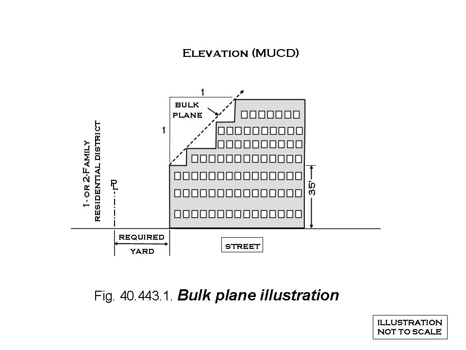
To encourage compatibility with surrounding land uses, buildings shall use bulk plane(s) only on façade(s) facing an abutting single-family or two-family residential zoning district. To match the maximum thirty-five (35) foot maximum height allowed by right in single-family and two-family residential zoning districts the bulk plane(s) shall begin at a horizontal line located directly above the line(s) created by the setbacks at a height of thirty-five (35) feet, rising over the lot upward at a 45-degree angle equal to a pitch or slope of one (1) foot of vertical distance for each one (1) foot of horizontal distance. See Figure 40-443.1.
(2)
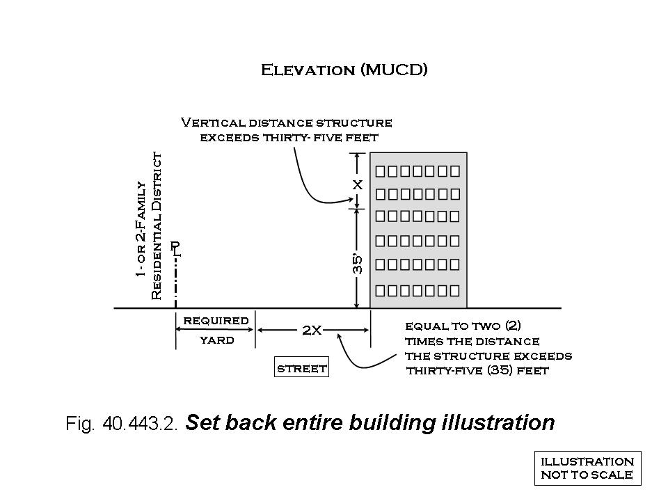
To encourage compatibility with surrounding land uses, buildings on lots that abut single-family or two-family residential zoning districts and do not meet the requirements of section 40-443(b)(1) listed above shall increase only the yard(s) abutting any single-family or two-family residential zoning district. In addition to the minimum yard requirement of this district, the abutting yard shall be increased by locating the entire building a minimum horizontal distance measured from the lot line abutting the single-family or two-family residential zoning district to the base of the building and equal to two (2) times the vertical distance the building exceeds thirty-five feet in height. See Figure 40-443.2.
(c)
Exceptions to the maximum height allowed by right for multiple-family dwellings. Multiple-family dwellings composed of fifty (50) or more units may exceed the maximum height allowed by right in this district if the building meets the following requirements in addition to all other applicable requirements of this district:
(1)
Site plan. Site plan submittal and review shall be conducted in accordance with the site plan review requirements of this district.
(2)
Proximity to residential districts. See Figure 40-423.1, Building height based on proximity to residential zoning districts, and Figure 40-423.2, Building height unlimited. To encourage compatibility with adjacent residential developments, the following shall apply:
a.
Buildings greater than sixty-five (65) feet in height shall be located in their entirety a minimum distance measured, without regard to intervening structures, from the nearest lot line of the nearest one-, two-, three-, or four-family residential zoning district including any of the following districts: Suburban District (S1), Single-Family Residential District (R1A), Suburban Residential District (R1B), Rural Residential District (R1C), Rural Residential District (R1D), Manufactured Home District (R1MH), Two-Family Residential District (R2), Three- and Four-Family Residential District (RR3), Townhouses (R1TH), to the nearest exterior structural wall of the building to the one-, two-, three-, or four-family residential zoning district and equal to the maximum height of the entire building up to two hundred (200) feet.
b.
The above requirement shall not apply to buildings located in their entirety more than two hundred (200) feet from any of the above-mentioned one-, two-, three-, or four-family residential zoning districts as measured, without regard to intervening structures, from the nearest lot line of the nearest one-, two-, three-, or four-family residential zoning district to the nearest exterior structural wall of the building to the one-, two-, three-, or four-family residential zoning district.
(3)
Yards. Yards that abut any of the following one-, two-, three-, or four-family residential zoning districts: Suburban District (S1), Single-Family Residential District (R1A), Suburban Residential District (R1B), Rural Residential District (R1C), Rural Residential District (R1D), Manufactured Home District (R1MH), Two-Family Residential District (R2), Three- and Four-Family Residential District (RR3), Townhouses (R1TH) shall have a depth of twenty (20) feet, landscaped in accordance with the requirements of this section. Yards for developments that do not abut the above listed one-, two-, three-, or four-family residential zoning district shall comply with the yard area requirements of this zoning district.
(4)
Location. The development site shall front only on a collector street or a major or minor arterial. Exempt from this requirement are those properties located in the area identified in Figure ES-1 of the Metairie CBD Land Use and Transportation Plan as adopted by Ordinance No. 21987 on September 17, 2003 and also identified as the area bounded on the north by west Esplanade Avenue and the Lake Pontchartrain lakefront, on the east by Metairie Lawn Drive, Tolmas Drive, and Ridgelake Drive, on the west by North Hullen Street, and Division Street, and on the south by West Napoleon Avenue.
(5)
Frontage. In a multi-frontage development site, for purposes of this section and in accordance with the relevant provisions in this section, any frontage that permits a height greater than the maximum height allowed by right shall qualify the building(s) on that site to be of a height greater than the maximum height allowed by right. Notwithstanding any other provisions in this Code regarding required yards for corner lots and through lots, the only required front yard for all other purposes related to such a development site shall be located on the frontage that permits a height that exceeds the maximum height allowed by right.
(6)
Access. Primary access to the development site shall be provided only from a collector street, or a major, or minor arterial; however, secondary access from a local street or neighborhood collector shall be permitted if the access point is not located across from the following one-, two-, three-, or four-family residential zoning districts: Suburban District (S1), Single-Family Residential District (R1A), Suburban Residential District (R1B), Rural Residential District (R1C), Rural Residential District (R1D), Manufactured Home District (R1MH), Two-Family Residential District (R2), Three- and Four-Family Residential District (RR3), Townhouses (R1TH) and is located within two hundred (200) feet of the street providing primary access to the development site, measured in a straight line from the lot line at the primary street frontage, along the lot line where the secondary access is proposed. Exempt from this requirement are those properties located in the area identified in Figure ES-1 of the Metairie CBD Land Use and Transportation Plan as adopted by Ordinance No. 21987 on September 17, 2003 and also identified as the area bounded on the north by west Esplanade Avenue and the Lake Pontchartrain lakefront, on the east by Metairie Lawn Drive, Tolmas Drive, and Ridgelake Drive, on the west by North Hullen Street, and Division Street, and on the south by West Napoleon Avenue.
(7)
Traffic impact analysis and adequate public facilities. To ensure adequate transportation access and to minimize impacts on the transportation network, the applicant shall provide to the parish: 1) a traffic impact analysis for any development comprised of thirty (30) or more units or any development that meets the threshold requirements in accordance with parish policy in effect at the time of application; and 2) any improvements reasonably necessary to meet the needs of the development which are clearly and substantially related to the development. The parish shall be the final arbiter of which improvements are reasonably necessary to meet the needs of the development. The development shall not be approved unless and until adequate transportation facilities exist or provision has been made for essential transportation facilities as determined by the parish.
(8)
Public works impact analysis and adequate public facilities. To ensure adequate public infrastructure and to minimize impacts on the public works systems, the applicant shall provide to the parish a public works impact analysis for the development and shall provide any improvements reasonably necessary to meet the needs of the development which are clearly and substantially related to the development. The parish shall be the final arbiter of which improvements are reasonably necessary to meet the needs of the development. The development shall not be approved unless and until adequate public facilities exist or provision has been made for the following essential public facilities, in accordance with the threshold or service level requirements of parish policy in effect at the time of application: water, sewerage, drainage, streets, fire protection and any other provisions for public facilities as determined by the parish.
(9)
Levee impact. Federal, state, and parish agencies regulate the type and location of improvements for flood and hurricane protection and work within various distances from the river, lakes, levees, and floodwalls in the parish. To avoid adverse impacts on the flood and hurricane protection systems and to ensure continuous and uninterrupted access for maintenance and monitoring, the applicant shall obtain all permits or other types of authorizations required by the U.S. Army Corps of Engineers ("the Corps"), the appropriate state agencies including the appropriate Levee District(s), and Jefferson Parish in accordance with the regulations of these agencies for any project proposed within the areas regulated by such agencies.
(10)
Landscaping.Section 33-6.25, Landscaping, buffering, and screening, shall apply.
(11)
Lighting. The maximum height for any light fixture is forty (40) feet, except on the side or sides of a development abutting a one- to four-family residential district, in which case the maximum height of twenty-five (25) feet shall be allowed. All light structures shall be shaded or hooded and oriented inward so as to prevent intrusion into surrounding areas.
(12)
Signs. Signs shall conform to section 40-448, Sign regulations, of this district. Signage for each ground-floor commercial use that is shall be permitted in accordance with the regulations of this district.
(13)
Parking. Parking shall be provided as set forth in Article XXXV, Off-Street Parking, Loading, and Clear Vision Area Regulations.
(14)
Service bays and drives. To mitigate the negative effect of service areas such as noise, odor, refuse, and visual pollution, the following criteria shall apply:
a.
Service bays, service drives, trash receptacle and dumpster areas, and support structures shall not be located on any side of the development abutting the following 1-, 2-, 3-, or 4-family residential zoning districts: Suburban District (S1), Single-Family Residential District (R1A), Suburban Residential District (R1B), Rural Residential District (R1C), Rural Residential District (R1D), Manufactured Home District (R1MH), Two-Family Residential District (R2), Three- and Four-Family Residential District (RR3), or Townhouses (R1TH). In such cases where this is not possible, an additional five (5)-foot landscaping and buffer strip shall be required in addition to the yard requirements for development that exceeds the height allowed by right in this district.
b.
Service bays and drives and trash receptacle and dumpster areas shall be oriented in such a way that in the process of loading and unloading, no vehicle will block the passage of other vehicles on the service drive or extend into any other public or private street.
c.
All service bays, loading and unloading areas, trash receptacles and dumpster areas must be screened on all sides by a wood, brick, or masonry fence with a minimum height of seven (7) feet.
d.
All dumpster areas shall comply with the requirements of chapter 16 garbage and other solid waste, section 16-4(d) bulk waste containers. In situations where the regulations of that chapter and the regulations of this article are in conflict, the more restrictive shall apply.
(15)
Sidewalks. Continuous sidewalks connecting any existing sidewalks shall be provided along public rights-of-way.
(16)
Fire department vehicle access, water supply, and communications. To provide access for emergency fire suppression response vehicles and to ensure adequate water supply the following criteria shall be met in addition to the currently adopted National Fire Code, International Building Code, and Life Safety Code standards. The Jefferson Parish Fire Department shall review the submitted site plan for compliance with all applicable fire regulations.
a.
Access. The following minimum criteria for emergency fire suppression response vehicle access shall be required:
1.
Two (2) hard-surfaced fire vehicle access roads with twenty-foot minimum width for one-way traffic and twenty-four-foot minimum width for two-way traffic installed on two (2) adjoining sides of all buildings that exceed the height permitted by right, located at a minimum distance of ten (10) feet from the building and a maximum distance of thirty (30) feet from the building as measured from the nearest exterior building wall to the edge of roadway nearest to the building wall
2.
Fire vehicle access roads shall be located so that at least seventy-five (75) percent of the two (2) adjoining sides of the building that exceeds the height permitted by right are accessible from the road
3.
All fire vehicle access roads shall be connected to and accessible from the main vehicle entrance to the development site
4.
A parking lot drive aisle shall be considered part of a fire vehicle access road provided it meets all required criteria.
5.
A street shall be considered a fire vehicle access road provided it meets all required criteria.
b.
Water supply. The following minimum criteria for adequate water supply shall be required:
1.
Two (2) fire hydrants capable of supplying not less than twenty-five hundred (2,500) gallons per minute (gpm) of water located within fifty (50) feet of all buildings that exceed the height permitted by right, and
2.
Additional fire hydrants capable of supplying not less than twenty-five hundred (2,500) gallons per minute (gpm) of water shall be located so that all portions of the exterior walls of all buildings that exceed the height permitted by right are no more than four hundred (400) feet from any fire hydrant.
(17)
Communications. The following minimum criteria for adequate emergency fire communications shall be required:
a.
A radio repeater shall be required for structures that exceed one hundred (100) feet in height.
b.
Multiple radio repeaters shall be required for structures that exceed two hundred (200) feet in height.
(Ord. No. 20783, § 3(XIII-F(3)), 9-22-99; Ord. No. 22794, § 11, 7-19-06; Ord. No. 23330, § XXIII, 6-11-08; Ord. No. 23292, § 22, 5-7-08; Ord. No. 23663, § 1, 10-14-09; Ord. No. 24823, § XIV, 9-17-14; Ord. No. 25405, § 68, 8-9-17)
Sec. 40-444. - Area regulations.
(a)
Yard requirements for multiple-family dwellings that exceed the maximum height allowed by right are located in the height regulations section of this district.
(b)
Setbacks.
(1)
Front yard.
a.
All structures, other than fountains, clock towers or other architectural feature within the landscaping, shall have a minimum front yard of twenty (20) feet from the front lot line, unless otherwise provided for in section 40-442(b)(2).
b.
The required front yard shall be the minimum front building setback and shall be landscaped in accordance with section 33-6.25, Landscaping, buffering, and screening. No parking or paving shall be allowed in the required front yard except for sidewalks or approved driveways directly connecting the development site to the adjacent street. Notwithstanding provisions in Chapter 33 that establish lot frontage, for purposes of applying MUCD landscaped buffer requirements in the required yards of a corner lot and as determined by the planning director, the required front yard shall be located on the street with the higher classification in the parish thoroughfare plan, or if the streets have equal classification, it shall be located on the street upon which the building has its primary entrance.
c.
On through lots the required front yard shall be provided on both streets and shall be landscaped in accordance with section 33-6.25, Landscaping, buffering, and screening.
(2)
Side yard.
a.
All buildings shall be a minimum of ten (10) feet from the side lot line, lease line, or designated development site boundary.
b.
On the side of the lot abutting any of the following 1-, 2-, 3-, or 4-family residential zoning districts: Suburban District (S1), Single-Family Residential District (R1A), Suburban Residential District (R1B), Rural Residential District (R1C), Rural Residential District (R1D), Manufactured Home District (R1MH), Two-Family Residential District (R2), Three- and Four-Family Residential District (RR3), Townhouses (R1TH), or on the side of a non-residential structure adjacent to a stand alone 1-, 2-, 3-, or 4-family residential structure, there shall be a side yard having a minimum width of fifteen (15) feet.
c.
Legal nonconforming lots of record established prior to the adoption of this section as amended shall provide a side yard as per the following schedule when abutting a nonresidential use or district:
d.
On corner lots the building setback on the side of the lot abutting the side street shall not be less than twenty (20) feet, within which the ten (10) feet closest to the street shall be landscaped in accordance with section 40-446(a)(3). If a development has a building setback greater in depth than the required minimum, no support building or structure shall be located any closer to the side street than the principal building.
(3)
Rear yard.
a.
All buildings shall be a minimum of ten (10) feet from the rear lot line, lease line, or designated development site boundary. On the rear of a lot abutting any of the following 1-, 2-, 3-, or 4-family residential zoning districts: Suburban District (S1), Single-Family Residential District (R1A), Suburban Residential District (R1B), Rural Residential District (R1C), Rural Residential District (R1D), Manufactured Home District (R1MH), Two-Family Residential District (R2), Three- and Four-Family Residential District (RR3), Townhouses (R1TH), or on the side of a non-residential structure adjacent to a stand alone 1-, 2-, 3-, or 4-family residential structure, there shall be a side yard having a minimum depth of twenty (20) feet.
(c)
Lot area.
(1)
For mixed use developments comprised of separate multiple-family residential structures and other permitted uses in the Mixed Use Corridor District, the area of the lot or designated development site occupied by multiple-family dwellings shall contain a minimum of eight hundred (800) square feet per family.
(2)
When a lot is improved for a residential use, or when living facilities are erected above or in connection with other uses in the same structure, the lot area per family regulation shall be the same as those in the R-3, Multiple-Family Residential District.
(3)
Lot area per family regulations shall not apply to dormitory buildings, or fraternity or sorority houses not having culinary facilities.
(d)
Site area requirements.
(1)
All development sites with multiple-family residential structures shall be a minimum of five (5) acres and have a minimum width of two hundred (200) feet and a minimum depth of five hundred (500) feet.
(2)
For all other developments in the Mixed Use Corridor District, minimum site area shall be ten thousand (10,000) square feet and have a minimum width of seventy-five (75) feed and a minimum depth of one hundred (100) feet. When two or more adjoining lots comprise a MUCD development site, such lots shall be resubdivided into one lot of record, except as provided for in section 33-5.22 Group development of this Code.
(Ord. No. 20783, § 3(XIII-F(4)), 9-22-99; Ord. No. 21388, § 2, 9-26-01; Ord. No. 22010, § 9, 10-8-03; Ord. No. 22011, § 1, 10-8-03; Ord. No. 22794, § 11, 7-19-06; Ord. No. 23663, § 1, 10-14-09; Ord. No. 24955, § 3, 6-10-15; Ord. No. 25405, § 69, 8-9-17; Ord. No. 25480, § 18, 1-10-18; Ord. No. 26351, § 19, 1-26-22)
Sec. 40-445. - Parking requirements.
(a)
Parking space requirements are listed in Article XXXV, Off-Street Parking, Loading, and Clear Vision Area Regulations in the Zoning Ordinance.
(b)
Additionally, said parking spaces shall be oriented so that no vehicle is required to back directly into a street right-of-way.
(Ord. No. 20783, § 3(XIII-F(5)), 9-22-99; Ord. No. 22794, § 11, 7-19-06; Ord. No. 23330, § XXIV, 6-11-08)
Sec. 40-446. - Landscape and buffer standards.
(a)
Section 33-6.25, Landscaping, buffering, and screening, shall apply, with the following additional provisions:
(1)
The landscaping requirements for developments that include separate multiple-family residential structures developed and integrated with other permitted uses shall be applied separately to the residential portion and the non-residential portion of the development site.
(2)
Developers are encouraged to incorporate waterscapes, fountains, clock towers and other architectural features excluding fences, with landscaping to add to aesthetics and visual attraction.
(b)
Development within the Mixed Use Corridor District. Different land uses within the Mixed Use Corridor District shall be landscaped and buffered appropriately and in general compliance with the landscape and buffer standards set forth in this section.
(c)
Visual clearance.
(1)
Sight triangles. In accordance with section 40-665, clear vision area regulations, access way and street intersection sight triangles shall be maintained.
(2)
Fences. Fences for the purposes of this ordinance shall not be considered structures.
(Ord. No. 20783, § 3(XIII-F(6)), 9-22-99; Ord. No. 21388, § 3, 9-26-01; Ord. No. 22010, § 10, 10-8-03; Ord. No. 22670, § 10, 1-11-06; Ord. No. 22794, § 11, 7-19-06; Ord. No. 23330, § XXV, 6-11-08; Ord. No. 23663, § 1, 10-14-09; Ord. No. 24823, § XV, 9-17-14; Ord. No. 24955, § 4, 6-10-15; Ord. No. 25405, § 70, 8-9-17)
Sec. 40-447. - General design standards.
(a)
Public service infrastructure and right-of-way.
(1)
Adequate public facilities are required in accordance with Chapter 33 Unified Development Code, Article 7, Adequate public facilities required of this Code.
(2)
Public right-of-way may be used to meet streetscape landscaping requirements, to locate vehicular display or parking that is not required off-street parking, to locate directional signs or a monument sign in lieu of an on-premises detached sign, or to locate fountains, clock towers, or other architectural structures, excluding fences, approved by the department of public works, subject to the following provisions:
a.
Use of parish public right-of-way shall be in accordance with the requirements of Chapter 2. Administration, sections 2-877, Lease of parish immovable, 2-877.1, Required information for proposals for real estate transactions, Chapter 29 Roads and bridges, section 29-6, Right-of-way obstruction and Chapter 32 Signs, section 32-5, Council permission as applicable; and use of state public right-of-way shall be in accordance with applicable state requirements.
b.
The parish may approve the use of right-of-way to meet requirements for streetscape landscaping or to provide vehicular display or parking that is not required off-street parking only in conjunction with the site plan review procedures of this article. For a monument sign in the right-of-way, the property owner requesting the monument sign for the adjacent property must submit an application for a minor amendment to an approved site plan if a site plan is in effect for the property. If no site plan is in effect and the monument sign is the only development approval requested, site plan review in accordance with this article is not required.
c.
If an application for site plan review includes a valid lease approved by the parish council or written authorization from the state for use of public right-of-way to meet requirements for streetscape landscaping in accordance with section 40-446(3)(c), and the application for development approval meets all other requirements of this Code, then Level 1 administrative site plan review may apply. If an application includes a variance to the MUCD regulations or features more than ten (10) feet of the required front landscaped area in the public right-of-way, then Level 2 site plan review shall apply and the council shall determine final action on the request by ordinance.
d.
All requests to locate parking in parish rights-of-way shall be predicated upon the proposed parking meeting the following:
1.
The proposed parking in the parish right-of-way is not required parking for the use on the abutting private property as determined by parking regulations established in Chapter 40.
2.
The proposed parking in the parish right-of-way is screened by a hedge, wall, earth berm, or other durable landscape barrier a minimum of two (2) feet in height between the remainder of the right-of-way and the parking area to screen the vehicular use area. If the barrier consists of nonliving material, one (1) vine or shrub shall be planted every ten (10) feet and abutting the barrier.
3.
The proposed parking in the parish right-of-way does not result in the removal of any required landscaping previously approved as part of site plan review.
4.
If an approved site plan exists, the site plan must be amended to show the parking and screening.
(b)
Transportation networks.
(1)
Adequate ingress, egress and internal circulation shall be provided to accommodate vehicular and pedestrian traffic, including walks, driveways, service bays and driveways, and off-street loading areas.
(2)
All areas subject to vehicular traffic, including accessways, service bays and drives, loading and unloading areas shall be paved with hard, all-weather material.
(3)
Pedestrian and vehicular traffic shall be separated with landscaped space.
(4)
The linking and coordination of parking areas between developments in the Mixed Use Corridor District shall be encouraged to reduce the number of turns onto and off of surrounding streets and reduce potential traffic conflicts.
(5)
The sharing and coordination of access ways such as driveways and service areas between developments in the Mixed Use Corridor District shall be encouraged to control the number of curb cuts and reduce potential traffic conflicts in the transportation network of the site and enhance the site as it relates to surrounding development.
(c)
Service bays/drives.
(1)
Service bays, service drives, trash receptacle and dumpster areas, and support structures shall not be oriented on the same side of the Mixed Use Corridor District development as abutting residential property. The purpose of which is to mitigate the negative effect of such service areas, such as noise, odor, refuse, and visual pollution from residential development. In such cases where this is not possible, an additional five (5)-foot landscaping and buffer strip shall be required in addition to that required in section 40-446(a)(2), perimeter of lot adjacent to abutting property.
(2)
Service bays and drives and trash receptacle and dumpster areas shall be oriented in such a way that in the process of loading and unloading, no vehicle will block the passage of other vehicles on the service drive or extend into any other public or private street.
(3)
All service bays, loading and unloading areas, trash receptacles and dumpster areas must be screened on all sides by a wood, brick, or masonry fence with a minimum height of seven (7) feet.
(4)
All dumpster areas shall comply with the requirements of chapter 16 garbage and other solid waste, section 16-4(d) bulk waste containers. In situations where the regulations of that chapter and the regulations of this article are in conflict, the more restrictive shall apply.
(d)
Curbs and curb cuts.
(1)
All curb cuts on street frontage shall be vertical curbs. No roll over curbs shall be permitted in the Mixed Use Corridor District. No curb cut shall be greater than twenty-five (25) feet at the lot line and thirty-five (35) feet at the curb line and/or in accordance with the established parish standards.
(2)
No curb cuts for freight lanes shall be greater than thirty-five (35) feet at the lot line and forty-five (45) feet at the curb line.
(3)
The number of curb cuts for any particular development shall be minimized to the greatest extent possible to provide for controlled ingress and egress within the Mixed Use Corridor District.
(e)
Lighting. The maximum height for any light fixture is forty (40) feet, except on the side or sides of a development abutting a residential use or on the side or sides of multiple-family development that exceeds the height permitted by right where abutting a one- to four-family residential district, in which case the maximum height of twenty-five (25) feet shall be allowed. All light structures shall be shaded or hooded and orientated inward so as to prevent intrusion into surrounding areas.
(f)
Play area. In multiple-family residential developments, safely located play areas shall be provided for small children as required.
(g)
Screening for support structures. Any part of a support structure that is not a building, other than playground equipment accessory to permitted uses in this district or those structures used for drive-up service, e.g. gas pumps, vacuum stations and ATMs, visible from street right-of-way shall be screened by a wood, brick or masonry fence with a minimum height of seven (7) feet.
(h)
Architectural treatment of metal buildings. Any building consisting of a metal exterior shall be designed and constructed such that the front building face, the side building face(s) on corner lots with street exposure, and at least five (5) feet of the adjoining side walls are finished with wood, brick, stucco, concrete blocks with architectural treatment, glass or other similar materials.
(i)
Architectural treatment of support buildings. Any support building on the lot or development site shall be designed and constructed with an architectural treatment similar to the principal building(s).
(j)
Minimum size of structures. Any structure, permanent or temporary, having a gross floor area of less than five hundred (500) square feet, is prohibited for use as a commercial structure or for a commercial purpose unless used in conjunction with construction work as permitted in Article XXXIX, section 40-742(d). Exceptions and modifications to use regulation, or is a support structure to the principal building as defined in this chapter.
(k)
Temporary structures or trailers. Notwithstanding any other provisions of the Jefferson Parish Code of Ordinances, temporary structures or trailers shall not be permitted in the MUCD except as follows:
(1)
Temporary structures or trailers for use as commercial structures or for a commercial purpose are permitted in a MUCD along traditional parade routes during the Mardi Gras season or for other seasonal street parades and for seasonal sales, including, but not limited to, a pumpkin patch, Christmas trees or similar use, lasting not more than ninety (90) days.
(2)
Commercial developments are allowed temporary structures or trailers that are to be used for special outdoor sales events. The use of the temporary structure or trailer must be associated with the principal use of the commercial development that occupies the petitioned property. The temporary structure or trailer shall not reduce the required off-street parking for the principal use, and additional off-street parking shall be provided for said temporary use.
(Ord. No. 20783, § 3(XIII-F(7)), 9-22-99; Ord. No. 21941, § 1, 8-6-03; Ord. No. 22794, § 11, 7-19-06; Ord. No. 23663, § 1, 10-14-09; Ord. No. 24823, § XVI, 9-17-14; Ord. No. 24955, § 5, 6-10-15; Ord. No. 25405, § 71, 8-9-17)
Sec. 40-448. - Sign regulations.
(a)
General. The following sign regulations supersede those of and take precedence over regulations specified in Article XXXVI General Sign Regulations of this chapter. However, for regulations on signs not addressed in this subsection of the Mixed Use Corridor District, Article XXXVI, General Sign Regulations, shall apply. For the purpose of this section, "development" refers to a site which is a lot or lots considered as a unit for development purposes. Sign regulations are designed such that all signs in the Mixed Use Corridor District shall be harmonious and in proportion to the development and structures served, particularly as far as height and size of the building(s). The following signs shall be permitted in the Mixed Use Corridor District:
(b)
Permitted signs.
(1)
Attached signs. Each use shall be allowed either one (1) attached flat sign or one (1) projecting sign subject to the following provisions:
a.
Permitted sign area.
1.
The allowable sign area shall be computed at one (1) square foot per linear foot of building width or individual tenant space width along the wall on which the business has its main entrance. In no case shall the area for any flat or projecting sign be greater than one hundred (100) square feet. Illuminated signs inside of windows and within five (5) feet of such windows shall be included in the computation of aggregate sign area and in addition shall be limited to ten (10) percent of the total glass area of the window in which the signs are placed. Neon tubing outlining a show window, shall be included in the sign area and measured by multiplying the length of the tubing by six (6) inches.
2.
Larger developments with a gross floor area of twenty-five thousand (25,000) square feet or more, meeting the following minimum setback schedule shall be allowed a larger attached sign area:
LARGE DEVELOPMENT
ATTACHED SIGN
AREA SCHEDULE
BUILDING
b.
Signs on lots with multiple frontage. One (1) additional attached sign located on a secondary building face shall be allowed on property with more than one (1) building frontage provided the following conditions are met:
1.
That the property is located at the intersection of a major or minor arterial as defined by the Jefferson Parish Thoroughfare Plan and excluding streets serving adjacent residential property, to protect such development from the intrusion of additional signage;
2.
The total attached sign area for the project is no more than one hundred fifty (150) percent of that allowed for the attached sign on the primary building face, as set in section 40-448(b)(1);
3.
The sign area for any attached sign taken independently does not exceed the square footage allowed for attached sign located on the primary building face as set in section 40-448(b)(1);
4.
A corresponding amount of landscaping in identical square footage to the additional attached sign area is provided on that side of the property on which the additional attached sign is located, in addition to the basic landscaping requirements delineated in section 40-446, landscape and buffer requirements.
c.
Permitted dimensions. In every case the height of any flat or projecting sign measured from the bottom to the top shall be no greater than one-half (½) the width from one (1) side to the other. No projecting sign shall extend more than five (5) feet from the face of the building.
d.
Permitted height. No sign shall be erected above the parapet level of the main building.
(2)
Awning and marquee signs. Awning or marquee sign area shall not exceed twenty (20) square feet per sign except that where an awning or marquee sign is used in place of an attached flat sign or a projecting sign, the awning or marquee sign shall not exceed the lesser of the allowable attached or projecting sign, or forty (40) percent of the vertical area of the awning or marquee on which the sign is located.
(3)
Detached signs. Each development shall be allowed one (1) on-premises detached sign except as noted in subsection d. below, subject to the following provisions:
a.
General design criteria for detached signs. Detached sign regulations for the Mixed Use Corridor District shall be intended to increase visibility for individual projects and developments in the corridor in general by minimizing the size, height and number of detached signs and reducing competition among signs in the corridor. Low "eye level" monument type signs mounted on earth berms shall be encouraged and preferred over signs mounted on standard poles. Identification of particular projects may be emphasized by incorporating the detached sign within required landscaping and with unique, creative architectural features including but not limited to clock towers and waterscapes, such as water fountains and waterfalls.
b.
Permitted sign area. The allowable sign area shall be computed at one (1) square foot per linear foot of street frontage (being the width of the lot or development site along the adjacent public right-of-way) up to two hundred (200) square feet. Multi-tenant developments may add an additional twenty (20) square feet of detached signage per tenant up to a maximum of three hundred (300) square feet.
c.
Secondary signs on through lots. A second sign may be erected on the second front of a through lot provided the following additional provisions are met:
1.
The maximum area of the second sign is seventy (70) square feet.
2.
The maximum area of the second sign is twenty (20) square feet if the through lot is located across from, adjacent to or within seventy-five (75) feet of a residential development or district.
3.
Section 33-6.25, Landscaping, buffering, and screening, shall apply.
d.
Minimum setback. The minimum setback for a detached sign shall be ten (10) feet from the lot line, unless otherwise provided below.
e.
Permitted height.
1.
Standard height. The height of a detached sign shall be a maximum of twenty (20) feet.
2.
Conditional additional height. Additional height shall be permitted for a detached sign up to a maximum of thirty (30) feet provided an additional one-foot setback for every foot of height over twenty (20) feet is provided. The sign shall be located within a landscaped area of twenty-five (25) square feet or more.
3.
Monument type detached sign. If a monument type detached sign is employed, a twenty-five (25) percent increase in the permitted attached sign area shall be allowed. For the purpose of this section, a monument sign shall be limited to six (6) feet in height and not more than sixty (60) square feet and section 33-6.25, Landscaping, buffering, and screening, shall apply.
4.
No detached signs. If no detached sign of any kind is employed on the development site, a twenty-five (25) percent increase in the permitted attached sign area shall be allowed.
f.
Permitted materials. The sign shall be constructed of metal or wood, or encased in a wood frame or other such materials which compliment and coordinate with the architectural style of the development.
g.
The total depth of the detached sign shall not exceed five (5) feet.
(4)
Menu boards. Menu boards servicing drive-up (drive-through) restaurants shall be permitted provided that:
a.
Number. Only one (1) menu board shall be permitted per drive-through lane.
b.
Landscaping required.Section 33-6.25, Landscaping, buffering, and screening, shall apply.
c.
Visibility from street right-of-way. The menu board shall not be visible from the street right-of-way from which the primary access to the premises is obtained.
d.
Setbacks.
1.
The menu board shall not be located within the first twenty (20) feet of the front of the development site.
2.
The menu board shall be located a minimum of twenty (20) feet from any lot line abutting residential property.
e.
Sign area. The menu board shall have a maximum area of forty-eight (48) square feet.
f.
Sign height. The menu board shall have a maximum height of eight (8) feet.
g.
Sound system. The sound system associated with a menu board shall be oriented and adjusted in such a way that resulting noise does not intrude into surrounding development in compliance with the applicable provisions of section 20-102. Noise, of the Code of Ordinances of Jefferson Parish.
(5)
Temporary signs. Temporary signs shall be governed by general regulations set forth in Article XXXVI, General Sign Regulations.
(6)
Directional signs.
a.
Directional signs shall be excluded from the sign area calculation for both permitted attached and detached signs.
b.
Each directional sign shall have a maximum area of six (6) square feet.
c.
Detached directional signs shall have a maximum height of eight (8) feet above grade.
d.
Directional signs may be illuminated but shall not flash, blink or fluctuate.
e.
A directional sign shall not be an animated sign.
(7)
Nonconforming signs.
a.
All signs not in conformance with the provisions of this district, including off-premises signs erected prior to the enactment of this district but not in compliance with zoning regulations then in force, shall be terminated as provided in subsection b. below. Such signs may continue in operation and be maintained after the placement or effective date of the Mixed Use Corridor District provided that the burden of establishing that the sign is legally nonconforming rests entirely with the person claiming such status for a sign and subject to the following:
b.
All illegally erected off-premises signs and all nonconforming signs not in conformance with the provisions of the Mixed Use Corridor District shall be terminated as follows:
1.
Abandonment of thirty (30) days shall immediately terminate the right to maintain such sign.
2.
Whenever such sign is damaged, destroyed or becomes obsolete for any cause whatsoever, including Acts of God, the right to maintain such sign is immediately terminated.
(8)
Electronic variable message signs. Electronic variable message (EVM) signs in accordance with section 40-681 shall meet the following additional criteria:
a.
Number. Only one (1) detached EVM sign shall be permitted on a development site.
b.
Sign area. The EVM portion of the sign shall comprise no more than fifty (50) percent of the allowable detached sign area or one hundred (100) square feet, whichever is less.
c.
Residential proximity. EVM signs shall be located a minimum of one hundred fifty (150) feet from any residential district.
d.
Variances. A variance may be granted for an EVM sign under the provisions set forth in section 40-792 of this Code.
(c)
Prohibited signs. The following signs shall be prohibited:
(1)
Flashing signs and signs with animated and scintillating lights.
(2)
Off-premises signs.
(d)
Conditions for sign compliance to MUCD.
(1)
All signs not in conformance with the provisions of this section, including off-premises signs, shall be subject to the conditions stated in conditions for sign compliance, below. The burden of establishing a sign as legally nonconforming rests entirely with the person claiming such status for a sign.
(2)
Conditions for sign compliance.
a.
Existing signs which undergo a total replacement or change in height or area shall fully conform to section 40-448, sign regulations. Normal maintenance of existing signs or changes in the face are not included under this provision.
b.
Whenever a nonconforming sign is replaced it shall comply with the MUCD regulations.
c.
Signs relocated on the same or different premises within the MUCD shall comply with the MUCD regulations.
(e)
Nothing in this section shall be construed so as to allow any illegal sign in a MUCD to be considered a nonconforming sign.
(Ord. No. 20783, § 3(XIII-F(8)), 9-22-99; Ord. No. 23292, § 23, 5-7-08; Ord. No. 23643, §§ 1, 2, 9-23-09; Ord. No. 23663, § 1, 10-14-09; Ord. No. 23938, § 3, 1-12-11; Ord. No. 24364, § XXXV, 11-7-12; Ord. No. 25405, § 72, 8-9-17; Ord. No. 26490, § 24, 9-28-22)
Sec. 40-449. - Development review procedures in the Mixed Use Corridor District.
(a)
General review procedures. Requests for development and redevelopment in the mixed use corridor district shall be submitted to the Jefferson Parish Planning Department. Upon review of complete site plans, the Planning Department shall determine the level of site plan review required for the particular project. The applicant shall submit fully detailed development plans in accordance with section 40-450, site plan submittal, to the planning department. Development review procedures for each of the site plan review levels shall be as follows:
(1)
Level 1 site plan review. Level 1 site plan review shall apply to non-residential developments which fully meet the mixed use corridor district regulations. When the planning department determines that the mixed use corridor district regulations are fully met, the development project may proceed to the building permit process.
(2)
Level 2 site plan review. Level 2 site plan review shall apply to all mixed-use developments containing residential uses as well as all non-residential developments which do not fully meet the mixed use corridor district regulations and request a variance, in accordance with the following provisions:
a.
When the planning department determines that the MUCD regulations are not fully met and a variance is included in the development proposal, the site plan submittal shall be reviewed in accordance with section 40-449(d), application for site plan review, the final disposition of which shall be determined by the Jefferson Parish Council.
b.
A variance to the Mixed Use Corridor District regulations may be granted by the Jefferson Parish Council through the site plan review process for the Mixed Use Corridor District provided the variance is consistent with the criteria specified in section 40-442, District Composition, paragraph (e), site plan review.
c.
If the development proposal meets all of the requirements of the mixed use corridor district regulations except the sign regulations and the applicant has requested a sign variance that if granted would not affect the location of a substantial development feature including, but not limited to, a building or other structure, required parking, or required landscaping, then the department of building permits may issue a building permit for all improvements except signs. A sign permit shall not be issued until final disposition of the sign variance by the parish council. Within five (5) days of determination that the development proposal meets all of the MUCD requirements except the sign regulations, the planning department shall notify the department of building permits in writing of the determination.
(b)
Development existing prior to the establishment of the mixed use corridor district. Changes in use, additions or renovations to existing development established prior to the MUCD shall be reviewed by the planning department, which will determine the level of site plan review required in accordance with section 40-449(a), general review procedures.
(1)
Conditions for compliance. Development proposals meeting any of the conditions below shall be required to comply with the criteria set in this paragraph for development existing prior to the MUCD:
a.
Changes in use. If there is a change in the permitted use involving an increase in required parking.
b.
Additions. If there is an addition to any structure involving an increase in twenty-five (25) percent or more to the size of the original development or structure.
c.
Renovations. If there is a renovation of any structure which exceeds fifty (50) percent or more of the fair market value of the existing structure, as shown by the most recent tax assessment.
(2)
Signs.
a.
New signs. All new signs shall conform to the Mixed Use Corridor District regulations specified in section 40-448 of this section.
b.
Existing signs. Existing signs which undergo a total replacement or change in height or area shall fully conform to section 40-448, Sign Regulations. Normal maintenance of existing signs or changes in the face are not included under this provision.
(3)
Landscaping and buffering standards for existing development:
a.
Changes to developments existing prior to the MUCD meeting any of the conditions for compliance specified in section 40-449(b)(1) above shall be required to landscape a minimum of ten (10) percent of the development site. The required landscaping shall generally follow landscaping requirements set in section 40-446, landscaping and buffer requirements, subject to space limitations of the existing development.
b.
The trash disposal system shall be completely screened from view from public rights-of-way and adjacent properties by a wood, brick or masonry fence with a minimum height of seven (7) feet.
(4)
Parking.
a.
The proper number of parking spaces for the land use(s) included in the development shall be provided in accordance with Article XXXV, Off-Street Parking, Loading, and Clear Vision Area Regulations.
b.
No existing legal required parking space(s) shall be deleted to comply with the requirements set above in section 40-449(b)(3), Landscaping and Buffer Standards for Existing Development or below in section 40-449(b)(5) Support Buildings and Structures.
(5)
Support buildings and structures. New support buildings or structures or the relocation on the same development site of existing support buildings or structures shall, subject to space limitations, comply with all MUCD requirements for support buildings and structures.
(c)
Nonconforming lots of record within the MUCD.
(1)
Development proposals on lots less than ten thousand (10,000) square feet within the MUCD shall be submitted to the Jefferson Parish Planning Department, which will determine the level of site plan review required in accordance with section 40-449(a), general review procedures.
(2)
Lots which do not meet the site area or other requirements delineated in section 40-444, Area Regulations, shall follow the landscaping requirements for developments existing prior to the establishment of the MUCD in section 40-449(b)(3), Landscaping and Buffer Standards for Existing Development.
(d)
Application for site plan review.
(1)
Pre-application conference. Prior to the submission of an application for development review, a pre-application conference with a designated representative of the planning department is required. The purpose of the pre-application conference is to thoroughly discuss the proposal and regulations specified in the Mixed Use Corridor District.
(2)
Application.
a.
An application for site plan review in a Mixed Use Corridor District shall be filed with the planning department and shall contain the following information:
1.
Interest and ownership. The applicant's name, address and interest in the application, and the name, address and interest of every person, firm or corporation represented by the applicant in the application; the concurrence of the owner or owners of the entire land included in the proposed plan and all encumbrances of such land; and sufficient evidence to establish that the applicants are all the owners and encumbrances of the designated area, and have the ability to do so.
2.
Development plans. The applicant shall submit site plans with the information listed and procedures set in section 40-450, site plan submittal, and any other information as may be necessary to describe completely the mixed use corridor district development.
3.
Ordinance and legal attachments. An ordinance and all other legal attachments relative to the mixed use development are required at the time of application in the format specified by the Jefferson Parish Clerk of Council.
4.
Administrative examination.
i.
Upon receipt of a complete application with all information properly supplied as specified within this Code, the planning director shall forward the site plan to the Land Use Review Technical Committee (LURTC) for review and comment prior to action. Lack of findings from LURTC within ten (10) days shall be construed as no objection to approval.
ii.
After evaluating LURTC comments and the site plan's compliance with applicable development regulations, the planning director shall approve the site plan or make a recommendation regarding approval of the site plan and forward it to the planning advisory board and council for action in accordance with Article XLVIII, Changes and Amendments for general procedures not specified in section 40-449, by the next available advertisement deadline.
5.
Effect of approval. The approved site plan, as indicated by the dated signature of the council chairperson or planning director, as applicable, shall govern development and use of the property until a new or amended site plan is approved. Until a site plan is approved, no building or structure shall be erected, added to, or structurally altered; no parking lot shall be paved, added to, or structurally altered; and, no building permit or certificate of completeness shall be issued. Any deviation from the approved site plan is a violation of this Code.
(3)
Minor changes in approved Mixed Use Corridor District site plans.
a.
Minor changes needed to facilitate construction and site improvements are permitted, if such minor changes will not change the character of the approved development, nor increase the density, gross floor area, intensity of use, or ground coverage. Further no increase of total building site area, in spaces between building, the ratio of off-street parking and off-street loading area to gross floor area, or gross floor area shall be considered. No change shall be deemed minor to the approved Mixed Use Corridor District site plan that alters the approved permitted uses.
b.
The director of planning shall review and determine what constitutes a minor or major change for an approved Mixed Use Corridor District site plan and be responsible for making minor changes on the site plan, if the request is approved. Appeals of said decision by the planning director shall be forwarded to the planning advisory board for review, where a majority vote of the members shall be required to override the decision of the planning director concerning said minor change. Otherwise, an amendment to the Mixed Use Corridor District site plan shall be required, in accordance with procedures delineated in section 40-449(d)(4), Amendment or Withdrawal of Mixed Use Corridor District Site Plan.
(4)
Amendment of Mixed Use Corridor District site plan. Pursuant to the same procedure and subject to the same limitations and requirements by which the Mixed Use Corridor District site plan was approved, any Mixed Use Corridor District site plan may be amended, either partially or completely, if all land and structures remaining under such Mixed Use Corridor District site plan comply with all conditions and limitations of the Mixed Use Corridor District, and all land and structures remaining under such Mixed Use Corridor site plan comply with all regulations established by the zoning ordinance and unrelated to the Mixed Use Corridor District.
(e)
Vested rights for new applications. To assure applicants that development applications will be processed in accordance with the rules in effect at the time of submittal of a completed application, section 33-4.20, Vested rights for new applications, in Article 4, Non-Conforming Situations/Vested Rights of Chapter 33, UDC, of this Code, shall apply to MUCD applications for site plan review.
(Ord. No. 20783, § 3(XIII-F(9)), 9-22-99; Ord. No. 21388, § 4, 9-26-01; Ord. No. 22794, § 11, 7-19-06; Ord. No. 23330, § XXVI, 6-11-08; Ord. No. 23663, § 1, 10-14-09; Ord. No. 23938, § 4, 1-12-11; Ord. No. 24823, § XVII, 9-17-14; Ord. No. 24989, § XIII, 8-12-15; Ord. No. 24955, § 6, 6-10-15; Ord. No. 25744, § 12, 2-27-19; Ord. No. 26351, § 20, 1-26-22; Ord. No. 26490, § 25, 9-28-22; Ord. No. 26625, § 54, 6-14-23)
Sec. 40-450. - Site plan submittal.
The following minimum information shall be submitted to the planning department in the form of site plans for developments located in the mixed use corridor district:
(1)
The name of the developer, owner, north point, date and scale of the site plan.
(2)
A current certified survey showing existing lots and property boundaries, streets, rights-of-way, servitudes, buildings and building setbacks, surrounding streets and important physical features on and adjoining the property and their dimensions, and total square footage of the site. If the proposal includes a resubdivision, a separate survey shall include proposed lots, servitudes, rights-of-way and property to be revoked and dedicated.
(3)
Location and dimensions of all existing and proposed streets, driveways, entrances and exits, parking spaces, service bays and loading areas, sidewalks, traffic circulation patterns, directional signs and traffic signals.
(4)
Location, height and elevations of all existing and proposed structures showing setback dimensions, bulk plane(s) if applicable, use and type of materials and color schemes.
(5)
Total number of residential units and floor area in square feet.
(6)
Total number of non-residential units and floor area in square feet.
(7)
Floor plans of all structures and their uses showing main floor, typical floors, layout of individual units including any accessory uses with floor area in square feet.
(8)
A landscaping plan in accordance with section 33-6.25, Landscaping, buffering, and screening, including a tree survey if utilizing tree credit provisions.
(9)
A maintenance plan for landscaping to ensure a continuous healthy condition for plant material, and landscaped areas are kept free of debris.
(10)
The location, dimensions, area, type of materials and elevations of all signs and support structures.
(11)
Parking layout showing the number of required and proposed parking spaces.
(12)
Location of the trash disposal system and details of screening, including type, height and elevation of dumpster and fence.
(13)
Lighting plan of the site showing the location, number, type, height and materials of the fixtures.
(14)
Emergency services plan showing the location and dimensions of fire lanes, handicapped parking and the location of all fire hydrants within three hundred (300) feet of the site.
(15)
Total area of the site in square feet and the percentage of the site and total area in square feet to be used for open or green spaces, exclusive of parking area.
(16)
Zoning classification of the site, zoning classification and land use of surrounding property within a radius of three hundred (300) feet from the petitioned property.
(17)
Utilities inventory showing the location and size of existing water, sewerage, drainage and power lines, manholes, lift stations, ditches, canals and other watercourses within the vicinity and applicable to the Mixed Use Corridor District development.
(18)
A phasing schedule in accordance with section 40-451, Phased Development, as appropriate, when phasing of the project is employed.
(19)
Additional information as required by the department of building permits, planning department, planning advisory board, Jefferson Parish Council or other parish agency, depending on the nature and extent of the proposed development.
(Ord. No. 20783, § 3(XIII-F(10)), 9-22-99; Ord. No. 22794, § 11, 7-19-06; Ord. No. 25405, § 73, 8-9-17; Ord. No. 26625, § 55, 6-14-23)
Sec. 40-451. - Phased development.
(a)
Phasing requirements.
(1)
Multiphase development. Developments within a Mixed Use Corridor District may be developed in phases, provided that the following criteria are met:
a.
For developments with non-residential uses, the more restrictive land uses and the necessary off-site improvements are completed first. For developments with separate multiple-family residential structures developed and integrated with other permitted uses, the non-residential uses and the necessary off-site improvements shall be completed first.
b.
Each phase can function and can be utilized independently of subsequent phases.
c.
At the time of the application the applicant submits a phasing schedule in accordance with section 40-450, Site Plan Submittal, containing the following information:
1.
The number of phases in which the development will be built.
2.
The dates when the development of each phase is expected to begin and be completed. For the purposes of this article and references thereto, the "beginning or initiation of construction" of a development shall be the date on which a building permit is issued for the development or phase of the development and the completion of a development shall be the date on which a certificate of use and occupancy (temporary or regular) is issued for the development or phase of a development.
3.
The infrastructure and on-site improvements to be included in each phase including, but not limited to, service areas, access drives, parking spaces, landscaping and open space, buildings and other structures.
(2)
Single phase development. If no phasing schedule is provided at the time of the application, the applicant shall complete the development as a single phase including all on-site improvements required by this Code and delineated in the site plan submittal.
(b)
Time limitations.
(1)
Multiphase development. The applicant shall apply for and receive a building permit for at least one (1) phase of a multiple-phase development within one (1) year of site plan approval. The applicant shall have a maximum of five (5) years from the date the building permit is issued to complete all phases of the development unless the parish council or planning director approves an extension for the development.
(2)
Single phase development. The applicant shall apply for and receive a building permit within one (1) year of site plan approval. The applicant shall have a maximum of two (2) years from the date the building permit is issued to complete the development unless the parish council or planning director approves an extension for the development.
(3)
Failure to meet time limitations. Approval shall be vacated and site plan approval shall become null and void if a building permit has not been issued for single phase and multiphase development within the time limits prescribed above, including any extension(s), and no request for extension is pending. No building permits shall be issued for site plans that have been declared null and void. Nevertheless, such site plans may be submitted as a new application for review, and must conform to all site plan and review requirements in effect at the time of the later application.
(c)
Extensions.
(1)
Standards for extension. Upon a finding that unforeseen circumstances prevented completion within the approved time limitation, the planning department director may grant an extension for a period not to exceed six (6) months. If the planning director denies a request for an extension, the applicant may appeal the decision to the parish council. The parish council may grant extensions for periods greater than six (6) months subject to the following provisions:
a.
Single phase development. An extension for a single phase development may be granted by council resolution and shall not exceed a period of three (3) years.
b.
Multiphase development. An extension for a multiphase development shall be granted by ordinance for a period at the discretion of the council. If the council grants an extension the applicant shall submit a revised phasing schedule to the planning department for approval by the planning director.
(2)
Requests for extension. The applicant shall request an extension for the beginning of construction or completion of construction. The request, including information which explains the need for an extension, shall be made in writing to the planning director and must be received by the planning department within the original term to complete the project. Requests that require council action shall be processed in accordance with the procedures in Article XLVIII Changes and Amendments. The recommendations to the parish council for extension shall be based on a finding from the planning department and the planning advisory board that unforeseen circumstances prevented completion within the approved time limitation.
(Ord. No. 20783, § 3(XIII-F(11)), 9-22-99; Ord. No. 21388, § 5, 9-26-01; Ord. No. 22794, § 11, 7-19-06)
Sec. 40-452. - Regulations, requirements or standards.
Regulations, requirements or standards set in the Mixed Use Corridor District are not subject to appeal to the board of zoning adjustments. All requests for variances to the regulations of this article shall be a part of Level 2 site plan review.
(Ord. No. 20783, § 3(XIII-F(12)), 9-22-99; Ord. No. 21734, § 8, 12-11-02; Ord. No. 23663, § 1, 10-14-09)
Sec. 40-453. - Reserved.
Editor's note— Ord. No. 25744, § 13, adopted Feb. 27, 2019, repealed § 40-453, which pertained to title restrictions and derived from Ord. No. 20783, § 3(XIII-F(13)), adopted Sept. 22, 1999.
Sec. 40-454. - Applicable code regulations for development.
Development within a Mixed Use Corridor District shall meet all federal, state and local fire, safety and building codes, and all other applicable codes.
(Ord. No. 20783, § 3(XIII-F(14)), 9-22-99; Ord. No. 23663, § 1, 10-14-09)
Sec. 40-455. - Two-year limitation for petitions and amendments in Mixed Use Corridor District development.
Once an application for development in the Mixed Use Corridor District requiring Level 2 site plan review as defined in section 40-442(e), Site Plan Review, of this article, or an amendment to an approved site plan is filed and meets any of the following conditions:
(1)
Said petition or amendment is finally acted upon by the Jefferson Parish Council in accordance with the Mixed Use Corridor District regulations;
(2)
Said petition or amendment has received no action on the part of the council within one hundred twenty-six (126) days;
(3)
Said petition or amendment has been allotted a docket number and officially advertised for public hearing but has subsequently been withdrawn either before or after said public hearing has been conducted.
Then the same petition or the same amendment to an approved site plan for the same property meeting any of said conditions above shall not be considered by the council within two (2) calendar years from the date of the council's legal action on said petition or amendment, or from the expiration date of one hundred twenty-six (126) days from the public hearing originally scheduled for the case in the event no action was taken.
(Ord. No. 20783, § 3(XIII-F(15)), 9-22-99; Ord. No. 22322, § 2, 9-29-04)