
John Day City Zoning Code
ARTICLE 5
2 LAND USE DISTRICTS
19-179-03
22-202-13
22-201-12
5-2.1.010 Classification Of Land Use Districts
Every parcel, lot, and tract of land within the City of John Day is designated with a land use (zoning) district. The use of land is limited to the uses allowed by the applicable land use district and/or overlay zone. The applicable land use districts and overlay zone(s) are determined based on the Land Use District Map and the provisions of this Chapter, which shall be consistent with the City of John Day Comprehensive Plan, as indicated in Table 5-2.1.010.
Table 5-2.1.010
| Comprehensive Plan Designation | Applicable Land Use District |
| Residential Limited | RL |
| Residential General | RG |
| Residential Limited or Residential General | Residential Commercial (RC) allowed with rezoning |
| Downtown | Downtown |
| General Commercial | General Commercial |
| General Industrial | GI |
| Light Industrial | LI |
| Airport (Ogilvie Field) | Airport Industrial Park (AIP) |
| Overlay/Combining Zones | |
| Airport Approach | Airport Safety & Compatibility Overlay (AASC) |
| Geological Hazard | GH |
| Park Reserve | PR |
| Greenway | GW |
| Floodplain | FP |
| Public Facilities | PF |
5-2.1.020 Land Use District Map
- Consistency with Land Use District Map. The boundaries of the land use districts contained within this chapter shall coincide with the land use district boundaries identified on the City’s official zoning map, retained by the City Recorder. Said map by this reference is made a part of this Development Code. The City shall maintain the official zoning map, and any map amendments.
- Applicability of land use standards. Each lot, tract, and parcel of land or portion thereof within the land use district boundaries designated and marked on the zoning map, is classified, zoned and limited to the uses hereinafter specified and defined for the applicable land use district.
5-2.1.030 Determination Of Land Use District Boundaries
Where due to the scale, lack of scale, lack of detail or illegibility of the City zoning map, or due to any other reason, there is uncertainty, contradiction or conflict as to the intended location of a district boundary line, the boundary line shall be determined by the Planning Official in accordance with all of the following criteria:
- Rights-of-way. Boundaries indicated as approximately following the centerlines of streets, highways, railroad tracks, alleys, irrigation canals, bridges, or other right-of-way shall be construed to follow such centerlines. Whenever any public right-of-way is lawfully vacated, the lands formerly within the vacated right-of-way shall automatically be subject to the same land use district designation that is applicable to lands abutting the vacated areas. In cases where the right-of-way formerly served as a land use district boundary, the lands within the right-of-way now vacated shall be allocated proportionately among the subject land use districts;
- Parcel, lot, tract. Boundaries indicated as approximately following the boundaries of a parcel, lot, or tract shall be construed as following such boundaries;
- Jurisdiction boundary. Boundaries indicated as approximately following a City or County boundary, or the Urban Growth Boundary, shall be construed as following said boundary; and
- Natural features. Boundaries indicated as approximately following a river, stream, drainage channel, drainage basin, topographic contour or other changeable natural feature not corresponding to any feature listed in subsection A-C, above, shall be construed as following such feature, except that the location may be corrected administratively through a Code Interpretation procedure, in accordance with Chapter 5-4.8.
5-2.2.010 Residential Districts - Purpose
The Residential Districts are intended to promote the livability, stability and improvement of the City’s neighborhoods. Three districts are provided: 1) The Residential Limited (RL) district is intended to accommodate a wide variety of housing types, including attached and detached housing on small to medium size lots in the neighborhoods close to downtown. The RL district also supports parks, schools, places of worship, and other services at an appropriate neighborhood scale; 2) The Residential General (RG) district is intended to accommodate household living at somewhat lower densities than the RL district because it applies to the hillsides of John Day; and 3) The Residential-Commercial (RC) district is intended to encourage business formation, housing options, and transportation efficiency by combining a variety of housing, like that allowed in the RL district, with public and commercial services at an appropriate neighborhood scale. This chapter provides standards for land use and development in each of the three districts, based on the following principles:
- Promote the orderly expansion and improvement of neighborhoods.
- Make efficient use of land and public services and implement the Comprehensive Plan.
- Designate land for the range of housing types and densities needed by the community, including owner-occupied and rental housing.
- Provide flexible lot standards that encourage compatibility between land uses, efficiency in site design, and environmental compatibility.
- Provide for compatible building and site design at an appropriate neighborhood scale; provide standards that are in character with the landforms and architecture existing in the community.
- Apply the minimum amount of regulation necessary to ensure compatibility with existing residences, schools, parks, transportation facilities, and neighborhood services.
- Reduce reliance on the automobile for neighborhood travel and provide options for walking, bicycling.
- Provide direct and convenient access to schools, parks and neighborhood services.
- Maintain and enhance the City’s historic character and traditional neighborhoods.
5-2.2.020 Residential Districts - Allowed Land Uses
Table 5-2.2.020 identifies the land uses that are allowed in the Residential Districts. The specific land use categories are described and uses are defined in Chapter 5-1.3.
| Table 5-2.2.020 Land Uses Allowed in Residential Districts (RL, RG, RC) | ||||
| Uses | Status of Use in District | |||
| Use Categories (Examples of uses are in Chapter 5-1.3; definitions are in Chapter 5-6.1) | Residential Limited (RL) | Residential General (RG) | Residential Commercial (RC) | [Reserve] |
| Residential Categories | ||||
| Household Living | ||||
| Single Family (not attached) | P | P | P | |
| Accessory Dwelling, per Section 5-2.2.100A. | S | S | S | |
| Duplex (2 dwellings sharing a common wall on one lot) | ||||
| - One duplex on a corner lot | P | P | P | |
| - One duplex on an interior lot | P | P | P | |
| - More than one duplex (4+ units), per Section 5-2.2.100B | S | S | S | |
| Single Family Attached (2 or more common-wall single family dwellings), each on its own lot, per Section 5-2.2.100B | S | S | S | |
| Cottage Cluster (2-4 single family dwellings on one lot, accessed via an alley and oriented to a common green of at least 200 sq ft per unit, and each unit containing not more than 1,000 square feet of floor area) | P | P | P | |
| Manufactured Home, per Section 5-2.2.100E | S | S | S | |
| Manufactured Home Park, per Section 5-2.2.100F. | CU | S | CU | |
| Zero Lot Line Housing (not common wall), per Section 5-2.2.100J | S | S | S | |
| Multifamily (3 or more dwellings on lot), except as provided for Cottage Housing; includes Senior Housing, Assisted Living, and Single Room Occupancy Uses, but not Group Living), per Section 2.2.100G | S | S | S | |
| Group Living | ||||
| Group Care Home, per Section 5-2.2.100C | S | S | S | |
| Group Care Facility, per Section 5-2.2.100C | N | S | S | |
| Commercial Categories | ||||
| Drive-Up/Drive-In/Drive-Through (drive-up windows, kiosks, ATM’s, similar uses/facilities), per Section 5-2.3.100A | N | N | N | |
| Educational Services, not a school (e.g., tutoring or similar services), floor area limited to 2,000 square feet per use | N | N | P | |
| Entertainment, Major Event | N | N | N | |
| Home Occupation, per the standards in Section 5-2.2.100D and the procedures in Section 5-4.9.020. | S | S | S | |
| Office, floor area (limited to 2,000 square feet floor area per use) | N | N | P | |
| Outdoor Recreation, Commercial | N | N | N | |
| Quick Vehicle Servicing or Vehicle Repair | N | N | N | |
| Retail Sales and Commercial Services (limited to 2,000 square feet floor area per use) | N | N | P | |
| Self-Service Storage | N | N | N | |
| Short-Term Vacation Rental, per Section 5-2.2.100H | S | S | S | |
| Industrial Categories | ||||
| Industrial Service, enclosed in primary building | N | N | CU | |
| Manufacturing and Production, enclosed in primary building | N | N | CU | |
| Warehouse and Freight Movement | N | N | N | |
| Waste-Related | N | N | N | |
| Wholesale Sales | N | N | N | |
| Institutional Categories | ||||
| Basic Utilities | P | P | P | |
| Community Service, no drive-up uses | ||||
| - limited to 2,000 square feet floor area | CU | CU | P | |
| - exceeds 2,000 square feet floor area | N | N | CU | |
| Daycare | ||||
| Family Daycare (16 or fewer children) as allowed under ORS 657A.250 and ORS 657A.440(4), subject to State licensing | P | P | P | |
| Daycare Center subject to State licensing | CU | CU | P | |
| Adult daycare, subject to State licensing | P | P | P | |
| Parks and Open Space | CU | CU | CU | |
| Parks and Open Space, when designated on an adopted Specific Area Plan, or when part of a subdivision application (Chapter 5-4.3) or master planned development application (Chapter 5-4.5) | P | P | P | |
| Religious Institutions and Houses of Worship | CU | CU | CU | |
| Schools | CU | CU | CU | |
| Other Categories | ||||
| Accessory Structures (with a permitted use) | ||||
| - no taller than 14 ft. and no larger than 1,000 square feet of building footprint | P | P | P | |
| - taller than 14 ft. or larger than 1,000 square feet of building footprint | CU | CU | CU | |
| Agriculture – Animals | ||||
| - Livestock, limited to 1 head of cattle, horse, sheep, or similar size animal per ½ acre undeveloped pasture. Swine: 1 per ½ acre | P | P | N | |
| Small Animals (e.g., chickens, chukar, rabbits), excluding roosters and swine: limited to 5 of each type of animal. (Amended by Ord. 12-151-01, January 12, 2012) | P | P | P | |
| Agriculture – Nurseries and similar horticulture (indoor or outdoor) | N | N | CU | |
| Mining | N | N | N | |
| Radio Frequency Transmission Facilities | CU | CU | CU | |
| Utility Corridors, Regional | ||||
| Regional utility corridors extending through the City and existing prior to November 24, 2005 are permitted. All other regional utility corridors require a conditional use permit. | CU | CU | CU | |
| Temporary Uses (limited to “P” and “CU” uses), per Section 5-4.9.010. | P/CU | P/CU | P/CU | |
| Transportation Facilities (operation, maintenance, preservation, and construction in accordance with the City’s Transportation System Plan) | P | P | P | |
Key:
P = Permitted, subject to site/development review
S = Permitted with standards (Section 5-2.2.100)
CU = Conditional Use permit required (Chapter 5-4.4)
N = Not permitted
5-2.2.030 Residential Districts - Development Standards
The development standards in Table 5-2.2.030 apply to all uses, structures, buildings, and development, and major remodels, in the Residential Districts.
| Table 5-2.2.030 – Development Standards for Residential Districts (except as modified by 5-4.4 Master Planned Development) | ||||
| Standard | RL | RG | RC | [Reserve] |
| Minimum Lot Area* (square feet) | ||||
| Single Family, not attached | 5,000 sf | 10,000 sf | 5,000 sf | |
| Single Family, attached | 4,000 sf | 6,000 sf | 3,000 sf | |
| Single Family with Secondary DU | 7,500 sf | 10,000 sf | 6,000 sf | |
| Duplex | 7,500 sf | 12,000 sf | 7,500 sf | |
| Multiple-Family or Cottage Cluster | 10,000 sf | 12,000 sf | 10,000 sf | |
| Non-Residential Uses | 10,000 sf | 10,000 sf | 10,000 sf | |
| Lot Size on Slopes >20%, except as modified through a Master Planned Development | 10,000 sf | 10,000 sf | 10,000 sf | |
| *Average lot size in land divisions may be reduced through lot size averaging. See related procedures in Chapter 5-4.3.020. Minimum lot sizes do not apply to open space tracts. | ||||
| Minimum Lot Width | ||||
| Single Family, not attached | 40 ft | 40 ft | 40 ft | - |
| Single Family, attached | 20 ft | 20 ft | 20 ft | - |
| Duplex | 50 ft | 50 ft | 50 ft | - |
| Multiple-Family or Cottage Cluster | 50 ft | 50 ft | 50 ft | - |
| Non-Residential Uses | 20 ft | 20 ft | 20 ft | - |
| For flag lots, width is measured at the front building line. | ||||
| Minimum Lot Depth | 2 times min. width | 2 times min. width | 2 times min. width | |
| *Lot area must conform to the standards above. Lot dimensions may be reduced for Flag Lots, Section 5-4.3.040. | ||||
| Building/Structure Height (See also, Sections 5-2.2.040 Setback Yards; 5-2.2.050, Infill Standards; 5-2.2.080, RL Height Step-Down; 5-3.1.020, Clear Vision, and 5-3.2.050, Fences and Walls.) | ||||
| Level Site (slope less than 15%), maximum height | 35 ft 45 ft with CUP | 35 ft 45 ft with CUP | 35 ft 45 ft with CUP | |
| Sloping Site (15% or greater), maximum height | level site +5 | level site +5 | level site +5 | |
| Building Height Transition Required Adjacent to RL District, per Section 5-2.2.080 | No | Yes | Yes | |
| Fences, Retaining/Garden Walls See requirements in Section 5-3.2.050 | ||||
| Lot Coverage (two options)
1. Maximum Building Coverage (Foundation plane as % of lot area) | ||||
| Single-Family Dwelling | 50% | 40% | 50% | |
| Single Family – Common Wall | 70% | 60% | 70% | |
| Duplex | 60% | 60% | 60% | |
| Multifamily or Cottage Cluster | 60% | 60% | 60% | |
| Mixed-Use/Live-Work/Commercial | NA | NA | 70% | |
| Civic/Institutional/Open Space | 60% | 60% | 60% | |
| 2. Coverage Bonus | The allowable building coverage increases by a ratio of one-half (1/2) square foot for every one (1) square foot of required parking area that is paved using a City-approved porous/permeable paving material (i.e., allowing stormwater infiltration) or one-half (1/2) square foot for every one (1) square foot of City-approved water quality treatment area (e.g., vegetative swale or biofiltration) on the development site. | |||
| Min. Landscape Area (% site area), except does not apply to Single Family Dwellings. Landscape area may include plant areas and some non-plant areas as allowed under Section 5-3.2.030.D. | 7% | 10% | 7% | |
| Minimum Setbacks (feet): (See also, Sections 5-2.2.040 Setback Yards; 5-2.2.050, Infill Standards; 5-2.2.080, RL Height Step-Down; 5-3.1.020, Clear Vision, and 5-3.2.050, Fences and Walls.) | ||||
| Front/Street Setback (includes corner yards abutting street) | ||||
| Standard Minimum Setback | 15 ft | 15 ft | 10 ft | |
| Garages and Carport Entries (minimum distance from garage/carport opening to sidewalk or right-of-way, whichever is closest) | 20 ft | 20 ft | 20 ft | |
| Open Structures (e.g., porch, balcony, portico, patio, wall), where structure is less than 50% enclosed on side elevations and does not encroach into utility easement | 5 ft | 5 ft | 5 ft | |
| Note: Other standards may preclude building at a minimum setback. Avoid utilities and easements. See also, special setbacks for planned street improvements. | ||||
| Side Setback, except alleys and corner lots (total of 2 sides, 3 ft minimum) | ||||
| Structure >28’ height | 10 ft total | 15 ft total | 10 ft total | |
| Structure 16’-28’ height | 10 ft total | 12 ft total | 10 ft total | |
| Structure </=16’ height | 10 ft total | 10 ft total | 10 ft total | |
| Garage/Carport Entry, except alley | 20 ft | 20 ft | 20 ft | |
| Exceptions* | ||||
| Alley | 3 ft | 3 ft | 3 ft | |
| Open Structures (e.g., porch, balcony, portico, patio wall), where structure is less than 50% enclosed on side elevations | 5 ft min. on side with open structure | 5 ft min. on side with open structure | 5 ft min. on side with open structure | |
| Common Walls/Zero Lot Line | 10 ft one side | 10 ft one side | 10 ft one side | |
| *Sight distances shall be maintained along arterial and collector streets, per City standards. The City may defer to guidelines from the American Association of State Highway Officials (AASHTO). | ||||
| Rear Setback | ||||
| Standard Setback, except as approved for Common Walls | 10 ft | 15 ft | 10 ft | |
| Alley Setbacks | 3 ft | 3 ft | 3 ft | |
| Build-To Line (feet): | ||||
| New Buildings Only: At least one primary building entrance shall be built no farther from the street right-of-way than the build-to line (See also, Section 5-2.3.090) | Not applicable | Not applicable | 20 ft | |
| Special Setback for Planned Street Improvements | The City may require a minimum setback of up to 40 feet, measured from the street centerline to any structure, when a structure would abut a street containing less than the standard right-of-way for the subject street classification. Street classification and required right-of-way are as indicated by the City of John Day Transportation System Plan. | |||
5-2.2.040 Residential Districts - Setback Yard Purpose, Exceptions, Reverse Frontage Lots, Flag Lots
- Residential Yard Setbacks - Purpose Residential setback yards provide space for private yards and building separation for fire protection/security, building maintenance, sunlight and air circulation. The setback yard standards contained in Table 5-2.2.030 are also intended to promote human-scale design and traffic calming by diminishing the visual presence of garages along the street and encouraging the use of pedestrian amenities, such as extra-wide sidewalks and street furnishings in multiple family developments and in residential-commercial projects. The standards also encourage the orientation of buildings to provide street visibility for public safety and neighborhood security.
- Setback Yards – Exceptions The following architectural features may encroach into the setback yards by no more than 36 inches, provided that a setback of not less than thirty-six (36) inches is preserved, all applicable building and fire codes are met, and the clear vision standards in Section 5-3.1.020 are met. Eaves, chimneys, bay windows, overhangs, and similar architectural features may encroach into a setback yard by not more than 36 inches. Porches, decks and similar structures not exceeding 30 inches in height may encroach into setbacks as provided in Table 5-2.2.030. Walls and fences built on property lines are subject to the height standards in Table 5-2.2.030 and the provisions of Sections 5-3.1.020, Vision Clearance, and 5-3.2.050, Fences and Walls.
- Setback Yards – Reverse Frontage Lots Buildings on reverse-frontage lots (through lots) shall be required to meet the front yard setback build-to line standard on only one street. Reverse frontage lots are subject to the fence height and setback requirements in Section 5-2.2.030 and the landscape buffer requirements in Chapter 5-3.2.030.
- Setback Yards – Flag Lots The front yard of a flag lot shall conform to one of the following two options:
- parallel to the street from which access is taken, or
- parallel to the flagpole from which access is taken.
5-2.2.050 Residential Districts - Infill Standards
The purpose of Section 5-2.2.050 is to ensure compatibility of new development and redevelopment to existing residences and to provide flexibility in code standards. The setback standard in Section 5-2.2.050 supplements the standards in Table 5-2.2.030 when a building or building addition is proposed on a lot in a Residential District that was platted prior to November 24, 2005. The approval body shall use the criteria and standards in subsections A and B, below, in determining applicable setbacks and building heights.
- Compatibility with Yards of Adjacent Residence(s). When an existing single family residence is located within 20 feet of a proposed dwelling or dwelling addition on the same side of the street, and said residence has a front yard setback that is less than the minimum setback in Section 5-2.2.030, a front yard setback “similar” to that of the nearest single family residence(s) may be used for the new dwelling or dwelling addition. “Similar” means the setback is equal to or within 5 feet of the setback provided by the nearest single family residence on the same side of the street, but in no case shall the setback be reduced to less than 10 feet. (Figure 5-2.2.050.A) For example, if the existing single family residence has a front yard setback of 10 feet, then the new or remodeled dwelling may have a front yard setback of 10 feet. If the new building is to be located between two existing residences, then the applicant may choose a setback for the new building that is within 5 feet of the average setback of both adjacent residences. In no case may a front setback be less than 10 feet, or less than the minimum special street setback along such designated streets.
Figure 5-2.2.050.A – Residential Infill Front Yards
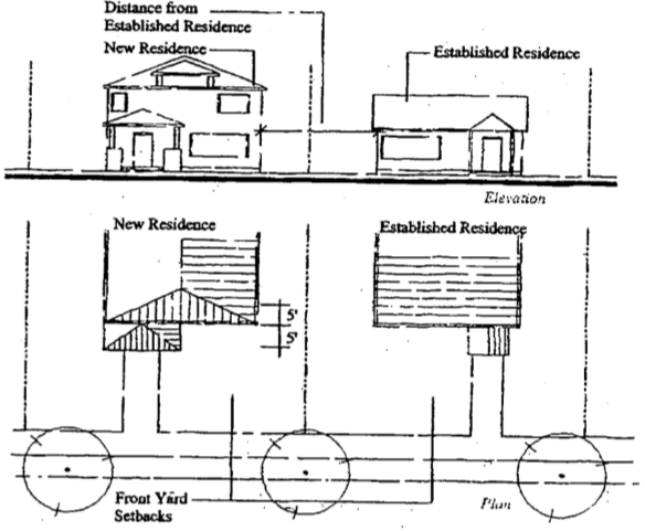
- Exception to Standard for Redevelopment Potential on Adjacent Lot(s). The provisions of Section 5-2.2.050.A allowing reduced setbacks do not apply when the approval body finds that the subject single family residential lots located within 20 feet of the subject site are redevelopable. “Redevelopable,” for the purposes of this Section, means a lot either has an assessed market value that exceeds the assessed market value of all improvements on the lot, based on the most recent data from the Grant County Assessor’s Office; or the front yard of the subject lot is large enough that it could be subdivided based on the Residential District standards.
5-2.2.060 Residential Districts - Housing Density
Allowable housing densities are calculated by dividing the total parcel or lot area by the applicable lot size standard after subtracting street rights-of-way. Areas reserved for flag lot access (flag poles) are not counted for the purpose of calculating minimum lot sizes.
5-2.2.070 Residential Districts - Lot Coverage And Impervious Surfaces
- Lot Coverage Calculation. The maximum allowable lot coverage is as provided in Table 5-2.2.030. Lot coverage is calculated as the percentage of a lot or parcel covered by buildings or structures (as defined by the foundation plane) and other structures with surfaces greater than 36 inches above the finished grade. It does not include paved surface-level developments such as driveways, parking pads, and patios. See subsection B, Impervious Surfaces.
- Impervious Surface Calculation. Impervious surfaces are calculated as the percentage of a lot or parcel covered by the foundation plane area (lot coverage) and other non-permeable surface-level development (e.g., asphalt, concrete, and similar impervious paving). It does not include planted areas, and other areas allowing stormwater infiltration, as approved by the City.
5-2.2.080 Residential Districts - Building Height: Measurement, Exceptions, RL Step-Down Requirement
Building heights shall conform to the standards in Table 5-2.2.030, and subsections A-C, below:
- Building Height Measurement. Building height is measured as provided under the International Building Code.
- Exclusions from Maximum Building Height Standards. Chimneys, bell towers, steeples, roof equipment, flag poles, and similar features not for human occupancy are exempt from the maximum building heights, provided that all applicable fire and building codes are met and exterior lighting complies with Airport Safety and Compatibility Overlay zone requirements.
- Height Step-down – RL District Transition. To provide compatible scale and relationships between new multi-story buildings and existing single-story dwellings in the RL District, multi-story buildings and structures in RC, GC, D, LI, and GI districts are required to “stepdown” to create a building height transition to adjacent single-story building(s) in the RL District, as provided in subsections 1-3, below:
- This standard applies to new and vertically expanded buildings and structures in any district that are within 20 feet (as measured horizontally) of an existing single-story building in the RL District with a height of 20 feet or less, as shown in Figure 5-2.2.080.C.
- The transition standard is met when the height of the taller structure (“x”) does not exceed one (1) foot of height for every one (1) foot separating the two structures (“y”), as shown in Figure 5-2.2.080.D.
Figure 5-2.2.080.C - RL Height Step-Down/Transition
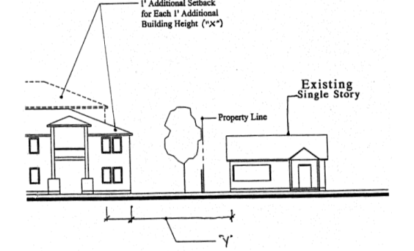
- Exception: The provisions of subsections 5-2.2.080.C.1-2 do not apply when the approval body finds that the subject single story buildings located within 20 of the subject site are redevelopable. “Redevelopable,” for the purposes of this Section, means a lot either has an assessed market value that exceeds the assessed market value of all improvements on the lot, based on the most recent data from the Grant County Assessor’s Office; or the front yard of the subject lot is large enough that it could be subdivided based on the Residential District standards.
5-2.2.090 Residential Districts - Building Orientation
- Purpose. The following standards are intended to orient building entrances close to streets to promote pedestrian-oriented development where walking is encouraged, and to avoid conflicts between pedestrians and vehicles. Placing residences and other buildings close to the street also encourages crime prevention, natural surveillance or security, and safety by having more “eyes-on-the-street.”
- Applicability. Section 5-2.2.090 applies to all developments that are subject to Site Design Review, including developments that are reviewed as part of a Master Planned Development or Conditional Use application.
- Building orientation standards. All developments that are subject to Section 5-2.2.090 shall have buildings that are oriented to a street. This standard is met when all of the following criteria are met:
- Development in the RC zone is required to comply with build-to line standards in Section 5-2.2.030;
- Except as provided in subsections 3 and 4, below, all buildings in the Residential Districts shall have at least one primary building entrance (i.e., dwelling entrance, a tenant space entrance, a lobby entrance, or breezeway/courtyard entrance serving a cluster of units or commercial spaces) facing an adjoining street, or if on a side elevation, not more than 40 feet from a street sidewalk. See Figures 5-2.2.090.C(1);
Figure 5-2.2.090.C(1) – Residential District Building Orientation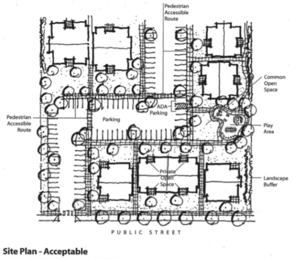
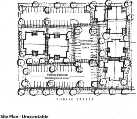
- Off-street parking, driveways, and other vehicle areas shall not be placed between buildings and the street(s) to which they are oriented, as per subsection 2 and Figure 5-2.2.090C(1); except the following vehicle areas are allowed where the approval body finds that they will not adversely affect pedestrian safety and convenience:
- Schools, multiple family buildings, assisted living facilities, and other institutional uses may have one driveway not exceeding 24 feet in width plus one row of parking on one or both sides of the driveway. ADA accessible spaces must be located closest to the primary building entrance, and the building’s primary entrance must be connected to an adjacent street by a pedestrian walkway. In addition, the driveway/parking area must be crossed by a clearly defined pedestrian walkway, as required by Section 5-3.1.030. The intent of this exception is to allow driveways between primary building entrances and the street only when necessary and provided such driveways have walkways adjacent to them;
- Attached single family housing developments (townhomes) with street-facing garages may have one driveway access located between the street and the primary building entrance for every two dwelling units, provided they meet the following criteria, as generally shown in Figure 5-2.2.090C(2):
- Where two abutting townhomes have street-facing garages, they shall share one driveway access that does not exceed 16 feet in width where it crosses the sidewalk and intersects the street. The driveway may taper out and be wider where it connects to paired garages;
- All primary building entrances shall be connected to a sidewalk or driveway via a pedestrian walkway that is not less than three (3) feet wide;
- The maximum number of consecutively attached townhomes with garages facing the same street is four (4) (two driveways); and
- Street-facing garages shall be setback at least 20 feet from the street; where a building is placed less than 20 feet from the street, the 20-foot garage setback may be accomplished by recessing the garage behind the front building elevation.
Figure 5-2.2.090.C(2) – Townhome Building Orientation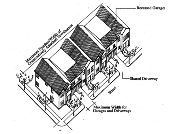
- Commercial buildings and uses (e.g., neighborhood commercial or mixed-use) shall have all of their off-street parking located behind or to the side of such buildings and uses and screened from abutting properties in accordance with Chapter 5-3.2, as generally shown in Figure 5-2.2.090.C(3). Off-street parking shall not be located between any building and any street.
Figure 5-2.2.090.C(3) – Commercial Orientation in a Residential District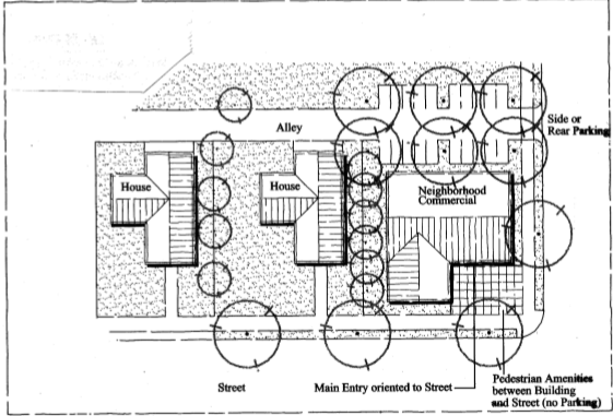
- Where a development contains multiple buildings and there is insufficient street frontage to which buildings can be oriented, a primary entrance may be oriented to common green, open space, plaza, or courtyard. When oriented in this way, the primary entrance(s) and green, plaza, or courtyard shall be connected to the street by a pedestrian walkway meeting the standards in Section 5-3.1.030. See example in Figure 5-2.2.090C(1) “acceptable site plan.” See also, requirements for Cottage Cluster housing in Section 5-2.2.020.
5-2.2.100 Residential Districts - Special Use Standards
Section 5-2.2.100 provides standards for specific land uses and building types, as identified in Table 5-2.2.020 that control the scale and compatibility of those uses within Residential Districts. The standards in Section 5-2.2.100 supplement (are in addition to and do not replace) the standards in Sections 5-2.2.010 through 5-2.2.090. This Section applies to the following uses and building types:
A. Accessory Dwelling
B. Attached Single Family (Townhouses or Rowhouses) and Attached Duplexes
D. Group Living (Residential Care Homes and Residential Care Facilities)
E. Home Occupations
F. Manufactured Homes
G. Manufactured/Mobile Home Parks
H. Multiple Family Housing
I. Short-Term Vacation Rentals
J. Zero-Lot Line Housing (not common wall)
K. Temporary Medical Hardship Dwellings
L. Manufactured Homes and RVs as Temporary Dwellings
- Accessory dwelling (attached, separate cottage, or above detached garage). Accessory dwellings shall conform to all of the following standards:
- Floor Area. Accessory dwellings shall not exceeding 800 square feet of floor area, or 40% of the primary unit, whichever is smaller. The unit can be a detached cottage, a unit attached to a garage, or in a portion of an existing house;
- Exempt from Density. Accessory dwellings are exempt from the housing density standards of the Residential District, due to their small size and low occupancy levels;
- Oregon Structural Specialty Code. The structure shall comply with the Oregon Structural Specialty Code;
- Owner-Occupied. The primary residence or accessory dwelling shall be owner-occupied. Alternatively, the owner may appoint a resident care-taker of the principal house and manager of the accessory dwelling;
- One Unit. A maximum of one accessory dwelling unit is allowed per lot;
- Building Height. The building height of detached accessory dwelling units shall not exceed the height of the primary dwelling; and
- Buffering. The approval body may require a landscape hedge or fence be installed on the property line separating a detached accessory dwelling from an abutting single family dwelling, unless the applicant and the owner of the abutting single family dwelling agree in writing not to install the hedge or fence.
- Attached Single Family (Townhouses and Rowhouses) and Duplexes. Single-family attached housing with three or more dwellings (lots), and developments with two or more consecutively attached duplexes, shall comply with the standards in sub-sections 1 and 2, below, which are intended to control development scale; avoid or minimize impacts associated with traffic, parking, and design compatibility; and ensure management and maintenance of common areas.
- Alley Access Required for Subdivisions Principally Containing Townhomes or Duplexes. Subdivisions, or phases of subdivisions, proposed to contain three (3) or more consecutively attached single family dwellings, and developments with two (2) or more consecutively attached duplexes (4+ dwelling units), shall provide vehicle access to all such lots and units from an alley or shared driveway, as described in Section 5-3.1.020, to minimize the number of individual driveway approaches on adjacent streets.
- Common Areas. Any common areas (e.g., landscaping, private tracts, common driveways, private alleys, building exteriors, and/or similar common areas) shall be owned and maintained by a homeowners association or other legal entity. A copy of any applicable covenants, restrictions and conditions shall be recorded and provided to the city prior to building permit approval.
- Bed and Breakfast Inns. Bed and Breakfast Inns. Bed and Breakfast Inns are permitted in the Residential Districts, and shall comply with all of the following standards. (See also, Vacation Rentals, which are different than Bed and Breakfast Inns, under Section 5-2.2.100.I.)
- Accessory Use. The use must be accessory to a household already occupying the structure as a residence.
- Maximum Size. In the RL and RG zones, four (4) bedrooms for guests, and a maximum of eight (8) guests are permitted per night; in the RC zone, twelve (12) bedrooms are allowed for guests, with a maximum of twenty-four (24) guests per night. No separate structures are permitted, except for customary residential accessory structures as defined in section J. above.
- Length of Stay. Maximum length of stay is 28 days per guest; anything longer is classified as a hotel or commercial lodging.
- Employees. Up to two (2) non-resident employees. There is no limit on residential employees.
- Food Service. Food service may be provided only to overnight guests of the business, except where zoning allows restaurant uses (e.g., RC District).
- Owner-Occupied. Bed and breakfast inns shall be owner-occupied.
- Signs. Signs shall not exceed a total of four (4) square feet of surface area on each side of one or two faces.
- Business License. The Bed and Breakfast Inn owner shall maintain a current City of John Day business license.
- Group Living (Residential Care Homes and Residential Care Facilities). Residential care homes are residential treatment or training homes or adult foster homes licensed by the State of Oregon. They may provide residential care alone, or in conjunction with treatment and/or training, for 5 or fewer individuals (“homes”) or 6 to 15 individuals (“facilities”) who need not be related. Developments with two or more homes, i.e., projects housing more than 5 individuals, are classified as residential care facilities. Staff persons required to meet State licensing requirements are not counted in the number of facility residents and need not be related to each other or the residents. Residential care homes and facilities shall comply with the following standards, consistent with ORS 197.660-.670:
- Licensing. All residential care homes and facilities shall be duly licensed by the State of Oregon.
- Access. Comply with access and circulation requirements of Chapter 5-3.1.
- Parking. Comply with parking requirements of Chapter 5-3.3.
- Landscaping. Comply with landscaping of Chapter 5-3.2.
- Site Development Review. Site Development Review shall be required for new structures to be used as residential care homes or facilities, to ensure compliance with the licensing, parking, landscaping, screening, transportation, and other requirements of this Code.
- Home Occupations. The purpose of this Section is to encourage those who are engaged in small commercial ventures that could not necessarily be sustained if it were necessary to lease commercial quarters, or which by the nature of the venture, are appropriate in scale and impact to be operated within a residence. Home occupations are encouraged for their contribution in reducing the number of vehicle trips often generated by conventional businesses. Two types of home occupations are contemplated by this Code: 1) Home Occupations meeting the standards in subsections 1-8, below, are allowed by right, provided the owner has a current business license and all other uses and structures on the subject property are in conformance with the applicable zoning; and 2) Home Occupations exceeding any of the threshold standards in subsections 1-8 may receive approval through the Type III Home Occupation Permit procedure under Section 5-4.9.020.
Type I Standards for Home Occupations- Appearance of Residence:
- The home occupation shall be restricted to lawfully-built enclosed structures and be conducted in such a manner as not to give an outward appearance of a business.
- The home occupation shall not result in any structural alterations or additions to a structure that will change its primary use or building code occupancy classification.
- The home occupation shall not violate any conditions of development approval (i.e., prior development permit approval).
- No products and or equipment produced or used by the home occupation may be displayed to be visible from outside any structure.
- Storage:
- Outside storage, visible from the public right-of-way or adjacent properties, that exceeds what is customary for a single family residence in the vicinity, is prohibited.
- On-site storage of hazardous materials (including toxic, explosive, noxious, combustible or flammable) beyond those normally incidental to residential use is prohibited.
- Storage of inventory or products and all other equipment, fixtures, and activities associated with the home occupation shall be allowed in any structure.
- Employees:
- Other than family members residing within the dwelling located on the home occupation site, there shall be no other/not more than one (1) full time equivalent employee at the home occupation site at any given time. As used in this chapter, the term “home occupation site” means the legal lot on which the home occupation is conducted.
- Additional individuals may be employed by or associated with the home occupation, so long as they do not report to work or pick up/deliver at the home occupation site.
- The home occupation site shall not be used as a headquarters for the assembly of employees for instruction or other purposes, including dispatch of employees to other locations.
- Advertising and Signs: Signs shall comply with all applicable sign regulations. In no case shall a sign in the Residential District exceed four (4) square feet of surface area on all sides.
- Vehicles, Parking and Traffic:
- Off-street parking shall be provided for all commercially licensed vehicles associated with the home occupation. Such parking shall conform to the standards of Chapter 5-3.3.
- There shall be no more than three (3) commercial vehicle deliveries to or from the home occupation site daily. There shall be no commercial vehicle deliveries during the hours of 9:00 p.m. to 7:00 a.m.
- There shall be no more than one (1) client's or customer's vehicle at any one time and no more than eight (8) per day at the home occupation site.
- Business Hours. There shall be no restriction on business hours, except that clients or customers are permitted at the home occupation from 7:00 a.m. to 9:00 p.m. only, Monday through Friday, subject to subsections 1 and 5, above.
- Prohibited Home Occupation Uses:
- Any activity that produces radio, TV, or other electronic interference; noise, glare, vibration, smoke, or odor beyond allowable levels as determined by local, state or federal standards, or that can be detected beyond the property line; is prohibited.
- Any activity involving on-site retail sales, including garage sales exceeding the thresholds of a temporary use, is prohibited; except that the sale of items that are incidental to a permitted home occupation is allowed. For example, the sale of lesson books or sheet music from music teachers, art or craft supplies from arts or crafts instructors, computer software from computer consultants, and similar incidental items for sale by home business is allowed subject to 1-6, above.
- The following uses and uses with objectionable impacts similar to those listed (i.e., due to motor vehicle traffic, noise, glare, odor, dust, smoke or vibration, or other nuisance), are prohibited:
- Ambulance service;
- Animal hospital, veterinary services, kennels or animal boarding;
- Auto and other vehicle repair, including auto painting; and
- Repair, reconditioning or storage of motorized vehicles, boats, recreational vehicles, airplanes or large equipment on-site.
- Inspection: The Planning Official or designee may visit and inspect the site of a home occupation during normal business hours, and with reasonable notice, to ensure compliance with all applicable regulations.
- Appearance of Residence:
- Manufactured Homes. Manufactured homes are permitted on individual lots, subject to all of the following design standards. Manufactured dwellings relocated into the City of John Day shall conform to City standards. The following standards do not apply to units existing within the City prior to November 24, 2005, provided they were lawfully established.
- Floor Plan. The manufactured home shall be multi-sectional and have an enclosed floor area of not less than 1,000 square feet;
- Roof. The manufactured home shall have a pitched roof with a slope not less than 3 feet in height for each 12 feet in width (14 degrees);
- Residential Building Materials. The manufactured home shall have exterior siding and roofing which in color, material and appearance are similar or superior to the exterior siding and roof material used on nearby residences (e.g., horizontal wood or wood-appearance siding is considered “superior” to metal siding and roofing);
- Garages and Carports. If the manufactured home has a garage or carport, the garage or carport shall be constructed of materials like those used on the house;
- Thermal Envelope. The manufactured home shall be certified by the manufacturer to meet the thermal envelope requirements equivalent to those for a single-family dwelling constructed under the State Building Code. Evidence demonstrating that the manufactured home meets “Super Good Cents” energy efficiency standards is deemed to satisfy the exterior thermal envelope certification requirement. Additional manufacturer certification shall not be required;
- Placement The manufactured home shall be placed on an excavated and back-filled foundation and enclosed at the perimeter such that the manufactured home is located not more than 16 inches above grade, and complies with the minimum set-up standards of the adopted state Administrative Rules for Manufactured Dwellings, OAR Chapter 918. Where the building site has a sloped grade, no more than 16 inches of the enclosing material shall be exposed on the uphill side of the home;
- Flood Plain. Manufactured homes, when placed in a flood hazard area, pursuant to Chapter 5-2.9, shall comply with the following supplemental standards.
- The stand shall be a minimum of 12 in. above Base Flood Elevation (BFE) unless the foundation wall is opened on one side or end so that floodwater cannot be trapped. [Manufactured Dwelling Specialty Code, 4-3.1(5)]
- The bottom of the longitudinal chassis frame beam in A zones, and the bottom of the lowest horizontal structural member supporting the dwelling in V zones shall be a minimum of 12 inches above BFE. [See definition of Lowest Floor in Manufactured Dwelling Specialty Code]
- The manufactured dwelling shall be anchored to prevent flotation, collapse, or lateral movement during the base flood. Anchoring methods may include, but are not limited to, use of over-the-top or frame ties to ground anchors (Reference FEMA’s “Manufactured Home Installation in Flood Hazard Areas” guidebook for anchoring techniques). [44 CFR 60.3(c)(6)]
- Electrical crossover connections shall be a minimum of 12 inches above BFE. [Manufactured Dwelling Specialty Code 6-4.2(1)]
- Foundation Skirt. The foundation area of the manufactured home shall be fully skirted with concrete, horizontal wood or vinyl siding, or other materials, pursuant to applicable building codes.
- Prohibited. The manufactured home shall not be located in a designated historic district.
- Manufactured/Mobile Home Parks. Manufactured/mobile home parks (not including recreational vehicles) are permitted on parcels of one (1) acre or larger, subject to compliance with subsections 1-5, below:
- Permitted uses: Single family residences, manufactured home park manager’s office, home occupations, and accessory structures that are necessary for the operation and maintenance of the manufactured dwelling park (e.g., landscape maintenance).
- Space. The minimum size pad or space for each dwelling is 2,500 square feet, provided that the overall density of the park does not exceed 12 units per acre. Each space shall be at least 30 feet wide and 40 feet long, in accordance with ORS 446.010(c).
- Setbacks and Building Separation. The minimum setback between park structures and abutting properties is 5 feet. The minimum setback between park structures and public street right-of-way is 15 feet. At least a 10-foot separation shall be provided between all dwellings. Dwellings shall be placed a minimum of 14 feet apart where flammable or combustible fuel is stored between units. Park structures shall be placed no closer than 5 feet to a park street or sidewalk/pathway. An accessory structure shall not be located closer than 6 feet to any other structure or dwelling, except that a double carport or garage may be built which serves 2 dwellings. When a double carport/garage is built, the carport/garage shall be separated from all adjacent structures by at least 3 feet.
- Perimeter landscaping. When manufactured dwellings are oriented with their back or side yards facing a public right-of-way, the City may require installation of fencing and planting of a 10-foot wide landscape buffer between the right-of-way and a manufactured home park for the privacy and security of residents or aesthetics of the streetscape.
- Dwelling design (for parks smaller than 3 acres). Manufactured dwellings in parks smaller than 3 acres shall meet the following design standards, consistent with ORS 197.314(6):
- The manufactured dwelling shall have a pitched roof with a slope not less than 3 feet in height for each 12 feet in width (14 degrees); and
- The manufactured dwelling shall have exterior siding and roofing which in color, material and appearance are similar or superior to the exterior siding and roof material used on nearby residences (e.g., horizontal wood or wood-appearance siding is considered “superior” to metal siding and roofing);
- Exception: Subsections a-b, above, do not apply to manufactured dwellings existing within the City prior to November 24, 2005.
- Flood Plain. Manufactured homes, when placed in a flood hazard area, pursuant to Chapter 5-2.9, shall comply with the following supplemental standards.
- The stand shall be a minimum of 12 in. above Base Flood Elevation (BFE) unless the foundation wall is opened on one side or end so that floodwater cannot be trapped. [Manufactured Dwelling Specialty Code, 4-3.1(5)]
- The bottom of the longitudinal chassis frame beam in A zones, and the bottom of the lowest horizontal structural member supporting the dwelling in V zones shall be a minimum of 12 inches above BFE. [See definition of Lowest Floor in Manufactured Dwelling Specialty Code]
- The manufactured dwelling shall be anchored to prevent flotation, collapse, or lateral movement during the base flood. Anchoring methods may include, but are not limited to, use of over-the-top or frame ties to ground anchors (Reference FEMA’s “Manufactured Home Installation in Flood Hazard Areas” guidebook for anchoring techniques). [44 CFR 60.3(c)(6)]
- Electrical crossover connections shall be a minimum of 12 inches above BFE. [Manufactured Dwelling Specialty Code 6-4.2(1)]
- Multiple Family Housing. Where multiple family housing is allowed, it shall conform to all of the following standards, which are intended to promote livability for residents and compatibility with nearby uses. Figure 5-2.2.100.H provides a conceptual illustration of the requirements listed below.
- Building mass. The maximum width or length of a multiple family building shall not exceed 100 feet from end-wall to end-wall, not including outdoor living areas (e.g., porches, balconies, patios, and similar unenclosed spaces).
- Common open space. A minimum of 10 percent of the site area shall be designated and permanently reserved as common open space, in accordance with all of the following criteria:
- The site area is defined as the lot or parcel on which the development to be located, after subtracting any required dedication of street right-of-way and other land for public purposes (e.g., public park or school grounds, etc.);
- In meeting the common open space standard, the multiple family development shall contain one or more of the following: outdoor recreation area, protection of sensitive lands (e.g., trees preserved), play fields, outdoor playgrounds, outdoor sports courts, swim pools, walking fitness courses, pedestrian amenities, or similar open space amenities for residents.
- Historic buildings or landmarks that are open to the public may count toward meeting the common open space requirements when approved by Planning Commission or City Council.
- To receive credit under Section 5-2.2.100.H, a common open space area shall have an average width that is not less than 20 feet and an average length that is not less than 20 feet;
- Projects in the Residential-Commercial District that provide pedestrian amenities between primary building entrance(s) and adjoining street(s) are required to provide a minimum of 5 percent of the site in common open space;
- The approval body may waive the common open space requirement for the first 20 dwelling units in a multiple family project that is located within one-quarter mile (measured walking distance) of a public park, and there is a direct, accessible (i.e., Americans With Disabilities Act-compliant), lighted walkway connecting the site to the park. If the park is not developed, or only partially developed, the approval body may require the multiple family housing developer to improve park land in an amount comparable to that which he or she would otherwise be required to provide in his or her development.
- Private open space. Private open space areas shall be required for ground-floor and upper-floor housing units based on all of the following criteria:
- A minimum of 40 percent of all ground-floor housing units shall have front or rear patios or decks measuring at least 48 square feet. Ground-floor housing means the housing unit entrance (front or rear) is within 5 feet of the finished ground elevation (i.e., after grading and landscaping);
- A minimum of 40 percent of all upper-floor housing units shall have balconies or porches measuring at least 48 square feet. Upper-floor housing means housing units that are more than 5 feet above the finished grade; and
- In the Residential-Commercial District, multiple family dwellings are exempt from the private open space standard where the development contains a plaza of at least 200 square feet in area between primary building entrance(s) and adjoining streets. The plaza must contain pedestrian amenities such as benches and planters, subject to Site Design Review.
Figure 5-2.2.100H – Examples of Multiple Family Open Space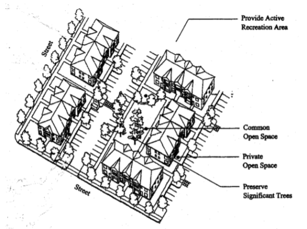
- Trash receptacles. Trash receptacles shall be oriented away from building entrances, setback at least ten (10) feet from any public right-of-way and adjacent residences and shall be screened with an evergreen hedge or solid fence or wall of not less than 6 feet in height. Receptacles must be accessible to trash pick-up trucks.
- Short-Term Vacation Rentals. Short-term vacation rentals shall conform to all of the following criteria:
- Vacation rentals allowed under this subsection are those with 28 or fewer days continuous occupancy by the same tenant;
- A Business License is required to operate one or more short-term vacation rentals as regulated by the John Day Code of Ordinances Title 3 Chapter 1. The license application shall identify all short-term rental properties under the same ownership or management, and shall provide the City with information regarding the name, address and telephone number of a contact person who can be on the vacation home rental site within four (4) hours to respond to problems.
- Maximum occupancy of the rental shall be based on the International Building Code Standards. The property owner shall be responsible for ensuring that the dwelling unit is in conformance with its maximum occupancy.
- All short-term vacation rentals must comply with all city codes and ordinances, including but not limited to Title 8, Chapter 2- Nuisances and Chapter 4- Noise.
- All transient lodging taxes must be collected by the registered listing and remitted to the applicable governing body.
- The scale, building materials, and colors of the building shall be consistent with the neighborhood.
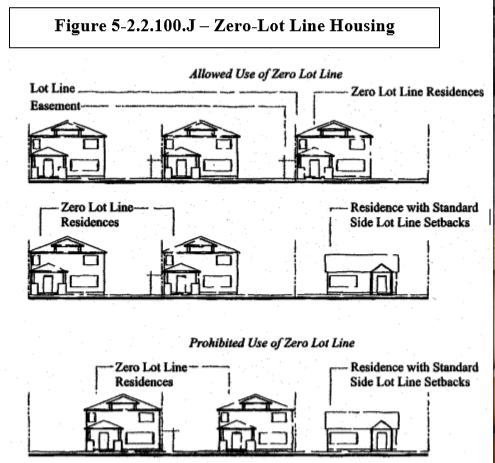
- Zero-Lot Line Housing. Zero-lot line houses are subject to the same standards as other non-attached single family housing, except that a side yard setback is not required on one side of the lot, as generally shown in Figure 5-2.2.100.J. The standards for zero-lot line housing are intended to ensure adequate outdoor living area, compatibility between adjacent buildings, and access to side yards for building maintenance. All zero-lot line houses shall conform to all of the criteria in subsections 1-4, below:
- Site Design Review Required. Site Design Review is required for new zero-lot line developments. When a zero-lot line development is proposed as part of a Land Division, Master Planned Development, or other application, the Site Design Review may be combined with the other application(s).
- Setbacks for Primary and Accessory Structures. The allowance of a zero (0) side yard setback is for one single family dwelling on each lot; it does not extend to accessory structures which shall conform to the applicable setback requirements of the zone;
- Setbacks Adjacent to Non-Zero Lot Line Development. When a zero-lot line house shares a side property line with a non-zero lot line development, the zero-lot line building shall be setback from that common property line by not less than 10 feet;
- Building Orientation and Design. The building placement and/or design shall encourage privacy for the occupants of abutting lots. For example, this standard can be met by staggering foundation plans, by placing windows (along the zero lot line) above sight lines with direct views into adjacent yards, by using frosted/non-see-through windows, by avoiding placement of windows on the zero lot line, or other designs approved by the approval body through Site Design Review; and
- Construction and Maintenance Easement. Prior to building permit approval, the applicant shall submit a copy of a recorded easement for every zero-lot line house that guarantees access onto adjoining lot for the purpose of construction and maintenance of the zero-lot line house. The easement shall require that no fence or other structure shall be placed in a manner that would prevent maintenance of the zero-lot line house. The easement shall not preclude the adjoining owner from landscaping the easement area.
- Temporary Medical Hardship Dwellings. A temporary medical hardship dwelling must meet the following requirements:
- The temporary hardship dwelling must either be occupied by someone who will care for the resident of the subject property, or it may be occupied by a relative of the resident when the relative has the medical hardship and the resident of the property will be the caregiver. (Relative is defined as a parent, child, grandparent, grandchild, brother, or sister of the existing resident.)
- The temporary hardship dwelling must use the same subsurface sewage disposal system as the existing dwelling, provided that the system is adequate to accommodate the additional dwelling. If on an existing septic system, the system will need to be inspected and approved by the John Day Public Works Director. Once the hardship has ended, the system must be abandoned in accordance with DEQ requirements.
- The application must include a written statement from the patient’s primary care medical doctor (MD) or osteopath (DO). The statements must be on the doctor’s stationery or stamped by their office. The statement must indicate that for health or age-related reasons the patient is unable to maintain a residence on a separate property and is dependent upon someone being close by for assistance.
- The permit authorizing the temporary hardship dwelling must be renewed every two years. In order to renew the temporary hardship permit, a letter from a doctor stating that the hardship still exists must be submitted to the Department, along with the renewal fee. If the hardship dwelling is connected to the same septic system as the existing dwelling, the septic system may also need to be re-inspected.
- Within three months of the end of the hardship, the manufactured dwelling, recreational vehicle, or travel trailer must be removed from the property or demolished. In the case of an existing building that has been converted for temporary residential use, the building must be removed, demolished or returned to an allowed use.
- The temporary dwelling must comply with applicable fire safety standards.
- A Temporary Medical Hardship Dwelling permit is obtained through a Type I Land Use Review, in accordance with Section 5-4.1.020. The application must include the following information:
- The aforementioned letter from a medical doctor or osteopath confirming that the person with the hardship is unable to maintain their own separate residence because of a health or age related condition or infirmity; and
- A site plan, drawn to scale on 8½“ by 11" paper, showing property lines, existing streets and driveways, existing and proposed buildings, including distances to property lines, location of any existing wells and/or septic systems, location of any physical features on the parcel such as streams, irrigation ditches, steep slopes, etc. must be submitted with the application.
- The Planning Official will review the application to determine whether it conforms to the criteria listed above. If approved, a manufactured dwelling installation permit must be obtained from Grant County. If the hardship dwelling is to be a recreational vehicle or travel trailer, applicable sewage disposal requirements shall be met.
- Manufactured Homes and RV's as Temporary Residences. Recreational vehicles may not be occupied for residential purposes outside an approved recreational vehicle park or in an approved mobile or manufactured home park on any lot in the city except:
- When permitted as a temporary residence by 5-2.2.100(K) Temporary Medical Hardship Dwellings; or
- As a temporary residence by guests of the owner for a period not to exceed 7 days out of any 30-day period, particularly during major local events such as rodeos, fairs, races, school and community events, adult and youth athletic events and similar events; or
- A single-wide or single unit manufactured home, or recreation vehicle (RV), may be authorized as a temporary residence if found to comply with the following conditions.
- Residential use during construction of a home.
- The unit shall only be placed upon a lot or parcel and occupied by the owner or builder for which a building permit for a conventional housing unit or a placement permit for a manufactured home meeting the standards of the applicable zone has been obtained.
- Only one unit shall be allowed and shall only be occupied during a period in which satisfactory progress is being made towards the completion of the conventional housing unit or placement of the manufactured home for which a permit has been obtained, and in no case shall the time period exceed 18 months involving a conventional dwelling or 6 months involving a manufactured home.
- The owner of the lot agrees in writing to remove the manufactured unit from the lot no later than the applicable time period set forth above in division (b) or not later than one month following the completion of the unit or placement of the manufactured home, whichever occurs first.
- Except in the case of a self-contained RV, public sewer and water connections shall be provided, as well as electric power.
- The City Planning Official may review permits issued under this subsection (L) using a Type I Decision at any time and revoke the permits when found to not be in compliance, including evidence of unsatisfactory progress on construction or placement of the intended permanent housing unit.
- Temporary residence for care of relative or other special circumstances under a Type III Conditional Use Permit.
- It is the intent of this temporary RV use permit to provide for the temporary placement and use of certain structures which, because of personal hardship and special needs, require and warrant special consideration for the special temporary use.
- No such use shall be approved unless there is a finding by the reviewing authority that there will not be any adverse impact on the welfare of adjacent properties and the community as a whole, nor a detriment to the overall intent of this chapter and the applicable zone designation.
- No temporary permit shall be granted which would have the effect of creating a permanent rezoning, nonconforming use or variance or when the use is not permitted to continue at the expiration of the permit period.
- As a temporary special use permit in every zone in which residential uses are permitted, the Planning Commission, as a type III Conditional Use Permit, may approve one (1) manufactured home or RV in conjunction with a primary dwelling unit with the following findings and limitations.
- The applicant and permit holder is the owner and resident of the primary dwelling where the RV is to be placed.
- That no additions to the manufactured home or RV unit shall be permitted, nor shall the unit be connected to the primary dwelling unit or an accessory dwelling unit in any way, except for a covered walkway to the main dwelling unit.
- That all residential utilities and facilities deemed necessary can be and are provided.
- That all setback requirements of the applicable zone designation can be met.
- That the subject manufactured home or RV unit is not of a condition as to constitute a visual nuisance or be a safety hazard to the occupant thereof.
- A temporary special use permit granted under this subsection shall be null and void when the special circumstance warranting the Conditional Use Permit has been resolved.
- Within 30 days of the permit becoming void or revoked, the unit shall be removed by the owner of the real property unless otherwise approved by the city.
- The city may review permits issued under this subsection at any time, and revocation thereof shall be effective upon a finding of noncompliance with the provisions of this subsection or with any other conditions set forth at the time of issuance of the permit.
- The permits shall be issued on a one-year basis and may be renewed on an annual basis through re-application provided compliance with the conditions applicable to the permit are maintained.
- Residential use during construction of a home.
5-2.3.010 Commercial Districts - Purpose
This Chapter provides two commercial districts to accommodate the range of commercial land uses in the community. The Downtown District is focused on the core commercial and civic (i.e., the central business) area of the community. The General Commercial District regulations apply to those commercial areas outside or adjacent to the central business area. Both districts are intended to:
- Promote efficient use of land and urban services;
- Create a mixture of land uses that encourages employment and housing options in close proximity to one another;
- Provide formal and informal community gathering places and opportunities for socialization (i.e., along an active street front);
- Encourage pedestrian-oriented development in all commercial areas;
- Create a distinct storefront character in the Downtown District;
- Provide connections to and appropriate transitions between residential areas and commercial areas;
- Discourage automobile-oriented and automobile-dependent uses in the Downtown District, and accommodate those uses with appropriate design standards in the General Commercial District;
- Provide for visitor accommodations and tourist amenities;
- Reduce reliance on the automobile and minimize the need for off-street parking;
- Implement design standards/guidelines that maintain and enhance the City’s historic character.
5-2.3.020 Commercial Districts - Allowed Land Uses
Table 5-2.3.020 identifies the land uses that are allowed in the Commercial Districts. The specific land use categories are described and uses are defined in Chapter 5-1.3.
| Table 5-2.3.020 – Land Uses Allowed in Commercial Districts (D, GC) | |||
| Uses | Status of Use in District | ||
| Use Categories (Examples of uses are in Chapter 5-1.4; definitions are in Chapter 5-6.1.) | Downtown (D) | General Commercial (GC) | [Reserve] |
| Residential Categories | |||
| Household Living | |||
| All Residential Uses and Structures (Household Living and Group Living) allowed, if: | |||
| - lawfully existing as of November 24, 2005* | P | P | |
| - a dwelling that does not occupy ground floor space fronting Main Street* | P | P | |
| *In the event of involuntary damage or destruction due to fire or other event beyond the owner’s control, a residential use lawfully existing in the Downtown as of November 24, 2005 may be rebuilt and reestablished pursuant with Section 5-5.2.020 through 5-5.2.030. A dwelling unit that existed prior to November 24, 2005 but was not used as a residence on that date may convert back to residential use, but may not be expanded upon. This provision does not apply to a dwelling unit that occupies ground floor space fronting Main Street. (Amended by Ord. #19-179-03, [11-12-2019]) Group Living Uses shall conform to the provisions in Section 5-2.2.100. | |||
| Commercial Categories | |||
| Drive-Up/Drive-In/Drive-Through (drive-up windows, kiosks, ATM’s, similar uses/facilities), per Section 5-2.3.100A | CU+S | CU+S | |
| Short-Term Vacation Rental per Section 5-2.2.100H | S | S | |
| Educational Services, not a school (e.g., tutoring or similar services) | P | P | |
| Entertainment, Major Event | CU | CU | |
| Offices | P | P | |
| Outdoor Recreation, Commercial | CU | CU | |
| Parking Lot (when not an accessory use) | CU | CU | |
| Quick Vehicle Servicing or Vehicle Repair. (See also Drive-Up/Drive-In/Drive-Through Uses, per Section 5-2.3.100A) | |||
| - fully enclosed (e.g., garage) | CU | P | |
| - not enclosed, except accessory uses | N | CU | |
| Retail Sales and Commercial Services (See also Drive-Up Uses, per Section 5-2.3.100A) | P | P | |
| -Marijuana Retailer per Section | CU/S | CU/S | |
| -Medical Marijuana Dispensary | CU/S | CU/S | |
| Self-Service Storage | N | CU | |
| Industrial Categories | |||
| Industrial Service (See also Drive-Up Uses) | |||
| - fully enclosed (e.g., office) | P | P | |
| - not enclosed | N | CU | |
| Marijuana Testing Laboratory | CU/S | CU/S | |
| Manufacturing and Production | |||
| - fully enclosed | P | P | |
| - not enclosed | N | CU | |
| -Marijuana Production Facility | N | CU/S | |
| -Marijuana Processing Facility | N | CU/S | |
| Warehouse and Freight Movement | N | CU | |
| Waste-Related | N | N | |
| Wholesale Sales | |||
| - fully enclosed, less than 20,000 square feet of floor area | CU | P | |
| - fully enclosed, equal to or greater than 20,000 square feet of floor area | N | CU | |
| - not enclosed | N | CU | |
| -Marijuana Wholesaler | CU/S | CU/S | |
| Institutional Categories | |||
| Basic Utilities | P | P | |
| Community Service | P | P | |
| Daycare | |||
| Family Daycare (16 or fewer children) as allowed under ORS 657A.250 and ORS 657A.440(4), subject to State licensing | P | P | |
| Daycare Center subject to State licensing | CU | CU | |
| Adult daycare, subject to State licensing | P | P | |
| Parks and Open Space, consistent with a downtown plan or in conjunction with a business (e.g., plaza, pocket park, etc.) | P | P | |
| Other Parks and Open Space uses | CU | CU | |
| Religious Institutions and Houses of Worship | |||
| - lawfully existing as of November 24, 2005 | P | P | |
| - new | CU | CU | |
| Schools | |||
| - lawfully existing as of November 24, 2005 | P | P | |
| - new | CU | CU | |
| Other Categories | |||
| Accessory Structures (with a permitted use) | P | P | |
| Buildings and Structures Exceeding the Height Limits in Table 5-2.3.030 | CU | CU | |
| Radio Frequency Transmission Facilities, including building-mounted facilities, that project above roofline | CU | CU | |
| Utility Corridors | CU | CU | |
| Temporary Uses (limited to “P” and “CU” uses), per Section 5-4.9.010. | P/CU | P/CU | |
| Transportation Facilities (operation, maintenance, preservation, and construction in accordance with the City’s Transportation System Plan) | P | P | |
Key:
P = Permitted, subject to site/development review
S = Permitted with standards (See cross-reference)
CU = Conditional Use permit required (Chapter 5-4.4)
N = Not permitted
CU/S = Conditional use with standards (Section 5-2.4.070)
5-2.3.030 Commercial Districts - Development Standards
The development standards in Table 5-2.3.030 apply to all new structures, buildings, and development, and major remodels, in the Commercial Districts.
| Table 5-2.3.030 – Development Standards for Commercial Districts | |||
| Standard | D | GC | [Reserve] |
| Minimum Lot Area* (square feet) | 2,000 sf | 2,000 sf | |
| *Development must conform to lot width, depth, yard setback and coverage standards. | |||
| Minimum Lot Width | |||
| Single Family, not attached | 40 ft | 40 ft | |
| Single Family, attached | 20 ft | 20 ft | |
| Duplex | 50 ft | 50 ft | |
| Multiple-Family | 50 ft | 50 ft | |
| Non-Residential Uses | 20 ft | 20 ft | |
| For flag lots, width is measured at the front building line. | |||
| Minimum Lot Depth | 2 times min. width | 2 times min. width | |
| Building/Structure Height | |||
| Height may be increased with Conditional Use Permit, per Chapter 5-4.4. Height transition required adjacent to RL District, per Section 5-2.2.080. | 60 ft | 45 ft | |
| Fences, Retaining/Garden Walls: See Section 5-3.2.050 | |||
| Lot Coverage, maximum building coverage (Foundation plane as % of site area) | 95% | 90% | |
| Landscape Area (% site area), except does not apply to single family dwellings. Landscape area may include a combination of plant beds, planters, and plaza space | 5% | 10% | |
| Minimum Setbacks (feet): (See also, Section 5-2.2.080, RL Height Step-Down.) | |||
| Front, Street, Side, and Rear property lines, except garage or carport | 0 ft | 0 ft | |
| Garage/Carport Entry, setback from street | 20 ft | 20 ft | |
| Alley | 3 ft | 3 ft | |
| Adjacent to RL District | 10 ft, and per Section 5-2.2.080 | 10 ft, and per Section 5-2.2.080 | |
| Build-To Line (feet): | |||
| New Buildings Only: At least one primary building entrance shall be built no farther from the street right-of-way than the build-to line; except where a greater setback is required for a Planned Street Improvement, then the build-to line increases proportionately. The build-to line may also be increased through Site Design Review when pedestrian amenities are provided between a primary building entrance and the street right-of-way. (See also, Section 5-2.3.090.) | 0 ft; may be increased when pedestrian amenities are provided between a primary building entrance and street | 60 ft; may be increased when a shopping street connects the primary building entrance(s) to the street, per Section 5-2.3.060.D | |
| Special Setback for Planned Street Improvements | The City may require a minimum setback of up to 40 feet, measured from the street centerline to any structure, when a structure would abut a street containing less than the standard right-of-way for the subject street classification. Street classification and required right-of-way are as indicated by the City of John Day Transportation System Plan. | ||
5-2.3.040 Commercial Districts - Zero Setbacks And Build-To Line
- Zero Setbacks and Build-To Line – Purpose; Fire Code; and Clear Vision Zero setbacks and build-to lines, as provided in Table 5-2.3.030, are intended to encourage pedestrian-oriented development, while providing more flexibility in site design than what is possible with large setbacks. With buildings placed close to the street, a development can afford good access for emergency service providers in the case of a fire or other emergency. Where no minimum setback is required, all structures and buildings shall conform to the vision clearance standards in Chapter 5-3.1 and the applicable fire and building codes (e.g., for attached structures, fire walls, and related requirements).
- Setback Yards – Reverse Frontage Lots Buildings on reverse-frontage lots (through lots) shall be required to meet the front setback and build-to line standards on only one street. Reverse frontage lots are subject to the fence height and setback requirements in Section 5-3.2.050 and the landscape buffer requirements in Chapter 5-3.2.030.
- Setback Yards – Flag Lots The front yard of a flag lot shall conform to one of the following two options:
- parallel to the street from which access is taken, or
- parallel to the flag pole from which access is taken.
5-2.3.050 Commercial Districts - Lot Coverage And Impervious Surface
Lot coverage and impervious surfaces are calculated as provided under Section 5-2.2.070.
5-2.3.060 Commercial Districts - Building Orientation And Commercial Block Layout
- Purpose. Section 5-2.3.060 orients buildings close to streets to promote pedestrian-oriented development where walking is encouraged, and to avoid conflicts between pedestrians and vehicles. Placing residences and other buildings close to the street also encourages crime prevention, natural surveillance or security, and safety by having more “eyes-on-the-street.”
- Applicability. Section 5-2.3.060 applies to projects that are subject to Site Design Review.
- Building orientation standards. Buildings shall have their primary entrance(s) oriented to a street, as generally shown in Figures 5-2.3.060.C(1)-(3). This standard is met when all of the following criteria are met:
- Compliance with the setback and build-to line standards in Section 5-2.3.030, where applicable. The build-to line may be setback to provide pedestrian amenities between a building and its adjoining street;
- Except as provided in subsections 5-2.3.060.C(4) and (5), below, all buildings shall have at least one primary building entrance (i.e., dwelling entrance, a tenant entrance, lobby entrance, or breezeway/courtyard entrance) facing an adjoining street (i.e., within 45 degrees of the street property line), or if the building entrance is turned more than 45 degrees from the street (i.e., front door is on a side elevation), the primary entrance shall not be more than 40 feet from a street sidewalk, except to provide pedestrian amenities; a walkway shall connect the primary entrance to the sidewalk in this case.
- In the Downtown District, off-street parking, driveways, and other vehicle areas shall not be placed between buildings and the street(s) to which they are oriented; except as provided under subsection 5-2.3.060.C(4). Off-street parking in the Downtown District shall be oriented internally to the site and divided by landscape areas into bays of not more than 24 parking spaces per bay, as required by Section 3.2.030.
Figure 5-2.060.C(1) – Building Orientation
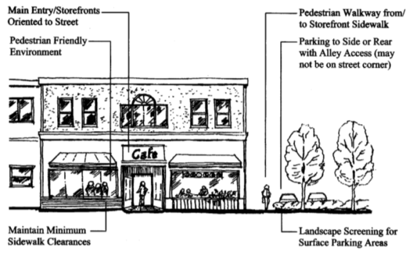
Figure 5-2.3.060.C(2) – Building Orientation With Internal Parking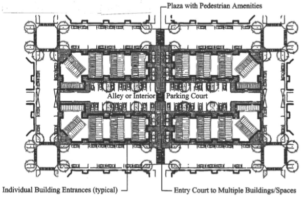
- In the GC District, the building orientation standard may be met with vehicle areas allowed between the street right-of-way and a building’s primary entrance when the approval body finds that the following criteria are met:
- Placing vehicle areas between the street right-of-way and building’s primary entrance will not adversely affect pedestrian safety and convenience, based on the distance from the street sidewalk to the building entrance, projected vehicle traffic volumes, and available pedestrian walkways;
- The proposed vehicle areas are limited to one driveway of not more than 24 feet in width with adjoining walkways and bays of not more than eight (8) consecutive parking spaces per bay (including ADA accessible spaces) on the side(s) of the drive aisle. (The intent is to create a drive aisle that is street-like, and break up parking into small bays with landscaping; and
- The building’s primary entrance is connected to an adjoining street by a pedestrian walkway that meets the standards for pedestrian walkways under Section 5-3.1.030.
- Where a development contains multiple buildings and there is insufficient street frontage to which buildings can be oriented, a primary entrance may be oriented to common green, plaza, or courtyard. When oriented in this way, the primary entrance(s) and green, plaza, or courtyard shall be connected to the street by a pedestrian walkway meeting the standards in Section 5-3.1.030.
- Block Layout Standard. Developments containing 40,000 square feet or more building floor area shall meet all of the following standards:
- The site shall be configured into blocks that have frontage onto streets, interior parking courts (as generally shown in Figure 5-2.3.060.C(2), above), or shopping streets (as generally shown in Figure 5-2.3.060.C(3), below). All parking courts and shopping streets shall contain on-street parking (parallel or angled parking), street- or court-facing building entrances and entrances at or near (i.e., within 40 feet of) block corners, sidewalks, street trees, and pedestrian lighting;
- Blocks shall be broken down into lengths of not more than 400 feet, and shall have a perimeter not exceeding 1,400 feet;
- Walkways shall connect the street right-of-way to building entrances and the interior parking courts between buildings, as necessary to ensure reasonably safe, direct, and convenient access to building entrances and off-street parking.
Figure 5-2.3.060.C(3) – Shopping Street Example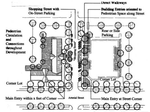
5-2.3.070 Commercial Districts - Building And Structure Height; Bonus For Mixed-Use
- Method of Measurement. Building and structure heights shall conform to the standards in Table 5-2.3.030; height is measured in conformance with Section 5-2.2.080. RL height step-down requirements, shall conform to the standards in Section 5-2.2.080.C.
- Height Bonus for Housing. Allowable building height in the Downtown District may be increased from 35 feet to 45 feet when housing is provided above ground floor commercial use(s), as generally shown in Figure 5-2.3.070B. Where a second egress is required for fire safety, residences may have their entrances/egress oriented to any yard; such entrances need not be oriented to the street.
Figure 5-2.3.070B - Building Height Bonus for Housing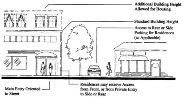
5-2.3.080 Commercial Districts - Architectural Design Standards
- Purpose and Applicability. Section 5-2.3.080 is intended to provide detailed, human-scale design that is characteristic of the City of John Day while affording flexibility to use a variety of architectural building styles. All new buildings and major remodels shall meet the standards of subsections 5-2.3.080.B-D., which are applied through Site Design Review. The applicant demonstrates that the standards are met by complying with the criteria under each standard.
- Pedestrian-Orientation. The design of all buildings on a site shall support a safe and attractive pedestrian environment. This standard is met when the approval body finds that all of the criteria in 1-7, below, are met. Alternatively, the approval body may approve a different design upon finding that the design contains an equally good or superior way of achieving the above standard.
- The building orientation standards under Section 5-2.3.060 are met; and
- Primary building entrances shall open directly to the outside and, if not abutting a street, shall have walkways connecting them to the street sidewalk; every building shall have at least one primary entrance that does not require passage through a parking lot or garage to gain access; and
- Corner buildings (i.e., buildings within 20 feet of a corner as defined by the intersecting curbs) shall have corner entrances, or shall provide at least one entrance within 20 feet of the street corner or corner plaza; and
- At least 60 percent of the building’s front facade (measured horizontally in linear feet) shall be located at the build-to line or closer to the street; build-to lines are prescribed by Section 5-2.3.030; and
- Ground floor windows or window displays shall be provided along at least 40 percent of the building’s (ground floor) street-facing elevation(s); windows and display boxes shall be integral to the building design and not mounted to an exterior wall; and
- Primary building entrance(s) are designed with weather protection, such as awnings, canopies, overhangs, or similar features; and
- Drive-up and drive-through facilities, when allowed, shall conform to Section 5-2.3.100; the provisions of which shall not be modified without a variance (Chapter 5-5.1).
- Compatibility. All new buildings and major remodels shall be designed consistent with the architectural context in which they are located. This standard is met when the approval body finds that all of the criteria in 1-7, below, are met.
- There is continuity in building sizes between new and existing buildings;
- The ground floor and upper floor elevations and architectural detailing are compatible with adjacent commercial buildings;
- Buildings adjacent to the RL district height step-down, as required by Section 5-2.2.080.C.
- Roof elevation is compatible with adjacent commercial buildings (roof pitch, shape, height step-down);
- There is continuity of building sizes on the site, if more than one building is proposed;
- There is continuity in the orientation, proportion, and detailing of windows and doors on the proposed building(s);
- The relationship of buildings to public spaces, such as streets, plazas, other areas, and public parking, including on-street parking, is strengthened by the proposed building(s).
- Human Scale. The design of all buildings shall be to a human-scale. This standard is met when the approval body finds that all of the criteria in 1-6, below, are met. Alternatively, the approval body may approve a different design upon finding that the design contains an equally good or superior way of achieving the above standard. Figure 5-2.3.080D contrasts examples of building elevations that are consistent/inconsistent with human scale criteria.
- Regularly spaced and similarly-shaped windows are provided on all building stories;
- Ground floor retail spaces have tall ceilings (i.e., 12-16 feet) with display windows on the ground-floor;
- Display windows are trimmed, recessed, or otherwise defined by wainscoting, sills, water tables, or similar architectural features;
- On multi-story buildings, ground floors are defined and separated from upper stories by appropriate architectural features (e.g., cornices, trim, awnings, canopies, arbors, trellises, overhangs, or other features) that visually identifies the transition from ground floor to upper story; such features should be compatible with the surrounding architecture;
- The tops of flat roofs are treated with appropriate detailing (i.e., cornice, pediment, flashing, trim, or other detailing) that is compatible with the surrounding architecture;
- Pitched roofs have eaves, brackets, gables with decorative vents, or other detailing that is consistent with the surrounding architecture;
- Historic design and compatibility requirements, where applicable, are met; and
- Where buildings with greater than 20,000 square feet of enclosed ground-floor space are proposed, they shall provide articulated facades on all street-facing elevations. This criterion is met when an elevation contains at least one of the following features for every 40 feet of building (horizontal length): windows; primary entrances; weather protection (awnings, canopies, arbors, trellises), building offsets; projections; changes in elevation or horizontal direction; sheltering roofs; terraces; a distinct pattern of divisions in surface materials; ornamentation; screening trees; small-scale lighting (e.g., wall-mounted lighting, or up-lighting); and/or similar features as generally shown in Figure 5-2.3.080.D. Note: Figure 5-2.3.080.D should not be interpreted as a required architectural style.
Figure 5-2.3.080.D – Examples of Large Commercial Design Elements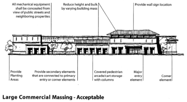
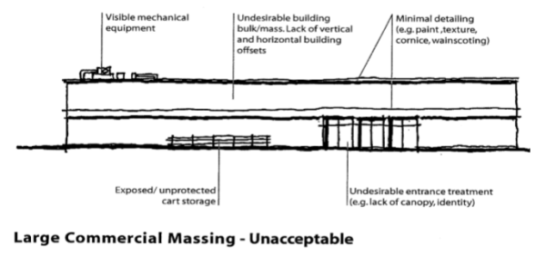
5-2.3.090 Commercial Districts - Pedestrian Amenities
- Purpose and Applicability. Section 5-2.3.090 provides standards for pedestrian amenities when pedestrian amenities are required as part of new developments and major remodels in the Downtown District, and when pedestrian amenities are provided to meet the requirements of other code sections. Pedestrian amenities serve as informal gathering places for socializing, resting, and enjoyment along street frontages and contribute to a walkable district.
- Standards. New developments and major remodels in the Downtown District and other developments subject to the provisions of this section shall provide one (1) or more of the “pedestrian amenities” listed below, and as generally illustrated in Figure 5-2.3.090.B. Pedestrian amenities may be provided within a street furnishing zone, building frontage zone, or plaza, or within the pedestrian through zone, as shown in Figure 5-2.3.090.B. Use of the public right-of-way requires approval by the road authority.
- A plaza, courtyard, square or extra-wide sidewalk next to the building entrance (minimum width of 6 feet);
- Sitting space (i.e., dining area, benches, garden wall or ledges between the building entrance and sidewalk) with a minimum of 16 inches in height and 30 inches in width;
- Building canopy, awning, pergola, or similar weather protection (minimum projection of 4 feet over a sidewalk or other pedestrian space);
- Public art that incorporates seating (e.g., fountain, sculpture).
- Transit bus shelter in accordance with the following guidelines:
- Three walls (a rear and two sides with a minimum covered area of 48 square feet. For areas with space limitations, other types of shelters (e.g., umbrella or half wall or canopies) may be used.
- Interior seating.
- A minimum front clearance of four feet (five feet desirable) from the shelter to the edge of the curb.
- Minimum sidewalk around shelter (i.e., sides and rear) of three feet (five feet desirable).
- Display panel for route and schedule information, if not provided on information kiosk.
Figure 5-2.3.090 – Examples of Pedestrian Amenities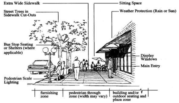
5-2.3.100 Commercial Districts - Special Use Standards
This section supplements the standards contained in Sections 5-2.3.020 through 5-2.3.090. It provides standards for the following land uses to control the scale and compatibility of those uses:
Drive-up and Drive-through Uses and Facilities
Marijuana Businesses
- Drive-Up/Drive-In/Drive-Through Uses and Facilities. When drive-up or drive-through uses and facilities are allowed, they shall conform to all of the following standards, which are intended to calm traffic, and protect pedestrian comfort and safety.
- The drive-up/drive-through facility shall orient to an alley, driveway, or interior parking area, and not a street [Figure 5-2.3.100.A(1)];
- None of the drive-up, drive-in or drive-through facilities (e.g., driveway queuing areas, windows, teller machines, service windows, kiosks, drop-boxes, or similar facilities) are located within 20 feet of a street and shall not be oriented to a street corner. (Walk-up only teller machines and kiosks may be oriented to a street or placed adjacent to a corner);
- Drive-up/in queuing areas shall be designed so that vehicles do not obstruct a driveway, fire access lane, walkway, or public right-of-way; and
- In the Downtown District, no more than one drive-up, drive-in, or drive-through facility is allowed for a distance of 400 linear feet along the same block face (same side of street).
Figure 5-2.3.100.A(1) – Drive-Up and Drive-Through Facilities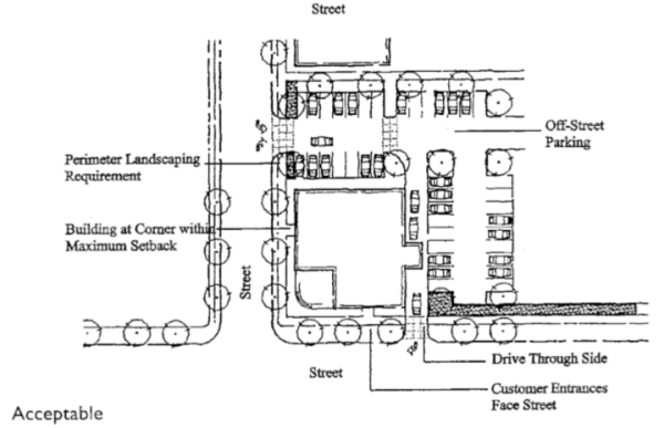
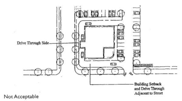
- Marijuana Businesses
- Marijuana Business General Standards
In addition to the approval for site design review and/or conditional use permit approval, and any other applicable standards in this Development Code, the applicant shall satisfy the following standards. These shall continue to be maintained throughout the life of the permit.
- The marijuana business’s state license or authority must be in good standing with the Oregon Health Authority or Oregon Liquor Control Commission and the marijuana business must comply with all applicable laws and regulations administered by the respective state agency, including, without limitation those rules that relate to labeling, packaging, testing, security, waste management, food handling, and training.
- If there are any conflicting standards between state law and the standards of this Development Code, the most stringent standard shall apply.
- An applicant for a marijuana business must obtain a City business license no later than six months after land use approval.
- All marijuana businesses shall conduct operations inside secure, enclosed structures. Marijuana products may not be displayed in a manner that is externally visible to the public. All doorways, windows, and other openings shall be located, covered, or screened in such a manner to prevent a view into the interior from any exterior public or semipublic area. No drive-through, curb-side, or other external sales methods are permitted.
- The applicant shall demonstrate how the proposed marijuana business complies with all state security system requirements applicable to the proposed marijuana business.
- Odors shall not be detectable at the property line. The applicant must demonstrate that an air filtration system or other mitigation measures will effectively control odors, to the satisfaction of the Planning Commission.
- The structure within which the marijuana business will operate must meet applicable fire and building code requirements.
- Applicants for a specific type of marijuana business shall satisfy the additional standards applicable to that type of marijuana business set out in subsections (2) through (5) of this section.
- Marijuana businesses must maintain adequate outdoor lighting over each exterior exit. All outdoor lighting must be fully shielded, downward casting, and must not spill over onto structures, other properties, or the night sky.
- No events of any kind are permitted in any marijuana business.
- Additional Standards for Medical Marijuana Dispensaries
- The premises of a medical marijuana dispensary must not be located:
- On the same parcel or lot as a marijuana grow site registered under ORS 475B.810;
- Within 1,000 feet of the real property comprising a school providing education to K-12 grades, childcare center, or park;
- Within 1,000 feet of another medical marijuana dispensary; and/or
- Within 500 feet of the premises of a marijuana retailer
- Sales or any other transfers of marijuana to customers must occur inside the licensed premises and must be conducted only between the marijuana business and individuals 21 years of age and older.
- "Within 1,000 feet" or “500 feet” means a straight-line measurement in a radius extending for 1,000 feet or less, or 500 feet or less (as applicable) in every direction from the closest point on the boundary line of the real property or premises (as applicable) of the applicable conflicting use identified in this section.
- “Premises” shall have the meaning assigned to such term in ORS 475B.015(30) as if such statute were also applicable to medical marijuana dispensaries.
- Medical marijuana dispensaries are considered “retail” for purposes of parking requirements.
- When a marijuana business is both a medical marijuana dispensary and a recreational marijuana retailer, the marijuana business must adhere to the more stringent standard between the two uses.
- No marijuana shall be consumed on the premises.
- The premises of a medical marijuana dispensary must not be located:
- Additional standards for Recreational Marijuana Retailers
- The premises for a marijuana retailer must not be located:
- At the same address as another marijuana business except as permitted under state law, the time, place, and manner restrictions, and this Development Code; or
- Within 1,000 feet of the real property comprising a public or private elementary, secondary, and/or career school attended primarily by minors;
- Within 500 feet of the premises of a medical marijuana dispensary; and/or
- Within 500 feet of the premises of another marijuana retailer.
- Sales or any other transfers of marijuana to customers must occur inside the licensed premises and must be conducted only between the marijuana business and individuals 21 years of age and older.
- "Within 1,000 feet” or “500 feet” means a straight-line measurement in a radius extending or 1,000 feet or less, or 500 feet or less (as applicable), in every direction from the closes point on the boundary line of the real property or premises (as applicable) of the applicable conflicting use identified in this section.
- "Premises” shall have the meaning assigned to such term in ORS 475B.015(30).
- Marijuana retailers are considered “retail” for purposes of parking requirements.
- When marijuana business is both a medical marijuana dispensary and a recreational marijuana retailer, the marijuana business must adhere to the more stringent standards between the two uses.
- No marijuana shall be consumed on the premises.
- The premises for a marijuana retailer must not be located:
- Additional standards for Marijuana Production Facilities
- Marijuana production facilities shall only be approved if the growing activities occur exclusively within permanent, fully enclosed, rigid, non-translucent structures with an approved building permit. No hoop-houses, sheds, shipping containers, trailers, or similar structures are permitted.
- Retail sales of marijuana products may not occur at the same location as a marijuana production facility.
- All production facilities shall be equipped with odor control filtration and ventilation system(s) to control odors, humidity, and mold.
- All lighting shall be fully shielded, downward casting and not spill over onto structures, other properties, or the night sky. All production facilities shall be fully contained so that little to no light escapes. Light shall not escape at a level that is visible from neighboring properties between sunset and sunrise.
- A site security plan shall be required. Security cameras shall be motion-sensor and be installed with capability to record activity beneath the canopy but shall not be visible from surrounding parcels and shall not be pointed at or recording activity on surrounding lots or parcels. Surveillance video shall be kept for a minimum of thirty (30) days. Video must use standard industry format to support criminal investigations. Lighting and alarms shall be installed to ensure the safety of persons and to protect the premises from theft. All production sites shall be screened by non-invasive fire-resistant vegetation and fenced with locking gates with a Knox lock. Razor wire and similar fencing shall not be permitted. Weapons and firearms at the cultivation site are prohibited. Security measures shall be designed to ensure emergency access in compliance with fire safe standards. All structures used for production shall have locking doors to prevent free access.
- Any production facilities that utilize hazardous materials shall maintain any applicable permits from local, regional, or state programs regulating the use, storage, or disposal of hazardous materials.
- A waste management plan addressing the storing, handling, and disposing of all waste by-products of the production activities in compliance shall be submitted for review and approval by the agency having jurisdiction. The plan shall characterize the volumes and types of waste generated, and the operational measures that are proposed to manage and dispose or reuse the wastes in compliance with best management practices. All garbage and refuse on the site shall be accumulated or stored in non-absorbent, water-tight, vector resistant, durable, easily cleanable, galvanized metal or heavy plastic containers with tight fitting lids. No refuse container shall be filled beyond the capacity to completely close the lid. All garbage and refuse on the site shall not be accumulated or stored for more than seven (7) calendar days and shall be properly disposed of before the end of the seventh day in a manner prescribed by the solid waste local enforcement agency. All waste, including but not limited to refuse, garbage, green waste, and recyclables, must be disposed of in accordance with local and state codes, laws, and regulations. All waste generated from production facilities must be properly stored and secured to prevent access from the public.
- Additional standards for Marijuana Processing Facilities
- Marijuana processing operations shall only occur in permanent, fully enclosed, rigid, non-translucent with an approved building permit. No hoop-houses, sheds, shipping containers, trailers, or similar structures are permitted.
- All processing facilities shall be equipped with odor control filtration and ventilation system(s) to control odors, humidity, and mold.
- A site security plan shall be required. Security cameras shall be motion-sensor and be installed with capability to record activity beneath the canopy but shall not be visible from surrounding parcels and shall not be pointed at or recording activity on surrounding lots or parcels.
- Surveillance video shall be kept for a minimum of thirty (30) days. Video must use standard industry format to support criminal investigations. Lighting and alarms shall be installed to ensure the safety of persons and to protect the premises from theft. All processing sites shall be screened by non-invasive fire-resistant vegetation and fenced with locking gates with a Knox lock. Razor wire and similar fencing shall not be permitted. Weapons and firearms at the cultivation site are prohibited. Security measures shall be designed to ensure emergency access in compliance with fire safe standards. All structures used for processing shall have locking doors to prevent free access.
- Any processing facilities that utilize hazardous materials shall maintain any applicable permits from local, regional, or state programs regulating the use, storage, or disposal of hazardous materials.
- A waste management plan addressing the storing, handling, and disposing of all waste by-products of the processing activities shall be submitted for review and approval by the agency having jurisdiction. The plan shall characterize the volumes and types of waste generated, and the operational measures that are proposed to manage and dispose or reuse the wastes in compliance with best management practices. All garbage and refuse on the site shall be accumulated or stored in non-absorbent, water-tight, vector resistant, durable, easily cleanable, galvanized metal or heavy plastic containers with tight fitting lids. No refuse container shall be filled beyond the capacity to completely close the lid. All garbage and refuse on the site shall not be accumulated or stored for more than seven (7) calendar days and shall be properly disposed of before the end of the seventh day in a manner prescribed by the solid waste local enforcement agency. All waste, including but not limited to refuse, garbage, green waste and recyclables, must be disposed of in accordance with local and state codes, laws and regulations. All waste generated from processing facilities must be properly stored and secured to prevent access from the public.
- The following regulations apply to all marijuana businesses and shall be reiterated in the Conditions of Approval of all land use approvals for a marijuana business.
- The applicant for a marijuana business shall obtain and present documentation of all applicable state approvals, registrations, licensing, and permitting to the City within six months after land use approval.
- Marijuana businesses shall keep all required state registrations, licensing, and permitting current at all times.
- Marijuana businesses shall keep all required City business licenses, permits, or other required approvals current at all times.
- At all times, marijuana businesses shall remain compliant with applicable standards and applicable state laws governing marijuana businesses, all as they may be amended from time to time.
- At all times, the operator of a marijuana business shall be the same person or entity holding the corresponding City business license, recreational marijuana or dispensary permit, and applicable state registrations, licensing, and/or permitting. The operator shall provide the City notice and appropriate documentation from the state of any changes in ownership or the suspension, loss, or forfeiture of any state approval, registration, licensing, or permitting.
- Any approval for a marijuana business shall be sent to the Planning Commission for a Type III revocation hearing if any condition of approval is violated and not cured within thirty (30) days of the City’s delivery of a notice identifying the violation. The Planning Commission shall have the authority to revoke the land use approval after a public hearing on the matter if it is shown that the applicant did not adhere to any criteria or development standard. The City Manager may prescribe a longer cure period provided such period does not exceed ninety (90) days.
- Any approval for a marijuana business shall be deemed abandoned, and thus void, if the marijuana business ceases to operate for any period of one hundred eighty (180) or more consecutive days.
- Marijuana and tobacco products must not be smoked, ingested, consumed, or otherwise used on the licensed premises.
- The facility must provide for secure disposal of marijuana remnants or byproducts; marijuana remnants or by-products shall not be placed within the marijuana business’s exterior refuse containers.
- All products containing marijuana intended to be ingested (i.e. edibles) must be labeled with the product’s serving size and the amount of tetrahydrocannabinol in each serving in accordance with Oregon Health Authority and Oregon Liquor Control Commission rules.
- Marijuana Business General Standards
In addition to the approval for site design review and/or conditional use permit approval, and any other applicable standards in this Development Code, the applicant shall satisfy the following standards. These shall continue to be maintained throughout the life of the permit.
5-2.4.010 Industrial Districts - Purpose
Chapter 5-2.4 accommodates a range of industrial and commercial land uses in three Industrial Districts, Light Industrial (LI), General Industrial (GI), and Airport Industrial Park (AIP). The districts are intended to provide for land use compatibility while providing a high-quality environment for businesses and employees. The AIP district is also intended to provide for compatible land use adjacent to Ogilvie Field, and provide for economic development consistent with Oregon’s Certified Industrial Lands program. The GI district is intended to provide suitable locations for heavy industrial uses (e.g., raw materials processing; and manufacturing, assembly, packaging or distribution of heavy or large goods) that would not otherwise be compatible in other districts. Chapter 5-2.4 guides the orderly development of industrial areas based on the following objectives:
- Provide for efficient use of land and public services;
- Provide appropriately zoned land with a range of parcel sizes for industry;
- Provide transportation options for employees and customers;
- Locate business services close to major employment centers;
- Ensure compatibility between industrial uses and nearby commercial, airport, and residential areas;
- Provide appropriate design standards to accommodate a range of industrial users;
- Provide attractive locations for business to locate; and
- Accommodate mixed-use development of light industrial areas.
5-2.4.020 Industrial Districts - Allowed Land Uses
Table 5-2.4.020 identifies the land uses that are allowed in the Industrial Districts. The specific land use categories are described and uses are defined in Chapter 5-1.3.
| Table 5-2.4.020 – Land Uses Allowed in Industrial Districts | |||
| Uses | Status of Use in District | ||
| Use Categories (Examples of uses are in Chapter 5-1.3; definitions are in Chapter 5-6.1.) | General Industrial (GI) | Light Industrial (LI) | Airport Industrial Park (AIP |
| Residential Categories | |||
| Household Living | |||
| Residential Uses (Household Living and Group Living) allowed, if: | |||
| - Lawfully existing as of November 24, 2005 | P | P | N |
| - New dwelling built in conjunction with a permitted commercial or industrial use | N | P | CU/S |
| - Manufactured dwelling on an individual lot, subject to Section 5-2.2.100F. | N | N | N |
| - Manufactured dwelling park | N | N | N |
| Group Living Uses, if allowed above, shall conform to the provisions in Section 5-2.2.100D. | |||
| Commercial Categories | |||
| Drive-Up/Drive-In/Drive-Through (drive-up windows, kiosks, ATM’s, similar uses/facilities), per Section 5-2.3.100A for uses in LI District | P | S | N except “P” when accessory to a industrial use |
| Short-Term Vacation Rental | N | N | N |
| Educational Services, not a school (e.g., tutoring or similar services) | N | CU | CU |
| Entertainment, Major Event | N | CU | CU |
| Offices | P | P | P |
| Outdoor Recreation, Commercial | N | CU | CU |
| Parking Lot (when not an accessory use) | CU | CU | CU |
| Quick Vehicle Servicing or Vehicle Repair (See also Drive-Up Uses, Section 5.2.3.100A) | P | S | CU |
| Retail Sales and Commercial Service, | |||
| - less than 10,000 square feet floor area | CU | P | CU |
| - greater than 10,000 square feet floor area, per Section 5-2.4.050 | N | N | CU |
| Self-Service Storage | P | CU | P |
| Industrial Categories | |||
| Industrial Service (See also Drive-Up Uses) | |||
| - fully enclosed (e.g., office) | P | P | P |
| - not enclosed | P | CU | P |
| Marijuana Testing Laboratory per Section 5-2.4.070 per Section 5-2.4.070, if applicable per Section 5-2.4.070 | S | S | S |
| Manufacturing and Production | |||
| - fully enclosed | P | P | P |
| - not enclosed | P | CU | P |
| -Agricultural Processing | S | S | S |
| -Marijuana Processing Facility | CU/S | CU/S | CU/S |
| -Marijuana Production Facility | CU/S | CU/S | CU/S |
| -Industrial Hemp Production | S | S | S |
| Warehouse and Freight Movement | P | CU | P |
| Waste-Related | CU | N | N |
| Wholesale Sales, per Section 5-2.4.070 per Section 5-2.4.050 | |||
| - fully enclosed | P | P | N except “P” when accessory to a industrial use |
| - not enclosed | P | CU | |
| -Marijuana Wholesaler | S | S | S |
| Institutional Categories | |||
| Basic Utilities | P | P | N except “P” for utilities required to serve AIP district |
| Community Service, except as otherwise allowed by Public Facilities Overlay zone | N except “P” for public safety facilities | N except “P” for public safety facilities | N except “P” for public facilities |
| Daycare | N | N | N |
| Parks and Open Space, except open space areas are permitted by right when accessory to a primary permitted use | CU | CU | CU |
| Religious Institutions and Houses of Worship | N | CU | N |
| Schools, except education uses are permitted by right when accessory to a primary permitted use (e.g., flight instruction at airport, or vocational instruction in conjunction with industrial use) | N | CU | N |
| Other Categories | |||
| Accessory Structures (with a permitted use) | P | P | P |
| Agriculture – Animals, when | |||
| - existing use as of November 24, 2005 | P | P | Not applicable |
| - accessory to a permitted industrial use | P | N | P |
| - new use | N | N | N |
Agriculture – Nurseries and similar horticulture (See also, Wholesale and Retail Uses) per Section 5-2.4.070, when applicable | S | S | S |
| Buildings and Structures Exceeding the Height Limits in Section 5-2.4.060 | CU | CU | N Except as required per Ogilvie Field Airport Master Plan |
| Mining | CU | N | N |
| Radio Frequency Transmission Facilities | |||
| - within height limit of district | P | P | N except “P” in conjunction with airport operations |
| - exceeds height limit (free-standing or building-mounted facilities) | CU | CU | |
| Rail Lines and Utility Corridors, except those existing prior to November 24, 2005 are allowed. | CU | CU | P |
| Temporary Uses (limited to “P” and “CU” uses), per Section 5-4.9.010. | P/CU | P/CU | P/CU |
| Transportation Facilities (operation, maintenance, preservation, and construction in accordance with the City’s Transportation System Plan) | P | P | P |
Key:
P = Permitted, subject to site/development review
S = Permitted with standards (See cross-reference)
CU = Conditional Use permit required (Chapter 5-4.4)
N = Not permitted
CU/S = Conditional use with standards (5-2.4.070)
5-2.4.030 Industrial Districts - Setback Yards; Industrial Buffers
- Purpose. Setback yards and buffers provide separation between industrial and non-industrial uses for fire protection/security, building maintenance, sunlight and air circulation, noise buffering, airport operations, and visual separation.
- Applicability. The setback yard and buffer standards in subsections 5-2.4.030.C-F are minimum standards that apply to buildings, accessory structures, parking areas, mechanical equipment, and other development. In granting a Conditional Use Permit, the approval body may increase the standard yards and/or buffers consistent with the criteria in Chapter 5-4.4. The approval body may also decrease the standard yards and/or buffers through the CUP process, provided that all applicable building and fire safety codes are met.
- Front and Street Yard Setbacks. The following setbacks may be increased by the approval body for development adjacent to streets with substandard right-of-way; in such cases, additional setback shall be required to reserve space for the ultimate right-of-way required for the subject street classification, in accordance with the Transportation System Plan.
- General Industrial (GI) District: Minimum of 20 feet;
- Light Industrial (LI) District: Minimum of 10 feet
- Airport Industrial Park (AIP) District: Minimum of 10 feet
- Rear Yard Setbacks.
- General Industrial (GI) District: Minimum of 20 feet where adjacent to a Commercial or Industrial District, except common wall buildings with 0-setback are allowed;
- Light Industrial (LI) District: Minimum of 10 feet where adjacent to a Commercial or Industrial District, except common wall buildings with 0-setback are allowed;
- Industrial District (GI or LI) Abutting a Residential District: Minimum of 40 feet, and conformance with the RL height step-down standards in Section 5-2.2.080.C.
- Airport Industrial Park (AIP): Minimum of 10 feet.
- Side Yard Setbacks. There are no required side-yard setbacks, except compliance with building and fire codes is required; and a minimum side yard of 20 feet and conformance with the RL height step-down standards in Section 5-2.2.080.C is required when a General Industrial District or Light Industrial District (GI or LI) abuts an RL District.
- Landscaping, Buffering, and Other Yard Requirements.
- Buffering. A minimum of ten (10) percent of the overall site shall be landscaped in accordance with Chapter 5-3.2. The approval body may require additional landscaping, fences, walls or other buffering that exceed the landscaping standards in Chapter 5-3.2 when it finds through Site Design Review (Chapter 5-4.2), Conditional Use Permit review (Chapter 5-4.4), and/or Master Planned Development review (Chapter 5-4.5), as applicable, that more or different buffering is necessary to mitigate adverse noise, light, glare, and/or aesthetic impacts to adjacent properties.
- Pedestrian Access. The approval body may require the construction of pedestrian access ways through required buffers to ensure pedestrian connections within large developments, between multiple development phases, or connecting to other streets or sidewalks. The design of access ways shall conform to Section 5-3.1.030.
5-2.4.040 Industrial Districts - Lot Coverage
- General Industrial (GI) District: Maximum lot coverage, including all impervious surfaces, 90 percent.
- Light Industrial (LI) District: Maximum lot coverage, including all impervious surfaces, 80 percent.
- Airport Industrial Park (AIP) District: Maximum lot coverage, including all impervious surfaces, 80 percent.
5-2.4.050 Industrial Districts - Site Layout And Design
Industrial uses and developments shall be oriented on the site to accommodate multiple modes of transportation (pedestrians, vehicles, bicycles), to minimize adverse impacts (e.g., noise, glare, smoke, dust, exhaust, vibration, etc.) on adjacent uses, and to provide compatibility with adjacent uses to the extent practicable. The following standards shall apply to all development in the General Industrial and Light Industrial Districts:
- Comply with the site design and public improvement standards, and standards for access, circulation, parking, loading areas, landscaping and screening, and other applicable provisions of Article 3;
- Mechanical equipment, lights, emissions, shipping/receiving areas, and other components of an industrial use that are outside enclosed buildings, shall be located away from residential areas, schools, parks and other non-industrial areas to the maximum extent practicable; and
- The City may require a landscape buffer, or other visual or sound barrier (fence, wall, landscaping, or combination thereof), to mitigate adverse impacts that cannot be avoided, as provided in Section 5-2.4.030.
- Projects within the Airport Safety and Compatibility (AASC) Overlay shall additionally conform to Chapter 5-2.5. Where a conflict arises between the provisions of Chapter 5-2.5 and this Chapter, the provisions of Chapter 5-2.5 shall apply.
5-2.4.060 Industrial Districts - Building And Structure Height
The maximum allowable height of buildings and structures in the GI, LI, and AIP districts is 35 feet, except that taller buildings and structures are allowed when approved as part of a Conditional Use Permit, provided they conform to the RL height step-down standards in Section 5-2.2.080.C.
5-2.4.070 Industrial Districts - Special Use Standards
Section 5-2.4.070 supplements the standards contained in Sections 5-2.4.020 through 5-2.4.060. It provides standards for the following land uses to control the scale and compatibility of those uses:
- Marijuana Businesses
- Marijuana Business General Standards
In addition to approval the criteria for site design review and/or conditional use permit approval, and any other applicable standards in this Development Code, the applicant shall satisfy the following standards. These shall continue to be maintained throughout the life of the permit.- If there are any conflicting standards between state law and the standards of this Development Code, the most stringent standard shall apply.
- An applicant for a marijuana business must obtain a City business license no later than six months after land use approval.
- All marijuana businesses shall conduct operations inside secure, enclosed structures. Marijuana products may not be displayed in a manner that is externally visible to the public. No drive-through, curb-side, or other external sales methods are permitted.
- The applicant shall demonstrate how the proposed marijuana business complies with all state security system requirements applicable to the proposed marijuana business.
- Odors shall not be detectable at the property line. The applicant must demonstrate that the air filtration system will effectively control odors, to the satisfaction of the Planning Commission.
- The structure within which the marijuana business will operate must meet applicable fire and building code requirements.
- Applications for a specific type of marijuana business shall satisfy the additional standards applicable to that type of marijuana business set out in subsections (2) through (3) of this section.
- Additional standards for Marijuana Production Facilities
- Marijuana production facilities shall only be approved if the growing activities occur exclusively within permanent, fully enclosed, rigid, non-translucent structures with an approved building permit. No hoop-houses, sheds, shipping containers, trailers, or similar structures are permitted.
- Under no circumstances, and notwithstanding anything in this Development Code to the contrary, may retail sales of marijuana products occur at the same location as a marijuana production facility.
- All production facilities shall be equipped with odor control filtration and ventilation system(s) sufficiently sized to control odors, humidity, and mold.
- All lighting shall be fully shielded, downward casting and not spill over onto structures, other properties, or the night sky. All production facilities shall be fully contained so that little to no grow lighting escapes. Grow lighting shall not escape at a level that is visible from neighboring properties between sunset and sunrise.
- A site security plan shall be required. Security cameras shall be motion-sensor and be installed with capability to record activity beneath the canopy but shall not be visible from surrounding parcels and shall not be pointed at or recording activity on surrounding lots or parcels. Surveillance video shall be kept for a minimum of thirty (30) days. Video must use standard industry format to support criminal investigations. Lighting and alarms shall be installed to ensure the safety of persons and to protect the premises from theft. All production sites shall be screened by non-invasive fire-resistant vegetation and fenced with locking gates with a Knox lock. Razor wire and similar fencing shall not be permitted. Weapons and firearms at the cultivation site are prohibited. Security measures shall be designed to ensure emergency access in compliance with fire safe standards. All structures used for production shall have locking doors to prevent free access.
- Any production facilities that utilize hazardous materials shall maintain any applicable permits from local, regional, or state programs regulating the use, storage, or disposal of hazardous materials.
- A waste management plan addressing the storing, handling, and disposing of all waste by-products of the production activities in compliance shall be submitted for review and approval by the agency having jurisdiction. The plan shall characterize the volumes and types of waste generated, and the operational measures that are proposed to manage and dispose or reuse the waste in compliance with best management practices. All garbage and refuse on the site shall be accumulated or stored in non-absorbent, water-tight, vector resistant, durable, easily cleanable, galvanized metal or heavy plastic containers with tight fitting lids. No refuse container shall be filled beyond the capacity to completely close the lid. All garbage and refuse on the site shall not be accumulated or stored for more than seven (7) calendar days and shall be properly disposed of before the end of the seventh day in a manner prescribed by the solid waste local enforcement agency. All waste, including but not limited to refuse, garbage, green waste, and recyclables, must be disposed of in accordance with local and state codes, laws, and regulations. All waste generated from production facilities must be properly stored and secured to prevent access from the public.
- Additional standards for Marijuana Processing Facilities or Testing Laboratory
- Marijuana processing operations shall only occur in permanent, fully enclosed, rigid, non-translucent structure with an approved building permit. No hoop-houses, sheds, shipping containers, trailers, or similar structures are permitted.
- All processing facilities shall be equipped with odor control filtration and ventilation system(s) sufficiently sized to control odors, humidity, and mold.
- A site security plan shall be required. Security cameras shall be motion-sensor and be installed with capability to record activity beneath the canopy but shall not be visible from surrounding parcels and shall not be pointed at or recording activity on surrounding lots or parcels. Surveillance video shall be kept for a minimum of thirty (30) days. Video must use standard industry format to support criminal investigations. Lighting and alarms shall be installed to ensure the safety of persons and to protect the premises from theft. All processing sites shall be screened by non-invasive fire-resistant vegetation and fenced with locking gates with a Knox lock. Razor wire and similar fencing shall not be permitted. Weapons and firearms at the cultivation site are prohibited. Security measures shall be designed to ensure emergency access in compliance with fire safe standards. All structures used for processing shall have locking doors to prevent free access.
- Any processing facilities that utilize hazardous materials shall maintain any applicable permits from local, regional, or state programs regulating the use, storage, or disposal of hazardous materials.
- A waste management plan addressing the storing, handling, and disposing of all waste by-products of the processing activities shall be submitted for review and approval by the agency having jurisdiction. The plan shall characterize the volumes and types of waste generated, and the operational measures that are proposed to manage and dispose or reuse the waste in compliance with best management practices. All garbage and refuse on the site shall be accumulated or stored in non-absorbent, water-tight, vector resistant, durable, easily cleanable, galvanized metal or heavy plastic containers with tight fitting lids. No refuse container shall be filled beyond the capacity to completely close the lid. All garbage and refuse on the site shall not be accumulated or stored for more than seven (7) calendar days and shall be properly disposed of before the end of the seventh day in a manner prescribed by the solid waste local enforcement agency. All waste, including but not limited to refuse, garbage, green waste and recyclables, must be disposed of in accordance with local and state codes, laws and regulations. All waste generated from processing facilities must be properly stored and secured to prevent access from the public.
- The following regulations apply to all marijuana business and shall be reiterated in the Conditions of Approval of all land use permits for such business.
- The applicant for a marijuana business shall obtain and present documentation of all applicable state approvals, registrations, licensing, and permitting to the City within six months after land use approval.
- Marijuana businesses shall keep all required state registrations, licensing, and permitting current at all times.
- Marijuana businesses shall keep all required City business licenses, permits, or other required approvals current at all times.
- At all times, marijuana businesses shall remain compliant with applicable standards and applicable state laws governing marijuana businesses, all as they may be amended from time to time.
- At all times, the operator of a marijuana business shall be the same person or entity holding the corresponding City business license, recreational marijuana or dispensary permit, and applicable state registrations, licensing, and/or permitting. The operator shall provide the City notice and appropriate documentation from the state of any changes in ownership or the suspension, loss, or forfeiture of any state approval, registration, licensing, or permitting.
- Any approval for a marijuana business shall be sent to the Planning Commission for a Type III revocation hearing if any condition of approval is violated and not cured within thirty (30) days of the City’s delivery of a notice identifying the violation. The Planning Commission shall have the authority to revoke the land use approval after a public hearing on the matter if it is shown that the applicant did not adhere to any criteria or development standard. The City Manager may prescribe a longer cure period provided such period does not exceed ninety (90) days.
- Any approval for a marijuana business shall be deemed abandoned, and thus void, if the marijuana business ceases to operate for any period of one hundred eighty (180) or more consecutive days.
- Marijuana and tobacco products must not be smoked, ingested, consumed or otherwise used on the licensed premises.
- The facility must provide for secure disposal of marijuana remnants or byproducts; marijuana remnants or by-products shall not be placed within the marijuana business’s exterior refuse containers.
- All products containing marijuana intended to be ingested (i.e. edibles) must be labeled with the product’s serving size and the amount of tetrahydrocannabinol in each serving in accordance with Oregon Health Authority and Oregon Liquor Control Commission rules.
- Marijuana Business General Standards
- Industrial Hemp Businesses
- Industrial Hemp Standards
In addition to any applicable approval criteria, the applicant shall satisfy the following standards:
- The applicant must obtain all required state licenses and registrations and operate the industrial hemp use in accordance with state law.
- Applications for a specific type of industrial hemp use shall satisfy the additional standards applicable to that type of industrial hemp use set out in subsections (2) through (3) of this section.
- Industrial hemp production facilities shall only be approved if the growing activities occur exclusively within permanent, fully enclosed, rigid, non-translucent structures that require a building permit. All lighting used for growing purposes must be contained completely inside the structure. No hoop-houses, sheds, shipping containers, trailers, or similar structures are permitted.
- Odors shall not be detectable at the property line. The applicant must demonstrate that the air filtration system will effectively control odors.
- Retail sales of industrial hemp products may occur at the same location as an industrial hemp production facility as an ancillary use provided, such retail sales occupy less than ten percent (10%) of the total square footage of the structures in which industrial hemp production occurs.
- No outdoor storage or display of industrial hemp or industrial hemp products are permitted.
- The following regulations apply to all industrial hemp business and shall be reiterated in the Conditions of Approval of all land use permits for such business.
- Industrial hemp uses shall keep all required state registrations, licensing, and permitting current.
- At all times, industrial hemp uses shall remain compliant with applicable provisions of state laws governing industrial hemp, all as they may be amended from time to time.
- Industrial Hemp Standards
In addition to any applicable approval criteria, the applicant shall satisfy the following standards:
- Residential Use Standards in AIP Zone.
- Residential Uses shall not be allowed in the Primary Surface, Transitional Surface, or Runway Protection Zone.
- Residential Uses may be allowed under a Conditional Use Permit in the Horizontal Surface, Conical Surface, or Approach Surface, subject to compatibility criteria. Consult Table 3-4: Compatible Land Uses per FAR Part 77 Surfaces and FAA Safety Areas (January 2003) and follow notice criteria in Section 5-2.5-060 prior to issuing a Conditional Use Permit approval.
5-2.5.010 Scope And Purpose Of Regulations
The purpose of the AASC overlay zone is to encourage and support the continued operation and vitality of Ogilvie Field and to support compatible land uses adjacent to the airport. The overlay establishes land use compatibility and navigational safety standards to reduce potential safety hazards for persons living, working and recreating near Ogilvie Field, consistent with applicable State law and administrative rules. [ORS 836.600; ORS 836.619; OAR 660-013-0070; OAR 660-013-0080]
5-2.5.020 Definitions
The following definitions are incorporated consistent with applicable State law and administrative rules. [ORS 836.605; ORS 836.623(6); OAR 660-013-0020; OAR 660-013- 0070(1)A., B.; OAR 660-013-0080(1)A.]
Airport. The strip of land used for taking off and landing aircraft, together with all adjacent land used in connection with the aircraft landing or taking off from the strip of land, including but not limited to land used for existing airport uses.
Airport Direct Impact Area. The area located within 5,000 feet of an airport runway, excluding lands within the runway protection zone and approach surface.
Airport Elevation. The highest point of an airport's usable runway, measured in feet above mean sea level.
Airport Imaginary Surfaces. Imaginary areas in space and on the ground that are established in relation to the airport and its runways. Imaginary areas are defined by the primary surface, runway protection zone, approach surface, horizontal surface, conical surface and transitional surface.
Airport Noise Impact Boundary. Areas located within 1,500 feet of an airport runway or within established noise contour boundaries exceeding 55 Ldn.
Airport Secondary Impact Area. The area located between 5,000 and 10,000 feet from an airport runway.
Airport Sponsor. The owner, manager, or other person or entity designated to represent the interests of an airport.
Approach Surface. A surface longitudinally centered on the extended runway centerline and extending outward and upward from each end of the primary surface.
- The inner edge of the approach surface is the same width as the primary surface and it expands uniformly to a width of:
- 2,000 feet for a utility runway having a non-precision instrument approach;
- 3,500 feet for a non-precision instrument runway, other than utility, having visibility minimums greater than three-fourths statute mile;
- 4,000 feet for a non-precision instrument runway, other than utility, having visibility minimums at or below three-fourths statute mile; and
- 16,000 feet for precision instrument runways.
- The approach surface extends for a horizontal distance of:
- 5,000 feet at a slope of 20 feet outward for each foot upward for all utility runways;
- 10,000 feet at a slope of 34 feet outward for each foot upward for all non-precision instrument runways, other than utility; an
- 10,000 feet at a slope of 50 feet outward for each one foot upward, with an additional 40,000 feet at slope of 40 feet outward for each one foot upward, for precision instrument runways.
- The outer width of an approach surface will be that width prescribed in this subsection for the most precise approach existing or planned for that runway end.
Conical Surface. A surface extending outward and upward from the periphery of the horizontal surface at a slope of 20 to 1 for a horizontal distance of 4,000 feet.
Department of Aviation. The Oregon Department of Aviation, formerly the Aeronautics Division of the Oregon Department of Transportation.
FAA. The Federal Aviation Administration.
FAA's Technical Representative. As used in this ordinance, the federal agency providing the FAA with expertise on wildlife and bird strike hazards as they relate to airports. This may include, but is not limited to, the USDAAPHIS-Wildlife Services.
Height. The highest point of a structure or tree, plant or other object of natural growth, measured from mean sea level.
Horizontal Surface. A horizontal plane 150 feet above the established airport elevation, the perimeter of which is constructed by swinging arcs of specified radii from the center of each end of the primary surface of each runway of each airport and connecting the adjacent arcs by lines tangent to those arcs. The radius of each arc is:
- 5,000 feet for all runways designated as utility.
- 10,000 feet for all other runways.
- The radius of the arc specified for each end of a runway will have the same arithmetical value. That value will be the highest determined for either end of the runway. When a 5,000 foot arc is encompassed by tangents connecting two adjacent 10,000 foot arcs, the 5,000 foot arc shall be disregarded on the construction of the perimeter of the horizontal surface.
Non-precision Instrument Runway. A runway having an existing instrument approach procedure utilizing air navigation facilities with only horizontal guidance, or area type navigation equipment, for which a straight-in non-precision instrument approach has been approved, or planned, and for which no precision approach facilities are planned or indicated on an FAA approved airport layout plan or other FAA planning document.
Obstruction. Any structure or tree, plant or other object of natural growth that penetrates an imaginary surface.
Other than Utility Runway. A runway that is constructed for and intended to be used by turbine driven aircraft or by propeller-driven aircraft exceeding 12,500 pounds gross weight.
Precision Instrument Runway. A runway having an existing instrument approach procedure utilizing air navigation facilities that provide both horizontal and vertical guidance, such as an Instrument Landing System (ILS) or Precision Approach Radar (PAR). It also means a runway for which a precision approach system is planned and is so indicated by an FAA-approved airport layout plan or other FAA planning document.
Primary Surface. A surface longitudinally centered on a runway. When a runway has a specially prepared hard surface, the primary surface extends 200 feet beyond each end of that runway. When a runway has no specially prepared hard surface, or planned hard surface, the primary surface ends at each end of that runway. The elevation of any point on the primary surface is the same as the elevation of the nearest point on the runway centerline. The width of the primary surface is:
- 500 feet for utility runways having non-precision instrument approaches,
- 500 feet for other than utility runways having non-precision instrument approaches with visibility minimums greater than three-fourths statute mile, and
- 1,000 feet for non-precision instrument runways with visibility minimums at or below three-fourths statute mile, and for precision instrument runways.
Public Assembly Facility. For the purposes of Chapter 5-2.5, a permanent or temporary structure or facility, place or activity where concentrations of people gather in reasonably close quarters for purposes such as deliberation, education, worship, shopping, employment, entertainment, recreation, sporting events, or similar activities. Public assembly facilities include, but are not limited to, schools, churches, conference or convention facilities, employment and shopping centers, arenas, athletic fields, stadiums, clubhouses, museums, and similar facilities and places, but do not include parks, golf courses or similar facilities unless used in a manner where people are concentrated in reasonably close quarters. Public assembly facilities also do not include air shows, structures or uses approved by the FAA in an adopted airport master plan, or places where people congregate for short periods of time such as parking lots or bus stops.
Runway. A defined area on an airport prepared for landing and takeoff of aircraft along its length.
Runway Protection Zone (RPZ). An area off the runway end used to enhance the protection of people and property on the ground. The RPZ is trapezoidal in shape and centered about the extended runway centerline. The inner width of the RPZ is the same as the width of the primary surface. The outer width of the RPZ is a function of the type of aircraft and specified approach visibility minimum associated with the runway end. The RPZ extends from each end of the primary surface for a horizontal distance of:
- 1,000 feet for utility runways.
- 1,700 feet for other than utility runways having non-precision instrument approaches.
- 2,500 feet for precision instrument runways.
[NOTE: The outer width of the RPZ is specified by airport type in OAR 660, Div. 13, Exhibit 4]
Significant. As it relates to bird strike hazards, "significant" means a level of increased flight activity by birds across an approach surface or runway that is more than incidental or occasional, considering the existing ambient level of flight activity by birds in the vicinity.
Structure. Any constructed or erected object which requires location on the ground or is attached to something located on the ground. Structures include but are not limited to buildings, decks, fences, signs, towers, cranes, flagpoles, antennas, smokestacks, earth formations and overhead transmission lines. Structures do not include paved areas.
Transitional Surface. Those surfaces that extend upward and outward at 90 degree angles to the runway centerline and the runway centerline extended at a slope of seven (7) feet horizontally for each foot vertically from the sides of the primary and approach surfaces to the point of intersection with the horizontal and conical surfaces. Transitional surfaces for those portions of the precision approach surfaces which project through and beyond the limits of the conical surface, extend a distance of 5,000 feet measured horizontally from the edge of the approach surface and at a 90 degree angle to the extended runway centerline.
Utility Runway. A runway that is constructed for and intended to be used by propeller driven aircraft of 12,500 pounds maximum gross weight or less.
Visual Runway. A runway intended solely for the operation of aircraft using visual approach procedures, where no straight-in instrument approach procedures or instrument designations have been approved or planned, or are indicated on an FAA-approved airport layout plan or any other FAA planning document.
Water Impoundment. Includes wastewater treatment settling ponds, surface mining ponds, detention and retention ponds, artificial lakes and ponds, and similar water features. A new water impoundment includes an expansion of an existing water impoundment except where such expansion was previously authorized by land use action approved prior to the effective date of the AASC ordinance.
5-2.5.030 Imaginary Surface And Noise Impact Boundary Delineation
The airport elevation, the airport noise impact boundary, and the location and dimensions of the runway, primary surface, runway protection zone, approach surface, horizontal surface, conical surface and transitional surface, as delineated by the Ogilvie Field Airport Master Plan, are hereby made part of the Official City of John Day Zoning Map.
All lands, waters and airspace, or portions thereof, that are located within these boundaries or surfaces shall be subject to the requirements of this overlay zone. [ORS 836.619; OAR 660-0130040(8); OAR 660-013-0070(1); OAR 660-013-0080(1)]
5-2.5.040 Notice Of Land Use And Permit Applications Within Overlay Zone Area
Except as otherwise provided herein, written notice of applications for land use or limited land use decisions, including comprehensive plan or zoning amendments, in an area within this overlay zone, shall be provided to the airport sponsor and the Department of Aviation in the same manner as notice is provided to property owners entitled by law to written notice of land use or limited land use applications. See Development Code Article 5-4. [ORS 836.623(1); OAR 738-100-010; ORS 215.416(6); ORS 227.175(6)]
- Notice shall be provided to the airport sponsor and the Department of Aviation when the property, or a portion thereof, that is subject to the land use or limited land use application is located within 10,000 feet of the sides or ends of a runway:
- Except as provided under subsection 5-2.5.040D, notice of land use and limited land use applications shall be provided within the following timelines.
- Notice of land use or limited land use applications involving public hearings shall be provided prior to the public hearing at the same time that written notice of such applications is provided to property owners entitled to such notice.
- Notice of land use or limited land use applications not involving public hearings shall be provided at least 20 days prior to entry of the initial decision on the land use or limited land use application.
- Notice of the decision on a land use or limited land use application shall be provided to the airport sponsor and the Department of Aviation within the same timelines that such notice is provided to parties to a land use or limited land use proceeding.
- Notices required under Paragraphs A-C of this section need not be provided to the airport sponsor or the Department of Aviation where the property that is the subject of the land use or limited land use application is more than 35 feet lower in elevation at the site of structural development than any runway surface at Ogilvie Field; or, that meets all of the following criteria:
- Would only allow structures not exceeding 35 feet in height;
- Involves property located entirely outside the approach surface;
- Does not involve industrial, mining or similar uses that emit smoke, dust or steam; sanitary landfills or water impoundments; or radio, radiotelephone, television or similar transmission facilities or electrical transmission lines; and
- Does not involve wetland mitigation, enhancement, restoration or creation.
5-2.5.050 Height Limitations On Allowed Uses In Underlying Zones
All uses permitted by the underlying zone shall comply with the height limitations in this Section. When height limitations of the underlying zone are more restrictive than those of this overlay zone, the underlying zone height limitations shall control. [ORS 836.619; OAR 660-0130070]
- Except as provided in subsections B and C of this Section, no structure or tree, plant or other object of natural growth shall penetrate an airport imaginary surface. [ORS 836.619; OAR 660-013-0070(1)]
- For areas within airport imaginary surfaces but outside the approach and transition surfaces, where the terrain is at higher elevations than the airport runway surfaces such that existing structures and permitted development penetrate or would penetrate the airport imaginary surfaces, the maximum allowable structure height is 35 feet, except as approved with a Conditional Use Permit and pursuant to this Chapter.
- Where a structure height exceeding 35 feet is proposed, it may be approved only where it is supported in writing by the airport sponsor, and not opposed by the Department of Aviation or the FAA, unless the at-grade elevation of the structure’s footprint is such that the proposed maximum structure height is lower than the elevation of any runway surface at Ogilvie Field. Applications for increased height on any other property within this overlay zone shall follow the procedures set forth in Chapter 5-4.4 Conditional Use Permits and shall be subject to such conditions and terms as recommended by the Department of Aviation and the FAA.
5-2.5.060 Procedures
An applicant seeking a land use or limited land use approval in an area within this overlay zone shall provide the following information in addition to any other information required in the permit application:
- A map or drawing showing the location of the property in relation to the airport imaginary surfaces.
- A site plan drawn to scale including the location and elevation of the building site, all existing and proposed structures, measured in feet above mean sea level.
- If a Conditional Use Permit or Variance is requested for increased structure height, or residential dwelling letters of support from the airport sponsor, the Department of Aviation and the FAA unless the at-grade elevation of the structure’s footprint is such that the proposed maximum structure height is lower than the elevation of any runway surface at Ogilvie Field.
- Development of land near or adjacent to Grant County Regional Airport / Ogilvie Field may be required to undergo aeronautical evaluations by the FAA and ODAV, if
required under FAR Part 77.9 and OAR 738-070-0060. The aeronautical evaluations are initiated by the applicant providing notice to the FAA and ODAV to determine if the proposal poses an obstruction to aviation safety. Notice is to be provided in the form of FAA Form 7460-1, Notice of Proposed Construction or Alteration. The applicant must receive the resultant aeronautical determination letters from the FAA and ODAV prior to the approval of any building permits.
5-2.5.070 Land Use Compatibility Requirements
Applications for land use or building permits for properties within the boundaries of this overlay zone shall comply with the requirements of this chapter as provided herein. [ORS 836.619; OAR 660-013-0080]
- Noise. Within airport noise impact boundaries, land uses shall be established consistent with the levels identified in OAR 660, Division 13, Exhibit 5. A declaration of anticipated noise levels shall be attached to any subdivision or partition approval or other land use approval or building permit affecting land within airport noise impact boundaries. In areas where the noise level is anticipated to be at or above 55 Ldn, prior to issuance of a building permit for construction of a noise sensitive land use (real property normally used for sleeping or as a school, church, hospital, public library or similar use), the permit applicant shall be required to demonstrate that a noise abatement strategy will be incorporated into the building design that will achieve an indoor noise level equal to or less than 55 Ldn. [OAR 340-0350045(1)D., (4)] [NOTE: FAA Order 5100.38A, Chapter 7 provides that interior noise levels should not exceed 45 decibels in all habitable zones.]
- Outdoor Lighting. No new or expanded outdoor lighting shall project directly onto an existing runway or taxiway or into existing airport approach surfaces except where necessary for safe and convenient air travel and only as approved by the airport sponsor. Lighting for these uses shall incorporate shielding in their designs to reflect light away from airport approach surfaces. No use shall imitate airport lighting or impede the ability of pilots to distinguish between airport lighting and other lighting.
- Glare. No glare producing material, including but not limited to unpainted metal or reflective glass, shall be used on the exterior of structures located within an approach surface or on nearby lands where glare could impede a pilot's vision.
- Industrial Emissions. No new industrial, mining or similar use, or expansion of an existing industrial, mining or similar use, shall, as part of its regular operations, cause emissions of smoke, dust or steam that could obscure visibility within airport approach surfaces, except upon demonstration, supported by substantial evidence, that mitigation measures imposed as approval conditions will reduce the potential for safety risk or incompatibility with airport operations to an insignificant level. The review authority shall impose such conditions as necessary to ensure that the use does not obscure visibility.
- Communications Facilities and Electrical Interference. Proposals for the location of new or expanded radio, radiotelephone, and television transmission facilities and electrical transmission lines within this overlay zone shall be coordinated with the Department of Aviation and the FAA prior to approval. Approval of cellular and other telephone or radio communication towers on leased property located within airport imaginary surfaces shall be conditioned to require their removal within 90 days following the expiration of the lease agreement. A bond or other security shall be required to ensure this result.
- Landfills. No new sanitary landfills shall be permitted within 10,000 feet of any airport runway. Expansions of existing landfill facilities within these distances shall be permitted only upon demonstration that the landfills are designed and will operate so as not to increase the likelihood of bird/aircraft collisions. Timely notice of any proposed expansion shall be provided to the airport sponsor, the Department of Aviation and the FAA, and any approval shall be accompanied by such conditions as are necessary to ensure that an increase in bird/aircraft collisions is not likely to result.
- Limitations and Restrictions on Allowed Uses in the RPZ, Approach Surface, and Airport Direct and Secondary Impact Areas. The land uses allowed in the Airport Industrial District (Chapter 5-2.4) are allowed within the AA overlay, subject to the following standards and limitations:
- No Structures shall be allowed within the Runway Protection Zone (RPZ). Exceptions shall be made only for structures accessory to airport operations whose location within the RPZ has been approved by the Federal Aviation Administration.
- In the RPZ, public airport uses are restricted to those uses and facilities that require location in the RPZ.
- Agricultural and farming practices normal and accepted for the area are not considered a conflict; however, deliberate attempts to attract birds with agricultural and/or farming practices shall be prohibited.
- Roads and parking areas are permitted in the RPZ only upon demonstration that there are not practicable alternatives. Lights, guardrails, and related accessory structures are prohibited. Cost may be considered in determining whether practicable alternatives exist.
- In the RPZ, utilities, power lines and pipelines must be underground. In approach surfaces and in airport direct and secondary impact areas, the proposed height of utilities shall be coordinated with the airport sponsor and Department of Aviation (ODA).
- Public assembly facilities are prohibited in the RPZ.
- Golf courses may be permitted only upon demonstration, supported by substantial evidence, that management techniques will be utilized to reduce existing wildlife attractants and avoid the creation of new wildlife attractants. Such techniques shall be required as conditions of the approval. Structures are not permitted within the RPZ. For purposes of this document, tee markers, tee signs, pin cups and pins are not considered to be structures.
- Public assembly facilities may be allowed in an approach surface only if the potential danger to public safety is minimal. In determining whether a proposed use is appropriate, consideration shall be given to: proximity to the RPZ; density of people per acre; frequency of use; level of activity at the airport; and other factors relevant to public safety. In general, high density uses should not be permitted within airport approach surfaces, and on residential structures should be located outside approach surfaces unless no practicable alternatives exist.
- Mining operations involving the creation or expansion of water impoundments shall comply with the requirements of this document regarding water impoundments.
- Water impoundments are prohibited within 5,000 feet from the edge or end of a runway; however, Agricultural Irrigation Structures, including but not limited to; impoundments in rivers or streams; conveyance structures such as ditches and canals; and, the ponding of water caused by irrigation practices on crops in fields and runoff from irrigated fields, shall be exempt from this prohibition.
- Wetland Mitigation required for projects located within an approach surface, the airport direct or secondary impact area shall be authorized only upon demonstration, supported by substantial evidence, that it is impracticable to provide mitigation outside of these areas. Proposals for wetland mitigation shall be coordinated with the airport sponsor, the Department of Aviation, the FAA and the wetland-permitting agencies prior to the issuance of required permits. Wetland mitigation shall be designed and located to avoid creating a wildlife hazard or increasing hazardous movements of birds across runway and approach surfaces. Conditions shall be imposed as are appropriate and necessary to prevent in perpetuity an increase in hazardous bird movements across runway and approach surfaces.
- See also, Chapter 5-2.4 Airport Industrial District.
- Structures, Trees, and Landscaping. The height of any new structures, trees, or planted vegetation shall not penetrate FAR Part 77 Imaginary Surfaces, as determined by the FAA and ODAV.
5-2.5.080 Water Impoundments Within Approach Surfaces And Airport Direct And Secondary Impact Boundaries
Any use or activity that would result in the establishment or expansion of a water impoundment shall comply with the requirements of this section. [ORS 836.623(2); OAR 660-013-0080(1)(f)]
- Except as provided under subsection (B) of the section, and as set forth in 502.5.070 (G) (12) “Agricultural Irrigation Structures”, above, no new or expanded water impoundments of one-quarter acre in size or larger are permitted:
- Within an approach surface and within 5,000 feet from the end of a runway; or
- On land owned by the airport sponsor that is necessary for airport operations.
- Storm water management basins established by an airport identified under ORS 836.610(1) are allowed.
5-2.5.090 Wetland Mitigation, Creation, Enhancement And Restoration Within Approach Surfaces And Airport Direct And Secondary Impact Boundaries
- Notwithstanding the requirements of Subsection 5-2.5.080, wetland mitigation, creation, enhancement or restoration projects located within areas regulated under Subsection 5-2.5.080 shall be allowed upon demonstration of compliance with this requirements of this Section.
- Wetland mitigation, creation, enhancement or restoration projects existing or approved on the effective date of this ordinance and located within areas regulated under Subsection 5-2.5.080 are recognized as lawfully existing uses.
- To help avoid increasing safety hazards to air navigation near public use airports, the establishment of wetland mitigation banks in the vicinity of such airports but outside approach surfaces and areas regulated under Subsection 5-2.5.080 is encouraged.
- Applications to expand wetland mitigation projects in existence as of the effective date of this ordinance, and new wetland mitigation projects, that are proposed within areas regulated under Subsection 5-2.5.080 shall be considered utilizing the review process applied to applications for conditional use permits and shall be permitted upon demonstration that:
- It is not practicable to provide off-site mitigation; or
- The affected wetlands provide unique ecological functions, such as critical habitat for threatened or endangered species or ground water discharge, and the area proposed for mitigation is located outside an approach surface.
- Wetland mitigation permitted under subsection D. of this Section shall be designed and located to avoid creating a wildlife hazard or increasing hazardous movements of birds across runways or approach surfaces.
- Applications to create, enhance, or restore wetlands that are proposed to be located within approach surfaces or within areas regulated under Subsection 5-2.5.080, and that would result in the creation of a new water impoundment or the expansion of an existing water impoundment, shall be considered utilizing the review process applied to applications for conditional use permits and shall be permitted upon demonstration that:
- The affected wetlands provide unique ecological functions, such as critical habitat for threatened or endangered species or ground water discharge; and
- The wetland creation, enhancement or restoration is designed and will be maintained in perpetuity in a manner that will not increase hazardous movements of birds feeding, watering or roosting in areas across runways or approach surfaces.
- Proposals for new or expanded wetland mitigation, creation, enhancement or restoration projects regulated under this Section shall be coordinated with the airport sponsor, the Department of Aviation, the FAA and FAA's technical representative, the Oregon Department of Fish & Wildlife (ODFW), the Oregon Division of State Lands (DSL), the US Fish & Wildlife Service (USFWS), and the US Army Corps of Engineers (Corps) as part of the permit application.
- A decision approving an application under this Section shall require, as conditions of approval, measures and conditions deemed appropriate and necessary to prevent in perpetuity an increase in hazardous bird movements across runways and approach surfaces.
5-2.5.100 Nonconforming Uses
- These regulations shall not be construed to require the removal, lowering or alteration of any structure not conforming to these regulations. These regulations shall not require any change in the construction, alteration or intended use of any structure, the construction or alteration of which was begun prior to the effective date of this overlay zone, except as may be required under Chapter 5-5.2 Non-Conforming Uses and Development.
- Notwithstanding subsection A. of this section, the owner of any existing structure that has an adverse effect on air navigational safety as determined by the Department of Aviation shall install or allow the installation of obstruction markers as deemed necessary by the Department of Aviation, so that the structures become more visible to pilots.
- No land use or limited land use approval or other permit shall be granted that would allow a nonconforming use or structure to become a greater hazard to air navigation than it was on the effective date of the overlay zone.
5-2.5.110 Avigation Easement Required
Within this overlay zone, property owners who apply for land use or limited land use decisions, for building permits for new residential, commercial, industrial, institutional or recreational buildings or structures intended for inhabitation or occupancy by humans or animals, or for expansions of such buildings or structures by the lesser of 50% or 1,000 square feet, shall, as a condition of obtaining such approval or permits, dedicate an avigation easement to the airport sponsor. The avigation easement shall be in a form acceptable to the airport sponsor and shall be signed and recorded in the deed records of the County. The avigation easement shall allow unobstructed passage for aircraft and ensure safety and use of the airport for the public. Property owners or their representatives are responsible for providing the recorded instrument prior to issuance of building permits.
5-2.6.010 Scope And Purpose Of Regulations
In any zone which is a GH Geological Hazard Overlay, the requirements and standards of this Chapter shall apply in addition to those of the underlying zone; provided, that if a conflict in regulations or standards occurs, the provisions of this Chapter shall govern. The purpose of the GH overlay zone is to promote the public safety and welfare by preventing certain types of development in those areas which natural hazards or other factors pose threats to human occupancy safety.
5-2.6.020 Application Of Provisions
The provisions of this Chapter shall apply to all areas of special geological hazards within the jurisdiction of the City. The areas of special geological hazard identified by the Oregon Department of Geology and Mineral Industries in a report entitled “Engineering Geology of the John Day Area, Grant County, Oregon – Dated 1975” are hereby adopted by reference and declared to be a part of this Title, and thereof, the provisions of this Chapter shall apply to all geological hazard areas identified by said report.
5-2.6.030 Uses Permitted Outright
In a zone with which the GH Zone is an overlay, the following uses are the only uses permitted outright, and these uses are permitted only if such uses are permitted in the zone regulations for the primary zone:
- Agricultural use conducted without locating a structure in the zone, except for a boundary fence, and shall be restricted to prevent destruction of vegetation sufficient to cause erosion.
- Industrial or commercial use that does not require a structure other than surfacing at ground level such as for a loading area, parking area, or that requires only temporary structures that will not necessitate ground excavation for placement.
- Recreational use that requires no structures, alteration of the natural geology or vegetation removal without immediate replacement.
- Portions of a residential use that do not contain buildings such as a lawn, garden, parking area or play area, or a related use thereof that does not require alteration of the natural geology or excavation thereof.
5-2.6.040 Conditional Use Permitted In The GH Zone
In a zone with the GH overlay, those uses permitted by the primary zone shall be permitted, subject to this Chapter and the provisions of the primary zone.
5-2.6.050 Permit For Use Or Development
No person shall construct, reconstruct or install a development, install a mobile home, or divide land in a GH Zone unless a permit has been received for the work, except for those uses permitted by 5-2.6.040 of this Chapter. Except for improvement of an existing structure which is less than substantial as determined by a certified building official or the City upon appeal, no permit shall be issued unless the work will be reasonably safe from geological hazard and otherwise comply with this Chapter and this Title, and other applicable regulations. Said permits shall be processed in the same manner as a conditional use permit under this Title as set forth in Chapter 5-4.4 of this Title.
5-2.6.060 Application Requirements For Use
An application for a use or development in a GH overlay zone shall be accompanied by the following:
- Site Investigation Report: An application for a use or development in a GH overlay zone requires a site investigation report for the subject area. The site investigation report shall provide information on the site of the development and adjacent land that is likely to be affected by a proposed development. Unless the City determines specific terms are not required, the report shall include the information described in this Section together with appropriate identification of information sources and the date of the information. Before a development permit can be issued, the site investigation report must be approved as part of the development permit approval process. The approved site investigation report shall be referred to in the deed and other documents of sale and shall be recorded with the record of deeds.
- Background Data In Report: The site investigation report shall contain the following background information:
- A general analysis of the local and regional topography and geology including the faults, folds, geologic and engineering geologic units and any soil, rock and structural details important to engineering or geologic interpretations and their relative activity.
- A history of problems on land adjacent to the site, which may be derived from discussions with local residents and officials and the study of old photographs, reports and newspaper files.
- The extent of the surface soil formation and its relationship to the vegetation of the site, the activity of the land form, and the location of the site.
- The following ground photographs of the site with information showing the scale and date of the photographs and their relationship to the topographic map and profiles:
- A view of the general area.
- The site of the proposed development.
- Any features which are important to the interpretation of the hazard potential of the site, including all sites of erosion and accretion.
- Topography Map: A topography base map of one hundred feet to one inch (100’ = 1”) scale and with a contour interval of two feet (2”) shall be prepared identifying the following features and shall be accompanied by references to the source and date of information used:
- The position of the lot line.
- The boundaries of the property.
- Each geological feature classification type.
- Areas of open ground and the boundaries and species identification of major plant communities.
- Any springs, streams, marshy areas, standing bodies of water or intermittent waterways.
- Cut terraces, erosion scarps and areas exhibiting significant surface erosion due to improper drainage and runoff concentration.
- Geological information, including lithologic and structural details important to engineering and geologic interpretation.
- Subsurface Analysis: If upon initial investigation it appears there are critical areas where the establishment of geologic conditions at depth is required, a subsurface analysis obtained by drill holes, well logs and other geophysical techniques shall be conducted by the person responsible for the site investigation report to include the following data, as appropriate:
- The lithology and compaction of all subsurface horizons to bedrock.
- The depth, width, slope and bearing of all horizons containing significant amounts of silt and clay and any other subsurface layers which could reduce surface water infiltration.
- Development Proposals: The site investigation report shall include the following information on the proposed development as applicable:
- Plans and profiles showing the position and height of each structure, paved area and area where cut and fill is required for the construction.
- The percent and location of the surface of the site which will be covered by impermeable surfaces.
- A stabilization program for the development describing:
- How much of the site will be exposed during construction and what measures will be taken to reduce wind erosion and soil movement during construction.
- A revegetation program designed to return open soil areas, both preexisting and newly created, to a stable condition as soon as possible following construction and the period of time during which revegetated areas will receive revegetation maintenance.
- Conclusions In The Site Investigation:
- The site investigation report shall contain conclusions stating the following:
- How the intended use of the land is compatible with the conditions.
- Any existing or potential hazards noted during the investigation.
- Mitigating recommendations for specific areas of concern shall be included.
- Conclusions shall be based on data included in the report, and the sources of information and facts shall be specifically referenced.
- The site investigation report shall contain conclusions stating the following:
5-2.6.070 Standards For Building Construction In GH Zone
- Building construction shall only be approved under conditions that do not adversely affect geologically stability or vegetation. The grading of land and the orientation and design of a building shall avoid creating conditions that will cause erosion or accretion of soil. Where there is some risk of these conditions occurring, a “qualified geological expert” shall certify that the design and control measures will comply with this standard.
- Construction work shall be scheduled and constructed to avoid erosion and temporary stabilization measures may be needed until permanent installations are accomplished.
5-2.6.080 Standards For An Access Route
An access route within a GH overlay zone shall comply with the following:
- A road or street shall be stabilized by planking, gravel or pavement as deemed necessary.
- A roadway shall be built without installation of excessive fill, diversion of water or excessive cuts unless the site investigation determined that such conditions will not be detrimental to the area or create unwarranted maintenance problems or additional hazards.
5-2.6.090 Regulations Not A Guarantee
The degree of geological hazard protection afforded by the provisions of this Title is considered reasonable for regulatory purposes and is based upon engineering and scientific methods of study. Greater hazards than those anticipated by these provisions may occur on occasion or the natural hazard may be increased by human or natural causes. The identification of areas subject to geological hazards pursuant to the provisions of this Title does not imply that lands outside such areas will be free from such hazards. This Title shall not create liability on the part of the City or any office or employee thereof for any damages that result from reliance of the provisions or designations of this Title or any administrative decisions lawfully made thereunder.
5-2.7.010 Scope And Purpose Of Regulations
The Park Reserve (PR) Zone applies to park lands, existing and/or proposed, consistent with the John Day Comprehensive Plan and as designated on the Zoning Map. The purpose of the PR zone is to promote the public safety and welfare by preventing certain types of development in those areas which are best suited or deemed necessary for public protection against development for parks, open space or other natural resource qualities not protected by other zone designations.
5-2.7.020 Uses Permitted Outright
In a PR zone, the following uses and their accessory facilities are permitted outright. New development or modification of existing development may be subject to Land Use Review or Site design Review procedures as described in Chapter 5-4.2 of this title.
- Public reserve areas of natural, historical or geological significance.
- Public wildlife reserve or management area.
- Public or commercial recreation use, including marina, recreation camp, or resort.
- Utility facilities that directly support or enhance recreation use/visitor health and safety.
- Public picnic grounds, parks, playgrounds, campgrounds or nature trails.
- Fairgrounds, accessory structures for fairgrounds use, and accessory parking for fairgrounds.
5-2.7.030 Conditional Uses Permitted
In a PR zone, the following uses and their accessory uses are permitted when authorized in accordance with Chapter 5-4.4 of this Title:
- Public or private golf courses.
- Farm uses, structures and permanent facilities.
- Single-family dwelling, including a mobile home.
- Commercial uses not related to recreation.
5-2.7.040 Dimensional Standards
In a PR zone, the following dimensional standards shall apply:
- The minimum lot size shall be as determined by the City to be necessary for the protection of public health and natural resource.
- Changes to lot dimensions within the PR zone are subject to the Preliminary Plat Approval Process for land divisions and property line adjustments as described in Chapter 5-4.2 of this title and shall be processed as a type III procedure.
5-2.7.050 Setbacks
In a PR ozone, the following setback requirements shall apply:
- There shall be a setback of a minimum of 60 feet from an arterial or collector street or road right of way, and a 20-foot setback from a street within a duly platted and recorded subdivision.
- The setback from a stream high-water mark shall be a minimum of 100 feet, except as approved by the City.
- Each side setback shall be a minimum of five (5) feet, except on a corner lot, it shall be 10 feet on the street side.
- The rear setback shall be 10 feet.
5-2.7.060 Limitations On Conditional Uses
In addition to the standards and conditions that may be attached to the approval of a conditional use as provided by Chapter 5-4.4 of this Title, the following limitations shall apply to a conditional use in a PR zone:
- The City may require establishment and maintenance of fire breaks, the use of fire resistant materials in construction and landscaping, or may attach other similar conditions or limitations that will serve to reduce fire hazards or prevent the spread of fire to surrounding areas.
- The City may limit changes in the natural grade of land, or the alteration, removal or destruction of natural vegetation in order to prevent or minimize erosion, pollution or degradation of the natural attractiveness of the area.
- An application for a conditional use in a PR overlay zone shall be denied if, in the opinion of the City, the proposed use would exceed the carrying capacity of the area or would be detrimental to the natural features or resources of the area.
5-2.8.010 Purpose
The Greenway (GW) Overlay applies to riparian areas and other open spaces, consistent with the John Day Comprehensive Plan and as designated on the Zoning Map. In any zone which is a GW overlay zone, the requirements and standards of this Chapter shall apply in addition to those of the underlying zone; provided, that if a conflict in regulations or standards occurs, the provisions of this Chapter shall govern. The purpose of the GW overlay zone is to provide an area adjoining certain identified streams which is uncluttered and unobstructed by structures or other personal property on the land within the zone.
5-2.8.020 Uses Permitted Outright
In a GW overlay zone, the following uses are permitted outright:
- Only those uses considered compatible with the applicable resource shall be permitted outright in the GW overlay zone. Such uses shall be limited to open land uses such as agriculture and recreation, and may not include any use involving a structure, the storing or placing of personal property, the removal of natural vegetation or modification of the natural channel or stream banks.
- Any use not prohibited by subsection A above, but which must be compatible with the zoned or permitted use of land adjoining that within the GW overlay zone.
5-2.8.030 Conditional Uses
All uses not included in Section 5-2.8.020 shall be conditional uses and subject to approval in accordance with the provisions of Chapter 5-4.4 of this Title and limitations of Section 5-2.8.040 of this Chapter.
5-2.8.040 Limitations On Uses
No use shall be permitted that is not in compliance with the following conditions:
- Preserves or enhances the natural vegetation.
- Does not require channelization, removal of streamside vegetation, stream bank alteration or stream channel filling, except as deemed necessary to protect public or private life and property.
5-2.8.050 Review Process
In addition to the standard notice requirements, notice of any application for a use in a GW overlay zone shall be provided to the affected resource managing agency(s).
5-2.8.060 Zone Application
The GW overlay zone shall comprise an area abutting Canyon Creek and the John Day River, on each side thereof, for a distance perpendicular to and (20 feet for Canyon Creek) (20 feet for John Day River) distant from the normal average high water mark or identifiable stream channel.
5-2.8.070 Review Factors
The following factors, at a minimum, shall be considered in the review of an application for a land use in the GW overlay zone:
- Maintenance or enhancement of fish passages.
- Protection of streamside vegetation.
- Limitations on stream fords.
- Minimization of fill or material removal.
- Maximum protection of water quality.
- Reclamation of any natural disturbance.
- The timing of any in-stream work necessary.
- The need for buffer or special management zones or areas.
5-2.9.010 Statutory Authority, Findings Of Fact, Purpose, And Methods
A. Statutory Authorization
The State of Oregon has in ORS 197.175 delegated the responsibility to local governmental units to adopt floodplain management regulations designed to promote the public health, safety, and general welfare of its citizenry. Therefore, the City of John Day does ordain as follows:
B. Findings of Fact
I. The flood hazard areas of John Day are subject to periodic inundations which may result in loss of life and property, health and safety hazards, disruption of commerce and governmental services, extraordinary public expenditures for flood protection and relief and impairment of the tax base, all of which adversely affect the public health, safety, and general welfare.
II. The flood losses may be caused by the cumulative effect of obstructions in special flood hazard areas which increase flood heights and velocities, and when inadequately anchored, cause damage in other areas. uses that are inadequately floodproofed, elevated, or otherwise protected from flood damage also contribute to flood loss.
C. Statement of Purpose
It is the purpose of this ordinance to promote public health, safety, and general welfare, and to minimize public and private losses due to flooding in flood hazard areas by provisions designed to:
- Protect human life and health;
- Minimize expenditure of public money for costly flood control projects;
- Minimize the need for rescue and relief efforts associated with flooding and generally undertaken at the expense of the general public;
- Minimize prolonged business interruptions;
- Minimize damage to public facilities and utilities such as water and gas mains; electric, telephone and sewer lines; and streets and bridges located in special flood hazard areas;
- Help maintain a stable tax base by providing for the sound use and development of flood hazard areas so as to minimize blight areas caused by flooding;
- Notify potential buyers that the property is in a special flood hazard area;
- Notify those who occupy special flood hazard areas that they assume responsibility for their actions;
- Participate in and maintain eligibility for flood insurance and disaster relief.
D. Methods of Reducing Flood Losses
In order to accomplish its purposes, this ordinance includes methods and provisions for:
- Restricting or prohibiting development which is dangerous to heath, safety and property due to water or erosion hazards, or which result in damaging increases in erosion or in flood heights or velocities;
- Requiring that development vulnerable to floods, including facilities which serve such uses, be protected against flood damage at the time of initial construction;
- Controlling the alteration of natural floodplains, stream channels, and natural protective barriers, which help accommodate or channel flood waters;
- Controlling filling, grading, dredging, and other development which may increase flood damage;
- Preventing or regulating the construction of flood barriers which will unnaturally divert flood waters or may increase flood hazards in other areas.
5-2.9.020 Definitions
Unless specifically defined below, words or phrases used in this ordinance shall be interpreted so as to give them the meaning they have in common usage.
Appeal: A request for a review of the interpretation of any provision of this ordinance or a request for a variance.
Area of shallow flooding: A designated Zone AO, AH, AR/AO or AR/AH on a community's Flood Insurance Rate Map (FIRM) with a one percent or greater annual chance of flooding to an average depth of one to three feet where a clearly defined channel does not exist, where the path of flooding is unpredictable, and where velocity flow may be evident. Such flooding is characterized by ponding or sheet flow.
Area of special flood hazard: The land in the floodplain within a community subject to a 1 percent or greater chance of flooding in any given year. It is shown on the Flood Insurance Rate Map (FIRM) as Zone A, AO, AH, A1-30, AE, A99, AR. "Special flood hazard area" is synonymous in meaning and definition with the phrase "area of special flood hazard".
Base flood: The flood having a one percent chance of being equaled or exceeded in any given year.
Base flood elevation (BFE): The elevation to which floodwater is anticipated to rise during the base flood.
Basement: Any area of the building having its floor subgrade (below the ground level) on all sides.
Below-grade crawl space: An enclosed area below the base flood elevation in which the interior grade is not more than two feet below the lowest adjacent exterior grade and the height, measured from the interior grade of the crawlspace to the top of the crawlspace foundation, does not exceed 4 feet at any point.
Building: See "Structure."
Critical facility: A facility for which even a slight chance of flooding might be too great. Critical facilities include, but are not limited to schools, nursing homes, hospitals, police, fire and emergency response installations, wastewater treatment facilities, and installations which produce, use, or store hazardous materials or hazardous waste.
Development: Any man-made change to improved or unimproved real estate, including but not limited to buildings or other structures, mining dredging, filling, grading, paving, excavation, or drilling operations or storage of equipment or materials.
Elevated building: For insurance purposes, a nonbasement building which has its lowest elevated floor raised above ground by foundation walls, shear walls, posts, piers, pilings, or columns.
Flood or Flooding:
- A general and temporary condition of partial or complete inundation of normally dry land areas from:
- The overflow of inland or tidal waters.
- The unusual and rapid accumulation or runoff of surface waters from any source.
- Mudslides (i.e., mudflows) which are proximately caused by flooding as defined in paragraph (a)(2) of this definition and are akin to a river of liquid and flowing mud on the surfaces of normally dry land areas, as when earth is carried by a current of water and deposited along the path of the current.
- The collapse or subsidence of land along the shore of a lake or other body of water as a result of erosion or undermining caused by waves or currents of water exceeding anticipated cyclical levels or suddenly caused by an unusually high water level in a natural body of water, accompanied by a severe storm, or by an unanticipated force of nature, such as flash flood or an abnormal tidal surge, or by some similarly unusual and unforeseeable event which results in flooding as defined in paragraph (a)(1) of this definition.
Floodplain or flood prone area: Any land area susceptible to being inundated by water from any source. See "Flood or flooding."
Floodplain administrator: The community official designated by title to administer and enforce the floodplain management regulations.
Floodplain management: The operation of an overall program of corrective and preventive measures for reducing flood damage, including but not limited to emergency preparedness plans, flood control works, and floodplain management regulations.
Floodplain management regulations: Zoning ordinances, subdivision regulations, building codes, health regulations, special purpose ordinances (such as floodplain ordinance, grading ordinance, and erosion control ordinance) and other application of police power. The term describes such state or local regulations, in any combination thereof, which provide standards for the purpose of flood damage prevention and reduction.
Flood elevation study: An examination, evaluation and determination of flood hazards and, if appropriate, corresponding water surface elevations, or an examination, evaluation and determination of mudslide (i.e., mudflow) and/or flood-related erosion hazards.
Flood Insurance Rate Map (FIRM): The official map of a community, on which the Federal Insurance Administrator has delineated both the special hazard areas and the risk premium zones applicable to the community. A FIRM that has been made available digitally is called a Digital Flood Insurance Rate Map (DFIRM).
Flood Insurance Study (FIS): See "Flood elevation study".
Flood proofing: Any combination of structural and nonstructural additions, changes, or adjustments to structures which reduce or eliminate risk of flood damage to real estate or improved real property, water and sanitary facilities, structures, and their contents.
Floodway: The channel of a river or other watercourse and the adjacent land areas that must be reserved in order to discharge the base flood without cumulatively increasing the water surface elevation more than a designated height. Also referred to as "Regulatory Floodway."
Functionally dependent use: A use which cannot preform its intended purpose unless it is located or carried out in close proximity to water. The term includes only docking facilities, port facilities that are necessary for the loading and unloading of cargo or passengers, and ship building and ship repair facilities, and does not include long term storage or related manufacturing facilities.
Hazardous material: The Oregon Department of Environmental Quality defines hazardous materials to include any of the following:
- Hazardous waste as defined in ORS 466.005
- Radioactive waste as defined in ORS 469.300, radioactive material identified by the Energy Facility Siting Council under ORS 469.605 and radioactive substances defined in ORS 453.005
- Communicable disease agents as regulated by the Health Division under ORS Chapter 431 and 433.010 to 433.045 and 433.106 to 433.990;
- Hazardous substances designated by the United States Environmental Protection Agency (EPA) under section 311 of the Federal Water Pollution Control Act, P.L. 92-500, as amended;
- Substances listed by the United States EPA in section 40 of the Code of Federal Regulations, Part 302 – Table 302.4 (list of Hazardous Substances and Reportable Quantities) and amendments;
- Material regulated as a Chemical Agent under ORS 465.550;
- Material used as a weapon of mass destructtion, or biological weapon;
- Pesticide residue;
- Dry cleaning solvent as defined by ORS 465.200 (9)
Highest adjacent grade: The highest natural elevation of the ground surface prior to construction next to the proposed walls of a structure.
Historic structure: Any structure that is:
- Listed individually in the National Register of Historic Places (a listing maintained by the Department of Interior) or preliminarily determined by the Secretary of the Interior as meeting the requirements for individual listing on the National Register;
- Certified or preliminarily determined by the Secretary of the Interior as contributing to the historical significance of a registered historic district or a district preliminarily determined by the Secretary to qualify as a registered historic district;
- Individually listed on a state inventory of historic places in states with historic preservation programs which have been approved by the Secretary of Interior; or;
- Individually listed on a local inventory of historic places in communities with historic preservation programs that have been certified either:
- By an approved state program as determined by the Secretary of the Interior or
- Directly by the Secretary of the Interior in states without approved programs
- By an approved state program as determined by the Secretary of the Interior or
Letter of Map Change (LOMC): Means an official FEMA determination, by letter, to amend or revise effective Flood Insurance Rate Maps and Flood Insurance Studies. The following are categories of LOMCs:
- Conditional Letter of Map Amendment (CLOMA): A CLOMA is FEMA’s comment on a proposed structure or group of structures that would, upon construction, be located on existing natural ground above the base (1-percent-annual-chance) flood elevation on a portion of a legally defined parcel of land that is partially inundated by the base flood.
- Conditional Letter of Map Revision (CLOMR): A CLOMR is FEMA’s comment on a proposed project that would, upon construction, affect the hydrologic or hydraulic characteristics of a flooding source and thus result in the modification of the existing regulatory floodway, the effective base flood elevations, or the special flood hazard area.
- Conditional Letter of Map Revision based on Fill (CLOMR-F): A CLOMR-F is FEMA’s comment on a proposed project that would, upon construction, result in a modification of the special flood hazard area through the placement of fill outside the existing regulatory floodway.
- Letter of Map Amendment (LOMA): An official amendment, by letter, to the Flood Insurance Rate Maps (FIRMs) based on technical data showing that an existing structure, parcel of land or portion of a parcel of land that is naturally high ground, (i.e., has not been elevated by fill) above the base flood, that was inadvertently included in the special flood hazard area.
- Letter of Map Revision (LOMR): A LOMR is FEMA’s modification to an effective Flood Insurance Rate Map (FIRM), or Flood Boundary and Floodway Map (FBFM), or both. LOMRs are generally based on the implementation of physical measures that affect the hydrologic or hydraulic characteristics of a flooding source and thus result in the modification of the existing regulatory floodway, the effective base flood elevations, or the SFHA. The LOMR officially revises the FIRM or FBFM, and sometimes the Flood Insurance Study (FIS) report, and, when appropriate, includes a description of the modifications. The LOMR is generally accompanied by an annotated copy of the affected portions of the FIRM, FBFM, or FIS report.
- Letter of Map Revision based on Fill (LOMR-F): A LOMR-F is FEMA’s modification of the special flood hazard area shown on the Flood Insurance Rate Map (FIRM) based on the placement of fill outside the existing regulatory floodway.
- PMR: A PMR is FEMA’s physical revision and republication of an effective Flood Insurance Rate Map (FIRM) or Flood Insurance Study (FIS) report. PMRs are generally based on physical measures that affect the hydrologic or hydraulic characteristics of a flooding source and thus result in the modification of the existing regulatory floodway, the effective baes flood elevations, or the special flood hazard area.
Lowest floor: The lowest floor of the lowest enclosed area (including basement). An unfinished or flood resistant enclosure, usable solely for parking of vehicles, building access or storage in an area other than a basement area is not considered a building’s lowest floor, provided that such enclosure is not built so as to render the structure in violation of the applicable non-elevation design requirements of this ordinance.
Manufactured dwelling: A structure, transportable in one or more sections, which is built on a permanent chassis and is designed for use with or without a permanent foundation when attached to the required utilities. The term "manufactured dwelling" does not include a "recreational vehicle" and is synonymous with “manufactured home”.
Manufactured dwelling park or subdivision: A parcel (or contiguous parcels) of land divided into two or more manufactured dwelling lots for rent or sale.
Mean sea level: For purposes of the National Flood Insurance Program, the National Geodetic Vertical Datum (NGVD) of 1929 or other datum, to which Base Flood Elevations shown on a community's Flood Insurance Rate Map are referenced.
New construction: For floodplain management purposes, “new construction” means structures for which the “start of construction” commenced on or after the effective date of a floodplain management regulation adopted by the City of John Day and includes any subsequent improvements to such structures.
Recreational vehicle: A vehicle which is
- Built on a single chassis;
- 400 square feet or less when measured at the largest horizontal projection;
- Designed to be self-propelled or permanently towable by a light duty truck; and
- Designed primarily not for use as a permanent dwelling but as temporary living quarters for recreational, camping, travel, or seasonal use.
Regulatory floodway: See "floodway".
Sheet flow area: See "Area of shallow flooding".
Special flood hazard area: See “Area of special flood hazard” for this definition.
Start of construction: Includes substantial improvement and means the date the building permit was issued, provided the actual start of construction, repair, reconstruction, rehabilitation, addition, placement, or other improvement was within 180 days from the date of the permit. The actual start means either the first placement of permanent construction of a structure on a site, such as the pouring of slab or footings, the installation of piles, the construction of columns, or any work beyond the stage of excavation; or the placement of a manufactured home on a foundation. Permanent construction does not include land preparation, such as clearing, grading, and filling; nor does it include the installation of streets and/or walkways; nor does it include excavation for a basement, footings, piers, or foundations or the erection of temporary forms; nor does it include the installation on the property of accessory buildings, such as garages or sheds not occupied as dwelling units or not part of the main structure. For a substantial improvement, the actual start of construction means the first alteration of any wall, ceiling, floor, or other structural part of a building, whether or not that alteration affects the external dimensions of the building.
Structure: For floodplain management purposes, a walled and roofed building, including a gas or liquid storage tank, that is principally above ground, as well as a manufactured dwelling.
Substantial damage: Damage of any origin sustained by a structure whereby the cost of restoring the structure to its before-damaged condition would equal or exceed 50 percent of the market value of the structure before the damage occurred.
Substantial improvement: Any reconstruction, rehabilitation, addition, or other improvement of a structure, the cost of which equals or exceeds 50 percent of the market value of the structure before the "start of construction" of the improvement. This term includes structures which have incurred "substantial damage," regardless of the actual repair work performed. The term does not, however, include any project for improvement of a structure to correct existing violations of state or local health, sanitary, or safety code specifications which have been identified by the local code enforcement official and which are the minimum necessary to assure safe living conditions.
Variance: A grant of relief by the City of John Day from the terms of a flood plain management regulation.
Violation: The failure of a structure or other development to be fully compliant with the community's floodplain management regulations. A structure or other development without the elevation certificate, other certifications, or other evidence of compliance required in this ordinance is presumed to be in violation until such time as that documentation is provided.
Water dependent: A structure for commerce or industry which cannot exist in any other location and is dependent on the water by reason of intrinsic nature of its operations.
Water surface elevation: The height, in relation to the National Geodetic Vertical Datum (NGVD) of 1929, or other datum, of floods of various magnitudes and frequencies in the floodplains of coastal or riverine areas.
5-2.9.030 General Provisions
A. Lands to which this Ordinance Applies
This ordinance shall apply to all special flood hazard areas within the jurisdiction of the City of John Day, which includes both the incorporated city limits and the John Day Urban Growth Boundary.
B. Basis for Establishing the Special Flood Hazard Areas
The special flood hazard areas identified by the Federal Insurance Administrator in a scientific and engineering report entitled "The Flood Insurance Study (FIS) for the City of John Day", dated February 23, 1982, with accompanying Flood Insurance Rate Map (FIRM) panel numbers 410077001C and 4100770001 with Letter of Map Revision (LOMR) 19-10-0438P are hereby adopted by reference and declared to be a part of this ordinance. The FIS and FIRM panels are on file at the John Day City Hall.
C. Coordination with State of Oregon Specialty Codes
Pursuant to the requirement established in ORS 455 that the City of John Day administers and enforces the State of Oregon Specialty Codes, the City of John Day does hereby acknowledge that the Oregon Specialty Codes contain certain provisions that apply to the design and construction of buildings and structures located in special flood hazard areas. Therefore, this ordinance is intended to be administered and enforced in conjunction with the Oregon Specialty Codes.
D. Compliance and Penalties for Noncompliance
- Compliance. All development within special flood hazard areas is subject to the terms of this ordinance and required to comply with its provisions and all other applicable regulations.
- Penalties for Noncompliance. No structure or land shall hereafter be constructed, located, extended, converted, or altered without full compliance with the terms of this ordinance and other applicable regulations. Violations of the provisions of this ordinance by failure to comply with any of its requirements (including violations of conditions and safefaurds established in connection with conditions) shall constitute a misdemeanor in accordance with the provisions of Section 5-1.2.100 of the City of John Day Code, and shall be punished by a fine not to exceed $500.00 for any one offense, or by imprisonment for a period of not more than six months or by both such fine and imprisonment. A separate offense shall be deemed committed upon each day such duty or obligation remains unperformed or such act continues, unless otherwise specifically provided in this City Code. Nothing contained herein shall prevent the City of John Day from taking such other lawful action as is necessary to prevent or remedy any violation.
E. Abrogation and Severability
- Abrogation. This ordinance is not intended to repeal, abrogate, or impair any existing easements, covenants, or deed restrictions. However, where this ordinance and other ordinance, easement, covenant, or deed restriction conflict or overlap, whichever imposes the more stringent restrictions shall prevail.
- Severability. This ordinance and the various parts thereof are hereby declared to be severable. If any section, clause, sentence, or phrase of the Ordinance is held to be invalid or unconstitutional by any court of competent jurisdiction, then said holding shall in no way effect the validity of the remaining portions of this Ordinance.
F. Interpretation
In the interpretation and application of this ordinance, all provisions shall be:
- Considered as minimum requirements;
- Liberally construed in favor of the governing body; and
- Deemed neither to limit nor repeal any other powers granted under state statutes.
G. Warning and Disclaimer of Liability
- Warning. The degree of flood protection required by this ordinance is considered reasonable for regulatory purposes and is based on scientific and engineering considerations. Larger floods can and will occur on rare occasions. Flood heights may be increased by man-made or natural causes. This ordinance does not imply that land outside the areas of special flood hazards or uses permitted within such areas will be free from flooding or flood damages.
- Disclaimer of Liability. This ordinance shall not create liability on the part of the City of John Day, any officer or employee thereof, or the Federal Insurance Administrator for any flood damages that result from reliance on this ordinance or any administrative decision lawfully made hereunder.
5-2.9.040 Administration
- Designation of the Floodplain Administrator. The City Manager and their designee is hereby appointed to administer, implement, and enforce this ordinance by granting or denying development permits in accordance with its provisions. The Floodplain Administrator may delegate authority to implement these provisions.
- Duties and Responsibilities of the Floodplain Administrator. Duties of the floodplain administrator, or their designee, shall include, but not be limited to:
- Permit Review. Review all development permits to determine that:
- The permit requirements of this ordinance have been satisfied;
- All other required local, state, and federal permits have been obtained and approved.
- Review all development permits to determine if the proposed development is located in a floodway. If located in the floodway assure that the floodway provisions of this ordinance in section 5.2.4 are met; and
- Review all development permits to determine if the proposed development is located in an area where Base Flood Elevation (BFE) data is available either through the Flood Insurance Study (FIS) or from another authoritative source. If BFE data is not available then ensure compliance with the provisions of sections 5.1.7; and
- Provide to building officials the Base Flood Elevation (BFE) applicable to any building requiring a development permit.
- Review all development permit applications to determine if the proposed development qualifies as a substantial improvement as defined in section 5-2.9.020 of this Code.
- Review all development permits to determine if the proposed development activity is a watercourse alteration. If a watercourse alteration is proposed, ensure compliance with the provisions in section 5-2.9.050.
- Review all development permits to determine if the proposed development activity includes the placement of fill or excavation.
- Information to be Obtained and Maintained. The following information shall be obtained and maintained and shall be made available for public inspection as needed:
- Obtain, record, and maintain the actual elevation (in relation to mean sea level) of the lowest floor (including basements) and all attendant utilities of all new or substantially improved structures where Base Flood Elevation (BFE) data is provided through the Flood Insurance Study (FIS), Flood Insurance Rate Map (FIRM), or obtained in accordance with section 5-2.9.050 (a)
- Obtain and record the elevation (in relation to mean sea level) of the natural grade of the building site for a structure prior to the start of construction and the placement of any fill and ensure that the requirements of sections 5-2.9.050 (b) and 5-2.9.040 (b) are adhered to.
- Upon placement of the lowest floor of a structure (including basement) but prior to further vertical construction, obtain documentation, prepared and sealed by a professional licensed surveyor or engineer, certifying the elevation (in relation to mean sea level) of the lowest floor (including basement).
- Where base flood elevation data are utilized, obtain as-built certification of the elevation (in relation to mean sea level) of the lowest floor (including basement) prepared and sealed by a professional licensed surveyor or engineer, prior to the final inspection.
- Maintain all Elevation Certificates (EC) submitted to the City of John Day.
- Obtain, record, and maintain the elevation (in relation to mean sea level) to which the structure and all attendant utilities were floodproofed for all new or substantially improved floodproofed structures where allowed under this ordinance and where Base Flood Elevation (BFE) data is provided through the FIS, FIRM, or obtained in accordance with section 5-2.9.050.
- Maintain all floodproofing certificates required under this ordinance;
- Record and maintain all variance actions, including justification for their issuance;
- Obtain and maintain all hydrologic and hydraulic analyses preformed as required under section 5-2.9.050 (b)
- Record and maintain all Substantial Improvement and Substantial Damage calculations and determinations as required under this section.
- Maintain for public inspection all records pertaining to the provisions of this ordinance.
- Obtain, record, and maintain the actual elevation (in relation to mean sea level) of the lowest floor (including basements) and all attendant utilities of all new or substantially improved structures where Base Flood Elevation (BFE) data is provided through the Flood Insurance Study (FIS), Flood Insurance Rate Map (FIRM), or obtained in accordance with section 5-2.9.050 (a)
- Requirement to Notify other Entities and Submit New Technical Data
- Community Boundary Alterations. The floodplain Administrator shall notify the Federal Insurance Administrator in writing whenever the boundaries of the community have been modified by annexation or the community has otherwise assumed authority or no longer has authority to adopt and enforce floodplain management regulations for a particular area, to ensure that all Flood Hazard Boundary Maps (FHBM) and Flood Insurance Rate Maps (FIRM) accurately represent the community's boundaries. Include within such notification a copy of a map of the community suitable for reproduction, clearly delineating the new corporate limits or new area for which the community has assumed or relinquished floodplain management regulatory authority.
- Watercourse Alterations. Notify adjacent communities, the Department of Land Conservation and Development, and other appropriate state and federal agencies, prior to any alteration or relocation of a watercourse, and submit evidence of such notification to the Federal Insurance Administration. This notification shall be provided by the applicant to the Federal Insurance Administration as a Letter of Map Revision (LOMR) along with either:
- A proposed maintenance plan to assure the flood carrying capacity within the altered or relocated portion of the watercourse is maintained; or
- Certification by a registered professional engineer that the project has been designed to retain its flood carrying capacity without periodic maintenance.
- Community Boundary Alterations. The floodplain Administrator shall notify the Federal Insurance Administrator in writing whenever the boundaries of the community have been modified by annexation or the community has otherwise assumed authority or no longer has authority to adopt and enforce floodplain management regulations for a particular area, to ensure that all Flood Hazard Boundary Maps (FHBM) and Flood Insurance Rate Maps (FIRM) accurately represent the community's boundaries. Include within such notification a copy of a map of the community suitable for reproduction, clearly delineating the new corporate limits or new area for which the community has assumed or relinquished floodplain management regulatory authority.
- Permit Review. Review all development permits to determine that:
The applicant shall be required to submit a Conditional Letter of Map Revision (CLOMR) when required under the following section. Ensure compliance with all applicable requirements in sections 5-2.9.040 (B.3.c) and 5-2.9.050 (A)
c. Requirement to Submit New Technical Data. A community's base flood elevations may increase or decrease resulting from physical changes affecting flooding conditions. As soon as practicable, but not later than six months after the date such information becomes available, a community shall notify the Federal Insurance Administrator of the changes by submitting technical or scientific data in accordance with Section 44 of the Code of Federal Regulations (CFR), Sub-Section 65.3. The community may require the applicant to submit such data ad review fees required for compliance with this section through the applicable FEMA Letter of Map Change (LOMC) process.
The Floodplain Administrator shall require a Conditional Letter of Map Revision prior to the issuance of a floodplain development permit for:
- Proposed floodway encroachments that increase the base flood elevation; and
- Proposed development which increases the base flood elevation by more than one foot in areas where FEMA has provided base flood elevations but no floodway.
An applicant shall Notify FEMA within six (6) months of project completion when an applicant has obtained a Conditional Letter of Map Revision (CLOMR) from FEMA. This notification to FEMA shall be provided as a Letter of Map Revision (LOMR). The property owner shall be responsible for preparing all technical data to support the LOMR application and paying any processing or application fees associated with the LOMR, which shall be established by resolution of the city council. The Floodplain Administrator shall be under no obligation to sign the Community Acknowledgement Form, which is part of the CLOMR/LOMR application, until the applicant demonstrates that the project will or has met the requirements of this code and all applicable state and federal laws.
4. Substantial Improvement and Substantial Damage Assessments and Determinations. Conduct Substantial Improvement (SI) (as defined in section 5-2.9.020) reviews for all structural development proposal applications and maintain a record of SI calculations within permit files in accordance with section 5-2.9.040 (B.2). Conduct Substantial Damage (SD) (as defined in section 5-2.9.020) assessments when structures are damaged due to a natural hazard event or other causes. Make SD determinations whenever structures within the special flood hazard area (as established in section 5-2.9.030 (B)) are damaged to the extent that the cost of restoring the structure to its before damaged condition would equal or exceed 50 percent of the market value of the structure before the damage occurred.
C. Establishment of Development Permit
1. Floodplain Development Permit Required. A development permit shall be obtained before construction or development begins within any area horizontally within the special flood hazard area established in section 5-2.9.030 (B). The development permit shall be required for all structures, including manufactured dwellings, and for all other development, as defined in section 5-2.9.020, including fill and other development activities.
2. Application for Development Permit. Application for a development permit may be made on forms furnished by the Floodplain Administrator and may include, but not be limited to, plans in duplicate drawn to scale showing the nature, location, dimensions, and elevations of the area in question; existing or proposed structures, fill, storage of materials, drainage facilities, and the location of the foregoing. Specifically the following information is required:
- In riverine flood zones, the proposed elevation (in relation to mean sea level), of the lowest floor (including basement) and all attendant utilities of all new and substantially improved structures; in accordance with the requirements of section 5-2.9.040 (B).
- Proposed elevation in relation to mean sea level to which any non-residential structure will be floodproofed.
- Certification by a registered professional engineer or architect licensed in the State of Oregon that the floodproofing methods proposed for any nonresidential structure meet the floodproofing criteria for nonresidential structures in section 5-2.9.020 (C.3)
- Description of the extent to which any watercourse will be altered or relocated.
- Base Flood Elevation data for subdivision proposals or other development when required per sections 5-2.9.040 (B) and 5-2.9.050 (A).
- Substantial improvement calculation for any improvement, addition, reconstruction, renovation, or rehabilitation of an existing structure.
- The amount and location of any fill or excavation activities proposed.
D. Variance Procedure. The issuance of a variance is for floodplain management purposes only. Flood insurance premium rates are determined by federal statute according to actuarial risk and will not be modified by the granting of a variance.
- Conditions for Variances.
- Generally, variances may be issued for new construction and substantial improvements to be erected on a lot of one-half acre or less in size contiguous to and surrounded by lots with existing structures constructed below the base flood level, in conformance with the provisions of section 5-2.9.040. As the lot size increases beyond one-half acre, the technical justification required for issuing a variance increases.
- Variances shall only be issued upon a determination that the variance is the minimum necessary, considering the flood hazard, to afford relief.
- Variances shall not be issued within any floodway if any increase in flood levels during the base flood discharge would result.
- Variances shall only be issued upon:
- A showing of good and sufficient cause;
- A determination that failure to grant the variance would result in exceptional hardship to the applicant;
- A determination that the granting of a variance will not result in increased flood heights, additional threats to public safety, extraordinary public expense, create nuisances, cause fraud on or victimization of the public, or conflict with existing laws or ordinances.
- A showing of good and sufficient cause;
- Variances may be issued for the repair or rehabilitation of historic structures upon a determination that the proposed repair or rehabilitation will not preclude the structure's continued designation as a historic structure and the variance is the minimum necessary to preserve the historic character and design of the structure.
- Variances may be issued by a community for new construction and substantial improvements and for other development necessary for the conduct of a functionally dependent use provided that criteria (b)-(d) of this section are met, and the structure or other development is protected by methods that minimize flood damages during the base flood and create no additional threats to public safety.
- Variance Notification. Any applicant to whom a variance is granted shall be given written notice that the issuance of a variance to construct a structure below the Base Flood Elevation will result in increased premium rates for flood insurance and that such construction below the base flood elevation increases risks to life and property. Such notification and a record of all variance actions, including justification for their issuance shall be maintained in accordance with section 5-2.9.040 (B).
5-2.9.050 Provisions For Flood Hazard Reduction
- General Standards. In all special flood hazard areas, the following standards shall be adhered to:
- Alteration of Watercourses. Require that the flood carrying capacity within the altered or relocated portion of said watercourse is maintained. Require that maintenance is provided within the altered or relocated portion of said watercourse to ensure that the flood carrying capacity is not diminished. Require compliance with section 5-2.9.040 (B)
- Anchoring.
- All new construction and substantial improvements shall be anchored to prevent flotation, collapse, or lateral movement of the structure resulting from hydrodynamic and hydrostatic loads, including the effects of buoyancy.
- All manufactured dwellings shall be anchored per section 5-2.9.040 (B.3)
- Construction Materials and Methods
- All new construction and substantial improvements shall be constructed with materials and utility equipment resistant to flood damage.
- All new construction and substantial improvements shall be constructed using methods and practices that minimize flood damage.
- All new construction and substantial improvements shall be constructed with materials and utility equipment resistant to flood damage.
- Utilities and Equipment
- Water Supply, Sanitary Sewer, and On-Site Waste Disposal Systems
- All new and replacement water supply systems shall be designed to minimize or eliminate infiltration of flood waters into the system.
- New and replacement sanitary sewage systems shall be designed to minimize or eliminate infiltration of flood waters into the systems and discharge from the systems into flood waters.
- On-site waste disposal systems shall be located to avoid impairment to them or contamination from them during flooding consistent with the Oregon Department of Environmental Quality.
- Electrical, Mechanical, Plumbing, and other Equipment.
- Electrical, heating, ventilating, air-conditioning, plumbing, duct systems, and other equipment and service facilities shall be elevated one (1) foot above base flood level or shall be designed and installed to prevent water from entering or accumulating within the components and to resist hydrostatic and hydrodynamic loads and stresses, including the effects of buoyancy, during conditions of flooding.
- Electrical, heating ventilating, air-conditioning, plumbing, duct systems, and other equipment and service facilities shall, if replaced as a part of a substantial improvement, meet all the requirements of this section.
- Electrical, heating, ventilating, air-conditioning, plumbing, duct systems, and other equipment and service facilities shall be elevated one (1) foot above base flood level or shall be designed and installed to prevent water from entering or accumulating within the components and to resist hydrostatic and hydrodynamic loads and stresses, including the effects of buoyancy, during conditions of flooding.
- Water Supply, Sanitary Sewer, and On-Site Waste Disposal Systems
- Tanks
- Underground tanks shall be anchored to prevent flotation, collapse, and lateral movement under conditions of the base flood.
- Above-ground tanks shall be installed at or above the base flood level or shall be anchored to prevent flotation, collapse, and lateral movement under conditions of the base flood.
- Subdivision Proposals and Other Proposed Developments
- All new subdivision proposals and other proposed new developments (including proposals for manufactured home parks and subdivisions) grater than 50 lots or 5 acres, whichever is the lesser, shall include within such proposals, Base Flood Elevation data.
- All new subdivision proposals and other proposed new developments (including proposals for manufactured home parks and subdivisions) shall:
- Be consistent with the need to minimize flood damage.
- Have public utilities and facilities such as sewer, gas, electrical, and water systems located and constructed to minimize or eliminate flood damage.
- Have adequate drainage provided to reduce exposure to flood hazards
- Be consistent with the need to minimize flood damage.
- Use of Other Base Flood Data.
When Base Flood Elevation data has not been provided in accordance with section 5-2.9.030 (B) the local floodplain administrator shall obtain, review, and reasonably utilize any Base Flood Elevation data available from a federal, state, or other source, in order to administer section 5-2.9.050. All new subdivision proposals and other proposed new developments (including proposals for manufactured dwelling parks and subdivisions) must meet the requirements of section 5-2.9.050 (A.6). Base Flood Elevations shall be determined for development proposals that are 5 acres or more in size or are 50 lots or more, whichever is lesser in any A zone that does not have an established base flood elevation. Development proposals located within a riverine unnumbered A Zone shall be reasonably safe from flooding; the test of reasonableness includes use of historical data, high water marks, FEMA provided Base Level Engineering data, and photographs of past flooding, etc. where available. Failure to elevate at least two feet above grade in these zones may result in higher insurance rates. - Structures Located in Multiple or Partial Flood Zones
In coordination with the State of Oregon Specialty Codes:- When a structure is located in multiple flood zones on the community's Flood Insurance Rate Maps (FIRM) the provisions for the more restrictive flood zone shall apply.
- When a structure is partially located in a special flood hazard area, the entire structure shall meet the requirements for new construction and substantial improvements.
- When a structure is located in multiple flood zones on the community's Flood Insurance Rate Maps (FIRM) the provisions for the more restrictive flood zone shall apply.
- Critical Community Facilities
Construction of new critical facilities shall be, to the extent possible, located outside the limits of the special flood hazard area. Construction of new critical facilities shall be permissible within the SFHA only if no feasible alternative site is available. Critical facilities constructed within the SFHA shall have the lowest floor elevated three (3) feet above the Base Flood Elevation(BFE) or to the height of the 500-year flood, whichever is higher. Access to and from the critical facility shall also be protected to the height utilized above. Floodproofing and sealing measures must be taken to ensure that toxic substances will not be displaced by or released into floodwaters.
- Alteration of Watercourses. Require that the flood carrying capacity within the altered or relocated portion of said watercourse is maintained. Require that maintenance is provided within the altered or relocated portion of said watercourse to ensure that the flood carrying capacity is not diminished. Require compliance with section 5-2.9.040 (B)
- Specific Standards for Riverine (Including all Non-Coastal) Flood Zones
These specific standards shall apply to all new construction and substantial improvements in addition to the General Standards contained in section 5-2.9.050 (A) of this Code.- Flood Openings
All new construction and substantial improvements with fully enclosed areas below the lowest floor (excluding basements) are subject to the following requirements. Enclosed areas below the Base Flood Elevation, including crawl spaces shall:- Be designed to automatically equalize hydrostatic flood forces on walls by allowing for the entry and exits of floodwaters;
- Be used solely for parking, storage, or building access;
- Be certified by a registered professional engineer or architect or meet or exceed all of the following minimum criteria:
- A minimum of two openings,
- The total net area of non-engineered openings shall be not less than one (1) square inch for each square foot of enclosed area, where where the enclosed area is measured on the exterior of the enclosure walls,
- The bottom of all openings shall be no higher than one foot above grade.
- Openings may be equipped with screens, louvers, valves, or other coverings or devices provided that they shall allow the automatic flow of floodwater into and out of the enclosed areas and shall be accounted for in the determination of the net open area.
- All additional higher standards for flood openings in the State of Oregon Residential Specialty Codes Section R322.2.2 shall be complied with when applicable.
- A minimum of two openings,
- Be designed to automatically equalize hydrostatic flood forces on walls by allowing for the entry and exits of floodwaters;
- Garages
- Attached garages may be constructed with the garage floor slab below the Base Flood Elevation (BFE) in riverine flood zones, if the following requirements are met:
- If located within a floodway the proposed garage must comply with the requirements in 5-2.9.050 (B.4)
- The floors are at or above grade on not less than one side;
- The garage is used solely for parking, building access, and/or storage;
- The garage is constructed with flood openings in compliance with section 5-2.9.050 (B.1) to equalize hydrostatic flood forces on exterior walls by allowing for the automatic entry and exit of floodwater.
- The portions of the garage constructed below the BFE are constructed with materials resistant to flood damage;
- The garage is constructed in compliance with the standards in 5-2.9.050 (A); and
- The garage is constructed with electrical, and other service facilities located and installed so as to prevent water from entering or accumulating within the components during conditions of the base flood.
- If located within a floodway the proposed garage must comply with the requirements in 5-2.9.050 (B.4)
- Detached garages must be constructed in compliance with the standards for appurtenant structures in section 5-2.9.050 (B.3-6) or nonresidential structures in section 5-2.9.050 (B.3-3) depending on the square footage of the garage.
- Attached garages may be constructed with the garage floor slab below the Base Flood Elevation (BFE) in riverine flood zones, if the following requirements are met:
- For Riverine (Non-Coastal) Special Flood Hazard Areas with Base Flood Elevations
In addition to the general standards listed in section 5-2.9.050 (A) the following specific standards shall apply in Riverine (non-coastal) special flood hazard areas with Base Flood Elevations (BFE): Zones A1-A30, AH, and AE.- Before Regulatory Floodway
In areas where a regulatory floodway has not been designated, no new construction, substantial improvement, or other development (including fill) shall be permitted within Zones A1-30 and AE on the Community's Flood Insurance Rate Map (FIRM), unless it is demonstrated that the cumulative effect of the proposed development, when combined with all other existing and anticipated development, will not increase the water surface elevation of the base flood more than one foot at any point within the community. - Residential Construction
- New construction and substantial improvement of any residential structure shall have the lowest floor, including basement, elevated to one (1) foot above the Base Flood Elevation (BFE).
- Enclosed areas below the lowest floor shall comply with the flood opening requirements in section 5-2.9.050 (B.1)
- New construction and substantial improvement of any residential structure shall have the lowest floor, including basement, elevated to one (1) foot above the Base Flood Elevation (BFE).
- Non-Residential Construction
- New construction and substantial improvement of any commercial, industrial, or other nonresidential structure shall:
- Have the lowest floor, including basement elevated to one (1) foot above the Base Flood Elevation (BFE). Or, together with attendant utility and sanitary facilities,
- Be floodproofed so that below the base flood level the structure is watertight with walls substantially impermeable to the passage of water;
- Have structural components capable of resisting hydrostatic and hydrodynamic loads and effects of buoyancy.
- Be certified by a registered professional engineer or architect that the design and methods of construction are in accordance with accepted standards of practice for meeting provisions of this section based on their development and/or review of the structural design, specifications and plans. Such certifications shall be provided to the Floodplain Administrator as set forth in section 5-2.9.040 (B.2)
- Have the lowest floor, including basement elevated to one (1) foot above the Base Flood Elevation (BFE). Or, together with attendant utility and sanitary facilities,
- Non-residential structures that are elevated, not floodproofed, shall comply with the standards for enclosed areas below the lowest floor in section 5-2.9.050 (B.1).
- Applicants floodproofing non-residential buildings shall be notified that flood insurance premiums will be based on rates that are one (1) foot below the floodproofed level (e.g. a building floodproofed to the base flood level will be rated as one (1) foot below.
- Applicants shall supply a maintenance plan for the entire structure to include but not limited to: exterior envelop of structure; all penetrations to the exterior of the structure; all shields, gates, barriers, or components designed to provide floodproofing protection to the structure; all seals or gaskets for shields, gates, barriers, or components; and, the location of all shields, gates, barriers, and components, as well as all associated hardware, and any materials or specialized tools necessary to seal the structure.
- Applicants shall supply an Emergency Action Plan (EAP) for the installation and sealing of the structure prior to a flooding event that clearly identifies what triggers the EAP and who is responsible for enacting the EAP.
- New construction and substantial improvement of any commercial, industrial, or other nonresidential structure shall:
- Manufactured Dwellings
- New or substantially improved manufactured dwellings supported on solid foundation walls shall be constructed with flood openings that comply with section 5-2.9.050 (B.1);
- The bottom of the longitudinal chassis frame beam shall be at or above Base Flood Elevation;
- New or substantially improved manufactured dwellings shall be anchored to prevent flotation, collapse, and lateral movement during the base flood. Anchoring methods may include, but are not limited to, use of over-the-top or frame ties to ground anchors (Reference FEMA’s “Manufactured Home Installation in Flood Hazard Areas” guidebook for additional techniques), and;
- Electrical crossover connections shall be a minimum of twelve (12) inches above Base Flood Elevation (BFE).
- Recreational Vehicles
Recreational vehicles placed on sites are required to:- Be on the site for fewer than 180 consecutive days, and
- Be fully licensed and ready for highway use, on its wheels or jacking system, attached to the site only by quick disconnect type utilities and security devices, and having no permanently attached additions; or
- Meet the requirements of section 5-2.9.050 (B.3-d), including the anchoring and elevation requirements for manufactured dwellings.
- Be on the site for fewer than 180 consecutive days, and
- Appurtenant (Accessory) Structures
Relief from elevation or floodproofing requirements for Residential and Non-residential structures in Riverine (Non-Coastal) flood zones may be granted for appurtenant structures that meet the following requirements:- Appurtenant structures located partially or entirely within the floodway must comply with requirements for development within a floodway found in section 5-2.9.050 (B.4).
- Appurtenant structures must only be used for parking, access, and/or storage and shall not be used for human habitation;
- In compliance with State of Oregon Specialty Codes, Appurtenant structures on properties that are zoned residential are limited to onestory structures less than 200 square feet, or 400 square feet if the property is greater than two (2) acres in area and the proposed appurtenant structure will be located a minimum of 20 feet from all property lines. Appurtenant structures on properties that are zoned as non-residential are limited in size to 120 square feet.
- The portions of the appurtenant structure located below the Base Flood Elevation must be built using flood resistant materials;
- The appurtenant structure must be adequately anchored to prevent flotation, collapse, and lateral movement of the structure resulting from hydrodynamic and hydrostatic loads, including the effects of buoyancy, during conditions of the base flood.
- The appurtenant structure must be designed and constructed to equalize hydrostatic flood forces on exterior walls and comply with the requirements for flood openings in section 5-2.9.050 (B.1);
- Appurtenant structures shall be located and constructed to have low damage potential;
- Appurtenant structures shall not be used to store toxic material, oil, or gasoline, or any priority persistent pollutant identified by the Oregon Department of Environmental Quality unless confined in a tank installed in compliance with section 5-2.9.050 (A.5).
- Appurtenant structures shall be constructed with electrical, mechanical, and other service facilities located and installed so as to prevent water from entering or accumulating within the components during conditions of the base flood.
- Appurtenant structures located partially or entirely within the floodway must comply with requirements for development within a floodway found in section 5-2.9.050 (B.4).
- Below-Grade Crawl Spaces
- The building must be designed and adequately anchored to resist flotation, collapse, and lateral movement of the structure resulting from hydrodynamic and hydrostatic loads, including the effects of buoyancy. Hydrostatic loads and the effects of buoyancy can usually be addressed through the required flood openings stated in 5-2.9.050 (B.1). Because of hydrodynamic loads, crawlspace construction is not allowed in areas with flood velocities greater than five (5) feet per second unless the design is reviewed by a qualified design professional, such as a registered architect or professional engineer. Other types of foundations are recommended for these areas.
- The crawlspace is an enclosed area below the Base Flood Elevation (BFE) and, as such, must have openings that equalize hydrostatic pressures by allowing the automatic entry and exit of floodwaters. The bottom of each flood vent opening can be no more than one (1) foot above the lowest adjacent exterior grade.
- Portions of the building below the BFE must be constructed with materials resistant to flood damage. This includes not only the foundation walls of the crawlspace used to elevate the building, but also any joists, insulation, or other materials that extend below the BFE. The recommended construction practice is to elevate the bottom of joists and all insulation above BFE.
- Any building utility systems within the crawlspace must be elevated above BFE or designed so that floodwaters cannot enter or accumulate within the system components during flood conditions. Ductwork, in particular, must either be placed above the BFE or sealed from floodwaters.
- The interior grade of a crawlspace below the BFE must not be more than two (2) feet below the lowest adjacent exterior grade.
- The height of the below-grade crawlspace, measured from the interior grade of the crawlspace to the top of the crawlspace foundation wall must not exceed four (4) feet at any point. The height limitation is the maximum allowable unsupported wall height according to the engineering analyses and building code requirements for flood hazard areas.
- There must be an adequate drainage system that removes floodwaters from the interior area of the crawlspace. The enclosed area should be drained within a reasonable time after a flood event. The type of drainage system will vary because of the site gradient and other drainage characteristics, such as soil types. Possible options include natural drainage through porous, well-drained soils and drainage systems such as perforated pipes, drainage tiles or gravel or crushed stone drainage by gravity or mechanical means.
- The velocity of floodwaters at the site shall not exceed five (5) feet per second for any crawlspace. For velocities in excess of five (5) feet per second, other foundation types should be used.
- Before Regulatory Floodway
- Floodways
Located within the special flood hazard areas established in section 5-2.9.030 (B) are areas designated as floodways. Since the floodway is an extremely hazardous area due to the velocity of the floodwaters which carry debris, potential projectiles, and erosion potential, the following provisions apply:- Prohibit encroachments, including fill, new construction, substantial improvements, and other development within the adopted regulatory floodway unless:
- Certification by a registered professional civil engineer is provided demonstrating through hydrologic and hydraulic analyses performed in accordance with standard engineering practice that the proposed encroachment shall not result in any increase in flood levels within the community during the occurrence of the base flood discharge; or
- A community may permit encroachments within the adopted regulatory floodway that would result in an increase in base flood elevations, provided that a conditional letter of Map Revision (CLOMR) is applied for and approved by the Federal Insurance Administrator, and the requirements for such revision as established under Volume 44 of the Code of Federal Regulations, section 65.12 are fulfilled; or
- If an encroachment proposal resulting in an increase in Base Flood Elevation meets the following criteria:
- Is for the purpose of fish enhancement,
- Does not involve the placement of any structures (as defined in section 5-2.9.020) within the floodway,
- Has a feasibility analysis completed documenting that fish enhancement will be achieved through the proposed project,
- Has a maintenance plan in place to ensure that the stream carrying capacity is not impacted by the fish enhancement project,
- Has approval by the National Marine Fisheries Service, the State of Oregon Department of Fish and Wildlife, or the equivalent federal or state agency; and
- Has evidence to support that no existing structures will be negatively impacted by the proposed activity;
- Is for the purpose of fish enhancement,
- Certification by a registered professional civil engineer is provided demonstrating through hydrologic and hydraulic analyses performed in accordance with standard engineering practice that the proposed encroachment shall not result in any increase in flood levels within the community during the occurrence of the base flood discharge; or
- Prohibit encroachments, including fill, new construction, substantial improvements, and other development within the adopted regulatory floodway unless:
- Flood Openings
Then an approved CLOMR may be required prior to approval of a floodplain permit.
b. If the requirements of section 5-2.9.050 (B.4-a) are satisfied, all new construction, substantial improvements, and other development shall comply with all other applicable flood hazard reduction provisions of 5-2.9.050
5. Standards for Shallow Flooding Areas
Shallow flooding areas appear on FIRMs as AO zones with depth designations or as AH zones with Base Flood Elevations. For AO zones the base flood depths range from one (1) to three (3) feet above ground where a clearly defined channel does not exist, or where the path of flooding is unpredictable and where velocity flow may be evident. Such flooding is usually characterized as sheet flow.
For both AO and AH zones, adequate drainage paths are required around structures on slopes to guide floodwaters around and away from proposed structures.
- Standards for AH Zones
Development within AH Zones must comply with the standards in sections 5-2.9.050 (A) and (B) - Standards for AO Zones
In AO zones, the following provisions apply in addition to the requirement in section 5-2.9.050 (B.5-A):- New construction and substantial improvement of residential structures and manufactured dwellings within AO zones shall have the lowest floor, including basement, elevated above the highest grade adjacent to the building, at minimum one (1) foot above the depth number specified on the Flood Insurance Rate Maps (FIRM) (at least two (2) feet if no depth number is specified). For manufactured dwellings the lowest floor is considered to be the bottom of the longitudinal chassis frame beam.
- New construction and substantial improvements of non-nonresidential structures within AO zones shall either:
- Have the lowest floor (including basement) elevated above the highest adjacent grade of the building site, at minimum one (1) foot above the depth number specified on the Flood Insurance Rate Maps (FIRMS) (at least two (2) feet if no depth number is specified); or
- Together with attendant utility and sanitary facilities, be completely floodproofed to or above the depth number specified on the FIRM or a minimum of two (2) feet above the highest adjacent grade if no depth number is specified, so that any space below that level is watertight with walls substantially impermeable to the passage of water and with structural components having the capability of resisting hydrostatic and hydrodynamic loads and effects of buoyancy. If this method is used, compliance shall be certified by a registered professional engineer or architect as stated in section 5-2.9.050 (B.3-C (1.D))
- Have the lowest floor (including basement) elevated above the highest adjacent grade of the building site, at minimum one (1) foot above the depth number specified on the Flood Insurance Rate Maps (FIRMS) (at least two (2) feet if no depth number is specified); or
- Recreational vehicles placed on sites within AO Zones on the community's Flood Insurance Rate Maps (FIRM) shall either:
- Be on the site for fewer than 180 consecutive days, and
- Be fully licensed and ready for highway use, on its wheels or jacking system, is attached to the site only by quick disconnect type utilities and security devices, and has no permanently attached additions; or
- Meet the requirements of section 5-2.9.050 (B.3-d) above, including the elevation and anchoring requirements for manufactured dwellings.
- Be on the site for fewer than 180 consecutive days, and
- In AO zones, new and substantially improved appurtenant structures must comply with the standards in section 5-2.9.050 (B.3-f)
- In AO zones, enclosed areas beneath elevated structures shall comply with the requirements in section 5-2.9.050 (B.1).
- New construction and substantial improvement of residential structures and manufactured dwellings within AO zones shall have the lowest floor, including basement, elevated above the highest grade adjacent to the building, at minimum one (1) foot above the depth number specified on the Flood Insurance Rate Maps (FIRM) (at least two (2) feet if no depth number is specified). For manufactured dwellings the lowest floor is considered to be the bottom of the longitudinal chassis frame beam.
5-2.10.010 Purpose Of Regulations
The Public Facilities (PF) overlay is intended to facilitate the delivery of municipal services. The PF overlay allows land uses and activities by right, consistent with plans and policies adopted by the John Day City Council.
5-2.10.020 Applicability
The Public Facilities (PF) overlay is automatically applied to property owned by the City of John Day, including property acquired by the City after the effective date of this ordinance. The PF overlay automatically expires upon City disposal of said property. The requirements and standards of this Chapter shall apply, in addition to those herein specified for the underlying zone; provided, that if a conflict in regulations or standards occurs, the provisions of the PF overlay apply.
5-2.10.030 Uses Permitted Outright
In a PF overlay zone, the following uses and their accessory uses are permitted outright:
- Uses permitted outright by the underlying zone.
- Public picnic grounds, parks, playgrounds, campgrounds or nature trails.
- Utility facilities.
- Other uses as specifically approved by the City of John Day City Council, provided the use is consistent with an adopted City Master Plan; e.g., City of John Day Water System Master Plan, Sanitary Sewer Master Plan, Storm Drainage Plan, Parks Master Plan, and others that the City may adopt or update from time to time.
5-2.10.040 Conditional Uses Permitted
In a PF overlay zone, the following uses and their accessory uses are permitted when authorized in accordance with Chapter 5-4.4 of this Title:
- Uses allowed by the underlying zone subject to approval of a Conditional Use Permit.
5-2.10.050 Dimensional Standards
In a PF overlay zone, the following dimensional standards shall apply:
- The minimum lot size shall be as determined by the City to be necessary for the protection of public health and natural resource.
5-2.10.060 Setbacks
In a PR overlay zone, the following setback requirements shall apply:
- There shall be a setback of a minimum of twenty feet (20’) from all property lines, except as specifically approved as part of a Conditional Use Permit.
- The setback from a stream high-water mark shall be a minimum of 100 feet, except as specifically approved as part of a Conditional Use Permit and subject to Flood Plain Development approval.
5-2.10.070 Development Standards
In addition to the standards and conditions of the underlying zone, and those that may be attached to the approval of a conditional use as provided by Chapter 5-4.4 of this Title, the following limitations shall apply to uses in a PF overlay zone:
- The City may require establishment and maintenance of fire breaks, the use of fire resistant materials in construction and landscaping, or may attach other similar conditions or limitations that will serve to reduce fire hazards or prevent the spread of fire to surrounding areas.
- The City may limit changes in the natural grade of land, or the alteration, removal or destruction of natural vegetation in order to prevent or minimize erosion, pollution or degradation of the natural attractiveness of the area.
- A use in a PF overlay zone shall be denied if, in the opinion of the City, the proposed use would exceed the carrying capacity of the area or would be detrimental to the natural features or resources of the area.
5-2.11.010 Scope And Purpose Of Regulations
The Innovation Gateway (IG) Overlay applies to the area planned and evaluated as part of the John Day Innovation Gateway Plan and as designated on the Zoning Map. In any zone which is a GW overlay zone, the requirements and standards of this Chapter shall apply in addition to those of the underlying zone; provided, that if a conflict in regulations or standards occurs, the provisions of this chapter shall govern. The purpose of the IG overlay zone is to implement the recommendations of the Innovation Gateway Plan, including to create welcoming, attractive, active area on both sides of the John Day River; support establishment of a system of integrated parks and trails within and adjacent to the area; allow for an appropriate mix of commercial, industrial and institutional uses; support the City's goals associated with water reclamation and re-use; and promote use of a variety of modes of transportation to travel to, from and within the area.
5-2.11.020 Subdistricts
The IG zone includes three sub-districts, the Northeast, Northwest and South sub-districts as depicted in Figure 5-2.11-1. Use permitted outright or as conditional uses vary within the sub-districts as described in sections 5-2.11.030 and 5-2.11.040 of this chapter.
Figure 5-2.11.1. Sub-District
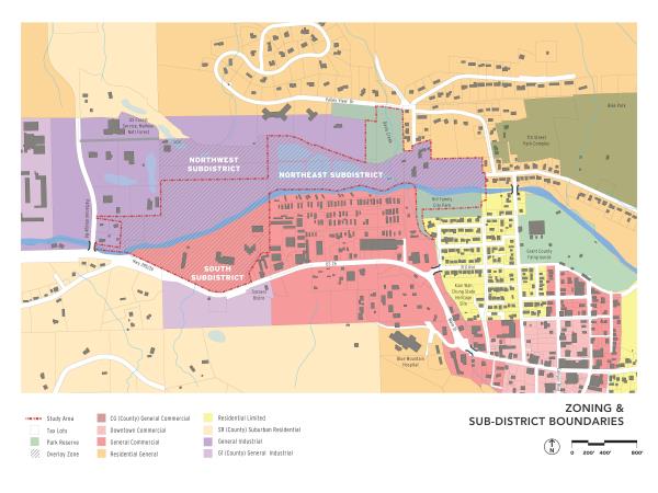
5-2.11.030 Allowed Uses
Permitted uses are those allowed outright in the underlying base zones, with the exceptions summarized in Table 5-2.11.030
| Use | South Sub-District | Northwest Sub-District | Northeast Sub-District |
| Residential Uses | |||
| - New dwelling built in conjunction with a permitted commercial or industrial use | P | N | N |
| - All other residential uses | - | - | - |
| Commercial Categories | |||
| Drive-up/Drive-in/Drive-through | N | N | N |
| Hotels and Motels | P | N | N |
| Quick Vehicle Servicing of Vehicle Repair | N | S | S |
| Retail Sales and Commercial Uses1 | Y | S | S |
| Self-Service Storage2 | - | S | N |
| Industrial Categories | |||
| Industrial Service | |||
| - Fully enclosed | N | - | - |
| - Not enclosed | N | N | N |
| Manufacturing and Production | |||
| - Fully enclosed3 | S | - | - |
| - Not enclosed | N | - | - |
| Warehouse and Freight Movement | N | - | - |
| Waste Related | - | N | N |
| Wholesale Sales | |||
| - Fully enclosed, less than 20,000 square feet of floor area | N | - | - |
| - Fully enclosed, equal to or greater than 20,000 square feet of floor area | N | N | N |
| - Not enclosed | N | N | N |
| Institutional Categories | |||
| Basic Utilities | - | - | - |
| Community Service, except as otherwise allowed by Public Facilities Overlay zone | - | - | - |
| Daycare | - | - | - |
Parks and Open Space | |||
- Consistent with the John Day Innovation Gateway Area Plan | P | P | P |
- Other parks and open space uses | CU | CU | CU |
Religious institutions/churches | - | - | - |
Schools | - | - | - |
Other Categories | |||
Accessory Structures (with a permitted use) | - | - | - |
Agriculture- Greenhouses and similar horticulture | P | P | P |
Buildings and Structures Exceeding the Height Limits in Table 5-2.3.030 | - | - | - |
Radio Frequency Transmission Facilities, including building-mounted facilities, that project above roofline | - | - | - |
Utility Corridors | - | - | - |
Temporary Uses (limited to "P" and "CU" uses), per Section 5-4.9.010. | - | - | - |
Transportation Facilities (operation, maintenance, preservation, and construction in accordance with the City's Transportation System Plan) | - | - | - |
Notes:
P= Permitted; CU= Permitted as a conditional use; S= Permitted with standards; N= Not permitted; - = Refer to base zone for use status
1. Uses subject to size limitations in the northeast and northwest sub-districts subject to section 5-2.11.050 of this code
2. Self-storage uses must be within a fully enclosed building; access to individual storage units shall be provided from the interior of the building only.
3. Manufacturing and production allowed in the Southern Subdistrict only if the use includes a retail compunent.
5-2.11.040 Limitations On Uses
[Placeholder for possible additional standards.]
5-2.11.050 Development Standards
Development standards are summarized in Table 5-2.11.050.
| Use | South Sub-District | Northwest Sub-District | Northeast Sub-District |
| Minimum Lot Area | |||
| - New dwelling built in conjunction with a permitted commercial or industrial use located above the ground floor | None | - | - |
| Minimum Lot Width | 20 ft | - | - |
| Minimum Lot Depth | None | - | - |
Maximum Building/Structure Height Ornamental and symbolic features not exceeding 200 square feet in gross floor or 15% of the total building footprint, whichever is less, and including towers, spires, cupolas, belfries, and domes, where such features are not used for human occupancy, may exceed the height limit by no more than 10 ft. | 35 ft | - | - |
| Maximum Building Size, Retail Comercial Uses | - | 5,000 sq ft | 5,000 sq ft |
Lot Coverage, Maximum Building Coverage (Foundation plane as % of site area) | 85% | 85% | 85% |
| Landscape Area (% site area). Landscape area may include a combination of plant beds, planters, and plaza space. | 15% | 15% | 15% |
| Minimum Setbacks1 | |||
| - Front, Street, Side, and Rear Property lines, except garage or carport | - | - | - |
| - Garage/Carport Entry, setback from street or vehicle accessway | - | NA | NA |
| - Alley | - | NA | NA |
| Build-to-Line1 | 20 ft | - | - |
Notes:
- = Same as indicated in base zone
1. Build-to line is measured from the edge of any adjacent public or private path or roadway providing primary access to the front of the proposed use.
5-2.11.060 Site Layout And Design
Building Orientation and Commercial Block Layout
A. Purpose. The purpose of these standards is to promote pedestrian-oriented development where walking is encouraged, and to avoid conflicts between pedestrians and vehicles. Providing direct pedestrian connections between buildings and adjacent streets and pathways also encourages crime prevention, natural surveillance or security, and safety by having more "eyes-on-the-street."
B. Applicability. This section applies to projects that are subject to Site Design Review.
C. Site layout and design standards for the Northwest and Northeast Sub-districts are as described for the General Industrial base zone in section 5-2.4.060 of this code.
D. Building Orientation and Commercial Block Layout standards described in section 5-2.3.060 do not apply to the South Sub-District. Instead, the following standards are applicable to projects that are subject to Site Design Review in the South Sub-District.
- Building Orientation Standards
- Compliance with the setback and build-to line standards in Section 5-2.11.040, where applicable. The build-to line may be setback to provide pedestrian amenities between a building and its adjoining street or vehicular accessway.
- All buildings shall have at least one prominent entrance oriented to the nearest pedestrian walkway
- Parking areas shall not be located between a proposed building and a trail adjacent to the John Day River.
- Block Layout Standards
- Block layout patterns shall be consistent with development concepts described in the John Day Innovation Gateway Plan
- Where block lengths exceed 600 feet, mid-block pedestrian pathway connections shall e provided at least every 400 feet.
- Walkways shall connect the street right-of-way to building entrances and the interior parking courts located between or adjacent to buildings, as necessary to ensure reasonably safe, direct, and convenient access to building entrances and off-street parking.
5-2.11.070 Architectural Design Standards
- Purpose and Applicability. Section 5-2.11.070 is intended to provide detailed, human-scale design that is characteristic of the City of John Day while affording flexibility to use a variety of architectural building styles. The standards are also intended to address the unique nature of the John Day Innovation Gateway Area and the objectives of the John Day Innovation Gateway Area Plan. All new buildings and major remodels within the South Sub-District shall meet the standards of subsections 5-2.11.070.B-C., which are applied through Site Design Review. The applicant demonstrates that the standards are met by complying with the criteria under each standard.
- Pedestrian-Orientation. The design of all buildings on a site shall support a safe and attractive pedestrian environment. This standard is met when the approval body finds that all of the criteria in 1-3, below, are met. Alternatively, the approval body may approve a different design upon finding that the design contains an equally good or superior way of achieving the above standard.
- The building orientation standards under Section 5-2.11.060 are met; and
- Primary building entrances shall open directly to the outside and, if not abutting a street, shall have walkways connecting them to a street sidewalk or other pedestrian walkway; every building shall have at least one primary entrance that does not require passage through a parking lot or garage to gain access; and
- Primary building entrance(s) are designed with weather protection such as awnings, canopies, overhangs, or similar features.
- Human Scale. The design of all buildings shall be to a human scale. This standard is met when the approval body finds that all of the criteria in 1-8, below, are met. Alternatively, the approval body may approve a different design upon finding that the design contains an equally good or superior way of achieving the above standard. Figure 5-2.3.080D contrasts examples of building elevations that are consistent/inconsistent with human scale criteria.
- Regularly spaced and similarly shaped windows are provided on all building stories;
- Ground floor retail spaces have tall ceilings (i.e., 12-16 feet) with display windows on the ground floor;
- Display windows are trimmed, recessed, or otherwise defined by wainscoting, sills, water tables, or similar architectural features;
- Ground floor windows for commercial or institutional uses must allow views into ground floor working areas or lobbies, pedestrian entrances, or display areas.
- On multi-story buildings, ground floors are defined and separated from upper stories by appropriate architectural features (e.g., cornices, trim, awnings, canopies, arbors, trellises, overhangs, or other features) that visually identifies the transition from ground floor to upper story; such features should be compatible with the surrounding architecture;
- The tops of flat roofs are treated with appropriate detailing (i.e., cornice, pediment, flashing, trim, or other detailing) that is compatible with the surrounding architecture;
- Pitched roofs have eaves, brackets, gables with decorative vents, or other detailing that is consistent with the surrounding architecture;
- Where buildings with greater than 20,000 square feet of enclosed ground-floor space are proposed, they shall provide articulated facades on all elevations facing a street or primary vehicle or pedestrian accessway. This criterion is met when an elevations contains at least one of the following features for every 40 feet of building (horizontal length): windows; primary entrances; weather protection (awnings, canopies, arbors, trellises), building offsets; projections; changes in elevation or horizontal direction; sheltering roofs; terraces; a distinct pattern of divisions in surface materials; ornamentation; screening trees; small-scale lighting (e.g., wall-mounted lighting, or up-lighting); and/or similar features as generally shown in Figure 5-2.3.080.D. Note Figure 5-2.3.080.D should not be interpreted as a required architectural style.
5-2.11.080 Pedestrian Amenities
- Applicability. Standards for Pedestrian Amenities found in Section 2‐2.3.090 are applicable to new developments and major remodels in all sub‐districts in the John Day Innovation Gateway Area.
5-2.11.090 Special Use Standards
- Landscaping. All landscaping standards found in Section 5-3.2.030 of this Code are applicable to development within the overlay zone. The following additional landscaping standards also apply.
- Landscaping within the portion of the overlay zone that lies within the Floodplain Overlay zone will be species of plants that are flood-resistant. For the purposes of this requirement, "flood-resistant" means trees and shrubs that have a high or medium flood tolerance rating as determined by the Oregon State University Extension Service.
- Landscaping and open areas shall emphasize the use of native trees, shrubs, or other plants adapted for survival or growth in this area. Shrubs and/or living groundcover shall be planted to assure fifty percent (50%) coverage within one (1) year and ninety percent (90%) coverage within five (5) years.
- Exterior Lighting. Exterior lighting facilities throughout the overlay zone should improve night-time public safety and security, promote energy efficiency, and avoid detrimental impacts to the environment or to public use and enjoyment of public and private property. The following standards apply to all areas:
- Light fixtures shall be full-cutoff. When installed, a full-cutoff fixture gives no emission of light above a horizontal plane.
- Pole-mounted lighting shall not exceed a height of 20 feet.
- Façade lighting shall be limited to illumination from building-mounted features. Up-lighting is not permitted. When installed, up-lighting emits light above a horizontal plane.
- Pedestrian scale lighting is required for the public walkways, plazas, and courtyards within areas that are open to the public after dark.