
John Day City Zoning Code
ARTICLE 5
6 DEFINITIONS AND RULES OF MEASUREMENT
5-6.1.010 Purpose
The purpose of Chapter 5-6.1 is to define terms that are used frequently in the City of John Day Development Code, to assist decision makers in interpreting and applying the Code. Some of the terms that are defined here may have different meanings in other communities.
5-6.1.020 Applicability
- Definitions. The definitions in Chapter 5-6.1 apply to all actions and interpretations under the City of John Day Development Code. The meanings of some terms in this chapter may, in certain contexts in which they are used, be clearly inapplicable. In such cases the context in which a term is used will indicate its intended meaning, and that intent shall control. Where a term used in this Code is already defined in another part of the City of John Day Municipal Code or codes incorporated therein by reference (e.g., building code) the term is not redefined herein for purposes of that other code. Terms not defined in this Code shall have their ordinary accepted meanings within the context in which they are used. Webster’s Third New International Dictionary of the English Language, Unabridged, shall be considered a standard reference.
- Land Use Categories. Chapter 5-1.3 contains descriptions of the land use categories and examples of uses allowed each the districts in Article 2.
5-6.1.030 Definitions
The following definitions are organized alphabetically and some related terms are also grouped together and cross-referenced under group headings (e.g., Transportation-Related, Environment-Related, etc.).
A
Abutting. Contiguous or adjoining. Access. See Transportation-Related terms. Accessory. Secondary or incidental to a primary use or structure.
Accessory Dwelling. See Residential Structure Types. Accessory Parking Facility. A parking facility that provides parking for one or more primary use and may be located on or off the site of the use or uses to which it is accessory. Accessory Structure. A structure of secondary importance or function on a site. In general, the primary use of the site is not carried on in an accessory structure. Accessory structures are detached from the primary structure. Examples of accessory structures include but are not limited to: garages, decks, fences, arbors, gazebos, heat pumps, workshops and other structures. See also Primary Structure. Accessory Use. A use or activity that is a subordinate part of a primary use and that is clearly incidental to a primary use on a site. See also Primary Structure. Adjacent. Abutting or located directly across a street right-of-way or easement. Administrative. A discretionary action or permit decision made without a public hearing, but requiring public notification and an opportunity for appeal. Adverse Impact or Effect. Negative effect that can be measured (e.g., noise, air pollution, vibration, dust, property values, etc.). Affordable. Housing affordable to a certain percentage of the population earning a specified level of income and spending no more than 30 percent of their income on housing expenses. For more information, contact the federal Department of Housing and Urban Development and the Oregon Department of Housing and Community Services. Airport-Related Definitions. The airport-related definitions of the Oregon Department of Aviation’s Land Use Compatibility Handbook are hereby incorporated by reference. Alley. See Transportation-Related definitions. Alteration. See Development-Related definitions. Ambient. Normal or background environmental conditions, as in the level of light, dust or noise. Applicant. A person who applies for a land use review. An applicant can be the owner of the property, a contract purchaser, or someone who is legally authorized to represent the owner, such as a builder, developer, contract purchaser, consultant, architect, or similar individual. Arterial. See Transportation-Related definitions. Attached House (Townhouse or Rowhouse). See Residential Structure Types. Attached Structure. See Development-Related definitions.
BBed and Breakfast Inn. Any establishment located in a structure designed for a single family residence and structures appurtenant thereto, regardless of whether the owner or operator of the establishment resides in any of the structures, that: (a) Has more than two rooms for rent on a daily basis to the public; and (b) Offers a breakfast meal as part of the cost of the room. Berm. A small man-made rise or hill in a landscape, which is, intended to buffer or visually screen certain developments, such as parking areas. Bikeway. See Transportation-Related definitions. Block. All of the property bounded by streets, rights-of-way (pedestrian or vehicle ways), water features, or any combination thereof, but is not divided or separated in any way by streets or water features. Block Face/Frontage. All of the property fronting on one side of a street that is between intersecting or intercepting streets, or that is between a street and a water feature, or end of a dead end street. An intercepting street determines the boundary of the block frontage only on the side of the street that it intercepts. See Figure.
Block Frontage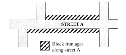
Bollard. A post of metal, wood or masonry that is used to separate or direct traffic (vehicles, pedestrians and/or bicycles). Bollards may contain sidewalk or pathway lighting. Building. See adopted Building Code. Building Official. The person who enforces the building ordinances and regulations for the City, and other ordinances and regulations as assigned. Build-to Line. A maximum front or street yard setback, which is typically required along commercial street frontages to promote a storefront character and pedestrian-oriented design.
C
Canopy. A permanent roofed unenclosed structure that may be free-standing or be partially attached to a building, for the purpose of providing shelter; typically used for sheltering patrons on foot and/or in motor vehicles; does not include a completely enclosed structure. See also, Carport (below), and Tree Canopy, under Environment-Related definitions. Capacity. Maximum holding or service ability, as used for transportation, utilities, parks and other public facilities. See also, definition of “Occupancy” in applicable building codes. Carport. A stationary structure consisting of a roof, its supports, not more than one wall or storage cabinets substituting for a wall, used to shelter motor vehicles, recreational vehicles, or boats; does not include temporary shelters or canopies not affixed to a permanent foundation per applicable building codes. Centerline Radius. The radius of a centerline of a street right-of-way. Certificate of Occupancy. A certificate of occupancy or a certificate of inspection issued by the Building Official at the completion of a building permit or change of occupancy. Change of Use. Change in the primary type of use on a site. Child Care. Facilities that provide care and supervision of minor children for periods of less than 24 hours. “Family child care providers” provide care for not more than 16 children in a home. See ORS 657A.440(4) for applicable requirements.
City. The City of John Day, Oregon. Clear and Objective. Decision criteria and standards that do not involve substantial discretion or individual judgment in their application. Clearing (as in clearing and grading). See Development-Related Definitions. Club. Any organization, group, or association supported by the members thereof, the purpose of which is to render a service customarily rendered for members and their guests but shall not include any organization, group, or association, the chief activity of which is to render a service customarily carried on as a business. Collector. See Transportation-Related definitions. Commission. The John Day Planning Commission. Commercial. Land use involving buying/selling of goods or services as the primary activity. Common Area. Land commonly owned to include open space, landscaping or recreation facilities (e.g., may be managed by a homeowners' association). Comprehensive Plan. The current adopted Comprehensive Plan of the City of John Day. Conditional Use. A use that requires a Conditional Use Permit. See Chapter 5-4.4. Condominium. Ownership of a single unit in a multi-unit structure that includes common areas and facilities; includes both residential and commercial condominiums. See ORS 100 for applicable requirements. Conservation Easement. See Environment-Related definitions. Corner lot. See Lot, Corner lot. Corner Radius. The radius of a street corner, as measured around the curb or edge of pavement. Cottage. See Residential Structure types. Council. The City Council of John Day, Oregon. Courtyard. See Development-Related definitions. Crown Cover. The area directly beneath the crown and within the drip line of a tree or shrub. The crown consists of the above ground branches, stems, and leaves. DDays. Calendar days, unless specifically stated as working days. Working days include Monday through Friday, excluding Federal holidays. Dead-End Street. See Transportation-Related Definitions. Dedication. The designation of land by its owner for any public use as shown on a subdivision plat or deed. The term may also be used for dedications to a private homeowners' association. Density(ies). A measurement of the number of dwelling units in relationship to a specified amount of land. As used in this Code, density is determined based on the gross parcel or lot area, which includes land that will be dedicated as right-of-way and land that will be reserved as open space through the development process. It does not include land previously dedicated as right-of-way. Density is a measurement used generally for residential uses. Development-Related Definitions
- Alter/Alteration. A change in use or occupancy or physical change to a structure or site. Alteration does not include normal maintenance and repair. (See also, Interior/Exterior Alteration.) Alterations may or may not require land use approval, but property owners should check with the City Planning Official before commencing any alteration.
Alterations include the following:- Changes in use or occupancy;
- Changes to the exterior of a building;
- Changes to the interior of a building;
- Increases or decreases in floor area of a building;
- Changes to other structures on the site, or the development of new structures;
- Changes to exterior improvements;
- Changes to landscaping; and
- Changes in the topography of the site.
- Arcade (architecture). An arched or covered passageway; often along building fronts, or adjacent to courtyards.
- Attached Structure. Any structure that is attached to another structure by a common wall, by a roof or canopy, or by other structural connections. A garage or workshop may be attached to another structure by sharing a wall or by a breezeway, subject to applicable building codes. Structures connected by an "I" beam or similar connections are not considered attached.
- Automobile-dependent Development. Primary or accessory structure or facility servicing motor vehicles, or patrons in motor vehicles, such as motor vehicle repair or service (e.g., oil change), gas station, car wash, auto or truck sales or rental, drive-up windows, kiosks, and similar uses.
- Automobile-oriented Development. Development in which the site layout and design gives preference to automobiles as the primary mode of transportation; generally discouraged in all residential areas and in the downtown.
- Building. A structure that has a roof and is enclosed on at least 50 percent of the area of its sides.
- Building Coverage. The area that is covered by buildings, and decks, stairways and entry bridges that are more than 30 inches above grade. Eaves are not included in building coverage.
- Building Footprint. The outline of a building, as measured around its foundation, or Building Coverage, whichever is greater.
- Building/Structure Height. Building height for the purposes of this Code is measured as the vertical distance above a reference datum (grade plane) to the highest point of a flat roof or to the mid-point of a sloping roof. The height of a stepped or terraced building is the maximum height of any segment of the building, except that parapets, cornices and other projections are allowed pursuant to the height limitations in Article 2.
- Building Line. A line running parallel to a lot line that is the same distance from the lot line as the closest portion of a building on the site, typically used in reference to required setback yards. See Figure.
Building Lines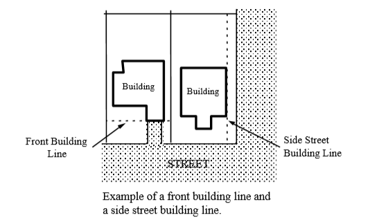
- Building Mass. The aggregate size of a building, or the total height, width, and depth of all its parts.
- Building Pad. The building envelope as identified by an approved site plan.
- Building Scale. The dimensional relationship of a building and its component parts to other buildings.
- Clearing (as in clearing and grading). Any activity that removes existing vegetation or strips surface material from any portion of the site and exceeding typical yard maintenance for a single family dwelling.
- Cornice. The projecting horizontal element that tops a wall or flat roof.
- Courtyard. A court or enclosure adjacent to a building, which usually provides amenities such as gardens, planters, seating, or art.
- Develop. To construct or alter a structure or to make a physical change to the land including excavations and fills. See also, Alteration.
- Development. All improvements on a site, including alterations to land and new or remodeled structures, parking and loading areas, landscaping, paved or graveled areas, and areas devoted to exterior display, storage, or activities. Development includes improved open areas such as plazas and walkways, but does not include naturally occurring (e.g., geologic) forms landscaping land. See also Exterior Improvements.
- Driveway. There are two types of driveways:
- The area that provides vehicular access to a site from a street. Maximum driveway width for this type is the same width as the curb cut excluding any aprons or extensions of the curb cut. This type of driveway begins at the street and extends into the site. A driveway does not include parking, maneuvering, or circulation areas in parking areas, such as aisles; and
- The area that provides vehicular circulation between two or more noncontiguous parking areas. This type of driveway does not include maneuvering or circulation areas within the interior of a parking area. Where required by Code for fire safety, a driveway must be kept clear of all obstructions.
- Driveway Apron/Approach. The edge of a driveway where it abuts a public right-of-way; usually constructed of concrete.
- Eave. Projecting overhang at the lower border of a roof and extending from a primary wall or support. See Figure.
Eave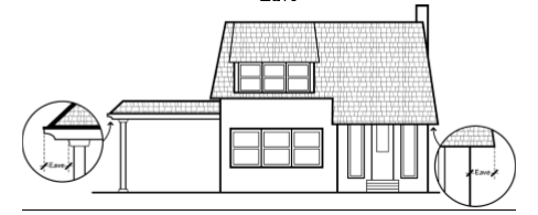
- Emergency Apparatus Lane or Fire Lane. Unobstructed area or driveway meeting Uniform Fire Code requirements; typically may not be used for parking or loading area.
- Exterior Improvements. All improvements except buildings or other roofed structures. Exterior improvements include surface parking and loading areas, paved and graveled areas, and areas devoted to exterior display, storage, or activities. It includes improved open areas such as plazas and walkways, but does not include vegetative landscaping, natural geologic forms, or unimproved land. See also Development.
- Facade. The front or street-facing elevation of a structure, except as otherwise specified by this Code.
- Floor Area. Except as otherwise prescribed by applicable building codes, the total floor area of a building, both above and below ground with a clear ceiling height of at least seven (7) feet. Floor area is measured from the interior walls of a building or structure and does not include the following:
- Roof area;
- Roof top mechanical equipment; and
- Roofed porches, exterior balconies, or other similar areas, unless they are enclosed by walls that are more than 42 inches in height, for 50 percent or more of their perimeter.
- Floor, Main Floor. Building floor closest to street level and within four (4) feet of finished grade.
- Grading. All cuts, fills, embankments, stockpile areas, and equipment maneuvering areas associated with development.
- Impervious Surface. Surface area that does not allow for water infiltration, or has a runoff coefficient of 0.90 or more (e.g., non-permeable pavement, solid rock, roofs, foundations, underground tanks and vaults, and similar areas).
- Parking. See Parking.
- Paved Area. An uncovered, hard-surfaced area or an area covered with a perforated hard surface (such as porous concrete or pavers) that is able to withstand vehicular traffic or other heavy-impact uses. Graveled areas are not paved areas but are typically impervious.
- Pedestrian Amenity(ies). Areas and objects that are intended to serve as places for public socializing and enjoyment and are usually closed to motorized vehicles. Examples include plazas, building frontage areas (extra-wide sidewalks), street furnishings (e.g., benches, drinking fountains, bus waiting shelters), pocket parks adjacent to a street or public right-of-way, and similar areas and objects. Sidewalk surfaces designed to meet the minimum sidewalk width standards are not “amenities” for the purpose of this Code.
- Pedestrian-Oriented Development. Development that is designed with an emphasis primarily on the street sidewalk and on pedestrian access to the site and building, rather than on auto access and parking areas. The building is generally placed close to the street and the main entrance is oriented to the street sidewalk. There are generally windows or display cases along building elevations, which face the street and other public right-of-ways. Typically, buildings cover a large portion of the site. Although parking areas may be provided, they are generally oriented behind or to the sides of buildings.
- Roof Pitch. The slope of a roof, usually described as ratio (e.g., 1 foot of rise per 2 feet of horizontal distance).
- Shopping Street. A driveway in a commercial development that is designed to mimic a public street with sidewalks, tree wells, pedestrian lighting, and street furnishings. A shopping street may also have on-street parking.
- Stormwater Facility. A facility designed to manage the quantity of stormwater runoff and may contain features that are designed to improve the quality of runoff. Stormwater quality facilities may include vegetated swales and sand filters, wet or dry ponds, marshes, DEQ-approved and permitted infiltration facilities, and structural storm sewer devices such as oil-water separators. Stormwater quality facilities do not include conveyance systems that are meant only for conveying the stormwater from one place to another and do not affect the quality of the stormwater.
- Storefront Character. The character expressed by buildings placed close to the street with ground-floor display windows, weather protection (e.g., awnings or canopies), corner building entrances or recessed entries, and similar features.
- Street Furniture/Furnishings. Benches, lighting, bicycle racks, drinking fountains, mail boxes, kiosks, and similar pedestrian amenities; may be located within a street furnishings zone or building front zone of a sidewalk or in a plaza. See also, Pedestrian Amenities.
- Structure. Except as provided by applicable building codes, any object constructed in or on the ground. Structure includes buildings, decks, fences, towers, flag poles, signs, utility vaults, and other similar objects. Structure does not include paved areas or vegetative landscaping materials.
- Structure Height. The height of a structure, and the cumulative height of a building with any appurtenant structures.
- Swale. A type of storm water facility. Usually a broad, shallow depression with plants that filter and process contaminants.
- Vehicle Areas. All of the areas on a site where vehicles may circulate or park including parking areas, driveways, drive-through lanes, and loading areas. See also, Driveway and Parking Area.
Disabled Person. For the purposes of this Code, a disabled person is a person who has a condition of physical or mental disability, which substantially limits one, or more major life activities as stated in Section 504 of the Federal Rehabilitation Act of 1973 and state law.
Discontinued Use. A use that physically left the land it was on, a permitted use that ceased, or a use terminated at the end of a lease or contract. See Chapter 5.2, Non-Conforming Uses and Developments. A use is considered temporarily discontinued during the first year (12 months) after it ceases, after which it is considered permanently discontinued. Discretionary. A permit action or decision that involves substantial judgment or discretion. Disturbance Area. See Environment-Related Definitions.
Drainage way. See Environment-Related Definitions. Drip-line. See Environment-Related definitions. Drive-through/Drive-up Facility. A facility or structure that is designed to allow drivers to remain in their vehicles before and during an activity on the site. Drive-through facilities are a type of site development that is usually found in conjunction with a Quick Vehicle Servicing use or a Retail Sales and Service use. Drive-through/drive-up facilities also include facilities designed for the rapid servicing of vehicles, where the drivers may or may not remain in their vehicles, but where the drivers usually either perform the service for themselves, or wait on the site for the service to be rendered. Drive-through facilities may serve the primary use of the site or may serve accessory uses. Examples are drive-up windows; automatic teller machines; coffee kiosks and similar vendors; menu boards; order boards or boxes; gas pump islands; car wash facilities; auto service facilities, such as air compressor, water, and windshield washing stations; quick-lube or quick-oil change facilities; and drive-in theaters. All driveways queuing and waiting areas associated with a drive-through/drive-up facility are similarly regulated as part of such facility. Driveway. See Development-Related Definitions. Driveway Apron/Approach. See Development-Related Definitions. Duplex. See Residential Structure Types. Dwelling Unit. See Residential Structure Types. EEasement. A grant of rights by a property owner that allows others to use the owner’s land for a specific purpose, such as access, or to locate utilities. Recorded and on record at Grant County. Eave. See Development-Related Definitions. Elevation. Height in feet and inches above a specified datum. Elevation, Building. Scaled drawing of the outside wall of a building or structure, from grade to roof ridgeline, typically specifying materials, color, and dimensions. Emergency Apparatus Lane or Fire Lane. See Development-Related definitions and applicable Fire Code. Environment-Related Definitions.
- Designated Sensitive Lands. Natural resources areas and landforms regulated under applicable overlay zones in Article 2.
- Conservation Easement. An easement that restricts development and protects identified conservation values of the land, such as wetlands, woodlands, significant trees or groves, floodplains, habitat, or similar resources.
- Crown Cover. The area directly beneath the crown and within the drip line of a tree or shrub. The crown consists of the above ground branches, stems, and leaves.
- Disturbance Area. An area that contains all temporary and permanent development, exterior improvements, and staging and storage areas on the site, both existing and proposed. Vegetation planted for resource enhancement and agricultural and pasture land is not included.
- Drainage way. An open linear depression, whether constructed or natural, that functions for the collection and drainage of surface water. It may be permanently or temporarily inundated.
- Drip-line. Imaginary line around a tree or shrub at a distance from the trunk equivalent to the canopy (leaf and branch) spread.
- Fish and Wildlife Habitat Areas. Lands that contain significant food, water, or cover for native terrestrial and aquatic species of animals. Examples include forests, fields, riparian areas, wetlands, and perennial or intermittent water bodies, as regulated by applicable state or federal natural resource regulatory agencies.
- Flood Plain/Hazard Area. See Chapter 5-2.9 Flood Plain Overlay.
- Identified Natural Features (e.g., wetlands or streams). Natural features that are identified in the National Wetlands Inventory, and/or other references used by applicable natural resource regulatory agency, as being significant and requiring protection under Federal Clean Water Act.
- Natural Hazard. Natural areas that can cause dangerous or difficult development situations. For example, natural hazard areas include steep slopes, unstable soils, and areas prone to landslides, floodways and flood plains. See applicable overlay zones in Article 2.
- Riparian Areas. Lands adjacent to rivers, streams, lakes, ponds, and other water bodies. They are transitional between aquatic and upland zones, and as such, contain elements of both aquatic and terrestrial ecosystems. They have high water tables because of their close proximity to aquatic systems, soils that are usually made up largely of water-carried sediments, and some vegetation that requires free (unbound) water or conditions that are more moist than normal.
- Sensitive Lands. Wetlands, significant trees, steep slopes, flood plains and other natural resource areas designated for protection or conservation by the Comprehensive Plan.
- Stream. An area where enough natural surface water flows to produce a stream channel, such as a river or creek that carries flowing surface water either intermittently or during most of the year. This includes:
- The water itself, including any vegetation, aquatic life, or habitat;
- Beds and banks below the high water level, which may contain water, whether or not water is actually present;
- The floodplain between the high water levels of connected side channels;
- Beaver ponds, oxbows, and side channels if they are connected by surface flow to the stream during a portion of the year; and
- Stream-associated wetlands.
- Stream Channel. An area with evidence of perennial or seasonal water passage. The depression between the banks worn by the regular and usual flow of the water. The channel need not contain water year-round. This definition does not include irrigation ditches, canals, storm or surface water runoff devices, or other entirely artificial watercourses.
- Top of Bank. The first major change in the slope of the incline from the ordinary high water level of a water body. A major change is a change of ten degrees or more. If there is no major change within a distance of 50 feet from the ordinary high water level, then the top of bank will be the elevation 2 feet above the ordinary high water level.
- Tree Canopy. The ground area that, when viewed from above the crown of one or more trees, is mostly covered by the tree(s). For deciduous trees, canopy area is based on the time of year when foliage is present.
- Water Bodies. Permanently or temporarily flooded lands, which may lie below the deepwater boundary of wetlands. Water bodies include rivers, streams, creeks, sloughs, drainage ways, lakes, and ponds.
- Wetland. Except as otherwise determined by applicable state or federal natural resource regulatory agencies with wetland jurisdiction, an area that is inundated or saturated by surface or ground water at a frequency and duration sufficient to support, and that under normal circumstances does support, a prevalence of vegetation typically adapted for life in saturated soil conditions. Wetlands include swamps, marshes, bogs, and similar areas.
Evidence. Application materials, plans, data, testimony and other factual information used to demonstrate compliance or non-compliance with a code standard or criterion. Excavating or Filling. The removal, placement, or replacement of earth, concrete, asphalt, and similar non-decomposable materials whether permanent or temporary in nature. Excavating or filling does not include the movement of earth or placement of gravel, asphalt, or other paving materials that is done in conjunction with road improvements. It does not include the excavation of mineral or aggregate resources. Excavating or filling includes the terms grading, preloading, surcharging, and stockpiling. Exterior Display. The outdoor display of products, vehicles, equipment, and machinery for sale or lease. Exterior display functions as an outdoor showroom for customers to examine and compare products. The display area does not have to be visible to the street. Exterior display does not include storage of goods placed or parked outside, if the goods are not examined and compared by customers in such location. It does not include damaged or inoperable vehicles, vehicles or equipment being serviced, bulk goods and materials, and other similar products. Exterior display does not include car and boat sales and/or leasing when such vehicles are not accessible to customers to inspect and compare; this situation is considered exterior storage. Examples of uses that often have exterior display are car and boat sales and leasing, and plant nurseries. See also, Exterior Work Activities and Exterior Storage.
Exterior Improvements. See Development-Related Definitions. Exterior Storage. Exterior storage includes the outdoor storage of goods exclusive of outdoor displays for sale or rent. The goods may be for sale or lease, but if so, the storage area is generally not for the purpose of inspection or comparison of goods by customers. Exterior storage includes the storage of raw or finished goods (packaged or bulk), including gases, oil, chemicals, gravel; building materials, packing materials; salvage goods; machinery, tools, and equipment; vehicles that are for sale, lease or rent, which are not accessible to the customer to inspect or compare; vehicles that have been unloaded and are waiting transport to off-site locations; vehicles that have been towed and are being kept in an impound lot; and other similar items. The storage of recreational vehicles outdoors is also considered exterior storage. Damaged or inoperable vehicles, or vehicles that have missing parts, which are kept outside are also included as exterior storage. Examples of uses that often have exterior storage are lumber yards, wrecking yards, tool and equipment rental, bark chip and gravel sales, car dealerships or car rental establishments, and port facilities. See also, Exterior Display and Exterior Work Activities.
Exterior Work Activities. Exterior work activities include the outdoor processing, assembly, or fabrication of goods; the maintenance, repair, and salvage of vehicles and equipment; and other similar activities that generally have an industrial orientation. Exterior work activities do not include normal pick-up and deliveries to a site, parking, excavation and fills, exterior eating areas, outdoor recreation, or outdoor markets. See Exterior Display and Exterior Storage. FFacade. See Development-Related definitions. Family Day Care. See Child Care Center, Family Child Care. Farming or Farm Use. As used in this Code, “agriculture” is the same as “farm use”. [See ORS 215.203(2)(a).] Includes utilization of land to raise, harvest, or sell crops; feed, breed, manage, and sell livestock, poultry, fur-bearing animals, honeybees, or their produce; dairy and sell dairy products; or any other agricultural or horticultural use, animal husbandry, timber agricultural use, or combination thereof. Farm uses include preparation or processing and storage of products raised on such land, but do not include construction or use of dwellings and other buildings customarily provided in conjunction with farm uses. Final Plat. The diagrams, drawings, and other writing containing all the descriptions, locations, dedications, provisions and information concerning a land division, pursuant to ORS 92 and Chapter 5-4.3 of this Code. Flag Lot. See Lot. Flood Hazard Area. See Chapter 5-2.9 Flood Plain overlay zone. Floor Area; Main Floor. See Development-Related definitions. Foot-candle. A unit of illumination (light standards), equal to one (1) lumen per square foot, or the amount of light from a source of one candela directly thrown on a square foot of surface at a distance of one (1) foot. Frontage. The dimension of a property line abutting a public or private street. Frontage Street or Road. A minor street that parallels an arterial street or highway in order to provide access to abutting properties and minimize direct access onto the arterial or highway. Functional Classification. The classification given to streets by the road authority (e.g., “local/collector/arterial”). See Transportation-Related definitions, and Section 5-3.4.010 for street standards. Future Division Plan or Future Development Plan. A document that shows lot, tract and right-of-way boundaries for all potential future phases of a land division. The plan is not binding on the City or the applicant. The purpose of the plan is to document that the design of the first phase of the plan does not preclude future phases or future development of adjacent properties from meeting City standards. GGarage. A covered permanent structure designed to provide shelter for vehicles, and which is accessory to a use in these structure types: houses, attached houses, duplexes, mobile homes, or houseboats. Carports are considered garages. Floor area adjacent to the space designed to provide shelter for vehicles, if not entirely separated from the garage area by floor-to-ceiling walls, is considered part of the garage. A garage may be attached to or detached from another structure. See also Structured Parking. Grade. The lowest point of elevation of the finished surface of the ground, paving, or sidewalk within the area between the building and the property line or, when the property line is more than 5 feet from the building, between the building and a line 5 feet from the building. This is the definition used in the Oregon Structural Specialty Code (the International Building Code as amended by the State of Oregon.) Grading. See Development-Related Definitions. Ground Cover. Living or processed plant material (e.g., mulch, bark chips), river rock and cinders used for aesthetic purposes and to prevent erosion (i.e., cover bare ground) in designated landscape areas. See Chapter 5-3.2, Landscaping. Group Living Structure. See Residential Structure Types. HHardscape. Non-vegetative landscape materials or installations, including pathways, decorative pavers, benches, drinking fountains, arbors, pergolas, playgrounds, plazas, and similar amenities. Hazardous Substances. Any substance, material, or waste listed below:
- Nuclear or radioactive materials or waste;
- Chemicals Subject to Reporting Under Title III of the Superfund Amendments and Reauthorization Act (SARA) of 1986, published July, 1987, U. S. Environmental Protection Agency; and
- Hazardous Materials Table, in the Code of Federal Regulations (CFR), Title 49, Part 172.101.
- Other substances as determined by applicable state or federal agency.
Historic Resource-Related Definitions. See Historic-Cultural Resources provisions. Home Occupation, Home Occupation Site. A business activity that is carried out on the same site as a dwelling unit, and which is accessory to the Household Living use on the site, subject to the provisions of Chapter 5-2.2 (Residential Districts) and Section 5-4.9.030 (Home Occupation Permits). Hotel/Motel. A building or portion thereof designed and used for occupancy of transient individuals lodged with or without meals for a continuous period not to exceed 29 days. (See ORS 446.310.) House. See Residential Structure Types. Household. One or more persons related by blood, marriage, civil union, legal adoption or guardianship, plus not more than 5 additional persons, who live together in one dwelling unit; or one or more handicapped persons as defined in the Fair Housing Amendments Act of 1988, plus not more than 5 additional persons, who live together in one dwelling unit. IImpervious Surface. Surface area that does not allow for water infiltration, or has a runoff coefficient of 0.90 or more (e.g., non-permeable pavement, solid rock roofs, foundations, underground tanks and vaults, and similar areas). Incidental and Subordinate to. Secondary to, and less apparent, than the primary use or other portion of the development. Infill. The development of vacant, bypassed lands located in an area that is predominately developed at densities/land use intensities allowed by zoning. JJunk Yard.
- Any property or establishment on which one or more persons are engaged in breaking up, dismantling, sorting, storing, distributing, buying, or selling scrap or waste materials.
- Any establishment or place of business on which two or more inoperable motor vehicles or an equivalent volume of waste or refuse are maintained, stored, bought, or sold. Includes wrecking yards, automobile grave yards, garbage dumps, and scrap metal processing facilities. See also, Recycling Facility.
KKennel. Any lot or premises where three (3) or more dogs or cats aged 6 months or older are boarded or bred for compensation. Establishments where animals are offered for sale as the primary use, such as pet stores, are not classified as kennels. LLand Division. The process of dividing land to create parcels or lots. See Chapter 5-4.3. Landing (stairs). A level part of a staircase, usually at the end of a flight of stairs. Landscaping. Any combination of living plants such as trees, shrubs, plants, vegetative ground cover or turf grasses, and may include structural features such as walkways, fences, benches, plazas, works of art, reflective pools, fountains or the like. Also includes irrigation systems, mulches, topsoil, and re-vegetation or the preservation, protection and replacement of trees. Land Use. The activity or activities that occur on a piece of land. Activities may be individually identified as primary or accessory uses. See also, Chapter 5-1.3 Use Categories. Land Use Approval. A land use decision for approval or approval with conditions under Article 4; includes any time limits or other restrictions that may apply to the land use decision. Land Use District. As used in this code, a land use district is the same as a zoning district. Land Use Review. An application for land use approval or the review of such application; typically limited to determining conformance with standards of the applicable land use district and does not include site design review, conditional use permit, or land division approval.
Lane, Mid-Block. See Transportation-Related definitions. Living Area. The habitable floor area of a residential structure conforming to applicable building codes; typically does not include garage area, and attic and basement areas with substandard ceiling height or substandard egress. Legislative. A legislative action or decision is the making of law, as opposed to the application of existing law to a particular use (e.g., adoption of, or amendment to, a comprehensive plan or development regulation). See also, Chapter 5-4.1.050 (Type IV Review). Light Manufacture. See Chapter 5-1.3, Use Categories. Livestock. Domestic animal types customarily raised or kept on farms. See Agriculture. Local Improvement District (LID). A small public district formed for the purpose of financing local improvements (paving of streets, construction of sidewalks, street lighting, water mains, storm sewers, parks, etc.) within a zone of benefit, usually assessed against abutting properties. Property owners within the LID are assessed for the cost of the improvements in accordance with ORS 223.387-223.485. Loading Area. The area available for the maneuvering and standing of vehicles engaged in delivering and loading goods, freight, or other articles. See also, Chapter 5-3.3, Parking and Loading. Longest Street-Facing Wall. The longest wall that faces a street. If two or more street-facing walls are of equal length, then the applicant chooses which is to be the longest street-facing wall for purposes of applying regulations of the Development Code. See also, Facade. Lot. A lot is a legally defined piece of land other than a tract that is the result of a land division. The following definitions for “lot” apply to the State definition of both lot, (result of subdividing), and parcel, (result of partitioning). See also, Ownership and Site.
- Corner Lot. A lot that has frontage on more than one intersecting street. A street that curves with angles that are 120 degrees or less, measured from the center line of the street, is considered two intersecting streets for the purpose of evaluating whether a lot is a corner lot. See Figures below.
- Flag Lot. A lot with two distinct parts (See Figure below):
- The flag, which is the only building site; and is located behind another lot; and
- The pole, which connects the flag to the street; provides the only street frontage for the lot; and at any point is less than the minimum lot width for the zone.
- Through/Reverse Frontage Lot. A lot that has frontage on two parallel or approximately parallel streets.
Lot Lines/Property Lines. The property lines along the edge of a lot or site.
- Front Lot Line. A lot line, or segment of a lot line, that abuts a street. On a corner lot, the front lot line is the shortest of the lot lines that abut a street. If two or more street lot lines are of equal length, then the applicant or property owner can choose which lot line is to be the front lot line for the purpose of determining required setbacks. However, a through lot has two front lot lines regardless of whether the street lot lines are of equal or unequal length. See Figures below.
- Rear Lot Line. A lot line that is opposite a front lot line. A triangular lot has two side lot lines but no rear lot line. For other irregularly shaped lots, the rear lot line is all lot lines that are most nearly opposite the front lot line. See Figures below.
- Side Lot Line. A lot line that connects front and rear lot lines. On a corner lot, the longer lot line that abuts a street is a side lot line. See Figures below.
- Side Street Lot Line. A lot line that is both a side lot line and a street lot line. See Figures below.
- Street Lot Line. A lot line, or segment of a lot line, that abuts a street. Street lot line does not include lot lines that abut a dedicated alley. On a corner lot, there are two (or more) street lot lines. Street lot line can include front lot lines and side lot lines, however, both are considered front yards for the purpose of measuring required setbacks. See Figures below.
Corner Lots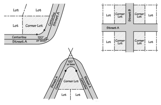
Flag Lot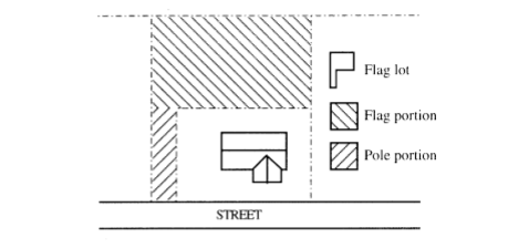
Front and Side Lot Lines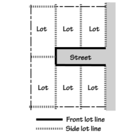
Street Lot Lines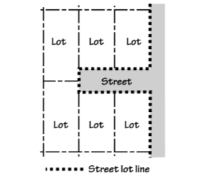
Lot Lines on Irregular Lots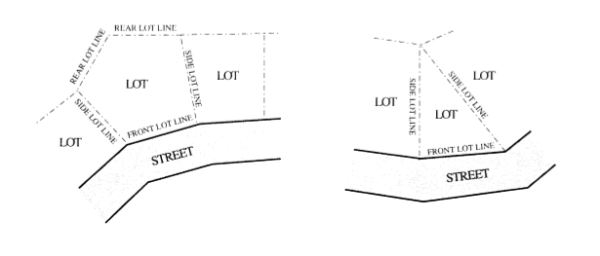
- Lot of Record. A legally created lot or parcel meeting all applicable regulations in effect at the time of creation, and held in separate ownership, or any other lot deemed a legal lot under Chapter 5.3.
Lot, Double-Frontage. See Lot, Through Lot.
Lot Area. The total surface area (measured horizontally) within the boundary lines of a lot. Lot Consolidation. The reduction in the number of lots; i.e., the creation of one lot from two or more existing lots. Lot Coverage. The total area of a lot covered by building(s) or impervious surfaces, as provided by the applicable land use district development standards. Lot Line Adjustment. See Property Line Adjustment. MMain/Primary Building Entrance. A main entrance is the entrance to a building that most pedestrians are expected to use. Generally, each building has one main entrance, however, some buildings may have more than one primary entrance where pedestrian access is provided from a street sidewalk as well as a parking area internal to the site. In multi-tenant buildings, main entrances may open directly into the building's lobby or principal interior ground level circulation space. When a multi-tenant building does not have a lobby or common interior circulation space, each tenant's outside entrance is a main entrance. In single-tenant buildings, main entrances typically open directly into lobby, reception, or sales areas. Floor, Main Floor. Building floor closest to street level and within four (4) feet of finished grade. Major Remodeling. Projects where the floor area is being increased by 50 percent or more, or where the cost of the remodeling is greater than the assessed value of the existing improvements on the site. Assessed value is the market value shown on the applicable county assessment and taxation records for the current year. Manufactured Home/Dwelling. See Residential Structure Types. Maneuvering Area/Aisle. The driving area in a parking lot where motor vehicles are able to turn around and access parking or loading spaces. Manufactured Dwelling Park. Any place where four (4) or more manufactured dwellings are located within 500 feet of one another on a lot, tract or parcel of land under the same ownership, the primary purpose of which is to rent or lease space or keep space for rent or lease to any person for a charge or fee paid or to be paid for the rental or lease or use of facilities or to offer space free in connection with securing the trade or patronage of such person. “Manufactured dwelling park” does not include a lot or lots located within an approved subdivision being rented or leased for occupancy by no more than one (1) manufactured dwelling per lot. See also, ORS Chapter 446. Ministerial Decision. A routine administrative action or decision involving little or no discretion and not requiring public notice. See Section 5-4.1.020 (Type I Review).
Mitigation. To avoid, rectify, repair, or compensate for negative impacts or effects that result from other actions (e.g., improvements to a street may be required to mitigate for transportation impacts resulting from development.)
Mixed-Use. The combination on a site of residential uses with commercial (e.g., office, retail, or services), civic, or light industrial uses. Mobile Home Park. Two or more mobile homes that are located on a single site for 30 days or more, connected to a electric utility and city sewer and water systems, and intended for permanent residential use; does not include recreational vehicle parks or temporary medical hardship homes approved by the City, nor does it include sites where unoccupied mobile homes are offered for sale or lease. See also Recreational Vehicle Park. Mobile Home Space. The area occupied by a mobile home and its accessory uses and structures in a mobile home park. Motor Home. See Recreational Vehicle, under Vehicle Types. Motor Vehicle. See Vehicle Types. Multi-Dwelling Development or Multifamily Housing. See Residential Structure Types. Multi-Dwelling Structure. See Residential Structure Types. Multi-Use Pathway. See Walkway and Bikeway. NNatural Resource Areas/Natural Resources. See Environment-Related Definitions. Neighborhood. A residential area usually having distinguishing character or geography. Neighborhood Commercial. See Chapter 5-1.3 Use Categories, Commercial. Nonconforming Development. An element of a development, such as lot area, setback, height, lot coverage, landscaping, sidewalk, or parking area, or lack thereof, that was created in conformance with development regulations but which subsequently, due to a change in the zone or applicable Code standards, is no longer in conformance with the current applicable development regulations. See Chapter 5-5.2. Nonconforming Situation. A Nonconforming Development or Nonconforming Use. A situation may be nonconforming in more than one aspect. For example, a site may contain a nonconforming use and also have some nonconforming development. See also Nonconforming Development and Nonconforming Use. See Chapter 5-5.2.
Nonconforming Use. A use that was allowed by right when established or a use that obtained a required land use approval when established, but that subsequently, due to a change in the zone or zoning regulations, the use or the amount of floor area of the use is now prohibited in the zone. See Chapter 5-5.2. Non-native Invasive Plants. Plants listed by Oregon State University Extension Service, Grant County, or other government agency as non-native invasive plants in Oregon. OOff-street Parking. All off-street areas designed, constructed, used, or required or intended to be used for the parking of motor vehicles. See Chapter 5-3.3 for parking standards. On-street Parking. Parking in the street right-of-way, typically in parking lanes or bays. Parking may be “parallel” or “angled” in relation to the edge of the right-of-way or curb, as provided by applicable standards of the roadway authority. See Chapter 5-3.3 for parking standards. Open Space (public/common/private/active/passive). Land within a development that has been dedicated in common to the ownership within the development or to the public specifically for the purpose of providing places for recreation, conservation or other open space uses. See also, Common Area.
Orientation. To cause to face toward a particular point of reference (e.g., “A building oriented to the street”). See also, Pedestrian-Oriented Development. Outdoor Commercial Use. A use supporting a commercial activity that provides goods or services, either wholesale, retail or entertainment, where the amount of site area in outdoor use (e.g., storage of materials, display of merchandise, or entertainment) exceeds the total floor area of all buildings on the site. Examples of outdoor commercial uses include automobile sales or services, nurseries, lumber yards and equipment rental businesses, and outdoor amusement. Overlay Zone/District. Overlay zones impose and/or relax requirements of an underlying land use district, or base zone, where characteristics of the land or neighborhood, or the types of development planned for an area, require special regulations. See Article 5-2. Owner. The owner of the title to real property or the contract purchaser of real property of record, as shown on the latest assessment records in the Office of the County Assessor. Owner also includes a deed holder or contract purchaser whose name does not appear in the latest assessment records, but who presents to the City a copy of a deed or contract of sale signed by the owner of record. Ownership. An ownership is one or more contiguous lots that are owned by the same person, partnership, association, or corporation. Ownership also includes lots that are in common ownership but are separated by a right-of-way. See also, Lot and Site.
PParcel. A legally defined area of land created through a partition. Parking Area. A parking area is all the area devoted to the standing, maneuvering, and circulation of motor vehicles. Parking areas do not include driveways or areas devoted exclusively to non-passenger loading or fire apparatus lanes. See also, Driveway, Garage, Structured Parking, and Vehicle Areas. Parking Lot Perimeter. The boundary of a parking lot area that usually contains a landscaped buffer area. Parking Space. An improved space designed to provide standing area for a motor vehicle. See Chapter 5-3.3 for parking space standards. Partial Street/Half Street. See Transportation-Related Definitions. Parking Versus Storage. Parking is to leave a motor vehicle for a temporary time, no longer than 24 hours. Storage is to place or leave in a location for storage, maintenance, repair, future sale or rental, or future use more than 24 hours. See also, Exterior Display. Partition. To divide an area or tract of land into two or three parcels within a calendar year when such area or tract of land exists as a unit or contiguous units of land under single ownership at the beginning of such year. See ORS 92.010(8). Paved Area. See Development-Related definitions. Pedestrian Amenity(ies). See Development-Related definitions. Planter Strip. A landscape area for street trees and other plantings within the public right-of-way, usually a continuous planter area between the street and a sidewalk. See also, Tree Well. Plat. Diagrams, drawings and other writing containing all the descriptions, locations, dedications, provisions, and information concerning a land division. This term includes the State law definitions of “partition plat” and “subdivision plat.” See also, Chapter 5-4.3, Land Divisions. Plaza. An area generally open to the public on a controlled basis and used for passive recreational activities, informal public gathering, and relaxation. Plazas are paved areas typically provided with amenities, such as seating, drinking and ornamental fountains, art, trees, and landscaping for use by pedestrians. See also, Pedestrian Amenities (Development-Related definitions). Pocket Park. A small park, usually less than one-half acre typically accessed by foot or wheelchair, or bicycle. See also, Pedestrian Amenities (Development-Related definitions).
Practicable. Capable of being done after taking into consideration reasonable cost, existing technology, and logistics in light of overall project purposes.
Primary Structure. A structure or combination of structures of chief importance or function on a site. In general, the primary use of the site is carried out in a primary structure. The difference between a primary and accessory structure is determined by comparing the size, placement, similarity of design, use of common building materials, and the orientation of the structures on a site.
Primary Use. An activity or combination of activities of chief importance on the site. One of the main purposes for which the land or structures are intended, designed, or ordinarily used. A site may have more than one primary use. See also, Chapter 5-1.3 Land Use Categories.
Project. An existing or proposed use or development subject to one or more land use approvals.
Property Line Adjustment. The relocation of a single common property line between two abutting properties not resulting in an increase in the number of lots, pursuant to Chapter 5-4.3. See Figure below.
Property Line Adjustment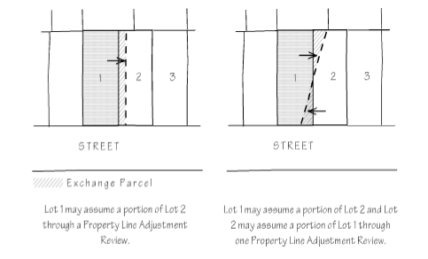
Public Access Easement. See Transportation-Related Definitions.
Public Safety Facility. A facility necessary to respond to an immediate hazard to the public health and safety, and that is owned, leased, or operated by a public agency. Public safety facilities include fire and police stations, flood control facilities, water towers and pump stations needed for emergency service, and emergency communication broadcast facilities.
Property Line: front, rear, interior side, street side. See Lot Line.
Public Improvements. Development of public infrastructure, as required by the City, County, Special District, or Road Authority, as applicable. See Chapter 5-3.4.
QQuasi-judicial. An action or decision that requires substantial discretion or judgment in applying the standards or criteria of this Code to the facts of a development or land use proposal, and requires a public hearing. See Article 5-4.
RRail Right-of-way. See Transportation-Related Definitions.
Recreation Camp.
- An area devoted to facilities and equipment for recreation purposes, including swimming pools, tennis courts, playgrounds, and similar uses, either open to the public upon payment of a fee, or limited to private membership.
- An area designated by the landowner for picnicking or overnight camping and offered to the general public, with or without a fee or charge. (See ORS Chapter 446)
Recreational Vehicle. See Vehicle Types. Recreational Vehicle Park. A commercial use providing space and facilities for motor homes or other recreational vehicles for recreational use or transient lodging. There is no minimum required stay in a recreational vehicle park, however, the maximum length of stay may be established by the City. Uses where unoccupied recreational vehicles are offered for sale or lease, or are stored, are not included as Recreational Vehicle Parks. See also Outdoor Storage and Display, and Mobile Home Park. Recycling Facility. Any property or establishment on which one (1) or more persons are engaged in collecting, sorting, storing, and distributing post-consumer goods or materials for reuse in the marketplace. Post-consumer goods do not include scrap or waste materials from manufacturing, industrial processing, or waste treatment facilities. Residence. Same as Dwelling. See Residential Structure Types.
Residential Structure Types
- Accessory Dwelling Unit. A second dwelling unit created on lot with a single family house, attached house, or manufactured home. The second unit is created auxiliary to, and is always smaller than the house, attached house, or manufactured home.
- Attached Duplex. A duplex located on its own lot that shares one (1) or more common or abutting walls with one other duplex (for a total of 4 dwelling units on 2 lots). The common or abutting wall must be shared for at least 50 percent of the length of the side of the dwelling.
- Attached House (Townhome or Rowhouse). A dwelling unit located on its own lot that shares one or more common or abutting walls with one or more dwelling units. The common or abutting wall must be shared for at least 50 percent of the length of the side of the dwelling. An attached house does not share common floor/ceilings with other dwelling units. An attached house is also called a rowhouse or a common-wall house.
- Cottage. A small house containing one dwelling unit that may be used as a primary dwelling or an accessory dwelling, as applicable.
- Cottage Cluster. A group of two or more cottages on one lot.
- Duplex. A building that contains two primary dwelling units on one lot. The units must share a common wall or common floor/ceiling.
- Dwelling Unit. A building, or a portion of a building, that has independent living facilities including provisions for sleeping, cooking, and sanitation, and that is designed for residential occupancy by a group of people. Buildings with more than one set of cooking facilities are considered to contain multiple dwelling units or accessory dwelling units, as applicable, unless the additional cooking facilities are clearly accessory to the primary use, such as an outdoor grill or wet bar.
- Manufactured Home. Manufactured home is a dwelling constructed off-site in accordance with federal manufactured housing construction and safety standards (HUD code) in effect after July 15, 1976, then assembled or placed on-site in accordance with the requirements of this Code. The term “manufactured home” does not include a “recreational vehicle.”
- Mobile Home. A dwelling unit constructed off of the site and which is not constructed to Building Code standards and does not conform to current standards for Manufactured Homes.
- Multi-dwelling Development. A grouping of individual structures where each structure contains one or more dwelling units. The land underneath the structures is not divided into separate lots. A multi-dwelling development project may include an existing single-dwelling detached building with one or more new detached structures located to the rear or the side of the existing house. It might also include a duplex in front with either one or more single-dwelling houses behind or one or more duplex units or multi-dwelling structures behind. There is no requirement for the structures on the sites to be attached.
- Multi-dwelling Structure. A structure that contains three (3) or more dwelling units that share common walls or floor/ceilings with one or more units. The land underneath the structure is not divided into separate lots. Multi-dwelling includes structures commonly called garden apartments, apartments, and condominiums.
- Residential Home is a residential treatment or training or adult foster home licensed by or under the authority of the department, as defined in ORS 443.400, under ORS 443.400 to 443.825, a residential facility registered under ORS 443.480 to 443.500 or an adult foster home licensed under ORS 443.705 to 443.825 that provides residential care alone or in conjunction with treatment or training or a combination thereof for five (5) or fewer individuals who need not be related. (See also, ORS 197.660.). “
- Residential Facility is defined under ORS 430.010 (for alcohol and drug abuse programs); ORS 443.400 (for persons with disabilities); and ORS 443.880; residential facilities provide housing and care for 6 to 15 individuals who need not be related. Staff persons required to meet State-licensing requirements is not counted in the number of facility residents and need not be related to each other or the residents.
- Residential Trailer. A mobile home that was not constructed in accordance with federal manufactured housing construction and safety standards (HUD code), in effect after July 15, 1976. This definition includes the State definitions of residential trailers and mobile houses, as stated in Oregon Revised Statutes (ORS) 446.
- Senior Housing. Housing designated and/or managed for persons over a specified age. Specific age restrictions vary. May include assisted living facilities, retirement homes, convalescent or nursing homes, and similar uses not otherwise classified as Residential Homes or Residential Facilities.
- Single Family House. A detached dwelling unit located on its own lot.
- Single Room Occupancy Housing (SRO). A structure that provides living units that have separate sleeping areas and some combination of shared bath or toilet facilities. The structure may or may not have separate or shared cooking facilities for the residents. SRO includes structures commonly called residential hotels and rooming houses.
- Temporary Medical Hardship Dwelling. A dwelling for the care of an aged or infirm person or persons. Financial hardship, child care, upkeep of home or property, or other convenience arrangements are not considered medical hardships. The temporary dwelling may be a manufactured home or an existing building on the property converted for temporary residential use.
Review Body. The person or group who is assigned to make decisions on land use reviews, whether initially or on appeal. Review body includes the City Planning Official, Planning Commission, and the City Council. Right-Of-Way. See Transportation-Related Definitions. Riparian Areas. See Environment-Related Definitions. Roadway; Roadway Authority. See Transportation-Related Definitions. SSenior Housing. See Residential Structure types. Sensitive Lands. See Environment-Related Definitions. Setback/Setback Yard. The minimum distance required between a specified object, such as a building, and another point, measured from lot lines to a specified object. Typically, a setback refers to the minimum distance (yard dimension) from a building to a specified property line. Shared Driveway. See Transportation-Related definitions. Shared Parking. Required parking facilities for two or more uses, structures, or lots or parcels, which are satisfied jointly with the same facilities. See Chapter 5-3.3. Shopping Street. See Development-Related definitions.
Sign. Any outdoor device, or device visible from outdoors, providing identification, advertising or directional information for a specific business, group of businesses, service, product, brand, person, organization, place or building. Including in this definition of signs are: graphic devices such as logos, trademarks, and attention attracting objects such as wind-driven spinners and portable sign devices, logo sculpture and, banners, balloons, streamers, strobe lights, flags, inflatable structures, projected picture signs, holographic projection signs, laser projected designs/images/copy and other attention attracting media and devices. Single Room Occupancy Housing (SRO). See Residential Structure Types. Site. For land divisions, property line adjustments, and lot consolidations, the site is the lots, lots of record, parcels, or tracts proposed to be divided or reconfigured. For all other purposes, the site is an ownership except as follows:
- If a proposed development includes multiple ownerships, then the site is the combined area of all contiguous ownerships.
- If a proposed development includes only a portion of an ownership, and the balance of the ownership is vacant, then the applicant may choose to define the site as the portion of the ownership that is proposed for development.
- If a proposed development includes only a portion of an ownership, and there is other development on the ownership, then the applicant may choose to define the site as the portion of the ownership that is currently developed plus the portion proposed for development.
Site Frontage. The part of a site that abuts a street. See also, Block Frontage. Site Design Review. A discretionary review that applies to all major developments except those specifically designated for Land Use Review. A development proposal is reviewed in light of the Chapter 5-2 Land Use District development standards and the design standards and public improvement requirements in Chapter 5-3. See Chapter 5-4.2 for review procedures. Specific Area Plan. An adopted plan for a sub-area of the City and/or Urban Growth Area providing a framework and standards for future land uses, densities, blocks, typical lot patterns, public improvements and streets, and site design; may also include architectural design guidelines or standards. Standards and Criteria. Both are code requirements for how to develop uses and structures on land. A standard is a quantitative requirement, or a qualitative requirement that is interpreted through one or more standards. (Example. Criterion: All developments subject to site design review shall comply with the Chapter 5-3.3 Parking. Standard: Medical and dental office uses must provide one vehicle parking space for each x square feet of gross floor area.) Steep Slopes. Slopes of [x] percent or greater. See Chapter 5-6.2 Rules of Measurement Storefront Character. See Development-Related definitions.
Stormwater Facility. See Development-Related definitions. Stormwater Management System. All components of stormwater facility (e.g., conveyance, detention/retention, treatment system or outfall). Story. That portion of a building included between the upper surface of any floor and the lower surface of the next floor above, or as otherwise provided by applicable building codes. Stream. See Environment-Related Definitions Street. See Transportation-Related Definitions. Street Connectivity. See Transportation-Related definitions.
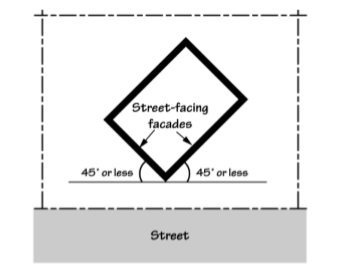
Street-facing Facade/Wall. All the wall planes of a structure as seen from one side or view that are at an angle of 45 degrees or less from a street lot line. See Figure below. Street-facing Facade
 Street Furniture/Furnishings. See Development-Related definitions.
Structure. See Development-Related Definitions.
Subdivision. To divide land into four (4) or more lots within a single calendar year. See also, Chapter 5-4.3, Land Divisions, and ORS 92.010(13).
Surface Water Management. Storm drainage facilities or practices conforming to an adopted surface or storm water management plan, or environmental/engineering best practices.
Street Furniture/Furnishings. See Development-Related definitions.
Structure. See Development-Related Definitions.
Subdivision. To divide land into four (4) or more lots within a single calendar year. See also, Chapter 5-4.3, Land Divisions, and ORS 92.010(13).
Surface Water Management. Storm drainage facilities or practices conforming to an adopted surface or storm water management plan, or environmental/engineering best practices.
Swale. See Development-Related definitions. TTangent. Meeting a curve or surface in a single point. Terrace. A porch or promenade supported by columns, or a flat roof or other platform on a building. Through Lot. See Lot. Through Street. See Transportation-Related Definitions. Top of Bank. See Environment-Related Definitions. Topographical Constraint. Where existing slopes, landforms (e.g., streams, canals, rock outcropping, etc.) or existing manmade feature (e.g., embankment or berm) make conformance with a Code standard impracticable.
Tract. A piece of land within a platted subdivision reserved for open space, utility corridor, recreation facilities, sensitive lands, or other purpose; may be dedicated to a homeowner’s association or other entity for maintenance. Transportation-Related Definitions (See also, Section 5-3.4.010 for related standards.)
- Access. A way or means of approach to provide pedestrian, bicycle, and/or motor vehicular entrances or exits to a property.
- Access point. Any driveway, street, turnout or other means of providing for the movement of vehicles to or from a public roadway.
- Access Easement. An easement recorded for the purposed of providing vehicle, bicycle, and/or pedestrian access from a public street to a parcel across intervening property under separate ownership from the parcel being provided access. Cross access is a service drive providing vehicular access between two or more separate sites, so that the driver need not enter the public street system between sites.
- Access Management. The systematic control of the location, spacing, design, and operation of driveways, median openings interchanges, and street connections to a roadway to minimize conflicts between turning and through vehicles, bicyclists and pedestrians. The purpose of access management is to provide vehicular access to land development in a manner that preserves the safety and efficiency of the transportation system. Public facility measures to support access management include roadway design applications, such as median treatments and auxiliary lanes, and the appropriate spacing of traffic signals. Measures that may be included as conditions of approval for development decisions include but are not limited to 1) standards such as minimum spacing of driveways and onsite vehicle storage requirements, 2) mitigations related to site conditions such as right-in-right-out only approaches, medians, dedicated turn lanes, and shared driveways and 3) provision for future opportunities for mitigation by land dedication or easement.
- Access Spacing/Intersection Spacing. The minimum required distance from an intersection of a public or private street to the nearest driveway or other access connection, measured from the closest edge of the pavement of the intersecting street to the closest edge of the pavement of the connection along the traveled way.
- Access Way. A walkway providing a through connection for pedestrians between two streets, between two lots, or between a development and adjoining public right-of-way. It may be an access way for pedestrians and bicyclists (with no vehicle access), or a walk way on public or private property (i.e., with a public access easement); may also be designed to accommodate emergency vehicles. See also, Walkway.
- Accessible. Two meanings are possible depending on the specific code provision: In general, accessible means approachable by pedestrians, vehicles or other transportation mode, as applicable. Accessible may also mean approachable and useable by people with disabilities, in conformance with the Federal Americans With Disabilities Act. Either or both definitions may apply in a particular situation. See Accessible Route.
- Accessible Route. A route that can be used by a disabled person using a wheelchair and that is also usable by people with other disabilities.
- Alley. A right-of-way that provides vehicle access to a lot or common parking area. Generally, alleys provide secondary vehicle access; however, where vehicle access from the street is not allowed, not possible, or not desirable the alley may provide primary vehicle access.
- Arterial. The highest order classification of streets; includes highways and other major streets with limited or no direct access from adjoining properties.
- Bicycle Facility. There are different types of bicycle facilities: In general, a bicycle facility is a public or private way designed for and dedicated to bicycle use. It may consist of a road, a lane within or on the shoulder of a road, a path, or other way that is specifically designated for bicycle travel or shared bicycle/pedestrian travel.
- Bus Stop. A location where bus service stops to load and unload passengers. For purposes of measuring, the bus stop is the location of a sign denoting the bus stop.
- Collector, Minor/Major. Type of street that serves traffic within commercial, industrial, and residential neighborhood areas. Connects local neighborhood or district streets to the arterial network. Part of the street grid system. See standards under Section 5-3.4.010.
- Common Green. A courtyard that provides for pedestrian access, but not vehicle access, to abutting property and generally provides a common area for use by residents. A common green may function as a community yard (e.g., as in a multiple family or cottage cluster development). Hard and soft landscape features may be included in a common green, such as groundcover, trees, shrubs, surfaced paths, patios, benches, or gazebos.
- Corner Clearance. The distance from an intersection of a public or private street to the nearest driveway or other access connection.
- Curb Cut. A driveway opening delineated by a concrete apron along a street.
- Driveway. Area providing vehicle access to a site, except streets.
- Driveway, Shared. When land uses on two or more lots or parcels share one driveway. An easement or tract (owned in common) must be created and recorded for this purpose.
- Dead-end Street. A street that connects to another street at only one end, does not have a City-approved turnaround on its other end, and may or may not be extended to serve future development. A pedestrian connection may extend from the end of a dead-end street to connect with another street of any type, or with another pedestrian connection.
- Level of Service ("LOS"). A quantitative standard for transportation facilities describing operational conditions. Level of Service may be described for intersections (signalized or unsignalized) or street segments (between signalized intersections).
- Pathway. A walkway, bikeway or access way conforming to City standards and separated from the street right-of-way, that may or may not be within a public right-of-way.
- Public Access Easement. A public access easement is an easement granted to the public for all the purposes for which a public sidewalk may be used, including but not limited to, pedestrian and bicycle travel.
- Rail right-of-way. A public or private right-of-way, for the purpose of allowing rail travel.
- Right-of-way. An area that allows for the passage of people or vehicles. Right-of-way includes all public streets, highways, alleys and public access ways (e.g., pedestrian connections). A right-of-way may be dedicated or deeded to the public for public use and under the control of a public agency, or it may be privately owned, provided the public is granted access. A right-of-way that is not dedicated or deeded to the public will be in a public access easement and may be separately contained in a tract.
- Roadway. The portion of a right-of-way that is improved for motor vehicle and bicycle travel, subject to applicable State motor vehicle licensing requirements. Roadway includes vehicle travel lanes and on-street parking areas. Roadway does not include area devoted to curbs, parking strips, or sidewalks.
- Road/Roadway Authority. The City or other agency (e.g., Oregon Department of Transportation, Grant County, a special purpose district, or other agency) with jurisdiction over a road or street.
- Sidewalk. A paved walkway within a public street right-of-way that is generally located adjacent to and separated from the roadway by a curb or curb and planter strip.
- Sight Distance. The unobstructed viewing distance measured from one object or location to another object or location, usually required the purpose of traffic safety.
- Street. A right-of-way that is intended for motor vehicle, pedestrian or bicycle travel or for motor vehicle, bicycle or pedestrian access to abutting property. For the purposes of this Code, street does not include alleys, rail rights-of-way that do not also allow for motor vehicle access, or freeways and their on-ramps.
- Street Connectivity. Expressed as the number of street and/or access way connections within a specific geographic area. Higher levels of connectivity provide for more direct transportation routes and better dispersion of traffic, resulting in less traffic on individual streets and potentially slower speeds through neighborhoods.
- Street Stub. A temporary street ending where the street will be extended through adjacent property in the future, as those properties develop. Not a permanent street-end or dead-end street. See also, Dead-End Street.
- Street Tree. A tree planted in a planter strip or tree well between the street and sidewalk.
- Through Street. A street that connects to other streets at both ends.
- Transportation Mode. The method of transportation (e.g., automobile, bus, walking, bicycling, train, etc.)
- Turnaround. A vehicle maneuvering area at the end of a dead-end street (e.g., hammerhead, cul-de-sac, or other configuration) that allows for vehicles to turn around.
- Walkway. A sidewalk or path, including any access way, improved to City standards, or to other roadway authority standards, as applicable. See also, Access way, Pathway, Sidewalk.
Travel Trailer. A vacation structure or self-propelled vehicle equipped with wheels for street or highway use; intended for human occupancy; equipped with plumbing, sink or toilets; used for vacation and recreational purposes; and not used as a residence. See ORS 446.003(5), (24); and see Recreational Vehicle. Travel Trailer/Recreational Vehicle Park/Campground. A lot or parcel on which two or more travel trailers, recreational vehicles, motor homes, tent trailers, tent sites, campers, and/or similar vehicles or devices, with or without a charge or fee.
Tree Well. A planter area cut out of a sidewalk within the street furnishing zone, planted with a street tree and including ground cover or a grate cover; typically used in commercial districts where on-street parking or pedestrian traffic makes the use of a planter strip impracticable. UUse (Land Use). The purpose for which land or a structure is designed, arranged, intended, occupied, or maintained. See also, Chapter 5-1.3, Use Categories. Utilities. For the purposes of this Code, there are two types of utilities: 1) Private: telephone, cable, natural gas, electric, telecommunication, and similar franchise facilities, any portion of which utilizes a public right-of-way; and 2) Public: water and wastewater conveyance and treatment facilities. VVacate Plat/Street. To abandon a subdivision or street right-of-way. For example, vacation of a public right-of-way that is not needed or cannot be used for a street or other public purpose. Vacation of a plat typically returns the property to the adjoining owners and restores it to an undivided condition and ownership. Vacation Home Rental. A commercial use of a single family or duplex dwelling unit where the unit is rented for periods of time of 28 or fewer consecutive days. Variance. An administrative or quasi-judicial decision to lessen or otherwise modify the requirements of this Code. See Chapter 5-5.1. Vehicle Areas. See Development-Related definitions.
Vehicle Types.
- Motor Vehicle. Vehicles that have their own motor power and that are used for the transportation of people or goods on streets. Motor vehicle includes motorcycles, passenger vehicles, trucks, and recreational vehicles, except all-terrain vehicles, off-road vehicles, snowmobiles, and similar vehicles may be prohibited from using streets.
- Passenger Vehicle. A motor vehicle designed to carry ten persons or less including the driver. Passenger vehicles are passenger cars and multi-purpose passenger vehicles as defined by the National Highway Traffic Safety Administration in Title 49 of the Code of Federal Regulations, Chapter V, Section 575-6.1. See also Recreational Vehicle, and Truck.
- Recreational Vehicle. A vehicle with or without motive power that is designed for sport or recreational use, or that is designed for temporary human occupancy on an intermittent basis. A recreational vehicle may be permitted in a City-approved mobile home park or manufactured home park where the vehicle is connected to an electrical utility and city sewer and water systems, in accordance with ORS 197.493. Recreational vehicle is divided into two categories as follows:
- Motor Home. Motor home includes motorized vehicles designed for human occupancy on an intermittent basis. A camper is considered a motor home when it is on the back of a pick-up or truck. Motor homes are regulated as trucks unless the regulations specifically indicate otherwise. See also Truck.
- Accessory Recreational Vehicle. Accessory recreational vehicle includes non-motorized vehicles designed for human occupancy on an intermittent basis such as vacation trailers and fifth-wheel trailers. A camper is considered an accessory recreational vehicle when it is standing alone. Accessory recreational vehicle also includes vehicles designed for off-road use, such as all-terrain vehicles, dune buggies, and recreational boats. Recreational vehicles are not dwellings, and occupancy of a recreational vehicle is not considered a primary or accessory residential use.
- Truck. A motor vehicle that is designed primarily for the movement of property or special purpose equipment, or a motor vehicle that is designed to carry more than ten persons. Truck includes vehicles commonly called trucks, pick-ups, delivery vans, buses, motor homes and other similar vehicles. See also, National Highway Traffic Safety Administration in Title 49 of the Code of Federal Regulations, Chapter V, Section 5756.1.
- Light Truck. Trucks and similar vehicles with single rear axles and single rear wheels.
- Medium Truck. Trucks and similar vehicles, other than truck tractors, with single rear axles and dual rear wheels. Truck tractors are in the Heavy Truck category.
- Heavy Truck. Trucks, including truck tractors, and similar vehicles with two or more rear axles.
- Utility Trailer. A vehicle designed to be pulled by a motor vehicle, which is used to carry property, trash, or special equipment and that is 16 feet, or less in length. Boat trailers are included as utility trailers. Utility trailers that are longer than 16 feet are considered industrial vehicles and are regulated as heavy trucks.
Vision Clearance Area. Those areas near intersections of roadways and motor vehicle access points where a clear field of vision is necessary for traffic safety and to maintain adequate sight distance. See standards in Chapter 5-3.1.020. WWaste Collection Areas. Waste collection areas include areas set aside or designed to be used for garbage collection and collection of materials for recycling. Waste collection areas include areas occupied by dumpsters and other solid waste receptacles. Window. For the purposes of this Code, a transparent or semi-transparent (not more than 50% opaque) glazing on a building facade; a window may be a display window (e.g., for merchandise, art, etc.) that is integral to a building design, but a display box mounted onto the exterior of a building is not a window for purposes of this Code. Wireless Communication Equipment. Cellular towers, antennae, monopoles, and related facilities used for radio signal transmission and receiving. X [Reserved]YYard. The area defined by setbacks (i.e., between the setback line and nearest property line). Z
Zero-lot Line House. A single-family detached dwelling with one "0" side yard setback. See also, Attached Dwelling types.
5-6.2.010 Purpose
This section explains how various numerical standards in this Code are to be measured.
5-6.2.020 General Provisions
- Administration. The City Planning Official shall be responsible for administering Chapter 5-6.2.
- Applicant Responsibility. For all calculations, the applicant shall be responsible for supplying drawings illustrating the measurements. These drawings shall be drawn to scale and shall be of sufficient detail to allow easy verification upon inspection by the Director.
- Minimum Requirements. When a regulation is expressed in terms of a minimum requirement, any fractional result will be rounded up to the next consecutive whole number. For example, if a minimum requirement of one tree for every 30 lineal feet is applied to a 50-foot strip, the resulting fraction of 1.37 is rounded up to two required trees.
- Maximum Limits. When a regulation is expressed in terms of maximum limits, any fractional result will be rounded down to the next lower whole number. For example, if a maximum size limit for an accessory use is applied to a 7,522-square-foot lot, and the resulting number of 752.2, the number is rounded down to 752 allowed square feet.
- Fractions. When calculations result in fractions, the results will be rounded as follows:
- Measuring Distances. Distances shall be measured as follows:
- Distances Are Measured Horizontally. When determining distances for setbacks and structure dimensions, all distances are measured along a horizontal plane from the appropriate line, edge of building, structure, storage area, parking area, or other object. These distances are not measured by following the topography or slope of the land.
- Measurements Are Shortest Distance. When measuring a required distance, such as the minimum distance between a structure and a lot line, the measurement is made at the closest or shortest distance between the two objects.
- Measurement of Vehicle Stacking or Travel Areas. The minimum travel distance for vehicles, such as a garage-entrance setback, is measured down the center of the vehicle travel area. For example, curving driveways are measured along the center arc of the driveway.
5-6.2.030 Slope
- Slope. The ratio between vertical and horizontal distances expressed in percent, the mathematical expression of which is based upon the formula below:
Vertical Distance X 100 = Average Percent Slope Horizontal Distance - Average Slope. The average slope of a lot is calculated by subtracting the average elevation of the downhill lot line from the average elevation of the uphill lot line and dividing the difference by the average distance between the two lot lines, as expressed by the formula below. The average elevation of the uphill or downhill lot line is calculated by adding the elevations at the ends of the lot line and dividing by two.
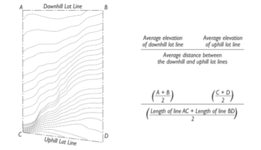
5-6.2.040 Grades
- Grade plane. Grade plane is a reference plane representing the average of finished ground level adjoining the building at exterior walls. Where the finished ground level slopes away from the exterior walls, the reference plane shall be established by the lowest points within the area between the building and the lot line or, where the lot line is more than six feet from the building, between the building and a point six feet from the building.
- Existing grade. Existing grade is the set of elevations representing the surface of the ground prior to grading, filling, or other site alterations for a project. On developed sites, as each topographic line passes beneath a building it shall be assumed to be a straight and level line for purposes of defining existing grade. Existing grade may also be referred to as natural grade if the surface has not been altered by mechanical means for development (See figure below).
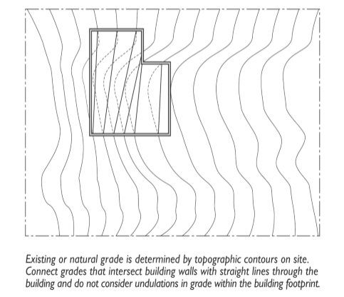
5-6.2.050 Floor Area Ratio
The floor area ratio shall be expressed as the total habitable floor area of the building divided by the total lot size. Floor area is measured at the interior of the enclosing walls. Basement floor space where the floor to ceiling height is less than seven (7) feet is not included in floor area.
5-6.2.060 Lot Coverage
Lot Coverage is the total ground area of a lot occupied by permanent impervious materials or improvements. Lot coverage includes the following materials and surfaces: asphalt, concrete, decomposed granite, compacted clay soil; mortared brick or stone; covered decks, balconies, carports, sheds and similar accessory structures; and other materials and surfaces that are predominately impervious and individually cover more than 121 square feet. The City Planning Official may determine that a material or structure meets or exempt from the criteria for impervious surfaces based on technical specifications from the manufacturer and acceptable performance guarantee from the property owner.
5-6.2.070 Lot Standards And Setbacks
- Lot Widths and Depths.
- Lot Depth. The horizontal distance from the midpoint of the front lot line to the midpoint of the rear lot line or to the most distant point on any other lot line where there is no rear lot line.
- Lot Width. The average horizontal distance between the side lot lines measured at right angles to the lot depth from the required front yard setback and from the required rear yard setback or from the rearmost point of the lot depth in cases where there is no rear lot line. The width of a nonrectangular lot shall be the mean length of the front and rear property lines.
- Setbacks.
- Front Setbacks. Front setbacks shall be measured from the property line adjacent to the street fronting the property. On corner lots with two street frontages, the location of the front entry shall determine the front of the lot.
- Rear Setbacks. Rear setbacks shall be measured from the property line most directly opposite the front.
- Side Setbacks. Side setbacks shall be measured from the property lines not defined as front or rear.
5-6.2.080 Building Height
Building height is measured from the highest point of a flat or deck roof, or the midpoint of the main gable on a gable roof, to the finished grade at the highest point, except where this Code specifies a different reference point. Chimneys, bell towers, steeples, roof equipment, flag poles, and similar features that comprise less than ten percent (10%) of a structure’s roof area, extend not more than eight (8) feet above the highest point of the roof, and are not for human occupancy are exempt from the maximum building heights, provided that all applicable fire and building codes are met. Similar projections exceeding ten percent (10%) of the roof area or projecting more than eight (8) feet may be approved with a Conditional Use Permit pursuant to Chapter 5-4.4.
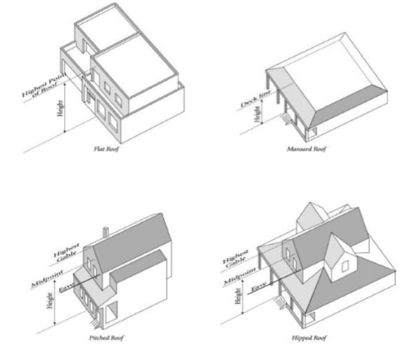
5-6.2.090 Corner Clearance
Corner clearance is measured from the closest edge of the pavement of the intersecting street to the closest edge of pavement of the connection along the traveled way.
5-6.2.100 Clear Vision Area
The clear vision area, as provided in Chapter 5-3.1, is measured along the axis formed by the curbs where they meet the roadway and intersect. In the absence of a curb, the clear vision area is measured along the axis that would be formed by curbs upon full improvement of the street under the applicable roadway standards.