
Kennewick City Zoning Code
CHAPTER 18
58 - CRITICAL AREAS—GENERAL PROVISIONS
18.58.010: - Definitions.
Words not defined in this Title shall be as defined in the Kennewick Municipal Code, the Washington Administrative Code, or the Revised Code of Washington. Words not found in these codes shall be as defined in the Webster's Third New International Dictionary, latest edition. The definitions are as follows:
(1)
Adaptive Management. Adaptive management relies on scientific methods to evaluate how well regulatory and non-regulatory actions protect the critical area. An adaptive management program is a formal and deliberate scientific approach to taking action and obtaining information in the face of uncertainty.
(2)
Adjacent means immediately adjoining (in contact with the boundary of the influence area) or within a distance that is less than that needed to separate activities from critical areas to ensure protection of the functions and values of the critical areas. Adjacent shall mean any activity or development located:
(a)
On a site immediately adjoining a critical area;
(b)
A distance equal to or less than the required critical area buffer width and building setback;
(c)
A distance equal to or less than one-half mile (2,640 feet) (distance of 2,640 feet is based on Department of Fish and Wildlife "Management Recommendations for Washington's Priority Species, Volume IV: Birds") from a bald eagle nest;
(d)
A distance equal to or less than 200 feet upland from a stream, wetland, or water body;
(e)
Bordering or within the floodway, floodplain or channel migration zone; or
(f)
A distance equal to or less than 200 feet (distance of 200 feet was established based upon a review of Department of Fish and Wildlife "Management Recommendations for Washington's Priority Habitats: Riparian, " 1997; and Department of Ecology "Wetland Buffers: Use and Effectiveness," 1992; and City of Kennewick specific conditions) from a critical aquifer recharge area.
(3)
Advance Mitigation. Mitigation of an anticipated critical area impact or hazard completed according to an approved report or other applicable information and prior to site development.
(4)
Alteration. Any human induced change in an existing condition of a critical area or its buffer. Alterations include, but are not limited to grading, filling, channelizing, dredging, clearing (vegetation), construction, compaction, excavation or any other activity that changes the character of the critical area.
(5)
Applicant is a person who files an application for permit under this Title and who is either the owner of the land on which that proposed activity would be located, a contract purchaser, or the authorized agent of such a person.
(6)
Aquifer is a geological formation, group of formations or part of formation that is capable of yielding a significant amount of water to a well or spring.
(7)
Aquifer, Confined is an aquifer bounded above and below by beds of distinctly lower permeability than that of the aquifer itself and that contains ground water under sufficient pressure for the water to rise above the top of the aquifer.
(8)
Aquifer Recharge Areas are areas that, due to the presence of certain soils, geology, and surface water, act to recharge ground water by percolation.
(9)
Aquifer Susceptibility means the ease with which contaminants can move from the land surface to the aquifer based solely on the types of surface and subsurface materials in the area. Susceptibility usually defines the rate at which a contaminant will reach an aquifer unimpeded by chemical interactions with the vadose zone media.
(10)
Aquifer, Unconfined means an aquifer not bounded above by a bed of distinctly lower permeability than that of the aquifer itself and containing ground water under pressure approximately equal to that of the atmosphere. This term is synonymous with the term "water table aquifer."
(11)
Base Flood means a flood event having a one-percent chance of being equaled or exceeded in any given year, also referred to as the 100-year flood. Designations of base flood areas on flood insurance map(s) always include the letters A or V.
(12)
Best Available Science means a current scientific information used in the process to designate, protect, or restore critical areas that is derived from a valid scientific process as defined by WAC 365-195-900 through 925. Sources of best available science are included in "Citations of Recommended Sources of Best Available Science for Designating and Protecting Critical Areas" published by the state Office of Community Development.
(13)
Best Management Practices (BMPs) means conservation practices or systems of practices and management measures that:
(a)
Control soil loss and reduce water quality degradation caused by high concentrations of nutrients, animal waste, toxics, and sediment;
(b)
Minimize adverse impacts to surface water and ground water flow, circulation patterns, and to the chemical, physical, and biological characteristics of wetlands;
(c)
Protect trees and vegetation designated to be retained during and following site construction; and
(d)
Provide standards for proper use of chemical herbicides within critical areas.
The City of Kennewick shall monitor the application of best management practices to ensure that the standards and policies of this Title are adhered to.
(14)
Buffer or Buffer Zone is an area contiguous to and protects a critical habitat that is required for the continued maintenance, functioning, and/or structural stability of a critical area.
(15)
Compensation Project are actions necessary to replace project-induced critical area and buffer losses, including land acquisition, planning, construction plans, monitoring and contingency actions.
(16)
Compensatory Mitigation means replacing project-induced critical wetland habitat losses or impacts, and includes, but is not limited to, the following:
(a)
Restoration: Actions performed to reestablish wetland functional characteristics and processes that have been lost by alterations, activities, or catastrophic events within an area that no longer meets the definition of a wetland.
(b)
Creation: Actions performed to intentionally establish a wetland at a site where it did not formerly exist.
(c)
Enhancement: Actions performed to improve the condition of existing degraded wetlands so that the functions they provide are of a higher quality.
(d)
Preservation: Actions taken to ensure the permanent protection of existing, high-quality wetlands.
(17)
Conservation Easement is a legal agreement that the property owner enters into to restrict uses of the land. Such restrictions can include, but are not limited to, passive recreation uses such as trails or scientific uses and fences or other barriers to protect habitat. The easement is recorded on a property deed, runs with the land, and is legally binding on all present and future owners of the property, therefore, providing permanent or long-term protection.
(18)
Critical Aquifer Recharge Area is an area designated by WAC 365-190-080(2) that are determined to have a critical recharging effect on aquifers used for potable water as defined by WAC 365-190-030(2).
(19)
Critical Areas include any of the following areas or ecosystems: Aquifer recharge areas, fish and wildlife habitat conservation areas, frequently flooded areas, geologically hazardous areas, and wetlands, as defined in RCW 36.70A and this Title.
(20)
Critical Facility is a facility for which even a slight chance of flooding, inundation, or impact from a hazard event might be too great. Critical facilities include, but are not limited to, schools, nursing homes, hospitals, police, fire and emergency response installations, and installations that produce, use or store hazardous materials or hazardous waste.
(21)
Developable Area is a site or portion of a site that may be utilized as the location of development, in accordance with the rules of this Title.
(22)
Development means any activity upon the land consisting of construction or alteration of structures, earth movement, dredging, dumping, grading, filling, mining, removal of any sand, gravel, or minerals, driving of piles, drilling operations, bulk heading, clearing of vegetation, or other land disturbance. Development includes the storage or use of equipment or materials inconsistent with the existing use. Development also includes approvals issued by the City of Kennewick that binds land to specific patterns of use, including, but not limited to, subdivisions, short subdivisions, zone changes, conditional use permits, and binding site plans. Development activity does not include the following activities:
(a)
Interior building improvements.
(b)
Exterior structure maintenance activities, including painting and roofing.
(c)
Routine landscape maintenance of established, ornamental landscaping, such as lawn mowing, pruning and weeding.
(d)
Maintenance of the following existing facilities that does not expand the affected area: septic tanks (routine cleaning); wells; individual utility service connections; and individual cemetery plots in established and approved cemeteries.
(23)
Development Permit means any permit issued by the City of Kennewick, or other authorized agency, for construction, land use, or the alteration of land.
(24)
Eco-Connectivity is a physical feature of the land as well as functional one. It is the geo-physical connection between natural habitat areas that allow fish and animals to move between feeding, reproductive, rearing, and resting areas. The functional connection is dependent on the physical connection.
(25)
Erosion is the process whereby wind, rain, water, and other natural agents mobilize and transport particles.
(26)
Erosion Hazard Areas are at least those areas identified by the United States Department of Agriculture National Resources Conservation Service as have a "severe" rill and inter-rill erosion hazard.
(27)
Exotic means any species of plants or animals, which are (not listed on the State plant list) foreign to the planning area.
(28)
Extreme Slope Hazard Areas are those areas with pre-development slope greater than 40 percent.
(29)
Fish and Wildlife Habitat Conservation Areas are areas necessary for maintaining species in suitable habitats within their natural geographic distribution so that isolated subpopulations are not created as designated by WAC 365-190-080(5). These areas are guided by the State's Priority Habitats and Species list and include the following:
(a)
Areas with which state or federally designated endangered, threatened, and sensitive species have a primary association;
(b)
Habitats of local importance, including, but not limited to, areas designated as priority habitat by the Department of Fish and Wildlife;
(c)
Naturally occurring ponds under 20 acres and their submerged aquatic beds that provide fish or wildlife habitat, including those artificial ponds intentionally created from dry areas in order to mitigate impacts to ponds;
(d)
Waters of the state, including lakes, rivers, ponds, streams, inland waters, underground waters, salt waters and all other surface waters and watercourses within the jurisdiction of the state of Washington;
(e)
Lakes, ponds, streams, and rivers planted with game fish by a governmental or tribal entity;
(f)
State natural area preserves and natural resource conservation areas; and
(g)
Land essential for preserving connections between habitat blocks and open spaces.
(30)
Habitat is an area or environment that is used by fish at any life stage at any time of the year, including potential habitat likely to be used by fish that could be recovered by restoration or management and includes off-channel habitat. (See WAC 222-16-030(5)(h)).
(31)
Flood or Flooding is a general and temporary condition of partial or complete inundation of normally dry land areas from the overflow of inland waters and/or the unusual and rapid accumulation of runoff of surface waters from any source.
(32)
Flood Insurance Map is the official map on which the Federal Insurance Administration has delineated the areas of special flood hazards and include the risk premium zones applicable to the community. Also known as "flood insurance rate map" or "FIRM."
(33)
Flood Insurance Study is the official report provided by the Federal Insurance Administration that includes floodprofiles, the Flood Boundary-Floodway Map, and the water surface elevation of the base flood.
(34)
Floodplain is the total land area adjoining a river, stream, watercourse or lake subject to inundation by the base flood.
(35)
Floodway is the channel of a river or other watercourse and the adjacent land area that must be reserved in order to discharge the base flood without cumulatively increasing the surface water elevation more than one foot. Also known as the "zero rise floodway."
(36)
Formation means an assemblage of earth materials grouped together into a unit that is convenient for description or mapping.
(37)
Formation, Confining means the relatively impermeable formation immediately overlying a confined aquifer.
(38)
Frequently Flooded Areas means lands in the floodplain subject to a one-percent or greater chance of flooding in any given year and those lands that provide important flood storage, conveyance and attenuation functions, as determined by the Planning Director in accordance with WAC 365-190-080(3). Frequently flooded areas perform important hydrologic functions and may present a risk to persons and property. Classifications of frequently flooded areas include, at a minimum, the 100-year floodplain designations of the Federal Emergency Management Agency and the National Flood Insurance Program.
(39)
Functions and Values means the beneficial roles served by critical areas including, but not limited to, water quality protection and enhancement, fish and wildlife habitat, food chain support, flood storage, conveyance and attenuation, ground water recharge and discharge, erosion control, wave attenuation, protection from hazards, historical and archaeological and aesthetic value protection, and recreation. These beneficial roles are not listed in order of priority.
(40)
Geologically Hazardous Areas means areas that may not be suited to development consistent with public health, safety or environmental standards, because of their susceptibility to erosion, sliding, earthquake, or other geological events as designated by WAC 365-190-080(4). Types of geologically hazardous areas include: erosion, landslide, seismic, mine, and volcanic hazards.
(41)
Ground Water means water in a saturated zone or stratum beneath the surface of land or a surface water body.
(42)
Growth Management Act means RCW 36.70A, and 36.70B, as amended.
(43)
Habitat Conservation Areas means areas designated as fish and wildlife habitat conservation areas.
(44)
Hazard Areas means areas designated as frequently flooded areas or geologically hazardous areas due to potential for erosion, landslide, seismic activity, extreme slopes, or other geological condition.
(45)
Hazardous Substances means any liquid, solid, gas, or sludge, including any material, substance, product, commodity, or waste, regardless of quantity, that exhibits any of the physical, chemical or biological properties described in WAC 173-303-090 or 173-303-100.
(46)
High Intensity Land Use means land uses which are associated with high levels of human disturbance or substantial habitat impacts including, but not limited to, commercial uses, industrial uses, and residential uses with five or more units per acre.
(47)
High Quality Wetlands means those wetlands that meet the following criteria:
(a)
No, or isolated, human alteration of the wetland topography;
(b)
No human-caused alteration of the hydrology or the wetland appears to have recovered from the alteration;
(c)
Low cover and frequency of exotic plant species;
(d)
Relatively little human-related disturbance of the native vegetation, or recovery from past disturbance;
(e)
If the wetland system is degraded, it still contains a viable and high quality example of a native wetland community; and
(f)
No known major water quality problems.
(48)
Historic Condition means condition of the land, is including flora, fauna, soil, topography, and hydrology that existed before the area and vicinity were developed or altered by human activity.
(49)
Hydraulic Project Approval (HPA) means a permit issued by the state Department of Fish and Wildlife for projects that affect the bed or flow of waters of the state in accordance with Chapter 77.55 RCW and WAC 220.110.
(50)
Hydric Soil means a soil that is saturated, flooded or ponded long enough during the growing season to develop anaerobic conditions in the upper part. The presence of hydric soil shall be determined following the methods described in the Washington State Wetland Identification and Delineation Manual.
(51)
Hydrologic Soil Groups means soils grouped according to their runoff-producing characteristics under similar storm and cover conditions. Properties that influence runoff potential are depth to seasonally high water table, intake rate and permeability after prolonged wetting, and depth to a low permeable layer. Hydrologic soil groups are normally used in equations that estimate runoff from rainfall, but can be used to estimate a rate of water transmission in soil. There are four hydrologic soil groups:
(a)
Low runoff potential and a high rate of infiltration potential;
(b)
Moderate infiltration potential and a moderate rate of runoff potential;
(c)
Slow infiltration potential and a moderate to high rate of runoff potential; and
(d)
High runoff potential and very slow infiltration and water transmission rates.
(52)
Hydrophytic Vegetation means Macrophytic plant life growing in water or on a substrate that is at least periodically deficient in oxygen as a result of excessive water content. The presence of hydrophytic vegetation shall be determined following the methods described in the Washington State Wetland Identification and Delineation Manual.
(53)
Hyporheic Zone means the saturated zone located beneath and adjacent to streams that contains some portion of surface waters, serves as a filter for nutrients, and maintains water quality.
(54)
Impervious Surface means a hard surface area that either prevents or retards the entry of water into the soil mantle as under natural conditions prior to development or that causes water to run off the surface in greater quantities or at an increased rate of flow from the flow present under natural conditions prior to development. Common impervious surfaces include, but are not limited to, roof tops, walkways, patios, driveways, parking lots or storage areas, concrete or asphalt paving, gravel roads, packed earthen materials, and oiled macadam or other surfaces which similarly impede the natural infiltration of stormwater.
(55)
In-Kind Compensation means replacement of the same species, habitat type, and function impacted. If the impacted habitat is disturbed, it means replacement with the natural habitat that would occur. It does not mean replacement "in-category."
(56)
Isolated Wetlands means those wetlands that are outside of and not contiguous to any 100-year floodplain of a lake, river, or stream, and have no contiguous hydric soil or hydrophytic vegetation between the wetland and any surface water.
(57)
Infiltration means the downward entry of water into the immediate surface of soil.
(58)
Injection well(s) means:
(a)
Class I - A well used to inject industrial, commercial, or municipal waste fluids beneath the lowermost formation containing, within one-quarter mile of the well bore, an underground source of drinking water.
(b)
Class II - A well used to inject fluids:
(i)
Brought to the surface in connection with conventional oil or natural gas exploration or production and may be commingled with wastewaters from gas plants that are an integral part of production operations, unless those waters are classified as dangerous wastes at the time of injection;
(ii)
For enhanced recovery of oil or natural gas; or
(iii)
For storage of hydrocarbons that are liquid at standard temperature and pressure.
(c)
Class III - A well used for extraction of minerals, including, but not limited to, the injection of fluids for:
(i)
In-situ production of uranium or other metals that have not been conventionally mined;
(ii)
Mining of sulfur by Frasch process; or
(iii)
Solution mining of salts or potash.
(d)
Class IV - A well used to inject dangerous or radioactive waste fluids.
(e)
Class V - All injection wells not included in Classes I, II, III, or IV.
(59)
Inter-rills are areas subject to sheetwash.
(60)
Joint Aquatic Resource Permits Application (JARPA) means a single application form that may be used to apply for hydraulic project approvals, shoreline management permits, approvals of exceedance of water quality standards, water quality certifications, coast guard bridge permits, Department of Natural Resources use authorization, and Army Corps of Engineers permits.
(61)
Lakeshore Management Plan means McNary Lakeshore Management Plan, Lake Wallula, Oregon and Washington. 1983. A U. S. Corps of Engineers lakeshore management plan intended to manage and protect the shoreline and to promote recreation and to operate and maintain water resource projects in the public interest. The Plan is a regulatory tool used to administer such activities as dock construction permits and vegetation removal.
(62)
Land Use, High Intensity. See "High Intensity Land Use."
(63)
Land Use, Low Intensity. See "Low Intensity Land Use."
(64)
Land Use, Moderate Intensity. See "Moderate intensity land use."
(65)
Landslide Hazard Areas are areas that are potentially subject to risk of mass movement due to a combination of geologic landslide resulting from a combination of geologic, topographic, and hydrologic factors. These areas are typically susceptible to landslides because of a combination of factors including: bedrock, soil, slope gradient, slope aspect, geologic structure, ground water, or other factors.
(66)
Long-Term Commercial Significance includes the growing capacity, productivity, and soil composition of the land for long-term commercial production, in consideration with the land's proximity to population areas, and the possibility of more intense uses of the land. RCW 36.70A.030(10); WAC 365-190-030(11).
(67)
Low Intensity Land Use means land uses which are associated with low levels of human disturbance or low habitat impacts, including, but not limited to, passive recreation uses, open space uses, and residential uses with four or fewer units per acre.
(68)
Minerals mean materials including gravel, sand, and valuable metallic substances. RCW 36.70A.030(11); WAC 365-190-030(12).
(69)
Mitigation means avoiding, minimizing or compensating for adverse critical areas impacts. Mitigation, in the following order of preference, is:
(a)
Avoiding the impact altogether by not taking a certain action or parts of an action;
(b)
Minimizing impacts by limiting the degree or magnitude of the action and its implementation, by using appropriate technology, or by taking affirmative steps, such as project redesign, relocation, or timing, to avoid or reduce impacts;
(c)
Rectifying the impact to wetlands, critical aquifer recharge areas, and habitat conservation areas by repairing, rehabilitating or restoring the affected environment to the conditions existing at the time of the initiation of the project;
(d)
Minimizing or eliminating the hazard by restoring or stabilizing the hazard area through engineered or other methods;
(e)
Reducing or eliminating the impact or hazard over time by preservation and maintenance operations during the life of the action;
(f)
Compensating for the impact to wetlands, critical aquifer recharge areas, and habitat or critical areas by replacing, enhancing, or providing substitute resources or environments; and
(g)
Monitoring the hazard or other required mitigation and taking remedial action when necessary.
Mitigation for individual actions may include a combination of the above measures.
(70)
Moderate Intensity Land Use means land uses which are associated with moderate levels of human disturbance or substantial habitat impacts including, but not limited to, low density residential (no more than one home per five acres), active recreation, and moderate agricultural land uses.
(71)
Monitoring means evaluating the impacts of development proposals on the biological, hydrological, and geological elements of such systems and assessing the performance of required mitigation measures throughout the collection and analysis of data by various methods for the purpose of understanding and documenting changes in natural ecosystems and features, and includes gathering baseline data.
(72)
Native Vegetation means plant species that are indigenous to the area in question. Plants that are not listed in Chapter 16-750 WAC.
(73)
Native Growth Habitat Area means an area where native vegetation is preserved for the purpose of preventing harm to property and the environment, including, but not limited to, controlling surface water runoff and erosion, maintaining slope stability, buffering and protecting plants and animal habitat;
(74)
Natural Waters means waters, excluding water conveyance systems, that are artificially constructed and actively maintained for irrigation, or any waters of the state. See WAC 222-16-030(5)(d) and WAC 222-16-031(6)(d).
(75)
Nonconformity means a legally established existing use or legally constructed structure that is not in compliance with current regulations.
(76)
Nonindigenous. See "Exotic."
(77)
Off-Site Mitigation means to replace critical areas away from the site on which a critical area has been impacted. For off-site mitigation to be acceptable, it must be demonstrated that greater habitat, water quality and hydrologic functions can be achieved off-site.
(78)
On-Site Mitigation means on or adjacent to the project impact site or in the same stream reach, based on resource needs. It is not to be limited to property ownership or city or county boundaries that do not limit the needs and uses of the resources.
(79)
Ordinary High Watermark (OHM) means a mark which is found by examining the bed and banks and ascertaining where the presence and action of waters are so common and usual, and so long continued in all ordinary years, that the soil or vegetation has a character distinct from that of the abutting upland.
(80)
Out-of-Kind Replacement means to replace critical areas with substitute critical areas whose functions and values do not closely approximate those destroyed or degraded. It does not refer to replacement "out-of-category."
(81)
Permeability means the capacity of an aquifer or confining bed to transmit water. It is a property of the aquifer or confining bed and is independent of the force causing movement.
(82)
Planning Director is the city official for of the City of Kennewick planning department or other responsible official or other city staff granted the authority to act on behalf of the director.
(83)
Potable Water means water that is safe and palatable for human use.
(84)
Practical Alternative means an alternative that is available and capable of being carried out after taking into consideration, cost, existing technology, and logistics in light of overall project purposes, and having fewer impacts to critical areas.
(85)
Priority Habitat means habitat type or elements with unique or significant value to one or more species as classified by the Department of Fish and Wildlife. A priority habitat may consist of a unique vegetation type or dominant plant species, a described successional stage, or a specific structural element (WAC 173-26-020(34)).
(86)
Project Area means all areas within 50 feet of the area proposed to be disturbed, altered, or used by the proposed activity or the construction of any proposed structures.
(87)
Qualified Professional means a person with experience and training in the pertinent scientific discipline, and who is a qualified scientific expert with expertise appropriate for the relevant critical area subject in accordance with WAC 365-195-905(4). A qualified professional must have obtained a B.S. or B.A. or equivalent degree in biology, engineering, environmental studies, fisheries, geomorphology or related field, and two years of related work experience.
(a)
A qualified professional for habitats or wetlands must have a degree in biology and professional experience related to the subject species.
(b)
A qualified professional for a geological hazard must be a professional geologist (preferred) or engineer, licensed in the state of Washington.
(c)
A qualified professional for critical aquifer recharge areas means a hydrogeologist, geologist, engineer, or other scientist with experience in preparing hydrogeologic assessments.
(88)
Recharge is the process involved in the absorption and addition of water to ground water.
(89)
Reclaimed Water means municipal wastewater effluent that has been adequately and reliability treated so that it is suitable for beneficial use. Following treatment it is no longer considered wastewater (treatment levels and water quality requirements are given in the water reclamation and reuse standards adopted by the state Departments of Ecology and Health).
(90)
Regulatory Flood means a level of flooding that a regulatory agency's design regulations apply to.
(91)
Repair or Maintenance is an activity that restores the character, scope, size, and design of a serviceable area, structure, or land use to its previously authorized and undamaged condition. Activities that change the character, size, or scope of a project beyond the original design and drain, dredge, fill, flood, or otherwise alter critical areas are not included in this definition.
(92)
Restoration means measures taken to restore an altered or damaged natural feature including:
(a)
Active steps taken to restore damaged wetlands, streams, protected habitat, or their buffers to the functioning condition that existed prior to an unauthorized alteration; and
(b)
Actions performed to reestablish structural and functional characteristics of the critical area that have been lost by alteration, past management activities, or catastrophic events.
(93)
Rills are steep-sided channels resulting from accelerated erosion. A rill is generally a few inches deep and not wide enough to be an obstacle to farm machinery. Rill erosion tends to occur on slopes, particularly steep slopes with poor vegetative cover.
(94)
Riparian Habitat is any area adjacent to surface water which possesses elements of both aquatic and terrestrial ecosystems that mutually influence each other. The width of these areas extends from the OHW to that portion of the terrestrial landscape that directly influences the aquatic ecosystem by providing shade, fine or large woody material, nutrients, organic and inorganic debris, terrestrial insects, or habitat for riparian-associated wildlife. It includes the entire extent of the floodplain and the extent of vegetation adapted to wet conditions as well as adjacent upland plant communities that directly influence aquatic ecosystem. Riparian habitat areas include those riparian areas severely altered or damaged due to human development activities. See Department of Fish and Wildlife "Management Recommendations for Washington's Priority Habitats - Riparian," page 4, 1997.
(95)
Scientific Process is a valid scientific process that produces reliable information useful in understanding the consequences of a decision. The characteristics of a valid scientific process are as follows:
(a)
Peer review. The information has been critically reviewed by other qualified scientific experts in that scientific discipline.
(b)
Methods. The methods that were used are standardized in the pertinent scientific discipline or the methods have been appropriately peer-reviewed to assure their reliability and validity.
(c)
Logical conclusions and reasonable inferences. The conclusions presented are based on reasonable assumptions supported by other studies and are logically and reasonably derived from the assumptions and supported by the data presented.
(d)
Quantitative analysis. The data have been analyzed using appropriate statistical or quantitative methods.
(e)
Context. The assumptions, analytical techniques, data, and conclusions are appropriately framed with respect to the prevailing body of pertinent scientific knowledge.
(f)
References. The assumptions, techniques, and conclusions are well referenced with citations to pertinent existing information.
(96)
Section 404 Permit is a permit issued by the Corps of Engineers for the placement of dredge or fill material or clearing in waters of the U.S., including wetlands, in accordance with 33 USC § 1344.
(97)
Seeps is a spot where water oozes from the earth, often forming the source of a small stream.
(98)
Seismic Hazard Areas are areas that are subject to severe risk of damage as a result of earthquake-induced ground shaking, slope failure, settlement, or soil liquefaction.
(99)
Serviceable means presently usable.
(100)
SEPA is the Washington State Environmental Policy Act, Chapter 43.21C RCW.
(101)
Shorelines means all of the water areas of the state as defined in RCW 90.58.030, including reservoirs and their associated shorelands, together with the lands underlying them except:
(a)
Shorelines of statewide significance;
(b)
Shorelines on segments of streams upstream of a point where the mean annual flow is 20 cubic feet per second (20 cfps) or less and the wetlands associated with such upstream segments; and
(c)
Shorelines on lakes less than 20 acres in size and wetlands associated with such small lakes.
(102)
Shorelines of the State is the total of all "shorelines," as defined in RCW 90.58.030(2)(d), and "shorelines of statewide significance" within the state, as defined in RCW 90.58.030(2)(c).
(103)
Shorelines of Statewide Significance are those areas defined in RCW 90.58.030(2)(e).
(104)
Shorelands or Shoreland Areas are those lands extending landward for 20 feet in all directions as measured on a horizontal plane from the ordinary high water mark; floodways and contiguous floodplain areas landward 200 feet from such floodways; and all wetlands and river deltas associated with the streams, lakes and tidal waters which are subject to the provisions of Chapter 90.58 RCW.
(105)
Shrub-Steppe are vegetative communities consisting of one or more layers of perennial grass with a conspicuous but discontinuous over-story layer of shrubs have been termed "shrubsteppe." In Washington, these communities usually contain big safebrush (Artemisia tridentate) in association with bunchgrasses, although other associations are found (Dobler et al, 1996).
(106)
Significant Portion of its Range means that portion of a species range likely to be essential to the long-term survival of the population in Washington.
(107)
Soil Survey means the most recent soil survey for the local area or county by the National Resources Conservation Service, U.S. Department of Agriculture.
(108)
Species means any group of animals classified as a species or subspecies as commonly accepted by the scientific community.
(109)
Species, Endangered means any fish or wildlife species that is threatened with extinction throughout all or a significant portion of its range and is listed by the state or federal government as an endangered species.
(110)
Species of Local Importance means those species of local concern due to their population status or their sensitivity to habitat manipulation, or that are game species.
(111)
Species, Priority means any fish or wildlife species requiring protective measures and/or management guidelines to ensure their persistence as genetically viable population levels as classified by the Department of Fish and Wildlife, including endangered, threatened, sensitive, candidate and monitor species, and those of recreational, commercial, or tribal importance.
(112)
Species, Threatened means any fish or wildlife species that is likely to become an endangered species within the foreseeable future throughout a significant portion of its range without cooperative management or removal of threats, and is listed by the state or federal government as a threatened species.
(113)
Stream means water contained within a channel, either perennial or intermittent, and classified according to WAC 222-16-030 or WAC 222-16-031 and as listed under "water typing system." Streams also include natural watercourses modified by man. Streams do not include irrigation ditches, waste ways, drains, outfalls, operational spillways, channels, storm water runoff facilities or other wholly artificial watercourses, except those that directly result from the modification to a natural watercourse.
(114)
Sub-Drainage Basin or Subbasin means the drainage area of the highest order stream containing the subject property impact area. Stream order is the term used to define the position of a stream in the hierarchy of tributaries in the watershed. The smallest streams are the highest order (first order) tributaries. These are the upper watershed streams and have no tributaries of their own. When two first order streams meet, they form a second order stream, and when two second order streams meet they become a third order stream, and so on.
(115)
Substantial Damage means damage of any origin sustained by a structure whereby the cost of restoring the structure to its before damaged condition would equal or exceed 50 percent of the market value of the structure before the damage occurred.
(116)
Substantial Improvement means any repair, reconstruction, or improvement of a structure, the cost of which equals or exceeds 50 percent of the market value of the structure either: before the improvement or repair is started; or if the structure has been damaged and is being restored, before the damage occurred.
(117)
Take means to harass, harm, pursue, hunt, shoot, wound, kill, capture, or collect, or to attempt to engage in any such conduct.
(118)
Unavoidable means adverse impacts that remain after all appropriate and practicable avoidance and minimization have been achieved. See RCW 90.84.010(9).
(119)
Vulnerability means the combined effect of susceptibility to contamination and the presence of potential contaminants.
(120)
Water Dependent means a use or portion of a use that cannot exist in a location that is not adjacent to the water, but is dependent on the water by reason of the intrinsic nature of its operations. A use that can be carried out only on, in, or adjacent to water. Examples of water dependent uses include ship cargo terminal loading areas; fishing; ferry and passenger terminals; barge loading, ship building, and dry docking facilities; marinas, moorage, and boat launching facilities; aquaculture; float plane operations; surface water intake; and sanitary sewer and storm drain outfalls.
(121)
Water Resource Inventory Area (WRIA) means one of 62 watersheds in the state of Washington, each composed of the drainage areas of a stream or streams, as established in Chapter 173-500 WAC as it existed on January 1, 1997.
(122)
Water Table means that surface in an unconfined aquifer at which the pressure is atmospheric. It is defined by the levels at which water stands in wells that penetrate the aquifer just far enough to hold standing water.
(123)
Water Table Aquifer. See "Aquifer, unconfined."
(124)
Water Typing System are waters classified according to WAC 222-16-031 including the following:
(a)
Type 1 Water - All waters, within their ordinary high-water mark, as inventoried as "shorelines of the state" under Chapter 90.58 RCW and the rules promulgated pursuant to Chapter 90.58 RCW, but not including those waters associated with wetlands as defined in Chapter 90.58 RCW.
(b)
Type 2 Water - Segments of natural waters that are not classified as Type 1 Water and have a high fish, wildlife, or human use. These are segments of natural waters and periodically inundated areas of their associated wetlands, which:
(i)
Are used by fish for spawning, rearing or migration. Waters having the following characteristics are presumed to have highly significant fish populations:
(A)
Stream segments having a defined channel 20 feet or greater within the bankfull width and having a gradient of less than four percent.
(B)
Lakes, ponds, or impoundments having a surface area of one acre or greater at seasonal low water; or
(ii)
Are used by fish for off-channel habitat. These areas are critical to the maintenance of optimum survival of fish. This habitat shall be identified based on the following criteria:
(A)
The site must be connected to a fish bearing stream and be accessible during some period of the year; and
(B)
The off-channel water must be accessible to fish through a drainage with less than a five percent gradient.
(c)
Type 3 Water - Segments of natural waters that are not classified as Type 1 or 2 Waters and have a moderate to slight fish, wildlife, and human use. These are segments of natural waters and periodically inundated areas of their associated wetlands which:
(i)
Are used by fish for spawning, rearing or migration. The requirements for determining fish use are described in the State Forest Practices Board Manual, Section 13. If fish use has not been determined:
(A)
Waters having the following characteristics are presumed to have fish use:
(I)
Stream segments having a defined channel of three feet or greater in width and having a gradient of 16 percent or less.
(II)
Stream segments having a defined channel or three feet or greater within the bankfull width, and having a gradient greater than 16 percent and less than or equal to 20 percent, and having greater than 175 acres contributing basin size, based on hydrographic boundaries;
(III)
Ponds or impoundments having a surface area of less than one acre at seasonal low water and having an outlet to a fish stream;
(IV)
Ponds of impoundments having a surface area greater than one-half acre at seasonal low water.
(B)
The Department of Natural Resources shall waive or modify the characteristics in (a) of this Subsection where:
(I)
Waters have confirmed, long term, naturally occurring water quality parameters incapable of supporting fish;
(II)
Snowmelt streams have short flow cycles that do not support successful life history phases of fish. These streams typically have no flow in the winter months and discontinue flow by June 1; or
(III)
Sufficient information about a geomorphic region is available to support a departure from the characteristics in (a) of this Subsection, as determined in consultation with the Department of Fish and Wildlife, Department of Ecology, affected tribes and interested parties.
(d)
Type 4 Water - All segments of natural waters within the bankfull width of defined channels that are perennial nonfish habitat streams. Perennial streams are waters that do not go dry any time of a year of normal rainfall. However, for the purpose of water typing, Type 4 Waters include the intermittent dry portions of the perennial channel below the uppermost point of perennial flow. If the uppermost point of perennial flow cannot be identified with simple, nontechnical observations (see State Forest Practices Board Manual, Section 23), then Type 4 Waters begin at a point along the channel where the contributing basin area is at least 300 acres.
(e)
Type 5 Waters - All segments of natural waters within the bankfull width of the defined channels that are not Type 1, 2, 3, or 4 Waters. These are seasonal, nonfish habitat streams in which surface flow is not present for at least some portion of the year and are not located downstream from any stream reach that is a Type 4 Water. Type 5 Waters must be physically connected by an above-ground channel system to Type 1, 2, 3, or 4 Waters.
(125)
Well is a bored, drilled or driven shaft, or a dug hole whose depth is greater than the largest surface dimension for the purpose of withdrawing or injecting water or other liquids.
(126)
Wellhead Protection Area (WHPA) is the portion of a zone of contribution for a well, wellfield or spring, as defined using criteria established by the state Department of Ecology.
(127)
Wetlands are those areas that are inundated or saturated by surface or ground water at a frequency and duration sufficient to support, and that under normal circumstances do support, a prevalence of vegetation adapted for life in saturated soil conditions. Wetlands generally include swamps, marshes, bogs and similar areas. Wetlands do not include those artificial wetlands intentionally created from non-wetland sites, including, but not limited to, irrigation and drainage ditches, grass-lined swales, canals, detention facilities, wastewater treatment facilities, farm ponds, and landscape amenities, or those wetlands created after July 1, 1990, that were unintentionally created as a result of the construction of a road, street, or highway. Wetlands may include those artificial wetlands intentionally created from non-wetland areas to mitigate the conversion of wetlands. Identification and delineation of Wetlands is also a product of the Washington State Wetland Identification and Delineation Manual (KMC 18.59.010).
(128)
Wetland Category are wetlands that are categorized into Category I, II, III or IV based upon the categorization procedures in the Washington State Wetland Rating System for Eastern Washington (Hruby T. 2004).
(129)
Wetland Classes, Classes of Wetlands, or Wetland Types are the descriptive classes of the wetlands taxonomic classification system of the U.S. Fish and Wildlife Service (Cowardin, et al. 1979).
(130)
Wetland Edge means the boundary of a wetland as delineated based on the definitions contained in this Title.
(131)
Wetlands Mitigation Bank means a site where wetlands are restored, created, enhanced, or in exceptional circumstances, preserved expressly for the purpose of providing compensatory mitigation in advance of authorized impacts to similar resources. See RCW 90.84.010(5).
(132)
Zone of Contribution means the area surrounding a well or spring that encompasses all areas or features that supply ground water recharge to the well or spring.
(Ord. 5206 Sec. 1, 2007)
18.58.020: - Purpose.
(1)
The purpose of this Title is to designate and classify ecologically sensitive and hazardous areas and to protect these areas and their functions and values, while also allowing for reasonable use of private property.
(2)
This Title is to implement the goals, policies, guidelines, and requirements of the City of Kennewick (City) Comprehensive Plan and the Growth Management Act.
(3)
The City finds that critical areas provide a variety of valuable and beneficial biological and physical functions that benefit the City and its residents, and/or may pose a threat to human safety or to public and private property. The beneficial functions and values provided by critical areas include, but are not limited to, water quality protection and enhancement, fish and wildlife habitat, support of trophic relationships, flood storage, conveyance and attenuation, ground water recharge and discharge, erosion control, wave attenuation, protection from hazards, historical and archaeological and aesthetic value protection, and recreation. These beneficial functions are not listed in order of priority.
(4)
Goals. By identifying development impacts to critical areas, this Title seeks to:
(a)
Protect members of the public and public resources and facilities from injury, loss of life, or property damage due to landslides and steep slope failures, erosion, seismic events, volcanic eruptions, or flooding;
(b)
Protect unique, fragile, and valuable elements of the environment, including ground and surface waters, wetlands, and fish and wildlife and their habitats;
(c)
Direct activities not dependent on critical area resources to less ecologically sensitive sites and
(d)
Mitigate unavoidable impacts to critical areas by regulating alterations in and adjacent to critical areas; and
(e)
Prevent cumulative adverse environmental impacts to water quality, wetlands, and fish and wildlife habitat, and the overall net loss of wetlands, frequently flooded areas and habitat conservation areas.
(5)
This Title is intended to protect critical areas in accordance with the Growth Management Act and through the application of best available science, as determined according to WAC 365-195-900 through 365-195-925, and in consultation with state and federal agencies and other qualified professionals.
(6)
This Title is to be administered with flexibility and attention to site-specific characteristics. It is not the intent of this Title to make a parcel of property unusable by denying its owner reasonable economic use of the property.
(7)
The City's enactment or enforcement of this Title shall not be construed for the benefit of any individual person or group of persons other than the general public.
(Ord. 5206 Sec. 1, 2007)
18.58.030: - Authority and Applicability.
(1)
As provided herein, the Planning Director is given the authority to interpret and apply and the responsibility to enforce this Title to accomplish the stated purpose.
(2)
The City shall not approve any permit or otherwise issue any authorization to alter the condition of any land, water, or vegetation, or to construct or alter any structure or improvement in, over, or on a critical area or associated buffer, without first assuring compliance with the requirements of this Title.
(3)
The provisions of this Title shall apply to all lands, all land uses and development activity, and all structures and facilities in the City, whether or not a permit or authorization is required, and shall apply to every person, firm, partnership, corporation, group, governmental agency, or other entity that owns, leases, or administers land within the City. No person, company, agency, or applicant shall alter a critical area or buffer except as consistent with the purposes and requirements of this Title.
(4)
Approval or denial of a permit or development proposal pursuant to the provisions of this Title does not discharge the obligation of the applicant to comply with the provisions of this Title.
(Ord. 5206 Sec. 1, 2007)
18.58.040: - Relationship to Other Regulations.
(1)
These critical area regulations shall apply as an overlay to the City's subdivision and zoning code (Title 17 and 18) and other applicable regulations adopted by the City, including, but not limited to permitting processes, construction standards, building code, shorelines management program, and environmental review (SEPA) procedures. In the case of conflict among regulations, whichever provision or regulation provides the greater protection to the critical area involved shall apply
(a)
Kennewick Code Title 4 - Administrative Procedures:
(i)
Chapter 4.08 State Environmental Policy Act implements the State Environmental Policy Act (SEPA) and establishes procedures for public review of impacts of public and private development actions.
(ii)
Chapter 4.12 Permit Process establishes a mechanism to enable compliance, conformity and consistency of proposed projects with respect to adopted comprehensive plans and development regulations.
(b)
Kennewick Code Title 5.56 - Public Works Construction Standards
(c)
Kennewick Code Title 15 - Buildings and Construction. This title provides uniform development and construction standards, primarily through adoption of the Uniform Building Codes by reference.
(d)
Kennewick Code Title 18 - Zoning Code:
(i)
Chapter 18.42, Land Use Permits, sets forth procedures and guidelines for review and approval of land use permits, including conditional uses (Chapter 18.42.100) and site plans (Chapter 18.42.110). Contents of the site plans include, but are not limited to, a site plan showing lot lines and dimensions, location of existing and proposed building or improvements, parking lot drainage, landscaping and fencing.
(ii)
Chapter 18.45, Planned Development Permit, provides a set of flexible standards for development of large parcels of property, provided that the deviation better accommodates the physical conditions of the property.
(e)
Kennewick Code Title 18.60 - Shoreline Management. Sets forth policy and requirements for protecting and regulating activities within 200 feet of the Ordinary High Water Mark for the City of Kennewick shorelines. The following exceptions to the applicability of this Title in Shoreline Jurisdiction shall apply:
(i)
If provisions of this Title and other parts of the master program conflict, the provisions most protective of the ecological resource shall apply, as determined by the City.
(ii)
Provisions of this Title that are not consistent with the Shoreline Management Act Chapter, 90.85 RCW, and supporting Washington Administrative Code chapters shall not apply in Shoreline jurisdiction.
(iii)
The provisions of this Title do not extend Shoreline Jurisdiction beyond the limits specified in this SMP.
(iv)
The "reasonable use determination" of this Title shall not apply within Shoreline Jurisdiction. Specifically, KMC 18.58.120 does not apply.
(f)
State of Washington Department of Ecology - Inspection Procedures for Underground Storage Tanks. This manual sets forth procedures for inspection, installation, monitoring, closure, and site remediation methods for underground storage tanks.
(2)
These critical area regulations shall apply concurrently with review conducted under the State Environmental Policy Act (SEPA), as locally adopted.
(3)
Compliance with the provisions of this Title does not constitute compliance with other federal, state, and local regulations and permit requirements that may be required (for example, Shoreline Substantial Development Permits, Hydraulic Project Approvals permits, Army Corps of Engineers Section 404 permits, National Pollutant Discharge Elimination System permits). The applicant is responsible for complying with these requirements, apart from the process established in this Title. Where applicable, the Planning Director will encourage use of information such as permit applications to other agencies or special studies prepared in response to other regulatory requirements to support required documentation submitted for critical areas review. The City's Shoreline Management Program (KMC 18.60) regulates all activities within the 200 feet of the Columbia River.
(Ord. 5206 Sec. 1, 2007)
18.58.050: - Administrative Procedures.
The administrative procedures followed during the critical area review process shall conform to the standards and requirements of the City's Administrative Procedures Code (Title 4) and Zoning Code (Title 18). This shall include, but not be limited to, timing and appeals associated with applications covered by this Title.
(Ord. 5206 Sec. 1, 2007)
18.58.060: - Severability.
If any clause, sentence, paragraph, section, or part of this Title or the application thereof to any person or circumstances shall be judged by any court of competent jurisdiction to be invalid, such order or judgment shall be confined in its operation to the controversy in which it was rendered. The decision shall not affect or invalidate the remainder of any part thereof and to this end the provisions of each clause, sentence, paragraph, section, or part of this law are hereby declared to be severable.
(Ord. 5206 Sec. 1, 2007)
18.58.070: - Interpretation.
In the interpretation and application of this ordinance, the provisions of this Title shall be considered to be the minimum requirements necessary, shall be liberally construed to serve the purpose of this ordinance, and shall be deemed to neither limit nor repeal any other provisions under state statute.
(Ord. 5206 Sec. 1, 2007)
18.58.080: - Jurisdiction—Critical Areas.
(1)
The City shall regulate all uses within 200 feet (based on the maximum buffer size recommended in this Title. See Chapter 18.59 for additional information) of, or that are likely to affect, one or more critical areas, consistent with the best available science and the provisions herein.
(2)
Critical areas regulated by this Title include:
(a)
Wetlands as designated in Chapter 18.59;
(b)
Critical aquifer recharge areas as designated in Chapter 18.60;
(c)
Frequently flooded areas as designated in Chapter 18.61;
(d)
Geologically hazardous areas as designated in Chapter 18.62; and
(e)
Fish and wildlife habitat conservation areas as designated in Chapter 18.63.
(3)
All areas within the City meeting the definition of one or more critical area, regardless of any formal identification, are hereby designated critical areas and are subject to the provisions of this Title.
(Ord. 5206 Sec. 1, 2007)
18.58.090: - General Provisions for Mitigation.
Any mitigation action taken pursuant to this Title shall result in equivalent or greater functions and values of the critical areas associated with the proposed action, as determined by the best available science. All actions and developments shall be designed and constructed in accordance with Mitigation Sequencing requirements in Section 18.58.170 to avoid, minimize and restore all adverse impacts. Applicants must first demonstrate an inability to avoid or reduce impacts, before restoration and compensation of impacts will be allowed. No activity or use shall be allowed that results in a net loss of the functions or values of critical areas.
(Ord. 5206 Sec. 1, 2007)
18.58.100: - Best Available Science.
(1)
Best Available Science to be Used Must be Consistent with Criteria. The best available science is that scientific information applicable to the critical area prepared by local, state or federal natural resource agencies, a qualified scientific professional or team of qualified scientific professionals that is consistent with criteria established in WAC 365-195-900 through WAC 365-195-925. In the context of critical areas protection, best available science must also be based upon a valid scientific process as defined in WAC 365-105-905. Best Available Science sources are available in Appendix A, which is adopted by reference and on file in the Department of Community Planning (Best Available Science References).
(2)
Absence of Valid Scientific Information. Where there is an absence of valid scientific information or incomplete scientific information relating to a critical area, leading to uncertainty about the specific boundary of a critical area, and risk to critical area function of permitting an alteration of or impact to the critical area, the Planning Director shall:
(a)
Maintain a critical areas designation certification program for wetlands, and fish and wildlife habitat conservation areas by periodically updating these maps with new information as it is provided to the City. Currently, the City has two types of boundaries depicted on the wetlands, and the fish and wildlife habitat conservation areas maps:
(i)
Certified - Where the critical area boundary has been verified and mapped within the past five years by a qualified professional (e.g. delineated wetland), hydrology of the site (applicable to wetlands only) has not been altered within that time period, and this territorial limit information has been provided to the City. Certified wetlands and fish and wildlife habitat as of 2007 include: Elliott Lake wetlands, 27th Avenue wetlands, Zintel Canyon, 36th Avenue wetland; wetlands and fish and wildlife habitat in Columbia Park, and the large contiguous block of shrub steppe habitat located adjacent to HWY 395 and Interstate I-82 on the southern portion of the City and its urban growth boundary.
(ii)
Uncertified - Where more specific information needs to be prepared by a qualified professional and provided to the City to accurately show the boundary of a given critical area, or where boundaries and conditions of certified wetlands and fish and wildlife habitat is more than five years old and needs to be verified.
(b)
The most recent map revision identifying certified and uncertified wetlands and fish and wildlife conservation areas becomes the map of record for demonstrating compliance with the state requirement for designating and classifying these critical areas.
(Ord. 5206 Sec. 1, 2007)
18.58.110: - Allowed Activities.
(1)
Process. The Planning Director shall allow activities that are verified to comply with this section. The Planning Director shall provide a copy of this section, including any future updates, and the maps of critical area designations to city departments and other potential affected agencies as determined by the Planning Director. City Departments and other local agencies when conducting allowed activities (except for 18.58.110(3)(c) and (d)), will notify the Planning Director in writing in advance of the planned activity, when it will occur, and steps that will be taken to comply with the provisions of this Title. Emergency activities or any other activities that occur without advance notice will be followed up with a report to the Planning Director describing how provisions of this Title are being met. Documentation of allowed activities shall be maintained on file at the Planning Department.
(2)
Allowed Activities shall Avoid Impacts to Critical Areas. All allowed activities shall use mitigation sequencing to avoid potential impacts to critical areas, using best management practices that result in the least amount of impact to the critical areas where practicable. Designation as an allowed activity does not give permission to degrade a critical area or ignore risk from natural hazards. Best management practices shall be used for tree and vegetation protection, construction management, erosion and sedimentation control, water quality protection, fish and wildlife protection, and regulation of chemical applications. The City shall monitor the use of best management practices to ensure that the activity does not result in degradation to the critical area. Any incidental damage to, or alteration of, a critical area that is not a necessary outcome of the exempted activity shall be restored, rehabilitated, or replaced at the responsible party's expense within one growing season.
(3)
Allowed Activities. The following developments, activities, and associated uses are allowed and shall be exempt from the provisions of this Title except as noted in provisions below, provided that they are otherwise consistent with the provisions of other local, state, and federal laws and requirements:
(a)
Emergencies. Emergency activities are those activities necessary to prevent an immediate threat to public health, safety, or welfare, or that pose an immediate risk of damage to private property and that require remedial or preventative action in a timeframe too short to allow for compliance with the requirements of this Title.
Emergency actions that create an impact to a critical area or its buffer shall use "reasonable methods" to address the emergency; in addition, they must have the least possible impact to the critical area or its buffer. The person or agency undertaking such action shall notify the City within one working day following commencement of the emergency activity. Within 30 days, the Planning Director shall determine if the action taken was within the scope of the emergency actions allowed in this Subsection. If the Planning Director determines that the action taken, or any part of the action taken, was beyond the scope of an allowed emergency action, then enforcement provisions of Section 18.58.190 shall apply.
After the emergency, the person or agency undertaking the action shall fully restore and/or mitigate any impacts to the critical area and buffers resulting from the emergency action in accordance with the critical area report or other applicable information, and mitigation plan. The person or agency undertaking the action shall apply for review, and the alteration, critical area report or other applicable information, and mitigation plan shall be reviewed by the City in accordance with the review procedures contained herein. Restoration and/or mitigation activities must be initiated within one year of the date of the emergency, and completed in a timely manner;
(b)
Operation, Maintenance or Repair. Operation, maintenance or repair of existing structures, infrastructure improvements, utilities, public or private roads, dikes, levees or drainage systems, that do not require a permit or are covered under a programmatic permit from an authorized agency, if the activity does not further alter or increase the impact to, or encroach further within, the critical area or buffer and there is no increased risk to life or property as a result of the proposed operation, maintenance, or repair;
(c)
Passive Outdoor Activities. Recreation, education, and scientific research activities that do not degrade the critical area, including fishing, hiking, and bird watching.
(d)
Permit Requests Subsequent to Previous Critical Area Review. Development permits and approvals that involve both discretionary land use approvals (such as subdivisions, rezones, or conditional use permits), and construction approvals (such as building permits) if all of the following conditions have been met:
(i)
The provisions of this Title have been previously addressed as part of another approval;
(ii)
There have been no material changes in the potential impact to the critical area or buffer since the prior review;
(iii)
There is no new information available that is applicable to any critical area review of the site or particular critical area;
(iv)
The permit or approval has not expired or, if no expiration date, no more than five years has elapsed since the issuance of that permit or approval; and
(v)
Compliance with any standards or conditions placed upon the prior permit or approval has been achieved or secured.
(e)
Modification to Existing Structures. Structural modification of, addition to, or replacement of an existing legally constructed structure that does not further alter or increase the impact to the critical area or buffer and there is no increased risk to life or property as a result of the proposed modification or replacement, provided that restoration of structures substantially damaged by fire, flood, or act of nature must be initiated within six months of the date of such damage, as evidenced by the issuance of a valid building permit, and diligently pursued to completion;
(f)
Activities within the Improved Right-Of-Way. Replacement, modification, installation, or construction of utility facilities, lines, pipes, mains, equipment, or appurtenances, not including substations, when such facilities are located within the improved portion of the public right-of-way or a City authorized private roadway except those activities that alter a wetland or watercourse, such as culverts or bridges, or results in the transport of sediment or increased stormwater;
(g)
Public and Private Pedestrian Trails. Public and private pedestrian trails not in wetlands, or fish and wildlife habitat conservation areas, where the trail surface meets all other requirements;
(h)
Select Vegetation Removal Activities. Select vegetation removal activities are allowed upon review and approval of the Director. Accepted vegetation removal activities include: a) removing and controlling invasive plants or noxious weeds; b) removal of trees that are hazardous, posing a threat to public safety, or posing an imminent risk of damage to private property and measures to control a fire or halt the spread of disease or damaging insects consistent with the State Forest Practices Act, Chapter 76.09 RCW. Unless otherwise provided or as a necessary part of an approved alteration, removal of any vegetation or woody debris from a habitat conservation area or wetland shall be prohibited;
(i)
Chemical Applications. The application of herbicides, pesticides, organic or mineral-derived fertilizers, or other hazardous substances, if necessary, provided that their use shall be conducted in accordance with applicable state and federal law. (More information on commercial and residential use of chemicals can be found in Department of Ecology "Guidance Document for Establishment of Critical Aquifer Recharge Areas Ordinances" Version 3.0, Publication #97-30; and from the state Department of Agriculture, http://www.wa.gov/agr/);
(j)
Minor Site Investigative Work. Work necessary for land use submittals, such as topographic surveys, soil logs, percolation tests, and other related activities, where such activities do not require construction of new roads or significant amounts of excavation. In every case, impacts to the critical area shall be minimized and disturbed areas shall be immediately restored; and
(k)
Navigational Aids and Boundary Markers. Construction or modification of navigational aids and boundary markers.
(Ord. 5206 Sec. 1, 2007)
18.58.120: - Exception—Reasonable Use.
(1)
If the application of this Title would deny all reasonable use of the subject property, the property owner may apply for an exception pursuant to this Section.
(2)
Exception Request and Review Process. An application for a reasonable use exception shall be made to the City and shall include a critical area report, including mitigation plan, if necessary; and any other related project documents, such as permit applications to other agencies, special studies, and environmental documents prepared pursuant to the State Environmental Policy Act (Chapter 43.21C RCW) (SEPA documents). The Planning Director shall determine whether an exception request shall be granted based on review of the submitted information, a site inspection, and the proposal's ability to comply with reasonable use exception criteria. The Planning Director shall approve with conditions, or deny the request based on the proposal's ability to comply with the following reasonable use exception review criteria:
(a)
The application of this Title would deny all reasonable use of the property;
(b)
No other reasonable use of the property has less impact on the critical area;
(c)
Any alteration is the minimum necessary to allow for reasonable use of the property;
(d)
The inability of the applicant to derive reasonable use of the property is not the result of actions by the applicant after the effective date of this Title; and
(e)
The proposal meets the review criteria set forth in this Title.
(3)
Burden of Proof. The burden of proof shall be on the applicant to bring forth evidence in support of the application and to provide sufficient information on which any decision has to be made on the application.
(Ord. 5206 Sec. 1, 2007)
18.58.130: - General Review Process.
(1)
The City shall begin the process discussed below and outlined in Figure 1, within 90 days after permit application:
(a)
Verify the information submitted by the applicant for the applicable permit;
(b)
Evaluate the project area and vicinity for critical areas;
(c)
For wetland and/or fish and wildlife habitat conservation areas, the City may require that boundaries be verified and mapped by a qualified professional. The scale of the boundary information shall be the same as the City maps, and such boundaries shall be submitted to the City as part of the application for the applicable permit if the project is:
(i)
Within 200 feet of a wetland, or fish and wildlife critical area for which the boundaries have not been certified and depicted by the City on the critical areas map (see Exhibits 1 through 4 which are adopted by reference and on file in the Department of Community Planning); and
(ii)
Will not be receiving a no-impact waiver as provided in Section 18.58.130(2) below.
(d)
Determine whether the proposed project is likely to impact the functions or values of critical areas; and
(e)
Determine if the proposed project adequately addresses the impacts and avoids impacts to the critical area associated with the project.
(2)
Critical Areas Present, but No-Impact Waiver. If the Planning Director determines that there are critical areas within or adjacent to the project area, but that the proposed activity is unlikely to degrade the functions or values of the critical area, the Planning Director may waive the requirement for a report or other applicable information. If the waiver involves a wetland, the Planning Director may require a wetland category rating be completed prior to determining whether a waiver can be granted. A waiver may be granted if there is substantial evidence that all of the following requirements will be met:
(a)
There will be no alteration of the critical area or buffer;
(b)
The development proposal will not impact the critical area in a manner contrary to the purpose, intent, and requirements of this Title; and
(c)
The proposal is consistent with other applicable regulations and standards.
A summary of this analysis and the findings shall be included in any staff report or decision on the underlying permit.
Figure 1: City of Kennewick Critical Areas Permit Procedures and Coordination with
Existing Permit Processes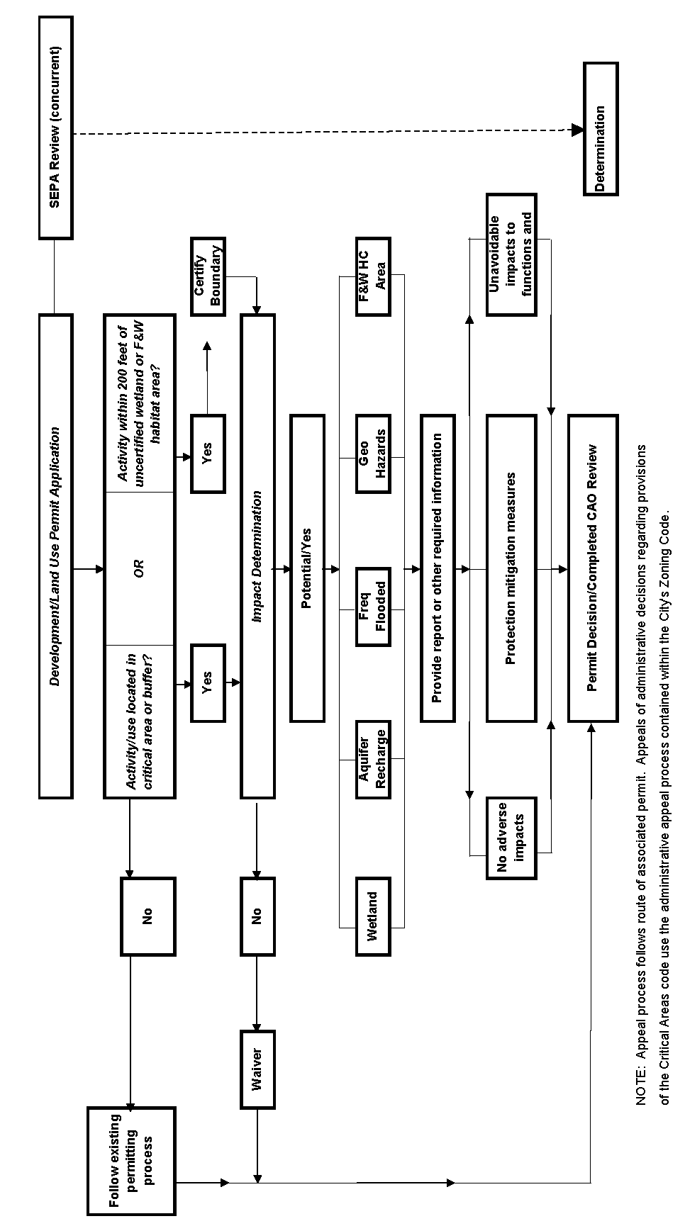
(3)
Critical Areas Present and Potential Impact Likely. If the Planning Director determines that the proposed project is within, adjacent to, or is likely to impact a critical area, the Planning Director shall:
(a)
Notify the applicant that a critical area report, SEPA checklist, and other applicable information must be submitted prior to further review of the project, and indicate each of the critical area types that should be addressed;
(b)
Require a critical area report or other applicable information from the applicant that has been prepared by a qualified professional;
(c)
Review and evaluate the critical area report and other applicable information to determine whether the development proposal conforms to the purposes and performance standards of this Title;
(d)
Assess potential impacts to the critical area and determine if they are necessary and unavoidable;
(e)
Determine if any mitigation proposed by the applicant is sufficient to protect the functions and values of the critical area and public health, safety, and welfare concerns consistent with the goals, purposes, objectives, and requirements of this Title; and
(f)
A summary of this analysis and the findings shall be included in any decision on the underlying permit(s). Critical area review findings may result in: a) no adverse impacts to critical area(s); b) list of applicable critical area(s) protection conditions for the underlying permit(s); or c) denial of permit based upon unavoidable impacts to critical area(s) functions and values.
(Ord. 5206 Sec. 1, 2007)
18.58.140: - Wetland, Geologically Hazardous Areas, and Habitat Conservation Areas—General Report Requirements.
(1)
Prepared by Qualified Professional. If required by Section 18.58.130, the applicant shall submit a report prepared by a qualified professional as defined herein.
(2)
Incorporating Best Available Science. The report shall use scientifically valid methods and studies in the analysis of data and field reconnaissance and reference the source of science used. The report shall evaluate the proposal and all probable impacts to critical areas in accordance with the provisions of this Title.
(3)
Minimum Report Contents. At a minimum, the report shall contain the following:
(a)
The name and contact information of the applicant, a description of the proposal, and identification of the permit requested;
(b)
A copy of the site plan for the development proposal showing:
(i)
Identified critical areas, buffers, and the development proposal with dimensions;
(ii)
Limits of any areas to be cleared; and
(iii)
A description of the proposed stormwater management plan for the development and consideration of impacts to drainage alterations, consistent with the current edition of the City of Kennewick Construction Standards.
(c)
The names and professional qualifications of the persons preparing the report and documentation of any fieldwork performed on the site;
(d)
Identification and characterization of all critical areas, wetlands, water bodies, and buffers adjacent to the proposed project area;
(e)
A statement specifying the accuracy of the report, and all assumptions made and relied upon;
(f)
An assessment of the probable cumulative impacts to critical areas resulting from development of the site and the proposed development;
(g)
An analysis of site development alternatives;
(h)
A description of reasonable efforts made to apply mitigation sequencing pursuant to Section 18.58.170 to avoid, minimize, and mitigate impacts to critical areas;
(i)
Plans for adequate mitigation, as needed, to offset any impacts, in accordance with Section 18.58.160 through 18.58.190, including, but not limited to:
(i)
The impacts of any proposed development within or adjacent to a critical area or buffer on the critical area; and
(ii)
The impacts of any proposed alteration of a critical area or buffer on the development proposal, other properties and the environment;
(j)
A discussion of the performance standards applicable to the critical area and proposed activity;
(k)
Financial guarantees to ensure compliance, if applicable; and
(4)
Unless otherwise provided, a report may be supplemented by or composed, in whole or in part, of any reports or studies required by other laws and regulations or previously prepared for and applicable to the development proposal site, as approved by the Planning Director.
(Ord. 5206 Sec. 1, 2007)
18.58.150: - Wetland, Habitat Conservation, and Geologically Hazardous Areas—Modifications to Report Requirements.
(1)
Limitations to Study Area. The Planning Director may limit the required geographic area of the critical area report as appropriate if:
(a)
The applicant, with assistance from the City, cannot obtain permission to access properties adjacent to the project area; or
(b)
The proposed activity will affect only a limited part of the subject site.
(2)
Modifications to Required Contents. The applicant may consult with the Planning Director prior to or during preparation of the report to obtain City concurrence on modifications to the required contents of the report where, in the judgment of a qualified professional, more or less information is required to adequately address the potential critical area impacts and required mitigation.
(Ord. 5206 Sec. 1, 2007)
18.58.160: - Mitigation Requirements.
(1)
The applicant shall avoid all impacts that degrade the functions and values of a critical area or areas. Unless otherwise provided in this Title, if alteration to the critical area is unavoidable, all adverse impacts to or from critical areas and buffers resulting from a development proposal or alteration shall be mitigated in accordance with the critical area report and SEPA requirements.
(2)
Mitigation shall be in-kind and on-site, when possible, and sufficient to maintain the functions and values of the critical area, and to prevent risk from a hazard posed by a critical area.
(3)
Mitigation shall not be implemented until (a) after City receipt of a report or other applicable information that includes a mitigation plan, and mitigation shall be in accordance with the provisions of the report or other applicable information; and (b) city approval of the underlying permit(s).
(4)
Mitigation monitoring shall be required for a minimum of five years. The project mitigation plan shall include monitoring elements that ensure certainty of success for the project natural value and functions. If the mitigation goals are not obtained within the initial five-year period, the applicant remains responsible for restoration of the natural values and functions until the mitigation goals agreed to in the mitigation plan are achieved.
(Ord. 5206 Sec. 1, 2007)
18.58.170: - Mitigation Sequencing.
Applicants shall demonstrate that all reasonable efforts have been examined with the intent to avoid and minimize impacts to critical areas. When an alteration to a critical area is proposed, such alteration shall be avoided, minimized, or compensated for in the following order of preference:
(1)
Avoiding the impact altogether by not taking a certain action or parts of an action; minimizing impacts by limiting the degree or magnitude of the action and its implementation, by using appropriate technology, or by taking affirmative steps, such as project redesign, relocation, or timing, to avoid or reduce impacts;
(2)
Rectifying the impact to wetlands, critical aquifer recharge areas, frequently flooded areas, and habitat conservation areas by repairing, enhancing, or restoring the affected environment to the historical conditions, or pre-development, or the conditions existing at the time of the initiation of the project;
(3)
Minimizing or eliminating the hazard by restoring or stabilizing the hazard area through approval engineered or other methods;
(4)
Reducing or eliminating the impact or hazard over time by preservation and maintenance operations during the life of the action;
(5)
Compensating for the impact to wetlands, critical aquifer recharge areas, frequently flooded areas, and fish and wildlife habitat, and vegetation conservation areas by replacing, enhancing, or providing substitute resources or environments; and
(6)
Monitoring the hazard or other required mitigation for a reasonable period of time and taking remedial action when necessary.
Mitigation for individual actions may include a combination of the above measures.
(Ord. 5206 Sec. 1, 2007)
18.58.180: - Mitigation Plan Requirements.
When mitigation is required, the applicant shall submit to the City a mitigation plan as part of the critical area report or other applicable information. The goals and objectives will be related to the functions and values of the impacted critical area, they include:
(1)
Environmental Goals and Objectives. The mitigation plan shall include a written report identifying environmental goals and objectives of the compensation proposed and including:
(a)
A description of the anticipated impacts to the critical areas and the mitigating actions proposed and the purposes of the compensation measures, including the site selection criteria; identification of compensation goals; identification of resource functions; and dates for beginning and completion of site compensation construction activities;
(b)
A review of the best available science supporting the proposed mitigation and a description of the report author's experience to date in restoring or creating the type of critical area proposed; and
(c)
An analysis of the likelihood of success of the compensation project.
(2)
Performance Standards. The mitigation plan shall address the applicable performance standards identified in this Title.
(3)
Detailed Construction Plans. The mitigation plan shall include written specifications and descriptions of the mitigation proposed, such as:
(a)
The proposed construction sequence, timing, and duration;
(b)
Grading and excavation details;
(c)
Erosion and sediment control features;
(d)
A vegetation planting plan specifying plant species, quantities, locations, size, spacing, and density; and
(e)
Measures to protect and maintain plants until established.
These written specifications shall be accompanied by detailed site diagrams, scaled cross-sectional drawings, topographic maps showing slope percentage and final grade elevations, and any other drawings appropriate to show construction techniques or anticipated final outcome.
(4)
Monitoring Program. The mitigation plan shall include a program for monitoring construction of the compensation project, and for assessing a completed project. A protocol shall be included outlining the schedule for site monitoring in years one, three and five after site construction, and how the monitoring data will be evaluated to determine if the performance standards are being met. A monitoring report shall be submitted as needed to document milestones, successes, problems, and contingency actions of the compensation project. At a minimum, a monitoring report shall be submitted to document mitigation plan performance in year five after site construction.
(5)
Contingency Plan. The mitigation plan shall include identification of potential courses of action, and any corrective measures to be taken if monitoring or evaluation indicates project performance standards are not being met.
(6)
Financial Guarantees. The mitigation plan shall include financial guarantees, if necessary, to ensure that the mitigation plan is fully implemented. Financial guarantees ensuring fulfillment of the compensation project, monitoring program, and any contingency measures shall be posted in accordance with Section 18.58.230.
(7)
Other Permits. Other local, state, and federal regulatory jurisdictions may require permits for habitat mitigation projects. The applicant shall comply with all other appropriate regulatory permits, agreements, and authority, as required by each respective jurisdiction.
(Ord. 5206 Sec. 1, 2007)
18.58.190: - Unauthorized Critical Area Alterations and Enforcement.
(1)
When a critical area or its buffer has been altered in violation of this Title, all ongoing development work shall stop and the critical area shall be restored. The City shall have the authority to issue a stop work order to cease all ongoing development work, and order restoration, rehabilitation, replacement or where determined appropriate by the Planning Director, mitigation measures at the owner's or other responsible party's expense to compensate for violation of provisions of this Title and other applicable city codes governing the underlying permit(s). Administrative procedures including, but not limited to, review and appeal of City actions related to unauthorized critical area alterations are outlined in Section 18.58.050.
(2)
Restoration/Mitigation Plan Required. All development work shall remain stopped until a restoration/mitigation plan is prepared and approved by City. Such a plan shall be prepared by a qualified professional and shall describe how the actions proposed meet the minimum requirements described in Subsection (3) and/or mitigation requirements outlined in Sections 18.58.160, 18.58.170, and 18.58.180, if mitigation is determined to be appropriate by the Planning Director. The Planning Director shall, at the violator's expense, seek expert advice in determining the adequacy of the plan. Inadequate plans shall be returned to the applicant or violator for revision and resubmittal.
(3)
Minimum Performance Standards for Restoration or Mitigation.
(a)
For alterations to critical aquifer recharge areas, frequently flooded areas, wetlands, and habitat conservation areas the following minimum performance standards shall be met for the restoration or mitigation of impacts to a critical area, provided that if the violator can demonstrate in a restoration/mitigation plan that greater functional and habitat values can be obtained, these standards may be modified by the Planning Director:
(i)
The historic structural and functional values shall be restored, including water quality and habitat functions;
(ii)
The historic soil types and configuration shall be replicated;
(iii)
The critical area and buffers shall be replanted with native vegetation that replicates the vegetation historically found on the site in species types, sizes, and densities; and
(iv)
The historic functions and values should be replicated at the location of the alteration.
(b)
For alterations to flood and geological hazards, the following minimum performance standards shall be met for the restoration of a critical area, provided that, if the violator can demonstrate that greater safety can be obtained, these standards may be modified:
(i)
The hazard shall be reduced to a level equal to, or less than, the pre-development hazard;
(ii)
Any risk of personal injury resulting from the alteration shall be eliminated or minimized; and
(iii)
The hazard area and buffers shall be replanted with native vegetation sufficient to minimize the hazard.
(4)
Penalties. Any person, party, firm, corporation, or other legal entity convicted of violating any of the provisions of this Title shall be guilty of a misdemeanor. Each day or portion of a day during which a violation of this Title is committed or continued shall constitute a separate offense. Any development carried out contrary to the provisions of this Title shall constitute a public nuisance and may be enjoined as provided by the statutes of the state of Washington. The City may levy civil penalties against any person, party, firm, corporation, or other legal entity for violation of any of the provisions of this Title. The civil penalty shall be assessed at a rate consistent with Section 1.12.030 of the Kennewick Municipal Code. Daily fines shall not be levied until after a violator has received a notice of violation and shall not be levied while the violator is making a good faith and diligent effort to correct the violation in cooperation with City enforcement personnel nor while a notice of violation is under appeal through the applicable appeal process.
(Ord. 5206 Sec. 1, 2007)
18.58.200: - Critical Area Markers and Signs.
The critical area or buffer shall be identified with temporary signs prior to any site alteration. Such temporary signs may be replaced with permanent signs, as determined appropriate by the Planning Director.
(Ord. 5206 Sec. 1, 2007)
18.58.210: - Native Growth Habitat Areas.
(1)
Unless otherwise required in this Title, native growth habitat areas shall be used in development proposals for subdivisions, short subdivisions, planned unit developments, and binding site plans to delineate and protect those contiguous critical areas and buffers listed below:
(a)
All landslide hazard areas and buffers;
(b)
All wetlands and buffers;
(c)
All habitat conservation areas; and
(d)
All other lands to be protected from alterations as conditioned by project approval.
(2)
See Exhibits 1 and 4, or the latest revisions of these maps for designated wetlands, erosion hazard areas and habitat conservation areas.
(Ord. 5206 Sec. 1, 2007)
18.58.220: - Building Setbacks.
Unless otherwise provided, buildings and other structures shall be set back a distance of 15 feet from the edges of all critical area buffers or from the edges of all critical areas, if no buffers are required. The following may be allowed in the building setback area:
(1)
Landscaping;
(2)
Uncovered decks;
(3)
Building overhangs if such overhangs do not extend more than 18 inches into the setback area; and
(4)
Impervious ground surfaces, such as driveways and patios, provided that such improvements may be subject to requirements provided in the most current edition of City's Construction Standards.
(Ord. 5206 Sec. 1, 2007)
18.58.230: - Bonds to Ensure Mitigation, Maintenance, and Monitoring.
(1)
Mitigation required pursuant to a development proposal should be completed prior to City final permit approval. When it is not feasible for mitigation to be completed prior to City final permit approval, such as final plat approval or final building inspection, the City shall require the applicant to post a performance bond in a form and amount deemed acceptable by the City.
(2)
The bond shall be in the amount of 125 percent of the estimated cost of the uncompleted actions or the estimated cost of restoring the functions and values of the critical area that are at risk, whichever is greater.
(3)
The performance bonds shall remain in effect until the City determines, in writing, that the standards bonded for have been met. Bonds shall be held by the City for a minimum of five years to ensure that the required mitigation has been fully implemented and demonstrated to function, and may be held for longer periods when necessary.
(4)
Depletion, failure, or collection of bond funds shall not discharge the obligation of an applicant or violator to complete required mitigation, maintenance, monitoring, or restoration.
(5)
Public development proposals shall be relieved from having to comply with the bonding requirements of this section if public funds have previously been committed for mitigation, maintenance, monitoring, or restoration.
(6)
Any failure to satisfy critical area requirements established by law or condition including, but not limited to, the failure to provide a monitoring report within 30 days after it is due or comply with other provisions of a mitigation plan shall constitute a default, and the City may demand payment of any financial guarantees or require other action authorized by the City code or any other law.
(7)
Any funds recovered pursuant to this Section shall be used to complete the required mitigation.
(Ord. 5206 Sec. 1, 2007)
18.58.240: - Critical Area Inspections.
Reasonable access to the site shall be provided to the City, state, and federal agency review staff for the purposes of inspections during any proposal review, restoration, emergency action, or monitoring period. Additionally, the City or its agent shall have reasonable access to the site for completing necessary remediation work in the event of noncompliance.
(Ord. 5206 Sec. 1, 2007)