
King And Queen County Unincorporated
City Zoning Code
City Zoning Code
ARTICLE 12
1.- TIERED WATER QUANTITY CONTROL
Sec. 3-280.- Title.
This article establishes the "Tiered Water Quantity Control Ordinance" of King and Queen County, Virginia, pursuant to the purpose and intent set forth in the Code of Virginia, § 62.1-44.15:27.2.
(Ord. of 6-8-2020(1))
Sec. 3-281. - Purpose.
For determining the water quantity technical criteria applicable to a land disturbance equal to or greater than 2,500 square feet (in the RMA/RPA), 10,000 square feet outside of the RMA/RPA but less than one acre, King and Queen County elects to use certain tiered water quantity control standards based on the percentage of impervious cover in the watershed. The establishment and conduct of the tiered approach pursuant to this section shall be subject to review by the department of environmental quality (DEQ).
(Ord. of 6-8-2020(1))
Sec. 3-282. - Creation and adoption of the official watershed map.
King and Queen County hereby adopts a watershed map (dated June 8, 2020). The watershed map illustrates the county boundaries, the boundaries of each watershed located partially or wholly within the county boundary, the percentage of impervious cover within each watershed, within the county boundary, and locations where development is expected or proposed to occur. A copy of the watershed map shall be filed in the office of the clerk of the circuit court.
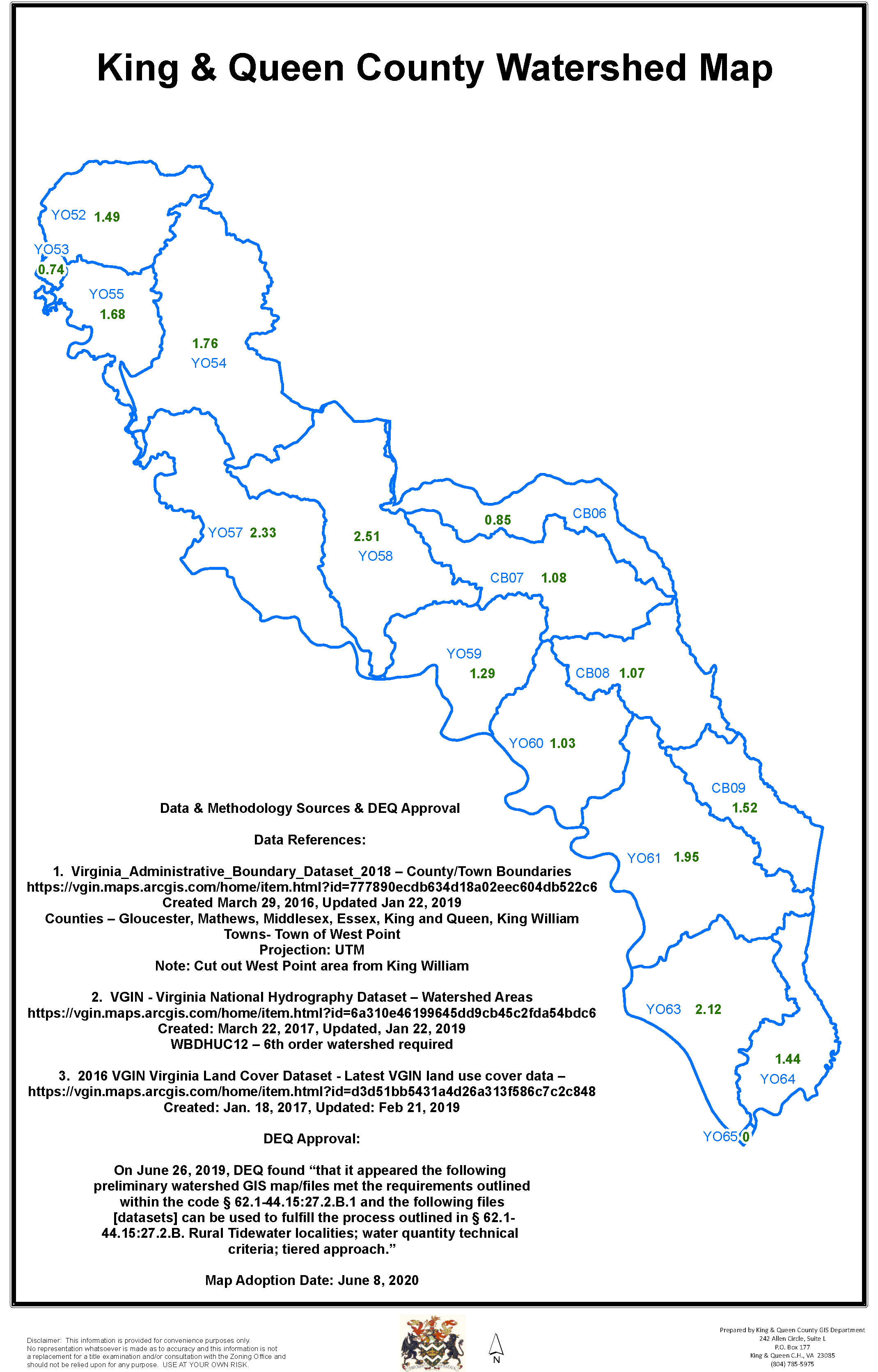
(Ord. of 6-8-2020(1))
Sec. 3-283. - Updates/changes to the official watershed map.
A.
At least once each calendar year, the county shall make additions to or modifications to the official watershed map to reflect actual development projects. The county shall keep current its impervious cover percentage for each watershed located within the county boundary, as reflected in the official watershed map, and shall make the map and such percentages available to the public.
B.
The county shall notify the department of environmental quality and update the official map within one year of the approval of the development plan for any project that exceeds the impervious cover percentage of the watershed in which it is located and causes the percentage for that watershed to rise such that the watershed steps up to the next higher tier pursuant to section 3-284.
(Ord. of 6-8-2020(1))
Sec. 3-284. - Tiered approach classifications.
A.
When the county evaluates any development project in a watershed that is depicted on the official watershed map as having an impervious cover percentage of:
1.
Less than five percent, the county shall apply the regulatory minimum standards and criteria adopted pursuant to article 2.4 (§ 62.1-44.15:51 et seq.) [and in effect prior to July 1, 2014,] for the protection of downstream properties and waterways from sediment deposition, erosion, and damage due to increases in volume, velocity, and peak flow rate of stormwater runoff for the stated frequency storm of 24-hour duration.
2.
Five percent or more but less than 7.5 percent, the county shall require practices designed to detain and release over a 24-hour period the expected rainfall resulting from the one year, 24-hour storm, which practices shall be exempt from any flow rate capacity and velocity requirements for natural or man-made channels.
3.
Seven and one-half percent or more, the county shall apply the energy balance method as set forth in regulations adopted by the state water control board.
B.
The county shall require that any project whose construction would cause the impervious cover percentage of the watershed in which it is located to rise, such that the watershed steps up to the next higher tier, to meet the current water quantity technical criteria using the energy balance method or a more stringent alternative/tier.
(Ord. of 6-8-2020(1))
Sec. 3-285. - Acceptance of sealed plan in lieu of local plan review.
Pursuant to Code of Virginia § 62.1-44.15:27.3, for any land-disturbing activity equal to or greater than 2,500 square feet (in the RMA/RPA), 10,000 square feet outside of the RMA/RPA but less than one acre, the applicant may submit a set of plans and supporting calculations prepared by a licensed professional retained by the applicant. Such plans and supporting calculations shall be appropriately signed and sealed by the professional with a certification that states: "This plan is designed in accordance with applicable state law and regulations."
(Ord. of 6-8-2020(1))