
King George County Unincorporated
City Zoning Code
City Zoning Code
ARTICLE X
- SUBDIVISIONS
Section 10-1-1. - Title.
This Article is a portion of the Zoning and Subdivision Ordinance of King George County, Virginia. It shall be permitted, for convenience, to be referred to as the "Subdivision Ordinance of King George County, Virginia" or "Ordinance."
Section 10-1-2. - Recording of Ordinance.
In accord with the Code of Virginia § 15.2-2252, as amended, a certified copy of the adopted Subdivision Ordinance of King George County, Virginia and any and all amendments thereto shall be filed in the office of the Subdivision Agent (Agent) and in the Clerk's Office of the Circuit Court of King George County, Virginia.
Section 10-1-3. - Amendments.
(A)
Per the Code of Virginia, § 15.2-2251 and § 15.2-2253, as amended, this Article may be amended in whole or in part by the Board of Supervisors; provided, that any such amendment shall either originate with or be submitted to the Planning Commission for recommendation; further provided, that no such amendment shall be adopted without a public hearing having been held by the Board of Supervisors in accordance with the Code of Virginia § 15.2-2204, as amended.
(B)
In no instance shall an amendment be adopted by the Board of Supervisors of the locality without first seeking the recommendation of the Planning Commission. If no recommendation is made by the Planning Commission, the Board of Supervisors may take action 60 days from their inquiry.
Section 10-1-4. - Repeal.
Upon the adoption of this Ordinance, all Subdivision Ordinances heretofore adopted by the King George County Board of Supervisors are hereby repealed.
Section 10-1-5. - Applicability.
(A)
This Article shall apply to the subdivision of all lots, tracts, or parcels of land within King George County, unless specifically exempt, as provided in Section 10-1-7, below.
(B)
No person shall subdivide any tract of land, or complete a Boundary Line Adjustment, that is located within King George County except in conformity with the provisions of this Article, the Zoning and Subdivision Ordinance, and the provisions of Virginia law relating to land subdivision and development.
(C)
Plats of Boundary Line Adjustments, consolidations, or easements shall follow the Final Plat requirements of Division 7 and may be administratively approved.
(D)
This Article bears no relation to any private easement, covenant, agreement, or restriction, nor is the responsibility of enforcing a private easement, covenant, agreement, or restriction implied herein to King George County.
Section 10-1-6. - Circumvention.
(A)
Development of multiple adjoining Minor or Single Lot Subdivisions, over any amount of time, for the purpose of circumventing subdivision requirements, shall not be permitted.
(B)
To the extent allowed by Virginia law, development of multiple adjoining Major Subdivisions for the purpose of circumventing preliminary plat requirements, shall not be permitted.
(1)
A presumption of circumvention of preliminary plat requirements may be invoked by the Agent if (i) within five (5) years of submitting a preliminary plat an applicant revokes the preliminary plat and submits two or more plats that combined are substantially similar to the original preliminary plat; or (ii) an applicant submits two or more plats of adjacent or contiguous lots within five (5) years of each other that combined would trigger preliminary plat requirements.
(2)
Upon a presumption of circumvention of preliminary plat requirements, the Agent shall further investigate and allow the applicant to refute the circumvention claim. After the investigation and concurring with the County Attorney, the Agent shall determine if the applicant attempted to circumvent preliminary plat requirements. The Agent shall provide their determination to the applicant in writing.
(3)
The Agent shall require the applicant to comply with preliminary plat requirements upon a finding of circumvention.
(C)
Creative lot layout, for the purpose of circumventing design requirements, shall not be permitted.
Section 10-1-7. - Exemptions.
(A)
The following are exempt from this Article, but this does not mean the parcels are exempt from the other Articles of the Zoning and Subdivision Ordinance:
(1)
Existing Parcels. The sale or exchange of existing parcels of land between owners and the creation of boundary surveys which do not change or alter any boundary lines of a parcel.
(2)
Utility Rights-of-Way; Public, Private Rights-of-Way. A bona fide division of a tract of land in order that 1 or more of the resulting parcels may be used as part of a public or private right-of-way. If a parcel resulting from such division is ever to be used as a building site for other than a hereinabove described right-of-way, then before a Building Permit may be issued for such other use, the minimum requirements of this Article shall be met.
(3)
Wills, Court Action. The partition of lands by will, by partition deed of intestate land, by the descendants of the deceased former owner or through action of a court of competent jurisdiction.
Section 10-1-8. - Variations, Exceptions, and Appeals.
(A)
Variations and exceptions to the provisions of this Article shall be taken to the Planning Commission for recommendation and final decision by the Board of Supervisors in accordance with Article III, Permits and Applications, Division 10, Public Hearings and Notifications, of this Ordinance.
(B)
Appeals to any decisions made by the Agent, regarding the requirements of this Article, shall be taken to the Planning Commission for recommendation and final decision by the Board of Supervisors in accordance with Article III, Permits and Applications, Division 10, Public Hearings and Notifications, of this Ordinance.
Section 10-1-9. - Establishment of Parent Tract.
All parcels recorded in the Clerk's Office of King George County, Virginia on or before October 1, 1987 are considered a parent parcel or parent tract.
Section 10-2-1. - Major Subdivisions.
(A)
Major Subdivisions are subdivisions of any parent tract into 6 or more lots, and therefore will have greater impact on the environment, highways, and surrounding communities than will smaller subdivisions.
(1)
Parcels in excess of 40 acres or more will not count toward a Major Subdivision but will be counted for street construction and platting requirements as provided in Division 3 and Divisions 5, Division 6, and Division 7, respectively.
Section 10-2-2. - Minor Subdivisions.
Minor Subdivisions are subdivisions of any parent tract into 3 to 5 lots and have reduced impact on the environment, highways, and surrounding communities than larger subdivisions.
Section 10-2-3. - Single Lot Subdivisions.
Single Lot Subdivisions are subdivisions that include one division of a single parent parcel of land, creating one new lot and a remainder or residual lot.
Section 10-2-4. - Family Subdivisions.
Family Subdivisions are subdivisions of land for simultaneous conveyance to a member of the immediate family, or beneficiaries of a trust, of the property owner.
(A)
Purpose. The purpose of Family Subdivisions is to:
(1)
Encourage and promote the ability of family members to live near one another as housing needs change;
(2)
Provide opportunities for mutual support and care of family members; and
(3)
Allow for the preservation of family land holdings which might otherwise be fragmented for economic reasons.
(B)
Applicability.
(1)
For the purposes of this Article, a "member of the immediate family" is defined as any person who is the natural or legally defined offspring, stepchild, spouse, sibling, grandchild, grandparent, or parent of the owner, who is 18 years or older.
(2)
If the property to be subdivided is owned in joint tenancy, the necessary relationship to the grantee may exist with any one or more of the joint tenants.
(3)
Family Subdivisions may also be for immediate family of beneficiaries of a trust, of land held in trust. In addition to the requirements of (C), below, for Family Subdivisions of land held in trusts, all trust beneficiaries must:
(i)
Be immediate family members as defined in (B) (1), above;
(ii)
Agree that the property should be subdivided, and
(iii)
Agree to place a restrictive covenant on the subdivided property that would prohibit the transfer of the property to a nonmember of the immediate family for a period of 15 years.
(C)
Standards. Per the Code of Virginia, § 15.2-2244, 2244.1, and 2244.2, as amended, all Family Subdivisions shall be subject to the following provisions and conditions in lieu of the other subdivision regulations imposed by this Article.
(1)
Only one such division shall be allowed within King George County for each immediate family member.
(2)
The property to be subdivided has been owned for at least 5 consecutive years by the current owner or member of the immediate family.
(3)
The grantee agrees to place a restrictive covenant on the subdivided property that would prohibit the transfer of the property to a nonmember of the immediate family for a period of 15 years. All lots or parcels, including the parent tract, created under this Article shall remain titled in the name(s) of the grantor for the 15-year period, from the date of recordation of the deed of conveyance, unless:
(i)
The parcel to be transferred out of the immediate family is the subject of an involuntary transfer such as foreclosure, divorce, death, judicial sale, condemnation, or bankruptcy, in which case, upon application to the Agent, any remaining required holding period shall be waived;
(ii)
The owner(s) of the parent tract dies in which case, upon application to the Agent, any remaining holding period shall be waived for the parent tract;
(iii)
The transferred property is later transferred to a subsequent grantee who qualifies as an immediate family member of the original grantor as set forth in this Article, in which case only the remainder of the initial required holding period shall apply to the subsequent grantee; or
(iv)
An exception to these provisions is made by the Planning Commission, upon a determination of an injustice or hardship as permitted under the provisions of this Article.
(4)
The minimum width, yard, and area requirements of all lots or parcels, including the remaining property from which the lot or parcel is subdivided, shall be in accordance with the applicable provisions of this Ordinance.
(5)
Each lot or parcel shall front on a public street or upon a private driveway or street that is in a permanent easement.
(i)
Lots shall have a minimum right-of-way of 20 ft.
(ii)
Where the parcel being subdivided fronts on an existing right-of-way less than 20 ft. in width, a 20-foot right-of-way shall only be required on the parcel to be subdivided and transferred.
(iii)
Prior to the use of any such lot or parcel for residential purposes, the required right-of-way shall include an improved driveway within it consisting of, at a minimum, an all-weather surface or rock, stone, or gravel, with a minimum depth of 3 inches and a minimum width of 10 ft. The right-of-way shall be maintained by those having a right to always use it in a condition passable by emergency vehicles. A notation to this effect shall be placed on the face of the Final Plat and this provision shall be included in the deed(s) by which the subdivision is affected. "Passable condition" refers to not only the surface, but also to horizontal and vertical clearances.
(iv)
All provisions of the King George County Code governing erosion and sediment control and the dedication of drainage and utility easements shall apply to Family Subdivisions fully and completely.
(6)
Property not served by a community water and sewer system shall have its water source and sewage disposal facilities approved by the Virginia Department of Health and be in accordance with all applicable King George County Service Authority Regulations and all applicable requirements of Article VII, Article VIII, and Article X of this Ordinance.
(D)
Final Plat. In addition to the requirements of Division 7 of this Article, Family Subdivisions shall comply with the following:
(1)
Along with the Final Plat, an affidavit, under oath, shall be submitted in the form prescribed by the Agent, describing the purposes of the subdivision, and identifying the member of the immediate family receiving the lot created.
(2)
The proposed deed of conveyance shall be submitted to the Agent and once approved for compliance with this Article, recorded along with the approved Final Plat.
(3)
Both the deed and the Final Plat shall contain the following statement set forth so as to be seen readily:
(i)
"This lot is created as a Family Subdivision for an immediate family member, pursuant to the provisions of the King George County Zoning and Subdivision Ordinance. The use and transfer of this property is restricted by the terms of that Ordinance. The property to be subdivided has been owned for at least 5 consecutive years by the current owner or member of the immediate family and the grantee agrees to place a restrictive covenant on the subdivided property that prohibits the transfer of the property to a nonmember of the immediate family for a period of 15 years."
(E)
Circumvention.
(1)
No Family Subdivision shall be made for the purpose of circumventing the requirements of this Article.
(2)
The Agent shall reject any proposed Family Subdivision if, after investigation of the facts and circumstances involved in the proposed subdivision, the Agent believes that the proposed subdivision is for the purpose of circumventing the requirements of this Article and is not in accordance with the purpose and intent of this Ordinance.
(i)
The burden of proving compliance with the purpose, intent, and conditions of this Article shall be on the property owner.
(ii)
Nothing in this Article shall be deemed to exempt Family Subdivisions from the requirements of other provisions of the King George County Code which are deemed to be applicable by the Agent.
(3)
In the event that the Board of Supervisors determines a circumvention to have occurred, the Family Subdivision approval shall be considered void, and the County may take appropriate action to require compliance with all other applicable requirements of this Ordinance or may initiate action to vacate said lot.
Section 10-3-1. - Suitability of Land.
(A)
The Agent shall not approve the subdivision of land if, from adequate investigation conducted by all public agencies concerned, including but not limited to the Virginia Department of Transportation, Virginia Department of Environmental Quality, Virginia Department of Health, and King George Service Authority, it is determined that in the best public interest the site is not suitable for platting and development of the kind proposed due to the inability to adequately provide ingress/egress, street improvements, utilities, and similar infrastructure needs.
(1)
In investigating the suitability of land for subdivision, the Agent may require the subdivider to furnish topographic maps, soil reports, established 100-year flood plain studies, wetlands delineation, and other information relevant to such determination.
(2)
The developer bears the risk as to suitability of the site for private uses.
(B)
Sensitive lands, as provided below in (B) (1) through (5), shall not be platted for residential occupancy, nor for such other uses as may increase danger of health, life, or property, or may aggravate erosion or flood hazard.
(1)
Land subject to flooding;
(2)
Land deemed to be topographically unsuitable;
(3)
Land having unsuitable soils; and
(4)
Land having inadequate light and air.
(5)
Such land within the subdivision shall be set aside on the plat for such uses as shall not be endangered by periodic or occasional inundation or shall not produce conditions contrary to public welfare.
Section 10-3-2. - Residential Density.
The maximum residential densities allowable within residential subdivisions shall be in accordance with the provisions of the applicable zoning district and guided by the Comprehensive Plan.
Section 10-3-3. - Lots.
(A)
Lot Size.
(1)
Lot area and width shall be in accordance with Article IV, Primary Zoning Districts, of this Ordinance.
(2)
Greater lot areas may be required by the Virginia Department of Health, if needed to adequately accommodate septic tanks and drain fields.
(B)
Lot Shape.
(1)
The lot arrangement, design, and shape shall be such that lots will provide satisfactory and desirable sites for buildings, be properly related to topography, and conform to requirements of this Ordinance.
(2)
Lots shall not contain peculiarly shaped elongations which would be substantially unusable for normal purposes solely to satisfy necessary square footage or frontage requirements; to provide for drainage fields or septic areas; or to provide access to any lot that would otherwise not have street frontage, except to the extent expressly permitted under (C), below.
(C)
Stem Lots.
(1)
Applicability.
(i)
The use of Stem Lots is prohibited except within Cluster Developments, where safety or environmental factors prevent normal lot design, and their use improves the quality of the design of the subdivision and provides for a better use of land.
(ii)
The financial cost of street construction, or the loss of lots, shall not by themselves constitute sufficient reasons to use Stem Lots.
(iii)
The restrictions and limitations on the use and number of Stem Lots shall not be circumvented by the subdivision of land at different times.
(iv)
For purposes of determining the maximum number of allowable Stem Lots, all subdivisions of the parent tract shall be deemed to be included as part of the same subdivision, regardless of when subdivided.
Figure X-1. Stem Lot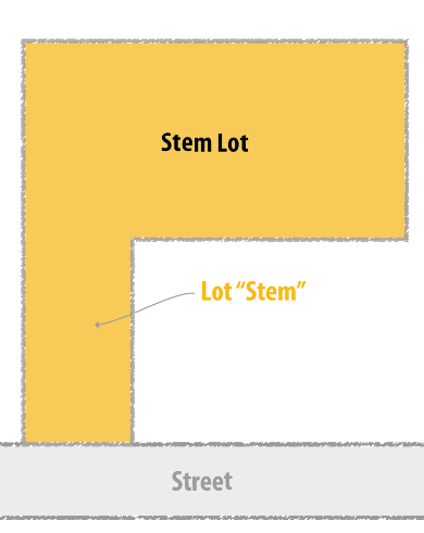
(2)
Standards.
(i)
Each lot "stem," or driveway, shall serve a maximum of 2 lots.
(ii)
A lot shall only be served by, or connected to, one "stem."
(iii)
No subdivision shall have more than 3 contiguous Stem Lots, so as not to create traffic hazards, confusion, and dispute with respect to boundary locations.
(iv)
Stem Lots shall comprise no more than 20% of the total lots in the subdivision (percentages will be rounded to nearest whole number).
(v)
The required lot area shall be exclusive of the "stem" portion of the lot.
(vi)
The stem that accesses the street shall be no less than 20 ft. in width at any point. The length of such stems shall be limited to no more than 350 ft.
(vii)
The Final Plat shall note each Stem Lot driveway as "privately owned and privately maintained by the lot owners served."
(viii)
Each house served by a "stem" driveway shall be numbered in accordance with the requirements of the King George County addressing system and each such number shall be displayed on a sign showing the address and an arrow, which shall designate the direction to which the address usage applies.
(ix)
The "stem" portion of a lot shall be a fee-simple part of the lot with cross easements for access in the case of a shared or common driveway.
Section 10-3-4. - Remnants.
(A)
All remnants of lots below minimum size, left over after subdividing a tract, must be added to adjacent lots rather than allowed to remain unusable parcels.
(1)
Parcels comprised solely of open space, stormwater management facilities, recreational amenities, and similar functions may be less than minimum lot size at the discretion of the Agent.
Section 10-3-5. - Frontage.
(A)
Unless otherwise stated, all lots or parcels of land shall front on an existing or proposed street (public or private) or right-of-way in accordance with the provisions of this Ordinance.
(1)
All private streets shall be constructed in accordance with Section 10-3-8, below.
Section 10-3-6. - Access.
(A)
General. The following shall apply to all Major and Minor Subdivisions:
(1)
When feasible, the design of a subdivision shall be made to interconnect streets within the subdivision to promote grid pattern development, avoid dead end streets, and to arrange streets to provide access to adjoining parcels to promote orderly development of the County.
(2)
Adequate easements shall be provided for the development of future streets and such easements shall include restrictions that assure the adequacy of the easement, including building setback lines, to ensure the future viability of the easement.
(3)
Streets between adjoining properties shall be required to interconnect where the ability to interconnect streets has been created through right-of-way construction and dedication.
(4)
If there are corner lots created in the subdivision of property that meet the street frontage requirements on existing public streets, then such lots are required to access the interior subdivision street and they shall not access the existing public street.
(5)
If any proposed subdivision results in a total of 6 or more lots, whether existing or proposed, that are accessed by an existing private street then the street shall be improved to meet the VDOT standards for streets within the State Highway System in conjunction with the development of the subdivision.
(B)
Major Subdivision. Major Subdivisions shall have direct access to an existing primary or secondary street and shall provide access connections to adjoining lots or parcels and subdivisions. The minimum requirements for access points and access connections are as shown in Table X-1, Major Subdivision Access Points and Connections.
(1)
Direct access may be provided by way of an existing primary or secondary street, or by one that will be improved to meet the VDOT standards for streets within the State Highway System in conjunction with the development of the subdivision.
Table X-1. Major Subdivision Access Points and Connections
1 At the request of the applicant, the Planning Commission may reduce the required number of access points and/or connections.
(C)
Minor or Single-Lot Subdivision. If a subdivision is being developed in such a manner that results in 5 lots or less, private streets are allowed, provided that all private streets are constructed in accordance with Section 10-3-8, below. Said private streets shall extend from such lots or parcels to a public street. The maximum number of entrances from a Minor Subdivision to an existing primary or secondary street shall be as provided in Table X-2, Minor Subdivision Access Points.
Table X-2. Minor Subdivision Access Points
(1)
All Minor Subdivisions containing more than 3 lots which are accessed by a private street or right-of-way that connects directly to an existing public street shall:
(i)
Submit their entrance location and design to the VDOT for review prior to Preliminary or Final Plat approval.
(ii)
No such Preliminary or Final Plat shall be approved unless the entrance has an existing approved commercial entrance permit or meets the VDOT's current minimum standards.
(iii)
If VDOT disapproves an entrance, the person submitting the Preliminary or Final Plat shall be provided an opportunity to amend the Preliminary or Final Plat to provide an alternative entrance.
(iv)
If an approved entrance cannot be obtained, then the Preliminary or Final Plat shall be disapproved.
Section 10-3-7. - Blocks.
(A)
Length.
(1)
No block in a Cluster Development, within any zoning district shall be longer than 600 ft.
(2)
No block in a subdivision within an A-3, R-1, R-2, or R-3 district shall be longer than 600 ft.
(3)
No block in a subdivision within a A-1 or A-2 district shall be longer than 1,200 ft.
(B)
Width. Blocks shall be wide enough to allow 2 tiers of lots of minimum depth, except where prevented by topographical conditions or size of the property, in which case the Agent may approve a single tier of lots of minimum depth. See Figure X-2.
(C)
Intersections. To ensure interconnection of streets and to achieve a grid pattern, all blocks shall be separated by an intersection.
(D)
Orientation.
(1)
The greater dimensions of blocks adjoining a major street shall, wherever practical, be parallel to such major street.
(2)
Where a proposed subdivision adjoins a street classified as a collector or arterial by the VDOT, blocks shall be oriented to minimize ingress and egress on such streets; provided, however, that adequate emergency access shall be allowed.
Figure X-2. Block Length and Width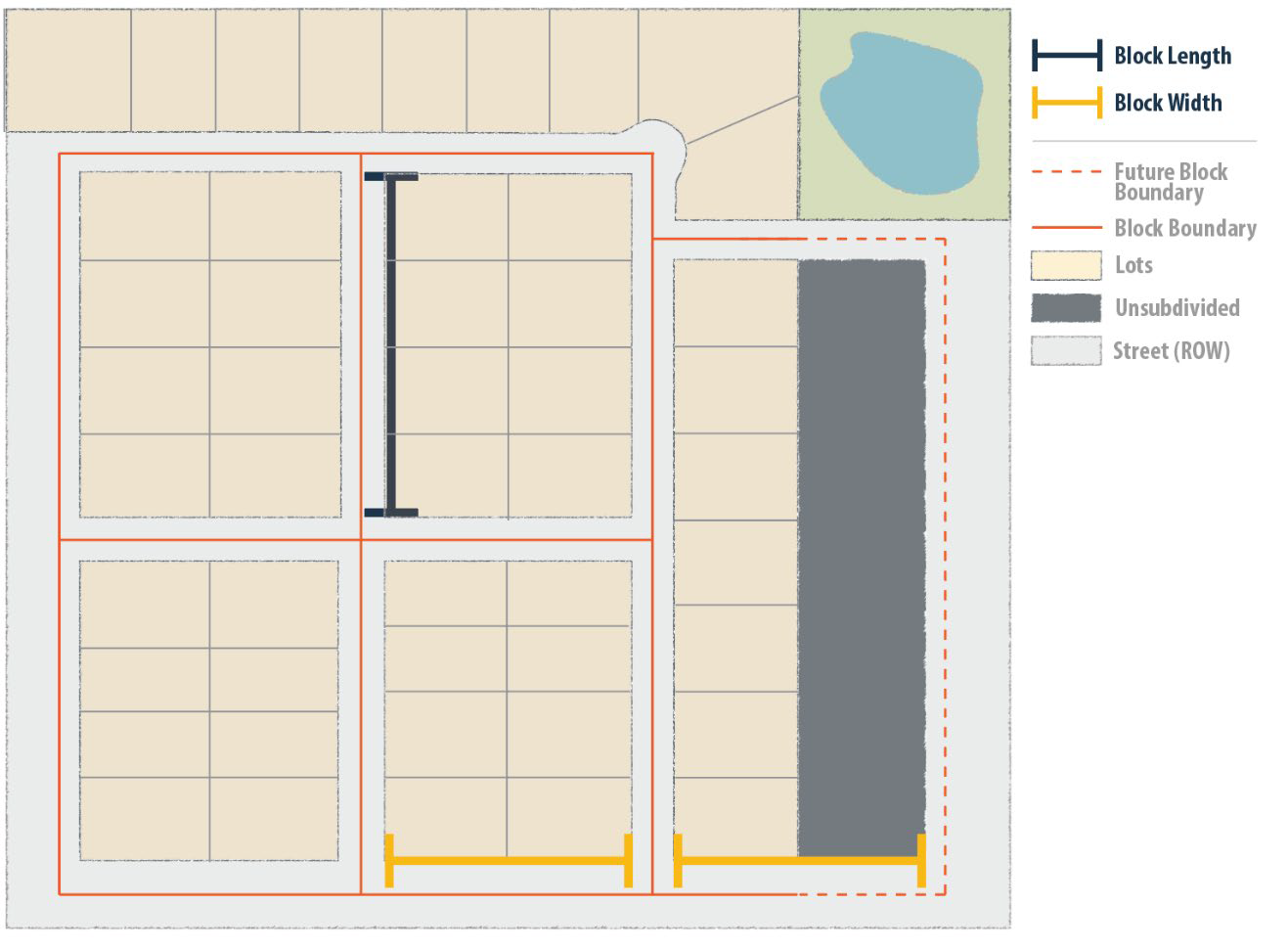
Section 10-3-8. - Streets.
(A)
Street Names and Signs. The following standards shall apply to all new streets, whether public or private:
(1)
Names.
(i)
Street names shall comply with Chapter 13.5, Article III of the King George County Code, E-911 Ordinance for the Naming of Roads, Addressing of Structures, and Management of County Signs.
(ii)
A proposed street which is aligned with an existing street shall bear the same name as the existing street and names of existing streets shall not be changed.
(iii)
In no case shall the name of proposed streets duplicate existing street names, regardless of the use of the suffix (e.g., Avenue, Boulevard, Drive, Way, Place, Lane, or Court).
(iv)
Street names shall be indicated on the Preliminary and Final Plats and shall be reserved, and approved, by the King George County GIS Department.
(2)
Signs. Street name signs shall be paid for by the developer, and installed by King George County, and shall:
(i)
Be on the most visible corner of every intersection and shall:
(ii)
Be of a suitable design and durable material; lettered on both faces; and approved by the County; wooden street name signs are prohibited.
(B)
Alleys.
(1)
Alleys shall not be required, and are discouraged, in all agricultural districts, and R-1 and R-2 districts.
(2)
Alleys may be in R-3, commercial, industrial, and planned development districts where needed for rear entry garages, service vehicles, deliveries, access to loading areas, and similar purposes.
(3)
Alleys shall be at least 24 ft. in width.
(C)
Intersections. The following standards shall apply to all new streets, whether public or private:
(1)
All streets shall intersect as near to a 90-degree angle as is practical. In no case shall streets intersect at an angle of less than 70-degrees.
(2)
No more than two (2) streets, including driveways, shall intersect at one point and intersections shall be separated by the minimum distance as provided by VDOT standards.
(D)
Cul-de-Sacs. Any street which terminates at a point not intersecting another street shall be considered a cul-de-sac. The following standards shall apply to cul-de-sacs on any new streets, whether public or private:
(1)
Permanent cul-de-sac streets, those without easement for future extension, shall be no longer than:
(i)
600 ft. in R-1, R-2, R-3, commercial, industrial, or planned development districts.
(ii)
1,800 ft. in agricultural districts.
(2)
Turnarounds shall be provided on all cul-de-sacs with a minimum right-of-way radius of 50 ft.
(3)
T-shaped turnarounds are prohibited.
(4)
On streets intended for future extension, temporary turnarounds shall be provided by means of easements over private land adjoining the street. Such easements shall revert to the landowners at such time as the street is extended.
(E)
Curbs, Gutter, and Sidewalks. The following standards apply to all new streets, whether public or private.
(1)
Curbs, gutters, and sidewalks shall be required on:
(i)
All streets in all commercial and planned development districts;
(ii)
All streets in subdivisions located in R-1, R-2, and R-3 districts, where a majority of the lots are 25,000 sq. ft. or less in area.
(a)
Sidewalks may be provided on only one side of residential areas.
(F)
Alignment and Layout. The following standards shall apply to all new streets, whether public or private:
(1)
As required by § 15.2-2241 of the Code of Virginia, as amended, the arrangement of streets in new subdivisions shall make provisions for the continuation and coordination of streets within and contiguous to the subdivision with other existing or planned streets within the general area.
(i)
Where appropriate, streets shall be extended to the subdivision boundary so that future extensions can be made into adjoining properties, which may be subdivided.
(ii)
Overall street layout shall provide for safe movement of vehicular traffic while discouraging through traffic on residential streets.
(2)
The street arrangement shall be such as to cause no unnecessary hardship to owners of adjoining property when they plat their own land and seek to provide for convenient access to it.
(G)
Public Streets. For purposes of this Ordinance, public streets are those that are dedicated to and accepted by the Virginia Department of Transportation (VDOT).
(1)
When Required. All streets in any Major Subdivision created after the effective date of this Ordinance shall require public streets.
(i)
Public streets are not required for townhouse developments, which may front on a private access easement provided that:
(a)
The number of units served by the easement does not exceed 60;
(b)
Provisions for maintenance of the easement are set forth in the application and referenced on the final plat;
(c)
All roadway and access improvements are constructed to VDOT standards.
(2)
Existing Public Streets. In cases where subdivision lots are created on an existing public street having a total width of less than 50 ft., a dedication of additional right-of-way to King George County shall be provided where appropriate as determined by the Agent in consultation with the County Attorney. If dedication of additional right-of-way is needed, the street shall not be less than 25 ft. in width on the side measuring from centerline of said street to the subdivision.
(3)
New Public Streets. All new public streets shall be constructed in accordance with alignment, approach angle, access, width, grading, paving, and other specifications established by VDOT in effect at the time the subdivision is approved. Upon completion, such street shall follow the dedication procedure for adoption into the State Highway System.
(H)
Private Streets.
(1)
Existing Private Streets.
(i)
The developer shall upgrade any private street, in its entirety, to VDOT standards when any subdivision, except Family Subdivisions, is created that results in the private street having 6 or more existing or proposed lots.
(a)
Private streets serving 6 or more lots as of January 1, 2024, do not need to be upgraded to VDOT standards unless a new subdivision, except Family Subdivisions, creates an additional lot requiring access from the private street.
(ii)
The developer shall upgrade any nonconforming private street, in its entirety, to the standards provided in (H) (2), below, when any subdivision, except Family Subdivisions, is created that results in the nonconforming private street having 5 or less existing or proposed lots.
(iii)
The developer shall dedicate additional private right-of-way to expand the existing private street to a minimum total width of 50 ft.
(a)
The street shall not be less than 25 ft. in width on either side from centerline.
(b)
The subdivider or developer shall certify to the Agent, on the approved Preliminary and/or Final Plat, that said private street is dedicated for use to the property where the subdivision will be created.
(2)
New Private Streets. In addition to the standards of 10-3-8 (A) through (F), above, all private streets which are not to be taken into VDOT's State Highway System, shall be in conformance with the following provisions:
(i)
Street Width.
(a)
In no case shall any newly constructed private street pavement be less than 25 ft. in width, located within an easement no less than 50 ft. in width.
(ii)
Accessibility.
(a)
All private streets shall remain private and the benefited property owners shall maintain any drive or street within it.
(b)
All necessary utility easements shall be located a minimum of 3 ft. outside of the private access easement in which the private street is located and shall be shown on the Final Plat. However, nothing in this Section shall prohibit a utility from crossing over or under a street where necessary to provide utility services to a lot.
(iii)
Approach Angle. Private streets shall approach the other streets at an angle of not less than 70 degrees, unless the Agent approves a lesser angle of approach for reasons of contour, terrain, or matching of existing patterns. Sight distance at intersecting streets is of paramount importance, and a minimum sight distance of 300 ft. should be obtained.
(iv)
Grades. Grade, horizontal and vertical alignment, and slope shall meet VDOT standards in effect at the time of the application.
(v)
Base and Pavement. Private streets shall be constructed with a minimum of six (6) inches of gravel or other dustless surface and have positive drainage and be designed and constructed in conformance with the King George County Erosion and Sediment Control Ordinance.
(vi)
Maintenance. Street maintenance agreements are required for all private streets that access more than one (1) parcel within a commercial or industrial district and more than three (3) parcels in an agricultural, residential, or planned district. Parcels that utilize private streets shall demonstrate that a maintenance agreement or covenant is signed and recorded that outlines maintenance responsibilities for the private street from the subject property to the existing state maintained street.
(vii)
Construction. A professional engineer shall certify that the street has been constructed according to the plans and requirements of this Ordinance, as provided in Section 10-3-8(A) through (F) and (H).
Section 10-3-9. - Monuments.
(A)
Property Monuments. In accordance with the Code of Virginia § 15.2-2241, as amended, permanent reference monuments shall be provided at all street corners, points where street lines intersect exterior boundaries, and at angle points and points of curvature and tangency in each street.
(1)
Monuments shall be:
(i)
Made of a permanent material, such as iron rods or concrete;
(ii)
18 to 24 inches in length; and
(iii)
Set flush with the finished grade and anchored or embedded to prevent movement.
(2)
The replacement of any monuments removed or destroyed during the development of the subdivision shall be the responsibility of the developer.
(3)
Upon completion of subdivision street, sewer, and other improvements, the developer shall make certain that all monuments required by this Ordinance are clearly visible for inspection and use. Such monuments shall be inspected and approved by the Agent before any improvements are accepted by the Board of Supervisors.
(4)
Any person, developer, builder, firm, or corporation shall take the necessary precautions to protect all monuments and metal markers during construction.
(B)
Geodetic Control Monuments. Every Major Subdivision shall have 2 control monuments, established in a manner sufficient to serve as geodetic control reference to the Virginia State Plane Coordinate System North, NAD 83, feet (US) and the monument data sheets supplied to the King George County GIS Department.
(1)
Geodetic control monuments set shall be:
(i)
Made of a permanent material, such as stone, concrete, or other suitable permanent material;
(ii)
At least 24 inches in length, with a top surface area of not less than 12 square inches, and with a centering point which shall not exceed two one-hundredths of a foot in breadth;
(iii)
Set flush with the finished grade and anchored or embedded to prevent movement;
(iv)
Designed by and located as determined by an engineer or land surveyor;
(v)
Accessible by an easement with a minimum width of 10 ft., which shall be shown on the Preliminary and Final Plat; and
(2)
Existing monuments may be designated as geodetic control monuments if the existing monument is made of concrete or stone material.
Section 10-3-10. - Utilities.
(A)
Public Water and Sewer. Connection to the King George County Service Authority shall be required as provided in the King George County Service Authority Regulations.
(B)
Private Water and Sewer. Private water and sewer facilities shall be in accordance with Article VII, Use Performance Standards, Article VIII, Community Design Standards, and all Virginia Department of Health (VDH) standards and requirements, as applicable.
(C)
Installation. All utilities in any subdivision having lots less than one (1) acre in size shall be installed underground at no expense to the County. Utilities shall include, but not be limited to, electricity, gas, water, sewer, telephone, cable television, and internet.
(D)
Easements. When utilities are not located in public street rights-of-way, the developer shall dedicate easements at least 20 ft. in width or greater, if required by the King George County Service Authority or other applicable local or State agency.
(E)
Fire Protection. To work towards a reasonable level of fire protection throughout the County, the following requirements apply to all Subdivisions:
(1)
Applicability. Fire protection systems shall be required for all Major Subdivisions.
(2)
Compliance. All fire protection systems shall be in accordance with the National Fire Code, the Virginia Statewide Fire Prevention Code, the King George County Code, and all other applicable federal, state, and local regulations.
(3)
Maintenance. Maintenance agreements shall provide for the continued maintenance of all installed fire protection systems.
(4)
Fire Chief Review.
(i)
All proposed fire protection systems—including the number, location, and capacity of each hydrant or cistern—shall be reviewed for adequacy and approved by the King George County Fire and Rescue Chief at the time of Final Plat approval and prior to construction and/or installation of the fire protection systems.
(ii)
All installed fire protection systems and access to systems shall be inspected and approved prior to final release of guarantee, or partial release if project is phased.
(5)
System Requirements. Fire protection systems shall be required based on the circumstances below:
(i)
King George County Service Authority (KGCSA) Water Connection. When public water is available through the KGCSA, the installation of adequate fire hydrants shall be required.
(ii)
Public/Community Water Systems. When non-KGCSA water systems are used, including Public/Community Water systems, as defined by this Ordinance, the installation of adequate fire hydrants shall be required. If adequate fire hydrants cannot be provided, the following may be used to supply fire protection:
(a)
Dry hydrant; or
1.
If the water impoundment is 3 or more acres in surface area, then the developer shall be required to install 2 dry fire hydrants.
2.
Dry fire hydrant standards and specifications shall be in accordance with the United States Department of Agriculture Forest Service Dry Hydrant Manual.
(b)
Cistern connected to a water source.
(iii)
Private Wells. When private wells are used, one or more of the following, supplied in the preferred order, (a) being the most preferred and (c) being the least, may be used to supply fire protection:
(a)
Dry hydrants;
1.
If the water impoundment is 3 or more acres in surface area, then the developer shall be required to install 2 dry fire hydrants.
2.
Dry fire hydrant standards and specifications shall be in accordance with the United States Department of Agriculture Forest Service Dry Hydrant Manual.
(b)
Cisterns that are connected to a water source; or
(c)
Cisterns that are filled by hauling.
(6)
Fire Hydrant Standards. When fire hydrants are used, the required number of fire hydrants and their spacing shall be in accordance with the adopted Virginia Statewide Fire Prevention Code, Appendix C, Fire Hydrant Locations and Distribution, as amended.
(7)
Access Requirements. The fire protections systems shall be accessible by a paved street capable of serving emergency vehicle needs. The distance of the paved surface area from the hydrant/fire protection system, and the size of parking and turn around area for fire protection vehicles, shall be approved by the King George County Fire and Rescue Chief.
Section 10-3-11. - Erosion and Sediment Control.
Development disturbing a land area of 2,500 sq. ft. or more must comply with requirements for erosion and sediment control in accordance with Chapter 6 of the King George County Code and the Virginia Department of Environmental Quality's (DEQ) Erosion and Sediment Control Handbook, 1999 Edition, as amended.
Section 10-3-12. - Stormwater Management.
(A)
All Major and Minor Subdivisions hereafter approved shall have adequate stormwater management facilities, to preclude flooding, erosion or standing pools of water. Stormwater management facilities shall be designed and constructed in accordance with Chapter 5.5 of the King George County Code and DEQ's most recent edition of the Virginia Stormwater Management Handbook.
(B)
Open channels, other than naturally occurring streams, shall not be used for the conveyance of runoff within 50 ft. of any residential structure.
(C)
All stormwater management facilities' access and drainage easements shall be fully contained within the parcel. This includes conserved open space.
(D)
All access easements shall be dedicated to public use.
(E)
Low Impact Development (LID) shall be permitted.
(1)
All areas used for LID shall have an easement located around the area. The easement may be contained on more than one lot or parcel.
Section 10-3-13. - Obligation of Improvements.
(A)
All improvements and facilities required by this Article shall be installed by the developer at their cost and is not the responsibility of the locality, as outlined in the Code of Virginia § 15.2-2268, as amended.
(B)
No bond or other surety posted by the developer shall be released until construction has been completed, inspected, and approved, or VDOT street acceptance has occurred. Periodic partial release is allowed as outlined in the Code of Virginia § 15.2-2245, as amended, and Section 10-4-4, below.
Section 10-3-14. - Homeowners Associations (HOAs).
(A)
Common areas—such as private streets, open space, utilities, or stormwater management facilities—provided by the subdivider or developer within any Major or Minor Subdivision, if not dedicated to the County, shall be conveyed to a homeowners' association created for the subdivision.
(1)
Private driveways, shared driveways, and access easements with road maintenance agreements are not required to be conveyed to the homeowners' association.
(B)
The developer shall file a declaration of covenants and restrictions that will govern the HOA. Such covenants and restrictions shall include, but not necessarily be limited to, the following:
(1)
The HOA including by-laws, covenants and restrictions, and articles of the association or corporation must be set up and legally constituted prior to the sale of any lot, dwelling unit, or other structure located within the subdivision.
(2)
Such HOA must be effectual prior to the sale of 25% of said lots or dwelling units, on whichever assessments are based. The entire cost for maintenance of the open spaces, private streets, or other communally owned facilities shall be borne by the developer until such time as the HOA becomes effectual.
(3)
All covenants and restrictions must be for a substantial period of time with a minimum of 25 years, run with the land, and must apply to all lots and dwelling units located within the subdivision.
(4)
The HOA must be responsible for liability insurance, local property taxes, and the maintenance of any private streets, land, communally owned facilities, and swim facilities;
(5)
Homeowners must pay their pro-rata share of the cost of the above through assessment levied by the HOA, which must become a lien on each homeowner's property. Every lot or landowner shall have the right to petition a court of competent jurisdiction to ensure adequate maintenance and upkeep of the HOA's responsibilities.
(6)
The HOA must be able to adjust assessments to meet changing needs;
(7)
The HOA must be organized as a nonprofit unincorporated association or nonprofit corporation, managed by either a trained professional or a Board of Directors elected by the voting members of the HOA. In accordance with the Code of Virginia § 15.2-2256, as amended, the Board of Directors or other managing professional charged with collection of fees and the maintenance of common improvements shall provide an annual report to the lot owners of all fees collected and disposition of all funds.
(8)
Lots or dwelling units assessed by the HOA shall only be those indicated on the approved Final Plat.
(9)
It shall be mandatory for every lot or landowner to have membership in the HOA.
(C)
King George County shall bear no responsibility for enforcement, administration, or otherwise of any established HOA.
Section 10-4-1. - Types of Guarantees.
(A)
The following guarantee options are available to the developer to provide to the County for acceptance by the Agent or County Attorney:
(1)
Performance Bond. A performance bond shall be executed by a surety company licensed to do business in the state of Virginia.
(2)
Letter of Credit. A letter of credit shall be executed by a bank licensed to do business in the state of Virginia.
(3)
Cash Escrow. The applicant shall provide to King George County cash or cashier's check.
Section 10-4-2. - Required to be Guaranteed.
(A)
Guarantees for Improvements Shown on Plat. Before any Final Plat will be approved, the developer shall, in lieu of construction, furnish a bond in an amount approved by the Agent to guarantee completion of the public and other site-related improvements in accordance with the specifications and construction schedules of this Division.
(1)
The bond shall be payable to, and held by, the Board of Supervisors.
(2)
In accordance with Code of Virginia § 15.2-2241 (B), as amended, any certified check, cash escrow, bond, letter of credit or other performance guarantee furnished pursuant to this Article shall only apply to, or include the cost of, any facility or improvement shown or described on the approved Final Plat or plan of the project for which such guarantee is being furnished. The guarantee shall remain in full force and effect until released, in accordance with the provisions of this Ordinance.
(B)
Guarantees for Dedicated Public Uses. In accordance with Code of Virginia § 15.2-2241.1, as amended, provided the developer and the Board of Supervisors have agreed on the delineation of sections within a proposed development, the developer shall be required to furnish a bond for construction of public facilities only when construction plans are submitted for the section in which such facilities are to be located.
(C)
Guarantees for Street Maintenance. In the event a street is constructed according to VDOT specifications for public use, and such street, due to factors other than its quality of construction, is not acceptable in the State Highway System, the developer shall furnish King George County with a maintenance and indemnifying bond, with surety satisfactory to the King George County Board of Supervisors in an amount set by the Board sufficient for, and conditional upon, the maintenance of such street until such time as it is accepted into the State Highway System.
(1)
In lieu of such bond, the developer may furnish King George County a bank or savings and loan association's Letter of Credit on certain designated funds satisfactory to the King George County Board of Supervisors.
(2)
The term "maintenance of such street" shall be deemed to mean maintenance of the streets, curb, gutter, drainage facilities, utilities, or other street improvements, including the correction of defects or damages and the removal of snow, water or debris, so as to keep such street reasonably open for public usage.
(D)
Guarantees for Other Improvements. Other improvements requiring a guarantee include, but are not limited to:
(1)
Structures necessary to ensure stability of critical slopes, and for stormwater management facilities;
(2)
Erosion and sediment control measures required as a condition to grading, building, or other permits;
(3)
Any private streets to be constructed in a subdivision or other development;
(4)
Any privately-owned site-related improvements, including but not limited to fencing, landscaping, buffering, internal sidewalks, lighting, paving, private recreational facilities, and pavement marking, required by this Ordinance but not completed prior to issuance of a Certificate of Occupancy.
Section 10-4-3. - Amount.
(A)
The guarantee shall be provided in the following amount:
(1)
Total estimated cost of construction based on unit prices, approved by the Administrator or designee;
(2)
Plus, an additional 10% of the total estimated cost of construction to cover administrative costs, inflation, and potential damage to existing streets or facilities, as permitted by the Code of Virginia § 15.2-2241, as amended.
Section 10-4-4. - Release.
(A)
As outlined in the Code of Virginia § 15.2-2245, as amended, the subdivider may apply for the periodic partial and final, complete release of any bond required under this Article.
(B)
Periodic Partial Release. Upon the completion of at least 30% of the improvements covered by a performance guarantee, the applicant may file a written request with the Agent for a partial release of such guarantee.
(1)
The Agent may inspect the facilities for conformance with the terms and conditions of the approved plan and specifications for the facilities for which the guarantee is applicable.
(2)
The Agent shall not refuse to make a periodic partial or final release of guarantee for any reason not directly related to the specified defects or deficiencies in construction of the facilities covered by such bond, escrow, letter of credit or other guarantee.
(3)
The Agent shall act upon the written request for a partial release within 30 days of receipt.
(4)
If no action is taken by the Agent within the 30-day time period, the request for partial release shall be approved, and a partial release shall be granted to the developer.
(5)
Up to 90% of the original amount of the performance guarantee may be released through periodic partial releases, based upon the percentage of public facilities completed and approved by the County or other agency having jurisdiction.
(6)
The Agent shall provide written notice to the board of supervisors and the county administrator upon receipt of written request for partial release from an applicant.
(C)
Final Release. Upon final completion of the facilities, the developer may file a written request for final release of the guarantee.
(1)
The Agent may inspect the facilities for conformance with the terms and conditions of the approved plan and specifications for the facilities for which the guarantee is applicable.
(2)
The Agent shall either accept the facilities and release the remaining guarantee or notify the applicant that the facilities are not accepted and that there are specific defects or deficiencies in construction.
(3)
If the Agent fails to act within the 30-day time period, then the applicant may make an additional request in writing for final release, sent by certified mail to the County Administrator.
(i)
The County Administrator shall act within 10 working days of the request.
(ii)
If no action is taken, the request shall be deemed approved and final release granted to the applicant.
(4)
The Agent shall provide written notice to the board of supervisors and the county administrator upon receipt of written request for final release from an applicant.
(D)
For the purposes of this Section and as defined in the Code of Virginia § 15.2-2245, as amended, the term "acceptance" means: when the public facility is accepted by and taken over for operation and maintenance by the State agency, local government department or agency, or other public authority which is responsible for maintaining and operating such public facility upon acceptance.
(E)
As-built Plans shall be required prior to the release of any guarantee and the Developer shall certify that all agreed upon standards have been met.
(1)
If a periodic release is requested, the As-builts Plans and certification for that phase of the development shall be provided prior to release of that portion of the guarantee.
Section 10-4-5. - Timeframe and Extensions for Completion.
(A)
The maximum period for the developer to complete guaranteed improvements shall be 24 months, unless extended in accordance with (B), below.
(B)
If guaranteed improvements are not completed in a timely manner acceptable to the County, the Agent may proceed via the provisions for default or allow an extension of time for the completion of facilities, not to exceed one year, provided that:
(1)
All surety consents have been acquired and approved by the County;
(2)
The owner has submitted an acceptable revised schedule for completion; and
(3)
Inspection of existing physical improvements is found to be satisfactory.
Section 10-4-6. - Default.
(A)
In the event of default in the construction of guaranteed facilities, the Agent is authorized to take such action as may be required to protect King George County including, but not limited to:
(1)
Draw or make demand on the owner or developer's security;
(2)
Contract for the completion of the work, following the rules for public procurement; and
(3)
Bring an action at law against the owner, developer, financial institution, or surety.
Section 10-5-1. - Approval Before Sale.
(A)
No person shall sell, convey, or record a deed to land subdividing off a parcel without making and recording a Final Plat of such subdivision and without fully complying with the provisions of this Article.
(B)
No Final Plat shall be approved unless all lots shown thereon comply with all applicable requirements of this Ordinance.
Section 10-5-2. - Subdivision Name.
If applicable as determined by the Agent, every subdivision shall be given a name which shall not duplicate or closely approximate that of any other subdivision existing or planned.
Section 10-5-3. - Separate Ownership.
Where the land covered by a subdivision includes 2 or more parcels in separate ownership, and lot arrangement is such that a property ownership line divides one or more lots, the land in each lot so divided shall be transferred by deed to single ownership, simultaneous with the recording of the plat. Said deed is to be deposited with the Agent and held with the plat until the subdivider is ready to record same, and they both shall then be recorded together.
Section 10-6-1. - Applicability.
(A)
In accordance with the Code of Virginia, all proposed subdivisions involving more than 50 lots must submit a Preliminary Plat for approval.
(B)
Preliminary Plats are not required for:
(1)
Single Lot, Family, or Minor Subdivisions;
(2)
Major Subdivisions of 50 or less lots; or
(3)
Boundary Line Adjustments;
(C)
For any of those instances in (B), above, the developer may have a preliminary conference and voluntarily provide a Sketch Plat, as outlined in Section 10-6-2 (A) (1), prior to submission of a Final Plat.
Section 10-6-2. - Preliminary Conference/Development Committee.
(A)
Preliminary Conference. Prior to the submission of either a Preliminary or Sketch Plat, the developer shall make known their intentions to the Agent by submitting an application and holding a Preliminary Conference, where the following actions shall be taken:
(1)
The developer, or their representative, shall meet informally with the Agent for the purpose of presenting a general Sketch Plat of their proposal, including, but not limited to:
(i)
Existing physical features such as natural drainageways, swamps, and wooded areas;
(ii)
Existing easements and covenants affecting the property;
(iii)
Surrounding land uses, streets, and existing buildings;
(iv)
A written description regarding future land use, street and lot arrangement, number of lots, and tentative lot sizes;
(v)
Preliminary proposals regarding water supply, sewage disposal, surface drainage, street improvement and land to be dedicated for public streets and other public uses;
(vi)
Evidence of consultation with, and tentative approval of, public utility companies concerned; and
(vii)
A map showing the location of various soil types underlying the property, color coded as to their limitations on septic tank absorption fields.
(2)
The Agent shall discuss the proposed subdivision with the developer and advise of procedural steps, design and improvement standards, and general plat requirements. The Agent shall then proceed with the following investigations:
(i)
Advise the developer of existing County plans which might affect the proposed subdivision;
(ii)
Check the existing zoning of the tract and make recommendations if a zoning change is necessary or desirable;
(iii)
Inspect the site or otherwise determine its relationship to existing and proposed streets, utility systems and adjacent land uses and determine any known problems; and
Section 10-6-3. - Preliminary Plat Requirements.
The following information, at a minimum, is required for all Preliminary Plats:
(A)
General.
(1)
All Preliminary Plats shall be prepared by a qualified professional engineer or land surveyor trained and experienced in the layout of subdivisions and licensed to do so within the Commonwealth of Virginia.
(2)
All Preliminary Plats shall be blueline or blackline prints on sheets a minimum of 24" x 36" in size, or a maximum of 30" x 42" in size, and at a scale of not more than 100 ft. to the inch.
(i)
The Agent may permit a different scale size, if it can be determined that all pertinent information can be clearly shown with a different scale.
(3)
North arrows and graphic scales shall be provided on each sheet, as applicable.
(B)
Contents.
(1)
Cover Page. A cover page shall be included for each Preliminary Plat that provides:
(i)
A title block denoting the type of application, tax map number, lot number, the total number of sheets, and a signature line for the approving authority.
(ii)
Names and email address of the developer;
(iii)
Name and email address of person preparing the Preliminary l Plat and professional seal, if applicable;
(iv)
Date of drawing (including any revision dates) and a list of revisions, if applicable;
(v)
A match-line key plan, if shown on more than one sheet. Match-lines shall clearly indicate where the several sheets join. Each sheet shall be consecutively numbered (e.g., 1 of 5 etc.);
(vi)
A vicinity or location map to a scale of 1" = 2,000' showing the location of the proposed subdivision with respect to adjoining property, including the area within 1/2 mile. In addition, this map shall show the relationship of the proposed subdivision to the existing community facilities which serve or influence it, including main traffic arteries, school(s), parks and playgrounds; and
(vii)
A note of any features shown on the Preliminary Plat that were acquired from the King George County GIS inventory.
(2)
Survey Data.
(i)
A boundary survey with a field error of closure that meets current surveying practices as administered by the State, and provided in Virginia Administrative Code 18VAC10-20-370, as amended.
(a)
The survey may be related to the U.S. Geological Survey state grid north if the coordinates of two adjacent corners of the subdivision are shown. Dimensions shall be expressed in feet and decimals of a foot.
(ii)
Delineation and location of all wetlands, floodplain areas, Chesapeake Bay Preservation Areas, United States Geological Survey (USGS) perennial and intermittent streams, and other bodies of water;
(a)
If a proposed subdivision borders a lake, the name shall be noted and bearings of the ordinary high-water mark of such lake must be established;
(b)
If an active watercourse, including a periodic/intermittent stream, lies adjacent to or transverses the property, its name, if known, shall be noted and if the name of stream is unknown the stream shall be labeled as an "unnamed tributary."
(c)
The plat preparer shall submit drainage divides, easements, building setback lines, and supporting calculations based upon 100-year flood, as shown by Federal Flood Insurance Program.
(iii)
The approximate location of any buffer area required under the County's Chesapeake Bay Preservation Area Overlay Zoning District;
(iv)
A topographic map with a contour interval of not greater than 10 ft. showing the total area covered by the subdivision properly related to USGS data and showing the boundary lines of the tract to be subdivided with designated floodplain districts delineated;
(v)
Location of all drainage areas and soils data, indicating at a minimum the existence of any highly erodible, highly permeable, high shrink/swell or hydric soils based on County soils map;
(vi)
Total acreage of the parcel to be divided (or square feet if less than an acre);
(vii)
The location of all monuments and their type of materials;
(viii)
The location and dimensions of any existing structures;
(ix)
The data of all curves along the street frontages shall be shown in detail at the curve or in a curve data table containing the following: delta, radius, arc, tangent, chord, and chord bearings; and
(x)
If applicable to the parcel(s) being subdivided, all King George County Tax Map Sheet Grid lines present on, or located across, the subject parcels.
(3)
Streets, Easements, and Rights-of-way.
(i)
Names, locations, and dimensions of all existing and proposed streets (public and private), easements (and owner's names), rights-of-way, and access points/driveways; and
(ii)
The names of adjoining or abutting streets, state highways, and subdivisions shown in their proper location;
(iii)
Typical cross-sections for proposed streets and other rights-of-way;
(iv)
The total acreage used for all streets.
(4)
Utilities and Public Facilities.
(i)
Names, locations, and dimensions of all existing and proposed parks, cemeteries, permanent buildings, and bridges located within 300 ft. of the subdivision;
(ii)
Existing sewers, water mains, culverts and drainpipes, transmission lines, railroads, and other structures (including those underground) within the tract or immediately adjacent thereto;
(a)
The location and size of the nearest public or semi-publicly owned water main and sanitary and storm sewers are to be indicated.
(iii)
Location and area of all property proposed to be dedicated or reserved for public use or to be reserved by deed covenant for use of all property owners in the subdivision with the conditions, if any, of such dedication or reservation;
(iv)
Location of historic landmarks, historic district boundaries, Virginia Natural Heritage sites and known historic features;
(v)
Location of any mapped dam break inundation zones;
(vi)
Location of any grave, object, or structure marking a place of burial;
(vii)
Location of stormwater management facilities, and other structures/facilities required for soil and erosion control.
(5)
Tracts, Lots, and Blocks.
(i)
The name of the owner, use, zoning district, and approximate property lines of each adjacent tract, including those tracts that may be located across a street from the subdivision.
(ii)
Location and names of abutting subdivisions;
(iii)
If the subdivision consists of land acquired from more than one source of title, the property boundary lines and names of the owners of the various tracts shall be identified;
(iv)
Names of owners of all adjoining land and indications of property lines, which intersect the boundary of the tract being subdivided.
(v)
The boundary lines of all existing and proposed lots and blocks located within the subdivision, except that when the lines in any tier of lots are parallel, it shall be sufficient to make bearings of the outer lines of said tier.
(a)
All lots in each block shall be consecutively numbered.
(b)
All blocks shall be consecutively numbered in numerical order or lettered in alphabetical order. The blocks in numbered additions to subdivisions bearing the same name shall be numbered or lettered consecutively through the several additions.
(vi)
Dimensions shall be shown along all boundaries of all lots under one (1) acre in size.
(a)
All lots over one (1) acre in size shall have the acreage marked within the lot.
(vii)
Easements shall be shown by centerline and width when lines are parallel to a boundary, otherwise boundary bearings and distances shall be shown.
(a)
Where the exterior boundary lines show bearings or lengths which vary from those recorded in abutting plats or certified surveys, there shall be the following note placed along such lines, "recorded as [show recorded bearing or length or both]."
(viii)
A graphic presentation showing the minimum building setbacks on all lots and parcels and a notation of the distance between such lines and the street right-of-way.
Section 10-6-4. - Submission of the Preliminary Plat.
(A)
Preliminary Plat submission shall include a written application by the developer or his agent, on forms provided by the Agent, and the Preliminary Plat.
(B)
Two (2) physical copies and one (1) digital copy of the Preliminary Plat shall be submitted to the Agent.
(1)
Upon determination by the Agent that the Preliminary Plat conforms to all applicable requirements of this Ordinance, 12 copies of the Preliminary Plat shall be submitted to the Planning Commission through the Agent for review.
Section 10-6-5. - Review of the Preliminary Plat.
In addition to (A) through (C) below, the Agent, Planning Commission, and Board of Supervisors will act accordingly with regard to timeframes of resubmittals and other agency reviews, as outlined in the Code of Virginia § 15.2-2259, as amended.
(A)
Review By Agent.
(1)
Upon receipt of all necessary data, recommendations, and applications, a Preliminary Plat shall be reviewed by the Agent to determine its conformity to this Ordinance, the Comprehensive Plan, and all other ordinances and regulations in force which affect subdivisions.
(i)
The King George County Community Development Office shall transmit copies of the Preliminary Plat, or appropriate portions thereof, to the County Administrator, County Engineer, appropriate utility companies, VDOT, the State Air Pollution Control Board, Soil Conservation Agent, and other pertinent County and State Officials and agencies as deemed necessary by the Agent for recommendations.
(a)
These recommendations shall be submitted to the Agent not later than 15 days before the Planning Commission meeting at which the Preliminary Plat will be reviewed.
(ii)
Upon receipt of such reports, the Agent shall incorporate all comments together with the results of the staff review and forward same with the Preliminary Plat to the Planning Commission for consideration.
(iii)
The Agent shall record the date of submission and shall, only after determining that all Preliminary Plat requirements have been met, schedule the Plat for review by the Planning Commission at a meeting to be held within 60 days of submission.
(B)
Review by the Planning Commission and Board of Supervisors.
(1)
The Planning Commission shall review and recommend for approval or disapproval all Preliminary Plats for subdivisions of more than 50 lots, and if determined that Planning Commission approval is needed, all other Preliminary Plats referred to it by the Agent.
(i)
If recommended for disapproval, the Planning Commission or Agent shall set forth in writing the reasons for such denial, with reference to the specific Section(s) of the Zoning and Subdivision Ordinance with which it does not comply and shall state what corrections or modifications will permit approval.
(ii)
The Planning Commission shall transmit its recommendation to the Board of Supervisors.
(2)
The Board of Supervisors shall approve or disapprove all plats referred to it by the Planning Commission.
(i)
If disapproved, the Board of Supervisors or Agent shall set forth in writing the reasons for such denial, with reference to the specific Section(s) of the Zoning and Subdivision Ordinance with which it does not comply and shall state what corrections or modifications will permit approval.
(C)
Effect and Validity.
(1)
Approval of a Preliminary Plat shall not constitute approval of the Final Plat. It shall be deemed as an expression of approval of the layout submitted on the Preliminary Plat as a guide to the preparation of the Final Plat.
(2)
As dictated by Code of Virginia § 15.2-2260, as amended, an approved Preliminary Plat shall be valid for a period of five (5) years, provided the developer:
(i)
Submits a Final Plat for all or a portion of the property within one year of such approval; and
(ii)
Thereafter diligently pursues approval of the Final Plat. "Diligent pursuit of approval" means that the developer has incurred extensive obligations or substantial expenses relating to the submitted Final Plat or modifications thereto.
(iii)
If, as determined by the Agent, approval of the Final Plat is not diligently pursued after a period of three (3) years, the Agent shall provide the subdivider with 90 days written notice by certified mail that because approval has not been diligently pursued, the approval of the Preliminary Plat has been revoked.
(3)
Once an approved Final Plat for all or a portion of the property is recorded, the underlying Preliminary Plat shall remain valid for a period of five (5) years from the date of the latest recorded Final Plat of subdivision for the property.
Section 10-6-6. - Changes to Preliminary Plats.
(A)
Technical Changes.
(1)
If it becomes necessary for an approved Preliminary Plat, or accompanying data sheets, to be changed, the Agent may, at the applicant's request, administratively approve technical changes to such Plat. The nature of technical changes are those that:
(i)
Do not alter the basic design or layout of the subdivision;
(ii)
Do not alter the functional interrelationship of the individual features of the subdivision to each other and surrounding properties; and
(iii)
Comply with the provisions of this Article or other applicable Article of this Ordinance, in effect at the time of Preliminary Plat approval:
(2)
Technical changes include:
(i)
Changes to correct demonstrated errors;
(ii)
Changes to name of the subdivision or the name of a street;
(iii)
Adjustment of the location of lot lines;
(iv)
Relocation or addition of utility easements;
(v)
Changes in response to amendments to County ordinances; or
(vi)
Other changes which are clearly of a similar technical nature.
(3)
A request for approval of a technical change shall be made in writing to the Agent on an application provided by the Agent. The request shall fully describe the change and provide reasonable justification for the granting of the change.
(4)
The Agent shall either approve or disapprove the change within 10 days of the request.
(B)
Major Changes. Any change to an approved Preliminary Plat or accompanying data sheets, beyond those technical changes provided in (A), above, shall require review of the Plat under the procedures of this Ordinance for original review and approval.
Section 10-7-1. - Applicability.
(A)
When Required. Final Plats are required for all subdivisions.
(1)
If a subdivision requires a Preliminary Plat, as provided in Section 10-6-1, above, Final Plat submission shall be after the Preliminary Plat is approved.
Section 10-7-2. - Minor, Single Lot, Family Subdivisions; BLA, Consolidations, and Easements—Final Plat Requirements.
(A)
Applicability. This Section applies to Minor Subdivisions, Family Subdivisions, Single Lot Subdivisions, Boundary Line Adjustments (BLA), and Final Plats for consolidations and easements.
(B)
Requirements. All Final Plats for Single Lot, Family, or Minor Subdivisions and Boundary Line Adjustments shall include, or conform, to the following:
(1)
All Final Plats shall be prepared by a qualified professional engineer or land surveyor trained and experienced in the layout of subdivisions and licensed to do so within the Commonwealth of Virginia.
(2)
All Final Plats shall be blueline or blackline prints on sheets a minimum of 24" x 36" in size, or a maximum of 30" x 42" in size, and at a scale of not more than 100 ft. to the inch.
(i)
The Agent may permit a different scale size, if it can be determined that all pertinent information can be clearly shown with a different scale.
(3)
North arrows and graphic scales shall be provided on each sheet, as applicable.
(4)
A title block denoting the type of application, tax map number, lot number, the total number of sheets, and a signature line for the approving authority;
(5)
Reference to the deed book, page number, and/or instrument number where the title is recorded;
(6)
A note of any features shown on the Preliminary Plat that were acquired from the King George County GIS inventory;
(7)
If applicable to the parcel(s) being subdivided, all King George County Tax Map Sheet Grid lines present on, or located across, the subject parcels.
(8)
Names and email address of the developer;
(9)
Name and email address of person preparing the Final Plat and professional seal, if applicable;
(10)
Date of drawing (including any revision dates) and a list of revisions, if applicable;
(11)
A boundary survey with a field error of closure that meets current surveying practices as administered by the State and provided in Virginia Administrative Code 18VAC10-20-370, as amended.
(12)
Zoning designation of the property being divided;
(13)
The minimum width, setback, and area requirements of all lots, including the remaining property from which the lot is subdivided;
(14)
Location of any mapped dam break inundation zones and any grave, object, or structure marking a place of burial;
(15)
The boundary lines of all existing and proposed blocks and lots located within the subdivision, except that when the lines in any tier of lots are parallel, it shall be sufficient to make bearings of the outer lines on one tier thereof;
(16)
The boundary lines of all existing and proposed lots and blocks located within the subdivision, except that when the lines in any tier of lots are parallel, it shall be sufficient to make bearings of the outer lines of said tier.
(i)
All lots in each block shall be consecutively numbered.
(ii)
All blocks shall be consecutively numbered in numerical order or lettered in alphabetical order. The blocks in numbered additions to subdivisions bearing the same name shall be numbered or lettered consecutively through the several additions.
(17)
Easements shall be shown by centerline and width when lines are parallel to a boundary, otherwise boundary bearings and distances shall be shown. Where the exterior boundary lines show bearings or length which vary from those recorded in abutting plats or certified surveys, there shall be the following note placed along such lines, "recorded as (show recorded bearing or length or both).";
(18)
Dimensions shall be shown along all boundaries of all lots and the acreage marked within the lots;
(19)
Lots shall be numbered;
(20)
The names of adjoining streets, state highways and subdivisions shown in their proper location; and
(21)
The following notes, when applicable:
(i)
Plat Preparer Signature. The land surveyor or engineer shall affix upon each plat their name and address with a certificate signed by them stating the source of the title of the owner of the land subdivided and the place of record of the last instrument in the chain of title. Additionally, a note stating, "I hereby certify, to the best of my knowledge and belief, that all of the requirements of the Board of Supervisors and ordinances of King George County Virginia, regarding the platting of subdivisions within the County have been met. Given under my hand this [date] day of [month] 20[year]."
(ii)
Owner Consent. In accordance with the Code of Virginia § 15.2-2264, as amended:
(a)
"The platting or dedication of the following described land [here insert a correct description of the land subdivided] is with the free consent and in accordance with the desire of the undersigned owners, proprietors, and trustees, if any."
(iii)
CBPA Compliance. If within the CBPA:
(a)
"Chesapeake Bay Preservation Area designated Resource Protection Areas (RPA) may not be disturbed without review and approval per Chesapeake Bay Preservation Area Overlay District, King George County Zoning Ordinance.
1.
Undisturbed and vegetated 100-foot wide RPA buffer areas are to be retained.
2.
Permitted development in RPAs is limited to water dependent facilities or redevelopment."
(b)
"The parcels shown hereon are subject to having sewage disposal system pumped out every five (5) years. A primary and reserve sewage disposal system must be provided, and system sites cannot be altered by construction or excavation."
(iv)
VDH Compliance. If utilizing private septic:
(a)
All lots shown on this plat have been evaluated by the Virginia Department of Health and/or an authorized on-site soil evaluator and have met the criteria as set forth in the Commonwealth of Virginia Sewage Handling and Disposal Regulations (32.1 Code of Virginia), as amended, and each lot or parcel is eligible for a septic permit."
(v)
Family Subdivisions. If a Family Subdivision:
(a)
"Approval of this subdivision is subject to the condition that the parcel subdivided can only be conveyed to a member of the immediate family as set forth in the King George County Zoning and Subdivision Ordinance, as amended, and the Code of Virginia, as amended. Conveyance to any other person or entity voids approval."
(b)
A copy of the proposed deed(s) from one family member to the other.
(c)
Proof that the grantee is an immediate family member.
(d)
A description of the family relationship in the consent statement or the following shown and notarized on the plat:
1.
"I, [grantor], do hereby certify that [grantee] is my legal [immediate family member relationship]. New tract [tax map number] is being conveyed to [grantee]."
(vi)
Private Streets. If private streets are within the subdivision:
(a)
"The street(s) serving this lot(s) is private and its maintenance, including snow removal, is not a public responsibility. It shall not be eligible for acceptance into the State Highway System for maintenance until such time as it is constructed and otherwise complies with all VDOT requirements for the addition of subdivision streets, current at the time of such request. Any costs required for construction of this street(s) to become eligible for addition into the State Highway System shall be the responsibility of the landowner(s)."
Section 10-7-3. - Major Subdivisions—Final Plat Requirements.
The following information, at a minimum, is required for all Final Plats for Major Subdivisions:
(A)
General.
(1)
All Final Plats shall be prepared by a qualified professional engineer or land surveyor trained and experienced in the layout of subdivisions and licensed to do so within the Commonwealth of Virginia.
(2)
All Final Plats shall be blueline or blackline prints on sheets a minimum of 24" x 36" in size, or a maximum of 30" x 42" in size, and at a scale of not more than 100 ft. to the inch.
(i)
The Agent may permit a different scale size, if it can be determined that all pertinent information can be clearly shown with a different scale.
(3)
North arrows and graphic scales shall be provided on each sheet, as applicable.
(B)
Contents.
(1)
Cover Page. A cover page shall be included for each Final Plat that provides:
(i)
A title block denoting the type of application, tax map number, lot number, the total number of sheets, and a signature line for the approving authority.
(ii)
Names and email address of the developer;
(iii)
Name and email address of person preparing the Preliminary or Final Plat and professional seal, if applicable;
(iv)
Date of drawing (including any revision dates) and a list of revisions, if applicable;
(v)
Reference to the deed book, page number, and/or instrument number where the title is recorded;
(vi)
A match-line key plan, if shown on more than one sheet. Match-lines shall clearly indicate where the several sheets join. Each sheet shall be consecutively numbered (e.g., 1 of 5 etc.);
(vii)
A vicinity or location map to a scale of 1" = 2,000' showing the location of the proposed subdivision with respect to adjoining property, including the area within ½ mile. In addition, this map shall show the relationship of the proposed subdivision to the existing community facilities which serve or influence it, including main traffic arteries, school(s), parks and playgrounds; and
(viii)
A note of any features shown on the Preliminary Plat that were acquired from the King George County GIS inventory.
(2)
Survey Data.
(i)
A boundary survey with a field error of closure that meets current surveying practices as administered by the State and provided in Virginia Administrative Code 18VAC10-20-370, as amended.
(a)
The survey may be related to the U.S. Geological Survey state grid north if the coordinates of two adjacent corners of the subdivision are shown. Dimensions shall be expressed in feet and decimals of a foot.
(ii)
Delineation and location of all wetlands, floodplain areas, Chesapeake Bay Preservation Areas, United States Geological Survey (USGS) perennial and intermittent streams, and other bodies of water;
(a)
If a proposed subdivision borders a lake, the name shall be noted and bearings of the ordinary high-water mark of such lake must be established;
(b)
If an active watercourse, including a periodic/intermittent stream, lies adjacent to or transverses the property, its name, if known, shall be noted and if the name of stream is unknown the stream shall be labeled as an "unnamed tributary."
(c)
The plat preparer shall submit drainage divides, easements, building setback lines, and supporting calculations based upon 100-year flood, as shown by Federal Flood Insurance Program.
(iii)
The approximate location of any buffer area required under the County's Chesapeake Bay Preservation Area Overlay Zoning District;
(iv)
A topographic map with a contour interval of not greater than 10 ft. showing the total area covered by the subdivision properly related to USGS data and showing the boundary lines of the tract to be subdivided with designated floodplain districts delineated;
(v)
Location of all drainage areas and soils data, indicating at a minimum the existence of any highly erodible, highly permeable, high shrink/swell or hydric soils based on County soils map;
(vi)
Total acreage of the parcel to be divided (or square feet if less than an acre);
(vii)
The location of all monuments and their type of materials;
(viii)
The location and dimensions of any existing structures;
(ix)
The data of all curves along the street frontages shall be shown in detail at the curve or in a curve data table containing the following: delta, radius, arc, tangent, chord, and chord bearings;
(x)
If applicable to the parcel(s) being subdivided, all King George County Tax Map Sheet Grid lines present on, or located across, the subject parcels.
(3)
Streets, Easements, and Rights-of-way.
(i)
Names, locations, and dimensions of all existing and proposed streets (public and private), easements (and owner's names), rights-of-way, and access points/driveways; and
(ii)
The names of adjoining or abutting streets, state highways, and subdivisions shown in their proper location;
(iii)
Typical cross-sections for proposed streets and other rights-of-way;
(iv)
The total acreage used for all streets.
(4)
Utilities and Public Facilities.
(i)
Names, locations, and dimensions of all existing and proposed parks, cemeteries, permanent buildings, and bridges located within 300 ft. of the subdivision;
(ii)
Existing sewers, water mains, culverts and drainpipes, transmission lines, railroads, and other structures (including those underground) within the tract or immediately adjacent thereto;
(a)
The location and size of the nearest public or semi-publicly owned water main and sanitary and storm sewers are to be indicated.
(iii)
Location and area of all property proposed to be dedicated or reserved for public use or to be reserved by deed covenant for use of all property owners in the subdivision with the conditions, if any, of such dedication or reservation;
(iv)
Location of historic landmarks, historic district boundaries, Virginia Natural Heritage sites and known historic features;
(v)
Location of any mapped dam break inundation zones;
(vi)
Location of any grave, object, or structure marking a place of burial;
(vii)
Location of stormwater management facilities, and other structures/facilities required for soil and erosion control.
(5)
Tracts, Lots, and Blocks.
(i)
The name of the owner, use, zoning district, and approximate property lines of each adjacent tract, including those tracts that may be located across a street from the subdivision.
(ii)
Location and names of abutting subdivisions;
(iii)
If the subdivision consists of land acquired from more than one source of title, the property boundary lines and names of the owners of the various tracts shall be identified;
(iv)
Names of owners of all adjoining land and indications of property lines, which intersect the boundary of the tract being subdivided.
(v)
The boundary lines of all existing and proposed lots and blocks located within the subdivision, except that when the lines in any tier of lots are parallel, it shall be sufficient to make bearings of the outer lines of said tier.
(a)
All lots in each block shall be consecutively numbered.
(b)
All blocks shall be consecutively numbered in numerical order or lettered in alphabetical order. The blocks in numbered additions to subdivisions bearing the same name shall be numbered or lettered consecutively through the several additions.
(vi)
Dimensions shall be shown along all boundaries of all lots under one (1) acre in size.
(a)
All lots over one (1) acre in size shall have the acreage marked within the lot.
(vii)
Easements shall be shown by centerline and width when lines are parallel to a boundary, otherwise boundary bearings and distances shall be shown.
(a)
Where the exterior boundary lines show bearings or lengths which vary from those recorded in abutting plats or certified surveys, there shall be the following note placed along such lines, "recorded as [show recorded bearing or length or both]."
(viii)
A graphic presentation showing the minimum building setbacks on all lots and parcels and a notation of the distance between such lines and the street right-of-way.
(6)
Notes. The following notes, when applicable:
(i)
Plat Preparer Signature. The land surveyor or engineer shall affix upon each plat their name and address with a certificate signed by them stating the source of the title of the owner of the land subdivided and the place of record of the last instrument in the chain of title. Additionally, a note stating, "I hereby certify, to the best of my knowledge and belief, that all of the requirements of the Board of Supervisors and ordinances of King George County Virginia, regarding the platting of subdivisions within the County have been met. Given under my hand this [date] day of [month] 20[year]."
(ii)
Owner Consent. In accordance with the Code of Virginia § 15.2-2264, as amended:
(a)
"The platting or dedication of the following described land [here insert a correct description of the land subdivided] is with the free consent and in accordance with the desire of the undersigned owners, proprietors, and trustees, if any."
(iii)
CBPA Compliance. "Chesapeake Bay Preservation Area designated Resource Protection Areas (RPA) may not be disturbed without review and approval per Chesapeake Bay Preservation Area Overlay District, King George County Zoning Ordinance.
(a)
Undisturbed and vegetated 100-foot wide RPA buffer areas are to be retained.
(b)
Permitted development in RPAs is limited to water dependent facilities or redevelopment."
(iv)
VDH Compliance. If utilizing private septic: "All lots shown on this plat have been evaluated by the Virginia Department of Health and/or an authorized on-site soil evaluator and have met the criteria as set forth in the Commonwealth of Virginia Sewage Handling and Disposal Regulations (32.1 Code of Virginia), as amended, and each lot or parcel is eligible for a septic permit."
(v)
Public Streets. If public streets are within the subdivision:
(a)
"The public streets shown on this plat are conveyed in fee simple to King George County."
(7)
Plat details shall meet the standard for plats as adopted under the Virginia Public Records Act, Code of Virginia § 42.1-76 et seq.
Section 10-7-4. - Submission of Final Plats.
(A)
Final Plat submission shall include a written application by the developer or his agent, on forms provided by the Agent, and the Final Plat.
(B)
Copies will be submitted in digital and physical format as required by the Agent.
Section 10-7-5. - Review of Final Plats.
In addition to (A) below, the Agent will act accordingly with regards to timeframes of resubmittals and other agency reviews, as outlined in the Code of Virginia § 15.2-2259, as amended.
(A)
Review By Agent.
(1)
Upon receipt of all necessary data, recommendations, and applications, a Final Plat shall be reviewed by the Agent to determine its conformity to this Ordinance, the Comprehensive Plan, and all other ordinances and regulations in force which affect subdivisions.
(2)
The developer shall transmit copies of the Final Plat, or appropriate portions thereof, to the County Administrator, County Engineer, appropriate utility companies, the State Air Pollution Control Board, Soil Conservation Agent, and other pertinent County and State Officials and agencies as deemed necessary by the Agent for recommendations.
(i)
These recommendations shall be submitted to the Agent within 10 days.
(3)
The Agent shall confirm that provisions for required guarantees, as provided in Division 4 of this Article, are met.
(4)
The Agent shall within 60 days of its submission, unless the time is extended by the Agent in agreement with the developer, either approve or disapprove the Final Plat.
(5)
After the Agent approves the Final Plat, such approval and the date thereof shall be noted on the plat.
(i)
If the Agent disapproves the Final Plat, a letter stating the reason(s) for disapproval and date of the action shall be provided to the applicant.
Section 10-7-6. - Recording.
(A)
As required by the Code of Virginia, §15.2-2254, as amended, any developer of any tract of land situated within the County who subdivides the same shall cause a plat of subdivision to be made and recorded in the Office of the Clerk of Circuit Court of King George County.
(B)
No Final Plat of subdivision shall be recorded unless and until it shall have been submitted, approved, and certified by the Agent in accordance with the regulations of this Article.
(1)
Permission for minor revisions and for correction of errors on approved plats shall be granted to the certifying surveyor or engineer upon filing a statement and revised plat with the Agent describing the changes.
(2)
All other revisions, including, but not limited to, adjustment of boundary lines between two (2) or more lots within the subdivision, vacation of lot lines for the purpose of combining two (2) or more lots, and addition of easements, shall be submitted on a revised plat with proper notations for review and approval by the Agent.
(C)
As directed by the Code of Virginia § 15.2-2241 (8), as amended, after the Agent has approved the Final Plat, the subdivider shall file such plat for recordation in the Office of the Clerk of Circuit Court of King George County within six (6) months after approval thereof, otherwise, such approval shall become null and void.
(1)
However, in any case where construction of facilities to be dedicated for public use has commenced pursuant to an approved plan or permit with surety approved by the Board of Supervisors or Agent, or where the developer has furnished surety to the Board of Supervisors or Agent by certified check, cash escrow, bond, or letter of credit in the amount of the estimated cost of construction of such facilities, the time for plat recordation shall be extended to one (1) year after final approval or to the time limit specified in the approved surety agreement, whichever is greater.
(D)
To entitle a Final Plat to be entered in the proper books in the Office of the Clerk of Circuit Court of King George County, the certificate of consent as outlined in the Code of Virginia, § 15.2-2264, as amended, together with the certificates of approval of the Agent, shall accompany it.
(1)
These certificates shall be lettered or printed legibly on the face of the Final Plat. After the Final Plat has been approved by the Agent, the Clerk of Circuit Court shall sign the Final Plat and cause a certified copy of the resolution approving such plat to be attached to the plat and returned to the developer.
(E)
A recorded Final Plat shall be valid for a period of not less than five (5) years from the date of approval, as required by the Code of Virginia § 15.2-2261, as amended.
(F)
Recordation of Final Plats shall act as transfer of streets, and the termination of easements and rights-of-way, as outlined in the Code of Virginia § 15.2-2265, as amended.
Section 10-8-1. - When Required.
Construction Plan shall be submitted for all subdivisions; they may be submitted in conjunction with, or following the approval of, the Final Plat.
Section 10-8-2. - General.
(A)
Contents.
(1)
Cover Page. A cover page shall be included for each set of Construction Plans that provides:
(i)
A title block denoting the type of application, tax map number, lot number, the total number of sheets, and a signature line for the approving authority;
(ii)
North arrows and graphic scales shall be provided on each sheet, as applicable.
(iii)
Names and email address of the developer;
(iv)
Name and email address of person preparing the Construction Plans and professional seal, if applicable;
(v)
Date of drawing (including any revision dates) and a list of revisions, if applicable;
(vi)
A match-line key plan, if shown on more than one sheet. Match-lines shall clearly indicate where the several sheets join. Each sheet shall be consecutively numbered (e.g., 1 of 5 etc.);
(vii)
The overall plan of the proposed subdivision in its entirety on one sheet; and
(viii)
Total acres of site.
(2)
The improvements and construction measures shown on the Construction Plans shall include, but not be limited to, water supply and sewage disposal, streets, drainage, soil erosion and sediment control, and stormwater management plans.
(B)
The Construction Plan shall comply with the approved Final Plat, except for allowable technical changes as described in Section 10-6-6, above.
(C)
Construction Plans for subdivision development must be prepared and certified by a professional engineer or land surveyor licensed to practice in the Commonwealth of Virginia and shall be stamped with the preparer's seal.
(D)
When phased development approval is requested, the construction plans for any improvements located outside the boundary of, but necessary for the development of, a single section shall be submitted with the Construction Plans for that section.
(E)
Construction of improvements within the area proposed shall only be commenced upon the approval of the Construction Plans and issuance of a land disturbing (grading) permit by the County.
Section 10-8-3. - Review and Approval.
(A)
Copies of the Construction Plans shall be provided to the Agent and to all permitting agencies in the numbers of copies as requested.
(B)
A decision shall be made within 90 days of submission to approve or disapprove the Construction Plans.
(1)
If approved, one (1) copy bearing certification of such approval shall be returned to the developer.
(2)
If disapproved, all papers shall be returned to the developer with a written reason for disapproval.
(3)
One (1) copy of each paper shall be retained by the County.
(C)
Approval of the Construction Plans expires in one (1) year from the date of approval, unless:
(1)
A Final Plat is recorded; or
(2)
Construction, in accordance with the approved Construction Plans, has actually begun on the site.
(3)
As otherwise provided by a mandatory provision of the Virginia Uniform Statewide Building Code.
(D)
If Construction Plans expire, the developer shall make application with the Agent for the re-approval of the Construction Plans.
Section 10-8-4. - As-Built Plans.
(A)
Upon the recordation of an approved Final Plat, and completion of all improvements as shown on the approved Construction Plans, four (4) copies of a certified "As-Built" Plan shall be submitted to the County for review and approval for conformance with the approved Construction Plans.
(B)
As-builts Plans shall be submitted prior to issuance of a Certificate of Occupancy.
Section 10-9-1. - Vacation.
(A)
Any Final Plat recorded in any clerk's office, may be vacated as outlined in this Section, in accordance with Code of Virginia, § 15.2-2270 et seq, as amended, § 15.2-2274, as amended, and § 15.2-2278, as amended.
(B)
Boundary Lines. As allowed by the Code of Virginia, § 15.2-2275, as amended, the Agent may approve the boundary lines of any lot or parcel of land may be vacated, relocated, or otherwise altered as a part of an otherwise valid and properly recorded plat of subdivision or re-subdivision:
(1)
Approved in accordance with this Article; or
(2)
Properly recorded prior to the applicability of a Subdivision Ordinance and executed by the owner or owners of the land.
(3)
The action shall not involve the relocation or alteration of streets, alleys, easements for public passage, or other public areas. No easements or utility rights-of-way shall be relocated or altered without the express consent of all persons holding any interest therein.
(C)
Interest to the County. Any interest in streets, alleys, easements for public rights of passage, easements for drainage, and easements for a public utility granted to the County as a condition of the approval of a Site Plan may be vacated by the Board of Supervisors according to the two methods listed in the Code of Virginia, § 15.2-2270, as amended.
(D)
Before Sale of Lot.
(1)
Single Lot, Family, or Minor Subdivision.
(i)
An approved and recorded plat of subdivision, or part thereof, may be vacated prior to the sale of any lot therein by the Agent utilizing the procedures set forth in the Code of Virginia, § 15.2-2271, as amended.
(2)
Major Subdivision.
(i)
An approved and recorded plat of subdivision, or part thereof, may be vacated prior to the sale of any lot therein by the Board of Supervisors utilizing the procedures set forth in the Code of Virginia, § 15.2-2271, as amended.
(E)
After Sale of Lot.
(1)
Single Lot, Family, or Minor Subdivision.
(i)
An approved and recorded plat of subdivision, or part thereof, may be vacated after the sale of any lot by the Agent utilizing one of the two methods specified in the Code of Virginia, § 15.2-2272, as amended.
(2)
Major Subdivision.
(i)
An approved and recorded plat of subdivision, or part thereof, may be vacated after the sale of any lot by the Board of Supervisors utilizing one of the two methods specified in the Code of Virginia, § 15.2-2272, as amended.
(F)
Fees.
(1)
As allowed by the Code of Virginia, § 15.2-2273, as amended, the County shall establish a fee for processing an application for vacation of plat. The filing fee shall be paid in accordance with the fee schedule established by the Board of Supervisors, as amended.
(G)
Duties of the Clerk.
(1)
According to the Code of Virginia, § 15.2-2276, as amended, the clerk in whose office any plat so vacated has been recorded shall write in plain legible letters across such plat, or the part thereof so vacated, the word "vacated," and make a reference on the plat to the volume and page in which the instrument of vacation is recorded.
Section 10-10-1. - Enforcement.
(A)
As provided in the Code of Virginia § 15.2-2254, as amended, the following applies:
(1)
No person shall subdivide land without making and recording a Final Plat of the subdivision and without fully complying with the provisions of the Code of Virginia and this Ordinance.
(2)
No Final Plat of any subdivision shall be recorded unless and until it has been submitted to and approved by the Agent or Board of Supervisors in accordance with the provisions of this Article.
(3)
No person shall sell or transfer any land of a subdivision, before a Final Plat has been duly approved and recorded as provided by this Article, unless the subdivision was lawfully created prior to the adoption of a subdivision ordinance. However, nothing contained in this Ordinance shall be construed as preventing the recordation of the instrument by which such land is transferred or the passage of title as between the parties to the instrument.
(4)
As of the effective date of this Ordinance, the clerk of the Circuit Court shall not file or record a Final Plat of a subdivision until such plat has been approved as required by this Article. Penalties provided by Code of Virginia § 17.1-223, as amended, shall apply to any failure to comply with the provisions of this Section.
(5)
On lands where a Final Plat is required to be approved and recorded as provided in this Article, until compliance with this Article and other applicable provisions of this Ordinance are met:
(i)
No Building Permit shall be issued, nor shall construction be authorized by the County; and
(ii)
No Certificate of Occupancy shall be issued regarding the use of any structure or land.
Section 10-10-2. - Violation and Penalty.
(A)
Violations of this Article shall be in accordance with Article II, Administration, of this Ordinance. Additionally:
(1)
For each lot or parcel of land subdivided, transferred, or sold in violation of this Article, as allowed by the Code of Virginia, § 15.2-2254, as amended, any person violating any provision of this Article shall be subject to a fine of not more than $500.00.
(2)
The description of such lot or parcel by metes and bounds in the instrument of transfer or other document used in the process of selling or transferring shall not exempt the transaction from such penalties or from the remedies herein provided.
Section 10-10-3. - Fees.
(A)
There shall be a charge to compensate the County for the costs incurred during the examination and approval or disapproval of every subdivision plat or lot required to be reviewed by the Agent or Board of Supervisors.
(B)
This fee shall be payable to the King George County Treasurer, in such amount as set by adopted ordinance of the King George County Board of Supervisors.