
King George County Unincorporated
City Zoning Code
City Zoning Code
ARTICLE IV
PRIMARY ZONING DISTRICTS
Section 4-1-1. - General.
(A)
Zoning Districts Established. Land within the County, as it exists at the time of this Ordinance being enacted, is hereby divided into classes of primary zoning districts to:
(1)
Regulate and restrict the location and use of buildings and land for trade, industry, residence, and other purposes in accordance with the objectives of the comprehensive plan;
(2)
Regulate and restrict the location, height, and size of buildings hereafter erected or structurally altered; and
(3)
Ensure adequate setbacks, open spaces, and public facilities to support the County's population.
(B)
Primary Zoning Districts. To carry out the purpose stated in Article I, In General, of this Ordinance and (A) above, King George County is hereby divided into the following primary zoning districts:
Table IV-1. Primary Zoning Districts
(C)
Overlay Districts are established in Article V, Overlay Districts, of this Ordinance.
Section 4-1-2. - References to District Names.
For the purpose of reference throughout this Ordinance, unless specifically provided to the contrary, the term "agricultural district" shall include A-1, A-2, and A-3 districts; "residential district" shall include R-1, R-2, and R-3 districts; "commercial district" shall include C-1 and C-2 districts; "industrial district" shall include I-1 and I districts; and "planned development district" shall include R-C and M-U districts.
Section 4-1-3. - Purpose and Intent of Primary Zoning Districts.
(A)
Agriculture.
(1)
A-1, Agriculture Preservation. The intent of this district is to preserve the agricultural character of the County by maintaining wide expanses of farming and forestry; and to permit the continued agricultural use and growth of agricultural related uses while discouraging urban and suburban developments of all types, except in conformity with the land use policies of the Comprehensive Plan. Residential uses shall consist of sparse single-family dwellings, primarily located to serve farm owners and their families. This is a rural area where urban services such as sewer and water mains are not planned.
(2)
A-2, Rural Agriculture. The intent of this district is to recognize the rural character of portions of the County while also allowing increased residential and low-impact non-residential uses that complement the rural nature of the County and provide basic services to the surrounding community. Non-residential uses should not be disruptive to the existing farming and rural living patterns. Residential uses shall consist of single-family dwellings on parcels large enough to provide private well and septic. Generally, public water and sewer services are not planned for this district.
(3)
A-3, General Agriculture. The intent of this district is to recognize the rural character of portions of the County and to provide a transition between the open space of farmland and forest and the more compact residential districts and commercial developments. This district allows single-family dwellings and duplexes on smaller lot sizes than other agricultural districts, and low-impact non-residential uses that provide basic services to the surrounding community. Non-residential uses should not be disruptive to the existing farming and rural living patterns but may have greater trip generation than those in the other agriculture districts. Generally, public water and sewer services are not planned for this district.
(B)
Residential.
(1)
R-1, Single-Family Dwelling. The intent of this district is to protect those areas within the County in which the predominant development pattern consists of single-family detached dwellings on separate lots; and to provide additional areas within the County in which housing of a similar character may be developed in the future. To accomplish this intent, this dwelling district is restricted in use to single-family dwelling uses, those accessory uses customarily associated with such dwellings, and various public or private community support facilities or services that are either necessary or compatible with low density dwelling development.
(2)
R-2, General Dwelling. The intent of this district is to recognize those single-family residential and office areas within the County, which are developed with smaller lots and to provide additional areas in which developments of a similar density may be established. This dwelling district allows for single- and two-family dwellings, religious assembly uses, public uses, and accessory uses that are compatible with residential surroundings. The regulations for this district are designed to stabilize the residential nature, promote single- and two-family homes, and to prohibit high-impact commercial activity.
(3)
R-3, Multi-Family Dwelling. The intent of this district is to recognize those areas within the County where multifamily and office development exists and to provide areas for additional development of a similar character and density which may be established. This dwelling district allows for the most variation of dwelling types. Uses compatible with residential neighborhoods, such as religious assembly uses, public uses, and accessory uses, are also permitted. The regulations for this district are designed to provide a range of residential dwellings, promote varied neighborhood types, and to prohibit high-impact commercial activity.
(C)
Commercial.
(1)
C-1, Neighborhood Commercial. The intent of this district is to recognize existing light commercial uses and to provide an opportunity to expand these and other retail opportunities. The district should accommodate a range of retail, personal service, and office uses that are compatible with adjacent residential areas and provide for the convenience and day-to-day needs of residents of nearby neighborhoods.
(2)
C-2, General Commercial. The intent of this district is to recognize existing commercial and/or service trade uses within the County and provide an opportunity to expand these and related general commercial opportunities. This district should accommodate a range of retail, wholesale, service, and office uses that cater to the traveling public and serve the County and the surrounding region. The district is designed to provide attractive and accessible shopping along principal highways. Uses may exhibit exterior storage or displays and may involve limited manufacturing or processing activities that are accessory to the sale of such goods.
(D)
Industrial.
(1)
I-1, Industrial Light. The intent of this district is to provide sufficient space in appropriate locations for certain types of business and manufacturing that do not create a danger to health and safety in surrounding areas and that do not create significant noise, vibration, smoke, dust, lint, odor, heat, or glare. The intent is also to make available more attractive locations for these businesses and industries. Certain commercial uses are permitted, primarily for service to employees in the district and as accessory uses to manufacturing conducted on site. Typical development in the district would be that which is commonly known as an "industrial" park."
(2)
I, Industrial. The intent of this district is to recognize industrial uses which presently exist within the County and to provide an appropriate zoning district within which additional industrial and related uses may be provided. The intent of this district is to permit certain larger scale manufacturing with outside storage, warehousing, and/or product display. The creation of any significant noise, vibration, smoke, dust, lint, odor, heat, or glare shall be mitigated with industry best practices for the compatibility of the surrounding uses and the preservation of the environment.
(E)
Planned Development.
(1)
R-C, Resort Community. The resort community district provides for resorts and related guest service facilities. Resort districts may be close to both residential and rural neighborhoods and will provide regulations and site plan controls to protect the quality of these neighborhoods. Development within the resort district will be designed in a manner that will protect and preserve the natural resources, trees, watershed, contours, and topographic features of the land. A resort community is a self-contained development of contiguous acreage under one ownership or control that provides tourist accommodations and developed recreational facilities in a setting with natural resources—and is intended to ensure that resort communities will be primarily visitor-oriented developments, with permanent residential units as a secondary use.
(2)
M-U, Mixed-Use Development. The Mixed-Use Development District is intended to provide for variety and flexibility in design necessary to implement the goals and objectives contained in the County's Comprehensive Plan. Mixed use development regulations are intended to promote economical and efficient land use through unified development, a mix of uses within individual structures, improved levels of amenities, appropriate and harmonious physical development, and creative design.
Section 4-2-1. - General.
(A)
The requirements specified in this Article shall be considered the minimum required to promote the public health, safety, and general welfare.
(B)
Except as provided elsewhere in this Ordinance for nonconforming lots, every structure hereafter constructed shall be located on a lot meeting the minimum requirements for the district in which it is located.
(C)
The State Health Official may require larger minimum lot area for permitted uses, as needed, to meet Department of Health requirements for use of individual wells and/or sewage disposal systems.
(D)
In residential and agricultural districts, only one principal structure is permitted on a lot. In commercial and industrial districts, lots may have unlimited principal structures.
(1)
In the R-3 district, additional principal structures may be permitted at the discretion of the Zoning Administrator, provided the requirements of Section 4-5-2 and Section 7-3-5 of this Ordinance are met.
(E)
Photographs, graphics, and/or diagrams in this Article are included for illustrative purposes only. If there is any inconsistency between them and the text of this Ordinance, including tables, the text will govern.
Section 4-2-2. - Additional Standards.
In addition to the provided standards for each district, additional standards may apply, as listed below:
(A)
Use Performance Standards. Article VII, Use Performance Standards, of this Ordinance establishes additional standards pertaining to specific uses.
(B)
Community Design Standards. Article VIII, Community Design Standards, of this Ordinance establishes additional standards for:
(1)
Visibility clearance;
(2)
Lighting;
(3)
Landscaping and screening;
(4)
Walls and fences;
(5)
Parking and loading;
(6)
Signs;
(7)
Open space;
(8)
Utilities; and
(9)
Streets and Sidewalks.
(C)
Drainage. Provisions shall be made for proper stormwater drainage from streets, parking, and loading areas. Water shall not be permitted to drain from such areas onto adjacent property except into a natural watercourse or a drainage easement. Provisions shall be made for protection against erosion and sedimentation in accordance with applicable County ordinances.
Section 4-2-3. - Height Regulations.
(A)
Measuring Height.
(1)
Building height is measured, in feet, from the level of the curb or the established curb grade opposite the middle of the front of the structure to the highest point of the roof if a flat roof, to the deck line of a mansard roof, or to the mean height level between the eaves and ridge of a gable, hip, or gambrel roof. See Figure IV-1.
(2)
Average grade is determined by calculating the average of the highest and lowest elevations along natural or improved grade (whichever is more restrictive) along the front of the structure that is parallel to the front setback.
Figure IV-1. Height Measurement in Primary Districts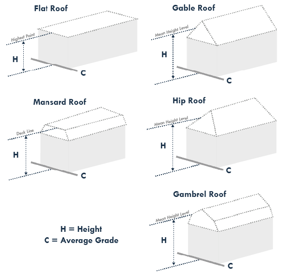
(B)
Exceptions.
(1)
For structures that are in V, VE, AE, AH, and A Flood Zones, as identified in Article V, Overlay Zoning Districts, Division 4, Floodplain Management Overlay District, of this Ordinance, the following applies:
(i)
Height is measured from 12 inches above the base flood elevation for the building site. See Figure IV-2.
(ii)
In cases where there is a ground floor enclosure below the base flood elevation, height shall be measured from the average grade, as shown in Figure IV-1.
Figure IV-2. Height Measurement of Raised Structures in Floodplain Areas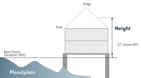
(2)
Structures and uses may exceed the maximum height standards with the issuance of a Special Exception Permit, in accordance with Article III, Permits and Applications, of this Ordinance, provided the structure or use complies with Article 5, Overlay Districts, Division 5, Military Overlay, and all other applicable standards in this Ordinance.
(C)
Exemptions. The height limitations of this Ordinance shall not apply to:
(1)
Spires;
(2)
Belfries;
(3)
Cupolas;
(4)
Monuments;
(5)
Chimneys, flues, and smokestacks;
(6)
Flagpoles less than 50 ft. in height;
(i)
Flagpoles 50 ft. or greater in height shall require a Special Exception Permit, in accordance with Article III, Permits and Applications, of this Ordinance.
(7)
Silos;
(8)
Farm animal building;
(9)
Farm buildings;
(10)
Television antennas;
(11)
Radio aerials;
(12)
Parapet walls;
(13)
Windmills;
(14)
Roof-top mechanical equipment screened by parapet walls;
(15)
Water tanks;
(16)
Broadcasting or communication towers, with Special Exception Permit approval;
(17)
Utility service, major, with Special Exception Permit approval.
(18)
If taller than the maximum height for a specific district, none of the listed exemptions shall exceed, in height, the distance to the nearest lot line—or, in the case of structures located on an easement, to the nearest easement line.
Section 4-2-4. - Determination and Measurement of Lots.
(A)
General.
(1)
Land restricted for building by utility easements shall be considered unusable and shall account for no more than 10% of the minimum required area on any lot.
(2)
Lot area for the purpose of satisfying minimum area requirements shall not include portions under water, except where the total area of a body of water is within the lot and/or constitutes less than 20% of the lot area.
(B)
Required Setbacks. See Figure IV-3.
(1)
Interior Lots, Through Lots, and Stem Lots shall have the following setbacks:
(i)
One front, two side, and one rear.
(2)
Corner Lots and Through Corner Lots shall have the following setbacks:
(i)
Two fronts, one side, and one rear.
Figure IV-3. Required Setbacks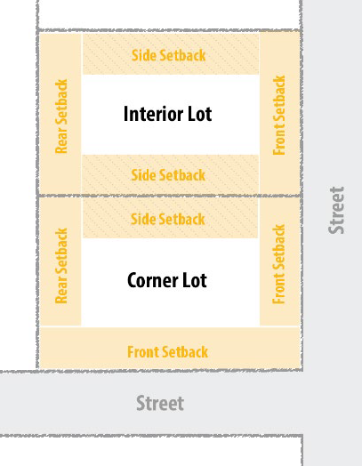
(C)
Measurement Methods. The following methods shall be used for measuring setbacks:
(1)
All Setback Types. Setbacks shall be measured in such a manner that the lot line and the setback line are parallel to one another. Except rounded lots shall be measured as follows:
(i)
Where lots are convex or concave, required setbacks shall be measured radially from the edge of the right-of-way (ROW). See Figure IV-5.
(ii)
In accordance with Article II, Administration, the Administrator shall determine the boundary line(s) from which the setback(s) shall be measured for Irregular Lots.
(2)
Front Setback. Except as otherwise provided in this Article, every lot shall front on an existing street; whether public or private. Front setbacks are determined as follows:
(i)
A front setback shall be included for the full width of the lot frontage, measured between the side lot lines.
(ii)
Depth of the front setback shall be measured from the edge of the ROW, inward towards the lot, until the distance required in the district standards is met. Note: ROW includes primary roads, secondary roads, and private easements.
(iii)
Interior Lots shall have one front setback that is the portion along the street.
(iv)
Corner Lots shall have two front setbacks, one along each street(s).
(v)
Through Lots shall have one front setback that is determined by the prevailing building pattern or, if a prevailing building pattern has not been established, the prevailing lotting pattern. If neither building nor lotting patterns exist, the lot front shall be along the lot frontage that is the narrowest.
(vi)
Through Corner Lots shall have two front setbacks, one that is the longest portion along a street and the other determined by the prevailing building pattern or, if a prevailing building pattern has not been established, the prevailing lotting pattern. If neither building nor lotting patterns exist, the second lot front setback shall be along the lot frontage that is the narrowest.
(vii)
Stem Lots shall have one front that is measured from the boundary delineating the end of the "stem" and then in towards the lot until the distance required in the district standards is met. See Figure IV-6.
(viii)
The front setback required for nonconforming lots may be the average of the front setbacks within 300 ft. on either side of the lot, except that no front setback shall be required to be greater than that required for the district in which the lot is located.
(a)
To maintain the pattern of the neighborhood, if the adjacent lots are vacant, the average(s) of the nearest developed lot(s) on the same side of the street shall be used.
Figure IV-4. Setback Example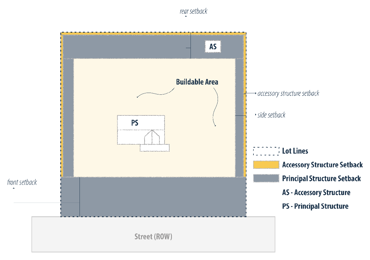
(3)
Side Setback.
(i)
Side setbacks shall be measured from the front setback to the rear setback.
(ii)
Depth of a side setback shall be measured from the lot line in towards the lot until the distance required in the district standards is met.
(4)
Rear Setback.
(i)
A rear setback shall be included for the full width of the rear of the lot, measured between the side lot lines.
(ii)
Depth of a rear setback shall be measured from the rear lot line in towards the lot until the distance required in the district standards is met.
Figure IV-5. Setback Measurement for Convex and Concave Lots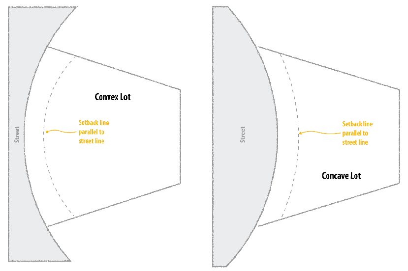
Figure IV-6. Stem Lot Front Setback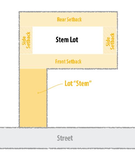
Figure IV-7. Lots, Setbacks, and Lot Lines Diagram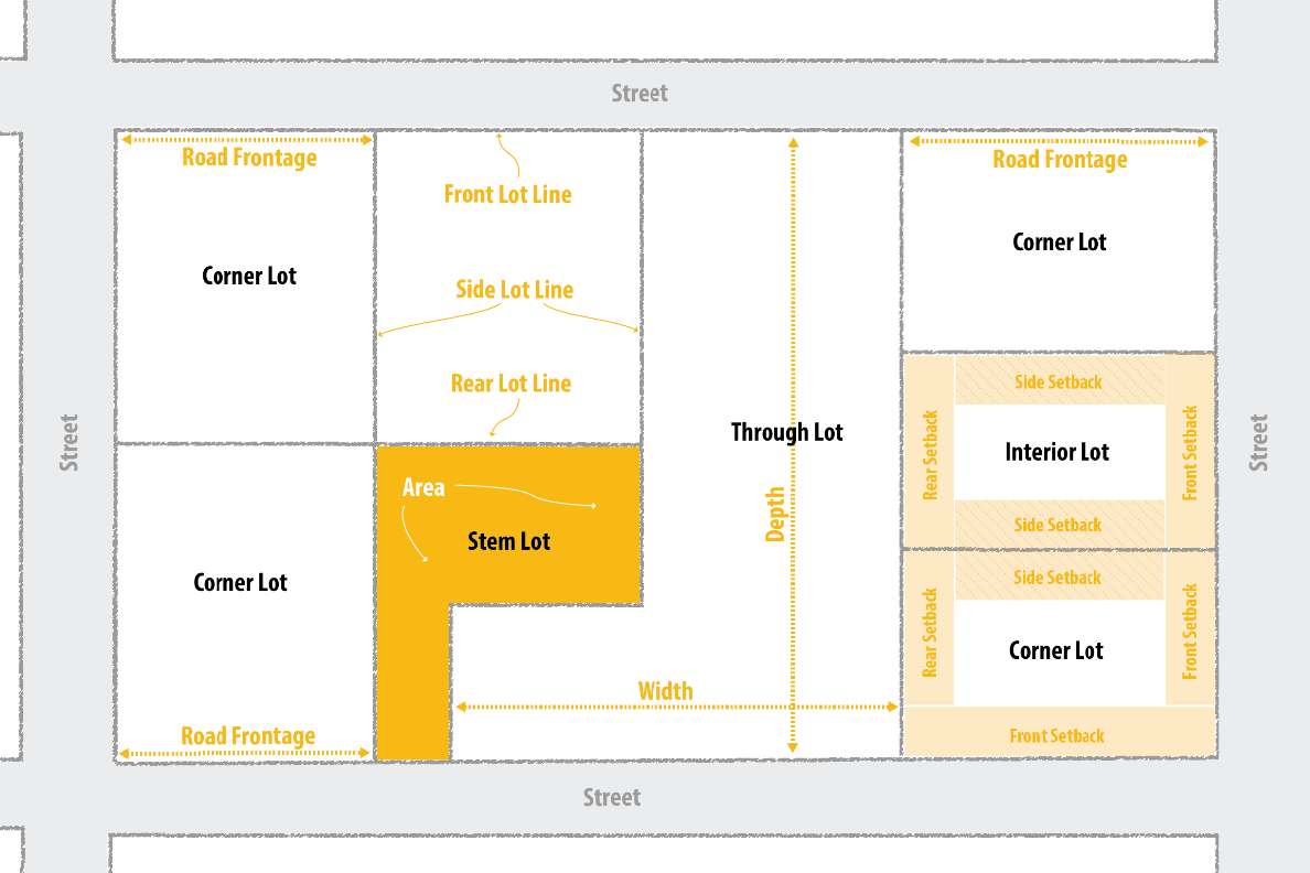
Section 4-2-5. - Steep Slopes.
(A)
Purpose. The purpose of this Section is to address development within the steep slope areas of the County, as delineated in the Comprehensive Plan. These areas have steep slopes, which garner additional considerations for design and development of a lot, prior to permitted development occurring. The disturbance of steep slopes is subject to additional consideration in order to:
(1)
Protect downstream lands and waterways from the adverse effects of the unregulated disturbance of steep slopes;
(2)
Protect land from excessive stormwater runoff;
(3)
Avoid the degradation of surface water;
(4)
Promote a safe means of ingress and egress for vehicular and pedestrian traffic in sloped areas;
(5)
Preserve the visual quality of steep slope areas, which are a valuable natural resource; and
(6)
Encourage innovative and imaginative building techniques to create structures and site plans that are suited to sloped terrain.
(B)
Definition. Steep slopes are those areas in the County with slopes greater than 15%.
(C)
Methods of Measurement. The source of delineation of steep slopes shall be on the County's Steep Slopes Map, or a field-prepared or aerial topographic survey of greater accuracy, certified by a licensed surveyor or engineer. The Administrator, based upon the available information, shall determine the slope of any land in question.
(1)
For the purposes of this Section, slope is calculated as a percentage as follows: vertical rise is divided by horizontal run, and then the resulting decimal is multiplied by 100.
(2)
For purposes of this Section, run is defined as the shortest horizontal distance between the first and third of three consecutive two foot (2') vertical contour intervals (unless a different representation that is equally effective is approved by the Zoning Administrator). It is not necessary that the run be contained entirely on the property of the applicant or developer if the steep slope at issue extends onto an adjacent property.
(D)
Requirements. No Zoning or Building Permit(s) shall be issued for any use, structure, or activity on any parcel of land which includes within its boundaries steep slopes, unless and until the following standards have been met:
(1)
The developer shall submit a map, plan, or plat showing the location and extent of steep slopes within the area to be disturbed, as well as the location and extent of land disturbing activities and mitigation measures, including the proposed building sites, paved areas, drainfields, well locations, and other uses.
(2)
The developer shall obtain a Land Disturbance Permit and incorporate stormwater management facilities and erosion and sediment control measures, in accordance with the King George County Code.
(i)
Any development occurring on steep slopes shall submit an Erosion and Sediment Control Plan and is not eligible to submit an Agreement in Lieu of a Plan, as provided in the King George County Erosion and Sediment Ordinance.
(E)
Design Limitations.
(1)
All streets/roads and driveways shall follow natural contour lines to the maximum extent feasible.
(2)
No driveway shall be constructed with a grade greater than 10%.
(3)
Minor utilities, individual water systems, or septic lines serving an individual sewage disposal system shall not disturb steep slope areas with slopes greater than 15%.
(i)
However, a run of no more than 200 ft. or 10% of the entire length of the minor utility, water line and/or septic line, whichever is greater, shall be allowed to disturb steep slope areas with slopes greater than 15%, based on a geotechnical study or findings from a geotechnical professional that:
1.
Such minor utility, water lines and/or septic lines will not have significant adverse visual, environmental or safety impacts, or appropriate engineering or other measures will be taken by the developer to substantially mitigate any such adverse impact; and
2.
No alternative location for such minor utility, water line and/or septic line is feasible or available.
Section 4-3-1. - Structures in Required Setbacks.
(A)
The following uses and structures are permitted in required setbacks, subject to the limitations provided:
(1)
Fences, walls, and hedges subject to visibility clearance requirements on corner lots as outlined in Article VIII, Community Design Standards, of this Ordinance.
(2)
Covered porches (on any façade) may project not more than 5 ft. into any required setback. Uncovered porches and decks may project not more than 8 ft. into a required rear setback.
(3)
Architectural features, chimney, eaves, exterior stairs, and other like building features may project not more than 4 ft. into any required setback.
(4)
Balconies may project not more than 4 ft. into any required side or rear setback but shall not be closer than 3 ft. to any lot line.
(5)
Accessory structures are subject to the requirements and regulations of Article VII, Use Performance Standards, of this Ordinance.
Section 4-4-1. - Agricultural District Regulations.
Table IV-2. Agriculture District Regulations
Notes:
1 For agricultural uses such as the keeping of animals: see Article VI, Use Matrix for permitted uses and Article VII, Use Performance Standards, for additional standards.
2 Non-residential buildings may be erected to a height of 50 ft.; provided that required front, side, and rear setback minimum standards shall be increased 1 foot for each foot in height over 35 ft.
Section 4-5-1. - Single Family Residential District Regulations.
Table IV-3. Single Family Residential District Regulations
Notes:
1 In dwellings, the maximum windowsill height on the second floor shall be 21 feet above average grade.
2 Non-residential structures may be erected to a height of 50 ft.; provided that required front, side, and rear setback minimum standards shall be increased 1 foot for each foot in height over 35 ft.
Section 4-5-2. - R-3, Multi-Family Dwelling District.
Table IV-4. Multi-Family Dwelling District Regulations
Notes:
1 In dwellings, the maximum windowsill height on the second floor shall be 21 feet above average grade.
2 Non-residential structures may be erected to a height of 50 ft.; provided that required front, side, and rear setback minimum standards shall be increased 1 foot for each foot in height over 35 ft.
Section 4-6-1. - Commercial District Regulations.
Table IV-5. Commercial District Regulations
Note:
1 Buildings may be erected to a height of 50 ft.; provided that required front, side, and rear setback minimum standards shall be increased 1 foot for each foot in height over 35 ft.
Section 4-7-1. - Industrial District Regulations.
Table IV-6. Industrial District Regulations
Note:
1 Buildings may be erected to a height of 50 ft.; provided that required front, side, and rear setback minimum standards shall be increased 1 foot for each foot in height over 35 ft.
2 Buildings may be erected to a height greater than 50 ft. upon the issuance of a Special Exception by the King George County Board of Supervisors.
(Ord. No. O-06-25, 6-3-2025)
Section 4-8-1. - Purpose.
(A)
The purpose of Planned Development Districts is to encourage innovative and efficient land use planning and physical design on large, unified sites. Planned Development Districts are intended to:
(1)
Achieve a high quality of development while protecting environmentally sensitive areas;
(2)
Provide a well-integrated mix of non-residential and recreation uses with various residential dwelling types to achieve a walkable, connected neighborhood;
(3)
Allow more efficient use of land through coordinated networks of streets, utilities, and pedestrian connections, both within the development and to adjacent development;
(4)
Encourage the provision of accessible and useable open space and recreational amenities within the development;
(5)
Promote development forms and patterns that respect the character of established surrounding neighborhoods and other land uses; and
(6)
Promote development patterns that complement a site's natural and man-made features, such as rivers, lakes, wetlands, floodplains, trees, and historic and cultural resources.
Section 4-8-2. - General.
(A)
Application.
(1)
Planned Development districts shall be established by amendment to the Zoning Map, in accordance with Article III, Permits and Applications, of this Ordinance.
(2)
No development within a Planned Development District, including but not limited to clearing, grading, excavating, road building, site preparation or structural improvements, may be permitted prior to Site Plan approval by the Board of Supervisors in accordance with Article III, Permits and Applications, Division 6, Site Plans, of this Ordinance.
(3)
No transfer, sale, or conveyance of any individual lot or interest shall be permitted prior to Final Subdivision Plat approval, in accordance with Article X, Subdivision, of this Ordinance.
(4)
All development and subsequent operation within a Planned Development district shall be undertaken in accordance with the provisions of the approved Site Plan.
(5)
A proposed development may vary from the guidelines outlined in this Division, except for uses subject to approval of a rezoning or Special Exception Permit in accordance with Article III, Permits and Applications, of this Ordinance or approval. Any waiver from the standards and guidelines shall be specifically acknowledged by means of a proffer or conditions. A request for waiver must:
(i)
Clearly outline the requested waiver(s) and
(ii)
Justify the need or benefit to the public and community should the waiver be granted.
Section 4-8-3. - R-C, Resort Community District.
(A)
Development Requirements and Standards. In addition to the standards provided in Table IV-7 of this Article, the following standards apply:
(1)
Generally:
(i)
Minimum setback ranges for multi-family dwellings and non-residential uses shall be specifically established during the review and approval of the Concept Plan. Minimum setbacks for single-family dwellings are provided in Table IV-7.
(ii)
Areas between buildings used as service yards, storage of trash, or other utility purposes should be designed to be compatible with adjoining buildings;
(iii)
Setbacks shall not interfere with public safety issues such as intersection sight distance or utilities, including other public infrastructure such as sidewalks, open space, etc.
(iv)
All new utility lines, electric, telephone, cable television lines, etc., shall be placed underground.
(v)
Resort Communities shall be served by centralized water and sewer utilities, whether public or privately operated, and shall be designed and constructed to public standards as approved by the King George County Public Service Authority.
(vi)
Unless otherwise operated by a public or private utility, private centralized utilities shall be maintained by a Homeowner's Association, which shall be established prior to final plat approval.
(B)
Additional Land. Additional land area may be added to an existing Resort Community District if it is adjacent to or across public or private roads from the Resort Community and forms a logical addition to the existing Resort Community, and if it is under the same ownership or control.
Table IV-7. RC, Resort Community District Regulations
Notes:
3 In dwellings, the maximum windowsill height on the second floor shall be 21 feet above average grade.
4 Non-residential structures may be erected to a height of 50 ft.; provided that required front, side, and rear setback minimum standards shall be increased 1 foot for each foot in height over 45 ft.
Section 4-8-4. - M-U, Mixed Use Development District.
(A)
Applicability. The following provisions shall apply generally to the establishment and regulation of all Mixed-Use Development Districts. The regulations of this Article are intended to permit Mixed-Use Development Districts in the Courthouse West primary settlement area and the Route 3/Route 301 primary settlement area, as set forth in the County's Comprehensive Plan.
(B)
Character of Development. Mixed-Use Development Districts should encourage development form and character that is aesthetically pleasing and is different from conventional suburban development, which typically includes the following:
(1)
Pedestrian orientation;
(2)
Neighborhood friendly streets and paths;
(3)
Interconnected streets and transportation networks;
(4)
Parks and open space amenities;
(5)
Neighborhood centers;
(6)
Appropriately scaled buildings and spaces;
(7)
Relegated parking;
(8)
Mixture of uses and use types;
(9)
Mixture of housing types and affordability; and
(10)
Environmentally sensitive design.
(C)
Development Requirements and Standards. In addition to the standards provided in Table IV-8 of this Article, the following standards apply:
(1)
Generally:
(i)
A diverse variety of architectural styles should be used;
(ii)
Minimum setback ranges for multi-family dwellings and non-residential uses shall be specifically established during the review and approval of the Concept Plan. Minimum setbacks for single-family dwellings are provided in Table IV-8.
(iii)
Areas between buildings used as service yards, storage of trash, or other utility purposes should be designed to be compatible with adjoining buildings;
(iv)
Building spacing and design shall incorporate privacy for outdoor activity areas (patios, decks, etc.) associated with individual dwelling units whenever feasible;
(v)
Setbacks shall not interfere with public safety issues such as intersection sight distance or utilities, including other public infrastructure such as sidewalks, open space, etc.
(vi)
All new utility lines, electric, telephone, cable television lines, etc., shall be placed underground.
(vii)
Mixed-Use developments shall be served by centralized water and sewer utilities, whether public or privately operated, and shall be designed and constructed to public standards as approved by the King George County Public Service Authority.
(viii)
Private centralized utilities shall be maintained by a Homeowner's Association (unless otherwise operated by a public or private utility), which shall be established prior to final plat approval.
(2)
Residential:
(i)
Residential units should vary by dwelling type in a logical and attractive manner to best fit the site. A mixture of residential structures is critical for providing good housing opportunities in a healthy neighborhood setting;
(ii)
All multifamily dwelling units shall be above the ground floor of the structure; and
(iii)
The gross and net residential densities shall be shown on the approved Concept Plan by area and for the development as a whole in dwelling units per acre (du/acre) and shall be binding upon its approval.
(3)
Non-Residential:
(i)
Non-residential density should be expressed in terms of floor area ratio (FAR). There is no maximum square footage for non-residential uses; and
(ii)
The proposed uses should be in proportion to the overall intent and functionality of the mixed-use district concept.
(4)
Open Space:
(i)
Open space shall be provided in a logical relationship to the site; and
(ii)
Improvements shall be configured to accommodate any permitted, accessory, and conditional uses in an orderly relationship with one another, with the greatest amount of open area and with the least disturbance to natural features.
Table IV-8. M-U, Mixed-Use District Regulations
Notes:
3 In dwellings, the maximum windowsill height on the second floor shall be 21 feet above average grade.
4 Non-residential buildings may be erected to a height of 50 ft.; provided that required front, side, and rear setback minimum standards shall be increased 1 foot for each foot in height over 45 ft.
(D)
Architectural Design Requirements. All development within the M-U district shall conform to the following architectural standards:
(1)
Form and massing:
(i)
Structures shall generally be designed with a rectangular form and necessary building floor area shall be accommodated through a primary structural block and subordinate wings, rather than a single massive block of space and building elevation.
(ii)
The main entrance façade of buildings shall be oriented towards a public right-of-way.
(2)
Façade design. Façade design shall not be overly complicated or overly monotonous and shall align with the architectural style of the County. The following criteria shall be considered when developing appropriate façade designs in a Mixed-Use Development District:
(i)
Façade arrangement. Façades shall be balanced and symmetrical. Primary entrances to buildings shall be clearly identified. Primary entrances shall be oriented towards the sidewalks and primary pedestrian paths.
(ii)
Variation. Large or multiple building projects shall use variation of detail, form, and siting to provide visual interest and to prevent monotonous design and appearance. When the prominent facades of a new commercial building are longer than 30 ft., they shall be modulated with breaks in the façade.
(iii)
Windows. Most windows on the principal façade shall be uniform in size and regularly spaced. Window designs shall be appropriate to the overall design of the building.
(iv)
Window Transparency. A minimum of 20% of the front façade should be comprised of clear windows. For non-residential and mixed-use structures, a minimum of 60% of the first-floor front façade should be comprised of clear windows.
(3)
Roof design and materials:
(i)
Varying rooflines. Rooflines shall be varied to add architectural interest and avoid the appearance of long, monotonous roofline expanses.
(ii)
Roof shapes. Hipped or side gabled roofs are highly encouraged for freestanding structures.
(a)
For large commercial structures (approximately 15,000 square feet or more) flat roofs may be permitted provided adequate detail and visual interest is incorporated in the parapet or roof design.
(iii)
Roof materials and colors. Roof materials and colors shall be appropriate to the architectural style of the building. Regardless of the material, shiny and bright roof colors are not permitted.
(a)
Metal or asphalt/fiberglass shingles are the preferred roof materials. Slate, composite, or other roofing materials may be considered on a case-by-case basis.
(4)
Building materials.
(i)
Brick or stone-faced foundations shall be used for all buildings.
(ii)
Major commercial buildings (two-story or higher, shopping centers, and buildings more than 10,000 square feet) shall be constructed primarily of brick. All other buildings shall be constructed of brick and either horizontal wood or horizontal cementitious siding. Other primary buildings materials may be submitted to the planning director or designee for approval provided they are consistent with the overall design of the Mixed-Use Development District.
(iii)
Aluminum siding, vinyl siding, and sheeted siding shall not be permitted materials for non-residential structures.
(iv)
Prefabricated metal buildings are not permitted in the Mixed-Use Development District.
(v)
Colors for brick shall be red or muted earth tones. All brick shall have a buff or gray mortar. White mortar is discouraged.
(vi)
Siding and trim shall be limited to three colors on any building. Additional colors may be approved by the Administrator, provided they are consistent with the overall style of the development.
(5)
Signs and Lighting.
(i)
In addition to the general requirements of Article VIII, Community Design Standards, all lighting, and signs in a Mixed-Use Development District shall be aesthetically consistent with the overall style of the development.
Section 4-9-1. - Purpose.
(A)
The purposes of cluster provisions are to:
(1)
Encourage the protection and preservation of open space and agricultural lands in the county;
(2)
Encourage development in a manner which lessens the cost of infrastructure;
(3)
Provide incentives for clustering residential development in the most appropriate locations;
(4)
Encourage more efficient and aesthetic use of open space;
(5)
Encourage the reservation of open space for scenic and recreational uses;
(6)
Create and encourage the use of a variety of development choices to satisfy the changing needs of the county; and
(7)
Offer flexibility to the developer in his approach and solution to land development problems.
Section 4-9-2. - General.
(A)
The provisions of this article will allow residential dwellings to be developed in clusters, subject to the provisions of Article X, Subdivision, of this Ordinance.
(B)
A cluster development shall be subject to all the applicable standards of this Ordinance, and all other requirements of King George County, unless specifically modified or excepted by the provisions of this Article.
(C)
Cluster development as allowed by the provisions of this article shall be permitted only in the following districts:
(1)
(A-2) Rural Agricultural;
(2)
(A-3) General Agricultural;
(3)
(R-1) Single-family Dwelling;
(4)
(R-2) General Dwelling; and
(5)
(R-3) Multi-family Dwelling.
(D)
All cluster developments shall provide open space in accordance with Table IV-9 and the open space shall be designed and used in accordance with the standards for open space provided in Article VIII, Community Design Standards, of this Ordinance.
(E)
The permitted uses for cluster developments shall conform to the respective permitted uses for the district in which the development is located.
Section 4-9-3. - Standards.
(A)
The dimensional requirements set forth in Table IV-9 shall supersede those stipulated for other development types, except that:
(1)
The allocated densities for each respective district shall not be exceeded, as described in Table IV-9. The maximum net density and net buildable area for a cluster development shall be calculated as follows:
(i)
Net buildable area is equal to the gross area of the property divided by minimum lot size based on the zoning district in which the project is located, as described in Table IV-9 below.
(2)
The requirements for corner visibility, as set forth in Article VIII, Community Design Standards, of this Ordinance are not waived.
(3)
The setback requirement for any building on a cluster lot which abuts a lot located outside the cluster development, shall be not less than the greater of such requirements.
(4)
All cluster developments shall adhere to the requirements of Article X, Subdivision, of this Ordinance.
Table IV-9. Cluster Development Standards
Notes:
1 Agricultural districts can be served by private, public, or a combination for water and sewer connections.