
Kinston City Zoning Code
ARTICLE 2
- GENERAL REGULATIONS
Section 2.1.- Conflicts with other regulations.
In interpreting and applying the provisions of this ordinance, they shall be held to be the minimum requirements for the promotion of the public safety, health, convenience, prosperity, and general welfare. It is not intended by this ordinance to interfere with, abrogate, or annul any easements, covenants, or other agreements between parties; provided, however, that where this ordinance imposes a greater restriction upon the use of buildings or premises or upon the height of buildings, or requires larger open spaces than are imposed or required by other ordinances, rules, regulations, restrictive covenants, or agreements, the provisions of this ordinance shall govern.
Section 2.2. - North Carolina State Building Code.
The City of Kinston Building Code with appendices and the North Carolina State Building Code are incorporated herein by reference, and serve as the basis for building inspector authority to regulate building construction. This ordinance is not intended to conflict with or supersede the North Carolina State Building Code regulations.
Section 2.3. - Interpretation.
2.3.1. Responsibility. In the event that any question arises concerning the application of regulations, performance standards, definitions, development criteria, or any other provision of the UDO, the UDO administrator shall be responsible for interpretation and shall look to the ordinance for guidance. Responsibility for interpretation by the UDO administrator shall be limited to standards, regulations and requirements of the UDO, but shall not be construed to include interpretation of any technical codes adopted by reference in the UDO, and shall not be construed as overriding the responsibilities given to any commission, board, building inspector, or city officials named in other sections or articles of the UDO.
2.3.2. Permitted uses. If a use is not specifically listed in any of the districts listed in this ordinance, then the UDO administrator shall have the authority to interpret in which district the use, if any, should be permitted. If the UDO administrator rejects a proposal for a use that is not clearly disallowed in a particular district, then the UDO administrator shall:
2.3.2.1. Ensure that the citizen is provided with a copy of the interpretation in writing.
2.3.2.2. Inform the citizen of the right to appeal the decision to the board of adjustment.
2.3.2.3. Assist with the development of a proposed zoning text change for consideration by the planning board and city council allowing policy-makers to determine whether the proposed use should be an allowable use in the district or not. Financial responsibility for a proposed zoning text change shall be on the applicant.
Section 2.4. - Identification of official zoning map.
2.4.1. The zoning map shall be identified by the signature of the mayor attested by the city clerk and bearing the seal of the city under the following words: (This is to certify that this is the Official Zoning Map of the Unified Development Ordinance, Kinston, North Carolina,) together with the date of the adoption of this ordinance and most recent revision date.
2.4.2. If, in accordance with the provisions of this ordinance, changes are made in district boundaries or other items portrayed on the zoning map, such changes shall be entered on the official zoning map promptly after the amendment has been approved by the city council, with an entry on the official zoning map denoting the date of amendment, description of amendment, and signed by the city clerk. No amendment to this ordinance which involves matter portrayed on the official zoning map shall become effective until after such change and entry has been made on said map.
2.4.3. No changes of any nature shall be made in the official zoning map or matter shown thereon except in conformity with the procedures set forth in this ordinance and state law. Any unauthorized change of whatever kind by any person shall be considered a violation of this ordinance and punishable as provided under section 1.5.
2.4.4. Regardless of the existence of purported copies of the official zoning map which may from time to time be made or published, the official zoning map, which shall be located in the office of the city clerk, shall be the final authority as to the zoning status of land and water areas, buildings, and other structures in the city.
2.4.5. In the event the official zoning map becomes damaged, destroyed, lost, or difficult to interpret, the city council may by resolution adopt a new official zoning map which shall supersede the prior zoning map. The new official zoning map may correct drafting errors or other errors or omissions in the prior official zoning map, but no correction shall have the effect of amending the original official zoning map, or any subsequent amendment thereof. The new official zoning map shall be identified by the signature of the mayor attested by the city clerk, and bearing the seal of the city under the following words: (This is to certify that this Official Zoning Map supersedes and replaces the Official Zoning Map adopted (date of adoption of map being replaced), as part of the Unified Development Ordinance, Kinston, North Carolina.)
2.4.6. Unless the prior official zoning map has been lost, or has been totally destroyed, the prior map or any significant parts thereof remaining, shall be preserved together with all available records pertaining to its adoption or amendment.
Section 2.5. - Zoning map interpretation.
Where uncertainty exists with respect to the boundaries of any district shown on the zoning map, the following rules shall apply:
2.5.1. Use of property lines. Where district boundaries are indicated as approximately following street lines, alley lines, and lot lines, such lines shall be construed to be such boundaries. Where streets, highways, railroads, water courses, and similar areas with width are indicated as the district boundary, the actual district boundary line shall be the centerline of such area.
2.5.2. Use of the scale. In unsubdivided property or where a zone boundary divides a lot, the location of such boundary, unless the same is indicated by dimensions shall be determined by use of the scale appearing on the map.
2.5.3. Vacated or abandoned streets. Where any street or alley is hereafter officially vacated or abandoned, the zoning regulations applicable to each parcel of abutting property shall apply to the centerline of such abandoned street or alley.
2.5.4. Split zoned parcels. If a district boundary divides a parcel, the requirement for the district in which the greater portion of the parcel lies shall be extended to the remainder of the parcel, provided that such extension shall not include any part of such parcel which lies more than one hundred and fifty (150) feet beyond the existing district boundary, and further provided that the remaining parcel shall not be less than the minimum required for the district in which it is located.
2.5.5. Flood hazard boundaries. Interpretations of the location of floodway and floodplain boundary lines shall be made by the administrator.
2.5.6. Board of adjustment. In case any further uncertainty exists, the board of adjustment shall interpret the intent of the map as to location of such boundaries.
Section 2.6. - Relationship to land use plan.
It is the intention of the council that this ordinance implement the planning policies adopted by the council for the city and its extraterritorial planning area, as reflected in the land use plan and other planning documents. While the council reaffirms its commitment that this ordinance and any amendment to it be in conformity with adopted planning policies, the council hereby expresses its intent that neither this ordinance nor any amendment to it may be challenged on the basis of any alleged nonconformity with any planning document.
Section 2.7. - No use or sale of land or buildings except in conformity with article provisions.
2.7.1. Subject to article 8 of this ordinance (Nonconforming situations), no person may use, occupy, or sell any land or buildings or authorize or permit the use, occupancy, or sale of land or buildings under his control except in accordance with all of the applicable provisions of this ordinance.
2.7.2. For purposes of this section, the "use" or "occupancy" of a building or land relates to anything and everything that is done to, on, or in that building or land.
Section 2.8. - Fees.
2.8.1. Reasonable fees sufficient to cover the costs of administration, inspection, publication of notice, and similar matters may be charged to applicants for zoning permits, sign permits, conditional use permits, special use permits, major and minor subdivision plat approval, zoning amendments, variances, appeals, and other administrative relief, street closings, and site plan review. The amount of the fees charged shall be set forth in the city's budget or as established by resolution of the council files in the office of the city clerk.
2.8.2. Fees established in accordance with subsection 2.8.1, above, shall be paid upon submission of a signed application or notice of appeal.
Section 2.9. - Computation of time.
2.9.1. Unless otherwise specifically provided, the time within which an act is to be done shall be computed by excluding the first and including the last day. If the last day is a Saturday, Sunday, or legal holiday, that day shall be excluded. When the period of time prescribed is less than seven (7) days, intermediate Saturdays, Sundays, and holidays shall be excluded.
2.9.2. Unless otherwise specifically provided, whenever a person has the right or is required to do some act within a prescribed period after the service of a notice and the notice or paper is served by mail (Certified Mail/Return Receipt Requested), three days shall be added to the prescribed period.
Section 2.10. - Reduction of lot and yard areas prohibited.
No yard or lot existing at the time of passage of this ordinance shall be reduced in size or area below the minimum requirements set forth herein. Yards or lots created after the effective date of this ordinance shall meet at least these minimum requirements.
Section 2.11. - Street access.
No building shall be erected on a lot which does not abut a street or have access to a public right-of-way. A building(s) may be erected adjoining a parking area or dedicated open space which has access to a street used in common with other lots.
Section 2.12. - Relationship of building to lot.
Every building hereafter erected, moved, or structurally altered, shall be located on a lot and in no case shall there be more than one principal building and its customary accessory buildings on the lot except in the case of a designed complex of professional, residential, or commercial buildings in an appropriate zoning district, i.e., school campus, apartments, condominiums, shopping center, and industrial park. Detached garages and carports must meet the same setback requirements as the principal building, just as if they were attached.
Section 2.13. - Required yards not to be used by building.
The minimum yards or other open spaces required by this ordinance for each and every building shall not be encroached upon or considered as meeting the yard and open space requirements of any other building.
Section 2.14. - Lot requirements/dimensions.
2.14.1. Insofar as practical, side lot lines which are not right-of-way lines shall be at right angles to straight street lines or radial to curved street lines.
2.14.2. Every lot shall have sufficient area, dimensions, and street access to permit a principal building to be erected thereon in compliance with all lot size and dimensions, yard space, setback, and other requirements of this ordinance.
2.14.3. The location of required front, side, and rear yards on irregularly shaped lots shall be determined by the UDO administrator. The determination will be based on the spirit and intent of this ordinance to achieve an appropriate spacing and location of buildings and structures on individual lots.
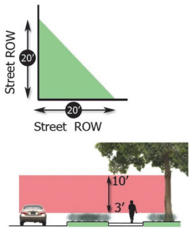
Section 2.15. - Street intersection sight visibility triangle.
The land adjoining a street intersection or egress to a street from off-street parking areas shall be kept clear of obstructions to protect the visibility and safety of motorists and pedestrians. On a corner lot, nothing shall be erected, placed, or allowed to grow in a manner so as materially to impede vision between a height of three feet and ten (10) feet in a triangular area formed by a diagonal line between two points on the right-of-way lines, twenty (20) feet from where they intersect. A clear view shall be maintained on corner lots from three (3) to ten (10) feet in vertical distance.
Section 2.16. - Property dedicated for private use.
Any property dedicated for private ownership, including but not limited to property owners' association ownership, for any use permitted by this ordinance is not the maintenance responsibility of the City of Kinston.
Section 2.17. - Measurement of distance.
All measurements for the purpose of the separation of uses shall be from the closest points of property line to property line for the parcels on which the uses are located.