
Kinston City Zoning Code
ARTICLE 9
- PERFORMANCE STANDARDS
Section 9.1.- Purpose.
The purpose of this section is to establish minimum requirements to provide adequate visual buffering and screening of permitted uses, structures, parking areas, and preservation of protected trees. The intention of these requirements is to satisfy the following objectives:
9.1.1. To provide attractive visual buffering between different land uses and enhance city beautification.
9.1.2. To safeguard and enhance property values and to protect public and private investment by providing standards for the protection of existing vegetation and root zones and the installation of new vegetation.
9.1.3. To mitigate stormwater runoff and erosion, enhance air quality, conserve energy, and aid in abating noise, glare, and heat.
9.1.4. To establish and maintain the maximum sustainable amount of tree cover on public and private lands.
9.1.5. To maintain trees in a healthy and non-hazardous condition through good arboricultural practices.
9.1.6. To establish, maintain, and protect appropriate diversity in tree species and age classes to provide a stable and sustainable urban forest.
Section 9.2. - Applicability.
The four (4) standard requirements in this section are: Street yards (section 9.4), Parking facility landscaping (section 9.5), Bufferyards (section 9.6), and Screening of dumpsters (subsection 9.7.3). The requirements of this article 9, part I shall be applicable to the following situations:
9.2.1. Multi-family residential development. When ten (10) or more parking spaces are required for all phases of development excluding all residential developments which contain solely detached single-family dwelling units.
9.2.2. Nonresidential development.
9.2.2.1. New construction. When a permitted use, a use or combination of uses contained within a conditional use permit require ten (10) or more parking spaces.
9.2.2.2. Existing development. When there is a change from an existing use to a new use which requires additional parking and the new use requires ten (10) or more parking spaces.
9.2.2.3. Expansion of structure. When there is an expansion of an existing structure by greater than twenty-five (25) percent of the gross floor area and that use requires ten (10) or more additional parking spaces.
9.2.2.4. Reconstruction of structure. When there is damage or destruction to an existing structure beyond fifty (50) percent of its assessed value, the reconstruction must conform to the new construction standards of this section.
9.2.2.5. Expansion of parking facility. When there is an expansion of the parking facility by a minimum of ten (10) percent of the parking with a minimum of ten (10) total spaces.
Section 9.3. - Tree resource management.
Tree resource management regulations shall apply to all protected trees for both new and existing development in accordance with this section 9.3. No building permit or certificate of occupancy shall be issued for any improvements upon a property where the provisions of this section have not been complied with.
9.3.1. Exemptions. All properties within the city's jurisdiction shall comply with the requirements of section 9.3, Tree resource management, except as otherwise exempted below:
9.3.1.1. Small trees. Any tree with a diameter/caliper less than eight (8) inches (circumference of twenty-five (25) [inches]) or less measured at diameter at breast height (DBH) may be cut at any time without a permit, except replacement plantings.
9.3.1.2. Nursery. A business location where trees are grown specifically for sale, as part of a primary commercial activity, shall be exempt.
9.3.1.3. Utility construction. Companies and governmental agencies installing and maintaining utilities in easements and right-of-ways shall be exempt when acting in accordance with approved construction plans.
9.3.1.4. Wetlands mitigation. Wetlands mitigation shall be exempt when working in accordance with an approved plan of the U.S. Army Corps of Engineers or North Carolina Department of Environment and Natural Resources (NCDENR).
9.3.1.5. Hazardous conditions. Any tree that is severely damaged, in hazardous condition, as determined by the town administrator, town building inspector, or code enforcement officer shall be exempt; except where hazardous conditions are caused by purposeful damage.
9.3.1.6. Certain forestry activities. Any activity associated with growing, managing, and harvesting trees on lands subject to forestry use-value property taxation or activity being conducted in accordance with a forest management plan shall be exempt.
9.3.1.7. New subdivisions. Any minor or major subdivision of land that includes submission of a landscape plan with the preliminary plat produced by a licensed landscape architect shall be exempt.
9.3.1.8. Site plans. Any minor or major site plan that includes submission of a landscape plan with the site plan produced by a licensed landscape architect shall be exempt.
9.3.2. Tree removal permits required. Any tree with a diameter/caliper of eight (8) inches (circumference of twenty-five and one-quarter (25¼) inches and greater shall be considered a protected tree and shall not be removed unless a removal permit is issued. The measurement shall be taken at DBH a height of four (4) feet above ground level. To obtain a permit, an application package must be submitted to and approved by the UDO administrator, assisted by staff and volunteers as needed. Permitting information shall contain the following:
9.3.2.1. A site plan that clearly indicates the specific location of the requested trees to be removed, trees to remain, and trees planned for installation. A major or minor site plan as specified in section 5.6 may serve as the required tree removal site plan.
9.3.2.2. Reason(s) for tree removal.
9.3.2.3. Payment of a permit fee as set forth in the city fee schedule.
9.3.2.4. A tree replacement schedule, where required.
9.3.2.5. Minor or major site plan approval, minor or major subdivision plat approval, certificate of zoning compliance, or building permit, as may be applicable, must be obtained before any land disturbing activity commences.
9.3.3. Standards for tree permit approval or denial. Protected trees are to be retained and protected to the maximum extent feasible. The UDO administrator shall issue or deny a tree permit within five (5) business days of receiving application for such. No permit shall be issued for the removal of protected trees unless one of the following conditions exists:
9.3.3.1. The tree is located in the buildable area of a yard area where a structure or improvements may be placed and it unreasonably restricts the permitted use of the property and such trees cannot reasonably be relocated elsewhere on the property. Necessity to remove trees in order to construct proposed improvements as a result of the following:
9.3.3.1.1. Essential grade changes for utility installations;
9.3.3.1.2. Location of proposed structure;
9.3.3.1.3. Essential to the nature of the business activity.
9.3.3.2. The tree cannot be relocated on or off the site because of the age, type, or size of the tree.
9.3.3.3. The tree is diseased, injured, in danger of falling, too close to existing or proposed structures, interferes with existing utility service, creates unsafe vision clearance, or conflicts with other ordinances or regulations.
9.3.3.4. Where tree removal is consistent with an approved subdivision plat or site plan.
9.3.3.5. It is in the welfare of the general public that the tree be removed for a reason other than set forth above.
9.3.4. Tree loss mitigation policy. To offset negative impacts to natural environment, aesthetics, and property values of the City of Kinston and to uphold the intent of this section, the following tree replacement schedule shall be followed, which shall be in addition to any and all fees and/or fines paid or incurred by a party that removes or alters a tree, the effect of which is to eliminate it, without having obtained a tree removal permit.
9.3.4.1. All protected trees removed shall be replaced in accordance with the following criteria:
9.3.4.1.1. All trees required by this section, all trees on city-owned property and other protected trees, excluding specimen trees, shall be replaced in a one-to-one ratio with trees that at maturity will be of comparable DBH and height of the tree removed. All replacement trees shall have a DBH of at least two (2) inches when planted.
9.3.4.1.2. Specimen trees shall be replaced on a two-to-one ratio with trees of the same species. All replacement trees shall have a DBH of at least two (2) inches when planted.
9.3.4.1.3. All mitigation shall occur on the property where the tree was removed. Mitigation in connection with construction shall be completed prior to issuance of a certificate of occupancy.
9.3.4.2. Tree loss mitigation shall not take effect when a tree removed is that lost to natural causes, such as age, disease, or storm, or other causes beyond the control of the landowner and property developer, such as a car crash or fire for which no party is found responsible. Tree loss mitigation shall take effect for all other trees allowed to be removed by permit from the UDO administrator or by variance from the board of adjustment as well as for those trees altered or removed in violation of this section.
9.3.4.3. A developer or property owner may be excused from the requirement to install new required trees that would cause the lot in question to contain more than five total protected trees, to include new and existing trees, if the UDO administrator determines that the size of a given property and presence of existing vegetation is such that the introduction of a significant number of new trees may be detrimental to both existing vegetation and proposed trees. The decision of the UDO administrator in such matter shall be final.
9.3.5. Marking of trees required. Any tree(s) indicated on a site plan for removal inspection must be clearly marked with brightly colored tape, ribbon, or similar material prior to an inspection by the UDO administrator.
9.3.6. Replacement plantings. The UDO administrator may recommend that trees be replaced on the same parcel of land removed from for aesthetic, harmonious, visual, or physical buffers to protect all property values. A recommendation on the size of tree(s) may be requested from the UDO administrator utilizing the recommended plant list.
9.3.7. Maintenance and inspection. It is the responsibility of the property owner to retain all trees as required by this section. Failure to do so will be considered a violation subject to all legal and equitable remedies available to the city. The UDO administrator will be notified of all violations for enforcement action.
9.3.8. Purposeful damage to trees prohibited. It shall be unlawful for any person, corporation or other entity to damage, deface, mutilate, alter, or otherwise cause severe or permanent harm to any tree(s) regulated by this section. Purposeful damage to trees shall include topping and any other practices deemed harmful to trees based upon current forestry practices. Purposeful damage prohibitions also apply to tree re-plantings that are less than a diameter/caliper of eight (8) inches (circumference of twenty-five (25) inches).

Section 9.6. - Bufferyard requirements.
Bufferyards are required for multi-family residential development with ten (10) or more parking spaces and nonresidential development as outlined in section 9.2. See the table below to determine the type of bufferyard required.
Bufferyard requirements as they pertain to the Table of Uses and Activities (section 6.5) are as follows:
(1)
Industrial shall include all uses allowed within the I-B, I-1, and I-2 districts.
(2)
Commercial (including O/I) shall include all uses allowed within the O&I, B-1, B-2, and SC districts.
(3)
Multi-family residential shall include all uses allowed within the RA-6, RA-5, and RO districts.
(4)
Single-family residential shall include all uses allowed within the RA-20, RA-15, RA-12, RA-8, and RA-7.
The following provides an example of a Type A bufferyard for a developed commercial district adjacent to a multi-family use in a residential district.


Section 9.7. - Additional requirements.
9.7.1. Existing trees and shrubs. Any existing trees within required bufferyards shall be encouraged to be utilized and supplemented as necessary to meet bufferyard screening requirements. Existing trees intended to meet bufferyard screening requirements shall be protected from detrimental actions such as vehicle or equipment movement, excavating and grading, and installation of storage or structured elements. Credit for existing trees will be based on the following:
9.7.2. Uses in the bufferyard. No activities shall occur in the bufferyard except for maintenance of the bufferyard, required ingress and egress and the installation and maintenance of water, sewer, electrical, and other utility systems where the installation causes minimal disturbance of existing vegetation.
9.7.3. Uses in the rear yard and side yards abutting a residential use. The following uses shall be shielded from view from the property line of adjacent residentially used or zoned property by means of an opaque fence, opaque wall, or solid vegetative buffer:
9.7.3.1. Outside storage areas.
9.7.3.2. Loading/unloading areas.
9.7.4. Dumpsters or other trash holding areas. All dumpsters or other trash holding areas shall be screened on three (3) sides by means of an opaque fence, opaque wall, or solid vegetative buffer.
9.7.5. Encroachment into setbacks.
9.7.5.1. If an existing structure is located within a setback where the implementation of the streetyard and/or bufferyard requirements are physically impossible and the encroachment into the yard (streetyard or bufferyard) allows for a minimum of three (3) feet of planting area, only the required shrubs shall be planted.
9.7.5.2. If the encroachment into the yard (streetyard or bufferyard) allows for less than three (3) feet of planting area, no planting shall be required in that yard.
Section 9.8. - Installation.
9.8.1. Plants shall meet the standards for plant quality and size as defined in the most recent version of the "American Standard of Nursery Stock" manual.
9.8.2. Plants shall be installed per the installation details included in appendix B of this ordinance.
Section 9.9. - Maintenance.
9.9.1. All existing vegetation that is used to meet landscaping requirements, all required plants, and all required berms shall be maintained by the owner of the property on a continuing basis for the life of the development.
9.9.2. Opaque fences or opaque walls shall be maintained, cleaned and repaired by the owner of the property on a continuing basis for the life of the development. Such fencing shall be kept free of litter and advertising. Opaque fences or walls may be subject to periodic inspection by the UDO administrator.
9.9.3. A new certificate of occupancy/building permit or a complaint will result in an inspection for compliance.
Section 9.10. - Landscape plan.
Landscape plans shall be submitted with minor or major site plans, conditional use permit application, and/or request for a zoning certificate of compliance, if section 9.2 applies. These plans shall contain the following information:
9.10.1. Date of plan preparation.
9.10.2. Project name and description of land use.
9.10.3. Project owner and mailing address.
9.10.4. A tree removal permit as specified in subsection 9.3.2.
Section 9.11. - Tree protection during construction.
Tree preservation is a pre-planning activity and will be thoroughly considered prior to development of engineering and/or architectural plans and prior to initiation of construction projects. Protected trees shall be guarded during development against the following:
9.11.1. Unnecessary cutting, breaking, or skinning of roots.
9.11.2. Skinning and bruising of bark.
9.11.3. Excessive vehicular and foot traffic within drip lines.
9.11.4. Parking vehicles within drip lines.
9.11.5. During the land clearing and construction stage of development, the developer shall erect and maintain protective barriers (to the building inspector's specifications consistent with good management practices) around all trees or groups of trees to be protected from the center of the tree(s) to the dripline. The developer shall not allow the movement of equipment or the storage of equipment, materials, debris or fill to be placed within the protective barrier.
9.11.6. During the construction stage of development, the developer shall not allow the cleaning of equipment or material within the drip line of any tree or groups of trees to be protected. Neither shall the developer allow the disposal of waste materials such as paint, oil solvents, asphalt, concrete, mortar and so on within the drip line of any tree or groups of trees.
9.11.7. No attachments or wires other than those of a protective nature shall be attached to any tree.
9.11.8. Soil disturbances within the drip line of a protected tree shall be limited to two inches in depth removed or two (2) inches in depth added. Any soil added under the drip line of the tree shall be a loamy soil mix to ensure minimal compaction.
9.11.9. During land clearing and construction stage of development, the UDO administrator shall periodically inspect the site to ensure compliance with the provisions of this section.
9.11.10. Tree location and replacement activity permitted or required under this section shall be done in accordance with standard forestry practices and procedures, and all such plantings shall be reasonably maintained and attended to promote successful establishment thereof.
Section 9.12. - Recommended plant list.
The following is a recommended plant list to be utilized in the preparation of landscape plans to meet vegetation requirements. Note: Native vegetation is preferred. Plants not listed may be accepted by the UDO administrator if they meet the standards defined by this section. Some plants are listed under multiple categories as many of these plants are offered in numerous varieties. Mature height and spread of each plant is contingent on the variety. It is highly recommended that landscape plans be prepared by or in consultation with a registered landscape architect or qualified landscape design professional.
Key:
E = Evergreen
N = Native
D = Drought tolerant
R = Prone to large surface roots
Section 9.13.- Intent.
In order to present an attractive "face" for the City of Kinston, buildings along roadways should enhance the image of the city's jurisdiction. The emphasis shall be on architectural detail and human-scale design.
Section 9.14. - Applicability.
The requirements of this section shall apply in the following circumstances:
9.14.1. Construction of any new use classified as commercial, office/institutional, or multi-family.
9.14.2. Construction of any new use classified as industrial when the building facade is located within one hundred (100) feet of a public roadway.
9.14.3. Expansion or modification of an existing commercial or office/institutional use that increase the total enclosed floor area by at least fifty (50) percent or five thousand (5,000) square feet, whichever is greater.
9.14.4. Where compliance with these standards is explicitly required in other portions of this ordinance.
Section 9.15. - Exempt.
Communication towers shall be exempt from these requirements.
Section 9.16. - Standards.
9.16.1. Materials. All facades that are visible from a public roadway or an abutting a residential district or use shall be constructed of one or a combination of the following materials: concrete aggregate, stucco, brick, stone, glass or wood, faced concrete block. Artificial materials which closely resemble these materials shall also be allowed. Pre-engineered metal building materials shall not be used on facades.
9.16.2. Scale. Primary facades shall incorporate details at the pedestrian level (below ten (10) feet) that emphasize human scale.
9.16.3. Transparency. Facades of all commercial structures facing a street or primary travelway shall incorporate transparent features on at least twenty-five (25) percent of the surface area on the ground floor.
9.16.4. Roofing materials. Recommended roofing materials include slate shingles, asphalt and fiberglass shingles, metal standing seam or tiles. Partial (occupying less than three (3) sides) mansard roofs are discouraged.
9.16.5. Outdoor site lighting. Shall be selected, designed, located, and installed so that light trespass onto public rights-of-way and adjacent residential property is significantly limited and direct glare is minimized.
9.16.6. Screening of utilities and mechanical equipment.
9.16.6.1. Roof top mounted equipment shall not be visible from public rights-of-way or adjacent residential property. Equipment shall be screened by parapet walls or continuous mechanical screens that are compatible with and complementary to the overall building design. Where complete screening is not technically feasible due to differences in grade elevations, then the parapet or screens shall be at least as tall as the tallest piece of equipment.
9.16.6.2. Ground mounted utilities and equipment, including outdoor service, storage, loading, and mechanical areas shall be located on non-character defining facades and shall be screened by garden walls, fences, or solid vegetation so they are not visible from public rights-of-way or adjacent residential properties.
9.16.6.3. Locate noise-generating equipment to mitigate the impact on adjacent properties and public rights-of-way. Equipment that generates more than sixty (60) decibels shall not be located next to a residential development or must incorporate mufflers or other noise-reducing equipment.
9.16.7. Fencing. Solid fencing shall not be used to obscure the building facade from streets and travelways. Where used, solid fencing shall be located behind the building line of the primary facade(s). Chain link fencing is not permitted where it will be visible from streets and travelways unless it is completely hidden by a permanently maintained vegetative cover.
Section 9.17. - Alternative compliance.
Alternative compliance may be approved in writing by the UDO administrator provided the design alternatives accommodate the following:
9.17.1. Use of high quality, durable materials is required. Materials used for the primary facades shall return along secondary sides a minimum distance as required based on visibility from public rights-of-way or adjacent residential property. Visible rear and side facades shall be designed with as much attention as the other elevations.
9.17.2. Visual balance shall be achieved with the use of order and symmetry within separate building elements.
9.17.3. Architectural elements, details or massing components shall be utilized to create visual organization through repetition and spacing.
9.17.4. Primary facades shall provide appropriate architectural transitions between horizontal elements or differences in apparent floor-to-floor heights.
9.17.5. Design and detailing of materials shall result in an authentic appearing structure, with dimensions and spans of visible materials related to the structural properties. Elements designed to appear as load-bearing shall be visually supported by other elements directly below.
Section 9.18. - Approval/appeal.
The building facade design shall be approved or denied by the UDO administrator within fifteen (15) days of submittal to the UDO administrator. Appeal of the UDO administrator's facade design decisions shall be made to the planning board by application submitted within forty-five (45) days of the UDO administrator's decision. The planning board shall act on the appeal at its next regularly scheduled meeting.
Section 9.19.- Off-street parking requirements.
There shall be provided at the time of the erection of any building, or at the time any principal building is enlarged or increased in capacity by adding dwelling units, guest rooms, seats, or floor area, permanent off-street parking space in the amount specified by this section. Such parking space may be provided in a parking garage or properly graded open space that complies with the standards for parking established in this section.
9.19.1. Certification of minimum parking requirements. Each application for a certificate of zoning compliance submitted to the UDO administrator as provided for in subsection 5.3.7 of this ordinance shall include information as to the location and dimensions of off-street parking and the means of entrance and exit to the space. This information shall be in sufficient detail to enable the UDO administrator to determine whether or not the requirements of this section are met.
9.19.2. Joint use of required parking spaces.
9.19.2.1. One (1) parking area may contain required spaces for several different uses, but except as otherwise provided in this section, the required space assigned to one (1) use may not be credited to any other use.
9.19.2.2. To the extent that developments that wish to make joint use of the same parking spaces operate at different times, the same spaces may be credited to both uses. For example, if a parking lot is used in connection with an office building on Monday through Friday but is generally ninety (90) percent vacant on weekends, another development that operates only on weekends could be credited with ninety (90) percent of the spaces on that lot. Or, if a church parking lot is generally occupied only to fifty (50) percent of capacity on days other than Sunday, another development could make use of fifty (50) percent of the church lot's spaces on those other days.
9.19.2.3. If the joint use of the same parking spaces by two (2) or more principal uses involves satellite parking spaces, then the provisions of subsection 9.20.3 are also applicable.
Section 9.20. - General provisions.
9.20.1. Mixed use. In the case of mixed use developments, the total required off-street parking or loading space shall be the sum of the requirements for the various uses computed separately except for as provided below.
9.20.1.1. Up to one-half of the parking spaces required for one use in a mixed use development may be used to satisfy the parking requirements for a second use within the proposed development, subject to certification by the UDO administrator that such joint usage parking complies with the following provisions:
9.20.1.1.1. The peak usage of the parking facility by one use will be at night or on Sundays and the peak usage of the parking facility by the second use will be at other times as provided in subsection 9.19.2.
9.20.1.1.2. The other uses are ancillary to the primary use, such as restaurants and meeting rooms included in hotels and motels.
9.20.1.2. Minimum parking requirements for a mixed use development may be reduced by the UDO administrator if a traffic/parking study is submitted to demonstrate and the UDO administrator finds that:
9.20.1.2.1. Sidewalks, bicycle facilities, transit service, and transit amenities are in place such that together with the number of parking spaces that are proposed, transportation is adequately served. Parking spaces required by this section may be placed within any public or private street right-of-way in accordance with the approved conditional use permit, if there is sufficient on-street public parking available within a four-hundred-foot radius of the mixed-use development to meet the requirement for the mixed-use development.
9.20.1.2.2. Reduction of the minimum parking requirements will not be injurious to the general health, safety, and welfare.
9.20.2. Phased developments. Each individual phase of a multi-phase development shall meet all applicable parking standards established in this section including shared parking facilities prior to initiation of the next phase.
9.20.3. Satellite parking.
9.20.3.1. If the number of off-street parking spaces required by this article cannot reasonably be provided on the same lot where the principal use associated with these parking spaces is located, then spaces may be provided on adjacent or nearby lots in accordance with the provisions of this section. These off-site spaces are referred to in this section as "satellite" parking spaces.
9.20.3.2. All such satellite parking spaces (except spaces intended for employee use) must be located within six hundred (600) feet of a public entrance of a principal building housing the use associated with such parking or within six hundred (600) feet of the lot on which the use associated with such parking is located if the use is not housed within any principal building. Satellite parking spaces intended for employee use may be located within any reasonable distance. Satellite parking spaces must be located in a zoning district which permits parking lots for the use intended.
9.20.3.3. The developer wishing to take advantage of the provisions of this section must present satisfactory written evidence, to be reviewed by the city attorney, that he has the permission of the owner or other person in charge of the satellite parking spaces to use such spaces. Access to principal site from satellite parking shall be via public streets or sidewalks, otherwise a private access easement must be mapped and recorded at the register of deeds if necessary to cross intermediate property. The developer must also sign an acknowledgment that the continuing validity of his permit depends upon his continuing ability to provide the requisite number of parking spaces. The satellite parking agreement must be recorded at the register of deeds and a copy must be provided to the planning department, prior to issuance of zoning permit.
9.20.3.4. Persons who obtain satellite parking spaces in accordance with this section shall not be held accountable for ensuring that the satellite parking areas from which they obtain their spaces satisfy the design requirements of this article.
9.20.3.5. Notwithstanding any other provisions of this article, whenever (1) there exists a lot with one or more structures on it constructed before the effective date of this ordinance, and (2) a change in use that does not involve any enlargement of a structure is proposed for such lot, and (3) the parking requirements of section 9.28 that would be applicable as a result of the proposed change cannot be satisfied on such lot because there is not sufficient area available on the lot that can practicably be used for parking, then the developer need only comply with the requirements of section 9.28 to the extent that (1) parking space is practicably available on the lot where the development is located and (2) satellite parking space is reasonably available as provided in subsection 9.20.3. However, if satellite parking subsequently becomes reasonably available, then it shall be a continuing condition of the permit authorizing development on such lot that the developer obtain satellite parking when it does become available.
9.20.4. Maneuvering room. Maneuvering space for off-street parking shall be located on the lot upon which parking is provided and not on public right-of-way.
9.20.5. Parking space requirements.
9.20.5.1. The parking surface on all on-site and off-site parking lot(s), with the exception of detached single-family or duplex housing units, shall be dust free, all weather material (i.e., concrete, asphalt, paving stones) or permeable all weather surfacing. The paving surface shall be marked with the necessary striping delineating the parking stalls and locations of handicapped parking spaces.
9.20.5.2. Residential parking areas or driveways shall be properly delineated and surfaced with concrete, asphalt, coquina, or permeable material.
9.20.6. Entrances to streets.
9.20.6.1. Access to public thoroughfares shall be from a driveway and not directly from a parking space.
9.20.6.2. All driveway entrances and other openings onto streets within the city's planning jurisdiction shall be constructed so that:
9.20.6.2.1. Vehicles can enter and exit from the lot in question without posing any substantial danger to themselves, pedestrians, or vehicles travelling in abutting streets; and
9.20.6.2.2. Interference with the free and convenient flow of traffic in abutting or surrounding streets is minimized.
9.20.6.3. Within the corporate limits of the City of Kinston, a driveway permit, issued by the city engineer, is required prior to the installation of a driveway. All such driveways must conform to the city's specification for driveways.
9.20.7. Extension of parking space into a residential district. Necessary customer and employee parking space may extend up to one hundred twenty (120) feet into a residential district, provided that the parking space:
9.20.7.1. Adjoins a residential district;
9.20.7.2. Has its only access to the property from upon the same street or alley as the property in the nonresidential district for which it provides the required parking space and has no access from any point within the residential district; and
9.20.7.3. Is separated from abutting properties or streets in the residential district by a planted buffer strip and fence or barrier to prevent through traffic or access beyond the buffer.
9.20.7. Deviations.
9.20.7.1. The UDO administrator may allow deviations from the parking requirements set forth in section 9.28 when he/she finds that:
9.20.7.1.1. A residential development is irrevocably oriented toward the elderly, disabled, or other populations that demonstrate a lesser parking need.
9.20.7.1.2. A business is primarily oriented to walk-in trade.
9.20.7.2. Whenever the UDO administrator allows or requires a deviation from the presumptive parking requirements set forth in section 9.28, he/she shall enter on the face of the permit the parking requirement that he/she imposes and the reasons for allowing or requiring the deviation.
9.20.7.3. If the UDO administrator concludes, based upon information he/she receives in the consideration of a specific development proposal, that the presumption established in section 9.28 for a particular use classification is erroneous, he/she shall initiate a request for an amendment to the Table of Parking Ratios in accordance with the procedures set forth in section 4.1.
Section 9.21. - Requirements for parking lots.
Where parking lots for more than five (5) cars are permitted or required or where any principal building enlargement is twenty (20) percent or greater of its existing size as specified by subsection 5.1.2., the following provisions shall be complied with:
9.21.1. The parking spaces may be used only for parking, but shall not preclude occasional use as convention and festival exhibits or parking of rental vehicles. Parking spaces may not be used for loading, sales, dead storage, repair work, dismantling or servicing.
9.21.2. All entrances, exits, barricades at sidewalks, and drainage plans shall be approved and constructed before occupancy.
9.21.3. Only one (1) entrance and one (1) exit sign no larger than two square feet prescribing parking regulations may be erected at each entrance or exit.
9.21.4. Vehicle accommodation areas shall be graded and improved with crushed stone, gravel, asphalt, concrete, or other suitable material to provide a surface that is stable and will help to reduce dust and erosion. Whenever such a vehicle accommodation area abuts a paved street, the driveway leading form such street to such area (or, if there is no driveway, the portion of the vehicle accommodation area that opens onto such streets), shall, at a minimum, be paved for a distance of fifteen (15) feet back from the edge of the paved street. This section shall not apply to single-family or two-family residences or other uses that are required to have only one or two (2) parking spaces.
9.21.5. Parking spaces in areas paved with an impervious surface shall be appropriately demarcated with painted lines or other markings.
9.21.6. Vehicle accommodation areas shall be properly maintained in all respects. In particular, and without limiting the foregoing, vehicle accommodation area surfaces shall be kept in good condition (free from potholes, etc.) and parking space lines or markings shall be kept clearly visible and distinct.
9.21.7. Vehicle accommodation areas for multi-family developments shall be constructed of masonry, concrete, or asphalt. This section shall not apply to single-family residences.
9.21.8. Where parking or loading areas are provided adjacent to a public street, ingress and egress thereto shall be made only through driveways not exceeding twenty-five (25) feet in width at the curb line of said street, except where the UDO administrator finds that a greater width is necessary to accommodate the vehicles customarily using the driveway.
9.21.9. Where two (2) or more driveways are located on the same lot, the minimum distance between such drives shall be thirty (30) feet or one-third ( 1/3 ) of the lot frontage, whichever is greater.
9.21.10. No driveway shall be located closer than twenty-five (25) feet to any street intersection.
9.21.11. Unless no other practicable alternative is available, vehicle accommodation areas shall be designed so that, without resorting to extraordinary movements, vehicles may exit such areas without backing onto a public street. This requirement does not apply to parking areas consisting of driveways that serve one (1) or two (2) dwelling units, although backing onto arterial streets is discouraged.
9.21.12. Vehicle accommodation areas of all developments shall be designed so that sanitation, emergency, and other public service vehicles can serve such developments without the necessity of backing unreasonable distances or making other dangerous or hazardous turning movements.
9.21.13. Every vehicle accommodation area shall be designed so that vehicles cannot extend beyond the perimeter of such area onto adjacent properties or public rights-of-way. Such areas shall also be designed so that vehicles do not extend over sidewalks or tend to bump against or damage any wall, vegetation, or other obstruction.
9.21.14. Circulation areas shall be designed so that vehicles can proceed safely without posing a danger to pedestrians or other vehicles and without interfering with parking areas.
9.21.15. Refer to article 9, part I for landscaping requirements.
9.21.16. Refer to article 9, part VIII for lighting requirements.
Section 9.22. - Manufactured home and trailer parking and storing.
It shall be unlawful to park or otherwise store for any purpose whatsoever any manufactured home or trailer within any zoning district unless a storing permit for any manufactured home to be parked or stored for longer than seven (7) days is obtained from the UDO administrator.
Section 9.23. - Vehicle storage.
9.23.1. Residential districts. Vehicles intended for personal use may be parked or stored on property zoned for residential use. Commercial trucks, vans, or trailers driven home must be parked in a garage or carport or in the driveway and never on the street. Inoperative vehicles, including trucks, vans, or trailers may not be stored in a residential district.
9.23.2. Business and industrial districts. Customer and employee parking is permitted along with the parking and storing of governmental or commercial vehicles, in any business or industrial district. Inoperative vehicles shall only be permitted to be parked or stored while undergoing repairs at a commercial garage or automobile service station or if stored in an approved junk or wrecking yard.
Section 9.24. - Vehicle stacking areas.
9.24.1. Vehicle stacking areas. The vehicle stacking standards of this section shall apply unless otherwise expressly approved by the UDO administrator. Additional stacking spaces may be required by the UDO administrator where trip generation rates suggest that additional spaces will be needed.
9.24.2. Minimum number of spaces. Off-street stacking spaces shall be provided as follows:
9.24.3. Design and layout of stacking spaces. Required stacking spaces shall be subject to the following design and layout standards:
9.24.3.1. Size. Stacking spaces shall be a minimum of eight (8) feet in width by twenty-five (25) feet in length.
9.24.3.2. Location. Stacking spaces shall not impede on- or off-site traffic movements or movements into or out of off-street parking spaces.
9.24.3.3. Design. Stacking spaces shall be separated from other internal driveways by raised medians if deemed necessary by the UDO administrator for traffic movement and safety.
Section 9.25. - Parking space dimensions.
9.25.1. Angled parking. Parking stalls intended for the use of standard size automobiles shall have a minimum size of eight (8) feet by eighteen (18) feet for angled parking. All angled parking stalls shall be provided with the minimum aisle width specified below depending on their angle of entry. This width is designed to accommodate traffic flow within the parking area and allow reasonable room for maneuvering in and out of parking stalls.
9.25.1.1. One-way traffic.

9.25.1.2. Two-way traffic. Aisle width: Twenty-two (22) feet.
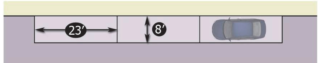
9.25.2. Parallel parking. Parallel parking stalls for standard size automobiles shall have a minimum size of eight (8) feet by twenty-three (23) feet. All parallel parking stalls shall have a minimum of ten (10) feet for maneuvering space in one-way traffic and twenty (20) feet maneuvering space in two-way traffic.
Section 9.26. - Handicapped requirements.
9.26.1. Handicapped parking spaces shall be in accordance with the regulations set forth by the Americans with Disabilities Act (ADA) and the NC Department of Transportation and NC Division of Motor Vehicles ADA requirements. All handicapped spaces shall be identified by pavement markings and by appropriate signage approved by the NC Department of Transportation. Handicapped parking shall be required on all multi-family and nonresidential sites.
9.26.2. Handicapped parking spaces shall be located in the closest proximity to major building entrances, but in no event shall such spaces be located more than one hundred (100) feet from a major building entrance.
9.26.3. Handicapped parking spaces shall be a minimum of eight (8) feet in width by twenty (20) feet in length and shall have an adjacent access aisle that has a minimum width of five (5) feet. Two accessible parking spaces may share a common access aisle.

9.26.4. The minimum number to be provided for all multi-family and nonresidential sites is as follows:
9.26.5. The number of accessible spaces shall be in addition to those required by the minimum parking ratios.
9.26.6. All spaces for the disabled shall have access to a curb-ramp or curb-cut when necessary to allow access to the building served, and shall be located so that users will not be compelled to wheel behind parked vehicles.
9.26.7. Parallel parking spaces for the disabled shall be located either at the beginning or end of a block or adjacent to alley entrances. Elective curbs adjacent to such spaces shall be of a height which will not interfere with the opening and closing of motor vehicle doors.
9.26.8. The first one out of every eight (8) accessible parking spaces shall be a van accessible space. Van parking spaces shall have an adjacent access aisle a minimum of eight (8) feet in width and a vertical clearance of at least eight (8) feet along the vehicular route to the parking space.
Section 9.27. - Loading areas.
9.27.1. Location.
9.27.1.1. No loading spaces shall be located within 30 feet of street intersections or in any required front, side, or rear yard.
9.27.1.2. A minimum setback of fifty (50) feet shall be required where loading docks face a residential district or a structure with first-floor residential uses, unless the loading area is completely screened from view with an eight-foot-high masonry wall in accordance with the requirements of section 7.2, retaining walls and fences.
9.27.1.3. Loading areas shall be located to provide the most convenient access to the use being served. Generally, loading areas should be adjacent to the building.
9.27.1.4. Loading and unloading areas shall be so located and designed that the vehicles intended to use them can (1) maneuver safely and conveniently to and from a public right-of-way and (2) complete the loading and unloading operations without obstructing or interfering with any public right-of-way or any parking space or parking lot aisle.
9.27.2. Surfacing. Generally, all open off-street loading areas shall be paved with an all-weather material such as concrete or asphalt, designed to carry the heaviest vehicle loads that can commonly be expected. Consideration should be given to the weight of fire and sanitation equipment as well as delivery vehicles.
9.27.3. Design.
9.27.3.1. Loading berths for office uses shall be a minimum of twelve (12) feet wide by thirty-five (35) feet long with a height clearance of fourteen (14) feet.
9.27.3.2. All other loading berths shall be a minimum of twelve (12) feet wide and fifty-five (55) feet long with a height clearance of fourteen (14) feet.
9.27.4. Utilization. Space allocated to any off-street loading space, accessory drives, or aisles, shall not be used to satisfy the space requirements for any off-street parking or trash handling facilities.
9.27.5. Ingress and egress. Each required off-street loading space shall be provided with a means of unobstructed ingress and egress to an alley or onto a public street wide enough to accommodate expected vehicles. Where such ingress and egress is made into a public street, it shall be through driveways or openings which meet required standards. Permanent wheel stops or curbing shall be provided to prevent any vehicle using the loading area from encroachment on the required front yards, side yards, or adjoining property.
9.27.6. Number of spaces required.
9.27.6.1. Loading spaces shall be required for uses which normally handle large quantities of goods, including but not limited to educational, institutional, manufacturing and industrial, professional and services offices, retail sales and services, transportation, and wholesale sales and warehousing.
9.27.6.2. The numbers in the table below shall serve as a guideline for determining the number of loading spaces required.
9.27.6.3. The UDO administrator may require one or more additional loading areas if the magnitude of the use would anticipate the need for more loading or standing space.
Section 9.28. - Parking ratios.
The following defines parking ratios for general use classifications as delineated in the Table of Uses and Activities (section 6.5). All uses are not defined; however, the broad categories listed should correlate with each use listed within the use table included in section 6.5. If there are questions regarding how a given project should be classified, the methodology for defining a required parking requirement shall be determined by the entity designated by this ordinance to approve a particular development. Parking requirements for all government sponsored/owned facilities, such as schools, shall be determined on a case-by-case basis through the development plan approval process. Parking requirements shall be rounded to the nearest whole number. For example, an eight-hundred-seventy-five-square-foot restaurant would require six (6) parking spaces (875/150 = 5.83 = 6).
Section 9.29.- Permit required for signs.
9.29.1. Except as otherwise provided in section 9.30 (Signs excluded from permit requirements) and section 9.31 (Certain temporary signs; permit exemptions and additional regulations), no sign may be erected, moved, enlarged, or substantially altered except in accordance with the provisions of this section. Mere repainting or changing the message of a sign shall not, in and of itself, be considered a substantial alteration.
9.29.2. If plans submitted for a zoning permit, special use permit, or conditional use permit include sign plans in sufficient detail that the permit-issuing authority can determine whether the proposed sign or signs comply with the provisions of this ordinance, then issuance of the requested zoning, special use, or conditional use permit shall constitute approval of the proposed sign or signs.
9.29.3. Signs not approved as provided in subsection 9.29.2 or exempted under the provisions referenced in subsection 9.29.1 may be erected, moved, enlarged, or substantially altered only in accordance with a sign permit issued by the UDO administrator. Sign permit applications and sign permits shall be governed by the same provisions of this ordinance applicable to zoning permits.
9.29.4. All sign permits shall expire if not utilized within one hundred eighty (180) days following issuance. No more than one (1) off-premises sign permit per parcel may be issued within any three-hundred-sixty-five-day period, such time beginning with the date of issuance of any previous off-premises sign permit.
Section 9.30. - Signs excluded from permit requirements.
The following signs are exempt from regulation under this ordinance except for those restrictions stated in sections 9.37.2 through 9.37.4.
9.30.1. Signs not exceeding four (4) square feet in area that are customarily associated with residential use and that are not of a commercial nature, such as (1) signs giving property identification names or numbers or names of occupants, (2) signs on mailboxes or paper tubes, and (3) signs posted on private property relating to private parking or warning the public against trespassing or danger from animals.
9.30.2. Signs erected by or on behalf of or pursuant to the authorization of a governmental body, including legal notices, identification and informational signs, and traffic, directional, or regulatory signs.
9.30.3. Official signs of a noncommercial nature erected by public utilities.
9.30.4. Flags, pennants, or insignia of any governmental or nonprofit organization when not displayed in connection with a commercial promotion of as an advertising device.
9.30.5. Integral decorative or architectural features of buildings or works of art, so long as such features or works do not contain letters, trademarks, moving parts, or lights.
9.30.6. Signs directing and guiding traffic on private property that do not exceed four (4) square feet each.
9.30.7. Church bulletin boards and church identification signs that do not exceed one per abutting street and thirty-two (32) square feet in area. Off-premises church identification signs may be permitted, provided that each sign does not exceed sixteen (16) square feet in area.
9.30.8. Signs painted on or otherwise permanently attached to currently licensed motor vehicles and trailers that are not primarily used as signs.
9.30.9. Signs proclaiming religious, political, or other noncommercial messages (other than those regulated by subsection 9.31.1.4) that do not exceed one per abutting street and sixteen (16) square feet in area and that are not internally illuminated.
9.30.10. Signs located on the interior of buildings, courts, lobbies, stadiums, or other structures that are not intended to be seen from the exterior of said building or structure.
9.30.11. Memorial plaques or markers.
9.30.12. Signs painted or attached to vending machines, gas pumps, ice machines, or similar devices which indicate the contents of the machine, the price, or operating instructions.
9.30.13. Window signs painted directly on or attached to a window.
9.30.14. Art, including murals and paintings.
Section 9.31. - Certain temporary signs; permit exemptions and additional regulations.
9.31.1. The following portable and temporary signs are permitted without a zoning, special use, conditional use, or sign permit. However, such signs shall conform to the requirements set forth below as well as all other applicable requirements of this article.
9.31.1.1. Signs containing the message that the real estate on which the sign is located (including buildings) is for sale, lease, or rent, together with information identifying the owner or agent. Such signs may not exceed nine (9) square feet in area and shall be removed immediately after sale, lease, or rental. For lots of less than five (5) acres, a single sign on each street frontage may be erected. For lots located in nonresidential districts and containing five (5) acres or more in area and having a street frontage in excess of four hundred (400) feet, a real estate sign not exceeding thirty-two (32) square feet in area may be erected.
9.31.1.2. Construction-site/opening soon identification signs. Construction signs may identify the project, the owner or developer, architect, engineer, contractor and subcontractors, funding sources, and related information. Not more than one such sign may be erected per site and it may not exceed thirty-two (32) square feet in area. Such signs shall not be erected prior to the issuance of a building permit and shall be removed within ten (10) days after the issuance of the final occupancy permit. One "Opening Soon" sign may be permitted per building site, provided such sign does not exceed thirty-two (32) square feet in area and is erected for a period not to exceed sixty (60) days.
9.31.1.3. Displays, including lighting, erected in connection with the observance of holidays.
9.31.1.4. Signs erected in connection with elections or political campaigns. Signs may only be displayed from the thirtieth day before the beginning of "one stop" early voting and the tenth day after the primary or election day. The party erecting the sign must obtain the permission of the owner of any residence, business, or religious property that fronts the right-of-way where the sign is erected. No such sign may exceed thirty-two (32) square feet in surface area.
9.31.1.5. Signs, including banners, pennants, streamers, and balloons, indicating that a special event such as a grand opening, fair, carnival, circus, festival or similar happening is to take place on the lot where the sign is located. Such signs may be erected up to one week before the event and must be removed not later than three (3) days after the event.
9.31.1.6. Portable signs and temporary signs, including, but not limited to, spotlights, inflatable balloons and similar apparatus, may be allowed for special promotional sales, going out of business sales, grand openings, and similar events in nonresidential districts with the issuance of a permit. Such signs shall be removed within fourteen (14) days after placement. Portable and/or temporary signs shall not be permitted for display longer than twenty-eight (28) days in any three hundred sixty-five-day period. Signs designed to be portable signs may not be converted to permanent signs without meeting the requirements of state and local codes. In the B-2 and arts and cultural overlay districts, one (1) sandwich board sign per parcel not exceeding six (6) square feet per side and no greater than two (2) feet in width may be located on a public sidewalk during normal business hours in front of the parcel on which the advertised business or function is located.
9.31.1.7. Temporary yard sale signs which are posted no longer than three (3) days per sale.
9.31.1.8. Temporary signs not covered in the foregoing categories, so long as such signs meet the following restrictions:
9.31.1.8.1. Not more than one such sign may be located on any lot.
9.31.1.8.2. No such sign may exceed four (4) square feet in surface area.
9.31.1.8.3. Such sign may not be displayed for longer than three (3) consecutive days nor more than ten (10) days out of any three-hundred-sixty-five-day period.
9.31.2. Other temporary signs not listed in subsection 9.31.1 shall be regarded and treated in all respects as permanent signs.
Section 9.32. - Determining the number of signs.
9.32.1. For the purpose of determining the number of signs, a sign shall be considered to be a single display surface or display device containing elements organized, related, and composed to form a unit. Where matter is displayed in a random manner without organized relationship of elements, each element shall be considered a single sign.
9.32.2. Without limiting the generality of subsection 9.32.1, a multi-sided sign shall be regarded as one sign.
Section 9.33. - Computation of sign area.
9.33.1. The surface area of a sign shall be computed by including the entire area within a single, continuous, rectilinear perimeter of not more than eight (8) straight lines or a circle or an ellipse enclosing the extreme limits of the writing, representation, emblem or other display, together with any material or color forming an integral part of the background of the display or used to differentiate the sign from the backdrop or structure against which it is placed, but not including any supporting framework or bracing that is clearly incidental to the display itself.
9.33.2. If the sign consists of more than one (1) section or module, all of the area, including that between sections or modules, shall be included in the computation of the sign area.
9.33.3. With respect to two-sided, multisided or three-dimensional signs, the surface area shall be computed by including the total of all sides designed either to attract attention or communicate information that can be seen at one time by any person from any vantage point. For example, with respect to a typical two-sided sign where a message is printed on both sides of a flat surface, the sign surface area of one side (rather than the sum total of both sides) shall be regarded as the total sign surface area of that sign, since one can see only one side of the sign from any vantage point.
9.33.4. With respect to V-shaped signs, the surface area shall be calculated as in subsection 9.33.3 above, provided the angle of the intersecting sign planes does not exceed ninety (90) degrees. If the angle of the intersecting sign planes exceeds ninety (90) degrees, sign area shall be computed as it would for a one-sided sign.
Section 9.34. - District signs.
9.34.1. Signs in general residential districts.
9.34.1.1. Unless otherwise provided in this article or in article 7, Supplemental Regulations, the maximum sign surface area permitted on any lot in any RA-20, RA-15, RA-12, RA-8, RA-7, RA-6, and RA-5 residential district is four (4) square feet, including home occupations.
9.34.1.2. At any entrance to a residential subdivision, multi-family development, or manufactured home park, there may be not more than two (2) signs identifying such subdivision or development. A single side of any such sign may not exceed thirty-two (32) square feet nor may the total surface area of all such signs located at a single entrance exceed sixty-four (64) square feet.
9.34.1.3. LED lighting is prohibited for churches located in residential zoning districts.
9.34.2. Signs in RO and O&I districts.
1 Bottom edge of sign must be at least ten (10) feet above the sidewalk; except in cases where sign is located underneath an awning or canopy, the bottom edge shall be at least eight (8) feet above the sidewalk. Projecting signs will not extend vertically above the roofline or parapet of a building.
2 Sign shall be located no closer than ten (10) feet from property line or street right-of-way.
9.34.3. Signs in B-2 districts.
1 Bottom edge of sign must be at least ten (10) feet above the sidewalk; except in cases where sign is located underneath an awning or canopy, the bottom edge shall be at least eight (8) feet above the sidewalk. Projecting signs will not extend vertically above the roofline or parapet of the building.
2 Sign shall be located no closer than ten (10) feet from property line or street right-of-way.
9.34.4. Signs in B-1, SC, I-B, I-1 and I-2 districts.
1 Wall signs may project a maximum of twelve (12) inches from the wall to which it is mounted.
2 Bottom edge of sign must be at least ten (10) feet above the sidewalk; except in cases where sign is located underneath an awning or canopy, the bottom edge shall be at least eight (8) feet above the sidewalk. Projecting signs will not extend vertically above the roofline or parapet of the building.
3 Sign shall be located no closer than ten (10) feet from property line or street right-of-way.
9.34.5. Off-premises signs.
1 Sign shall be located no closer than one thousand (1,000) feet from another off-premises sign on the same side of the street. An off-premises sign shall not be located less than five hundred (500) feet from any other off-premises sign as measured in a straight line. Off-premises signs shall not extend closer than the minimum building setback for the district in which located as specified in section 6.6 and subsection 6.7.3.
2 Off-premises signs shall not be located within two hundred (200) feet of any property which is used for public parks, public or private schools, churches, public museums, city hall, or courthouse and which has principal access on the same street as the off-premises sign. No off-premises sign shall be located closer than one hundred (100) feet of a lot on the same side of the street which is zoned or developed for residential purposes.
3 The City of Kinston will pay just compensation in accordance with N.C.G.S. 136-131.1 for required removal of billboards.
4 An additional fifteen (15) percent of the sign area may be permitted outside the sign face for enlargement for a specific display or copy.
9.34.6. Sign measurement. Measurement shall be taken from the center line of the adjacent street for freestanding signs and the ground for all other signs.
Section 9.35. - Location requirements.
9.35.1. No sign may extend above any parapet or be placed upon any roof surface; except that, for purposes of this section, roof surfaces constructed at an angle of seventy-five (75) degrees or more from horizontal shall be regarded as wall space. This section shall not apply to displays, including lighting, erected in connection with the observation of holidays on the roofs of residential structures.
9.35.2. No sign or supporting structure may be located in or over the traveled portion of any public right-of-way unless the sign is attached to a structural element of a building and an encroachment permit has been obtained from the city.
9.35.3. No wall sign attached flat to a building may project more than eighteen (18) inches from the building wall. Projecting signs may, however, exceed the eighteen-inch requirement.
Section 9.36. - Sign illumination and signs containing lights.
9.36.1. Unless otherwise prohibited by this article, signs may be illuminated if such illumination is in accordance with this section.
9.36.2. No sign within one hundred fifty (150) feet of a residential zone may be illuminated between the hours of 12:00 midnight and 6:00 a.m., unless the impact of such lighting beyond the boundaries of the lot where it is located is entirely inconsequential.
9.36.3. Lighting directed toward a sign shall be shielded so that it illuminates only the face of the sign and does not shine directly into a public right-of-way or residential premises.
9.36.4. Subject to subsection 9.36.5, no sign may contain or be illuminated by flashing or intermittent lights or lights of changing degrees of intensity, except signs indicating the time, date, or weather conditions.
9.36.5. Subsection 9.36.4 does not apply to temporary signs erected in connection with the observance of holidays or time and temperature signs.
Section 9.37. - Miscellaneous restrictions and prohibitions.
9.37.1. No temporary nor permanent sign (snipe signs) shall be attached to a tree or utility pole (other than signs allowed by subsection 9.30.2).
9.37.2. No sign may be located so that it substantially interferes with the view necessary for motorists to proceed safely through intersections or to enter onto or exit from public streets or private roads. Specifically, no sign shall create a visual obstruction in a designated sight clearance area.
9.37.3. No sign may be erected so that by its location, color, size, shape, nature or message it would tend to obstruct the view of or be confused with official traffic signs or other signs erected by governmental agencies.
9.37.4. Freestanding signs shall be securely fastened to the ground or to some other substantial supportive structure so that there is virtually no danger that either the sign or the supportive structure may be moved by the wind or other forces of nature and cause injury to persons or property.
9.37.5. Canopy signs are permitted when suspended or attached to the underside of a canopy provided such signs shall be located so that the bottom edge of the sign is at least eight (8) feet above the sidewalk.
9.37.6. Any sign that revolves, changes copy, or is otherwise animated, or that utilizes movement or apparent movement to attract the attention of the public is prohibited. This prohibition shall be limited to, propellers, discs, banners, pennants, and streamers.
9.37.7. All portable signs, except as specified in subsection 9.31.1.6, are prohibited. This prohibition shall not apply to signs erected by or pursuant to the authorization of the City of Kinston for events of a community nature including but not limited to emergencies or for other governmental purposes. This prohibition shall not apply to signs placed upon vehicles that are operational and which are not parked at one location for over twenty-four (24) hours.
9.37.8. Vehicle sign. Any sign that is attached to, painted on, or pulled by any vehicle that is parked on any street or in any parking space for the primary purpose of advertising.
9.37.9. No signs shall overhang or be erected in any public right-of-way. Traffic regulation, information or warning signs erected by the State Department of Transportation or signs erected by the town are exempt.
9.37.10. All message board signs are prohibited. This prohibition does not include menu and sandwich board signs.
9.37.11. All inflatable signs, balloons, and similar decorations are prohibited.
9.37.12. All roof signs are prohibited.
9.37.13. Any illuminated tubing or strings of lights outlining property lines, festoon lighting, open sales areas, rooflines, doors, windows, edges of walls, trees, or other landscaping are prohibited. This prohibition shall not apply to temporary holiday lighting; such temporary lighting shall be removed by the owner or tenant within a reasonable time following the end of the holiday.
9.37.14. Any sign that exhibits statements, words, or pictures of an indecent, obscene, or pornographic nature is prohibited.
9.37.15. Any sign that obstructs or interferes with any window, door, sidewalk, or fire escape is prohibited.
9.37.16. All beacons and spotlights are prohibited. Illumination system(s) shall not contain or utilize any beacon, spot, search, or stroboscopic light or reflector which is visible from any public right-of-way or adjacent property, nor shall such lights be operated outside, under any circumstances, except by authorized agencies for emergency services purposes.
9.37.17. Flood lights shall not be utilized as a part of a sign illumination system which are not hooded or shielded so that the light source is not visible from any public right-of-way or adjacent property nor shall any sign otherwise reflect or emit a glaring light so as to impair driver vision.
9.37.18. Any sign or sign structure that is structurally unsafe as determined by the UDO administrator or building inspector is prohibited.
9.37.19. Stacking signs on top of one another is prohibited.
9.37.20. Signs painted on or attached to trees, fences, or fence posts, and telephone or utility poles or signs on or attached to rocks or other natural features are prohibited. Any commercial identification or advertising signs on benches or refuse containers are also prohibited.
9.37.21. Pavement markings are prohibited except those of a customary traffic-control nature.
9.37.22. Any sign located or designated so as to intentionally or effectively deny an adjoining property owner reasonable visual access to an existing sign is prohibited.
Section 9.38. - General maintenance requirements.
To ensure that signs are erected and maintained in a safe and attractive condition, the following maintenance requirements shall apply to all signs:
9.38.1. Every sign and its supports, braces, guys, anchors, and electrical equipment shall be maintained in safe condition at all times. All signs shall be kept free from defective or missing parts or peeling paint and shall be sufficiently stabilized to withstand wind damage.
9.38.2. A sign shall have no more than ten (10) percent of its surface area covered with disfigured, cracked, ripped, or peeling paint, poster paper, or other material for a period more than fourteen (14) successive days.
9.38.3. A sign shall not have weeds, vines, or other vegetation growing upon it, or obscuring the view of the sign from the street or right-of-way from which it is to be viewed, for a period of more than fifteen (15) successive days.
9.38.4. An illuminated sign shall not have only partial illumination for a period of more than fifteen (15) successive days.
9.38.5. Should any sign become insecure or in danger of falling or otherwise unsafe in the opinion of the UDO administrator, the owner thereof, or the person or firm maintaining the sign, shall, upon written notice from the UDO administrator, forthwith in the case of immediate danger and in any case within ten (10) days, secure the sign in a manner to be approved by the UDO administrator, in conformity with the provisions of this section or remove the sign. If the order is not complied with within ten (10) days, the UDO administrator shall remove the sign at the expense of the owner or lessee thereof.
Section 9.39. - Reconstruction of damaged signs or sign structures.
9.39.1. Any conforming or permitted nonconforming sign or sign structure which has been damaged may be repaired and used as before, provided all repairs are initiated within thirty (30) days and completed within sixty (60) days of such damage. However, if the sign should be declared unsafe by the UDO administrator, the owner of the sign or the owner of record of the real property whereon the sign is located, shall immediately correct all unsafe conditions in a manner satisfactory to the UDO administrator.
9.39.2. For the purposes of this section, a nonconforming sign or its structure shall be considered destroyed, and therefore not repairable, if it receives damage to the extent of more than fifty (50) percent of its value as listed for tax purposes by the Lenoir County Tax Office.
Section 9.40. - Nonconforming signs.
Nonconforming signs are subject to the provisions of article 8, specifically section 8.7.
Section 9.41. - Discontinued signs.
Upon the discontinuance of a business or occupancy of an establishment for a consecutive period of one hundred eighty (180) days, the UDO administrator shall require the removal of the on-premises sign(s) advertising or identifying the establishment. The UDO administrator shall give thirty (30) days' notice to the property owner to remove the sign(s). Failure to remove the sign(s) within the thirty-day period shall constitute a violation of this article and shall be remedied in accordance with the provisions of section 1.5.
Section 9.42.- No subdivision without plat approval.
9.42.1. As provided in N.C.G.S. 160A-375, no person may subdivide his land except in accordance with all of the provisions of this ordinance. In particular, no person may subdivide his land unless and until a final plat of the subdivision has been approved in accordance with the provisions of sections 5.3 and 5.4 and recorded in the Lenoir County Registry.
9.42.2. As provided in N.C.G.S. 160A-373, the Lenoir County Register of Deeds may not record a plat of any subdivision within the city's planning jurisdiction unless the plat has been approved in accordance with the provisions of this ordinance.
Section 9.43. - Standards for review.
Refer to section 5.7 for the subdivision review process. Decision on approval or denial of preliminary or final plats may be made only on the basis of standards explicitly set forth in article 9, part V. Whenever the ordinance criteria for decisions requires application of judgement, those criteria must provide adequate guiding standards for the entity charged with plat approval.
Section 9.44. - Sketch plans.
A sketch plan is required and shall include the information specified in subsection 5.2.3.
Section 9.45 - Preliminary plats for minor and major subdivisions.
The preliminary plat shall depict or contain the information provided in section 9.47. Preliminary plats shall be clearly and legibly drawn at a scale of not less than two hundred (200) feet to one (1) inch.
Section 9.46 - Final plats for all subdivisions.
9.46.1. Final plat contents. The final plats shall depict or contain the information provided in section 9.47. Final plats shall be clearly and legibly drawn by a registered land surveyor currently licensed in the State of North Carolina by the N.C. State Board of Registration for Professional Engineers and Land Surveyors. The plat shall also be drawn at a scale of not less than two hundred (200) feet to one (1) inch and shall be drawn on a sheet size of mylar acceptable to the Register of Deeds of Lenoir County.
9.46.2. Certifications. The final plat shall contain the certifications outlined in section 9.48.
Section 9.47 - Information to be provided on preliminary and final plats.
The preliminary and final plats shall depict or contain the information indicated in the following table. An X indicates that the information is required.
Quality Assurance Signature, signifying that all Checklist items are enclosed with the submittal package. Return signed checklist with submittal.
Section 9.48. - Final plat certifications and other documentation.
9.48.1. Certificates for minor subdivision final plats.
9.48.1.1. Certificate of ownership and dedication. I hereby certify that I am (we are) the owner(s) of the property shown and described hereon, which property is within the subdivision regulation jurisdiction of the City of Kinston, and that I (we) freely adopt this plan of subdivision.
9.48.1.2. Certificate of approval for recording final plat. I hereby certify that the minor subdivision shown on this plat does not involve the creation of new public streets or any change in existing public streets, that the subdivision shown is in all respects in compliance with the City of Kinston UDO, and that therefore this plat has been approved by the Kinston UDO Administrator, subject to its being recorded in the Lenoir County Registry within sixty (60) days of the date below.
9.48.1.3. Certificate of survey and accuracy. I, ____________ , certify that this plat was drawn under my supervision from an actual survey made under my supervision (deed description recorded in Book ____________ , page ____________ etc.) (other); that the boundaries not surveyed are clearly indicated as drawn from information found in Book ____________ , page ____________ , that the ratio of precision as calculated is 1: ____________ , that this plat was prepared in accordance with G.S. 47-30 as amended. Witness my original signature, registration number and seal this ____________ day of ____________ A.D., 20 ____________ .
____________
Registered Land Surveyor
____________
Registration Number
The certificate of the notary shall read as follows:
North Carolina, ____________ County. I, ____________ , a Notary Public of the County and State aforesaid, certify that ____________ , a registered land surveyor, personally appeared before me this day and acknowledged the execution of the foregoing instrument. Witness my hand and official stamp or seal, this ____________ day of ____________ , 20 ____________ .
9.48.2. Certificates for major subdivision final plats.
9.48.2.1. Certificate of approval for recording final plat. I hereby certify that all streets shown on this plat are within the City of Kinston's planning jurisdiction, all streets and other improvements shown on this plat have been installed or completed or that their installation or completion (within twelve (12) months after the date below) has been assured by the posting of a performance bond or other sufficient surety, and that the subdivision shown on this plat is in all respects in compliance with the City of Kinston UDO, and this plat has been approved by the Kinston UDO administrator, subject to its being recorded in the Lenoir County Registry within sixty (60) days of the date below.
____________
UDO Administrator
____________
Date
9.48.2.2. Certificate of ownership and dedication. I hereby certify that I am (we are) the owner(s) of the property shown and described hereon, which property is located within the subdivision regulation jurisdiction of the City of Kinston, that I hereby freely adopt this plan of subdivision and dedicate to public use all areas shown on this plat as streets, alleys, walks, parks, open space, and easements, except those specifically specified as private, and that I will maintain all such areas until the offer of dedication is accepted by the appropriate public authority. All property shown on this plat as dedicated for a public use shall be deemed to be dedicated for any other public use authorized by law when such other use is approved by the Kinston City Council in the public interest.
____________
Owner(s)
____________
Date
9.48.2.3. Certificate of survey and accuracy. I, ____________ , certify that this plat was drawn under my supervision from an actual survey made under my supervision (deed description recorded in Book ____________ , page ____________ etc.) (other); that the boundaries not surveyed are clearly indicated as drawn from information found in Book ; ____________ , page ____________ , that the ratio of precision as calculated is 1: ____________ , that this plat was prepared in accordance with G.S. 47-30 as amended. Witness my original signature, registration number and seal this ____________ day of ____________ A.D., 20 ____________ .
____________
Registered Land Surveyor ;b1;;rule;;eol;Registration Number
The certificate of the notary shall read as follows:
North Carolina, ____________ County. I, ____________ , a Notary Public of the County and State aforesaid, certify that ____________ , a registered land surveyor, personally appeared before me this day and acknowledged the execution of the foregoing instrument. Witness my hand and official stamp or seal, this ____________ day of ____________ , 20 ____________ .
____________
Notary Public
My Commission Expires: ____________
9.48.2.4. Division of highways district engineer certificate. I hereby certify that the public streets shown on this plat have been completed, or that a performance bond or other sufficient surety has been posted to guarantee their completion, in accordance with at least the minimum specifications and standards of the State Department of Transportation for acceptance of subdivision streets on the state highway system for maintenance.
____________
District Engineer
____________
Date
9.48.2.5. Private streets disclosure statement. The maintenance of streets designated on this plat as "Private" shall be the responsibility of property owners abutting such streets. Private streets as shown hereon were not constructed to the minimum standards required to allow their inclusion, for maintenance purposes, on the North Carolina highway system or on the City of Kinston street system. Neither the City of Kinston nor the North Carolina Department of Transportation will maintain any private street shown on this plat.
Section 9.49. - Plat approval not acceptance of dedication offers.
In accordance with subsection 5.7.7, approval of a plat does not constitute acceptance by the city of the offer of dedication of any streets, sidewalks, parks, or other facilities shown on a plat. However, the city may accept any such offer of dedication by resolution of the city council or by actually exercising control over and maintaining such facilities.
Section 9.50. - Protection against defects.
9.50.1. Whenever occupancy, use, or sale is allowed before the completion of all facilities or improvements intended for dedication, then the performance bond or the surety posted pursuant to subsection 5.7.4.7 shall guarantee that any defects in such improvements or facilities which appear within one (1) year after the dedication of such facilities or improvements is accepted shall be corrected by the developer.
9.50.2. Whenever all public facilities or improvements intended for dedication are installed before occupancy, use, or sale is authorized, then the developer shall post a performance bond or other sufficient surety to guarantee that he will correct all defects in such facilities or improvements which occur within one (1) year after the offer of dedication of such facilities or improvements is accepted.
9.50.3. An architect or engineer retained by the developer shall certify to the city that all facilities and improvements to be dedicated to the city have been constructed in accordance with the requirements of this ordinance. This certification shall be a condition precedent to acceptance by the city of the offer of dedication of such facilities or improvements.
9.50.4. For purposes of this section, the term "defects" refers to any condition in publicly dedicated facilities or improvements that requires the city to make repairs in such facilities over and above the normal maintenance that they would require. If such defects appear, the guaranty may be enforced regardless of whether the facilities or improvements were constructed in accordance with the requirements of this ordinance.
Section 9.51. - Maintenance of common areas, improvements, and facilities.
9.51.1. Any applicant for subdivision approval, or his successor, shall be responsible for maintaining all common areas, improvements, or facilities required by this ordinance or any permit issued in accordance with its provisions, except those areas, improvements, or facilities with respect to which an offer of dedication to the public has been accepted by the appropriate public authority. As illustrations, and without limiting the generality of the foregoing, this means that private roads and parking areas, water and sewer lines, and recreational facilities must be properly maintained so that they can be used in the manner intended and required vegetation and trees used for screening, landscaping, or shading must be replaced if they die or are destroyed.
9.51.2. As provided in subsection 9.51.1, all facilities and improvements with respect to which the owner makes an offer of dedication to public use shall be maintained by the owner until such offer of dedication is accepted by the appropriate public authority.
Section 9.52. - Cluster subdivisions.
9.52.1. In any single-family residential subdivision in the zones indicated below, a developer may create lots that are smaller that those required by section 6.6 if such developer complies with the provisions of this section and if the lots so created are not smaller than the minimums set forth in the following table:
9.52.2. The intent of this section is to authorize the developer to decrease lot sizes and leave the land "saved" by so doing as usable open space, thereby lowering development costs and increasing the amenity of the project without increasing the density beyond what would be permissible if the land were subdivided into the size of lots required by section 6.6.
9.52.3. The amount of usable open space that must be set aside shall be determined by:
9.52.3.1. Subtracting from the standard square footage requirement set forth in section 6.6 the amount of square footage of each lot that is smaller than that standard;
9.52.3.2. Adding together the results obtained in subsection 9.52.3.1 above for each lot.
9.52.4. The provisions of this section may only be used if the usable open space set aside in a subdivision comprises at least ten thousand (10,000) square feet of space that satisfies the definition of usable open space set forth in section 9.53 and if such usable open space is otherwise in compliance with the provisions of part VI.
9.52.5. The building setback requirements delineated in the table below shall apply in cluster subdivisions:
Section 9.53.- Useable open space.
9.53.1. Every multi-family residential and manufactured home park development shall be developed so that at least five (5) percent of the total area of the development remains permanently as usable open space.
9.53.2. For purposes of this section, usable open space means an area that:
9.53.2.1. Is not encumbered with any substantial structure;
9.53.2.2. Is not devoted to use as a roadway, parking area, or sidewalk;
9.53.2.3. Is left in its natural or undisturbed state (as of the date development began), if wooded, except for the cutting of trails for walking or jogging, or, if not wooded at the time of development, is landscaped for ballfields, picnic areas, or similar facilities, or is properly vegetated and landscaped with the objective of creating a wooded area or other area that is consistent with the objective set forth in subsection 9.53.2.4;
9.53.2.4. Is capable of being used and enjoyed for purposes of informal and unstructured recreation and relaxation; and
9.53.2.5. Is legally and practicably accessible to the residents of the development out of which the required open space is taken, or to the public if dedication of the open space is required pursuant to section 9.55.
9.53.2.6. Consists of land no more than twenty-five (25) percent of which lies within an area of special flood hazard or a floodway as those terms are defined in appendix A.
Section 9.54. - Ownership and maintenance of recreational areas and required open space.
9.54.1. Except as provided in section 9.55, recreation facilities and usable open space required to be provided by the developer in accordance with this article shall not be dedicated to the public but shall remain under the ownership and control of the developer (or his successor) or a homeowners' association or similar organization that satisfies the criteria established in section 9.58.
9.54.2. The person or entity identified in subsection 9.54.1. as having the right of ownership and control over such recreational facilities and open space shall be responsible for the continuing upkeep and proper maintenance of the same.
Section 9.55. - Dedication of open space.
9.55.1. If any portion of any lot proposed for multi-family residential or manufactured home park development lies within an area designated on the officially adopted recreation master plan as a neighborhood park or part of the greenway system or bikeway system, the area so designated (not exceeding five (5) percent of the total lot area) shall be included as part of the area set aside to satisfy the requirement of section 9.53. This area shall be dedicated to public use.
9.55.2. If more than five (5) percent of a lot proposed for multi-family residential or manufactured home park development lies within an area designated as provided in subsection 9.55.1, the city may attempt to acquire the additional land in the following manner:
9.55.2.1. The developer may utilize the procedures authorized in section 9.52 (Cluster subdivisions) and to dedicate the common open space thereby created; or
9.55.2.2. The city may purchase or condemn the land.
9.55.3. An executed general warranty deed conveying the dedicated land to the City of Kinston shall be submitted to the city within thirty (30) working days of the approval by the city council of a development plan.
Section 9.56. - Payments in lieu of dedication.
9.56.1. Any developer required to dedicate land pursuant to this article, with the approval of the city council, may make a payment in lieu of such dedication or may make combination dedication and partial payment in lieu of dedication, whichever, in the opinion of the city council, shall be in the best interest of the citizens of the area to be served.
9.56.2. Any such payment in lieu of dedication shall be the product of the number of acres to be dedicated multiplied by the average fair market value of the land being subdivided at the time of the submission of the final development plan.
9.56.3. In case of a disagreement between the city and the developer as to the fair market value, such determination shall be made by a special appraisal committee made up of one (1) professional appraiser appointed by the city manager, one (1) professional appraiser appointed by the developer, and one (1) professional appraiser appointed by the initial two (2) committee appointees. The committee shall view the land and hear the contentions of both the city and the developer. The findings of the committee shall be by a majority vote and shall be certified to the city council in writing within thirty (30) days of the time of appointment of the third member of the committee. The costs of all professional land appraisers shall be borne entirely by the developer. (A professional appraiser is an individual who can show by legal credentials and experience that he or she has a knowledge of land appraisals of a similar type.)
9.56.4. All monies received by the city pursuant to this section shall be used only for the acquisition or development of recreational and park sites benefitting the new development and the residents in the vicinity of the development.
Section 9.57. - Procedure for requesting payment in lieu of dedication of land.
9.57.1. The developer shall attach to the preliminary development plan a letter requesting approval to make payment in lieu of dedication of land pursuant to this article. In this letter, the developer shall state the proposed per-acre value and include, in writing, the basis for determination of this value.
9.57.2. Upon receipt of the preliminary development plan, the UDO administrator shall submit a copy thereof with attached letter requesting approval to make payment in lieu of dedication to the city manager at least twenty (20) working days prior to the city council's next scheduled meeting. The city manager shall submit any and all recommendations concerning payment in lieu of dedication to the city council at its next scheduled meeting following review by the city manager.
9.57.3. Upon approval by the city council, payment in lieu of dedication shall be made within one (1) year of the approval of the final development plan, except as otherwise approved by the city council.
Section 9.58. - Homeowners' associations.
Homeowners' associations or similar legal entities that, pursuant to section 9.54, are responsible for the maintenance and control of common areas, including recreational facilities and open space, shall be established in such a manner that:
9.58.1. Provision for the establishment of the association or similar entity is made before any lot in the development is sold or any building occupied;
9.58.2. The association or similar legal entity has clear legal authority to maintain and exercise control over such common areas and facilities;
9.58.3. The association or similar legal entity has the power to compel contributions from residents of the development to cover their proportionate shares of the costs associated with the maintenance and upkeep of such common areas and facilities.
Section 9.59. - Flexibility in administration authorized.
9.59.1. The requirements set forth in this article concerning the amount, size, location and nature of recreational facilities and open space to be provided in connection with multifamily residential and manufactured home park developments are established by the council as standards that presumptively will result in the provision of that amount of recreational facilities and open space that is consistent with officially adopted city plans. The council recognizes, however, that due to the particular nature of a tract of land, or the nature of the facilities proposed for installation, or other factors, the underlying objectives of this article may be achieved even though the standards are not adhered to with mathematical precision. Therefore, the permit-issuing body is authorized to permit minor deviations from these standards whenever it determines that: (i) the objectives underlying these standards can be met without strict adherence to them; and (ii) because of peculiarities in the developer's tract of land or the facilities proposed it would be unreasonable to require strict adherence to these standards.
9.59.2. Whenever the permit-issuing board authorizes some deviation from the standards set forth in this article pursuant to subsection 9.48.1, the official record of action taken on the development application shall contain a statement of the reasons for allowing the deviation.
Section 9.60. - Authority to sell.
The city council shall have the authority to sell land dedicated pursuant to this article, with the proceeds of any such sale used solely for the acquisition and/or development of other recreation, park or open space sites.
Section 9.61. - Land acceptance.
The city council shall have the authority to accept or reject land dedications made as a requirement of this article. At the developer's request, the city council may accept a land dedication located elsewhere in the city's jurisdiction in lieu of a land dedication at the site of the proposed development.
Section 9.62.- Street classification.
9.62.1. In all new subdivisions, streets that are dedicated to public use shall be classified as provided in section 9.62.2.
9.62.1.1. The classification shall be based upon the projected volume of traffic to be carried by the street, stated in terms of the number of trips per day;
9.62.1.2. The number of dwelling units to be served by the street may be used as a useful indicator of the number of trips but is not conclusive;
9.62.1.3. Whenever a subdivision street continues an existing street that formerly terminated outside the subdivision or it is expected that a subdivision street will be continued beyond the subdivision at some future time, the classification of the street will be based upon the street in its entirety, both within and outside of the subdivision.
9.62.2. The classification of streets shall be as follows: Minor, local, cul-de-sac, subcollector, collector, arterial, margin access street (see appendix A for definitions).
Section 9.63. - Access to lots.
Every lot shall have access to a street so as to afford a reasonable means of ingress and egress for emergency vehicles as well as for all those likely to need or desire access to the property in its intended use.
All lots shall front upon a public or approved private street, except as provided below, and shall conform with the minimum standards or dimensions contained herein. A maximum of three (3) subdivision lots may be allowed with frontage on a perpetual easement provided that:
9.63.1. The perpetual easement is not less than thirty (30) feet in width and connects to a public road;
9.63.2. Proof of the permanence of the easement is submitted prior to final plat approval;
9.63.3. Restrictive covenants prohibiting further resubdivision of the individual lots are recorded with the Lenoir County Register of Deeds prior to final plat approval; and
9.63.4. Each subdivision lot is zoned RA-20 or RA-15.
Section 9.64. - Access to arterial streets.
Whenever a major subdivision that involves the creation of one (1) or more new streets borders on or contains an existing or proposed arterial street, no direct driveway access may be provided from the lots within this subdivision onto this street.
Section 9.65. - Street width, sidewalk, and drainage requirements in subdivisions.
9.65.1. Street rights-of-way are designed and developed to serve several functions: (i) to carry motor vehicle traffic and, in some cases, allow on-street parking; (ii) to provide a safe and convenient passageway for pedestrian traffic; and (iii) to serve as an important link in the city's drainage system. In order to fulfill these objectives, all public streets shall be constructed to meet either the standards set forth in subsections 9.65.2 or 9.65.3.
9.65.2. All streets, except as provided in subsection 9.65.3, shall be constructed with curb and gutter as specified in the "Kinston Public Services Infrastructure Design Manual" and shall conform to the other requirements of this section. Street pavement width shall be measured from back of curb to back of curb.
The construction standards for streets within rights-of-way dedicated prior to the effective date of this ordinance shall be determined by the city engineer on a case-by-case basis.
9.65.3. The minor, local, and subcollector classifications of streets may be constructed with six-foot-wide shoulders and drainage swales on either side in lieu of curb and gutter so long as the street grade does not exceed the maximum grade specified in the City of Kinston "Manual for the Design and Construction of Water and Wastewater System Extensions and Street and Drainage Systems," or the drainage characteristics do not exceed the velocities with the recommended vegetative covers of the latest edition of the "North Carolina Erosion and Sediment Control Planning and Design Manual." The minimum right-of-way and pavement width of streets constructed without curb and gutter shall be as follows:
9.65.4. The construction of sidewalks adjacent to one side of all new streets in subdivisions in which pedestrian traffic is projected to be heavy due to the proximity of schools, parks, open space, playgrounds, or other community or private facilities is required. The sidewalks required by this section shall be at least four (4) feet in width and constructed according to the specifications set forth in the City of Kinston "Manual for the Design and Construction of Water and Wastewater System Extensions and Street and Drainage Systems." Additional right-of-way may be required by the city council to accommodate sidewalks provided under this section.
9.65.5. Whenever the planning board finds that a means of pedestrian access is necessary to provide access to schools, parks, open space, playgrounds, or other roads or facilities and that such access is not conveniently provided by sidewalks adjacent to the streets, the developer may be required to reserve an unobstructed easement of at least ten (10) feet in width to provide such access.
Section 9.66. - General layout of streets.
9.66.1. Marginal access, minor and collector residential streets shall be curved whenever practicable to the extent necessary to avoid conformity of lot appearance.
9.66.2. All permanent dead-end streets (as opposed to temporary dead-end streets) shall be developed as cul-de-sacs in accordance with the standards set forth in subsection 9.49.3. Except where no other practicable alternative is available, such streets shall be designed so as to provide access to no more than twenty (20) dwelling units or a maximum ADT of 200, whichever is greater. ADT is calculated according to the following trip generation rates:
9.66.3. The right-of-way of a cul-de-sac turnaround shall have a radius of fifty (50) feet. The radius of the paved portion of the turnaround (measured to the outer edge of the pavement) shall be thirty-five (35) feet and the pavement width shall be twelve (12) feet without curb and gutter or eighteen (18) feet with curb and gutter. Any unpaved center of the turnaround area shall be landscaped.
9.66.4. Half streets (i.e., streets of less than the full required right-of-way and pavement width) will not be permitted except where such streets, when combined with a similar street (developed previously or simultaneously) on property adjacent to the subdivision, creates or comprises a street that meets the right-of-way and pavement requirements of the City of Kinston "Manual for the Design and Construction of Water and Wastewater System Extensions and Street and Drainage Systems."
9.66.5. Streets shall be laid out so that residential blocks do not exceed one thousand feet (1,000), unless otherwise approved by the city engineer.
Section 9.67. - Street intersections.
9.67.1. Streets will intersect as nearly as possible at right angles and no two (2) streets will intersect at less than sixty (60) degrees. The most desirable intersections are those with angles of seventy-five (75) to ninety (90) degrees. Not more than two (2) streets will intersect at any one point unless otherwise approved by the city engineer.
9.67.2. Whenever possible, proposed intersections along one side of a street will coincide with existing or proposed intersections on the opposite side of such street. Otherwise, where a centerline offset (jog) occurs at an intersection, the distance between centerlines of the intersecting streets shall not be less than four hundred (400) feet.
9.67.3. Except as may be approved otherwise by the city engineer, no two (2) streets may intersect with any other street on the same side at a distance of less than four hundred feet (400) measured from centerline to centerline of the intersecting street. When the intersected street is an arterial, the distance between intersecting streets shall be at least one thousand (1,000) feet.
Section 9.68. - Construction standards and specifications.
Construction and design standards and specifications for streets, sidewalks, and curbs and gutters are contained in the City of Kinston "Manual for the Design and Construction of Water and Wastewater System Extensions and Street and Drainage Systems," and all such facilities shall be completed in accordance with these standards.
Section 9.69. - Private streets and private roads in subdivisions.
9.69.1. Except as otherwise provided in this section, all lots created after the effective date of this section shall abut a public street at least to the extent necessary to comply with the access requirement set forth in section 9.63. For purposes of this section, the term "public street" includes a pre-existing public street as well as a street created by the subdivider that meets the public street standards of this chapter and is dedicated for public use. Unless the recorded plat of a subdivision clearly shows a street to be private, the recording of such a plat shall constitute an offer of dedication of such street.
9.69.2. Subdivisions may be developed with private roads so long as:
9.69.2.1. The private roads are built to the same street construction standards and specifications as public streets.
9.69.2.2. The proposed development will have direct access onto a public street or, if the tract has access to a public street only via a private road, such private road is improved to public street standards;
9.69.2.3. No road intended to be private is planned to be extended to serve property outside of that development;
9.69.2.4. The subdivider demonstrates to the reasonable satisfaction of the planning board that the private roads will be properly maintained by a property owners' association or similar maintenance procedure; and
9.69.2.5. The standards applicable to unsubdivided developments set forth in sections 9.60 and 9.61 are complied with.
9.69.3. No final plat that shows lots served by private roads may be recorded unless the final plat contains the following notations as well as the disclosure statement require in subsection 9.48.2.5:
9.69.3.1. "Further subdivision of any lot shown on this plat as served by a private road is prohibited."
9.69.3.2. "The policy of the City of Kinston is that, if the city improves streets (i) that were never constructed to the standards required in the Kinston Unified Development Ordinance for dedicated streets, and (ii) on which seventy-five (75) percent of the dwelling units were constructed after the effective date of this chapter, then the costs of such improvements shall be assessed to abutting landowners in accordance with current City of Kinston policies."
9.69.3.3. "The maintenance of all private streets and roads shown on this plat shall be the responsibility of property owners of lots within this subdivision. The City of Kinston and the North Carolina Department of Transportation will not maintain any private street or road."
9.69.4. The recorded plat of any subdivision that includes a private road shall clearly state that such road is a private road. Further, the initial purchaser of a newly created lot served by a private road shall be furnished by the seller with a disclosure statement, in accordance with the provisions of N.C.G.S. 136-102.6, outlining the maintenance responsibilities for the road.
Section 9.70. - Road and sidewalk requirements in unsubdivided developments.
9.70.1. Within unsubdivided developments, all private roads and access ways shall be designed and constructed to facilitate the safe and convenient movement of motor vehicle and pedestrian traffic. Width of roads, use of curb and gutter, and paving specifications shall be determined by the provisions of the chapter dealing with parking (article 9, part III) and flood damage prevention (article 9, part IX). To the extent not otherwise covered in the foregoing articles, and to the extent that the requirements set forth in this article for subdivision streets may be relevant to the roads in unsubdivided developments, the requirements of this article may be applied to satisfy the standard set forth in the first sentence of this section.
9.70.2. Whenever a road in an unsubdivided development connects two (2) or more collector or arterial streets in such a manner that any substantial volume of through-traffic is likely to make use of this road, such road shall be constructed in accordance with the standards applicable to subdivision streets and shall be dedicated. In other cases when roads in unsubdivided developments within the city are constructed in accordance with the specifications for subdivision streets, the city may accept an offer of dedication of such streets.
9.70.3. In all unsubdivided residential developments, sidewalks shall be provided linking dwelling units with other dwelling units, the public street, and on-site activity centers such as parking areas, laundry facilities, and recreational areas and facilities. Notwithstanding the foregoing, sidewalks shall not be required where pedestrians have access to a road that serves not more than nine (9) dwelling units. The sidewalk requirement may also be waived where, in the opinion of the planning board, an adequate system of hiking and/or bicycling trails are provided which would offer acceptable pedestrian facilities and access.
9.70.4. Whenever the planning board finds that a means of pedestrian access is necessary from an unsubdivided development to schools, parks, playgrounds, or other roads or facilities and that such access is not conveniently provided by sidewalks adjacent to the roads, the developer may be required to reserve an unobstructed easement of at least ten (10) feet to provide such access.
9.70.5. The sidewalks required by this section shall be constructed according to the specifications set forth in the City of Kinston "Manual for the Design and Construction of Water and Wastewater System Extensions and Street and Drainage Systems."
Section 9.71. - Attention to handicapped in street and sidewalk construction.
9.71.1. As provided in N.C.G.S. 136-44.14, whenever curb and gutter construction is used on public streets, wheelchair ramps for the handicapped shall be provided as specified in the "Kinston Public Services Infrastructure Design Manual." Wheelchair ramps and depressed curbs shall be constructed in accordance with published standards of the North Carolina Department of Transportation, Division of Highways.
9.71.2. In unsubdivided developments, sidewalk construction for the handicapped shall conform to the requirements of Section 11X of the North Carolina State Building Code, as amended.
Section 9.72. - Street names and house numbers.
9.72.1. Street names shall be assigned by the developer subject to the approval of the planning board. Proposed streets that are obviously in alignment with existing streets shall be given the same name. Newly created streets shall be given names that neither duplicate nor are phonetically similar to existing streets within the city's planning jurisdiction, regardless of the use of different suffixes (such as those set forth in subsection 9.72.2.).
9.72.2. Street names shall include a suffix such as the following:
9.72.2.1. Circle. A short street that returns to itself.
9.72.2.2. Court or place. A cul-de-sac or dead-end street.
9.72.2.3. Loop. A street that begins at the intersection with one street and circles back to end at another intersection with the same street.
9.72.2.4. Street, avenue, drive, boulevard, and other common suffixes not applying above. All public streets not designated by another suffix.
9.72.3. Building numbers shall be assigned by the city staff. Building numbers shall be displayed in accordance with city policy concerning building numbers.
Section 9.73. - Bridges.
All bridges shall be constructed in accordance with the standards and specifications of the North Carolina Department of Transportation, except that bridges on roads not intended for public dedication may be approved if designed by a registered, professional engineer.
Section 9.74. - Utilities.
Utilities installed in public rights-of-way or along private roads shall conform to the requirements set forth in article 9, part VIII, Utilities.
Section 9.75. - Cost of street and sidewalk improvements/maintenance until acceptance.
The cost of installing street and sidewalk improvements required by this article shall be borne entirely by the developer. In no case shall the City of Kinston be responsible for the cost of street and sidewalk improvements required by this article. The developer shall be responsible for the maintenance of all facilities and improvements for which an offer of dedication to public use has been made until such offer of dedication is accepted by the appropriate public authority.
Section 9.76. - Street name and traffic signs.
Street name and traffic signs which meet standard City of Kinston and North Carolina Department of Transportation specifications shall be placed at all street intersections. The developer may purchase all street signs from the city. The city shall be responsible for the installation of all street signs. In the case of a subdivision with private streets, street and traffic signs shall be constructed of a retro-reflective material and shall meet the size and location requirements of the "Manual of Uniform Traffic Control Devices."
Section 9.77. - Permits for connection to state roads.
An approved permit is required for connection to any existing state system road. This permit is required prior to any construction on the street or road. The application is available at the Office of District Engineer of the State Division of Highways (Highway Division 2, District 3).
Section 9.78. - Offsets to utility poles.
Poles for overhead utilities should be located clear of roadway shoulders, preferably at edge of rights-of-way on major thoroughfares. On streets with curb and gutter, utility should be set back a minimum distance of six (6) feet from the face of the curb.
Section 9.79. - Street connectivity requirements.
9.79.1. An interconnected street system is necessary in order to protect the public health, safety, and welfare in order to ensure that streets will function in an interdependent manner, to provide adequate access for emergency and service vehicles, to enhance nonvehicular travel such as pedestrians and bicycles, and to provide continuous and comprehensible traffic routes. All proposed new streets shall be platted according to the current city thoroughfare plan. In areas where such plans have not been completed, the streets shall be designated and located in relation to existing and proposed streets, the topography, to natural features such as streams and tree cover, to public safety and convenience, and to the proposed use of land to be served by such streets.
9.79.2. All proposed streets shall be continuous and connect to existing or platted streets without offset with the exception of cul-de-sacs as permitted and except as provided below. Whenever practicable, provisions shall be made for the continuation of planned streets into adjoining areas.
9.79.3. The street network for any subdivision shall achieve a connectivity ratio of not less than 1.45 (see example below). The phrase "connectivity ratio" means the number of streets links divided by the number of nodes or link ends, including cul-de-sac heads. A "link" means and refers to that portion of a street defined by a node at each end or at one end. Approved stubs to adjacent property shall be considered links. However, alleys shall not be considered links. A "node" refers to the terminus of a street or the intersection of two (2) or more streets, except that intersections that use a roundabout shall not be counted as a node. For the purposes of this section, an intersection shall be defined as:
9.79.3.1. Any curve or bend of a street that fails to meet the minimum curve radius as established by the North Carolina Department of Transportation, Division of Highways design and minimum construction standards, or
9.79.3.2. Any location where street names change (as reviewed and approved by the UDO administrator).

9.79.4. For the purposes of this section, the street links and nodes within the collector or thoroughfare streets providing access to a proposed subdivision shall not be considered in computing the connectivity ratio.
9.79.5. Residential streets shall be designed so as to minimize the length of local streets, to provide safe access to residences, and to maintain connectivity between and through residential neighborhoods for autos and pedestrians.
9.79.6. Where necessary to provide access or to permit the reasonable future subdivision of adjacent land, rights-of-way, and improvements shall be extended to the boundary of the development. A temporary turnaround may be required where the dead end exceeds five hundred (500) feet in length. The platting of partial width rights-of-way shall be prohibited except where the remainder of the necessary right-of-way has already been platted, dedicated, or established by other means.
9.79.7. Exemptions. New subdivisions that intend to provide one new cul-de-sac street shall be exempt from the connectivity requirement when the UDO administrator determines that the subdivision will provide for connectivity with adjacent future development and there is:
9.79.7.1. No options for providing stub streets due to topographic conditions, adjacent developed sites, or other limiting factors; and
9.79.7.2. Interconnectivity (use of a looped road) within the development cannot be achieved or is unreasonable based on the constraints of the property to be developed.
Section 9.81.- Utility ownership and easement rights.
In any case in which a developer installs or causes the installation of water, sewer, electrical power, telephone, natural gas, or cable television facilities and intends that such facilities shall be owned, operated or maintained by a public utility or any entity other than the developer, the developer shall transfer to such utility or entity the necessary ownership or easement rights to enable the utility or entity to operate and maintain such facilities. In addition, the developer, in accordance with section 9.88, shall dedicate sufficient easement rights to accommodate the extension of utility facilities which will serve adjacent or nearby developments. Refer to the "Kinston Public Services Infrastructure Design Manual" for more information on right-of-ways and utility alignment/requirements.
Section 9.82. - Lighting requirements.
9.82.1. Subject to subsection 9.82.2., all public streets, sidewalks, and other common areas or facilities in subdivisions created after the effective date of this ordinance shall be sufficiently illuminated to ensure the security of property and the safety of persons using such streets, sidewalks, and other common areas or facilities. A site lighting plan shall be submitted with all major site plans. Minor and major subdivisions require a lighting plan approved by the City of Kinston Electric System or, in the case of a development located outside of the city's electric system service area, Duke Energy Progress.
9.82.2. To the extent that fulfillment of the requirement established in subsection 9.67.1 would normally require street lights installed along public streets, this requirement shall be applicable only to subdivisions located within the corporate limits of the city. Street lights shall be placed at each intersection and at such block spacing as may be required by the public utilities director in accordance with the city's street lighting policies.
9.82.3. All roads, driveways, sidewalks, parking lots, and other common areas and facilities in unsubdivided developments shall be sufficiently illuminated to ensure the security of property and the safety of persons using such roads, driveways, sidewalks, parking lots, and other common areas and facilities.
9.82.4. All entrances and exits in substantial buildings used for nonresidential purposes and in multi-family residential developments containing more than four (4) dwelling units shall be adequately lighted to ensure the safety of persons and the security of the buildings.
9.82.5. Systems using lights other than the standards, such as colonial-style post lantern, set forth within this ordinance may be approved if payment is made, at the time of platting or development, for the difference in the cost between operating and maintaining the proposed system and a standard system for a period of twenty (20) years.
Section 9.83. - Illumination levels.
9.83.1. All site lighting shall be designed so that the level of illumination as measured in foot-candles (fc) at any one point meets the standards in the table below with minimum and maximum levels measured on the pavement within the lighted area and average level (the overall generalized ambient light level), measured as a not-to-exceed value calculated using only the area of the site intended to receive illumination.
9.83.2. The maximum level of illumination at the outer perimeter of the site or project shall be 0.2 foot-candles when abutting a residential zoning district and 0.5 foot-candles when abutting all other districts and/or streets.
Section 9.84. - Excessive illumination.
9.84.1. Lighting within any lot that unnecessarily illuminates any other lot and substantially interferes with the use or enjoyment of such other lot is prohibited. Lighting unnecessarily illuminates another lot if it exceeds the requirements of this section.
9.84.2. Lighting shall not be oriented so as to direct glare or excessive illumination onto streets in a manner that may distract or interfere with the vision of drivers on such streets.
9.84.3. Fixtures used to accent architectural features, landscaping or art shall be located, aimed or shielded to minimize light spill into the night sky.
9.84.4. Blinking or flashing lights shall be prohibited unless the lights are required as a safety feature (i.e., beacons on towers) or shall be permitted as part of a sign in accordance with article 9, part IV, Signs.
Section 9.85. - Electric power.
Every principal use and every lot within a subdivision shall have available to it a source of electric power adequate to accommodate the reasonable needs of such use and every lot within such subdivision. The provision of electrical service shall be in accordance with the City of Kinston Electric System Policies or, in the case of a development located outside of the city's electric system service area, Duke Energy Progress's policies.
Section 9.86. - Telephone service.
Every principal use and every lot within a subdivision must have available to it a telephone service cable adequate to accommodate the reasonable needs of such use and every lot within such subdivision.
Section 9.87. - Underground utilities.
9.87.1. All electric power lines (not to include transformers or enclosures containing electrical equipment including, but not limited to, switches, meters or capacitors which may be pad mounted), telephone, gas distribution, and cable television lines in residential subdivisions constructed after the effective date of this ordinance are encouraged to be placed underground in accordance with the specifications and policies of the respective utility service providers.
9.87.2. Whenever an unsubdivided residential development is hereafter constructed on a lot that is undeveloped on the effective date of this ordinance, then all electric power, telephone, gas distribution, and cable television lines installed to serve the development that are located on the development site outside of a previously existing public street right-of-way are encouraged to be placed underground in accordance with the specifications and policies of the respective utility companies.
Section 9.88. - Utilities to be consistent with internal and external development.
9.88.1. Whenever it can reasonably be anticipated that utility facilities constructed in one development will be extended to serve other adjacent or nearby developments, such utility facilities (e.g., water or sewer lines) shall be located and constructed so that extensions can be made conveniently and without undue burden or expense or unnecessary duplication of service as determined by the City of Kinston. The dedication of requisite utility easements and/or the construction of utility facilities may be required, as determined necessary by the City of Kinston, to accommodate utility service to adjacent or nearby properties.
9.88.2. All utility facilities shall be constructed in such a manner as to minimize interference with pedestrian or vehicular traffic and to facilitate maintenance without undue damage to improvements or facilities located within the development.
Section 9.89. - As-built drawings required.
Whenever a developer installs or causes to be installed any utility line in any public right-of-way, the developer shall, as soon as practicable after installation is complete, furnish the city with a mylar reproducible copy and one (1) print copy of a drawing that shows the exact location of such utility lines. Such drawings must be verified as accurate by the utility service provider and must be certified by a registered, professional engineer that the utility lines have been installed according to applicable state and city specifications. Compliance with this requirement shall be a condition of the continued validity of the permit authorizing such development. Failure to submit the as-built drawings may result in the city withholding additional water, sewer, and electrical services to the development.
Section 9.90. - Fire hydrants.
Every development (subdivided or unsubdivided) that is served by a public water system shall include a system of fire hydrants sufficient to provide adequate fire protection for the buildings located or intended to be located within such development in accordance with the provisions of the City of Kinston "Manual for the Design and Construction of Water and Wastewater System Extensions and Street and Drainage Systems."
Section 9.91. - Sites for and screening of dumpsters.
9.91.1. Every development that, under the city's solid waste collection policies, is or will be required to provide one (1) or more dumpsters for solid waste collection shall provide sites for such dumpsters that are:
9.91.1.1. Located so as to facilitate collection and minimize any negative impact on persons occupying the development site, neighboring properties, or public rights-of-way; and
9.91.1.2. Constructed according to specifications established by the public works director to allow for collection without damage to the development site or the collection vehicle.
9.91.2. All such dumpsters shall be screened in accordance with the provisions of subsection 9.7.4.
Section 9.92. - Lots served by governmentally owned water or sewer lines.
9.92.1. Whenever it is legally possible and practicable in terms of topography to connect a lot with a city water or sewer line by running a connecting line not more than five hundred (500) feet from the lot to such line, then no use requiring water or sewage disposal service may be made of such lot unless connection is made to such line.
9.92.2. Connection to such water or sewer line is not legally possible if, in order to make connection with such line by a connecting line that does not exceed five hundred (500) feet in length, it is necessary to run the connecting line over property not owned by the owner of the property to be served by the connection and, after diligent effort, the easement necessary to run the connecting line cannot reasonably be obtained.
9.92.3. For purposes of this article, a lot is "served" by a city-owned water or sewer line if connection is required by this section.
9.92.4. Water and sewer extensions shall be made in accordance with the provisions of the City of Kinston water and sewer extension policies and shall conform to the city's design standards and specifications (see the City of Kinston "Manual for the Design and Construction of Water and Wastewater System Extensions and Street and Drainage Systems").
Section 9.93. - Sewage disposal facilities required.
Every principal use and every lot within a subdivision shall be served by a sewage disposal system that is adequate to accommodate the reasonable needs of such use or subdivision lot and that complies with all applicable health regulations.
Section 9.94. - Determining compliance with section 9.93.
9.94.1. Primary responsibility for determining whether a proposed development will comply with the standard set forth in section 9.93 often lies with an agency other than the city and the developer must comply with the detailed standards and specifications of such other agency. The relevant agencies are listed in subsection 9.94.2. Whenever any such agency requires detailed construction or design drawings before giving its official approval to the proposed sewage disposal system, the authority issuing a permit under this chapter may rely upon a preliminary review by such agency of the basic design elements of the proposed sewage disposal system to determine compliance with section 9.93. However, construction of such system may not be commenced until the detailed plans and specifications have been reviewed and any appropriate permits issued by such agency.
9.94.2. In the following table, the column on the left describes the type of development and the column on the right indicates the agency that must certify to the city whether the proposed sewage disposal system complies with the standard set forth in section 9.93.
Section 9.95.- Statutory authorization.
The Legislature of the State of North Carolina has in Part 6, Article 21 of Chapter 143; Parts 3, 5, and 8 of Article 19 of Chapter 160A; and Article 8 of Chapter 160A of the North Carolina General Statutes, delegated to local governmental units the responsibility to adopt regulations designed to promote the public health, safety, and general welfare.
Therefore, the city council of the City of Kinston, North Carolina, does ordain as follows.
Section 9.96. - Findings of fact.
9.96.1. The flood prone areas within the jurisdiction of the City of Kinston are subject to periodic inundation which results in loss of life, property, health and safety hazards, disruption of commerce and governmental services, extraordinary public expenditures of flood protection and relief, and impairment of the tax base, all of which adversely affect the public health, safety, and general welfare.
9.96.2. These flood losses are caused by the cumulative effect of obstructions in floodplains causing increases in flood heights and velocities and by the occupancy in flood prone areas of uses vulnerable to floods or other hazards.
Section 9.97. - Statement of purpose.
It is the purpose of this ordinance to promote public health, safety, and general welfare and to minimize public and private losses due to flood conditions within flood prone areas by provisions designed to:
9.97.1. Restrict or prohibit uses that are dangerous to health, safety, and property due to water or erosion hazards or that result in damaging increases in erosion, flood heights or velocities;
9.97.2. Require that uses vulnerable to floods, including facilities that serve such uses, be protected against flood damage at the time of initial construction;
9.97.3. Control the alteration of natural floodplains, stream channels, and natural protective barriers, which are involved in the accommodation of floodwaters;
9.97.4. Control filling, grading, dredging, and all other development that may increase erosion or flood damage; and
9.97.5. Prevent or regulate the construction of flood barriers that will unnaturally divert flood waters or which may increase flood hazards to other lands.
Section 9.98. - Objectives.
The objectives of this ordinance are to:
9.98.1. Protect human life, safety, and health;
9.98.2. Minimize expenditure of public money for costly flood control projects;
9.98.3. Minimize the need for rescue and relief efforts associated with flooding and generally undertaken at the expense of the general public;
9.98.4. Minimize prolonged business losses and interruptions;
9.98.5. Minimize damage to public facilities and utilities (i.e., water and gas mains, electric, telephone, cable and sewer lines, streets, and bridges) that are located in flood prone areas;
9.98.6. Help maintain a stable tax base by providing for the sound use and development of flood prone areas; and
9.98.7. Ensure that potential buyers are aware that property is in a special flood hazard area.
Section 9.99. - General provisions.
9.99.1. Lands to which this ordinance applies. This ordinance shall apply to all special flood hazard areas within the jurisdiction, including extraterritorial jurisdictions (ETJs), of the City of Kinston.
9.99.2. Basis for establishing the special flood hazard areas. The special flood hazard areas are those identified under the Cooperating Technical State (CTS) agreement between the State of North Carolina and FEMA in its Flood Insurance Study (FIS) for Lenoir County, dated April 16, 2013, and its accompanying Flood Insurance Rate Map Panels (3720358400K, 3720359600K, 3720450200K, 3720450400K, 3720450600K, 3720450700K, 3720451600K, 3720451700K, 3720451800K, 3720452200K, 3720452400K, 3720452500K, 3720452600K, 3720452700K, 3720452800K, 3720453400K, 3720453500K, 3720453600K, 3720453700K, 3720454400K, and 3720454500K), including any digital data developed as part of the FIS, which are adopted by reference and declared to be a part of this ordinance. Future revisions to the FIS or FIRM panels that do not change flood hazard data within the jurisdictional authority of the City of Kinston are also adopted by reference and declared to be part of this ordinance. Subsequent revisions to the FIRM should be adopted within twelve (12) months.
The initial flood insurance rate maps are as follows for the jurisdictional areas at the initial date: Lenoir County Unincorporated Area, dated January 6, 1983; City of Kinston, dated June 15, 1982.
9.99.3. Establishment of floodplain development permit. A floodplain development permit shall be required in conformance with the provisions of this ordinance prior to the commencement of any development activities within special flood hazard areas determined in accordance with the provisions of subsection 9.99.2 of this ordinance.
9.99.4. Compliance. No structure or land shall hereafter be located, extended, converted, altered, or developed in any way without full compliance with the terms of this ordinance and other applicable regulations.
9.99.5. Abrogation and greater restrictions. This ordinance is not intended to repeal, abrogate, or impair any existing easements, covenants, or deed restrictions. However, where this ordinance and another conflict or overlap, whichever imposes the more stringent restrictions shall prevail.
9.99.6. Interpretation. In the interpretation and application of this ordinance, all provisions shall be:
9.99.6.1. Considered as minimum requirements;
9.99.6.2. Liberally construed in favor of the governing body; and
9.99.6.3. Deemed neither to limit nor repeal any other powers granted under state statutes.
9.99.7. Warning and disclaimer of liability. The degree of flood protection required by this section is considered reasonable for regulatory purposes and is based on scientific and engineering consideration. Larger floods can and will occur. Actual flood heights may be increased by manmade or natural causes. This section does not imply that land outside the special flood hazard areas or uses permitted within such areas will be free from flooding or flood damages. This section shall not create liability on the part of the City of Kinston or by any officer or employee thereof for any flood damages that result from reliance on this ordinance or any administrative decision lawfully made hereunder.
9.99.8. Penalties for violation. Violation of the provisions of the flood damage prevention regulations or failure to comply with any of its requirements, including violation of conditions and safeguards established in connection with grants of variance or special exceptions, shall constitute a misdemeanor. Any person who violates this regulations or fails to comply with any of its requirements shall, upon conviction thereof, be fined not more than fifty dollars ($50.00) or imprisoned for not more than thirty (30) days, or both. Each day such violation continues shall be considered a separate offense. Nothing herein contained shall prevent the City of Kinston from taking such other lawful action as is necessary to prevent or remedy any violation.
Section 9.100. - Administration.
9.100.1. Designation of floodplain administrator. The UDO administrator, hereinafter referred to as the "floodplain administrator," is hereby appointed to administer and implement the provisions of these regulations.
9.100.2. Floodplain development application, permit, and certification requirements.
9.100.2.1. Application requirements. Application for a floodplain development permit shall be made to the floodplain administrator prior to any development activities located within special flood hazard areas. The following items shall be presented to the floodplain administrator to apply for a floodplain development permit:
9.100.2.1.1. A plot plan drawn to scale which shall include, but shall not be limited to, the following specific details of the proposed floodplain development:
9.100.2.1.1.1. The nature, location, dimensions, and elevations of the area of development/disturbance; existing and proposed structures, utility systems, grading/pavement areas, fill materials, storage areas, drainage facilities, and other development;
9.100.2.1.1.2. The boundary of the special flood hazard area as delineated on the FIRM or other flood map as determined in subsection 9.99.2, or a statement that the entire lot is within the special flood hazard area;
9.100.2.1.1.3. Flood zone(s) designation of the proposed development area as determined on the FIRM or other flood map as determined in subsection 9.99.2;
9.100.2.1.1.4. The boundary of the floodway(s) or non-encroachment area(s) as determined in subsection 9.99.2;
9.100.2.1.1.5. The base flood elevation (BFE) where provided as set forth in subsection 9.99.2; subsection 9.100.3; or section 9.103;
9.100.2.1.1.6. The old and new location of any watercourse that will be altered or relocated as a result of proposed development; and
9.100.2.1.1.7. The certification of the plot plan by a registered land surveyor or professional engineer.
9.100.2.1.2. Proposed elevation, and method thereof, of all development within a special flood hazard area including but not limited to:
9.100.2.1.2.1. Elevation in relation to mean sea level of the proposed reference level (including basement) of all structures;
9.100.2.1.2.2. Elevation in relation to mean sea level to which any non-residential structure in Zone AE, A or AO will be floodproofed; and
9.100.2.1.2.3. Elevation in relation to mean sea level to which any proposed utility systems will be elevated or floodproofed.
9.100.2.1.3. If floodproofing, a floodproofing certificate (FEMA Form 81-65) with supporting data, an operational plan, and an inspection and maintenance plan that include, but are not limited to, installation, exercise, and maintenance of floodproofing measures.
9.100.2.1.4. A foundation plan, drawn to scale, which shall include details of the proposed foundation system to ensure all provisions of this ordinance are met. These details include but are not limited to:
9.100.2.1.4.1. The proposed method of elevation, if applicable (i.e., fill, solid foundation perimeter wall, solid backfilled foundation, open foundation on columns/posts/piers/piles/shear walls); and
9.100.2.1.4.2. Openings to facilitate automatic equalization of hydrostatic flood forces on walls in accordance with subsection 9.102.4.3 when solid foundation perimeter walls are used in Zones AE, A, or AO.
9.100.2.1.5. Usage details of any enclosed areas below the lowest floor.
9.100.2.1.6. Plans and/or details for the protection of public utilities and facilities such as sewer, gas, electrical, and water systems to be located and constructed to minimize flood damage.
9.100.2.1.7. Certification that all other local, state and federal permits required prior to floodplain development permit issuance have been received.
9.100.2.1.8. Documentation for placement of recreational vehicles and/or temporary structures, when applicable, to ensure that the provisions of subsection 9.98.6 and 9.98.7 of this ordinance are met.
9.100.2.1.9. A description of proposed watercourse alteration or relocation, when applicable, including an engineering report on the effects of the proposed project on the flood-carrying capacity of the watercourse and the effects to properties located both upstream and downstream; and a map (if not shown on plot plan) showing the location of the proposed watercourse alteration or relocation.
9.100.2.2. Permit requirements. The floodplain development permit shall include, but not be limited to:
9.100.2.2.1. A description of the development to be permitted under the floodplain development permit.
9.100.2.2.2. The special flood hazard area determination for the proposed development in accordance with available data specified in subsection 9.99.2.
9.100.2.2.3. The regulatory flood protection elevation required for the reference level and all attendant utilities.
9.100.2.2.4. The regulatory flood protection elevation required for the protection of all public utilities.
9.100.2.2.5. All certification submittal requirements with timelines.
9.100.2.2.6. A statement that no fill material or other development shall encroach into the floodway or non-encroachment area of any watercourse, as applicable.
9.100.2.2.7. The flood openings requirements, if in Zones AE, A, or AO.
9.100.2.2.8. Limitations of below BFE enclosure uses (if applicable). (i.e., parking, building access and limited storage only).
9.100.2.3. Certification requirements.
9.100.2.3.1. Elevation certificates.
9.100.2.3.1.1. An elevation certificate (FEMA Form 81-31) is required prior to the actual start of any new construction. It shall be the duty of the permit holder to submit to the floodplain administrator a certification of the elevation of the reference level, in relation to mean sea level. The floodplain administrator shall review the certificate data submitted. Deficiencies detected by such review shall be corrected by the permit holder prior to the beginning of construction. Failure to submit the certification or failure to make required corrections shall be cause to deny a floodplain development permit.
9.100.2.3.1.2. An elevation certificate (FEMA Form 81-31) is required after the reference level is established. Within seven (7) calendar days of establishment of the reference level elevation, it shall be the duty of the permit holder to submit to the floodplain administrator a certification of the elevation of the reference level, in relation to mean sea level. Any work done within the seven-day calendar period and prior to submission of the certification shall be at the permit holder's risk. The floodplain administrator shall review the certificate data submitted. Deficiencies detected by such review shall be corrected by the permit holder immediately and prior to further work being permitted to proceed. Failure to submit the certification or failure to make required corrections shall be cause to issue a stop-work order for the project.
9.100.2.3.1.3. A final as-built elevation certificate (FEMA Form 81-31) is required after construction is completed and prior to certificate of compliance/occupancy issuance. It shall be the duty of the permit holder to submit to the floodplain administrator a certification of final as-built construction of the elevation of the reference level and all attendant utilities. The floodplain administrator shall review the certificate data submitted. Deficiencies detected by such review shall be corrected by the permit holder immediately and prior to certificate of compliance/occupancy issuance. In some instances, another certification may be required to certify corrected as-built construction. Failure to submit the certification or failure to make required corrections shall be cause to withhold the issuance of a certificate of compliance/occupancy.
9.100.2.3.2. Floodproofing certificate. If non-residential floodproofing is used to meet the regulatory flood protection elevation requirements, a floodproofing certificate (FEMA Form 81-65), with supporting data, an operational plan, and an inspection and maintenance plan are required prior to the actual start of any new construction. It shall be the duty of the permit holder to submit to the floodplain administrator a certification of the floodproofed design elevation of the reference level and all attendant utilities, in relation to mean sea level. Floodproofing certification shall be prepared by or under the direct supervision of a professional engineer or architect and certified by same. The floodplain administrator shall review the certificate data, the operational plan, and the inspection and maintenance plan. Deficiencies detected by such review shall be corrected by the applicant prior to permit approval. Failure to submit the certification or failure to make required corrections shall be cause to deny a floodplain development permit. Failure to construct in accordance with the certified design shall be cause to withhold the issuance of a certificate of compliance/occupancy.
9.100.2.3.3. If a manufactured home is placed within Zone AE, A, or AO and the elevation of the chassis is more than thirty-six (36) inches in height above grade, an engineered foundation certification is required in accordance with the provisions of subsection 9.102.3.2.
9.100.2.3.4. If a watercourse is to be altered or relocated, a description of the extent of watercourse alteration or relocation; a professional engineer's certified report on the effects of the proposed project on the flood-carrying capacity of the watercourse and the effects to properties located both upstream and downstream; and a map showing the location of the proposed watercourse alteration or relocation shall all be submitted by the permit applicant prior to issuance of a floodplain development permit.
9.100.2.3.5. Certification exemptions. The following structures, if located within Zone AE, A, or AO, are exempt from the elevation/floodproofing certification requirements specified in items 9.100.2.3.5.1 and 9.100.2.3.5.2 of this section:
9.100.2.3.5.1. Recreational vehicles meeting requirements of subsection 9.102.6.1;
9.100.2.3.5.2. Temporary structures meeting requirements of subsection 9.102.7; and
9.100.2.3.5.3. Accessory structures less than one hundred fifty (150) square feet meeting requirements of subsection 9.102.8.
9.100.2.4. Determinations for existing buildings and structures. For applications for building permits to improve buildings and structures, including alterations, movement, enlargement, replacement, repair, change of occupancy, additions, rehabilitations, renovations, substantial improvements, repairs of substantial damage, and any other improvement of or work on such buildings and structures, the floodplain administrator, in coordination with the building official, shall:
9.100.2.4.1. Estimate the market value, or require the applicant to obtain an appraisal of the market value prepared by a qualified independent appraiser, of the building or structure before the start of construction of the proposed work; in the case of repair, the market value of the building or structure shall be the market value before the damage occurred and before any repairs are made;
9.100.2.4.2. Compare the cost to perform the improvement, the cost to repair a damaged building to its pre-damaged condition, or the combined costs of improvements and repairs, if applicable, to the market value of the building or structure;
9.100.2.4.3. Determine and document whether the proposed work constitutes substantial improvement or repair of substantial damage; and
9.100.2.4.4. Notify the applicant if it is determined that the work constitutes substantial improvement or repair of substantial damage and that compliance with the flood resistant construction requirements of the NC Building Code and these regulations are required.
9.100.3. Duties and responsibilities of the floodplain administrator. The floodplain administrator shall perform, but not be limited to, the following duties:
9.100.3.1. Review all floodplain development applications and issue permits for all proposed development within special flood hazard areas to assure that the requirements of these regulations have been satisfied.
9.100.3.2. Review all proposed development within special flood hazard areas to assure that all necessary local, state and federal permits have been received, including Section 404 of the Federal Water Pollution Control Act Amendments of 1972, 33 U.S.C. 1334.
9.100.3.3. Notify adjacent communities and the North Carolina Department of Public Safety, Division of Emergency Management, State Coordinator for the National Flood Insurance Program prior to any alteration or relocation of a watercourse, and submit evidence of such notification to the Federal Emergency Management Agency (FEMA).
9.100.3.4. Assure that maintenance is provided within the altered or relocated portion of said watercourse so that the flood-carrying capacity is maintained.
9.100.3.5. Prevent encroachments into floodways or non-encroachment areas unless the certification and flood hazard reduction provisions of section 9.105 are met.
9.100.3.6. Obtain actual elevation (in relation to mean sea level) of the reference level (including basement) and all attendant utilities of all new and substantially improved structures, in accordance with the provisions of subsection 9.100.2.3.
9.100.3.7. Obtain actual elevation (in relation to mean sea level) to which all new and substantially improved structures and utilities have been floodproofed, in accordance with the provisions of subsection 9.100.2.3.
9.100.3.8. Obtain actual elevation (in relation to mean sea level) of all public utilities in accordance with the provisions of subsection 9.100.2.3.
9.100.3.9. When floodproofing is utilized for a particular structure, obtain certifications from a registered professional engineer or architect in accordance with the provisions of subsection 9.100.2.3 and subsection 9.102.2.
9.100.3.10. Where interpretation is needed as to the exact location of boundaries of the special flood hazard areas, floodways, or non-encroachment areas (for example, where there appears to be a conflict between a mapped boundary and actual field conditions), make the necessary interpretation. The person contesting the location of the boundary shall be given a reasonable opportunity to appeal the interpretation as provided in this article.
9.100.3.11. When base flood elevation (BFE) data has not been provided in accordance with the provisions of subsection 9.99.2, obtain, review, and reasonably utilize any BFE data, along with floodway data or non-encroachment area data available from a federal, state, or other source, including data developed pursuant to [section] 9.103.2.2, in order to administer the provisions of these regulations.
9.100.3.12. When base flood elevation (BFE) data is provided but no floodway or non-encroachment area data has been provided in accordance with the provisions of subsection 9.99.2, obtain, review, and reasonably utilize any floodway data or non-encroachment area data available from a federal, state, or other source in order to administer the provisions of these regulations.
9.100.3.13. When the lowest floor and the lowest adjacent grade of a structure or the lowest ground elevation of a parcel in a special flood hazard area is above the base flood elevation (BFE), advise the property owner of the option to apply for a letter of map amendment (LOMA) from FEMA. Maintain a copy of the LOMA issued by FEMA in the floodplain development permit file.
9.100.3.14. Permanently maintain all records that pertain to the administration of this ordinance and make these records available for public inspection, recognizing that such information may be subject to the Privacy Act of 1974, as amended.
9.100.3.15. Make on-site inspections of work in progress. As the work pursuant to a floodplain development permit progresses, the floodplain administrator shall make as many inspections of the work as may be necessary to ensure that the work is being done according to the provisions of the local ordinance and the terms of the permit. In exercising this power, the floodplain administrator has a right, upon presentation of proper credentials, to enter on any premises within the jurisdiction of the community at any reasonable hour for the purposes of inspection or other enforcement action.
9.100.3.16. Issue stop-work orders as required. Whenever a building or part thereof is being constructed, reconstructed, altered, or repaired in violation of this ordinance, the floodplain administrator may order the work to be immediately stopped. The stop-work order shall be in writing and directed to the person doing or in charge of the work. The stop-work order shall state the specific work to be stopped, the specific reason(s) for the stoppage, and the condition(s) under which the work may be resumed. Violation of a stop-work order constitutes a misdemeanor.
9.100.3.17. Revoke floodplain development permits as required. The floodplain administrator may revoke and require the return of the floodplain development permit by notifying the permit holder in writing stating the reason(s) for the revocation. Permits shall be revoked for any substantial departure from the approved application, plans, and specifications; for refusal or failure to comply with the requirements of state or local laws; or for false statements or misrepresentations made in securing the permit. Any floodplain development permit mistakenly issued in violation of an applicable state or local law may also be revoked.
9.100.3.18. Make periodic inspections throughout the special flood hazard areas within the jurisdiction of the community. The floodplain administrator and each member of his or her inspections department shall have a right, upon presentation of proper credentials, to enter on any premises within the territorial jurisdiction of the department at any reasonable hour for the purposes of inspection or other enforcement action.
9.100.3.19. Follow through with corrective procedures of subsection 9.100.4.
9.100.3.20. Review, provide input, and make recommendations for variance requests.
9.100.3.21. Maintain a current map repository to include, but not limited to, the FIS report, FIRM and other official flood maps and studies adopted in accordance with the provisions of subsection 9.99.2 of this ordinance, including any revisions thereto including letters of map change, issued by FEMA. Notify state and FEMA of mapping needs.
9.100.3.22. Coordinate revisions to FIS reports and FIRMs, including letters of map revision based on fill (LOMR-Fs) and letters of map revision (LOMRs).
9.100.4. Corrective procedures.
9.100.4.1. Violations to be corrected. When the floodplain administrator finds violations of applicable state and local laws, it shall be his or her duty to notify the owner or occupant of the building of the violation. The owner or occupant shall immediately remedy each of the violations of law cited in such notification.
9.100.4.2. Actions in event of failure to take corrective action. If the owner of a building or property shall fail to take prompt corrective action, the floodplain administrator shall give the owner written notice, by certified or registered mail to the owner's last known address or by personal service, stating:
9.100.4.2.1. That the building or property is in violation of the floodplain management regulations;
9.100.4.2.2. That a hearing will be held before the floodplain administrator at a designated place and time, not later than ten (10) days after the date of the notice, at which time the owner shall be entitled to be heard in person or by counsel and to present arguments and evidence pertaining to the matter; and
9.100.4.2.3. That following the hearing, the floodplain administrator may issue an order to alter, vacate, or demolish the building; or to remove fill as applicable.
9.100.4.3. Order to take corrective action. If, upon a hearing held pursuant to the notice prescribed above, the floodplain administrator shall find that the building or development is in violation of the flood damage prevention regulations, he or she shall issue an order in writing to the owner, requiring the owner to remedy the violation within a specified time period, not less than sixty (60) calendar days, nor more than one hundred eighty (180) calendar days. Where the floodplain administrator finds that there is imminent danger to life or other property, he or she may order that corrective action be taken in such lesser period as may be feasible.
9.100.4.4. Appeal. Any owner who has received an order to take corrective action may appeal the order to the local elected governing body by giving notice of appeal in writing to the floodplain administrator and the clerk within ten (10) days following issuance of the final order. In the absence of an appeal, the order of the floodplain administrator shall be final. The local governing body shall hear an appeal within a reasonable time and may affirm, modify and affirm, or revoke the order.
9.100.4.5. Failure to comply with order. If the owner of a building or property fails to comply with an order to take corrective action for which no appeal has been made or fails to comply with an order of the governing body following an appeal, the owner shall be guilty of a misdemeanor and shall be punished at the discretion of the court.
9.100.5. Variance procedures.
9.100.5.1. The board of adjustment as established by the City of Kinston, hereinafter referred to as the "appeal board", shall hear and decide requests for variances from the requirements of this ordinance.
9.100.5.2. Any person aggrieved by the decision of the appeal board may appeal such decision to the court, as provided in Chapter 7A of the North Carolina General Statutes.
9.100.5.3. Variances may be issued for:
9.100.5.3.1. The repair or rehabilitation of historic structures upon the determination that the proposed repair or rehabilitation will not preclude the structure's continued designation as a historic structure and that the variance is the minimum necessary to preserve the historic character and design of the structure;
9.100.5.3.2. Functionally dependent facilities if determined to meet the definition as stated in appendix A of this ordinance, provided provisions of subsections 9.100.5.9.2, 9.100.5.9.3, and 9.100.5.9.5 have been satisfied, and such facilities are protected by methods that minimize flood damages during the base flood and create no additional threats to public safety; or
9.100.5.3.3. Any other type of development, provided it meets the requirements of this section.
9.100.5.4. In passing upon variances, the appeal board shall consider all technical evaluations, all relevant factors, all standards specified in other sections of this ordinance, and:
9.100.5.4.1. The danger that materials may be swept onto other lands to the injury of others;
9.100.5.4.2. The danger to life and property due to flooding or erosion damage;
9.100.5.4.3. The susceptibility of the proposed facility and its contents to flood damage and the effect of such damage on the individual owner;
9.100.5.4.4. The importance of the services provided by the proposed facility to the community;
9.100.5.4.5. The necessity to the facility of a waterfront location as defined under appendix A of this ordinance as a functionally dependent facility, where applicable;
9.100.5.4.6. The availability of alternative locations, not subject to flooding or erosion damage, for the proposed use;
9.100.5.4.7. The compatibility of the proposed use with existing and anticipated development;
9.100.5.4.8. The relationship of the proposed use to the comprehensive plan and floodplain management program for that area;
9.100.5.4.9. The safety of access to the property in times of flood for ordinary and emergency vehicles;
9.100.5.4.10. The expected heights, velocity, duration, rate of rise, and sediment transport of the floodwaters and the effects of wave action, if applicable, expected at the site; and
9.100.5.4.11. The costs of providing governmental services during and after flood conditions including maintenance and repair of public utilities and facilities such as sewer, gas, electrical and water systems, and streets and bridges.
9.100.5.5. A written report addressing each of the above factors shall be submitted with the application for a variance.
9.100.5.6. Upon consideration of the factors listed above and the purposes of this ordinance, the appeal board may attach such conditions to the granting of variances as it deems necessary to further the purposes and objectives of these regulations.
9.100.5.7. Any applicant to whom a variance is granted shall be given written notice specifying the difference between the base flood elevation (BFE) and the elevation to which the structure is to be built and that such construction below the BFE increases risks to life and property, and that the issuance of a variance to construct a structure below the BFE will result in increased premium rates for flood insurance up to twenty-five dollars ($25.00) per one hundred dollars ($100.00) of insurance coverage. Such notification shall be maintained with a record of all variance actions, including justification for their issuance.
9.100.5.8. The floodplain administrator shall maintain the records of all appeal actions and report any variances to the Federal Emergency Management Agency and the State of North Carolina upon request.
9.100.5.9. Conditions for variances:
9.100.5.9.1. Variances shall not be issued when the variance will make the structure in violation of other federal, state, or local laws, regulations, or ordinances.
9.100.5.9.2. Variances shall not be issued within any designated floodway or non-encroachment area if the variance would result in any increase in flood levels during the base flood discharge.
9.100.5.9.3. Variances shall only be issued upon a determination that the variance is the minimum necessary, considering the flood hazard, to afford relief.
9.100.5.9.4. Variances shall only be issued prior to development permit approval.
9.100.5.9.5. Variances shall only be issued upon:
9.100.5.9.5.1. A showing of good and sufficient cause;
9.100.5.9.5.2. A determination that failure to grant the variance would result in exceptional hardship; and
9.100.5.9.5.3. A determination that the granting of a variance will not result in increased flood heights, additional threats to public safety, or extraordinary public expense, create nuisance, cause fraud on or victimization of the public, or conflict with existing local laws or ordinances.
9.100.5.10. A variance may be issued for solid waste disposal facilities or sites, hazardous waste management facilities, salvage yards, and chemical storage facilities that are located in special flood hazard areas provided that all of the following conditions are met.
9.100.5.10.1. The use serves a critical need in the community.
9.100.5.10.2. No feasible location exists for the use outside the special flood hazard area.
9.100.5.10.3. The reference level of any structure is elevated or floodproofed to at least the regulatory flood protection elevation.
9.100.5.10.4. The use complies with all other applicable federal, state and local laws.
9.100.5.10.5. The City of Kinston has notified the Secretary of the North Carolina Department of Public Safety of its intention to grant a variance at least thirty (30) calendar days prior to granting the variance.
Section 9.101. - General standards for flood hazard reduction.
In all special flood hazard areas the following provisions are required:
9.101.1. All new construction and substantial improvements shall be designed (or modified) and adequately anchored to prevent flotation, collapse, and lateral movement of the structure.
9.101.2. All new construction and substantial improvements shall be constructed with materials and utility equipment resistant to flood damage.
9.101.3. All new construction and substantial improvements shall be constructed by methods and practices that minimize flood damages.
9.101.4. Electrical, heating, ventilation, plumbing, air conditioning equipment, and other service facilities shall be designed and/or located so as to prevent water from entering or accumulating within the components during conditions of flooding to the regulatory flood protection elevation. These include, but are not limited to, HVAC equipment, water softener units, bath/kitchen fixtures, ductwork, electric/gas meter panels/boxes, utility/cable boxes, hot water heaters, and electric outlets/switches.
9.101.5. All new and replacement water supply systems shall be designed to minimize or eliminate infiltration of floodwaters into the system.
9.101.6. New and replacement sanitary sewage systems shall be designed to minimize or eliminate infiltration of floodwaters into the systems and discharges from the systems into floodwaters.
9.101.7. On-site waste disposal systems shall be located and constructed to avoid impairment to them or contamination from them during flooding.
9.101.8. Any alteration, repair, reconstruction, or improvements to a structure, which is in compliance with the provisions of this ordinance, shall meet the requirements of "new construction" as contained in this ordinance.
9.101.9. Nothing in this ordinance shall prevent the repair, reconstruction, or replacement of a building or structure existing on the effective date of this ordinance and located totally or partially within the floodway, non-encroachment area, or stream setback, provided there is no additional encroachment below the regulatory flood protection elevation in the floodway, non-encroachment area, or stream setback, and provided that such repair, reconstruction, or replacement meets all of the other requirements of this ordinance.
9.101.10. New solid waste disposal facilities and sites, hazardous waste management facilities, salvage yards, and chemical storage facilities shall not be permitted, except by variance as specified in subsection 9.100.5.10. A structure or tank for chemical or fuel storage incidental to an allowed use or to the operation of a water treatment plant or wastewater treatment facility may be located in a special flood hazard area only if the structure or tank is either elevated or floodproofed to at least the regulatory flood protection elevation and certified in accordance with the provisions of subsection 9.100.2.3.
9.101.11. All subdivision proposals and other development proposals shall be consistent with the need to minimize flood damage.
9.101.12. All subdivision proposals and other development proposals shall have public utilities and facilities such as sewer, gas, electrical, and water systems located and constructed to minimize flood damage.
9.101.13. All subdivision proposals and other development proposals shall have adequate drainage provided to reduce exposure to flood hazards.
9.101.14. All subdivision proposals and other development proposals shall have received all necessary permits from those governmental agencies for which approval is required by federal or state law, including Section 404 of the Federal Water Pollution Control Act Amendments of 1972, 33 U.S.C. 1334.
9.101.15. When a structure is partially located in a special flood hazard area, the entire structure shall meet the requirements for new construction and substantial improvements.
9.101.16. When a structure is located in multiple flood hazard zones or in a flood hazard risk zone with multiple base flood elevations, the provisions for the more restrictive flood hazard risk zone and the highest base flood elevation (BFE) shall apply.
Section 9.102. - Specific standards for flood hazard reduction.
In all special flood hazard areas where base flood elevation (BFE) data has been provided, as set forth in subsection 9.99.2, or section 9.103, the following provisions, in addition to the provisions of section 9.101, are required:
9.102.1. Residential construction. New construction and substantial improvement of any residential structure (including manufactured homes) shall have the reference level, including basement, elevated no lower than the regulatory flood protection elevation, as defined in appendix A of this ordinance.
9.102.2. Non-residential construction. New construction and substantial improvement of any commercial, industrial, or other non-residential structure shall have the reference level, including basement, elevated no lower than the regulatory flood protection elevation, as defined in appendix A of this ordinance. Structures located in Zones AE, A, or AO may be floodproofed to the regulatory flood protection elevation in lieu of elevation provided that all areas of the structure, together with attendant utility and sanitary facilities, below the regulatory flood protection elevation are watertight with walls substantially impermeable to the passage of water, using structural components having the capability of resisting hydrostatic and hydrodynamic loads and the effect of buoyancy. For Zone AO, the floodproofing elevation shall be in accordance with subsection 9.106.2. A registered professional engineer or architect shall certify that the floodproofing standards of this section are satisfied. Such certification shall be provided to the floodplain administrator as set forth in subsection 9.100.2.3, along with the operational plan and the inspection and maintenance plan.
9.102.3. Manufactured homes.
9.102.3.1. New and replacement manufactured homes shall be elevated so that the reference level of the manufactured home is no lower than the regulatory flood protection elevation, as defined in appendix A of this ordinance.
9.102.3.2. Manufactured homes shall be securely anchored to an adequately anchored foundation to resist flotation, collapse, and lateral movement, either by certified engineered foundation system, or in accordance with the most current edition of the State of North Carolina Regulations for Manufactured Homes adopted by the Commissioner of Insurance pursuant to N.C.G.S. 143-143.15. Additionally, when the elevation would be met by an elevation of the chassis thirty-six (36) inches or less above the grade at the site, the chassis shall be supported by reinforced piers or engineered foundation. When the elevation of the chassis is above thirty-six (36) inches in height, an engineering certification is required.
9.102.3.3. All enclosures or skirting below the lowest floor shall meet the requirements of subsection 9.102.4.
9.102.3.4. An evacuation plan must be developed for evacuation of all residents of all new, substantially improved or substantially damaged manufactured home parks or subdivisions located within flood prone areas. This plan shall be filed with and approved by the floodplain administrator and the local emergency management coordinator.
9.102.4. Elevated buildings. Fully enclosed area, of new construction and substantially improved structures, which is below the lowest floor:
9.102.4.1. Shall not be designed or used for human habitation, but shall only be used for parking of vehicles, building access, or limited storage of maintenance equipment used in connection with the premises. Access to the enclosed area shall be the minimum necessary to allow for parking of vehicles (garage door) or limited storage of maintenance equipment (standard exterior door), or entry to the living area (stairway or elevator). The interior portion of such enclosed area shall not be finished or partitioned into separate rooms, except to enclose storage areas;
9.102.4.2. Shall be constructed entirely of flood resistant materials at least to the regulatory flood protection elevation; and
9.102.4.3. Shall include, in Zones AE, A, or AO, flood openings to automatically equalize hydrostatic flood forces on walls by allowing for the entry and exit of floodwaters. To meet this requirement, the openings must either be certified by a professional engineer or architect or meet or exceed the following minimum design criteria:
9.102.4.3.1. A minimum of two flood openings on different sides of each enclosed area subject to flooding;
9.102.4.3.2. The total net area of all flood openings must be at least one (1) square inch for each square foot of enclosed area subject to flooding;
9.102.4.3.3. If a building has more than one enclosed area, each enclosed area must have flood openings to allow floodwaters to automatically enter and exit;
9.102.4.3.4. The bottom of all required flood openings shall be no higher than one (1) foot above the adjacent grade;
9.102.4.3.5. Flood openings may be equipped with screens, louvers, or other coverings or devices, provided they permit the automatic flow of floodwaters in both directions; and
9.102.4.3.6. Enclosures made of flexible skirting are not considered enclosures for regulatory purposes, and, therefore, do not require flood openings. Masonry or wood underpinning, regardless of structural status, is considered an enclosure and requires flood openings as outlined above.
9.102.5. Additions/improvements.
9.102.5.1. Additions and/or improvements to pre-FIRM structures when the addition and/or improvements in combination with any interior modifications to the existing structure are:
9.102.5.1.1. Not a substantial improvement, the addition and/or improvements must be designed to minimize flood damages and must not be any more non-conforming than the existing structure.
9.102.5.1.2. A substantial improvement, both the existing structure and the addition and/or improvements must comply with the standards for new construction.
9.102.5.2. Additions to post-FIRM structures that are a substantial improvement with no modifications to the existing structure other than a standard door in the common wall shall require only the addition to comply with the standards for new construction.
9.102.5.3. Additions and/or improvements to post-FIRM structures when the addition and/or improvements in combination with any interior modifications to the existing structure are:
9.102.5.3.1. Not a substantial improvement, the addition and/or improvements only must comply with the standards for new construction.
9.102.5.3.2. A substantial improvement, both the existing structure and the addition and/or improvements must comply with the standards for new construction.
9.102.5.4. Any combination of repair, reconstruction, rehabilitation, addition or improvement of a building or structure taking place during a (number of years) year period, the cumulative cost of which equals or exceeds fifty (50) percent of the market value of the structure before the improvement or repair is started must comply with the standards for new construction. For each building or structure, the (number of years) year period begins on the date of the first improvement or repair of that building or structure subsequent to the effective date of this ordinance. If the structure has sustained substantial damage, any repairs are considered substantial improvement regardless of the actual repair work performed. The requirement does not, however, include either:
9.102.5.4.1. Any project for improvement of a building required to correct existing health, sanitary or safety code violations identified by the building official and that are the minimum necessary to assume safe living conditions.
9.102.5.4.2. Any alteration of a historic structure provided that the alteration will not preclude the structure's continued designation as a historic structure.
9.102.6. Recreational vehicles.
9.102.6.1. Temporary placement. Recreational vehicles placed temporarily in flood hazard areas shall:
9.102.6.1.1. Be on site for fewer than one hundred eighty (180) consecutive days; or
9.102.6.1.2. Be fully licensed and ready for highway use (a recreational vehicle ready for highway use if it is on its wheels or jacking system, is attached to the site only by quick disconnect type utilities, and security devices has no permanent attachments such as additions, rooms stairs, decks, and porches).
9.102.6.2. Permanent placement. Recreational vehicles that do not meet the limitations of Temporary placement shall meet all the requirements for new construction.
9.102.7. Temporary non-residential structures. Prior to the issuance of a floodplain development permit for a temporary structure, the applicant must submit to the floodplain administrator a plan for the removal of such structure(s) in the event of a hurricane, flash flood or other type of flood warning notification. The following information shall be submitted in writing to the floodplain administrator for review and written approval:
9.102.7.1. A specified time period for which the temporary use will be permitted. Time specified may not exceed three (3) months, renewable up to one (1) year;
9.102.7.2. The name, address, and phone number of the individual responsible for the removal of the temporary structure;
9.102.7.3. The time frame prior to the event at which a structure will be removed (i.e., minimum of seventy-two (72) hours before landfall of a hurricane or immediately upon flood warning notification);
9.102.7.4. A copy of the contract or other suitable instrument with the entity responsible for physical removal of the structure; and
9.102.7.5. Designation, accompanied by documentation, of a location outside the special flood hazard area, to which the temporary structure will be moved.
9.102.8. Accessory structures. When accessory structures (sheds, detached garages, etc.) are to be placed within a special flood hazard area, the following criteria shall be met:
9.102.8.1. Accessory structures shall not be used for human habitation (including working, sleeping, living, cooking or restroom areas);
9.102.8.2. Accessory structures shall not be temperature-controlled;
9.102.8.3. Accessory structures shall be designed to have low flood damage potential;
9.102.8.4. Accessory structures shall be constructed and placed on the building site so as to offer the minimum resistance to the flow of floodwaters;
9.102.8.5. Accessory structures shall be firmly anchored in accordance with the provisions of subsection 9.101.1;
9.102.8.6. All service facilities such as electrical shall be installed in accordance with the provisions of subsection 9.101.4; and
9.102.8.7. Flood openings to facilitate automatic equalization of hydrostatic flood forces shall be provided below regulatory flood protection elevation in conformance with the provisions of subsection 9.102.4.3.
An accessory structure with a footprint less than one hundred fifty (150) square feet or that is a minimal investment of ten thousand dollars ($10,000.00) or less and satisfies the criteria outlined above is not required to meet the elevation or floodproofing standards of subsection 9.102.2. Elevation or floodproofing certifications are required for all other accessory structures in accordance with subsection 9.100.2.3.
9.102.9. Tanks. When gas and liquid storage tanks are to be placed within a special flood hazard area, the following criteria shall be met:
9.102.9.1. Underground tanks. Underground tanks in flood hazard areas shall be anchored to prevent flotation, collapse or lateral movement resulting from hydrodynamic and hydrostatic loads during conditions of the design flood, including the effects of buoyancy assuming the tank is empty;
9.102.9.2. Above-ground tanks, elevated. Above-ground tanks in flood hazard areas shall be attached to and elevated to or above the design flood elevation on a supporting structure that is designed to prevent flotation, collapse or lateral movement during conditions of the design flood. Tank-supporting structures shall meet the foundation requirements of the applicable flood hazard area;
9.102.9.3. Above-ground tanks, not elevated. Above-ground tanks that do not meet the elevation requirements of subsection 9.102.2 of this ordinance shall be permitted in flood hazard areas provided the tanks are anchored or otherwise designed and constructed to prevent flotation, collapse or lateral movement resulting from hydrodynamic and hydrostatic loads during conditions of the design flood, including the effects of buoyancy assuming the tank is empty and the effects of flood-borne debris.
9.102.9.4. Tank Inlets and vents. Tank inlets, fill openings, outlets and vents shall be:
9.102.9.4.1. At or above the design flood elevation or fitted with covers designed to prevent the inflow of floodwater or outflow of the contents of the tanks during conditions of the design flood; and
9.102.9.4.2. Anchored to prevent lateral movement resulting from hydrodynamic and hydrostatic loads, including the effects of buoyancy, during conditions of the design flood.
9.102.10. Other development.
9.102.10.1. Fences in a regulated floodway or non-encroachment area that have the potential to block the passage of floodwaters, such as stockade fences and wire mesh fences, shall require a floodway encroachment analysis and meet the limitations of section 9.105 of this ordinance.
9.102.10.2. Retaining walls, sidewalks, or driveways in a regulated floodway or non-encroachment area. Retaining walls, sidewalks, or driveways that involve the placement of fill in a regulated floodway or non-encroachment area shall require a floodway encroachment analysis and meet the limitations of section 9.105 of this ordinance.
9.102.10.3. Roads or watercourse crossings in a regulated floodway or non-encroachment area. Roads or watercourse crossings, including roads, bridges, culverts, low-water crossings or similar means for vehicles or pedestrians to travel from one side of a watercourse to the other side, that encroach into a regulated floodway or non-encroachment area shall require a floodway encroachment analysis and meet the limitations of section 9.105 of this ordinance.
Section 9.103. - Standards for floodplains without established base flood elevations.
Within the special flood hazard areas designated as Approximate Zone A and established in subsection 9.99.2, where no base flood elevation (BFE) data has been provided by FEMA, the following provisions, in addition to the provisions of section 9.101, shall apply:
9.103.1. No encroachments, including fill, new construction, substantial improvements or new development shall be permitted within a distance of twenty (20) feet each side from top of bank or five times the width of the stream, whichever is greater, unless certification with supporting technical data by a registered professional engineer is provided demonstrating that such encroachments shall not result in any increase in flood levels during the occurrence of the base flood discharge.
9.103.2. The BFE used in determining the regulatory flood protection elevation shall be determined based on the following criteria:
9.103.2.1. When base flood elevation (BFE) data is available from other sources, all new construction, substantial improvements, or other development within such areas shall also comply with all applicable provisions of this ordinance and shall be elevated or floodproofed in accordance with standards in sections 9.101 and 9.102.
9.103.2.2. When floodway or non-encroachment data is available from a federal, state, or other source, all new construction, substantial improvements, or other development within floodway or non-encroachment areas shall also comply with the requirements of sections 9.102 and 9.105.
9.103.2.3. All subdivision, manufactured home park and other development proposals shall provide base flood elevation (BFE) data if development is greater than five (5) acres or has more than fifty (50) lots/manufactured home sites. Such base flood elevation (BFE) data shall be adopted by reference in accordance with subsection 9.99.2 and utilized in implementing these regulations.
9.103.2.4. When base flood elevation (BFE) data is not available from a federal, state, or other source as outlined above, the reference level shall be elevated or floodproofed (nonresidential) to or above the regulatory flood protection elevation, as defined in appendix A. All other applicable provisions of section 9.102 shall also apply.
Section 9.104. - Standards for riverine floodplains with base flood elevations but without established floodways or non-encroachment areas.
Along rivers and streams where base flood elevation (BFE) data is provided by FEMA or is available from another source but neither floodway nor non-encroachment areas are identified for a special flood hazard area on the FIRM or in the FIS report, the following requirements shall apply to all development within such areas:
9.104.1. Standards of sections 9.101 and 9.102; and
9.104.2. Until a regulatory floodway or non-encroachment area is designated, no encroachments, including fill, new construction, substantial improvements, or other development, shall be permitted unless certification with supporting technical data by a registered professional engineer is provided demonstrating that the cumulative effect of the proposed development, when combined with all other existing and anticipated development, will not increase the water surface elevation of the base flood more than one (1) foot at any point within the community.
Section 9.105. - Floodways and non-encroachment areas.
Areas designated as floodways or non-encroachment areas are located within the special flood hazard areas established in subsection 9.99.2. The floodways or non-encroachment areas are extremely hazardous areas due to the velocity of floodwaters that have erosion potential and carry debris and potential projectiles. The following provisions, in addition to standards outlined in sections 9.101 and 9.102, shall apply to all development within such areas:
9.105.1. No encroachments, including fill, new construction, substantial improvements and other developments shall be permitted unless:
9.105.1.1. It is demonstrated that the proposed encroachment would not result in any increase in the flood levels during the occurrence of the base flood, based on hydrologic and hydraulic analyses performed in accordance with standard engineering practice and presented to the floodplain administrator prior to issuance of floodplain development permit, or
9.105.1.2. A conditional letter of map revision (CLOMR) has been approved by FEMA. A letter of map revision (LOMR) must also be obtained upon completion of the proposed encroachment.
9.105.2. If subsection 9.105.1 is satisfied, all development shall comply with all applicable flood hazard reduction provisions of this ordinance.
9.105.3. Manufactured homes may be permitted provided the following provisions are met:
9.105.3.1. The anchoring and the elevation standards of subsection 9.102.3; and
9.105.3.2. The no encroachment standard of subsection 9.105.1.
Section 9.106. - Standards for areas of shallow flooding (Zone AO).
Located within the special flood hazard areas established in subsection 9.99.2, are areas designated as shallow flooding areas. These areas have special flood hazards associated with base flood depths of one (1) to three (3) feet where a clearly defined channel does not exist and where the path of flooding is unpredictable and indeterminate. In addition to section 9.101 and 9.102, all new construction and substantial improvements shall meet the following requirements:
9.106.1. The reference level shall be elevated at least as high as the depth number specified on the flood insurance rate map (FIRM), in feet, plus a freeboard of two (2) feet, above the highest adjacent grade; or at least four (4) feet above the highest adjacent grade if no depth number is specified (residential construction only).
9.106.2. Non-residential structures may, in lieu of elevation, be floodproofed to the same level as required in subsection 9.106.1 so that the structure, together with attendant utility and sanitary facilities, below that level shall be watertight with walls substantially impermeable to the passage of water and with structural components having the capability of resisting hydrostatic and hydrodynamic loads and effects of buoyancy. Certification is required in accordance with sections 9.100.2.3 and 9.102.2.
9.106.3. Adequate drainage paths shall be provided around structures on slopes, to guide floodwaters around and away from proposed structures.
Section 9.107. - Legal status provisions.
9.107.1. Effect on rights and liabilities under the existing flood damage prevention ordinance. These regulations in part comes forward by re-enactment of some of the provisions of the Flood Damage Prevention Ordinance enacted March 1, 2004, as amended, and it is not the intention to repeal but rather to re-enact and continue to enforce without interruption of such existing provisions, so that all rights and liabilities that have accrued thereunder are reserved and may be enforced. The enactment of these regulations shall not affect any action, suit or proceeding instituted or pending. All provisions of the Flood Damage Prevention Ordinance of the City of Kinston enacted on March 1, 2004, as amended, which are not reenacted herein are repealed.
The date of the initial flood damage prevention ordinance for Lenoir County is July 7, 1980.
9.107.2. Effect upon outstanding floodplain development permits. Nothing herein contained shall require any change in the plans, construction, size, or designated use of any development or any part thereof for which a floodplain development permit has been granted by the floodplain administrator or his or her authorized agents before the time of passage of this ordinance; provided, however, that when construction is not begun under such outstanding permit within a period of six (6) months subsequent to the date of issuance of the outstanding permit, construction or use shall be in conformity with the provisions of this ordinance.
Section 9.108.- General regulations.
The use and development of any land or structure within the historic overlay (HO) district shall comply with the use regulations and intensity regulations applicable to the underlying zoning district except that (i) no manufactured home shall be located within an historic overlay district, (ii) no building or part of a building shall extend nearer to or be required to be set back further from the front street right-of-way than the average distance of the setbacks of the nearest principal structures in the vicinity of such building and fronting on the same side of the street, and (iii) no principal or accessory building shall be required to be set back further from a side or rear property line than the average distance of the setbacks of the nearest principal or accessory structures in the vicinity of such building.
Section 9.109. - Certificate of appropriateness required.
9.109.1. No exterior portion of any building or other structure (including masonry walls, fences, light fixtures, steps and pavement, or other appurtenant features), or any aboveground utility structure, or any type of outdoor advertising sign shall be erected, altered, restored, moved, or demolished within the historic district until after an application for a certificate of appropriateness as to exterior architectural features has been submitted to and approved by the historic district commission.
9.109.2. For purposes of this article, "exterior architectural features" shall include the architectural style, general design, and general arrangement of the exterior of a building or other structure, including the kind and texture of the building material, the size and scale of the building, and the type and style of all windows, doors, light fixtures, signs, and other appurtenant fixtures. In the case of outdoor advertising signs, "exterior architectural features" shall be construed to mean the style, material, size, and location of all such signs.
9.109.3. Such a certificate of appropriateness shall be issued by the commission prior to the issuance of a building permit or any other permit granted for purposes of constructing, altering, or demolishing buildings or structures. A certificate of appropriateness shall be required whether or not a building permit is required. Any building permit or other permit not issued in conformity with this section shall be invalid.
9.109.4. The commission shall take no action under this section except to prevent the construction, reconstruction, alteration, restoration, moving, or demolition of buildings, structures, appurtenant fixtures, outdoor advertising signs, or other significant features in the district which would be incongruous with the special character of the district.
9.109.5. Prior to any action to enforce a landmark or historic district ordinance, the commission shall (i) prepare and adopt rules of procedure, and (ii) prepare and adopt principals and guidelines for new construction, alterations, additions, moving and demolition.
Section 9.110. - Maintenance or repair.
9.110.1. Nothing in this part shall be construed to prevent the ordinary maintenance or repair of any exterior architectural feature in the historic district that does not involve a change in design, material, or outer appearance thereof, or to prevent the construction, reconstruction, alteration, restoration, moving, or demolition of any such feature that the building inspector or similar official shall certify is required for the public safety because of unsafe or dangerous condition. Ordinary maintenance or repair shall include, but is not limited to, the following:
9.110.1.1. Painting of structures, when said painting is not connected with alteration or new construction.
9.110.1.2. Interior work which does not result in any exterior changes.
9.110.1.3. Planting of yard vegetables, shrubbery, trees, etc.
9.110.1.4. Replacement of window glass with a pane of equal dimensions and transparency.
9.110.1.5. Caulking and weatherstripping.
9.110.1.6. Installation on the rear or side of the house window air conditions, television antennas, and other temporary mechanical equipment.
9.110.1.7. Repairs to walks, patios, fences, and driveways so long as the replacement materials match the original.
9.110.1.8. Replacement of small amounts of missing or deteriorated siding, roof shingles, porch flooring, steps or railing so long as the replacement materials are identical to the original. (For siding, roofing and porch flooring, twenty (20) square feet or less shall be considered normal maintenance.)
9.110.2. On the basis of preliminary sketches or drawings and other supporting data, the UDO administrator may exempt from requirements for a certificate of appropriateness projects involving the ordinary maintenance or repair of any exterior architectural feature that does not involve a change in design, material, or outer appearance thereof. The UDO administrator shall notify the commission of all such exemptions.
9.110.3. Nothing in this section shall be construed to prevent a property owner from making any use of his property that is not prohibited by other law. Nothing in this section shall be construed to prevent (i) the maintenance or, (ii) in the event of an emergency, the immediate restoration of any existing aboveground utility structure without approval by the historic district commission.
Section 9.111. - Procedures for approval of certificates of appropriateness.
9.111.1. Application submittal requirements.
9.111.1.1. Applications for certificates of appropriateness shall be filed with the UDO administrator ten (10) working days prior to the next regularly scheduled meeting of the commission in order to be considered at the meeting.
9.111.1.2. The UDO administrator shall prescribe the form(s) on which applications are made, as well as any other material which may reasonably be required to determine the nature of the application.
9.111.1.3. The commission may specify criteria for situations in which the UDO administrator may waive any of the application material requirements.
9.111.1.4. No application shall be accepted by the UDO administrator unless it complies with such requirements. Applications which are not complete shall be returned forthwith to the applicant, with a notation of the deficiencies in the application.
9.111.2. Notification of affected property owners. Prior to approval or denial of an application for a certificate of appropriateness, the commission shall take such action as may reasonably be required to inform the owners of any property likely to be materially affected by the application, and shall give the applicant and such owners an opportunity to be heard.
9.111.3. Public hearing. In cases where the commission deems it necessary, it may hold a public hearing concerning the application.
9.111.4. Commission action. Within sixty (60) days of the acceptance of an application, or within such further time consented to by written notice from the applicant, the commission shall take action on the application. Such action shall be based upon the review criteria established in sections 9.109 and 9.110, and shall be one (1) of the following:
9.111.4.1. Approval.
9.111.4.2. Approval subject to conditions.
9.111.4.3. Denial.
Failure of the commission to take final action on an application within the prescribed time limit, or extensions thereof shall result in approval of the application as submitted.
The commission may impose such reasonable conditions on its approval of an application as will ensure that the spirit and intent of this article are achieved.
9.111.5. Demolition, relocation. An application for a certificate of appropriateness authorizing the relocation, demolition, or destruction of a building or structure within the historic district may not be denied. However, the effective date of such a certificate may be delayed for a period of up to three hundred sixty-five (365) days from the date of approval. The maximum period of delay authorized by this section shall be reduced by the commission where it finds that the owner would suffer extreme hardship or be permanently deprived of all beneficial use of or return from such property by virtue of the delay. During such period, the commission shall negotiate with the owner and with any other parties in an effort to find a means of preserving the building. If the commission finds that the building has no particular significance or value toward maintaining the character of the historic district, it shall waive all or part of such period and authorize earlier demolition or removal. In every case, the record of the commission's action shall include the reasons for its action.
If the commission or planning agency has voted to recommend designation of an area as a district, and final designation has not been made by the city council, the demolition or destruction of any building, site, or structure located in the proposed district may be delayed by the commission or planning agency for a period of up to one hundred eighty (180) days or until the local governing board takes final action on the designation, whichever occurs first.
The city council may enact an ordinance to prevent the demolition by neglect of any building or structure within an established historic district. Such ordinance shall provide appropriate safeguards to protect property owners from undue economic hardship.
An application for a certification of appropriateness authorizing the demolition or destruction of a building, site, or structure determined by the State Historic Preservation Officer as having statewide significance as defined in the criteria of the National Register of Historic Places may be denied except where the commission finds that the owner would suffer extreme hardship or be permanently deprived of all beneficial use or return by virtue of the denial.
9.111.6. Actions subsequent to decision. The UDO administrator shall notify the applicant of the commission's decision in writing and shall file a copy of it with the city's planning department. If the applicant is denied, the notice shall include the reasons for such action.
9.111.7. Appeal of decision. A decision by the commission on an application for a certificate of appropriateness may be appealed to the board of adjustment. Appeals may be taken by any aggrieved party, shall be taken within times prescribed by the historic district commission by general rule and shall be in the nature of certiorari. Any appeal from the board of adjustment's decision in any such case shall be heard by the Superior Court of Lenoir County.
9.111.8. Submission of new application. If the commission denies an application for a certificate of appropriateness, a new application affecting the same property may be submitted only if substantive change is made in plans for the proposed construction, reconstruction, alteration, restoration, or moving.
Section 9.112. - Review criteria.
9.112.1. In considering an application for a certificate of appropriateness, the commission shall take into account the historical and/or architectural significance of the structure under consideration and the exterior form and appearance of any proposed additions or modifications to that structure that are visible from a public right-of-way. The commission shall not consider interior arrangement or use.
9.112.2. The commission, using the criteria below, shall make findings of fact indicating the extent to which the application is or is not congruous with the historic aspects of the historic district. The following design features shall be considered, when relevant, by the commission in reviewing applications for a certificate of appropriateness:
9.112.2.1. The height of the building in relation to the average height of the nearest adjacent and opposite buildings.
9.112.2.2. The setback and placement on lot of the building in relation to the average setback and placement of the nearest adjacent and opposite buildings.
9.112.2.3. Exterior construction materials, including texture and pattern.
9.112.2.4. Architectural detailing, such as lintels, cornices, brick bond, and foundation materials.
9.112.2.5. Roof shapes, forms, and materials.
9.112.2.6. Proportion, shape, positioning and location, pattern, and size of any elements of fenestration.
9.112.2.7. General form and proportions of buildings and structures.
9.112.2.8. Appurtenant fixtures and other features such as lighting.
9.112.2.9. Structural conditions and soundness.
9.112.2.10. Architectural scale.
Section 9.113. - Parking spaces.
Where the historic district commission, in considering an application for a certificate of appropriateness, shall find that the number of off-street parking spaces required by this ordinance for a building or structure for which a building permit is requested would render the building and/or parking area incongruous with the historic aspects of the district, it shall recommend to the board of adjustment a waiver, in part or in whole, of the off-street parking requirements. The board of adjustment may authorize a lesser number of off-street parking spaces, provided:
9.113.1. The board finds that the lesser number of off-street parking spaces will not create problems due to increasing on-street parking; and
9.113.2. Will not constitute a threat to the public safety.
Section 9.114. - Restoration/reconstruction.
9.114.1. Where it is found by the historic district commission that an application for a building permit covers activity constituting an authentic restoration or reconstruction in the same location as the original location and in the original configuration of a structure of historic and/or architectural significance to the historic district, such activity may be approved by the board of adjustment, following approval by the historic district commission. This allows the waiver of zoning requirements which would otherwise prevent the authentic restoration or reconstruction of a structure so long as said improvement shall meet the requirements of the commission.
9.114.2. The board of adjustment shall not be authorized, in action undertaken by this section, to approve a use of property which is not a use permitted by right or as a conditional use within the district in which the property is located.
9.114.3. In addition to any other conditions the board of adjustment may make regarding such authorization, any items restored, reconstructed or maintained on, over or within a public sidewalk, public alley area or other such public way shall be the responsibility of the owner, his heirs and assigns. The owner's restoration, reconstruction or maintenance of any such item within such area shall constitute the owner's agreement to protect and hold the City of Kinston harmless against any and all liability, cost, damage or expense suffered by the City of Kinston as a result of or growing out of the restoration, reconstruction or maintenance thereof. Such items, so approved, may be lawfully restored, reconstructed or maintained. Any such item projecting over the right-of-way of a street or alley shall be, at its lowest point, twelve (12) feet above the travel way.
Section 9.115. - Minor work.
The UDO administrator is authorized to approve minor works with a certificate of appropriateness with prior categorical consent by the commission. For any work not approved as minor, an application for a certificate of appropriateness must be reviewed by the commission. No application for a certificate of appropriateness for minor work may be denied without formal action by the commission. The UDO administrator shall use the following criteria in determining whether a proposed action is a minor work:
9.115.1. Renewal of expired certificate of appropriateness where no change or circumstances under which the certificate was approved originally.
9.115.2. Street, sidewalk and underground utility work which does not substantially change the appearance of the streetscape, such as replacement of water and sewer lines, street resurfacing and installation or replacement of sidewalk and curbing.
9.115.3. Replacement of missing or deteriorated siding, porch floors or roof shingles in excess of twenty (20) square feet, trim, ceiling, columns and balustrades or architectural details with new materials that are identical to the original.
9.115.4. Removal of asbestos, asphalt or other artificial siding when the original siding is to be repaired and repainted.
9.115.5. Installation of metal foundation vents on side and rear only, soffit and roof vents, gable end vents and replacement of wood access doors. Installation of foundation access doors which cannot easily be seen from the street.
9.115.6. Installation of mechanical equipment such as satellite receiving dishes, heating and air conditioning units, etc., which cannot be seen easily from the street or are screened from view with shrubbery or appropriate fencing.
9.115.7. Minor work where there is no change in materials or appearance of the structure and where the visual character of the structure is not changed; i.e., replacement of a deteriorated front porch floor when new material matches the original.
9.115.8. Repair or replacement of masonry foundation where the original foundation material is retained or where new material matches the original.
9.115.9. Small identification signs or historic markers previously approved by the commission.
9.115.10. Repainting and other masonry repairs when the color and composition of the mortar matches the original and new brick or stone matches the original.
9.115.11. Installation of storm windows, so long as they are of one-over-one construction and the sash and trim are not covered and a baked enamel finish which compliments or matches the structure is used.
9.115.12. Installation of storm doors so long as they are of "full view" type and highlight the features of the main door and frame and a baked enamel finish which compliments or matches the structure is used.
9.115.13. Sympathetic applications for vinyl or aluminum siding that maintains the original sidings size, shape, rhythm and detailing.
9.115.14. Repainting (of a house) when the color is requested and the new color/colors is/are among the preapproved paint colors.
Section 9.116. - Applicability.
All of the provisions of this part are hereby made applicable to construction, alteration, moving and demolition by the State of North Carolina, its political subdivisions, agencies and instrumentalities, provided, however, they shall not apply to interiors of buildings or structures owned by the State of North Carolina. The state and its agencies shall have a right of appeal to the North Carolina Historical Commission or any successor agency assuming its responsibilities under N.C.G.S. 121-12(a) from any decision of a local preservation commission. The commission shall render its decision within thirty (30) days from the date that the notice of appeal by the state is received by it. The current edition of the Secretary of the Interior's Standards for Rehabilitation and Guidelines for Rehabilitating Historic Buildings shall be the sole principles and guidelines used in reviewing applications of the state for certificates of appropriateness. The decision of the commission shall be final and binding upon both the state and the historic district commission.
Section 9.117. - Conflicts with other regulations.
Whenever any ordinance adopted pursuant to this part requires a longer waiting period or imposes other higher standards with respect to a designated district than are established under any other statute, charter provision, or regulation, this section shall govern. Whenever the provisions of any other statute, charter provision, ordinance or regulation require a longer waiting period or impose other higher standards than are established under this section, such other statue, charter provision, ordinance or regulation shall govern.
Section 9.118. - Enforcement.
9.118.1. Compliance with the terms of the certificate of appropriateness shall be enforced by the UDO administrator. Failure to comply with a certificate of appropriateness shall be a violation of this ordinance. The failure to begin work, discontinuance of work, or the lack of progress toward achieving compliance with a certificate of appropriateness for a period of six (6) months shall be considered as a failure to comply with a certificate of appropriateness and thus, it expires.
9.118.2. In case any building, structure, site, area or object located within a historic district designated pursuant to this part is about to be demolished, whether as the result of deliberate neglect or otherwise, materially altered, remodeled, removed or destroyed, except in compliance with the ordinance or other provisions of this section, the city or county, the historic district commission, or other party aggrieved by such action may institute any appropriate action or proceedings to prevent such unlawful demolition, destruction, material alteration, remodeling or removal, to restrain, correct or abate such violation, or to prevent any illegal act or conduct with respect to such building, structure, site, area or object. Such remedies shall be in addition to any other authorized for violation for a municipal ordinance.
Section 9.119.- General regulations.
9.119.1. Allowable zoning districts. B-2 central business district and O&I office and institutional district.
9.119.2. Permitted uses. As allowed in the underlying zoning district.
9.119.3. Conditional uses. Rowhouse dwelling; accessory uses; and home occupations.
9.119.4. Parking. All required parking shall be located in the rear yard.
9.119.5. Minimum zoning district area. Twenty thousand (20,000) square feet of contiguous area within the rowhouse overlay district. Note: It is intended that the rowhouse overlay district will include multiple parcels.
9.119.6. Yard, area, and height requirements. Minimum yard requirements may be modified through the issuance of a conditional use permit.
9.119.6.1. Minimum lot area: Three thousand (3,000) square feet.
9.119.6.2. Minimum lot width: Thirty (30) feet.
9.119.6.3. Front yard setback: Five (5) feet in the B-2 district, and as required in the O&I district.
9.119.6.4. Side yard setback: Zero (0) setback for units with a shared/common wall, six (6) feet for ends of individual buildings.
9.119.6.5. Rear yard setback: Fifteen (15) feet.
9.119.6.6. Maximum height: Thirty-five (35) feet.