
Lafayette City Zoning Code
ARTICLE 2
- DISTRICTS
Summary: this chapter establishes the zoning districts for the City of Lafayette, the regulations that apply to each district, and a comprehensive list of uses (the "Use Table").
⇔ Technical standards such as how building height and setbacks are measured, how buildings relate to utility easements, development in required setbacks, and development on substandard rights-of-way, are addressed in article 3.
Sec. 89-6.- Generally.
(a)
To promote the public health, safety, morals, and general welfare of the community, the City of Lafayette is divided into the following districts:
(1)
The RS, RM, MN and CM districts each have subdistricts (e.g., RS-1, RS-2). The uses allowed in a district are consistent across subdistricts, whereas dimensional and development standards differ.
(2)
The MN, CM and CH districts include alternative development types, labeled "A" and "B." Development Type "A" provides for urban-type development, with reduced landscaping and parking requirements but increased frontage buildout requirements. Development Type "B" provides for more conventional, suburban-type development, with greater parking, landscaping and green infrastructure requirements to accommodate vehicular access and to mitigate the impacts of paved surfaces and buildings. The following criteria determine whether an application is required to use Development Type "A" or "B":
1
When determining "Mix of Uses," a quarter-mile is measured as the distance a person
walks or drives from the nearest point of the subject property line to the nearest
point of the second property line.
2
When determining "Density," a quarter-mile is measured as the radius from the centroid
of the subject property.
Sites that meet all five of the criteria above shall be required to use development type "A" unless otherwise determined by the board of zoning adjustment. Sites that do not meet all five of the criteria above may use either Development Type "A" or Development Type "B."
(b)
Notwithstanding any setback established by this Article, buildings adjacent to substandard streets may be subject to additional setbacks (see article 3, §89-38).
(c)
Private roads and driveways. A private road or driveway shall be accessory to the principal use of the parcel or lot upon which the same is located. Where a private road or driveway is the principal use of a parcel or lot, the use of such private road or driveway shall be concordant with the zoning district of the property upon which the private road or driveway is located. Accordingly, a private road or driveway located on property zoned RS shall not be trafficked except for traffic accessory to uses permitted in the RS district. Notwithstanding the forgoing, traffic, accessory to uses permitted in the RS district, shall be permitted on private roads and driveways located within the RM district; traffic, accessory to uses permitted in the RS and RM districts, shall be permitted on private roads and driveways located within MN, CM and CH; and traffic, accessory to uses permitted in CH and PI districts, shall be permitted on private roads and driveways located with IL and IH districts.
Sec. 89-7. - Zoning map.
(a)
The boundaries of the zoning districts are shown on a separate instrument referred to as the zoning map of the Lafayette Consolidated Government (LCG). The Official Zoning Map is maintained as an electronic map layer by the LCG Geographic Information Systems (GIS) application maintained by development and planning department ("DPD"). The official copy of the electronic version of the official zoning map shall be recorded onto permanent media to ensure the electronic information is protected.
(b)
The map, together with all of its notations, references, and other information, is a part of this chapter and has the same force and effect as if fully set forth or described in the text.
Sec. 89-8. - "A" Agricultural.
Purpose: the "A" Agricultural district implements the Rural/Agriculture future land use category of PlanLafayette by creating a district for land that is principally agricultural or natural in character. The area has low residential densities, and commercial areas are small in scale and either buffered from residential uses or integrated with a conservation design development. This district is applied on a voluntary basis at the request of a property owner, or as part of an area plan. Property owners have the option to build on a lot by lot basis, or to use a conservation subdivision option. Unzoned unincorporated areas that are not subject to the "A" district are subject to the landscaping, buffering and screening standards in article 3.
(a)
Permitted uses. See § 89-21.
(b)
Dimensional standards.
Notes:
(1) Option 1 refers to development on an individual lot, except as provided below. Option 2 refers to conservation design.
(2) Lot size, coverage and frontage do not apply to Public/Civic/Institutional uses.
(c)
Conservation design.
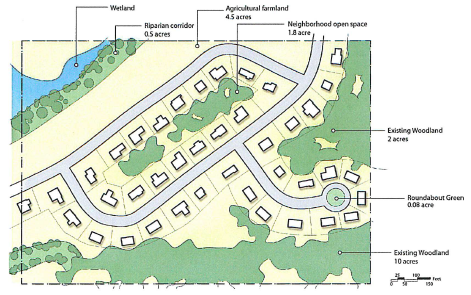
Purpose: a conservation subdivision is a development option that preserves agricultural land, natural resources, and rural character. The standards provide for low development impacts, while providing design flexibility and eliminating standards that would require unnecessary consumption of land. The site characteristics conserve important site features such as open space networks and contiguous woodland habitats adjacent to other existing open space tracts. The site design should encourage connectivity between environmental characteristics of adjacent properties and provide a continuous open space network between the proposed development layout and the adjacent properties. Intermodal trails which provide a link to adjacent properties as an enhancement of recreational opportunities are encouraged. Because the development standards are flexible, development costs per lot are significantly lower than conventional options, and lot yield is typically higher. Conservation street designs are provided in article 3 of this chapter.
(1)
Lot yield. The number of lots that may be developed under a Conservation Design approach are based on —
a.
A maximum density of one dwelling unit per five acres. To maintain design flexibility and to maximize open space and rural character, minimum lot size requirements do not apply, and
b.
The conservation areas provided (see subsection (2), below).
(2)
Conservation areas.
a.
Amount. As a baseline, at least 60 percent of the site shall be preserved as conservation areas. This percentage establishes a baseline requirement that is adjusted based on the quality and value of the conservation space, based on conservation units (see below).
1.
Determine the number of conservation units within the conservation areas as follows:
2.
Determine the conserved portion of the development as follows:
C = S * (0.6 x U), where
C = conserved portion of the development
S = site area (prior to subdivision)
U = conservation units
b.
Excluded areas. The following areas do not qualify as conservation units:
1.
Stormwater detention areas or artificial water bodies;
2.
Septic recovery areas, except as provided in subsection 89-8(c)(2)(d); or
3.
Lawns or planted areas located on private lots.
c.
Agricultural land.
1.
Farm structures shall be retained whenever possible.
2.
The subdivision or development layout shall retain existing farm operations within the conservation area.
d.
Stormwater management and septic areas.
1.
Septic recovery areas and stormwater management facilities may be counted as part of a conservation area if —
A.
The area is maintained by the homeowners' association; and
B.
The applicant demonstrates, by a report submitted by a registered professional engineer, that:
i.
there is no adverse impact to the character of that area of land, such as —
ii.
increased runoff, or
iii.
impairment of water quality, or
iv.
a decrease in existing tree cover, and
v.
the developed area of the site is inadequate to accommodate these facilities.
2.
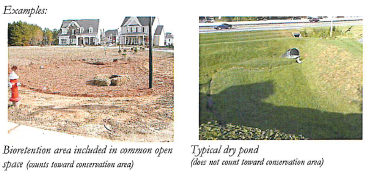
Dry ponds with associated steep slopes, dams, mowed areas, fencing or unsightly overflow structures do not count toward the required conservation area.
3.
Farm ponds, bioretention ponds, naturally contoured ponds and wet ponds with wetland edges and no visible structures may count as part of a conservation area.
4.
Septic recovery areas may count as part of a conservation area if -
A.
They are maintained by the homeowners' association, and
B.
Designed so that they are visually integrated with the existing landscape.
(3)
Preservation of conservation areas. See § 89-40(e).
(4)
Continuity of conservation areas.
a.
Fragmentation of the conservation area into small, irregularly shaped conservation parcels and lots is prohibited.
b.
Naturally contiguous conservation areas shall not be divided for the sole purposes of obtaining allowable density.
c.
Conservation areas shall connect with existing and potential conservation areas on abutting sites to encourage corridors of compatible site characteristics, unless it is found to be impractical due to topography, spacing or existing natural barriers.
Sec. 89-9. - "RS" Residential Single-Family.
Purpose: the "RS" districts implement the Residential future land use category of PlanLafayette by providing for predominantly detached, single family neighborhoods. The dimensional standards accommodate a variety of densities and lot sizes.
(a)
Permitted uses. See § 89-21.
(b)
Dimensional standards.
⇔ Refer to Article 3 for rules and measurement of building height, lots, and setbacks.
* For corner lots, see §89-38(c)(6)(g)
(1)
Required front, side, and rear setbacks must be planted in grass or other planting except for required ingress and egress.
(2)
For buildings adjacent to substandard streets, an additional setback may apply (see article 3, § 89-38).
(3)
Non-residential uses in the RS district are subject to the same standards as residential uses, except as provided in article 5.
(4)
For any subdivision of three or more lots zoned RS-2 with lot widths less than 40 feet, an alley will be required and access must be provided by that alley. Lot widths greater than or equal to 40 feet can be serviced by alleys and/or driveways. Notwithstanding the foregoing, in the discretion of the administrator, the use of driveways is permissible as an alternate to the alley requirement where feasible and aesthetically appropriate.
(5)
For wedge-shaped lots or lots fronting on a cul-de-sac, the minimum lot frontage in RS-1 shall be 25 feet.
(Ord. No. JO-024-2021, § 3(Exh. C), 7-20-21)
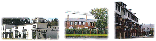
Sec. 89-10. - "RM" Residential Mixed.
Purpose: the "RM" districts implement the Mixed Residential and Residential future land use categories of PlanLafayette by providing for a wide range of housing types, from single-family detached units to apartments. The dimensional standards accommodate a variety of densities and lot sizes.

(a)
Permitted uses. See § 89-21.
(b)
Dimensional standards
(1)
Maximum density for attached or zero lot line (dwelling units per gross acre) is as follows:
(2)
Notwithstanding that there is no minimum lot size in the RM zoning district, each detached Single-Family Residence in the RM zoning district shall be subject to a minimum lot size of 3,000 square feet, and each detached Single-Family Residence in the RM-2 zoning district shall be subject to the same alley requirements as the RS-2 zoning district.
(3)
Building entrances shall face the street or an interior courtyard, except for interior units that are screened from the street by street facing buildings. The rear of buildings shall not face the street.
(Ord. No. JO-004-2023, § 3(Exh. C), 2-1-23)
Sec. 89-11. - "MN" Mixed-Use Neighborhood.
Purpose: the 'MN" district —
• implements the Transitional Mixed-Use future land use category of PlanLafayette,
• provides an opportunity to establish neighborhood retail, convenience, service, office, and institutional uses in the Residential and Mixed Residential categories,
• provides a transition between residential areas and more intense commercial corridors, and
• provides opportunities for pedestrian access between residential and commercial areas.
Each district has type "A" (urban) and type "B" (suburban) development types, as described and permitted in § 89-6.
(a)
Permitted uses. See § 89-21.
(b)
Dimensional standards.
(c)
Whenever a setback greater than the maximum setback established by this Section is required under § 89-38(e), the setback requirements of § 89-38(e) shall supersede the maximum setback established in this Section. In that case, the setback required under § 89-38(e) shall be the maximum setback.
(d)
In the MN district, no sound shall be amplified outside of the confines of a building.
(e)
Drive-in and drive-through establishments are subject to article 5, § 89-80.
(f)
For frontages on minor arterials, collectors, or local streets: if the width of the front lot line is 100 feet or less, the buildout requirement is reduced by ten percentage points.
(g)
For frontages on major arterials: the frontage buildout requirement is reduced to 40 percent for corner lots.
(h)
For a single-family detached dwelling, the minimum setbacks shall be subject to the same minimum setbacks as the "RM" Residential-Mixed zoning district.
(i)
Corner lot developments will use highest classified road, as determined by LCG, when determining frontage buildout and setback requirements.
(j)
A detached single-family residence in the MN zoning district shall be subject to a minimum lot size of 3,000 square feet.
(Ord. No. JO-024-2021, § 3(Exh. C), 7-20-21; Ord. No. JO-067-2024, 11-18-24)
Sec. 89-12. - "MX" Mixed-Use Center.
Purpose: the "MX" districts implement the Mixed-Use Center future land use category of PlanLafayette for centers outside of downtown. This includes a wide range of commercial, institutional and residential uses, and development design and intensity that supports walkable streets and transit. MX districts are part of approved mixed-use centers (MUCs) (see § 89-28). The MX district is divided into subdistricts based upon the development context, and the location of a lot on an "A" or "B" Street.
⇔ See article 3, § 89-28 (Mixed-Use Center Design Standards) for processes and standards for designating mixed-use centers and master plan elements such as MX subdistricts and "A" and "B" streets.
⇔ See article 3, § 89-29 (Mixed-Use Building Standards) for building design standards that are referenced in this section. These include minimum buildout, entryways, facade design, and architectural features.
(a)
Permitted uses. See § 89-21.
(b)
Dimensional standards
(1)
Generally. This section establishes dimensional standards for each MX district. These standards are keyed to the standards defined in § 89-28Article 3, § 89-29. For development that is subject to a Master Site Plan and a development agreement, the LCG may designate the applicable dimensional standards in the development agreement.
(2)
MX-1. MX-1 provides a high level of density, intensity and design to reflect the more urban character of Mixed-Use Centers in the LCG's established neighborhoods.
(3)
MX-2. MX-2 provides an opportunity for mixed-use development in the edges of the city, or for projects that annex to the city, at a lower scale and intensity than MX-1.
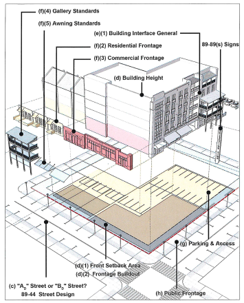
Sec. 89-13. - "D" Downtown.
Purpose: the "D" district implements the Mixed-Use Center future land use category of PlanLafayette. This provides the highest density and intensity in the City and Parish, and preserves its unique character and function.
(a)
Permitted uses. See § 89-21.
(b)
General provisions.
(1)
Intent.
a.
To provide development standards that enhance and protect the core downtown amenities of vibrancy as characterized by human activity and interaction; convenience to one's daily needs; and public space as defined by high quality outdoor rooms.
b.
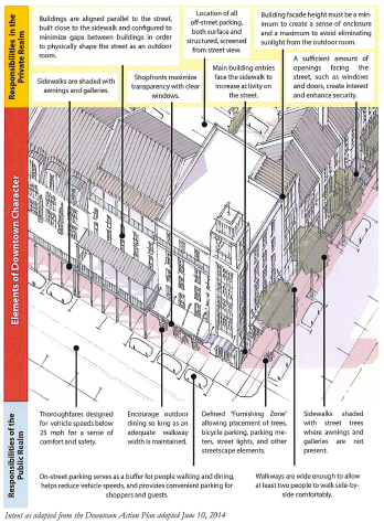
To ensure the appropriate character and function for private property having the following characteristics:
1.
Buildings are aligned parallel to the street, built close to the sidewalk, and configured to minimize gaps between buildings in order to physically shape the street as an outdoor room.
2.
Sidewalks are shaded with awnings and galleries.
3.
Shopfronts maximize transparency with clear windows.
4.
Location of all off-street parking, both surface and structured, screened from street view.
5.
Main building entries face the sidewalk to increase activity on the street.
6.
Building facade height must be a minimum to create a sense of enclosure and a maximum to avoid eliminating sunlight from the outdoor room.
7.
A sufficient amount of openings facing the street, such as windows and doors, create interest and enhance security.
c.
To ensure the appropriate character and function for the public realm having the following characteristics:
1.
Thoroughfares designed for vehicle speeds not to exceed 25 mph for a sense of comfort and safety.
2.
Encourage outdoor dining so long as an adequate walkway width is maintained.
3.
Defined "Furnishing Zone" allowing placement of trees, bicycle parking, parking meters, street lights, and other streetscape elements.
4.
Sidewalks shaded with street trees where awnings and galleries are not present.
5.
On-street parking serves as a buffer for people walking and dining, helps reduce vehicle speeds, and provides convenient parking for shoppers and guests.
6.
Walkways are wide enough to allow at least two people to walk side-by-side comfortably.
(c)
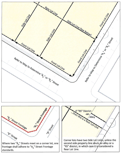
Establishment of lot lines and ADand BDStreets.
(1)
Definition of front lot line(s): A Front Lot Line is the front or side (in the case of a corner lot) lot line along a public street or pedestrian right-of way. All lots shall have at least one front lot line.
(2)
Definition of side and rear lot lines: Side and Rear Lot Lines are established as follows:
a.
Side Lot Lines are established between adjoining lots.
b.
Rear lot lines are those that do not intersect with a front lot line or that abut an alley.
c.
Corner lots have two side lot lines, unless the second side lot line abuts an alley or a residential district in which case it is considered a rear lot line.
(3)
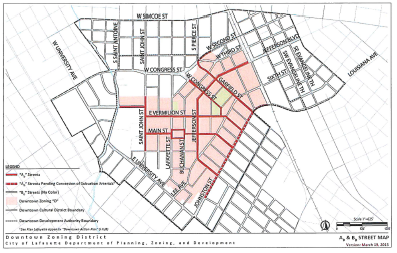
Establishment of ADand BDstreets: All existing and future streets and pedestrian rights-of-way within and immediately adjacent to this zoning district shall be classified as either an "A D " Street or "B D " Street where:
a.
"A D " Streets are designed at the highest standards for vibrancy as characterized by human activity and interaction, and public spaces defined by high quality outdoor rooms.
b.
"B D " Streets allow for reduced Frontage standards allowing for more flexibility and a limited vehicular interface.
c.
Corner lots have two Front Lot Lines. Where two "B D " Streets meet, one frontage shall adhere to "A D " Street Frontage standards.
(4)
ADand BDStreets Map: An official A D and B D Street Map as adopted and amended from time to time by the provisions of this ordinance is provided below:
(d)
Building placement.
(1)
Setbacks
a.
Front setback: Maximum 10.0 feet.
1.
Front setback area: The area within the front setback shall be the Front Setback Area and shall be used for:
A.
Placement and articulation of the building Facade;
B.
Establishing required minimum public walkways;
C.
Providing additional sidewalk space for outdoor dining and other commercial-related activities,
D.
Street furniture and non-permanent planters; and
E.
In the case of a Residential Frontage, landscaped yards and building access such as porches and stoops.
2.
Required front setback for walkway: Where a minimum Public Walkway width requirement has not been met, a setback is required in accordance with Building Interface and Public Frontage Standards.
3.
Required front setback at corner: To ensure adequate pedestrian circulation and visibility at corners, corner lots shall maintain a minimum corner setback formed by the line joining two points measured 20.0 feet along the edge of pavement on each side to their intersecting point.
4.
Corner line of sight: All Required Lines of Sight shall be calculated at no higher than a 25 mph design speed as determined by PW.
5.
Notwithstanding anything herein to the contrary, where a walkway encroaches onto private property, the maximum setback shall be ten feet from the interior line of such walkway.
b.
Side setback: There shall be no required setback where a Party Wall is built at the lot line, otherwise a minimum 3.0 foot side setback is required where:
1.
No party wall is to be built, or
2.
The abutting lot is zoned Residential.
c.
Rear setback: Minimum setbacks from a rear lot line shall be as follows:
1.
12.0 feet from the center-line of an alley, or
2.
10.0 feet from a rear lot line adjoining another Downtown parcel or Commercial district, or
3.
20.0 feet from a rear lot line adjoining a lot zoned Residential.
d.
Secondary building setbacks: On lots with more than one building and where the Frontage Buildout requirements of this district have been met, additional buildings on a lot shall not be subject to the front setback and Frontage Buildout requirements.
(2)
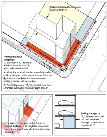
Frontage buildout.
a.
Frontage buildout: The facade of a building shall be built to a minimum percentage of the front lot line width within the maximum allowed front setback as follows:
1.
For frontages on an "A D " Street with a front lot line width of 100.0 feet or less, a minimum of 80 percent of the facade must be built within the front setback area.
2.
For frontages on a "A D " Street with a lot widths greater than 100.0 feet, a minimum of 90 percent of the facade must be built within the front setback area; provided, however, that in calculating lot width, neither areas dedicated to a side setback nor, in the case of a corner lot, areas dedicated to a walkway that encroaches upon private property shall be counted.
3.
For frontages on a "B D " Street: a minimum of 40 percent of the facade must be built within the front setback area.
4.
Pedestrian passages and vehicular access through buildings having habitable space built above them to a minimum depth of 18.0 feet and within the front setback area shall be counted toward minimum frontage buildout requirements.
b.
Building depth: The frontage buildout shall be built to the minimum building depth from the front facade as follows:
1.
Parking garages along "B D " Streets shall build out their required frontage buildout to a minimum building depth of 12.0 feet.
2.
All other buildings shall be built to the minimum depth of 18.0 feet.
3.
The building depth shall be habitable space as described in subsection (f)(1) building interface general.
c.
Facade alignment: Facades facing the front lot line shall be built parallel to the front lot line or to the tangent of a curved front lot line.
d.
Building footprint: The maximum building footprint on a lot shall be 90 percent of the lot unless the lot is less than 10,000 square feet or has alley access, in which case it shall have no maximum.
(e)
Building height.
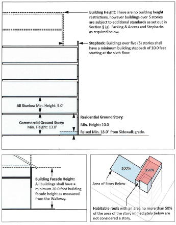
(1)
Building height: There are no maximum building heights within the Downtown district except as they are limited by the following:
a.
Parking for buildings over five stories: buildings over five stories shall be subject to additional parking standards as set forth in subsection (g) parking and access; and
b.
Stepbacks for buildings over five stories: Buildings over five stories shall have a minimum building stepback of 10.0 feet starting at the sixth floor.
(2)
Building facade height: All buildings shall have a minimum 20.0 foot building facade height as measured from the walkway. Building facade height for single story buildings shall be measured from the walkway to the top of a parapet or eaves line.
(3)
Habitable roofs: As described in section 89-27 Building height, habitable space within enclosed attics, towers, and penthouses with an area equaling 50 percent or less of the building area of the story immediately below shall not be counted as a story. Non-conditioned rooftop space, covered or uncovered, such as rooftop terraces and patios are permitted, but are not included as habitable space.
(4)
Building height exceptions: Elements that are exempt from building height regulations are as described in section 89-27 Building height.
(5)
Commercial ground story: Commercial ground stories shall have a minimum 12.0 foot floor to ceiling height or a 13.0 foot finished floor to second story finished floor height.
(6)
Residential ground story: Residential ground stories shall:
a.
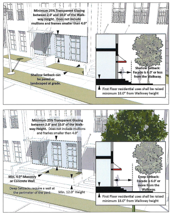
Be raised a minimum of 18.0 inches from sidewalk level; and
b.
Have a minimum 10.0 foot finished floor to finished floor.
(7)
Minimum story height: All stories shall have a minimum of 9.0 feet from finished floor to finished floor of story above.
(f)
Building interface.
(1)
General.
a.
Private frontage interface: The private frontage shall be established as the area within the front setback area from the front lot line up to and including the facade and the required habitable space.
b.
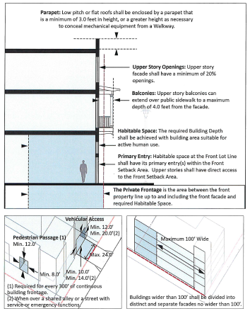
Habitable space: Habitable space is building area suitable for active human use such as residential, office, retail, and institutional uses. Parking and warehousing are examples of non-habitable space. The required building depth as described in subsection (d)(2), Frontage Buildout shall be habitable space.
c.
Primary building entry: Habitable space at the front lot line shall have its primary entry(s) within the front setback area. Upper stories shall have direct access to the front setback area.
d.
Private frontage interfaces: There are two possible private frontage types. Private frontages are limited to the following, and are to be designed in conformance to their applicable standards (as noted):
1.
Commercial frontage (f)(2).
2.
Urban residential frontage (f)(3).
e.
Frontage attachments: Galleries and awnings are not required. Galleries and awnings shall not overlap the walkway and/or encroach into the public right-of-way unless constructed in accordance with subsection (f)(4), Building interface: Gallery standards and subsection, (f)(5) Building interface: Awning standards.
f.
Upper story facade requirements.
1.
Glazing above the first story facade shall be a minimum of 20 percent of the facade wall area.
2.
Low pitch or flat roofs on new buildings shall be enclosed by a parapet that is a minimum of 3.0 feet in height, or as necessary to screen the view of mechanical equipment from the Walkway. Existing buildings shall screen mechanical equipment through a parapet or by other means.
3.
Upper story balconies can extend over public sidewalk to maximum depth of 4.0 feet. See section 78-4 (Right-of-way encroachments)
g.
Development over accessways: To achieve a connected street wall and for more efficient use of land, buildings may extend over pedestrian and vehicular accessways to internal blocks as follows:
1.
Required pedestrian passages shall form a continuous minimum at-grade opening of 12.0 feet sidewalk to ceiling height and a width of 8.0 feet.
2.
Vehicular access to structured and surface parking having the following unobstructed dimensions:
A.
A minimum opening height of 10.0 feet in height, or 14.0 feet in height when over a shared alley or street with service or emergency functions; and
B.
A minimum width of 12.0 feet, or a minimum width of 20 feet (18 feet curb face to curb face minimum) when over a shared alley or street with service or emergency functions. The maximum width of the opening shall be 24 feet.
h.
Required pedestrian passage: Any block length having 300.0 feet or more of continuous building frontage shall be required to have an unobstructed pedestrian passageway for emergency service access.
i.
Building facades: Buildings wider than 100 feet shall be divided into distinct and separate building facades no wider than 100.0 feet.
(2)
Building interface: commercial frontage.
a.
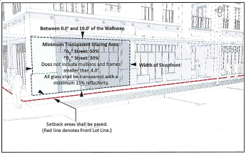
Minimum glazing: Facades along "A D " Streets shall be glazed with no less than 50 percent of the first story measured between the ground and 10.0 feet of the walkway. Facades along "B D " Streets shall be glazed with no less than 30 percent of the first story measured between the ground and 10.0 feet of the walkway. Mullions, muntin and frames that are no wider than 4.0 inches shall be included as part of the glazed area.
b.
Glass transparency: All glass shall be transparent with a maximum 15 percent reflectivity. Any window tinting, graphics, and interior affixed window shades that create a permanent opaque or translucent condition are prohibited, except for allowed signage.
c.
Setback landscaping: Setbacks shall be paved and shall be available for outdoor dining and furnishing where the minimum Walkway width is established as required in subsection (h)(3).
d.
Shading of private and public frontage: In addition to shade provided by street trees where they are provided, shading of the private and public frontage can be achieved through the combination of a gallery and/or awning frontage.
(3)
Building interface: urban residential frontage.
a.
Minimum glazing: Facades shall be glazed with no less than 25 percent of the first story measured between 2.0 feet and 10.0 feet of the Walkway.
b.
Glass transparency: All glass shall be transparent with a maximum 15 percent reflectivity. Window tinting and interior affixed window shades that create a permanently opaque or translucent condition are prohibited. Window shading and privacy can be achieved through interior adjustable window treatments, and/or operable exterior shutters.
c.
Raised ground story access: Access to the required minimum 18.0 inch raised residential ground story can be achieved through exterior or interior steps and ramping.
d.
Flex frontage: The raised residential ground story requirement shall be waived where:
1.
The ground story at the frontage to a minimum depth of 18.0 feet is built to a commercial building standard;
2.
No other residential room is at the frontage;
3.
There is a separate entry for the Residential and Commercial areas of the building, and a lockable interior connection between the areas.
e.
Shallow setback landscaping: After minimum walkway requirements are met, setbacks less than 6.0 feet may be landscaped or paved.
f.
Deep setback landscaping: After minimum walkway requirements are met, setbacks over 6.0 feet of the walkway shall be landscaped.
g.
Deep setback planter wall: After minimum walkway requirements are met and where setbacks from the walkway are greater than six feet, a required landscaping wall shall be built at the perimeter of the yard, measuring a minimum 12.0 inches in height and 4.0 inches in depth. A side wall is not required where the planter wall is continuous with an abutting yard.
(4)
Building interface: gallery standards.
a.
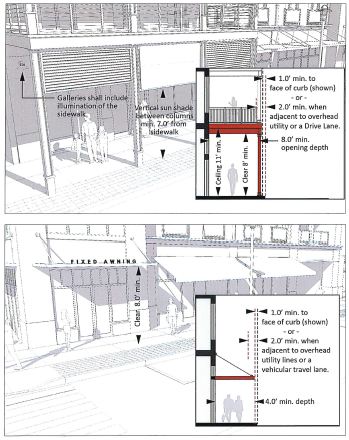
Gallery standards: Galleries may not cover the public frontage unless the following standards are met:
1.
Galleries shall have the following minimum dimensions:
A.
Depth: 8.0 feet
B.
Height to ceiling: 11.0 feet
C.
Clear height: 8.0 feet
2.
Galleries are not permitted above the third story.
3.
No element of a gallery shall encroach closer than 1.0 foot to the face of curb, or 2.0 feet when adjacent to overhead utilities or a Drive Lane (as opposed to a Parking Lane).
4.
All gallery roof overhangs above 20.0 feet from the sidewalk can be built to the face of curb where overhead utilities are not present.
5.
Galleries shall have a consistent depth.
6.
Galleries may include a vertical shade between columns to within 7.0 feet of the sidewalk.
7.
Galleries shall include illumination of the sidewalk.
8.
Galleries shall not be built over an electrical transformer.
9.
When built within the public right-of-way, galleries are subject to applicable agreements with LCG and utility providers.
(5)
Building interface: awning standards
a.
Awning standards: Awnings may not cover the public frontage unless the following standards are met:
1.
Awnings shall have a minimum depth of 4.0 feet from the facade.
2.
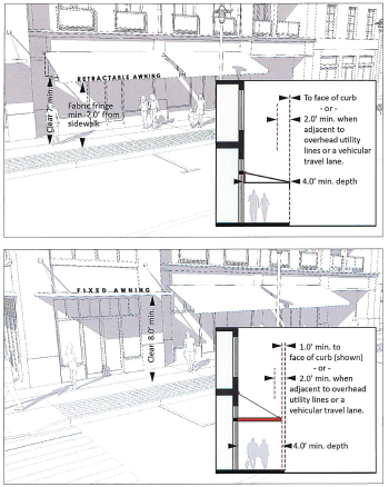
Retractable awnings may cover sidewalks to the face of curb and to a minimum height of 7.0 feet from the sidewalk.
3.
Fixed awnings shall be built to a minimum height of eight feet from the sidewalk and to within a minimum of 1.0 feet of the curb.
4.
Awnings shall not extend closer than 2.0 feet from the face of curb when adjacent to overhead utility lines or a drive lane (as opposed to a parking lane).
5.
The fabric fringe of an awning may extend as a vertical shade to within 7.0 feet of the sidewalk where it does not impede the walkway.
6.
Fixed awnings shall not be built over an electrical transformer.
7.
When built within the public right-of-way, awnings are subject to applicable agreements with LCG and utility providers.
(g)
Parking and access.
(1)
Vehicle parking space requirements:
a.
There shall be no minimum parking space requirements for all buildings of five stories or less.
b.
For buildings over five stories, parking shall be provided on the lot, screened from the walkway as per the provisions of this code, and the minimum number of required parking spaces for the entire building shall be as follows:
1.
Retail: Three spaces/1,000 sf
2.
Office: Two spaces/1,000 sf
3.
Residential: One space/Unit
4.
Accommodations: One space/room
(2)
Location of off-street parking: Off-street parking shall not be viewable from the walkway unless the following conditions are met:
a.
Parking garage standards subsection (g)(3), or
b.
Parking screen standard subsection (g)(4).
(3)
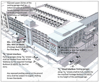
Parking garage standards: The following applies to parking garages:
a.
Parking garages along "B D " streets shall be masked from view of the walkway by the required frontage buildout subsection (d)(2) for the first story. The remainder of the garage may be unmasked provided the following standards are met:
1.
Upper stories of the parking garage shall have a facade where all openings are vertically proportioned.
2.
Any exposed parking spaces at the ground story shall be subject to subsection (g)(4) Parking screen standards.
b.
Parking garages along "A" streets shall be fully masked by the required frontage buildout subsection (d)(2) to the height of the parking garage.
(4)
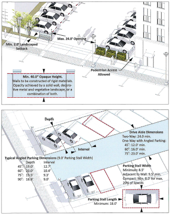
Parking screen standards.
a.
Opaque height: 40.0 inches minimum, 8.0 feet maximum vertical distance from the top of the walkway.
b.
Material: Rigid opaque materials to minimum depth of 4.0 inches, and to the minimum height after which other materials may be used to the maximum height. Decorative metal in combination with vegetative landscaping can be used in place of rigid materials. Chain-link and wood fences are not permitted. Vegetative landscaping shall achieve and maintain the required minimum opaque height within one year of installation.
c.
Setback landscaping: Parking screens shall be set back a minimum of 2.0 feet from the walkway and may be landscaped or paved. In no case shall a parking screen be set closer to the walkway than the building facade.
d.
Parking screens shall allow openings no wider than 24.0 feet for vehicles, and provide openings as needed for pedestrian access along the rear of the building.
(5)
Parking and loading access.
a.
Loading facilities and service areas shall not be visible along "A D " Street Walkways.
b.
Loading facilities and service areas are permitted within the front setback area of a building on a "B D " Street, but shall not count toward the required frontage buildout.
c.
Garbage enclosures shall not be visible from view of a walkway.
d.
Where a lot abuts an alley, parking shall be accessed from the alley.
e.
Drive aisle dimensions: Minimum 24.0 feet for two way traffic. One-way drive aisles are allowed only for angled parking (both back-in/head-out and head-in/back-out) with dimensions as follows:
1.
45° parking stall: minimum 12.0 foot drive aisle
2.
60° degree parking stall: minimum 16.0 foot drive aisle
3.
75° degree parking stall: minimum 23.0 foot drive aisle
4.
Where drive aisle does not abut parking space: minimum 18.0 foot drive aisle.
f.
Parking stall dimensions:
1.
Width as measured on-centre: Minimum 8.0 feet, typically 9.0 feet, or a minimum 9.5 feet to accommodate door openings where the side of a stall is directly adjacent to a wall or vertical element over 6.0 inches in height.
2.
Length: Minimum 18.0 feet.
g.
Vehicular entrances to off-street parking lots and parking garages shall be no wider than 24.0 feet at the front lot line.
(h)
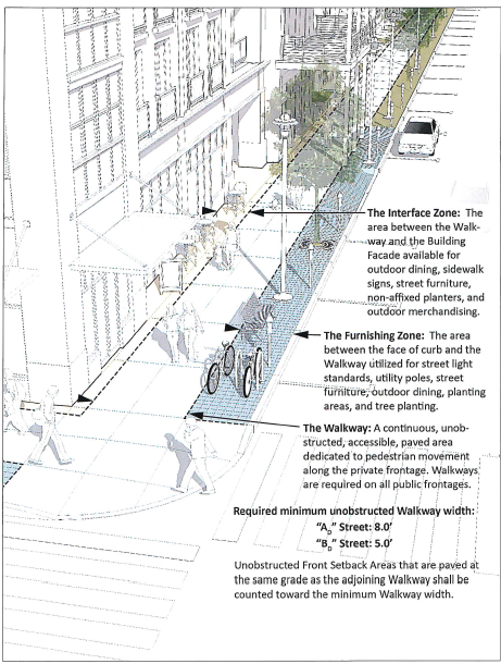
Public frontage.
(1)
Public frontage: The public frontage shall be established as the area between the front lot line and the face of curb.
(2)
Public frontage components: The public frontage has three primary components.
a.
The furnishing zone: The area between the face of curb and the walkway utilized for street light standards, utility poles, street furniture, outdoor dining, planting areas, and tree planting.
b.
The walkway: A continuous, unobstructed, accessible, paved area dedicated to pedestrian movement along the private frontage. Walkways are required on all public frontages.
c.
The interface zone: The area between the walkway and the building facade (not including residential yards) available for outdoor dining, sidewalk signs, street furniture, non-affixed planters, and outdoor merchandising.
(3)
Minimum walkway widths: Minimum, unobstructed walkway widths shall be established as follows:
a.
A minimum of 8.0 feet on "A D " Streets.
b.
A minimum of 5.0 feet on "B D " Streets.
c.
Unobstructed front setback areas that are paved at the same grade as the adjoining walkway shall be counted toward the minimum walkway width.
d.
Bollards installed for pedestrian safety shall not be considered an obstruction to a walkway.
e.
Non-permanent outdoor dining may encroach into an "A D " Street Walkway provided that a minimum 5.0 feet clear is maintained.
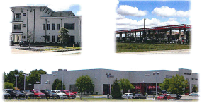
Sec. 89-14. - "CM" commercial mixed.
Purpose: the "CM" district implements the commercial/office future land use category of PlanLafayette. This district provides for compact development patterns and pedestrian friendly design features.
The "CM" districts are divided into two types:
• CM-1, which is smaller in scale, and is compatible in massing and buildout with nearby single-family neighborhoods, and
• CM-2, which accommodates a more intense mix of uses and taller, or "high-rise," residential with an urban form.
Each district has type "A" (urban) and type "B" (suburban) development types, as described and permitted in section 89-6.

(a)
Permitted uses. See section 89-21.
(b)
Dimensional standards.
(c)
Whenever a setback greater than the maximum setback established by this section is required under section 89-38(e), the setback requirements of section 89-38(e) shall supersede the maximum setback established in this section. In that case, the setback required under section 89-38(e) shall be the maximum setback.
(d)
The minimum frontage buildout established by this section may be reduced to the extent necessary to satisfy any other requirement of this chapter.
(e)
For frontages on minor arterials, collectors, or local streets: if the width of the front lot line is 100 feet or less, the buildout requirement is reduced by ten percentage points.
(f)
For frontages on major arterials: the frontage buildout requirement is reduced to 40 percent for corner lots.
(g)
Corner lot developments will use highest classified road, as determined by LCG, when determining frontage buildout and setback requirements.
(h)
Parking reduction for "A" development types. The following provisions apply:
(1)
The number of parking spaces required by section 89-39(g) is reduced by 50 percent.
(2)
The administrator may further reduce the number of spaces as needed to accommodate reductions in space attributable to the placement of buildings required by the front/corner street setback and minimum frontage buildout.
Note: For permitted and conditional uses in the CM (CM-1 and CM-2) districts, see section 89-21. See article III for specific rules, measurement standards, and alternatives for development standards such as open space, setbacks, bulk plane, and buffers and landscaping (in particular, see section 89-36 for alternative standards relative to tree distribution in vehicular use areas, reduced parking lot landscaping requirements, tree preservation credits, increased buffer thresholds and reduced buffer widths). Refer to section 89-80 for standards for drive-in and drive-through establishments.
Sec. 89-15. - "CH" commercial-heavy.
Purpose: The "CH" district implements the commercial/office future land use category of PlanLafayette. The district allows compact development patterns, but provides flexibility for front parking, loading, and building design features for heavy commercial or service-oriented uses (such as large format retailers, auto dealerships, and repair services). PlanLafayette provides that the commercial office future land use category is principally a pedestrian oriented area. This district should only be used for locations where these uses currently exist, or where a rezoning applicant demonstrates that there is unmet market demand for the use.
(a)
Permitted uses. See section 89-21.
(b)
Dimensional standards.
(1)
Maximum density is 25 dwelling units per gross acre. This applies to mixed-use buildings or to residential uses permitted in the district.
(2)
A buffer may be required (see article 3section 89-36).
(3)
Front, side, and rear setbacks must be planted in grass or other plantings except for required ingress and egress.
(4)
For buildings adjacent to substandard streets, an additional setback may apply (see article 3section 89-38).
(c)
Whenever a setback greater than the maximum setback established by this section is required under section 89-38(e), the setback requirements of section 89-38(e) shall supersede the maximum setback established in this section. In that case, the setback required under section 89-38(e) shall be the maximum setback.
(d)
Corner lot developments will use highest classified road, as determined by LCG, when determining frontage buildout and setback requirements.
(e)
Parking reduction for "A" Development Types. The following provisions apply:
(1)
The number of parking spaces required by section 89-39(g) is reduced by 50 percent.
(2)
The administrator may further reduce the number of spaces as needed to accommodate reductions in space attributable to the placement of buildings required by the front/corner street setback and minimum frontage buildout.
Note: For permitted and conditional uses in the CH districts, see section 89-21. See article III for specific rules, measurement standards, and alternatives for development standards such as open space, setbacks, bulk plane, and buffers and landscaping (in particular, see section 89-36 for alternative standards relative to tree distribution in vehicular use areas, reduced parking lot landscaping requirements, tree preservation credits, increased buffer thresholds and reduced buffer widths). Refer to section 89-80 for standards for drive-in and drive-through establishments.
Sec. 89-16. - "IL" industrial-light.
Purpose: the "IL" district implements the Office/Industrial future land use category of PlanLafayette by accommodating existing light industrial uses, and encouraging new light industrial or office park employment uses in locations designated in the plan. Buffering is required in article 3.

(a)
Permitted uses. See section 89-21.
(b)
Dimensional standards.
(1)
A buffer may be required (see article 3, section 89-36).
(2)
Front, side, and rear setbacks must be planted in grass or other planting except for required ingress and egress.
(3)
For buildings adjacent to substandard streets, an additional setback may apply (see article 3, section 89-38).
Sec. 89-17. - "IH" industrial-heavy.
Purpose: the "IH" district implements the Office/Industrial future land use category of PlanLafayette by accommodating existing and future heavy industrial uses. Buffering is required in article 3.

(a)
Permitted uses. See section 89-21.
(b)
Dimensional standards.
(1)
A buffer may be required (see article 3, section 89-36).
(2)
Front, side, and rear setbacks must be planted in grass or other plantings except for required ingress and egress.
(3)
For buildings adjacent to substandard streets, an additional setback may apply (see article 3, section 89-38).
Sec. 89-18. - "PD" planned development.
Purpose: the "PD" district gives the LCG, property owners, and developers the opportunity to proceed with development that —
• cannot meet the standards in one of the base zoning districts, and
• is consistent with and accomplishes the policies of PlanLafayette, or a strong public need, and
• provides the LCG valid assurances that it will mitigate any anticipated impacts on the general public.
A PD rezoning requires legislative approval, which involves a high degree of discretion by the appropriate zoning commission.
(a)
Permitted uses. Permitted uses for a PD are designated in the ordinance approving the PD rezoning.
(b)
Dimensional standards. Dimensional standards for a PD are designated in the ordinance approving the PD rezoning
(c)
Minimum design requirements. The following are the minimum design requirements for a PD development. The applicant shall demonstrate how the development complies with these requirements in the concept plan.
(1)
Site relationship to immediate surroundings.
a.
The planned development's relationship to its immediate surroundings shall avoid adverse effects to surrounding development from traffic circulation, building height or bulk, lack of screening, or intrusions on privacy.
b.
Areas which cannot be feasibly serviced by necessary public services, including transportation, street maintenance, schools, police, fire, and utilities, shall not be approved for planned development.
c.
Adequate landscaping must be provided to reduce the visual impact of off-street parking areas and provide a logical transition between the planned development and surrounding uses. Landscaped buffers shall be provided to screen commercial and industrial uses when those uses differ from surrounding uses. Screening shall buffer potential adverse effects of light, noise or other undesirable elements that could disturb surrounding development.
(2)
Utilities.
a.
The developer shall provide water, sewer and electrical facilities for connection to a public utility which meets the standards established by Lafayette Utility System ("LUS").
b.
Wherever practical and feasible, all utilities shall be placed underground.
(3)
Off-street parking.
a.
Parking shall comply with article 3 and this section.
b.
Parking may be provided in grouped facilities to service several separate uses and consolidated facilities are encouraged.
c.
The placement and design of parking facilities shall be consistent with PlanLafayette's policies for multi-modal accessibility by pedestrians, cyclists or transit.
(4)
Circulation.
a.
Construction of the planned development shall include adequate, safe, and convenient arrangements for pedestrian circulation, streets, driveways, off-street parking and loading space.
b.
Public streets must serve the entire planned development. However, the where private roads would otherwise be allowed under this chapter, PW may approve private roads for a planned development if they meet minimum construction standards and can be used by police and fire department vehicles for emergency purposes.
c.
The geometric design of internal ways, streets and alleys shall be determined by sound planning and engineering standards. Consideration shall be given to special street widths, construction and paving requirements resulting from multi-modal access requirements within the planned development.
(5)
Common open space and civic space.
a.
Common open space and civic space shall meet or exceed the applicable requirements of article 3.
b.
The applicant shall designate the type, location, dimensions, and maintenance requirements for the common open space in the concept plan.
(6)
Compliance with subdivision design standards. The planned development shall be subject to all appropriate design, flood, and drainage standards in these regulations.
(d)
Application requirements. The following procedures apply to an application for PD rezoning:
(1)
Pre-application. Prior to submitting a formal application for planned development, a pre-application conference with the DPD is encouraged in order for the applicant to become acquainted with planned development procedures and related requirements.
(2)
Concept plan. The applicant shall include a concept plan with the rezoning application.
Sec. 89-19. - "PI-L" and "PI" public/institutional light and heavy.
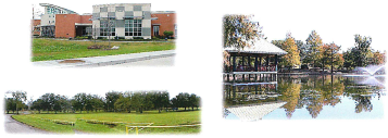
Purpose: the "PI-L", and "PI-H" districts are appropriate in any PlanLafayette land use category, and specifically implements the public park category. These standards provide flexibility for the wide range of potential public or institutional facilities.
(a)
Permitted uses in "PI-L", and "PI-H" . See section 89-21.
(b)
Dimensional standards.
(c)
Any references to "PI" throughout this chapter are intended to include PI-L and/or PI-H where applicable.
(Ord. No. JO-021-2022, § 2(Exh. B), 3-22-22)
Sec. 89-20. - Annexed territory.
(a)
Generally.
(1)
All territory that is annexed to the City of Lafayette is automatically assigned the "A" Agricultural classification until existing land uses are determined and a new zoning category is adopted.
(2)
In lieu of the "A" district, the applicant for annexation may provide an application for rezoning concurrent with any petition for annexation. If the proper notice is given, the zoning classification may be approved concurrent with final approval of the annexation, or after the annexation is complete.
(3)
Time limitations. Unless another district is applied at the time of annexation, the "A" district zoning classification will apply to that property until:
a.
The LCG initiates and approves a rezoning to another zoning district as provided in article 4.
b.
The owner or owners of property automatically zoned "A" may file an application to rezone the property as provided in article 4. The appropriate zoning commission will then proceed through normal zoning reclassification procedures.
c.
Property automatically zoned "A" is considered on a priority basis and shall be scheduled at the earliest possible scheduled regular meeting of the appropriate zoning commission.
Sec. 89-21. - Use table.
(a)
This section establishes the uses that are permitted in each zoning district. Each use is defined in subsection (d), below.
(b)
The Use Table (Table 89-21-2) establishes the following categories of uses:
(c)
If a use is not defined in this section, the administrator may authorize the use if —
(1)
The use is functionally the same as a listed use, or
(2)
The use has similar visual, traffic, environmental and similar impacts as an expressly listed use. The administrator may refer to empirical studies or generally accepted planning or engineering sources in making this determination. The burden is on the applicant to establish that the use is similar to the expressly listed use, or
(3)
Other comparably sized jurisdictions have successfully integrated the use in one or more equivalent zoning districts.
(4)
The use is within the same industry classification as another permitted use. In making this determination, the administrator may refer to the most recent edition of the North American Industry Classification Manual (Executive Office of the President, Office of Management and Budget, ("NAICS"). If the use is not defined in the NAICS, the Administrator may refer to the most recent addition of the American Planning Association, Land-Based Classification Standards LBCS Tables, or any other recognized and accepted publication in the industry.
Table 89-21-2 Use Table
(d)
The uses listed in the Use Table (Table 89-21) above are defined as follows:
(Ord. No. JO-024-2021, § 3(Exh. C), 7-20-21; Ord. No. JO-021-2022, § 2(Exh. B), 3-22-22; Ord. No. JO-024-2022, §§ 4,5, 4-19-22; Ord. No. JO-077-2022, § 3(Exh. C), 9-20-22; Ord. No. JO-004-2023, § 3(Exh. C), 2-1-23; Ord. No. CO-094-2023, §§ 3, 4, 10-3-23; Ord. No. JO-067-2024, 11-18-24)
Sec. 89-22. - Overlay districts.
A set of regulations which apply to a specific geographic area in addition to the underlying zoning districts and existing zoning and development regulations is commonly known as an "overlay district."
The Louisiana Avenue Zoning and Development Overlay District, The Louisiana Avenue Interstate 10 Zoning and Development Overlay District, and the University Avenue Zoning and Development Overlay District, shall remain in full force and effect. The standards for governing zoning and development within the overlay districts are set forth in Appendix A of this chapter.
(Ord. No. JO-021-2022, § 2(Exh. B), 3-22-22)
Sec. 89-23. - Historic districts.
The description of historic districts and any specific regulations related thereto are set forth in Appendix B of this chapter. These specific regulations are in addition to any applicable general historic preservation provisions in this chapter, as well as the underlying zoning districts and existing zoning and development regulations applicable thereto.
(Ord. No. JO-057-2023, § 2, 9-19-23)