
Lafayette City Zoning Code
ARTICLE 3
- DEVELOPMENT STANDARDS
Purpose: this article establishes general standards for all development in the parish, including both unincorporated areas and the city. Specifically, this article:
• Implements the Comprehensive Plan (PlanLafayette),
• Ensures that new development and redevelopment mitigates impacts on the neighborhood and community, and
• Ensures that development is consistent with best practices for public safety, community design, and PlanLafayette.
Sec. 89-25.- Generally.
(a)
Applicability.
(1)
This article applies to the City of Lafayette and the unincorporated areas of the parish, except where otherwise indicated. This includes applications for subdivision plat, rezoning, zoning application, conditional use, driveways, building, and work within the right-of-way permits.
(2)
This article applies to all developments, and to all rezoning, conditional use permits, subdivision plats, building permits, or certificates of occupancy, except where otherwise indicated.
(3)
No permits as described herein are required for LCG sponsored work with the exception of building permits for building work, but the standards herein do apply to all LCG sponsored work.
(b)
Standards.
(1)
Public facilities and improvements. The proposed development or use must be served by public utilities, fire protection, police protection or other public services.
(2)
LCG shall control the space allocation in street right-of-way and public servitudes.
(3)
LCG shall control the space allocation in utilities servitudes as recommended by LUS.
(4)
Suitability of land. A proposed subdivision plat, conditional use permit, or rezoning request that increases allowable density or floor area must be located outside of areas subject to flooding, or that are topographically unsuitable for development; or that for any other reason are being unwisely or prematurely subdivided or developed.
(5)
The developer and contractor responsible for the development shall acquire a free development permit from PW and LUS, if applicable, detailing the proposed improvements and adherence to these standards.
(6)
All public infrastructure shall be designed and constructed in accordance with the applicable technical references including but not limited to LCG's Public Infrastructure Design Standards, Construction Specifications and LUS's Electrical Service Specifications.
(c)
Variances or modifications.
(1)
A variance or modification to a standard in this Article may be granted by the agencies listed in Table 89-25-1 below -
Table 89-25-1 Variances
a.
The agency approving the permit where the standard is applied as noted within the subsection, or
b.
Any other agency or official designated in the section that establishes the standard, in which case subsection "a." above does not apply.
(2)
A variance may be granted only if the applicant demonstrates that —
a.
The variance, or an alternative standard proffered by the applicant, is consistent with PlanLafayette, and
b.
Practical difficulties in the development and adequate use of land would result from the literal enforcement of the standard, and
c.
The variance is in harmony with the general intent of the standard, and
d.
The variance is consistent with public interest, safety and the general welfare.
(3)
Any variance shall be in writing and specifically set forth in the permit issued.
(d)
Name of subdivision, development, and streets.
(1)
No subdivision shall bear the same name as another subdivision in the city or parish unless located on adjoining property.
(2)
LCG policy is to preserve and promote the French language in Acadiana. Residential, commercial, and industrial developments are encouraged to include French names and terms wherever possible, particularly in reference to street names.
(Ord. No. JO-024-2021, § 4(Exh. D), 7-20-21)
Sec. 89-26. - Access management and driveways.
Purpose: this section establishes standards for public roads and streets which ensure that they work efficiently and safely accommodate all modes of travel (including pedestrian, bicycles, transit, and cars). Action Item (1.3.2)
(a)
Applicability.
(1)
This section applies to the city and the unincorporated areas of the parish.
(2)
For developments along state routes, all requirements within this document apply as approved by the State.
(b)
Definitions. In addition to article 8, the terms and phrases used in this section are defined below:
(c)
Driveway permit.
(1)
Applicability. Before constructing, relocating or altering structurally any driveway on a public road, a permit shall be obtained from PW if the work is not associated with a commercial building permit or with a residential building permit within a development with subsurface drainage. However, no permit is required for the construction of any driveways installed as part of the paving or widening of any street in accordance with plans approved by PW.
(2)
Requirements.
a.
The grantee of any driveway permit shall furnish all materials, labor and equipment necessary for the construction of the driveways authorized in the permit. LCG shall not, as a policy, participate in the construction of any driveway, except when the driveway is part of an LCG sponsored project as set forth in subsection 1 above.
b.
The permit is subject to approval as to location, design and driveway materials, as well as pipe size and grade, by PW.
c.
All materials shall meet the specifications of LCG and shall be subject to approval of PW.
(3)
Indemnification. The grantee of any driveway permit shall hold harmless LCG, the Parish of Lafayette, the City of Lafayette, as applicable, its/their agents and employees against any action for personal injury or property damage sustained by reasons of the exercise of the permit.
(d)
Design and construction standards. The following design and construction standards are subject to modification for compatibility with urban development, such as that located in a Mixed-Use Center, or an MX, D, or MN district.
(1)
Number of driveways.
a.
Unless approved otherwise by PW, driveways must be spaced as indicated in the table below unless the speed limit on the adjacent roadway(s) is 30 mph or less and the lots are in a residential subdivision. Residential drives are permitted one per lot. Full access driveways may require modification (not allowing all movements) based on, but not limited to, sight distance, crash history, and the need for sufficient gaps.
b.
Joint access and cross access servitudes are required to maintain the driveway spacing in (a) above.
c.
A traffic impact analysis may be required by PW and/or the appropriate planning commission to determine information such as, but not limited to:
1.
The expected volume and direction of traffic from the project and from surrounding development, existing street capacity, the street capacity resulting from funded improvements at the time of development, offsetting mitigation resulting from internal capture of trips, pedestrian and bicycle improvements, and public transit, and
2.
Necessary improvements to existing and proposed roadway/driveway/parking lot infrastructure to accommodate trips generated by the proposed development in a safe, convenient and efficient manner.
(2)
Residential driveways.
a.
Residential driveways and/or parking pads shall be located no closer than three feet to any adjacent property lines and shall not conflict with line of sight regulations section 89-44(f) and shall not conflict with utilities servitudes. If the driveway or parking pad is designed and constructed to slope away from the adjoining side and/or rear property line, it may be constructed adjacent to the side and/or rear property line.
b.
Circular driveways or parking pads with both access points on the same street are permitted according to the following conditions:
1.
Existing or required sidewalk must be continued and maintained through the area according to applicable standards.
2.
The sidewalk must remain parallel to the street.
3.
If a green space is provided, it must be four-feet deep in relation to the street and at least ten-feet in length as measured by its point nearest the street.
(3)
Width.
a.
The width of entrance and/or exit driveways is measured at right angles to the driveway.
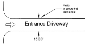
b.
Minimum and maximum driveway width is as follows:
c.
The area between driveways and on either side of the driveway shall remain unimproved for vehicular travel or parking. This area shall be considered restricted and may be filled only with sidewalks, landscaping, or stormwater facilities (as provided in subsection d, below). If a curb exists on the roadway, a permanent separation (i.e. 6" curb) from the roadway shall be present.
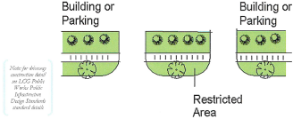
d.
The area between and on the side of entrances and exits, defined in subsection (c) as restricted areas, may be filled in or paved only when surface drainage is provided so that all surface water of the filled-in areas are carried away from the street roadbed in a suitable manner and the area does not interfere with any required landscaping or open space. The drainage opening beneath the filled-in area shall be adequate to carry the storm water, and the size of the opening and other design features shall be approved by PW.
(4)
Separation from street intersections.
a.
When measured along the curbline or edge of the roadway, no driveway shall be located nearer than 30 feet to the projection of any intersecting street right-of-way line.
b.
Commercial driveways must be at least 150 feet from a public street intersection.
c.
Commercial driveways must be right-in, right-out when intersecting a dedicated public street turn lane.
(5)
Angle of intersection with street. The angle formed by the intersection of the centerline of a two-way roadway and the centerline of a driveway shall be at least 60 degrees, except for an access driveway on frontage abutting a one-way street; then, the intersection of the centerlines shall be at least 45 degrees.
(6)
Sight distance along street. Refer to the street design standards (section 89-44(f)). All entrance and exit driveways shall be so located that vehicles approaching or using them will be able to obtain adequate sight distance in both directions along the street in order to maneuver safely and without interfering with traffic.
(7)
Parking pads adjacent to street right-of-way shall have a minimum length of 20 feet such that no part of the pad shall protrude into the street right-of-way.
(8)
Encroachment on adjoining property or facilities. No driveway shall encroach upon any adjoining property or city-parish facility. The relocation of city-parish facilities may be authorized, however, if the construction of a driveway, as authorized in this section, will encroach on the facility. In that case, the relocation shall be completed by and at the expense of the owner or lessee of the property. Any work done in the relocation shall comply with the specifications of LCG or the public utility having control of the facility to be relocated.
(9)
Separation of motor vehicle service structures from right-of-way. No service pump island, vendor stand or other structure designed or intended to be used to service motor vehicles shall be constructed closer than 20 feet to the street right-of-way.
(10)
Drainage. Drainage in gutters and side ditches shall not be altered or impeded, and the applicant for a permit under this division must provide, at his expense, suitable structures approved by PW.
(11)
Curbing, grades, sidewalk and driveway materials.
a.
The grades of the driveway and sidewalk shall be mutually compatible to provide an uninterrupted sidewalk grade for safe pedestrian movement and be in accordance with the Americans with Disabilities Act (ADA) and other applicable federal regulations.
b.
Maximum slope of a driveway within the right-of-way is 1:10.
c.
The driveway within the right-of-way shall be constructed of the same or more durable material as the adjoining street.
(12)
Driveways requiring motorists to back out onto street. A driveway shall not be constructed so as to force a motorist to back out into the street as a means of egress, except for driveways constructed for a single-family or two-family residence, but these must be built in accordance with the head-in/back-out parking requirements in section 89-39(i). Single and two-family residences shall have area within the property to turn around so a vehicle may pull out onto streets designated collector or higher.
(e)
Administration.
(1)
Inspections. PW may inspect driveways at or after the time of construction and require any changes needed to make the construction conform to applicable requirements. This subsection shall apply even if the driveway was constructed prior to its incorporation into the City of Lafayette or before the establishment of this section.
(2)
Correction of violations and assessment of costs.
a.
After proper notification to the owner, LCG may enter those areas declared to be in violation of this Section and effect repairs of the area as needed to protect the public.
b.
The administrator shall not undertake any work until the owner or occupant of the lot, business or use has had the opportunity to do the work within 30 days after proper notice is given. Notice must be given to the owner or occupant, or to the agent of the leased or occupied premises. Proper notice shall consist of notification by certified mail to the last known address of the owner as reflected by the assessor's tax rolls in and for the parish. If the property is not leased or occupied, the administrator must provide notice by advertisement in the city-parish official journal for two consecutive days.
c.
The actual cost to LCG in having the work performed, and any necessary, reasonable and required administrative charges, is declared to be a charge, cost or expense of the property, lot, place, structure, house, business or area where any repairs or maintenances are performed. Expenses shall be collected in the manner fixed by law for the collection of taxes and are subject to the same penalties for delinquencies. The administrator shall demand of the owner of the property the payment of such charges, costs or expenses, by written notice to the owner of the property. If the costs or expenses are not paid within 30 days after demand, the administrator shall, after due notice as stated in this section, send an attached bill of the costs and expenses to the support service manager for the LUS, who shall add the amount of the bill to the next tax bill of the owner. The administrator shall have recorded, in the mortgage office of the parish, an attached bill showing the cost and expense of the work and the place or property on which the work was done, so as to establish for LCG a lien and privilege securing the payment by the property owner of the charges, costs and expenses.
(3)
Removal of noncomplying culverts or drainage grates. After giving a property owner 30 days written notice of the noncompliance, LCG may remove and replace any culvert or drainage grate, with its accompanying drop inlet or curb inlet, for noncompliance with standards set by LCG. The cost and charges for these repairs are assessed in the same manner as outlined in subsection (2) above.
(f)
Maintenance.
(1)
Maintenance of sidewalks and bikeways passing through driveways. Where a sidewalk or bikeway passes through, traverses or intersects a driveway, commercial or residential, and becomes a part of the driveway, the maintenance and repair of that portion of the sidewalk or bikeway is the property owner's responsibility.
(2)
Responsibility for maintenance. The entire maintenance of any driveway, whether it is located on private or public property, or both, is the property owner's responsibility. This does not apply where damages are caused by failure of subsurface structures or utility connections owned by LCG or other utility. The maintenance responsibility includes the driving surface, the parking area and anything located within these areas, such as drainage grates, curb or drop inlets and sidewalks.
(g)
Abandoned driveways.
(1)
A driveway is "abandoned" if:
a.
The parking or land use is situated so that the driveway is not useable or not needed; or
b.
The buildings or other structures are remodeled or situated on the property so as to prevent a vehicle from parking completely on the property.
(2)
When a driveway is abandoned, PW may order the replacement of the curbing and/or sidewalk so as to effectively close the driveway.
(3)
When any abandoned driveway is closed for the reasons set forth in subsection (1) above, PW shall notify the property owner in writing of the work to be done. Upon notification thereof, the property owner shall proceed to perform such work at his/her own cost.
(4)
If, within 30 days after notification, work is not started on the installation of the curb and/or sidewalk as set forth in the notification, the work may be done by LCG and all costs thereof assessed to the property owner. The cost and charges for these repairs are assessed in the same manner as outlined in subsection (e)(2) above.
(City Code 1965, § 19-53(d); Ord. No. JO-077-2022, § 4(Exh. D), 9-20-22)
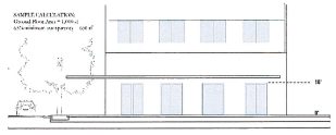
Sec. 89-27. - Building height and interface.
Purpose: This section establishes design guidelines that reinforce existing and/or desirable characteristics and ensure compatibility with surrounding properties. Action Items (1.2.1, 2.4.1, 3.13.1)
(a)
Building height.
(1)
Structure height is measured in number of stories.
(2)
A "story" is defined by LCG's adopted Building Code.
Note: the International Building Code defines a "story" as "that portion of a building included between the upper surface of a floor and the upper surface of the floor or roof next above (also see "Basement" and "Mezzanine"). It is measured as the vertical distance from top to top of two successive tiers of beams or finished floor surfaces and, for the topmost story, from the top of the floor finish to the top of the ceiling joists or, where there is not a ceiling, to the top of the roof rafters.
(3)
Notwithstanding the foregoing, when the maximum number of stories is regulated in article 2 of this chapter, the maximum story height shall be 14 feet.
(4)
An attic is not a story if at least 50 percent of the attic floor area has a clear height of less than seven and one-half (7.5') feet, measured from the finished floor to finished ceiling.
(5)
Where a lot slopes downward from the front property line, one story that is additional to the specified maximum number of stories may be built on the lower, rear portion of the lot.
(b)
Bulk plane.
(1)
The zoning district regulations (article 2) establish bulk plane requirements for each zoning district. The bulk plane establishes a setback line for buildings and structures based on their height and distance from the side or rear setback line.
(2)
The bulk plane requirements have three elements:
a.
Starting point. This is the point from which the bulk plane is measured. It is measured in stories above the setback line. For purposes of this subsection, a story is considered 12 feet in height measured from average grade if a building is below the maximum height at the starting point. For example, the bulk plane requirement may specify three stories for the first 20 feet from the setback. The starting requirement in that instance is three stories above average grade at the setback line. If a building is only one or two stories at the setback line, the starting point is 36 feet (3x12).
b.
Bulk plane limit line. This is an imaginary line measured from the starting point to the ending point, which establishes the maximum building height based on the building's distance from the starting point.
c.
Ending point. The zoning district regulations may establish a point beyond which the bulk plane requirements do not apply. There is no limit on building height beyond that point.
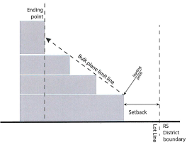
(3)
For purposes of measuring the bulk plane, the side or rear setback line refers to a minimum setback line, and not a maximum setback line.
(c)
Height exceptions. The following accessory structures are not subject to the height limits in the bulk plane (subsection (b) above):
(d)
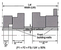
Frontage buildout.
(1)
Frontage buildout refers to the distance that a building is required to be constructed within the front setback area, expressed as a percentage and measured as follows:
FB = BW ÷ FLL
Where FB is the frontage buildout, BW is the length of building elevations (or other elements as permitted below, and FLL is the front lot line).
(2)
The following elements are counted toward the frontage buildout requirements if the Administrator finds that existing restrictions such as easements, unusually narrow lot widths, or environmental constraints would prohibit the construction of an economically viable building size:
* "Minimum Height" means the minimum height of the frontage element structure within
the maximum setback area or co-planar with the facade if required above.
** "Maximum Extent" is the percent of the frontage buildout that may be occupied by
a frontage element in lieu of a building facade.
(3)
Unless alley access is available, the frontage buildout is reduced as needed to accommodate the minimum width of a driveway (see § 89-26, "Access Management and Driveways," for required driveway widths).
(4)
Where existing buildings on a lot or parcel are nonconforming as to a maximum front setback, existing buildings to expand on any side or new buildings may be constructed, subject to all other provisions of the LDC, if the frontage buildout is not further reduced.
(Ord. No. JO-021-2022, § 3(Exh. C), 3-22-22)
Sec. 89-28. - Mixed use center design standards.
Purpose: this section establishes guidelines and provides standards for Mixed Use Centers.
(a)
Application.
(1)
The MUC is subject to a master site plan. The master site plan shall demonstrate compliance with the standards listed in this chapter and may include an illustrative plan to demonstrate feasibility and ability to meet minimum intensity thresholds.
(2)
A mixed use center (MUC) may be applied for through an owner-initiated rezoning, or initiated by LCG.
(3)
An applicant for an owner-initiated rezoning may combine the master site plan with a preliminary plat and a development agreement. LCG will not approve a property owner-initiated rezoning until a development agreement is approved or concurrent with the development agreement.
(b)
Mixed use center development area.
(1)
The MUC shall not exceed 150 acres.
(2)
If the proposed development would exceed the maximum size, the development shall be split into multiple MUC's to provide adequate mixing of civic and commercial opportunities.
(c)
Land use allocation.
(1)
An MX district is a portion of a mixed use center that includes a center and common open space, and may be eligible for supporting uses on "B" Streets that are designated on the master site plan.
| District or Area | Description |
|---|---|
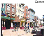 | A Center is the focal point of a mixed-use development or Master Site Plan, and contains a mix of retail, commercial, civic, and/or public services, and residential uses. A neighborhood center area is pedestrian-oriented. These areas are integrated with surrounding areas zoned MX, MN, or RM through a continuous network of streets, sidewalks, trails, and civic spaces. MX includes several different categories of building and site design standards to reflect anticipated buildout, phasing, transitions in scale, and market conditions. Several categories of MX are provided to reflect differences in building scale, market demand and commuting patterns throughout the community. |
 | Common and open space spaces serve as areas for community gathering, landmarks, and as organizing elements for the neighborhood. These include squares, plazas, greens, preserves, parks, and greenbelts. These are permitted in either the MX or MN areas, and standards are provided below. |
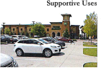 | A property owner-initiated MUC that includes at least 50 acres, or an LCG-initiated zoning designation or rezoning, may include Supportive Uses. These are commercial, light industrial, large office and low-impact manufacturing uses that have flexible site and building design standards. This gives applicants the flexibility to incorporate these uses as anchors that support the balance of the development, and provide access to services or shopping that would not otherwise become available to nearby residents or employees. These areas are limited to designated "B" streets in order to maintain the function and appearance of a compact neighborhood. |
(d)
Zoning Districts.
(1)
The MUC shall include a variety of zoning districts, including MX, RS (1&2), RM (1&2), MN, and CM.
(2)
The MX zoning district is only available within an MUC as shown on a Master Site Plan.
(3)
The following minimums and maximums apply to an overall development plan for supportive zoning districts:
• = MN and CM may not exceed the area of the MX district.
MX + (MN + CM) may not exceed 50 percent of MUC.
(e)
Intensity threshold. The following density requirements supersede the minimum lot sizes established in Article 2 for the supportive zoning districts.
(f)
Open and civic spaces.
(1)
If the MUC is an owner-initiated rezoning, it shall include at least the amount of open space required below. If LCG initiates an MUC, the MUC shall include a plan for providing and maintaining the required open space.
(2)
Required open and civic spaces for Site Category 1, shall total ten percent of the overall site area. Required open and civic spaces for Site Category 2, shall total 15 percent of the overall site area. See Section 89-40 for definitions.
(3)
If the MUC meets the required percentage of open space as shown on a Master Site Plan, then individual lots within the MUC do not need to provide additional open space. If the Master Site Plan does not meet the required open space, the applicant shall indicate the lots or parcels that will provide the open space or provide an allocation system in the development agreement to meet the open space obligations.
(4)
An MUC shall reserve at least five percent of the open space as civic space.
a.
Civic spaces include greens, plazas, squares, courtyards, boulevard pathways, or historic/cultural sites (see section 89-40).
b.
The MUC shall establish at least one square, plaza, or green.
c.
All areas within the MUC shall be located within 1,000 feet of a civic space.
(5)
All streets must connect to another street to form blocks, or shall provide a connectivity ratio of at least 1.6 (see section 89-44).
(6)
No block shall have a perimeter greater than 2,000 feet as measured along the adjoining property line or lines.
(g)
Streets.
Purpose: street types within the MX district encourage pedestrian activity and accommodate multimodal activity.
(1)
To implement LCG's design objectives while providing market flexibility, an MX district is divided into "A" Streets and "B" Streets, as follows:
| An "A" Street is a street with frontage that is restricted to building types and uses that promote pedestrian activity, and which benefit from pedestrian and/or transit access. A street is classified an "A" Street unless otherwise designated on the Zoning Map or a Master Site Plan. | 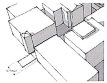 |
| A "B" Street is a street that permits front-loaded surface parking, retail and service uses, and single-story buildings. A "B" designation may be considered an interim designation as part of a phased development plan. The total length of all "B" type streets shall not exceed 35 percent of total streets within the MUC. |  |
(2)
If a property owner initiates an MUC, the Master Site Plan shall designate "A" and "B" streets. After the MUC is approved, "A" and B" streets will be designated on the zoning map.
(3)
If LCG initiates an MUC, "A" and B" streets will be designated on the zoning map.
(4)
The compact street type cross section will be made available by PW.
(h)
Site design.
Purpose: This section establishes standards for site design that are divided into Category 1 and Category 2, described generally as follows:
Under PlanLafayette, Site Category 1 is the preferred outcome. Site Category 2 is allowed in an MUC, but are limited as provided for "B" streets above, and as provided in the site design standards below.
(1)
Site Categories. Standards for Site Category 1 apply to all development with frontage on an "A" Street. Standards for Site Category 2 apply to development with frontage only on a "B" Street.
Site Elements. The required and permitted elements for Site Categories 1 and 2 are as follows:
| Site Element | Definition & General Requirements | Site Category 1 | Site Category 2 |
|---|---|---|---|
| Parking | • This establishes the location and size of parking areas. | • Required parking spaces are reduced to 50% of those otherwise required, and are limited to 120% of the required spaces (see § 89-39). | • Required parking spaces are reduced to 50% of those otherwise required (see § 89-39). No maximum applies. |
| • The reduced parking ratios established here are in addition to any shared parking reductions in § 89-39. | • At least 85% of the parking spaces must be located to the rear of the principal building, in an interior courtyard, or a shared parking structure | • Parking may be located between the street and the principal building, except where, pursuant to § 89-39(d), parking is required to be located at the rear or side of a building. Front and interior landscaping requirements apply. | |
| • A parking space located on a street is included in the calculation of required parking space if it is adjacent to the building site where the use is located | |||
 |  | ||
| Pedestrian Circulation | Pedestrian connections include: (see § 89-39 for definitions) | ||
| • Pedestrian pathway | Front-loaded spaces only | Required | |
| • Cross-access connections | Required | Required | |
| • Connections to public trail systems | Required | Required | |
 |  |  | |
| Land-scaping | • Standards and definitions are provided in § 89-36. | Not required except for parking frontages. Rear, interior or alley-facing parking areas are exempt. | Required as provided in § 89-36. |
 | |||
Sec. 89-29. - Mixed use building standards.
(a)
Applicability. This section applies to all buildings within the MN, CM, and MX districts of an MUC except as noted.
(b)
Building interface.
(1)
General: The building interface applies to all districts except the CM.
(2)
Primary building entry: Habitable space at the front lot line shall have its primary entry(s) within the front setback area.
(3)
Commercial buildings.
a.
Minimum glazing: Facades facing "A" Streets shall be glazed with at least 50 percent of the first story measured between zero feet and ten feet of the sidewalk. Facades facing "B" Streets shall be glazed with at least 30 percent of the first story measured between zero feet and ten feet of the sidewalk. Mullions, muntin, and frames that are no wider than four inches are considered part of the glazed area.
b.
Glass transparency: All glass shall be transparent with a maximum 15 percent reflectivity. Any window tinting, graphics, and interior affixed window shades that create a permanent opaque or translucent condition are prohibited, except for allowed signs.
c.
Setback landscaping: Setbacks shall be paved and shall be available for outdoor dining and furnishing where the minimum sidewalk width is established (see section 89-44).
d.
Shading of private and public frontage: In addition to shade provided by street trees where they are provided, shading of the private and public frontage can be achieved through galleries or awnings.
(4)
Residential buildings.
a.
Minimum glazing: Facades shall be glazed with at least 25 percent of the first story measured between two feet and ten feet of the sidewalk.
b.
Glass transparency: All glass shall be transparent with a maximum 15 percent reflectivity. Window tinting and interior affixed window shades that create a permanently opaque or translucent condition are prohibited. Window shading and privacy can be achieved through interior adjustable window treatments, and/or operable exterior shutters.
c.
Raised ground story access: Access to the required minimum 24 inch raised residential ground story can be achieved through exterior or interior steps and ramping.
d.
Flex buildings: The raised residential ground story requirement does not apply where:
1.
The ground story at the front elevation to a minimum depth of 18 feet is built to a commercial building standard;
2.
No other residential room is in the ground floor;
3.
There is a separate entry for the residential and commercial areas of the building, and a lockable interior connection between the areas.
e.
Shallow setback landscaping: After minimum sidewalk requirements are met, setbacks less than six feet may be landscaped or paved.
f.
Deep setback landscaping: After minimum sidewalk requirements are met, setbacks over six feet of the sidewalk shall be landscaped.
g.
Deep setback planter wall: After minimum sidewalk requirements are met and where setbacks from the sidewalk are greater than six feet, a landscaping wall shall be built at the perimeter of the yard. The landscaping wall shall measure at least 18 inches in height and four inches in depth. A side wall is not required where the planter wall is continuous to an abutting yard.
(5)
Building attachments: Galleries and awnings are not required. Galleries and awnings shall not overlap the sidewalk and/or encroach into the public right-of-way unless permitted by PW and LUS.
(6)
Upper story facade requirements: Glazing above the first story facade shall be at least 20 percent of the Facade wall area.
a.
Low pitch or flat roofs on new buildings shall be enclosed by a parapet that is at least three feet in height, or as necessary to screen the view of mechanical equipment from the sidewalk. Existing buildings shall screen mechanical equipment through a parapet or by other means.
b.
Upper story balconies can extend over public sidewalk to maximum depth of four feet.
(7)
Development over accessways: To achieve a connected street wall and for more efficient use of land, buildings may extend over pedestrian and vehicular Accessways to internal blocks as follows:
a.
Required pedestrian passages shall form a continuous minimum at-grade opening of 12 feet from sidewalk to ceiling height and a width of eight feet.
b.
Vehicular access to structured and surface parking having the following unobstructed dimensions:
a.
a minimum opening height of ten feet in height, or 14 feet in height when over a shared alley or street with service or emergency functions; and
b.
a minimum width of 12 feet, or a minimum width of 20 feet (18 feet curb face to curb face minimum) when over a shared alley or street with service or emergency functions. The maximum width of the opening shall be 24 feet.
(8)
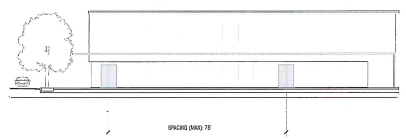
Entrance spacing: Buildings along a class A Street shall have a maximum spacing between entrances of 75 feet. This distance is calculated from midpoint of the entrance to midpoint of the following entrance.
(9)
Building facades:
a.
Buildings located in the MN district shall be no wider than 100 feet. If the building is greater than 100 feet then it shall have separate Building Facades treatments no wider than 100 feet.
b.
Buildings located in the MX and CM districts shall be no wider than 200 feet. If the building is greater than 200 feet then it shall have separate Building Facades treatments no wider than 200 feet.
(c)
Architectural features.
a.
Buildings shall include the following number of architectural features (A color rendering will be required at permitting to satisfy this requirement):
b.
The following are examples of the required types of design features:
(d)
Frontage buildout. Frontage buildout refers to the area between the minimum and maximum front setback that is occupied by building elevations. Building elevations are counted towards frontage's buildout requirements only if they meet the building interface standards in subsection (b) above.
Unless the zoning district regulations establish a different requirement, building walls shall occupy at least 50 percent of the lot width at the maximum front setback lines.
Sec. 89-30. - Servitudes (easements).
Purpose: this section provides standards for the location, width, and maintenance of servitudes/easements to ensure that public infrastructure is adequately maintained. Action Item (3.15.5)
(a)
Applicability.
(1)
Public servitudes are those servitudes established to accommodate publicly owned or controlled utility facilities necessary to provide various types of utility services to individual properties.
(2)
Public servitudes may be used for, among other uses, facilities necessary to provide water, electrical power, natural gas, drainage, storm sewer, traffic control, fiber, access, access management, telephone, telegraph, sanitary sewer services, and "utility" as defined in article 8.
(3)
The term "servitude" may be used interchangeably with the term "easement" as found throughout this Chapter.
(b)
Generally.
(1)
Public servitudes across lots or centered on rear or side lot lines shall be provided as necessary.
(2)
The location and width of private servitudes must be coordinated with any individual private utility companies involved.
(3)
Public servitudes located along the outer boundaries of a plat must contain the full width required for the servitude unless the adjacent property is within a portion of a previously approved plat and under the same ownership as the property being platted or where additional servitude is dedicated by separate instrument by the owner of the adjacent tract. In those cases, one-half (½) of the required servitude width may be dedicated within the plat boundary by separate instrument or through notation on the plat certifying the ownership and dedication of the servitude.
(4)
All existing servitudes which traverse or border any property planned for development under these regulations must be indicated on the subdivision plat and site plans submitted to the appropriate planning and zoning commission for approval.
(5)
LCG shall control the space allocation in public servitudes.
(6)
No permanent buildings, overhangs, or obstructions shall be constructed or placed in a public servitude. Prior to construction, LCG may require a pre-slab survey or other appropriate survey, paid for by the owner of the property or his/her representative, to ensure compliance with the requirements of this subsection.
(7)
Quasi-permanent structures, fences, plantings, and all other temporary obstructions may be constructed or placed within the required public servitude only if, prior to the construction or placement of same, the owner of the property or his/her representative submits an appropriate survey acceptable to LCG for review and that same is approved in advance by LCG in writing. LCG may approve in full, approve in part, or reject the request to place a quasi-permanent structure, fence, planting or other temporary obstruction within the public servitude. No quasi-permanent structure, fence, planting or other obstruction shall be constructed or placed within the public servitude unless and until the same is specifically authorized by LCG. Any damage to a quasi-permanent structure, fence, planting or other temporary obstruction occurring as a result of the maintenance or improvement of a facility by LCG shall be the responsibility of the property owner, not LCG.
(8)
In the event LCG approves the construction or placement of a quasi-permanent structure, fence, planting or other temporary obstruction within the public servitude, LCG shall have the right to require the property owner to remove the same, at the cost of the property owner, if removal of the same is necessary for the enjoyment and/or exercise of the public servitude by LCG. A property owner required to remove a quasi-permanent structure, fence, planting or other temporary obstruction shall not be entitled to damages for the removal of the same, nor shall the property owner be entitled to recover the costs of removing, replacing or reconstructing the same. Further provided, should LCG require the removal of a quasi-permanent structure, fence, planting or other temporary obstruction from the public servitude, the property owner shall allow LCG to place the removed objects adjacent to the public servitude on property belonging thereto.
(c)
Utilities servitudes.
(1)
Public utility servitudes may be used for, but not limited to, facilities necessary to provide water, electrical power, natural gas, fiber, telephone, telegraph and sanitary sewer services.
(2)
Public utility servitudes shall have a total width of at least ten feet. A ten-foot by ten-foot (10'x10') niche is required at all property corners fronting streets and existing electrical facilities. The niche will be centered such that five feet of the width is on each side of the property line or existing electrical facility not located on a property line. Deviations from this general requirement shall be subject to approval by LUS for city property and LCG for unincorporated property.
(3)
Storm sewers or open drainage ways must not be constructed within public utility servitudes unless specifically approved by LCG and where additional servitude width is provided to conform to the standards established above for utility servitudes.
(4)
No permanent buildings or obstructions shall be placed in the public utility servitude.
(5)
Quasi-permanent structures, fences, plantings and other temporary obstructions shall not be allowed within public utility servitudes unless the same are approved in accordance with the procedure set forth in section 89-30(b)(7), and any such structures, fences, plantings or other temporary instructions shall be subject to the provisions of section 89-30(7)-(8).
(6)
Overhangs encroaching into the public utility servitude shall not be allowed, unless specifically approved by the Field Operations division of LUS or appropriate designee of the applicable utility provider. All approvals of requests will be contingent upon the following requirements:
a.
Overhangs above existing public utility facilities 0"/none;
b.
Overhang height less than ten (10') feet from final grade 0"/none;
c.
Overhang height more than ten (10') feet from final grade (min) 12"; and
d.
Overhang height more than twenty (20') feet from final grade (max) 30% the width of the servitude.
(7)
Dead-end public utility servitudes are not allowed unless specifically agreed to by the utility in whose favor the public utility servitude has been granted.
(d)
Drainage servitudes.
(1)
Where a subdivision is traversed by a public water course, drainage way, channel, or stream, the applicant shall provide a public drainage and access servitude at least 20 feet in width on each side of the water course and conforming substantially with the water course's lines and a public drainage servitude for the location of the water course, the same being necessary to ensure proper drainage, minimize flooding, and accommodate the movement of equipment, manpower and materials along such water course for maintenance. If the water public course, drainage way, channel, or stream is identified on the official drainage map, there shall be provided a public drainage and access servitude of at least 30 feet in width on each side and conforming substantially with the water course's lines and a public drainage easement for the location of the water course, the same being necessary to ensure proper drainage, minimize flooding, and accommodate the movement of equipment, manpower and materials along such major public water course for maintenance. The public easement shall include further width and/or construction where needed to accommodate drainage flows. Notwithstanding the foregoing, if the appropriate director of PW or his designee should determine that the public interest in effective drainage and flood prevention can be served by a public servitude of narrower width than prescribed above, then the director may require a public servitude of reduced width, provided that the same is sufficient to ensure proper drainage, minimize flooding and allow the movement of equipment, manpower and materials along the public channel for maintenance.
(2)
Storm sewers or open drainage ways must not be constructed within public utility servitudes unless specifically approved by PW and where additional public easement width is provided to conform to the standards established above for drainage public servitudes.
a.
The public drainage servitude, for sub-surface drainage not adjacent to a public roadway, shall be a minimum of 20 feet and meet the requirements of PW.
(3)
The property owner shall not permit drainage across the public servitude into the water course except by natural means. If drainage across the public servitude is requested, any drainage structure must be approved by PW or other authorized public drainage or flood control official.
(e)
Private servitudes.
(1)
This subsection applies to the unincorporated areas of the Parish and City of Lafayette.
(2)
All private servitudes created prior to the subdivision of any tract of land must be shown on any subdivision plat as provided in article 10.
(3)
If the holder of an undefined servitude does not define the servitude involved, the subdivision plat must —
a.
Provide accurate information as to the center line location of all existing pipelines, pole lines, or other utility facilities that conform with the servitude holders rights, and
b.
Establish building setback lines 15 feet from and parallel with both sides of the center line of all utility facilities identified in subsection "a" above.
(4)
Special use servitudes.
a.
The establishment of special use utility servitudes may be provided on a subdivision plat when —
a.
The servitude accommodates a utility facility owned, operated and maintained by a unit of government and is restricted to either water mains, sanitary sewers, storm sewers or for drainage purposes; and
b.
PW determines that these facilities cannot or should not be accommodated within a general purpose public utility servitude or public street right-of-way.
b.
Servitudes proposed to be established for any private utility company or private organization providing utility services and restricted for their exclusive use may be shown on a subdivision plat.
c.
Private utility facilities cannot be accommodated and placed within the public utility servitudes, public streets and alleys established within the plat boundary unless authorized through a separate agreement with LCG.
d.
This subsection does not prevent the private utility companies or the subdivider from granting and establishing special or exclusive use servitudes by separate instruments if those arrangements are deemed necessary to properly serve the properties within the plat boundaries.
(f)
Cross access easement/servitude.
(1)
A "cross access easement or servitude" includes —
a.
Public access easement/servitude (joint use) for vehicle/pedestrian access from the public roadway to two or more properties, or
b.
Public access easement/servitude (cross access) for vehicle/pedestrian access across multiple properties generally parallel to a public roadway.
(2)
If the administrator or approving agency finds that internal circulation between adjoining properties will avoid a reduction in the level of service (LOS) of adjacent streets, the applicant shall provide a cross access easement or servitude between the properties.
(Ord. No. JO-021-2022, § 3(Exh. C), 3-22-22; Ord. No. JO-077-2022, § 4(Exh. D), 9-20-22; Ord. No. JO-067-2024, 11-18-24)
Sec. 89-31. - Covenants and restrictions.
(a)
Applicability. This section applies to any subdivision plat.
(b)
Requirements.
(1)
LCG does not enforce the private provisions within covenants or deed restrictions.
(2)
If required, deed restrictions, covenants, or maintenance agreements shall be submitted to provide for public protection and maintenance of the development. Those deed restrictions or covenants, however, shall not contain reversionary clauses where any lot shall return to the subdivider because of a violation of the terms of the restrictions or covenants.
(3)
All covenants and/or restrictions for a development's public infrastructure/maintenance agreement shall be referenced on the final plat or provided to LCG prior to final plat approval.
Sec. 89-32. - Fences.
Purpose: this section is in accordance with Action Item 1.1.4 of PlanLafayette.
(a)
Applicability. This section applies to the City of Lafayette and unincorporated Lafayette Parish.
(b)
Location.
(1)
Fences may be erected along the boundaries of a lot or required setback. The restrictions and procedures set forth at subsections 89-30(b)-(c) and 89-38(e) shall apply to fences.
(2)
No fence foundation may conflict with public servitudes or public infrastructure — i.e. water, electrical power, natural gas, drainage, storm sewer, or other utilities as defined by article 8. Any damage to the public infrastructure shall be repaired and paid for by the fence owner. If, within 30 days after notification of damage, work is not started on the repairs as set forth in the notification, the work may be done by LCG and all costs thereof assessed to the property owner. The cost and charges for these repairs are assessed in the same manner as outlined in section 89-26(e)(2).
(3)
Fences may not block the function and flow of the public storm water system and shall not block the function and access to utilities facilities, unless approved by LUS.
(c)
Advertising. In the unincorporated Parish, fences shall not contain any poster, graphics or advertising of any kind, except for one sign of the owner, lessee, operator or licensee of the premises, on each street frontage. The sign shall not exceed 100 square feet in area. i
(d)
Screening and privacy barriers. See section 89-36.
Sec. 89-33. - Flood damage protection.
Purpose and intent: It is the purpose of this section to promote the public health, safety and general welfare and to minimize public and private losses due to flood conditions in specific areas by provisions designed to:
• Protect human life and health and property; and
• Minimize expenditures of public money for costly flood control projects; and
• Minimize the need for rescuer and relief efforts associated with flooding and generally undertaken at the expense of the general public; and
• Minimize prolonged business interruptions; and
• Minimize damage to public facilities and utilities such as water and gas mains, electric, telephone and sewer lines, streets and bridges located in floodplains; and
• Help maintain a stable tax base by providing for the sound use and development of flood prone areas in such a manner as to minimize future flood blight areas; and
• Ensure the potential buyers are notified that property is in a flood area.
⇔ Refer to sections 26-681 to 26-800 for additional information.
Action Item (10.4.1)
(a)
Plat and elevation requirements: The following requirements shall apply to all residential, commercial, industrial and other nonresidential developments:
(1)
Residential and non-residential floor elevations: Lots within developments proposed for residential, commercial, industrial or other nonresidential developments shall be designated as being in or out of the 100-year Flood Zone (1% Annual Chance Floodplain (Flood Zones A, AE, or AH)) including floodway and being in or out of the 500-year Flood Zone (0.2% Annual Chance Floodplain (Flood Zones X and X-Shaded)) as per the effective FEMA F.I.R.M and any subsequent updates. The plat shall include flood demarcation lines and state the following:
a.
"Any structure, enclosed on three or more sides, built or placed on property in the 100-year Flood Zone (1% Annual Chance Floodplain (Flood Zones A, AE, or AH)) as depicted on this plat shall be elevated so as to ensure the lowest floor of such structure and all electrical/mechanical equipment is located at a minimum of one foot above the base flood elevation height for the area at that time."
b.
In the event the property is in a floodway: "No development shall take place in the mapped floodway without an engineer's certificate of no-rise including the supporting technical data which is to be approved by PW."
c.
"Any utility and sanitary facilities shall be installed so as to minimize the effect on same by Flood Waters."
Sec. 89-34. - Designation of historic districts and landmarks.
Action Items (2.1.1, 4.1.3, 4.2.1, 4.2.2, 4.2.3, 4.2.4, 4.2.5 4.3.2)
(a)
Criteria for designation. A historic district or landmark should exhibit one or more of the following characteristics:
(1)
Historic or cultural significance. The site proposed for designation should:
a.
Have character, interest or value as part of the development, heritage, or cultural characteristics of the City of Lafayette, Parish of Lafayette, or the United States;
b.
Be the site of an historic event;
c.
Be identified with a person or group who influenced society; or,
d.
Exemplify the cultural, archaeological, economic, social, political, or historic heritage of the city and/or Parish of Lafayette and its communities.
(2)
Architectural and design significance. The site proposed for designation should:
a.
Embody the distinctive characteristics of a type, period, theme, method of construction or indigenous materials and craftsmanship;
b.
Represent the work of a master architect, builder, engineer or that of significant artisans;
c.
Possess high artistic values and design integrity;
d.
Be a distinguishable entity in that it has not been altered to the extent that its original purpose or use is indiscernible;
e.
Be an established and familiar visual feature of the neighborhood and community or a place of natural or aesthetic interest that contributes to the cultural or historical development of the City and/or Parish of Lafayette, State or region; or,
f.
Be an outstanding example of a building, structure, object, or work of art representative of its era, or one of the few remaining examples of past architectural styles.
(b)
Process for designation.
(1)
Application.
a.
Historic districts. All property owners owning property within a proposed historic district may collectively apply for designation.
b.
Historic landmarks. A property owner of a proposed historic landmark may apply for designation.
(2)
Survey.
a.
As part of the application, applicants shall provide a survey that can be used to inform the public and to document and evaluate archaeological and historic sites for the purpose of understanding the architectural or cultural significance of all features within locally designated historic districts or landmarks. The survey shall include:
1.
A physical description of the proposed historic district or landmark, including clearly defined boundaries for the proposed historic district, or the landmark, and,
2.
A description of its historic significance.
b.
All structures, buildings, site features, objects, works of art and cultural landscapes in the proposed historic district or landmark shall be surveyed and evaluated and each shall be classified as:
1.
Historic element. A building, structure, site feature, object, work of art, or cultural landscape that is 50 years old or more that is culturally significant or a worthy representative example of its period style of architecture.
2.
Non-historic element. A building, structure, site-feature, object, work of art, or cultural landscape that does not meet the criteria for a historic element listed above.
(3)
Adoption procedure.
a.
Historic preservation commission action. The LHPC shall consider the merits of designation in accordance with the applicable provisions of the Lafayette Development Code at a public hearing and shall recommend, to the appropriate planning or zoning commission(s), approval, approval with conditions, or denial of any request in a timely manner.
b.
Planning commission action. Following receipt of the recommendation of the LHPC, the appropriate planning or zoning commission(s) shall hold a public hearing on the designation and shall recommend, to the appropriate council(s), approval, approval with conditions, or denial of any request in a timely manner.
c.
Council action. The Lafayette City Council and/or the Lafayette Parish Council, as the case may be, shall make the final determination regarding a designation, and if so designated, evidenced through the adoption of an ordinance, considering the recommendations of the LHPC and the appropriate planning or zoning commission(s), at a public hearing.
d.
Ordinance requirements. Any ordinance designating a historic district or landmark shall describe the exterior boundaries of the historic district or landmark to be designated, and establish the requirement that a certificate of appropriateness ("COA") be obtained from the LHPC prior to any change to the exterior of any part of a designated property that is visible from a public street.
e.
Notification of adoption of ordinance for designation and recordation thereof. Within 30 days following the adoption of the ordinance for designation by the appropriate council(s), the owners of each designated historic property shall be given written notification of such designation by the LHPC; which notice shall notify those owners of the requirement to obtain certificates of appropriateness. Within 30 days of receipt, the owner(s) shall file the notice of designation in the Lafayette Parish Conveyance Records.
f.
Moratorium on applications for alterations or demolitions. If an application for designation has been received by the LHPC, the LHPC shall have the power to require that the building official delay an application for a building or demolition permit for properties under consideration for up to 120 days. Any building or demolition permit issued prior to the LHPC's receipt of an application for designation may continue until its expiration.
(c)
Design guidelines for historic districts and landmarks.
(1)
Intent. Design guidelines shall identify the characteristic features of the historic district or landmark to be used in determining the compatibility of new construction or alterations with the character and architecture of the area. It is the responsibility of the LHPC to ensure that changes, including demolition and relocation, in the historic districts or landmarks are consistent with the appropriate design guidelines, including any Lafayette Historic District or Landmark Guidelines.
(2)
Development.
a.
The LHPC shall draft design guidelines, and working with owners within a historic district or owners of a landmark, any additional design guidelines specific to any post-designation of a historic district or landmark, all consistent with the Secretary of the Interior's Standards for the Treatment of Historic Properties.
b.
The LHPC shall hold a public hearing in order to receive comments on proposed design guidelines and, at the conclusion of that hearing, shall recommend to the appropriate planning commission(s) their approval, approval with changes, or may defer action, determining additional work is necessary.
c.
After receiving the LHPC's recommendation, the appropriate planning commission(s) shall consider proposed design guidelines at a public hearing. Following the public hearing, the appropriate planning commission(s) shall recommend to the appropriate council(s) their approval, approval with changes, all consistent with the Secretary of the Interior's Standards for the Treatment of Historic Properties, or may refer them back to the LHPC for additional work.
d.
The Lafayette City Council and/or the Lafayette Parish Council, as the case may be, shall make the final determination regarding design guidelines, all consistent with the Secretary of the Interior's Standards for the Treatment of Historic Properties, evidenced through the adoption of an ordinance, considering the recommendations of the LHPC and the appropriate planning or zoning commission(s), at a public hearing.
e.
Notice of all hearings on design guidelines shall be made in the same manner as provided for in article 4, section 89-70(d).
f.
All amendments to design guidelines shall follow the procedure set forth above in this subsection (2).
(d)
Certificates of appropriateness (coa).
(1)
When required. A COA shall be required for any exterior change to any property within a designated historic district or landmark, or the demolition or relocation of a designated landmark or historic element within a historic district, unless the change is determined to be ordinary maintenance and repair under the applicable design guidelines.
(2)
Approval authority. Depending on the nature of the work proposed, a COA may be issued by the by the administrator through a staff-level approval process, or by the LHPC through a public hearing process.
(3)
Submittal requirements. Applications shall be submitted along with required documentation identified below to the office of the community development and planning department.
a.
New construction, additions, and alterations. Such drawings, photographs, or plans as may be required by the administrator to permit determination of conformity with the applicable design guidelines.
b.
Demolition or relocation. Unless the request for demolition is made by the City of Lafayette and/or the Parish of Lafayette, in which case only the records depicting the current condition of the building and the building official's determination that the structure is unsafe are required, an applicant shall provide the following material:
1.
Records depicting the original construction of the structure, including drawings, pictures, and/or written descriptions, if available;
2.
Records depicting the current condition of the structure, including drawings, pictures, and/or written descriptions;
3.
Description of the proposed use of the property after demolition/relocation of structure;
4.
The current fair market value of the structure and property as determined by an independent licensed appraiser or recent sales documents; and
5.
A reliable report regarding the nature, imminence, and severity of the threat, the cost of restoration or rehabilitation of the structure, and the feasibility of restoration or rehabilitation of the structure.
(4)
Criteria for approval. The decision to approve a COA shall be based on the application meeting the following criteria:
a.
New construction, additions, and alterations. The proposed work is consistent with the design guidelines applicable to the subject property.
b.
Demolition or relocation. The LHPC shall, apply the criteria and standards contained within the applicable design guidelines and may approve a COA for demolition or relocation.
(5)
Relation to other ordinances. The issuance of a COA shall not relieve an applicant from any and all requirements to obtain a building permit, special use permit, variance, or other authorization required by any other provision of the Lafayette City-Parish Consolidated Government Code of Ordinances concerning zoning, construction, repair, or demolition. In all such cases, applicants are required to obtain a COA prior to obtaining other required approvals as other agencies will require the decision of the LHPC in order to make their subsequent decisions.
(6)
Undue hardship. Where, by reason of topographical conditions, irregularly shaped lots, or because of unusual circumstances applicable solely to the particular applicant, strict enforcement of the historic preservation provisions of this chapter would result in serious undue hardship particularly affecting said applicant, then the LHPC, in passing upon his application shall have the power to vary or modify adherence to the historic preservation provisions of this chapter; provided always that its requirements insure harmony with the general purposes hereof, and will not adversely affect a historic district as a whole or any historic landmark. Any relief granted pursuant to this paragraph shall be restricted to the minimum needed to provide the relief the applicant is requesting.
(7)
Exceptions.
a.
Temporary fences on private property shall not require a COA provided that the temporary fence is no more than five feet in height and is in place no more than 30 days. In no instance shall the fencing be within the public right-of-way or restrict access along streets or sidewalks.
b.
Ordinary maintenance or repair shall not require a COA.
c.
The administrator may authorize work which would require a COA and is deemed necessary on an emergency basis for the preservation of a structure. Such authorization shall not constitute issuance of a COA, and the property owner must apply for a COA in a timely manner after such work is commenced. Failure to apply for a COA within ten working days of the administrator's authorization for such work shall constitute a violation of these regulations.
(8)
Stopping work commenced without or inconsistent with COA. The building official shall be authorized to issue a stop work order related to any work involving a historic district or landmark, requiring a COA, that is being performed without a valid COA or is inconsistent with a valid COA. Any such work shall be considered a violation of this chapter.
(e)
Demolition by neglect.
(1)
Prevention.
a.
All locally designated landmarks, including all historic elements thereon, as well as all historic elements located in a historic district, shall be preserved against decay, deterioration, and kept free from structural defects by the owner thereof or such person, persons, or entities who may have custody or control thereof.
b.
Demolition by neglect shall mean neglect in maintaining, repairing, or securing a landmark or any historic element thereon, or a historic element located in a historic district that results in deterioration of an exterior feature of the historic element, or the loss of structural integrity of the historic element that threatens the condition of the historic element or its structure.
c.
The LHPC shall ensure that all locally designated landmarks including all historic elements thereon, as well as all historic elements located in a historic district designated by the LHPC are not allowed to be demolished through neglect of the owner. However, if the property owner has submitted a COA application, then the LHPC shall not finalize demolition by neglect proceedings until the COA is denied and all appeals have been exhausted.
(2)
Standards. The exterior features of any locally designated landmarks including all historic elements thereon, as well as all historic elements located in a historic district found to have defects shall be rehabilitated by the owner or such other person who may have legal possession, custody, and control thereof protecting against decay and deterioration and kept free from structural defects. The owner, or other person having such legal possession, custody, and control, shall upon written request by the administrator stabilize or repair such features if they are found to be deteriorating, or if their condition is contributing to deterioration of the property or the historic district, including but not limited to any of the following defects:
a.
Deterioration of exterior walls, foundations, or other vertical support that causes leaning, sagging, splitting, listing, or buckling where such condition threatens the integrity of the structure;
b.
Deterioration of flooring or floor supports, roofs, or other horizontal members that causes leaning, sagging, splitting, listing, or buckling where such condition threatens the integrity of the structure;
c.
Deterioration of external chimneys that causes leaning, sagging, splitting, listing, or buckling where such condition threatens the integrity of the chimney;
d.
Deterioration or crumbling of exterior plasters or mortars where there is evidence that such condition has allowed deterioration of structural elements that threaten the structure's integrity;
e.
Ineffective waterproofing of exterior walls, roofs, and foundations, including broken windows or doors where there is evidence that such condition has allowed deterioration of elements that threaten the structure's integrity;
f.
Defective protection or lack of weather protection for exterior wall and roof coverings, including lack of paint, or weathering due to lack of paint or other protective covering where there is evidence that such condition has allowed deterioration of elements that threaten the structure's integrity;
g.
Rotting, holes, and other forms of decay where there is evidence that such condition has allowed deterioration of structural elements that threaten the structure's integrity;
h.
Deterioration of exterior stairs, porches, handrails, window and door frames, cornices, entablatures, wall facings, and architectural details that causes delamination, instability, loss of shape and form, or crumbling where there is the possibility that the architectural details will be lost or destroyed; or
i.
Deterioration of accessory structures.
(3)
Procedure for enforcement of demolition by neglect.
a.
The LHPC may, by majority vote, identify a landmark or any historic element thereon, or a historic element located in a historic district as a candidate for potential demolition by neglect violations and request that the administrator perform an inspection of said identified property.
b.
The administrator shall present the findings of the inspection to the LHPC at its next available meeting following the completion date of the inspection. Based upon the reported finding of the inspection and the standard for demolition by neglect herein, the LHPC shall declare, by majority vote, whether or not the identified property is in violation of the demolition by neglect provisions. If the identified property is found to meet one or more of the applicable criteria of the demolition by neglect provisions herein, then the administrator shall commence enforcement proceedings through the Administrative Adjudication Bureau pursuant to 89-170 and utilize its procedural processes therein.
(f)
180-day option for rescission and cancellation of landmark designation upon change of ownership.
(1)
Upon the change of ownership of a landmark, the new owner(s) shall have the option to rescind and cancel the designation of the property as a landmark. This option shall be exercised within 180 days from the date ownership of the Landmark changed and shall be effectuated by the new owner(s) completing and filing, in the conveyance records of the Lafayette Parish Clerk of Court, a notice of recission and cancellation of designation on a form provided by the administrator. Once filed, the new owner(s) shall provide the Administrator with a file-stamped copy of said notice of recission and cancellation of designation within ten business days of the recordation date. Failure to timely exercise the option to rescind and cancel the designation of a property as a landmark shall result in the loss of said option.
(g)
Alternative compliance to regulations for historic districts and landmarks. The administrator may provide alternative compliance to regulations for Historic Districts and Landmarks within Articles 2, 3, 4, and 5 herein, except in cases where doing so would: (1) pose a health or safety risk; and/or (2) all proposed work, including repairs, alterations and work required because of a change of occupancy or use, constitutes a substantial improvement to the Historic District or Landmark as defined by the International Building Code (IBC). Alternative compliance may be applied for and provided to any historic district or landmark that meets one or more of the following criteria:
a.
Listed, or certified as eligible for listing, by the State Historic Preservation Officer or the Keeper of the National Register of Historic Places, in the National Register of Historic Places;
b.
Designated as historic under an applicable state or local law;
c.
Certified as a contributing resource within a National Resister, state designated or locally designated historic district or neighborhood; or
d.
Where, in the opinion of the Lafayette Preservation Commission and Administrator, compliance with the requirements herein would threaten or destroy the historic significance of the Historic District or Landmark.
(Ord. No. JO-024-2021, § 4(Exh. D), 7-20-21; Ord. No. JO-057-2023, § 3, 9-19-23; Ord. No. JO-067-2024, 11-18-24)
Editor's note— Ord. No. JO-057-2023, § 3, adopted September 19, 2023, amended the title of § 89-34 to read as herein set out. The former § 89-34 title pertained to historic preservation.
Sec. 89-35. - Improvement guarantees.
Purpose: this section is in accordance with Actions Items 3.15.1, 6.3.3, and 6.8.3.
(a)
Applicability. In each new subdivision, the subdivider and LCG shall agree on the type, location, and extent of necessary public improvements depending on the characteristics of the proposed development and its relationship to surrounding areas, and according to the standards and criteria as outlined in this chapter.
(b)
General requirements.
(1)
The following improvements are minimum general requirements. These shall be constructed at the subdivider's expense and stipulated in the subdivision improvements agreement in a manner approved by the appropriate planning and zoning commission as part of the plat approval.
a.
Roads, grading, base and surfacing.
b.
Curbs and gutters, if required.
c.
Sidewalks, if required.
d.
Sanitary sewer, laterals and mains, if required.
e.
Storm sewers or storm drainage system, as required.
f.
Water distribution system, if required.
g.
Fire hydrants, if required.
h.
Street lighting, if required by PW.
i.
Permanent reference monuments and monument boxes.
j.
Other facilities as may be specified or required in this chapter, by the appropriate planning and zoning commission.
(c)
Completion of improvements. Before the final plat is approved for recording, all applicants shall:
(1)
Complete all improvements, in accordance with the action letter and approved construction plans and to the satisfaction of LCG PW and LUS.
(2)
Dedicate the improvements to LCG free and clear of all liens and encumbrances on the property (except existing servitudes or easements).
(3)
Or apply for a subdivision improvements agreement as described below. At least 80 percent of the public improvements must be completed prior to application for a subdivision improvements agreement.
(d)
Improvements agreement and guarantee.
(1)
LCG, in its discretion, may waive the requirement that the applicant complete and offer for dedication all public improvements prior to approval of the final subdivision plat. No final plat shall be recorded until the subdivider submits and LCG approves the following:
a.
A subdivision improvements agreement that —
a.
Sets forth the cost, plan, method, and parties involved, and
b.
Guarantees to construct any required public improvements shown in the final plat documents, and
c.
Includes collateral sufficient to complete the improvements in accordance with plat design and time specifications.
b.
Sufficient collateral in amount stipulated in the subdivision improvements agreement.
a.
The collateral shall accompany the final plat submission to insure completion of the improvements according to design and time specifications.
b.
The collateral shall be in the form of a letter of credit accompanied by a draft drawn on a bank, certified check or other legal assurances the appropriate planning and zoning commission deems appropriate.
c.
If the improvements are not constructed in accordance with all of the required specifications deemed by the administrator, LCG shall notify the subdividers of noncompliance and discuss with them the reasons for noncompliance. PW and/or LUS shall establish proposed schedules to correct the noncompliance. The administrator may annul the funds as may be necessary to construct the improvements if the subdivider will not construct any or all of the improvements in accordance with all of the specifications.
c.
If a subdivider does not provide suitable collateral to ensure completion of the required improvements, no final plat shall be approved for recording until the improvements are constructed and approved by LCG. However, LCG will supply the subdivider with a letter guaranteeing final plat approval when improvements are constructed to LCG specifications.
(e)
Time schedule and release of improvements guarantee
(1)
LCG must specify the period within which required improvements must be completed. The time period shall be incorporated in the bond, letter of credit accompanied by a draft drawn on a bank, certified check or other legal assurances, and shall not exceed two years from date the final plat is certified for recording.
(2)
LCG may, upon proof of difficulty, recommend extensions of the completion date set forth in the bond, letter of credit accompanied by a draft drawn on a bank, certified check or other legal assurances for a maximum period of one year.
(3)
From time to time as the required improvements in a subdivision are completed, the subdivider shall apply in writing to the respective department for a partial or full release of the collateral.
a.
Upon receipt of the written application, PW and/or LUS shall inspect the improvements which have been completed.
b.
If it is determined from the inspection that the improvements comply with the final plat and the requirements of these regulations, a portion of the collateral shall be released. However, LCG shall retain collateral sufficient to cover the cost of the uncompleted improvements.
(4)
PW and LUS may monitor and inspect progress toward the completion of improvements at any time during the construction period. If LCG deems that satisfactory progress has not been made, it may draw upon collateral to collect payments. This may be done after advance notification to the subdivider.
(Ord. No. JO-077-2022, § 4(Exh. D), 9-20-22)
Sec. 89-36. - Landscaping, buffers and screening.
Purpose and intent: This section promotes the health, safety, and welfare, facilitates the creation of an attractive and harmonious community, conserve property values, conserves natural resources, and encourages the appropriate use of the land. These landscape requirements establish standards consistent with Louisiana Horticulture Law Rules and Regulations, to protect natural plant communities, to provide post-construction landscaping within the City-Parish of Lafayette, and to educate the public as to the merits of preservation and conservation of natural vegetative habitat for the following nonexclusive purposes:
• Preserve existing vegetation. To preserve, conserve and protect healthy existing natural vegetation, and encourage the incorporation of plant materials, especially native plants, plant communities and ecosystems into landscape design, where possible.
• Human values. To reduce noise and glare, break up monotony, and soften the harsher aspects of urban development, to educate citizens as to the advantages of preservation of trees and existing natural landscaping, to promote voluntary preservation of those features, avoid clear cutting, and promote landscaping with native plant materials.
• Community design. To improve the aesthetic appearance of industrial, commercial, and residential areas through landscape design, and allow flexibility to promote innovative, diverse and cost-conscious approaches to the design, installation and maintenance of landscaping.
• Environmental quality. To improve environmental quality by recognizing the beneficial effects of landscaping on the environment, encourage forestation that replenishes the local stock of plant material suitable for growing in the City and Parish of Lafayette, encourage the preservation of existing trees, protect and increase the number of trees in the community, and facilitate compliance with state and federal environmental legislation such as the Clean Air Act.
• Air and water quality management. To conserve potable and non-potable water by preserving existing plant communities; to encourage the planting of natural or uncultivated areas; encouraging the use of site specific plant materials; providing for natural water recharge; preventing excess runoff; and facilitating compliance with state and federal water and air legislation such as Clean Air Act and the Clean Water Act.
Action Items (1.2.1, 1.5.4, 10.2.1, 10.2.2)
(a)
Applicability.
(1)
Land affected.
a.
This Section applies to all areas within the jurisdiction of the City of Lafayette and the unincorporated areas of Lafayette Parish, except as provided below.
b.
This section does not apply to —
1.
Single-family detached residences.
2.
Developments without a vehicular use area.
3.
The "MX" (Mixed Use) Districts for Site Category 1 developments, and "D" (Downtown) districts.
(2)
Activities affected.
a.
This section applies to new construction.
b.
This section is applied at the time of application for a building permit or certificate of occupancy, whichever is appropriate. The requirements continue to apply after the building permit or certificate of occupancy is issued and the property is developed.
c.
A lot with any improvements thereon which did not meet the landscape requirement on the effective date of original adoption of this chapter is exempt from this section unless there is a cumulative building expansion of the percentage indicated in the table below:
Table 89-36-1 Landscaping and Buffer Applicability to Building Expansion
(b)
General requirements.
(1)
Installation.
a.
Unpaved areas not covered with mulch or planted with trees, shrubs, or ground cover shall be planted with turf grass to prevent soil erosion.
b.
Encroachment barriers shall be provided wherever a vehicle is likely to protrude onto a landscape area, such as in front of a parking space.
c.
Plant materials shall be placed in such a manner that the top of the root ball shall be even with the finished grade level of the soil, safety staked, girdle protected, with adequate mulching of the planting bed.
d.
Planting areas shall be worked to break the hardpan formed during construction until the natural soil level is reached and/or amended to insure proper growth.
e.
All planting areas shall be designed to accept water.
(2)
Landscape areas may be provided in the form of islands or delineated walkways within the interior parking area, landscape strips, peninsulas of landscape strips, or a combination thereof.
(3)
Required landscape areas shall be protected by properly anchored perforated curbing at least six inches high using materials such as concrete, natural stone, railroad ties, or landscape timbers. This does not apply to approved low-impact stormwater management practices including bioretention, filter/buffer strips, swales, or infiltration trenches. Perimeter strip and landscape island measurements do not include curbing. In the case of redevelopment or expansion, existing landscape spaces with a barrier curb can remain as is.
(4)
Landscaped areas shall not be in conflict with the site drainage plan.
(5)
The removal of a required tree or installation of an impermeable surface within a required landscape area requires approval of the DPD.
(6)
Required buffers and landscape areas shall not be encroached upon by:
a.
Accessory buildings;
b.
Storage of equipment or goods;
c.
Garbage or trash collections;
d.
Vehicular use areas (except for accessways within landscape strips as provided for in section 89-36(g)(4)(b)); or
e.
Within ten feet of a sidewalk located in the right-of-way or in a sidewalk easement.
(c)
Frontage landscape strips.
(1)
Street frontages.
a.
A minimum ten-foot landscape strip is required along each frontage line. A "frontage line" is the property line abutting a public or private street right-of-way. Table 89-36-6 may supersede this minimum.
b.
This requirement does not apply to frontage lines along Lots in the "RM," "MN," "MX," "CM," "CH," "IH," "PI," or "PD" zoning districts or an "A" Development Type where a building frontage is within ten feet of a sidewalk.
(2)
Multiple street frontages. Except as provided in section 89-36(c)(1)(b) above, on lots with multiple frontages, the landscape strip shall be provided on all street frontages. However, all landscaping shall comply with line of sight regulations (see section 89-44(f)).
(d)
Parking lot landscaping.
(1)
Generally. At least the following percentage of the vehicular use area of a lot or parcel that includes vehicular use areas shall include parking lot landscaping. This section does not apply to parking structures.
(2)
Parking lot landscaping may include any combination of the following:
a.
Interior landscape islands;
b.
Low-impact stormwater management features; or
c.
Existing tree clusters within the vehicular use areas that have the same tree density as the minimum planting requirements below.
d.
The parking lot landscape area may be in the form of a delineated walkway with different material or color surface treatment with plantings along both sides through the parking lot to the entrance of the building.
(3)
The following minimum standards apply to interior landscape islands where the required minimum parking lot landscaping is at least 12 percent (⇔ subsection (d)(1), above):
a.
Every part of a vehicular use area shall be within 75 feet of the trunk of two class "B" trees, with no intervening structures, where islands are a minimum of 324 square feet with a minimum width of nine feet; or
b.
Every part of a vehicular use area shall be within 100 feet of the trunk of a class "A" or two class "B" trees, with no intervening structures, where islands are a minimum of 324 square feet with a minimum width of 18 feet; or
c.
Every part of a vehicular use area shall be within 125 feet of the trunk of a class "A" tree when at least four class A trees are provided, with no intervening structures, where islands are a minimum of 1,296 square feet with a minimum width of 36 feet; or
d.
For trees of a minimum 18-inch diameter at breast height (DBH) or clusters of trees with a combined minimum DBH of 24 inches, every part of a vehicular use area shall be within 150 feet of the trunk of a tree, with no intervening structures. These islands shall be a minimum of 972 square feet with a minimum width of 27 feet.
e.
A combination of the above standards may be used to provide minimum requirements.
(4)
Where open space is not required by article 2, all parking lot landscaping shall be designed to receive and collect stormwater runoff from the site.
(5)
Whenever low-impact stormwater management features are provided, the following minimum standards shall apply:
a.
All islands, peninsulas, or other qualifying areas shall receive and collect stormwater runoff from the site.
b.
Appropriate pervious vegetation and/or ground cover shall be used in all islands, peninsulas and other qualifying areas.
c.
The minimum area for islands, peninsulas, and other qualifying areas is set forth in subsection (3) above.
d.
Plants in islands, peninsulas and other qualifying areas shall be selected from those listed in section 89-155.
(e)
Right-of-way landscaping.
(1)
PW shall regulate the types of trees that may be planted in the public right-of-way for any development.
(2)
Plantings in the public right-of-way at intersections shall be reviewed for compliance with the line of sight requirements (section 89-44(f)).
(3)
Recommended street trees for frontage with or without power lines are indicated in the species list (section 89-155)
(f)
Tree preservation and tree credits.
(1)
Credit for preserved trees.
a.
Existing healthy trees may be included in the minimum planting requirements and credited as per the following schedule. The landscape area surrounding a preserved tree in a parking lot that is necessary to the critical root zone will be deleted from the required parking count.
b.
Existing trees included on the recommended tree lists may count toward 50 percent of the minimum tree requirement. On lots of one acre or less in the "MN" or "MX" ("B" Street frontages), and on lots of one acre or less and of the "A" Development Type in the "CM" or "CH" districts, Live Oaks and Southern Magnolias with DBHs of 18 inches or greater may count toward 100 percent of the tree requirement. Existing trees shall only be used as credit where adequate green area, as required herein, is provided to maintain the tree in a healthy condition.
c.
A tree proposed for use as a credit to satisfy minimum planting requirements must be shown on the site plan and approved as part of the underlying review process. Trees with life spans of 30 years or less are not considered for credit.
d.
The landscape area surrounding a preserved tree shall be located so that the trunk of the tree is as close to the center of the landscape area as possible. The applicant shall preserve the tree's critical root zone (CRZ) as defined as a circle on the ground corresponding to the dripline of the tree. Determine this dimension by measuring the diameter of the tree trunk in inches at breast height (DBH), multiplied by 12.
(2)
Protection of preserved trees during construction. Existing tree(s) shall only be credited where the following management standards are met:
a.
During construction, the critical root zone of the tree(s) to be preserved shall be fenced and protected from compaction, trenching, harmful grade changes, or other injury.
b.
Pavement or building foundations shall not encroach into the critical root zone, unless specific preservation practices are followed to ensure exchange of oxygen and water to the root system.
c.
Sidewalks or other forms of hard surfaces that do not require soil compaction and are not intended for vehicular use may be located within the critical root zone only if specific preservation practices are followed to ensure exchange of oxygen and water to the root system.
(g)
Buffers.
(1)
Applicability.
a.
Generally.
1.
The buffer requirements in this section are based on the use (in the unincorporated parish) or zoning (in the city) of adjacent property. Any change in use in the unincorporated area of Lafayette Parish after the effective date of these regulations may cause the new use to become subject to this subsection.
2.
This section does not apply to the "MX" or "D" zoning districts.
3.
Buffers are intended to provide visual screening between conflicting land uses or zoning in the city and unincorporated areas.
b.
Buffer areas.
a.
This subsection establishes the areas subject to buffer requirements.
b.
In the city or zoned areas, the applicable zoning district is used to determine the buffer requirement.
c.
The following use classifications are established to determine the buffer requirements in the unincorporated areas. Use categories are defined and determined in the Use Table (section 89-21).
Table 89-36-3 Use Classifications for Buffer Requirements
c.
In the unincorporated parish, this subsection does not apply to:
a.
Any detached single-family residence located on its own individual legal lot, that may include any accessory building;
b.
Any apartment, condominium, or townhouse or other development of attached housing, consisting of 15 or less units;
c.
The location or placement of no more than four mobile homes on one tract that otherwise meets applicable regulations in article 5;
d.
Any development which is to be an asphalt and/or concrete batching plant with a temporary location to service the construction of a road or highway project is exempt from this subsection at its temporary location but only for the duration of the construction project which it is servicing. After the completion of the construction project, should said asphalt and/or concrete batching plant remain at said location, it must then comply with all of the applicable terms and provisions of these regulations. Furthermore, this exemption shall apply only to the temporary location of the batching plant which is servicing the highway and/or road construction project and any other location owned or operated by the same owner or operator of the temporary asphalt and/or concrete batching plant will be subject to all applicable terms and conditions of these regulations;
e.
Any barn, shed or other storage building constructed or placed on an individual legal lot that is either entirely undeveloped or used exclusively for agricultural purposes, where the barn, shed, or other storage building is used solely for the storage of materials, supplies, equipment and/or machinery necessary for the maintenance of the lot. Where the lot is used for agricultural purposes, this shall include any materials, supplies, equipment and/or machinery necessary to the cultivation of the agricultural product or products being cultivated thereupon; or
f.
Any home occupation permitted under section 89-83.
(2)
Buffer types and specifications. There are seven types of buffer yards. Table 89-36-6 (Buffer Specifications) shows the minimum width and number of trees and/or plants required for each 100 linear feet for each buffer yard. Each buffer yard type provides several plant material options. The applicant may either plant new trees or plants, or preserve existing trees or plants, within the required buffer which meet the requirements of this subsection.
a.
Canopy trees required for buffer yard types D, E, F and G shall be class A trees (see article 8). Where existing or proposed overhead electric lines conflict with tree canopies, understory trees may substitute for canopy trees.
b.
A Class B understory tree is a small to medium deciduous tree, with a mature height of 15 to 25 feet.
c.
At least 50 percent of the shrubs for buffer yard types D, E, F and G shall be evergreen.
d.
A fence or wall with a minimum height of six feet high and two and one-half (2½) inches thick is required where the land use abuts a residential district. The fence, wall or berm is required in addition to the trees and shrubs required by Table 89-36-6 (Buffer Specifications). The fence, wall or berm shall be located inside the required buffer, but may be located on the property line or interior to the buffer.
e.
Natural area with native existing mature vegetation may be used to meet any of the above buffer yards requirements if the criteria of Table 89-36-6 (Buffer Specifications) are met.
a.
The required buffer yard width is reduced by 20 percent but the minimum width is at least ten feet.
b.
Each buffer type "A" through "F," below, is assigned the following number of PUs to determine whether a type "N" buffer may be substituted:
Table 89-36-4 Planting Units Required by Buffer
c.
The number of planting units (PUs) for purposes of applying a type "N" buffer, below, is calculated based on the following ratios:
Table 89-36-5 Planting Units Defined
f.
Buffers may be placed inside a required setback.
g.
Buffers may include —
h.
Pedestrian pathways or sidewalks, and
i.
Drainage retention and detention ponds.
(3)
Type of buffer required.
a.
Tables 89-36-6b and 89-36-6d (Required Buffers) shows when a buffer is required to buffer an adjoining zoning district or adjoining development. Uses in the "adjoining zoning district" or "adjoining development" are not required to provide the buffer. The applicant shall install the type of buffer as indicated in the table.
b.
Buffering requirements for a phased development can be modified to the portion of the parcel that is being developed as long as the adjacent land use is buffered.
c.
In the unincorporated parish only, with the exception of a development classified in the "Intense Land Use" (IT-A or IT-B) category, in cases where the adjacent land is undeveloped, only a ten foot landscape strip is required.
d.
The property owner shall install a continuous fence between a parking lot and any "RS" and "RM" zoning district. The fence shall be six feet in height and constructed of permanent durable material. Fences are not otherwise required along the property line or within a buffer bordering a street.
e.
When the property in the city is adjacent to property outside the city limits, the buffer will be calculated by determining the buffer of the less intensive zoning district in which the adjacent use would be permitted.
f.
When the property in unincorporated area of the parish is adjacent to an incorporated municipality or other parish, the buffer will be calculated by adjacent land use or ten feet, whichever is greater.
g.
The following conversions can be used to maximize flexibility of plantings:
• 2 class B trees = 1 class A tree
• 2 large shrubs = 1 class B tree
• 2 medium shrubs = 1 large shrub
• 3 small shrubs = 1 medium shrub
h.
Unincorporated buffers
Table 89-36-6a Buffer Specifications in the Unincorporated Area
Table 89-36-6b Required Buffer types along Interior Property Lines and Streets Unincorporated Area
i.
City of Lafayette Buffers
Table 89-36-6c Buffer Specifications in the City of Lafayette
Table 89-36-6d Required Buffer types along Interior Property Lines and Streets in the City of Lafayette
(4)
Interior property lines. A minimum 5-foot landscape strip is required along property lines without street frontage. This does not apply:
a.
Parking facilities and/or vehicular use areas are used jointly and no landscape strip exists on either property, and
a.
The parking or vehicular use areas were lawfully established before the effective date of this Section, or
b.
The parking or vehicular use areas are subject to a cross-access easement or servitude.
b.
Accessways are allowed within landscape strips. Parking spaces are not allowed within landscape strips.
(5)
Residential subdivisions.
a.
This subsection applies when a residential subdivision abuts an existing or proposed commercial or industrial use (including parking lots), a major thoroughfare, or any other unlike use, (i.e., a hazardous site).
b.
The subdivider shall construct a solid sight proof fence, barrier or vegetative screen that provides a visual barrier at least six feet in height along the property line between the subdivision and the abutting use.
(h)
Tree planting and maintenance standards.
(1)
Minimum spacing requirement
a.
At least one Class A or 2 Class B trees shall be provided per 50 linear feet of landscape strip, unless proximity to existing utility lines prohibits that placement.
b.
Where street frontage strips are wider than 15 feet and/or interior strips are wider than ten feet, the distances from trees to vehicular use areas may be a maximum of 100 feet.
c.
A minimum of 100 square feet for each Class A tree or 50 square feet for each Class B tree of non-paved area is required for each tree at the planting location.
d.
Trees need not be planted in straight lines, and Class B trees may be clustered to enhance visual effects. Minimum and maximum spacing of trees shall be:
e.
Minimum distances measured horizontally from trees to overhead utility lines shall be:
f.
The location and species of trees proposed for location in utility servitudes shall be approved by LUS before installation.
(2)
Tree and shrub specifications.
a.
All trees and shrubs shall be of good quality and free of girdling roots, disease, and insects.
b.
Tree specifications
a.
Class A trees shall be a minimum 2-inch caliper with a minimum height of ten feet;
b.
Class B trees shall be a minimum 1.5-inch caliper with a minimum height of eight feet; for multi-trunk species, each trunk shall have minimum caliper of one inch.
c.
In landscape islands, only Class A trees are credited.
c.
Shrub specifications -
a.
A large shrub is between eight feet and 15 feet in height at maturity and may be either deciduous or evergreen.
b.
A medium shrub is between three feet and eight feet in height at maturity and may be deciduous or evergreen.
c.
A small shrub is no more than three feet in height at maturity and may be either deciduous or evergreen.
d.
Article 8 includes lists of approved tree and shrub species. The applicant shall select planting materials that correspond with the approved species list. The administrator may approve a landscape plan with species not shown on the approved species list if:
a.
The species are comparable in appearance and durability to the approved species, and
b.
Are normally grown in southern Louisiana, or are adaptable to the climate and growing conditions of southern Louisiana and are not invasive.
e.
Landscape materials shall be installed in accordance with landscape and arboricultural specifications as defined in this section.
f.
Plant material shall be true to name, variety and size, and shall conform to all applicable provisions of the American Standards for Nursery Stock, latest edition.
(3)
Maintenance. Landscape material which is preserved or installed as part of the minimum landscape requirements of this section shall be maintained in perpetuity, or until a new landscape plan is approved and implemented. If any such landscape material is removed, the landowner shall replace it with material necessary to return the site to compliance. If a preserved tree is removed, the property owner shall install new trees equaling the number of trees for which credit was given.
(i)
Alternative compliance.
Intent: The landscape, buffers, and screening requirements are intended to encourage development which is economically viable and environmentally sensitive. The standards are not intended to be so specific as to inhibit creative development. Project conditions associated with individual sites may justify approval of alternative methods of compliance. Conditions may arise where normal compliance is impractical or impossible, or where maximum achievement of the purpose and intent of this ordinance can only be obtained through alternative compliance.
(1)
Request for alternative compliance review. Requests for alternative compliance may be granted for any permit application to which the landscape, buffers, and screening requirements apply, when one or more of the following conditions are met:
a.
Improved environmental quality would result from alternative compliance.
b.
Topography, soil, vegetation, drainage or other site conditions are such that full compliance is impractical.
c.
Spatial limitations, unusually shaped pieces of land, unusual servitude requirements, or prevailing practices in the surrounding neighborhood may justify alternative compliance.
d.
Public safety considerations make alternative compliance appropriate.
e.
Public improvement projects make alternative compliance appropriate.
f.
The site is part of a development for which a master plan has been submitted which makes adequate provision for landscaping.
(2)
Written and graphic documentation. Requests for alternative compliance shall be accompanied by written explanation and landscape plan drawings to allow staff evaluation and decision. Depending on the size of the site, and at the discretion of the department, documentation shall be prepared and stamped by a State of Louisiana Registered Landscape Architect.
(3)
Criteria for approval.
a.
The use of existing trees, which as a result of prior growing conditions have reached mature heights with little canopy, in lieu of planting new trees, are discouraged unless such trees are grouped in a setting which to some degree replicates a natural forest setting.
b.
Aesthetics, innovation, and creativity are encouraged.
c.
Significant anticipated mature canopy coverage of the vehicular use area of the site is encouraged.
d.
Landscape design which makes use of existing vegetation and topographical conditions is encouraged.
e.
Landscape design which provides a buffer between different uses of adjacent properties is encouraged.
f.
The use of various complementary species of trees and shrubbery is encouraged.
g.
Alternative compliance is not allowed as a way to provide less landscape material than is otherwise required.
(Ord. No. JO-024-2021, § 4(Exh. D), 7-20-21; Ord. No. JO-021-2022, § 3(Exh. C), 3-22-22)
Sec. 89-37. - Commercial lighting.
Purpose and intent: The intent and purpose of this section is to protect and maintain the residential character of established neighborhoods and residential properties by establishing requirements regarding the artificial lighting provided for adjacent commercial developments. Action Item (1.3.2)
(a)
Applicability.
(1)
This section applies to
a.
The City of Lafayette, and
b.
New multifamily, commercial, and industrial construction in the unincorporated areas of Lafayette Parish.
(2)
This section is applied at the time of application for a building permit or final certificate of occupancy.
(3)
A lot which did not meet the lighting requirements at the time of the original adoption of the commercial lighting requirements is not required to comply with this section unless there is a cumulative building expansion of the percentage indicated in the table below:
(4)
This section does not apply to the following:
a.
Single-family detached residences.
b.
Developments without a vehicular use area.
c.
A change in use that involves no new construction.
(b)
Lighting standards.
(1)
Lighting shall meet all codes and safety clearances from above-ground electric facilities.
(2)
Lighting shall illuminate only those areas for which it is designed.
(3)
Lights shall not be taller than the structures they are serving.
(4)
Parking lot lighting poles shall not exceed 60 feet in height.
(5)
Developments shall shield lighting away from adjacent residential uses or zoning districts.
(6)
Low mounted lights, not to exceed 20 feet in height, shall be used for parking areas within 100 feet of residential uses or vacant property located in residential zoning districts.
Sec. 89-38. - Lots, blocks and setbacks.
This section:
• Provides general standards and guidance for new lots in subdivision plats, and
• Provides guidance for measuring lot size and other lot characteristics to administer the zoning and other regulations in this chapter, and
• Accommodates various types of residential housing schemes without resorting to more specific and detailed standards strictly associated with a particular housing type or market label.
Action Item (1.2.1)
(a)
Applicability. This section applies to any lots, blocks or setbacks —
(1)
Prescribed in the zoning district regulations (Article 2), or
(2)
Otherwise required under this article.
(b)
Generally.
(1)
Lots, blocks, and setbacks shall comply with article 2 and this section.
(2)
Buildings shall not encroach into utility servitudes, rights-of-way, or required minimum setbacks.
(c)
Lots.
(1)
Measurement. Lot area is the size of a lot measured within the lot lines and expressed in terms of acres or square feet.
(2)
Design, arrangement, and layout
a.
A subdivision layout shall result in the creation of lots which are developable under this Chapter and any applicable codes and regulations.
b.
Lots shall have sufficient area to accommodate servitudes for all public and private utility services and facilities.
c.
The lot shall have direct access from a public or private street.
d.
Up to 20 percent of lots in a subdivision may be served by a rear private alley and front on a common open space.
(3)
Lot shapes
a.
Lots should be designed, so far as possible, with side lot lines being at right angles or radial to any adjacent street right-of-way line.
b.
Side lot lines shall be at right angles to straight streets and be radial to curved streets.
(4)
Area
a.
Lots in the city must comply with the applicable zoning district regulations (see article 2).
b.
In the unincorporated parish, lots established in any subdivision plat that are not served by a public or off-site sanitary sewer system shall meet the requirements of the State Department of Health and Hospitals relative to sewerage disposal and potable water facilities (i.e., lots with individual sewer systems must have a minimum lot size of 12,000 square feet with a minimum frontage of 60 feet.
c.
Nonresidential lots created by platting in the unincorporated parish that have an average depth of more than 300 feet from an adjacent public street right-of-way must be established and designated as reserves and subject to those provisions of these regulations pertaining to reserve tracts. (See subsection (11) below).
d.
Lots that face or back on a designated major arterial must have a depth at least ten feet deeper than the average depth of lots within the interior of the subdivision.
(5)
Buildings.
a.
Every building erected, reconstructed, converted, moved, or structurally altered shall be located on a lot of record.
b.
Only one principal building is allowed on one lot in the "A" or "RS" zoning districts, unless otherwise provided for in article 5.
c.
In the unincorporated parish, no more than two single family dwelling units are permitted on a lot, except as provided for manufactured homes in article 5.
(6)
Corner lots.
a.
Corner lots are subject to the line of sight requirements of section 89-44(f).
b.
A corner lot has a front lot line on each street and no rear setback.
c.
If the line of sight requirements exceed the minimum front setback in the applicable zoning district or subsection "c" above, the line of sight requirements apply.
d.
No part of any driveway entering the property shall be closer than 30 feet from the point of intersection of the right-of-way lines of any fronting street.
e.
No part of any garage or carport structure having access to and facing a side street shall be closer than 20 feet from the right-of-way line of the street.
f.
Any parking pad having access from or facing the side street shall have a minimum length of 20 feet, and no part of the pad shall protrude into the street right-of-way.
g.
A corner lot for a single-family detached dwelling in the "RS-1" zoning district or the unincorporated area of Lafayette Parish has a 20 foot front lot line setback on the street assigned as the address on the final plat, a ten foot side street setback on local streets for the dwelling, a five foot interior side setback, and a ten foot rear setback. The front street and side street setback for a garage or carport shall be 20 feet.
(7)
Access.
a.
Each lot shall have a direct frontage on a public or private street or permanent access easement or servitude approved by LCG.
b.
Rear and side vehicular driveway access from lots restricted for residential use are not allowed adjacent to:
a.
Streets designed in the Lafayette Transportation Plan as Major Arterials, or
b.
Any other public street which carries a traffic volume where additional vehicular driveways would create a traffic hazard or impede the flow of traffic.
(8)
Numbering. All lots and common areas in the subdivision shall be numbered.
a.
Municipal address numbers shall be assigned to all lots as specified in section 89-45 (b).
b.
Numbers shall be consecutive within each block and throughout the subdivision. No two lots in a given subdivision (including an extension of the subdivision) shall have the same identification number.
(9)
Key or flag lots are permitted, as follows:
a.
The narrowest part of the flag lot (i.e., the "pole," or "staff portion") must be at least 20 feet wide, but no more than 30 feet wide.
b.
The minimum pole/staff length shall be 60 feet and the maximum pole/staff length shall be 450 feet.
c.
No building, structure, wall or fence is permitted within the pole/staff portion of the lot.
d.
The pole/staff portion of the lot must include a driveway providing access to the lot.
e.
The restrictions above must be shown on the face of the subdivision plat in the form of a notation or as part of the dedicatory language on the plat.
(10)
Double frontage lots are prohibited unless —
a.
Private alleys are approved or when reverse frontage is used to separate and control traffic or to overcome specific disadvantages of topography and orientation.
b.
The following shall be provided along the line of lots abutting each street —
a.
In the city, a Type A buffer (see section 89-36(6)(c) ), or
b.
In the unincorporated parish, a minimum one-foot reserve strip.
c.
The planting screen or reserve strip shall provide no right of access.
d.
A statement dissolving the right of access of individual lots to the arterial or collector street shall be placed on the final plan and recorded.
(11)
Reserve tracts.
a.
Reserve tracts are individual parcels created within a subdivision plat which are not divided into lots, but are established to accommodate some specific purpose (such as commercial centers, industrial sites, golf courses or other type of private recreational facilities, schools or church sites or sites for utility facilities such as water wells and storage areas, wastewater treatment plants, electrical power stations, or other activities and land uses which division into lots is not suitable or appropriate). Since the use of reserve tracts may not be completely determined by the subdivider or developer at the time plats are prepared and submitted to the appropriate planning and zoning commission, these reserve tracts are often established as "unrestricted reserves" which allows maximum flexibility in the determination of the ultimate use planned for those properties.
b.
Public street access. Reserve tracts must have frontage on and be immediately adjacent to at least one public street. The frontage must be at least 60 feet in width. If the average depth of an unrestricted reserve is more than 300 feet, the reserve access to all adjacent public streets must be separated by a one-foot reserve placed within the adjacent street right-of-way. The reserve will be automatically removed upon the approval and recording of a suitable development plat of the property within the reserve.
c.
Identification and designation. All reserves must be labeled and identified on the plat and a description of the use intended for the reserve must be noted. If the use of the reserve is not restricted for any specific use, the reserve must then be identified and noted as being unrestricted. All reserves are to be identified and designated by alphabetical letters, not numbers. An indication as to the total acreage of the reserves must be shown within each reserve boundary.
(12)
Special infill compatibility standards in the RS-1 Zoning District.
a.
To maintain the character and compatibility of established residential neighborhoods, special residential infill standards may apply where vacant lot(s) are subdivided or resubdivided in the RS-1 zoning district. These standards shall apply when:
1.
The median lot size in a comparative lot sample meets or exceeds 12,000 square feet; and
2.
The subject property is on a local street; and
3.
The subject property is five acres or less.
b.
The comparative lot sample shall include three lots zoned RS-1 in each direction of the subject property along the same side of the street and the three closest lots across the street. Lot size and width of the newly subdivided or resubdivided lots shall meet or exceed 66 percent of:
1.
The median lot size; and
2.
The median lot width of the lots in the comparative lot sample.
c.
In the comparative lot sample, if one encounters a lot that is not zoned RS-1, or a major or minor arterial street in either direction, the infill compatibility standards shall not apply.
d.
If a minimum comparative sample of at least three lots cannot be established, the infill compatibility standards shall not apply.
e.
In the case where lots in the comparative lot sample are not platted, these measurements may be derived from parcel information from the Lafayette Parish Tax Assessor.
(d)
Blocks.
(1)
Measurement. Block lengths are measured —
a.
Along the face of a block (i.e., congruent with street right-of-way lines) from street intersection to another street intersection, where the streets provide cross traffic circulation (not cul-de-sac streets or loop streets).
b.
For cul-de-sac or loop streets, blocks are measured along the centerline from the intersecting street right-of-way line to the furthest edge of the right-of-way of the bulb of the cul-de-sac or loop.
(2)
General. The length, width, and shape of a block shall be determined with regard to:
a.
Provisions of adequate building sites suitable to the special needs of the type of use contemplated.
b.
Zoning requirements as to lot size and dimensions.
c.
Need for access, circulation, control, and safety of pedestrian and vehicular traffic.
d.
Limitations and opportunities of topography.
(3)
Block length.
a.
General. The length between intersecting streets is as follows. This subsection does not apply to arterial streets.
* The maximum block length for lots having a width of 40 feet or less is 1,200 feet.
b.
In blocks over 700 feet in length, the appropriate planning and zoning commission may require a pedestrian crosswalk at least ten feet wide to provide circulation or access to schools, playgrounds, shopping areas, transportation or other community facilities.
c.
If lots are subdivided and a public or private street is proposed which equals or exceeds the maximum length, the plat shall include cross streets extending to the property line within each interval equal to the maximum block length.
d.
If lots are created along the length of an existing public or private street, and the cumulative length of frontage for the lots equals or exceeds the maximum block length, a cross street extending to the rear property line of the lots (which divides the lots into two or more blocks) shall be provided for each frontage increment equal to the maximum block length.
e.
Stub streets or dead-ends may have a block length of up to 800 feet unless terminated with a circular turnaround and if deemed necessary by the appropriate planning and zoning commission suitably modified to accommodate future extension of the street into adjacent property.
f.
Dead-end private streets must not extend further than 800 feet from the nearest right-of-way line of the intersecting public or private street measured along the center line of said private street to the center of the circular turnaround (cul-de-sac) or the outer limit of the paving in the T-type turnaround configuration.
(e)
Setbacks.
(1)
Measurement.
a.
Required setbacks adjacent to public streets or alleys shall be measured from the property line adjacent to the right-of-way. If a utility or drainage servitude adjoins the right-of-way, is within 30 feet of the right-of-way, or exists such that it would prohibit a minimum building depth of 50 feet, a maximum front/corner street setback is measured from the interior edge of the servitude.
b.
Where lots are created adjacent to or abutting a substandard public right-of-way, an enhanced building setback line shall be placed at a distance from the public right-of-way equal to the sum of one-half of the right-of-way deficit plus any setback required as part of these regulations.
c.
Required setbacks adjacent to private streets or alleys shall be measured from the edge of pavement or back of curb of the street, whichever is closest to the structure.
d.
Required setbacks not adjacent to a street or alley are measured from the property line.
e.
If sidewalks are located in a sidewalk easement or servitude, required setbacks and landscape elements are measured from the edge of the sidewalk servitude on the development side.
(2)
Setback types.
a.
Front setback means a setback across the full width of the lot extending from the front line of the principal building to the front lot line.
b.
Rear setback means the setback between the rear lot line and the rear line of the principal building and the side lot lines.
c.
Side setback means a setback between the principal building and the adjacent side line of the lot, and extending entirely from a front setback to the rear setback or along adjacent lot lines.
(3)
Required setbacks.
a.
Setbacks shall be provided as set out in the zoning district regulations (article 2).
b.
Where a lot in a business or industrial district abuts a lot in a residential district, there shall be provided along the abutting lines a setback equal in width or depth to that required in the residential district. See buffer section section 89-36.
c.
There are no required front setbacks for townhouse developments on private streets or alleys.
d.
Setback requirements may vary if a complete subdivision development plan is submitted to the appropriate planning and zoning commission showing the proposed location of all buildings and the maximum buildable area.
e.
No part of a setback or other landscape buffer required for any building shall be included as a part of a required setback or other landscape buffer required for another building.
(4)
Projections into required setbacks
a.
Every part of a required minimum setback shall be open to the sky except for —
a.
Normal projections not over 24 inches, and
b.
Required landscaping, buffering and screening (see section 89-36), and
c.
Required ingress and egress.
b.
The features as conditioned and designated below may encroach into a required setback:
c.
One encroachment into the required rear setback is allowed (for the principal structure) if:
a.
The encroachment shall not be closer than five feet to the rear lot line.
b.
The encroachment is only permitted on one side of the lot when the lot is divided by extending a line that divides the rear and front lot lines in half.
c.
No building or portion of building located on the other side of the lot shall be located closer than the required rear setback plus the amount of the setback reduced by the encroachment.
d.
The encroachment is permitted upon receipt of a site plan demonstrating that all existing and proposed construction is in compliance with setback requirements in article 2. A plat of survey (by a registered land surveyor) is required after construction has begun and before the foundation inspection is approved.
d.
This subsection does not apply to buildings, or portions of buildings, that are located within the maximum setback as provided in section 89-38 (e)(9).
(5)
Side yards setback. Side setbacks are subject to the applicable building code.
(6)
Setback reductions in the City of Lafayette
a.
Any lot less than 100 feet deep may have front and rear setback areas reduced by one percent for each foot that the depth of the lot is less than 100.
b.
In the case of a lot less than 50 feet in width, the minimum side setback requirement is ten percent of the lot width.
c.
No building need be set back from the street more than the average front setback depth of the buildings within 100 feet on either side.
(7)
Yards setback in unincorporated areas. The following setback requirements apply to the unincorporated areas of Lafayette Parish that are not zoned:
a.
Setback. Yard setbacks are as follows:
b.
When the lots face local streets classified as interior streets, the appropriate planning and zoning commission may waive the required front setback if:
a.
The applicant submits in writing a request to have the building setback lines waived, and
b.
The face of the plat includes a typical lot layout and notes restricting the placement of the garage and dwelling unit.
(8)
Enhanced setbacks.
a.
All roads in the rural area of the Lafayette Transportation Plan with posted speed limits of 35 mph or greater shall have an enhanced building setback equal to (100 feet — actual ROW)/2
b.
All roads in the urban growth area of the Lafayette Transportation Plan with posted speed limits of 35 mph or greater shall have an enhanced building setback of (100 feet — actual ROW)/2 + 20 feet permanent building setback, unless districts provide otherwise.
c.
For projects identified on the Lafayette Transportation Plan, additional setbacks are required. PW determines the setback based on project scope.
(9)
Maximum setback.
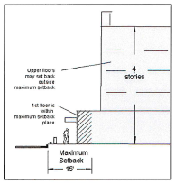
a.
Maximum setbacks apply to all building components, excluding open space, driveways, and porte cocheres.
b.
The maximum setback does not apply to the building plan above the first floor.
(10)
Waiver. The administrator may waive any setback required under regulations in effect prior to the effective date of this chapter (see section 89-174) to the extent that the property at issue is located in a zoning district with required setbacks that conflict with such regulations.
(f)
Railroad rights-of-way/arterial roads - lot arrangement. Where a proposed subdivision abuts or contains a railroad right-of-way or an existing or proposed arterial thoroughfare, as designated in the Lafayette Transportation Plan, the appropriate planning and zoning commission may require:
(1)
Marginal access streets on each side of the right-of-way.
(2)
Reverse frontage lots with required screen planting within the non-access frontage.
(3)
Deep lots with service alleys.
(4)
Adequate right-of-way that is appropriate for future traffic demands.
(5)
Other treatment necessary to protect and separate local and through traffic.
(g)
Administrative modification.
(1)
How do I start the process?
A written request for modification from strict compliance with the requirements of this section is filed with the administrator.
(2)
How are decisions made?
If the Administrator finds that the standards in this Section apply, he/she may vary, modify, or waive the requirements of this Section so that substantial justice may be done and the public interest secured.
(3)
What are the standards for approval?
A.
The administrator may approve a modification if the applicant demonstrates that there are practical difficulties or unnecessary hardships in compliance with the strict letter of this section. If these standards apply, the administrator may vary or modify the requirements of this section so that the spirit of this section shall be observed, public safety and welfare secured, and substantial justice done.
B.
The modification shall not have the effect of nullifying the intent and purpose of the requirements of this section, or of the comprehensive plan.
(4)
The modification shall be the minimum needed to provide the relief the applicant is requesting, and not conflict with the zoning regulations.
(5)
The administrator may require conditions that will, in his/her judgment, secure substantially the objectives of the standards and regulations affected.
(6)
How is a decision appealed?
Appeals of a decision by the administrator by an aggrieved party shall be taken to the appropriate planning and zoning commission or BOZA, as determined by the provisions of sections 89-68 and 89-69.
Sec. 89-39. - Parking and loading.
Purpose: this section provides safety, comfort and convenience to parking lot users, pedestrians and motorists. These standards:
• reduce the effect of parking demand on traffic movement on adjacent streets, and
• prevent the occurrence of undesirable conditions caused by the construction of parking lots which would adversely affect adjacent property owners; and
• establish minimum levels of parking to capture vehicular traffic while avoiding the undesirable effects of excessive parking, and
• consistent with PlanLafayette Action Item (3.2.3), discourage excessive paved surfaces, and
• ensure that parking does not interfere with pedestrian, bicycle, or other modes of transportation.
(City Code 1965, § 19-7)
(a)
Applicability.
(1)
This section applies to the city and the unincorporated parish.
(2)
This section applies to the parking of vehicles accessory to any use.
(3)
Where the requirements of this section conflict with the provisions of section 89-13, Downtown, the provisions of section 89-13, and related appendices, shall apply.
(4)
Administrative modification
a.
How do I start the process?
A written request for modification from strict compliance with the requirements of this section is filed with the administrator.
b.
How are decisions made?
If the administrator finds that the standards in this section apply, he/she may vary, modify, or waive the requirements of this section so that substantial justice may be done and the public interest secured.
c.
What are the standards for approval?
i.
The administrator may approve a modification if the applicant demonstrates that there are practical difficulties or unnecessary hardships in compliance with the strict letter of this Section. If these standards apply, the administrator may vary or modify the requirements of this section so that the spirit of this section shall be observed, public safety and welfare secured, and substantial justice done.
ii.
The modification shall not have the effect of nullifying the intent and purpose of the requirements of this section, or of the comprehensive plan.
d.
The modification shall be the minimum needed to provide the relief the applicant is requesting, and not conflict with the zoning regulations.
e.
The administrator may require conditions that will, in his/her judgment, secure substantially the objectives of the standards and regulations affected.
f.
How is a decision appealed?
Appeals of a decision by the administrator by an aggrieved party shall be taken to the appropriate planning and zoning commission or BOZA, as determined by the provisions of sections 89-68 and 89-69.
(b)
Accessibility. Parking areas that include parking spaces required by this section must be accessible to a public or private street right-of-way or approved permanent access servitude.
⇔ See section 89-26 for ingress and egress requirements.
(c)
Residential zoning district separation. The property owner shall install a continuous fence between the parking lot and any "RS" or "RM" zoning district. The fence shall be six feet in height and constructed of permanent, durable material.
(d)
Location.
(1)
The property used for parking required by this section must be located on or within a contiguous lot or parcel containing the principal use, except as provided below.
(2)
A required parking lot (including any parking space) separated only by an alley, servitude, or street from the property containing the principal use, is considered contiguous if it is within:
a.
300 feet, or
b.
1,000 feet where the property including the principal use and the parking areas are connected by a continuous system of sidewalks (including any street intersection) or pedestrian pathways.
(3)
In the MX district and for Development Type "A" in the MN, CM, and CH districts:
a.
With the exception of a parking for single-family detached and two-family (duplex) uses, parking shall be located at the rear or side of a building. Parking areas located at the side shall be screened from sidewalks by rigid, opaque materials between three and four feet in height. Decorative metal in combination with vegetative landscaping can be used in place of rigid materials. Chain-link fences are not permitted. Vegetative landscaping may exceed four feet in height, but shall achieve and maintain at least three feet opaque height within one year of installation.
b.
Parking shall be accessed by an alley or rear lane, when available. However, there shall be no parking in an alley or lane.
c.
Parking facilities adjacent to or opposite a street or intersection shall be screened.
(4)
In the MN district, parking adjacent to the principal use must not be in excess of the parking requirements for its use type, as required by Table 89-39-2.
(5)
In the MN district, if parking is provided, such shall be designed and constructed to meet the standards contained in 89-39(h).
(e)
Joint parking.
(1)
The off-street parking facilities required by two or more uses may be combined and used jointly.
(2)
The joint spaces shall be located —
a.
On the same building site, or
b.
Within 1,320 feet of the building or area that includes each use.
(3)
The off-street parking facilities shall be adequate in area to provide the sum total of the facilities required for all of the uses.
(4)
Two or more owners or operators of buildings or uses requiring off-street parking or loading facilities may collectively use such facilities if the total minimum and maximum number of such parking or loading spaces conform with this section when computed separately for each use or building type.
(5)
An off-street parking area required for any building or use may be used as part of an off-street parking area required for another building or use where peak use periods do not overlap, as provided below. The required parking spaces are reduced in accordance as follows:
a.
Determine the minimum parking requirements in accordance with Table 89-39-1 for each land use as if it were a separate use,
b.
Multiply each amount by the corresponding percentages for each of the five time periods set forth in Columns (B) through (F) of Table 89-39-1 below,
c.
Calculate the total for each time period (Column),
d.
Select the column with the highest total. This is the required number of spaces.
Table 89-39-1 Shared Parking Reduction
(6)
If an office use and a retail use share parking and the office space comprises at least 35 percent of the space and at least 2,000 square feet, the parking required for the retail use is reduced to the lesser of —
a.
80% percent of the parking spaces otherwise required, or
b.
1 parking space per 500 square feet.
(7)
If a residential use shares parking with a retail use other than lodging uses, eating and drinking establishments or entertainment uses, the parking required for the residential use is reduced by 30 percent or the minimum parking required for the retail and service use, whichever is less.
(8)
If an office and a residential use share off-street parking, the parking requirement for the residential use is reduced to the lesser of —
a.
50 percent of the parking normally required for the residential use, or
b.
1 space per 1,000 square feet.
(f)
Leases. Required parking may be leased if —
(1)
It is located as provided in subsection (d) above, and
(2)
The required parking spaces are leased for a period of time equal to or longer than the lease of the use they are provided for. If the associated use is owned by the operator, the lease of the parking area must be maintained as long as the business is operating, and
(3)
A copy of the new lease must be filed with the administrator prior to expiration of the current lease.
(g)
Required parking.
(1)
Applicability. This subsection applies to all development in the unincorporated area of the Parish and the City of Lafayette. It does not apply to the "MN," "MX," or "D" zoning districts, except where specifically indicated below. Required parking is reduced for "A" Development Types in the "CM" and "CH" districts as provided in article 2.
⇔ §§ 89-14 (CM) and 89-15 (CH)
(2)
Type of parking required.
a.
The schedule in Table 89-39-2 below establishes the motor vehicle parking spaces required for any use.
b.
Ten permanent bicycle parking spaces may be provided in lieu of one parking space. A maximum of 20 bicycle parking spaces may be provided to count toward this reduction.
c.
Parking lots or garages must provide at least one bicycle parking space for every ten motor vehicle parking spaces in the "MN", "MX", and "D" zoning districts.
(3)
Calculations.
a.
Adjacent on-street parking is counted toward the minimum parking requirements.
b.
When a determination of the number of minimum required off-street parking spaces or the permitted maximum number of off-street parking spaces results in a requirement of a fractional space, the fraction counts as one space.
c.
If the number of spaces is based on square feet, the square footage is the gross floor area of all habitable building spaces on the lot or parcel. This does not include any parking garage.
d.
When computing required minimum off-street parking spaces, the total number of required spaces are calculated separately for each use, except as indicated below.
e.
Where applicable, up to two provisions of subsection (4) below may be applied in order to reduce the minimum off-street parking requirement.
(4)
Parking space reductions.
a.
Joint parking spaces. Required parking spaces are reduced if joint parking spaces are provided (⇔ section 89-38(e) above).
b.
Reduction for proximity to public transit. Where a nonresidential use is located within 1,200 feet of a public transit route, the total number of required off-street parking spaces, unassigned to specific persons, is reduced to eighty percent of that otherwise required as set forth in Table 89-39-2.
c.
Reduction for first 4,000 square feet. Where the off-street parking requirement for a nonresidential or mixed use is based on square footage, the total number of required off-street parking spaces, for the first 4,000 gross square feet of floor area of the use, is reduced by two spaces.
Parking is also reduced in the CM (section 89-14) and CH (section 89-15) districts for certain development options.
(5)
Parking space limits.
a.
For purposes of this subsection, "parking spaces" refers to parking lots and the first level of parking garages.
b.
If the number of parking spaces provided exceeds the "number of spaces required" plus the number of "additional spaces allowed before green infrastructure is required," as set forth in the table below, the area of the required green infrastructure shall be equivalent to the area of the parking spaces (together with appurtenant access aisle) that exceed the minimum number of spaces required by this Section (column (A) below) and the additional spaces allowed before Green Infrastructure is required (Column (B) below.
Example: A 10,000 square foot retail building requires 40 parking spaces (10,000 ÷ 250). The applicant may provide ten additional spaces (i.e., a total of 50 spaces) without providing green infrastructure. If the applicant provides 70 spaces, the applicant must also provide green infrastructure equivalent in area to the 20 additional parking spaces (70 - 50) together with appurtenant access aisles.
c.
In lieu of providing the green infrastructure required in this section, an applicant who provides more parking spaces in excess of the "number of spaces required" plus the number of "additional spaces allowed before green infrastructure is required" may instead pave such parking spaces (and appurtenant access aisles) with porous pavement, as defined in article 8. For the purposes of prolonging the lifespan and functionality thereof, the applicant shall enter into a maintenance agreement with LCG relative to any porous pavement (e.g. permeable pavers, porous surfaces, and grass pavers). Among such other reasonable requirements as might be imposed by LCG in order to achieve said purpose, the maintenance agreement shall provide:
i.
that all porous surfaces be vacuumed biannually with a commercial cleaning unit; and
ii.
that, in order to maintain infiltration rates, all permeable pavers be cleaned of any sediment, soil, dirt, and debris from the joint aggregate material.
d.
For purposes of this section, the "number of spaces provided" shall in all instances correspond to the table found at subsection (b) of this section, including where a reduction in the minimum number of parking spaces is allowed in the applicable zoning district.
e.
Green infrastructure shall qualify as parking lot landscaping for purposes of open space requirements.
Table 89-39-2 Required Parking Spaces
(h)
Parking area design.
(1)
Stall dimensions. Parking stalls shall conform to the minimum dimensions established in Table 89-39-3.
(2)
Compact spaces.
a.
Up to ten percent of parking spaces may be designed for use by cars smaller than full size (called "compact spaces").
b.
Compact spaces shall be located in continuous areas, and shall not be mixed with spaces designed for full size cars.
c.
Compact spaces shall be clearly designed by pavement marking and labeled as "Compact Cars Only."
d.
Stall dimensions for compact spaces are reduced to eight feet wide and 16 feet deep.
Table 89-39-3 Parking Stall Dimensions
For purposes of Table 89-39-3:
"Aisle" (A) means the drive aisle serving rows of parked vehicles.
"Angle" (R) means the angle of rotation of a parking space from a position parallel to the wall or edge of the module to the desired angle of parking, in degrees.
"Interlock" (i) means an adjustment of the module for a parking design which has overlapping stalls (i = SW/(2 x cosine (R)). Where stalls on only one side of the aisle are interlocked, M = M-i. Where stalls on both sides of the module are interlocked, M = M- (2 x i).
"Module" (M) means the out-to-out dimension of two rows of parked vehicles and the drive aisle between (M= SD+A+SD). Where single-loaded parking aisles (i.e., parking stalls on only one side of the drive aisle) are provided, M=SD+A.
"Stall Width" (SW) is the width (in feet) between two stripes indicating a parking space.
"Stall Depth" (SD) is the distance measured perpendicular to the wall or module edge.
* Only allowed in "A" Development Types in the MN, CH, and CM districts.
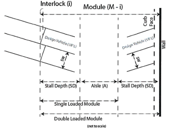
(3)
Use of street, sidewalk or alley as part of access aisle. The full width of an alley, but no part of a public street, shoulder or sidewalk, may be used in calculating the access aisle portion of a one-side parking module.
(4)
Surfacing.
a.
Non-residential lots. The surface of parking lots shall be constructed of concrete or asphalt in accordance with the construction plans approved by PW.
1.
Notwithstanding the foregoing, aggregate parking lots are allowed in the unincorporated parish and all zoning districts in the City of Lafayette, except for the Downtown District, subject to the following conditions:
i.
For properties in the City of Lafayette, they must be located on a local road or a collector road;
ii.
Aggregate parking lots must be located behind the building;
iii.
For corner lots, a landscaping visual barrier shall be provided between the aggregate parking lot and the street which the aggregate parking lot fronts;
2.
Any redevelopment of a property in the City of Lafayette which has a non-conforming aggregate parking lot, and that redevelopment requires and/or incorporates an expansion of said aggregate parking lot, then a landscaping barrier shall be required between the parking lot and the street.
3.
Surface design criteria for aggregate parking lots.
i.
River stone or other smooth aggregate recommended;
ii.
Limestone may be used, but runoff must be filtered through active vegetation or buffers to avoid direct runoff into roadside drainage;
iii.
Parking lot must be bordered to keep aggregate/limestone in parking lot and not on connecting streets and roadside drainage;
iv.
Parking lot entrances (driveway apron) must be hard surface and meet specifications of section 89-39(h)(4);
v.
Compliance with all applicable ADA requirements, including but not limited to hard surface for handicap.
b.
Residential lots. The surface shall consist of shell, brick, stone, aggregate, concrete or asphalt. The material shall be compacted and of such thickness as to provide for the safe movement of traffic and pedestrians during inclement weather.
c.
Driveways
1.
The surfacing between the edge of the existing street and property line for the driveway shall consist of the same or more durable material as the contiguous street surfacing.
2.
If a sidewalk exists it shall continue across the driveway and shall be of concrete composition with a minimum depth of six inches or the same thickness of the driveway, whichever is greater. It shall be separated from the drive by expansion joints for the total length it traverses the driveway and be ADA compliant.
3.
A driveway permit must be obtained from PW prior to construction of the driveway if the construction is not already associated with a building permit.
4.
The design must be in accordance with LCG Driveway Specifications, a copy of which can be obtained from LCG.
(5)
Drainage. Parking lots shall have on-site drainage such that surface rainwater will not be allowed to flow across any sidewalks or properties of different ownership adjoining the property proposed for off-street parking. The size and positioning of culverts and drains shall be approved by PW.
(6)
Wheelguards. Wheelguards or bumper guards so located that no part of parked vehicles will extend beyond the parking facility. The distance from the property line to the wheelguard shall be a minimum of 3.0 feet.
(7)
Dumpsters, when present, shall be located within the development. Dumpsters are not permitted within the public right-of-way.
(8)
Where cart corrals are provided, trash receptacles must also be provided.
(i)
Head-in/back-out parking.
(1)
Applicability.
a.
This subsection applies to "head-in/back-out parking spaces." These are parking spaces requiring a vehicle to back onto a public street or right-of-way as a means of gaining access to the public street.
b.
This subsection does not apply to:
1.
Single-family dwellings, including single-family detached dwellings, accessory apartments, cottage courts, two-family dwellings (duplexes), live/work dwellings, manufactured homes, manufactured housing land lease communities, apartment houses, townhouses/ROW houses, and zero lot line homes (see Use Table, section 89-21), or
2.
The "D" (Downtown) zoning districts.
(2)
Generally (⇔ see also 89-26(d)(12))
a.
Head-in/back-out parking spaces shall not be constructed in any development except where provided in this subsection.
b.
No head-in/back-out parking spaces will be located within the public rights-of-way and no limestone areas within the public rights-of-way shall be used as head-in/back-out parking spaces.
c.
The construction or renovation of existing buildings or structures shall not cause the number of existing head-in/back-out parking spaces located at and servicing the building or structures to increase.
(3)
Existing spaces. An existing building or structure that has existing head-in/back-out parking spaces may expand if:
a.
Any head-in/back-out parking spaces that front major arterial, minor arterial and major collection streets shall be removed.
b.
If the subject property is unable to meet the number of parking spaces required by applicable regulations after removing the head-in/back-out spaces, the owner of the property may construct head-in/back-out parking spaces adjacent to streets which are not designated as major arterial, minor arterial or major collector streets. However, the maximum number of replacement head-in/back-out parking spaces added cannot exceed the number of head-in/back-out spaces removed pursuant to subsection a, above.
c.
PW shall determine whether a property or existing head-in/back-out parking spaces fronts a major arterial, minor arterial or major collection street at the time a request for a building permit is requested for the expansion of a building or structure located on a property which has existing head-in/back-out parking spaces.
d.
Existing head-in/back-out parking spaces are not required to be removed unless there is cumulative expansion (aggregate of all expansions) of existing buildings or structures equal to or greater than the percentages indicated below:
(4)
If an existing building or structure is converted from a residential use to a commercial use, existing head-in/back-out spaces may remain unless they front a major arterial, minor arterial or major collector street. In that event, the existing head-in/back-out parking spaces shall be removed and the property shall provide all requested parking spaces in accordance with applicable regulations.
(5)
The PW director may grant variances from the strict application of this subsection when the director determines either (i) extenuating circumstances exist or (ii) practical difficulties in the development or use of land would result from strict application of this section. Any variances shall be consistent with the intent of this section, the general welfare of the community and traffic safety. The procedure for requesting variances of this subsection shall be published by PW.
(j)
Inventory parking.
(1)
The required parking set forth in section 89-39(g)(5) shall not apply to motor vehicles for sale or lease as inventory at an automobile or vehicle dealership (hereinafter an "Inventory Lot") in the City of Lafayette or in unincorporated areas of Lafayette Parish.
(2)
The provisions of sections 89-36(c), 89-39(d)(3)(a), (b), and 89-39(h)(4)—(7) shall apply to parking areas used as an inventory lot.
(3)
The area utilized by an automobile or vehicle dealership as an inventory lot shall be considered in determining required open space for the automobile or vehicle dealership.
(4)
Inventory lots shall be used exclusively for motor vehicles for sale or lease as inventory, and shall not be used for any other purpose, including employee or customer parking.
(Ord. No. JO-024-2021, § 4(Exh. D), 7-20-21; Ord. No. JO-021-2022, § 3(Exh. C), 3-22-22; Ord. No. JO-077-2022, § 4(Exh. D), 9-20-22; Ord. No. JO-004-2023, § 4(Exh. D), 2-1-23; Ord. No. JO-067-2024, 11-18-24)
Sec. 89-40. - Open space.
(a)
Applicability. This section applies to —
(1)
Any residential subdivision of property, except for a single-family residential subdivision of less than ten lots.
(2)
Any building permit, except for that of a single-family residential home.
(3)
In the event the appropriate planning commission finds that the interests of infill and redevelopment of areas into a more urban character, these requirements may be modified or waived.
(4)
A lot which did not meet the open space requirements at the time of the adoption of this chapter is not required to comply with this section unless there is a cumulative building expansion of the percentage indicated in the table below:
(b)
Reservation.
(1)
Where a proposed park, playground, or other site for public use is shown on an approved plan and is located in whole or in part in a proposed subdivision, the appropriate planning and zoning commission may require the land to be reserved within the proposed subdivision.
(2)
The reservation shall continue in effect for a period of up to one year from the date of filing of the proposed subdivision plan. Additional reservation time may be provided but only upon mutual agreement of the subdivider and the appropriate governmental agency.
(3)
The reservation may be released upon written notice by the respective governmental agency.
(4)
For lands intended for reservation, the subdivider may provide alternate plans for the development lands set aside for public use by the respective governmental agency.
(5)
If the appropriate governmental agency does not initiate action toward a commitment to acquire the land held in reservation during the period of reservation (see subsection (2) above), and the reservation expires, any alternate subdivision plans for the tract become an integral part of the subdivision. When all technical requirements as found in these regulations are met, the reserved land is deemed to have obtained preliminary subdivision approval by the appropriate planning and zoning commission.
(c)
Open space requirements.
(1)
Amount required. Open space is required as a percentage of the gross developable area of a lot or lots. In the City of Lafayette, the amount of open space required depends upon the zoning district in which the property is located, as set forth in article 2. Open space requirements may vary when included as part of a mixed-use center (section 89-28). In the unincorporated areas of the Lafayette Parish, the amount of required open space shall be 20 percent of the gross developable area.
(2)
Design.
a.
Open space includes neither building sites for dwelling units, utility or storage purposes, vehicular parking, carports or garages, driveways, nor streets, either public or private.
(3)
Improvement. Open space may contain complementary structures and improvements needed and appropriate for the benefit and enjoyment of residents of the development.
(d)
Qualifying open space.
(1)
This subsection does not apply to residential development in the City of Lafayette or any development in the unincorporated area of Lafayette Parish.
(2)
Where the zoning district or this section requires an open space allocation, the following areas count toward the total requirement at the percentage designated below:
(3)
Open space does not include:
a.
Vehicle use areas.
b.
Any noncontiguous green area of less than 100 square feet.
c.
Unless expressly allowed by this section, required elements, such as:
1.
Driveways;
2.
Utilities with above ground improvements or road servitudes;
3.
Paved coulees or creeks.
d.
Structures (unless a part of a common open space such as gazebos);
e.
Required unimproved drainage ditches or canals; and
f.
Areas reserved for the exclusive use and benefit of an individual tenant or owner.
(4)
The required private maintenance agreement referenced in subsection 89-40(d)(2) shall provide for the perpetual maintenance and upkeep of open space in a form approved by PW. A form private maintenance agreement is available from PW.
(e)
Ownership and maintenance of common open space.
(1)
Unless otherwise open to the public, common open space shall be permanently set aside for the sole benefit, use, and enjoyment of present and future occupants of the development through covenant, deed restriction, common open space servitude, or similar legal instrument. If agreed to by the LCG, the common open space may be conveyed to LCG for general public use.
(2)
Common open space shall be protected against building development and environmental damage by conveying to LCG, association, or land trust a common open space servitude restricting the area in perpetuity against any future building and against the removal of soil, trees and other natural features.
(3)
If land shown on a preliminary plat as common open space is dedicated to LCG, LCG may, but is not required to, accept the common open space if:
a.
The land is accessible to the residents of the parish;
b.
There is no cost of acquisition other than the costs incidental to the transfer of ownership; and
c.
LCG agrees to and has access to maintain the lands.
(4)
The developer shall provide for and establish an organization for ownership and maintenance of the common open space for the benefit of residences, occupants and owners of the development.
(5)
The organization shall not be dissolved and shall not dispose of the common open space, by sale or otherwise, except to an organization conceived and established to own and maintain the common open space for the benefit of the development. The organization shall not be dissolved or dispose of the common space without first offering to dedicate it to the city or other appropriate governmental unit.
(f)
Cross-access credit. In order to encourage cross-access between lots, for each cross-access point provided to an adjoining lot, the open space requirement for that development shall be reduced by one percentage point, up to a maximum total credit of three percentage points. For example, in a district with a 20 percent open space requirement, providing two such cross-access points reduces the open space requirement to 18 percent.
(g)
Joint-access credit. In order to encourage joint-access, when a development provides joint-access with an adjoining lot along the same public street, the open space requirement for that development shall be reduced by one percentage point. For example, in a district with a 20 percent open space requirement, providing joint-access reduces the open space requirement to 19 percent.
(Ord. No. JO-024-2021, § 4(Exh. D), 7-20-21; Ord. No. JO-077-2022, § 4(Exh. D), 9-20-22)
Sec. 89-42. - Stormwater improvements.
Purpose: The Drainage system within Lafayette Parish is extensive and critical to the success of the parish. Therefore, the design of drainage systems contributes to the success of the area and shall be designed in conformance with the concepts listed within. Action Items (1.5.6, 1.5.7, 7.6.1).
(a)
Applicability.
(1)
This section applies to all proposed development within the City and Parish of Lafayette.
(2)
PW shall review all developments for compliance with these requirements and PW and the appropriate planning commission shall in no way modify or void any other development drainage requirements found herein.
(3)
Zero net fill shall apply to property within the special flood hazard area going through the appropriate planning commission, minor plat (hearing examiner), or commercial plan review.
(b)
General requirements.
(1)
All drainage systems shall be designed, signed and sealed by a Louisiana Registered Professional Engineer in accordance with the most recent editions of LCG's Public Infrastructure Design Standards and LCG's Standard Specifications for Roads, Drainage, Bridges, and Other Infrastructure, unless otherwise approved by PW; shall include hydraulic calculations, plan profile sheets, typical sections and a Drainage Impact Study; and shall be submitted to PW for approval.
(2)
The developer's design engineer shall design the on-site drainage improvements to accommodate potential runoff from the entire upstream drainage area, whether inside or outside of the development. A sufficient number of grading sections shall be provided to adequately evaluate site drainage patterns as required by PW.
(3)
The design engineer shall study the effect of each development on existing downstream drainage facilities or roadside ditches outside the area of the development for no less than 1,000 feet of the effluent channel downstream of the development.
(4)
If the runoff created by the development will overload an existing downstream drainage facility or roadside ditch, the design engineer shall —
a.
Indicate this fact in the development drainage design, and
b.
Provide improvements or site design features that prevent the overloading of downstream facilities or roadside ditch.
(5)
Streets and lots in a proposed development shall be arranged to minimize natural and/or artificial drainage channel relocation. Existing natural and/or artificial channels shall not be incorporated into or function as a proposed storm water management facility.
(6)
Development proposals shall have public utilities and facilities such as water, sewer, gas, and electrical systems located and constructed to minimize flood damage.
(7)
New and replacement sanitary sewage systems shall be designed to minimize infiltration of flood waters into the system and discharges from the system into flood waters. New and replacement water distribution systems shall be designed to eliminate infiltration of flood waters into the system and discharge from the system into flood waters.
(8)
All developments shall comply with sections 26-681—26-800 (Flood Damage Protection) or any subsequent updates.
(9)
Open ditches.
a.
Open ditch drainage is not allowed on proposed public or private streets in the City of Lafayette. In the unincorporated areas of Lafayette Parish, open ditch drainage is allowed on proposed private streets and, on proposed public streets, when the lot frontage averages 150 feet (mean and median).
b.
Notwithstanding the foregoing, the appropriate planning and zoning commission may grant approval of open ditch streets within a development only when the sub-surface system hydraulic calculations and elevations do not function in an effective manner and PW concurs with this finding.
c.
If the design engineer determines, and PW concurs, that an area of the development cannot accommodate a sub-surface system, that area must be designated on the final plat. The following note shall be placed on the plat:
"This development/lot/area has been approved with an open ditch drainage system providing the required storm water retention/detention capacity. The development/lot/area shall remain open ditch and only subsurface culverts required for driveways shall be permitted, unless otherwise approved by LCG Public Works Department."
d.
If approval is granted, see subsection (e), "Standards of Construction of Drainage Systems," below for open ditch construction standards.
(10)
Developments shall be designed for the applicable design storm criteria and shall not negatively impact adjacent properties or the existing public infrastructure upon which the particular development relies.
(c)
Design requirements.
(1)
All flow of water across any intersection either public or private shall be through culverts or bridges.
(2)
Runoff determination methods. The design engineer shall use the following procedures to determine runoff rates:
(3)
Rainfall intensity. Rainfall intensity and duration shall be taken from the latest edition of the National Oceanic and Atmospheric Administration (NOAA) Atlas 14 Point Precipitation Frequency Estimates for Louisiana.
(4)
Runoff coefficients. The runoff coefficients to be used for the S.C.S. Method can be found in the U.S. Army Corps of Engineers HEC-HMS Technical Reference Manual CN Tables section and at https://www.hec.usace.army.mil/confluence/hmsdocs/hmstrm/cn-tables. The runoff coefficients to be used in the Rational Method shall be those indicated in Tables 89-42-1 and 89-42-2.
Table 89-42-1 Rational Method Runoff Coefficients
Table 89-42-2 Runoff Coefficients for Average Block Calculations
(5)
Design storm event. The drainage systems for the following development categories, uses, and infrastructure categories shall be designed and evaluated for the following designated storm events:
1 For developments up to and including 2.5 acres.
2 For developments larger than 2.5 acres.
3 Inline detention - see latest edition of Public Infrastructure Design Standards
4 Or such lesser minimum design storm event as determined by PW
(6)
Tailwater (TW) is defined as the flow depth of the downstream channel or pipe measured from the flow line of the outlet structure or culvert. Tailwater is considered to be an important factor in outfall structure or culvert hydraulic design because a submerged outlet may cause structures or culverts to flow full, rather than partially full, thereby impacting the hydraulic efficiency of the drainage system. The hydraulic analysis of the drainage system shall address the tailwater elevation of the outfall channel. The tailwater elevation of the outfall channel shall be set at top bank and/or flowing full level (i.e., top of pipe) for sub-surface drainage systems unless otherwise determined to be lower through a hydraulic analysis for the applicable design storm event.
(7)
In-line Detention can be implemented for development conditions as described in (5) Design Storm Event and the latest edition of the Public Infrastructure Design Standards.
(d)
Drainage impact study.
(1)
Any development causing post-development runoff that exceeds the development area's pre-development runoff rate shall mitigate the increase through drainage improvements such that the post-development runoff shall be 15 percent less than the pre-development runoff (85 percent of the pre-development runoff) for developments greater than two and half (2.5) acres. Additionally, developments up to and including two and a half (2.5) acres in area are required to retain the design storm event, not a 25-year storm event. The design and calculations of the mitigation measures shall be presented to LCG for review and approval in a drainage impact study. Additional descriptions of the information required in the study may be found in LCG's Public Infrastructure Design Standards.
(2)
A developer may submit a written request to waive the drainage impact study to PW.
a.
PW may approve, approve with conditions, or deny the request.
b.
PW may approve the request if —
1.
A prior approved drainage impact study was performed for the site, the analysis complies with the requirements of this chapter, and conditions have not materially changed since the analysis was performed, or
2.
Existing site conditions are such that a drainage impact study would not provide information needed to determine whether the proposed development complies with this section.
3.
The site is less than ¾ of acre in total size. Runoff to the adjacent roadway, outfall or other properties for these sized developments shall not be allowed as a single point discharge unless approved by PW director. Rather, in these cases, a drainage site and grading plan shall be submitted for review and approval.
(3)
If the drainage impact study indicates that the proposed development does not comply with this section, the plat shall be returned to the appropriate planning commission to determine whether the condition of preliminary plat approval is satisfied. If that planning commission determines the condition is not satisfied, they shall rescind the conditional preliminary plat approval.
(4)
No construction of any development components subject to any approved preliminary or final plat shall be commenced until PW issues a favorable written approval of the drainage impact study and construction plans. Violation of this provision can result in a cease and desist order being issued for the development (⇔ article 4, 89-71).
(e)
Standards of construction of drainage systems.
(1)
Culverts.
a.
Size and type. Only drainage pipe constructed of materials approved by PW may be used in storm sewer construction in the public rights-of-way or servitudes. The minimum size pipes for any culvert shall be a diameter of 15 inches, unless otherwise approved by PW. The design service life for materials used in a drainage system is 50 years, unless otherwise approved by PW.
b.
All roadway cross drains shall be reinforced concrete. No other material will be accepted unless otherwise approved by PW.
(2)
Lateral drainage ditches from the street to an outfall channel which traverse lots shall be provided by subsurface pipe drain with at least a 20-foot permanent drainage servitude. The actual width of the drainage servitude required will be determined by PW based upon pipe diameter, invert elevations, and maintenance issues.
(3)
Open ditch.
a.
A minimum right-of-way of 60 feet is required for developments with open ditch drainage. Rights-of-way exceeding 60 feet may be required depending on the depth and cross section of roadside ditches and an evaluation of the developer's drainage design. The maximum depth of open ditches is limited to 30 inches.
b.
Right-of-way width shall be determined by the maximum ditch side slopes of 3:1 (H:V) for foreslope and 2:1 (H:V) for backslope with a minimum shoulder width of five feet unless otherwise approved by PW.
c.
No objects or culverts shall be placed within the drainage system without prior written approval from PW.
d.
Maximum grade for street ditches shall be limited to that which will not cause erosion.
e.
For development with open ditch systems, the development engineer shall include a culvert sizing chart for each future driveway location based on the design storm flows, depth of cover and constructability.
(4)
Erosion.
a.
Embankment slopes of coulees and drainage ditches shall have slopes which are not in excess of 2:1 (H:V) and shall have appropriate erosion control as approved by PW. End of pipe treatments shall be for both the upstream and downstream end of pipe. Utilization of articulated block matting may be required. Slope requirements around pipe terminus shall be the same as side slope of channel.
b.
Erosion is a naturally occurring phenomenon and the control of erosion on private property and street ditches is the responsibility of the property owner of the drainage servitude and the property owner adjacent to the open ditch within the right-of-way.
(f)
Storm water management facility.
(1)
Responsibility of the owner.
a.
The owner of the storm water management facility shall maintain (such as mowing, bank or bulkhead repairs, and removing debris and trash that occurs on a regular basis, etc.) all other public or private areas, access areas, or privately owned lots, which are a part of or adjacent to the facility.
b.
The owner of the proposed development storm water management facility or any successor who acquires title to the storm water management facility shall at all times maintain the design section of the storm water management facility as indicted on the site drainage plan and in the drainage impact study.
c.
PW shall have the right to enter the premises where a storm water management facility is located to determine whether the owner has maintained the design section of the storm water management facility as indicated on the site drainage plan and in the drainage impact study and as set forth above in subsection (d).
(2)
Inspections.
a.
PW may inspect storm water management facilities at or after the time of construction and require any changes necessary to make the construction conform to applicable requirements. This subsection shall apply even if the storm water management facility was constructed prior to its incorporation into the City of Lafayette or before the establishment of this section.
(3)
Guaranty by the owner.
a.
The requirements of this section shall be included on the site drainage plan and the drainage impact study report and shall be acknowledged in writing by the owner and/or developer, if different from the owner. The developer will cause to be created (or furnish a certified correct copy if already in existence) a financial and management legal entity or entities that will guarantee and assure the maintenance of all private facilities constructed for storm water management.
b.
The developer will provide a certification to the administrator from an attorney licensed to practice law in the State of Louisiana that the documentation, attached to the certification, provides for the creation of an entity that is responsible for maintaining the private facilities for storm water management in the subdivision. The certification must be provided prior to obtaining final subdivision approval. The certification shall contain the name of the entity responsible for maintenance and its registered office.
(4)
Maintenance.
a.
After proper notification to the owner, LCG may enter those areas declared to be in violation of this section and effect repairs of the area as needed to protect the public.
b.
The administrator shall not undertake any work until the owner of the lot, place, area or premises has had the opportunity to do the work within 30 days after proper notice is given. Notice must be given to the owner of the lot, place, area or premises, or, in his absence from the city, to his agent of the leased premises or occupant thereof. Proper notice shall consist of notification by certified mail to the last known address of the owner as reflected by the assessor's tax rolls in and for the parish. If the property is not leased or occupied, the administrator must provide notice by advertisement in the official journal of the City-Parish for two consecutive days.
c.
The actual cost to LCG in having the work performed, and any necessary, reasonable and required administrative charges, is declared to be a charge, cost or expense of the property, lot, place, structure, house, business or area where any repairs or maintenance are performed. Expenses shall be collected in the manner fixed by law for the collection of taxes and are subject to the same penalties for delinquencies. The administrator shall demand of the owner of the property the payment of such charges, costs or expenses by written notice to the owner of the property. If the costs or expenses are not paid within 30 days after demand, the administrator shall, after due notice as stated in this section, send an attached bill of the costs and expenses to the support services manager for LUS who shall add the amount of the bill to the next tax bill of the owner. The administrator shall have recorded, in the mortgage office of the parish, an attached bill showing the cost and expense of the work and the place or property on which the work was done, so as to establish for LCG a lien and privilege securing the payment by the property owner of the charges, costs and expenses.
(5)
Desiltation.
a.
For developments where water collected from public infrastructure is routed through a detention facility, access in favor of LCG shall be provided from a publicly dedicated road to the storm water management facility. The access shall be at least a clear 20-foot wide travel way (graded to accommodate use by equipment) and sufficient area proximate to the travel ways to allow desiltation activities. A note shall be placed on the final plat indicating that this access shall be provided to LCG.
b.
It shall be the responsibility of the owner of the storm water management facility to ensure proper desiltation. If, within 30 days of notification by LCG that desiltation is required to ensure proper performance of the facility, desiltation is not performed by the owner, then LCG may (but is not obligated to) perform the desiltation and other required remedial measures as determined by LCG. Cost and charges will be assessed to the owner. Notice and assessment of costs and charges shall be in the same manner as set forth in subsection (f)(4) above.
(g)
Development within designated 100-year flood hazard area.
(1)
In addition to any other stated provisions, a development proposed within a FIRM designated special flood hazard area (flood plain, flood hazard or floodway) whether located in the city or Parish of Lafayette, shall be in accordance with the rules and regulations of all applicable regulatory agencies and comply with the provisions of the Flood Damage Prevention Ordinance of the applicable governing authority.
(2)
The appropriate planning commission shall not permit the development of any land in a special flood hazard area where such land is found to be incompatible with its proposed use due to poor drainage, flooding or other factors, which would make the area vulnerable to flooding and pose a potential hazard threat to public health and safety.
(3)
A flood plain analysis shall be required for any development of five acres or more (whether or not comprising 50 or more lots), or 50 or more lots (whether or not comprising five acres or more), located within a designated special flood hazard area. The complete analysis must be conducted after preliminary plat approval by the appropriate planning commission.
(4)
No development, fill, or obstruction of any type on or over any portion of a designated floodway shall be permitted that alone or cumulatively with other developments, fill or obstructions would cause or result in an obstruction or other condition that would adversely affect the efficiency of or restrict the flow or capacity of a designated floodway so as to cause foreseeable damage to others, wherever located.
a.
Any application for development within a designated floodway shall include hydrologic and hydraulic HEC-RAS data, or other models acceptable to the applicable regulatory agency, certifying that no adverse flood effects will result from a proposed development in the designated floodway.
b.
This certification is subject to review and approval or denial by the LCG Floodplain Administrator and/or FEMA.
(5)
Any flood plain impact analysis conducted for a development located in designated special flood hazard area zone "A" shall include, as an integral part of the flood plain impact analysis, a base flood elevation determination in accordance with FEMA document, "Managing Floodplain Development in Approximate Zone A Area."
(6)
Development proposals shall have public utilities and facilities such as water, sewer, gas, and electrical systems located and constructed to minimize flood damage.
(7)
For the plat requirements relative to proposed development within a flood hazard, flood plain, or floodway, see section 89-33.
(8)
Any development that fills or modifies a designated special flood hazard area must mitigate that development activity volumetrically.
The volume of any proposed fill material or modification below the base flood elevation and above natural grade shall be calculated and documented. Mitigation activities shall restore that volume to achieve an effective "zero net fill" of the pre-development storage capacity of the special flood hazard area. The development shall accept stormwater during a 100-year (one percent) storm event, both from on-site and off-site, such that post-development conditions provide storage volume equal to the pre-development storage volume, as measured in acre-feet. If the stormwater retention/detention facility is used as a storage mitigation area, the storage volume shall be calculated as the volume above the static water surface elevation of the facility.
(Ord. No. JO-024-2021, § 4(Exh. D), 7-20-21; Ord. No. JO-021-2022, § 3(Exh. C), 3-22-22)
Sec. 89-43. - Environmental stormwater management.
(a)
See Stormwater Ordinance of the Lafayette City-Parish Consolidated Government (LCG Code Chapter 34, Article V).
Sec. 89-44. - Street design.
Purpose: this section establishes street connectivity, layout and geometric design standards that —
• implement PlanLafayette Action Items 1.3.2, 1.6.4, 2.11.1, 3.15.5, 6.4.2, 6.8.3, 10.2.1, and
• protect the public health, safety and general welfare, and
• promote the character of development provided in PlanLafayette and, if applicable, the zoning district, and
• provide for the efficient movement of all modes of travel, including cars, pedestrians, bicycles, and transit.
• Adhere to local, state, and federal engineering standards, policies, practices, and requirements for compliance and public safety.
(a)
Public streets.
(1)
General.
a.
The arrangement character, extent, width, grade and location of all streets shall —
1.
Conform to the Lafayette Transportation Plan, and
2.
Be considered in their relation to existing and planned streets, topographical conditions, public convenience and safety, and their appropriate relation to the proposed uses of the land to be served by the streets. Artificial channel relocation shall be minimal.
b.
The Lafayette Transportation Plan shall be adopted by ordinance after review and recommendation by the appropriate planning and zoning commission as part of its responsibility in section 4-10 of the Lafayette City-Parish Charter. LCG staff, under the direction of the administrator and PW, shall annually review, and if necessary suggest updates, to the Lafayette Transportation Plan.
c.
Where streets are not shown on the Lafayette Transportation Plan, the arrangement of streets in a subdivision shall:
1.
Provide for the continuation or appropriate projection of existing or proposed streets into surrounding areas where possible;
2.
Conform to any neighborhood or area plan for the neighborhood approved or adopted by the appropriate planning and zoning commission.
3.
Provide adequate street connections to adjacent properties to insure adequate traffic circulation within the general area.
4.
Shall not include a drainage crossing greater than 84 inches in diameter without the benefit of access to both sides of the crossing when the area of the crossing will be closed for repair/replacement. If this requirement cannot be met, the proposed roadway shall be private.
d.
Public or private street layout within a subdivision shall provide access to all lots, or residential units, within the subdivision. Private streets may not be used to block connections to existing public rights-of-way or stub-out streets.
e.
New public streets shall be constructed with curb and gutter unless otherwise approved by PW based upon the results of the drainage impact study.
f.
The actual right-of-way varies based on the number of travel lanes and lane widths and the provision of other elements to support the type and density of adjoining land uses including parallel or angled on-street parking, buffer planting zones with landscape and streetscape materials, pedestrian zones and sidewalk widths, on-street bike facilities, and medians.
g.
Typical pavement section using minimum construction requirements is to be supported by sufficient geotechnical testing or design documentation to determine the section is suitable for the site specific or borrow material soil properties and anticipated traffic loading. The geotechnical testing used for design and construction testing/inspection results are to be submitted to PW at the time of completion of construction and the final inspection. The minimum pavement section shall be three inches asphaltic concrete wearing course, and eleven inches soil cement base or eight inches concrete (3,800 psi) and six inches properly prepared base.
h.
In those instances where a subdivision plat is located adjacent to an existing public street with a sub-standard right-of-way, sufficient additional right-of-way or setback shall be dedicated to accommodate the ultimate development of the subject street to a right-of-way width as required by the development standards.
i.
Public alleys are not permitted.
j.
Street lighting.
1.
Street lighting is required along all streets within a subdivision plat located in the City of Lafayette. Street lighting is not required along streets within a subdivision plat located in the unincorporated areas of Lafayette Parish.
2.
Street lighting is required along all streets in a subdivision plat in accordance with PW and LUS Standards for Arterial Street Lighting, when applicable.
3.
Lighting along streets, including pedestrian scale lighting, shall be provided along all streets required in the MX and PD districts along all streets that have sidewalks in accordance with PW and LUS Standards for Arterial Street Lighting, when applicable.
4.
Lighting shall be shielded and directed downward in order to reduce glare.
(2)
Geometric design.
a.
Plan and profile sheets showing the roadway geometric design, drainage design and utility plans shall be designed by a Louisiana Registered Professional Engineer and submitted for review and approved by PW and LUS, when applicable, before any development improvement work begins.
b.
The minimum right-of-way, horizontal curves, gradients and miscellaneous widths for streets shall be as listed below for conventional street designs and for compact street designs.
c.
Design standards. The table below describes the minimum facilities required for each roadway type and the minimum widths of those facilities. Note, additional facilities are permitted if they are in accordance with the standards.
Table 89-44-1 Street Design Minimum Standards a
a Information shown on this table is the minimum required. Additional right-of-way will be required to accommodate additional facilities above the minimums. The minimum may not be acceptable for all developments.
b Compact Roads are only allowed in the following districts: RS-2, RM, MN, PI and PD.
c Open Ditch streets apply to the "A" zoning districts, conservation subdivisions or locations where curb and gutter requirement is determined to be hydraulically unfeasible by PW. A sub-surface system shall be extended as far as hydraulically feasible before an open ditch section is permitted.
d.
Curves and intersections.
1.
Subdivision plats, site plans and concept plans shall be arranged to allow the opening of future streets and logical future subdivision or development.
2.
Curves proposed for the right-of-way of designated major thoroughfares must have a minimum center line radius of 150 feet.
3.
Reverse curves shall be separated by a tangent distance of at least 100 feet.
4.
Intersections with other public streets shall be at right angles. Any variance shall not modify the angle of a major thoroughfare intersection more than five degrees. Where acute angle intersections are approved, a radius of at least 25 feet in the right-of-way line at the acute corner must be provided.
5.
Streets may intersect at a minimum 60-degree angle unless otherwise provided. If a street intersects at an acute angle, a minimum 25 foot radius is required at the edge of pavement.
(3)
Roundabouts. Roundabouts must be constructed of PCC Pavement** if any of the following conditions apply:
a.
The roundabout is on the only entrance/exit to the proposed development; or
b.
The traffic impact analysis requires construction of a turn lane to the development, and the roundabout is located on the entry/exit road; or
c.
The average daily trips ("ADT") is 250 vehicles per day or greater; or
d.
There are 100 or more lots in the proposed development; or
** The typical section for the PCC pavement must conform to the recommendations of a Louisiana Licensed Geotechnical Engineer, based upon sampling of in-situ or proposed fill materials. This report is to be submitted with the development construction plans, for review and approval by public works.
(b)
Connectivity.
Purpose: Street layouts should respond to local conditions such as topography, watercourses, greenways and the existing street systems of neighboring developments. Local street patterns may discourage through traffic, but should also include interconnecting streets with alternative routes throughout the neighborhood to diffuse automobile traffic and shorten walking distances. A well connected street network shall be provided to spread traffic efficiently, and to provide greater opportunities for access and circulation of motor vehicle, pedestrian, and bicycle modes of travel.
(1)
Reserve strips that control access to streets are not permitted unless they are dedicated to or controlled by LCG, and approved by the appropriate planning and zoning commission. This does not apply to reserve strips where required for double frontage lots. (⇔ section 89-38(c)(10))
(2)
Half streets are prohibited.
(3)
External connectivity.
a.
Parcels shall be arranged to allow the opening of future streets and logical further subdivision.
b.
Proposed streets shall be extended to the boundary lines of the tract to be subdivided or developed, unless prevented by topography or other physical conditions, or unless the PW engineer determines that the extension is not necessary or desirable for the coordination of the layout of the subdivision or development with the existing layout or is not the most advantageous future development of adjacent tracts.
c.
The external connection shall be provided by extending at least one street to the boundary line of the tract.
d.
The number of external connections shall be determined by one of the following:
1.
The property boundary length divided by twice the minimum block length (see section 89-38 (d)(3)). In calculating this number, fractions are rounded down. Straight line approximations of the boundary length may be used if approved by the PW engineer.
Example: A tract zoned "RM" has a common boundary of 1,000 feet with an adjacent tract. The minimum required block length is 200 feet. Two external connections are required (1,000 - (2 x 200) =1,000 / 400 =2.5 rounded down to two.
2.
For developments fronting streets designated as arterials or which have speed limits of 35 mph or greater, only one external connection to said street is permitted.
3.
A greater or lesser number of external connections may be allowed if a traffic impact analysis establishes that varying from the requirements set forth above would not adversely impact the flow of traffic.
(4)
Internal connectivity.
a.
The following terms are defined for purposes of this subsection only:
b.
Streets within any proposed residential subdivision shall achieve a connectivity ratio as provided below. The connectivity ratio is computed by dividing the number of street links and pedestrian connections by the number of nodes within the subdivision.
c.
The administrator may count a feature as a street link or pedestrian connection or reduce the required ratio if:
1.
Existing topography or natural features make the required number of connections impractical, and
2.
The applicant provides alternative solutions that substantially accomplish the purposes of this section.
Table 89-44-2 Connectivity Ratio
(5)
Cul-de-sacs and dead-end streets.
a.
Dead-end streets are not allowed except in those instances where the street is terminated by a circular cul-de-sac turnaround or where the street is designed to be extended into adjacent property.
b.
The maximum length of dead-end streets (cul-de-sacs) is established in the table below. However, the appropriate planning and zoning commission may approve dead-end streets of a greater length when unusual conditions exist. The turnaround dimensions apply to a dead-end street over 150 feet from a through street intersection unless otherwise recommended or approved by the PWorks and/or approved by the appropriate planning commission.
Table 89-44-3 Cul-de-Sacs and Dead-End Streets
c.
When there are plans for the future extension of a dead-end street, the closed end of the streets shall include a hard surface turnaround subject to the specifications of PW.
(6)
Applicant/developer traffic impact analysis.
a.
With respect to the arrangement of parcels and number and location of external connections (see section 89-44(b)(3)), the number and location of internal connections (including street links and pedestrian connections) and the computation of the connectivity ratio for a residential subdivision (see section 89-44(b)(4)), and the length of cul-de-sacs and dead-end streets (see section 89-44(b)(5)), as well as any other similar or related matters, the applicant or developer, at its own costs, shall be entitled to submit a traffic impact analysis to PW, with a copy to the PW engineer, the administrator, and the appropriate planning and zoning commission, in order to allow the applicant or developer to provide recommendations and alternatives related to connectivity. Nothing herein shall prohibit or limit PW and/or the appropriate planning and zoning commission from requiring an applicant or developer to submit a traffic impact analysis, where otherwise required.
b.
The traffic impact analysis shall, at a minimum, (i) be prepared by a registered professional engineer in the state of Louisiana qualified to practice traffic engineering (ii) state the purposes of the report, (iii) state the findings of the report, and (iv) state the recommendations and alternatives proposed by the report. The PW engineer, the administrator, the appropriate planning and zoning commission, and/or PW, as applicable, shall give due consideration to the recommendations and alternatives set forth in the traffic impact analysis, but shall not be bound to implement or adopt, in whole or in part, any recommendations and alternatives therein.
(c)
Improvements proposed for public dedication.
(1)
The design and construction of public streets are not subject to direct regulation or control of the appropriate planning commission, but such matters do fall within the review and policies of the state and PW.
(2)
On all streets developed within LCG's jurisdiction, all grading, surfacing, drainage and sidewalk construction shall be done under the supervision of a licensed civil engineer with full time inspection who has obtained either LCG construction inspection certification or LA-DOTD certification in the area of work in which the inspection is being provided. New road pavement design shall be determined by the site soils and anticipated traffic loading.
(3)
For all improvements offered for dedication, the developer's engineer shall certify to the completeness of the construction and that the construction was performed under the supervision of a full time quality control/quality assurance inspector, completed in accordance with the approved plans and LCG's specifications approved by LCG and all of the requirements set forth at provisions listed within sections 89-58 (e) and (f) and 89-59. The testing laboratory shall be approved by PW.
(4)
All curbs, sidewalks, crosswalks and pedestrian ways intended for public dedication shall be designed and constructed in accordance with the Americans with Disabilities Act (ADA).
(5)
A development permit must be completed and adhered to for dedication and acceptance.
(d)
Private streets and private alleys.
(1)
General arrangement and layout. The pattern or layout of private streets in any project shall provide the following basic design concepts:
a.
Provide adequate vehicle access to buildings and facilities within the plat boundaries.
b.
Provide adequate interior traffic circulation and access to buildings by firefighting personnel and equipment and not induce a hazard to vehicular traffic and the occupants of the development as determined by PW.
c.
Provide adequate access to the existing public street system adjacent to the boundaries of the plat however, private streets shall not be direct projections of any public street.
d.
The developer is responsible for private streets. The appropriate planning and zoning commission will designate these streets as such. All private streets and private alleys will be clearly marked and designated as private streets or private alleys on the preliminary and final plats.
e.
Minimum unobstructed private right-of-way width of twenty-five feet shall be required along all private streets except in the case of a private street being designated as a one-way street, in which event a minimum constructed private right-of-way width of twenty feet shall be required. If parallel parking is proposed along the private street, additional width may be required to accommodate the parking in question as determined by LCG.
f.
The assurance of pavement construction requirements will be under the jurisdiction PW review of construction standards.
g.
Typical pavement section.
1.
For all subdivisions in unincorporated Lafayette Parish with more than 15 lots and all subdivisions in the City of Lafayette, typical pavement section using minimum construction requirements is to be supported by sufficient geotechnical testing or design documentation to determine the section is suitable for the site specific or borrow material soil properties and anticipated traffic loading. The geotechnical testing used for design and construction testing/inspection results are to be submitted to PW at the time of completion of construction and the final inspection. The minimum pavement section shall be two inches asphaltic concrete wearing course, and eight inches soil cement base or eight inches concrete (3,800 psi) and six inches properly prepared base.
2.
For subdivisions in unincorporated Lafayette Parish with 15 lots or fewer, pavements section shall meet the requirements of section 89-44 (d)(1)(j).
3.
For subdivisions served by private roads in existence prior to the final adoption of this chapter, or for which access is obtained through private right-of-passage or other private access agreements recorded prior to final adoption of this chapter, pavement shall be of a strength sufficient to insure stable passage and adequate drainage, as determined by the PW. "As built" documentation demonstrating the stability of the pavement and adequacy of the drainage shall be submitted to PW prior to recordation of the final plat, and shall be subject to approval by PW.
h.
A private development may not block an existing or proposed public street extension.
i.
The minimum pavement or traffic lane width requirement shall be 20 feet. When the private Street is designated as a one-way street, then the minimum pavement or traffic lane width requirement shall be 12 feet.
j.
Any single-family residential development within the unincorporated Parish of Lafayette composed of 15 proposed lots or fewer, or any apartment, condominium, planned unit development, or other attached housing, having fewer than 15 units and containing private streets, shall be serviced by a private street system with an aggregate or paved surface. The typical roadway section shall be a minimum four inches of aggregate (limestone or aggregate) or two inches of asphaltic concrete placed over a base that is either ten percent lime treated soil ten inches thick or eight inch soil cement.
k.
It shall be unlawful to develop property in phases or otherwise as a means of avoiding paving private street(s) in compliance with these regulations. For purposes of these regulations, all potential phases of a proposed development will be counted to determine the number of lots or units in any such development. No individual, directly or through the interposition of any legal entity, whether an individual, corporation, partnership, limited liability company, association, trust or other entity, shall be permitted to develop property by phases or any other means in an effort to avoid compliance with the requirement of paving private street(s) in accordance with these regulations or that would otherwise circumvent the intent of these regulations. No property contiguous to a development in which private street(s) are installed as permitted herein shall be developed by the same person either directly or through the interposition of any legal entity, whether an individual, corporation, partnership, limited liability company, association, trust or other entity for a period of two years after occupancy of the last unit occupied in the previously approved subdivision.
(2)
Private alleys.
a.
Private alleys may be provided within any subdivision to provide secondary vehicular access to buildings that have their primary access from an adjacent public street or private street.
b.
Private alleys cannot be used or designed to provide the principle access to property outside the subdivision plat boundaries in which the private alleys are located.
c.
Parallel parking is not allowed along a private alley. To maintain this restriction, the owner of the alley shall, at the developer's expense, conspicuously display signs prohibiting parking.
d.
Intersections of private streets shall be at right angles with variations not to exceed ten degrees.
e.
A driveway easement assuring permanent rear lot access for interior lots may be substituted for an alley.
(3)
Geometric design.
a.
Private streets (including private alleys) shall comply with the geometric design requirements in section 89-44 (a) 2.
b.
Private streets may be established without a formal right-of-way if an unobstructed right-of-passage width equal to the right-of-way width required in section 89-44 (a) is provided and constructed.
c.
Dead-ends, cul-de-sacs, and T-type turnarounds are allowed only in the unincorporated parish, and shall comply with subsection (b)(3) and Table 89-44-3.
(4)
Intersections.
a.
When a private street or private alley intersects with a public street there must be a minimum off-set distance of 125 feet from the center line of the private street or private alley to the center line of any adjacent street or alley intersecting the public street.
b.
Intersections of all private streets and private alleys with the public streets must be at right angles with variations not to exceed ten degrees and have 25 feet radii at all corners.
(5)
Connectivity.
a.
Private streets must comply with the connectivity standards in subsection (b) above.
b.
To provide adequate emergency vehicular access, the private street system shall provide at least two points of access to the project or development from the public streets adjacent to the boundaries of the project or development.
(6)
Fire protection.
a.
All buildings proposed to be constructed within any project containing private streets must be so arranged and located that the firefighting apparatus can park and reach any part of any building with a 200-foot long hose extending from the apparatus. The 200-foot hose length must be measured as the hose is laid on the ground and may not be measured as the aerial radius from the parked apparatus.
b.
Fire hydrants, where required, must be so located and provided within the project boundaries that 300 feet of fire hose, extending on the ground from the hydrant, can reach the furthermost part of any building within the boundaries of the plat.
c.
All buildings proposed to be constructed within any project containing private streets and which contain residential dwelling units and have an overall length of 300 feet or more, must be so designed to have at least one open, unobstructed walkway through the building at ground level. The walkway must have a width of at least five feet to allow ready access by fire and police and their equipment and other emergency services to each side of such buildings. Where buildings are to be constructed over and across any private street, the unobstructed overhead clearance must be at least 14 feet when measured between the highest point of the private street paving under the structure and the lowest part of the building structure or associated parts of the building. Suitable restrictions to this condition must be noted on the plat.
(7)
Maintenance of private streets and private alleys.
a.
LCG is not responsible for maintaining any private streets, signs or drainage improvements on the private street(s).
b.
The developer will cause to be created (or furnish a certified correct copy if already in existence) a financial and management legal entity or entities that will guarantee and assure the maintenance of all private streets and private alleys constructed.
c.
The developer will provide a certification to the administrator from an attorney licensed to practice law in the State of Louisiana that the documentation attached to the certification provides for the creation of an entity that is responsible for maintaining the private streets, private roads and/or private alleys in the subdivision. The certification must be provided prior to obtaining final subdivision approval. The certification shall contain the name of the entity responsible for maintenance and its registered office.
(8)
Drainage of private streets and private alleys.
a.
New private streets, private alleys and private drainage systems shall conform to the applicable requirements of section 89-42(a)—(g) with respect to the design and construction of the sub-surface/open ditch roadway drainage system and private drainage outfall.
(9)
Administrative modification.
a.
How do I start the process?
A written request for modification from strict compliance with the requirements of this subsection 89-44(d) is filed with the administrator.
b.
How are decisions made?
If the administrator finds that the standards in this subsection apply, he/she may vary, modify, or waive the requirements of this subsection so that substantial justice may be done and the public interest secured.
c.
What are the standards for approval?
1.
The administrator may approve a modification if the applicant demonstrates that there are practical difficulties or unnecessary hardships in compliance with the strict letter of this subsection. If these standards apply, the administrator may vary or modify the requirements of this subsection so that the spirit of this subsection shall be observed, public safety and welfare secured, and substantial justice done.
2.
The modification shall not have the effect of nullifying the intent and purpose of the requirements of this subsection, or of the comprehensive plan.
d.
The modification shall be the minimum needed to provide the relief the applicant is requesting, and not conflict with the zoning regulations.
e.
The administrator may require conditions that will, in his/her judgment, secure substantially the objectives of the standards and regulations affected.
f.
How is a decision appealed?
Appeals of a decision by the administrator by an aggrieved party shall be taken to the appropriate planning and zoning commission or BOZA, as determined by the provisions of 89-68 and 89-69.
(e)
Sidewalks.
(1)
Sidewalks are required where indicated in the geometric design standards (see section 89-44(a)(2)). Sidewalks shall be a minimum of five feet when separated from the roadway by a four-foot open area. When sidewalks are adjacent to the roadway (curb) the sidewalk minimum width is six feet.
(2)
The applicant for subdivision plat approval shall construct all sidewalks on the property.
(3)
The sidewalks shall be constructed at the time of final plat recordation. The acceptance of a letter of credit in lieu of the construction of sidewalks is allowed according to section 89-35 "Improvement Guarantees." The amount of the letter of credit must be approved by PW.
(4)
Development fronting on state highways.
a.
The developer must construct sidewalks either in state highway right-of-way or in a sidewalk easement on the development property.
b.
If the applicant intends to construct the sidewalk in the state right-of-way —
1.
The applicant shall request approval from the local state highway office on the appropriate form during the platting process.
2.
If the state highway department approves the application, the sidewalks will be shown on the preliminary plat as approved by the DOTD and a copy of the DOTD permit submitted to PW prior to final plat approval.
3.
If the state highway department denies the application, the developer will designate a minimum 5-foot-wide sidewalk easement adjacent to the state right-of-way line on development property on the preliminary plat.
4.
The sidewalk easement can be located within the utility easement.
(5)
Development fronting city/parish streets.
a.
The developer must construct sidewalks either in public street right-of-way or in a sidewalk easement on the development property.
b.
Sidewalks built in the public street right-of-way shall be constructed so that the development side edge of the sidewalk is one foot within the right-of-way line and the 5-foot sidewalk width is in public right-of-way.
c.
If street right-of-way width, trees, utilities, topography, existing ditches, or similar existing obstructions prevent the construction of sidewalks in public right-of-way, the sidewalk will be constructed in a sidewalk easement designated on the preliminary plat. The sidewalk easement can be located within the utility easement. If the conflict is discovered after final plat recordation, an act of correction must be completed and recorded with the revised sidewalk easement shown.
(6)
Maintenance. If sidewalks are constructed according to LCG standards in the designated sidewalk easement, LCG will assume perpetual maintenance of these sidewalks.
(7)
Design.
a.
Sidewalks shall be constructed according to LCG's specifications for roads, drainage, bridges, and other infrastructure improvements.
b.
Sidewalks shall avoid obstacles such as ditches, trees, and utilities.
c.
Sidewalks across driveways or that will be crossed by vehicles will be at least six inches thick or as thick as the driveway, whichever thickness is greater.
d.
The sidewalk will be continuous over the full frontage of the development.
e.
At street corners the sidewalk in both directions will extend to the pavement edge. If a ditch culvert is required to accomplish this, it will be considered part of the sidewalk requirement. The size and grade of culverts will be determined by the development engineer and approved by PW.
f.
Sidewalks along "A" and "B" streets in the MX and D zones ("A" and "B" streets are as defined in the development's plan), shall be divided into frontage zones, pedestrian through zones and furnishing zones as follows:
Table 89-44-4 Frontage Zones
| "A" Streets/Main Street | "B" Streets | |
|---|---|---|
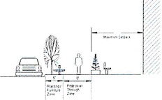 | 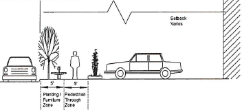 | |
| Pedestrian Through Zone (minimum-feet) | 8 feet | 5 feet |
| Planting / Furniture Zone (minimum-feet) | 5 feet | 5 feet |
(f)
Line of sight.
(1)
Applicability.
a.
This subsection applies to existing obstructions predating adoption of this ordinance and new construction of fences or signs or placement of movable objects, and new planting of hedges, bushes or other plants.
b.
Utility structures, traffic and street signs, where necessary as determined by the administrator, and buildings existing at the time of adoption of this ordinance are exempt from this subsection.
c.
This subsection shall apply to properties located at the intersection of a public street with a public street, the intersection of a public street with a private street, and as otherwise provided herein.
(2)
It is unlawful to construct or maintain, or permit to remain, any fence, sign, movable object, hedges, bushes or other plants which exceed 36 inches in height measured from the street level on any lot where the fence, sign, movable object, hedges, bushes or other plants obstruct the line of sight at street intersections as defined in this section.
(3)
The sight line and the curb lines of the major street and minor street represent sight triangles that are to be free from obstructions as noted in this section.
(4)
The sight distance is measured from a point along the minor street intersection approach located 14.4 feet from the intersection of the centerline of the minor street with the curb line extension of the major street. This point is established at 3½ feet above the minor street pavement elevation. From this point a vehicle driver shall be able to view an object from a predetermined distance measured along the center of the lane of the intersecting major street. This object shall be visible from a height of 3½ feet above the pavement of the major street. The required distance varies with the posted and/or 85th percentile operating speed of the major street and the number of lanes on the major street.
(5)
Sight distance for various speeds and number of lanes for the intersection roadways are specified in Table 89-44-5 The area required to be free from obstructions for intersections on the inside of a horizontal curve of a major street requires sight distance restrictions more than a street intersection at 90 degrees.
(6)
For permitting purposes, a 30 foot sight triangle may be used instead of the line of sight calculations for corner lots located at the intersection of a private street with a private street. On such corner lots, no driveway, automobile, trailer, sign, movable object, fence, wall, hedge, or other structure shall be erected, placed, or maintained within the triangular area formed by the intersection projections of the lines forming the edge of the pavement at points which are 30 feet distant from the point of the intersection, measured along the edge of the pavement. Notwithstanding the foregoing, if the speed limit for either intersecting private street would require line of sight distances greater than the 30 foot sight triangle, it shall be the responsibility of the developer to comply with AASHTO safety guidelines and present those findings on the permit drawings.
Table 89-44-5 Minimum Required Sight Distances/Required Sight Triangles
* 85 percent speed may be used in lieu of existing speed limit.
The value noted within Table 89-44-5 is measured in accordance with the following graphic figure:
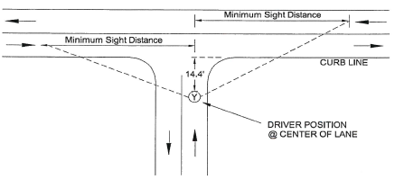
Figure 89-44-2 Sight Distance Measurements
(Ord. No. JO-024-2021, § 4(Exh. D), 7-20-21; Ord. No. JO-021-2022, § 3(Exh. C), 3-22-22; Ord. No. JO-067-2024, 11-18-24)
Sec. 89-45. - Street names.
(a)
Generally.
(1)
Required. Street name signs shall be erected at all intersections built and set to the specifications of PW.
(2)
DPD. DPD is the coordinating agency for the identification and naming of public and private streets, roads, and thoroughfares within the jurisdiction of LCG. In this capacity the department shall review, recommend and assign names submitted for new streets and roads and proposed changes to existing street, road, and thoroughfare names. Street names are subject to the approval of the 911 Lafayette Parish Communication District.
(3)
Duplication prohibited. Proposed street names shall not duplicate any existing street name, public or private, located within the Parish of Lafayette or any incorporated municipality.
a.
This does not apply to streets in the "D" Downtown District, such as Main Street or First Street.
b.
Identification as a public street or as a private street does not exempt a street name from duplication. Example: Broussard Road and Broussard Lane (Private) is not acceptable.
c.
Suffixes such as Drive, Road, Street, Parkway, Avenue, Court, Loop, Circle, etc. do not remedy duplication.
d.
Prefixes such as Saint, Rue, Chemin, Avenue, etc. do not remedy duplication.
e.
Directional prefixes and suffixes in French or English may be allowed and will remedy duplication if the streets are coterminous.
(4)
General standards.
a.
Streets that align with existing streets shall bear the names of existing streets.
b.
Streets shall, whenever possible, have the same name throughout their entire length.
c.
Alphabetical and numerical street names are not allowed.
d.
All existing and new public streets shall have block numbers assigned in conformity with the block numbering system for Lafayette Parish.
e.
LCG encourages developers, property owners, residents and businesses applying for street names to use French names or terms in an effort to preserve and promote the Cajun/Creole culture and heritage in Acadiana. Applicants for street names may use the names of individuals who may have some historical relationship to the area where the street is to be located or who may have donated the right-of-way, or may recognize historical events and place names in the development of street names.
f.
Private street name signs shall have an abbreviation for private (PVT) placed on the sign after the street's name. The background color of private street name signs shall be blue. Public street name signs shall follow LCG street sign standards. Private and public street name signs shall be identical in every other way except those mentioned in this section or as outlined in the LCG street sign standards.
g.
Streets or roads may "offset" or "jog" with the same name up to 125 feet from center line to center line.
h.
Where a major thoroughfare replaces a local street or road in whole or in part, the name of the major thoroughfare shall prevail over the local street or road name. When the local street or road name is determined to be non-duplicative and of historical or sentimental value the name shall be placed in a street name reserve list for reuse at an appropriate opportunity.
i.
Existing street names must be used in those instances where a new street is a direct extension of an existing street or logical extension thereof except in those instances where the existing street name is a duplicate street name.
(5)
Procedures.
a.
Street, road, and thoroughfare names and name changes may be initiated by three different sources:
1.
DPD — Administrative costs for streets, road, and thoroughfare name change proposals originated by Lafayette City Council and/or Lafayette Parish Council shall be funded by DPD.
2.
Lafayette City Council and/or Lafayette Parish Council, as the case may be.
3.
Fifty percent plus one of the property owners owning or fronting the public or private street/road under consideration.
b.
Applications to change the name of a public or private street, road, or thoroughfare are allowed only for the entire length of the subject street, road or thoroughfare.
c.
DPD may initiate a public or private street name change for the following reasons:
1.
To resolve an existing duplication of street names within the parish.
2.
To accommodate capital improvements by federal, state, and local government.
3.
To coordinate the establishment of one name where multiple names exist on one continuous street.
4.
To identify an existing road or street lacking a name designation.
5.
In all other instances where confusion or duplication might otherwise exist with reference to streets with the same or deceptively similar names.
(6)
The city council and/or the parish council, as appropriate, shall initiate a request for a public or private street name change only by resolution which shall be forwarded to the DPD for review.
(7)
Property owner applicants for public or private street, road, thoroughfare, etc., name change or name identification must furnish to DPD an application form acceptable to the department containing a list of all property owners owning and fronting said private or public street right-of-way with their mailing addresses. Property owner certificates, which can be obtained from the Lafayette Parish Tax Assessor's office, shall be furnished for all property owners listed.
(8)
DPD will forward the proposed street names to the parish communication district (9-1-1) office, which shall respond in writing within seven days of their approval or disapproval of the proposed street names.
(9)
DPD shall notify owners of property fronting on any public or private street, road or thoroughfare of any proposed or requested name change. Adjacent property owners who wish to respond shall mail to DPD their choice for the street name within 14 days.
(10)
DPD will determine the proposed street name favored by the majority of persons subject to notice. If the name in majority is "other" (their own recommended name), DPD will forward this proposed street name to the parish communication district (9-1-1) office, which shall respond in writing within seven days of their approval or disapproval of the proposed street name. In the latter case, i.e. disapproval, DPD will make a recommendation from the approved list.
(11)
DPD will implement the street name change after obtaining all necessary approvals from the parish communication district office and shall notify all property owners abutting the street within seven days of the new street name.
(12)
DPD will coordinate the implementation of the respective changes. DPD will assign addresses to residents who currently have a municipal number and/or route number. These residents will be notified in writing by DPD within 14 days of their municipal number and the property owner will need to comply within six months of this notification. DPD will notify the post office and other departments and agencies affected at the time of implementation of these changes.
(13)
DPD will notify PW in writing within seven days of notification from the appropriate planning and zoning commission of name change. PW shall fabricate and install street name signs within 14 days of notification and maintain approved street name signs on public streets and intersections with private streets.
(14)
Applicants for street name changes shall provide sufficient funds to cover the cost of installing new street name signs. The funds shall be identified on the application and paid within 30 days following approval by LCG. LCG shall cover installation costs of new street name signs only for proposals initiated by DPD or the Lafayette City Council and/or the Lafayette Parish Council, as the case may be.
(b)
Street addressing.
(1)
DPD is the coordinating agency for the property addresses on all public and private streets and thoroughfares within the jurisdiction of LCG. In this capacity, the department shall assign new addresses and, to the extent appropriate, make changes to existing addresses in order to eliminate duplication of addresses, confusing similar addresses and other potential difficulties with regard to street addresses.
(2)
General standards.
a.
Property number addresses shall be issued in conformance with the street/road block numbering system established for all minor and major thoroughfares in Lafayette Parish.
b.
Property number addresses shall be issued only for building and/or property referenced as "lots of record" or property divisions recognized and/or approved by the appropriate Planning and Zoning Commission.
c.
A single building or property will be assigned a single property number address. An exception may be made for multi-use or multi-building complexes. Shopping centers, apartment complexes, condominium development, etc. may have multiple property number addresses provided that each property number address is fronting a public street or road. Only "sub unit" number addresses may be issued for buildings or properties not fronting directly on a public street or road or appropriate Planning and Zoning Commission approved private street. "Sub unit" must be numerical (e.g. 515A, 515B, or 515 Building A, 515 Building B Main Street). "Sub unit" identification defines property or buildings and does not prohibit the use of alphabetical identification within a building if pre-existing.
d.
Odd numbers shall be assigned to the left side of a street and even numbers shall be assigned to the right side of a street. All streets/roads shall have a point of origin identified on the parish-wide block numbering system.
e.
Where no lots or blocks exist along a street or road, the department shall generally assign a new block every 1,000 feet; provided, however, natural divisions of any existing intersecting streets may be considered in determining the beginning of a new block.
f.
As a general rule, a property address shall be reserved every 50 feet along each side of every street or road.
g.
The block number and property number addresses of any new street or development which is a continuation of an existing street shall be in conformance with the already established block numbering system of the existing street unless changed by DPD.
h.
In those instances where plats are required to be submitted to and approved by the appropriate planning and zoning commission which include private streets, property number addresses shall be issued in the same manner as property number addresses on public streets or roads.
i.
The department shall ensure that property number addresses are issued uniformly and consecutively within each block (e.g. 915 Broussard Road must be opposite 914 or 916 Broussard Road).
j.
The department shall require each and every property owner to display numbered with Arabic numbers not less than four inches in height, the address of every property having its own property address. The department shall provide a procedure whereby applicants for a property address number shall complete an application form and such forms shall be maintained by DPD.
(3)
Procedures.
a.
Requests to issue property addresses may be initiated by three different sources:
1.
DPD.
2.
Lafayette City Council and/or the Lafayette Parish Council, as the case may be.
3.
The property owner.
b.
DPD may initiate a property address change and/or assignment for the following reasons:
a.
To resolve an existing error in property addressing.
b.
To assign addresses to lots in a subdivision plat approved by the appropriate planning and zoning commission.
c.
To eliminate multiple or confusingly similar property addresses.
c.
The city council and/or the parish council, as appropriate, shall initiate a request for an address change only by resolution which shall be forwarded to DPD for review.
d.
The Lafayette Parish Communications District (9-1-1) office shall initiate through the city council and/or the parish council, as the case may be, a request for a change of property addresses for the health, safety and general welfare of the people of the Parish of Lafayette and their property.
e.
When the property owner is the applicant, DPD will determine an address and notify the property owner in writing within five days of the application being filed. When the applicant is platting the property, the address will be issued subject to approval. The property owner shall post the newly assigned address number prior to final inspection, and no certificate of occupancy will be granted until a new building is properly numbered for identification.
f.
If a source other than the property owner initiates the address request, DPD will determine the address and notify the property owner or owners of the government action. The newly assigned number shall be posted within 90 days of receipt by the property owner of notification of the assignment, except that in business locations a reasonable extension may be granted to avoid hardship to a business and allow time to notify business clientele.
g.
DPD will coordinate the implementation of the address changes accordingly. DPD will notify the U.S. Post office, the Lafayette Parish Communication District (9-1-1) and other identified departments and agencies through standard correspondence.
(Ord. No. JO-021-2022, § 3(Exh. C), 3-22-22)
Sec. 89-46. - Utilities.
Action Item (3.15.5)
(a)
Applicability. This section applies to any application for subdivision plat, conditional use permit, or building permit approval where a site plan is required.
(b)
General.
(1)
If the proposed development is in the City of Lafayette or requesting LUS potable water, sewer or electric services, the applicant shall reach an agreement with the LUS to provide a water distribution system, sewage disposal facilities and electrical facilities for the proposed subdivision.
(2)
Utility improvements shall be constructed in accordance with any applicable standard specifications of LCG/LUS, FEMA, water district, or sewer district having jurisdiction, and the sanitary code of the Louisiana Department of Health and Human Resources.
(c)
Water system.
(1)
Proposed subdivisions in the City of Lafayette shall enter into an agreement with LUS or the applicable municipality, parish or water district to extend the public water system (including the installation of standard valves, fire hydrants, and similar appurtenances) to each lot in the subdivision.
(2)
Fire hydrants shall be designed to meet LUS specifications and located in accordance with LCG Fire Department specifications.
(3)
If a public water supply is not available —
a.
The developer shall construct a private water system that provides an adequate supply of potable water to every lot within the subdivision or development with a minimum pressure of 40 pounds per square inch.
b.
The source of water supply and distribution system shall comply with the sanitary code of the State Department of Health and Hospitals and the area municipality designated by the commission.
c.
LUS is not obligated to incorporate any private system of water supply into any public system of water supply that may be built in the future.
d.
When authorized by the State Department of Health and Hospitals, individual water wells may be used to supply potable water to each lot in the development.
(d)
Sewage.
(1)
If a subdivision is located so that it can be served by the extension of an existing public sanitary sewer within a reasonable time, the subdivider shall enter into an agreement with either LUS, the appropriate municipality, or sewer district to extend sanitary sewer service to each lot within the subdivision.
(2)
If public sanitary sewers are not available —
a.
The subdivision shall include a collection system and treatment plant approved by LUS.
b.
The developer may, at the discretion of the State Department of Health and Hospitals, build a community sewer system or install individual septic tanks or other mechanical means of sewerage disposal for the entire subdivision. The sewage disposal system shall be approved by State Department of Health and Hospitals and PW and installed in accordance with the State Sanitary Code.
(3)
Unincorporated areas.
a.
Public: If the subdivision is so located within 300 feet and to be served by an existing public sanitary sewer system, the developer shall enter into an agreement with the respective municipality, sewer district or parish so that such service shall be available to each lot within the subdivided area. Municipal sewer district systems should be planned and designed for interconnectivity (with private and public sewer systems) and economic efficiency.
b.
Private: Where a public sanitary sewer system is not available, the subdivision sewer shall be connected to a private community disposal system complying with the applicable provisions of this subsection. The developer shall pay for costs of sewer infrastructure within a subdivision to accommodate the proposed dwelling unit density to the outflow based on sound engineering practices. All new private community sewage infrastructure should be planned and designed for interconnectivity with municipal systems at some point in the future.
c.
Permits.
1.
Before commencement of construction of a private sewage disposal system (either individual or community), the owner shall first obtain a written permit from the applicable federal, state and local regulatory agencies, including but not limited to LUS, Louisiana Department of Health and Hospitals, DPD and the Louisiana Department of Environmental Quality (Collectively the "Regulatory Agencies.").
2.
It shall be unlawful for a person to construct, install or provide a private community-type sewage system or make changes to an existing sewage system in the City-Parish of Lafayette unless and until the plans and specifications therefore have been submitted to and approved by the applicable regulatory agencies.
d.
Inspection: approval.
a.
A permit for a private sewage disposal system shall not become effective until the installation is completed to the satisfaction of the regulatory agencies having jurisdiction with regard thereto. The regulatory agencies shall be allowed to inspect the work at any stage of construction, and in any event, the applicant for the permit shall notify the appropriate regulatory agencies when the work is ready for final inspection and before any underground portions are covered.
b.
No utility company licensed to do or doing business in the City-Parish of Lafayette shall install or connect permanent service or provide electric or gas service to run any sewer system to any person at a location required to provide a sewage disposal system until a final permit has been issued by applicable regulatory agencies approving such system and a final certificate of occupancy has been issued. (Any utility service previously connected shall be disconnected upon demand of the administrator where a sewage disposal system is being operated unlawfully.)
e.
Design standards.
a.
The type, capacities, location and layout of an individual treatment system and/or a private community sewage disposal system shall comply with the recommendations and requirements of the applicable regulatory agencies.
b.
A private community-type sewage disposal system shall be constructed in accordance with standards established by LUS. The system, when applicable, shall meet all U.S. Environmental Protection Agency and Louisiana Department of Environmental Quality water discharge permit requirements as the same may be published from time to time.
c.
No floor drain, soil pipe, main drain or other pipe, or part thereof, which is directly connected to a storm or sanitary sewage line, or through which waste water or sewage from any source flows or into which sewage or waste water may back up, shall be located nearer than 30 feet from any well, spring or other source of water supply. Pipes and drainage or parts thereof through which sewage or waste water flows, or into which sewage or waste water may backup and which are located within 50 feet of any well, spring or other water supply shall be constructed of ductile iron pipe or plastic pipe approved by the regulatory agencies.
d.
The minimum lot size for lots with individual treatment systems and/or individual water wells shall be 12,000 square feet with a minimum of 60-foot frontage on a public or private road.
f.
Regulation of individual sewage treatment systems
a.
No development wherein there is proposed greater than 15 lots, or in the case of any apartment, condominium, planned unit development or other attached housing, greater than 15 units, shall be serviced by individual treatment systems. Every such development shall be serviced by a community-type sewage disposal system and all proposed or future lots and/or units shall be connected to said system. LUS may require a development to be serviced by a community-type sewage disposal system and all proposed or future lots to be connected to said system, within developments wherein there is proposed nine to 15 lots and any of the proposed lots can be further subdivided resulting in more than 15 lots containing at least 12,000 square feet and having at least 60 feet of frontage on a public or private road.
b.
No new individual septic tank systems shall be allowed.
c.
In those situations where an individual treatment system is permitted hereunder, every such system shall have an effluent reduction process constructed in accordance with the minimum standards imposed by Louisiana Law.
d.
An individual treatment system shall be located not less than 50 feet from any well, spring or other water supply source if the system is located at a lower ground elevation than the water supply and not less than 100 feet if the system is located at a higher ground elevation than the water supply.
e.
It shall be unlawful to develop property in phases as a means of avoiding the installation of a community-type sewage disposal system in compliance with this ordinance. For purposes of this ordinance, all potential phases of a proposed development will be counted to determine the number of lots or units in any such development. No individual, directly or through the interposition of any legal entity, whether an individual, corporation, partnership, limited liability company, association, trust or other entity, shall be permitted to develop property by phases or any other means in an effort to avoid compliance with the requirement to install a community-type system in accordance with this ordinance. No property contiguous to a development in which individual systems are installed as permitted herein shall be developed by the same person either directly or through the interposition of any legal entity, whether an individual, corporation, partnership, limited liability company, association, trust or other entity for a period of two years after occupancy of the last unit occupied in the previously approved subdivision.
f.
The owner of any property on which an individual sewage treatment system is located is responsible for its successful and proper operation. LCG shall have no responsibility, financial or otherwise, or any liability of any kind with respect to the ownership or operation of an individual sewage treatment system. On any property or properties where soil porosity or other limitations preclude or prevent the proper operation of an individual sewerage treatment system in full compliance with all applicable laws, ordinances and regulations, such system shall be abandoned and a system approved by the regulatory agency installed.
g.
Community-type systems.
a.
In those instances where connection to a public sewage system is not required and an individual treatment system is not permitted, a private community-type sewage system shall be installed. Prior to installation, the plans and specifications shall be submitted to and approved by LUS, Louisiana Department of Health and Hospitals (DHH) and the Regulatory Agencies. All component facilities of a community-type sewage system shall, at all times, be maintained in good working order and operated efficiently to minimize upsets, discharges of excessive pollutants, bypassing of discharges from the system, health hazards and nuisances. Operator staffing and training, laboratory and process controls, maintenance during normal period of equipment downtime, back up equipment and spare parts shall be provided as needed to maintain continued compliance with the effluent limitation and standards established for the facility by the applicable regulatory agencies.
b.
Every community type sewage system shall consistently produce the quality of effluent required in the applicable state, federal or municipal wastewater discharge permits.
c.
The bypass of any raw or partially treated sewage from a sewage system is prohibited, except where unavoidable to prevent loss of life, personal injury or severe property damage, and where no feasible alternative to bypass exists. The use of alternatives to bypass, such as auxiliary treatment facilities, retention of untreated wastes, elimination of wastewater production, maintenance during normal period of equipment downtime, or installation of adequate backup equipment, shall be utilized to the maximum extent feasible to avoid bypass and shall be utilized in strict compliance with all laws, ordinances and regulations.
d.
The developer of a development (the "Developer") shall remain individually and personally liable for the continued successful and proper operation of community type sewage system for so long as the system is intended to provide or provides sewage treatment to the development. The developer shall be relieved from further liability upon the transfer of control and ownership of the system to either of the following:
1.
LUS, whereupon LUS shall assume all further operations, maintenance and control of the system; or
2.
A company licensed by the State of Louisiana to own and operate a community sewage system which at the time of such transfer is in good standing and fully licensed by the State of Louisiana ("Licensed Sewage Company") whereupon said licensed sewage company shall assume all further operations, maintenance and control of the system.
e.
Notwithstanding any other language contained in the ordinance to the contrary, every developer of a development with a community sewerage system must first offer in writing to LUS ("Transfer Offer") to transfer ownership and control of the community sewage system before offering to transfer ownership and control of such system to any licensed sewage company. LUS shall have a period of 60 days from the date of its receipt of the transfer offer ("Response Period") to accept the transfer offer by delivering written notice of acceptance to the developer ("Acceptance Notice") on or before the expiration of the response period. In the event that LUS does not provide the acceptance notice to the developer within the response period or LUS rejects the transfer offer within the response period, then in either event, the developer may thereafter transfer ownership and control of the community sewage system to a licensed sewage company. LUS' decision to accept or reject the transfer offer shall be in LUS' sole and unqualified discretion including but not limited to LUS having adequate manpower, equipment and resources to operate and maintain the community system that is the subject of the transfer offer.
f.
With regard to community type sewage systems existing on the date of enactment of this ordinance, the owner of such system may offer same to LUS for maintenance and thereby be relieved from further liability for the maintenance thereof if LUS accepts such system for maintenance. All costs of inspection in order to determine whether said system is in fact acceptable to LUS shall be borne by the owner of said system seeking transfer. LUS may require the system to be upgraded to LUS standards prior to acceptance. All costs to upgrade the system shall be borne by the owner of said system seeking transfer.
g.
For the purposes of this section, "Developer" shall mean and include individual developers, legal entities such as corporations, limited liability companies, partnerships, trusts or association, and shall further include individually and in so lido with any such legal entity that individual or those individuals with decision-making authority for such legal entities at the time the system is installed and at any time thereafter during which the system must be maintained in good working order. A developer shall not avoid contained liability by transferring ownership, operation or control of the system to a private entity.
h.
Penalties: Any person, partnership corporation, limited liability company, trust, association or other entity who shall violate any of the provisions of this ordinance, whether acting for himself or others, shall be guilty of a misdemeanor and upon conviction shall be fined no less than $100.00 nor more than $500.00 and/or shall be imprisoned in the parish jail for not less than 30 days nor more than six months for each offense. Each day of violation or each incident of discharge of raw sewage shall constitute a separate offense.
(e)
Electricity.
(1)
An underground electrical distribution system shall be provided in all residential and commercial subdivisions in accordance with the standards of LUS.
(2)
In industrial subdivisions, the electrical distribution system may be placed above or below ground as determined by the needs and proposed uses of the subdivision.
(3)
Storm water-utility location and installation shall regard the existing drainage pattern and not modify it unless designed by an engineer and approved by PW.
(f)
Wiring improvements.
(1)
Service wiring shall be according to the standards of NEC or NESC requirements.
(2)
All utilities shall be constructed in accordance with good utility practice and with the approval of LUS.
(g)
Refuse disposal. Refuse storage shall be conveniently located and conform to PW policy on enclosures. If inside storage is to be provided, the location shall facilitate pickup.
(Ord. No. JO-021-2022, § 3(Exh. C), 3-22-22)