
Lake County Unincorporated
City Zoning Code
City Zoning Code
CHAPTER IX
DEVELOPMENT DESIGN AND IMPROVEMENT STANDARDS
9.01.00 - Landscaping Standards.
9.01.01 Purpose. The purpose of this section is to encourage water conservation and to provide minimum standards for landscaping, buffering and site clearing within the unincorporated area of Lake County. This section Shall be implemented so as to promote the preservation of native plant species, to provide for aesthetic landscaping complements to proposed development and to encourage the use of plants that qualify as Florida Friendly Landscaping. The provisions of this section may be cited as the Landscape Code.
9.01.02 General Requirements and Exemptions. It Shall be unlawful for any person to clear, develop or increase the developed area of any site or lot unless in compliance with the terms of this Section. No development order or development permit Shall be issued unless it complies with these requirements or unless such development is specifically exempted as specified below. The following activities are exempt from the provisions of this Section:
A.
Agriculture and Silviculture.
1.
Bona fide farm operations on land classified as agricultural pursuant to Section 193.461, Florida Statutes, as amended.
2.
Silviculture operations on property zoned Agriculture, or legally existing nonconforming agricultural uses, that have completed a Forestry Management Plan and would qualify for classification as agricultural pursuant to Section 193.461, Florida Statutes, as amended.
3.
Silviculture activities regulated through best management practices, interim measures, or regulations developed through the Florida Department of Environmental Protection, Florida Department of Agriculture and Consumer Services, or water management district.
B.
Any activity that is expressly regulated and permitted by the U.S. Army Corps of Engineers or U.S. Environmental Protection Agency.
C.
Emergency maintenance work performed for the protection of public health and welfare.
D.
Any maintenance to an existing approved landscaped area made in accordance with an approved landscape plan.
E.
Parks and Conservation lands with an approved Land Management Plan Shall be exempt from complying with the Landscaping Standards in Section 9.01 and the Tree Protection Standards in Section 9.02.
F.
Any tree located on a single family residential lot, two (2) acres or less in size, and contains a residential dwelling are exempt from needing a tree removal permit provided tree requirements in Section 9.01.08(A) are met.
(Ord. No. 2019-01, § 2, 1-15-19)
9.01.03 Waivers to Landscaping and Tree Protection Requirements. The County Manager or designee may waive up to twenty-five percent (25%) of any requirement in Section 9.01.00 or 9.02.00, other than requirements specified in a site specific zoning ordinance or conditional use permit, based on any of the following conditions:
1.
The site cannot accommodate the required landscaping due to conditions not caused by the applicant;
2.
A Landscape Architect certifies that the type and configuration of the landscape material to be used will accomplish the intent of this section;
3.
Existing vegetation is of sufficient size and maturity that planting all the required vegetation is unnecessary. Such existing vegetation shall be preserved as a condition of approval;
4.
Existing topography and grade changes naturally occurring on the land, not caused by the applicant, limit the planting area;
5.
Existing wetlands limit the available planting area, or disturbance of the wetlands would be necessary in order to install the required landscaping; or
6.
Required landscaping would impose greater drainage impacts on adjacent lands than an alternative design.
At least two-thirds (2/3) of the required landscaping consists of native vegetation.
9.01.04 Waterwise, Florida Water StarSMProgram, and Florida-Friendly LandscapingTM.
A.
Landscaping. All ground surface areas of any lot Shall maintain landscaping to eliminate erosion, reduce the generation of dust particles and other windborne particles, provide aesthetic relief, and further the objectives of this section.
B.
Mandatory Waterwise, and Florida Friendly Landscape Measures with Site-Appropriate Plants. All required landscaping Shall be installed and maintained to meet the following purposes:
1.
To conserve and use water efficiently.
2.
To encourage creative sustainable landscape design.
3.
To use Waterwise, Florida Water Star SM Program, and Florida-Friendly Landscaping TM , implementing right plant-right place principles.
4.
To use native vegetation.
5.
To re-establish native plant communities.
6.
To recognize the need to protect groundwater as a natural resource.
7.
To reduce energy costs and maintenance.
8.
To provide design consistency for landscape professionals and residents.
C.
Water Efficiency. All required landscaping Shall be installed and maintained to be consistent with the water-efficient landscaping requirements established herein. Landowners are additionally encouraged to follow Waterwise Florida Landscapes, Florida Water Star SM Program, and Florida Irrigation Society standards. The water-efficient requirements are as follows:
1.
Use of mulch. Organic mulches Shall be used during installation around all trees located in turf grass areas, in landscaped areas not planted or not appropriate for growing turf grass, and in all planted areas. Due to slow growth rate, low renewability as a natural resource, and impacts to wetlands, cypress mulch Shall be prohibited. Mulch Shall be installed two (2) to four (4) inches deep and kept a minimum of one (1) foot from the base of a tree trunk.
2.
Limit irrigated lawn areas. The use, type, and location of irrigated lawn area in the landscape Shall be selected in a planned manner and not used as a fill-in material. Since most lawn varieties used in the landscape require supplemental watering more frequently than other types of landscape plants, turf Shall be placed so that it can be irrigated separately. The installation of turf grass Shall be subject to the following:
a.
Grasses having less than excellent drought tolerance as referenced in the Plant List for Lake County may be installed on a maximum of sixty (60) percent of the pervious (landscape) area of any lot or parcel as follows:
Exemptions:
• Turf having an excellent drought tolerance rating, such as Bahia grass, may be used on the entire site and is not subject to this limitation.
• Agricultural uses, commercial golf courses greens and fairways, cemeteries, and public or private active recreation fields such as ball fields are exempt from this limitation.
b.
Existing Development. Property owners Shall be encouraged to replace lawns and plants with Florida-Friendly Landscaping and drought tolerant turf for development existing as of December 1, 2009.
3.
Appropriate plants. Landscape plants Shall be selected based on appropriateness to the site considering conditions such as soil type, moisture, and sunlight using the principle of "right plant-right place," as described by the Florida-Friendly Landscaping TM program. The plants Shall be grouped in accordance with their respective water needs. A list of appropriate plants and plant resources is contained in The Plant List for Lake County.
9.01.05 General Landscaping Requirements.
A.
Plant Materials. All required landscaping Shall meet the following general requirements:
1.
Quality. All required plant materials Shall be installed and maintained in conformance with the provisions of this Section and Shall conform to the standards for Florida No. 1 or better as given in Florida Grades and Standards for Nursery Plants 2015 State of Florida, Department of Agriculture and Consumer Services, Tallahassee, which is hereby adopted and included by reference herein. A copy of such publication is available from the County Manager or designee. All plant material Shall be planted in suitable soil to permit its survival. Any plant materials not contained in the references provided in The Plant List for Lake County, and not prohibited by Section 9.01.09 Prohibited Plant Species, must be shown to be suitable for planting.
2.
Soil Analysis. The existing soils on the site should be analyzed to help determine the appropriate plant types for the site.
3.
Native Plants. A minimum of fifty (50) percent of the required plants Shall be native species suitable for the site.
4.
Canopy Trees. All canopy trees required pursuant to this chapter Shall be a minimum of two and one-half (2.5) caliper inches and in a thirty (30) gallon container or greater. Equivalent ball and burlap trees may be used. The minimum height of trees is eight (8) feet and the minimum spread is four (4) feet.
a.
Canopy trees Shall be provided with a minimum one hundred (100) square foot pervious area around the trunk with a minimum diameter of eight (8) feet.
b.
Clustering may be utilized if needed for design intent. Special precautions Shall be taken to not locate canopy trees under or near utility easements.
5.
Ornamental trees. All ornamental trees required pursuant to this chapter Shall be a minimum of two (2) caliper inches and in a thirty-gallon container or greater. Equivalent ball and burlap trees may be used. The minimum height of trees is eight (8) feet and the minimum spread is four (4) feet.
Adequate spacing Shall be maintained to protect and allow for the growth of the root systems of each tree.
6.
Palms. Palms may be used in place of ornamental or canopy trees to meet the minimum tree requirements. In no case Shall the total number of palms of all species combined account for more than twenty (20) percent of the required canopy trees nor more than twenty (20) percent of the required ornamental trees. The minimum size of palms is four (4) feet of clear trunk for tree form palms. Two (2) palm trees count as one (1) canopy or ornamental tree unless it is a large specimen palm tree such as a Medjool or Date Palm which may be counted as one (1) palm tree to one (1) canopy or ornamental tree.
7.
Tree Measurement and Credits.
a.
New trees Shall be measured six (6) inches above grade for trees that are under four (4) inch caliper or less and twelve (12) inches above grade for trees larger than four (4) inch caliper.
b.
Existing tree calipers are measured at Diameter at Breast Height (DBH) or fifty-four (54) inches height from grades.
c.
Multi-trunk trees Shall have an average cumulative caliper of two (2) inches.
d.
Tree Credits for new trees planted. For each new tree planted the following credits shall be granted for trees exceeding the minimum size:
Canopy Trees:
• Minimum four-inch caliper × twelve-foot Height × five-foot Spread = Two (2) Tree Credits
• Minimum six-inch caliper × fourteen-foot Height × six-foot Spread = Three (3) Tree Credits
Ornamental Trees:
• Minimum three-inch caliper × ten-foot Height × five-foot Spread = Two (2) Tree Credits
• Minimum four-inch caliper × fourteen-foot Height × six-foot Spread = Three (3) Tree Credits
e.
Substitution. Ornamental trees may be used in place of canopy trees at a ratio of two (2) ornamental trees to replace each canopy tree in situations where height restrictions or root zone intrusion issues are shown to be a concern, such as under power lines.
8.
Shrubs. Shrubs Shall be used for all visual screens that are required pursuant to the provisions of this Section. Shrubs Shall be planted on minimum centers no greater than forty-eight (48) inches. The minimum installed size of shrubs Shall be three (3) gallon Florida Grade 1.
9.
Grass. Grassed areas may be sodded, plugged, sprigged, or seeded and Shall provide complete coverage planted to industry standards within one hundred eighty (180) days. Complete coverage Shall mean that, once established, not more than ten (10) square feet cumulative of bare ground per one-quarter (¼) acre of grass area are exposed. Nothing herein Shall be construed to prevent the conversion of grassed areas to Florida Friendly landscapes. Solid sod Shall be used on slopes greater than twenty (20) percent.
10.
Site Appropriateness. All landscape material Shall be suited to soil and climate conditions of the site in order to conserve water.
11.
Synthetic Lawns and Plants. Synthetic or artificial turf, trees and plants Shall be prohibited from use in lieu of required live plantings.
12.
Architectural Planters. The use of permanent or moveable architectural planters may be permitted. The planters Shall be adequately sized for palms, ornamental trees, and shrubs, Shall not cause the roots to bind and Shall permit water to drain through the base of the planter. Required canopy trees are prohibited from being planted in moveable planters.
13.
Existing Trees. Existing trees may be used to meet tree requirements in accordance with the following criteria:
a.
The tree Shall be in very good health and free of pests, disease, or injury.
b.
The tree Shall meet the requirements above for canopy, ornamental and palms.
c.
The tree Shall not be a prohibited species.
d.
To count for buffering or interior landscape requirements, the tree Shall be located within the appropriate corresponding area.
e.
Tree credits Shall be given for existing qualifying canopy trees as follows:
f.
Ornamental trees meeting a minimum cumulative caliper Shall be credited as one (1) existing ornamental tree = One (1) replacement [minimum two-inch Caliper × eight-foot height × four-foot spread
14.
Existing Shrubs. Existing shrubs may be used to meet shrub requirements in accordance with the following criteria:
a.
The shrub Shall be in very good health and free of pests, disease, or injury.
b.
The shrub Shall not be a prohibited species.
c.
To count for buffering or interior landscape requirements; the shrub Shall be located within the appropriate corresponding area.
15.
Plant Substitutions to approved plans. Changes to the landscape section of the approved site plan Shall require an amendment to the site plan, unless:
a.
The change affects five (5) percent or less of any plant species; or
b.
A buffer is moved less than twenty (20) feet.
Any change authorized by subsection (a) and (b) above Shall require written notification by the applicant to the County Manager or designee, including plans indicating the change.
B.
Diversity. When ten (10) or more trees are required, no more than one-third (1/3) of the trees planted Shall be from the same genus (for example oak). Existing non-invasive trees Shall be exempt from the diversity requirement and may be included, if desired. Live Oaks required for parking lot landscaping are exempt from this requirement.
C.
Installation. All landscaping Shall be installed according to "Selecting and Planting Trees and Shrubs," published by the University of Florida/Florida Cooperative Extension Service (Institute of Food and Agricultural Sciences, Circular 858, October 2003), or Florida Friendly Best Management Practices for Protection of Water Resources by the Green Industry[.] These publications are hereby adopted and included by reference herein. The natural growth habit of a tree Shall be considered in advance of conflicts which might arise (i.e. view, signage, lighting and similar conflicts). Plantings in close proximity to roadways and intersections Shall meet the site distance requirements of the Florida Green Book, as amended, produced by the State of Florida's Department of Transportation.
D.
Irrigation Systems. All installed irrigation systems Shall be designed to provide irrigation appropriate to meet the needs of the landscape area to be served. n irrigation plan Shall be required for development other than single-family lots, if installed. In evaluating irrigation plans, the primary consideration Shall be water conservation. Irrigation systems Shall be designed to provide the minimum irrigation necessary to ensure the survival of the plant material and Shall be designed to avoid runoff and promote optimal percolation. The property owner or applicant should also see the irrigation plan requirements in Section 14.07.05 A.2.j.(1) — Irrigation Plan.
1.
The use of a temporary irrigation system that can be removed following establishment of vegetation is the preferred method of irrigation and permanent installed irrigation systems are discouraged.
2.
Landscape irrigation Shall comply with the applicable water use permits, rules, and water shortage orders of the water management district where the landscape irrigation will occur.
3.
To conserve potable water, reclaimed water, storm water ponds, water recycling systems, and water collected from cisterns Shall be encouraged-for landscape irrigation water if the water quality will meet the needs of the landscape. Such use must comply with the applicable water use permits, rules, and water shortage orders of the water management district where the landscape irrigation will occur. Developments seeking to use water from retention ponds or natural lakes for landscape irrigation Shall comply with all applicable water use permits, rules, and water shortage orders of the water management district where the landscape irrigation will occur.
E.
Irrigation Design Standards and Self-Inspections.
1.
Applicability.
a)
Irrigation systems installed prior to June 1, 2016 and the repair or replacement of such systems is expressly exempted from this section.
b)
All irrigation systems installed on, or after, June 1, 2016 shall meet one of the criteria specified in Subsection 2 of this section.
2.
All irrigation systems shall be installed in accordance with one of the following standards:
a)
Florida Water Star SM Program; or
b)
Adhere to the following standards:
i.
The maximum total irrigated area on residential lots, regardless of lot size, shall not exceed 60% of a lot or 0.5 acres, whichever is less.
ii.
High volume irrigation area shall not exceed 60% of the irrigated area. This standard is applicable on residential and commercial lots over 1/8 acre. This requirement applies to common areas and open space in developments.
iii.
Landscape irrigation systems shall not be installed in narrow areas that are four (4) feet or less in width unless correctly installed micro-irrigation is used.
iv.
High volume irrigation systems shall not be used for trees, shrubs, and groundcover beds. Permanent low volume irrigation or micro-irrigation systems may be used in these areas, but the County encourages the use of temporary establishment irrigation systems which may be removed after the vegetation is established.
v.
Irrigation zones shall be divided according to vegetated groupings (i.e. turfgrass, shrubs, trees, etc.) and the water requirements of the plants.
vi.
Sprinkler head types, such as spray heads and rotors, shall not be mixed in the same zone.
vii.
Distribution equipment in a given zone shall have matched precipitation rates.
viii.
Rotors and spray sprinkler heads in turfgrass areas shall be spaced to provide head to head coverage. This article does not pertain to valve-in-head sprinklers using multi-stream, multi-trajectory nozzles.
ix.
A minimum separation of four inches is required between distribution equipment and the pavement.
x.
A minimum separation of 24 inches is required between distribution equipment and buildings and other vertical structures.
xi.
A rain sensor device, soil moisture device or similar device shall be required on all irrigation systems to avoid irrigation during periods of sufficient rainfall. The rain sensor device shall consist of an automatic sensing device or switch that will override the irrigation cycle when adequate rainfall has occurred. It shall be placed where it is exposed to unobstructed natural rainfall and in compliance with section 373.62, Florida Statutes, as amended.
xii.
Irrigation systems equipped with an automatic control system shall, at a minimum, provide the following capabilities:
1.
Ability to be programmed in minutes, by day of week, season, and time of day or by inches of water, by day of week, and time of day.
2.
Ability to accommodate multiple star times and programs;
3.
Automatic shut off after adequate rainfall;
4.
Ability to maintain time during power outages for a minimum of three days; and
5.
Operational flexibility to meet the applicable water management district's year round water conservation requirements and water shortage order restrictions.
xiii.
Check valves or similar devices which are capable of holding a minimum of a five foot head shall be used in low-lying areas to prevent head drainage unless using valve-in-head sprinklers.
xiv.
Irrigation system equipment shall be installed in accordance within manufacture's specifications.
xv.
Sprinkler heads shall not spray onto walkways, buildings, roadways, and drive ways.
xvi.
Pipes shall have a flow velocity of five feet per second or less.
xvii.
Pipelines shall be designed to provide the system with the appropriate pressure required for maximum irrigation uniformity.
xviii.
All irrigation system underground piping shall have minimum soil cover of six inches.
xix.
The following are exempted from the provisions of this Article, but shall follow applicable Florida Friendly Best Management Practices for Protection of Water Resources by the Green Industries, as amended:
1.
Vegetable gardens and fruit and nut trees;
2.
Athletic fields;
3.
Golf course play areas; and
4.
Cemeteries.
3.
Within thirty (30) days of any irrigation system installed pursuant to this section, the property owner shall submit to the County written certification from a Florida Water Star SM inspector, licensed irrigation contractor or licensed landscape professional that the irrigation system on the property meets the requirements of this Section, except that an Owner, acting as an owner-builder, may certify the irrigation system as meeting the requirements herein. All properties subject to such certification may be inspected to ensure compliance with the requirements of this Section.
F.
Maintenance.
1.
All landscaping Shall be maintained so as to present a neat, healthy, and orderly appearance free of refuse and debris. Use of high amounts of fertilizer and pesticides is discouraged.
2.
Tree maintenance shall be in accordance with ANSI 300 of the National Tree Care Association. Trees Shall not be severely pruned in order to permanently maintain growth at a reduced height or spread. Excessive pruning (hat racking, topping, etc.) is prohibited.
G.
Pruning. All pruning Shall be in accordance with Standard Practice for Tree, Shrubs and Other Woody Plant Maintenance—Standard Practices (Pruning), ANSI 300 of the National Tree Care Association.
H.
Notification. In any residential plat where landscaping is proposed on individual lots, the final plat and restrictive covenants Shall contain a provision that notifies prospective lot purchasers of the landscape maintenance requirements.
I.
Re-vegetation Required.
1.
Revegetation Shall be required within six (6) months of expiration of any development order if natural vegetation was disturbed and if the landscaping has not been completed in accordance with the landscape plan.
2.
If work ceases for six (6) months on a site, then the entire site Shall be revegetated if natural vegetation was disturbed and if the landscaping has not been completed in accordance with the landscape plan.
3.
If Revegetation is required, the property owner Shall submit and have approved an interim landscape plan within thirty (30) days by the County Manager or designee for revegetation of the subject property, which Shall provide for stabilized vegetative groundcover of trees, grasses, forbs, or legumes consistent with the original condition of the site. The Revegetation plan Shall indicate the method and location of tree replacement required by any tree removal permit.
9.01.06 Landscape Buffer Requirements.
A.
General Buffer Requirements. Any approved development order, other than for a single-family or duplex lot, Shall provide for the following buffers.
1.
Buffering from adjacent Properties. Landscape buffering Shall be required at the time of development as specified in Table 1 below.
a.
If no buffer exists on the adjoining property or if the existing buffer fails to meet the requirements of the table below, buffering Shall be required. In order to utilize a buffer on an adjoining property to meet the regulations, the buffer on the adjoining property must have been required by a development order issued by Lake County or a municipality in Lake County.
b.
If a buffer exists on the adjoining property that meets the requirements of the table below, no additional buffering Shall be required. In order to utilize a buffer on an adjoining property to meet the regulations, the buffer on the adjoining property must have been required by a development order issued by Lake County or a municipality in Lake County.
c.
Commercial parcels within a master planned commercial center, or mixed use Planned Unit Developments (PUD) may utilize the buffer installed on adjacent parcels within the same development if such buffers were required by a development order issued by Lake County.
d.
If an adjacent commercial parcel is vacant, only fifty (50) percent of the buffer width and plants Shall be required for the commercial parcel being developed. The adjacent vacant commercial parcel Shall install the remaining fifty (50) percent of the buffer when it is developed.
e.
Single-Family residential subdivisions of less than ten (10) lots and a density of less than one (1) dwelling unit per net acre Shall be exempt from this buffer requirement.
2.
Buffering from Public Roadways. Any parcel adjacent to a public right-of-way Shall have a Type A landscape buffer along its right-of-way A Type C Landscape Buffer is required for parcels along SR 50, US 27, US 192 and US 441. Subdivisions in the A, AR, and RA Zoning Districts Shall be exempt from this requirement, unless required by another provision of this Section.
B.
Landscape Buffers. The table below provides the required buffer and specific requirements.
Table 1 - Landscape Buffers between Zoning Districts.
* Indicates that no landscape buffer is required.
** 1 Bufferyard E is required when the proposed heavy industrial use is adjacent to a residential area.
2 Minimum buffer, if a not otherwise specified in site specific ordinance.
Table 2 - Land Use Buffer Area Requirements
Note 1: Commercial and office uses are not required to have walls, fences, berms or combinations thereof along roads.
Note 2: The minimum requirements for tree planted in a Buffer Type E Shall be three (3) inches caliper and forty-five (45) gallon container or greater. The minimum height of trees is ten (10) feet. Allowable trees planted in Buffer Type E Shall not include Palms.
C.
Front Yard Tree Requirements.
1.
Front yard trees shall be along internal roads.
2.
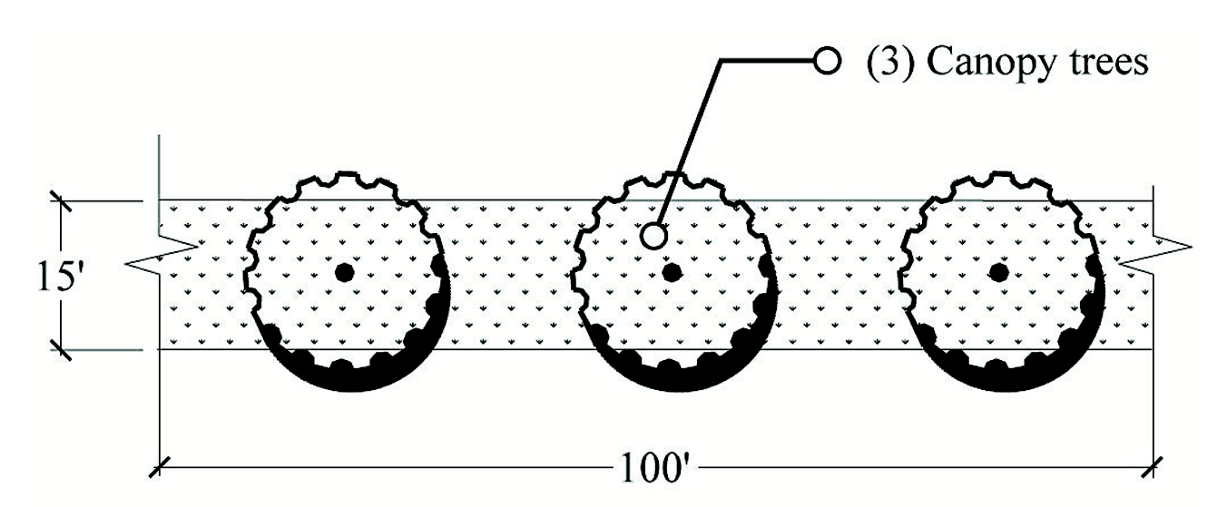
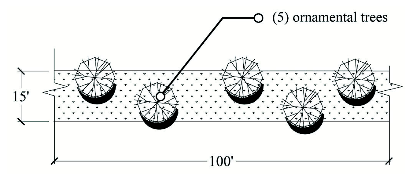
All front yard trees Shall be canopy trees, at an average spacing of fifty (50) feet on center spacing along both sides of roads. The canopy trees required for residential lots may count towards this requirement if within a minimum of ten (10) feet and a maximum of twenty (20) feet of the right-of-way line. Canopy trees Shall be planted a minimum of eight (8) feet from public sidewalks and curb.
3.
Trees may not be planted in the right-of-way (R.O.W.); provided, however, that trees may be permitted in the R.O.W. if they are replacing a dead or unsafe tree removed by the County. Such replacement trees shall be approved by the County Manager or designee through the issuance of a R.O.W. Utilization permit and must be one that will not damage or interfere with the pavement or sidewalks. Trees replanted under this exception shall not be required to meet setbacks from public sidewalks and curbs and shall not be canopy trees.
Figure A — Typical Street Tree Section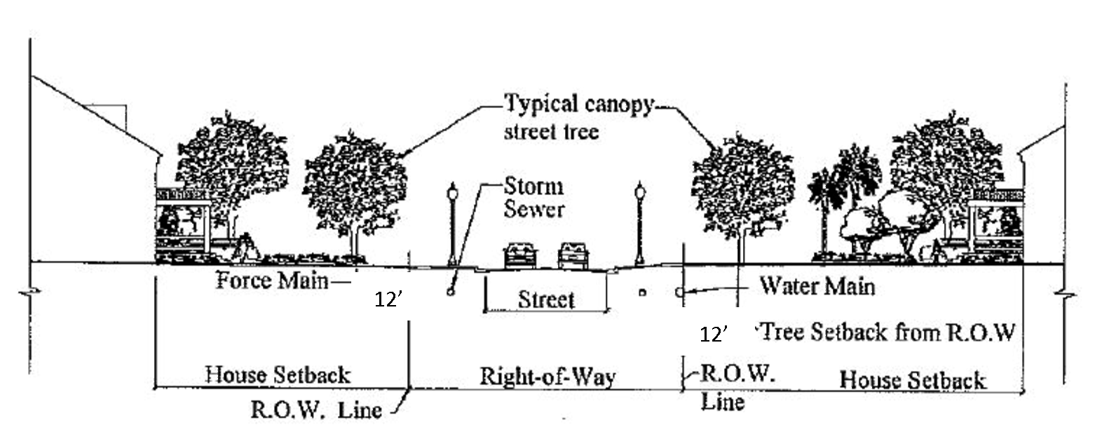
4.
The following zoning districts shall be exempt from providing front yard trees: A, RA, AR, R-1 [for lots greater than or equal to one (1) acre], RV, and RMRP.
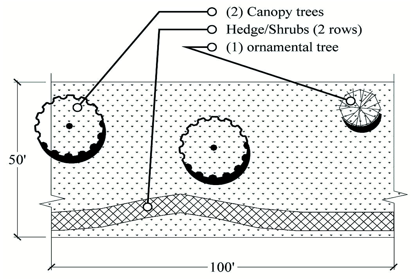
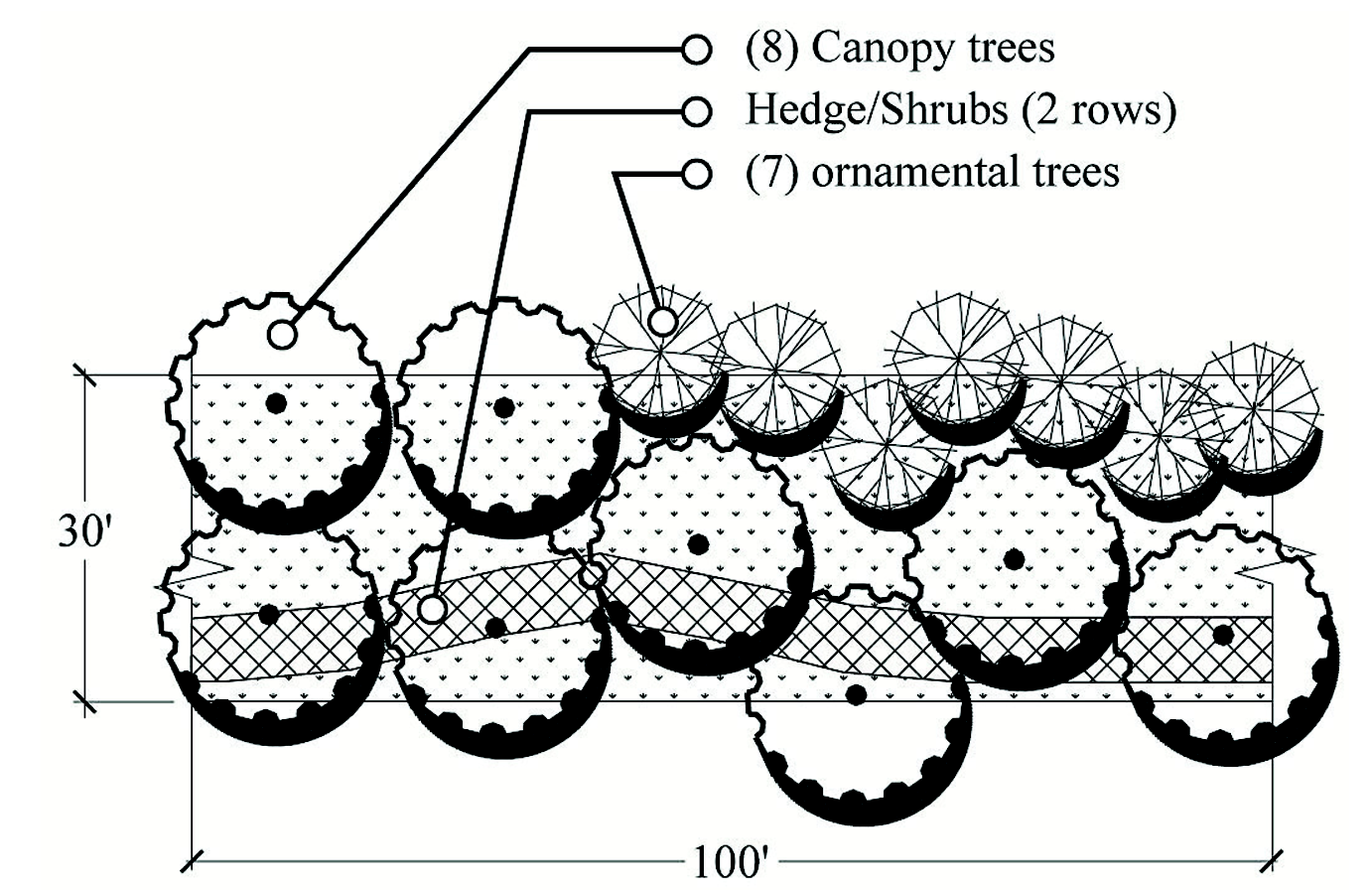
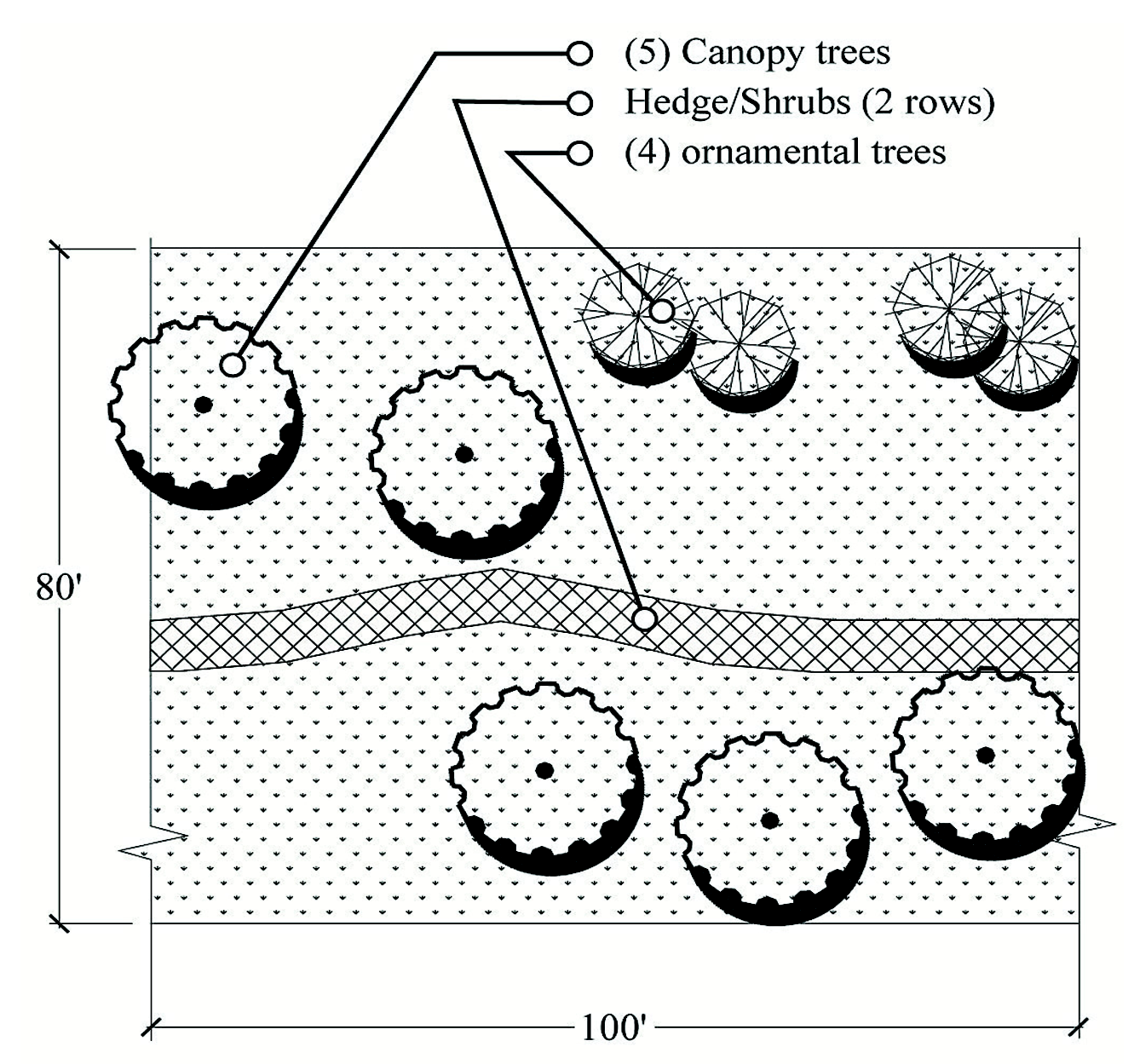
Figure B — Landscape Buffer Plan Views
Note: Below landscape buffer layouts are schematic and designer may adjust layouts as long as minimum requirements are provided.
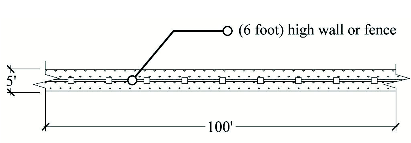
Landscape Buffer A - Five-feet (5) width option
Residential to residential zoning only
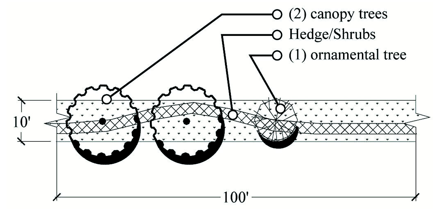
Landscape Buffer A - Ten-feet (10) width option
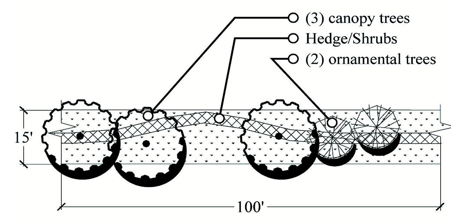
Landscape Buffer A - Fifteen-feet (15) width option
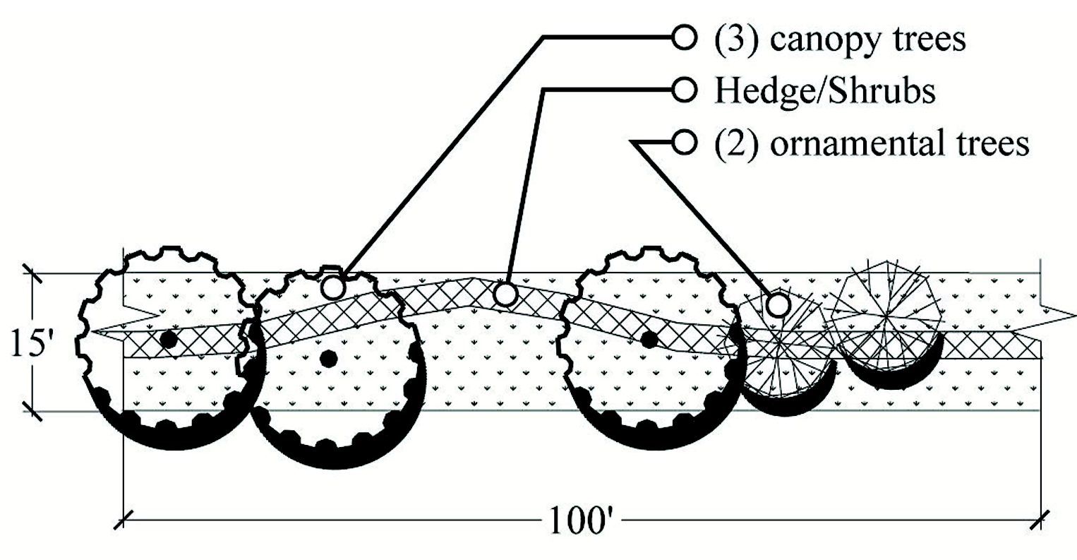
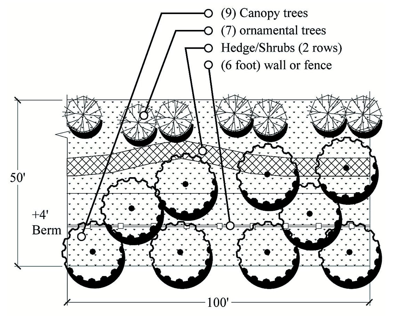
Landscape Buffer B - Fifteen-feet (15) width option
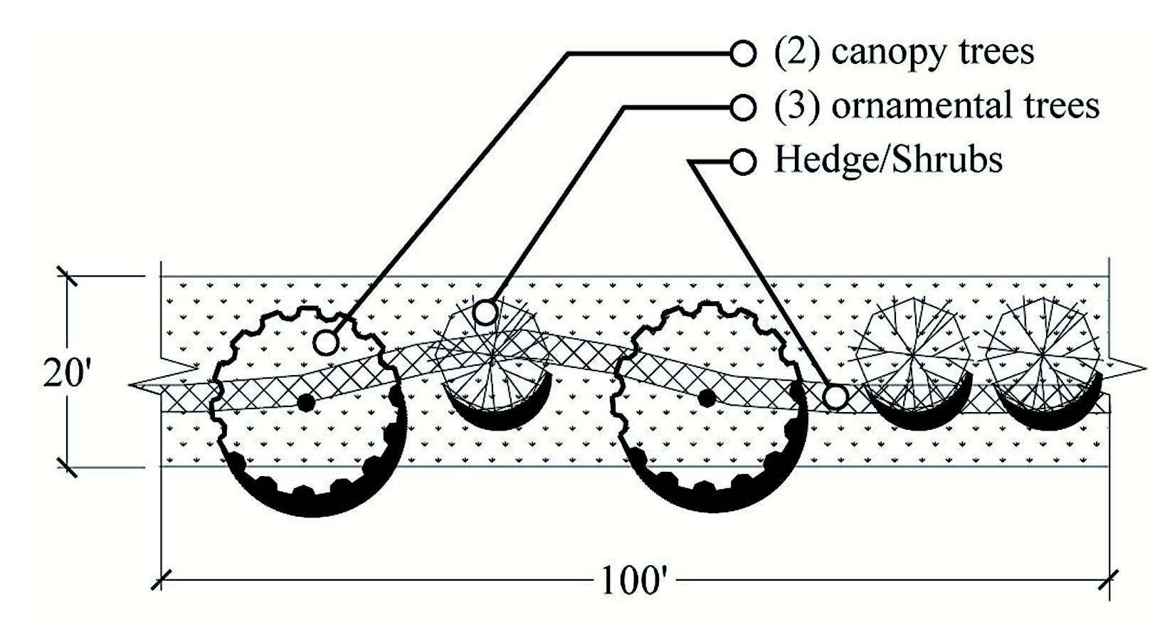
Landscape Buffer B - Twenty-feet (20) width option
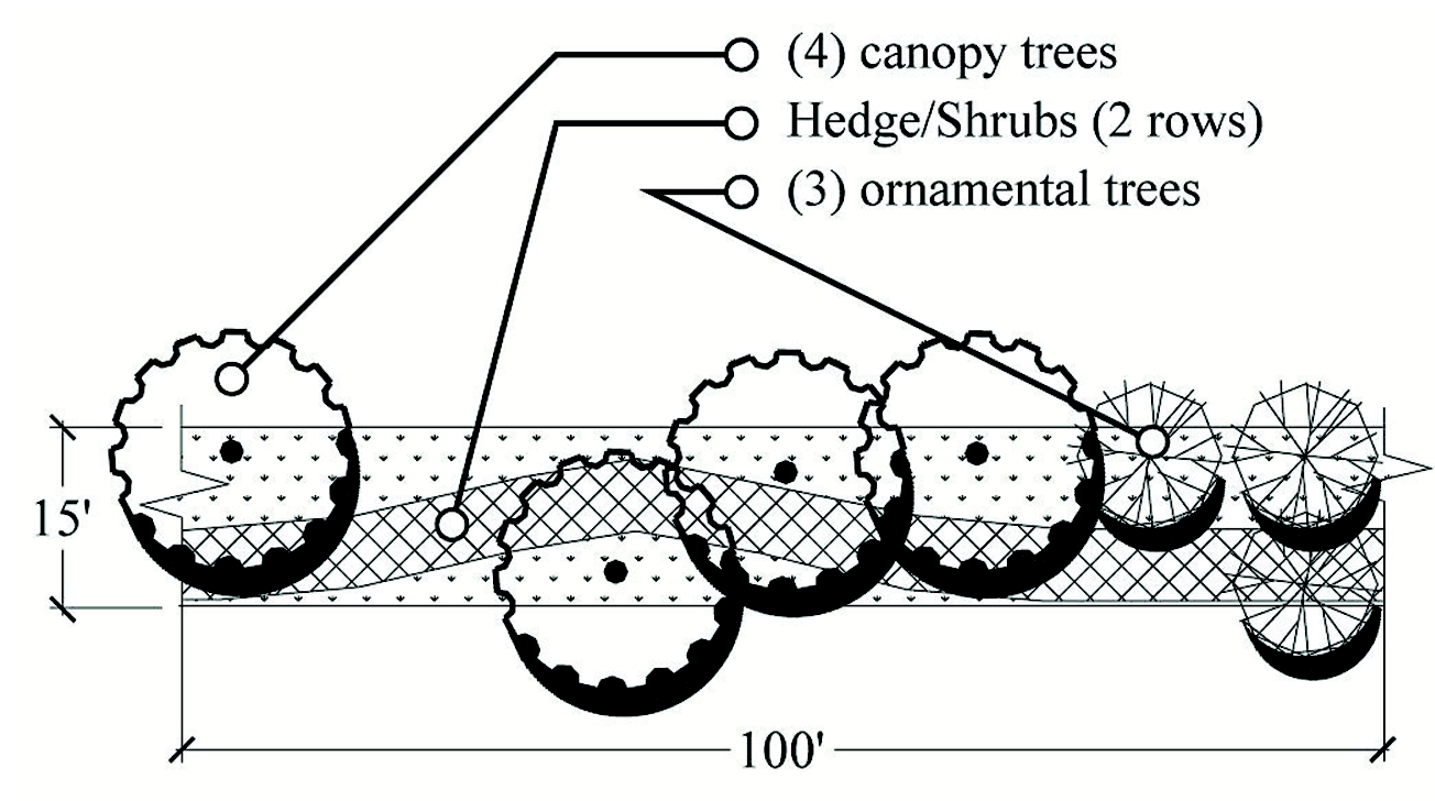
Landscape Buffer C - Fifteen-feet (15) width option
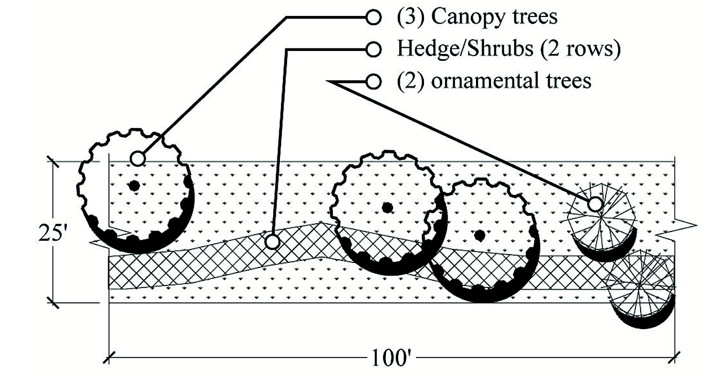
Landscape Buffer C - Twenty-five (25) feet width option
Landscape Buffer C - Fifty (50) feet width option
Landscape Buffer D - Thirty (30) feet width option
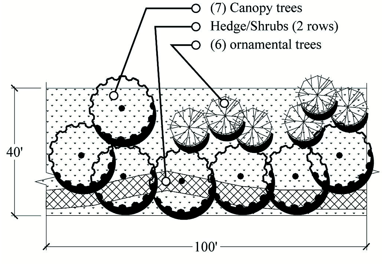
Landscape Buffer D - Forty (40) feet width option
Landscape Buffer D - Eighty (80) feet width option
Landscape Buffer E - Fifty (50) feet width option
Landscape Buffer F - Reserved
Landscape Buffer G - Fifteen-feet (15) width option
Landscape Buffer G - Fifteen-feet (15) width option
D.
Supplemental Requirements for Subdivisions and Site Plans. The following requirements supplement the tables above and Shall be used to install and maintain the required buffer.
1.
Walls. Required walls Shall be solid, and surfaces Shall be finished. Allowed wall types mean solid walls and include Exterior Insulation Finish Systems (EIFS) with stucco, brick, stucco, finished or textured block, vinyl-plastic, pre-cast and poured-in-place concrete wall with a finished surface. Solid fences where required Shall be opaque. One-sided wood fences Shall be installed with wood posts to the inside of the property that is installing the fence. Chain-link and barbwire fencing may not be used to meet the screening requirement. Pedestrian access shall be provided at intervals of six hundred sixty (660) feet, or less.
2.
Additional requirements:
a.
A minimum of fifty (50) percent of the required vegetation in a landscape buffer Shall be located on the outside of any required fencing, walls, or any other screening structures.
b.
Any wall, fence, or other screening structure built along a public right-of-way for property which requires a landscape plan Shall consist of harmonious screening material that has a consistent and uniform texture, color, and pattern along all major collector or arterial roadways.
3.
All pervious common areas Shall have ten (10) Canopy trees per acre minimum. Some parts of the site may be left as open space, but the total number of trees Shall average ten (10) canopy trees per acre for pervious areas. Other landscape requirements may be used to meet this requirement such as required landscape buffering and retention pond landscaping. Permanent water bodies, wetlands and wet retention ponds Shall be excluded in calculating the amount of pervious area requiring ten (10) canopy trees per acre.
4.
Landscape materials within buffers along rights-of-way Shall be designed to display variety, color, form, and texture, by emphasizing native and drought tolerant plants. Such variety and color may be accomplished by using a combination of shrubs and ornamentals. The placement of landscape materials within landscape buffers Shall have a rational relationship to the existing patterns and densities of adjoining areas which have been designed or preserved. Arrangements Shall replicate natural conditions and Shall not be linear unless dimensional limitations necessitate such an arrangement or linear arrangement are part of a formal landscape directly related to the architecture of the building(s) or are part of a formal street tree landscape.
5.
Shrubs. Shrubs may be clustered within each one hundred (100) feet of buffer.
(Ord. No. 2019-01, § 3, 1-15-19)
9.01.07 Internal Landscaping in Parking Areas and other Site Areas, other than Single-Family and Duplex Lots. Any development order other than for single-family or duplex dwellings Shall require that all ground surface areas used on commercial, institutional, community facility, industrial, condominium, recreational vehicle parks, or multifamily sites Shall have internal landscaping to provide visual and climatic relief from broad expanses of pavement and channelize and define logical areas for pedestrian and vehicular circulation. The following special landscaping requirements apply to commercial, institutional, community facility, industrial, condominium, recreational vehicle parks and multifamily sites.
A.
Interior Parking Areas. Landscape islands Shall be provided within parking areas, as described below to prevent excessively long, contiguous runs of parking spaces. These areas Shall use curbs, wheel stops, bollards or other control measures to prevent encroachment or damage to trees and vegetation. This requirement Shall not apply to parking garages, staging or storage areas at distribution centers. A minimum of fifty (50) percent of the required Interior Parking areas trees Shall be Live Oak trees.
1.
Single-Row Terminal Landscape Islands. A single row parking bay Shall not contain more than ten (10) contiguous parking spaces or extend more than one hundred twenty (120) feet, whichever is more restrictive. One (1) single-row terminal landscape island, with a minimum pervious area of three hundred (300) square feet and a minimum width of twelve (12) feet, Shall be provided at each end of a single-row parking bay. Each single-row terminal landscape island Shall contain at least one (1) canopy tree. Required maximum two-foot high screening shrubs Shall be utilized the entire length of the landscape island, or as limited by sight distances. Please see below Figure C — Single and Double-Row Terminal Landscape Island.
Figure C — Interior Parking Areas
Single and Double-Row Terminal Landscape
Island — Perspective View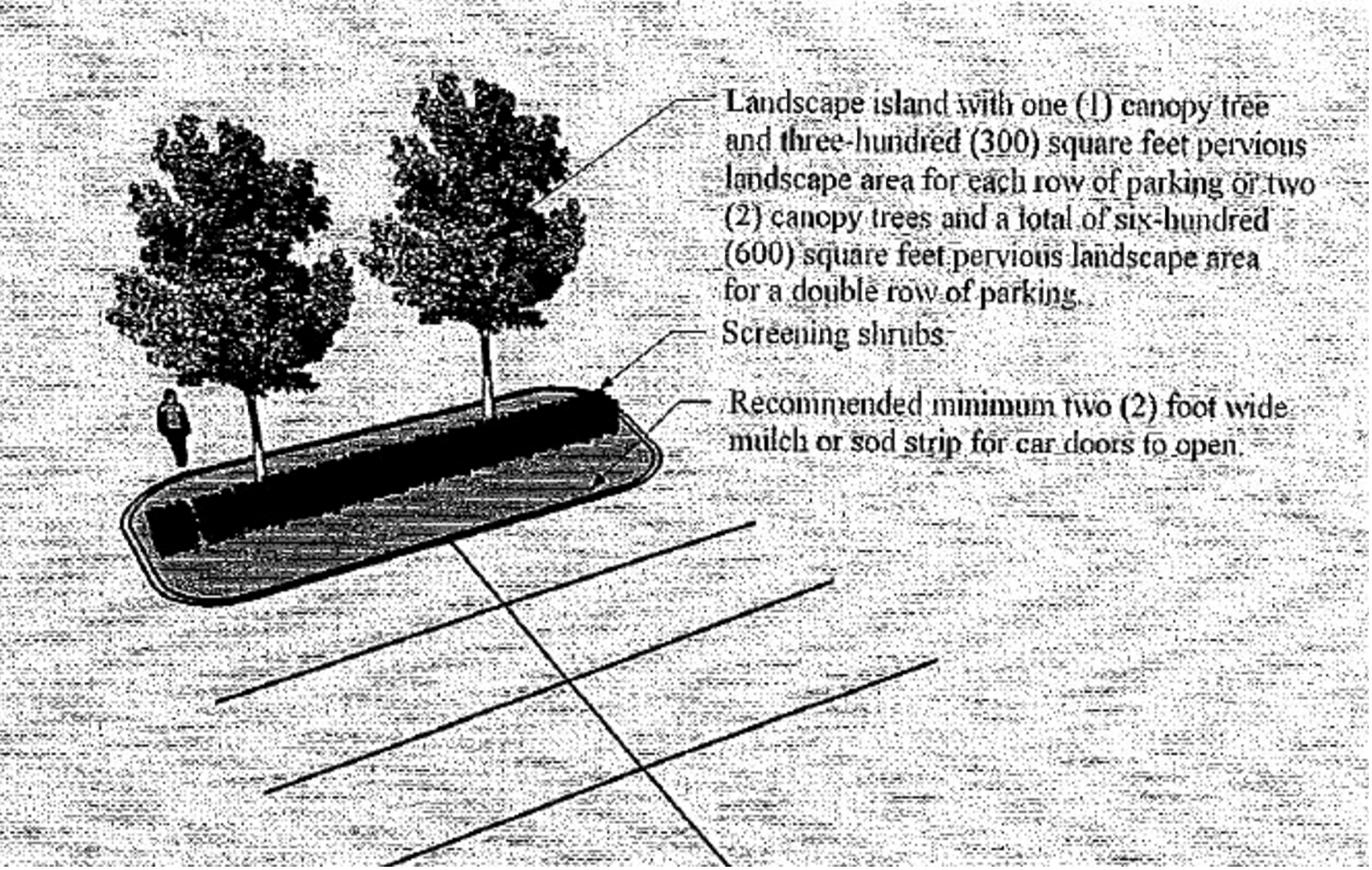
2.
Double-Row Terminal Landscape Islands. A double-row parking bay with head-to-head parking Shall not contain more than twenty (20) contiguous parking spaces in a two (2) rows × ten-space configuration or extend more than one hundred twenty (120) feet, whichever is more restrictive. One (1) double-row terminal landscape island, with a minimum pervious area of six hundred (600) square feet and a minimum width of twelve (12) feet, Shall be provided at each end of a double-row parking bay. Each double-row terminal landscape island Shall contain at least two (2) canopy trees. Required maximum two-foot high screening shrubs Shall be utilized the entire length of the landscape island, or as limited by sight distances.
3.
Intermediate Landscape Islands. Intermediate landscape islands Shall be provided for any parking lot with eighty (80) or more parking spaces, and an additional intermediate landscape island Shall be provided for every additional twenty (20) parking spaces in excess of eighty (80). Each intermediate landscape island Shall have a minimum pervious area of three hundred (300) square feet and a minimum width of twelve (12) feet, and each intermediate landscape island Shall contain at least one (1) canopy tree. Required maximum two-foot high screening shrubs Shall be utilized the entire length of the landscape island, or as limited by sight distances. Alternatively, a minimum seven-foot wide landscape strip may be provided between head-to-head parking, which may count as the required intermediate landscape island for every three hundred (300) square feet of pervious area provided. If a landscape strip is used, ornamental landscape trees and shrubs Shall be planted within the landscape strip on minimum thirty-foot centers. Please see below Figure D — Intermediate Landscape Islands.
Figure D — Interior Parking areas — Intermediate Landscape Islands.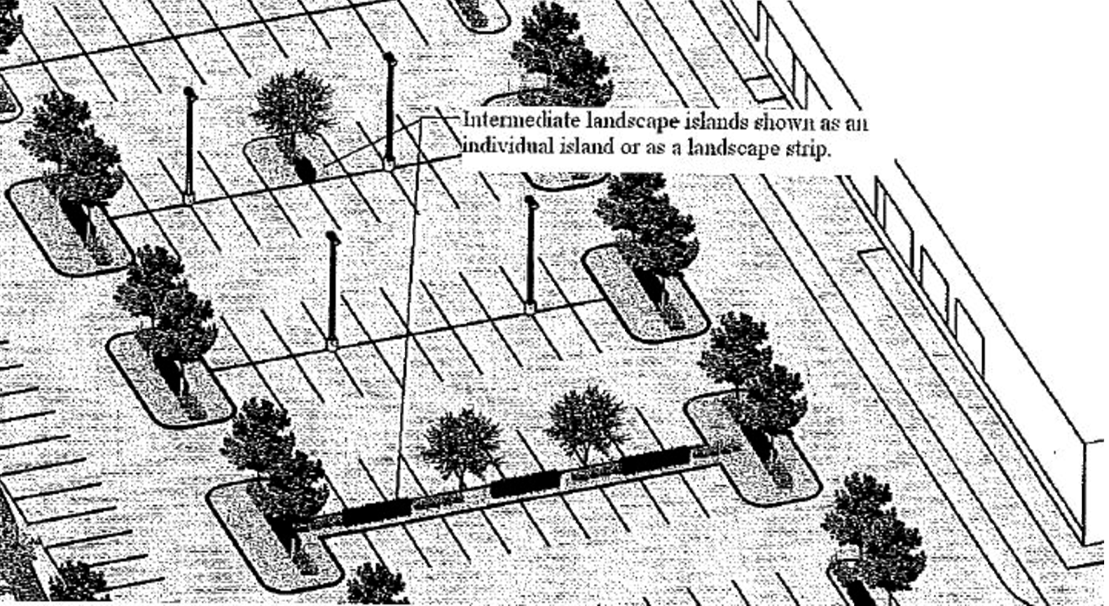
4.
Limited Off-Street Paved Parking areas. Interior portions of off-street parking facilities, which are not specifically designed as parking spaces or maneuvering areas, Shall not be paved for vehicle use.
5.
Parking Lot Trees and Substitutions. All trees in the parking lots Shall be canopy trees, unless otherwise provided. A maximum of twenty (20) percent of the required canopy trees in the parking lots may be substituted with palm trees. Palm trees used as substitutions in parking lots Shall be planted at a 2:1 ratio (i.e. Cabbage Palms, Windmill Palms) in relation to canopy trees with the exception of Canary Island Palms, Date Palms and Paurotis Palms, which may be planted at a 1:1 ratio.
6.
Perimeter Trees and Spacing. Canopy trees Shall be planted an average of fifty-foot centers around the total perimeter of the parking lot and all vehicular service areas. Clustering may be utilized, but spacing Shall not exceed one hundred fifty-foot spacing. The canopy trees Shall be planted between eight feet (8) and thirty (30) feet from the edge of pavement. Canopy trees within the landscape buffers may be used if they fall within thirty (30) feet from the edge of paving or vehicular service area as shown in Figure E — Perimeter Trees and Spacing.
Figure E — Interior Parking areas — Perimeter Trees and Spacing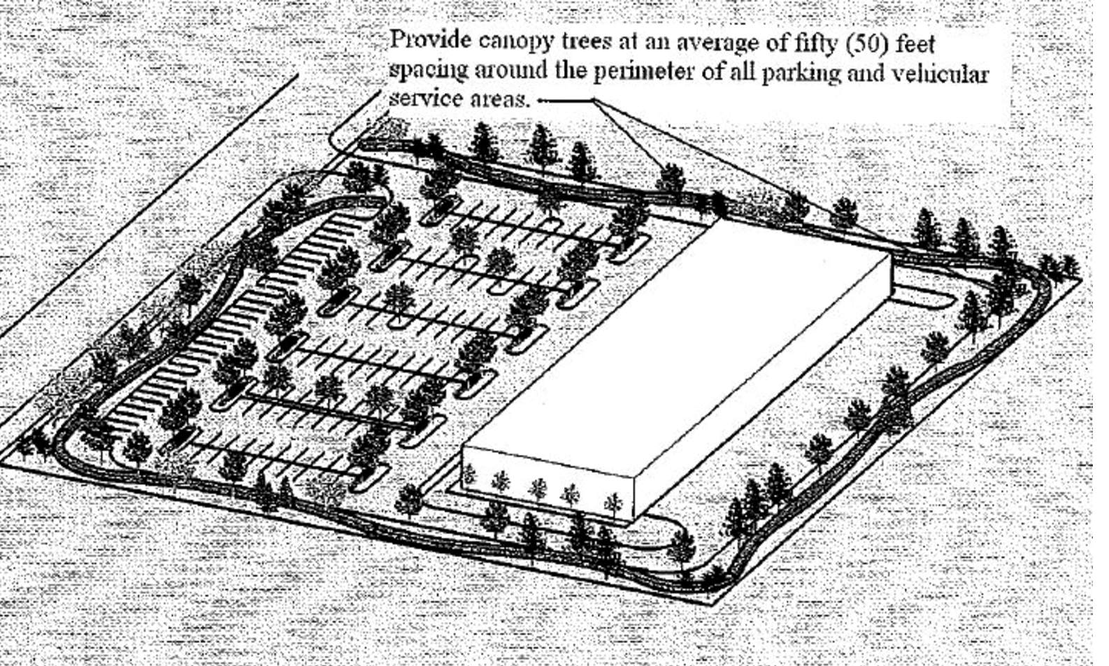
B.
Building Landscapes, other than industrial. Buildings Shall have landscape areas planted with trees, shrubs or groundcovers, other than sod, around the building as follows:
1.
Building Perimeter landscaped area.
a.
Shall be a minimum of three (3) feet wide;
b.
Shall be around a minimum of forty (40) percent of the building perimeter; and
c.
Shall be located within twenty-five (25) feet of the building walls.
2.
Minimum planting requirement for each one hundred (100) feet.
a.
Three (3) ornamental trees or one (1) canopy tree; and
b.
Twenty-eight (28) shrubs.
c.
Trees installed for any other requirement of this section may be credited towards this requirement if in the required location.
Example: A Building with a perimeter of 150 feet would require 60 feet of perimeter landscaping (40% × 150 feet). The planting requirement would be:
Ornamental Trees: 0.60 (60 feet/100 feet) × 3 Ornamental Trees = 2 Ornamental Trees (1.8 rounded to nearest whole number) OR one (1) canopy tree.
Shrubs: 0.60 (60 feet/100 feet) × 28 shrubs = 17 Shrubs (16.8 rounded to nearest whole number).
C.
Pervious Parking. Parking spaces provided in excess of the minimum required Shall be constructed of pervious materials, such as turf blocks or grassed parking areas. Pervious parking may also be provided, if not otherwise prohibited by other provisions of the Lake County Code, in the following areas:
1.
Adjacent to parking lot landscape islands to allow for the percolation of water and the exchange of oxygen for the tree roots.
2.
In low impact areas or infrequent use areas such as churches or the outlying parking areas of malls or other shopping areas.
D.
Internal Access Roads. Developments with internal access roads Shall be required to plant one (1) canopy tree on each side of the road approximately every fifty (50) feet. Access roads immediately in front of commercial structures and other buildings do not have to meet the access road tree requirement but do have to meet other parking landscape requirements. Parking lot island canopy trees may be used to meet this requirement if they fall within thirty (30) feet from the edge of the pavement along the internal access road. Figure F — Internal Access Roads.
Figure F — Interior Parking areas — Internal Access Roads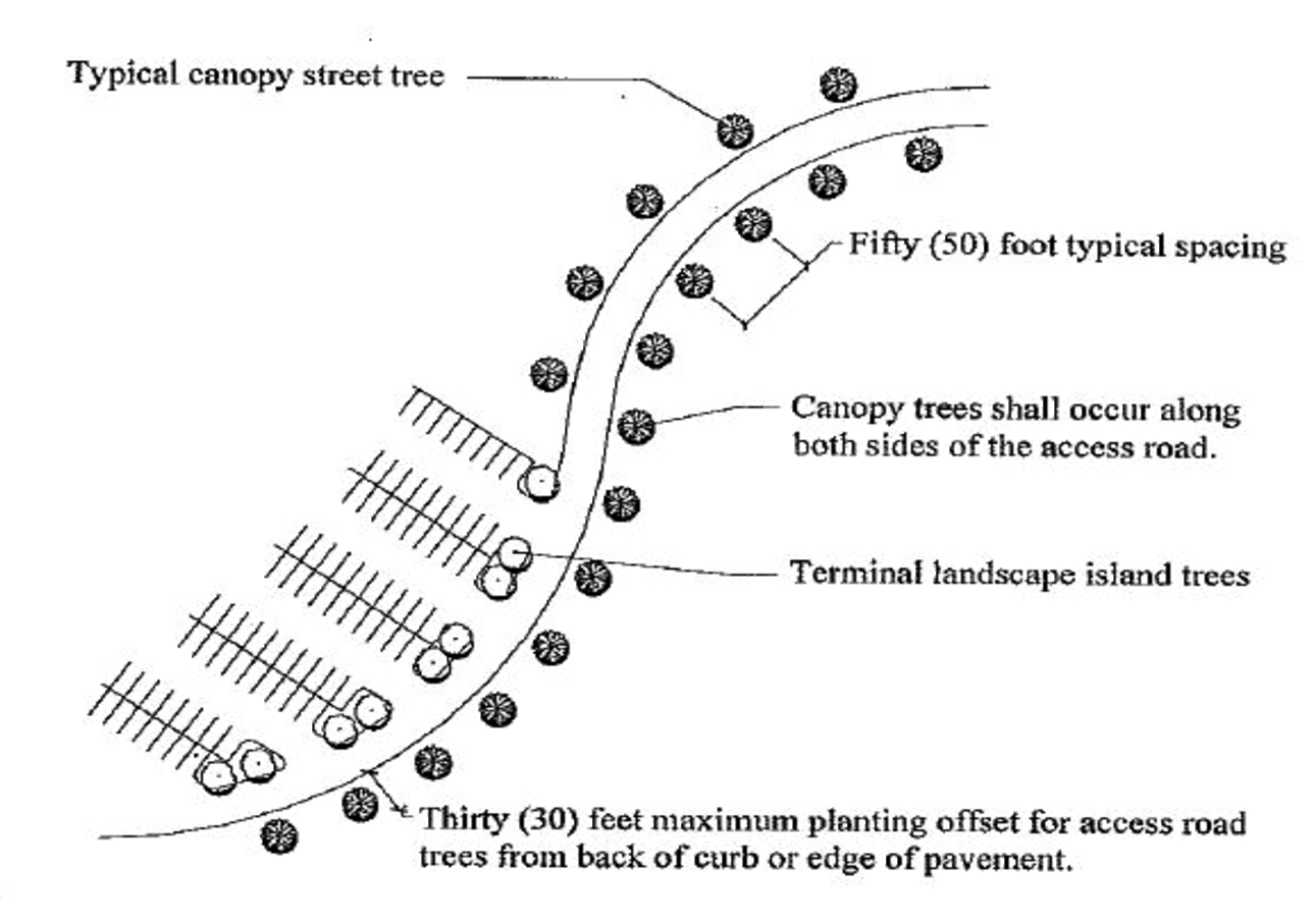
E.
Accommodations for Lighting and Other Features. Islands Shall be enlarged beyond the minimum requirement if necessary to accommodate light poles, fire hydrants, or other necessary features. Light poles may be located within the parking area rather than in landscape islands if necessary to ensure that the lighting placement does not conflict with the location or normal growth of landscape island trees. Figure G — Parking Lot Light Placement below.
Figure G — Interior Parking areas — Parking Lot Light Placement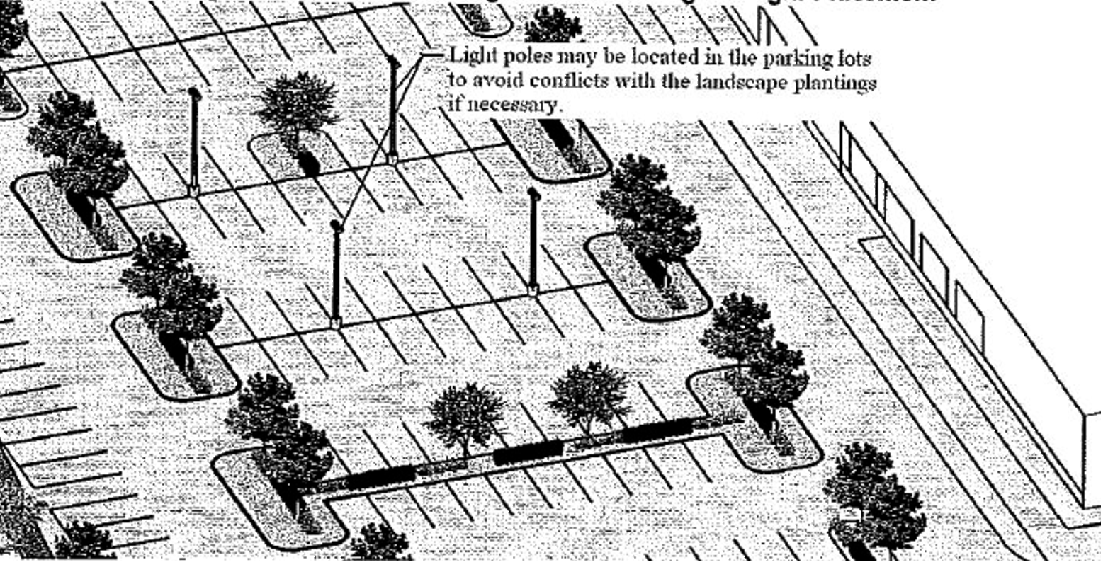
F.
Rain Gardens. Parking lot islands are encouraged to use curb breaks and create swale or depression areas to allow for the percolation of rainwater and parking storm water. Attention Shall be given to the selection, placement and durability of landscape material within rain garden areas to ensure their long-term viability. Any proposed rain garden areas must comply with all storm water requirements. Smaller rain gardens that serve as landscape islands Shall adhere to all canopy and understory requirements for landscape islands. Figure H — Rain Garden Photo below.
Figure (Photo) H — Interior Parking areas — Rain Garden Example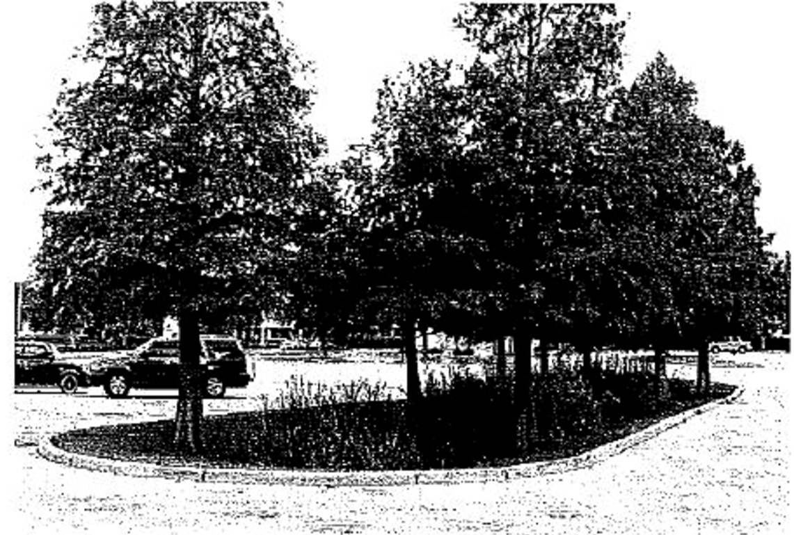
G.
Guardhouses. An area greater than or equal to fifty (50) percent of the footprint of any guardhouse Shall be landscaped immediately adjacent to the guardhouse to create an aesthetic landscape. When the guardhouse is located within the roadway median, the required landscaping Shall also be planted in the median. Clear zones and clear sight lines must be maintained for any landscape within the road right-of-way. The clear zone Shall consist of an area between two (2) feet and eight and one half (8.5) feet height from the road elevation. The landscape area Shall consist of shrubs, groundcovers, and trees. Sod or other ornamental landscaping may be utilized in the remaining area around the guardhouse as long as fifty (50) percent of the guardhouse square footage area has been landscaped as described (see Figure I Vehicular Gates and Associated Security Walls).
H.
Vehicular Gates and Associated Security Walls. Landscaping Shall be required on the entrance side of gates and walls as follows (see Figure I):
1.
A minimum of four hundred (400) square feet of landscape area Shall be provided on each side of an entrance road.
2.
Within each entrance area of four hundred (400) square feet, one (1) canopy tree or three (3) ornamental trees Shall be provided.
3.
The landscape area Shall have shrubs, perennials, vines or other ornamental plantings other than sod. When a utility easement or other restrictive condition restricts the use of trees, then the tree portion of this requirement may be waived or limited by the County Manager or designee.
Figure I — Vehicular Gates and Associated Security Walls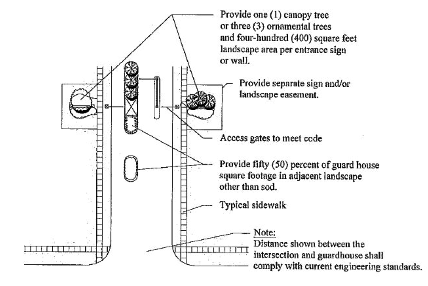
I.
Retention Pond Landscaping. Three (3) canopy trees for every one hundred fifty (150) linear feet of retention pond bank Shall be required as measured at the top of pond bank. Trees Shall be planted within forty (40) feet from the top of bank line and include a ten-foot clear zone for maintenance. A minimum of three (3) canopy trees Shall be required at retention ponds. Curvilinear retention ponds, rather than geometric or rectangular ponds, are encouraged. (See Figure J Retention Ponds).
Figure J — Retention Ponds (Landscaping)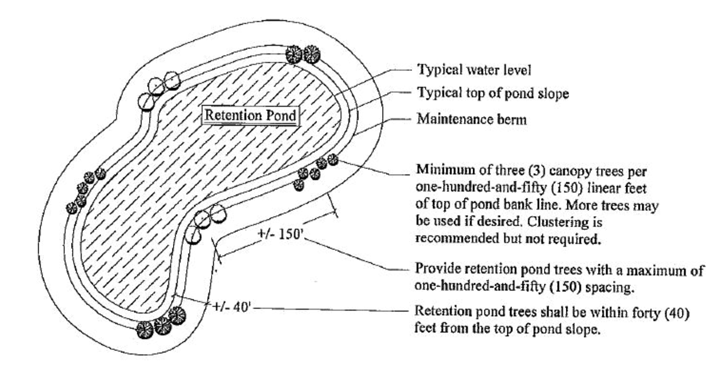
J.
Screening of Heating/Ventilation/Air Conditioning Units. Where heating/ventilation/air conditioning units are located on the ground surface area, they Shall be screened from view. A combination of a fence and a berm or shrubs Shall be required.
K.
Fire Stations and Emergency Management Facilities.
1.
There Shall be roadway line of site visibility for emergency vehicles to exit a facility property, and
2.
Trees Shall not be located within one hundred (100) feet of either side of the access driveway for emergency vehicles, and
3.
Shrubs and groundcovers Shall be limited to those varieties that will not exceed three (3) feet in height.
9.01.08 Landscape Requirements for Individual Single-Family Residential and Duplex Lots. No Certificate of Occupancy Shall be issued unless in compliance with this section. The requirements of this Section Shall be noted on the development permit and/or plot plan unless otherwise required by other provisions in the Lake County Code or any other development order.
A.
Canopy tree requirements. Each single-family or duplex lot Shall provide canopy trees as follows:
1.
A minimum of two (2) canopy trees for lots six thousand (6,000) square feet or less.
2.
A minimum of three (3) canopy trees for lots between six thousand one (6,001) and ten thousand (10,000) square feet.
3.
A minimum of four (4) canopy trees for lots between ten thousand one (10,001) square feet to fifteen thousand (15,000) square feet.
4.
A minimum of five (5) canopy trees for lots between fifteen thousand one (15,001) square feet to forty-three thousand five hundred sixty (43,560) square feet (1 acre).
5.
A minimum of eight (8) canopy trees for lots between one (1) acre and less than two (2) acres.
6.
A minimum of eleven (11) canopy trees for lots between two (2) acres and less than three (3) acres.
7.
A minimum of fifteen (15) canopy trees for lots between three (3) acres and less than five (5) acres.
8.
A minimum of twenty-five (25) trees for lots five (5) acres or greater.
Existing trees meeting the quality and size requirements within required buffers immediately adjacent to the lot may be credited towards this requirement.
B.
Front yard trees within lots. One (1) or more of the required trees Shall be planted at a minimum of ten (10) feet and maximum of twenty (20) feet outside of the right-of-way for lots less than or equal to one-half (½) acre. More canopy trees may need to be planted along the road right-of-way to satisfy other requirements of the code.
C.
Preservation of existing trees. Existing trees that are classified as protected trees in Section 9.02.01 (A) and greater than three (3) inches in diameter Shall be preserved unless within the areas required for access, infrastructure, building footprint or within a fifteen-foot offset of the footprint for the residence. Stem wall construction Shall be used where necessary to achieve this requirement. The following exceptions may be allowed to this requirement:
1.
Trees in fire prone areas, such as pine forests, or in rural communities with a density of less than two (2) dwelling units per acre, may remove trees with the appropriate permit, a distance of up to thirty (30) feet from a building upon written authorization by the Lake County Fire Chief or designee.
2.
Existing fire-prone vegetation may also be removed up to thirty (30) feet from the structure's wall with permission granted by the Lake County Fire Chief or designee. The minimum landscaping required by this section Shall be provided.
3.
Any trees or vegetation that are protected by other laws such as wetland trees Shall not be removed without the prior written approval from the Water Management District or the appropriate jurisdictional agency.
D.
Avoid damage by structures. Structures Shall be located to avoid removing or damaging protected trees to the maximum extent possible.
(Ord. No. 2019-01, § 5, 1-15-19)
9.01.09 Prohibited Plant Species. The control and elimination of invasive, non-native plant species helps protect the natural vegetative communities existing within Lake County.
A.
Planting. Prohibited plant species Shall not be planted or counted toward minimum tree or vegetation requirements.
B.
Prohibited Plants. Prohibited vegetation Shall be listed in the Plant List for Lake County based on the following sources:
1.
Florida Exotic Pest Plant Council Category I & II List of Invasive Plant Species.
2.
Prohibited Aquatic Plants per F.A.C. 5B-64.011,
3.
Center for Aquatic and Invasive Plants, University of Florida, IFAS.
C.
Removal. Removal and eradication of Prohibited Plant Species listed below Shall be a condition of development approval on the parcel within one hundred (100) feet of principal structure(s) or up to fifty (50) feet from the overall limits of construction, whichever is greater.
1.
Plants to be Removed. All Prohibited Plants listed in the following resources require removal as a condition of development approval.
2.
The Plant List for Lake County lists the plants to be removed based on the following specific sources and list:
a.
Plants listed on the Noxious Weed List developed by The Florida Department of Agriculture and Consumer Services 5B-57.007 Florida Administrative Code;
b.
Plants listed in Florida Statutes 369.251(1);
c.
Chinaberry (Melia azedarch); Ear Tree (Enterlobium cyclocarpum); Eucalyptus species, (Eucalyptus spp.); Paper Mulberry (Broussonetia papyrifora); and Silk Oak (Grevillea robusta).
d.
All other Prohibited Plants are encouraged, but not required, to be removed.
3.
Prohibited vegetation Shall not be required to be removed from wetlands or natural water bodies that are regulated or protected by the Water Management Districts or other regulatory agencies without approval.
(Ord. No. 2012-27, § 2, 4-24-12; Ord. No. 2016-13, § 3, 3-15-16)
Editor's note— Ord. No. 2012-27, § 2, adopted April 24, 2012, amended section 9.01.00 in its entirety, to read as herein set out. See also the Code Comparative Table.
9.02.00 - Tree Protection.
A.
Purpose. The purpose of this Section is:
1.
To encourage the proliferation of trees and palms.
2.
To establish rules and regulations governing the protection and replacement of trees and palms within unincorporated Lake County; and
3.
To recognize the importance of trees and palms and their meaningful contribution to a healthy, beautiful, and safer community attributable to their carbon dioxide absorption, oxygen production, dust filtration, wind and noise reduction, soil erosion prevention, lakeshore erosion protection, wildlife habitat, surface drainage improvement, beautification and aesthetic enhancement of improved and vacant lands and the general promotion of the health, safety, welfare and well-being of the community.
9.02.01 Protected Trees.
A.
Designation of Protected Trees. The following trees and palms are designated protected trees:
1.
All trees and palms native to Florida or Florida Friendly, three (3) inches or larger in diameter at breast height.
2.
Sand Pine and Xeric Oak Scrub community trees two (2) inches diameter or larger at breast height.
3.
Wetland trees of any size.
4.
Specimen and Heritage trees.
B.
Exemptions to Protected Trees. Prohibited trees, invasive trees, citrus or non-native fruit trees of any species Shall not be considered a protected tree.
9.02.02 Tree Removal Permit Required. It Shall be unlawful and a violation of this Section to clear, kill or remove a protected tree or palm by any method without first obtaining a tree removal permit unless exempted under Section 9.02.04.
When a development order is issued for a site plan, subdivision or master park plan, a separate tree removal permit Shall not be required if the trees to be removed are identified and mitigated on the approved landscape plan. Approval of a preliminary plat does not authorize approval for the removal of trees or other vegetation.
Any tree removal, not specifically exempted herein, Shall require replacement trees in compliance with this Section and Shall specify the schedule when trees will be removed and when such replacement trees will be planted.
When the removal of trees is associated with a development project, the removal of trees authorized pursuant to the Lake County Tree Removal Permit Shall not commence until one (1) of the following has been approved or issued:
A.
Subdivision construction plan;
B.
Final master site plan;
C.
Master park plan; (only applicable within parks);
D.
Building permit; or
E.
Lot grading/site alteration plan.
9.02.03 Violations. Each tree damaged or destroyed without a permit required under Section 9.01 or Section 9.02 Shall be considered a separate violation punishable pursuant to Chapter 8, Lake County Code. Determinations of the number of cleared trees Shall be based on best available data that may include surveys of adjacent property or aerial photographs taken prior to clearing.
A.
If a specimen tree or a heritage tree is removed without a tree removal permit, each tree Shall be replaced at a ratio of 2.5:1 of the mitigation requirement. If three (3) or more protected trees are removed without a tree removal permit, each tree Shall be replaced at a ratio of 2:1 for mitigation. Any other tree removal without a tree removal permit Shall be replaced in accordance with the replacement requirements stated for a permitted removal.
B.
If a protected tree is removed without a permit, a restoration plan Shall be prepared and submitted within thirty (30) days for approval by the County Manager or designee. All trees shown on the approved site restoration plan must be installed pursuant to Section 9.02.07 Location of Tree Replacement Sites.
9.02.04 Exemptions to Tree Removal Permit Requirements. Neither a tree removal permit nor mitigation will be required under the following circumstances:
A.
Excluding the number of trees required in Section 9.01.08(A), any tree located on a single family residential lot, two (2) acres or less in size that also contains a residential dwelling. All other trees that are not required for any landscape requirement, provided such removal does not exceed a combined cumulative caliper of thirty (30) inches of Protected Trees within any one (1) three-year period;
B.
Trees located within new or existing recorded or prescriptive public road or drainage rights-of-way and easements that are to be removed as part of a Board of County Commissioners approved project. However, all protected trees removed under this exemption Shall be avoided or relocated whenever feasible.
C.
For trees located on nonresidential property, any tree determined to be in a hazardous or dangerous condition so as to endanger the public health, safety or welfare and requires immediate removal. Authorization may be given by the County Manager or designee pursuant to the following procedures:
1.
Photo documentation of the hazardous tree(s) by property owner is required prior to removal and Shall be submitted to the County Manager or designee.
2.
If the tree, due to immediate danger, is removed prior to obtaining written authorization, a letter and photo documentation demonstrating the immediate danger Shall be submitted to the County Manager or designee within fifteen (15) days of the removal.
3.
The subsection expressly includes Heritage and Specimen Trees when such trees endanger property or the public health, safety or welfare.
D.
Trees located on residential property that present a danger to persons or property so long as the property owner complies with the requirements set forth in Section 163.045, Florida Statutes.
E.
Agriculture and Silviculture. Bona fide farm operation on land classified as agricultural pursuant to Section 193.461, Florida Statutes, as amended.
1.
Silviculture operations on property zoned Agriculture, or legally existing nonconforming agricultural uses, that have completed a Forestry Management Plan and would qualify for classification as agricultural pursuant to Section 193.461, Florida Statutes, as amended.
2.
Silviculture activities regulated through best management practices, interim measures, or regulations developed through the Florida Department of Environmental Protection, Florida Department of Agriculture and Consumer Services, or water management district.
3.
The activity is expressly regulated and permitted by the U.S. Army Corps of Engineers or U.S. Environmental Protection Agency.
F.
Trees that have died through natural causes or diseased trees Shall not require replacement or relocation. Trees killed or toppled by Acts of God such as lightning, hurricanes and tornadoes Shall not be required to be replaced or mitigated unless the tree(s) are required as part of a Development Order issued by Lake County.
G.
Trees removed as part of a county public works' project including, but not limited to, stormwater management, reservoirs, or other major utility improvements. A tree removal permit shall be required for municipal public works' projects located in the unincorporated county.
(Ord. No. 2019-01, § 4, 1-15-19; Ord. No. 2019-27, § 3, 4-23-19; Ord. No. 2019-61, § 2, 11-19-19)
9.02.05 Criteria for Issuance of Tree Removal Permit.
A.
Tree Removal Permit. A tree removal permit may be issued when one (1) or more of the following circumstances exist:
1.
Street opening. The location of a tree restricts the opening of a street or right-of-way. Streets and rights-of-way Shall be located to minimize the loss of trees, especially specimen and heritage trees;
2.
Utilities and drainage. The location of the tree restricts the construction of utility lines or drainage facilities. Utility lines and drainage facilities shall be located to minimize the loss of trees, especially specimen and heritage trees. Utility providers shall also coordinate with adjacent property owners and seek alternative easements to the extent practicable so as to minimize the loss of trees;
3.
Property access. The location of the tree prevents access to the property. Exit and entry Shall be located to minimize the loss of trees, especially specimen and heritage trees;
4.
Property use. The location of the tree restricts use of the property consistent with all other County and state codes, statutes, ordinances, and resolutions, and site location modifications are not feasible or reasonable;
5.
Hazards. The tree constitutes a potential hazard to life or property that cannot be mitigated without removing the tree provided, however, that a permit shall not be required if exempt under Section 9.02.04 of these regulations;
6.
Poor tree health. The tree is dying or dead so that its restoration to sound condition is not practical, or it has a disease which can be expected to be transmitted to other trees and to endanger their health;
7.
Thinning of trees. For non-bona fide silviculture operations, thinning of trees in order to increase light and air circulation for the purpose of improving health conditions, or to prevent disease, of a group of trees, the selective removal of up to twenty-five (25) percent of the group of trees may be permitted. Thinning Shall include any removal of trees from the lot and Shall not exceed the maximum clearing allowed in this Section. Thinning Shall follow Best Management Practices (BMPs) published by a government agency or the National Tree Care Industry Association.
8.
The tree is located in the footprint of a Family Garden to be sited pursuant to Chapter III, LDR.
B.
Tree Removal Procedure. The tree removal permit, when issued, Shall specifically identify which trees Shall be permitted to be removed. Each tree permitted for removal Shall be physically marked with an "X" using brightly colored paint or surveyor's tape; or if a group of trees are permitted for removal, the outside perimeter trees of the group may be designated with brightly-colored rope or tape in lieu of each tree. Such permit Shall automatically expire twelve (12) months after issuance. Trees not removed during the life of the permit may not be removed without the issuance of a new permit based upon a new application.
C.
Removal not required. Tree removal permits merely authorize the removal of trees specified therein. Nothing in this Section Shall be construed to require the removal of protected trees by the permittee.
(Ord. No. 2012-70, § 5, 11-6-12; Ord. No. 2019-27, § 4, 4-23-19; Ord. No. 2019-61, § 3, 11-19-19)
9.02.06 Replacement Requirements. When a tree removal permit is issued, the County Manager, or designee, Shall require the replacement of removed trees and palms as a condition of the issuance of a permit, as follows:
A.
Protected and Specimen Trees. Fifty (50) percent of the total number of caliper inches measured at diameter breast height (DBH) for Native and Florida-Friendly trees.
B.
Heritage Trees. One-hundred (100) percent of the total caliper inches of a Heritage Tree.
C.
Replacement trees.
1.
Trees removed which are exempt under Section 9.02.04 or removed pursuant to Section 9.02.05.A.7. shall not require replacement unless needed for minimum tree requirement.
2.
Trees located within the proposed footprint and ten (10) feet around the perimeter of the footprint of a new dwelling unit, duplex, residential addition, septic tank/drainfield or driveway area, shall not require replacement unless needed to meet the minimum tree requirement, provided the following condition is met:
a)
There is not sufficient area on the lot to locate the new dwelling unit, duplex, residential addition, septic tank/drainfield or driveway, meeting all setbacks, without removing the trees. The following standards shall apply:
1.
Trees shall only be removed after the building permit for the new dwelling unit, duplex or residential addition has been obtained; and
2.
If an approved building inspection is not completed on the dwelling unit, duplex or residential addition within six (6) months of obtaining the building permit, replacement of the trees removed shall be required.
3.
More than one (1) tree may be used to replace a tree or trees that are removed, but the minimum caliper of the replacement canopy trees Shall be no less than two-and-one-half (2½) inches and two (2) inches for replacement ornamental trees.
4.
Minimum of seventy-five (75) percent of the replacement trees Shall be canopy trees.
5.
Twenty-five (25) percent maximum of the replacement trees may be ornamental trees.
6.
Palm trees and pine trees may be used but Shall not exceed four (4) inches credit per tree given as replacement regardless of their installed size.
7.
Replacement trees may be used to meet the landscape requirements set out in Section 9.01.
D.
Tree Sampling for Large Sites. Sites over fifty (50) acres may identify and sample trees to be removed as follows:
1.
The locations of all specimen and heritage trees protected or proposed for removal Shall be located.
2.
Other protected trees Shall be surveyed as follows:
a.
The first fifty (50) contiguous acres Shall be surveyed by accounting for all protected trees to be removed.
b.
The remaining acreage may be surveyed using sample plots. The sample plots Shall be a minimum area of twenty (20) percent of the remaining part of the site to be developed and twenty (20) percent of each vegetative community within the remaining part of the site to be developed. Each of the sample survey plots Shall be a minimum of one hundred (100) feet by one hundred (100) feet in size and Shall conform to current forestry practices.
c.
All protected trees three (3) inch DBH caliper or greater, unless the trees are part of a wetland, sand pine or xeric oak scrub community in which case trees two (2) inches DBH and larger Shall be counted.
3.
The tree survey Shall be conducted by a registered Landscape Architect, certified arborist, or certified forester.
4.
A tree survey report detailing all findings, including the number and caliper of trees surveyed, estimates of trees surveyed, estimates of protected trees and distribution based on survey plots, and the size and location of specimen or heritage trees, Shall be prepared and submitted to the County as part of the site plan review process. The methods of the tree survey Shall be clearly detailed in the written report provided to Lake County.
5.
Lake County reserves the right to require more detailed tree sampling if the County Manager or designee determines that the information provided is insufficient or that site-specific considerations warrant additional information.
E.
Landscape credit. The replacement trees may be used to meet the requirements of the landscape standards set out in Section 9.01. All replacement trees Shall be provided even if the total number exceeds the landscape requirement.
F.
Replacement maintenance. The replacement trees Shall be maintained in good condition in perpetuity, and the property owner Shall guarantee survival.
G.
Palm trees. Palm trees Shall not account for more than twenty (20) percent of the required replacement trees.
H.
Replacement size. Replacement trees Shall conform to the size and planting requirements of the Landscape Code. Ornamental trees may not exceed twenty-five (25) percent of the total caliper replacement inches required.
(Ord. No. 2013-53, § 2, 9-24-13)
9.02.07 Location of Tree Replacement Sites.
A.
Replacement trees Shall be mitigated on the lot, if possible.
B.
If replacement trees cannot be placed on the lot, they Shall be located in common areas of the development such as: open space areas, areas adjacent to stormwater management facilities, landscape buffer areas, or entrances of the development in which the site is located, if possible.
C.
If replacement cannot be made on the lot or in a common area of the development, the owner or applicant may place the mitigation trees on a designated conservation or park property within Lake County pursuant to the following conditions:
1.
The recipient property Shall be suitable for the replacement trees and approved in writing by the County.
2.
The request to utilize this option Shall be submitted to the County Manager or designee in writing and Shall include an— explanation why the trees cannot be replaced on site;
3.
The size of the mitigated trees shall be determined by the County based on the needs and ability to provide maintenance to the site. The Applicant shall be responsible for providing the total caliper inches required for mitigation under this section.
4.
If replacement cannot be made on the lot or in a common area of the development, the owner or applicant may contribute to a County Tree Mitigation Fund to be used for tree planting in public spaces. The fee per tree shall be established annually by the County Manager or designee, based on the average cost of a 2.5 inch-caliper canopy tree plus the cost of installation in Lake County.
9.02.08 Voluntary Planting. This Section Shall not be interpreted to restrict, regulate, or limit the voluntary planting of any protected tree in Lake County. Any size tree may be voluntarily planted. The provisions of this Section govern only the planting of trees that are required to be planted or retained.
9.02.09 Specimen Trees.
A.
Purpose. It is the purpose of this Subsection to acknowledge the existence of certain trees within the County that are rare or unique due to factors such as age, size, or type, and to protect such trees through their designation as specimen trees. Designation of specimen trees by the Board Shall be in accordance with the standards and procedures in this Subsection.
B.
Standards. At least one (1) of the following standards Shall apply in order for a tree to be designated a specimen tree:
1.
Size. Trees with a thirty (30) inch caliper or greater, singly or with a combined trunk, measured at fifty-four (54) inches from the surface of the ground shall be specimen trees unless otherwise classified in this chapter.
2.
Age. Trees that are determined to be at least one hundred (100) years old or to be at approximately half-life maturity and are in good health.
3.
Form. Trees that are determined to have a unique form or shape, due to geography, climate, environmental or natural growth habitat conditions, and are in good health.
4.
Ecological Value. Trees that are determined to have an ecological value to the County in terms of soil or water conservation and management, wildlife habitat, or endemic native flora habitat, and are in good health.
5.
Rarity. Trees that are determined to be non-indigenous, rare, or unique to the County, and are in good health.
C.
Prohibited Trees are excluded from designation as a Specimen Tree.
D.
Approval and Protection.
1.
Any non-prohibited tree satisfying one (1) or more of the size criteria in this subsection, as specified above, Shall be recognized as a specimen tree by the County Manager or designee.
9.02.10 Heritage Trees.
A.
Purpose. It is the purpose of this Subsection to acknowledge the existence of certain trees within the County that are significant or unique due to factors such as age, size, historic significance or type and to protect such trees through their designation as heritage trees. Designation of heritage trees by the Board Shall be in accordance with the standards and procedures in this Subsection.
B.
Designation Standards. At least one (1) of the following standards Shall apply in order for a tree to be designated a heritage tree:
1.
Size. Trees with a forty-inch caliper or greater, singly or with a combined trunk, measured at fifty-four (54) inches from the surface of the ground.
2.
Age. Trees that are determined to be at least one hundred (100) years old or to be at approximate half-life maturity and are in good health.
3.
Form. Trees that are determined to have a unique form or shape, due to geography, climate, environmental or natural growth habitat conditions, and are in good health.
4.
Ecological Value. Trees that are determined to have an ecological value to the County in terms of soil or water conservation and management, wildlife habitat, or endemic native flora habitat, and are in good health.
5.
Rarity. Trees that are determined to be non-indigenous, rare, or unique to the County, and are in good health.
6.
Historical Significance. Trees that have been designated as having historical significance by the Lake County Historical Society or the Board of County Commissioners.
C.
Prohibited Trees are excluded from designation as a Heritage Tree.
D.
Application Procedures.
1.
Applications may be initiated by owners of the Property or developers as part of their development plan.
2.
Applications on forms provided by the County Manager or designee Shall be completed and submitted to the County Manager or designee.
3.
The County Manager or designee may request assistance from the Lake County Forester, State Division of Forestry, in determining compliance with any of the designation standards. If the tree poses a potential hazard to persons or property it shall not be designated.
4.
The Board of County Commissioners may adopt a resolution recognizing the designation.
E.
Recognition of Heritage Trees. Any non-prohibited trees with forty-inch caliper or greater, singly or with a combined trunk, measured at fifty-four (54) inches from the surface of the ground Shall be recognized as a heritage tree without application. An applicant Shall identify the location, number and size of all heritage trees on any required tree survey submitted to the County for site plan or plat review. In addition, the County may identify heritage trees that are found to meet this criterion.
F.
Approval and Protection.
1.
Any non-prohibited tree satisfying one (1) or more of the size criteria for a heritage tree as specified above Shall be recognized and recorded as a heritage tree by the County Manager or designee, without approval by the Board of County Commissioners. The Board of County Commissioners may adopt a resolution recognizing the designation.
2.
Removal of a heritage tree Shall be prohibited, unless it poses a danger to persons or property. A variance may also be granted by the Board of Adjustment. The property owner Shall protect any tree designated as a heritage tree to ensure its long-term health.
(Ord. No. 2012-27, § 3, 4-24-12)
Editor's note— Ord. No. 2012-27, § 3, adopted April 24, 2012, amended section 9.02.00 in its entirety, to read as herein set out. See also the Code Comparative Table.
9.03.00 - Off-Street Parking Regulations.
9.03.01 Purpose and Intent.
A.
All Buildings and uses Shall provide adequate off-Street parking facilities for Use by the Owner, Occupants, employees, visitors, customers and patrons, in conformance with the requirements of this Section, in order to lessen congestion in the Streets.
B.
The parking facilities Shall be available throughout the hours of operation of the particular business or Use for which the facilities are provided, and Shall be maintained and continued as long as the Use is in existence.
9.03.02 Reserved. Ord. No. 2013-25, § 6, adopted May 21, 2013, repealed subsection 9.03.02, nonconforming parking lots, in its entirety.
9.03.03 Parking Space Location.
A.
All Parking Spaces Shall be located on the same Lot that the Principal Building or Use is located, provided however, that for other than Residential uses, the County Manager or designee may allow all or part of the required Off-Street parking to be located on an alternate Site, when located within five hundred (500) feet of the premises they are intended to serve and when the alternate Site is not zoned Residential.
B.
The Owner of the alternate parking Site and the Owner of the principal Use or Building (including the Land on which it is situated), Shall enter into a written agreement with the County with enforcement running to the County, providing that Land comprising the alternate Parking Area Shall never be disposed of except in conjunction with the transfer or sale of the Building which the Parking Area is intended to serve, so long as parking facilities are required. The two (2) Owners Shall agree that such agreement Shall be in recordable form, be recorded in the public records of Lake County, the expense of recording to be borne by the two (2) Owners, and that the agreement Shall constitute a covenant running with the Land and binding upon the two (2) Owner's heirs, administrators, successors, and assignees. The agreement Shall be released by the Board of County Commissioners at such time as the alternate parking Site is no longer required, or when other lawful Off-Street parking facilities are provided.
9.03.04 Combined Off-Street Parking.
A.
Two (2) or more Owners or Operators of Buildings or uses requiring Off-Street parking facilities may make collective provisions for such facilities, provided the total of such Parking Spaces when combined or used together Shall not be less than the sum of the requirements computed separately except as otherwise approved by the County Manager or designee.
B.
All arrangements for combined parking Shall be subject to recording in the public record of Lake County a legal instrument, satisfactory to the County Attorney, insuring that such parking facilities will be maintained in the future as long as the Use or uses requiring such parking continues.
C.
No part of any Off-Street Parking Area required for any Building or Use Shall be included as part of an Off-Street Parking Area required for another Building or use, except where Permitted by A, above.
9.03.05 Parking Design Standards.
A.
Parking uses not specifically listed. Requirements for Off-Street parking for uses not specifically listed in Table 9.03.06 below, Shall be the same as provided for the Use most similar to the one in question, it being the intent of these regulations to require all uses to provide off-Street parking.
B.
Fractional number of Parking Spaces. When units or measurements determining the number of Parking Spaces result in a fraction of a space, such fraction Shall be increased or decreased to the nearest whole number.
C.
Mixed use. In the case of mixed uses, which contain less than twenty-five thousand (25,000) square feet of gross leasable area, the total number of Parking Spaces Shall be the sum of the number required for the various uses computed separately, and Parking Spaces for one (1) Use Shall not be considered as providing the required spaces for other use.
D.
Private Garages and Carports. A Private Garage or Carport may be located wholly or partly inside the walls of the Principal Building, or attached to the outer walls. If separated from the Principal Building, the garage Shall conform to all Accessory Building requirements. Garages may be constructed under a yard or court.
E.
Setbacks. In Commercial and industrial zoning districts, the Area used for Setback purposes Shall not be used for storage or parking, except for currently licensed and operable Vehicles belonging to Owners, supervisors, or clients.
F.
Maneuvering. With the exception of single-family and duplex Dwellings, maneuvering and Access aisle Areas Shall be of sufficient size to Permit a Vehicle to enter and leave in a forward manner.
G.
Ingress and egress. There Shall be adequate provisions for ingress and egress to all Parking Areas designed for Use by employees, customers, delivery services, sales people, and the general public. Where a Parking Area does not abut a public Right-of-Way, private Alley or Access Easement, an Access drive Shall be provided into the Parking Area, which Shall consist of one (1) drive per lane of traffic and Shall not be less than ten (10) feet in width per lane.
H.
Accessibility. Access to and from all off-Street Parking Areas along public Right-of-Ways Shall conform to Access Management requirements of this Chapter.
I.
Surfacing and drainage. All off-Street Parking Spaces, Driveways, and Access aisles Shall be Graded for proper drainage, and Shall be surfaced with a durable surface such as, but not limited to, gravel, concrete, or bituminous material.
Provided, however, that for all uses, except Residential, the required number of improved off-Street Parking Spaces may be reduced by up to twenty-five (25) percent when approved by the County Manager or designee. The Parking Area required for the reduced percentage may not be improved, but must be set aside and indicated on the Site Plan as future Parking Area, and Shall remain as grass or lawn until the need for it occurs. Such need to be an administrative determination by the County Manager or designee, and Shall be based upon an inspection of the traffic and parking facilities of the project, to determine if parking demand is such that said grass or lawn has been damaged or destroyed to the extent that it ceases to grow.
Upon determination that the Parking Spaces that have been set aside must be improved, the Owner, be it an individual or association, Shall be responsible for implementing this decision, and Shall include both pecuniary responsibility and its actual Construction, which Shall be completed within six (6) months after notification by the County Manager or designee.
J.
Lighting. All lighting used to illuminate Parking Areas, Shall be so arranged as to direct the light away from adjoining properties and Rights-of-Way.
K.
Screening. See Section 9.02.03.
L.
Minimum stall size and aisle width. The minimum parking stall size Shall be nine (9) feet by eighteen (18) feet for regular stalls, and handicap stalls Shall meet state Accessibility requirements. A maximum of twenty (20) percent of the required Parking Area may be allocated for parking of compact cars. The minimum parking stall size for compact cars Shall be eight (8) feet by fifteen (15) feet. All parking stalls abutting a sidewalk, Landscape Buffer or travel lane Shall have wheel stop or curbs.
The minimum aisle width Shall be as follows:
9.03.06 Parking Requirements.
Table 9.03.06 - Parking Space Requirements
9.03.07 Bicycle Parking Requirements. The bicycle parking requirements in this Section are intended to encourage the Use of bicycles as a means of transportation in Lake County. Bicycle parking Shall be required within the urban, urban expansion, urban compact node, rural village, and suburban Land Use categories. The number of bicycle Parking Spaces required Shall be as follows:
A.
Design of Bicycle Parking Spaces. Required bicycle parking facilities Shall be designed and constructed in accordance with the following standards:
1.
Bicycle parking facilities Shall include provision for the secure storage and locking of bicycles.
2.
Fixed objects that are intended to serve as bicycle parking facilities Shall be clearly labelled as available for bicycle parking.
(Ord. No. 1996-77, § 13, 9-17-96; Ord. No. 2008-54, § 2, 8-19-08; Ord. No. 2013-25, § 6, 5-21-13)
9.04.00 - Transportation Systems.
9.04.01 Road Location and Layout.
A.
Subdivisions.
1.
The primary objective of Subdivision design is to provide maximum livability. This requires a safe and efficient Access and circulation system. The following principles should be considered when developing the Subdivision design.
a.
Adequate vehicular and pedestrian Access should be provided to each Parcel.
b.
Circulation systems and Land-Development patterns should not deTract from the efficiency of bordering major Roads. This principal may involve control of Driveway, intersection placement, and full or partial control of Access. Land Development should occur so that no Parcels require direct Access to major Roads.
c.
Planning and Construction of Residential Roads should clearly indicate their local function. These Roads should have an appearance commensurate with their functions. They should not be overdesigned or overbuilt i.e. high speed, excessive width etc. Appurtenances should be in keeping with the Residential character.
d.
There should be a minimum number of intersections. Within the Subdivision and especially along abutting major Streets, intersections pose an accident potential. The fewer intersections there are, consistent with other requirements, the fewer accidents there should be.
2.
Road layout
a.
Where a proposed Subdivision is adjacent to, or encompasses, an Arterial or Collector Road, it Shall be planned so as to avoid having Lots fronting on the Arterial or Collector in such a manner as to derive Access from the Arterial or Collector.
b.
Proposed Roads Shall be adjusted to the contour of the Land so as to produce usable Lots and Streets of reasonable gradient.
c.
In order to provide continuity and improved traffic circulation within the vicinity, main Roadways within Developments should be interconnected. Roads with expected internally generated traffic volumes in excess of two thousand (2,000) ADT Shall have Roadways and/or Rights-of-Way extended to the boundary lines of the Property when extension is necessary to provide for normal circulation of traffic within the vicinity.
Subdivisions with smaller volume Roads and are located adjacent to or near proposed Roads identified in an adopted County Roadway plan, or are adjacent to an existing or planned Right-of-Way extension, Shall provide Road and/or Right-of-Way extensions if necessary for improved traffic circulation within the vicinity. Other Subdivisions with smaller volume Roads should, where feasible and consistent with the character of the Development, provide Road and/or Right-of-Way extensions if necessary for improved traffic circulation within the vicinity.
d.
Loop Roads and curvilinear Roads are recommended for Residential Roads to discourage excessive speeds, provide atTractive vistas and provide an integrated Road network.
e.
Temporary dead-end Roads may be Permitted if future Access is anticipated if it is provided with a temporary turn around Area which Shall meet the requirements of the County Engineer for design, Maintenance, and Removal. Permanent dead-end Streets, exclusive of Cul-de-sacs, Shall not be Permitted.
f.
Half Right-of-Way Shall not be Permitted unless contiguous to an existing Subdivision with an existing half Right-of-Way.
g.
Where necessary for design, Alleys may be provided to serve multiple Dwellings, business, Commercial and industrial area.
3.
Block layout.
a.
Residential Block length. In general, intersecting Streets, which determine Block length, should be provided at such intervals as necessary to meet existing Street patterns, topography, and requirements for safe and convenient vehicular and pedestrian circulation. Blocks, however, normally should not exceed one thousand two hundred (1,200) feet in length, nor be less then six hundred (600) feet in length. Straight lengths of Local Streets greater then one thousand (1,000) feet in length should be avoided where possible.
b.
Non-Residential Block length. Blocks intended for non-Residential uses should be of such length, width and other design as necessary for the prospective use, including adequate provision for Off-Street parking, loading and unloading of trucks, and limitation and control of vehicular Access points to adjacent Streets.
4.
Local Streets and Neighborhood Collector Roads. The primary function of Local Streets is service to abutting properties. Street widths, placement of sidewalks, pattern of Streets and number of intersections are related to safety and efficiency of Access to abutting Lands.
5.
The primary function of Neighborhood Collector Roads is to collect traffic from the Local Streets and provide a Connection to higher volume Roadways (feeder/distributor, Collector or Arterial).
6.
The following principles should be considered when designing Local Streets and Neighborhood Collector Roads:
a.
Local Street systems should be designed to minimize through traffic movements. Through traffic on Local Streets increases the average speed and volume and thus the accident potential, thereby reducing Residential amenities. Through traffic should be discouraged by creating discontinuities in the Local Street pattern, and by offsetting Local Street intersections.
b.
Local Street systems should be logical and comprehensible. The pattern of Local Streets and their names should be designed to satisfy the needs of visitors, delivery trucks, and emergency Vehicles as well as local residents. A reasonable repetition in Street pattern, or conformance to topography can help in achieving an understandable Street system. Streets which wander directionally or which turn back on themselves tend to be confusing and should be avoided except in small cluster Developments.
c.
The Local Street system should be designed for a relatively uniform low volume of traffic. To the extent possible, the design of the Local Street system should recognizes the need for Residential amenities along all Streets in the neighborhood. This suggests that the Street system should be designed for uniformly low volumes on all Streets after continuous Land Development is complete.
d.
Local Streets should be designed to discourage excessive speeds. Residential Streets should by designed to discourage fast movement (more than thirty (30) MPH), through the Use of curvilinear alignment and discontinuities in the Street system.
e.
It is desirable to design Local Streets so that anticipated traffic volumes will be in the range of approximately one hundred (100) to five hundred (500) V.P.D.
f.
Neighborhood Collector Roads should be designed to carry between five hundred (500) to one thousand five hundred (1,500) Vehicles per day.
B.
Site Plans.
1.
Every Site Shall have Access to a publicly owned and maintained Road or to a privately owned and maintained Road, Easement, or commonly owned Parcel. When the Site does not abut a publicly or privately owned Road, the Applicant must provide proof of Easement or common Ownership Parcel.
2.
Access to and from the Site Shall be designed and constructed in conformance with Section 9.05.00 Access Management.
3.
Access drives to and from the Site Shall be designed and constructed to provide a minimum width of ten (10) feet per lane.
4.
Site Plans Shall provide for the internal circulation of traffic in a safe, comprehensible, and efficient manner. All traffic circulation systems Shall be designed considering the provisions included in Section 9.04.01 and the Lake County Transportation Planning, Design and Construction Standards. The County Manager or Designee may, if deemed necessary, require a traffic Engineering analysis and/or specific design modifications regarding a Site Plan's internal traffic circulation system.
9.04.02 Planning, Design and Construction Requirements.
A.
General. The Professioanl Engineer of record is totally responsible for all Road and bridge design data and calculations, and for ensuring that the criteria contained in this Code are followed during design and preparation of Construction plan. Review and approval of design data and Construction plans by Lake County does not relieve the Professional Engineer of record of any responsibility.
B.
Technical standards. All Roadway and transportation planning, design, and Construction Shall conform to the requirement contained in the Lake County Transportation Planning, design and Construction standards.
C.
Gated Community Access. Every electronic roadway entrance gate must be equipped with an approved public safety access emergency gate opening system ("Access System"). The Access System must be permitted, inspected, and approved by Lake County prior to installation and operation. In the event an Access System is found to be malfunctioning, Lake County Fire Rescue may order that the entrance gate remain in the locked-open position until the system is repaired and inspected. As of July 1, 2024, any electronic gate opening system being installed shall be permitted and approved utilizing a specific and exclusive radio frequency channel for all public safety agencies utilizing the "Click-2-Enter®" public safety access technology.
(Ord. No. 2024-17, § 2, 6-11-24)
9.04.03 Right-of-Way Provisions.
A.
Minimum Right-of-Way Standards. Minimum Right-of-Way widths Shall be based upon the classification of the Road, and Shall be in accordance with the following tables (Right-of-Way widths on State Arterial Roads may vary depending upon FDOT standards):
1.
Arterial Roads.
2.
Collector Roads.
3.
Local Roads
B.
Additional Right-of-Way. This Subsection Shall apply for all applications for Development Orders.
1.
Existing roads.
a.
Whenever a Property abuts an adjacent roadway with deficient Right-of-Way width, the County may require the dedication of additional Property to bring the existing Rights-of-Way up to standard widths, consistent with these standards.
2.
Future Arterial and Collector Roads.
a.
A proposed subdivision or Site Plan that abuts or encompasses an Area identified in the Lake County Road Construction Program as a future Arterial or Collector Road Shall provide for the dedication of Right-of-Way to meet the minimum Right-of-Way required by these regulations.
3.
Intersections.
a.
A proposed subdivision or Site Plan that abuts or encompasses an existing intersection Shall provide for the dedication of Right-of-Way for a rounded corner clip with a minimum radius of 25 feet.
b.
A proposed subdivision or Site Plan that abuts or encompasses an existing intersection Shall provide for the dedication of additional Right-of-Way of a length and width determined by the County Manager or Designee for the purpose of the installation of turn lanes. In no case Shall the additional Right-of-Way exceed a width of ten (10) feet and a length of five hundred (500) feet per each side of the Right-of-Way.
4.
Bicycle/Pedestrian Facilities.
a.
A proposed subdivision or Site Plan that abuts or encompasses an Area identified for improvement in an adopted Lake County Bicycle/Pedestrian plan or an adopted Rails to Trails plan Shall provide for the dedication of Right-of-Way to meet the minimum Right-of-Way required by the plans.
5.
Lot size and setback calculations.
a.
The dedication of the required Right-of-Way Shall not affect the calculations for Lot size or setbacks. For example, if a 25′ by 100′ Lot is required to dedicate one foot of Right-of-Way, the Lot Shall still be considered to have 2500 square feet (25 × 100 = 2500), not 2400 square feet (24 × 100 = 2400) and the Lot Shall still be considered to have a length of 100′, not 99′.
C.
Obstructions. It Shall be unlawful to cause to be created or constructed any Building, Structure, causeway or other obstruction (including but not limited to ditches) on the Right-of-Way of any public Road or Easement in Lake County, Florida, except Permitted activities.
(Ord. No. 1995-9, § 1, 5-3-95)
9.04.04 Bicycle and Pedestrian Provisions
A.
On-site.
1.
Subdivisions within urban, urban expansion, urban node, rural village, and suburban Land Use areas, regardless of the number of dwelling units, Shall provide sidewalks on all roads within the Development with the exception of dead-end cul-de-sacs and short interconnecting roads less than three hundred (300) feet in length. Sidewalks Shall be provided according to the following:
2.
Subdivisions located within the urban, urban expansion, urban node, rural village, and suburban Land Use Areas and containing more than two hundred (200) Dwelling Units Shall make provisions for bicycle and pedestrian traffic. Provisions may include sidewalks, mulched paths, bike paths, or other facilities.
3.
Site Plans Shall consider the needs of bicycle and pedestrian traffic, and Shall be designed, as necessary, to accommodate the traffic.
B.
Off-Site. Subdivisions and Site Plans which abut or encompass Roads identified for improvement in an adopted Lake County Bicycle/Pedestrian Plan Shall provide the required Improvements to the Road along the Frontage of the Property.
C.
Design and Construction. All design and Construction of sidewalks, walkways, bike paths, bikeways and other bicycle and pedestrian routes Shall be in accordance with the requirements in the Lake County Transportation Planning, Design, and Construction Standards.
9.05.00 - Access Management.
9.05.01 Purpose and Intent.
A.
The Board of County Commissioners recognizes the unique and disparate functions of the Road network which must serve long distance traffic movement yet provide Access to Sites adjacent to the Roadway. In order to serve the public interest and provide increased safety to motorist this Ordinance strives to minimize operational difficulties caused by these generally incompatible traffic functions. The regulations establish herein establish an Access Management System so as to:
1.
Promote the efficient Use of public thoroughfares in the state and County Road System within Lake County;
2.
Protect the public investment in the long distance traffic carrying capacity of its Road network;
3.
Diminish hazardous traffic conditions in Areas of high Development, thereby minimizing accident experience, Property damage, and potential loss of life; and
4.
Avoid continued degradation of the Road network traffic capacities.
B.
In addition, this Ordinance serves to provide Land Owners abutting affected Roads reasonable Access to and from their Property.
9.05.02 Highway Systems.
A.
Roadway Types. The following types of Roadways, as designated by the FDOT's Functional Classification System and the Traffic Circulation Element of the Lake County Comprehensive Plan, within the incorporated municipal Areas and Unincorporated Areas of Lake County Shall be subject to the provisions of this Ordinance and are also defined as the Highway System:
1.
Principal Arterials.
2.
Minor Arterials.
3.
Major Collectors.
4.
Roadways designated as by-passes:
a.
County Road 44 Eustis By-Pass.
b.
Leesburg East-West Connector.
B.
Roadway Classification.
1.
When major Improvements are planned for a Roadway, its functional classification Shall be evaluated by the County, in compliance with Policy No. 2-1.12 and Policy No. 2-1.13 of the Traffic Circulation Element of the Lake County Comprehensive Plan. If the functional classification is determined to be either Principal Arterial, Minor Arterial or Major Collector, the affected Roadway Shall become part of the Highway System.
2.
Any proposed new Roadway Shall have its functional classification determined during the preliminary design and Engineering phase. All those Roads which are determined to be either Principal Arterials, Minor Arterials or Major Collectors Shall become part of the Highway System.
9.05.03 Site Evaluation and Site Classification.
A.
Site Classification.
1.
Applicability of Access Management.
a.
The applicability of Access Management to Sites Shall be evaluated individually during the rezoning process, Site Plan review process or Platting process, whichever is applicable. Upon submission of an application for rezoning to a zoning district which does not require a Site Plan, a conference on Access Management Shall be scheduled with the County, or a city with jurisdiction, prior to the first Public Hearing on the application. Prior to submission of an application for rezoning to a zoning district which requires a Site Plan, an application for preliminary or Final Plat approval, or a Site Plan, a pre-application conference Shall be
Access Mgmt
Ord.
Highway System
scheduled by the Applicant with the County, or a city with jurisdiction.
b.
Pursuant to Policies 9-1.2, 9-6.1 and 9-6.2 of the Intergovernmental Coordination Element of the Lake County Comprehensive Plan, in order to coordinate an unified Access Management system, a joint review Shall be made by the County and a city, which Shall include a joint conference, as provided above, between the Applicant, County and city when appropriate, as follows:
1)
A proposed Development is adjacent to a cities' corporate limits, or
2)
Development is proposed within a distance so that an impact on the Access Management system Shall be evident.
c.
The Site classification Shall be verified by the Lake County Department of Planning and Development and Department of Public Works, or a city, if applicable, which Shall include, but not be limited to, the Use of the Property to be served, the expected traffic generation Rates pursuant to the most recent edition of the Institute of Transportation Engineers "Trip Generation Manual," as well as location on the Highway System. The Land Use criteria used to determine classification of Sites Shall be the same criteria used to determine Land Use classification for Road impact fee Assessments. This Site classification Shall be one (1) factor in determining the need for Access Management. Other factors to be used in determining the need for Access Management techniques include, but are not limited to: Parcel Depth, Parcel Width, adjacent existing conditions and topography.
2.
Access Management Techniques. Various Access Management techniques may be utilized and may include, but are not limited to: Access Roads, cross-Access corridors, Joint Parking Design, Joint Use Connections, rear Lot Access, continuous right turn lanes and Access from Collector Roads or service drives, or a combination of any of the above.
3.
Feasibility. The feasibility of constructing Access Roads Shall be analyzed from the nature of the existing adjacent Land Use; e.g., Commercial Tracts with short front Setbacks that may not be able to accommodate an Access Road. Other conditions that may make Access Roads unfeasible are, but are not limited to, Roadside Areas with Lakes, Wetlands, and utility corridors and Existing Buildings.
B.
Site Evaluation. The following Site classification Shall be applied in Site evaluation:
1.
Class I One (1) Residential Dwelling Unit, duplex or small Apartment complexes (5 units or less). This class Shall also apply to agricultural and silvicultural Lands including field entrances.
2.
Class II Minor Commercial and noncommercial traffic generators having an average daily traffic (ADT) of one thousand five hundred (1,500) Vehicles per day (VPD) or less and which do not fall under Class I.
3.
Class III Major Commercial and non-commercial traffic generators having an ADT exceeding one thousand five hundred (1,500) VPD. A Development of Regional Impact (DRI) or a Florida Quality Development (FQD) Shall be classified as a Class III Site. Receipt of a Preliminary Development Agreement Shall not Remove a DRI or FQD from this Class III classification.
4.
Class IV Temporary Connections. Provides a temporary, time limited to six (6) months with a maximum of two (2) six (6) month extensions, Road Connection to a specific Property. Such uses would include Silviculture Land Clearing, temporary agricultural uses or temporary Construction. Classification of a temporary Connection Shall not in any way bind the appropriate governmental entity to this Class IV classification for future Land Uses.
TABLE 9.05.03(A)
In order to maintain the continuity of Access Management facilities, Developments otherwise exempted from Access Road requirements based upon trip generation criteria may be required to provide an Easement or dedicated Right-of-Way for an Access Road or make other Road Improvements if Development located on adjacent Property is required to comply with the Access Management requirements.
9.05.04 General Requirements.
A.
Access Roads. When the Construction of an Access Road is deemed necessary and appropriate by the County or city such Access Road Shall be shown on all Site Plans or Plats approved by the County or city and Shall comply with specifications in Transportation Planning, Design and Construction Standards.
B.
Existing Abutting Uses. In the event the Building Site abuts an existing Developed Property, the Access Management facility Shall be designed so as to tie into the abutting parking, Access and circulation facilities in order to create a unified system, unless the County or city finds that this would be impractical or inappropriate.
C.
Cross-Access Easements. Wherever cross-Access corridors, coordinated or Joint Parking Designs are provided to accomplish Access Management, each Applicant for a Development of Regional Impact, Florida Quality Development, a Plat or Site Plan Approval Shall provide such Easements or agreements as may be necessary to ensure that adjoining properties Shall be appropriately connected in order to implement a unified system allowing general cross-Access to and from the other properties in the affected area. Cross Access Easements may be required of Class II and III Sites. Such Easements or agreements Shall be recorded in the Public Records of Lake County and Shall constitute a covenant running with the Land.
D.
Where Unified Access and Circulation is not Practical. The County or city Engineer is authorized to modify the Access Management requirements when he or she determines that abutting properties have been so Developed that it is clearly impractical to create a unified Access and circulation system within part or all of the affected area.
E.
Adjacent Roadway Right-of-Way. In order to implement Policy No. 2-3.3, of the Traffic Circulation Element of the Lake County Comprehensive Plan whenever a Property, regardless of its Site classification, abuts an adjacent Roadway in the Highway System with deficient Right-of-Way width, the County or city may require the dedication of additional Property to bring the existing Right-of-Way up to standard widths, based upon the Land Use designation, the adjacent Highway System, the Traffic Circulation Element of the Lake County Comprehensive Plan and Florida law.
F.
Right-of-Way Required to be Dedicated For Public Assess Road. Wherever an Access Road is required, no Subdivision Plat, Site Plan or other Development Permit Shall be approved unless the Property Owner Shall convey to the governmental entity a minimum Right-of-Way of fifty (50) feet for a two (2) lane Road and forty (40) feet for a one-way, single lane Road, allowing general cross-Access to and from the other properties in the affected area. Such Right-of-Way dedication whether by deed or Plat Shall be recorded in the Public Records of Lake County and constitute a covenant running with the Land. Right-of-Way dedication for an Access Road Shall be in Addition to any Right-of-Way dedication required to bring the adjacent Roadway up to current County standards. If a Site is classified as exempt from the requirement of an Access Road and the adjacent Parcels of Land are Undeveloped, Right-of-Way for an Access Road may be required by the governmental entity for future Construction of an Access Road based upon the Land Use designation, the adjacent Highway System, the Traffic Circulation Element of the Lake County Comprehensive Plan and Florida law.
G.
Indication on Maps. Wherever the County or a city requires the dedication of Right-of-Way for an Access Road, the Road Right-of-Way Shall be indicated on the official zoning map and Road Rights-of-Way of the governmental entity by means of dashed or dotted lines or other suitable symbols.
H.
State Highway System. When a Site abuts the State Highway System, the Applicant Shall consult with FDOT prior to, and during, the local government Plat Subdivision, rezoning, Site Plan or any other applicable pre-Development review process for which a Connection Permit Shall be required by the State. The purpose of the consultation Shall be to determine the Permit category and to obtain a conceptual review of the Development Site Plan and proposed Access Connections to the State Highway System with respect to FDOT's Connection location, quantity, spacing and design standards. Such consultation Shall assist the Developer in minimizing problems and delays during the Permit application process and eliminate the need for costly changes to Plats, or Site Plans when unpermittable Connection proposals are identified early in the planning phase.
9.05.05 Minimum Connection Spacing and Median Standards.
A.
Minimum Connection Spacing and Median Openings Access Roads. The minimum spacing between Access Connections on Roadways with Access Roads Shall be as follows:
TABLE 9.05.05(A)
B.
Minimum Connection Spacing and Median Openings Other Access Management Techniques
The minimum spacing between Access Connections on Roadways which utilize other Access Management techniques Shall be as follows:
TABLE 9.05.05(B)
* The thirty-five (35) MPH or less (Special Case) standards Shall be used only where current Connection Development averages at least fifty (50) Connections per mile on the side of the highway for which the Connection is requested, based on actual count of Connections one quarter (¼ mile in each direction, for a total of one-half (½) mile, from the proposed Connection.
C.
The Minimum Connection Spacings specified above may not be adequate if right-turn or left-turn storage is required. Greater distances may be required to provide sufficient Site-specific storage.
D.
The above Minimum Connection Spacing and Median opening spacing Shall apply to the County Roads in the Highway System as specified in Section 17.144.
E.
The above Minimum Connection Spacing and Median opening spacing Shall also apply to all designated Roads on the State Highway System until such time that the Roads are classified pursuant to Chapter 14-97, Florida Administrative Code, State Highway System Access Management Classification System and Standards, Section 14-97.003.
F.
No Additional Median cuts Shall be constructed through any existing Median on any of the Roads in the Highway System as specified in Section 17-144 unless the Median cut is necessary to accommodate safe traffic flow as determined by the County Engineer or City Engineer, or to replace an inappropriate, existing Median cut and is Permitted by the governmental entity with jurisdiction.
G.
Unless prohibited by natural or design limitations, all necessary ingress and egress Driveways Shall coincide with the existing Median cuts. All Driveways Shall receive a Permit from the appropriate governmental entity with jurisdiction prior to Construction.
H.
A Nonconforming Connection may be issued for Class I through Class IV after an analysis and determination that a conforming Connection, meeting location and spacing criteria standards, cannot be made and a finding that the denial of a Connection would leave the Property without a reasonable means of Access to the Highway System. In such an instance, the Connection Shall be noted as non-conforming and contain specific restrictions and provisions including:
1.
Maximum vehicular usage of the Connection;
2.
Construction of a conforming Connection when future alternate means can be obtained with Removal of the Nonconforming Connection;
3.
Limitation on properties to be served by the Connection; and
4.
Any other conditions deemed necessary by the County or City to carry out the provisions of this Article, the Access Management Regulations.
9.05.06 Performance and Design Standards for Access Roads. All Access Roads Shall meet the following criteria:
A.
The Access Road Shall comply with all Landscaping ordinances, Code provisions, rules or regulations of the city or County, whichever has jurisdiction, as determined by the location of the Property. Landscaping Shall not impede sight distance.
B.
The separation between the Access Road and through lanes of the main thoroughfare Shall meet the requirements of the Florida Department of Transportation Green Book or applicable provisions of the Lake County Code or County ordinances.
C.
Access Roads Shall be constructed so that the thoroughfare drainage Shall not be adversely affected. The drainage or the stability of the Road subgrade Shall not be altered by Access Road Construction.
D.
Any Access Road design Shall allow a Vehicle to enter the Access Road at a turning speed of fifteen (15) miles per hour to reduce interference with through Street traffic.
E.
A minimum turning radius of thirty-five (35) feet Shall be required for connecting Streets with little or no Commercial truck traffic. A minimum turning radius of fifty (50) feet Shall be required to accommodate Commercial truck traffic.
F.
The Access Road minimum design specifications Shall conform to the design and Construction specifications of the Lake County Code, County regulations or policies, or city Code or regulations, for Roadway Construction.
G.
Minimum Connection Spacings for both one (1) way and two (2) way Access Roads Shall be as follows:
1.
Exit lanes from Access Roads onto the main thoroughfare Shall be at least three hundred (300) feet from the next intersection.
2.
Access Roads which exit onto a side Street Shall have a Minimum Connection Spacing of two hundred (250) feet from the side Road Connection to the main thoroughfare.
H.
For reasons of safety and economic feasibility, the preferred Access Road Shall be a one-way facility:
1.
One-way, one-lane Access Roads Shall have a minimum pavement width of fourteen (14) feet.
2.
One-way, one-lane Access Roads utilizing curbs and gutters Shall have at least one (1) side with mountable type, or Miami-type, curb and gutter in order to allow Vehicles to pull off pavement for emergencies or breakdowns.
3.
One-way Access Roads Shall be Accessed by entrance lanes or directly from side Streets. Exiting may be by exit lane, a parallel and adjoining mixing lane, or by direct exit into the side Street.
I.
Two-way Access Road systems Shall meet the following standards:
1.
The two-way Access Road pavement Shall be a minimum width of twenty-four (24) feet.
2.
Access to and from the Access Road Shall only be from a side Street or by a direct controlled Connection onto the main thoroughfare.
9.05.07 Effects of Rezoning, Remodeling or Change of Use. When a Building Permit is sought for the reconstruction or the remodeling of an existing Structure on a Site, or a rezoning is sought for a change of Use of the Property, the Site Shall be evaluated and classified according to the new use, intensity of Development, type of traffic or expected trip generation or location on the Highway System, or any or all of these factors. If the Site evaluation indicates a Significant Change, any existing as well as proposed Access Management Shall comply or be brought into compliance with all performance and design standards specified in this Ordinance, if practical or appropriate. If a Significant Change in Use occurs on the State Highway System, FDOT Shall be notified by the Applicant of the change to determine if a new Permit application and modifications to existing Connections will be required.
9.05.08 Reserved.
Editor's note— Ord. No. 1997-44, § 8, adopted June 17, 1997, repealed § 9.05.08, which pertained to variances. See the Code Comparative Table.
9.05.09 Costs of Design and Construction. The Property Owners, Developers, tenants, agents, or successors in title Shall be severally and jointly responsible for the cost of design and Construction of an Access Road. The design and Construction plans Shall be approved by the County or city Engineer and Shall meet all County or city ordinances, Code provisions, rules and design and Construction regulations. The plans for Access Roads on the State Highway System Shall also be approved by FDOT prior to Construction. Upon acceptance of the Access Road by the County or city, routine Maintenance of the Access Road and appurtenant facilities dedicated to the County or city Shall be the responsibility of the appropriate governing body.
9.05.10 Countywide Applicability. This Ordinance Shall apply within the unincorporated Area of Lake County and all incorporated municipalities within Lake County.
9.06.00 - Stormwater Management.
9.06.01 Legislative Intent. In order to protect, maintain, and enhance both the immediate and the long-term health, safety and general welfare of the citizens of Lake County, it is the intent of the Board of County Commissioners to enact this Section so as to accomplish the following objectives:
A.
To prevent loss of life and significant loss of Property due to Flooding;
B.
To protect, restore, and maintain the chemical, physical, and biological quality of ground and Surface Waters;
C.
To encourage productive and enjoyable harmony between humanity and nature;
D.
To prevent individuals, business entities, and governmental entities from causing harm to the community by activities which adversely affect water resources;
E.
To encourage the protection of Wetlands and other natural systems and the Use of those natural systems in ways which do not impair their beneficial functioning;
F.
To minimize the transport of Sediments and pollutants to Surface Waters;
G.
To protect, restore, and maintain the habitat of fish and wildlife;
H.
To perpetuate natural Groundwater Recharge;
I.
To encourage the Use of Drainage Systems which minimize the consumption of electrical energy or petroleum fuels to move water, Remove pollutants, or maintain the system; and
J.
To ensure the attainment of these objectives by requiring the approval and implementation of water Management Plans for all activities which may have an adverse impact upon Groundwater and Surface Water.
K.
To implement the Surface Water Management (SWM) programs of the St. Johns River Water Management District and the Southwest Florida Water Management District, and goals, objectives and policies of the Lake County Comprehensive Plan.
9.06.02 Jurisdiction. This Section Shall apply County wide in all Areas of Lake County. In those municipalities which have Stormwater Management ordinances equal to or more stringent than the requirements specified herein, the more stringent requirements Shall apply. In lieu of issuing a Lake County Permit, the County may accept Permits required under St. Johns River Water Management District, Chapter 40C-4 and Southwest Florida Water Management District, Chapter 40D-4.
9.06.03 Permit Requirements.
A.
No Person Shall conduct a Development Activity, or subdivide or make any change in the Use of Land, or construct any Stormwater Management system or Structure, or change the size of an existing Structure or system, except as exempted in Section 9.06.04, without first obtaining a Permit from the County Manager or designee as provided herein.
B.
The requirements of this Section Shall be implemented, and Shall be satisfied completely, prior to:
1.
Final Subdivision Plat approval;
2.
Issuance of a Certificate of Occupancy on approved Site Plan projects; and
3.
Final inspection for all other projects
C.
Approval of the Stormwater Management Permit Shall be contingent on approval of any required Permit from the St. Johns River Water Management District, the Southwest Florida Water Management District and Florida Department of Environmental Regulation but will not result in automatic approval of the Stormwater Management Permit by the County Manager or designee.
D.
For the purposes of this Section, the following activities may alter or disrupt Stormwater runoff patterns and Shall, therefore, unless exempt in accordance with Section 9.06.04, require a Permit prior to the initiation of any project:
1.
Clearing and/or Construction for the drainage of Land;
2.
Replatting recorded Subdivisions and the Development of recorded and unrecorded Subdivisions;
3.
Changing the Use of Land and/or the Construction of a Structure;
4.
Changing the size of one (1) or more Structures;
5.
Altering shorelines or banks of waterbodies;
6.
Increasing by five hundred (500) square feet or greater the impervious Area of any Parcel of Land; and
7.
Using natural or artificial waterbodies for Stormwater Management purposes.
9.06.04 Exemptions. For the purposes of this Section, the following activities Shall be exempted from further consideration under the provisions of this Section. However, these exemptions do not preclude the need to comply with other Sections of this Code.
A.
Residential Parcel Exemption. Residential Parcels where such Parcels are part of an overall Subdivision which has been approved in accordance with these regulations.
B.
Agricultural Exemptions.
1.
Facilities for agricultural Lands, provided those facilities are part of an approved Conservation Plan by the Soil Conservation Service; however, if the Conservation Plan is not implemented according to its terms, this exemption Shall be void.
2.
In determining whether an exemption is available to a Person engaged in the occupation of Agriculture, the purpose of the topographic Alteration must be consistent with the practice of Agriculture and such Alteration may not be for the sole or predominant purpose of impounding or obstructing Surface Waters. In determining consistency with the practice of Agriculture occupations, the County will refer to the following publication: "A Manual of Reference Management Practices for Agricultural Activities (Florida Department of Regulation, November, 1978)". The following activities, Structures, and waterbodies are considered as having impoundment or obstruction of Surface Waters as a primary purpose:
a.
Diversion, when such practice would cause diverted water to flow directly onto the Property of another Landowner;
b.
Floodwater retarding Structure;
c.
Irrigation pit or regulating reservoir;
d.
Pond;
e.
Structure for water control;
f.
Regulating water in Drainage Systems; and
g.
Pumping plant for water control, when used for controlling water levels on Land.
3.
Other practices which are described in the Manual and which are constructed and operated in compliance with Soil Conservation service standards and approved by the Lake County Soil and Water Conservation District are presumed to be consistent with agricultural activities. Activities or practices not described in the manual are presumed to be inconsistent with the practice of Agriculture.
C.
Silvicultural Exemption.
1.
Facilities for silvicultural Lands, provided that the facilities are constructed and operated in accordance with the Silviculture Best Management Practices Manual, (1979), published by the State of Florida, Department of Agriculture and Consumer Services, Division of Forestry; and provided further that a Notice of Intent to conduct a silvicultural activity is received by the County Manager or designee in accordance with the provisions in Subsection (C)(5) below.
2.
In determining whether an exemption is available to a Person engaged in the occupation of Silviculture, the purpose of the topographic Alteration must be consistent with the practice of Silviculture and such Alteration may not be for the sole or predominant purpose of impounding or obstructing Surface Waters. The following activities are presumed to be consistent; with the practice of Silviculture when they are undertaken to place Property into Silviculture Use or perpetuate the Maintenance of Property in Silviculture use:
a.
Normal Site preparation for planting of the tree crop;
b.
Planting; and
c.
Harvesting.
3.
If any activity is undertaken to place the Property into Use other than Silviculture, the activity is not considered to be consistent with the practice of Silviculture and Shall be subject to Permitting by the County.
4.
Specifically exempt from Permitting under this Section are the Construction, operation, Maintenance, alternation, abandonment and Removal of above Grade, unpaved, upland silvicultural Roads with up to twenty-eight (28) feet of Road surface within a Construction corridor up to fifty (50) feet in width. These Roads must incorporate sufficient culverts at Grade and may have associated borrow ditches. Road ditches exempted under this provision are those constructed only to obtain Road material for the exempt Road and to provide only enough storage to maintain a dry Road surface. Exempt Road ditches must not be designed nor may they serve to provide drainage to the Tract adjoining the Road. These Road ditches must not connect directly or indirectly to any Works not owned by the Person who owns the exempt Road and must be separated from Streams, other Watercourses or impoundments by at least a thirty-five (35) foot Buffer Zone of indigenous vegetation and a water turnout prior to said Buffer.
5.
No Construction, operation, Maintenance, Alteration, abandonment or Removal of a minor silvicultural Surface Water Management system Shall commence until a completed Notice of Intent is received by the County Manager or designee. If the activities described above are undertaken without proof of Notice of Intent to the County Manager or designee, these activities Shall be considered as being undertaken without a Permit. The Notice of Intent Shall only authorize Construction, operation, Maintenance, Alteration, abandonment or Removal when it is received by the County Manager or designee and provided the proposed activity qualifies under this Section.
D.
Emergency Exemption. Emergency Maintenance work performed for the protection of public health and welfare.
E.
Maintenance Exemption. Any Maintenance to an existing system made in accordance with Permitted plans and specifications.
F.
Single-Family or Duplex Exemption. Single-family or duplex Residential Construction on a single Lot.
9.06.05 Performance Criteria. Stormwater Management Permit applications Shall be approved by the County Manager or designee when it is demonstrated to the satisfaction of the County Manager or designee that the proposed Development Activity has been planned and designed, and Shall be constructed and maintained, to meet the performance criteria described herein. The stormwater Management system design Shall conform to the Lake County Stormwater Design Standards approved and adopted by the Board.
A.
Criteria which is consistent with Section 6.05.03.
B.
All Developments within a Riverine Flood hazard Areas Shall be designed to maintain the Flood carrying capacity of the Floodway such that the Base Flood elevations are not increased, either upstream or downstream.
C.
All Residential Structures permitted to be constructed within the one hundred (100) year flood zone shall be elevated to meet the requirements of the Flood Resistant Design and Construction Standard, ASCE 24 or eighteen (18) inches above base flood elevation, whichever is higher. Non-residential structures permitted to be constructed within the one hundred (100) year flood zone shall be elevated to meet the requirements of the Flood Resistant Design and Construction Standard, ASCE 24 or eighteen (18) inches above base flood elevation, whichever is higher. As an alternative, non-residential structures can be flood-proofed in accordance with the Code.
D.
Development Shall not result in an increase in the base Flood elevation. No fill Shall be allowed to be placed in the flood hazard area without an equivalent volume of soil Removed to compensate for the loss of the Flood storage. Compensating Storage is to be determined by the volume of material Removed above the Ordinary High Water table and below the base Flood elevation established for that area. Fill placed in the flood hazard area Shall not reduce the flow Rate.
E.
Projects Shall be designed so that Stormwater Discharges meet, at a minimum, the Water Quality criteria set forth by the St. John River Water Management District or the Southwest Florida Water Management District, whichever apply, and the requirements of the Lake County Stormwater Design Standards in order to achieve the state Water Quality standards established by the Florida Department of Environmental Regulation in Chapter 17-3, Florida Administrative Code.
F.
The Peak Rate of Flow of the Discharge hydrograph for the project Site Shall not exceed the pre-Development Peak Rate of Flow for the range of storms specified in the Lake County Stormwater Design Standards, if the project Area is not contributory to a Land-Locked Area with no Positive Outlet. When the project Area is contributory to a Land-Locked Area with no Positive Outlet, the project Shall provide extended Detention for the difference in volume of Stormwater Discharge for pre-Development and Post-Development conditions from the 25-year, 96-hour Storm Event.
G.
The Stormwater Management system Shall not create an adverse impact to upstream or downstream areas. Off-Site Areas which Discharge to or across a Site proposed for Development Shall be accommodated in the Stormwater Management Plans for the Development. No Stormwater Management Permit application Shall be approved until the Applicant demonstrates that the runoff from the project Shall not overload or otherwise adversely impact any downstream areas.
H.
The Stormwater Management system Shall minimize adverse environmental impacts to Wetlands, fish, wildlife, or other natural resources.
I.
Wetlands Shall not be used for StormWater Quality treatment.
J.
Wetlands Shall not be used to attenuate runoff peak Rates except for isolated Wetlands which are wholly-contained on-site, provided that the utilization of the Wetlands for Stormwater attenuation does not disrupt the normal range of water level fluctuation as it existed prior to Construction of the wetland Discharge facility.
K.
Stormwater facilities Shall be designed to perform as follows:
1.
Bridges. Hydraulic profile Shall be below the top cord of the bridge for the 50-year, 24-hour storm.
2.
Stormwater Detention and Retention ponds which are contributory to Land-Locked Areas with no Positive Outlet Shall be designed for the 25-year, 96-hour storm.
3.
Canals, ditches, or culverts external to the Development, and Stormwater Detention or Retention basins which are part of a project that is not contributory to a Land-Locked Areas with no Positive Outlet, Shall be designed for the 25-year, 24-hour storm.
4.
Stormwater Flooding for all Arterial and Collector Roads (as classified in Section 9.04.03A.1 &2) Shall not exceed one-half (½) of the Roadway width. For all Local Roads (as classified on Section 9.04.03(A)3), Stormwater Flooding Shall not exceed the crown of the Road for the 10-year, 24-hour storm.
5.
Storm sewers and Roadside Swales Shall be designed such that the hydraulic gradient is 1.0 foot below the gutter line or edge of pavement for Arterial Roadways; and 0.5 feet below the gutter line or edge of the pavement for collector and Local Roadways for the 10-year, 24-hour storm.
L.
All proposed Stormwater Management systems Shall be designed to prevent Flooding, promote safety, and minimize health hazards.
M.
All Stormwater Management systems Shall be designed to reduce the pollution of Surface Water and Groundwater resources by Stormwater, control Erosion, and provide for Recharge where appropriate. The County Manager or designee, while enforcing standards set for pollution and Sedimentation control, may encourage innovative approaches to control pollution and Erosion, and to provide for Recharge.
N.
A vegetated and functional littoral Zone Shall be established for any new Lake or wet Detention Area established as part of any new Surface Water Management system greater than or equal to 0.5 acres in size based upon the 10-year Storm Event.
(Ord. No. 2012-71, § 6, 11-20-12)
9.06.06 Stormwater Management System Design Criteria.
A.
Stormwater Management systems Shall be designed in accordance with the criteria contained in the Lake County Stormwater Design Standards.
B.
The County may periodically modify these Stormwater design criteria to meet the objectives of this Section or other Construction Codes which may be required by the County. These modifications Shall be compiled by the County Manager or designee in a set of amended Lake County Stormwater Design Standards and incorporated into the adopted Lake County Stormwater Design Standards annually.
9.06.07 Dedication of Drainage Easements and Rights-of-Way.
A.
Drainage Easements or Rights-of-Way, as specified in the Lake County Stormwater Design Standards, Shall be dedicated by the Owner at, no expense to the County, for the Stormwater facilities within the Development.
B.
When a proposed Drainage System will carry water across private Land outside the Development, the Off-Site drainage Easements as specified in the Lake County Stormwater Design Standards Shall be secured by the Owner or Applicant and indicated on the Plat, or in a separate recorded document approved by the County.
C.
When a Development is traversed by a Watercourse or Open Channel, the Applicant Shall provide a drainage Easement or Right-of-Way to convey water, which Shall be a minimum width, as specified in the Lake County Stormwater Design Standards.
D.
Easements and Rights-of-Way Shall include suitable Access as specified in the Lake County Stormwater Design Standards for Maintenance equipment from public Rights-of-Way.
E.
All drainage Easements, both On-Site and Off-Site, Shall be recorded on a Final Plat or a separate recorded document approved by the County.
9.06.08 Maintenance.
A.
The County Manager or designee Shall approve a written Maintenance plan upon a finding that the plan meets the terms of this Section. The written operation and Maintenance plan Shall contain the information in this Subsection as the minimum criteria that Shall be accepted by the County Manager or designee. The Maintenance plan Shall include:
1.
Demonstration of the ability of an entity to provide adequate Maintenance;
2.
Written agreement of acceptance of an entity to maintain the facilities;
3.
Specific Maintenance activities to be performed;
4.
Frequency of Maintenance activity; and
5.
Measurable objective of Maintenance activity.
B.
The installed Stormwater system Shall be maintained by the legal entity responsible for Maintenance. All Stormwater Management Permit applications Shall contain documentation sufficient to demonstrate that the operation and Maintenance entity is the legal entity empowered and obligated to perpetually maintain the Stormwater Management facilities. The County considers the following entities acceptable to operate and maintain Stormwater Management facilities. The County considers the following entities acceptable to operate and maintain Stormwater Management facilities:
1.
Local governmental units including the County, municipalities, or Municipal Service Taxing Units or Municipal Benefit Taxing Units.
2.
Active F.S. Ch. 298, water control Districts or drainage districts, or F.S. Ch. 190, Community Development Districts, or F.S. Ch. 170, Special Assessment Districts.
3.
Non-profit corporations including homeowners associations, Property Owners associations, Condominium Owners associations, or master associations under certain conditions which ensure that the corporation has the financial, legal, and administrative capability to provide for the long-term operation and Maintenance of the facilities.
4.
The Property Owner or Developer as Permittee is normally not acceptable as a responsible entity, especially when the Property is to be sold to various third parties. However, the Property Owner or Developer may be acceptable under one (1) of the following circumstances:
a.
The Property is wholly owned by Permittee and the Ownership is intended to be Retained. This would apply to a farm, corporate office, or single industrial facility, for example.
b.
The Ownership of the Property is Retained by the Permittee and is either leased to third parties (such as in some shopping centers), or rented to third parties (such as in some Mobile Home parks), for example.
C.
The Stormwater Management system to be maintained by the legal entity Shall have adequate Easements, in accordance with Section 9.06.07, to Permit the County to inspect, and if necessary, to take corrective action should the legal entity fail to maintain the system properly.
D.
Maintenance of Stormwater facilities Shall allow the Stormwater Management system to perform as originally designed and Permitted by the County and other appropriate governmental agencies and as set forth in the written plan.
E.
Maintenance Shall include compliance with County Building and Construction Codes, and all other applicable County Codes.
F.
Non-Profit Corporations Shall annually report to the County the Maintenance performed during the year and demonstrate their financial capability to provide the required Maintenance for the coming year. This Shall be done to reflect compliance with their written Maintenance plan.
G.
The legal entity Shall execute and record a document acceptable to the County Attorney which defines its authority and responsibility for Maintenance of the Stormwater Management system, defines how the Maintenance is to be performed, defines the funding mechanisms for the required Maintenance, and provides a legal mechanism assuring the perpetuation of the Maintenance.
9.06.09 NPDES Stormwater Illicit Discharge Regulations.
A.
Purpose/intent. The purpose of this ordinance is to protect the health, safety, and general welfare of the citizens of Lake County through the regulation of non-stormwater discharges to storm drainage systems as required by Federal and State law. This section Shall apply to all discharges entering the storm drain system generated from any developed or undeveloped lands unless explicitly exempted by law. This section establishes methods for controlling the introduction of pollutants into the Municipal Separate Storm Sewer System (MS4) in order to comply with requirements of the National Pollutant Discharge Elimination System (NPDES) permit process and state law. The objectives of these regulations are:
1.
To regulate the contribution of pollutants to the Municipal Separate Storm Sewer System (MS4) by stormwater discharges.
2.
To prohibit Illicit Connections and Discharges to the Municipal Separate Storm Sewer Systems.
3.
To establish authority to carry out all inspection, monitoring and enforcement procedures necessary to ensure compliance with this Section.
B.
Definitions. For the purposes of this Section, the following terms Shall mean:
1.
Best Management Practices (BMPs) - Methods that are the most effective means of preventing or reducing pollution from non-point sources, such as pollutants carried by runoff. BMPs can be structural (e.g., ponds, oil and water separator, silt fence, hay-bales) or non-structural (e.g. education, maintenance).
2.
Illegal Discharge - Any direct or indirect non-stormwater discharge to the storm drain system, except as exempted in subsection C, Discharge Prohibitions.
3.
Illicit Connections Either of the following:
a.
Any surface, or subsurface, drain or conveyance which allows an illegal discharge to enter the storm drain system, including but not limited to, any conveyances which allow any non-stormwater discharge including sewage, wastewater, and wash water to enter the storm drain system and any connections to the storm drain system from indoor drains and sinks, regardless of whether said drain or connection had been previously allowed, permitted, or approved by an authorized agency; or
b.
Any drain or conveyance connected from a commercial or industrial land use to the storm drain system which has not been documented in plans, maps, or equivalent records and approved by an authorized agency.
4.
Industrial Activity - Activities subject to NPDES Industrial Permits as defined in 40 CFR, Section 122.26(b)(14).
5.
Municipal Separate Storm Sewer (MS4) - a conveyance or system of conveyances like roads with stormwater systems, municipal streets, catch basins, curbs, gutters, constructed channels or storm drains as defined in Section 62-624.200, Florida Administrative Code.
6.
National Pollutant Discharge Elimination System (NPDES) Stormwater Discharge Permit - A permit issued by the Environmental Protection Agency (EPA) or Florida Department of Environmental Protection (DEP) that authorizes the discharge of pollutants to waters of the United States, whether the permit is applicable on an individual, group, or general area-wide basis.
7.
Non-Stormwater Discharge. Any discharge to the storm drain system that is not composed entirely of stormwater.
8.
Pollutant - Anything which causes or contributes to pollution. Pollutants may include, but are not limited to: paints, varnishes, and solvents; oil and other automotive fluids; non-hazardous liquid and solid wastes and yard wastes; refuse, rubbish, garbage, litter, or other discarded or abandoned objects, and accumulations, so that same may cause or contribute to pollution: pesticides, herbicides, and fertilizers; hazardous substances and wastes; sewage and other biological waste, dissolved and particulate metals; animal wastes; wastes and residues that result from constructing a building or structure; and noxious or offensive matter of any kind.
C.
Discharge Prohibitions. The commencement, conduct or continuance of any non-stormwater discharge to the Municipal Separate Storm Sewer System or watercourse from a storm drain system is prohibited, except the following:
a)
Uncontaminated water line flushing
b)
Rising ground waters
c)
Uncontaminated groundwater infiltration
d)
Uncontaminated pumped ground water
e)
Potable water
f)
Foundation drains
g)
Air conditioning condensate
h)
Irrigation
i)
Springs
j)
Water from crawl space pumps
k)
Footing drains
l)
Individual residential car washing
m)
Natural flows from riparian habitats and wetlands
n)
Dechlorinated swimming pool discharges
D.
Industrial or Construction Activity Discharges. Any Person subject to an industrial or construction activity NPDES stormwater discharge permit Shall comply with all provisions of such permit. Proof of compliance with said permit Shall be required in a form acceptable to the County prior to the allowing of discharges to the MS4.
1.
Access to Facilities.
a.
The County Shall be permitted to enter and inspect facilities subject to regulation as often as may be necessary, at reasonable times, to determine compliance with this Section. Facility operators Shall make the necessary arrangements to allow access to representatives of the County. Failure to allow the County access to a permitted facility is a violation of a stormwater discharge permit and of this Section.
b.
Facility operators Shall allow the County ready access to all parts of the premises for the purposes of inspection, sampling, examination and copying of records that must be kept under the conditions of an NPDES permit to discharge stormwater, and the performance of any additional duties as defined by State and Federal law.
c.
The County Shall have the right to set up on any permitted facility such devices as are necessary to conduct monitoring and/or sampling of the facility's stormwater discharge.
d.
The County has the right to require the discharger to install monitoring equipment as necessary. The facility's sampling and monitoring equipment shall be maintained at all times in a safe and proper operating condition by the discharger at its own expense. All devices used to measure stormwater flow and quality shall be calibrated to ensure their accuracy.
e.
Any temporary or permanent obstruction to access the facility to be inspected or sampled Shall be promptly removed by the operator at the written request of the County and Shall not be replaced. The costs of clearing such access shall be borne by the operator.
E.
Requirement To Prevent, Control, and Reduce Storm Water Pollutants By the Use of Best Management Practices. Lake County Shall require that Best Management Practices are utilized for any activity, operation, or facility which may cause or contribute to pollution or contamination of stormwater, the storm drain system, or waters of the United States. The Owner or operator of a commercial or industrial establishment Shall provide, at their own expense, reasonable protection from accidental discharge of prohibited materials or other wastes into the Municipal Storm Drain System or watercourses through the use of structural or non-structural BMPs. Any person responsible for a property or premise which is the source of an illegal discharge, Shall be required to implement, at said person's expense, additional structural or non-structural BMPs to prevent the further discharge of pollutants to the Municipal Separate Storm Sewer System. Compliance with all terms and conditions of a valid NPDES permit authorizing the discharge of stormwater associated with industrial activity Shall be required. These BMPs Shall be part of a stormwater pollution prevention plan (SWPPP) as necessary for compliance with requirements of the NPDES permit.
F.
Notification of Discharge. Notwithstanding other requirements of law, if any person responsible for a facility or operation, is aware of any known or suspected release of materials which may result in illegal discharges or pollutants discharging into a storm drain system or Florida waters said person Shall notify the County and immediately take all necessary steps to ensure the discovery, containment, and cleanup of such release. If the discharge of prohibited materials emanates from an industrial or construction activity, the Owner or operator Shall also retain an on-site written record of the discharge and the actions taken to prevent its recurrence. Such records Shall be retained for at least three (3) years or as required by Federal or State law, whichever is longer.
G.
Enforcement. Whenever the County finds that a person has violated or failed to meet a requirement of this Section, the County Shall order compliance by written notice of violation to the responsible person.
a.
The performance of monitoring, analyses, and reporting may be required;
b.
The elimination of illicit connections and illegal discharges shall be required;
c.
The violating discharges, practices, and operations shall be required to cease and desist;
d.
The abatement or remediation of stormwater pollution or contamination hazards and the restoration of any affected property shall be required; and
e.
The implementation of source control or treatment BMPs shall be required.
If abatement of a violation and/or restoration of affected property is required, the notice Shall set forth a deadline within which such remediation or restoration must be completed. If, after a reasonable period of time to comply, the violation has not been corrected, the case will be enforced according to the provisions of Chapter 8, Lake County Code.
(Ord. No. 2007-50, § 2, 11-6-07)
9.07.00 - Floodplain Management.[1]
9.07.01 Administration.
A.
Scope. The provisions of this Section shall apply to all development that is wholly within or partially within any flood hazard area, including, but not limited to, the subdivision of land; filling, grading, and other site improvements and utility installations; construction, alteration, remodeling, enlargement, improvement, replacement, repair, relocation or demolition of buildings, structures, and facilities that are exempt from the Florida Building Code; placement, installation or replacement of manufactured homes and manufactured buildings; installation or replacement of tanks; placement of recreational vehicles; installation of swimming pools; and any other development.
B.
Intent. The purposes of this Section and the flood load and flood resistant construction requirements of the Florida Building Code are to establish minimum requirements to safeguard the public health, safety and general welfare and to minimize public and private losses due to flooding through regulation of development in flood hazard areas to:
1.
Minimize unnecessary disruption of commerce, access and public service during times of flooding;
2.
Require the use of appropriate construction practices in order to prevent or minimize future flood damage;
3.
Manage filling, grading, dredging, mining, paving, excavation, drilling operations, storage of equipment or materials and other development, which may increase flood damage or erosion potential;
4.
Manage the alteration of watercourses, flood hazard areas and shorelines to minimize the impact of development on the natural and beneficial functions of the floodplain;
5.
Minimize damage to public and private facilities and utilities;
6.
Help maintain a stable tax base by providing for the sound use and development of flood hazard areas;
7.
Minimize the need for future expenditure of public funds for flood control projects and response to and recovery from flood events; and
8.
Meet the requirements of the National Flood Insurance Program for community participation as set forth in the Title 44 Code of Federal Regulations, Section 59.22.
C.
Coordination with the Florida Building Code. This Section is intended to be administered and enforced in conjunction with the Florida Building Code. Where cited, American Society of Civil Engineers (ASCE) 24 refers to the edition of the standard that is referenced by the Florida Building Code.
D.
Warning. The degree of flood protection required by this Section and the Florida Building Code, as amended by the County, is considered the minimum reasonable for regulatory purposes and is based on scientific and engineering considerations. Larger floods can and will occur. Flood heights may be increased by man-made or natural causes. This Section does not imply that land outside of mapped special flood hazard areas, or that uses permitted within such flood hazard areas, will be free from flooding or flood damage. The flood hazard areas and base flood elevations contained in the Flood Insurance Study and shown on Flood Insurance Rate Maps and the requirements of Title 44 Code of Federal Regulations, Sections 59 and 60 may be revised by the Federal Emergency Management Agency, requiring these regulations to be revised in order to remain eligible for participation in the National Flood Insurance Program. No guaranty of vested use, existing use or future use is implied or expressed by compliance with this Section.
E.
Disclaimer of Liability. The degree of flood protection required by Section 9.07.00, Lake County Code, of these regulations is considered reasonable for regulatory purposes and is based on scientific and engineering considerations. This Section shall not create liability by or on the part of the Board of County Commissioners of Lake County and its officers and employees for any damage, loss and harm that results from reliance on this Section or any decision lawfully made under this Section.
(Ord. No. 2012-71, § 7, 11-20-12; Ord. No. 2020-37, § 3, 8-11-20; Ord. No. 2023-61, § 2, 10-10-23)
9.07.02 Applicability.
A.
General. Where there is a conflict between a general requirement and a specific requirement, the specific requirement shall be applicable.
B.
Areas to which this Section applies. This Section shall apply to all flood hazard areas within Lake County, as established in Subsection C.
C.
Basis for establishing flood hazard areas. The Flood Insurance Study for Lake County, Florida and Incorporated Areas dated December 18, 2012, and all subsequent amendments and revisions, and the accompanying Flood Insurance Rate Maps (FIRM), and all subsequent amendments and revisions to such maps, are adopted by reference as a part of this Section and shall serve as the minimum basis for establishing flood hazard areas. Studies and maps that establish flood hazard areas are on file at the County office.
D.
Submission of additional data to establish flood hazard areas. To establish flood hazard areas and base flood elevations, pursuant to Section 14.09.01-(B)(3), Lake County Code, the Floodplain Administrator may require submission of additional data. Where field surveyed topography prepared by a Florida licensed professional surveyor or digital topography accepted by the County indicates that ground elevations:
1.
Are below the closest applicable base flood elevation, even in areas not delineated as a special flood hazard area on a FIRM, the area shall be considered as flood hazard area and subject to the requirements of this Section and, as applicable, the requirements of the Florida Building Code.
2.
Are above the closest applicable base flood elevation, the area shall be regulated as special flood hazard area unless the applicant obtains a Letter of Map Change that removes the area from the special flood hazard area.
E.
Other laws. The provisions of this Section shall not be deemed to nullify any provisions of local, state or federal law.
F.
Conflicts. In the event of a conflict between this Section and any other regulation, these regulations shall take precedence over any less restrictive conflicting local law, ordinance or code. This Section shall not impair any deed restriction, covenant or easement, but any land that is subject to such interests shall also be governed by this Section.
G.
Interpretation. In the interpretation and application of this Section, all provisions shall be:
1.
Considered as minimum requirements;
2.
Liberally construed in favor of the governing body; and
3.
Deemed neither to limit nor repeal any other powers granted under state statutes.
(Ord. No. 2012-71, § 7, 11-20-12; Ord. No. 2020-37, § 3, 8-11-20; Ord. No. 2023-61, § 2, 10-10-23)
9.07.03 Duties and Powers of the Floodplain Administrator.
A.
Designation. The County Manager or designee is designated as the Floodplain Administrator. The Floodplain Administrator may delegate performance of certain duties to other employees.
B.
General. The Floodplain Administrator is authorized and directed to administer, interpret, and enforce the provisions of this Section. The Floodplain Administrator shall not have the authority to waive requirements specifically provided in this Section without the granting of a variance pursuant to Section 14.15.03, Lake County Code.
C.
Applications and permits. The Floodplain Administrator, in coordination with other agencies, shall:
1.
Review applications and plans to determine whether proposed new development will be located in flood hazard areas;
2.
Review applications for modification of any existing development in flood hazard areas for compliance with the requirements of this Section;
3.
Interpret flood hazard area boundaries where such interpretation is necessary to determine the exact location of boundaries; a person contesting the determination shall have the opportunity to appeal the interpretation;
4.
Provide available flood elevation and flood hazard information;
5.
Determine whether additional flood hazard data shall be obtained from other sources or shall be developed by an applicant;
6.
Review applications to determine whether proposed development will be reasonably safe from flooding;
7.
Issue floodplain development permits or approvals for development other than buildings and structures that are subject to the Florida Building Code, including buildings, structures and facilities exempt from the Florida Building Code, when compliance with this Section is demonstrated, or disapprove the same in the event of noncompliance; and
8.
Coordinate with and provide comments to the Building Official to assure that applications, plan reviews, and inspections for buildings and structures in flood hazard areas comply with the applicable provisions of this Section.
D.
Substantial improvement and substantial damage determinations. For applications for building permits to improve buildings and structures, including alterations, movement, enlargement, replacement, repair, change of occupancy, additions, rehabilitations, renovations, substantial improvements, repairs of substantial damage, and any other improvement of or work on such buildings and structures, the Floodplain Administrator, in coordination with the Building Official, shall:
1.
Estimate the market value, or require the applicant to obtain an appraisal of the market value prepared by a qualified independent appraiser, of the building or structure before the start of construction of the proposed work; in the case of repair, the market value of the building or structure shall be the market value before the damage occurred and before any repairs are made;
2.
Compare the cost to perform the improvement, the cost to repair a damaged building to its pre-damaged condition, or the combined costs of improvements and repairs, if applicable, to the market value of the building or structure;
3.
Determine and document whether the proposed work constitutes substantial improvement or repair of substantial damage; and
4.
Notify the applicant if it is determined that the work constitutes substantial improvement or repair of substantial damage and that compliance with the flood resistant construction requirements of the Florida Building Code and this Section is required.
E.
Modifications of the strict application of the requirements of the Florida Building Code. The Floodplain Administrator shall review requests submitted to the Building Official that seek approval to modify the strict application of the flood load and flood resistant construction requirements of the Florida Building Code to determine whether such requests require the granting of a variance, pursuant to Section 14.15.03, Lake County Code.
F.
Notices and orders. The Floodplain Administrator shall coordinate with appropriate local agencies for the issuance of all necessary notices or orders to ensure compliance with this Section.
G.
Inspections. The Floodplain Administrator shall make the required inspections as specified in Section 9.07.06, Lake County Code, for development that is not subject to the Florida Building Code, including buildings, structures and facilities exempt from the Florida Building Code. The Floodplain Administrator shall inspect flood hazard areas to determine if development is undertaken without issuance of a permit.
H.
Other duties of the Floodplain Administrator. The Floodplain Administrator shall have other duties, including, but not limited to:
1.
Establish, in coordination with the Building Official, procedures for administering and documenting determinations of substantial improvement and substantial damage made pursuant to Section 9.07.03(D), Lake County Code;
2.
Require that applicants proposing alteration of a watercourse notify adjacent communities and the Florida Division of Emergency Management, State Floodplain Management Office, and submit copies of such notifications to the Federal Emergency Management Agency (FEMA);
3.
Require applicants who submit hydrologic and hydraulic engineering analyses to support permit applications to submit to FEMA the data and information necessary to maintain the Flood Insurance Rate Maps if the analyses propose to change base flood elevations, flood hazard area boundaries, or floodway designations; such submissions shall be made within six (6) months of such data becoming available;
4.
Review required design certifications and documentation of elevations specified by this Section and the Florida Building Code to determine that such certifications and documentations are complete; and
5.
Notify FEMA when annexations are approved.
I.
Floodplain management records. Regardless of any limitation on the period required for retention of public records, the Floodplain Administrator shall maintain and permanently keep and make available for public inspection all records that are necessary for the administration of this Section and the flood resistant construction requirements of the Florida Building Code, including Flood Insurance Rate Maps; Letters of Map Change; records of issuance of permits and denial of permits; determinations of whether proposed work constitutes substantial improvement or repair of substantial damage; required design certifications and documentation of elevations specified by the Florida Building Code and this Section; notifications to adjacent communities, FEMA, and the state related to alterations of watercourses; assurances that the flood carrying capacity of altered watercourses will be maintained; documentation related to appeals and variances, including justification for issuance or denial; and records of enforcement actions taken pursuant to this Section and the flood resistant construction requirements of the Florida Building Code. These records shall be available for public inspection at the Public Works Department.
(Ord. No. 2012-71, § 7, 11-20-12; Ord. No. 2020-37, § 3, 8-11-20; Ord. No. 2023-61, § 2, 10-10-23)
9.07.04 Permits.
A.
Permits required. Any owner or owner's authorized agent (hereinafter "applicant") who intends to undertake any development activity within the scope of this Section, including buildings, structures and facilities exempt from the Florida Building Code, which is wholly within or partially within any flood hazard area shall first make application to the Floodplain Administrator and the Building Official, if applicable, and shall obtain the required permit(s) and approval(s). No such permit or approval shall be issued until compliance with the requirements of this Section and all other applicable codes and regulations has been satisfied.
B.
Floodplain development permits or approvals. Floodplain development permits or approvals shall be issued pursuant to this Section for any development activities not subject to the requirements of the Florida Building Code, including buildings, structures and facilities exempt from the Florida Building Code. Depending on the nature and extent of proposed development that includes a building or structure, the Floodplain Administrator may determine that a floodplain development permit or approval is required in addition to a building permit.
C.
Buildings, structures and facilities exempt from the Florida Building Code. Pursuant to the requirements of federal regulation for participation in the National Flood Insurance Program (44 C.F.R. Sections 59 and 60), floodplain development permits or approvals shall be required for the following buildings, structures and facilities. Structures identified in Section 553.73(10)(k), Florida Statutes, are exempt from the Florida Building Code, but are not exempt from complying with the Floodplain regulations if such structures are located in flood hazard areas established on Flood Insurance Rate Maps, including the following:
1.
Railroads and ancillary facilities associated with the railroad.
2.
Nonresidential farm buildings on farms, as provided in Section 604.50, Florida Statutes.
3.
Temporary buildings or sheds used exclusively for construction purposes.
4.
Mobile or modular structures used as temporary offices.
5.
Those structures or facilities of electric utilities, as defined in Section 366.02, Florida Statutes, which are directly involved in the generation, transmission, or distribution of electricity.
6.
Chickees constructed by the Miccosukee Tribe of Indians of Florida or the Seminole Tribe of Florida. As used in this paragraph, the term "chickee" means an open-sided wooden hut that has a thatched roof of palm or palmetto or other traditional materials, and that does not incorporate any electrical, plumbing, or other non-wood features.
7.
Family mausoleums not exceeding two hundred fifty (250) square feet in area which are prefabricated and assembled on site or preassembled and delivered on site and have walls, roofs, and a floor constructed of granite, marble, or reinforced concrete.
8.
Temporary housing provided by the Department of Corrections to any prisoner in the state correctional system.
9.
Structures identified in Section 553.73(10)(k), Florida Statutes, are not exempt from the Florida Building Code if such structures are located in flood hazard areas established on Flood Insurance Rate Maps.
D.
Application for a permit or approval. To obtain a floodplain development permit or approval the applicant shall first file an application in writing on forms furnished by the Floodplain Administrator. The information provided shall:
1.
Identify and describe the development to be covered by the permit or approval.
2.
Describe the land on which the proposed development is to be conducted by legal description, street address or similar description that will readily identify and definitively locate the site.
3.
Indicate the use and occupancy for which the proposed development is intended.
4.
Be accompanied by a site plan or construction documents as specified in Section 14.09.01(B)(3), Lake County Code.
5.
State the valuation of the proposed work.
6.
Be signed by the applicant or the applicant's authorized agent.
7.
Give such other data and information as required by the Floodplain Administrator.
E.
Validity of permit or approval. The issuance of permits based on submitted applications, construction documents, and information shall not prevent the Floodplain Administrator from requiring the correction of errors and omissions if discovered at a later date.
F.
Expiration. A floodplain development permit or approval shall expire unless the work authorized by such permit is commenced within one hundred eighty (180) days after its issuance, or if the work authorized is suspended or abandoned for a period of one hundred eighty (180) days after the work commences. Extensions for periods of not more than one hundred eighty (180) days each shall be requested in writing no later than thirty (30) days prior to the expiration date and may be granted if the applicant has demonstrated a good-faith effort to substantially complete the work prior to any extension being granted.
G.
Suspension or revocation. The Floodplain Administrator is authorized to suspend or revoke a floodplain development permit or approval if the permit was issued in error, on the basis of incorrect, inaccurate or incomplete information, or if the permittee is found to be in violation of this Section or any other Section, regulation or requirement.
H.
Other permits required. Floodplain development permits and building permits shall include a condition that all other applicable state or federal permits be obtained before commencement of the permitted development, including, but not limited to, the following:
1.
The St. Johns River and Southwest Florida Water Management Districts; Section 373.036, Florida Statutes.
2.
Florida Department of Health for onsite sewage treatment and disposal systems; Section 381.0065, Florida Statutes, and Chapter 64E-6, F.A.C.
3.
Florida Department of Environmental Protection for activities subject to the Joint Coastal Permit; Section 161.055, Florida Statutes.
4.
Florida Department of Environmental Protection for activities that affect wetlands and alter surface water flows, in conjunction with the U.S. Army Corps of Engineers; Section 404 of the Clean Water Act.
5.
Federal permits and approvals.
(Ord. No. 2012-71, § 7, 11-20-12; Ord. No. 2020-37, § 3, 8-11-20; Ord. No. 2023-61, § 2, 10-10-23)
9.07.05 Design and Construction of Buildings, Structures and Facilities exempt from the Florida Building Code.
Pursuant to Section 9.07.04(C), Lake County Code, buildings, structures, and facilities including substantial improvement or repair of substantial damage of such buildings, structures and facilities, shall be designed and constructed in accordance with the flood load and flood resistant construction requirements of ASCE 24. Structures that are not walled and roofed buildings shall comply with the requirements of Section 9.07.12, Lake County Code, of these regulations.
(Ord. No. 2012-71, § 7, 11-20-12; Ord. No. 2023-61, § 2, 10-10-23)
9.07.06 Inspections.
A.
General. Development for which a floodplain development permit or approval is required shall be subject to inspection.
B.
Development other than buildings and structures. The Floodplain Administrator shall inspect all development to determine compliance with the requirements of this Section and the conditions of issued floodplain development permits or approvals.
C.
Buildings, structures and facilities exempt from the Florida Building Code. The Floodplain Administrator shall inspect buildings, structures and facilities exempt from the Florida Building Code to determine compliance with the requirements of this Section and with any conditions of a valid floodplain development permits or approvals.
D.
Buildings, structures and facilities exempt from the Florida Building Code, lowest floor inspection. Upon placement of the lowest floor, including basement, and prior to further vertical construction, the owner of a building, structure or facility exempt from the Florida Building Code, or the owner's authorized agent, shall submit to the Floodplain Administrator:
1.
If a design flood elevation was used to determine the required elevation of the lowest floor, the certification of elevation of the lowest floor prepared and sealed by a Florida licensed professional surveyor; or
2.
If the elevation used to determine the required elevation of the lowest floor was determined in accordance with Section 14.09.01(B)(3)(c)(3)(b), Lake County Code, the documentation of height of the lowest floor above highest adjacent grade, prepared by the owner or the owner's authorized agent.
E.
Buildings, structures and facilities exempt from the Florida Building Code, final inspection. As part of the final inspection, the owner or owner's authorized agent shall submit to the Floodplain Administrator a final certification of elevation of the lowest floor or final documentation of the height of the lowest floor above the highest adjacent grade; such certifications and documentations shall be prepared as specified in Section 9.07.06(D), Lake County Code.
F.
Manufactured homes. The Building Official shall inspect manufactured homes that are installed or replaced in flood hazard areas to determine compliance with the requirements of this Section and the conditions of the issued permit. Upon placement of a manufactured home, certification of the elevation of the lowest floor shall be submitted to the Floodplain Administrator.
(Ord. No. 2012-71, § 7, 11-20-12; Ord. No. 2020-37, § 3, 8-11-20; Ord. No. 2023-61, § 2, 10-10-23)
9.07.07 Variances and Appeals.
The Board of Adjustment shall hear and make decisions on requests for appeals and requests for variances from the strict application of this Section, and the strict application of the flood resistant construction requirements of the Florida Building Code.
(Ord. No. 2012-71, § 7, 11-20-12; Ord. No. 2023-61, § 2, 10-10-23)
9.07.08 Violations.
A.
Violations. It shall be a violation of this Section to perform any development regulated by this Section without a permit. The owner of a building or structure who cannot produce documentation showing the elevation of the lowest floor, other required design certifications, or other evidence of compliance required by this Section or the Florida Building Code is presumed to be in violation of this Section until such time as that documentation is provided.
B.
Authority. For development that is not within the scope of the Florida Building Code, but that is regulated by this Section and is determined to be in violation, the Floodplain Administrator is authorized to serve notices of violation or stop work orders to the property owners, to the owner's agent, or to the person or persons performing the work.
C.
Unlawful continuance. Any person who shall continue any work after having been served with a notice of violation or a stop work order shall be subject to penalties as prescribed by law, unless that person is directed to perform work that would remove or remedy a violation or unsafe condition.
(Ord. No. 2012-71, § 7, 11-20-12; Ord. No. 2023-61, § 2, 10-10-23)
9.07.09 Manufactured Homes.
A.
General. All manufactured homes installed in flood hazard areas shall be installed by an installer that is licensed pursuant to Section 320.8249, Florida Statutes, and shall comply with the requirements of Chapter 15C-1, F.A.C. and the requirements of this Section.
B.
Foundations. All new manufactured homes and replacement manufactured homes installed in flood hazard areas shall be installed on permanent, reinforced foundations that are designed in accordance with the foundation requirements of the Florida Building Code, Residential Section R322.2 and this Section.
C.
Anchoring. All new manufactured homes and replacement manufactured homes shall be installed using methods and practices which minimize flood damage and shall be securely anchored to an adequately anchored foundation system to resist flotation, collapse or lateral movement. Methods of anchoring include, but are not limited to, use of over-the-top or frame ties to ground anchors. Anchoring shall be in accordance with the Rules of Department of Highway Safety and Motor Vehicles, Division of Motor Vehicles, Chapter 15C-1, F.A.C. This anchoring requirement is in addition to applicable state and local anchoring requirements for wind resistance.
D.
Elevation. All manufactured homes that are placed, replaced, or substantially improved in flood hazard areas shall be elevated such that the bottom of the frame is at or above the elevation required in the Florida Building Code, Residential Section R322.2 (Zone A) or eighteen (18) inches above the base flood elevation, whichever is higher.
E.
Enclosures. Enclosed areas below elevated manufactured homes shall comply with the requirements of the Florida Building Code, Residential Section R322 for such enclosed areas.
F.
Utility equipment. Utility equipment that serves manufactured homes, including electric, heating, ventilation, plumbing, and air conditioning equipment and other service facilities, shall comply with the requirements of the Florida Building Code, Residential Section R322.
G.
Designated Floodways and Streams. Manufactured homes shall be prohibited within designated floodways and streams, except in an existing approved manufactured home park or subdivision.
(Ord. No. 2012-71, § 7, 11-20-12; Ord. No. 2020-37, § 3, 8-11-20; Ord. No. 2023-61, § 2, 10-10-23)
9.07.10 Recreational Vehicles and Park Trailers.
A.
Temporary placement. Recreational vehicles and park trailers placed temporarily in flood hazard areas shall:
1.
Be on the site for fewer than one hundred eighty (180) consecutive days; or
2.
Be fully licensed and ready for highway use, which means the recreational vehicle or park model is on wheels or jacking system, is attached to the site only by quick-disconnect type utilities and security devices, and has no permanent attachments such as additions, rooms, stairs, decks and porches.
B.
Permanent placement. Recreational vehicles and park trailers that do not meet the limitations in Section 9.07.10(A), Lake County Code, for temporary placement shall meet the requirements of Section 9.07.09, Lake County Code, for manufactured homes.
(Ord. No. 2012-71, § 7, 11-20-12; Ord. No. 2023-61, § 2, 10-10-23)
9.07.11 Tanks.
A.
Underground tanks. Underground tanks in flood hazard areas shall be anchored to prevent flotation, collapse or lateral movement resulting from hydrodynamic and hydrostatic loads during conditions of the design flood, including the effects of buoyancy assuming the tank is empty.
B.
Above-ground tanks not elevated. Above-ground tanks that do not meet the elevation requirements of Section 9.07.11(C), Lake County Code, shall be permitted in flood hazard areas provided the tanks are anchored or otherwise designed and constructed to prevent flotation, collapse or lateral movement resulting from hydrodynamic and hydrostatic loads during conditions of the design flood, including the effects of buoyancy assuming the tank is empty and the effects of floodborne debris.
C.
Above-ground tanks, elevated. Above-ground tanks in flood hazard areas shall be attached to and elevated to or above the design flood elevation on a supporting structure that is designed to prevent flotation, collapse or lateral movement during conditions of the design flood. Tank-supporting structures shall meet the foundation requirements of the applicable flood hazard area.
D.
Tank inlets and vents. Tank inlets, fill openings, outlets and vents shall be:
1.
At or above the design flood elevation or fitted with covers designed to prevent the inflow of floodwater or outflow of the contents of the tanks during conditions of the design flood; and
2.
Anchored to prevent lateral movement resulting from hydrodynamic and hydrostatic loads, including the effects of buoyancy, during conditions of the design flood.
(Ord. No. 2012-71, § 7, 11-20-12; Ord. No. 2023-61, § 2, 10-10-23)
9.07.12 Other Development.
A.
General requirements for other development. All development, including man-made changes to improved or unimproved property for which specific provisions are not specified in this Section or the Florida Building Code, shall:
1.
Be located and constructed to minimize flood damage;
2.
Meet the limitations of Section 14.20.04, Lake County Code, if located in a regulated floodway;
3.
Be anchored to prevent flotation, collapse or lateral movement resulting from hydrostatic loads, including the effects of buoyancy, during conditions of the design flood;
4.
Be constructed of flood damage-resistant materials; and
5.
Have mechanical, plumbing, and electrical systems above the design flood elevation or eighteen (18) inches above base flood elevation, whichever is higher, or meet the requirements of ASCE 24, except that minimum electric service required to address life safety and electric code requirements is permitted below the design flood elevation provided it conforms to the provisions of the electrical part of building code for wet locations.
B.
Fences in regulated floodways. Fences in regulated floodways that have the potential to block the passage of floodwaters, such as stockade fences and wire mesh fences, shall meet the limitations of Section 14.20.04, Lake County Code.
C.
Retaining walls, sidewalks and driveways in regulated floodways. Retaining walls and sidewalks and driveways that involve the placement of fill in regulated floodways shall meet the limitations of Section 14.20.04, Lake County Code.
D.
Roads and watercourse crossings in regulated floodways. Roads and watercourse crossings, including roads, bridges, culverts, low-water crossings and similar means for vehicles or pedestrians to travel from one (1) side of a watercourse to the other side, that encroach into regulated floodways shall meet the limitations of Section 14.20.04, Lake County Code. Alteration of a watercourse that is part of a road or watercourse crossing shall meet the requirements of Section 14.09.01(B)(3)d.3, Lake County Code.
(Ord. No. 2020-37, § 3, 8-11-20; Ord. No. 2023-61, § 2, 10-10-23)
9.07.13 Accessory Structures in Flood Hazard Areas.
Accessory structures are permitted below the base flood elevation provided the Accessory Structures are used only for parking or storage and:
1.
If located in special flood hazard areas, are one-story and not larger than 600 sq. ft.
2.
If located in special flood hazard areas have flood openings in accordance with Section R322.2 of the Florida Building Code, Residential.
3.
Are anchored to resist flotation, collapse or lateral movement resulting from flood loads.
4.
Have flood damage-resistant materials used below the base flood elevation plus one (1) foot.
5.
Have mechanical, plumbing and electrical systems, including plumbing fixtures, elevated eighteen (18) inches above the base flood elevation.
(Ord. No. 2020-37, § 3, 8-11-20; Ord. No. 2023-61, § 2, 10-10-23)
9.07.14 Reserved.
Editor's note— Ord. No. 2016-18, § 2, adopted May 17, 2016, renumbered § 9.07.14, as § 9.11.00 and amended it to read as set out herein. Former § 9.07.14 was pertained to "Grading."
Editor's note— Ord. No. 2012-71, § 7, adopted November 20, 2012, repealed and replaced § 9.07.00 in its entirety. Former § 9.07.00 pertained to lot grading, erosion control and floodplain management regulations and was derived from Ord. No. 1995-9, § 1, adopted May 3, 1995; Ord. No. 1995-46, § 1, adopted Nov. 7, 1995; Ord. No. 1996-63, §§ 2, 3, adopted Aug. 6, 1996; Ord. No. 2002-39, § 2, adopted May 7, 2002; Ord. No. 2008-60, § 2, Sept. 2, 2008; Ord. No. 2009-1, § 4, Jan. 6, 2009.
Editor's note— Ord. No. 2016-18, § 3, adopted May 17, 2016, amended § 9.07.00, to read as set out herein. Previously § 9.07.00 was titled "Floodplain Management Regulations and Lot Grading."
9.08.00 - Fire Protection Standards.
9.08.01 Installation and Maintenance of Fire Protection Water Supply Systems and Appliances. All new Buildings or Structures Shall be required to have available by either an existing system or provide a suitable approved fire protection water supply, unless exempted herein. Fire protection water supply systems Shall be designed and constructed in accordance with the fire protection requirements of the Insurance Services Office (National Board of Fire Underwriters), as stated in their Fire Protection Rating Schedule "Needed Fire Flow" Section, NFPA (National Fire Protection Association) Standards, and state and local codes, if not in conflict with the following:
(Ord. No. 1996-42, § 1, 5-7-96)
9.08.02 Required Fire Flows.
A.
Residential Fire Protection Waterflow Requirements. Every subdivider Shall be required to install the following public and other improvements in accordance with the conditions and specifications as follows, for one and two-family dwellings:
1.
Water Supply for Single and Two-Family Dwellings. In all new subdivisions, expansion of existing subdivisions, planned unit Developments, or master park plans, an adequate water supply system and an adequate water delivery system for fire protection as defined in this Section Shall be provided.
(a)
Water Supply System. For 1- and 2-family dwellings not exceeding 2 stories in height, the following Needed Fire Flows Shall be used.
There Shall be a minimum of one (1) fire hydrant provided for every one thousand (1,000) gpm required.
2.
Exceptions to Water Supply Requirements.
(a)
In all subdivisions where no public or private water system is available for fire flow and where a water source, such as a canal, pond or lake is available, and the source meets the fifty (50) year draught requirement for ISO fire rating, a "dry hydrant" shall be required. At least one (1) "dry hydrant" shall be within five hundred (500) feet of all the lots in the subdivision and an easement granted for access. All "dry hydrants" shall be approved by the appropriate authority having jurisdiction. An agreement, approved by the County Manager or designee, shall be in place for maintenance of the "dry hydrants".
(b)
In subdivisions with one (1) acre or larger lots where no public or private water system is available, no water shall be required.
(c)
In subdivisions with smaller than one (1) acre lots and where no public or private water system is available for flow, an alternative means of fire protection water supply shall be provided with the County Manager or designee's approval, such as:
1)
Residential fire sprinkler system.
2)
Spacing of homes a minimum of sixty (60) feet apart, minimum of thirty (30) feet from the property lines and, a minimum of thirty (30) feet clear open space on all sides of the structure.
B.
Water Supply for Multiple-Dwelling Complexes as Defined in Florida Building Code. Water supplies for multiple dwelling complexes Shall meet the requirements for Commercial Structures with the following additions, not to exceed three thousand five hundred (3,500) gpm, as per Insurance Services Office:
1.
Sprinkler systems. Multiple-family dwelling three or more stories in height are required to have sprinklers. The water requirement for a fire sprinkler system is in addition to the required fire protection water flow.
C.
Commercial Waterflow Requirements. Fire flows in commercial, institutional, industrial Areas and Apartment or multi-unit complexes, Shall provide a minimum of seven hundred fifty (750) gpm at twenty (20) psi residual pressure. Larger commercial/industrial parks or industrial plants, major shopping centers, schools, and similar uses Shall have a fire flow capacity as determined necessary by the Fire Official.
For Structures with less than a 1000 gpm requirement, the Fire Official may consider such alternatives that may provide for alternate fire protection water supplies. These alternatives may include, but are not limited to, fire sprinkler systems and water storage tanks with approved distribution systems. Such approval Shall consider certain criteria such as:
1.
Type Construction.
2.
Square footage.
3.
Type occupancy.
4.
Hazardous conditions.
5.
Other fire protection measures.
(Ord. No. 1996-42, § 1, 5-7-96; Ord. No. 2003-32, § 2, 4-22-03)
9.08.03 System Criteria.
A.
Public Water Systems. Where public water systems are required by other County requirements, systems Shall be capable of providing sufficient flow and pressure for an approved fire hydrant system.
B.
Fire Flow Duration.
1.
Fire flow duration Shall be two (2) hours for Needed Fire Flows up to two thousand five hundred (2,500) gpm, and three (3) hours for Needed Fire Flows in excess of two thousand five hundred (2,500) gpm.
2.
The maximum credited flow from any given hydrant is one thousand (1,000) gpm at and must have a minimum of twenty (20) psi residual. If flow requirements exceed one thousand (1,000) gpm, then additional hydrants will be required.
3.
Fire hydrants installed on well systems and/or pumps must be pressurized at all times. Pumps must auto engage when hydrants are opened.
4.
Locations and numbers of hydrants will be required based on location to Buildings, exposures and at the discretion of the Fire Official in accordance with the National Fire Protection Association (NFPA) standards.
C.
Fire Hydrants. Distance from or spacing of fire hydrants Shall be a maximum of five hundred (500) feet from the furthermost point of any Structure, as the Fire Department would lay hose or as otherwise specified by the Fire Department to meet determined water flow requirements for fire protection and/or increase fire protection effectiveness. Fire hydrants Shall be connected to water mains of six-inch minimum size which are of satisfactory loop design in low density Residential subdivisions and a minimum of eight-inch mains in all other areas. Connection to dead end stubs are acceptable, provided that said stubbed water main is not less than eight (8) inches and will provide acceptable flow.
D.
System Size Computation. If system is to be used for domestic and fire flow, the minimum design for water distribution system Shall provide for at least one hundred (100) percent of the combined maximum day demand rate and required fire flow for said rate, with special provisions for peak flows in excess thereof. The allowable minimum service pressure under said design condition Shall not be less than twenty (20) pounds per square inch. Design flows and method of computation Shall be subject to review and approval by the County.
E.
Valve Locations. Valves Shall be provided for all branch connections, loop ends, fire hydrant stubs, or other locations, as required to provide an operable, easily maintained, and repaired water distribution system. Valves are to be placed so that the maximum allowable length of water main required to be shutdown for repair work Shall be five hundred (500) feet in commercial, industrial or high density Residential districts, or one thousand (1,000) feet in other areas.
(Ord. No. 1996-42, § 1, 5-7-96; Ord. No. 2003-32, § 3, 4-22-03)
9.08.04 Standard Requirements. Fire Hydrants. Hydrants Shall comply with AWWA Standard C502, "Fire Hydrants for Ordinary Water Works Service", and Shall be equipped with a minimum of one (1) pumper outlet nozzle, four and one-half (4½) inches in diameter and two (2) hose nozzles, two and one-half (2½) inches in diameter. Threads, nozzle caps, operating nuts and color Shall conform to NFPA Standards. Units Shall be traffic type with breakable safety clips or flange, and stem with safety coupling located below barrel break line to preclude valve opening. Hydrants Shall be dry top type. Outlet nozzles Shall be on the same plane, with minimum distance of eighteen (18) inches from center of nozzles to ground line. Valve Shall be compression type with five and one-quarter (5¼) inches minimum opening unless otherwise requested and show inlet connection to be six (6) inches minimum.
A.
Hydrants Shall be installed plumb and in true alignment with the connection pipes to the water main. They Shall be securely braced against the end of the trench (undisturbed soil) with concrete thrust blocks. The gravel or crushed stone for the drain sump, followed by backfilling, Shall be carefully placed and compacted. Installed hydrants Shall be painted red for the final coat.
B.
Hydrant placement is to be a minimum of six-foot and a maximum of nine-foot from the curb or paved Road surface unless otherwise approved. The center of the steamer port Shall be eighteen (18) inches minimum and twenty-four (24) inches maximum above final Grade. Steamer port Shall be correctly positioned for the proper connection.
C.
Fire hydrant marker is a blue device visible during daylight and reflective at night, which is to be approved by the Fire Department as permanently installed on the Road surface. All fire hydrants installed after the effective date of this ordinance Shall be required to have fire hydrant marker(s) installed. Hydrant markers are to be installed by the Developer, owner, or contractor as follows:
1.
As may comply with Department of Transportation regulations.
2.
Areas such as, but not limited to, parking Lots, loading areas, or storage yards, Shall have marker location designated by the Fire Department.
D.
Fire Hydrant Classifications and Colors. Hydrants should be classified in accordance with their rated capacities (at twenty (20) psi residual pressure);
All barrels are to be red. The tops and nozzle caps will be painted with the following capacity indicating color scheme to provide simplicity and consistency with colors used in signal work for safety, danger, and intermediate condition:
E.
Water Supply Easements, Dedications, or Rights-of-Way. For any water system created pursuant to this standard, necessary easements, dedications, or rights-of-way Shall be dedicated, conveyed, or deeded to Lake County so that Lake County or its authorized agents Shall have the right to Access for Use for fire protection purposes all parts of the water system. Such dedications or easements Shall also provide for unlimited Use of water when necessary for training, firefighting or other emergency operational purposes.
(Ord. No. 1996-42, § 1, 5-7-96)
9.08.05 Municipal Systems. Should any of these requirements conflict with municipal requirements, consideration will be given, after coordinating with municipality involved, to possible alternative measures.
(Ord. No. 1996-42, § 1, 5-7-96)
9.08.06 Calculations. Fire flow calculations for all Development other than one and two-family Residential Developments are based on Insurance Services Office Rating Schedule. They are based on the following criteria with certain revisions:
1.
Construction Type.
2.
Occupancy Type.
3.
Square Footage.
4.
Exposure.
A copy of the fire flow calculations and methodology used is available in the Lake County Fire Rescue Administrative Offices, 315 W. Main Street, Tavares, Florida 32778.
(Ord. No. 1995-9, § 1, 5-3-95; Ord. No. 1996-42, § 1, 5-7-96)
9.09.00 - Noise Protection Standards.
9.09.01 Purpose and Applicability.
A.
The purpose of this section is to require new development to consider noise impacts to different land uses. This section shall be implemented so as to promote noise compatibility between existing and proposed land use and to provide for mitigation measures in the design and layout of proposed development to avoid conflicts with different land uses.
B.
This section shall apply to all site plans, preliminary plats, construction plans and master park plans.
9.09.02 Noise Standards. The allowable decibel level for new development shall be determined by an acceptable noise study, as described below.
9.09.03 Determination of Need for Noise Study.
A.
Adjoining Property. At the time of application for a preliminary plat, site plan, or master park plan, an applicant shall identify the uses on all property within three hundred (300) feet of the property to be developed. If the use on such neighboring property is a different use, as defined below, than that proposed on the applicant's property, the applicant shall be required to submit a noise study. The noise study shall identify the sound level and quality of noise coming from the neighboring property as well as the sound level and quality of noise proposed to come from the development of the applicant's property. If existing noise impacts from neighboring property are greater than expected from the proposed development, or if the noise impact expected from the proposed development is greater than exists on the neighboring property, the noise study shall include recommendations to mitigate the noise impacts and all plans for development shall incorporate such recommendations in their design and implementation.
B.
Mixed Use Projects. In addition to the noise study required by (A) above, any application for a final development order for property located in a mixed use development shall include a noise study. The noise study shall identify the sound level and quality of noise for each use expected from the development of the applicant's property. If the noise impacts expected from any of the uses will exceed the noise impacts expected from other uses, the noise study shall include recommendations to mitigate the excessive noise impacts and all plans for development shall incorporate such recommendations in their design and implementation.
9.09.04 Definition of Different Use. The Use Classifications of Section 3.01.03 of the Land Development Regulations shall be used to determine whether a use is different. For purposes of this section, whether a use on neighboring property is different from the proposed use shall be determined as follows:
1.
If the neighboring property is developed, the actual neighboring use shall be used for the comparison.
2.
If the neighboring property is undeveloped, neighboring uses allowed by the current zoning district which do not require a conditional use permit shall be used for the comparison.
9.09.05 Requirements for Noise Study.
A.
Terminology and standards. All technical acoustical terminology and standards used to comply with this section shall be read or construed in conformance with applicable publications of the American National Standards Institute, Inc. (ANSI), Housing and Urban Development (HUD) Noise Guidelines, or similar comprehensive criteria approved by the Director of Growth Management, or designee.
B.
Standardized measurements. Sound measurements shall conform to standardized practices and must be completely delineated in any submitted noise study. Measurements shall be taken so as to present an accurate representation of the sound.
C.
Required measurement procedures. Calibration of all instruments, components, and attachments used in the noise study shall conform to the latest ANSI standards, HUD standards, or similar authoritative noise study standards approved by the Director of Growth Management, or designee.
9.09.06 Noise Study Mitigation.
A.
The County Manager, or designee, shall review findings and recommendations of the Noise Study. If it is determined by the County Manager, or designee, that the proposed recommendations do not adequately mitigate expected noise impacts, then the application shall be denied.
B.
If the mitigation of noise impacts is not sufficient it may still constitute a nuisance and be subject to code enforcement action that may require further mitigation.
(Ord. No. 2009-19, § 2, 4-21-09)
9.10.00 - Commercial Design Standards.
9.10.01 Purpose and Intent. The intent and purpose of these development standards is to accomplish the following:
A.
To promote architectural and site design treatments that enhance the visual appearance of the built environment;
B.
To create and maintain an image of commercial quality; and
C.
To provide visual interest and a sense of place, while allowing design flexibility.
9.10.02 Design Standards. The following standards shall apply to nonresidential buildings and structures on parcels within the Commercial, Industrial and Community Facility zoning classifications and located on an arterial or collector road within Lake County. Portions of buildings and structures on these parcels that are not visible from the road shall not be subject to these requirements. Existing development shall comply with these requirements when substantially improved.
A.
Building Design.
1.
Materials and colors. Buildings shall be constructed to have the following:
a.
Significant use of two building materials shall be incorporated into the design to establish a clear texture change.
b.
Façade colors shall be neutral or earth tone colors.
c.
Building trim, doors, shutters, and accent areas may feature other colors, including primary colors and black. Metallic, fluorescent, or neon tubing shall not be permitted for building trim or accent areas.
2.
Massing. Massing shall be used to encourage pedestrian scale elements in building design, and to reduce bulk and mass of buildings.
3.
Roofs. Roofs shall be constructed to meet the following minimum criteria:
a.
Parapets concealing flat roofs; or
b.
Three (3) or more roof slope planes that do not exceed the average height of the supporting walls, with overhanging eaves extending no less than two (2) feet past the supporting walls.
4.
Building Lighting.
a.
Lighting shall be decorative and blend with the architectural style of the development.
b.
All lighting shall be cutoff fixtures designed and located so as to minimize glare and overhead sky glow.
c.
Canopy and overhead lighting shall be recessed or shielded in a manner that prevents lighting of the horizontal axis.
5.
Mechanical Equipment.
a.
All mechanical equipment shall be located as far as reasonably possible from adjoining residential uses.
b.
Roof-mounted mechanical equipment shall be shielded from view with the use of a parapet wall or other architectural feature.
c.
Ground-mounted mechanical equipment shall be located within twenty (20) feet of the principal structure on the site and shall be shielded on all sides with acoustically lined walls that are at least two feet higher than the top of the equipment and treated to match the exterior of the building.
B.
Site Design. The site shall be designed to incorporate the following features:
1.
Entrances. Principal buildings that face an arterial or collector road shall feature at least one (1) entrance on each facade that faces the arterial or collector road. A faux entrance may be used to satisfy this requirement.
2.
Connectivity. The site design shall provide direct connections and safe street crossings to adjacent land uses. Future connections or streets and treed sidewalks/paths to the property line(s) of the abutting properties shall be provided to the greatest extent possible.
3.
Loading docks, trash collection containers and similar facilities. These features shall be incorporated into the overall design of the building and landscaping so that the acoustic impacts of these functions are confined within and the visual impacts are out of view from adjacent properties and public streets.
4.
Pedestrian Circulation.
a.
Sidewalk/Paths. Sidewalks/paths shall be provided along all sides of the parcel that abut a public street per Florida Department of Transportation sidewalk width guidelines, and shall be at least:
1)
Five (5) feet in width with a two (2) foot wide planting strip on the street side; or
2)
Seven (7) feet in width without a planting strip.
b.
Pedestrian access. Continuous internal pedestrian walkways, no less than five (5) feet in width, shall be provided from public sidewalks or right-of-ways to the primary entrance of all principal structures on site. Walkways shall connect all focal points of pedestrian activity such as transit stops, street crossings, building and store entry points, and shall feature adjoining landscaped areas that include trees, shrubs, benches, flower beds, ground covers or other such materials.
5.
Fences & Walls. Fences or walls shall be wood, metal, masonry, vinyl/plastic or a combination of these materials, which match the development. A coated chain-link fence may be used as long as it is effectively screened from the view of any arterial or collector road, utilizing landscaping or other approved feature.
C.
Alternative Design. These standards are not intended to prevent the use of alternative design solutions that meet the intent and purpose of this Section. Proposals for alternative design solutions may be approved by the County Manager or designee if the applicant demonstrates that the alternative design meets the intent of Section 9.10.01. Plans that have been signed and sealed by an architect licensed in the State of Florida shall be submitted by the applicant; the plans shall include renderings and elevations, or other equivalent architectural drawings and illustrations to demonstrate compliance with the purpose and intent of this Section.
(Ord. No. 2023-60, § 3, 9-26-23)
9.10.03 Mt. Plymouth-Sorrento Community Redevelopment Area Commercial Design Standards. The following standards shall apply to all new office, commercial and industrial development and redevelopment located in the Mt. Plymouth-Sorrento Community Redevelopment Area. The Mt. Plymouth-Sorrento Community Redevelopment Area ("planning area") shall be defined as set forth in Resolution No. 2012-77. Additions, renovations, replacement or redevelopment of an existing structure or project in the planning area, not exceeding thirty-five percent (35%) of the square footage of the existing structure(s), unless the use of the structure(s) or project has ceased for a period of more than 365 consecutive days, or unless cumulative additions, renovations, replacement or redevelopment initiated during any five (5) year period meet the thresholds listed above, shall be exempt from the standards set for in this Section 9.10.03.
A.
Submittal and Approval Requirements. Submission and approval of project plans shall be in accordance with the applicable sections of these regulations. Architectural drawings (complete front, sides, and rear elevations and overhead view of roof) of all structures shall be required in addition to any site plan required to be submitted for development approval. Such drawings shall be rendered in color prior to final project review and shall include construction material specifications, color charts, structure dimensions, service area and mechanical equipment locations, outdoor storage area locations, screening devices, master lighting plan, and any other information as determined necessary by the County to ensure consistency with the intent of these regulations. Final approval of all required project design submittals shall be part of the development approval process. Such approval shall include, but not be limited to, building elevations, roof type, construction materials, lighting, screening, colors and building orientation.
B.
Enhanced Standards (Architectural Criteria). Compliance with the intent, standards and provisions of this section shall be as provided for below:
1.
Architectural style and application. It is the intent of this code to ensure a harmonious streetscape, compatibility between structures and well-designed transitions between architectural styles from project to project. This shall be accomplished through utilization of the following techniques:
a.
Structures within the same parcel shall reflect similar style, materials detail and colors.
b.
Structures on different parcels, but within the same master development, shall reflect similar styles, and shall reflect similar materials, details and colors.
2.
Building mass. Building design shall be such that rectangular structures and blank walls are minimized. In order to accomplish this requirement, the following techniques shall be incorporated into project design:
a.
Building mass shall be varied by height and width so that it appears to be divided into distinct massing elements and architectural details can be viewed from a pedestrian scale.
b.
Projections and recesses from uninterrupted façade lengths shall have a minimum depth of 1.5 feet with a minimum of twenty percent (25%) of the uninterrupted façade being of varied length.
c.
All buildings shall have a minimum of one (1) offset per façade length that is visible from the public right-of-way.
d.
Blank wall areas shall incorporate the use of landscaping to break up the monolithic and monotonous appearance of such areas. Blank wall areas shall not exceed ten (10) feet in vertical direction or twenty (20) feet in horizontal direction of any building façade.
3.
Design detail. Buildings shall be designed to enhance the attractiveness of the streetscape. The following techniques shall be incorporated into building design in order to accomplish such requirements:
a.
All buildings shall be required to provide a minimum of four (4) of the following exterior design treatments:
1)
Canopies or porticos, integrated with building massing and style;
2)
Overhangs;
3)
Arcades, a minimum of eight (8) feet clear in width;
4)
Sculptured artwork;
5)
Raised cornice parapets over doors;
6)
Peaked roof forms;
7)
Arches;
8)
Ornamental and structural architectural details, such as bays, columns, gables, belt courses, lintels, pilasters and fascia; and/or
9)
Clock towers, bell towers, cupolas and the like.
b.
Building facades shall, on all sides that are, or will be, exposed to the general public, include a repeating pattern that shall consist of a minimum of two (2) of the elements listed below. At least one (1) of the elements shall repeat horizontally.
1)
Color change;
2)
Texture change:
3)
Material change;
4)
Pattern change;
5)
Architectural banding;
6)
Expression of architectural or structural bays, such as a reveal, an offset, or a projecting rib, through a change in plane of no less than twelve (12) inches in width; and/or
7)
Building setbacks or projections, a minimum of three (3) feet in width, on upper level(s).
c.
Windows shall be placed along at least fifty percent (50%) of any façade that is visible from a public right-of-way. Windows shall be recessed or shall project at least one (1) inch and shall include prominent sills, shutters, stucco relief or other such forms of framing. Faux windows are not permitted.
4.
Entryways/customer entrance design. Entryways shall be designed to provide project focal points and to provide protection from the sun and adverse weather conditions. As such, entryways shall be designed in accordance with the techniques listed below:
a.
Entryways shall be differentiated from the remainder of the façade through the use of color, change in materials, application of architectural features (arches, columns, colonnades, etc.), setbacks, offsets, level changes and the like.
b.
Entryway design shall incorporate hardscape features such as low walls, decorative paving, water features and the like.
c.
Entryway design shall incorporate landscaping, landscape planters or wing walls with landscaped areas.
d.
Entryway areas shall be provided with structural or vegetative shading features and benches or other seating components.
5.
Building orientation. Buildings shall be oriented so as to enhance the appearance of the streetscape. This requirement shall be met by incorporating the following techniques into project design.
a.
The building's entrance shall face parallel to the public road from which driveway access is provided. In the event that access is provided by two (2) or more roads, the building's entrance shall face parallel to the road that is determined by the County to be a major road providing such access.
b.
The building's primary façade shall face the public road from which driveway access is provided. In the event that access is provided by two (2) or more roads, the building's primary façade shall face the road that is determined by the County to be the major road providing such access. Where, because of site constraints or other factors, the building's primary facade is unable to be oriented parallel to the major road providing driveway access, each façade which is clearly visible from a public right-of-way or public area of adjoining properties shall be designed with full architectural treatment. Such treatments shall be consistent with the design requirements of this section and shall incorporate door and window placements, façade architectural treatments and detail, roof design and building materials applications necessary to give the appearance that each visible façade is a primary façade.
c.
The architectural treatment requirements of subsection (b) above shall also be applied to any building facade which is situated where it is clearly visible from a right-of-way or public area of an adjoining building.
d.
Building orientation shall be such that service areas are placed out of view from a right-of-way, parking area and adjacent properties. Unless, because of site constraints service areas cannot be located in accordance with this requirement, such areas shall be screened from view by vegetative or structural means.
6.
Building transition. Façade and height transitions between buildings are key elements in creating and maintaining an attractive streetscape. Height and scale of a new development and redevelopment shall be compatible with that of surrounding development, provided such surrounding development complies with the standards set forth in this section. The following transitional techniques shall be applied to new development and redevelopment when within three hundred (300) feet of an existing building.
a.
Buildings shall be designed to provide transitional elements and architectural features that are architecturally compatible with adjacent structures. Buildings that are twice the height, or greater, than an adjacent structure shall also provide transitional elements and features that provide for transitional blending of heights,
b.
The pattern of placement, proportions and materials of windows and doors shall be harmonious with surrounding structures.
c.
The ratio of wall surface to openings and the ratio of width and height of windows and doors shall be consistent and compatible with surrounding structures.
7.
Exterior materials and colors. Exterior building materials and colors contribute significantly to the visual impact of a building on a community, which, individually and collectively reflect upon the visual character and quality of a community. In order to project an image of high quality aesthetics, building materials and colors shall conform to the following requirements:
a.
All buildings shall be faced with materials that exhibit a durable, high quality appearance.
b.
Materials shall be of a low maintenance type, retaining a consistent, clean appearance.
c.
Generally accepted exterior facing materials shall include, on all façades that are, or will be, exposed to the general public, brick, tinted and textured or split-faced concrete masonry blocks, exposed aggregate, stone, architectural concrete and cellulose fiber-reinforced cement building boards. Vinyl siding and wood shall not be permitted. Metal buildings shall not be permitted, except that in industrial zoning districts metal buildings shall be permitted to long as, horizontally, the exposed exterior metal surface does not exceed fifty percent (50%) of any façade. The primary facade of metal buildings shall not have an exposed metal surface. Stucco shall be permitted so long as, horizontally, the exposed exterior stucco surface does not exceed fifty percent (50%) of any façade.
d.
Exterior colors shall not be florescent or neon. Color schemes must be submitted to the County during development approval.
e.
Building materials and colors shall be consistent around the entire building. Exceptions to this provision may be made for portions of a structure that are not exposed to the general public.
8.
Roof design and materials. Roofs are an integral part of building design and shall be designed and constructed to add interest to and reduce the massing of buildings. Roofs shall be constructed of durable, high quality materials in order to enhance the appearance and attractiveness of the community. Roofs shall incorporate the design elements and materials listed below.
a.
The design of roof structures shall be of hip, gambrel, gable and true mansard styles and shall be extended to all sides of the structure. Roof-like appurtenances such as false roofs, parapets and other similar features may be allowed if such features are required for mechanical equipment screening or acoustical control that cannot be accomplished through utilization of approved roof styles. Application of such roof-like features shall be accomplished in such a manner as to minimize the appearance of a flat roof design.
b.
Roofs shall be designed to be of such height, bulk and mass so as to appear structural even when the design is non-structural.
c.
The roof edge, where visible from any public right-of-way, shall have, at a minimum of two (2) locations, a vertical change from the dominant roofline. Such change shall be a minimum of three (3) feet.
d.
Sloping roofs shall have a minimum of two (2) plane changes per primary façade (buildings constructed adjacent to public road intersections shall be considered to have a primary façade on each of the sides nearest the individual intersecting roads).
e.
Roof materials shall consist of concrete tiles, terra cotta, metal or asphalt shingles (laminated, 25-year architectural grade or better), or similar materials that meet building codes.
9.
Parking.
a.
Sites shall be designed to provide safe, convenient, and efficient access for pedestrians and vehicles. Parking shall be designed in a consistent and coordinated manner for the entire site. The parking area shall be integrated and designed so as to enhance the visual appearance of the community. Parking shall be designed so that no more than thirty percent (30%) of the off-street parking for the entire site shall be located between any primary facade of the building and the abutting street.
b.
All parking be located in the rear of building structures facing Main Street, with the exception of on-street angle or parallel parking.
c.
All parking lots shall be required to extensively use trees, landscaping, and utilize full-cutoff lighting with traditional-style fixtures.
d.
Design of the Main Street corridor shall accommodate on-street parallel or angled parking.
10.
Fence and wall design. Design and construction quality of fences and walls are important visual reflections of community character and quality. In order to promote quality site aesthetics, fence and wall design and construction shall comply with the following requirements.
a.
Fences and walls, whether required for project approval or whether incorporated into overall project design, shall be designed as an integral part of the principal structure(s). Such design shall include the use of similar materials, colors and finished as the principal structure.
b.
Fences and walls shall be architecturally designed with offsets, raised elements and landscape pockets to avoid an expansive monolithic or monotonous appearance.
c.
Chain link fencing shall only be utilized in the rear of the building lot. Where chain link fencing is required or approved, such fencing shall be of the black vinyl type, posts and rails shall also be black.
11.
Perimeter planting. Plantings located around the perimeter of buildings enhance site aesthetics All projects shall incorporate perimeter plantings into project design in accordance with the requirements listed below. All plantings and landscape features shall be perpetual maintained to ensure living vibrancy.
a.
Perimeter landscape plantings shall be located adjacent to the primary façade(s) and along any blank façade wall areas that will be, exposed to the general public. Such plantings shall also be included at entrance areas, plazas and courtyards.
b.
Perimeter landscaping shall consist of a combination of trees, palms, shrubs, and ground covers. Planting material type, size and spacing shall, at a minimum, be consistent with the requirements of Sections 9.01.00 and 9.02.00, Land Development Regulations.
12.
Screening of mechanical equipment. Inadequate screening of mechanical equipment can have negative visual impacts on streetscape, landscape and community image. Such impacts shall be minimized through compliance with the following requirements:
a.
Mechanical equipment located on the ground shall be screened from public view. Screening shall be at least the same height as the equipment. Structural screening shall architecturally match the style, construction materials, colors, and finish with the principle structure(s). Landscaping may be substituted for structural screening provided it is of such size and maturity as to be able to provide a fully opaque screen at time of planting.
b.
Equipment and appurtenances mounted on roof tops shall be kept to a minimum. All exposed roof top mounted equipment and appurtenances shall be fully screened from view from any public right-of-way as an integral part of the design of the building(s) and shall be architecturally consistent with the building design. Painting of exposed appurtenances to blend with the color of adjacent materials of the building may be approved where utilization of approved roof designs precluded full screening of exposed surfaces.
13.
Lighting. Lighting fixture design and placement are important components of an attractive urban environment as well as important to public safety. In order to enhance site aesthetics and minimize visual distraction, yet maintain adequate public safety, project lighting shall comply with all lighting requirement set forth elsewhere within the Land Development Regulations.
14.
Utilities. The location and aesthetic treatment of utilities is an important factor in creating an attractive urban environment. In order to enhance and maintain the image of quality in the urban environment, utilities construction and placement shall comply with the following requirements:
a.
All utility lines, whether new or relocated, shall be installed underground.
b.
Utility conduit and utility panels/boxes shall be painted to match the color of the building on which they are placed.
c.
Utility structures shall be located at the rear of the project site and shall be fully screened from view by structural or vegetative means. Where screening is accomplished by structural means, it shall be compatible in design and color with the main building.
15.
Stormwater Pond Design. All wet and dry stormwater retention ponds or other manmade waterbodies shall be designed to be located to the rear of the primary facade of the building and appear naturally contoured.
16.
Outdoor storage. Outdoor storage areas shall be located behind the front façade of the main building and shall be fully screened from view by structural means, vegetative means, or a combination of earthen berms and vegetation. Where screening is accomplished by structural means, the structure shall be compatible in design and color with the main building.
17.
Accessory uses and structures. Structures and uses accessory to the principle structures and uses shall be integrated into project design in a manner such that they will not detract from site aesthetics. Such structures and uses shall comply with the requirements listed below:
a.
Accessory structures shall be designed and constructed so as to be compatible with the architectural design of the principle structure(s) including exterior finishes, colors and materials;
b.
Coin-operated rides and other amusement devices shall only be permitted within the principle structure;
c.
Outdoor garden supply areas shall be screened from view and shall be incorporated into the building architecture of the principle structure;
d.
Temporary outdoor display and sales areas shall be limited to arcaded areas that are structurally integrated into the architectural design of the principle structure and shall not impede the flow of pedestrian or vehicular traffic;
e.
Site furnishings shall be compatible with the architectural design of the principle structure. Permanent shopping cart storage shall be contained within the principle structure;
f.
Tent sales, boat sales, car sales, recreational vehicle sales and similar uses shall not be permitted as an accessory use on either a temporary, seasonal or permanent basis; and
g.
Waste management enclosures (dumpsters, recycling, storage, etc.) shall be constructed of concrete block or similar material and shall be compatible with the architectural design of the principal structure(s) including exterior finishes, textures and colors.
18.
Special building considerations. Certain uses such as gas stations, power supply facilities, commercial convenience stores, auto repair facilities and the like require special design considerations to integrate them into a quality community design fabric. Such facilities shall comply with the following requirements, in addition to the other requirements of this section:
a.
Where canopies are part of the structure design, buildings shall be constructed so that canopies shall be constructed with the same roof design and materials as the main building and shall be attached to the main building. Canopy facing and support poles shall be constructed of the same material as the main building façade.
b.
Power supply facilities shall be, to the fullest practical extent, screened from public view through use of structural or vegetative means.
c.
Auto repair facilities shall be oriented on a site in such a fashion that open bays are not located facing the primary public road on which they are located. Site design shall utilize landscaping and/or structural means to help screen open bays from right of ways and adjacent residential properties.
(Ord. No. 2014-3, § 3, 1-28-14; Ord. No. 2017-48, § 2, 10-10-17)
9.10.04 State Road 50 and US 27 Commercial Corridor Design Criteria.
A.
Intent. The intent of the State Road 50 and US 27 Commercial Corridor Design Criteria is to promote a more orderly and cohesive development pattern. Further, these regulations will encourage developers to accommodate a mix of uses and modes of active and motorized transportation.
B.
Boundary. The State Road 50 and US 27 Commercial Corridor Design Criteria established herein affects those properties located within the State Road 50 and U.S. Highway 27. south of State Road 50. Major Commercial Corridors, as established on the Future Land Use Map.
C.
Applicability. This Section is applicable to all new development and redevelopment of any parcel of land within the boundary set forth in subsection B above. All substantial enlargement or substantial improvement of any land use or building within the State Road 50 and US 27 Commercial Corridors shall comply as follows:
1.
New Development means the construction of a building upon a vacant parcel; construction of a building upon a parcel whereon a building existed as of the effective date of these regulations and such building was razed; or the construction, alteration, improvement, expansion, renovation or modification of a building which involves the complete demolition of said building. Notwithstanding the foregoing, "new development" does not include the construction, alteration, improvement, expansion, renovation or modification of all or part of a building razed or demolished by (or which is required to be razed or demolished due to) an act of God when such building, or portions thereof, legally existed and lawfully conformed with the Lake County Code prior to the effective date of this section.
2.
Substantial Modification means any improvement, expansion, renovation, alteration, construction or modification of a building or accessory structure existing as of the effective date of these regulations in which said improvement, expansion, renovation, alteration, construction or modification:
a.
Results in greater than a 50 percent increase in the total square footage of the existing building and accessory structure footprint if said existing building and accessory structure footprint is 10,000 square feet or less: or
b.
Results in greater than a 25 percent increase in the total square footage of the existing building and accessory structure footprint if said building and accessory structure footprint is greater than 10,000 square feet; or
c.
Results in an improvement, expansion, renovation, alteration, construction or modification where the cost of the proposed improvements is greater than 50 percent of the assessed value of the existing improvements. For purposes of this paragraph, "assessed value" shall be as determined by the Lake County Property Appraiser and "costs of the proposed improvements" shall be submitted with a cost estimate from the contractor and approved by the building official: or
d.
Results in greater than a 100 percent increase in the number of existing paved parking spaces, as required and in compliance with the Code, due to a change in the use of the subject property when compared to the existing number of paved parking spaces required for the prior use of the subject property.
3.
Non-Substantial Modification means any improvements, expansions, renovations alterations or modifications of a building or accessory structure existing as of the effective date of this article which either:
a.
Results in a redevelopment, modification, alteration, renovation or refurbishment of the existing business building facade and building design with no proposed change of uses for the subject property: or
b.
Does not constitute a Substantial Modification provided that: (1) the building or structure was lawfully permitted under the Lake County Code; (2) such reconstruction is necessitated due to a natural disaster; (3) such reconstruction is substantially similar to such building or accessory structure, or portions thereof, which was damaged or destroyed by an act of God; and (4) such reconstruction does not cause nonconformity by increasing its size, height, or other physical characteristics or intensity of the site when compared to the building or accessory structure, or portions thereof, which was destroyed or damaged by an act of God.
D.
Design. All land development within the State Road 50 and US 27 Commercial Corridor shall conform to the applicable provisions of this section and all other county codes. The following site/building design criteria are required in addition to. or in lieu of the applicable provisions of the land development code. When in conflict, the provisions of the State Road 50 and US 27 Commercial Corridor shall take precedence.
1.
Site Circulation.
a.
Access to a site shall maximize shared ingress and egress and minimize access from Highway 50 and US 27 to individual uses.
b.
Access within a site shall provide cross access between all adjoining parcels and uses, maximizing multiple options for internal circulation.
c.
A pedestrian circulation plan shall be required for all development proposals within the State Road 50 and US 27 Special Overlay District. This plan shall demonstrate how each use is internally connected to ensure safe access for pedestrians.
d.
All properties with frontage along Highway 50 and US 27 shall provide a direct pedestrian connection(s) to the sidewalk system on Highway 50 and US 27.
2.
Drive-Thru Facilities.
a.
Drive-thru facilities should be located to have the minimal visual impact on Highway 50 and US 27 while ensuring safe vehicular movement on site. Drive thru lanes should not be front facing.
b.
The architectural details of drive-thru canopies and canopy supports (colors, materials) shall be consistent with the principle building and building facade.
c.
A clearly defined pedestrian route shall be provided. Pedestrian routes travelling through the drive thru lanes shall be prohibited.
3.
Building-Street Relationship. Buildings shall be setback from State Road 50 and U.S. 27 right-of-way a minimum of ten (10) feet and a maximum of sixty (60) feet. The setback may be increased if additional right-of-way is needed, as determined by FDOT.
4.
Convenience Stores with Gasoline Sales.
a.
All convenience stores with gasoline sales shall design canopies, canopy supports and awnings to appear as an extension of the roof covering the principle structure, including, but not limited to, the form, pitch, colors, materials and architectural details. The design elements of the pump island, canopy and the primary building shall use the same colors, materials and architectural details.
b.
A clearly defined pedestrian route, distinguished by varied paving treatments, shall be provided between fueling pumps and the primary entrance(s) to the building.
5.
Water Bodies. Water retention areas, detention areas, natural and man- made bodies of water which are located adjacent to public rights-of-way and are greater than 20,000 square feet in area shall be incorporated into the overall design of the project with one of the following:
a.
Provide a minimum of eight-foot sidewalk with trees planted an average of fifty (50) feet on center and shaded benches a minimum of six-feet long, every 150 linear feet.
b.
Provide a public plaza/courtyard, 200 square feet minimum, shaded benches and picnic tables adjacent to the water body.
6.
Parking of Commercial and Recreational Vehicles. All commercial parking and loading areas shall be designed and located so as to ensure visually appealing projects.
a.
Overnight parking of commercial vehicles, tractor trailers, boats, recreational vehicles, campers, motor homes, lawn mowers, ATV's and golf carts shall be prohibited within the Commercial Corridors.
b.
No commercial or personal vehicle with signage placed thereon shall be parked in a manner along a public street to be visible as an advertising device.
c.
Exceptions: existing prior to the adoption of the Commercial Corridor design criteria, existing commercial automotive dealerships, boat sales and commercial businesses with front facing repair bays are excluded.
7.
Storage areas. Service areas; Miscellaneous.
a.
No outside freestanding display of products of any kind shall be permitted unless located in a fully screened enclosure which includes propane stations, newspaper boxes, vending machines or similar devices.
b.
Shopping cart corrals are required where shopping carts are provided to customers. Shopping cart corrals must use screening to contain carts. Colors of the shopping corrals must be consistent with the primary building color. Shopping corrals must include a covered waste receptacle. A minimum of one (1) cart return corral measuring a minimum 180 square feet shall be provided for every 100 parking spaces. Cart return corrals shall be of durable, non-metal, all season construction, and shall be designed and colored to be compatible with the building and parking lot light standards. Cart storage adjacent to the building entry shall be within the building, or within designated, walled enclosures measuring a minimum of four (4) feet in height. The design of the walled enclosure shall be compatible with the primary building by incorporating similar fenestration and construction materials. Sidewalks necessary for pedestrian use shall not be permitted for cart storage. Landscaping may be necessary to visually enhance or otherwise camouflage the appearance of the corral.
8.
Individual projects shall create a safe, enjoyable environment for pedestrians, motorists, and cyclists as well as encouraging transit ridership, at a minimum, by accomplishing the following:
a.
Accommodating bicycle and pedestrian facilities.
b.
Providing bicycle racks on each site at or near building entrances consistent with the requirements of Section 9.03.07, Land Development Regulations.
c.
Designating transit access points and pick-up areas and transit shelters on-site, if determined to be necessary by the transit provider.
d.
Providing for future transit stops, if determined to be necessary by the County or transit provider, if a project contains new commercial uses totaling more than 100,000 square feet.
e.
Providing a sidewalk connection to the front entrance of any adjoining building to transit stops located adjacent to a site.
9.
When a development includes an outparcel site, the architecture of the outparcel buildings shall take into consideration the architectural design of the non-outparcel buildings in types of colors, roof treatments and architectural details.
(Ord. No. 2019-67, § 2, 12-17-19)
9.11.00 - Lot grading.
A.
Lot Grading. Lot Grading is the movement, extraction and/or placement of soils within the limits of an individual residential lot or parcel boundary.
1.
Lot Grading shall not adversely affect surrounding or downstream wetlands, floodplains or neighboring property. Runoff directed to drainage easements shall not be considered an adverse impact. The volume, rate and quality of stormwater runoff shall be consistent with conditions prior to the lot grading, or consistent with approved site or lot grading plans.
2.
Reasonable measures to prevent the erosion of soils due to the action of water and wind shall be taken. Measures shall include the following as appropriate:
a.
Limit clearing to expose the smallest possible area;
b.
Immediately vegetate with sod, seed, mulch or other equivalent forms of landscaping in all exposed areas;
c.
Provide silt fencing, berms, or staked hay bales for protection from erosion, and/or:
d.
Provide a source of water for application to dry exposed soil in order to prevent wind erosion during construction.
3.
Elevation changes in topography shall not exceed a maximum of ten (10) feet except for the footprint of the structure.
4.
Graded slopes shall be rounded and shaped to blend with naturally occurring slopes at a radius compatible with the existing natural terrain and shall follow the natural contours, unless terracing techniques are used. Retaining walls shall not exceed six (6) feet in height. Spacing between retaining walls used in terracing shall be no less than six (6) feet.
B.
Exempt Activities. The following activities are exempt from lot grading requirements, and no inspection or lot grading plan shall be necessary:
1.
Any permitted improvement that does not increase the impervious surface area and does not change the existing grade.
2.
Additional impervious areas consisting of two hundred (200) cumulative square feet or less on a lot where the additional impervious area is offset at least five (5) feet from the property line and where no earthwork takes place in the offset area.
3.
Additional impervious areas consisting of three hundred (300) cumulative square feet or less on a lot where the additional impervious area is offset at least ten (10) feet from the property line and where no earthwork or grading takes place in the offset area.
4.
Additional impervious areas consisting of five hundred (500) cumulative square feet or less on a lot where the additional impervious area is offset at least fifteen (15) feet from the property line and where no earthwork or grading takes place in the offset area.
5.
Additional impervious area of any size on a lot greater than one-half (½) acre where the additional impervious area is offset at least twenty (20) feet from the property line and where no earthwork takes place in the offset area.
6.
Additional impervious surface that intrudes into any portion of the setback that is within five (5) feet of the side or rear property line, provided that:
a.
Impervious surface is installed in no more than two (2) areas with a maximum size of four (4) feet by four (4) feet each, for the purpose of supporting mechanical equipment, pool equipment, step-off pads and other similar uses; and
b.
A detailed plan is submitted by the owner or applicant demonstrating that stormwater will be conveyed in a way to protect neighboring property. Drainage pipes, underdrains, inlets, or other approved methods may be used to convey the stormwater. The plan shall be reviewed and approved prior to construction of an alternative method of stormwater conveyance.
C.
Lot Grading Requirements in Subdivisions where Mass Grading Plan was Approved in Connection with Subdivision Approval.
1.
In a subdivision where a mass grading plan was approved by the County in connection with the approval of a subdivision plat, any lot grading which occurs on a lot shall be consistent with the mass grading plan. A lot grading plan shall not be required for grading on the individual lot, but inspection of the lot shall be conducted to ensure that the lot grading is consistent with the mass grading plan.
2.
Should an individual lot owner wish to conduct lot grading which is inconsistent with the mass grading plan for the subdivision, prior to the lot grading taking place a lot grading plan shall be required to be submitted and approved as provided below.
D.
Simplified Lot Grading Approval for Lots in Subdivisions where no Mass Grading Plan has been Approved or Individual Residential Lots not in Subdivisions. Lots in subdivisions where a mass grading plan has not been approved, or residential lots outside of subdivisions may utilize a simplified lot grading approval if the provisions of this subsection are met. If the required provisions have been met, a lot grading plan shall not be required, but inspection of the lot shall be conducted by the County to insure that the lot grading is consistent with this subsection. The approximate change in elevation shall be included on the plot plan required under Section 14.14.02 of these Regulations. The lot grading approval is authorized in the following situations:
1.
The requirements of subsection (A) shall be complied with; any proposed driveway (other than a shared driveway) is five (5) feet or more from the property line; the change in grade shall be no more than one (1) foot above the ground level as it existed prior to any lot grading and no grading shall occur within five (5) feet of the property line.
2.
The requirements of subsection (A) above shall be complied with; any proposed driveway (other than a shared driveway) is five (5) feet or more from the property line; the change in grade shall be no more than two (2) foot above the ground level as it existed prior to any lot grading and no grading shall occur within ten (10) feet of the property line.
3.
The requirements of subsection (A) shall be complied with; any proposed driveway (other than a shared driveway) is five (5) feet or more from the property line; and stem walls are used in construction resulting in slopes no greater (steeper) than a ratio of four to one (4:1) (horizontal to vertical) on the lot.
E.
Lot Grading Plan Requirements.
1.
A lot grading plan shall be submitted and approved prior to the start of the lot grading if it does not qualify as exempt or does not qualify for the simplified lot grading approval. The plan shall identify the Federal Housing Agency grading type used.
2.
A lot grading plan shall be submitted and approved prior to the start of any lot grading that would impact flood zones or wetlands.
3.
The lot grading plan submittal shall be from a Florida licensed professional landscape architect, surveyor, or engineer showing existing elevations and proposed elevations for finished floor, and proposed lot grading. Spot elevations for existing and proposed grades shall be required at property corners and the street centerline, and must detail a proposed drainage pattern. If necessary in order to evaluate impacts to adjacent lots or properties, as determined by the County Manager or designee, a partial topography survey (spot elevations) that includes adjacent lots shall be required.
4.
The lot grading plan shall be reviewed by the County Manager or designee utilizing the requirements of subsection (A) and the following:
a.
Where filling is necessary, the property owner shall demonstrate that stormwater runoff will be managed to not adversely affect adjacent or nearby properties.
b.
Filling or cutting shall not result in slopes directed toward or away from adjoining properties steeper than four to one (4:1) (horizontal:vertical) within five (5) feet of the property line.
c.
Swales shall be required to divert runoff around any structure so as to not adversely impact the structure, adjacent property owners, open water bodies, or wetlands.
(Ord. No. 2016-18, § 2, 5-17-16)
Editor's note— Ord. No. 2016-18, § 2, adopted May 17, 2016, renumbered § 9.07.14, as § 9.11.00 and amended it to read as set out herein. Previously § 9.07.14 was titled "Grading."