
Lake County Unincorporated
City Zoning Code
City Zoning Code
CHAPTER XVI
WELLNESS WAY AREA PLAN DEVELOPMENT STANDARDS
16.00.01 - Applicability.
The regulations contained within this Chapter shall apply within the Wellness Way Area Plan as set forth in Goal I-8 of the Comprehensive Plan. All development within the Wellness Way Area Plan shall also comply with any other applicable provisions of the Land Development Regulations to the extent those regulations are not in conflict with the Chapter. Existing development that has received, prior to May 3, 2022, a Conditional Use Permit or are the subject of a development agreement pursuant to Chapter 163, Florida Statutes, are deemed consistent with the Wellness Way Area Plan design standards and may continue to operate under the standards set forth in the pre-existing development orders so long as the uses authorized therein remain the same.
(Ord. No. 2022-23, § 2, 5-3-22)
16.00.02 - Development Standards.
Section 1 Intent and Purpose
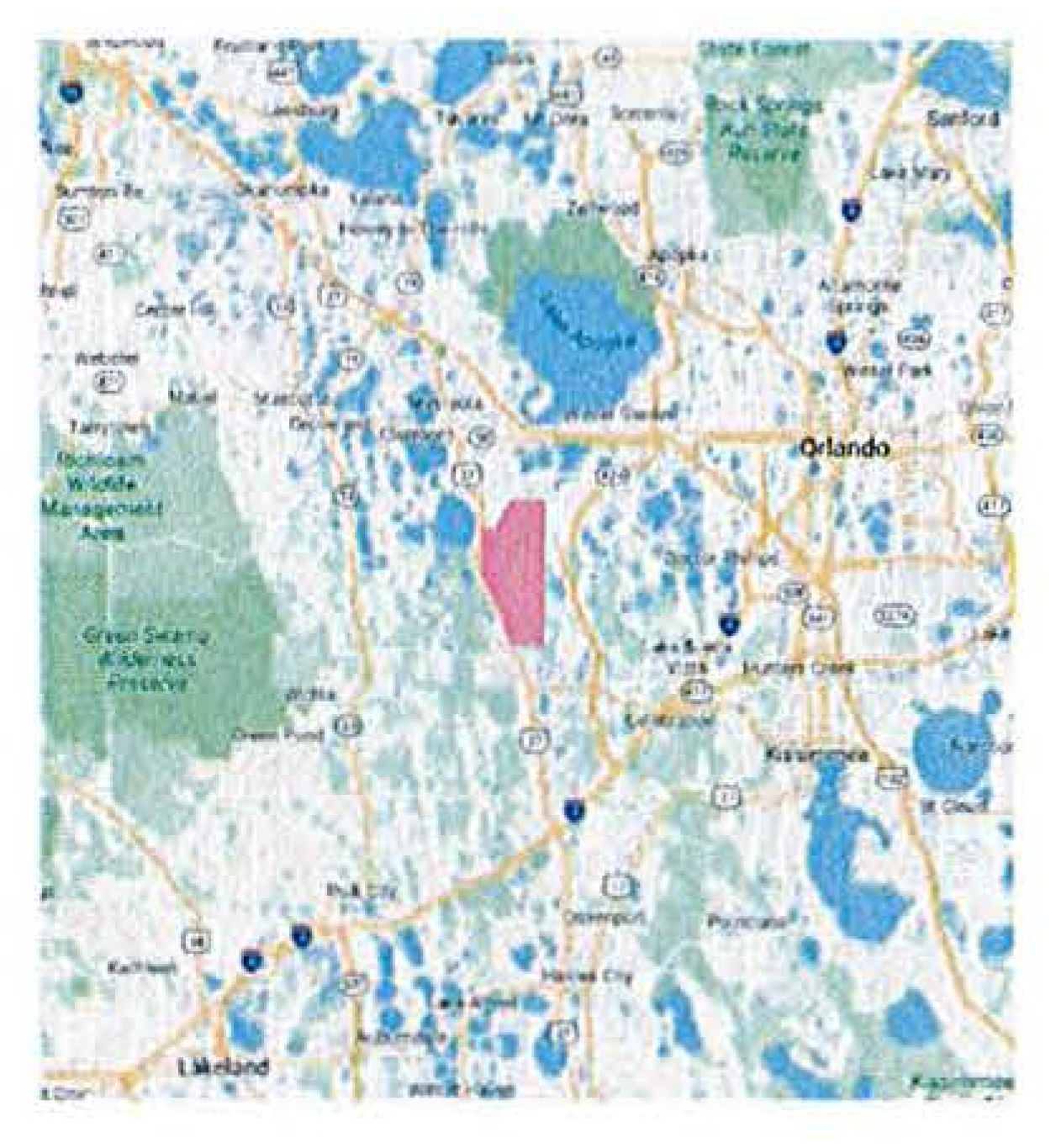
Wellness Way consists of approximately 15,500 gross acres of land located in southeast Lake County (See Figure 1). The Intent and Purpose of these Design Guidelines is to provide a regulatory framework for decision makers to implement the Guiding Principles of the adopted Wellness Way Area Plan. They are intended to produce development that achieves the following:
1.
a high-quality built environment;
2.
significant regional employment centers;
3.
regional infrastructure constructed with, not after, the impacts of development;
4.
a robust multi-modal mobility system; and
5.
protection of key regional natural and ecological systems
1.1 Guiding Principles of Wellness Way
Wellness Way is envisioned as a mixed-use area proximate to arterial thoroughfares. Land uses within Wellness Way are intended to be flexible allowing employment, residential, institutional, agriculture and Wellness/Green Space. Guiding principles [1] for urban form are as follows, and shall be specifically demonstrated in the PUDs:
1.
Wellness Way is intended to include a mix of uses that integrate residential, non-residential and open space networks. As such, guidelines for each district allocate a desired percentage distribution of uses (as measured in net acreage) along with an interconnected Wellness/Green Corridor network including a trail system to reach destinations within Wellness Way
2.
Plan for and implement regional roadway connectivity as generally depicted on the Future Land Use Map.
3.
An emphasis on complete streets and multi-modal facilities (bike trails, on-street parking, enhanced pedestrian environments).
4.
A green strategy considering a balance of development, preservation, energy, conservation and water conservation.
5.
An economic development approach that requires land set aside for non- residential employment generating uses.
6.
School centered development pattern with a co-located neighborhood park and connectivity to the Wellness Corridor network for each school.
7.
Neighborhood scale development based upon a pedestrian orientation with neighborhood centers/parks as the center of the neighborhood to create neighborhood identity and place.
8.
Allow interim and/or permanent agricultural uses.
9.
Job Hubs as defined in the Comprehensive Plan are directed to Centers as defined in these standards and guidelines.
1.2 Development Program
Wellness Way is envisioned to include a diverse range of neighborhoods, appealing to the entire spectrum of residents living in concert with nature. The design intent for the project will offer a wide range of residential densities and commercial districts. At build out, the project is planned to support the development shown in Table 1.2.
Table 1.2: Wellness Way Development Program
1.2.1 Development Districts
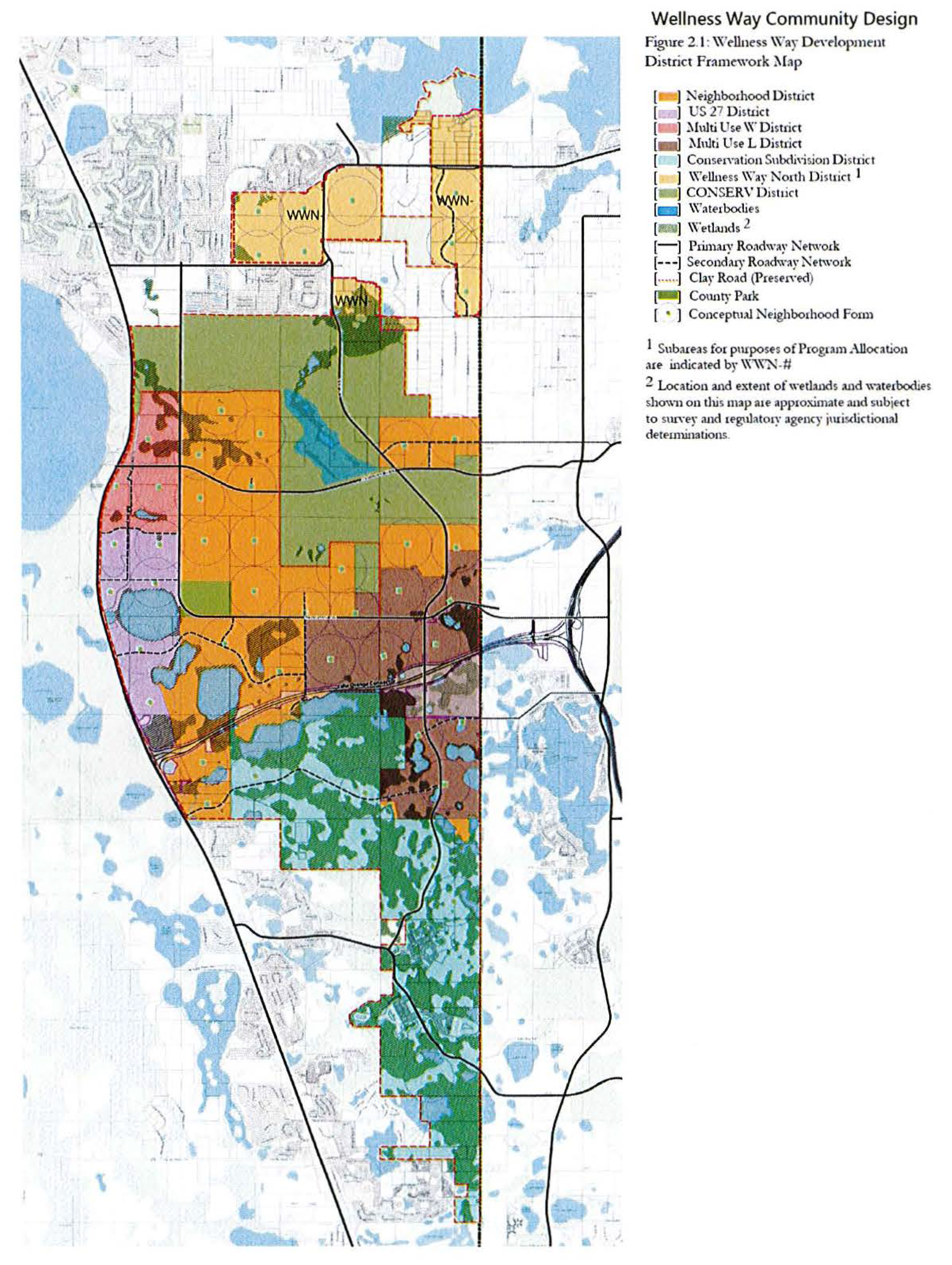
Six Districts are created within Wellness Way to guide the development and character of the community. Each District has a specific requirement for allocation of land and program as described in Sections 1.3 and 1.4. In addition, the Districts have development standards intended to support the desired community character of Wellness Way. The Districts are as follows:
1.
Neighborhood - intended to support lower density neighborhood development outside the boundaries of Wellness Way's community and employment centers in the US 27 and Multi-Use Districts.
2.
US 27 - intended to support moderate density residential, commercial, and employment uses that serve the daily needs of the residents and employees from nearby neighborhoods and workplaces.
3.
Multi-Use - intended to be the primary concentration of employment and non-residential uses in Wellness Way.
4.
Conservation Subdivision - intended to promote a balance between carefully designed residential development while supporting the ecological value of the 'mosaic' of wetlands and uplands that characterize the area.
5.
Wellness Way North - intended to carry forward the existing Wellness Way Area Plan allocation of low density residential with the required minimum of non-residential/employment square footage for the area north of CONSERV.
6.
CONSERV - intended to recognize the public ownership nature of the land holding permitting public facilities and encouraging public access as an open space amenity.
1.3 Land Allocation
All development within Wellness Way shall be allocated to one of three categories:
1.
Open Space: Lands comprising the Wellness Space and Green Space areas further defined in Section 4.1
2.
Center: Area for required non-residential uses and associated residential uses
3.
Residential: Area of residential uses
Table 1.3: Wellness Way District Land Allocation
1 Calculated on net land area defined as gross acres minus wetland acres minus waterbody acres.
2 No Center requirement in Conservation Subdivision District
1.4 Program Allocation
Minimum and maximum development programs are allocated based on the multipliers in Table 1.4. All calculations are made on net land area of the categories described in Section 1.3. For proposed developments containing more than one District, the combined program allocation may be blended among Districts within the development. However, all development must comply with the District standards listed in Section 2, including uses, residential densities, and non-residential FARs.
Table 1.4: Wellness Way District Program Allocation
1 Calculated on net land area defined as gross acres minus wetland acres minus waterbody acres.
2 Accessory Dwelling Units built in residential areas do not count toward residential maximum.
3 No Center requirement in Conservation Subdivision District
1.4.1 Non-Residential Program
Full non-residential program is not required to be built during initial phases of development. However, during the PUD approval process, applicants must demonstrate through a conceptual plan how the non-residential program allocation shown in Table 1.4 will be accommodated at buildout.
1.5 Implementation
Development within Wellness Way shall be contingent upon the adoption of Planned Unit Developments (PUDs). Each PUD shall be developed in sufficient detail to allow evaluation of the interrelationship of its parts and establish consistency with principles and criteria contained within the Lake County Comprehensive Plan and the Wellness Way Goals, Objectives, and Policies. There is no minimum size for a PUD in Wellness Way, provided the PUD reflects an overall plan for the entire parcel including future development tracts.
1.5.1 PUD Approval Process
The PUD approval process has three tasks as follows:
1.
PUD Boundary Analysis
2.
Preliminary PUD development and community input
3.
Final PUD application and public hearings as a PUD
1.5.1(a) PUD Boundary Analysis
The Applicant shall conduct a preliminary analysis of the proposed PUD area to determine appropriateness. This analysis shall include the following:
• Proposed PUD boundary including gross acreage and ownership information;
• General identification of the extent and location of significant natural and scenic resources;
• Identification of net acres (gross acres less water bodies and wetlands);
• A preliminary land allocation assessment consistent with Section 1.3;
• Determination of program allocation consistent with Section 1.4; and
• General identification of public facilities and services available to the area; available capacity; and potential deficiencies.
The Boundary Analysis application must include
• A location map;
• Acreage;
• General calculation of gross and net acres;
• FLUC designations;
• Primary roadways; and
• Justification Report demonstrating consistency and compatibility with the WWUSA GOPs.
The parcels within a PUD are not required to be contiguous parcels.
1.5.1(b) Preliminary PUD
The intent of the Preliminary PUD process is to prepare an initial plan for public review and comment. The plan for the Preliminary PUD shall consider the Framework Map and the Urban Service Area Goal, Objectives and Policies. At a minimum, a Preliminary PUD shall address the following:
• Location map;
• Context Plan showing relationship of proposed plan to overall Wellness Way plan frameworks;
• The location of proposed land uses;
• A general description of proposed land use districts;
• An integrated open space system based upon the standards in Section 4;
• Location and program of Centers, including preliminary block structure;
• Location and program of Residential Areas meeting the following standards:
• Neighborhoods should be designed at a pedestrian scale.
• Each neighborhood shall be surrounded by Wellness Corridor/open space.
• Each neighborhood shall have a central focal point of a park, community building, playground or similar uses.
• For mixed-use areas, requirements for Centers shall be met.
• The identification of significant natural, scenic and cultural resources including areas for potential preservation, permanent protection and/or restoration;
• Proposed transportation facilities for pedestrians, bicycles, and automobiles, including consideration for connection with facilities outside the PUD. For each facility to be included in the PUD, design criteria should be included to address:
• Roadway cross-sections
• Pedestrian, Bicycle and Multi-modal facilities
• Landscape and streetscape standards
• Proposed Wellness Corridor network
• Proposed location and size/capacity of major public facilities, including potable water, reuse water, sanitary sewer, solid waste, parks and trails, public schools, law enforcement, fire protection and emergency services; and
• When applicable, strategies for the integration of existing development.
The Preliminary PUD shall be presented to the public at a workshop. This workshop is to be advertised in a manner consistent with Florida Statute. In addition, each property owner in the PUD and each property owner within 1,000 feet of the boundary of the PUD shall be notified of the workshop. Comments from the public shall be documented by the applicant and included in a letter to Lake County.
The Preliminary PUD community presentation must include
• a location map,
• calculation of land use acreage,
• general calculation of gross and net acres,
• FLUC designations,
• primary roadways
• Master Plan
• Context Plan
• Wellness/Green Space Corridor Plan
• Hierarchy of Place consist with the Framework Map
• Natural, scenic, and cultural resources Plan
• Justification Report demonstrating consistency and compatibility with the WWUSA GOPs
1.5.1(c) Final PUD
Following the informational workshop described in the Preliminary PUD phase, a Final PUD shall be prepared as a Master PUD application. At a minimum, this plan shall consist of the following elements:
• A detailed land use plan indicating the distribution, extent and location of land use districts including any requested design standards for the various districts proposed in the land use plan,
• A detailed natural and scenic resource plan that identifies significant natural and scenic resources within the PUD and outlines specific measures to ensure the protection and, as appropriate, preservation, restoration and management of areas containing these resources.
• A detailed transportation plan containing, at a minimum, the following:
• A roadway plan containing the general location of all arterial and collector roadways necessary to serve the PUD, their right-of-way width, and final design cross section.
• The general location of all bikeways and multi-use trails in a manner which connects residential neighborhoods with Centers, parks, and schools.
• A report demonstrating the PUD's impact on transportation facilities and documenting the timing and estimated cost and funding sources for needed transportation improvements. Each PUD shall analyze the cumulative traffic impact of all previously approved PUDs within Wellness Way on the area road network.
• A detailed public facilities plan identifying public facilities. At a minimum, this plan shall address:
• Potable water
• Re-use water
• Sanitary sewer
• Solid waste
• Parks and trails
• Public schools (if any)
• Law enforcement, fire protection and emergency services (if any)
• Non-potable water demand
• Identification of specific procedures to facilitate intergovernmental coordination to address extra jurisdictional impacts from the PUD.
• A list of requested Alternate Standards consistent with Section 1.7.
The Final PUD application shall be submitted to Lake County for review and recommendation by the Planning & Zoning Board and approval by the Board of County Commissioners.
1.5.2 Changes to an Approved PUD
Any addition or deletion of property or changes to the land use district boundaries in an approved PUD shall follow the process for adoption of a PUD. It shall include an evaluation and analysis of the impacts to the approved or planned land uses and the ability of the proposed amendment to meet the principles and standards set forth in these Standards
1.5.3 Development Approvals within a PUD
Once a Master PUD is adopted by the Board of County Commissioners, all applications for development approval (i.e., subdivision plans, site plans, lot splits, and special exceptions) shall be evaluated for compatibility and compliance with the adopted PUD.
1.6 Conflicts and Omissions
This document shall govern the development of property within Wellness Way. In an instance where the Design Guidelines and Standards conflict with existing County codes, the Design Guidelines and Standards shall control. When the Design Guidelines and Standards do not address a specific standard, the standard in the County LDC and Manual of Uniform Minimum Standards for Design, Construction and Maintenance (Florida Greenbook) shall be applied. Terms are defined as contained within the Land Development Code unless otherwise noted.
1.7 Alternate Standards
One size does not fit all circumstances. Each development proposal may include alternatives to the requirements of these guidelines. Alternatives will be evaluated on the following criteria:
1.
The consistency of the requested alternative with the Guiding Principles of Wellness Way as set forth in Section 1.1 of these standards;
2.
The requested alternative is shown by the applicant to produce an outcome that, after consideration of the basis for the request, is substantially equivalent to outcome sought to be produced by application of the adopted standard including, but not limited to, recognition of unique environmental conditions, landforms, character of surrounding development, and elevation changes; and
3.
The requested alternative is shown by the applicant to be the least deviation from the adopted standard necessary to produce the desired outcome.
(Ord. No. 2022-23, § 2, 5-3-22)
Section 2 Development Districts
2.1 District Standards
These Design Guidelines establish six districts to guide the development and character of the community. The districts are shown on the Framework Map in Figure 2.1 and further described below.
Table 2.1: Wellness Way Districts by Acreage
1 Acreage shown is net of wetlands and waterbodies which are subject to survey and regulatory agency jurisdictional determinations. Final acreages may vary from those shown in this table.
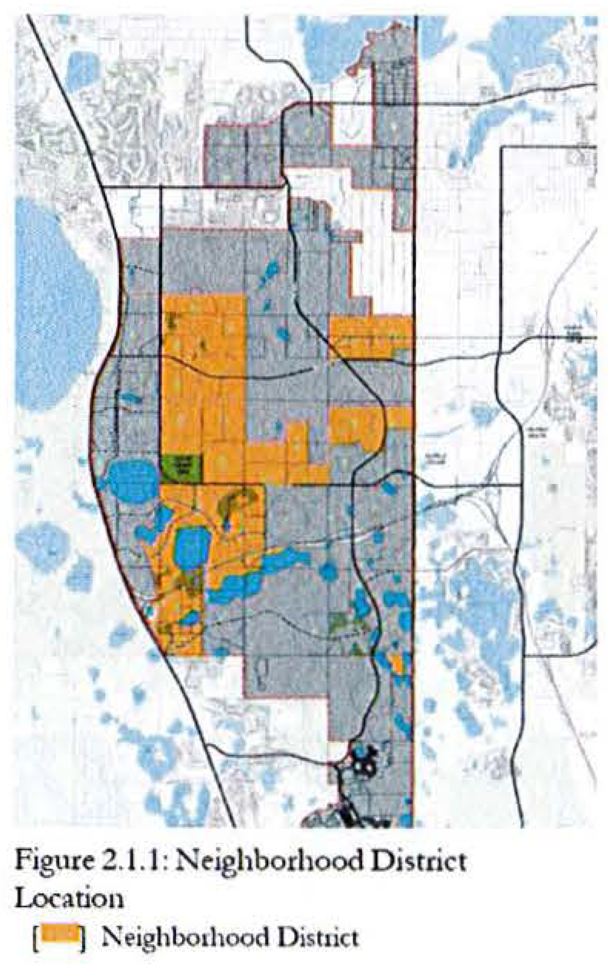
2.1.1 Neighborhood District
The Neighborhood District is intended to support lower density neighborhood development outside the boundaries of Wellness Way's community and employment centers in the US 27 and Multi-Use Districts. This is the largest district and requires flexibility in design to accommodate neighborhood and housing types for many market segments.
2.1.1(a) Form and Design.
The design standards in this district are intended to achieve the following:
1.
Development will be organized in the form of neighborhoods. A neighborhood shall be defined by a single standard pedestrian-shed generally ½-mile diameter. Its physical center should be located at an important traffic intersection associated with a civic or commercial use. The edges of the neighborhood should blend into an adjacent neighborhood or district without buffer.
2.
Massing, setbacks, and character of new residential developments shall encourage structures that do not overly dominate streets, foster diversity in design, and maintain the character of the community. Alternative housing forms, such as small-lot single family, bungalow single family, townhomes, small-scale apartments, and accessory dwelling units that provide diversity of housing opportunities are encouraged.
3.
Each neighborhood shall include a variety of housing types and styles to allow people with a range of different ages and incomes to live in the neighborhood of their choice as a diverse community. To maintain the desired density of residential neighborhoods, a variety of housing types, lot sizes, and patterns are encouraged.
4.
The Neighborhood District may contain the following residential housing types:
• Single-family detached homes;
• Townhomes;
• Duplexes and other types of attached units up to four-plexes;
• Walk up apartments; and
• Accessory dwelling units.
5.
Whenever possible, land use boundaries and density changes in neighborhoods should occur at mid-block locations, rather than along streets, so that buildings facing each other are compatible and transitions between uses are gradual.
6.
Higher residential densities should generally be located adjacent to a Center, or a location that would serve as a transition between a Neighborhood District and Multi-Use District or US 27 District.
7.
Neighborhoods shall be pedestrian and bicycle friendly. Individual neighborhoods should be sized so that dwellings are generally within a maximum quarter-mile of a Center or a Neighborhood Park, Square, or Green as described in Section 4.2.4.
8.
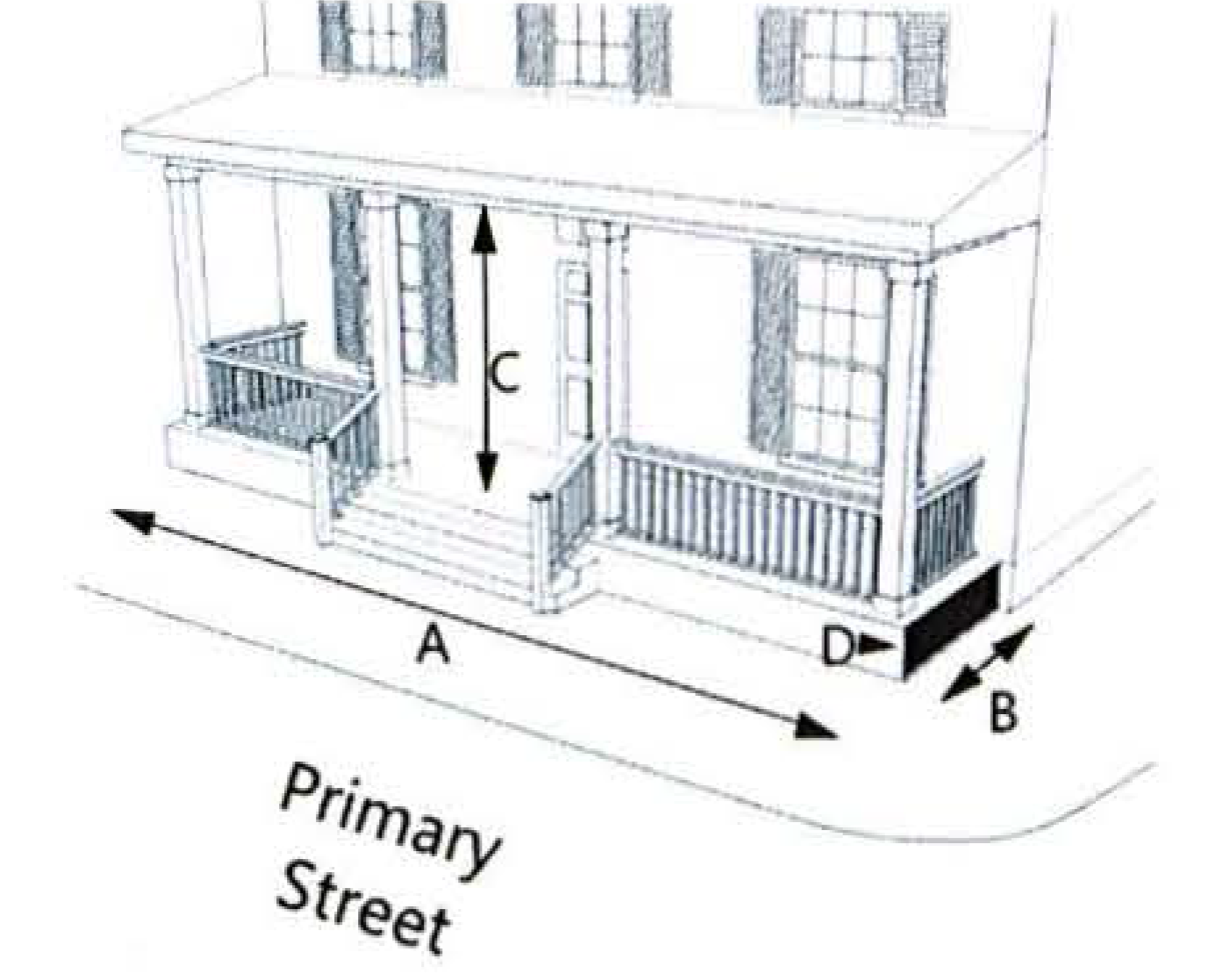
Houses shall front the local street system and public spaces with entries, balconies, porches, architectural features, and activities to enliven the streets and create safe and pleasant walking environments.
2.1.1(b) Connectivity.
Wellness Way neighborhoods will be designed with a network of interconnected local streets and trails to encourage pedestrian, bicycle, and vehicular access. The intersection density in the Neighborhood District shall be at least 80 intersections per square mile inclusive of bicycle/pedestrian crossings and street intersections. This standard shall in no way preclude the governing County, or State access management standards for arterial and collector roads.
2.1.1(c) Development Standards.
All development within the Neighborhood District shall be consistent with the standards governing density, intensity, and lot development shown in Table 2.1.1(c).
Table 2.1.1(c): Neighborhood District Development Standards
SFD: Single-Family Detached
SFA: Single-Family Attached (Duplex/Townhome)
MF: Multi-Family
NR: Non-Residential
1 4' minimum allowed on lots less than 40' in width. Mechanical equipment prohibited in side yards less than 5' wide.
2 Front loaded garages must be recessed at least five feet from front of primary structure.
3 Any setback beyond minimum shall be at least 20'.
4 Garages on lots less than 50' wide shall be alley accessed.
5 5' side setback required for end units.
6 Front yard setback may be reduced to 15' if alley loaded garages are provided.
7 Accessory structure setback 5' minimum.
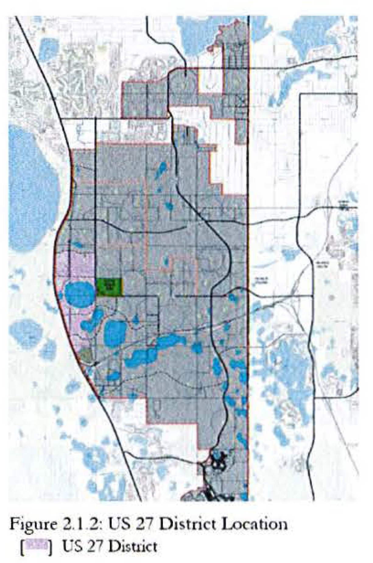
2.1.2 US 27 District
The US 27 District is intended to support moderate density residential, commercial, and employment uses that serve the daily needs of the residents and employees from nearby neighborhoods and workplaces. The District is not intended to create a conventional 'strip commercial' frontage along US 27.
2.1.2(a) Form and Design. The design standards in this district are intended to achieve the following:
1.
This District is designed to encourage development of multiple uses that are integrated to form a cohesive development pattern.
Development should be designed to ensure a series of interconnected mix of uses with an internal street/driveway pattern which allows convenient movement within the district as well as easy access from surrounding neighborhoods. The primary orientation is to US 27.
2.
The scale of this district is mid-rise buildings - typically five stories in height and below. This District serves as a transition in land use intensity from the Neighborhood District to the Multi Use District to the north.
3.
The street layout should allow for movement between differing land uses without relying upon the external arterial street system. This can include local public or private streets. Access between residential areas and commercial/employment areas must include facilities for safe pedestrian movement.
4.
Residential buildings include:
• detached single-family
• Townhomes;
• Duplexes and other types of attached units up to four-plexes; and
• multi-unit stacked flat buildings.
Commercial buildings include:
• in-line retail centers;
• out-parcels - with or without drive-thru facilities;
• single or multi-story office; and
• institutional uses.
5.
Whenever possible, land use boundaries and density changes in neighborhoods should occur at mid-block locations, rather than along streets, so that buildings facing each other are compatible and transitions between uses are gradual.
6.
Higher residential densities should generally be located adjacent to a Center or transition to Multi-Use. No more than 50% of the parcels with US 27 frontage may be retail/commercial use. Lowest densities and intensities should generally be located adjacent to Neighborhood Districts.
7.
The District shall be pedestrian and bicycle friendly. Development should be sized so that dwellings are generally within a maximum quarter-mile of a Center. Access between residential areas and commercial/employment areas must include facilities for safe bicycle and pedestrian movement.
8.
All buildings in the District shall front the local street system and public spaces with entries, balconies, porches, architectural features, and activities to enliven the streets and create safe and pleasant walking environments.
2.1.2(b) Connectivity.
Wellness Way neighborhoods will be designed with a network of interconnected local streets and trails to encourage pedestrian, bicycle, and automobile access. The intersection density in the US 27 District shall be at least 100 intersections [2] per square mile inclusive of bicycle/pedestrian crossings and street intersections.
2.1.2(c) Development Standards.
All development within the US 27 District shall be consistent with the standards governing density, intensity, and lot development shown in Table 2.1.2(c).
Table 2.1.2(c): US 27 District Development Standards
SFD: Single-Family Detached
SFA: Single-Family Attached (Duplex/Townhome)
MF: Multi-Family
NR: Non-Residential
1 Measured from edge of right-of-way.
2 Frontage requirements apply only to designated A-streets. See Section 2.3.1 for details. Up to 50% of frontage requirement may be met through knee-wall of 30" to 54" or designated public space. B-streets have no frontage requirements.
3 10' building separation required adjacent to residential uses
4 Any setback beyond minimum shall be at least 20'.
5 5' side setback required for end units.
6 4' minimum allowed on lots less than 40' in width. Mechanical equipment prohibited in side yards less than 5' wide.
7 Accessory structure setback 5' minimum.
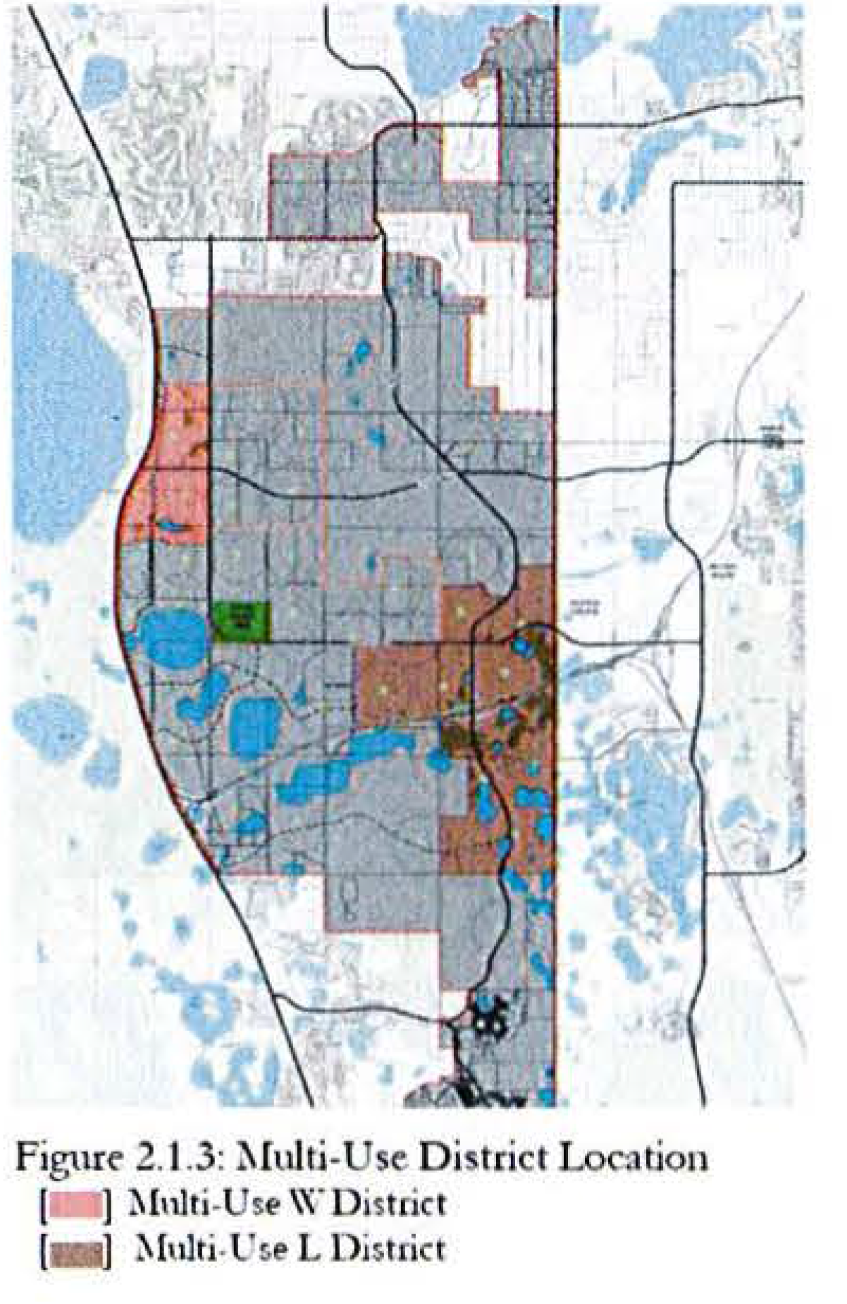
2.1.3 Multi-Use District
The Multi-Use District is intended to be the primary concentration of employment and non-residential uses in Wellness Way. There are two distinct Multi-Use Districts. The Multi-Use W District is centered on the intersection of Wellness Way and US 27. The Multi-Use L District, supporting increased options for logistics and distribution, occurs at the planned County Road 455 and the Lake-Orange Connector expressway.
2.1.3 (a) Form and Design.
The design standards in this district are intended to achieve the following:
1.
This District focuses on employment as its central purpose, with ancillary residential and service uses. Uses should be organized around a "block structure" providing for vehicular, pedestrian and bicycle access in and between blocks.
2.
This District supports the highest intensity of land uses in Wellness Way. Larger square footage buildings, sometimes exceeding 1MM square feet under roof, are encouraged in the Multi-Use L District.
3.
The Multi-Use L District is intended to support a high concentration of logistics, distribution, and similar facilities. This District has standards to facilitate development as a logistics hub for truck-related facilities within the context of the broader Wellness Way Guiding Principles. The Multi-Use W District is intended to support regional employment of varying types while also serving the community level retail and services for surrounding neighborhoods.
4.
A wide variety of building types are encouraged. The Multi-Use W District is intended to be characterized by single and multi-tenant retail, office, and services buildings. Drive thru facilities are permitted. The Multi-Use L is similar, but also includes large scale logistics, distribution, and similar facilities.
5.
The edges of both Multi-Use Districts should be designed to transition to adjacent development districts based on the character of the adjoining uses.
6.
In the Multi-Use W District, residential uses should be integrated into the overall design of the District with close proximity to employment uses. The Multi-Use L District is oriented to larger logistics and distribution uses. Residential uses should be oriented away from concentrations of logistics/distribution uses, to maximize available land for employment uses and minimize conflicts between employment uses and surrounding residential neighborhoods.
7.
Bicycle and pedestrian facilities to be included along all arterial and collector roadways and into and through the District to promote access from residential areas.
8.
The streets in the Multi-Use L District should be designed to accommodate large volumes of truck traffic. Logistics and distribution buildings shall be oriented to provide the greatest operational benefit to those uses, while ensuring that robust landscape and hardscape elements enhance the street edge.
2.1.3(b) Connectivity.
The Multi-Use District will be designed with a network of interconnected local streets and trails to encourage pedestrian, bicycle, and automobile access.
2.1.3(c) Development Standards.
All development within the Multi-Use District shall be consistent with the standards governing density, intensity, and lot development shown in Table 2.1.3(c).
Table 2.1.3(c): Multi-Use District Development Standards
1 Measured from edge of right-of-way.
2 Frontage requirements apply only to designated A-streets. See Section 2.3.1 for details. Up to 50% of frontage requirement may be met through knee-wall of 30" to 54" or designated public space. B-streets have no frontage requirements.
3 Industrial: 3 stories; Office/Hospital: 8 stories; Commercial 3 stories; Hotel: 8 stories
4 Ground floors of buildings on A-street frontages shall be designed and built to accommodate future ground floor commercial uses unless otherwise approved by Lake County.
5 Minimum setback; no build-to required.
6 5' side setback required for end units.
7 Accessory structure setback 5' minimum.
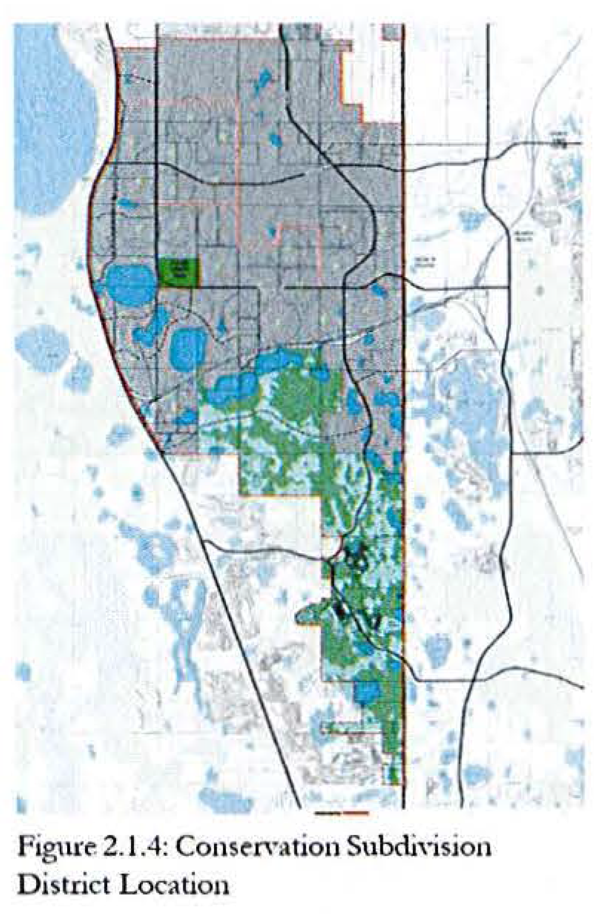
2.1.4 Conservation Subdivision District
The Conservation Subdivision District is intended to promote a balance between carefully designed residential development while supporting the ecological value of the "mosaic" of wetlands and uplands that characterize the area. Recognition of wildlife corridors is central to the purpose of the District.
2.1.4(a) Form and Design.
The design standards in this district are intended to achieve the following:
1.
This District provides for the protection of the extensive wetland system by orienting residential development in uplands well buffered from wetland systems. The preservation of documented wildlife corridors through this District is integral to the purpose of the District.
2.
The scale of this District is one of clustering residential development on uplands while preserving large wetland and adjacent uplands to maintain the integrity of the natural ecosystem to the greatest extent possible.
3.
Higher net densities in the form of smaller lot sizes may be permitted to achieve a balance between residential land development and ecological preservation. No Center is required but may be provided. Non-residential uses are limited to civic and residential amenity uses only.
4.
This is generally a single-family and agricultural district; however alternative building types can be considered if the resulting land use pattern provides greater protection for conservation lands and ecological habitat.
5.
Land use transitions in this District occur between residential development on upland and protected wetland systems.
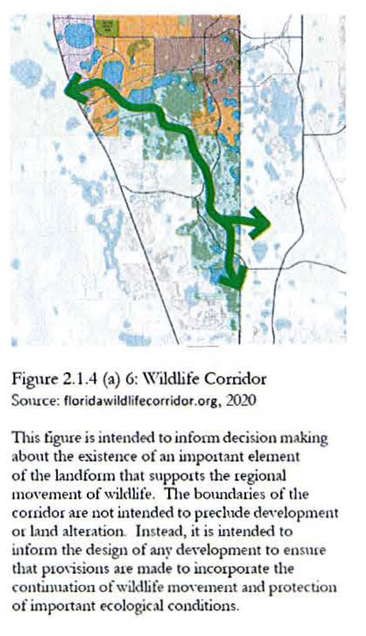
6.
All Districts, including this District, encourage an approach that limits the impact of residential areas on protected conservation areas and documented wildlife corridors (see Figure 2.1.4 (a) 6). Wherever possible, community facilities/amenities should be used as organizing features of neighborhoods.
7.
Emphasis should be on multi-use trails in lieu of sidewalks on both sides of streets to limit impervious surfaces and reduce impacts to surrounding conservation areas.
8.
Wherever possible, neighborhood street design should take on more of a rural, open swale design.
9.
Open space tracts should be located and designed to allow for free movement of wildlife. Fencing of open space tracts is discouraged.
2.1.4(b) Connectivity.
Wellness Way neighborhoods will be designed with a network of interconnected local streets and trails to encourage pedestrian, bicycle, and automobile access. The intersection density in the Conservation Subdivision District shall be at least 40 intersections per square mile inclusive of bicycle/pedestrian crossings and street intersections [3].
2.1.4(c) Development Standards.
All development within the Conservation Subdivision District shall be consistent with the standards governing density, intensity, and lot development shown in Table 2.1.4(c).
Table 2.1.4(c): Conservation Subdivision District Development Standards
SFD: Single-Family Detached
SFA: Single-Family Attached (Duplex/Townhome)
5 4' minimum allowed on lots less than 40' in width. Mechanical equipment prohibited inside yards less than 5' wide.
6 Front loaded garages must be recessed at least five feet from front of primary structure.
7 Any setback beyond minimum shall be at least 20'.
8 Garages on lots less than 50' wide shall be alley accessed.
9 5' side setback required for end units.
10 Accessory structure setback 5' minimum.
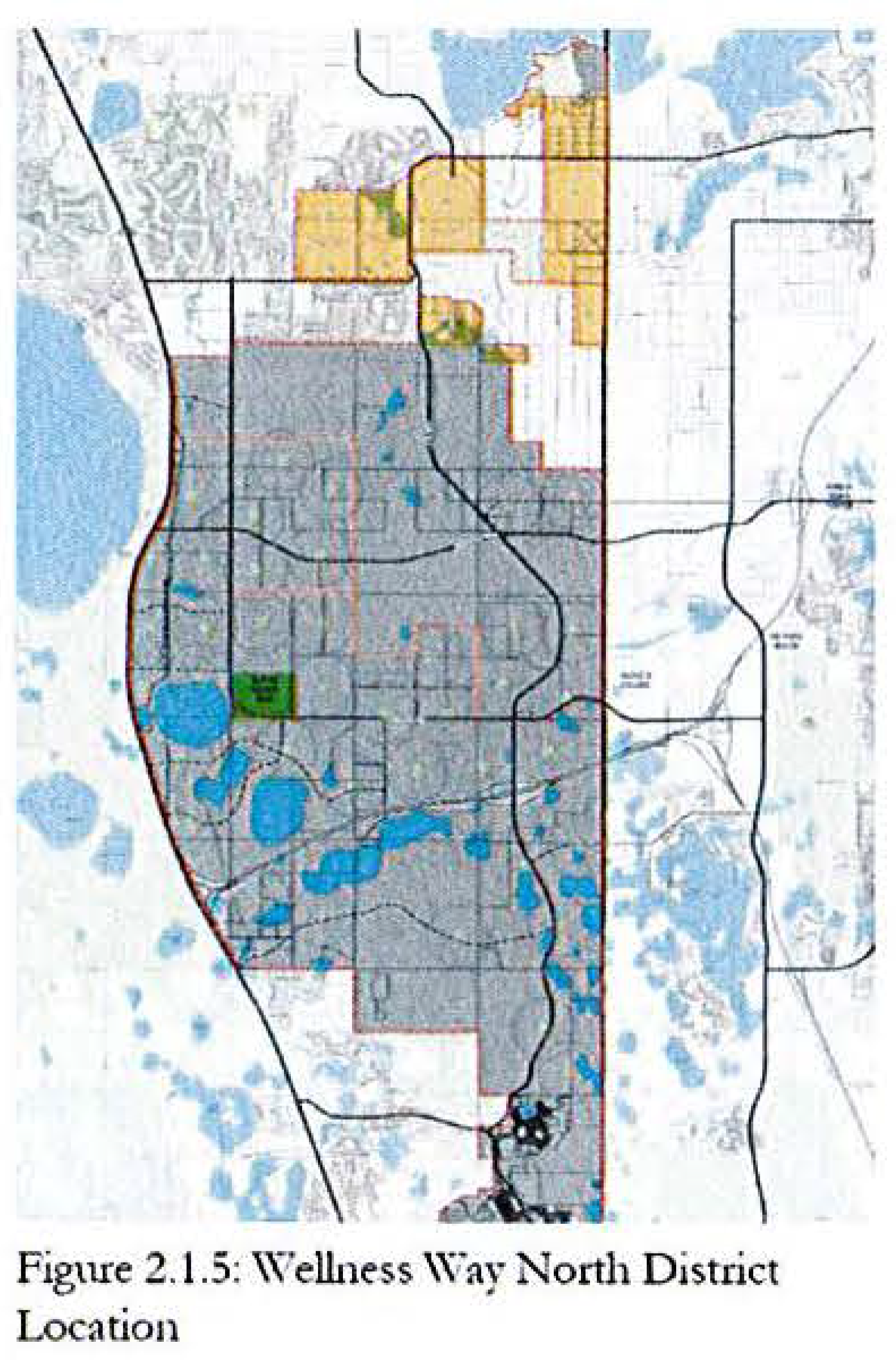
2.1.5 Wellness Way North District
This District is intended to implement the existing Wellness Way Area Plan allocation of low density residential with the required minimum of non-residential/employment square footage.
2.1.5(a) Form and Design.
The design standards in this district are intended to achieve the following:
1.
Development will be organized in the form of neighborhoods. A neighborhood shall be defined by a single standard pedestrian-shed generally ½-mile diameter. Its physical center should be located at an important traffic intersection associated with a civic or commercial use. The edges of the neighborhood should blend into an adjacent neighborhood or district with appropriate buffer.
2.
Massing, setbacks, and character of new residential developments shall encourage structures that do not overly dominate streets, foster diversity in design, and maintain the character of the community. Alternative housing forms, such as duplexes, bungalow single family, and accessory dwelling units ("granny flats") that provide diversity of housing opportunities are encouraged.
3.
Each neighborhood shall include a variety of housing types and styles. To maintain the desired density of residential neighborhoods, at least three distinct housing types and/or lot sizes are required.
4.
Wellness Way North neighborhoods may contain the following residential housing types:
• Single-family detached homes;
• Townhomes;
• Duplexes and other types of attached units up to four-plexes;
• Walk up apartments; and
• Accessory dwelling units.
5.
Whenever practical, land use boundaries and density changes in neighborhoods should occur at mid-block locations, rather than along streets, so that buildings facing each other are compatible and transitions between uses are gradual.
6.
Higher densities within neighborhoods should generally be located adjacent to a Center or a Neighborhood Park, Square, or Green as described in Section 4.2.4.
7.
Neighborhoods shall be pedestrian and bicycle friendly. Individual neighborhoods should be sized so that dwellings are generally within a maximum quarter-mile of a Center.
8.
Houses shall front the local street system and public spaces with entries, balconies, porches, architectural features, and activities to enliven the streets and create safe and pleasant walking environments.
2.1.5(b) Connectivity.
Wellness Way neighborhoods will be designed with a network of interconnected local streets and trails to encourage pedestrian, bicycle, and automobile access. The intersection density in the Wellness Way North District shall be at least 80 intersections per square mile inclusive of bicycle/pedestrian crossings and street intersections [4].
2.1.5(c) Development Standards.
All development within the Wellness Way North District shall be consistent with the standards governing density, intensity, and lot development shown in Table 2.1.5(c).
Table 2.1.5(c): Wellness Way North District Development Standards
SFD: Single-Family Detached
SFA: Single-Family Attached (Duplex/Townhome)
MF: Multi-Family
NR: Non-Residential
1 4' minimum allowed on lots less than 40' in width.
2 Front loaded garages must be recessed at least five feet from front of primary structure.
3 Any setback beyond minimum shall be at least 20'.
4 Garages on lots less than 50' wide shall be alley accessed.
5 5' side setback required for end units.
2.1.6 CONSERV District
This District is intended to recognize the public ownership nature of the land holding and as such, no private urban land uses are permitted. Public facilities, including schools, utilities and other support facilities for public uses are permitted. Public access as an open space amenity is highly encouraged.
2.2 Permitted Uses, Densities, and Intensities
2.2.1 Density and Intensity Ranges
All development within Wellness Way shall be consistent with the applicable minimum and maximum density and intensity ranges shown in Figure 2.2.1 and Table 2.2.1. The minimum and maximum densities/intensities shown in Table 2.2.1 are the range of net densities/intensities for any individual parcel within a PUD.
Table 2.2.1: Wellness Way Density/Intensity Tiers
1 Density calculated on net buildable acreage (Gross acres minus wetland acres minus water body acres minus designated open space.)
2 Accessory Dwelling Units (ADUs) will not be included in unit or density calculations
3 Minimum and maximum FAR shall be applied to the overall development plan and not to each freestanding phase. The Developer shall maintain a cumulative record of FAR approved to date and provide it with each phase of the project.
4 Non-residential uses, except for civic and amenity related uses, shall only be in Centers.
2.2.2 Permitted Principal Uses
The permitted uses shown in Table 2.2.2 for each District are intended to support the following design elements:
a)
An interconnected network of streets and paths designed to encourage walking and bicycle use, with traffic calming where necessary;
b)
A complementary mix and range of land uses, including residential, employment, educational, recreational, and cultural activities;
c)
Appropriate densities and intensities of land use within centers;
d)
Daily activities within walking distance of residences; and
e)
Public uses, streets and gathering places that are safe, comfortable, and attractive for the pedestrian, with adjoining buildings that rationally relate to the street and parking designed to support all transportation modes.
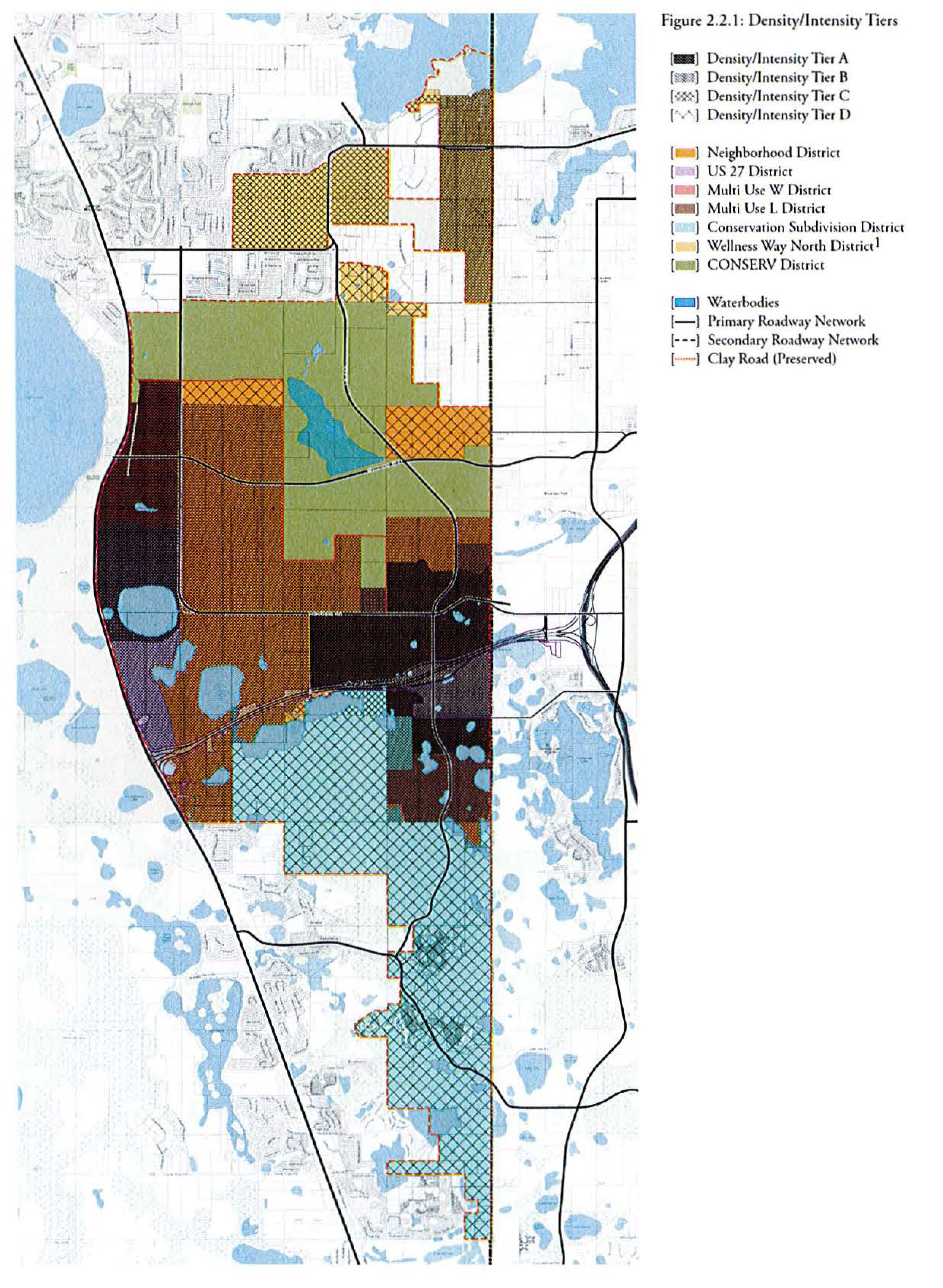
Table 2.2.2: Permitted Principal Uses by District
P Permitted use in specified District
1 Permitted only in Centers
2 Accessory Dwelling Units (ADUs) will not be included in unit or density calculations
3 Walk up apartments only; must be located adjacent to Center; no more than three stories in height.
4 Agriculture allowed throughout District
5 See 2.1.4(b)2
6 Large, single story commercial building with high ceilings, designed with flexibility in mind to accommodate a mix of office, production, and warehouse/distribution uses.
7 Outpatient medical uses only
8 Permitted only by Conditional Use Permit
2.3 Site and Architectural Standards for Centers
The following standards apply to all buildings and sites in Centers.
2.3.1 "A" and "B" Street Framework
Every street within the Center area of each District shall be designated as either an "A" street or a "B" street. At least 50% of the streets in an individual Center must be "A" streets.
• "A" streets are intended to be the primary pedestrian-oriented streets that provide a mix of uses, promoting pedestrian activity, cycling, and transit. These streets will have building frontage requirements that establish a strong relationship between the building and the street.
• "B" streets are intended to provide vehicular and service access to development blocks. These streets will have no building frontage requirements. While "B" streets are not intended to be primary pedestrian streets, they should include sidewalks and street trees in accordance with appropriate street types. "B" streets can either be publicly dedicated or privately maintained.
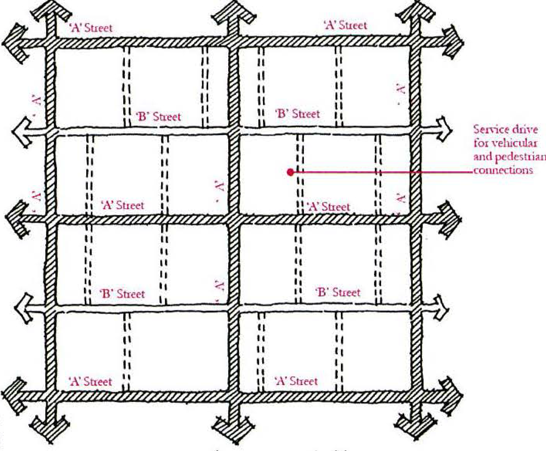
Figure 2.3.1: "A"/"B" Street Concept
Since "A" and "B" streets inside centers may not be public streets, each PUD shall define its own applicable cross section consistent with the standards of this section.
Maximum internal block lengths, defined as the distance between "A" Streets, shall be indicated in Table 2.3.1. This requirement only applies to the Center area of each District.
Table 2.3.1: Centers Maximum Block Lengths by District
1 Logistics/Distribution and other major employment facilities exempt from this requirement.
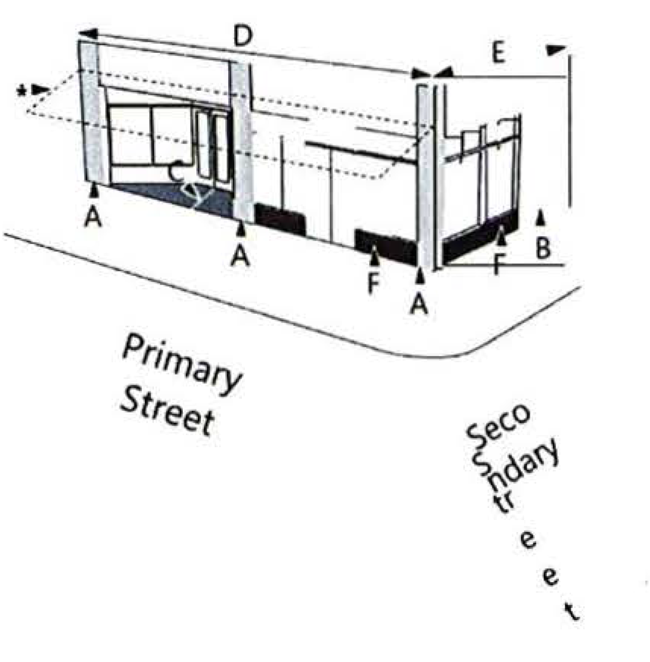
2.3.2 Building Location and Siting
In general, within the Neighborhood, US 27, Multi-Use W, and Wellness Way North Districts, urban architecture should be built up to all property lines that front "A" streets described in Section 2.3.1 and/or parks described in Section 4.4. The intent of these standards is to promote a substantially continuous building edge along these streets to encourage density, connection to adjacent properties, and street activity.
• Parking and service areas shall not be located between the principal building and the street.
• Building service elements (e.g., loading docks, dumpsters, etc.) shall be located at the rear of the building and screened from view of adjacent "A" Streets. Development is encouraged to develop a system of service alleys to provide access to these areas.
• Buildings on corner parcels shall be located up to and address the corner. They are encouraged to wrap the corner where possible.
Within the Multi-Use L District, industrial and manufacturing buildings should be sited, regardless of their use, in a manner that emphasizes building frontage and landscape more than parking and service/loading areas. While there is not a requirement that buildings be placed at the edge of the sidewalk; the intent of these guidelines is to encourage a varied streetscape that allows buildings with a mix of employment uses near each other.
1.
Buildings are encouraged to have a variety of front setbacks to avoid the creation of a constant wall of buildings. This is particularly important where proposed buildings have similar heights and massing.
2.
Large scale parking and service areas shall not be located between the principal building and the street. No more than a single bay of parking may be located between the principal building and the street at the front of the parcel. Where parking is provided between the building and street, at least 25% of the building frontage must be kept free of parking stalls.
3.
Parking may be located to the side of the principal building. In this condition, special screening guidelines apply.
4.
Where unique operational needs of logistics and distribution uses require a parking arrangement inconsistent with these standards, the PUD shall incorporate alternative standards consistent with Section 1.6.
2.3.3 Required Building Frontages
All buildings in Centers shall provide a primary frontage consistent with one of the following types. Each frontage type has a schematic example and standards that are required for development within the Center.
2.3.3(a) Storefront.
Storefront frontages are intended to create an enhanced pedestrian-oriented environment through design elements such as high visibility into the buildings, shade fixtures, outdoor dining spaces, architectural details, and other features. These Storefront frontage elements are governed by the following requirements:
General. The frontage is set back from the front property line per applicable street setback requirements typically at or near a front property line with the entrance at sidewalk grade. Frontages shall incorporate awnings, marquees and/or arcades that cover the sidewalk and may request to extend into the right-of-way, as well as galleries. Recessed entrances are acceptable. Building frontages wider than 75 feet shall incorporate vertical divisions to mimic smaller-scale development. All frontages directly facing an "A" Street or open space shall incorporate architectural elements that divide the building horizontally. Single story buildings shall contain a recognizable ground floor area and cornice area. Multi-story buildings shall contain recognizable ground floor, middle, and cornice areas.
Windows and Entrances. All glass shall be clear and non-reflective. If glass incorporates tinting, it should be transparent enough for those outside the buildings to see building occupants. Tinting should not be the primary strategy to provide privacy or reduce solar transmittance, but rather these should be accomplished through the articulation of buildings facades with awnings, wall thickness, canopies, marquees, arcades, or galleries.
Transparency. Transparency shall be calculated as the percentage of clear glass between the ground and 10 feet in height. False windows shall not be counted toward meeting the minimum transparency requirement.
Table 2.3.3(a): Storefront Frontage Requirements
2.3.3(b) Civic/Institutional Frontage.
Civic and institutional frontages are intended to facilitate the functioning of government buildings, hospitals, churches, and other public type uses, while maintaining a pedestrian orientation. It is acknowledged that such buildings are sometimes internally complex and uses are sensitive in nature. Flexibility in the requirements is warranted as follows:
General. Frontages shall incorporate awnings, marquees, porches, and/or arcades. Building frontages wider than 75 feet shall incorporate vertical divisions to mimic smaller-scale development. All frontages facing a street or open space shall incorporate architectural elements that divide the building horizontally. Single story buildings shall contain a recognizable ground floor area and cornice area. Multi-story buildings shall contain recognizable ground floor, middle, and cornice areas. Buildings should have a well-defined pedestrian access on the primary frontage.
Transparency. Transparency shall be calculated as the percentage (%) of clear glass between the ground and 10 feet in height. Exceptions to the transparency requirements may be granted where patient privacy or employee safety would be compromised. In such situations, the building shall be designed with features that break up the mass of the building such as treated or spandrel glass, building articulations, architectural fenestrations or green wall landscape features. For these exceptions, such details shall be counted towards the transparency requirement.
Table 2.2.2(b): Civic/Institutional Frontage Requirements
2.3.3(c) Industrial Frontages.
Industrial frontages are intended to facilitate the function of warehouse, manufacturing, or flex office/industrial uses, while maintaining a high-quality visual environment. Industrial frontage elements are governed by the following requirements:
General. Building frontages wider than 75 feet shall incorporate vertical divisions to mimic smaller-scale development. All frontages facing a street or open space shall incorporate architectural elements that divide the building horizontally. Single story buildings shall contain a recognizable ground floor area and cornice area.
Exterior Surface Materials. No exposed, unfinished sheet metal or concrete shall be permitted on building exteriors unless used as an accent to the architectural style of the building. No exposed, unfinished concrete block shall be permitted on building exteriors or screen walls. Color palette, materials, and finishes shall be consistent on all exterior elevations of the principal building. Any secondary buildings, accessory structures, or screen walls shall be treated consistent with the principal building. Gutters, downspouts, vents, louvers, and rolling doors, shall be a color consistent with the color scheme of the building they are incorporated into.
Transparency. Transparency shall be calculated as the percentage of clear glass between the ground and 10 feet in height. The following requirements apply only to the office portion of an industrial building frontage.
Table 2.2.2(c): Industrial Frontage Requirements
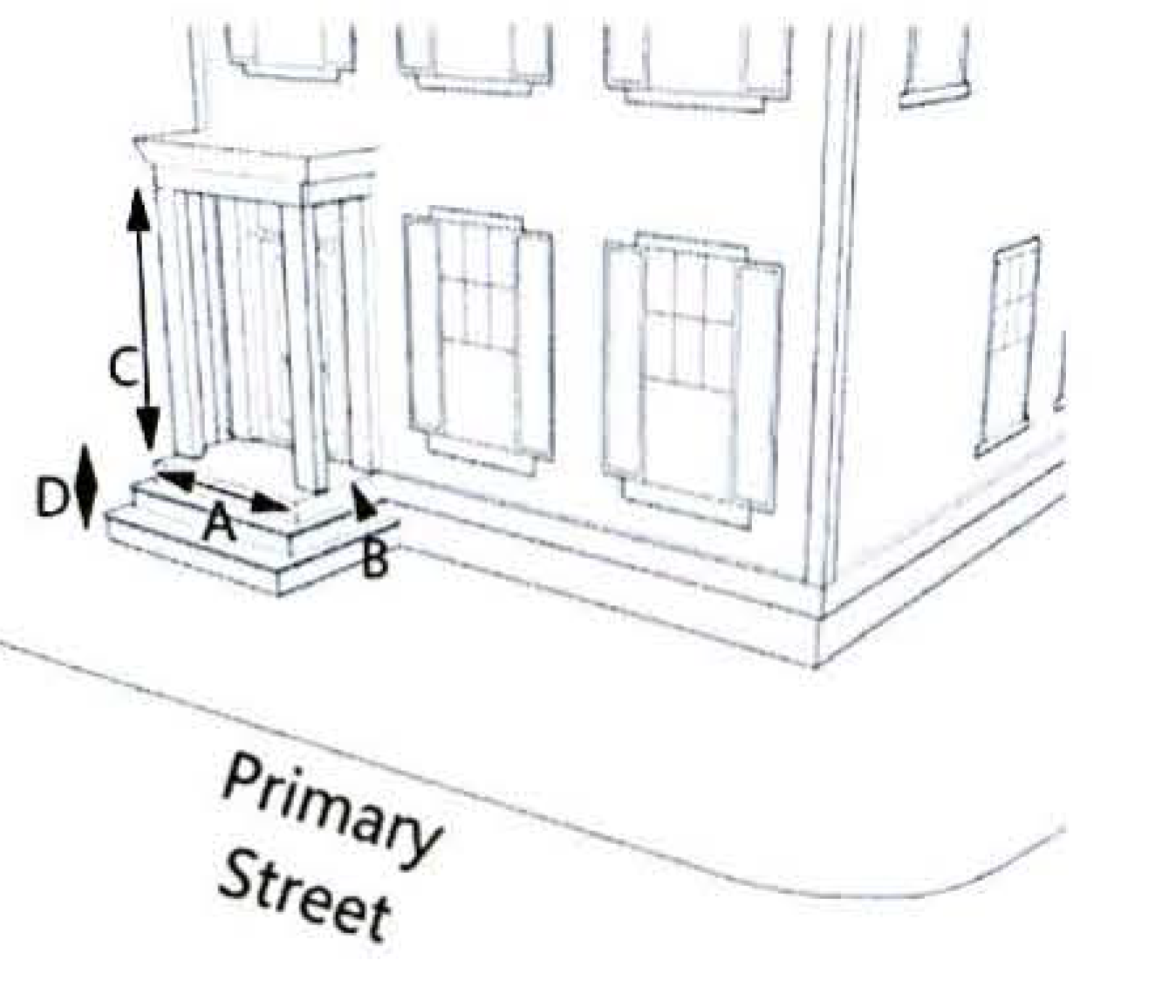
2.3.3(d) Stoop.
A stoop is an elevated entrance to a building, usually of a residence, with small setbacks from the sidewalk:
General. Stoops must be set back from the front lot line per applicable setback standards. Steps from the sidewalk to the stoop may encroach into the minimum setback but shall not encroach into the ROW. The frontage includes an elevated landing and entryway accessed by a series of steps. The stoop may or may not feature a roof covering the landing.
Table 2.2.2(d): Stoop Frontage Requirements
2.3.3(e) Porch.
A porch is a covered entry and sitting area attached to the face of a residential building, at the same level as the ground floor, and accessed by a series of steps.
General. Porches must be set back from the front lot line per applicable setback standards. Porches may wrap around the corners of the building.
Steps from the sidewalk to the porch may encroach into the minimum setback but shall not encroach into the ROW.
Table 2.2.2(e): Porch Frontage Requirements
2.3.4 Building Facade Standards
2.3.4(a) Commercial and Mixed-Use Buildings.
Building facades shall be composed with elements that reinforce a pedestrian scale. These elements are to be utilized to create a rhythm and scale consistent with traditional architecture. Large unarticulated facades along the sidewalk are not conducive to a pedestrian experience. The street front facades of all new buildings shall be broken down into several smaller bays that relate to the context. Additional interest can be added through variations in solid and void composition, color, material, and height.
The following standards shall apply to all commercial and mixed-use buildings in Centers within the Neighborhood, US 27, Multi-Use, and Wellness Way North Districts:
1.
All facades shall present consistent design elements that reflect appropriate structural elements and variation of the wall plane through the expression of at least three of the following:
• Floors (banding, belt courses, etc.)
• Vertical support (columns, pilasters, piers, quoins, etc.)
• Foundation (water tables, rustication, etc.)
• Variation in wall plane using projecting and recessed elements
• Changes in material or material pattern
2.
Facades oriented to a publicly accessible street or open space shall include clear delineation between the first or second level and the upper levels with a cornice, canopy, balcony, arcade, or other architectural feature.
3.
Each block of new construction shall contain unique building facades to encourage architectural variety within the Center.
2.3.4(b) Industrial Building Facades.
Industrial building facades shall be composed with elements that reduce the mass of building walls, reinforce locations of entries and create architectural interest. This can be done through variations in solid and void composition, color, material, and height. The following standards shall apply to all industrial buildings in Centers:
1.
The front façade of every building should reflect appropriate structural elements and variation of the wall plane through the expression of at least three of the following:
• Floors (banding, belt courses, etc.)
• Vertical support (columns, pilasters, piers, quoins, etc.)
• Foundation (water tables, rustication, etc.)
• Variation in wall plane using projecting and recessed elements
• Changes in material or material pattern
2.
The sides of each building on a site, particularly buildings visible from multiple streets, should be consistent in design and should be compatible with other development in the immediate vicinity.
3.
Industrial building frontages shall be broken up and/or screened with landscape at intervals of no more than 100 linear feet. For cross-dock facilities where this is not feasible, additional perimeter landscaping may be substituted to be determined at PUD zoning.
2.3.5 Pedestrian Access
Buildings shall feature functional pedestrian entrances. When parking is located to the rear of a street-facing building, entrances shall be provided from both the front and rear of the building rather than solely from the parking lot. The following standards shall apply to all buildings in Centers:
1.
Primary entrances shall be both architecturally and functionally designed to demonstrate their prominence.
2.
All buildings fronting "A" Streets and/or parks described in Section 4.4 shall have a main entrance from the public sidewalk. In addition, each retail use along these streets shall have an individual public entry from the street.
3.
Entrances along a public sidewalk shall incorporate arcades, roofs, porches, alcoves, or awnings that protect pedestrians from the sun and rain.
4.
Logistics and distribution buildings, due to the nature of their operations, are exempt from the requirements of this section.
2.3.6 Exterior Surface Materials and Colors
The materials used in building facades adjacent to public streets shall reinforce a strong pedestrian realm. The following standards shall apply to all buildings in Centers:
1.
In general, facades shall utilize one clearly dominant material and no more than three exterior building materials (in addition to glass). Selection should be based on the material's durability.
2.
Street level design shall reflect a direct relationship to pedestrians. Materials used at street level shall reflect a higher level of finish and tactile interest to reinforce the pedestrian environment.
3.
Inappropriate materials:
• EIFS (Exterior Insulation & Finish System)
• Applied Stone - any stone system without cavity wall construction
• Vinyl or Aluminum Siding
• Mirrored or Tinted Glass (on the ground floor)
4.
Colors will be reviewed and approved administratively. No primary or fluorescent colors will be permitted.
2.3.7 Awnings and Canopies
The use of elements such as canopies, awnings, alcoves, balconies, arcades, and storefront windows should be utilized to break down the scale of an otherwise too massive building. The following standards shall apply to all buildings in Centers:
1.
Window awnings and canopies are encouraged.
2.
Awning and canopy materials shall be compatible with other materials utilized in the building façade. Plastic or vinyl awnings are not permitted.
3.
These elements may overhang into the right-of-way so long as a clear pedestrian pathway is maintained.
4.
The design of all building elements shall be coordinated with streetscape elements in the public right-of-way. Any encroachments into the public right-of-way must meet current County standards and be approved prior to installation.
2.3.8 Ground Floor Residential Character
The integration of residential buildings within Centers can add to the mixed-use nature of these places. Rather than units segregated from other non-residential uses, careful design can integrate residential uses within a mixed-use development. The following standards shall apply to all buildings in Centers with ground floor residential uses:
1.
Where residential occurs on the ground floor of a building, a maximum 10-foot setback is allowed, but not required, to accommodate entrance stoops, planters, canopies, or landscaped areas.
2.
Ground floor residential uses shall provide a clear delineation between public and private space using a patio, landscaped yard, or raised stoop.
3.
Residential characteristics such as elevated stoops, entrance canopies, balconies, and other features are required in all residential development.
4.
No front-loaded garages are permitted in any Center.
2.3.9 Parking Lot Design
Within Centers, parking shall be designed to be safe, shaded, and easily accessible, but must be in such a fashion that it does not dominate the development of a site. The following standards shall apply to all buildings in Centers:
1.
Surface parking within Centers is to be limited to the minimum required by governing code. Additional parking above code minimum is permitted if it is contained within the footprint of a building, in a parking structure, or in a surface lot with enhanced parking lot landscaping and pedestrian circulation to be determined at PUD zoning.
2.
Certain specialized or unique uses may require more surface parking than allowed by Code minimum standards and such parking shall be determined at PUD zoning, subject to otherwise applicable code requirements.
3.
Pedestrian walkways through parking areas are required and should be carefully defined, particularly where pedestrian and vehicle conflicts are unavoidable.
a)
Pedestrian walkways shall be provided within all parking lots serving commercial, office and multi-family residential development, and be designed to provide direct connections between all building entrances, adjacent rights-of-way, transit stops, and outparcels.
b)
A minimum of one pedestrian walkway shall be provided for every five head-to-head parking rows, except where an alternative arrangement is approved as part of a planned unit development.
c)
At least one pedestrian walkway shall be designed to provide a direct connection from the main pedestrian entrance of any anchor tenant, principal building, or multi-family leasing office to the sidewalk along the perimeter of the development site.
d)
Pedestrian walkways shall have a minimum width of 14 feet, including a minimum of six feet in width for the sidewalk, and a minimum of eight feet in width for the central landscape strip. All unpaved areas within pedestrian walkways shall have 100 percent landscape coverage in accordance with this Section and shall conform to the tree spacing requirements provided therein. Shade structures, including pergolas or gazebos, may be substituted for canopy trees.
e)
Crosswalks connecting pedestrian walkways across parking lot drive aisles shall be designed and constructed to appear visually distinct from the adjacent driving surface using colored or textured concrete.
4.
Building exposure shall be maximized and parking areas minimized along all "A" Street frontages, where parking areas should be located behind buildings and be screened from direct view from the street using landscaping, knee walls, etc.
5.
Where parking areas cannot be located behind buildings and are therefore adjacent to public streets, parking areas shall be screened using some combination of landscaping, colonnades, trellises, pergolas, knee walls, low masonry, or concrete walls.
2.3.10 Parking Lot Screening
On larger blocks within Centers, parking may be located to the side of the building. When parking is visible from public or private "A" Streets, walls, architectural elements, and/or landscaping materials shall be used to screen views. The following standards shall apply to all buildings in Centers:
1.
Where parking lots are located adjacent to "A" Streets, a street wall edge to the sidewalk shall be maintained by a solid knee wall of 30" to 36" in height in order to reduce visual impact of parking fields and headlights.
2.
Wall materials should be consistent with the composition of the adjacent building façade.
2.3.11 Service and Storage Yards and Loading Docks
The mix of uses in the Centers necessitates a certain amount of service and loading areas. To maintain a positive image of building and landscape from the street, service and loading shall be oriented toward the interior of blocks and screened with landscape. The following standards shall apply to all buildings in Centers:
1.
Loading docks should be oriented toward the interior of a block to the extent possible. Where no feasible option exists to orient inward, docks shall be screened from view of adjacent public rights-of-way by an appropriate landscape buffer. In no case shall loading docks be located less than 150 feet from a single-family residential use.
2.
Loading areas are not to interfere with on-site pedestrian and vehicular circulation. Loading areas must be separate from areas that are devoted to public parking and public entrances.
3.
Loading operations shall not be conducted on or from a public street.
4.
No outdoor storage as a principal use is permitted within the District. Storage of equipment and vehicles shall be within a building or storage yard enclosed and screened from the public right-of-way and adjacent properties.
5.
Service and/or storage yards [5] should include, but not be limited to, loading areas, refuse and recycle bins, trash compactors, equipment and material storage, utility cabinets and transformers.
6.
Service yards will be easily accessible to tenants and service vehicles and shall be located to minimize conflicts with other activities on the site. Public circulation shall be separated from service yards.
7.
Service yards may not be located within 150 feet of properties planned or zoned for single family residential use.
2.3.12 Landscape, Buffers, Walls, and Fencing for Industrial Sites
Within the Multi-Use L District, there should be a focus on creating an image of buildings and landscape rather than parking and service areas. The landscape between the building and public streets is intended to be informal and create a soft appearance over time. Screening landscape is intended to mask the appearance of more industrial elements of sites to allow for integrated uses within the District. The following standards shall apply to all industrial buildings in the Multi-Use L District:
1.
Where the parking area is visible from a public street or highway, the area will be screened from view by some combination of landscaping, earth berms and decorative walls. Landscape screens consisting of trees, shrubs, ground cover and earth berms are preferred.
2.
All service yards and maintenance equipment must be enclosed and screened from the public right-of-way. Screening may be accomplished with a combination of buildings, walls, landscaping, and/or landscaped earth berms.
3.
Walls and accessory structures shall be consistent with the building materials, finish and colors used in the main building or buildings.
4.
Masonry walls and/or buffer landscaping shall be provided along the side and rear property lines and streets adjacent to property planned or zoned for residential use.
5.
Walls or fences of more than 100' in length should be broken up by landscaping, pilasters, offsets in the alignment of the wall or fence, and/or changes in materials and colors.
(Ord. No. 2022-23, § 2, 5-3-22)
Section 3 Mobility and Connectivity
3.1 Mobility and Connectivity General Intent
Complete streets are a guiding principle for the organization and design of the entire Wellness Way community. This principle supports the most efficient and effective means to maximize access to different methods of movement within and between neighborhoods, wellness spaces, workplaces, and commercial centers.
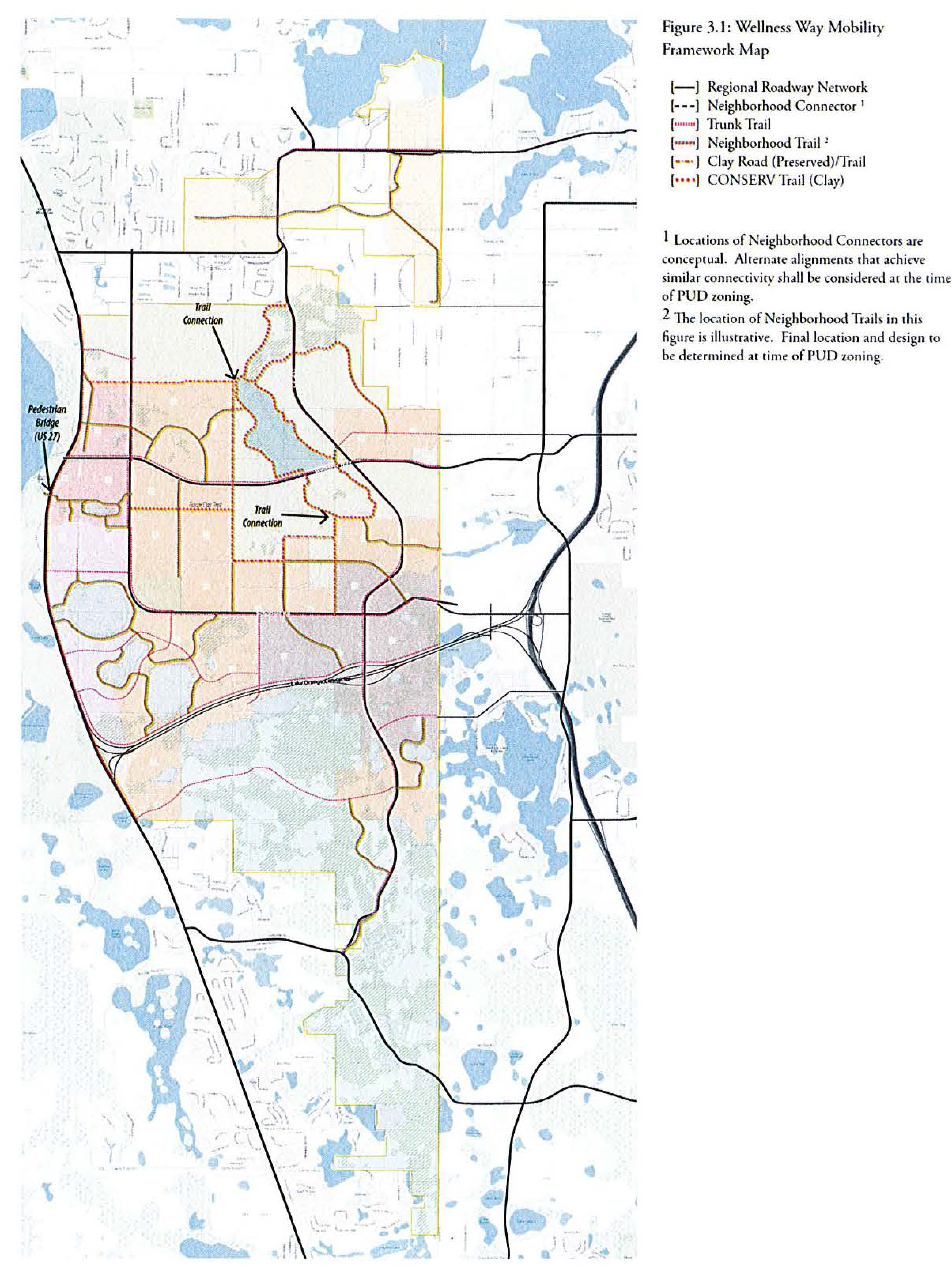
Figure 3.1 identifies the major framework roadways within Wellness Way which establish the basic structure for mobility within the community. The roadway network should be thought of as two distinct, but interconnected network elements. These two network elements are the Regional Roadway Network and the Neighborhood Street System.
3.2 Wellness Way Regional Roadway Network
This network is defined in Policy I-8.3.1 of the Comprehensive Plan and is comprised of the following roadways:
1.
Wellness Way from US 27 to the Orange County Line
2.
Hancock Road from Wellness Way to Hartwood Marsh Road
3.
Schofield Road from the intersection of Wellness Way and Hancock Road to the Orange County Line
4.
CR 455 Extension from Hartwood Marsh Road to Sawgrass Bay Boulevard
3.2.1 Regional Roadway Network Construction and Financing
The network is to be constructed commensurate with the phasing of land development activities in Wellness Way. The objective is to achieve interconnectivity of this network with existing regional roadways to the north and east as quickly as possible, and to minimize reliance on US 27 as the only regional roadway for access to new development activity.
To achieve an orderly delivery of the Wellness Way Regional Roadway Network, each rezoning application in Wellness Way must conduct a traffic study to determine the proportionate share of that project's impact on the network. The findings of each study will produce the financial contribution that must be made to the network for each project.
The County shall consider Transportation Impact Fee Credit (TIFC) agreements with developers and/or property owners who will construct some or all the roadways in 3.2 in exchange for impact fee credits. Inside Wellness Way, only those roadways listed in section 3.2 are eligible for impact fee credits.
Each application for zoning approval within Wellness Way share require a (TIFC) agreement to be approved before any land development activity (subdivision approval, mass grading, site infrastructure, etc.) may commence. The TIFC agreement will include a schedule of proportionate share payments to be made by project phase. The TIFC agreement shall allow for the contributions of off-site right-of-way, roadway design, permitting and roadway construction to be creditable against the required proportionate share payments. Development phases may only be advanced once the corresponding proportionate share payment or work/contributions in lieu of payment have been made at the beginning of each phase.
Proportionate share payments are transportation impact fee creditable per Florida Statute. If, for any reason, a project's proportionate share payment is less than the transportation impact fees generated by the project, the project shall still be responsible for its full payment of transportation impact fees once proportionate share payments have been made.
3.2.2 Cross Sections
These multi-modal corridors shall be designed to balance the need to provide mobility for a large volume of daily auto users, while supporting the design characteristics of the adjoining land uses. Each of the corridors will be established with sufficient future right-of-way to support four travel lanes with a multi-purpose path on one side of the roadway. Conceptual cross sections for these corridors are shown in Figures 3.2.2(a) and 3.2.2(b).
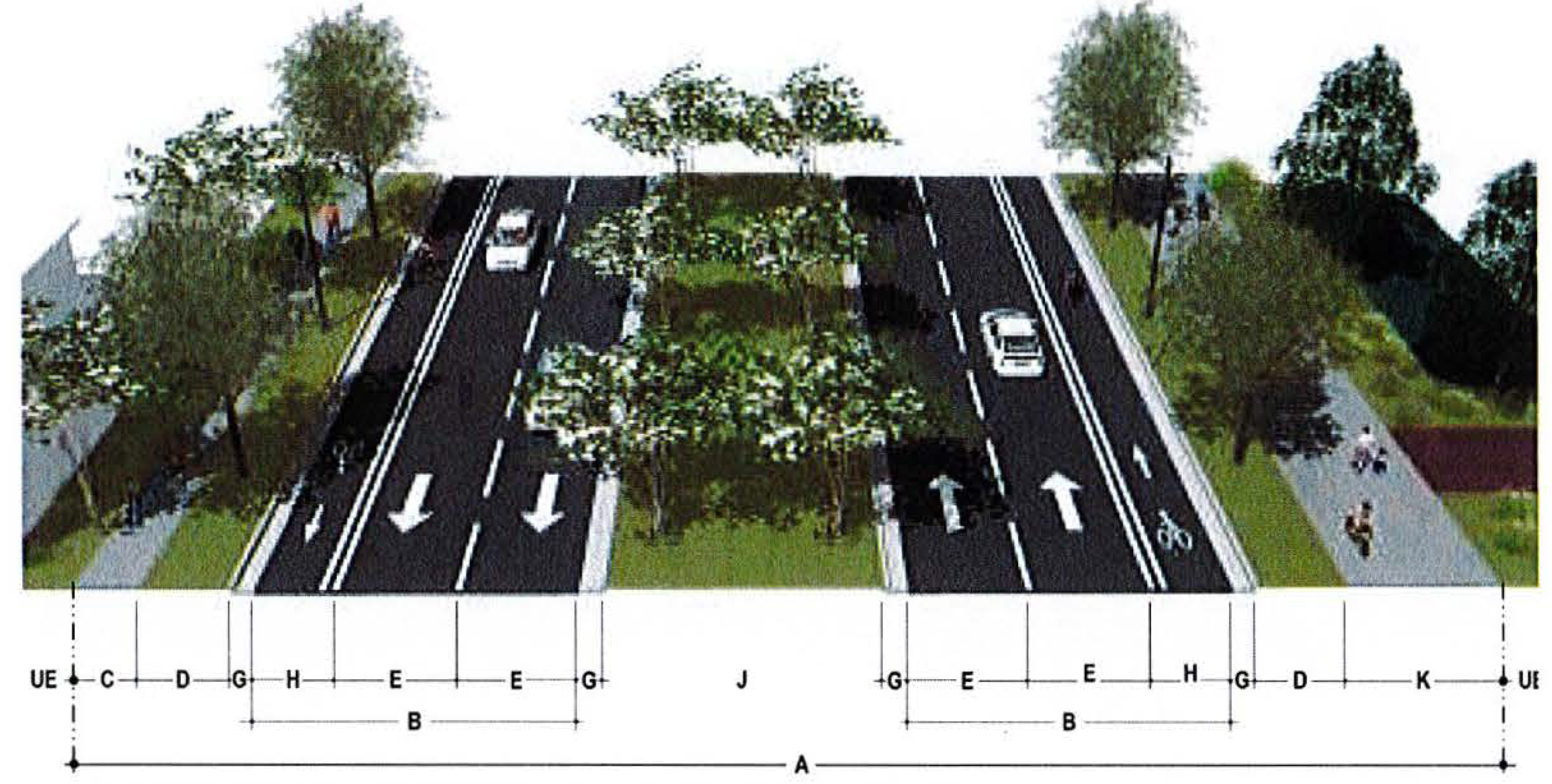
Figure 3.2.2(a): Regional Roadway Illustrative Urban Section
This section applies to all Regional Roadway listed in Section 3.2 outside of CONSERV lands.
Final roadway dimensions will be determined with final engineering documents.
1 Trees must be located at least 8' from sidewalk or trail unless root barriers are provided.
2 Median openings for turn lanes must be at least 22' wide.
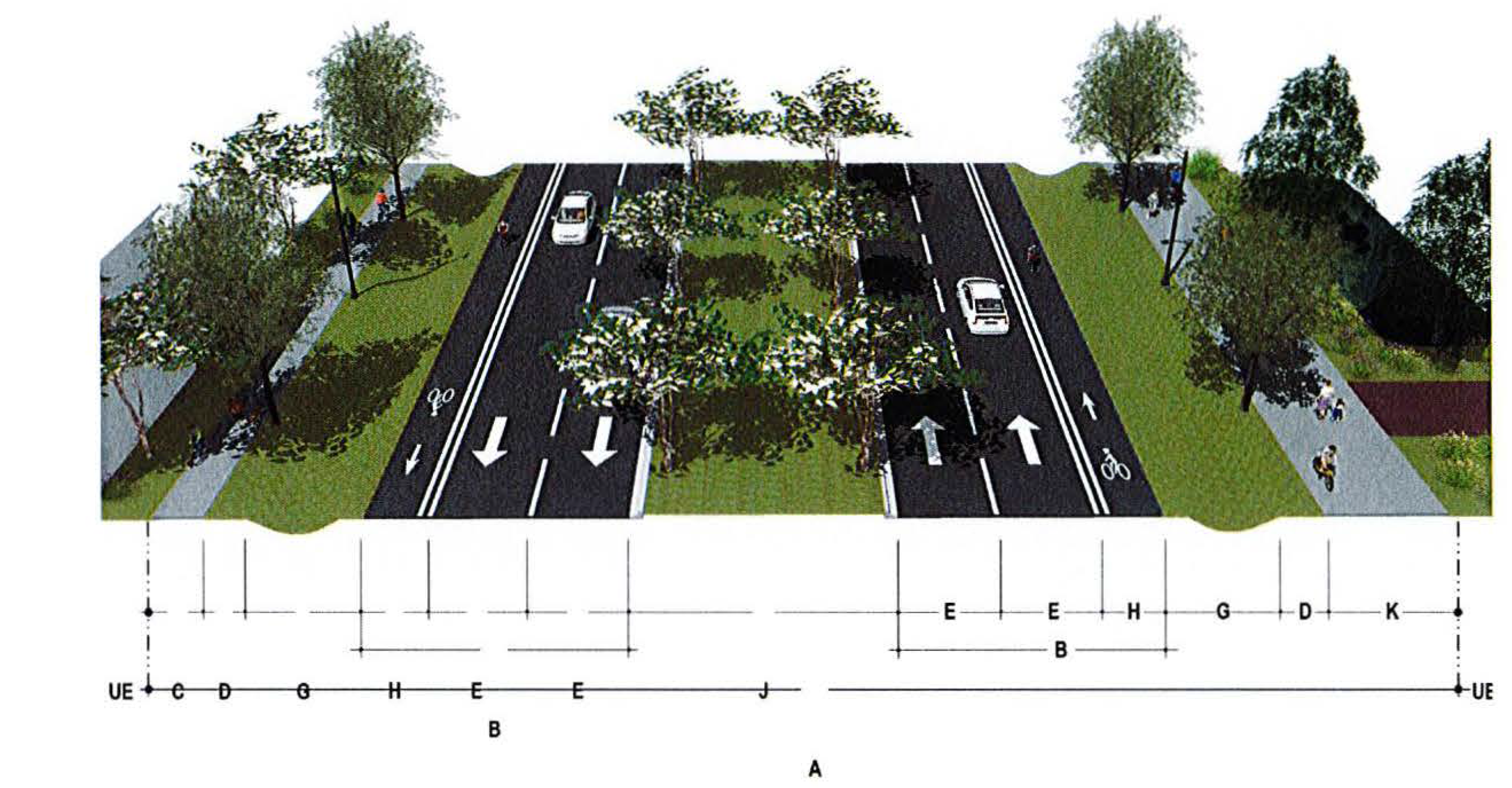
Figure 3.2.2(b): Regional Roadway Illustrative Rural Section
This section applies to roadways within CONSERV lands.
Final roadway dimensions will be determined with final engineering documents.
1 Trees must be located at least 8' from sidewalk or trail unless root barriers are provided.
2 Median openings for turn lanes must be at least 22' wide.
3.3 Neighborhood Street System
The design of new neighborhoods in Wellness Way is intended to achieve mobility options and connectivity elements within and between neighborhoods. This will be accomplished by ensuring:
1.
Local streets form an interconnected network of automobile, bicycle, and pedestrian routes providing direct connections to local destinations.
2.
Local streets provide for both intra- and inter-neighborhood connections and thus knit neighborhoods together, not form barriers between them.
3.
Local streets are both public ways and neighborhood amenities. They shall have continuous sidewalks, bikeways (where appropriate), street trees, and other amenities that support the pedestrian.
4.
To provide continuous circulation systems for pedestrians, bicyclists and automobiles, unconnected streets such as cul-de-sacs, T-turnarounds, and dead ends shall be used only as a last resort. In places where an unconnected street may be desirable or cannot be avoided due to the configuration of developable land, pedestrian, and bicycle connectivity shall be provided via through-connections designed into the fabric of the community, wherever practicable.
All development plans in Wellness Way shall include streets stubbed to the boundary of the development in all major directions. Development plans shall include streets connecting to all streets stubbed to the boundary of adjacent development plans. To continue the interconnected street network of the area from one development to the next, street connections shall be made between adjacent development. This requirement does not apply if it is demonstrated that a connection cannot be made because the existence of one or both of the following conditions:
1.
Physical conditions preclude development of a connecting street on the adjacent property, or
2.
Buildings or other existing development on adjacent lands, including previously subdivided but vacant lots or parcels, physically preclude a connection.
Developments adjacent to school properties shall be required to provide right-of-way and a direct safe access path for pedestrian and bicycle travel to existing and planned school sites and shall connect to the neighborhood's existing pedestrian network.
Public access shall be provided to all publicly owned and maintained parks, recreation areas, conservation areas, natural areas, lakes and general open space from a public roadway, sidewalk, or trail. The public roadway, sidewalk, or trail shall be located to provide access between private property, including homes, and the park, recreation area, conservation area, natural area, lake, or general open space.
Street design should include provisions for wildlife connectivity across or under roadways that must cross wetland systems and associated buffers due to no other means of connectivity.
PUDs within Wellness Way shall include a safe and continuous bicycle network that encourages cycling as both a means of transportation and a recreational activity. Bicycle networks shall connect residential neighborhoods with centers, neighborhoods, parks, and schools, and may include:
a)
Shared lane markings;
b)
Designated bike lanes;
c)
Separated bike facilities or "cycle tracks"; and/or
d)
Multi-use paths and trails.
3.3.1 Cross Sections
Streets shall be designed consistent with the following criteria.
3.3.1(a) Neighborhood Connectors.
Neighborhood Connectors are intended to be complete streets, designed to accommodate the needs of adjacent users as well as the movement through the interior of a neighborhood or district. They serve many functions beyond transportation, including community structure, identity, and pride, utilities, stormwater management, access to private property, connection to the parks, open space and trail system, and a place for social interaction. Conceptual cross sections for these streets are shown in Figures 3.3.1(a1) and (a2).
3.3.1(b) Local Streets.
Local streets are intended to be complete streets, designed to provide access to homes and businesses. They, too, serve many functions beyond transportation, including community structure, identity and pride, utilities, stormwater management, access to private property, connection to the parks, open space and trail system, and a place for social interaction. Conceptual cross sections for these streets are shown in Figures 3.3.1(b1) and (b2).
3.3.1(c) Alleys.
Alleys provide service access to homes and businesses. Conceptual alley cross section is shown in Figure 3.3.1(c).
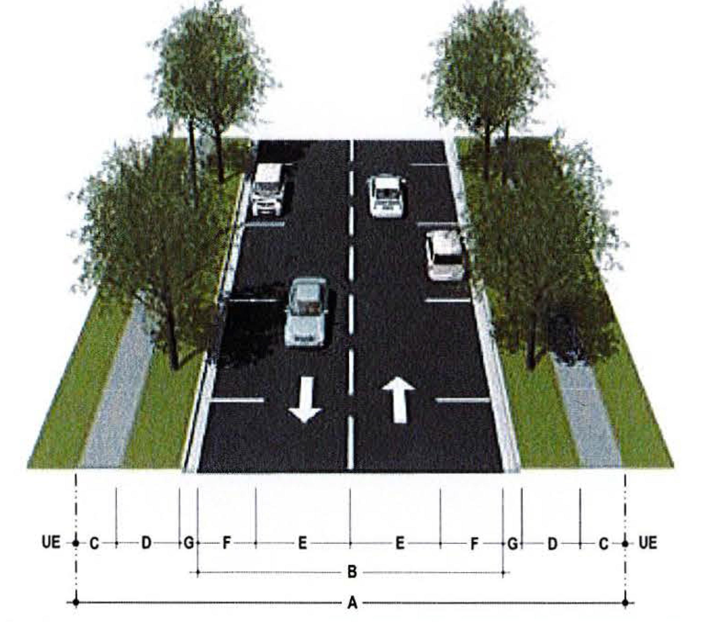
Figure 3.3.1(a1): Neighborhood Connector Typical Section
This section typically applied to internal streets connecting neighborhoods. It may also be used in areas of higher density residential and/or commercial/mixed-use contexts.
1 If this section is utilized for a street classified as a collector roadway, it will be considered for bike lanes consistent with requirements of Florida Greenbook, Chapter 9.
2 Trees must be located at least 8' from sidewalk or trail unless root barriers are provided.
Final roadway dimensions will be determined with final engineering documents.
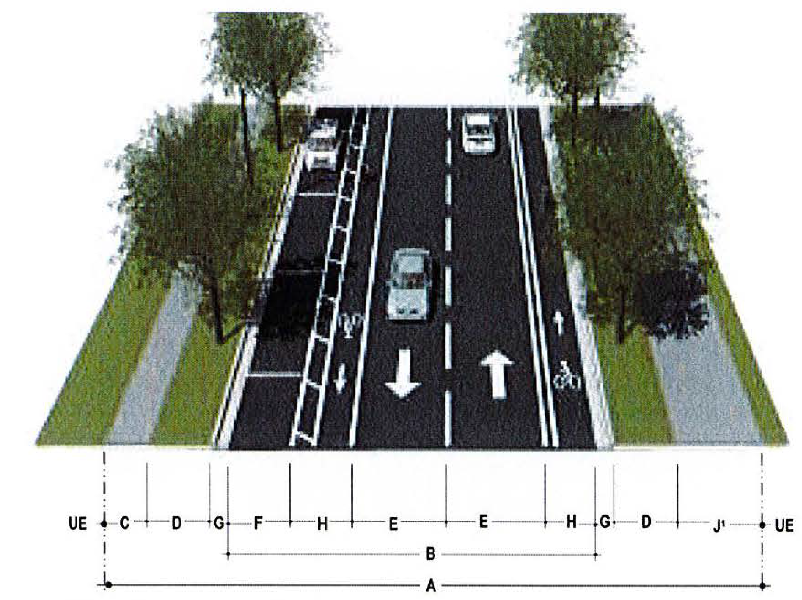
Figure 3.3.1(a2): Neighborhood Connector 2 Typical Section
This section typically applied to higher density residential and/or commercial/mixed-use contexts.
1 If a multi-use trail is provided within the right-of-way, the area from the back of curb to the edge of right-of-way inclusive of the trail may be counted for park space credit as a Greenway under Section 4.2 of these standards.
2 Trees must be located at least 8' from sidewalk or trail unless root barriers are provided.
Final roadway dimensions will be determined with final engineering documents.
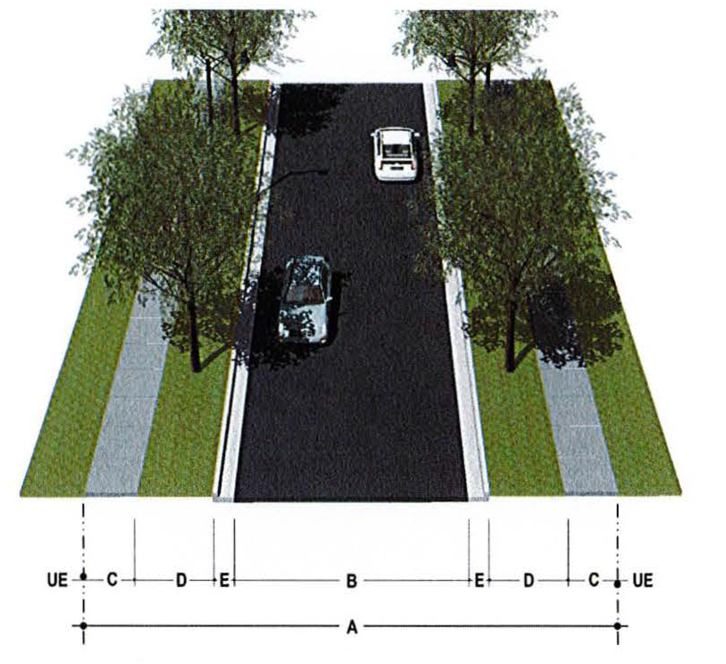
Figure 3.3.1(b1): Local Street Typical Section
This section typically applied to lower density residential contexts.
1 Trees must be located at least 8' from sidewalk or trail unless root barriers are provided.
Final roadway dimensions will be determined with final engineering documents.
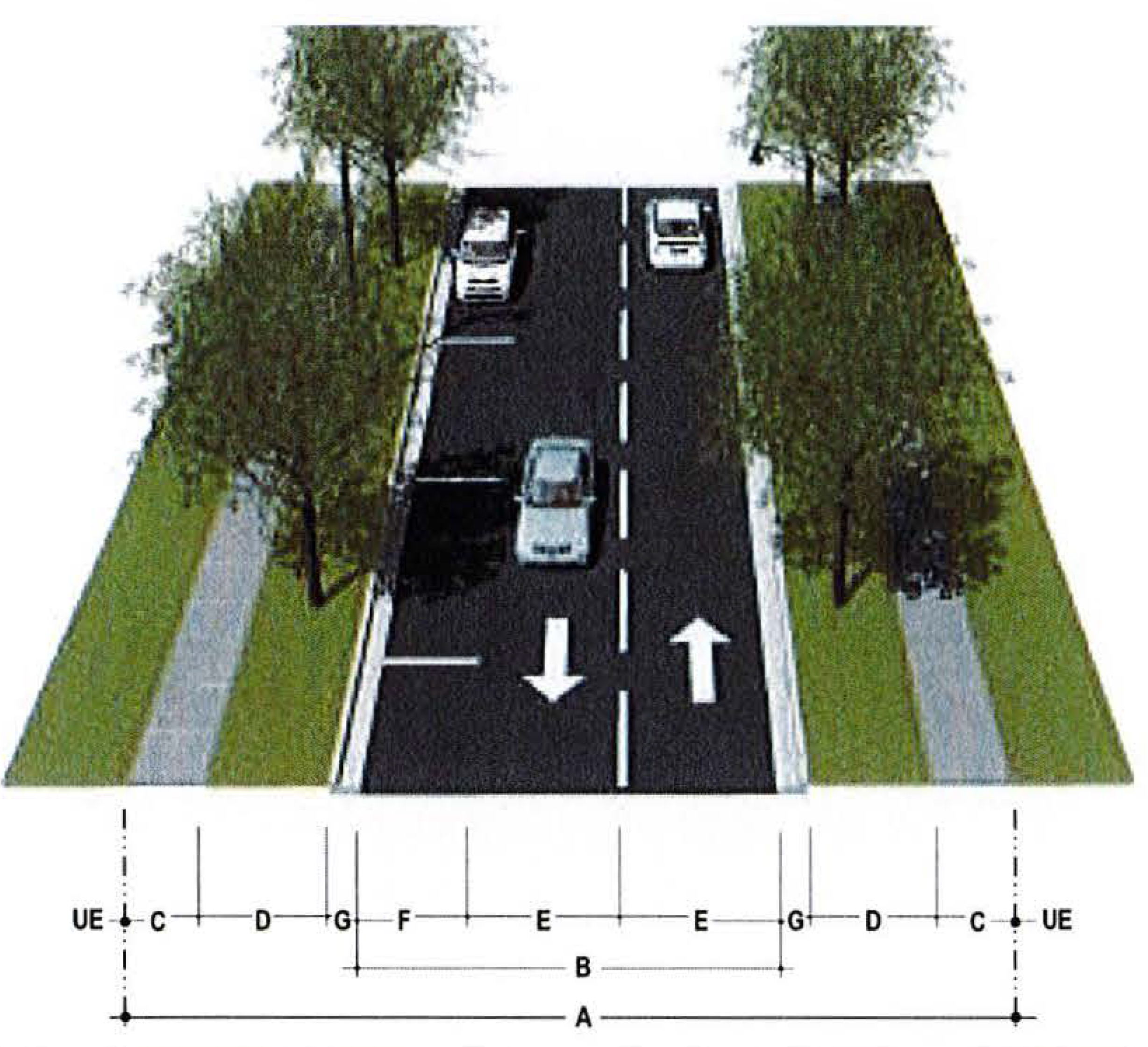
Figure 3.3.1(b2): Local Street 2 Typical Section
This section typically applied to lower density residential contexts where parking and a free flow condition is required.
1 Trees must be located at least 8' from sidewalk or trail unless root barriers are provided.
Final roadway dimensions will be determined with final engineering documents.
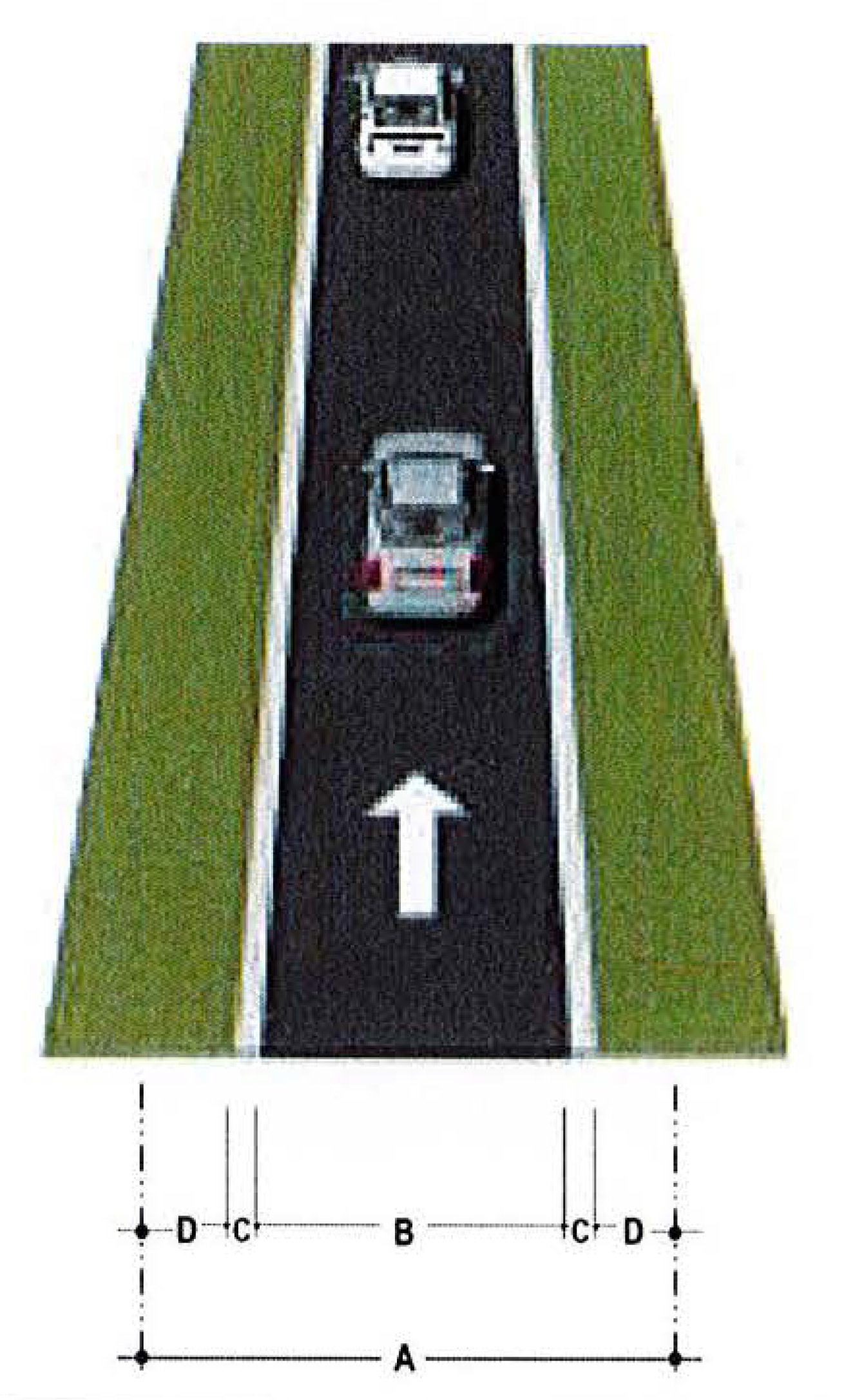
Figure 3.3.1(c): One-Way Alley Typical Section
This section is applicable to many urban contexts.
If this section is utilized as the required fire department access road, the one-way alley shall be a 17-foot driveway width including curbs.
Final roadway dimensions will be determined with final engineering documents.
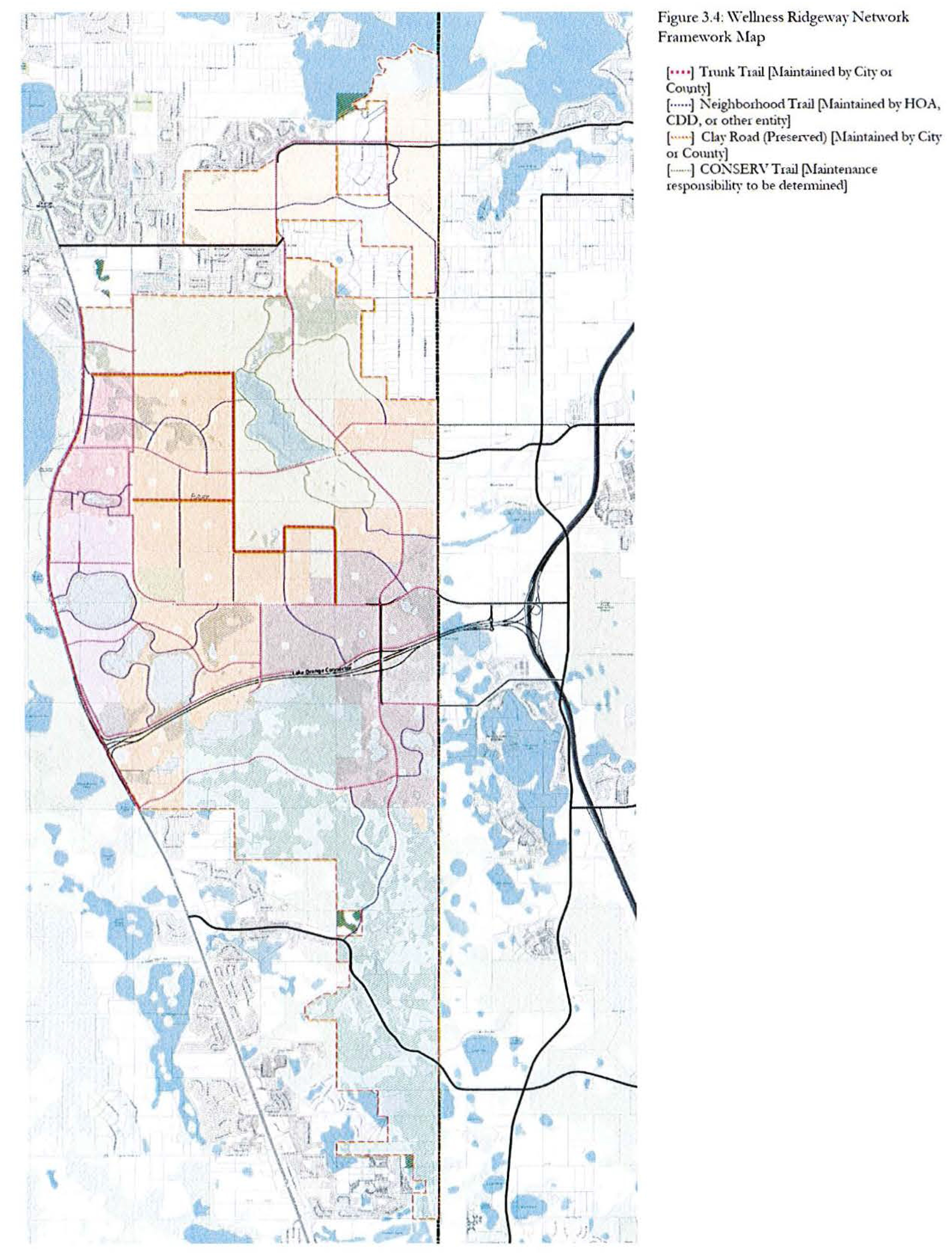
3.4 Wellness Ridgeway Network
The Wellness Ridgeway Network is intended to be a system of trails providing non-motorized transportation within and through Wellness Way. The Network is organized to provide both recreational and functional use to origins and destinations such as parks and schools within Residential areas and employment and commercial areas in Centers. The Network is made up of four types of trails:
1.
Trunk Trail
2.
Neighborhood Trail
3.
Clay Road
4.
CONSERV Trail
3.4.1 Cross-Sections
The Wellness Ridgeway Network shall be developed consistent with PUD phasing such that trail connections are completed concurrent with development of each neighborhood or center. Illustrative cross sections for these trails are shown in Figures 3.4.1 (a) and (b).
3.4.1(a) Trunk Trail.
Trunk Trails are the main system of trails located within the right-of-way of the Primary Roadway Network and Neighborhood Connectors. They must be at least 14' wide and separated from the adjacent roadway by at least 8'.
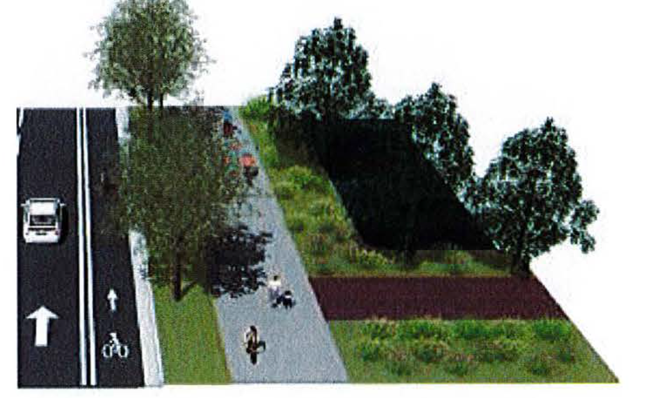
Figure 3.4.1(a): Trunk Trail Illustrative Section
3.4.1(b) Neighborhood Trail.
Neighborhood Trails are a finer-grain system of trails connecting to Trunk Trails that are intended to connect destinations within neighborhoods and centers to parks and other places of activity. Neighborhood Trails must be at least 12' wide. They may be located within street right-of-way or within park or open space tracts. If located adjacent to a street, these trails must be separated from the back of curb (or edge of travel lane if no curb) by at least 8'.
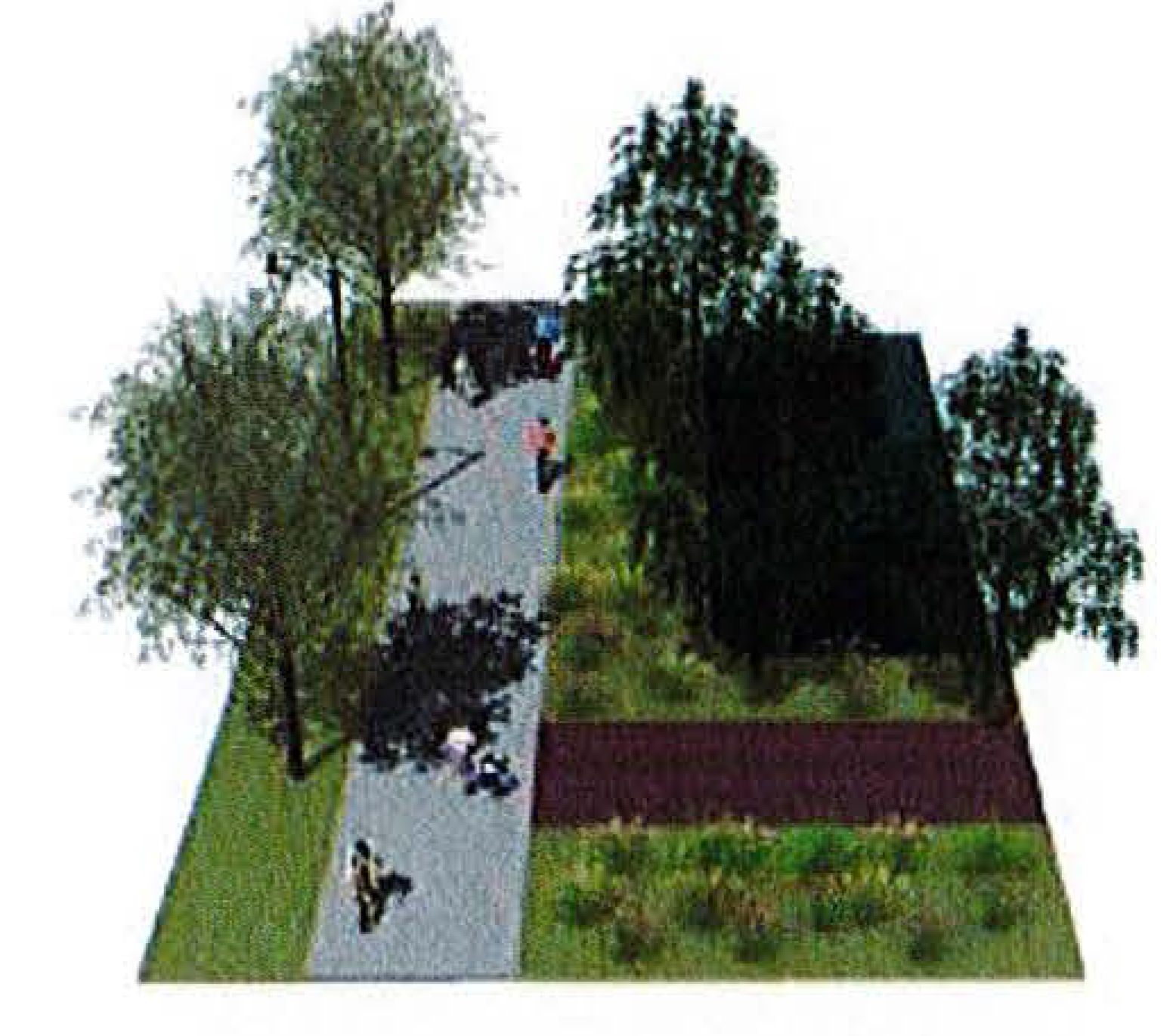
Figure 3.4.1(b): Neighborhood Trail Illustrative Section
3.4.1(c) Clay Road.
The Clay Road is a unique roadway in Wellness Way that has attracted local athletes and visiting users from the U.S. and internationally. The rolling terrain and soft material make it ideal for runners of all levels. Because of its unique attributes, development adjacent to the Clay Road should limit its access points and the volume of traffic that would impact the roadway. Continued long term use by runners should be protected from undue conflicts from vehicular traffic.
Development adjacent to the Clay Road shall provide trail access to the Clay Road via the internal neighborhood trail system.
3.4.1(d) CONSERV Trail.
CONSERV Trails are a potential series of paths connecting within and through CONSERV.
3.5 Infostructure
The entire roadway system in Wellness Way is the primary means to delivering high speed broadband services to businesses and residents. All roadways, including arterials, collector, and local streets, shall provide conduit to deliver fiber to each household and business.
(Ord. No. 2022-23, § 2, 5-3-22)
Section 4 Open Space and Parks
4.1 Open Space
Wellness Way will preserve a significant amount of land area in the form of open space and natural protected areas. The natural protected areas include wetlands and water bodies. Open space is divided into two separate categories, Wellness Space and Green Space, with each type allowing different uses.
4.1.1 Wellness Space
Wellness Space is limited to a cumulative 10% impervious surface ratio for each PUD and includes the following types of areas:
1.
Land area that remains minimally developed, such as trails and boardwalks, as part of a natural resource preserve or active/passive recreation area;
2.
Land area open to public access and gathering places;
3.
Permeable storm water areas if enhanced as amenities using native vegetation;
4.
Parks designed consistent with the standards in Section 4.2; and
5.
Open water bodies surrounded by uninterrupted Wellness Space.
4.1.2 Green Space
Green Space includes land areas for the purpose of protecting natural resources or environmental quality, including areas designated for such purposes as flood control, protection of quality or quantity of groundwater or surface water, or protection of vegetative communities or wildlife habitat and shall include land preserved for conservation purposes. Green Space should be maintained in such a way to encourage the proliferation of native flora and fauna. Active recreation is prohibited in Green Space; passive recreation is allowed in Green Space.
4.1.3 Required Open Space
PUDs in Wellness Way will identify and reserve 20% of the net acres as Wellness Space and 10% of the net acres as Green Space. If suitable Green Space areas do not allow the PUD to reach the required 10% area, the remainder up to 10% may be designated Wellness Space. Wetlands and naturally created water bodies cannot be counted towards a PUD's Wellness Space or Green Space allocation, except for naturally created water bodies that are completely surrounded by uninterrupted Wellness Space, in which case, up to 25% of such water body may be counted towards the Open Space requirement. A 50-foot-wide continuous upland buffer is required around all wetlands and naturally created water bodies counted towards Open Space. In the Conservation Subdivision District, the wetland and waterbody buffer must be undisturbed land with only minimal impacts allowed for an unimproved single track walking path as permitted by jurisdictional authorities.
Open Space is meant to provide an amenity to the community and should be designed to promote public access. Open Space tracts are encouraged to be placed in the interior of a PUD. Narrow open space tracts, bordering the perimeter of a PUD, being used solely as a buffer, shall not count toward the Open Space requirement. All open space calculations shall be applied at the PUD and shall be phased consistent with development.
4.2 Parks
As a subset of Open Space, the standards for park development support the Guiding Principles of Wellness Way. These principles seek to create a compact urban mixed-use community supported by a diverse mix of uses that provides necessary employment, commercial, housing and lifestyle opportunities for current and future residents of Wellness Way. All parks designed consistent with the standards of this section may be counted toward the required Wellness Space and/or Open Space described in Section 4.1.1 and 4.1.2. The standards for parks are based on the locational relationship between the park and its users. The purpose and intent of the park standards is:
1.
To provide a system of parks of varied size, programming, and design that supports a rich mix of land uses that combine to create active, lively neighborhoods and enhance the quality of life for residents of Wellness Way;
2.
To design and locate parks to create livable and sustainable places that improve with time;
3.
To encourage a system of linked parks, wetlands, and lake edges that create a significant network of functional open spaces; and
4.
To create an ample supply of parks whose frequent use is encouraged through proper placement, connectivity, and design.
4.2.1 Park Principles
The public realm - parks, plazas, conservation lands, trails, greenways, and public streets - are essential to a high quality of life. The benefits of a well-planned system of parks include increased property values, community identity, improved community aesthetics, opportunities for recreation and socializing, protection of natural resources, and multi-modal transportation linkages. Parks are used by residents, employees, and the public for many different functions, requiring a range of sizes and types. All parks are connected to each other by a network of sidewalks, trails, and streets. These spaces should be integrated into the fabric of the community along with other public infrastructure systems such as streets, utilities, and stormwater drainage. Therefore, a multitude of parks of different size and character is better than a small number of larger parks. Different aspects of each park fall along a spectrum:
• design ranging from formal to informal
• use ranging from active to passive
• activities ranging from planned and structured to spontaneous and unstructured
• sizes ranging from tiny to expansive
• single- to multiple-purpose
• settings ranging from urban to rural
• orientation of the intended users ranging from the local community to the public
• frequency ranging from daily activities to annual events
• stormwater design ranging from structured to naturalistic
• park shapes and proportions ranging from rectangular to curvy to linear
4.2.2 Required Park Area
To accommodate a wide range of park sizes and types, all new development within Wellness Way districts shall provide park space classified in the following levels:
• Level 1: County Park. The County Park is intended to be a regional-scale park with a target size of at least 100 acres. The location of the County Park is shown on Figure 2.1: Wellness Way Development District Framework Map. This park is intended to be scaled and designed to ultimately fall under County ownership and maintenance and is meant to serve the entire Wellness Way community.
• Level 2: Close-to-Home Parks. Close-to-Home Parks are intended to serve day-to-day park needs, provide for the spatial organization of the community, and link homes, offices, and workplaces with outdoor spaces. Close-to-Home Parks shall make up at least five percent of the net residential acreage of each district. Their locations are specified through PUD zoning and the site plan approval process. These parks shall be owned and maintained by a HOA or other similar entity acceptable to the County.
4.2.3 Park Location and Service Areas
All residential units and all public entrances of non-residential uses included in the development shall be within the service radius of a Close-to-Home Park. Park service radii are measured from the edge of the park parcel or lot and shall be as listed in Table 4.2.3.
Table 4.2.3: Park Service Area
1 Park size criteria listed in Section 4.2.5.
2 Example: a 4.5-acre park has a service radius of 1200'.
4.2.4 Park Type Standards
All Close-to-Home Parks shall be classified as one of the following park types and conform to the following standards specific to each type. Open spaces not meeting these criteria are allowed within the development but shall not be eligible for either Required Park Area or Location credit. The park types are as listed below. In addition to minimum and maximum sizes and other design criteria, each contains a required group of uses that must be provided within that type of park. Other permitted uses are allowed at the developers' discretion. All park sizes referenced herein are to be calculated per Section 4.2.5.
Neighborhood Park. A Neighborhood Park is a natural landscape consisting of open and wooded areas or lawns, typically furnished with paths, benches, and open shelters. Neighborhood parks are often irregularly shaped but may be linear to parallel creeks, canals, or other corridors. The minimum size shall be 2 acres and the maximum shall be 5 acres. The park shall have at least 25% canopy coverage. A neighborhood park must front on at least one street. At least one neighborhood park shall be provided for each 100 acres of residential development area.
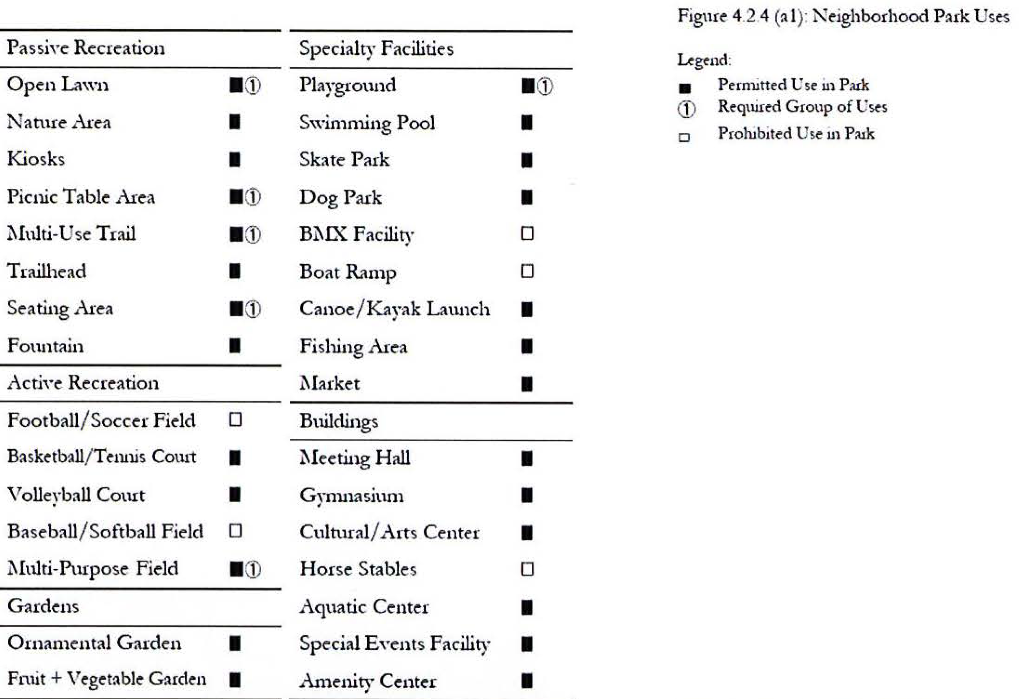
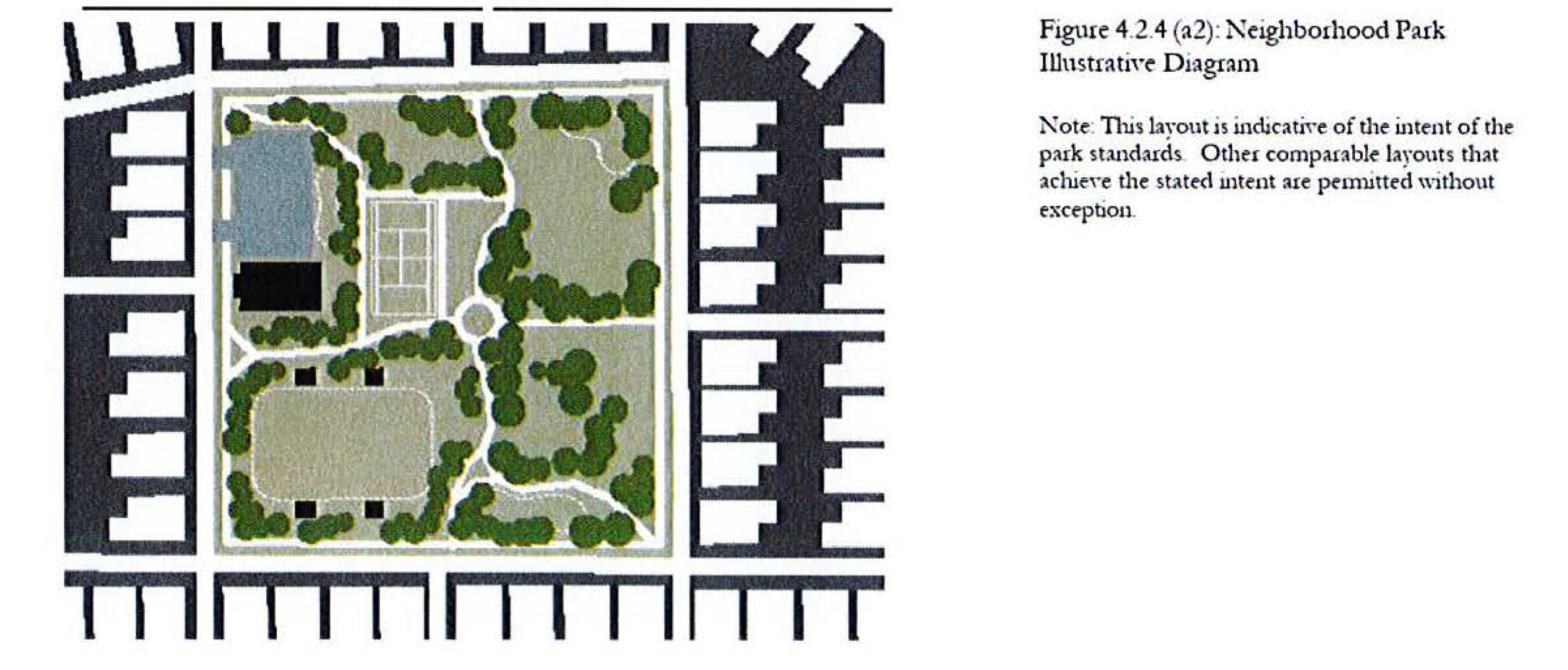
Square. A square is a formal open space available for passive recreational and civic uses and spatially defined by abutting streets and building frontages. Landscaping in a square consists of lawn, trees, and shrubs planted in formal patterns and it is typically furnished with paths, benches, and open shelters. Natural wooded areas are not appropriate for a square. The minimum size shall be 1/2 acre and the maximum shall be 2 acres. A square must front on at least three streets.
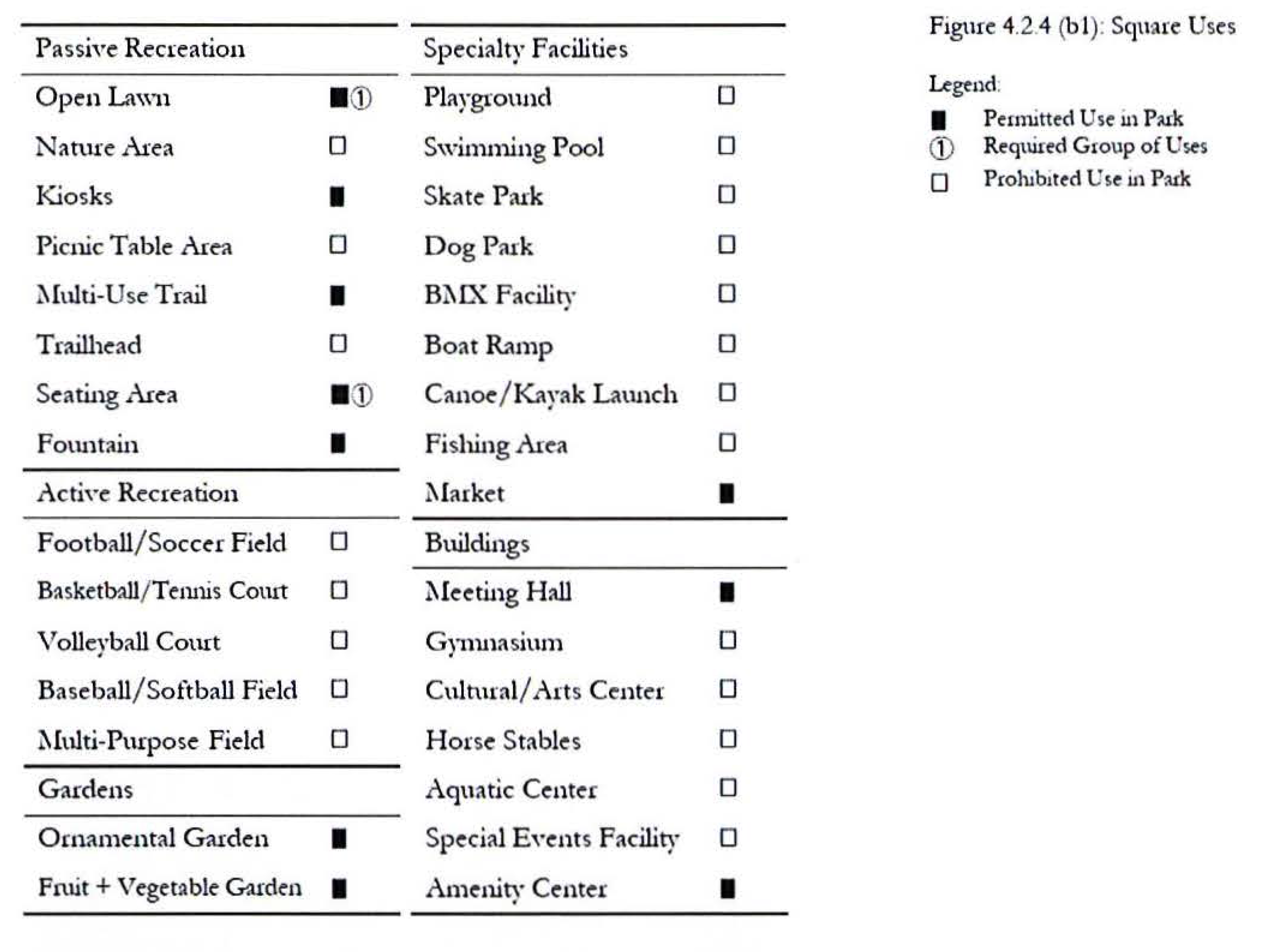
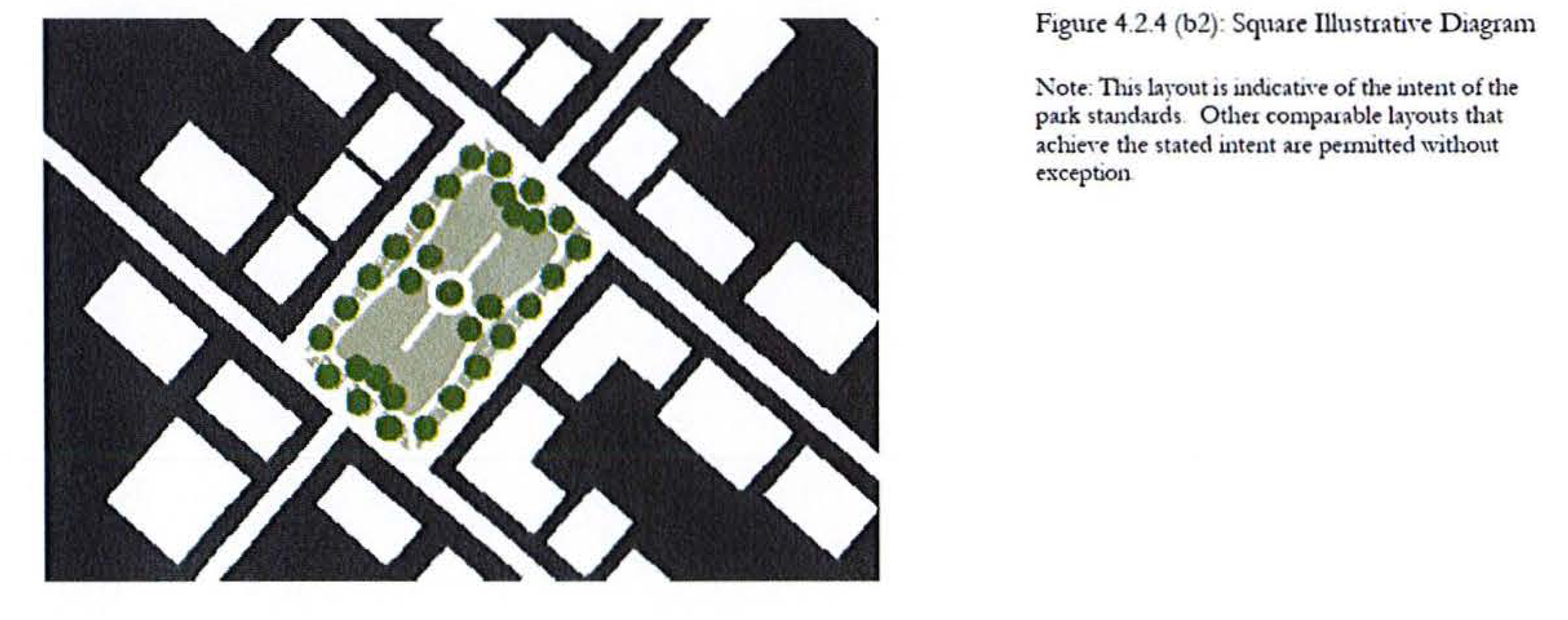
Green. A Green is an open space consisting of lawn and informally arranged trees and shrubs, typically furnished with paths, benches, and open shelters. Greens are spatially defined by abutting streets. The minimum size shall be 1 acre. There is no maximum size. No more than one half of the area of a green may consist of natural landscape or wooded area. A green must front on at least two streets.
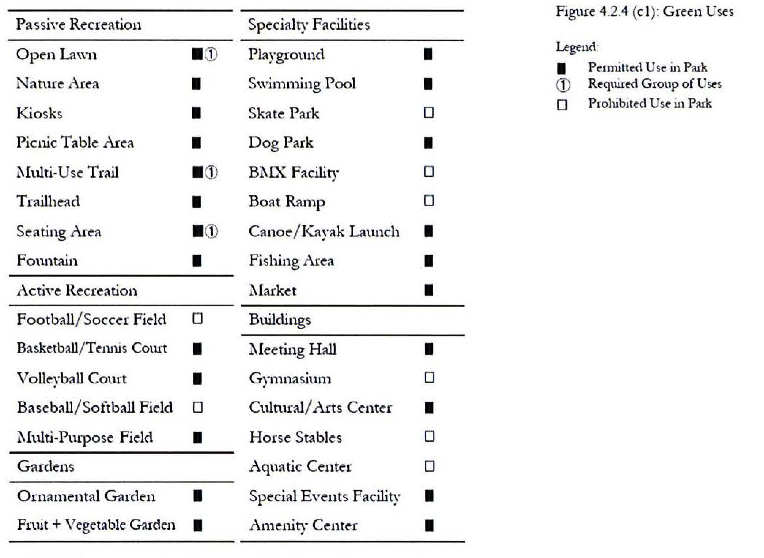
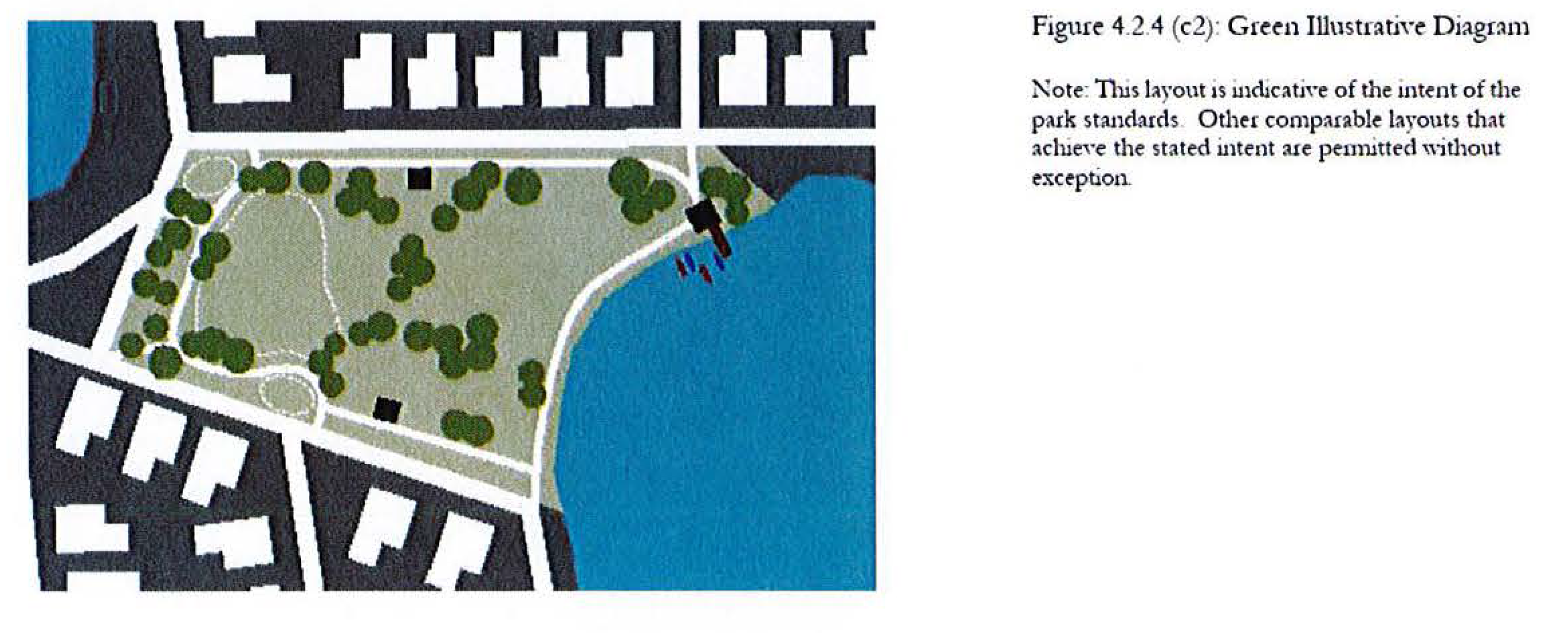
Playground. A Playground is a fenced open space, typically interspersed within residential areas, which is designed and equipped for the recreation of children. Playgrounds may be freestanding or located within parks, greens, or school sites. The minimum size shall be 1/8 acre and the maximum shall be 1 acre. A playground is not required to front on any streets. No more than one playground for each 20 acres of residential development may be used to meet the location criteria of Section 4.2.2.
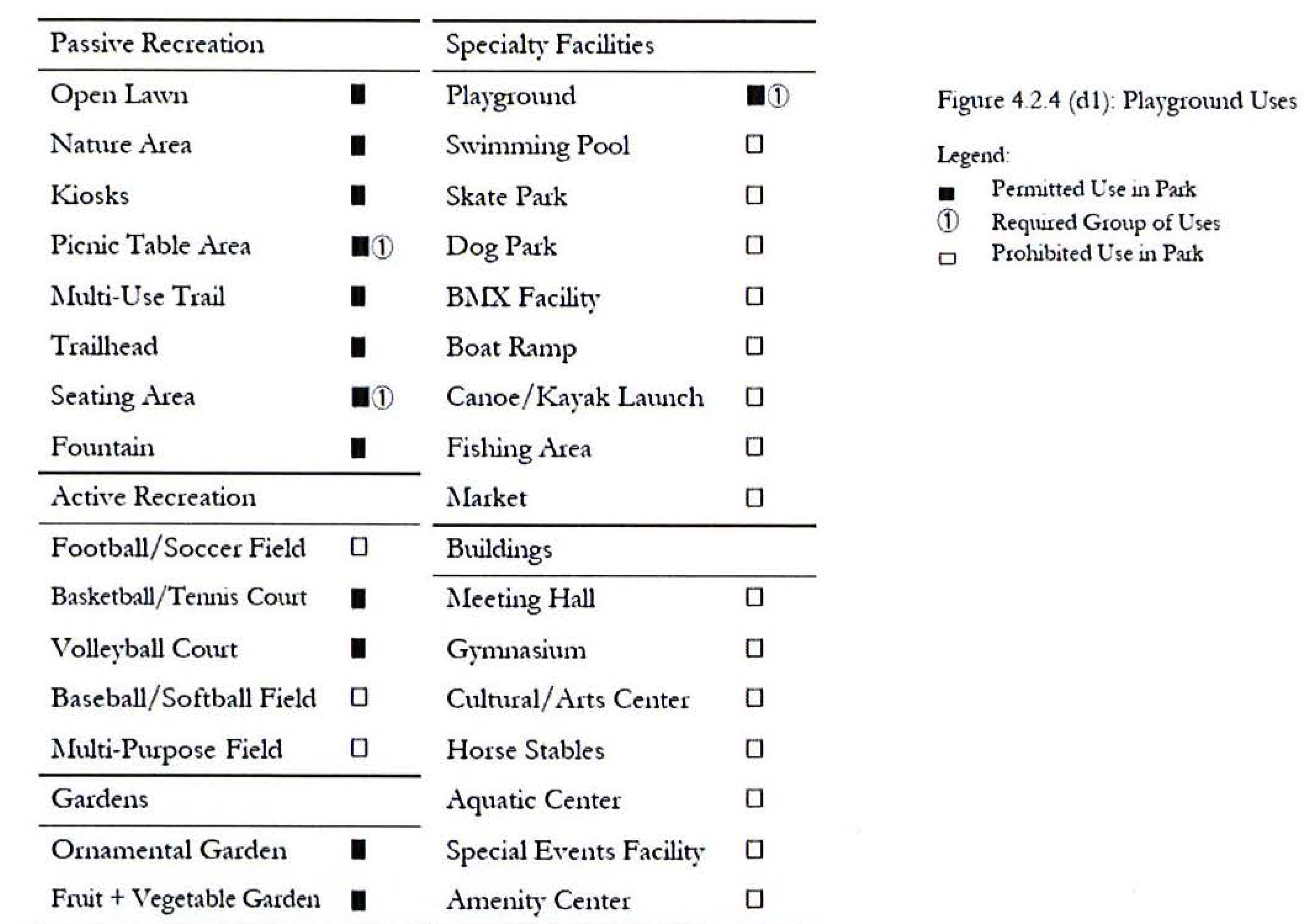
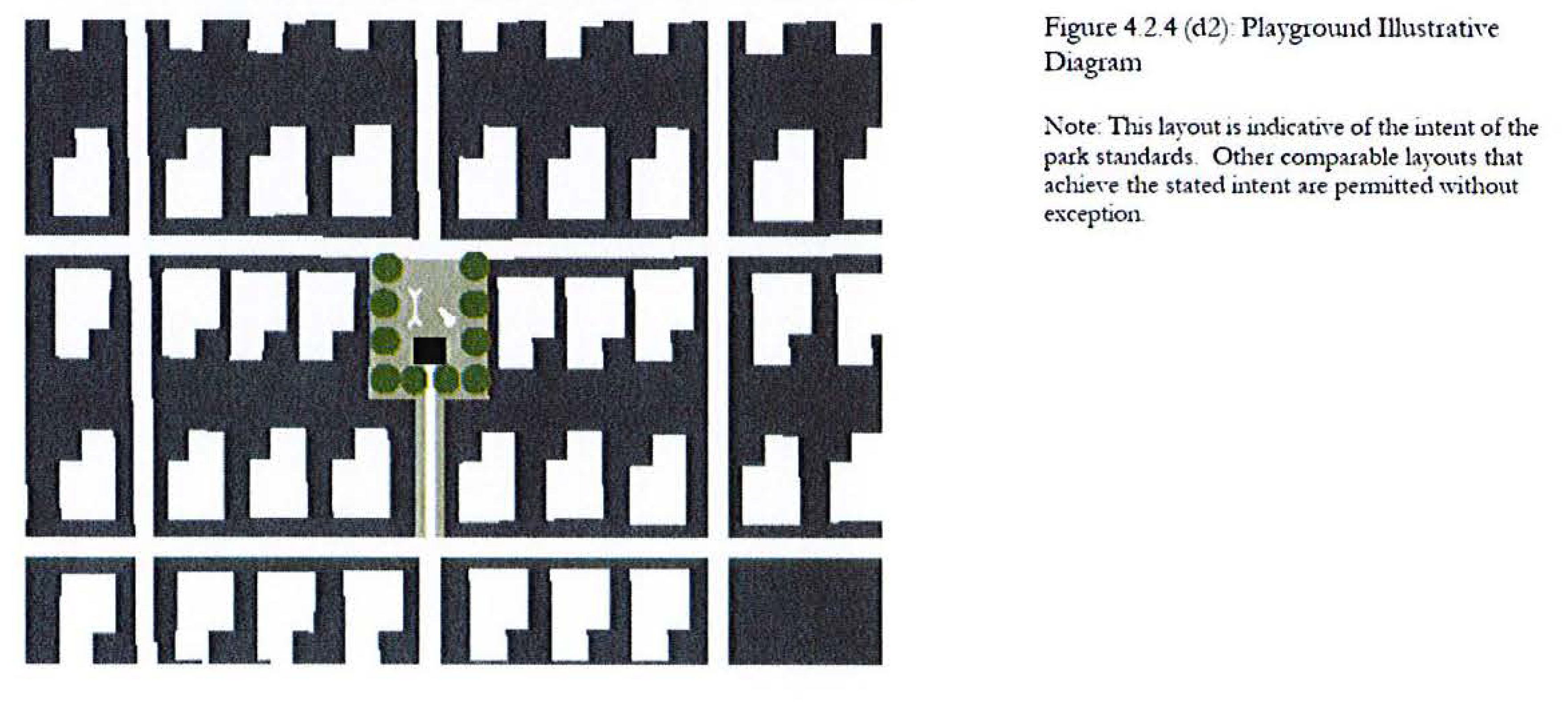
Plaza. A Plaza is a formal open space available for civic and commercial uses and spatially defined by building frontages. Landscaping in a plaza consists primarily of pavement; however, at least 25% of the area of the plaza shall be shaded by trees or shade structures integral with the design of the plaza. The minimum size shall be 1/8 acre and the maximum shall be 2 acres. A plaza must front on at least one street.
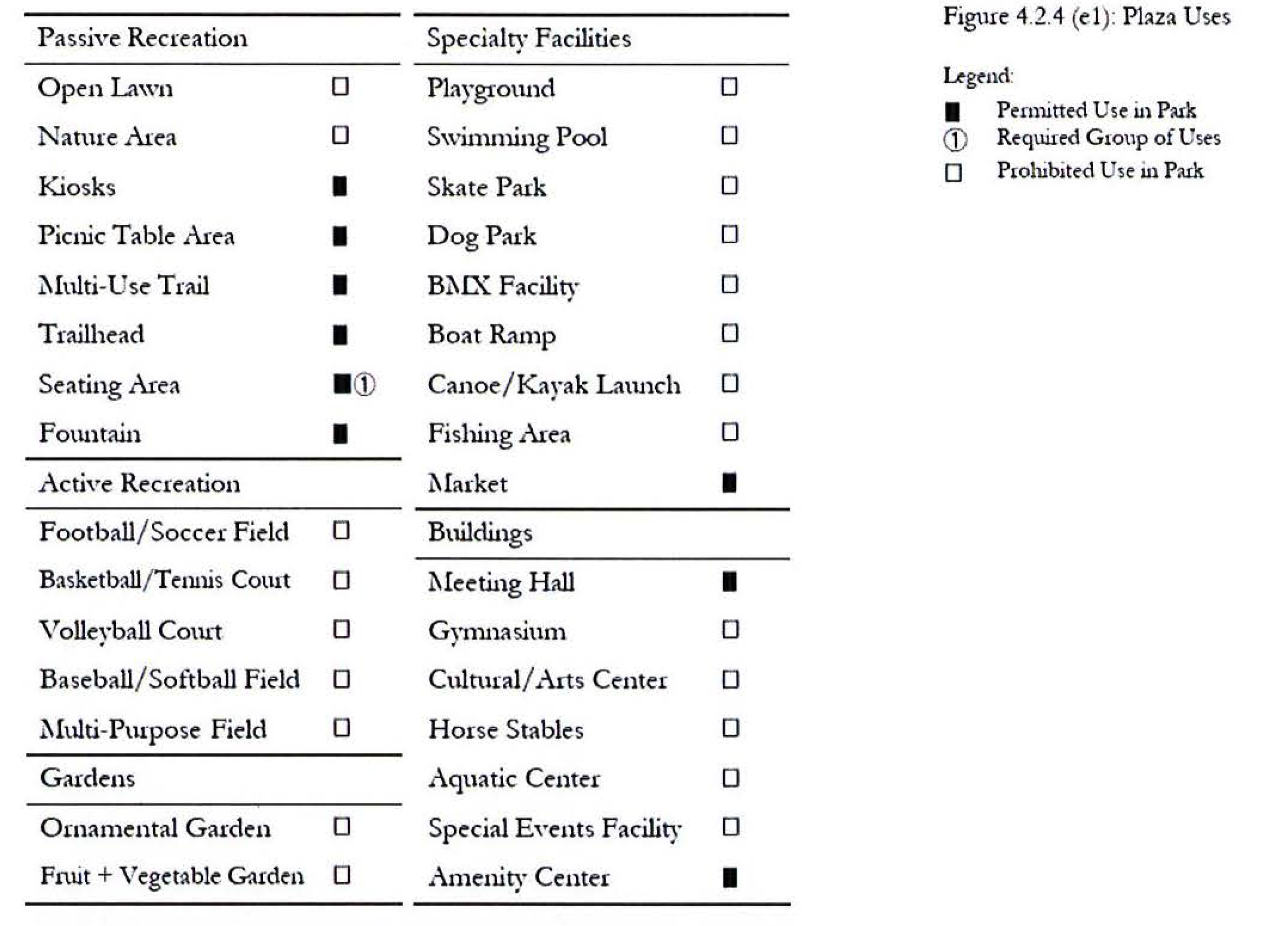
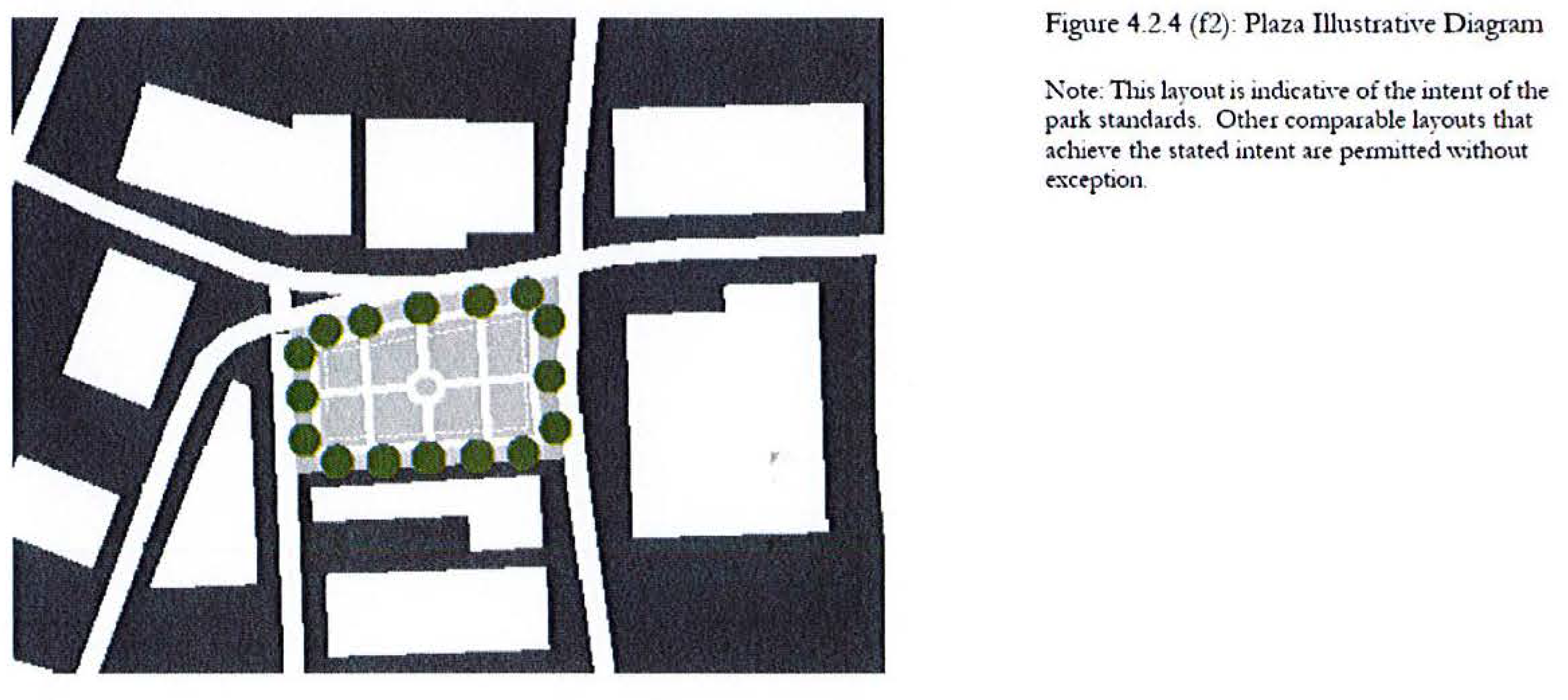
Community Garden. A Community Garden is a grouping of garden plots available to nearby residents for small-scale cultivation. The minimum size shall be 1/8 acre and the maximum shall be 1 acre. A community garden is not required to front on any streets.
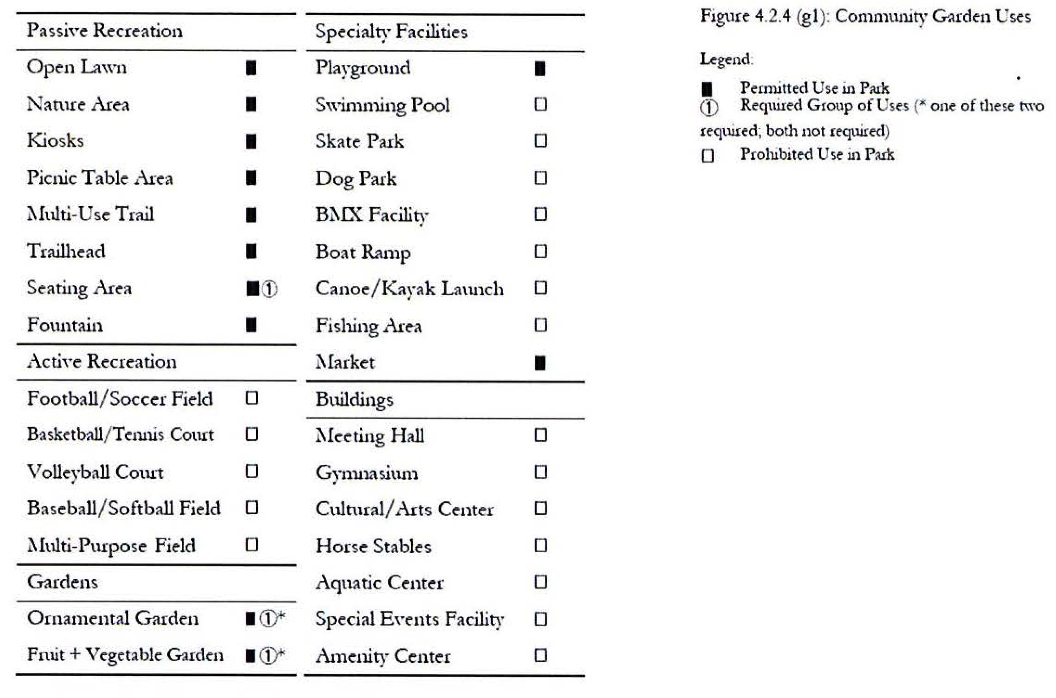
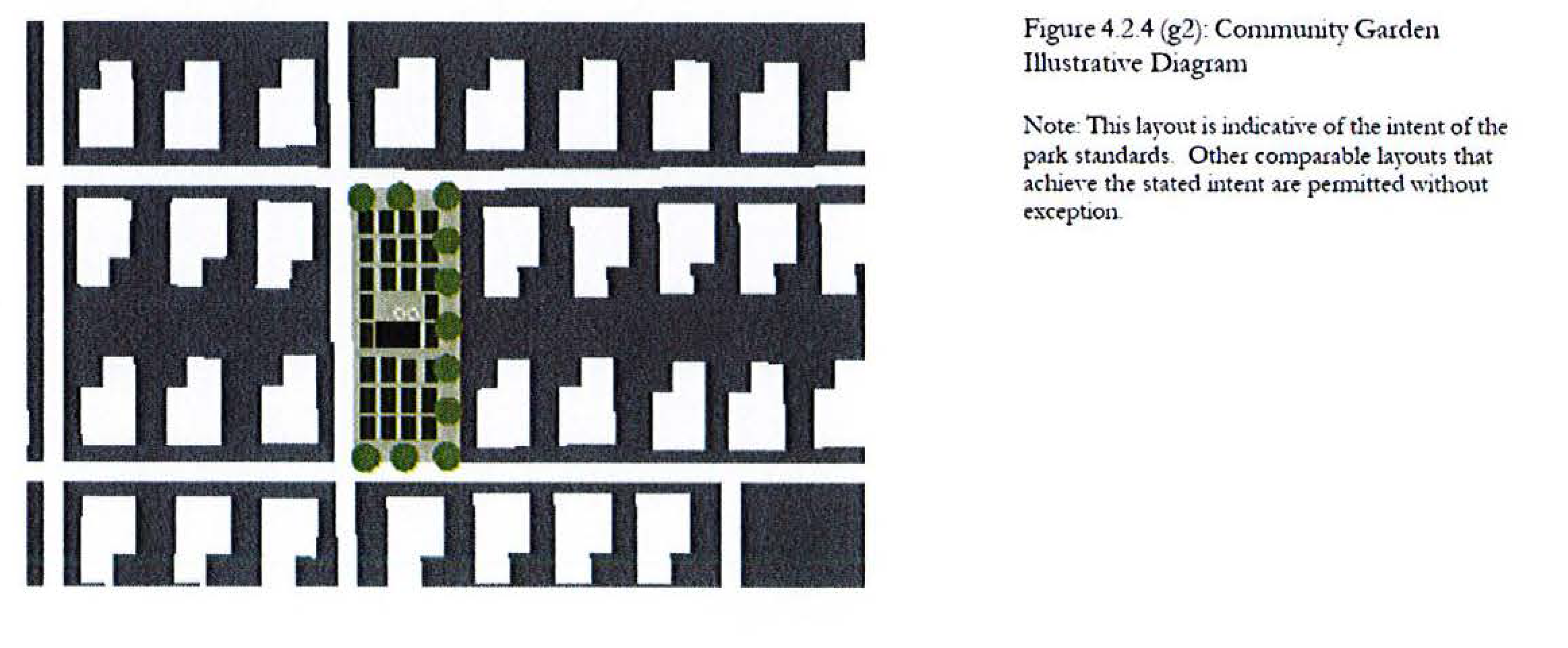
Greenway. A Greenway is a linear open space that ties together park components or preserves important ecological corridors with public access for recreation. Landscaping along a greenway consists of natural wooded areas, lawn, trees, and shrubs planted in informal patterns and it is typically furnished with paths, benches, and open shelters. The minimum width for a greenway shall be 25' of total upland area, and a continuous trail of at least 12' in width shall be provided for the length of the greenway. A greenway is not required to front on any streets, but shall terminate on at least one end in another type of park, Center, or other community facility.
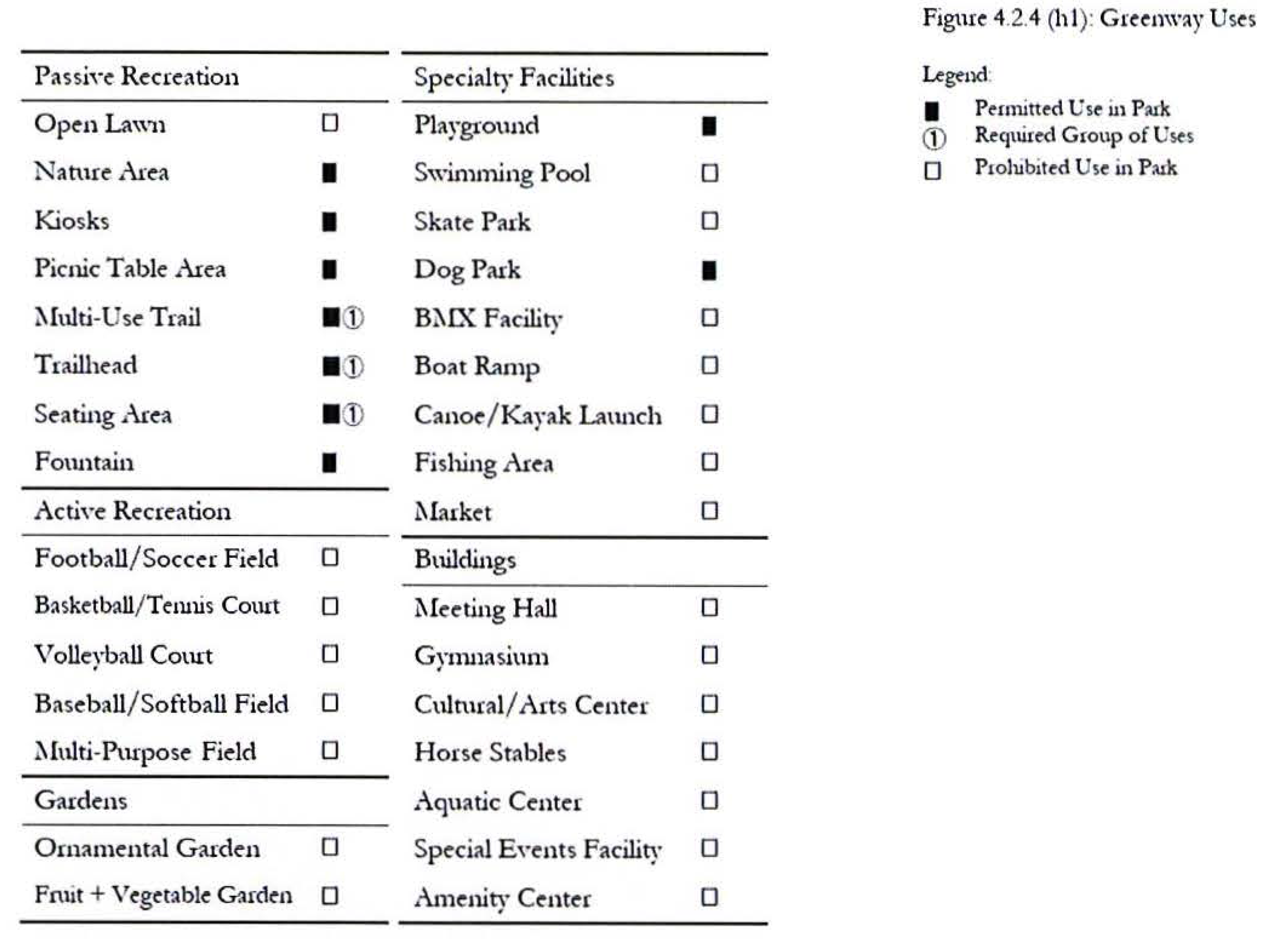
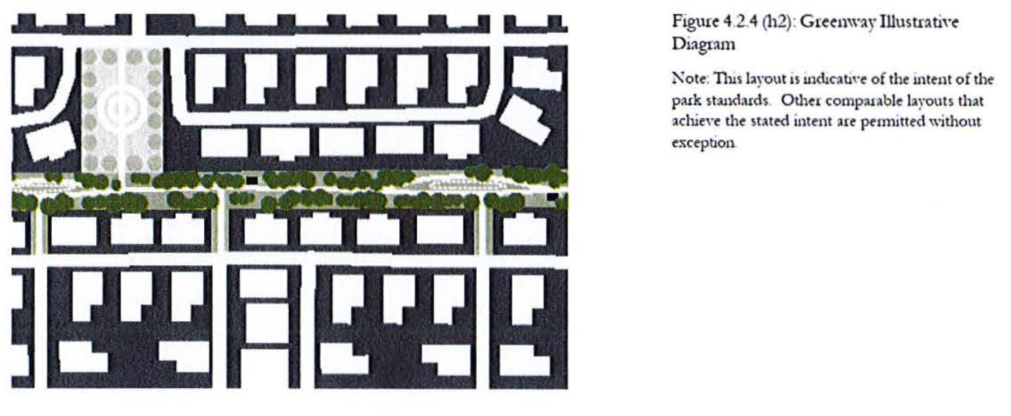
4.2.5 Park Size Calculation
The size of Close-to-Home Parks credited toward the Required Park Area (Section 4.2.2) shall be calculated as follows.
1.
The following areas may be counted for park size credits:
• Upland acreage designed per Park Type Standards, including adjacent upland buffer areas
• Dry bottom stormwater management ponds designed as depressional lawns and integrated with other park features consistent with a given park type provided they are sodded, include a skimmer, are dry within 72 hours after a 25-year storm event, and make up less than 75% of the total size of the park they are within
• Other accepted LID [6] practices that make up less than 15% of the total size of the park they are within
• Pools, recreation centers, and other community-use structures that make up less than 25% of the total size of the park they are within
2.
The following areas may be incorporated into a park; however, their acreage shall not be included in the Required Park Area calculation under Section 4.2.2 or applied toward Location criteria under Section 4.2.3.
• Wetlands or natural lakes
• Wet bottom stormwater management ponds
• Parking lots
3.
Close-to-Home Parks may be co-located with County Parks. However, their acreage shall be counted separately, and the County Park area shall not be eligible for incentives and/or bonuses as described in Section 4.2.6.
4.2.6 Incentives and Bonuses
To encourage joint planning of adjacent developments and to facilitate a system of well-connected park spaces, the following incentives may be utilized:
1.
A development may utilize the service radius of a park in an adjoining development provided street connections are present. The acreage of the park, however, may only be counted toward the Required Park Area of the development in which it is located.
2.
Where parks of different types are co-located, the service radius for location credit shall be calculated on the total contiguous acreage [7].
4.2.7 Contextual Design Standards
The following design standards shall apply to all development (including both non-residential, residential, and mixed uses) that fronts on a park. These standards are in addition to the District Standards in Section 2.
1.
Orientation. Development surrounding a park shall be designed to:
• spatially define parks and adjacent streets as positive, usable community elements around which to organize;
• promote a positive physical character that supports convenient access to and use of parks;
• give prominence to park spaces as a defining element of community character; and
• organize and orient buildings to promote pedestrian activity and a sense of security and community.
2.
Building Form. The form of buildings surrounding a park shall:
• Respond to the surrounding context and reinforce nodes of activities.
• Provide a consistent street edge through rear-accessed vehicular use areas to enhance the character of the context.
• Define streets to promote pedestrian activity and sense of place.
• Reinforce the character and quality of parks with designs that provide pedestrian orientation and access to the sidewalk.
3.
Street Design. Streets that front parks shall:
• Be designed foremost for pedestrian comfort, with shade, sidewalks, crosswalks, connected destinations, and protection from automobiles.
• Be interconnected and offer direct route options among all locations.
• Be designed to keep automobile traffic slow and drivers alert to their surroundings.
• Provide on-street parking.
4.
Building Design. Buildings surrounding a park shall:
• Encourage transparency of windows at ground level to activate the edges of the park.
• Give prominence to and visually clarify public entrances.
• Use fenestration, color, and materials to establish scale, variation, and patterns to create visually interesting and human-scaled building facades.
• Provide direct and convenient access to park uses.
4.2.8 Flexibility in Standards
A 10% variation shall be considered in compliance with the numerical standards of Section 4.2.3 and 4.2.4 provided the park otherwise meets or exceeds the intent and purpose of all other Sections.
4.2.9 Timing of Development of Close-to-Home Parks
Plans for Close to Home Parks shall be approved as part of a PUD. Construction of Close to Home Parks shall be completed prior to issuance of a Certificate of Completion for improvements associated with the approved phase of subdivision or development plans.
4.2.10 Park Maintenance
The developer shall be required to maintain all Close to Home Parks at no expense to the County. Ownership and maintenance of Close to Home Parks shall be in the name of an HOA, CDD, or other entity acceptable to the County.
(Ord. No. 2022-23, § 3, 5-3-22)
Section 5 Landscape and Natural Resources
5.1 Landscape Standards
All development within Wellness Way shall be subject to the Landscaping Standards found in Lake County Land Development Code Sec. 9.01.00. The following additional standards shall also apply.
The landscape in all required buffer areas in Wellness Way shall be composed 100% of native Florida species [8]. Through the PUD process, exceptions may be granted for designs that receive irrigation solely from retained stormwater.
5.1.1 Landscape Irrigation
All landscape irrigation shall be provided by reclaimed water. Another type of non-potable water supply may be used for landscape irrigation if reclaimed water is not available to the PUD. In no instance shall potable water be used for landscape irrigation unless authorized by the St. Johns River Water Management District pursuant to part II of Chapter 373, F.S. Conservation programs, system interconnections and alternative water supply options such as reclaimed water reuse and storage, shall occur when accessible. All development containing irrigated open space shall be required to accept reclaimed water for irrigation when such reclaimed water is available adjacent to the development's boundary. Connection shall be made at the developer's cost.
5.2 Conservation and Preservation Lands
5.2.1 Regionally Significant Natural Resources
The Critical Lands and Waters Identification Project (CLIP), and Florida Fish and Wildlife Conservation Commission (FFWCC) databases shall be consulted during the preparation of PUDs within Wellness Way. Areas designated as Priority 1 or 2 within the CLIP database and areas within the FFWC database containing known locations of rare and imperiled species of plants and animals shall be given the highest consideration for protection or preservation within a PUD.
5.2.2 Identification and Preservation of Xeric Uplands
During the preparation of PUDs, upland areas containing xeric, or scrub habitats should be analyzed closely for permanent preservation. Large habitat patches near each other provide for the greatest species diversity and minimizes extinction probabilities; small patches that are isolated are less likely to preserve species. Habitat fragmentation shall be discouraged. If preserved, these areas may serve as relocation sites for gopher tortoises, sand skinks, and other xeric-adapted species that may be present within the Urban Service Area and surrounding areas.
5.2.3 Conservation Lands
PUDs in Wellness Way shall provide for the conservation of significant natural, scenic, and cultural resources through the creation of an interconnected open space network. These resources and corridors shall be specifically demonstrated in each PUD.
The determination of areas most suitable for permanent preservation shall occur during the preparation of a PUD. The permanent preservation of suitable areas through recordation of conservation easements, consistent with s. 704.06 FS, as amended, shall correspond with each development phase or stage. Once an area is placed in permanent preservation, either through easement or acquisition, the Future Land Use Map designation of that area may be amended to Conservation.
5.2.4 Wetlands and Water Bodies
Wetlands and water bodies shall be delineated during PUD zoning. The types, values, functions, sizes, conditions and locations of wetlands within the planning area, shall be determined through on-site studies and field verification as the primary data source conducted by qualified professionals in accordance with state and federal regulations, guidelines and procedures. The existing wetland systems have several important functions, including flow of water (lakes are connected by waterways and streams), and habitat for plants and wildlife. Wetland impacts shall be carefully planned to avoid inordinate impacts to the wetlands system and be integrated into the overall conservation plan for the PUD.
5.2.5 Wetland Setbacks
A mandatory minimum setback of 50 feet from all retained jurisdictional wetland lines shall be established in the PUDs, and a minimum 50-foot-wide buffer shall apply to isolated wetlands, non-isolated wetlands, and rivers and streams, except where the required buffer makes a lot unbuildable, in which case a variable buffer consisting of a minimum width of 15 feet and average width of 50 feet shall be provided.
Development should preserve wetlands and portions of developable uplands containing designated species or rare upland habitats. The permanent preservation of suitable areas through recordation of conservation easements, consistent with s. 704.06 FS, as amended, shall correspond with each development phase or stage.
5.2.6 Protection of Trees and Native Vegetation
PUDs shall ensure the protection of specimen trees (live oak and magnolia trees Special consideration shall be given to rare upland habitats and designated species within ecologically significant areas identified herein. The extent to which preservation of vegetative communities and wildlife habitats shall be protected and incorporated into protected open space on a development site, shall be determined during the PUD process.
1.
Tree Replacement. Tree replacement ratios shall be as follows:
a)
Replacement of non-specimen trees shall be based on a one-to-one ratio of the cumulative DBH of the trees to be removed to the cumulative caliper of the trees to be installed.
b)
Specimen trees shall be replaced on a two-to-one ratio of the cumulative caliper of the trees to be installed to the cumulative DBH of the trees removed.
5.2.7 Wildlife Data
An applicant for a PUD shall submit baseline data consistent with the guidelines for any state or federally listed wildlife or plant species, based on Florida Fish and Wildlife Conservation Commission (FFWCC) and U.S. Fish and Wildlife Service survey methodologies and casual observation of non-listed wildlife and plant species. The purpose of the baseline data is to recognize the cumulative effects of development within Wellness Way on species diversity and habitat over a period of time.
5.3 Wellness Corridor Network
At build-out, Wellness Way shall contain a large, interconnected network of open spaces comprised of water bodies, wetlands, passive open space, important upland habitats and publicly owned lands. This system, referred to as Wellness Corridors, shall serve to protect environmentally sensitive lands, allow for the continued and safe movement of wildlife, and provide for significant passive recreation areas for the residents, employees, and visitors. Wellness Corridors shall be indicated on each PUD.
5.3.1 Native Vegetation within Corridors
Non-native landscape species shall be prohibited within these corridors, except for turf grass used as road or yard stabilizer. Vegetation identified on the Florida Exotic Pest Plant Council's List of Invasive Plant Species shall be prohibited.
5.3.2 Movement of Wildlife Crossings
Collaboration with the Florida Fish and Wildlife Conservation Commission (FFWCC), the U.S. Fish and Wildlife Service, and the Florida Department of Transportation shall be required to establish standards and locations for the movement of wildlife on public roads and other corridors, as well as ensuring the crossings or corridors are of the appropriate size.
5.4 Water Conservation
To maximize water conservation, all new construction shall incorporate WaterSense® plumbing fixtures (faucets, showerheads, and toilets) and ENERGY STAR® appliances to the greatest extent possible.
To maximize water conservation and minimize fertilizer/pesticide runoff, all new construction must be certified as Florida Water Star SM Silver. Where Florida Water Star Certification will not be obtained, a "Letter of Certification of the Design for an Irrigation System" signed by the contracted irrigation installation/design professional certifying the design is consistent with Florida Water Star SM criteria shall be required before issuance of a building permit. In addition, where Florida Water Star SM Certification will not be obtained, a "Letter of Completion Certifying Compliance with Design for an Irrigation System" signed by the contracted irrigation installation/design professional certifying the installation is consistent with Florida Water Star SM criteria shall be required before issuance of a certificate of occupancy.
5.5 Dark Skies
All new development within Wellness Way, including residential, non-residential, and all public rights-of-way shall utilize lighting fixtures designed and located to minimize glare and reduce light trespass and overhead skyglow. All fixtures shall be certified by the International Dark Sky Association's Fixture Seal of Approval program.
(Ord. No. 2022-23, § 2, 5-3-22)
Section 6 Public Facilities/Utilities
6.1 Intent
All development in Wellness Way must be consistent with the Capital Improvements Element and approved facility and service plans in order to discourage urban sprawl, meet adopted level of service standards, and thereby minimize associated public costs.
6.2 Identification of Water Supplies
All new development shall connect to non-potable sources of water, such as reclaimed water, for landscape irrigation, when available. The availability of, and requirement to connect to, Alternative Water Supplies, including reclaimed water, will be determined during the PUD approval process unless the use of water from other water sources is authorized by the St. Johns River Water Management District pursuant to part II of Chapter 373, F.S.
6.3 Potable and Reclaimed Water Facilities
PUDs within Wellness Way shall include an analysis of potable and reclaimed water facilities, including sources, treatment capacity and delivery infrastructure, required to accommodate projected impacts and maintain the County or private utility provider's adopted level of service (LOS) for such facilities. If it is determined that treatment plant sites and/or right-of-way/easements are needed to accommodate the projected impacts, then those sites and/or right-of-way/easements shall be conveyed prior to the issuance of building permits for development within the PUD.
6.4 Sanitary Sewer Facilities
PUDs within Wellness Way shall include an analysis of sanitary sewer facilities, including treatment capacity and delivery infrastructure, required to accommodate projected impacts and maintain the County or private utility provider's adopted level of service (LOS) for such facilities. If it is determined that treatment plant sites and/or right-of-way/easements are needed to accommodate the projected impacts, then those sites shall be conveyed prior to the issuance of building permits for development within the PUD.
6.5 Solid Waste Facilities
PUDs within Wellness Way shall include an analysis of solid waste impacts and, when necessary, mitigation plans that ensure adequate capacity exists to accommodate proposed demand.
6.6 Educational Facilities
PUDs within Wellness Way shall include an analysis of impacts to public schools and, when necessary, mitigation consistent with the policies and procedures identified in the Lake County 2030 Comprehensive Plan, Objective VI-1.8 as amended. If it is determined that one or more school sites within the proposed PUD are needed to accommodate projected impacts, then those sites shall be consistent with the PSFE's School Facility Siting objective and policies.
PUDs shall analyze the impacts of the future residential land uses on public schools and identify the facilities needed.
6.6.1 School Sites
1.
In addition to the PSFE's school facility siting objective and policies, the public-school siting provisions of Sections 333.03 and 1013.36, F.S., and the First Amended Interlocal Agreement between Lake County and Lake County School Board and Municipalities for School Facilities Planning and Siting (the ILA) be followed when identifying and dedicating public school sites.
2.
Future school sites shall be suitable for development as a public school and can be served with the necessary infrastructure, such as the following: potable and non-potable water, sanitary sewer, electrical power, high-speed internet service and transportation facilities.
3.
When it is not possible to avoid soil conditions on a public-school site that would require remediation to permit vertical construction, such remediation will be included in the applicant's PUD plan for mitigation of the impacts on public schools.
6.7 Public Safety
PUDs within Wellness Way shall include an analysis of law enforcement, fire protection and emergency services impacts and shall include coordination with the agencies providing these services to determine if facility sites are required within the PUD to ensure the provision of adequate public facilities and services. If it is determined that land is needed to accommodate the siting of facilities required to address the impacts of the proposed PUD, these lands shall be conveyed prior to the issuance of building permits for development within the PUD.
6.8 Technology Infrastructure
The delivery of high-speed data transfer to businesses and homes is critical to advancing high value, high wage job creation. Each PUD shall demonstrate how technology infrastructure and services will be delivered to each residential home and commercial business.
(Ord. No. 2022-23, § 2, 5-3-22)
Section 7 Signage
7.1 Signage
Except as provided herein, signage within Wellness Way shall be subject to the applicable Lake County Signage Code.
7.1.1 Public Realm Signage
Public realm signage creates brand awareness and wayfinding clarity along transportation routes. They are intended to be located at important entry access points to projects and site features/amenities. These freestanding signs allow for fluid traffic movement and will be sized appropriately for maximum visibility, placed in optimal locations, and display the information necessary to provide easy navigation throughout Wellness Way.
The following types of signs are allowed within Wellness Way:
• Wellness Way Identification and Wayfinding Signs
• Primary Regional Gateway
• Secondary Regional Wayfinding
• Parcel Identification Signs
• Single Use Non-Residential
• Multi-Tenant Commercial
• Office Complex
• Residential Subdivision
• Multi-Family Residential
Electronic message signs are prohibited within Wellness Way except for price signage for gas stations.
7.1.1(a) Primary Regional Gateway Signs.
Table 7.1.1(a): Primary Regional Gateway Sign Standards
Figure 7.1.1(a): Example of Primary Regional Gateway Sign
7.1.1(b) Secondary Regional Wayfinding Signs.
Table 7.1.1(b): Secondary Regional Wayfinding Sign Standards
Figure 7.1.1(b): Example of Secondary Regional Wayfinding Sign
7.1.1(c) Single Use Non-Residential Signs.
Table 7.1.1(c): Single Use Non-Residential Sign Standards
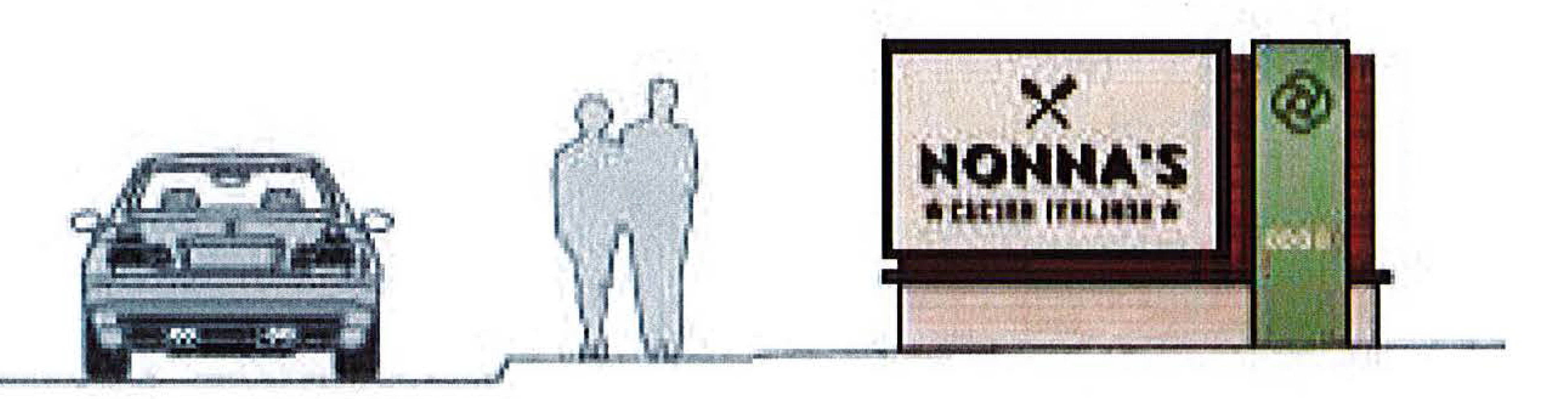
Figure 7.1.1(c): Single Use Non-Residential Sign Standards
7.1.1(d) Multi-Tenant Commercial Signs.
Table 7.1.1(d): Multi-Tenant Commercial Sign Standards
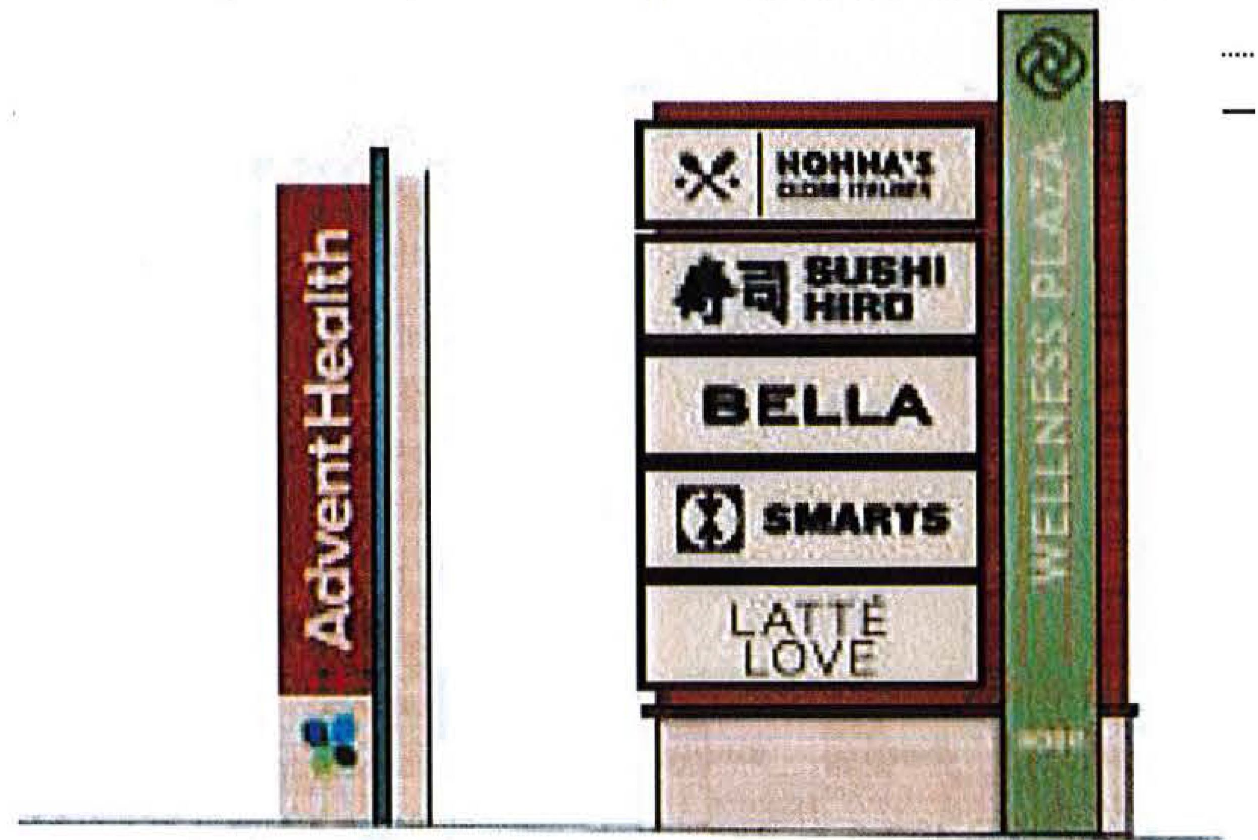
Figure 7.1.1(d): Example of Multi-Tenant Commercial Sign
7.1.1(e) Office Complex, Commerce Park, or Logistic Center Signs.
Table 7.1.1(e): Office Complex Sign Standards
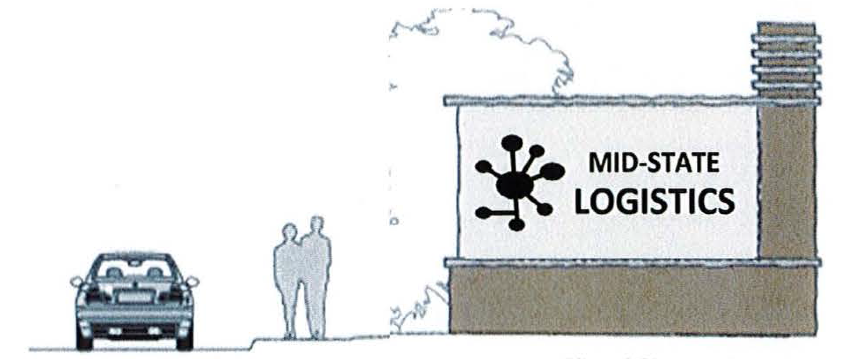
Figure 7.1.1(e): Example of Office Complex Sign
7.1.1(f) Residential Subdivision Signs.
Table 7.1.1 (f): Residential Subdivision Sign Standards
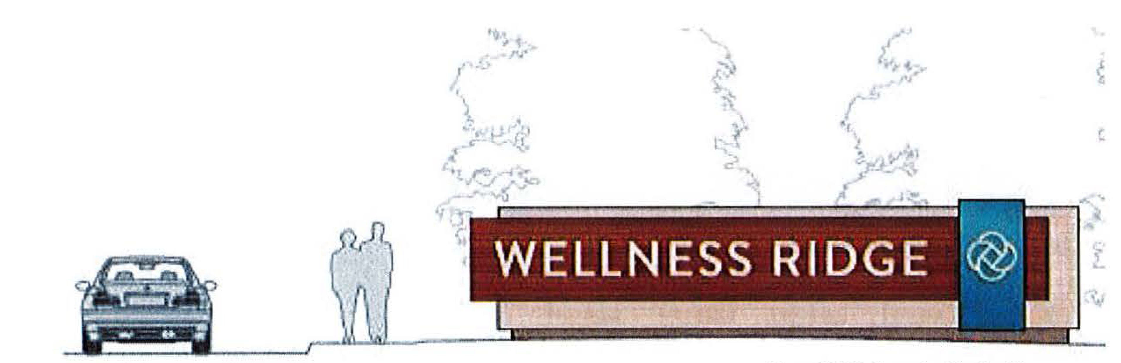
Figure 7.1.1(f): Example of Residential Subdivision Sign
7.1.1(g) Multi-Family Residential Signs.
Table 7.1.1(g): Multi-Family Residential Sign Standards
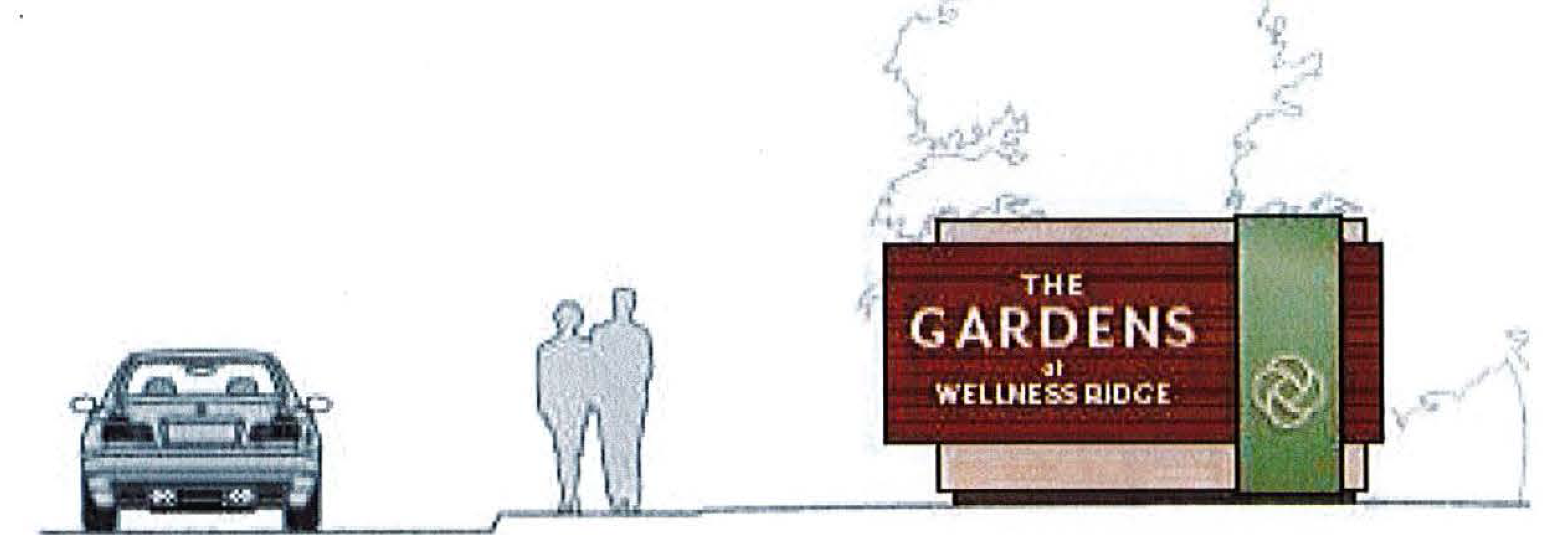
Figure 7.1.1(g): Example of Multi-Family Residential Sign
(Ord. No. 2022-23, § 2, 5-3-22)
Adopted from Policy I-8.2.2 Urban Form Guiding Principles
--- (2) ---
Measurement includes intersections of all public streets, private drives, and multi-use trails.
This standard shall in no way preclude the governing County, or State access management standards for arterial and collector roads.
--- (3) ---
This standard shall in no way preclude the governing County, or State access management standards for arterial and collector roads.
--- (4) ---
This standard shall in no way preclude the governing County, or State access management standards for arterial and collector roads.
--- (5) ---
Those areas required to provide loading, unloading, waste management, and other services necessary for the operation of the building and its tenants.
--- (6) ---
Low impact design (LID) is an approach to stormwater management that works with nature to manage stormwater as close to its source as possible. LID employs principles such as preserving and recreating natural landscape features, minimizing imperviousness to create functional and appealing site drainage that treat stormwater as a resource rather than a waste product. Example LID practices include bioretention cells, infiltration basins (dry ponds) bioswales, recharge trenches, and constructed wetlands.
--- (7) ---
Example: a 2 acre "Greenway" which connects a 1/2 acre "Playground," a 1/2 acre "Community garden," and a 2 acre "Green" has the service radius of a 5-acre park (1200').
--- (8) ---
Native Florida landscape material lists may be found from multiple sources including Florida Native Plant Society https://www.fnps.org/plants/browse UF/IFAS https://gardeningsolutions.ifas.ufl. edu/plants/ornamentals/native-plants.html
16.00.03 - Regional Roadway Network Landscape and Hardscape Design Standards.
A.
Introduction and Purpose.
1.
Wellness Way is envisioned as a mixed-use area proximate to arterial thoroughfares. Land uses within Wellness Way are intended to be flexible allowing employment, residential, institutional, agriculture and Wellness/Green Space.
2.
The primary intent of the Wellness Way Area Plan is to effectuate positive change for the following initiatives:
a.
Job creation and economic development
b.
Regional transportation connectivity
c.
Creation of the wellness corridor/recreation/open space network
d.
Promotion of recreation and healthy living
e.
Water smart approaches
f.
Preservation of scenic resources including topography
g.
Health and wellness community development
3.
These Landscape and Hardscape Design Standards will provide direction to designers of individual segments of the Regional Roadway Network and to the County for approval of final construction plans that are consistent with these initiatives.
B.
Applicability.
1.
These standards shall apply to the following Regional Roadways:
a.
Wellness Way from U.S. 27 to the Orange County Line
b.
Hancock Road from Hartwood Marsh Road to Wellness Way
c.
Schofield Road from Wellness Way to the Orange County Line
d.
County Road 455 from Hartwood Marsh Road to Sawgrass Bay Boulevard
2.
The locations of these Regional Roadways are shown on Figure 1, Subsection J. The Standards are not intended to be applicable to the Neighborhood Street System as defined in the Wellness Way Community Design Guidelines and Standards.
3.
These standards do not apply to construction as described in the approved plans and specifications of that portion of Schofield Road described as the "Schofield Road Improvements" in that certain Development Agreement between CEMEX Construction Materials Florida, LLC, Lake Louisa LLC and Lake County dated November 21, 2017, and recorded at OR BK 500 PG 1880-1946.
C.
Design Intent. Landscape and hardscape designs for the applicable roadways shall be consistent with the following principles:
1.
Low Maintenance: Utilize material selections and innovative design strategies to minimize costs of high-quality vegetation management.
2.
Minimal Irrigation: Select material that does not require supplemental irrigation beyond the establishment period.
3.
Florida-Friendly Landscaping: Utilize a diverse mix of context appropriate, resilient, Florida Friendly, primarily native plants that reflect the regional identity.
4.
Reflect Open Space Character Through CONSERV II: Design to respect a rural character in landscape design where Framework Roadways cross CONSERV.
5.
Trail Comfort and Connectivity: Design to include shade on the trail to the maximum extent possible and incorporate elements that promote the clear identification of the trail as part of the larger Lake County trail network.
6.
Color and Seasonal Interest: Utilize color, texture, pattern, and form to develop naturally beautiful and enjoyable roadways that are context sensitive, and conserve scenic, aesthetic, historic, and environmental resources while maintaining safety and mobility.
D.
Typical Sections and Landscape/Hardscape (LS/HS) Zones.
1.
The Regional Roadways within the Wellness Way Area are designed with one of two typical sections. The locations of these sections are shown on Figure 2, Subsection K.
a.
The Urban Section (shown below) shall be designed to ultimately be a 4-lane divided roadway with curb and gutter drainage, a curbed landscape median, and landscape parkways on each side separating a sidewalk on one side of the roadway and a multi-use trail on the opposite side. The standard right-of-way width is 120 feet. Dimensions shall be approved by the County Engineer.
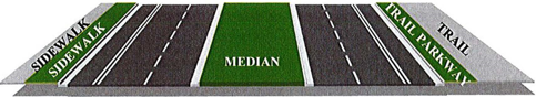
b.
Rural Section (shown below) shall be designed to ultimately be a 4-lane divided roadway with drainage swales, a curbed landscape median, and landscape parkways on each side separating a sidewalk on one side of the roadway and a multi-use trail on the opposite side. The standard right-of-way width is 200 feet. Dimensions shall be approved by the County Engineer.
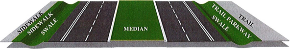
E.
Landscape and Hardscape Requirements
1.
Urban Section.
2.
Rural Section.
Notwithstanding any of the above standards, all roadway planting shall comply with clear zone and sight line standards found in the FDOT Manual of Uniform Minimum Standards for Design, Construction and Maintenance for Streets and Highways.
3.
Illustrative Standard Sections. The following figures are not regulations but are included to illustrate the application of the landscape and hardscape standards to typical roadway sections.
a.
Urban Section - Initial 2-Lane Roadway.
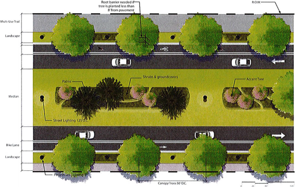
b.
Urban Section - Ultimate 4-Lane Roadway.
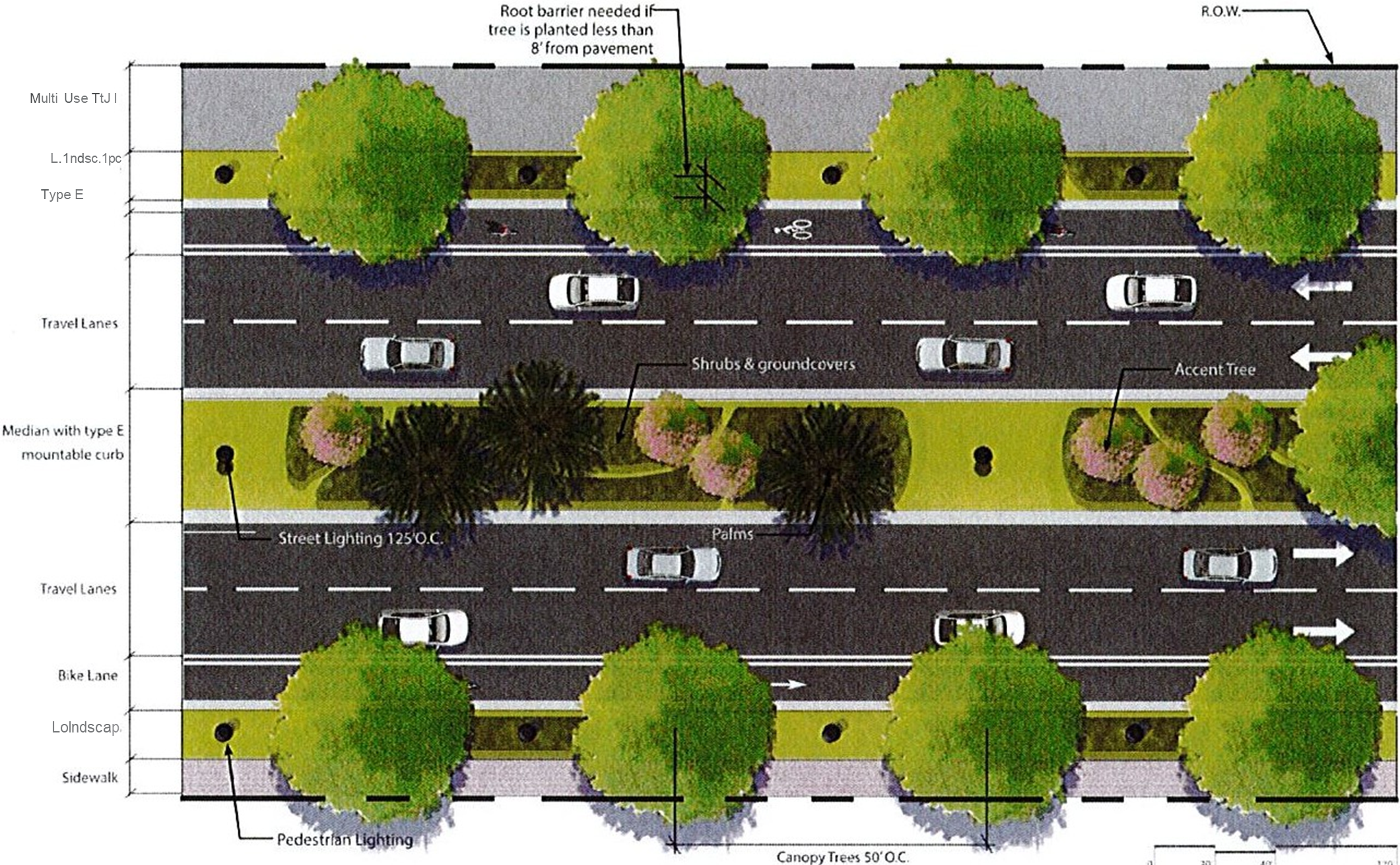
c.
Urban Section - Optional Trail Configuration in WWAP Center with Buildings at Edge of Right of Way.
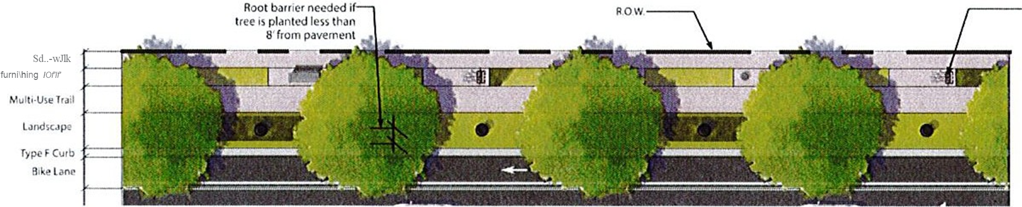
d.
Rural Section - Initial 2-Lane Roadway.
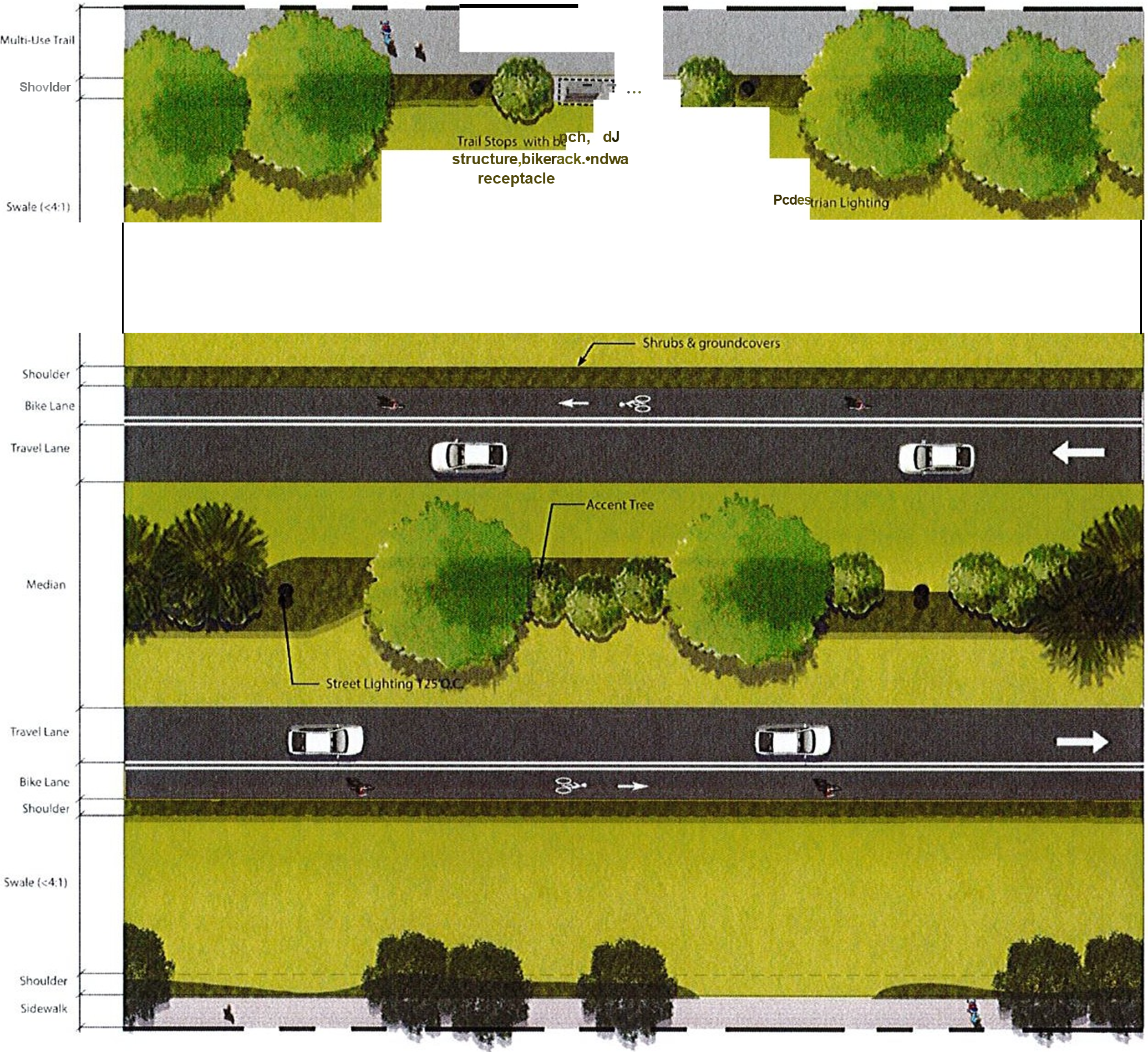
e.
Rural Section - Ultimate 4-Lane Roadway.
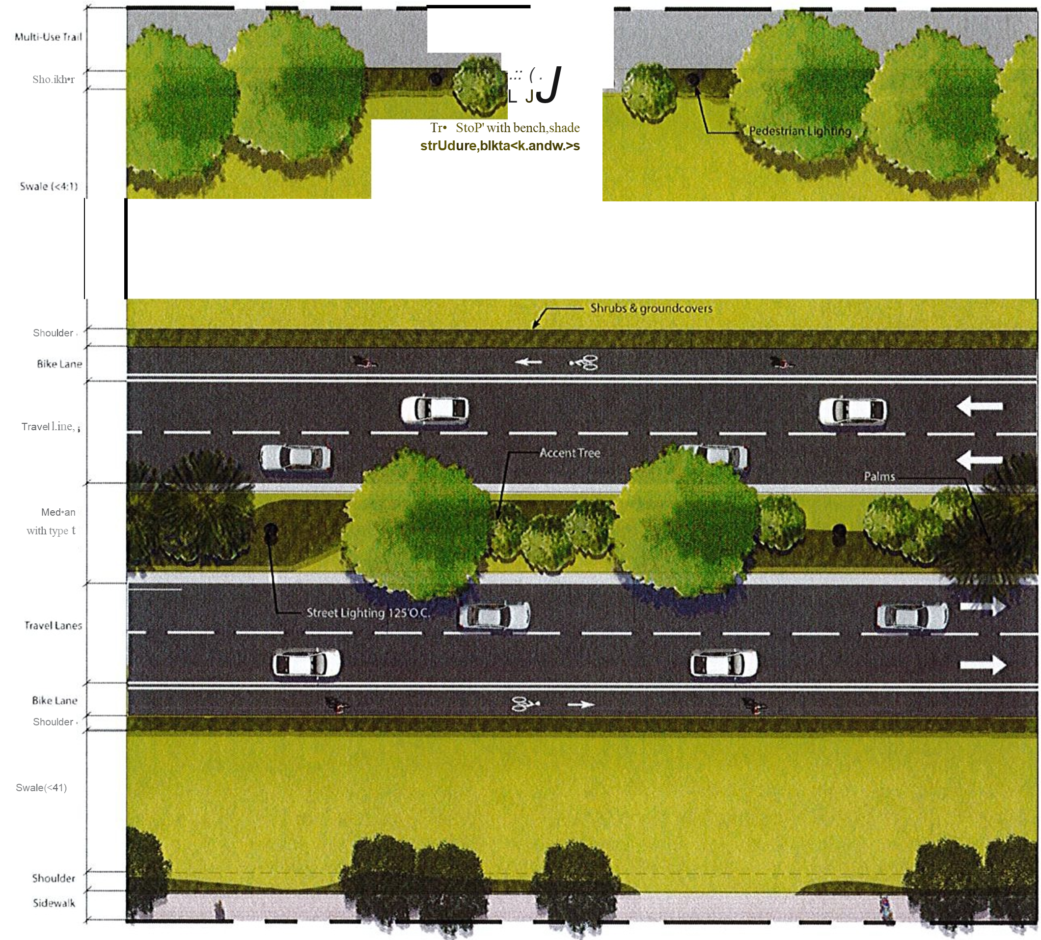
F.
Materials
1.
Landscape Palette
2.
General Landscape Palette Notes.
a.
All plant material shall be in full and strict accordance with Florida No. 1 grade, according to Grades and Standards for Nursery Plants published by the Florida Department of Agriculture and Consumer Services, or the most current minimum standards of Florida No. 1 plant materials.
b.
All plant material sizes specified are minimum sizes. Container size shall be increased if necessary to provide overall plant size specified.
c.
Root barriers required for any tree planted within 8 feet of pavement, trail, or sidewalk.
d.
Peg sod on slopes greater than 3:1.
e.
All planting beds shall be top-dressed with a 3-inch layer of pine straw. All trees shall have a 3-inch-thick mulch ring placed around the base of the trunk.
f.
Palm heights, as indicated in table, refer to clear trunk (C.T.), gray wood (G.W.), or overall height (O.A.) as specified.
g.
Along Trail, a rest area with bench, bike rack, and waste receptacle is required at least every mile.
h.
Flared connections between sidewalks and trails are recommended for easier transition between various bicycle and pedestrian facilities.
3.
Hardscape Palette, Lighting, and Furnishings.
G.
Soils and Soil Enhancements
1.
Highly disturbed soils (e.g., those located in medians, embankments, and parkways) are often densely compacted, rocky, and infertile. These soil conditions may negatively impact plant establishment by inhibiting root growth, reducing water infiltration, and increasing run-off. Soil enhancements shall be specified when existing soils inhibit plant establishment and growth.
2.
Soil enhancement options include the following:
a.
Soil scarification (a.k.a., soil structural improvement)
b.
Soil amendments
c.
Full soil replacement with Landscape Soil
3.
Soil scarification includes mechanically loosening the existing soils to accommodate plant establishment and growth.
4.
Soil amendments include mixing of organic soils, inorganic soils, or minerals with the existing soils. Soil amendments help support plant growth by providing nutrients, increasing water retention and transmission, and reducing erosion. Mineral amendments (e.g., nitrogen, phosphorus, potassium) improve soil fertility and pH levels.
5.
Full soil replacement with Landscape Soil is only warranted when all other soil enhancement measures will not improve the quality of the existing soil enough to support establishment and growth of plants. Landscape Soil shall conform to FDOT Standard Specification 987-2.4.
6.
Roadway developer shall bear all costs of testing of soils, amendments, etc. associated with the work. See below for additional testing requirements.
7.
Roadway developer shall provide soil test reports of existing soil conditions at selected locations within the right of way at test sites approved by the County Manager or designee.
8.
Roadway developer shall provide recommendations for organic materials, fertilizers, and other materials found necessary to amend the specified planting mix for optimum plant growth based on submitted report(s).
9.
Roadway developer shall provide a backfill mix or mixes, as appropriate, to be employed in the planting of all plants for the project if soils test report(s) indicate inadequacies in the specified mix.
10.
Roadway developer shall provide an approved planting soil mixture for all plant material, including trees and palms.
11.
Topsoil. Provide topsoil that is:
a.
Natural surface soil from well-drained areas, fertile, friable, and free of weeds, typical of productive, cultivated topsoils of the locality.
b.
Not excessively acid or alkaline (pH 5.5 to 7.0), nor containing toxic substances.
c.
Without admixture of sub-soil and reasonably free of clay, stones, stumps, roots, or other similar substances 1 inch or more in diameter or any other object which may be a hindrance to the finish-grading operation.
d.
Acceptable topsoil from the site and any imported soil used on the project shall be a natural, fertile, friable soil possessing characteristics representative of a well-drained area in Florida. Soil containing muck or poorly drained soils shall not be used.
e.
Acceptable soil from the site may be substituted for topsoil and/or sand, based upon the results of the laboratory analysis.
12.
Compost Amended Soil Requirements:
a.
Roadway developer shall incorporate compost into the soil within landscapable areas of new construction projects to a depth of at least 4 inches and average of 6 inches at a rate of 4 cubic yards per 1,000 square feet, or whatever the current guidance from the University of Florida Institute of Food and Agriculture Sciences (UF/IFAS) provides prior to installing landscaping material.
b.
Roadway developer shall use compost certified by the U.S. Composting Council where available.
c.
Where certified compost is not available, amended soil shall have an organic matter content of greater than 2.0% and a pH between 5.5 and 8.0, and shall be free from noxious weeds and roots, salts, clay lumps, any non-soil materials such as rock, concrete, brick chips, or building materials, foreign matter, and any chemical, biological or radiological contaminants. The amendments shall have dry weight content equal or less than 2.0% nitrogen and 0.8% phosphorus. The quality of amended soil should be in accordance with the current guidance provided by UF/IFAS.
13.
Roadway developer shall submit samples of existing on-site soils to a certified testing laboratory for analysis as to the suitability of the planting mix specified above to obtain a pH of 5.5 to 6.5. The findings, together with any recommendations for amending the specified planting mix shall be reviewed and approved by the County Engineer prior to delivery and installation of plant materials at the job.
14.
Soil amendments shall be added to any soil used for planting and in planting beds and plant pits in the amount and manner prescribed by a soil analysis. Results from soil analysis and a list of the prescribed amendments shall be presented to the County Engineer prior to incorporating into the soil.
15.
Roadway developer shall be responsible for providing adequate acceptable soil to prepare the planting mixture and is also responsible for supplying and mixing soil amendments and moving the planting mix to the plant pits and beds.
H.
Irrigation. Where provided, all landscape irrigation shall be provided by reclaimed water. Another type of non-potable water supply may be used for landscape irrigation if reclaimed water is not available to the roadway. In no instance shall potable water be used for landscape irrigation unless authorized by the St. Johns River Water Management District pursuant to part II of Chapter 373, Florida Statutes. System interconnections and alternative water supply options such as reclaimed water reuse and storage, shall occur when accessible. All irrigated landscape shall be required to accept reclaimed water for irrigation when such reclaimed water is available adjacent to the roadway.
I.
Street Corner Visibility. All landscaping at the intersections of streets and driveways shall comply with the street corner visibility and driveway sight distance requirements of Lake County. If the project abuts a Florida Department of Transportation (FDOT) roadway, the landscaping shall meet the requirements of the FDOT Manual of Uniform Minimum Standards for Design, Construction and Maintenance for Streets and Highways (latest revision). Drivers' clear sight distance lines shall be shown on the landscape plans.
J.
Figure 1: Wellness Way Regional Roadway Network
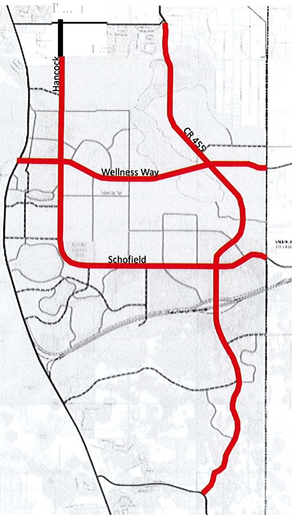
K.
Figure 2: Locations of Urban and Rural Sections
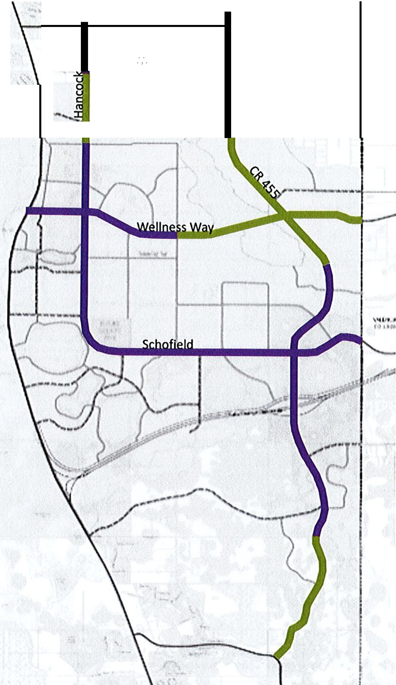
(Ord. No. 2023-42, § 2, 7-11-23)