Lancaster City Zoning Code
CHAPTER 17
40 - GENERAL REGULATIONS
Article XIII - Wireless Telecommunication Facilities[6]
Editor's note— Ord. No. 1070, Exh. A, adopted Jan. 14, 2020, repealed the former Art. XIII, §§ 17.40.640—17.40.681, and enacted a new Art. XIII as set out herein. The former Art. XIII pertained to similar subject matter and derived from Ord. 753 § 1 (Exh. A § 10 (part)), adopted 1999.
17.40.010 - Buildings moved.
No building or structure shall be moved from one lot or premises to another unless such building or structure shall thereupon be made to conform to all the provisions of this title relative to buildings or structures hereafter erected upon the lot or premises to which such building or structure shall have been moved, and shall be made to conform to the general character of the existing buildings in the neighborhood or better.
(Prior zoning ord. § 701.2)
17.40.020 - Buildings converted or altered.
No building or structure existing at the time of the effective date of the ordinance codified in this title or any amendment thereof which is designed, arranged, intended for or devoted to a use not permitted in the zone in which such building or structure is located, shall be enlarged, extended, reconstructed, built upon or structurally altered unless the use of such building or structure is changed to a use permitted in the zone in which such building or structure is located.
(Prior zoning ord. § 701.3)
17.40.030 - Temporary housing in disaster areas.
Notwithstanding any other provision of this title, where an existing residence is damaged or destroyed by a major disaster such as fire, flood or earthquake so declared by the Governor of the state of California during the previous 6 months, a mobilehome may be used as a residence on the same lot or parcel of land by the owner and his family for a period not to exceed one year. This section authorizes only the temporary replacement of a damaged or destroyed residence and not an increase in the number of living quarters permitted on the property.
(Prior zoning ord. § 701.4)
17.40.040 - Prohibition, general.
A person shall not use or cause or permit to be used any building, structure, improvement or premises located in any zone described in this title contrary to the provisions of this title.
(Prior zoning ord. § 701.5)
17.40.050 - Defined.
See definition in Section 17.04.240.
(Prior zoning ord. § 702.1)
17.40.060 - Undersized sections.
If as a result of the normal division of an undersized section of land, a parcel of land would be created having less than the required area, such parcel of land shall be considered as having the required area provided:
A.
That in no event shall more parcels be created under this section than would result from the breakdown of a normal section of land in the same zone; and
B.
That this section shall apply only to parcels of land when division of a normal section would create parcels of land having not less than a minimum gross area of 2½ acres; and
C.
That the total reduction of all parcels in a division of an undersized section shall not exceed 10%; and
D.
That no lot or parcel of land shall be created which contains less than a minimum gross area of 2¼ acres; and
E.
That the creation of such parcels shall meet all the requirements of Ordinance 4478 entitled "Subdivision Ordinance," adopted March 19, 1945.
(Prior zoning ord. § 702.2)
17.40.070 - Required area reduced by public use.
If a lot or parcel of land has not less than the required area and after creation of such lot or parcel of land a part thereof is acquired for public use other than for highway purposes, in any manner including dedication, condemnation or purchase, and if the remainder of such lot or parcel has not less than the 80% of the required area, such remainder shall be considered as having the required area.
(Prior zoning ord. § 702.3)
17.40.080 - Required area reduced for highway purposes.
If a lot or parcel of land has not less than the required area, as defined in Section 17.40.050, and after the creation of such lot or parcel of land a part thereof is acquired for highway purposes exclusively in any manner including dedication, condemnation or purchase, and if the remainder of such lot or parcel has not less than 75% of the required area, then such remainder shall be considered as having the required area, provided the remaining portion of said lot or parcel of land has an area of less than 2,500 square feet, or an area as is otherwise provided herein. The director, without notice or hearing, may approve a reduction of lot area to 75% of the required area where the remaining parcel would have less than 2,500 square feet, but not less than 2,000 square feet, where topographic features, subdivision design or other conditions create an unnecessary hardship or unreasonable limitation making it obviously impractical to comply with the stated minimum.
(Prior zoning ord. § 702.4)
17.40.090 - Required width of depth reduced by public use.
A.
If a lot or parcel of land has not less than the required width and after the creation of such lot or parcel of land a part thereof is acquired for public use in any manner including dedication, condemnation or purchase if the remainder of such lot has a width of not less than 40 feet, such remainder shall be considered as having the required width.
B.
If a lot or parcel of land has not less than the required depth and after the creation of such lot or parcel of land a part thereof is acquired for public use in any manner including dedication, condemnation or purchase, if the remainder of such lot or parcel has not less than 75% of the required depth, then such remainder shall be considered as having the required depth.
(Prior zoning ord. § 702.5)
17.40.093 - Reduction of required yards for street widening.
Where the provisions of Section 17.40.070, 17.40.080 or 17.40.090 are applied on a property adjoining any arterial street, the director may reduce the amount of yard required on a 1:1 basis, provided that the yard may not be reduced to less than 10 feet.
(Ord. 711 § 40, 1995; prior zoning ord. § 702.6)
17.40.095 - Reduction of required yards to accommodate transit stops.
Where the city has deemed it necessary to locate a transit stop within a turnout which requires an additional easement or right-of-way, the director may reduce the amount of yard required on a 1:1 basis, provided that the yard may not be reduced to less than 10 feet.
(Ord. 711 § 41, 1995; prior zoning ord. § 702.7)
17.40.097 - Reduction of required yards where widening of an arterial street exceeds city standards.
Where the city has deemed it necessary to widen an arterial street in excess of the city standard, the director may reduce the amount of yard required as necessary, provided that the yard may not be reduced to less than 5 feet.
(Ord. 711 § 42, 1995; prior zoning ord. § 702.8)
17.40.100 - Contiguous narrow lots.
Where, prior to the territory being zoned R-1, R-2, R-A, A-1, A-2 or A-2-H, lots exist not less than 100 feet deep but less than 50 feet wide, if 2 or more such contiguous lots, or one or more such contiguous lots and one or more lots also contiguous thereto which have a depth of not less than 100 feet, have a total frontage of not less than 50 feet, such lots may be treated and considered as one parcel.
If such parcel is in the RR, SRR or R zones, 2 single-family residences may be constructed thereon and so used. If such parcel is in zone MDR, 2 single-family dwellings or 2 2-family dwellings or one single-family dwelling and one 2-family dwelling may be constructed thereon and so used.
(Prior zoning ord. § 702.13)
17.40.110 - Sale.
Where a portion of a lot or parcel of land is sold or transferred and as a result of such sale or transfer one or more parcels are created of such an area that the number and location of the buildings thereon no longer conform to the requirements of this article, then, in the determination of the permissible number and location of any buildings on any other parcel so created by such sale or transfer, the portion sold or transferred and the remainder shall be considered as one parcel.
(Prior zoning ord. § 702.16)
17.40.120 - Area or width diminished by public use.
Where a building or structure is lawfully located on property acquired for public use (by condemnation, purchase or otherwise) such building or structure may be relocated on the same lot or parcel of land, although such building or structure is existing as nonconforming use or although the area or width regulations of this title or both cannot be complied with. Where any part of such building or structure is acquired for public use, the remainder of such building or structure may be repaired, reconstructed or remodeled, with the same or similar kind of materials as used in the existing buildings.
(Prior zoning ord. § 702.18)
17.40.130 - Reduction of lot area or width.
Except for a conveyance for public use, a person shall not divide any lot or parcel of land or any portion thereof, if as a result of such division or conveyance the area, depth or width of any lot or parcel of land is so reduced, or a lot or parcel of land is created, which lot or parcel of land has an area, depth or width less than the required minimum lot area, depth or width specified for the zone in which the property is located and except for public use no such reduction shall occur in a residential planned development or commercial planned development, without a new public hearing on the case. If the zone does not specify a minimum lot area, depth, or width then the minimum lot area shall be 5,000 square feet, the minimum lot depth shall be 100 feet, and the minimum lot width shall be 50 feet.
(Prior zoning ord. § 702.19)
17.40.140 - Rescission.
Any deed of conveyance, sale or contract to sell made contrary to the provisions of this article is voidable at the sole option of the grantee, buyer or person contracting to purchase, his heirs, personal representative, or trustee in insolvency or bankruptcy within one year after the date of execution of, the deed or conveyance, sale or contract to sell, but the deed of conveyance, sale or contract to sell is binding upon any assignee or transferee of the grantee, buyer or person contracting to purchase, other than those above enumerated, and upon the grantor, vendor or person contracting to sell, his assignee, heir or devisee.
(Prior zoning ord. § 702.20)
17.40.150 - Statutory authorization, findings of fact, purpose and methods.
A.
Statutory Authorization. The Legislature of the state of California has in Government Code Sections 65302, 65560 and 65800 conferred upon local government units authority to adopt regulations designed to promote the public health, safety and general welfare of its citizenry.
B.
Findings of Fact.
1.
The flood hazard areas of the city are subject to periodic inundation which could result in loss of life and property, health and safety hazards, disruption of commerce and governmental services, extraordinary public expenditures for flood protection and relief, and impairment of the tax base, all of which adversely affect the public health, safety and general welfare.
2.
These flood losses are caused by the cumulative effect of obstructions in areas of special flood hazards which increase flood heights and velocities, and when inadequately anchored, damage uses in other areas. Uses that are inadequately flood proofed, elevated or otherwise protected from flood damage also contribute to the flood loss.
C.
Statement of Purpose. It is the purpose of this article to promote the public health, safety, and general welfare, and to minimize public and private losses due to flood conditions in specific areas by provisions designed:
1.
To protect human life and health;
2.
To minimize expenditure of public money for costly flood control projects;
3.
To minimize the need for rescue and relief efforts associated with flooding and generally undertaken at the expense of the general public;
4.
To minimize prolonged business interruptions;
5.
To minimize damage to public facilities and utilities such as water and gas mains, electric, telephone and sewer lines, streets and bridges located in areas of special flood hazard;
6.
To help maintain a stable tax base by providing for the sound use and development of areas of special flood hazard so as to minimize future flood blight areas;
7.
To insure that potential buyers are notified that property is in an area of special flood hazard; and
8.
To insure that those who occupy the areas of special flood hazard assume responsibility for their actions.
D.
Methods of Reducing Flood Losses. In order to accomplish its purpose, this article includes methods and provisions for:
1.
Restricting or prohibiting uses which are dangerous to health, safety and property due to water or erosion hazards or which result in damaging increases in erosion flood heights or velocities;
2.
Requiring that uses vulnerable to floods, including facilities which serve such uses, be protected against flood damage at the time of initial construction;
3.
Controlling the alteration of natural floodplains, stream channels, and natural protective barriers which help accommodate or channel floodwaters;
4.
Controlling fill, grading, dredging, and other development which may increase flood damage; and
5.
Preventing or regulating the construction of flood barriers which will unnaturally divert flood waters or which may increase flood hazards in other areas.
(Prior zoning ord. §§ 705.1—705.1.4)
17.40.160 - Definitions.
Unless specifically defined below, words or phrases used in this article shall be interpreted to give them the meaning they have in common usage and to give this article its most reasonable application.
"Alluvial fan" means a geomorphologic feature characterized by a cone- or fan-shaped deposit of boulders, gravel and fine sediments that have been eroded from mountain slopes, transported by flood flows and then deposited on the valley floors, and which is subject to flash flooding, high velocity flows, debris flows, erosion, sediment movement and deposition, and channel migration.
"Apex" means the point of highest elevation on an alluvial fan which, on undisturbed fans, is generally the point where the major stream that formed the fan emerges from the mountain front.
"Appeal" means a request for a review of the floodplain administrator's interpretation of any provision of this article or a request for a variance.
"Area of shallow flooding" means a designated AO or AH zone on the Flood Insurance Rate Map (FIRM). The base flood depths range from one to 3 feet; a clearly defined channel does not exist; the path of flooding is unpredictable and indeterminate; and velocity flow may be evident. Such flooding is characterized by ponding or sheet flow.
Area of Special Flood Hazard. See "Special flood hazard area."
"Backfill" means the placement of fill material within a specified depression, hole or excavation pit below the surrounding adjacent ground level as a means of improving floodwater conveyance or to restore the land to the natural contours existing prior to excavation.
"Base flood" means the flood having a 1% chance of being equalled or exceeded in any given year (also called the "100 year flood").
Building. See "Structure."
"Critical feature" means an integral and readily identifiable part of a flood protection system without which the flood protection provided by the entire system would be compromised.
"Curvilinear line" means the border on either a flood hazard boundary map or flood insurance rate map that delineates the special flood, mudslide (i.e., mudflow), and/or flood-related erosion hazard areas and consists of a curved or contour line that follows the topography.
"Development" means any man-made change to improved or unimproved real estate including, but not limited to, buildings or other structures, mining, dredging, filling, grading, paving, excavation or drilling operations, or storage of equipment or materials.
"Encroachment" means the advance or infringement of uses, plant growth, fill, excavation, buildings, permanent structures or development into a floodplain which may impede or alter the flow capacity of a floodplain.
"Existing manufactured home park or subdivision" means a manufactured home park or subdivision for which the construction of facilities for servicing the lots on which the manufactured homes are to be affixed (including, at a minimum, the installation of utilities, the construction of streets, and either final site grading or the pouring of concrete pads) is completed before the effective date of the floodplain management regulations adopted by a community.
"Expansion to an existing manufactured home park or subdivision" means the preparation of additional sites by the construction of facilities for servicing the lots on which the manufactured homes are to be affixed (including the installation of utilities, the construction of streets, and either final site grading or the pouring of concrete pads).
"Fill" means the placement of fill material at a specified location to bring the ground surface up to a desired elevation.
"Fill material" can be natural sand, dirt, soil or rock. For the purposes of floodplain management, fill material may include concrete, cement, soil cement, brick or similar material as approved on a case-by-case basis.
"Flood," "flooding" or "floodwater" means:
1.
A general and temporary condition of partial or complete inundation of normally dry land areas from:
a.
The overflow of inland or tidal waters;
b.
The unusual and rapid accumulation or runoff of surface waters from any source; and/or
c.
Mudslides (i.e., mudflows) which are proximately caused by flooding as defined in subsection 1.b. of this definition and are akin to a river of liquid and flowing mud on the surfaces of normally dry land areas as when earth is carried by a current of water and deposited along the path of the current; and
2.
The collapse or subsidence of land along the shore of a lake or other body of water as a result of erosion or undermining caused by waves or currents of water exceeding anticipated cyclical levels or suddenly caused by an unusually high water level in a natural body of water, accompanied by a severe storm, or by an unanticipated force of nature, such as flash flood or an abnormal tidal surge, or by some similarly unusual and unforeseeable event which results in flooding as defined in subsection 1.a. of this definition.
"Flood elevation determination" means a determination by the administrator of the water surface elevations of the base flood; that is, the flood level that has a 1% or greater chance of occurrence in any given year.
"Flood elevation study" means an examination, evaluation and determination of flood hazards and, if appropriate, corresponding water surface elevations, or an examination, evaluation and determination of mudslide (i.e., mudflow) and/or flood-related erosion hazards.
"Flood Hazard Boundary Map" means the official map on which the Federal Emergency Management Agency or Federal Insurance Administration has delineated the areas of flood hazards.
"Flood Insurance Rate Map (FIRM)" means the official map on which the Federal Emergency Management Agency or Federal Insurance Administration has delineated both the areas of special flood hazards and the risk premium zones applicable to the community.
"Flood insurance study" means the official report provided by the Federal Insurance Administration that includes flood profiles, the Flood Insurance Rate Map, the Flood Boundary and Floodway Map, and the water surface elevation of the base flood.
"Floodplain or flood-prone area" means any land area susceptible to being inundated by water from any source (see definition of "flooding").
"Floodplain administrator" means the individual appointed to administer and enforce the floodplain management regulations.
"Floodplain management" means the operation of an overall program of corrective and preventive measures for reducing flood damage including, but not limited to, emergency preparedness plans, flood control works, and floodplain management regulations.
"Floodplain management regulations" means the zoning ordinances, subdivision regulations, building codes, health regulations, special purpose ordinances (such as floodplain management regulations).
"Floodproofing" means any combination of structural and nonstructural additions, changes or adjustments to structures which reduce or eliminate flood damage to real estate or improved real property, water and sanitary facilities, structures, and their contents.
"Flood protection system" means those physical structural works for which funds have been authorized, appropriated and expended and which have been constructed specifically to modify flooding in order to reduce the extent of the area within a community subject to a "special flood hazard" and the extent of the depths of associated flooding. Such a system typically includes hurricane tidal barriers, dams, reservoirs, levees or dikes. These specialized flood modifying works are those constructed to conform with sound engineering standards.
"Floodway" means the channel of a river or other watercourse and the adjacent land areas that must be reserved in order to discharge the base flood without cumulatively increasing the water surface elevation more than one foot. Also referred to as "regulatory floodway."
"Floodway encroachment lines" means the lines marking the limits of floodways on federal, state and local floodplain maps.
"Floodway fringe" means the areas of a floodplain on either side of the designated floodway where encroachment may be permitted.
"Fraud and victimization," related to Section 17.40.200, Variance procedures, means the variance granted must not cause fraud on or victimization of the public. In examining this requirement, the variance board will consider the fact that every newly constructed building adds to government responsibilities and remains a part of the community for 50 to 100 years. Buildings that are permitted to be constructed below the base flood elevation are subject, during all those years to increased risk of damage from floods while future owners of the property and the community as a whole are subject to all the costs, inconvenience, danger and suffering that those increased flood damages bring. In addition, future owners may purchase the property, unaware that it is subject to potential flood damage, and heights greater than the height calculated for a selected size flood and floodway conditions, such as wave action, bridge openings, and the hydrological effect of urbanization of the watershed.
"Functionally dependent use" means a use which cannot perform its intended purpose unless it is located or carried out in close proximity to water. The term includes only docking facilities, port facilities that are necessary for the loading and unloading of cargo or passengers, and ship building and ship repair facilities. It does not include long-term storage or related manufacturing facilities.
"Hardship" as related to Section 17.40.200, Variance procedures, means the hardship that would result from a failure to grant the requested variance. The variance board requires that the variance be exceptional, unusual and peculiar to the property involved. Mere economic or financial hardship alone is not exceptional. Inconvenience, aesthetic considerations, physical handicaps, personal preferences, or the disapproval of one's neighbors likewise cannot, as a rule, qualify as exceptional hardships. All of these problems can be resolved through other means without granting a variance. This is so, even if the alternative means are more expensive or complicated than building with a variance, or if they require the property owner to put the parcel to a different use than originally intended, or to build elsewhere.
"Highest adjacent grade" means the highest natural elevation of the ground surface prior to construction next to the proposed walls of a structure.
"Historic structure" means any structure that is:
1.
Listed individually in the National Register of Historic Places (a listing maintained by the Department of Interior) or preliminarily determined by the Secretary of the Interior as meeting the requirements for individual listing on the National Register;
2.
Certified or preliminarily determined by the Secretary of the Interior as contributing to the historical significance of a registered historic district or a district registered historic district;
3.
Individually listed on a state inventory of historic places in states with historic preservation programs which have been approved by the Secretary of the Interior; or
4.
Individually listed on a local inventory of historic places in communities with historic preservation programs that have been certified either:
a.
By an approved state program as determined by the Secretary of the Interior; or
b.
Directly by the Secretary of the Interior in states with approved programs.
"Landfill" means a permitted location for the disposal, placement or dumping of garbage, trash, debris, junk or waste material.
"Levee" means a man-made structure, usually an earthen embankment, designed and constructed in accordance with sound engineering practices to contain, control or divert the flow of water to provide protection from temporary flooding.
"Levee system" means a flood protection system which consists of a levee, or levees, and associated structures, such as closure and drainage devices, which are constructed and operated in accord with sound engineering practices.
"Lowest floor" means the lowest floor of the lowest enclosed area (including basement). An unfinished or flood-resistant enclosure, usable solely for parking of vehicles, building access, or storage in an area other than a basement area is not considered a building's lowest floor provided that such enclosure is not built so as to render the structure in violation of the applicable nonelevation design requirements of this title.
"Manufactured home" means a structure, transportable in one or more sections, which is built on a permanent chassis and is designed for use with or without a permanent foundation when attached to the required utilities. The term "manufactured home" does not include a "recreational vehicle."
"Manufactured home park or subdivision" means a parcel (or contiguous parcels) of land divided into 2 or more manufactured home lots for rent or sale.
"Map" means the Flood Hazard Boundary Map (FHBM) or the Flood Insurance Rate Map (FIRM) for a community issued by the Flood Insurance Administration of the Federal Emergency Management Agency.
"Mean sea level" means that for purposes of the National Flood Insurance Program, the National Geodetic Vertical Datum (NGVD) of 1929 or other datum, which base flood elevations shown on a community's Flood Insurance Rate Map are referenced.
"Minimum necessary" related to Section 17.40.200, Variances procedures, means the minimum necessary to afford relief to the applicant of a variance with minimum deviation from the requirements of this title. In the case of variances to an elevation requirement, this means the variance board need not grant permission for the applicant to build at grade, for example, or even to whatever elevation the applicant proposes, but only that level that the board believes will both provide relief and preserve the integrity of the local ordinance.
"Mudslide" (i.e., mudflow) describes a condition where there is a river, flow or inundation of liquid mud down a hillside, usually as a result of a dual condition of loss of brush cover and the subsequent accumulation of water on the ground preceded by a period of unusually heavy or sustained rain.
"New construction," for floodplain management purposes, means structures for which the "start of construction" commenced on or after the effective date of a floodplain management regulation adopted by a community and includes any subsequent improvements to such structures.
"New manufactured home park or subdivision" means a manufactured home park or subdivision for which the construction of facilities for servicing the lots on which the manufactured homes are to be affixed (including at a minimum, the installation of utilities, the construction of streets, and either final site grading or the pouring of concrete pads) is completed on or after the effective date of floodplain management regulations adopted by a community.
"Obstruction" means and includes but is not limited to any dam, wall, wharf, embankment, levee, dike, pile, abutment, protection, excavation, channelization, bridge, conduit, culvert, building, wire, fence, rock, gravel, refuse, fill, structure, vegetation or other material in, along, across or projecting into any watercourse which may alter, impede, retard or change the direction and/or velocity of the flow of water, or due to its location, its propensity to snare or collect debris carried by the flow of water or its likelihood of being carried downstream.
"One hundred year flood" means a flood which has a 1% annual probability of being equalled or exceeded. It is identical to the "base flood" which will be the term used throughout this title.
"Principal structure" means a structure used for the principal use of the property as distinguished from an accessory use.
"Public safety and nuisances" as related to Section 17.40.200, Variance procedures, means the granting of a variance must not result in additional threats to public safety or create nuisances. This title is intended to help protect the health, safety, well-being and property of the local citizens. This is a long-range community effort made up of a combination of approaches such as adequate drainage systems, warning and evacuation plans, and keeping new property above the flood levels. These long-term goals can only be met if exceptions to the requirements of this title are kept to a bare minimum.
"Regulatory floodway" means the channel of a river or other watercourse and the adjacent land areas that must be reserved in order to discharge the base flood without cumulatively increasing the water surface elevation more than a designated height.
"Riverine" means relating to, formed by, or resembling a river (including tributaries), stream, brook, etc.
Sheet Flow Area. See "Area of shallow flooding."
"Special flood hazard area (SFHA)" means an area having special flood or flood-related erosion hazards, and shown on an FHBM or FIRM as zone A, AO, A1—A30, AE, A99 or AH.
"Start of construction" means and includes substantial improvement and other proposed new development and means the date the building permit was issued, provided the actual start of construction, repair, reconstruction, rehabilitation, addition, placement, or other improvement was within 180 days from the date of the permit. The actual start means either the first placement of permanent construction of a structure on a site, such as the pouring of slab or footings, the installation of piles, the construction of columns, or any work beyond the stage of excavation; or the placement of a manufactured home on a foundation. Permanent construction does not include land preparation, such as clearing, grading and filling; nor does it include the installation of streets and/or walkways; nor does it include excavation for a basement, footings, piers or foundations or the erection of temporary forms; nor does it include the installation on the property of accessory buildings, such as garages or sheds not occupied as dwelling units or not part of the main structure. For a substantial improvement, the actual start of construction means the first alteration of any wall, ceiling, floor, or other structural part of a building, whether or not that alteration affects the external dimensions of the building.
"Structure" means a walled and roofed building, including a gas or liquid storage tank, that is principally above ground, as well as a manufactured home.
"Substantial damage" means damage of any origin sustained by a structure whereby the cost of restoring the structure to its before damaged condition would equal or exceed 50% of the market value of the structure before the damage occurred.
"Substantial improvement" means any reconstruction, rehabilitation, addition, or other proposed new development of a structure, the cost of which equals or exceeds 50% of the market value of the structure before the "start of construction" of the improvement. This term includes structures which have incurred "substantial damage," regardless of the actual repair work performed. The term does not, however, include either:
1.
Any project for improvement of a structure to correct existing violations or state or local health, sanitary or safety code specifications which have been identified by the local code enforcement official and which are the minimum necessary to assure safe living conditions; or
2.
Any alteration of a "historic structure," provided the alteration will not preclude the structure's continued designation as a "historic structure."
"Variance" means a grant of relief from the requirements of this title which permits construction in a manner that would otherwise be prohibited by this title.
"Watercourse" means a lake, river, creek, stream, wash, arroyo, channel, or other topographic feature on or over which waters flow at least periodically. Watercourse includes specifically designated areas in which substantial flood damage may occur.
"Water surface elevation" means the height, in relation to the National Geodetic Vertical Datum (NGVD) of 1929, (or other datum, where specified), of floods of various magnitudes and frequencies in the floodplains of coastal or riverine areas.
(Prior zoning ord. § 705.2)
17.40.170 - General provisions.
A.
Lands to Which this Article Applies. This article shall apply to all areas of special flood hazards within the jurisdiction of the city.
B.
Basis for Establishing the Areas of Special Flood Hazard. The areas of special flood hazard identified by the Federal Insurance Administration (FIA) of the Federal Emergency Management Agency (FEMA) in the Flood Insurance Study (FIS) dated July 6, 1981, and the Flood Insurance Rate Map (FIRM), dated January 6, 1982, and all subsequent amendments and/or revisions are adopted by reference and declared to be a part of this article. This Flood Insurance Study (FIS) and attendant mapping is the minimum area of applicability of this article and may be supplemented by studies for other areas which allow implementation of this article and which are recommended to the city council by the floodplain administrator. The study and Flood Insurance Rate Maps (FIRMs) are on file at 44933 North Fern Avenue, Lancaster, California 93534.
C.
Compliance. No structure or land shall hereafter be constructed, located, extended, converted or altered without full compliance with the term of this article and other applicable regulations. Violation of the requirements (including violations of conditions and safeguards established in connection with conditions) shall constitute a misdemeanor. Nothing herein shall prevent the city council from taking such lawful action as is necessary to prevent or remedy any violation.
D.
Abrogation and Greater Restriction. The ordinance codified in this article is not intended to repeal, abrogate or impair any existing easements, covenants or deed restrictions. However, where this ordinance and another ordinance, easement, covenant or deed restriction conflict or overlap, whichever imposes the more stringent restrictions shall prevail.
E.
Interpretation. In the interpretation and application of this article, all provisions shall be:
1.
Considered as minimum requirements;
2.
Liberally construed in favor of the governing body; and
3.
Deemed neither to limit nor repeal any other powers granted under state statutes.
F.
Warning and Disclaimer of Liability. The degree of flood protection required by this article is considered reasonable for regulatory purposes and is based on scientific and engineering considerations. Larger floods can and will occur on rare occasions. Flood heights may be increased by man-made or natural causes. This article does not imply that land outside the areas of special flood hazards, or uses permitted within such areas, will be free from flooding or flood damages. This article shall not create liability on the part of the city council, any officer or employee thereof, the Federal Insurance Administration of the Federal Emergency Management Agency for any flood damages that result from reliance on this article or any administrative decision lawfully made thereunder.
G.
Severability. This article, and the various parts thereof, are declared to be severable. Should any section of this article be declared by the courts to be unconstitutional or invalid, such decision shall not affect the validity of the article as a whole, or any portion thereof other than the section so declared to be unconstitutional or invalid.
(Prior zoning ord. §§ 705.3—705.3.7)
17.40.180 - Administration.
A.
Establishment of Development Permit. A development permit shall be obtained before any construction or other development begins within any area of special flood hazard established in Section 17.40.170B. Application for a development permit shall be made on forms furnished by the floodplain administrator and may include, but not be limited to: plans in duplicate drawn to scale showing the nature, location, dimensions and elevation of the area in question; existing or proposed structures, fill, storage of materials, drainage facilities; and the location of the foregoing. Specifically, the following information is required:
1.
Proposed elevation in relation to mean sea level, of the lowest floor (including basement) of all structures. In zone AO, elevation of highest adjacent grade and proposed elevation of lowest floor of all structures;
2.
Proposed elevation in relation to mean sea level to which any structure will be flood-proof;
3.
All appropriate certifications listed in subsection C of this section; and
4.
Description of the extent to which any watercourse will be altered or relocated as a result of proposed development.
B.
Designation of the Floodplain Administrator. The director of public works is appointed to administer, implement and enforce this article by granting or denying development permits in accord with its provisions.
C.
Duties and Responsibilities of the Floodplain Administrator. The duties and responsibilities of the floodplain administrator shall include, but not be limited to:
1.
Permit Review. Review all development permits to determine that the permit requirements of this article have been satisfied;
a.
All other required state and federal permits have been obtained;
b.
The site is reasonably safe from flooding; and
c.
The proposed development does not adversely affect the carrying capacity of areas where base flood elevations have been determined but a floodway has not been designated. For purposes of this article, "adversely affects" means that the cumulative effect of the proposed development when combined with all other existing and anticipated development will increase the water surface elevation of the base flood more than one foot at any point.
2.
Use of Other Base Flood Data. When base flood elevation data has not been provided in accordance with Section 17.40.170 B, the floodplain administrator shall obtain, review and reasonably utilize any base flood elevation and floodway data available from a federal or state agency, or other source, in order to administer Section 17.40.190. Any such information shall be submitted to the city council for adoption.
3.
Whenever a watercourse is to be altered or relocated:
a.
Notify adjacent communities and the California Department of Water Resources prior to such alteration or relocation of a watercourse and submit evidence of such notification to the Federal Insurance Administration of the Federal Emergency Management Agency;
b.
Require that the flood carrying capacity of the altered or relocated portion of said watercourse is maintained.
4.
Obtain and maintain for public inspection and make available as needed:
a.
The certification required by Section 17.40.190A.3.a. (floor elevations);
b.
The certification required by Section 17.40.190A.3.b. (elevations in areas of shallow flooding);
c.
The certification required by Section 17.40.190A.3.c.3) (elevation or flood-proofing of nonresidential structures);
d.
The certification required by Section 17.40.190A.3.d.1) or 2) (wet flood proofing standard);
e.
The certification of elevation required by Section 17.40.190C.2. (subdivision standards); and
f.
The certification required by Section 17.40.190F.1. (floodway encroachments).
5.
Make interpretations, where needed, as to the exact location of the boundaries of the areas of special flood hazards, areas of flood-related erosion hazards or areas of mudslide (i.e., mudflow) (for example, where there appears to be a conflict between a mapped boundary and actual field conditions). The person contesting the location of the boundary shall be given a reasonable opportunity to appeal the interpretation to the city council. Take action to remedy violations of this article as specified in Section 17.40.170C.
(Prior zoning ord. §§ 705.4—705.4.3)
17.40.190 - Provisions for flood hazard reduction.
A.
Standard of Construction. In all areas of special flood hazards the following standards are required:
1.
Anchoring.
a.
All new construction and substantial improvements shall be adequately anchored to prevent flotation, collapse or lateral movement of the structure resulting from hydrodynamic and hydrostatic loads, including the effects of buoyancy.
b.
All manufactured homes shall meet the anchoring standards of subsection D. of this section.
2.
Construction Materials and Methods.
a.
All new construction and substantial improvements shall be constructed with materials and utility equipment resistant to flood damage.
b.
All new construction and substantial improvements shall be constructed using methods and practices that minimize flood damage.
c.
All new construction and substantial improvements shall be constructed with electrical, heating, ventilation, plumbing and air conditioning equipment and other service facilities that are designed and/or located to prevent water from entering or accumulating within the components during conditions of flooding.
d.
Require within zones AH or AO that adequate drainage paths around structures on slopes to guide flood waters around and away from proposed structures.
3.
Elevation and Floodproofing.
a.
New construction and substantial improvements shall have the lowest floor, including basement, elevated to or above the base flood elevation. Nonresidential structures may meet the standards in subsection A.3.c. of this section. Upon the completion of the structure, the elevation of the lowest floor, including basement, shall be certified by a registered professional engineer or surveyor, or verified by the community building inspector to be properly elevated. Such certification or verification shall be provided to the floodplain administrator.
b.
New construction and substantial improvement in zone AO shall have the lowest floor, including basement, elevated above the highest adjacent grade at least as high as the depth number specified in feet on the FIRM, or at least 2 feet if no depth number is specified. Nonresidential structures may meet the standards in subsection A.3.c. of this section. Upon the completion of the structure, the elevation of the lowest floor, including basement, shall be certified by a registered professional engineer or surveyor, or verified by the community building inspector to be properly elevated. Such certification or verification shall be provided to the floodplain administrator.
c.
Nonresidential construction shall be either elevated to conform with subsection A.3.a. or b. of this section or together with attendant utility and sanitary facilities:
1)
Be floodproof so that below the base flood level the structure is watertight with walls substantially impermeable to the passage of water;
2)
Have structural components capable of resisting hydrostatic and hydrodynamic loads and effects of buoyancy; and
3)
Be certified by a registered professional engineer or architect that the standards of this subsection are satisfied. Such certifications shall be provided to the floodplain administrator.
d.
Require, for all new construction and substantial improvements, that fully enclosed areas below the lowest floor that are usable solely for parking of vehicles, building access or storage in an area other than a basement and which are subject to flooding shall be designed to automatically equalize hydrostatic flood forces on exterior walls by allowing for the entry and exit of floodwater. Designs for meeting this requirement must either be certified by a registered professional engineer or architect or meet or exceed the following minimum criteria:
1)
Either a minimum of 2 openings having a total net area of not less than one square inch for every square foot of enclosed area subject to flooding shall be provided, the bottom of all openings shall be no higher than one foot above grade (openings may be equipped with screens, louvers, valves or other coverings or devices provided that they permit the automatic entry and exit of floodwater); or
2)
Be certified to comply with a local flood proofing standard approved by the Federal Insurance Administration of the Federal Emergency Management Agency.
e.
Manufactured homes shall also meet the standards in subsection D of this section.
B.
Standards for Utilities.
1.
All new and replacement water supply and sanitary sewage systems shall be designed to minimize or eliminate infiltration of floodwaters into the system and discharge from systems into flood waters.
2.
On-site waste disposal systems shall be located to avoid impairment to them or contamination from them during flooding.
3.
Other utilities are addressed in subsections A.2. and C.4. of this section.
C.
Standards for Subdivisions.
1.
All preliminary subdivision proposals shall identify the flood hazards area and the elevation of the base flood.
2.
All subdivision plans will provide the elevation of proposed structure(s) and pad(s). If the site is filled above the base flood elevation, the final first floor and pad elevations shall be certified by a registered professional engineer or surveyor and provided to the floodplain administrator.
3.
All subdivision proposals shall be consistent with the need to minimize flood damage.
4.
All subdivision proposals shall have public utilities and facilities such as sewer, gas, electrical and water systems located and constructed to minimize flood damage.
5.
All subdivisions shall provide adequate drainage to reduce exposure to flood hazards.
D.
Standards for Manufactured Homes.
1.
All manufactured homes that are placed or substantially improved within zones A1—30, AH and AE on the community's Flood Insurance Rate Map on sites (a) outside of a manufactured home park or subdivision; (b) in a new manufactured home park or subdivision; (c) in an expansion to an existing manufactured home park or subdivision; (d) in an existing manufactured home park or subdivision on which a manufactured home has incurred "substantial damage" as the result of a flood should be elevated on a permanent foundation such that the lowest floor of the manufactured home is elevated to or above the base flood elevation and is securely anchored to an adequately anchored foundation system to resist flotation collapse and lateral movement.
2.
All manufactured homes to be placed or substantially improved on sites in an existing manufactured home park or subdivision within zones A1—30, AH and AE on the community's Flood Insurance Rate Map that are not subject to the provisions of subsection D.1. of this section will be elevated so that either:
a.
The lowest floor of the manufactured home is at or above the base flood elevation; or
b.
The manufactured home chassis is supported by reinforced piers or other foundation elements of at least equivalent strength that are no less than 36 inches in height above grade and be securely anchored to an adequately anchored foundation system to resist flotation, collapse and lateral movement.
E.
Standards for Recreational Vehicles. All recreational vehicles placed on sites within zones A1—30, AH and AE on the community's Flood Insurance Rate Map will either:
1.
Be on the site for fewer than 180 consecutive days;
2.
Be fully licensed and ready for highway use (a recreational vehicle is ready for highway use if it is on its wheels or jacking system, is attached to the site only by quick disconnect type utilities and security devices, and has no permanently attached additions); or
3.
Meet the permit requirements of Section 17.40.180 and the elevation and anchoring requirements for manufactured homes in subsection D.1. of this section.
F.
Floodways. Located within areas of special flood hazard established in Section 17.40.170B are areas designated as floodways. Since the floodway is an extremely hazardous area, due to the velocity of floodwaters which carry debris, potential projectiles and erosion potential, the following provisions apply:
1.
Prohibit encroachments, including fill, new construction, substantial improvement, and other new development unless certification by a registered professional engineer or architect is provided demonstrating that encroachments shall not result in any increase in flood levels during the occurrence of the base flood discharge.
2.
If subsection F.1. of this section is satisfied, all new construction, substantial improvement, and other proposed new development shall comply with all other applicable flood hazard reduction provisions of this section.
(Prior zoning ord. §§ 705.5—705.5.6)
17.40.200 - Variance procedures.
A.
Nature of Variances. The variance criteria set forth in this section are based on the general principle of zoning law that variances pertain to a piece of property and are not personal in nature. Though these standards vary from jurisdiction to jurisdiction, in general, a properly issued variance is granted for a parcel of property with physical characteristics so unusual that complying with the requirements of this article would create an exceptional hardship to the applicant or the surrounding property owners. The characteristics must be unique to the property and not be shared by adjacent parcels. The unique characteristic must pertain to the land itself, not to the structure, its inhabitants, or the property owners. It is the duty of the planning commission to help protect its citizens from flooding. This need is so compelling, and the implications of the cost of insuring a structure built below flood level are so serious that variances from the flood elevation or from other requirements in the flood ordinance are quite rare. Therefore, the variance guidelines provided in this article are more detailed and contain multiple provisions that must be met before a variance can be properly granted. The criteria are designed to screen out those situations in which alternatives other than a variance are more appropriate.
1.
In passing upon such applications, the planning commission shall consider all technical evaluations, all relevant factors, standards specified in other sections of this article, and:
a.
The danger that materials may be swept onto other lands to the injury of others;
b.
The danger of life and property due to flooding or erosion damage;
c.
The susceptibility of the proposed facility and its contents to flood damage and the effect of such damage on the existing individual owner and future owners of the property;
d.
The importance of the services provided by the proposed facility to the community;
e.
The necessity to the facility of a waterfront location, where applicable;
f.
The availability of alternative locations for the proposed use which are not subject to flooding or erosion damage;
g.
The compatibility of the proposed use with existing and anticipated development;
h.
The relationship of the proposed use to the comprehensive plan and floodplain management program for that area;
i.
The safety of access to the property in time of flood for ordinary and emergency vehicles;
j.
The expected heights, velocity, duration, rate of rise, and sediment transport of the floodwaters expected at the site; and
k.
The costs of providing governmental services during and after flood conditions, including maintenance and repair of public utilities and facilities such as sewer, gas, electrical, water system, and streets and bridges.
2.
Any applicant to whom a variance is granted shall be give written notice over the signature of a community official that:
a.
The issuance of a variance to construct a structure below the base flood level will result in increased premium rates for flood insurance up to amounts as high as $25.00 for $100.00 of insurance coverage; and
b.
Such construction below the base flood level increases risks to life and property. A copy of the notice shall be recorded by the floodplain board in the office of the Los Angeles County Recorder and shall be recorded in a manner so that it appears in the chain of title of the affected parcel of land.
3.
The floodplain administrator will maintain a record of all variance actions, including justification for their issuance, and report such variances issued in its biennial report submitted to the Federal Insurance Administration of the Federal Emergency Management Agency.
B.
Conditions for Variances.
1.
Generally, variances may be issued for new construction, substantial improvement and other proposed new development to be erected on a lot of ½ acre or less in size contiguous to and surrounded by lots with existing structures constructed below the base flood level, providing that the procedures of Sections 17.40.180 and 17.40.190 have been fully considered. As the lot size increases beyond ½ acre, the technical justification required for issuing the variance increases.
2.
Variances may be issued for the repair or rehabilitation of "historic structures" (as defined in Section 17.40.160) upon a determination that the proposed repair or rehabilitation will not preclude the structure's continued designation as a historic structure and the variance is the minimum necessary to preserve the historic character and design of the structure.
3.
Variances shall not be issued within any designated floodway, if any increase in flood levels during the base flood discharge would result.
4.
Variances shall only be issued upon a determination that the variance is the "minimum necessary" (as defined in Section 17.40.160), considering the flood hazard, to afford relief.
5.
Variances shall only be issued upon:
a.
A showing of good and sufficient cause;
b.
A determination that failure to grant the variance would result in exceptional "hardship" (as defined in Section 17.40.160), to the applicant; and
c.
A determination that the granting of a variance will not result in increased flood heights, additional threats to public safety, extraordinary public expense, create "nuisances" (as defined in Section 17.40.160), cause "fraud or victimization" (as defined in Section 17.40.160) of the public, or conflict with existing local laws or ordinances.
6.
Variances may be issued for new construction, substantial improvement and other proposed new development necessary for the conduct of a functionally dependent use provided that the provisions of subsections B.1.—5. of this section are satisfied and that the structure or other development is protected by methods that minimize flood damages during the base flood and create no additional threats to public safety.
7.
Upon consideration of the factors of subsection A.3. of this section and the purposes of this article, the planning commission may attach such conditions to the granting of variances as it deems necessary to further the purposes of this article.
8.
A fee may be charged for the variance process as provided for in Resolution No. 91-174.
C.
The city clerk shall certify to the passage of the ordinance codified in this article and shall cause it to be posted or published in a manner required by law.
(Prior zoning ord. §§ 705.6—705.7)
17.40.210 - Off-premises outdoor advertising signs.
A.
Purposes. The purposes of this section are as follows:
1.
To preserve and improve the appearance of the city as a place to live, work, trade, do business and visit; protect the city from the blighting influence of excessive off-premises outdoor advertising signage; and thereby preserve and enhance the economic base of the city, and safeguard property values within the city;
2.
To restrict off-premises outdoor advertising signs so as to avoid increasing the hazards to motorists and pedestrians caused by excessive distracting signage;
3.
To precisely identify areas and/or zones where the installation of additional off-premises outdoor advertising signs should be prohibited due to the importance of such areas to the environmental and economic development goals and objectives of the city;
4.
To provide for the relocation of existing legal off-premises outdoor advertising signs so as to minimize the adverse effects of such signs on the city's goals and objectives, in accordance with Section 5412 of the Business and Professions Code of the State of California;
5.
To remove off-premises outdoor advertising signs from the residential areas of the city, in accordance with Section 5412 of the Business and Professions Code of the State of California;
6.
To promote the general welfare and temperance of children and minors, and to intend to help reduce the illegal consumption and purchase of tobacco products by children and minors by limiting their exposure to the advertising of tobacco products on certain off-premises signs;
7.
To promote the general welfare and temperance of children and minors, and to intend to help reduce the illegal consumption and purchase of alcoholic beverages by children and minors by limiting their exposure to the advertising of alcoholic beverages on certain off-premises signs;
8.
To promote the general welfare and temperance of children and minors, and to intend to help reduce the illegal use or purchase of adult telephone messages by children and minors by limiting their exposure to the advertising of adult telephone messages on certain off-premises signs.
B.
Definitions. As used in this section, the following words shall have the following respective meanings:
1.
"Outdoor advertising sign" means a sign, display or device affixed to the ground or attached to or painted or posted onto any part of a building or similar permanent structure used for the display of an advertisement to the general public when viewed from outside of a building or similar enclosed area.
2.
"Commercial advertisement" means any advertisement which has, as its primary purpose, the promotion of the sale of goods or services by a commercial business or enterprise to the public generally or any significant part thereof.
3.
"Noncommercial advertisement" means any advertisement other than a commercial advertisement.
4.
"On-premises advertisement" means any commercial advertisement which pertains solely to goods or services, which are produced or offered for sale on the premises where the advertisement is displayed.
5.
"Off-premises advertisement" means any commercial advertisement other than an on-premises advertisement.
6.
"Construct," when used with reference to a sign, means to install, erect or place on the ground or on a building or structure, or to affix, paint or post on or to a building or structure.
7.
"Relocate," when used with reference to a sign, means to move a sign from one location to another, or to remove a sign from one location and construct a similar sign at another location.
8.
"Maintenance" means any activity relative to repair, restoration or preservation of an existing sign, display or device intended to keep such sign, display or device in a state similar to that when originally installed or erected.
9.
"Upgrade" means any activity intended to improve the design quality and aesthetic appeal of an existing sign, display or device by modifying structural elements of, or providing substantial cosmetic enhancements to, such sign, display or device, including the change of the sign from conventional copy to a digital advertising display.
10.
"Tobacco product" means any substance containing tobacco leaf, including but not limited to cigarettes, cigars, pipes, tobacco, snuff, chewing tobacco and dipping tobacco.
11.
"Alcoholic beverage" means any beverage in liquid form that contains not less than one-half of one percent of alcohol by volume and is intended for human consumption.
12.
"Adult telephone messages" means live or recorded telephone messages containing any harmful matter, as defined in Section 313 of the Penal Code of the state of California.
13.
"School" includes any elementary or secondary school, public or private, attendance at which satisfies the compulsory education laws of the state of California.
14.
"Public park" means any park, playground or grounds under the control, direction or management of a public entity.
15.
"Private park" means any park, playground or ground under control, direction or management of a private entity.
16.
"Church" means a development maintained and used exclusively for religious worship, including customary incidental education and social activities in conjunction therewith.
17.
"Child care center" means a facility, other than a family day care home, in which less than 24-hour-per-day nonmedical care and supervision is provided for children in a group setting as defined and licensed under the regulations of the state of California.
18.
"Youth center" means any designated indoor public, private or parochial facility, other than a private residence or a multiple dwelling unit, which contains programs which provide, on a regular basis, activities or services for persons who have not yet reached the age of 18 years, including, but not limited to, community-based programs, after-school programs, weekend programs, violence prevention programs, leadership development programs, vocational programs, substance abuse prevention programs, individual or group counseling, case management, remedial, tutorial, or other educational assistance or enrichment, music, art, dance, and other recreational or cultural activities, physical fitness activities and sports programs.
19.
"Digital advertising display" (DAD) means a display created by light-emitting diodes, liquid crystal displays, display panels, pixel or sub-pixel technology, or other similar means.
20.
"Residential structure" means any building that includes a kitchen and at least one bedroom and bathroom that is being occupied and used as a dwelling unit at the time an application for relocation of a billboard is submitted to the city; and for which the city has on file a current and valid certificate of occupancy for the building as a residential occupancy classification.
C.
Application to Existing Signs. Any off-premises outdoor advertising sign which was constructed in conformance with the requirements of this title as they existed at the time of such construction, but which is not in conformance with the requirements of this section, shall be deemed a legal nonconforming use which must be maintained, and may be upgraded subject to the restrictions and limitations imposed on nonconforming uses by Chapter 17.32. Such signs may be compelled to be removed through eminent domain proceedings subject to the requirements and limitations imposed by Sections 5412 through 5412.4 of the Business and Professions Code of the state of California, the provisions of which, as they may from time to time be amended, are incorporated herein by this reference.
D.
Fees. The city council may, by resolution, establish fees for any or all of the administrative processes established by this section.
E.
Director's Review. Relocations of and upgrades to off-premises commercial advertising signs are subject to a director's review as set forth in this section.
F.
Preclusions of New or Additional Signs. No new or additional off-premises outdoor advertising signs shall be constructed in any zone district or area of the city after the effective date of the ordinance codified in this title; provided, however, that upon a finding that the purpose(s) of this section would not be served by the application of this prohibition to a particular area within the city, the city council may by resolution designate such area(s) as exempt from the provisions of this paragraph.
G.
Amortization in Residential Zones. No off-premises outdoor advertising sign shall be relocated into any residential zone. Such signs located in any residential zone as of February 6, 1985, shall be removed in accordance with the following amortization schedule:
Fair Market Value of Off-Premises
Commercial Advertising Sign
On February 6, 1985
H.
Other Location Restrictions. An off-premises commercial advertising sign may be relocated or upgraded provided that:
1.
It is relocated no closer than 500 feet to a previously constructed off-premises commercial advertising sign located on the same or opposite side of the same street; or
2.
It is relocated no closer than 200 feet to any a residential structure, school, church or similar place of worship, historical building, cemetery or similar place of interment, private park.
I.
Size Restrictions. No off-premises commercial advertising sign shall be relocated or upgraded unless it complies with the following restrictions:
1.
The sign shall not exceed 32 feet in height from ground level.
2.
The total area of a single sign face shall not exceed 300 square feet. The total area of a double-faced sign shall not exceed 600 square feet.
3.
The size and height restrictions listed in this section may be modified for a digital advertising display relocation or upgrade as provided in subsection (R). The height restrictions for a relocation or upgrade of a conventional advertising display may be modified as provided in subsection (R)2.
J.
Visual and Maintenance Standards. No off-premises outdoor advertising sign shall be relocated or upgraded unless it complies with the following requirements.
1.
The message copy area of the relocated or upgraded sign may be no larger than the message copy area of the original sign or the size restrictions established in subsection (I), whichever is less, unless modified pursuant to subsection (I)3.
2.
Such sign may be relocated to a new site only if the sign at the new site complies with all setback and yard requirements of the underlying land use zone.
3.
Such sign may be relocated to a new site only if the sign at the new site is built with no more than one supporting post.
4.
The sign structure shall be architecturally treated so as to screen the frame, support structures and lighting from public view. A combination of landscaping and other decorative materials can be used to comply with this section. The color and materials of this architectural treatment shall be in conformance with the architectural plan approved pursuant to subsection (K) and subsection (L) and shall be subject to further design review, as may be determined by the community development director.
5.
Utility lines providing electrical power to a relocated sign shall be underground.
6.
The sign shall be continuously maintained in an attractive, clean and safe condition.
7.
Digital advertising displays shall comply with the visual standards contained in subsection (R).
K.
Director's Review Procedures. Relocation of or upgrade to off-premises outdoor advertising signs is subject to a director's review that shall be conducted upon the community development department's receipt of a complete application, which shall, at a minimum, include the following:
1.
Elevations. Fully dimensioned and scaled colored elevations of each view (indicating direction as north, east, south, west) of the proposed sign, including height;
2.
Site Plan. A site plan on which the proposed sign is to be relocated, disclosing the location of the sign in relation to other improvements on the site as well as adjacent properties;
3.
Context Aerial Map. An aerial map stating the distances between the proposed sign the nearest off-premises commercial advertising sign, residential structure, school, church or similar place of worship, historical building, cemetery or similar place of interment, and private park;
4.
Visual Simulations. Visual simulations showing photographs of existing sign and photo simulations of proposed sign;
5.
A description of the proposed architectural treatment of the sign structure, disclosing proposed colors and materials.
6.
Such other information as the community development department deems appropriate to determine compliance with the provisions of this section.
L.
Determination of Director's Review. The development services director shall review each application filed under subsection (K) and shall make a decision thereon. If the proposed sign complies with this title and all other requirements of the law, and if the colors and materials of the architectural treatment required by subsection (J) of this section are attractive and suitable for the purpose of providing the required screening, the permit shall be issued based upon application as submitted. If the proposed sign can be brought into such compliance by modifications in the proposal, the permit shall be issued subject to conditions requiring such modifications. Otherwise, the application shall be denied.
M.
Appeal Procedures. An appeal may be filed in accordance with Section 17.32.820. Such appeal shall be filed with the city clerk in accordance with Section 17.36.030.
N.
Relocation Agreements. An off-premises outdoor advertising sign may be relocated within or to the C, LI, or HI zones provided an agreement for such relocation between the sign owner and the city is approved by the development services director. The development services director may approve such relocation agreement if the sign will, upon its relocation, comply with the requirements of this section and if, the relocation will promote the purposes of this section. The relocation agreement shall contain such terms and conditions pertaining to the relocation and maintenance of the sign as are consistent with this section and mutually agreeable to the parties thereto.
O.
Prohibition.
1.
Tobacco Advertising Prohibited in Certain Areas of the City. No person shall place or cause to be placed any advertisement for cigarettes or other tobacco products on any off-premises outdoor advertising sign within 200 feet of a residential zone, or within 1,000 feet of the premises of any school, park, youth center, child care center or church.
2.
Alcoholic Beverage Advertising Prohibited in Certain Areas of the City. No person shall place or cause to be placed any advertisement for alcoholic beverages on any off-premises outdoor advertising sign within 200 feet of a residential zone, or within 1,000 feet of the premises of any school, park, youth center, child care center or church. This prohibition shall not apply to outdoor advertising signs located on property adjacent to, and designed to be viewed primarily by, persons traveling on a freeway.
3.
Advertising Adult Telephone Message Prohibited in Certain Areas of the City. No person shall place or cause to be placed any advertisement for live or recorded telephone messages containing harmful matter, as defined in Section 313 of the Penal Code, on any off-premises outdoor advertising sign within 200 feet of a residential zone, or within 1,000 feet of the premises of any school, park, youth center, child care center, or church.
P.
Digital Advertising Displays (DAD). The installation of a DAD is permissible in conjunction with the upgrade or relocation of an off-premises outdoor advertising sign subject to the following requirements:
1.
Modification of Sign Face Size Requirements. Generally, a DAD shall be subject to the same sign face size restrictions as contained in subsection (I). However, given the unique characteristics of DAD's, an applicant may request a modification to the maximum sign face size restrictions under the following conditions:
a.
The applicant demonstrates, to the satisfaction of the Development Services director, that the larger size is necessary to provide a readable DAD in a cost-effective manner; and
b.
The maximum sign area for a single-face DAD is 675 square feet, or for a double-face sign is a total of 1,350 square feet (see subsection (P)1.d.); and
c.
The applicant agrees to remove, or has already removed and agrees to permanently surrender rights to, off-premise outdoor advertising signage with the city that is equal to or greater in square-footage than the excess amount requested beyond the limits established by subsection (I)2. Such signage shall be specifically identified in either the relocation agreement required under subsection (N) or a separate binding agreement between the city and the applicant.
d.
The maximum size face area listed in subsection (P)1.b. is also allowable for a static display sign face that is the opposite face of a DAD, provided that it is no larger than the DAD.
2.
Modification of Height Requirements. Generally, a DAD shall be subject to the same height restrictions as contained in subsection (I). Height restrictions may be modified for a DAD upgrade immediately adjacent to the freeway if the applicant demonstrates that compliance with the 32-foot height limit would impair visibility for a portion of the sign face. Increased height shall only be permitted to the extent necessary to allow reasonable view of the sign face.
3.
No DAD shall depict or simulate any motion or video (e.g. video clips, flashing, etc.)
4.
The DAD may be programmed to allow changeable messages, provided that any image shall be displayed for a minimum of 6 seconds, and transitions between slides shall not exceed one second.
5.
Each DAD shall include a photometric sensor that will adjust the intensity of the sign for daytime and nighttime viewing. The nighttime intensity shall be limited to 0.3-foot candles (over ambient levels) as measured at a preset distance as established by the Lewin Report as prepared for the Outdoor Advertising Association of America (OAAA). The city may modify or further restrict the intensity of any DAD display should the lighting create a distraction to drivers or an adverse effect on nearby residential property.
6.
The city may, as part of an upgrade or relocation that results in the installation of a DAD, require that time be available for the posting of public announcements on the DAD, subject to space availability.
(Ord. 757 § 1 (Exh. A), 1999; Ord. 756 § 1 (Exh. A), 1999; Ord. 755 § 1 (Exh. A), 1999; Ord. 668 § 1, 1994; prior zoning ord. §§ 707.6—707.6.16)
(Ord. No. 950, §§ 1, 2, 8-24-2010; Ord. No. 1045, § 3, 7-10-2018; Ord. No. 1130, § 4(Exh. A), 5-27-2025)
17.40.220 - Subdivision sales signs.
Temporary subdivision sales signs, entry signs and special feature signs shall be accompanied by site plan or other pertinent information and approved by the director in order to be permitted in all zones.
A.
Subdivision Sales Signs.
1.
One freestanding subdivision shall be pertained per street frontage.
2.
Sign Area. The sign face shall not exceed 180 square feet per sign face or 360 square feet in total sign area.
3.
Height Permitted. Twelve feet measured vertically from ground level at the base of the sign.
4.
Location. Each sign shall be located on the subdivision and be oriented to read from the street or highway where the sign is permitted. The distance between subdivision signs shall be a minimum of 500 feet.
5.
Lighting. Subdivision signs may be internally or externally lighted. Continuous or sequential flashing is not allowed.
6.
Time Limit. Subdivision sales signs shall be maintained only until all the property is disposed of, or for a period of 3 years from the date of issuance of the first building permit. The approved sales sign shall be removed at the end of the 3-year period. The director may extend the permitted time beyond 3 years, if needed by the owner of the property. The owner must make the request in writing.
7.
Copy. All copy shall relate exclusively to the subdivision being offered for sale.
B.
Subdivision Entry and Special Feature Signs.
1.
Such signs are permitted and shall be located within a subdivision to facilitate entry and movement.
2.
Sign Area.
a.
Subdivision Entry Signs. The sign face shall not exceed 12 square feet per sign face or 24 feet in total sign area.
b.
Special Feature Signs. The sign face shall not exceed 6 square feet per sign face or 12 feet in total sign area.
3.
Height Permitted.
a.
Subdivision Entry Signs. Shall not exceed a maximum height of 8 feet measured from the base of the sign.
b.
Special Feature Signs. Shall not exceed 6 square feet in sign area or 12 square feet in total sign area.
4.
Lighting. Signs shall be unlighted.
5.
Time Limit. Shall have the same time limit as subdivision sales signs approved for the same tract and shall be removed at the end of such period.
C.
Subdivision Kiosk Signs.
1.
Contents of Application. An application for a subdivision kiosk sign shall be filed as a director's review, and shall contain the following information:
a.
A scale drawing of the proposed sign;
b.
Proposed location of the sign, including distance from adjacent streets and public sidewalks;
c.
The proposed colors of the sign.
2.
Development Standards. All subdivision kiosk signs shall be of a consistent design and shall comply with the following standards:
a.
Height. The overall height of the sign shall not exceed 10 feet, measured from the ground level at the base of the sign.
b.
Width. The overall width of the sign shall not exceed 6 feet.
c.
Individual Sign Panels. Individual sign panels shall not exceed one foot in width and 6 feet in length. Copy on sign panels shall be limited to the name of the subdivision and/or builder, and a directional arrow.
d.
Location. Signs may be located on either public or private property, provided that the appropriate agency or property owner has given their written consent. Signs shall not obscure required line of sight visibility for motorists or pedestrians.
e.
There shall be no additions, tag signs, streamers, flags, banner devices, display boards, or appurtenances added to the signs as originally approved. Further, no other directional signs shall be used, including but not limited to posters or portable outdoor advertising signs.
f.
Subdivision directional signs may advertise tracts either within the city limits or within that portion of the county of Los Angeles which is within the city's sphere of influence.
3.
Approval Process.
a.
Approval Authority. Application shall be reviewed and approved by the department of community development.
b.
Building Permit. The applicant shall obtain all necessary construction permits from the department of public works.
c.
Separate Agreement. The city may, at its discretion, enter into an agreement with a private entity for the purpose of erecting and maintaining subdivision kiosk signs. Such agreement shall be consistent with the provisions of this section, but may also establish other requirements not specifically addressed by this section.
(Ord. 849 § 1 (Exh. A § 2), 2005; prior zoning ord. § 707.15)
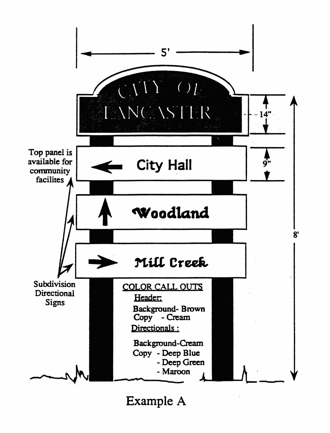
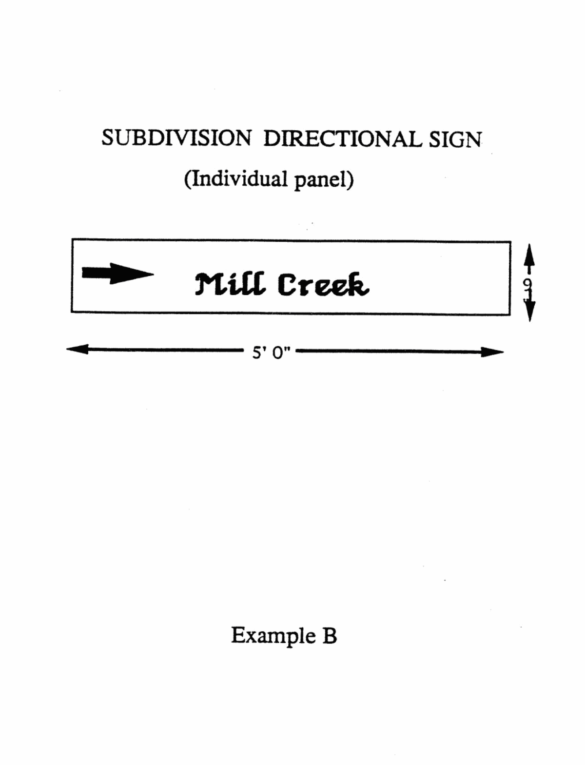
17.40.230 - Definitions.
As used in this chapter, the following words and phrases have the meanings set forth below:
"Artist" means an individual or team of individual artists whose body of work and professional activities demonstrate serious ongoing commitment to the fine arts. History of professional art exhibitions, auction record, and reputation in the professional art community are some factors that may assist in making a determination that an artist demonstrates such commitment. An applied artist or tradesperson does not constitute an artist as defined herein and for purposes of this chapter. Members of architectural, engineering, design or landscaping firms retained for the design and construction of a development project covered by this chapter shall not be considered artists for the purpose of meeting the requirement to provide public art.
"Artwork" or "work of art" means a visual work of art, as distinguished from the performing arts, media art and literary or cultural arts. The works of art may either be permanent or, in some circumstances, temporary, as required by the specific project, and installed in public view. For purposes of this chapter, "artwork" does not include a business-related work, as defined herein.
"Business-related work" means a visual representation of which more than twenty (20) percent of the overall image contains lettering or logo that is related to the business or establishment at which the visual representation is located. Business-related works are subject to the applicable sign permitting and approval provisions set forth in title 17 of the Lancaster Municipal Code.
"City" means the City of Lancaster.
"Code" means the Lancaster Municipal Code.
"Manual" means the art in public places program and manual approved by the city council, and as may be revised from time to time.
"Publicly visible art" means any permanent display of a work of visual art that was specifically designed to be located on private property within the city where it would be accessible to public view. The work of art may include, without limitation, murals, mosaics, sculptures, artist-designed landscape features, streetscape features and earthworks. For purposes of this article, temporary displays of artwork on private property are subject to the procedures and guidelines set forth herein.
(Ord. No. 1057, § 3, 3-26-2019)
17.40.240 - Art in public places program; manual.
A.
The city council has approved the art in public places program and the associated manual. The purpose of the program is to provide publicly accessible works of art for the benefit of the city, its citizens and its visitors, and to increase citizens' appreciation of art, improve the quality of life and enhance and identify the Antelope Valley as a unique community for its residents and visitors.
B.
General guidelines and criteria regarding publicly visible art, the procedure for application, review, approval, and private property owners' responsibilities concerning publicly visible art are set forth in the art in public places manual, as may be revised from time to time.
(Ord. No. 1057, § 3, 3-26-2019)
17.40.250 - Public art application fee.
A private property owner who wishes to install publicly visible art in the city shall submit an application in accordance with the procedures set forth in the program and manual, and shall tender the requisite fee as established by resolution, as may be amended from time to time.
(Ord. No. 1057, § 3, 3-26-2019)
17.40.260 - Violation; nuisance.
The city council declares that it is an unlawful for any person to install, erect, maintain or permit the maintenance of publicly visible art in a manner that is in violation of this chapter or the art in public places program and manual. Any such publicly visible art further constitutes a public nuisance subject to abatement in accordance with the procedures set forth in chapter 8.28 of this Code. The procedures for abatement shall not be exclusive and shall not limit or restrict the city from pursuing any other remedies available at law, or from abating or causing abatement of public nuisances in any other manner provided by law.
(Ord. No. 1057, § 3, 3-26-2019)
17.40.290 - In general.
The following criteria and standards set out in this article shall be applied to each type of recycling facility as appropriate whether the facility is a permitted use or use subject to director's review and approval.
(Prior zoning ord. § 710.000)
17.40.300 - Reverse vending machines.
Reverse vending machine(s) located completely within a commercial or industrial building need not comply with the following criteria and standards. Reverse vending machines do not require additional parking space for recycling customers. Such machines outside of a building shall comply with the following standards regardless of the zone in which it is located:
A.
Shall be established in conjunction with a commercial or industrial use or community service facility which is in compliance with this title and city building and fire codes;
B.
Shall be located within 30 feet of the entrance to the commercial structure on a surfaced site and shall not obstruct pedestrian or vehicular circulation;
C.
Shall not occupy parking spaces required by the primary use;
D.
Shall occupy no more than 50 square feet of floor space per installation, including any protective enclosure, and shall be no more than 8 feet in height;
E.
Shall be constructed and maintained with durable waterproof and rust-proof material. The color of the machine shall be compatible with the colors utilized on the site upon which it is located;
F.
Shall be clearly marked to identify the type of material to be deposited, operating instructions, and the identity and phone number of the operator or responsible person to call if the machine is inoperative;
G.
Shall have a sign area of a maximum of 4 square feet per machine, exclusive of operating instructions;
H.
Shall be maintained in a clean, litter-free condition on a daily basis;
I.
Operating hours shall be at least the operating hours of the primary use;
J.
Shall be illuminated to ensure comfortable and safe operation if operating hours are between dusk and dawn;
K.
Failure to comply with any standard shall be grounds for the director to order removal of the machines.
(Prior zoning ord. § 710.010)
17.40.310 - Small collection facilities.
Small collection facilities shall comply with the following standards:
A.
Shall be established in conjunction with a commercial or industrial use or community service facility which is in compliance with this title and city building and fire codes;
B.
Shall be no larger than 500 square feet and occupy a surfaced site;
C.
Shall be set back at least 10 feet from any street line and shall not obstruct pedestrian or vehicular circulation;
D.
Shall accept only glass, metals, plastic containers, papers and reusable items. Used motor oil may be accepted with written permission of the Los Angeles County department of health services, hazardous materials control program (213-744-3223);
E.
Shall use no power-driven processing equipment except for reverse vending machines;
F.
Shall use containers that are constructed and maintained with durable waterproof and rustproof material, the color of the containers shall be compatible with the colors utilized on the site upon which they are located, covered when site is not attended, secured from unauthorized entry or removal of material, and shall be of a capacity sufficient to accommodate materials collected and collection schedule;
G.
Shall store all recyclable material in containers or in the mobile unit vehicle, and shall not leave materials outside of containers when attendant is not present;
H.
Shall be maintained free of litter and any other undesirable materials, and mobile facilities, at which truck or containers are removed at the end of each collection day, shall be swept at the end of each collection day;
I.
Shall not exceed noise levels of 60 dBA as measured at the property line of residentially zoned or occupied property, otherwise shall not exceed 70 dBA;
J.
Attended facilities located within 100 feet of a property zoned or occupied for residential use shall operate only during the hours between 9 a.m. and 7 p.m.;
K.
Containers for the 24 hour donation of materials shall be at least 50 feet from any property zoned or occupied for residential use unless there is a recognized service corridor and acoustical shielding between the containers and the residential use;
L.
Containers shall be clearly marked to identify the type of material which may be deposited; the facility shall be clearly marked to identify the name and telephone number of the facility operator and the hours of operation, and display a notice stating that no material shall be left outside the recycling enclosure or containers;
M.
Signs may be provided as follows:
1.
Recycling facilities may have identification signs with a maximum of 20% per side or 16 square feet, whichever is larger, in addition to informational signs required under subsection L of this section; in the case of a wheeled facility, the side will be measured from the pavement to the top of the container.
2.
Signs must be consistent with the character of the location.
3.
Directional signs, bearing no advertising message, may be installed with the approval of the director if necessary to facilitate traffic circulation, or if the facility is not visible from the public right-of-way;
N.
The facility shall not impair the landscaping required by this title or any permit issued pursuant thereto;
O.
No additional parking spaces will be required for customers of a small collection facility located at the established parking lot of the primary use. One space will be provided for the attendant, if needed;
P.
Mobile recycling units shall have an area clearly marked to prohibit other vehicular parking during hours when the mobile unit is scheduled to be present;
Q.
Occupation of parking spaces by the facility and by the attendant may not reduce available parking spaces below the minimum number required for the primary use unless all of the following conditions exist:
1.
The facility is located in a convenience zone or a potential convenience zone as designated by the California Department of Conservation.
2.
A parking study shows that existing parking capacity is not already fully utilized during the time the recycling facility is expected to be on the site.
A reduction in available parking spaces in an established parking facility may then be allowed as follows:
For a commercial/industrial primary use:
For a community facility primary use:
A maximum 5 spaces reduction will be allowed when not in conflict with parking needs of the primary use;
R.
The following shall be grounds for the director to order the removal of the small collection facility:
1.
Failure to comply with any standard set forth in this section,
2.
A parking study shows that existing parking capacity has become fully utilized and the parking occupied by the facility is needed for the customers or clients of the primary use.
(Prior zoning ord. § 710.020)
17.40.320 - Large collection facilities.
A large collection facility is larger than 500 square feet, or is on a separate property not appurtenant to a primary use, and which may have a permanent building. Large collection facilities shall comply with the following standards:
A.
Facility does not abut a property zoned or planned for residential use.
B.
Facility will be screened from the public right-of-way by operating in an enclosed building or:
1.
Within a surfaced area enclosed by a masonry wall at least 6 feet in height with a 10 foot landscaped strip;
2.
At least 150 feet from property zoned or planned for residential use;
3.
Meets all applicable noise standards in this section.
C.
Setbacks and landscape requirements shall be those provided for the zoning district in which the facility is located.
D.
All exterior storage of material shall be in sturdy containers which are covered, secured and maintained in good condition, or may be baled or strapped to pallets. The color of the containers shall be compatible with the colors utilized on the site upon which they are located. Storage containers for flammable material shall be constructed of nonflammable material. Oil storage must be in containers approved by the fire and health departments. No storage, excluding truck trailers, overseas containers or other enclosed containers, will be visible above the height of the wall.
E.
Site shall be maintained free of litter and any other undesirable materials, and will be cleaned of loose debris on a daily basis.
F.
Space will be provided on site for 6 vehicles or the anticipated peak customer load, whichever is higher, to circulate and to deposit recyclable materials, except where the director determines that allowing overflow traffic above 6 vehicles is compatible with surrounding businesses and public safety.
G.
One parking space will be provided for each commercial vehicle operated by the recycling facility. Parking requirements will be as provided for in the zone.
H.
Noise levels shall not exceed 60 dBA as measured at the property line of residentially zoned property, or otherwise shall not exceed 70 dBA.
I.
If the facility is located within 500 feet of property zoned, planned or occupied for residential use, it shall not be in operation between 7 p.m. and 7 a.m.
J.
Any containers provided for after-hours donation of recyclable materials will be at least 100 feet from any property zoned or occupied for residential use, shall be of sturdy, rustproof construction, shall have sufficient capacity to accommodate materials collected, and shall be secure from unauthorized entry or removal of materials.
K.
Donation areas will be kept free of litter and any other undesirable material, and the containers will be clearly marked to identify the type of material that may be deposited; facility shall display a notice stating that no material shall be left outside the recycling containers.
L.
Facility will be clearly marked with the name and phone number of the facility operator and the hours of operation; identification and informational signs will meet the standards of the zone; and directional signs, bearing no advertising message, may be installed with the approval of the director, if necessary, to facilitate traffic circulation or if the facility is not visible from the public right-of-way.
M.
Power-driven processing, including aluminum foil and can compacting, baling, plastic shredding, or other light processing activities necessary for efficient temporary storage and shipment of material, may be approved at the discretion of the director if noise and other standards are met.
N.
Failure to comply with any standard set forth in this section shall be grounds for the director to order the closure/removal of the large collection facility.
(Prior zoning ord. § 710.030)
17.40.330 - Processing facilities.
Light (45,000 square feet or less) and heavy (greater than 45,000 square feet) recycling processing facilities shall comply with the following standards:
A.
Facility does not abut a property zoned or planned for residential use.
B.
Processors will operate in a wholly enclosed building except for incidental storage, or:
1.
Within a surfaced area enclosed on all sides by a masonry wall not less than 8 feet in height and landscaped on all street frontages;
2.
Located at least 150 feet from property zoned or planned for residential use.
C.
Power-driven processing shall be permitted, provided all noise level requirements are met. Light processing facilities are limited to baling, briquetting, crushing, compacting, grinding, shredding and sorting of source-separated recyclable materials and repairing of reusable materials.
D.
A light processing facility shall be no larger than 45,000 square feet and shall have no more than an average of 2 outbound truck shipments of material per day and may not shred, compact or bale ferrous metals other than food and beverage containers.
E.
A processing facility may accept used motor oil for recycling from the generator in accordance with Section 25250.11 of the California Health and Safety Code.
F.
Setbacks and landscaping requirements shall be those provided for the zoning district in which the facility is located.
G.
All exterior storage of material shall be in sturdy containers or enclosures which are covered, secured and maintained in good condition. Storage containers for flammable material shall be constructed of nonflammable material. Oil storage must be in containers approved by the fire and health departments. No storage, excluding truck trailers and overseas containers, will be visible above the height of the fencing.
H.
Site shall be maintained free of litter and any other undesirable materials, and will be cleaned of loose debris on a daily basis and will be secured from unauthorized entry and removal of materials when attendants are not present.
I.
Space shall be provided on site for the anticipated peak load of customers to circulate, park and deposit recyclable materials. If the facility is open to the public, space will be provided for a minimum of 10 customers or the peak load, whichever is higher, except where the director determines that allowing overflow traffic is compatible with surrounding businesses and public safety.
J.
One parking space will be provided for each commercial vehicle operated by the processing center. Parking requirements will otherwise be as mandated by the zone in which the facility is located.
K.
Noise levels shall not exceed 60 dBA as measured at the property line of residentially zoned or occupied property, or otherwise shall not exceed 70 dBA.
L.
If the facility is located within 500 feet of property zoned or planned for residential use, it shall not be in operation between 7 p.m. and 7 a.m. The facility will be administered by on-site personnel during the hours the facility is open.
M.
Any containers provided for after-hours donation of recyclable materials will be at least 100 feet from any property zoned or occupied for residential use; shall be of sturdy, rustproof construction; shall have sufficient capacity to accommodate materials collected; and shall be secure from unauthorized entry or removal of materials.
N.
Donation areas shall be kept free of litter and any other undesirable material. The containers shall be clearly marked to identify the type of material that may be deposited. Facility shall display a notice stating that no material shall be left outside the recycling containers.
O.
Sign requirements shall be those provided for the zoning district in which the facility is located. In addition, facility will be clearly marked with the name and phone number of the facility operator and the hours of operation.
P.
No dust, fumes, smoke, vibration or odor above ambient level may be detectable on neighboring properties.
Q.
Failure to comply with any standard set forth in this section shall be grounds for the director to order the closure/removal of the processing facility.
(Ord. 711 § 46, 1995; prior zoning ord. § 710.040)
17.40.340 - Purpose and intent.
The purpose of this article is to establish a uniform conditional use permit application and review process for the location, design and maintenance of hazardous waste facilities, and to ensure protection of the health, safety and welfare of the residents of city. All land use decisions made with regard to an application for a hazardous waste facility project shall be consistent with the approved Los Angeles County hazardous waste management plan.
(Prior zoning ord. § 711.010)
17.40.350 - Prohibition.
A person shall not use any premises for a hazardous waste facility except as permitted in this article. All hazardous waste facilities are subject to all regulations and conditions enumerated in this article.
(Prior zoning ord. § 711.020)
17.40.360 - Definitions.
For the purposes of this article, the following are defined. Additional definitions contained in Health and Safety Code Sections 25100 et seq. are incorporated herein by reference.
"Hazardous waste" is defined in the Health and Safety Code Section 25117.
"Hazardous waste facility" or "facility" is defined in Health and Safety Code Section 25117.1. Unless expressly provided otherwise, "hazardous waste facility" includes a "specified hazardous waste facility."
"Hazardous waste facility project" is defined in Health and Safety Code Section 25199.1(b). Unless expressly provided otherwise, "hazardous waste facility project" includes a "specified hazardous waste facility project."
"Land use decision" means any discretionary decision of the city council or planning commission concerning a hazardous waste facility project.
"Local assessment committee" or "LAC" means a 7-member public body appointed by the city council to represent the interests of the community in the hazardous waste facility project review process. The LAC shall be established and administered in accordance with Health and Safety Code Section 25199.7.
"Specified hazardous waste facility" is defined in Health and Safety Code Section 25199.1(m).
"Specified hazardous waste facility project" is defined in Health and Safety Code Section 25199.1(n).
(Prior zoning ord. § 711.030)
17.40.370 - Procedures.
The following procedures are established for all land use decisions relating to any hazardous waste facility project. All hazardous waste facility projects shall require a conditional use permit as set forth in Article I of Chapter 17.32. The planning commission shall act to recommend approval subject to conditions or denial of the conditional use permit to the city council. The city council shall act to approve subject to conditions or deny the conditional use permit.
A.
Specified Hazardous Waste Facility Projects. In addition to the procedures set forth in Health and Safety Code Section 25199 et seq., Public Resources Code Section 21000 et seq., and Government Code Section 65920 et seq., applicants for specified hazardous waste facility projects shall comply with the following requirements.
1.
Applicants shall submit to the director of community development (hereinafter referred to as the director) the application required by Section 17.40.380.
2.
In addition to the application contents required pursuant to section 17.40.380, all applications shall contain a proposed public education/participation program to be employed during the land use decision making process. Such plan shall be mutually agreeable to the project proponent and the director.
3.
A local assessment committee (LAC) shall be formed. In addition to its duties under Section 25199.7(d) of the California State Health and Safety Code, the LAC shall review the application and the environmental documentation, to solicit public comments on the application and recommend conditions to be attached to the conditional use permit. The person or entity preparing the documents required by the California Environmental Quality Act (CEQA) shall not be the same person or entity which acts as a consultant to the LAC.
B.
Hazardous Waste Facility Projects. In addition to the procedures set forth in Public Resources Section 21000 et seq. and Government Code Section 65920 et seq., applicants for hazardous waste facility projects (which are not specified hazardous waste facility projects) shall comply with the following requirements:
1.
Applicants shall submit to the director the application required by Section 17.40.380.
2.
At the request of the applicant, the director shall, within 90 days after the application has been deemed complete, issue an initial written determination on whether the project is consistent with the general plan, applicable provisions of this title, and has met the local environmental guidelines of the city for implementing CEQA. This determination will not prohibit the city council from making a different determination.
3.
A public hearing upon the application shall be set before the planning commission as soon as the director has determined that the application complies with all requirements of this title and all requirements by the city of Lancaster with regard to the CEQA have been met.
4.
Not later than one month prior to any public hearing, the applicant shall provide the director with 3 sets of mailing labels indicating all property owners of record (as shown on the latest county equalized assessment roll), residents, businesses, and tenants within a 2,000 foot radius of the boundary of the lot or lots on which the proposed hazardous waste facility will be located.
5.
A LAC need not be formed for all proposed on-site facilities. The director shall have 30 working days to make a determination that an application is complete for filing purposes. At the discretion of the city council and upon the recommendation of the director, a LAC may be formed for a proposed on-site storage or recycling facility which does not include an incinerator, or for any on-site facility for which an environmental impact report is not required.
(Prior zoning ord. § 711.040)
17.40.380 - Contents of applications.
Every application for a hazardous waste facility project shall be filed with the director and accompanied by a deposit in the amount set forth in Section 17.40.440. The application shall include, but not be limited to, the following information:
A.
Name(s), address(es) and telephone number(s) of the applicant(s);
B.
Evidence that the applicant is the owner of the premises involved or that the applicant has the written permission of the owner to make such application;
C.
Complete project narrative, demonstrating the need for siting the proposed hazardous waste facility in the specific location identified;
D.
A project analysis, plot plan, and development plan drawn to scale in sufficient detail to clearly illustrate the following:
1.
Physical dimensions of the property and structures, both existing and proposed,
2.
Site plan, indicating the initial project proposal and the ultimate land use layout and utilization of property,
3.
Location of existing and proposed structures,
4.
Setbacks and landscaping,
5.
Parking and circulation,
6.
Ingress and egress,
7.
Drainage patterns,
8.
Storage and processing areas,
9.
The distance to the nearest residences, to properties designated in the general plan for residential use, to proposed or presently zoned residential areas, and to immobile populations,
10.
The distance from the project property line to the nearest adjacent structures, and a description and location of such structures,
11.
Topographic description of the property and surrounding area within 2,000 feet of the boundary of the lot or lots on which the proposed facility will be located,
12.
Proximity of site to the 100-year floodplain boundary as established by FIRM or FEMA,
13.
Distance to all ground water supplies, dry washes, and rivers and aquifers,
14.
Proximity to pumping water wells or well fields, whether operational or not,
15.
Existing and proposed utilities which service or will be required to service the facility;
E.
An analysis of visual, noise and any olfactory impacts associated with the project and recommended mitigation measures;
F.
Identification of all wastewater, treated and untreated, generated by the proposed facility, and the method and place of final discharge;
G.
An analysis of all anticipated air quality impacts associated with the project and proposed mitigation measures to ensure no degradation of air quality occurs in the area;
H.
Identification of any rare or endangered species of plant or animals within the project site and surrounding area and recommended impact mitigation measures;
I.
Identification of the amounts (in tons), sources and types of hazardous wastes to be treated, stored or disposed of at the proposed facility, the ultimate disposition of the wastes, and anticipated life of the facility. This information shall be based on an actual survey of the industries to be served by the facility and thereby be representative of the wastes that will be processed at the facility;
J.
A risk assessment, including health and environmental risks, which analyzes in detail all possibilities and probabilities of accidents or spills involving hazardous materials or wastes to be used or stored at the site, transportation-related accidents from the point of origin to the facility, and other probabilities requested by either the director, the planning commission or the city council. Such analyses shall specify mitigation measures to reduce the identified risks. The risk assessment shall also identify the most probable routes for transporting hazardous waste to the facility, and identify provisions for automatic facility shutdown and resumption of facility operations in the event of adverse meteorological conditions, fire, flood, earthquake or other geologic or natural phenomena. The risk assessment conducted shall include information required under the Los Angeles County hazardous waste management plan and the standards for the use analysis shall be based on standards generally applied on a statewide and regional basis, by the U.S. Environmental Protection Agency, State Department of Health Services, and South Coast Air Quality Management District;
K.
The monitoring program required by Section 17.40.400. The monitoring program shall also include any monitoring requirements imposed by other permitting agencies including but not limited to, the South Coast Air Quality Management District (SCAQMD), Lahontan Regional Water Quality Control Board and the State Department of Health Services;
L.
A water consumption report for the project and proposed mitigation measures for water conservation to the city and to the local water purveyor;
M.
An emergency response plan as approved by the emergency preparedness coordinator which contains, at a minimum, the following information:
1.
That the proposed plan is consistent with any and all applicable county and regional emergency response plans and all city, county, state and federal regulatory requirements regarding emergency response procedures,
2.
Detailed procedures to be employed at the time of emergency for each and every type of chemical substance and emergency, including contingency procedures,
3.
Anticipated impacts on local fire, police and medical services,
4.
Names, home and business addresses, and home and business telephone numbers of all management personnel at the facility, and a detailed description of uncontrolled release and emergency situation reporting procedures;
N.
A completed city environmental assessment questionnaire;
O.
A land use map which depicts land uses within 2,000 feet of the boundary of the lot or lots on which the proposed facility will be located;
P.
A title report completed within 60 days of the date of facility application submittal;
Q.
Financial statements for the applicant including proposed means for financing the development of the facility, and anticipated costs and revenues associated with operation of the facility;
R.
Detailed information regarding how the applicant will meet state pollution liability insurance and state requirements for funding closure and post closure;
S.
Vicinity map which indicates, at a minimum, proximity of the facility to schools, parks, residences, hospitals, and other immobile populations, community facilities, and to properties designated by the general plan for residential use;
T.
A seismic and geological evaluation of the site must be conducted by a certified geologist/ seismologist which shall confirm, at a minimum, the following information:
1.
The proximity to earthquake fault zones,
2.
Whether or not active faults or lineaments which would suggest the presence of faults are located within 2,000 feet of the proposed site,
3.
A preliminary geological study of the property and surrounding area including a soils analysis location and description of known aquifers, regardless of the potability of those aquifers,
4.
Information as to whether ground subsidence and liquefaction have occurred or whether they may occur at the proposed site;
U.
Documentation of how the proposed facility will serve the needs of local producers of hazardous waste, including household hazardous waste.
(Prior zoning ord. § 711.050)
17.40.390 - Development standards and locational criteria for hazardous waste facilities.
All hazardous waste facilities shall comply with the following standards and locational criteria:
A.
Facilities shall be located in areas designated on the general plan land use map as heavy industrial, and shall only be permitted in the HI zone.
B.
No facility shall be permitted within 2,000 feet of residential zoned sites, hospital sites, school sites or sites planned for immobile populations unless the applicant proves through a risk analysis that a 2,000 foot buffer zone is not required to protect public health and safety. A separation greater than 2,000 feet may be required if determined necessary by a risk assessment.
C.
The site on which the facility is located shall be of adequate size and shape to accommodate yards, walls, parking, loading and storage, landscaping and other development requirements prescribed by this title. As a condition of the conditional use permit the proposed use would be required to interface appropriately with surrounding uses.
D.
All setbacks shall be landscaped. The minimum setbacks shall be 20 feet for front and street side yards. Landscape plans shall be subject to approval by the director.
E.
All hazardous waste facilities shall erect a minimum 8-foot high decorative block wall that shall not exceed 15 feet in height. The wall shall be set back at least 20 feet from the property line when located on street or highway frontage. The area between the wall and the sidewalk shall be fully landscaped. The decorative block wall shall be erected along the perimeters of the side and rear property line.
F.
No facility shall be placed within 200 feet of any known active earthquake fault or lineation suggesting the presence of a fault. The facility must be designed in such a manner to ensure structural integrity should a seismic event occur of up to 8.3 on the Richter Scale. If it is demonstrated that ground subsidence and/or liquefaction has occurred or may occur on the site, the proposed facility shall be engineered and designed to ensure structural stability in such an event.
G.
No facility shall be constructed in any area identified as being within a 100 year floodplain boundary established by FIRM or FEMA unless it is designed, constructed, operated and maintained to prevent inundation.
H.
No facility shall be placed within 500 feet of a dry wash or river, aqueduct, reservoir, supply well, or aquifer recharge area or within any area known or suspected on basis of a geological study to be supplying recharge to an aquifer unless design features are incorporated to avoid any potential for water contamination.
I.
Facilities generating wastewater shall be located in areas with adequate sewer capacity and treatment capability to accommodate the expected wastewater discharge.
J.
All facilities shall avoid locating in areas of potential rapid geologic change, or areas with high rate of subsidence and areas subject to liquefaction unless containment structures are designed, constructed and maintained in a manner acceptable to the director of public works and/or the city engineer so as to preclude failure as a result of such changes.
K.
All facilities shall locate in areas posing minimal threats to the contamination of drinking water supplies contained in reservoirs and aqueducts.
L.
All facilities shall be prohibited in areas of recreation, cultural or aesthetic value, as determined by the director.
M.
All facilities shall locate in areas where fire departments are able to quickly respond to hazardous materials accidents and where demonstrated emergency response times are deemed acceptable by the local fire department official. In addition, hazardous materials accident response services at the facility may be required based on the type of wastes handled or the location of the facility.
N.
All facilities shall be located so that distance traveled on city streets is kept to a minimum, and any routes to and from state or interstate highways to or from the facility are used primarily by trucks, and the number of nonindustrial structures (homes, hospitals, schools, etc.) along such routes is minimal. As part of conditional use permit approval, the city may impose limitations on the use of access routes to and from the facility by vehicles containing hazardous waste. This may include specifying the number and size of vehicles used and the hours of travel.
O.
All facilities shall comply with the provisions of the CEQA.
P.
Any modifications of the types and quantities of hazardous wastes to be managed at the proposed facility or significant modifications to the processes employed at the facility which were not considered in the original facility approval by the city, shall be presented to the director in writing. The proposed modifications may, at the discretion of the director, result in the approval of minor modifications to the process, or require revision of the facility's conditional use permit through a public hearing both before the planning commission and the city council, or may require a new application for the facility and a new conditional use permit.
(Prior zoning ord. § 711.060)
17.40.400 - Monitoring program.
All applications for hazardous waste facility projects shall include for approval a monitoring program that complies with the following requirements:
A.
For the purpose of ensuring compliance with all standards, conditions and other requirements, the city or its designated representative may enter the premises on which a hazardous waste facility permit has been granted.
B.
A provision for a periodic general review by the planning commission and/or city council of the applicant's compliance with the facility's conditional use permit, with provisions for modifying the existing conditions or adding new conditions, as appropriate.
C.
The owner or operator of a hazardous waste facility shall file a written quarterly report with the city, and to the Los Angeles County Department of Public Works. This report shall include, but not be limited to, the amount (in tons), type and disposition of all wastes processed by the facility. The report shall also include copies of all manifests showing the delivery and types of hazardous wastes and include a map showing the exact location by coordinates and elevation of the quantities and types of materials placed in repositories or otherwise stored or disposed of on site. The report shall also include information on hazardous waste releases to the air, water or soil, spills and injuries to facility personnel.
D.
The owner or operator of a hazardous waste facility shall immediately send copies of all complaints relating to the facility and/or the operation of the facility and copies of all inspection reports made by other local, state or federal agencies to the director who shall distribute copies to the Director of Public Works.
E.
The emergency response plan shall be updated annually, and all management personnel at the facility shall sign the plan acknowledging familiarity with the plan. The updated plan shall be distributed to all local emergency response agencies which includes, but is not limited to, the Los Angeles County sheriff's department, the Los Angeles County fire department, and to the emergency response staff for the city of Lancaster, the Los Angeles County health department and the Los Angeles County public works department.
F.
Immediate notification to the city of any unauthorized release to the air, water or soil from any facility.
G.
Payment of all monitoring costs. Such costs shall include but are not limited to preparation and administration of a CEQA mitigation monitoring program for the facility and administration of the monitoring program provided for in this section.
H.
The LAC may recommend to the city council that a separate body act as a "standing committee" to serve during the period in which facility is in operation to promote ongoing communication between the owner/operator and the community, and to monitor adherence to the requirements of this article.
(Prior zoning ord. § 711.070)
17.40.410 - General conditions.
A.
Prior to issuance of a certificate of occupancy, the applicant shall demonstrate to the satisfaction of the director that the applicant has met all of the financial responsibility requirements imposed by the state of California Department of Health Services, the city and any other state or federal agency.
B.
The applicant agrees to indemnify, defend, and hold harmless the city, the director, the planning commission, and the city council, and all officers, employees and agents of the city against and from all claims, actions or liabilities relating to the land use decision or arising out of its implementation at the facility location.
C.
All costs of compliance with this article shall be borne by the facility owner/operator.
D.
The city may employ any and all methods permitted by law to enforce this article.
E.
The owner/operator shall keep all equipment, buildings and the site in an orderly condition and in good repair and shall employ technological advances as may be required by the state of California Department of Health Services, the South Coast Air Quality Management District, the Federal Environmental Protection Agency, and any other agency required by law.
F.
The city council may impose, as necessary, conditions and standards other than those presented, in order to achieve the purposes of this article and to protect the environment and the public health, safety or general welfare.
G.
All studies, including the risk assessment, shall be made by a third party agreement administered through the city of Lancaster.
(Prior zoning ord. § 711.080)
17.40.420 - Duration of land use decision.
A.
The duration of the land use decision will be determined at the time of conditional use permit approval but shall not exceed 10 years.
B.
The conditional use permit may be renewed for an additional time period not to exceed 10 years, upon the submission of a new application in accordance with Section 17.40.380 and payment of processing and review costs as set forth in Section 17.40.440.
C.
If the applicant fails to commence operation of the facility within 2 years of the date of the land use decision, the conditional use permit shall expire.
D.
A comprehensive review of the facility will be required after every 5 years.
E.
Failure to comply with the conditions contained in the conditional use permit, to conduct the mitigation required by CEQA or failure to comply with the provisions of this article will be considered grounds for permit review and possible revocation at the discretion of the city council.
(Prior zoning ord. § 711.090)
17.40.430 - Costs.
The applicant will pay all costs related to city processing and review of the facility application; the preparation, review and administration of all documentation and programs prepared pursuant to the California Environmental Quality Act (CEQA); and all activities of the local assessment committee (LAC) related to the facility application review and processing.
(Prior zoning ord. § 711.100)
17.40.440 - Deposit.
An initial deposit amount to cover the costs set forth in Section 17.40.430 shall be set by resolution of the city council.
(Prior zoning ord. § 711.110)
17.40.450 - Variances.
No variance shall be granted to the requirements or conditions set forth in this article.
(Prior zoning ord. § 711.120)
17.40.460 - Findings.
The following findings shall be made in writing prior to the city council making a land use decision which will permit the development of a hazardous waste facility project:
A.
The proposed project is consistent with the city general plan and this title.
B.
The project will not be detrimental to the public health, safety or general welfare.
C.
The proposed facility is or will be served by roads and all other necessary public and private service facilities and utilities of adequate capacity to serve the proposed use. The circulation features serving the proposed facility are adequate in width and location, and are improved and located in such a manner as to provide for the safe transport of hazardous wastes to the proposed facility.
D.
The project has met or exceeded each requirement of this article.
E.
All environmental impacts identified in any environmental document prepared as part of the process to comply with the California Environmental Quality Act and this article are insignificant, have been mitigated, or are acceptable due to a statement of overriding considerations, and the mitigation measures (if any) will be monitored under a mitigation monitoring program.
F.
All the findings set forth in Article I of Chapter 17.32 have been met. Health risk and environmental risk assessments have been conducted for the proposed facility based on well-defined and credible assumptions detailing the results of a "worst-case" scenario as well as all other possible or probable accidents or spills at the proposed facility, which address both the potential threat to public health, safety and the environment posed by the proposed facility.
(Prior zoning ord. § 711.130)
17.40.470 - Severability.
If any section, sentence, clause or phrase of this article is, for any reason, held to be invalid or unconstitutional by a decision of any court of competent jurisdiction, such decision shall not affect the validity of the remaining portions of this article. The city council declares that it would have passed the ordinance codified in this article and each section, sentence, clause or phrase thereof, irrespective of the fact that any one or more sections, sentences, clauses or phrases may be declared invalid or unconstitutional.
(Prior zoning ord. § 711.140)
17.40.480 - Description and purpose.
The purpose of this article is to provide regulations for the location, design and use of mobilehomes for caretaker purposes.
(Prior zoning ord. § 713.110)
17.40.490 - Permit and application procedures.
A.
Upon the issuance of a conditional use permit and subject to all conditions imposed thereby and to the following regulations, a mobilehome may be used as a caretaker residence in the C, CBD, CPD, H, MPD, LI, MI, HI and BP zones, when the planning commission finds the granting of such conditional use permit will not adversely affect properties in the vicinity and will not be contrary to the public interest.
B.
Application. An application for a conditional use permit for a caretaker mobilehome shall include such materials as deemed necessary by the director to enable a complete analysis and appraisal of the proposal.
(Prior zoning ord. § 713.120)
17.40.500 - Permitted uses.
Permitted uses shall be limited to a one-family mobilehome for use by a caretaker and his immediate family on each legal parcel for which a conditional use permit is granted.
(Prior zoning ord. § 713.121)
17.40.510 - Accessory uses.
Accessory uses are limited to awnings, cabanas, ramadas, storage sheds or cabinets, fences or windbreaks, carports and porches.
(Prior zoning ord. § 713.122)
17.40.520 - Use and development standards.
A.
Density.
1.
A caretaker mobilehome and any accessory structures shall be included in calculating lot coverage by buildings in all commercial and manufacturing zones.
B.
Location.
1.
The placement of the mobilehome shall be at a location where the erection of residential structures is otherwise permitted by this title.
C.
Time Limitation.
1.
Any caretaker mobilehome shall be removed from the site prior to the end of 5 years from the date of the conditional use permit approval unless a lesser time period is specified by the commission.
D.
Automobile Parking. A garage is not required for a caretaker's mobilehome.
E.
Other Regulations.
1.
Approval of a conditional use permit for a mobilehome for use by a caretaker shall not relieve the applicant and his successors in interest from complying with all other applicable statutes, ordinances, rules and regulations.
(Prior zoning ord. § 713.150)
17.40.530 - Review for compliance.
Within one year subsequent to the granting of a conditional use permit for a mobilehome caretaker residence, and thereafter as needed, the director shall inspect such caretaker residence to insure compliance with all conditions of approval imposed by the planning commission. Failure of the applicant to comply with said conditions shall provide grounds for initiation of permit revocation procedures by the planning commission.
(Prior zoning ord. § 713.160)
17.40.540 - Recreational trailer parks.
Every conditional use permit for a recreational trailer park in the C zone shall be subject to the following conditions. All of the following conditions shall be deemed to be conditions of every conditional use permit granted for a recreational trailer park whether or not such conditions are set forth in the conditional use permit. The commission in granting the conditional use permit may impose additional conditions but may not change or modify any of the following conditions except as provided by Article II of Chapter 17.32.
A.
Area. The recreational trailer park shall have an area of not less than 5 acres.
B.
Density. The density of the recreational trailer park shall not exceed 30 lots per acre.
C.
Minimum Lot Size. No recreational vehicle lot shall have an average area of less than 1,000 square feet.
D.
Signs. Signs shall be in accordance with the requirements of the C zone or as specified by the planning commission.
E.
Duration of Occupancy. Occupancy by any one occupant and party shall be limited to 90 consecutive days within any 6-month period.
F.
Prohibitions.
1.
No permanent residency shall be permitted within the recreational trailer park except for a caretaker, manager or employees responsible for maintaining and/or operating the property, as permitted by the zone and authorized by the commission as a part of the conditional use permit approval.
2.
A recreational trailer park shall have no dwelling units except that of a caretaker, manager or employees responsible for maintaining and/or operating the property, as permitted by the zone and authorized by the commission as a part of the conditional use permit approval.
3.
Facilities within the recreational trailer park shall be used only by the occupants of the park except where otherwise authorized by the commission as part of the conditional use permit approval.
4.
Recreational vehicle lots shall not be used for any commercial activity by the occupants.
5.
There shall be no principal commercial uses within the recreational trailer park except as permitted by the zone and authorized by the commission as part of the conditional use permit approval. This provision does not prohibit accessory uses where authorized by the commission as part of said conditional use permit approval, including, but not limited to, areas for the storage of unoccupied recreational vehicles.
G.
Other Regulations. Approval of a conditional use permit for a recreational trailer park shall not relieve the applicant and his successors in interest from complying with all other applicable statutes, ordinances, rules and regulations.
(Prior zoning ord. § 713.2)
17.40.550 - Travel trailer parks.
Every conditional use permit for a travel trailer park in the C zone shall be subject to the following conditions. All of the following conditions shall be deemed to be conditions of every conditional use permit granted for a travel trailer park whether or not such conditions are set forth in the conditional use permit. The commission in granting the conditional use permit may impose additional conditions but may not change or modify any of the following conditions except as provided by Article II of Chapter 17.32.
A.
Density. The density of the travel trailer park shall not exceed 30 lots per acre.
B.
Minimum Lot Size. No travel trailer lot shall have an average area of less than 1,000 square feet.
C.
Location Within Mobilehome Parks. Where a travel trailer is located within a mobilehome park, it shall be a separate designated section of the mobilehome park and shall be so designated.
D.
Signs. Signs shall be in accordance with the requirements of the C zone or as specified by the planning commission.
E.
Duration of Occupancy. Occupancy by any one occupant and party shall be limited to 90 consecutive days in any 6-month period.
(Prior zoning ord. § 713.3)
17.40.560 - Purpose and intent.
The purpose and intent of this article shall be to establish standards for the use and placement of commercial coaches as temporary offices in the city. These provisions do not apply to temporary construction offices.
(Prior zoning ord. § 716.010)
17.40.570 - Applicability.
These specific standards are applicable for commercial coaches as temporary offices in all zones where they are allowed.
(Prior zoning ord. § 716.030)
17.40.580 - Standards.
When commercial coaches are used as temporary offices, they shall be reviewed by the director and shall meet the following standards:
A.
Commercial coach offices shall not be moved onto the site until building, electrical and plumbing permits have been obtained.
B.
The commercial coach shall have been manufactured after November 23, 1970, and have been issued an insignia of approval by the California Department of Housing and Community Development.
C.
The commercial coach shall not have been altered in violation of applicable codes.
D.
All commercial coach offices shall be skirted or recessed into the ground.
E.
All commercial coach offices shall be connected to water, approved sewerage system and other utilities. EXCEPTION: Temporary subdivision sales offices are not required to connect to a water and sewerage system, however, such offices shall be provided with temporary sanitary facilities. The offices and any temporary sanitary facilities shall be removed upon completion of the model home(s) which are used as a sales office for the project or after a period of one year whichever occurs first unless such office is connected to the water and sewerage system. Such offices shall not be eligible for any extensions as provided under subsection K of this section.
F.
The commercial coach office shall be placed to comply with any yard requirements of the zone in which it is located.
G.
The required amount of improved parking spaces shall be provided.
H.
A handicap access ramp shall be provided to all commercial coach offices.
I.
No accessory structures shall be allowed.
J.
A moving permit shall be obtained from the city if the commercial coach is moved within the city or from the county if it is moved from the county into the city.
K.
A time limit of 2 years shall be placed on each commercial coach as a temporary office. One extension of up to one year may be granted by the director.
(Prior zoning ord. § 716.040)
17.40.590 - Purpose and intent.
In view of the rising costs of fossil fuels and thus electricity, the urgent need for alternative energy resources is a vital concern to the residents of the city. Harnessing the wind's energy is becoming an attractive energy alternative. In consideration of public health, safety and welfare, the eventual construction and siting of wind energy conversion systems, hereafter referred to as WECS, shall meet the standards established in this article.
(Prior zoning ord. § 717.010)
17.40.600 - Applicability.
These specific standards are applicable for all wind energy conversion systems in zones in which they are allowed, or allowed subject to the granting of a conditional use permit.
(Prior zoning ord. § 717.020)
17.40.610 - Standards.
The following standards shall apply to all wind energy conversion systems:
A.
Automatic Overspeed Control. Any WECS shall have an automatic overspeed control which shall be designed to protect the system from sustaining structural failure, such as thrown blades and the overturning or breaking of towers due to an uncontrolled condition brought on by abnormally high winds.
B.
Manual Shutdown. The WECS shall have a manually operable method that assures WECS shutdown. Acceptable methods include mechanical or hydraulic brakes or tail-vane deflection systems which turn the rotor out of the wind. (Shutdown is defined to mean a safe condition for WECS which is not its power-producing mode but either protects the WECS from unusual circumstances or protects those working on the machine.)
C.
Blade Height. The minimum distance between the ground and any protruding blades utilized on a WECS shall be 15 feet for horizontal axis WECS and 10 feet for any vertical axis WECS as measured to the lowest point of blade travel/motion.
D.
Tower Safety. WECS towers and supporting structures shall be designed and constructed in accordance with accepted engineering standards and applicable city building codes and shall be approved by the city engineer as to safety and suitability.
1.
Tower heights of not more than 65 feet shall be allowed on parcels between one and 5 acres and tower heights of not more than 80 feet shall be allowed on parcels of 5 acres or more, provided that the application includes evidence that the proposed height does not exceed the height recommended by the manufacturer or distributor of the system.
2.
Roof-Mounted WECS. Devices or towers mounted on buildings may require strengthening of the existing structure to bear the additional weight and stress created by the WECS for which a building permit shall be obtained.
3.
Ground-Mounted WECS. Ground-mounted WECS shall not be permitted in required front or side yards (setbacks). WECS in rear yards shall not be counted against lot coverage.
E.
Tower Access. Climbing access to the ground-mounted WECS tower shall be limited in one of the following ways:
1.
By means of a fence or wall not less than 6 feet in height with locking gates enclosing the yard where the tower is located;
2.
By means of a fence or wall not less than 6 feet in height with a locking gate around the base of the tower; or
3.
By limiting tower climbing apparatus to no lower than 12 feet from the ground for horizontal axis WECS and 10 feet for vertical axis WECS.
F.
Decibel levels for the WECS shall not exceed 60 decibels (dBA) as measured at the closest neighboring inhabited dwelling, except during short-term events such as utility outages and severe wind storms.
G.
Electro-Magnetic Interference. The WECS shall not cause radio and/or television broadcasting or reception interference to the surrounding area.
H.
Setbacks. If the structural design is approved by the city engineer as to the safety and stability, the WECS shall not be erected nearer to any lot line than the tower height.
I.
Guy Wires. For towers which require guy wires, anchor points for guy wires shall be located within property lines and not on or across any above ground electric transmission or distribution line.
J.
Electrical Safety. The electrical box or any hazardous components of the WECS within ground reach shall be securely locked.
K.
Signs. At least one sign shall be posted at the base of the tower warning of electrical shock or high voltage.
(Ord. 804 (part), 2002; Prior zoning ord. § 717.030)
17.40.620 - Required conditions.
Required conditions of approval for the permit shall include but not be limited to the following:
A.
Required permits shall be obtained from building and engineering services prior to installation of the WECS.
B.
Every WECS shall be insured for an amount sufficient to protect neighboring property owners in the event of mechanical or structural failures.
C.
For utility interconnected WECS, Southern California Edison (SCE) shall be notified in writing of any proposed connection and SCE shall give written approval to such interconnection prior to installation.
D.
Documentation shall be provided from the WECS manufacturer or a recognized testing facility indicating that the system will operate safely in Lancaster, California, atmospheric conditions. Suitable documentation attesting to the ability of the WECS to meet the standards of this section will be determined by the city engineer. Documentation considered suitable includes but is not limited to WECS and tower assembly designs bearing the stamp of a California registered civil or mechanical and electrical engineer attesting to the WECS compliance with the standards of this section.
E.
Any WECS which ceases to be operable for a period of 60 days shall be removed within 6 months of the date it became inoperable.
F.
Any WECS not in compliance with subsection D of this section is subject to a setback from all occupied buildings a distance at least equal to that shown in Figure 1 based on the WECS rotor diameter.
G.
Notice of an application for installation of a WECS shall be provided to property owners within 300 feet of the property on which the system is to be located.
H.
The system shall comply with all applicable Federal Aviation Administration requirements, including Subpart B (commencing with Section 77.11) of Part 77 of Title 14 of the Code of Federal Regulations regarding installations close to airports, and the State Aeronautics Act ((Part 1 (commencing with Section 21001) of Division 9 of the Public Utilities Code)).
I.
The application shall include a line drawing of the electrical components of the system in sufficient detail to allow for a determination that the manner of installation conforms to the National Electric Code.
(Ord. 804 (part), 2002; Prior zoning ord. § 717.040)
17.40.630 - In general.
Structures such as chimneys, domes, elevator shaft housing, spires, steeples, towers, and similar objects not used for human occupancy are not subject to the height limitations of this title. However, this section does not apply to signs or wind energy conversion systems.
(Prior zoning ord. § 718.000)
17.40.640 - Purpose and intent.
A.
The purpose and intent of this article shall be to establish standards for the placement and use of wireless telecommunication facilities in all zones in which they are allowed within the City of Lancaster. These requirements provide incentives for well-designed and well placed telecommunication facilities by simplifying and shortening the review process, where warranted, while at the same time protecting the public interest. It is the City's intent, in establishing these standards, to allow for the development of wireless communication facilities where needed in accordance with the Telecommunications Act of 1996, while maintaining development standards and permitting requirements consistent with state law.
(Ord. No. 1070, § 4(Exh. A), 1-14-2020)
17.40.650 - Applicability.
These standards are applicable to all wireless telecommunication facilities in all zones and in the public right-of-way where they are allowed. These standards do not apply to noncommercial radio or television antennas, which shall be subject to the specific requirements for the zone in which they are located.
(Ord. No. 1070, § 4(Exh. A), 1-14-2020)
17.40.660 - Permit Requirements.
A.
Mini, Minor, Stealth and Major wireless communication facilities shall require a Directors Review unless they exceed the allowed height for the zone in which they are located. In the event height is exceeded, a Conditional Use Permit shall be required. All wireless communication facilities shall comply with the development standards and submittal requirements identified within this Article.
B.
Major wireless communication facilities in the residential zones shall require a Conditional Use Permit.
C.
Wireless communication facilities on City property or within the public right-of-way shall comply with the required permitting process as indicated in Lancaster Municipal Code Sections 17.40.665-17.40.666
(Ord. No. 1070, § 4(Exh. A), 1-14-2020)
17.40.661 - Collocations.
A.
Notwithstanding any other provision of this Chapter, the collocation of a new wireless communication facility on an existing major wireless communication facility that (i) was approved after January 1, 2007, by discretionary permit; (ii) was approved subject to an environmental impact report, negative declaration, or mitigated negative declaration; and (iii) otherwise complies with the requirements of Government Code §65850.6(b) for wireless communication collocation facilities shall not be required to obtain another discretionary permit approval, but shall be required to obtain all other applicable non-discretionary permit(s), as specified by this Title and the City-adopted Building Code, provided such collocation does not increase the height or change the location of the existing wireless facility or otherwise change the bulk, size, or other physical attributes of the existing permitted wireless communication facility.
B.
The proposed collocation of a new wireless communication facility on an existing minor or major wireless communication facility that meets all of the requirements stated in the above paragraph may include new appurtenant equipment boxes or shelter units that are colored and/or disguised to match the existing equipment boxes or shelter units and that do not exceed the total volume of equipment boxes utilized by the existing wireless communication collocation facility per Section 6409 (a).
C.
The proposed collocation of a new wireless communication facility on an existing major wireless communication facility that meets all of the requirements stated in the above paragraphs may not include the following:
1.
More additional surface area of antennas than is being utilized by the existing wireless communication collocation facility, provided all antennas are colored and/or disguised to match the existing facility.
2.
Any additional tower or additional support structure than is shown in plans and specifications to be reasonably necessary to collocate the permitted antenna panels on the existing wireless communication facility. Unless otherwise approved in writing by the Director, and except as provided in this subsection, installation of all collocation accessory equipment and enclosures shall comply with the requirements of this Chapter.
D.
Except as otherwise provided above, a Director's Review may be required when the proposed collocation facility:
1.
Increases the height of the existing permitted tower/structure or otherwise changes the bulk, size, location, or any other physical attributes of the existing permitted wireless communication facility; or
2.
Adds any microwave dish or other antenna not expressly permitted to be included in a collocation facility by this Section; or
3.
Collocates on an existing legally permitted wireless communication facility; or
4.
Will serve or be operated by more than one wireless services provider, unless an additional provider has properly obtained a written authorization from the Director after consideration of the factors applicable to administrative approval of collocation facilities set forth above in this Section, the size of the additional, proposed facility, and the potential visual or other impact of the proposed facility.
(Ord. No. 1070, § 4(Exh. A), 1-14-2020)
17.40.662 - Development Criteria.
A.
Screening and Site Selection Guidelines. The following screening and site selection guidelines apply to all wireless communication facilities:
1.
Stealth facilities and concealed antennas are preferred.
2.
Wireless communications facilities shall be located where the existing topography, vegetation, buildings, or other structures provide the greatest amount of screening. Where insufficient screening exists, applicants shall provide screening satisfactory to the Development Services Director, or as otherwise required herein.
3.
Ground-mounted wireless communications facilities shall be located only in close proximity to existing above-ground utilities, such as electrical towers or utility poles (which are not scheduled for removal or undergrounding for at least 18 months after the date of application), light poles, trees of comparable heights, and in areas where they will not detract from the appearance of the City.
B.
Wireless communication facilities shall be located in the following order of preference:
1.
Collocated with existing wireless communications facilities.
2.
On existing structures such as buildings, communication towers, or utility facilities.
3.
On an existing signal, power, light, or similar kinds of poles.
4.
In industrial zones.
5.
In commercial zones.
6.
In residential zones, subject to additional restrictions set forth herein.
C.
When located on any existing non-residential building or structure or on any existing utility pole provided such location complies with all of the following:
1.
The collocation is in full compliance with the California Public Utilities Commission Joint Pole Association General Order 95, Rule 94, and any other applicable state or federal regulations; and
2.
Existing Major Wireless Communications Facility to be utilized for collocation shall previously be granted with a Conditional Use Permit or a Director's Review approval, including modification of an existing Conditional Use Permit or Director's Review: and
3.
All accessory equipment and enclosures shall be located underground or screened from public view as approved in writing by the Director; and
4.
Unless shown in the submitted application documentation to not be technically and/or commercially feasible, all antennas and/or antenna panels shall be flush mounted and limited in number to that amount necessary to achieve the required coverage described in said documentation.
5.
The proposed facility will replace or modify an existing facility for purposes of collocation.
6.
The proposed facility will be designed and constructed in a manner to allow for future collocation of an additional wireless communication carrier provided the applicant submits written documentation that shows:
A more preferable location, as determined by reference to Section 17.40.662 (2) cannot be reasonably accommodated by the applicant due to technical requirements of the proposed facility including, but not limited to, coverage requirements imposed by the Federal Communications Commission (FCC) or otherwise by law, or due to other factors beyond the applicant's reasonable control. For the purposes of this Chapter, all distances shall be measured in a straight line without regard to intervening structures, from the nearest point of the proposed Major Wireless Communications Facility to the nearest property line of any residential land use, or to the nearest point of another Major Wireless Communications Facility.
D.
General Development Requirements.
1.
As part of the application process, each wireless communications facility applicant may, at the discretion of the Director, be required to provide written documentation demonstrating good faith efforts in locating facilities in accordance with the Site Selection Guidelines (order of preference). Such documentation shall include at minimum a coverage map (before and as proposed) and analysis of alternative sites.
2.
Wireless communications facilities shall not bear any signs or advertising devices other than certification, warning, or other required seals or legally required signage. Advertising of any kind on the facility is prohibited.
3.
All accessory equipment associated with the operation of the wireless communications facility shall be located within a building, enclosure, or underground vault that complies with the development standards of the zone in which the accessory equipment is located, subject to City approval. If the equipment is permitted to be located above ground, it shall be visually compatible with the surrounding buildings and include sufficient landscaping to screen the structure from view.
4.
Wireless communications facilities shall be subdued colors and non-reflective materials, which blend with surrounding materials and colors.
5.
All screening for building-mounted facilities shall be compatible with the existing architecture, color, texture, and/or materials of the building.
6.
Monopoles and antennas shall be no greater in diameter or other cross-sectional dimensions than is necessary for the proper functioning of the wireless communications facility. The applicant shall provide documentation satisfactory to the Director establishing compliance with this subsection.
7.
Proof of Federal Communications Commission and Federal Aviation Administration approvals shall be provided prior to building permit issuance.
8.
Where possible, wireless telecommunication facilities shall be integrated into the design of the existing buildings on-site.
9.
Wireless telecommunication facilities, including equipment buildings and cabinetry shall be treated to match existing buildings on-site.
10.
Wireless telecommunication facilities shall be painted with a non-reflective finish in a color to be determined by the approving authority which best matches the background environment color. Primarily, colors shall be light blue where the predominant background for the structure is above the horizon and beige where the background is the mountains or desert.
11.
Lighting, other than required safety lights, is prohibited.
12.
Construction and operation of a wireless telecommunication facility shall meet the noise standards identified in the City of Lancaster's General Plan (Table 3-1) and adhere to the City's Noise Ordinance (Chapter 8.24 of the Lancaster Municipal Code). A detailed noise study by a qualified acoustical engineer may be requied to document that the noise levels meet the required levels and to determine any necessary attenuation measures.
13.
Anti-climbing devices are required.
14.
Any required parking or landscaping displaced by the construction of a wireless telecommunication facility shall be replaced on-site or additional review for off-site parking shall be required. Landscape plans shall be submitted according to the most recent landscape ordinance, as necessary.
15.
Wireless telecommunication facilities shall not be placed where they will cause interference with the operation of other wireless telecommunication facilities, wind energy conversion systems or solar power systems.
The Development Services Director, or their designee, or the Planning Commission, as appropriate, can require additional design criteria or other information as deemed necessary to integrate the proposed wireless telecommunication facilities with the surrounding area.
(Ord. No. 1070, § 4(Exh. A), 1-14-2020)
17.40.665 - Submittal Requirements for Wireless Telecommunication Facilities within the Public Right-of-Way.
A.
All wireless telecommunication facilities which are installed, erected, co-located, or modified within the City right-of-way following the effective date of the ordinance codified in this chapter shall conform to the following requirements.
B.
All equipment shall be associated with a specific provider and the GPS coordinates of any nodes to be connected to must be provided. No applications will be accepted for equipment if the provider is not identified in advance and the GPS coordinates of the connecting nodes are not provided.
C.
Wireless facilities applications proposed for location in the public right-of-way that conform to the requirements in Section 17.40.675 shall be submitted to the Development Services Department for processing. Any request for a deviation from the requirements shall require the Director of Development Services' review and approval.
D.
Any applicant that seeks approval for five or more wireless telecommunications facilities in the public right-of-way within a 24-month period, either individually or cumulatively, shall submit a Director's Review application. Approved facilities shall require subsequent individual permitting from Building and Safety.
E.
Installation of wireless telecommunications facilities within the City right-of-way will be permitted subject to issuance of a Master Telecommunications Agreement, encroachment permit, and payment of applicable permit fees. The City Engineer or his designee will review and approve encroachment permit applications from carriers which hold a Certificate of Public Convenience and Necessity (CPCN) from the California Public Utilities Commission (CPUC) subject to the criteria contained in this section. A Removal or Relocation Security, and a certificate of general liability insurance and commercial automobile liability insurance in a form and amount acceptable to the City must be submitted prior to issuance of the permit, and maintained for as long as the facilities exist within the City right-of-way.
F.
In addition to the requirements found in this chapter, every wireless telecommunication facility request within the public right-of-way must be accompanied by the following prior to review:
1.
Elevations showing the height of the proposed facility, location and placement of any related equipment, and the height of other structures within a 60-foot radius from the proposed location;
2.
A completed Master Telecommunications Agreement;
3.
Photos of the site with a rendering of the proposed facility taken from a minimum of three directions;
4.
A written description and map identifying the location of the proposed facility in relation to all existing and planned facilities within a two (2) mile radius maintained within the City by each of the applicant, operator, and owner, with an explanation of the facility's purpose to address service coverage or capacity, and graphic and/or written evidence which demonstrates the inability of existing facilities to meet the need met by the new facility.
(Ord. No. 1070, § 4(Exh. A), 1-14-2020)
17.40.666 - Development and Design Standards for Wireless Telecommunication Facilities in the Public Right-of-Way.
All wireless telecommunications facilities that are located within the public right-of-way shall be designed and maintained as to minimize visual, noise, and other impacts on the surrounding community and shall be planned, designated, located, and erected in accordance with the following:
A.
Wireless telecommunication facilities in the public right-of-way shall not alter vehicular circulation or parking in the public right-of-way, nor impede vehicular or pedestrian access or visibility along any public right-of-way. No facility shall interfere with the use of City property or the public right-of-way, no any City or public utility facility located in the public right-of-way, no any reasonable expectation of future City, general public, or public utility use of the public right-of-way. Any such facility shall be moved, permanently or temporarily, at the permittee's expense, as determined by the Director of Development Services.
B.
In no case shall a new facility be erected adjacent to vacant land unless there is an approved project or site plan associated with the parcel and the applicant assumes responsibility for moving the facility, permanently or temporarily, at the permittee's expense, should the facility become incompatible due to revision or cancellation of the project or plan, as determined by the Director of Development Services. If the facility is required to be to be moved, the permittee has 180 days (6 months) to move the facility from the date of notification.
C.
Location. Wireless telecommunication facilities in the public right-of-way shall be developed in the following manner in order of preference:
1.
Co-located on an existing City-owned light pole in any zone except residential, provided the facility conforms to the design guidelines and is located on a primary or secondary arterial street. The permittee shall enter into a facilities lease agreement with the City for the use of the pole.
2.
A new light pole in any zone except residential, provided the facility conforms to the design guidelines, is located on a primary or secondary arterial street, and is proposed in a location with an approved site plan or map that is in the permitting process at the time of application.
3.
A co-located facility, replacement light pole, or new light pole proposed in a residential zone shall require a Director's Review.
D.
Design.
1.
Wireless communication facilities shall not bear any signs or advertising devices other than certification, warning, or other required seals or required signage.
2.
All antennas shall meet the minimum siting distances to habitable structures required for compliance with Federal Communications Commission (FCC) regulations and standards governing the environmental effects of radio frequency emissions.
3.
No more than one (1) antenna assembly may be attached to a light pole.
4.
All cabling and wiring shall be run through the interior of the pole. No exposed slack or extra cable is allowed.
5.
An antenna assembly must be mounted to the top of the pole, or flush to the pole near the top.
6.
A flush-mounted antenna assembly may not exceed a total volume of 3 cubic feet. A cylindrical antenna assembly shall not exceed 5 feet above the existing height of a light pole or 50% larger than the top diameter of the pole, whichever is less, unless additional separation is required for conformance with CPUC General Order 95 clearance requirements.
7.
No portion of the antenna or transmission equipment mounted on a pole may be less than 16 feet above any road surface to minimize potential safety conflicts with users of said roadway.
8.
All parts of the antenna assembly shall be completely shrouded with no exposed components or mounting apparatus.
9.
The facility shall comply with all applicable sections of the City of Lancaster's adopted Building Code.
10.
Replacement Poles. If an applicant proposes to replace a pole in order to accommodate a proposed facility, the pole shall be designed to resemble the appearance and dimensions of existing poles near the proposed location, including size, height, color, materials, and style to the maximum extent feasible.
11.
New Poles. The model of new pole shall be determined by the City and will be either a) the same model and manufacturer normally required for the location, or b) the equivalent to a Replacement Pole for the required model should that model not be able to accommodate the facility.
E.
Support Equipment. To preserve community aesthetics, all facility equipment, excluding antennas, aboveground vents and the smallest possible electrical meter boxes, shall to the greatest extent possible be required to be located underground, flush to the finished grade, shall be fully enclosed, and not cross property lines. Equipment may include, but not be limited to, the following: meter pedestals, fiber optic nodes, radio remote units or heads, power filters, cables, cabinets, vaults, junction or power boxes, and gas generators. Wherever possible, electrical meter boxes related to wireless facilities shall be appropriately screened, not visible to the general public, and located in less prominent areas within the public right-of-way. Where it can be demonstrated that undergrounding of equipment is infeasible due to conflict with other utilities, the City Engineer may approve alternative above grade equipment mounting, including pole mounting, when adequately screened from public view. Any approved above grade equipment must be located so as not to cause any physical or visual obstruction to pedestrian or vehicular traffic, or to otherwise inconvenience public use of the right-of-way, or create safety hazards to pedestrians or motorists.
(Ord. No. 1070, § 4(Exh. A), 1-14-2020)
17.40.668 - Removal of Wireless Telecommunication Facilities within the Public Right-of-Way.
A.
Any wireless telecommunication facility in the public right of way may at any time be required to be removed and/or relocated by the City at the owner's expense for any reason including, but not limited to, street reconstruction or widening.
B.
In the event that the wireless telecommunication facility is deemed to be unsafe or unstable due to damage as a result of an act of nature (e.g., severe wind storm, etc.), vandalism, or any other such incident, the facility shall be removed immediately. If the owner of the telecommunications facility does not remove the facility immediately as requested, the City shall remove the structure and bill the owner. The owner shall have the right to rebuild the structure in the same location
(Ord. No. 1070, § 4(Exh. A), 1-14-2020)
17.40.670 - Submittal Requirements for Wireless Telecommunication Facilities on Private Property.
A.
Prior to review, every wireless telecommunication facility request must be accompanied by the following:
1.
A site plan showing the locations of existing structures, parking facilities, driveways, landscaping, conduit, fiber, and other relevant infrastructure and information on-site as well as the location of adjacent buildings and structures within a distance equal to the height of the proposed facility or 60 feet, whichever is greater, measured from the base of the support structure;
2.
Detailed engineering plans for the proposed facility including GPS coordinates on a Datum, Reference and at an accuracy acceptable to the City; and depth and size of all conduit and fiber locations;
3.
Elevations showing the height of the proposed facility, cabinetry or equipment buildings supporting the facility, and the height of other structures on-site;
4.
Property owner's authorization for establishment of a wireless telecommunication facility. Include a copy of the lease agreement with a statement regarding liability for future removal of the structure;
5.
Proof of Federal Communications Commission licensing;
6.
A map or narrative of other facilities proposed or existing to support the proposed facility including identification of the carrier the connection is being made for and the GPS coordinates of the nodes being connected to.
B.
Prior to review, major wireless telecommunications facilities (including stealth and co-located facilities) must be accompanied by the following:
1.
Photos of the site taken from a minimum of four directions with an emphasis on the worst case scenario as seen from the most visually sensitive adjacent use or street right-of-way.
2.
A rendering of the proposed facility superimposed upon a photograph of the site.
3.
A siting statement describing the method used to determine the height and location of the facility. Describe how other alternative sites would not be feasible.
4.
A co-location statement, which is a written statement indicating that the applicant will accept collocation of other wireless telecommunication facilities at the proposed location in good faith and that an exclusive lease agreement will not be signed between the owner of the property and the wireless telecommunication facilities provider.
5.
Proof of Public Utilities Commission license for the applicant to provide service in this area.
(Ord. No. 1070, § 4(Exh. A), 1-14-2020)
17.40.675 - Work Standards.
A.
All work shall be done in a good and skillful manner, subject to the inspection and reasonable satisfaction of the City. All work shall comply with standards imposed by City ordinance and be conducted with the least possible hindrance or interference to the public right-of-way and City property. The telecommunications facility shall occupy the smallest space necessary and be installed in such a manner as to not unreasonably hinder the future installation of co-located facilities.
B.
The operator/applicant shall be responsible for any damage to City street pavement, existing utilities, curbs, gutters, sidewalks or to any private property or improvements, including but not limited to subsidence, cracking, erosion, collapse, weakening, or loss of lateral support, to the extent caused by its installation, maintenance, repair or removal of its wireless telecommunication facility and shall repair, replace and restore in kind any such damaged facilities at its sole expense and to the reasonable satisfaction of the City.
C.
If the public right-of-way to be utilized has preexisting installation(s) placed in said right-of-way, the operator/applicant shall assume the responsibility to verify the location of the preexisting installation and notify City and any third part of the proposed installation. The reasonable cost of any work required of such third party or City to provide adequate space or required clearance to accommodate the installation shall be borne solely by the operator/applicant.
D.
The operator/applicant shall be responsible for ensuring that the work of employees, contractors, subcontractors, agents, representative and permitted assigns is performed consistent with applicable laws and shall be responsible for acts or omissions of such third parties including responsibility for promptly correcting acts or omissions.
(Ord. No. 1070, § 4(Exh. A), 1-14-2020)
17.40.680 - Performance Standards.
No wireless communication facility shall interfere with any public safety radio communications system. Wireless communication facilities shall comply with all FCC rules and regulations regarding the avoidance, mitigation, and abatement of any such interference
(Ord. No. 1070, § 4(Exh. A), 1-14-2020)
17.40.681 - Abandonment.
A.
A wireless communications facility is considered abandoned and shall be promptly removed as provided herein if it ceases to provide wireless communication services for 180 or more days. Such removal shall be in accordance with proper health and safety requirements and all ordinances, rules, and regulations of the City.
B.
A written notice of the determination of abandonment shall be sent by first class mail, or personally delivered, to the operator of the wireless communications facility at said operator's business address on file with the City. The operator shall remove all facilities within 30 days of the date of such notice unless, within 10 business days of the date of said notice, the operator appeals such determination, in writing, to the Planning Commission. The Director shall schedule a hearing on the matter to be conducted before the Planning Commission at which time the operator may present any relevant evidence on the issue of abandonment. The Planning Commission may affirm, reverse, or modify with or without conditions the original determination of abandonment and shall make written findings in support of its decision. The decision of the Planning Commission shall be final.
C.
Any wireless communications facility determined to be abandoned and not removed within the 30-day period from the date of notice, or where an appeal has been timely filed, within such time as prescribed by the Planning Commission following its final determination of abandonment, shall be in violation of this Chapter, and the operator of such facility shall be subject to the penalties prescribed herein. Facilities determined to be abandoned and not removed within the time limits prescribed herein hereby are deemed to be a nuisance and, alternative to the procedure described above, may be abated as a nuisance in any manner provided by law.
(Ord. No. 1070, § 4(Exh. A), 1-14-2020)
17.40.682 - Deployment of Temporary Facilities.
A temporary wireless communication facility may be deployed subject to approval by the Director and the following:
A.
A permanent wireless communication facility has been approved for the property in question.
B.
The temporary facility was approved as part of the Conditional Use Permit or other discretionary application.
C.
The facility is deployed for no more than six (6) months, provided that two extensions may be granted by the Director; however, the total period shall not exceed one (1) year.
(Ord. No. 1070, § 4(Exh. A), 1-14-2020)
17.40.683 - Notifications.
All notifications with respect to this ordinance shall be provided via certified, return receipt mail and addressed to the applicant, property owner identified in the lease (private property) and/or the entity identified in the Master Telecommunications Agreement (public right-of-way).
(Ord. No. 1070, § 4(Exh. A), 1-14-2020)
17.40.684 - Relationship to State and Federal Law.
Wireless telecommunication facilities are heavily regulated by both state and federal law. If and to the extent there is any conflict between any provision of this article and any applicable provision of federal law, the federal law shall control and the conflicting provision of this article shall have no force or effect. If and to the extent there is any conflict between any provision of this article and any applicable provision of state law, the state law shall control and the conflicting provision of this article shall have no force or effect.
(Ord. No. 1070, § 4(Exh. A), 1-14-2020)
17.40.685 - Severability.
If any section, sentence, clause or phrase of this article is, for any reason, held to be invalid or unconstitutional by a decision of any court of competent jurisdiction, such decision shall not affect the validity of the remaining portions of this article. The city council declares that it would have passed the ordinance codified in this article and each section, sentence, clause or phrase thereof, irrespective of the fact that any one or more sections, sentences, clauses or phrases may be declared invalid or unconstitutional.
(Ord. No. 1070, § 4(Exh. A), 1-14-2020; Ord. No. 1130, § 4(Exh. A), 5-27-2025)
17.40.690 - Co-located Small Wind Energy Systems (CSWES).
A.
Purpose and Intent. It is the purpose and intent of this section to promote the safe, effective and efficient construction and use of CSWES on commercial and industrial lots within the city limits of the City of Lancaster. These regulations are intended to assure that CSWES are designed and located in a manner that minimizes visual, noise, and safety impacts on the surrounding community.
B.
Applicability. These specific standards are applicable for all co-located small wind energy systems in commercial and industrial zones allowed subject to approval of a director's review in accordance with Article VI of Chapter 17.32.
C.
Definitions. The following are definitions of specialized terms and phrases used in this section. Definitions of general terms and phrases are located in Chapter 17.04 Section 17.04.240 (Definitions).
1.
"Co-located small wind energy system (CSWES)" shall mean a wind energy conversion system that is located on a pole with site lighting below the turbine, which has a rated capacity of 8kW or less.
2.
"Temporary meteorological tower (met tower)" shall mean a temporary structure which includes the tower, base plate, anchors, guy cables and hardware, anemometers, (wind speed indicators), wind direction vanes, booms to hold equipment anemometers and vanes, data logger, instrument wiring, and any telemetry devices that are used to monitor or transmit wind speed and wind flow characteristics over a period of time for either instantaneous wind information or to characterize the wind resource at any given location.
3.
"Co-located wind energy system height" shall mean the vertical distance from ground level to the tip of the wind generator blade when it is at its highest point.
D.
Restriction on Use of Electricity Generated by CSWES. A CSWES shall be used exclusively to supply electrical power for on-site consumption. Electrical power generated by the CSWES exceeding on-site consumption may be used by the utility company in exchange for a reduction in the cost of electrical power supplied by that company to the parcel for on-site use, as long as no net revenue is produced by such excess electrical power. CSWES, as allowed pursuant to this section shall not be used for commercial production or profit.
E.
Property Development Regulations. A CSWES shall be subject to all applicable regulations of the commercial and industrial zones in which it is proposed, except that the following standards shall take precedence over the regulations of the commercial and industrial zones to the extent that installation of co-located small wind energy systems (CSWES) where permitted by a director's review application, shall be constructed in the following manner:
1.
Minimum development/parcel size: Developments of a minimum of twenty (20) acres or more with parking lot light fixtures at a minimum of twenty-five (25) feet in height.
2.
Setbacks: Co-located small wind energy systems shall meet the following setbacks:
a.
A distance equal to the tower height from any abutting private properties that are not part of the development.
b.
A distance equal to the tower height from any overhead utility lines, unless written permission is granted by the affected utility.
c.
A distance equal to one hundred fifty (150) feet from any property that is residentially used or designated.
3.
Noise: Co-located small wind energy systems shall meet the following criteria with respect to noise:
a.
A site-specific noise study or the manufacturer's engineered sound studies shall be submitted for review to verify that the noise level will comply with the noise element of the general plan.
b.
On-site noise levels for each unit shall not exceed 70 decibels (dBA) except during short-term events, such as utility outages and severe windstorms.
c.
Noise levels at the property line of the development site shall not exceed 70 decibels, if the adjacent use is a commercial or industrial use, and shall not exceed 65 decibels, if the adjacent use is residential.
4.
Aesthetics: Co-located small wind energy systems shall meet the following criteria with respect to aesthetics:
a.
All proposed replacement poles for a CSWES system shall be of the same design, shape and color as the remaining light poles throughout the parking lot.
b.
The wind turbine housing and the blades of the CSWES system shall not be brightly colored. The turbine housing should be white, sky colored, or should coordinate with the color palette approved for the project buildings, subject to the approval of the planning director.
c.
The physical size of the turbine shall not extend beyond thirty-six (36) inches from the center of the pole.
d.
The maximum diameter of the blades shall not exceed sixteen (16) feet.
e.
All electrical transmission lines from the tower shall be installed underground.
5.
Access:
a.
All ground mounted electrical and control equipment shall be labeled and secured to prevent unauthorized access.
b.
The pole shall be designed and installed so as to not provide step bolts or a ladder.
6.
Lighting:
a.
A co-located small wind energy system (CSWES) shall not be illuminated unless such lighting is required by the Federal Aviation Administration. A light temporarily used to inspect a turbine, tower and associated equipment is permissible, providing said light is only used for inspection purposes and not left on for an extended period of time.
b.
The height of the light fixture on the structure itself shall not be altered from its original height as previously permitted or as permitted by the reviewing authority when co-locating a CSWES in a parking lot.
7.
Height: Co-located small wind energy systems shall meet the following criteria with respect to height:
a.
The maximum CSWES height shall be sixty (60) feet at the highest point with one (1) of the blades at its highest vertical point.
b.
The maximum height of the center of the turbine shall not exceed fifty-three (53) feet.
c.
The maximum diameter of the blades from the lowest point to the highest point shall not exceed sixteen (16) feet.
8.
Temporary meteorological (met) towers shall be permitted under the same standards as those for a CSWES facility. Approval for a temporary met tower shall be valid for a maximum of thirty (30) days.
9.
Signs: All signs, other than the manufacturer's or installer's identification, and appropriate warning signs, shall be prohibited.
10.
Building Permit: Applicable building permits shall be required for a CSWES.
11.
FAA Height Restrictions: The system shall comply with all applicable Federal Aviation Administration requirements, including but not limited to Subpart B (commencing with Section 77.11) of Part 77 of Title 14 of the Code of Federal Regulations regarding installations close to airports. These regulations apply to any installation within 20,000 feet of an airport and exceeding specific heights based on specific FAA and airport parameters.
12.
Abandoned/Inoperative CSWES: Any CSWES deemed to be abandoned or inoperative for a period of six (6) months, shall constitute a public nuisance pursuant to Chapter 8.28 of the Lancaster Municipal Code. The property owner shall abate such nuisance in accordance with Section 8.28.050, of the Lancaster Municipal Code. The city shall retain the right to abate such nuisance in accordance with the procedures and requirements of Chapter 8.28.
F.
The planning director may require additional design criteria or other information as deemed necessary to integrate the proposed CSWES with the surrounding area.
(Ord. No. 941, § 2, 2-9-2010)