
Lebanon City Zoning Code
ARTICLE 3
- Community Development and Use Standards
16.12.010 - Purpose and traffic impacts.
A.
Purpose.
1.
General. The purpose of this chapter is to ensure that developments provide adequate access to lots as well as safe and efficient access and circulation, for pedestrians, bicycles, and motor vehicles. This chapter provides standards for:
a.
Minimum street frontage.
b.
Motor vehicular access and circulation.
c.
Bicycle access and circulation.
d.
Pedestrian access and circulation.
e.
Section 16.12.060 lists exceptions to the placement standards for streets and pathways for pedestrians and bicyclists.
2.
Connectivity and Access. It is the intention of the city to promote connectivity and efficient multi-modal access within and between developments and neighborhoods. The goal of the city's access management is to both establish efficient access to land development and to maintain maximum levels of the flow of traffic in terms of safety, capacity, functional classification, and performance standards. Accomplishing this goal requires the regulation and coordination of highway access, and as necessary access onto other major arterials and collectors.
3.
General Requirements. All developed properties in the city are required to access adjacent streets that have been improved to full city standards.
B.
Traffic Impacts, Studies, and Mitigation Measures.
1.
Transportation Related Development and Traffic Impacts. All transportation related development (including off-street parking and loading) must take into account the impacts of such development upon the transportation system, including the street grid, access, access management, circulation, and transportation improvements. Accordingly, a variety of land use actions (such as subdivisions, partitions, planned developments, conditional uses, and so on), may require studies and mitigation of traffic impacts as noted in a number of chapters in this code. The city engineer, in consultation with the planning official, may determine additional requirements for such studies and mitigation measures. The following provisions and definitions will guide such studies.
2.
Studies of Traffic Impacts and Mitigation Measures.
a.
Traffic Impact Analysis (TIA). A traffic impact analysis may involve, at a minimum, any or all of the following depending on the nature of a development and its relationship to the transportation system:
i.
An analysis of the effect of traffic generated by a development on the capacity, operations, and safety of the public street and/or highway system.
ii.
An analytical and informational document prepared by a licensed professional traffic engineer or civil engineer in connection with a specific proposed land use application that forecasts, describes, and suggests mitigation measures or ways of off-setting the traffic effects of the proposed new activities within a geographic area.
iii.
A study or analysis of how any use, plan or development will affect traffic in a surrounding area.
iv.
A study that assesses the impacts of a proposed development on the existing and future multi-modal transportation network, and includes recommended mitigation measures for the anticipated impacts, and an analysis of the adequacy of the development's planned access points.
b.
Traffic Impact Mitigation Measure. Any measure or improvement taken by or required of the developer in order to lessen, abate, or reduce the traffic impact of the development on the public street and/or highway system.
c.
Traffic Impact Study. An analysis of the effects of a proposed development on the transportation system, and of traffic impacts on neighboring properties.
d.
Traffic Impact. A proposed development's effects on the transportation system, as represented by increased vehicle trips on the public street system, an increase in congestion, worsening of level of service, or reductions in safety and efficiency.
e.
Traffic Model. A mathematical representation of traffic movement within an area or region based on observed relationships between the kind and intensity of development in specific areas.
f.
Traffic Study. A limited analysis of the operational aspects and traffic safety issues of a particular development area, including, but not limited to on-site traffic circulation and access design and operation.
3.
Traffic Counts. Unless otherwise specified by the city engineer, the number used for traffic counts for all traffic studies and analyses shall be based on the number of persons determined by the fire marshal as maximum occupancy for the facility(ies) in question.
(See Section 16.20.110 of Chapter 16.20 for additional information on traffic studies.)
(Ord. 2766 § 1 (part), 2008; Ord. No. 3036, § 3(Exh. A), 6-11-2025)
16.12.020 - Minimum street frontage requirements.
A.
Multifamily, Commercial, Industrial, Public/Civic Use, and Other Use Lots. Every multifamily, commercial, industrial public/civic use, and other use lot shall abut a street other than an alley, for a minimum width of twenty feet, except where the planning commission has approved an easement or other lawful means of access or where the easement or other access existed prior to the adoption of this development code.
B.
Single-Family and Duplex Residential Lots. For purposes of this subsection, unless otherwise specified, lots and parcels are interchangeable, and either could have a single-family or a duplex on it. This subsection not only takes into account the space requirements for vehicular access, but also the space needed for multiple utility lines.
1.
Single Parcel. A lot must abut a street for a minimum width of fourteen feet including a minimum twelve-foot wide driveway.
2.
Two Adjacent Parcels. Two adjacent parcels must abut a street for a minimum of twenty-four feet (minimum of twelve feet for each parcel) that may include a shared twelve-foot wide driveway serving both. Perpetual reciprocal access easements and maintenance agreements for shared driveways are required.
3.
Six Parcels and/or Six Dwelling Units. Up to a maximum of six parcels and/or dwelling units may be served by a minimum thirty-foot wide access easement with a minimum twenty-four-foot wide two-way driveway. All buildings must be set back at least five feet from the access easement. Perpetual reciprocal access easements and maintenance agreements for all lots proposed to use the driveway are required.
4.
Parcel Not Abutting a Public Right-of-Way. A lot or parcel developed with a single-family dwelling or duplex may be partitioned creating a parcel with access by easement to a public street. A minimum twelve-foot wide easement, with ready access by emergency vehicles is required per lot or parcel.
(Ord. 2766 § 1 (part), 2008; Ord. No. 2957, § 3(Exh. A), 5-12-2021; Ord. No. 3036, § 3(Exh. A), 6-11-2025)
16.12.030 - Motor vehicle access and management requirements.
A.
Purpose. This section sets the standards for vehicle access to individual properties. Vehicle access must be balanced with the overall objectives of providing a connected street system, and preserving the flow of traffic in terms of safety, roadway capacity, and efficiency.
1.
Goals. Access shall be managed to maintain an adequate "level of service" and to maintain the "functional classification" of roadways as required by the city's transportation system plan. Major roadways, including highways, arterials, and collectors, serve as the primary system for moving people and goods. "Access management" is a primary concern on these roads. Local streets and alleys provide access to individual properties. If vehicular access and circulation are not properly designed, these roadways will be unable to accommodate the needs of development and serve their transportation function. This section attempts to balance the right of reasonable access to private property with the right of the citizens of the city and the State of Oregon to safe and efficient travel. It also requires all developments to construct planned streets (arterials and collectors) and to extend local streets.
2.
Classification of Roadways. To achieve this policy, state and local roadways have been categorized in the comprehensive plan and transportation system plan by function and classified for access purposes based upon their level of importance and function. Regulations have been applied to these roadways for the purpose of reducing traffic accidents, personal injury, and property damage attributable to access systems, and to thereby improve the safety and operation of the roadway network. This will protect the substantial public investment in the existing transportation system and reduce the need for expensive remedial measures. These regulations also further the orderly layout and use of land, protect community character, and conserve natural resources by promoting well-designed road and access systems and discouraging the unplanned subdivision of land.
B.
Applicability. The requirements of this chapter apply to all public streets within the city and to all properties that abut these streets.
C.
Access Permits Required. Access to a public street requires an access permit issued in accordance with the following procedures:
1.
City Streets. Permits for access to city streets are subject to review and approval by the city engineer based on the standards contained in this chapter, the provisions of both LDC Chapter 16.14, and the city's public improvement standards. An access permit may be in the form of a letter to the applicant, or may be attached to a land use decision notice. It may further serve as a basis for the imposition of conditions of approval.
2.
State Highways 20 and 34. Permits to develop or use access to State Highways 20 and 34 (defined as principal arterials in the Lebanon TSP, as per Table 9) must be obtained from the Oregon Department of Transportation (ODOT). Permits are subject to the requirements established in applicable Oregon Administrative Rules.
3.
County Roadways. Permits for access to county roadways are subject to review and approval by Linn County and implemented in accordance with the Lebanon-Linn County Growth Management Agreement (UGMA), Lebanon's Comprehensive Plan and Transportation System Plan, the Linn County's Comprehensive Plan and Transportation System Plan, and the state's transportation planning rule.
D.
Traffic Study Requirements. The City or other agency with jurisdiction over transportation access may require a traffic impact analysis or traffic study prepared by a qualified professional to determine access, circulation and other transportation-related impacts created by development and redevelopment (see Section 16.12.010.B, above).
E.
Development Requirements.
1.
The city may require the closing or consolidation of existing curb cuts or other vehicle access points, recording of reciprocal access easements (e.g., for shared driveways, etc.), development of a frontage street, installation of traffic control devices, and/or other mitigation as a condition of granting an access permit, to ensure the safe and efficient operation of the street and highway system. Development requirements, including those identified above, will be based on clear and objective technical analysis, including, but not limited to a traffic impact analysis, review of AASHTO standards, conditions from outside agencies including Oregon Department of Transportation and Linn County, and the city's adopted engineering standards.
2.
Except for single-family and duplexes, access to and from off-street parking areas shall not permit backing onto a public street (also see Chapter 16.14, Off-street parking.)
F.
Access Options for City Streets and Alleys. When vehicle access is required for development (e.g., for off-street parking, delivery, service, drive-through facilities, etc.), access shall be provided by one of the following methods (a minimum of twelve feet per lane is required). These methods are "options" for the applicant, unless one method is specifically required by applicable regulations. Street accesses shall comply with the access spacing standards in Section 16.12.030.G, below.
1.
Option 1—Access is From an Alley. If a property has access to an alley, direct access to a public street may not be required, and may not be allowed to an arterial. Garage doors or carports facing alleys must be at least forty-four feet from the farthest side of the alley when parking is provided in front of these structures. Garages and carports facing an alley may be located twenty-four feet from the farthest side of the alley when no parking is required in front of these structures.
2.
Option 2—Access is From a Private Street or Shared Driveway. An access easement and maintenance agreement covering the private street or driveway shall be recorded.
3.
Option 3—Access is from a public street adjacent to the development parcel.
4.
Subdivisions Fronting Onto an Arterial Street. In order to minimize or preclude access to arterials, new residential land divisions fronting on an arterial street shall be required to provide access from alleys or secondary (local or collector) streets to individual lots. When alleys, collectors or local streets cannot provide access due to topographic or other physical constraints, access may be provided by creating a frontage street or other suitable alternatives acceptable to the city engineer, and where access to Highway 20 or 34 (defined as principal arterials in the Lebanon TSP, as per Table 9) is proposed, acceptable to the Oregon Department of Transportation.
5.
Backing movements are not allowed onto arterial streets.
6.
Through Lots. When a lot has frontage onto two or more streets, and in order to minimize access to the higher class street, access shall be provided first from the street with the lowest classification. For example, access shall be provided from a local street before a collector or arterial street.
7.
Dedication of Public Rights-of-Way and Construction of New Streets. The city may require the dedication of public right-of-way and construction of a street (e.g., frontage road, alley or other street) when the development impact warrants such mitigation.
G.
Access Spacing. When required to serve the proposed development, accesses shall be separated from driveways and street intersections in accordance with the following standards and procedures:
1.
Local Streets. Driveways and alleys shall be placed as far away as practicable from an intersecting street, and on the street with the lowest classification possible.
2.
Arterial and Collector Streets. Where a collector or arterial street or a controlled intersection is under the jurisdiction of the City of Lebanon (see Table 9 in the Lebanon TSP), access spacing shall be determined based on the policies and standards contained in the city's transportation system plan as well as the Manual for Uniform Traffic Control Devices. Exceptions to this may be granted by the city engineer. Evaluations of exceptions shall consider posted speed of the street on which access is proposed, constraints due to lot patterns, and effects on safety and capacity of the adjacent public street, bicycle and pedestrian facilities. Access spacing on State Highways 20 and 34 (defined as principal arterials in the Lebanon TSP, as per Figure 6-2) is subject to the requirements of applicable Oregon Administrative Rules as determined by Oregon Department of Transportation.
3.
Special Provisions for All Streets. Direct street access may be restricted for some land uses, in conformance with the provisions of Chapters 16.05 through 16.11. For example, access consolidation, shared access, and/or access separation greater than that specified by subsections 1 and 2 above, may be required for access to the city, county or state roadways for the purpose of protecting the function, safety and operation of the facility for all users (see subsection I, below). In some cases, directional connections (i.e., right in/out, right in only, or right out only) may be required.
H.
Clear Vision Requirements. All street access points must meet the applicable clear vision requirements noted below.
1.
Except within the central business commercial zone (Z-CCM), vision clearance areas shall be provided at intersections of all streets and at intersections of driveways and alleys with streets to promote pedestrian, bicycle, and vehicular safety. The extent of vision clearance to be provided shall be determined from standards listed below, and as otherwise adopted by the city to further take into account functional classification of the streets involved, type of traffic control present at the intersection, street configuration, clear sight distance needed to see on coming traffic (motor vehicles, pedestrians, and bicyclists), and designated speed for the streets.
2.
A clear vision area shall consist of a triangular area, two sides of which are lot lines measured from the corner intersection of the street lot lines for a distance specified in this regulation, and the third side of which is a line across the corner of the lot joining the nonintersecting ends of the other two sides. Where the lot lines have rounded corners, the lot lines shall be extended in a straight line to a point of intersection and so measured. In situations involving driveways, the two sides shall include the sides of the driveway and the adjacent property line or access easement line.
3.
A clear-vision area shall contain no plantings, fences, walls, structures, utility pedestals, or temporary or permanent obstruction exceeding two and one-half feet in height, measured from the top of the curb, or where no curb exists, from the established street center line grade. Trees exceeding this height may be located in this area, provided all branches or foliage are removed to a height of eight feet above grade.
4.
The following measurements shall establish a clear vision area:
a.
Corner Lots. The clear vision area for corner lots shall be twenty feet along the right-of-way of each intersecting street.
b.
Street-Driveway. The clear vision area for a street-driveway intersection shall be ten feet along the driveway from its intersection with the street right-of-way and twenty feet along the street right-of-way at the point of intersection with the driveway.
c.
Street-Alley. The clear vision area for street-alley intersections shall be ten feet along the alley from its intersection with the street right-of-way and twenty feet along the street right-of-way at the point of intersection with the alley.
d.
Street-Private Access Easement. The clear vision area for street-access easement intersections shall be ten feet along the access easement from its intersection with the street right-of-way and twenty feet along the street right-of-way at the point of intersection with the access easement.
e.
Dimension Exceptions. When the angle of intersection between streets, other than an alley, is less than thirty degrees, the distance shall be twenty-five feet. Dimensions for clear vision areas for new development in the central business commercial zone (Z-CCM), shall be specified by the city engineer on a site by site basis given the near total build out of that zone.
5.
Exceptions Within Vision Clearance Areas. Traffic control devices, streetlights, and utility installations meeting approval by the city engineer are permitted within vision clearance areas.
I.
Number of Access Points. For single-family (detached and attached), duplex, and three-family housing types, normally one street access point is permitted per lot, unless otherwise permitted by the city engineer, in consultation with the planning official. Two access points may be permitted for duplex and three-family housing on corner lots (no more than one access per street), subject to the access spacing standards in subsection G, above. The number of street access points for multiple family, commercial, industrial, and public/institutional developments shall be minimized to protect the function, safety and operation of the street(s) and sidewalk(s) for all users. Shared access may be required, in conformance with subsection J, below, in order to maintain the required access spacing, and minimize the number of access points.
J.
Shared Driveways and Access. The number of driveway and private street intersections with public streets shall be minimized by the use of shared driveways with adjoining lots where feasible. The city may require shared driveways as a condition of approval for a land division or other land use review, as applicable, for traffic safety and access management purposes in accordance with the following standards:
1.
Shared Driveways and Frontage or Local Access Streets. Shared driveways, frontage streets, and local access streets may be required to consolidate access onto a collector or arterial street. New streets shall be stubbed to adjacent developable parcels to indicate future extension.
2.
Lot Development Abutting a State Highway. Subdivisions with frontage along a state highway shall have access points from local streets whenever possible.
3.
Adjacent Commercial and Public Use Direct Access. Adjacent commercial and/or public use developments (e.g., shopping plazas, office parks), shall provide a cross access drive and pedestrian access (and reciprocating access easements) to allow off-highway/roadway circulation between sites.
4.
Recording of Shared Access Easements and Coordinated Maintenance Agreements. Access easements for the benefit of affected properties shall be recorded for all shared driveways, joint access, cross-access, and shared parking areas as well as pathways, at the time of final plat approval or as a condition of site development approval. Pursuant to the provisions of this subsection, the property owners:
a.
Shall record an easement with the deed allowing cross access to and from other properties served by facility (i.e., the joint use driveways, and/or cross access, and/or service drive).
b.
Shall record a coordinated maintenance agreement with the deed defining maintenance responsibilities of the property owners.
c.
Such agreements shall be on forms acceptable to the City.
5.
Reduction of Separation Distance Between Access Points for City Streets. The city may reduce the required separation distance between access points on city streets where the required distance would be impractical, provided all of the following applicable requirements are met:
a.
Joint access driveways and cross access easements are provided in accordance with the provisions of this subsection.
b.
The site plan incorporates a unified access and circulation system in accordance with the provisions of this subsection.
6.
Exceptions. The city may in its discretion modify or waive any of the requirements of this subsection (16.12.030) for city streets when existing development patterns or physical constraints (e.g., topography, parcel configuration, and similar conditions) prevent extending the street/driveway in the future, and/or would make a development of a unified or shared access and circulation system impractical, in conjunction with a development application. Such exceptions may also be made to preserve trees, wetlands, and other significant natural areas. Exceptions shall be approved in writing by the city engineer or designee.
K.
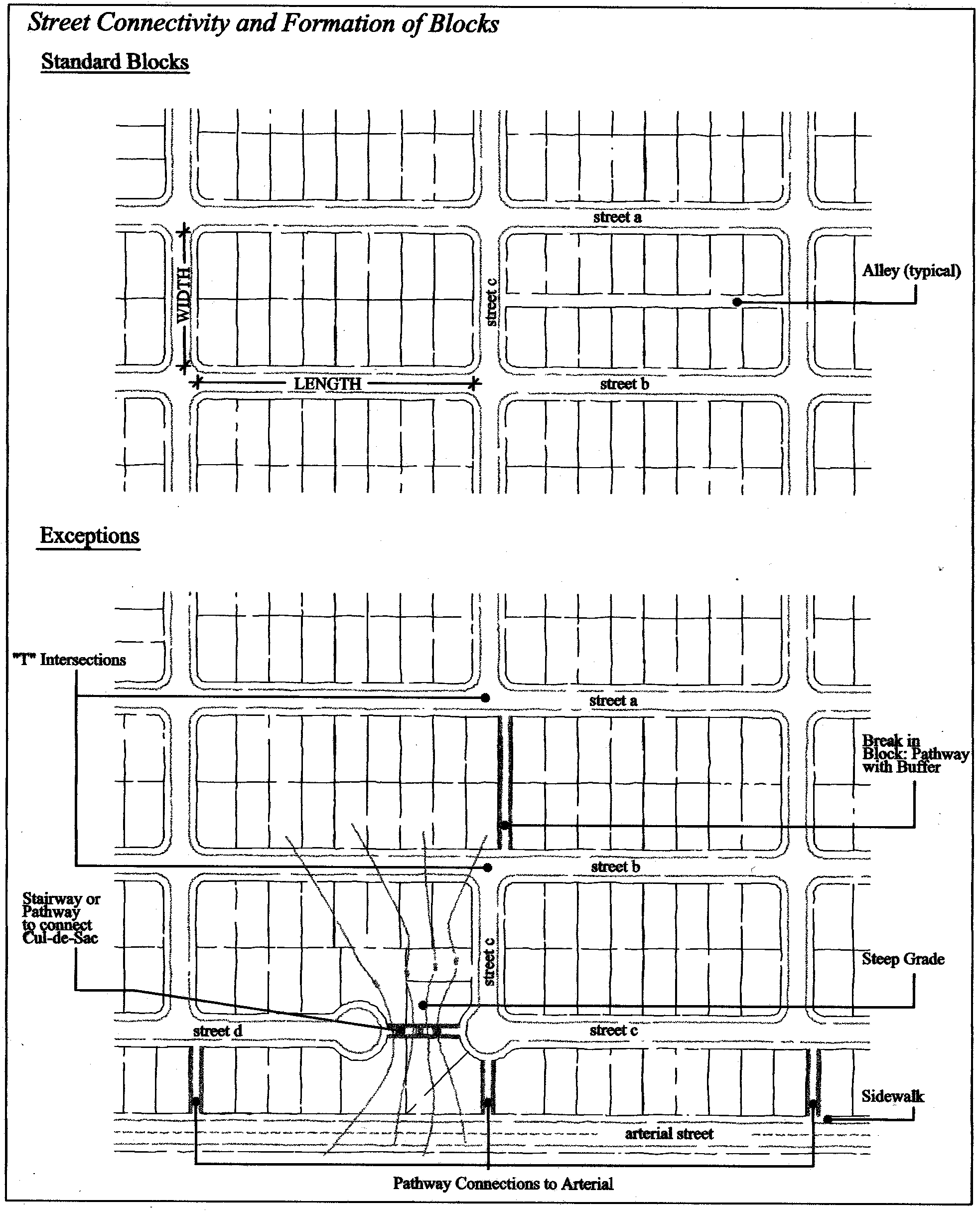
Requirements for Street Connectivity and Formation of Blocks. In order to promote efficient vehicular and pedestrian circulation throughout the city, new land divisions and large site developments shall produce complete blocks bounded by a connecting network of public and/or private streets, in accordance with the following standards (see Figure 16.12.030-1):
1.
Block Length and Perimeter. The maximum block length and perimeter (measured along the edge of the right-of-way) should not exceed:
a.
In residential zones (Z-RL, Z-RM, Z-RH):
i.
Blocks without pedestrian and bicycle pathway connections through the block (see "standard blocks" in Figure 16.12.030-1), six hundred feet length and one thousand six hundred feet perimeter.
ii.
Blocks that include pedestrian and bicycle pathway connections through the block (see "exceptions in Figure 16.12.030-1), eight hundred feet length and 2,000 feet perimeter.
b.
In the central business commercial zone (Z-CCM), except for the existing city blocks. Four hundred feet length and one thousand two hundred feet perimeter.
c.
Six hundred to eight hundred feet length and one thousand six hundred to two thousand feet perimeter in the highway commercial zone (Z-HCM), and mixed-use zone (Z-MU), except as required for commercial developments subject to other provisions of this code or the subdivision ordinance.
d.
Not applicable to the neighborhood commercial zone (Z-NCM) where the requirements of the surrounding zone(s) shall prevail.
e.
Not applicable to the industrial zone (Z-IND).
Figure 16.12.030-1: Street Connectivity and Formation of Blocks
2.
Street Standards. Public and private streets shall also conform to applicable provisions of Chapter 16.14 of this code, and applicable Americans With Disabilities Act (ADA) design standards for public streets. See blocks above in Section 16.12.030.I, and adopted city public improvement standards.
3.
Exceptions to Block Lengths. Exceptions to the above standards may be granted when:
a.
Blocks are divided by one or more pathway(s), in conformance with applicable provisions of this code. Pathways shall be located to minimize out-of-direction travel by pedestrians and may be designed to accommodate bicycles.
b.
Blocks are divided by an alley in conformance with the applicable provisions of this code.
c.
Existing development precludes meeting the established standards.
d.
Geographical or natural features preclude meeting the established standards.
e.
Block perimeters may be increased by twice the width of any alley that is included in a block.
4.
Connectivity and Subdivisions. The street grid of proposed subdivisions shall be designed to connect with existing, proposed, and planned streets outside of the subdivision as provided below:
a.
Whenever a proposed development abuts unplatted land, underutilized land, redevelopable land (as identified in the city's buildable lands inventory), or a future development phase of the same development, street stubs shall be provided to access abutting properties and to extend the street system into the surrounding area, except where
i.
Existing development precludes street stubs, or
ii.
Geographical or natural features preclude street stubs.
b.
All street stubs shall be provided with a temporary turn-around unless specifically exempted by the public works director, and/or fire code official.
c.
The extension of the street shall be the responsibility of the developer of the adjacent land.
5.
Future Street Plans. Building placement and alignment of shared drives shall be designed so that future street connections can be made as surrounding properties develop.
6.
Minor Collector and Local Residential Access Streets. Minor collector and local residential access streets shall connect with surrounding streets to permit the convenient movement of traffic between residential neighborhoods or facilitate emergency access and evacuation. Connections shall be designed to avoid or minimize through traffic on local streets.
7.
Cul-de-Sacs. The following provisions shall apply to development utilizing cul-de-sacs.
a.
Shall be limited to situations where full street connections cannot be made because of topography, pre-existing development, or environmental constraints.
b.
Cul-de-sac streets may also be permitted when compliance with other standards in this code preclude street extension and through circulation.
c.
Also see Section 16.13.030.L and Table 16.13.030-1 in Chapter 16.13.
8.
Pedestrian and Bicycle Accessways. Block lengths of more than six hundred feet shall include a pedestrian/bike accessway. Typically, such an accessway shall be located in the middle third of the block.
L.
Driveway Approaches. Driveway approaches or curb cuts shall be provided to the minimum standards as required in this code to provide safe and efficient access. The following standards (i.e., as measured where the front property line meets the sidewalk or right-of-way) are required to provide adequate site access, minimize surface water runoff, ensure an exiting vehicle with an unobstructed view, avoid conflicts between vehicles and pedestrians, and have appropriate signage for one-way connections. Unless otherwise permitted by the city engineer, in consultation with the planning official, or, for State Highways 20 and 34, by Oregon Department of Transportation, minimum driveway widths shall be as follows:
1.
Single-family, and duplex use shall have a minimum driveway width of 12 feet.
2.
Multiple family uses and up to six individual family dwelling units with shared access shall have a minimum driveway width of twenty-four feet.
3.
Multiple family uses and off-street parking areas with sixteen or more parking spaces shall have a minimum driveway width of twenty-four feet, and a maximum width of thirty-six feet. These dimensions may be increased if the planning official, in consultation with the city engineer, determines that more than two lanes are required based on the number of trips generated or the need for turning lanes.
4.
Access widths for all other uses shall be based on twelve feet of width for every travel lane, except that driveways providing direct access to parking spaces shall conform to the parking area standards in Chapter 16.14 (Off-street parking requirements) of this code.
5.
Driveway Aprons. Driveway aprons (when required) shall be constructed of concrete and shall be installed between the street right-of-way and the private drive.
6.
Construction of driveways along acceleration or deceleration lanes and tapers shall be avoided to prevent potential weaving conflicts between vehicles.
7.
Driveways shall also conform to the specifications provided in Chapter 16.14 (Off-street parking requirements).
8.
Emergency Access Lane. Any access lane that serves as an emergency vehicle access lane must comply with the standards of the Lebanon Fire District and emergency services.
M.
Fire Access and Parking Area Turn-Arounds. Fire access and parking area turn-arounds shall comply with the fire code and standards adopted by the Lebanon Fire District.
N.
Vertical Clearances. Driveways, private streets, aisles, turn-around areas and ramps shall have a minimum vertical clearance of twelve and one-half feet for their entire length and width.
O.
Nonconforming Existing Access. Pre-existing and legally established access in place prior to the adoption of this code are considered to be nonconforming and shall be brought into compliance with applicable standards under the following conditions:
1.
When new access permits are requested;
2.
When a land use permit is required for change of use, building expansion, or redevelopment.
P.
Lots With Multiple Frontages.
1.
Corner Lots and Through Lots. Lots that front on more than one street shall be required to locate motor vehicle accesses on the street with the lower functional classification. On a corner lot, the access point shall be as far from the intersection as practicable.
2.
Subdivision Abutting an Arterial. When a residential subdivision is proposed that would abut an arterial, it shall be designed to provide through lots along the arterial with access from a frontage road or interior local road. Access rights of these lots to the arterial shall be strictly limited or prohibited. A buffer yard may be required at the rear of through lots to buffer residences from traffic on the arterial. Where such rear buffer yards exist, rear yard fences with gates shall be provided.
Q.
Flag Lot Standards.
1.
Connections to the State Highway System or City Arterials. Flag lots shall not be permitted when the results would be to increase the number of driveways requiring direct and individual access connections to the state highway system, or city arterial streets.
2.
Planning Objectives and Residential Development. Flag lots may be permitted for residential development when necessary to achieve planning objectives, such as reducing direct access to roadways, providing internal platted lots with access to a residential street, infill development, redevelopment, or preserving natural or historic resources.
3.
Conditions of Flag Lot Creation. Flag lots may be created only when a through street or mid-block lanes cannot be extended to serve abutting uses or future development. A flag lot driveway ("flag pole" or "pan handle") may serve no more than two individual lots with a maximum of four dwelling units (maximum two dwelling units per individual lot served by flag lot driveway). A driveway serving more than one lot shall have a reciprocal access and maintenance easement recorded for all lots. No fence, structure or other obstacle shall be placed within the driveway area. The fire marshal may require an emergency turn-around. Fire sprinklers may also be required for buildings that cannot be fully served by fire hydrants (e.g., due to distance from hydrant or insufficient fire flow).
4.
Flag Lot Addressing. Flag lots shall be addressed at the street according to addressing standards established by emergency services.
R.
Required Improvements, Time of Construction, and Temporary Deferments.
1.
Development abutting existing substandard public streets may temporarily defer some or all city standard street upgrade improvements, if so permitted by the city engineer in consultation with the planning official.
2.
When such required street improvements are temporarily deferred, the property owner shall sign an irrevocable petition agreeing not to challenge the future formation of and proportionate financial participation in a local improvement district.
3.
City standard street improvements are required with approval of any of the following applications:
a.
Land divisions;
b.
Land use and development approvals;
c.
Building permits for residential, commercial or industrial development.
4.
Street Frontage Improvements. The following improvements shall be required:
a.
Consistent with the adopted transportations plans, sufficient land shall be dedicated to establish the appropriate right-of-way width.
b.
Nonremonstrance Agreement. If the street frontage of the subject property is less than or equal to two hundred fifty feet, the applicant shall sign a nonremonstrance agreement with the City of Lebanon. This agreement shall also apply to street extensions. This agreement shall stipulate that the applicant, or future property owner, will agree to participate in right-of-way improvements. The agreement may include provisions for the following: Street paving, curbing, sidewalks, utility lines, storm sewer facilities and sanitary sewer facilities. The agreement shall be recorded in the county deed records at the time of the recording of the final plat.
c.
If the street frontage of the subject property exceeds two hundred fifty feet, or extends an existing dedicated right-of-way, the applicant shall improve the following:
i.
Public streets upon which the property fronts to public standards, including: Surfacing from center line to curb, installation of curbing, storm sewers, sanitary sewers, water lines and other necessary public utilities per approved master plans. Where a master plan has not been adopted, the developer shall enter into a nonremonstrance agreement consistent with item 4.b, above.
ii.
Sidewalks, meeting city standards, along public street frontage. Sidewalk construction may be deferred until such time as a building permit is issued.
iii.
The installation of storm sewers, sanitary sewers, water lines and other utilities necessary to serve parcels accessing off of the new street.
d.
Improvements specified in the approach road permit issued by the Oregon Department of transportation.
S.
Variances from Access Standards. All variances shall conform to the specifications established in Chapter 16.29 (Variances) of this code.
(Ord. 2766 § 1 (part), 2008; Ord. No. 2801, Exh. A, 7-14-2010; Ord. No. 2923, § 4(Exh. D, § I.A), 12-12-2018; Ord. No. 2957, § 3(Exh. A), 5-12-2021; Ord. No. 3036, § 3(Exh. A), 6-11-2025)
16.12.040 - Bicycle access and management requirements.
A.
On-Street Bike Lanes. On- and/or off-street bike lanes or paths shall be provided as per the street standards and specifications in the Lebanon Transportation System Plan (TSP) and constructed at the time of street improvements.
B.
Safe and Convenient Bicycle Facilities. Safe and convenient bicycle facilities that strive to minimize travel distance to the greatest extent practicable shall be provided in conjunction with applicable redevelopment as well as new development within and between new subdivisions, planned developments, commercial developments, industrial areas, residential areas, transit stops, and neighborhood activity centers such as schools and parks. For the purposes of this section, "safe and convenient" means bicycle facilities that:
1.
Are reasonably free from hazards that would interfere with or discourage bicycle travel for short trips.
2.
Provide a direct route of travel between destinations and other modes of travel such as transit.
3.
Meet the travel needs of bicyclists considering destination and length of trips, including trips that may connect to other modes of transportation, such as transit.
C.
Bicycle or Shared-Use Pathway Facility Paving Standards. Adequate widths for bicycle or shared-use pathway facilities shall be provided in accordance with the standards summarized below.
1.
Paving Standards. Shared-use paths shall be twelve to fifteen feet wide, consistent with the standards of the adopted transportation system plan (Figure 16). The City may reduce the width of the typical paved shared-use path to a minimum of ten feet in constrained areas (e.g., steep, environmentally sensitive, historic or previously developed areas).
2.
Bicycle/Pedestrian Rights-of-Way. Bicycle/pedestrian rights-of-way connecting cul-de-sacs or passing through unusually long or oddly shaped blocks shall be a minimum of fifteen feet wide.
D.
Connectivity and Creating an Effective Bicycle Network. To provide for orderly development of an effective bicycle network, bicycle facilities installed concurrent with development of a site, or applicable redevelopment, shall be extended through the site to the edge of adjacent property(-ies).
E.
Safe Lines of Sight. To maximize the personal safety of the pedestrians and cyclists that use paths that connect streets, such paths should be developed with a straight line of site from the streets at both ends, except where terrain does not permit such a linear layout.
Table 16.12.040-1: Bicycle or Shared-Use Pathway Facility Paving Width Standards
Notes:
* Bike lanes provided only where specified in bicycle plan.
• Shared-use paths and bike paths must be paved.
• The ROW that is not paved must be graveled.
• "Recreational trails" are not regulated by the standards of this chapter (nor Chapter 16.14), and as noted in the state's transportation planning rule (TPR) do not have to be paved. See parks master plan and related documents.
(Ord. 2766 § 1 (part), 2008; Ord. No. 2923, § 4(Exh. D, §§ I.B—I.E), 12-12-2018; Ord. No. 3036, § 3(Exh. A), 6-11-2025)
16.12.050 - Pedestrian access and management requirements.
A.
Pedestrian Access and Circulation. To ensure safe, direct and convenient pedestrian circulation, all developments, except single-family detached dwelling or duplex on individual lots, shall provide a continuous pedestrian and/or shared-use pathway system.
1.
Pathways only provide for pedestrian circulation.
2.
Shared-use pathways accommodate pedestrians and bicycles.
3.
Recreational Trails. See parks master plan and related documents for standards.
4.
The system of pathways shall be designed based on the standards in subsections B, C, and D, below.
B.
Continuous Pathways. The pathway system (also applicable for bike paths) shall extend throughout the development site, and connect to all future phases of development, adjacent trails, public parks and open space areas whenever possible. The developer may also be required to connect or stub pathway(s) to adjacent streets and private property, in accordance with the provisions of Chapter 16.13 (Transportation improvements and design standards).
C.
Safe, Direct, and Convenient Pathways. Pathways within developments shall provide safe, reasonably direct and convenient connections between primary building entrances and all adjacent streets, based on the following definitions:
1.
Reasonably Direct. A route that does not deviate unnecessarily from a straight line or a route that does not involve a significant amount of out-of-direction travel for likely users.
2.
Safe and Convenient. Bicycle and pedestrian routes that are reasonably free from hazards and provide a reasonably direct route of travel between destinations.
3.
Primary Entrance for Commercial, Industrial, Mixed-Use, Public, and Institutional Buildings. For such development, the "primary entrance" is the main public entrance to the building. In the case where no public entrance exists, street connections shall be provided to the main employee entrance. The primary entrance to the building closest to the street where the transit stop is located shall be oriented to the street.
4.
Primary Entrance for Residential Buildings. For such development the "primary entrance" is the front door (i.e., the entrance that faces the street). For multifamily buildings in which each unit does not have its own exterior entrance, the "primary entrance" may be a lobby, courtyard or breezeway that serves as a common entrance for more than one dwelling.
D.
Connections Within Development. For all developments subject to any site design review (e.g., planning process, engineering services process), pathways shall connect all building entrances to one another. In addition, pathways shall connect all parking areas, storage areas, recreational facilities and common areas (as applicable), developments and existing and planned transit stops adjacent to the site, as applicable.
E.
Street Connectivity. Pathways (for pedestrians and bicycles) shall be provided at or near mid-block where the block length exceeds the length required by Section 16.12.030 above. Pathways shall also be provided where cul-de-sacs or dead-end streets are planned, to connect the ends of the streets together, to other streets, and/or to other developments, as applicable. Pathways used to comply with these standards shall conform to all of the following criteria:
1.
Shared-Use Pathways. Shared-use pathways for pedestrians and bicyclists shall be no less than twelve feet wide in a fifteen-foot-wide ROW and if warranted and required located within a twenty-foot-wide right-of-way or easement that allows access for emergency vehicles.
2.
Lighting. If the streets within the subdivision or neighborhood are lighted, the pathways shall also be lighted (also applicable for bike paths), subject to review authority approval.
3.
Alternatives for Areas with Steep Grades. Stairs or switchback paths using a narrower right-of-way/easement may be required in lieu of a shared-use pathway where grades are steep.
4.
Required Landscaping. The city may require landscaping within the pathway easement or right-of-way for screening and the privacy of adjoining properties (also applicable for bike paths).
5.
Exceptions. The hearings body or planning official, as appropriate, may determine, based upon facts in the record, that installation of a pathway (also applicable for bike paths) is impracticable due to:
a.
Physical or topographic conditions (e.g., railroads, extremely steep slopes, sensitive lands, and similar physical constraints);
b.
Buildings or other existing development on adjacent properties that physically prevent a connection now or in the future, considering the potential for redevelopment; and
c.
Sites where the provisions of recorded leases, easements, covenants, restrictions, or other agreements recorded as of the effective date of this code prohibit the pathway connection.
F.
Design and Construction Standards. Pathways shall conform to all of the standards in subsections 1 through 8 below:
1.
Vehicle/Pathway Separation. Where off-street pathways (also applicable for bike paths) are parallel and adjacent to a driveway or street (public or private), they shall generally be raised six inches and curbed, or separated from the driveway/street by a five-foot minimum strip with bollards, a landscape berm, or other physical barrier. If a raised path is used, the ends of the raised portions must be equipped with curb ramps. Alternative safety features may be approved by the city engineer.
2.
Housing/Pathway Separation. Pedestrian pathways (also applicable for bike paths) shall be separated a minimum of five feet from all residential living areas on the ground floor, except at building entrances. Separation is measured as measured from the pathway edge to the closest dwelling unit. The separation area shall be landscaped in conformance with the provisions of Chapter 16.15 of this code. No pathway/building separation is required for commercial, industrial, public, or institutional uses.
3.
Pathway Surface. Pathway surfaces (also applicable for bike paths) shall be concrete, asphalt, brick/masonry pavers, or other durable surface, at least five feet wide, and shall conform to ADA requirements. Shared-use paths for bicycles and pedestrians shall be the same materials, at least twelve feet wide (see also, transportation standards for public, shared-use pathway standards).
4.
Accessible Routes. Pathways shall comply with the provisions of the Americans with Disabilities Act (ADA) that require accessible routes of travel.
5.
Internal Pedestrian Connections—Accessway and Walkway Connections within Commercial and Office Park Development. Acceptable methods for meeting the state's transportation planning rule (TPR) requirements for internal pedestrian connections within new office parks and commercial developments include:
a.
Providing at least one sidewalk connection between abutting developments.
b.
Providing walkways to the street for every three hundred feet of frontage.
c.
Providing direct connections and minimizing driveway crossings.
d.
Linking connections to the internal circulation of the building.
e.
Providing walkways that are at least five feet wide and are raised, have curbing, or have different paving material when crossing driveways.
f.
Providing accessways for through parking lots that are physically separated from adjacent vehicle parking or parallel vehicle traffic by curbs or similar devices and include landscaping, trees and lighting.
6.
Paving Width Standards for Pedestrian Facilities (e.g., Pathways, Sidewalks). The following paving width standards shall apply to all new development and redevelopment (see Table 16.12.050-1).
Table 16.12.050-1: Pedestrian Facility Paving Width Standards
(Ord. 2766 § 1 (part), 2008; Ord. No. 2923, § 4(Exh. D, §§ I.F—I.I), 12-12-2018; Ord. No. 2957, § 3(Exh. A), 5-12-2021; Ord. No. 3036, § 3(Exh. A), 6-11-2025)
16.12.060 - Exceptions to requirements for streets and accessways.
Streets and accessways for both pedestrians and bicyclists need not be provided where one or more of the following conditions exist:
A.
Physical or Topographic Conditions. Physical or topographic conditions make providing a street or accessway connection impracticable. Such conditions include, but are not limited to, railroads, steep slopes, wetlands or other bodies of water where a connection cannot reasonably be provided;
B.
Buildings and Other Development Blocking Access Routes. Buildings or other existing development on adjacent lands physically preclude a connection now or in the future considering the potential for redevelopment; or
C.
Legal Constraints. Where streets or accessways would violate provisions of recorded leases, easements, covenants, restrictions or other agreements existing as of May 1, 1995, that preclude a required street or accessway connection.
(Ord. 2766 § 1 (part), 2008; Ord. No. 3036, § 3(Exh. A), 6-11-2025)
16.13.010 - Purpose and applicability.
A.
Purpose. The purpose of this chapter is to provide planning and design standards for transportation improvements, and for public and private transportation facilities. Streets are the most common public spaces, touching virtually every parcel of land. Accordingly, one of the primary purposes of this chapter is to provide standards for attractive and safe streets that can accommodate vehicle traffic, and provide a range of transportation options, including options for driving, walking, bicycling. This chapter also provides standards for attractive and safe alleys. The provisions of this chapter are consistent with and implement the city's transportation system plan. Key goals of this chapter are to establish:
1.
Standards for local streets and accessways that minimize pavement width and total right-of-way consistent with the operational needs of the facility to:
a.
Reduce excessive standards for local streets and accessways in order to reduce the cost of construction,
b.
Provide for more efficient use of urban land,
c.
Provide for emergency vehicle access,
d.
Discourage inappropriate traffic volumes and speeds,
e.
Accommodate convenient pedestrian and bicycle circulation;
2.
Standards that create circulation patterns that facilitate bicycle and pedestrian trips to meet local travel needs in developed areas. Appropriate improvements shall provide for more direct, convenient and safer bicycle or pedestrian travel within and between residential areas and neighborhood activity centers (e.g., schools, shopping areas, transit stops). Specific measures may include constructing walkways between cul-de-sacs and adjacent roads, providing walkways between buildings, and providing direct access between adjacent uses.
B.
Important Cross-References to Other Standards. The city requires that streets provide direct and convenient access, including regular intersections, and there are other required provisions for accessways. See Chapter 16.12 of this code (subsections regarding motor vehicle access and management requirements, bicycle access and management requirements, and pedestrian access and management requirements), the city's public improvement standards, the city's adopted standards and specifications for construction, and relevant sections of the Lebanon Municipal Code, that collectively provide standards for transportation improvements such as intersections and blocks, and requirements for vehicle access, and pedestrian and bicycle access and circulation.
C.
When Standards Apply and Exceptions. The standard specifications for construction, reconstruction or repair of transportation facilities within the city shall occur in accordance with the standards of this chapter and other appropriate city improvement standards, unless site-specific considerations warrant exceptions as provided for in this code. All such exceptions must be approved in writing by the city as part of development review. No development or redevelopment may occur unless the public facilities related to the development or redevelopment comply with the public facility requirements established in this chapter.
D.
Standard Specifications. The city engineer shall establish standard construction specifications consistent with the design standards of this chapter and application of engineering principles.
E.
Basic Decision Criteria for Development Approval. Development may not occur unless:
1.
Key urban utility services (i.e., water, storm drainage, sanitary sewerage, and streets) to serve the proposed development are in place, guaranteed, are planned for, or are constructed concurrently with the proposed development in conformance with the provisions of this code and other relevant city standards; or
2.
There are on-site equivalent services approved by the appropriate review authority.
F.
Compliance with Transportation System Plan. If review under this chapter indicates that the use or activity is inconsistent with the transportation system plan, the procedures for plan and/or code amendments, as appropriate, shall be undertaken prior to or in conjunction with the required land use review.
(Ord. 2766 § 1 (part), 2008)
16.13.020 - Transportation improvements—Outright permitted and conditionally permitted uses.
A.
Transportation Uses Permitted Outright. Except where otherwise specifically regulated by this code, the following standard transportation improvements are permitted outright:
1.
Normal operation, maintenance, repair, and preservation activities of existing transportation facilities;
2.
Installation of culverts, pathways, medians, fencing, guardrails, lighting, directional signs, and similar types of improvements within the right-of-way;
3.
Projects specifically identified in the transportation system plan as not requiring further land use regulation;
4.
City approved transportation facility related projects;
5.
Landscaping as part of a transportation facility, as long as it complies with standards set forth in Chapter 16.15 (Landscaping/Street Trees), and Chapter 16.12 (Section 16.12.030(H), Clear vision) of this code;
6.
Emergency measures necessary for the safety and protection of property;
7.
Acquisition of right-of-way for public roads, highways, and other transportation improvements deemed necessary in the public interest, and/or designated in the transportation system plan;
8.
Construction of a street or road as part of an approved subdivision or land partition approved consistent with the applicable land division ordinance;
9.
Changes in the frequency and intensity of transit, rail, and airport services.
B.
Transportation Conditional Uses Permitted.
1.
Conditionally permitted transportation improvements include construction, reconstruction, or widening of highways, roads, bridges, or other transportation projects that:
a.
Are not designated in the transportation system plan, or an adopted transportation facility plan, or a city-approved project; or
b.
Change the character, function, or operation of an existing transportation-related facility as proposed or designated in the transportation system plan (TSP). Such projects shall comply with the overall standards of the TSP and other applicable standards, and shall address the following criteria:
i.
The project is designed to be compatible with existing land use and social patterns, including noise generation, safety and zoning,
ii.
The project is designed to minimize avoidable environmental impacts to identified wetlands, wildlife habitat, air and water quality, cultural resources and scenic qualities,
iii.
The project preserves or improves the safety and function of the facility through access management, traffic calming, or other design features,
iv.
The project includes provisions for bicycle and pedestrian circulation as consistent with the applicable requirements of the ordinance codified in this chapter.
2.
If review under this chapter indicates that the use or activity is inconsistent with the transportation system plan, the development code, or the public improvement standards, the procedures for plan and zoning amendments, as appropriate, shall be undertaken prior to or in conjunction with the conditional permit review.
3.
Time Limitations on Transportation-Related Conditional Use Permits. Authorization of a conditional use shall be void after a period specified by the applicant as reasonable and necessary based on season, right-of-way acquisition, and other pertinent factors. This period shall not exceed three years, or a period of time approved or extended by the review authority.
(Ord. 2766 § 1 (part), 2008)
16.13.030 - Design standards for improvements—Streets, alleys and pathways.
A.
General Development Standards. Development shall not occur unless the development has frontage or approved access to a public street, in conformity with the provisions of Section 16.12.020 in Chapter 16.12, and the following additional standards are met:
1.
Streets within or adjacent to a development shall be improved to city standards in accordance with the transportation system plan, public improvement standards, and the provisions of this chapter;
2.
Development of new streets, additional street width or improvements planned as a portion of an existing street, shall be improved in accordance with this chapter, and other applicable city standards;
3.
All driveway approaches and driveways shall be paved, as per adopted city engineering standards;
4.
Minor sections of non-contiguous street improvements may be deferred until contiguous to city standard street improvements as determined by the city engineer.
B.
Creation of Rights-of-Way for Streets and Related Purposes. Streets shall be created through the approval and recording of a final subdivision or partition plat; except the city may approve the creation of a street by acceptance of a dedication by the city council for the purpose of implementing the transportation system plan, and the dedication of right-of-way conforms to the standards of this code. All dedications shall be in a form approved by the city engineer.
C.
Creation of Access Easements. The city may approve an access easement when the easement is necessary to provide for access and circulation in conformance with Chapter 16.12 of this code (Transportation Access, Access Management and Circulation). Access easements shall be created and maintained in accordance with this code, the Oregon Fire Code, and Lebanon fire district's requirements as determined by the fire code official.
D.
Street Location, Width and Grade. Except as noted below, the location, width and grade of all new public streets shall conform to the transportation system plan, as applicable, and an approved street plan or subdivision plat. Street location, width and grade shall be determined in relation to existing and planned streets, topographic conditions, public convenience and safety, and in appropriate relation to the proposed use of the land to be served by such streets:
1.
Street grades shall be approved by the city engineer in accordance with the design standards in the city's transportation system plan and public improvement standards;
2.
Where the location of a street is not shown in an existing street plan (See Subsection "H" below), the location of streets in a development shall either:
a.
Provide for the continuation and connection of existing streets in the surrounding areas, conforming to the street standards of this chapter, Chapter 16.13; or
b.
Conform to a site development plan approved by the review authority if it is impractical to connect with existing street patterns because of particular topographical or other existing conditions of the land. Such a plan shall be based on the type of land use to be served, the volume of traffic, the capacity of adjoining streets and the need for public convenience and safety.
E.
Minimum Rights-of-Way and Street Sections. The city of Lebanon street cross-section standards are summarized in TSP Table 8 and Figures 9 to 15.
Table 16.13.030-1: Typical Street Cross-Sections
Table 16.13.030-2: Typical Street Design Standards
(Subject to Engineering Site Plan Reviews)
F.
Traffic Signals and Traffic Calming Features.
1.
Traffic-calming features, such as traffic circles, curb extensions, narrow residential streets, and special paving may be used to slow traffic in neighborhoods and areas with high pedestrian and/or bicycle traffic.
2.
Traffic signals may be required when traffic signal warrants are met, in conformance with the Highway Capacity Manual, and Manual of Uniform Traffic Control Devices. The location of traffic signals shall be noted on approved street plans. Where a proposed street intersection will result in an immediate need for a traffic signal, a signal meeting approved specifications shall be installed. The developer's cost and the schedule of improvements may be included as a condition of development approval.
G.
Future Street Plan and Extension of Streets.
1.
When a new subdivision or planned development includes the creation of a new street(s), the subdivision proposal must include a proposed street plan as part of the application for the subdivision in order to facilitate orderly development of the street system. The plan shall show the pattern of existing and proposed future streets from the boundaries of the proposed land division and shall include other parcels within six hundred feet surrounding and adjacent to the proposed land division. The plan must demonstrate that connectivity can be achieved in a practical manner by connections with potential street extensions within future development on the surrounding and adjacent parcels.
2.
Streets shall be extended to the boundary lines of the parcel or tract to be developed. These extended streets or street stubs to adjoining properties are not considered to be cul-de-sacs since they are intended to continue as through streets when the adjoining property is developed. The point where the streets temporarily end shall conform to subsections "a" and "b" below:
a.
A MUTCD barricade shall be constructed at the end of the street and shall not be removed until authorized by the city or other applicable agency with jurisdiction over the street. The cost of the barricade shall be included in the street construction cost.
b.
Emergency Vehicle turnarounds (e.g., hammerhead or bulb-shaped configuration) shall be constructed for stub streets in compliance with the Oregon Fire Code and Lebanon fire district's requirements, as determined by the fire code official.
H.
Street Alignment and Connections.
1.
Spacing between street intersections shall have a minimum separation of two hundred sixty-five feet for arterial and collector streets and one hundred fifty feet for local roadways, except where more closely spaced intersections are warranted by site specific considerations.
2.
Through Circulation of Local and Collector Streets. Unless superseded by a local street network plan, all local and collector streets that abut a development site shall be extended within the site to provide through circulation and connection to abutting streets unless prevented by environmental or topographical constraints, existing development patterns or compliance with other standards in this code.
I.
Sidewalks, Planter Strips, Bicycle Lanes. Sidewalks, planter strips, and bicycle lanes shall be installed in conformance with the standards in transportation system plan Figures 9 to 15, Public improvement standards, and adopted street plans. Maintenance of sidewalks, and planter strips is the continuing obligation of the adjacent property owner. Also see Chapter 16.12 of this code, Sections 16.12.040 (Bicycle access and management requirements), and 16.12.050 (Pedestrian access and management requirements) for further details on bicycle and pedestrian pathways.
J.
Intersection Angles. Streets shall be laid out so as to intersect at an angle as near to a right angle as practicable, except where topography requires a lesser angle or where a reduced angle is necessary to provide an open space, park, common area or similar neighborhood amenity.
K.
Existing Rights-of-Way. Whenever existing rights-of-way adjacent to or within a tract are of less than standard width, additional rights-of-way shall be provided at the time of subdivision or development.
L.
Cul-de-sacs.
1.
The length of a cul-de-sac street shall not exceed four hundred feet. However, cul-de-sacs may be up to six hundred feet in length with a pedestrian/bicycle accessway to neighboring streets and/or pathways for connectivity that includes a dedicated right-of-way for utilities, and subject to approval of the Lebanon fire district.
2.
The length of a cul-de-sac is measured from the edge of the street right-of-way along the length of the "stem" to the back of the "bulb."
3.
All cul-de-sacs of more than one hundred fifty feet in length shall terminate with a circular turnaround. Such emergency vehicle turnarounds shall be constructed in compliance with the Oregon Fire Code and Lebanon fire district's requirements.
4.
Also see Section 16.12.030(K)(7) (Chapter 16.12), and Table 16.13.030-1 (in this chapter).
M.
Development Adjoining Arterial Streets. Where a development adjoins or is crossed by an existing or proposed arterial street, the development design shall separate residential access and through traffic, and shall minimize traffic conflicts. The design shall include one or more of the following:
1.
Parallel access street along the arterial with a landscape buffer separating the two streets;
2.
Deep lots abutting the arterial or major collector to provide adequate buffering with frontage along another street (double-frontage lots shall conform to the buffering standards in subsection O (Chapter 16.12) of this code;
3.
Screen planting at the rear or side property line to be contained in a non-access reservation (e.g., public easement or tract) along the arterial; or
4.
Other treatment suitable to meet the objectives of this subsection;
5.
If a lot has access to two streets with different classifications, primary access shall be from the lower classification street, in conformance with subsection O (Chapter 16.12) of this code.
N.
Private Streets Standards.
1.
Private streets shall not be used to avoid connections with public streets.
2.
A new private roadway shall only be allowed in residential areas with sixteen or fewer dwelling units.
3.
All private streets shall conform to the adopted city standards for private streets, Figure 15 in the transportation system plan and with the Oregon Fire Code and Lebanon fire district's requirements.
O.
Gated Communities. Developments that have a gate limiting access from a public street (i.e., a "gated community") shall allow unrestricted access for emergency service vehicles and the vehicles of public and private utility providers that service the community.
P.
Street Names. Proposed new street names must conform to city of Lebanon requirements, and with the requirements of the Linn County sheriff's office, emergency services division. Accordingly, no street name shall be used that will duplicate or be confused with the names of existing streets except for extensions of existing streets. Street names, signs and addresses shall conform to the established city standards in the surrounding area, except as requested by emergency service providers.
Q.
Street Signage. The developer shall be responsible for funding and installing all signs for traffic control and street names. Street name signs shall be installed at all street intersections. Stop signs and other signs may be required. All signage shall conform to the applicable city, county, and state standards, and be subject to the approval of the appropriate jurisdiction.
R.
Mailboxes. Plans for mailboxes to be installed shall be approved by the United States Postal Service. All such units shall comply with clear vision area restrictions, including appropriate height limitations.
S.
Street Light Standards. Streetlights shall be installed in accordance with city standards.
T.
Utility Pedestals. The plans and locations for all utility pedestals to be installed shall be subject to the approval of the appropriate jurisdiction. All such units shall comply with clear vision area restrictions, including appropriate height limitations.
(Ord. 2766 § 1 (part), 2008; Ord. No. 2923, § 4(Exh. D, §§ II.A—II.F), 12-12-2018)
16.14.010 - Purposes.
A.
Off-Street Parking, Loading, and Access.
1.
These regulations are established in order to provide on-site parking and loading areas and access to such areas of adequate capacity, and appropriate location and design.
2.
The parking requirements are intended to provide sufficient parking in close proximity to the various uses for residents, customers, and/or employees; and to maintain traffic carrying capacity of nearby streets.
3.
These regulations apply to both motorized vehicles (hereafter referred to as vehicles) and bicycles.
4.
For each new structure or use, each structure or use increased in area and each change in the use of an existing structure there shall be provided and maintained off-street parking areas in conformance with the provisions of this section.
5.
Off-street parking does not include on-street parking or parking in a public lot.
B.
Nonemergency Access. The provisions in this chapter regarding "access" refer exclusively to nonemergency access unless otherwise specified.
(Ord. 2766 § 1 (part), 2008; Ord. No. 3036, § 3(Exh. A), 6-11-2025)
16.14.020 - General provisions.
A.
Provision and Maintenance.
1.
The provision and maintenance of off-street parking spaces for vehicles and bicycles, and loading facilities for vehicles are continuing obligations of the property owner.
2.
The subsequent use of property for which the permit is issued shall be conditioned upon the unqualified continuance and availability of the amount of parking required by this code.
B.
Plans for Compliance. A site plan, drawn to scale, and narrative indicating how the off-street parking requirements are to be fulfilled, shall accompany all requests for building permits, and may be required for a variety of land use applications. No building permit or other permit shall be issued until such site plans are submitted and approved.
C.
Parking for Uses not Specified. Vehicle and bicycle parking requirements for uses not specified in this section shall be determined by the planning official based upon the requirements of similar uses.
D.
New Structures. When a structure is constructed, on-site vehicle and bicycle parking and loading spaces shall be provided in accordance with Section 16.14.070 below.
E.
Alteration of Existing Structures.
1.
When an existing structure is altered to the extent that the existing use is intensified (i.e., Changes from a lower to higher impact classification), vehicle and bicycle parking shall be provided in the amount required for such intensification.
2.
When structural increases require no more than two vehicle spaces, no additional vehicle parking facilities shall be required.
F.
Change in Use.
1.
When an existing structure is changed in use from one use type to another use type (as listed in Section 16.14.070 below) and the vehicle and bicycle parking requirements for each use type are the same, no additional parking shall be required.
2.
When a change in use results in an intensification of use in terms of number of vehicle and bicycle parking spaces required, additional vehicle parking space shall be provided in an amount equal to the difference between the number of spaces required for the existing use and number of spaces required for more intensive use.
3.
When an owner or occupant of a lot or building changes the use of the property to a use that increases the off-street parking requirements, it is unlawful and a violation of this code to begin to maintain such altered use until the required increase in off-street parking is provided.
G.
Inoperative Motor Vehicles. In any residential zone or neighborhood in a mixed-use zone, all motor vehicles incapable of movement under their own power or lacking legal registration shall be stored in a garage, carport, or a completely screened space in a side or rear yard.
H.
Availability and Exclusive Use of Parking Spaces. Required parking spaces shall be available and unobstructed for the parking of operable motor vehicles and bicycles for residents, customers, patrons, and employees only and shall not be used for storage of vehicles, trailers, or materials or for the parking of trucks, other vehicles or bicycles used in conducting the business or for repair or servicing of any vehicle or bicycle.
I.
Multiple Uses.
1.
In the event several uses occupy a single structure or parcel of land, the total requirements for off-street parking shall be the sum of the requirements of the several uses computed separately.
2.
Where it can be shown that the peak parking demands are actually less (e.g., the uses create parking demand on different days or at different times of the day), the total requirements may be reduced accordingly provided reasonable evidence is presented by the proponent demonstrating to the planning official or hearings authority that such distinct parking demands exist.
J.
Conflicting Parking Requirements. When a building or use is planned or constructed in such a manner that more than one standard is applicable, the use that requires the greater number of parking spaces shall govern.
K.
Joint Use of Parking Spaces and Reductions of Parking Requirements.
1.
Shared Parking. Owners of two or more uses, structures or parcels of land may agree to use the same parking spaces jointly when the parking demands do not overlap, provided reasonable evidence is presented by the proponent demonstrating to the planning official or hearings authority that there is not adverse impact to the existing or the proposed cooperative parking facility. Shared parking spaces must be within three hundred feet of the uses, structures or parcels sharing such parking.
2.
Parking Reductions. Shared parking areas satisfying parking requirements may contain a reduced number of individual required parking spaces if peak demands do not occur at the same time periods.
L.
Fractions. When the sum of the required vehicle and bicycle parking spaces is a fraction of a space (one-half or more of a space) a full space shall be required.
M.
Maximum Parking Allowed. With the exception of properties with single-family homes and duplexes, no site shall be permitted to provide more than thirty percent in excess of the minimum off-street vehicle parking required by Section 16.14.070.
N.
Prohibited Backing Movements and the Blocking of Public Streets, Sidewalks and Pathways.
1.
Parking areas for other than single-family dwellings and duplexes shall be served by a service driveway so that no backing movements or other maneuvering within a street other than an alley shall be required.
2.
No motor vehicle or bicycle parked off-street shall be permitted to park in a manner that extends into or across a public street.
3.
No motor vehicle or bicycle shall be permitted to park in a manner that blocks a public sidewalk or pathway.
4.
No motor vehicle or bicycle shall be permitted to park in a manner that extends into or across a public sidewalk or pathway.
(Ord. 2766 § 1 (part), 2008; Ord. No. 2847, § 2(Exh. A), 8-14-2013; Ord. No. 2957, § 3(Exh. A), 5-12-2021; Ord. No. 3036, § 3(Exh. A), 6-11-2025)
16.14.030 - Earned parking reductions.
The amount of vehicle parking may be reduced by one space for every eight bicycle parking spaces or every four covered bicycle parking spaces, not to exceed fifteen percent of required vehicle parking spaces.
(Ord. 2766 § 1 (part), 2008; Ord. No. 3036, § 3(Exh. A), 6-11-2025)
16.14.040 - Location standards for parking lots.
A.
Vehicles.
1.
Off-street parking shall be provided on the development site for all Z-RL, Z-RM, Z-RH, Z-NCM, Z-HCM, Z-MU, Z-NMU, Z-PU and Z-IND Zones.
2.
Off-street parking areas for commercial and industrial development may be located in a required front or street side yard, if separated from the adjacent street by at least a five-foot landscaped buffer outside of the clear vision triangle (see Section 16.12.030.H.3).
3.
Exclusive of driveways with a city approved street access, no parking or vehicle storage shall be allowed within the required front yard or required yards located adjacent to a street on residential property. The side yard and rear yard areas may be used for parking of vehicles unless otherwise prohibited by this code.
4.
Boats, trailers, detached campers, motorized dwellings, recreational vehicles (RVs), and similar recreational equipment may be stored on a lot as an accessory use to a dwelling (or as part of a multifamily development), subject to the following:
a.
Exclusive of driveways, storage shall not be permitted in a required front or required street side yard and shall not reduce the number of required (i.e., per Development Code Chapter 16.14) off-street parking spaces.
b.
Access to the recreational equipment shall be provided by a city approved street access.
c.
All such RV storage shall be on an improved surface. This may include paving, compacted gravel, brick pavers or similar surfacing.
d.
The equipment shall not be used for human habitation.
B.
Bicycles. Bicycle parking required for all use types in all land use zones shall be provided on the development site in accordance with Section 16.14.070.
(Ord. 2766 § 1 (part), 2008; Ord. No. 2847, § 2(Exh. A), 8-14-2013; Ord. No. 3036, § 3(Exh. A), 6-11-2025)
16.14.050 - Landscaping and visual buffering design standards for parking lots.
Parking lots shall be provided with landscaping as provided in Chapter 16.15 and other suitable devices in order to divide the parking lot into sub-units to provide for pedestrian safety, traffic control, and to improve the appearance of the parking lot.
(Ord. 2766 § 1 (part), 2008; Ord. No. 3036, § 3(Exh. A), 6-11-2025)
16.14.060 - Design and improvement requirements for parking lots.
A.
Hard All-Weather Surface. All parking areas and driveway approaches shall have a hard all-weather surface and shall meet the minimum city standard improvement requirements or an alternative approved by the city engineer.
B.
Grading. All parking areas, except those in conjunction with a single-family dwelling or duplex, shall be graded so as not to drain storm water over sidewalks or onto any abutting property.
C.
Marking. Service drives and parking spaces on surfaced parking lots shall be clearly and permanently marked, per adopted public works standards.
D.
Streets, Sidewalks and the Design of Parking Lots and Spaces.
1.
Parking lots and spaces shall be designed such that motor vehicles or bicycles parked off-street are able to park in a manner that does not extend into or across a public street.
2.
Parking lots and spaces shall be designed such that motor vehicles or bicycles are able to park in a manner that does not block a public sidewalk or pathway.
3.
Parking lots and spaces shall be designed such that motor vehicles are able to park in a manner that does not extend into or across a public sidewalk or pathway.
E.
Turning Movements and Parking Lot Design. Turning movements shall meet the minimum standards of AASHTO. Design for parking areas shall be reviewed and approved by the city engineer (as per the city's site design review process).
F.
Driveway Widths. See Section 16.12.020 (Single-family and duplex residential lot frontage requirements), and Section 16.12.030.L (Driveway approaches) in Chapter 16.12 (Transportation access, access management, and circulation).
G.
Outer Boundaries of a Parking Area.
1.
Parking spaces along the outer boundaries of a parking area shall include improvements such as a curb or bumper so placed to prevent a motor vehicle from extending over adjacent property or public right-of-way.
2.
Those areas not paved shall be landscaped.
H.
Service Driveways to Off-Street Parking Areas.
1.
Service driveways to off-street parking areas shall be designed and constructed to facilitate the flow of traffic, provide maximum safety of traffic access and egress, and maximum safety of pedestrian and vehicular traffic on the site.
2.
The number of service driveways shall be limited to the minimum that will allow the property to accommodate and service the traffic anticipated, as specified in Section 16.14.080 below.
3.
Service driveways shall be located as far from an intersection as possible, unless otherwise approved by the city engineer.
I.
Off-Street Parking Areas Within or Abutting Residential Zones. All off-street parking areas within or abutting residential zones shall be provided with both of the following:
1.
Sight-obscuring fence, wall or hedge as approved by the Planning Official to minimize disturbances to adjacent residents. The minimum height for this fence, wall or hedge shall be five feet.
2.
Five foot landscaped buffer in addition to the fence, hedge, or wall as required above.
J.
Lighting of Off-Street Parking Facilities. Per Section 16.19.050 (in Chapter 16.19), exterior lighting shall be designed, constructed, located, shielded, and directed in such a manner so as to not face directly, shine, or reflect glare onto an adjacent residences, streets, and other land uses. Also see airport overlay zones (in Chapter 16.11) for additional lighting standards for that zone.
(Ord. 2766 § 1 (part), 2008; Ord. No. 2957, § 3(Exh. A), 5-12-2021; Ord. No. 3036, § 3(Exh. A), 6-11-2025)
16.14.070 - Off-street parking requirements for motor vehicles and bicycles.
The number of required parking spaces for each use category shall be determined by criteria appropriate for that usage as specified below, and then applied in Table 16.14.070-1, Section 16.14.070.B.
A.
Criteria Used in Determining Parking Requirements. The criteria used include the following:
1.
Number of Dwelling Units.
2.
Square Footage of a Facility or Building. Unless otherwise noted, when square feet are specified, the area measured shall be the net floor area of the building's primary use, but shall exclude any space within a building used for off-street parking, loading, or service functions not primary to the use. For example, net floor area for a restaurant is limited to the dinning area.
3.
Capacity or Number of Persons. When the requirements are based on the number of:
a.
Employees. It shall be determined on the basis of the number of persons working on the premises during the largest shift at peak season;
b.
Sleeping Facilities or Beds Provided. It shall be determined on the basis of the maximum number of persons to be accommodated or beds available.
4.
Persons at Maximum Occupancy. The number used shall be determined on the basis of the maximum occupancy for the facility allowed by the fire marshal.
5.
Schools.
a.
Elementary, Middle or Junior High School, and High Schools. For elementary, middle or junior high school, and high schools, the number used shall be that of the standard specified in the following table. The maximum "seating" capacity, if there is no fixed seating in the "auditorium" with the largest capacity (e.g., gymnasium or assembly room), shall be determined on the basis of the maximum occupancy for the facility allowed by the fire marshal. Capacity may be posted for at least three different configurations: tables and chairs, rows of chairs, and primarily open for events such as dances. It is noted that maximum capacity of such a facility with no fixed seating may be based on events that do not have seating (e.g., a dance rather than an assembly with chairs and tables). Likewise, a gymnasium may have benches that are "relatively fixed" but that can be rolled up to make the area available for an event such as a dance. Furthermore, even facilities with "fixed" or "relatively fixed" seating (benches, bleachers) may have additional chairs set up on the main "playing floor" as is often the case with a school gymnasium. In such cases, "maximum capacity" will be based on the configuration that is conducive to the highest number of persons allowed by the fire marshal.
b.
For Colleges or commercial schools for adults, the number used shall be based on the number of classrooms in the facility.
B.
Space Requirements for Off-Street Parking (Table 16.14.070-1). Space requirements for off-street parking shall be as listed in this section in Table 16.14.070-1.
Table 16.14.070-1: Off-Street Parking Requirements for Motor Vehicles and Bicycles by Types of Uses
1 Includes one visitor space for every four units.
(Ord. 2766 § 1 (part), 2008; Ord. No. 2801, Exh. A, 7-14-2010; Ord. No. 2936, §§ 2, 3(Exh. A), 11-13-2019; Ord. No. 2957, § 3(Exh. A), 5-12-2021; Ord. No. 3036, § 3(Exh. A), 6-11-2025)
16.14.080 - Standards for maneuvering and access from off-street parking.
A.
Introduction.
1.
All off-street parking facilities, vehicular maneuvering areas, driveways, loading facilities, accessways, and private streets shall conform to the standards set forth in this section.
2.
These facilities shall be designed and constructed in accordance with the standards established by the city engineer.
3.
Additional access standards are contained in Chapter 16.12 of this code, and should be also consulted for applicability for each development proposal.
4.
An approved engineered site plan and the relevant permits are required to construct parking, loading, and access facilities, except for single detached, duplexes, single attached, attached duplexes, and manufactured dwellings on individual lots.
B.
Vehicular Access to City Streets and Alleys.
1.
Turnaround Areas. Off-street maneuvering and parking facilities (except for single-family dwellings and duplexes) shall be designed and constructed with turnaround areas to prevent back up movement onto streets.
2.
Access Location and Design.
a.
Location and design of all accesses to and/or from city streets are subject to review and approval by the city engineer.
b.
Access spacing on collector and arterial streets, and at controlled intersections, shall be determined based on the policies and standards in the city's transportation system plan, city public improvement standards, as well as manual for uniform traffic control devices.
c.
Exceptions may be granted by the city engineer.
d.
Evaluations of exceptions shall consider posted speed of the street on which access is proposed, constraints due to lot patterns, and effects on safety and capacity of the adjacent public street, bicycle and pedestrian facilities.
3.
Access Points. See Chapter 16.12.
4.
Redevelopment and Re-evaluation of Access Points.
a.
When developed property is to be expanded or altered in a manner that significantly 2 affects on-site parking or circulation, both existing and proposed accesses shall be reviewed under the standards in subsections 2 and 3 above.
b.
As a part of an expansion or alteration approval, the city may require relocation and/or reconstruction of existing accesses not meeting those standards.
C.
Vision Clearance at Access. The standards for the clear vision area are set forth in Chapter 16.12, Section 16.12.030.H.
(Ord. 2766 § 1 (part), 2008; Ord. No. 2957, § 3(Exh. A), 5-12-2021; Ord. No. 3036, § 3(Exh. A), 6-11-2025)
2 Significant in this context means (a) a need for greater parking, and/or (b) increased traffic flows.
16.14.090 - Special parking requirements.
A.
Group Care Facilities and Other Similar Facilities. The number of spaces required may be modified for uses such as group care facilities where it can be demonstrated that automobile use or ownership is significantly lower than the standards listed above. Reductions may be granted by the review authority if the site design provides a correspondingly sized area reserved for parking expansion (e.g., as open space) should the reduced number of parking spaces prove inadequate in actual practice.
B.
Other Parking Reductions.
1.
An applicant for industrial, commercial and multifamily developments may request a reduction in required parking spaces if the applicant can demonstrate that in another location within the City of Lebanon or in another city similar demographically to Lebanon such a facility has lower parking demands than the standards listed above. Reductions may be granted by the review authority if the site design provides a correspondingly sized area reserved for parking expansion (e.g., as open space) should the reduced number of parking spaces prove inadequate in actual practice. Such open space reserves for parking may not also be part of the minimum required open space for the development.
2.
Transit Related Facilities in Parking Lots. Parking spaces and portions of parking lots may be used for transit-related uses such as transit stops and park-and-ride or rideshare areas, provided that the total number of vehicular parking spaces can meet a minimum of eighty percent of the total spaces required, pursuant to Table 16.14.070-1.
(Ord. 2766 § 1 (part), 2008; Ord. No. 2923, § 4(Exh. D, § III.A), 12-12-2018; Ord. No. 3036, § 3(Exh. A), 6-11-2025)
16.14.100 - Parking space sizes.
A.
Variations in Parking Lot Design. Parking space sizes vary as a function of parking lot design. The city parking standards contain the details of requirements for size of spaces, and address variations based on the details and geometry of parking lot design (available from the city engineer).
B.
Standard Parking Space. A standard parking space is generally a minimum of nine feet wide and nineteen feet deep (see city parking standards for design requirements for different configurations).
C.
Compact Car Parking Space.
1.
A standard compact car parking space is generally a minimum of eight and one-half feet wide and seventeen feet long (see city parking standards for design requirements for different configurations).
2.
Up to twenty percent percent of the required parking spaces may be reduced in size for the accommodation of compact cars.
3.
Compact car spaces should be located near the entrance to any lot or aisle. Compact sized parking spaces shall be signed and clustered.
(Ord. 2766 § 1 (part), 2008; Ord. No. 3036, § 3(Exh. A), 6-11-2025)
16.14.110 - Standards for off-street loading facilities.
Proposed commercial entertainment, commercial, public facilities, and industrial development (listed in Table 16.14.070-1) must demonstrate the adequacy of on-site loading and unloading facilities, including all maneuvering areas. Dedicated loading/unloading facilities shall be screened as per the provisions of this code. Off-street loading space shall be provided as listed below:
A.
Commercial Office Buildings. Commercial office buildings shall require a minimum loading space size of twelve feet wide, twenty feet long and fourteen feet high in the following amounts:
1.
For buildings over five thousand square feet of net floor area, one space.
2.
For each additional forty thousand square feet of net floor area, or any portion thereof, one space.
B.
Other Commercial or Industrial Buildings. All other commercial or industrial buildings shall require a minimum loading space of twelve feet wide, thirty feet long, and fourteen feet high in the following amount:
1.
For buildings containing over five thousand square feet of net floor area, one space.
2.
For each additional forty thousand square feet of net floor area, or any portion thereof, one space.
(Ord. 2766 § 1 (part), 2008; Ord. No. 3036, § 3(Exh. A), 6-11-2025)
16.14.120 - Standards for bicycle access and parking.
A.
Introduction.
1.
All bicycle parking facilities required in conjunction with development shall conform to the standards set forth in this section.
2.
Bicycle parking shall be located on site with safe, convenient access to the public right-of-way.
3.
Bicycle parking shall be located in a manner that is consistent with the requirements of both the adopted building code and Oregon Fire Code.
B.
Location.
1.
Safe, well-lit and convenient pedestrian access shall connect the bicycle parking area to the main entrance of the principle use of the site.
2.
If the bicycle parking area is located within the vehicle parking area, the bicycle facilities shall be separated from vehicular maneuvering areas by curbing or other barrier to prevent damage to parked bicycles.
3.
Curb cuts shall be installed to provide safe, convenient access to bicycle parking areas.
4.
Where bicycle parking facilities are not directly visible and apparent from the public right-of-way, entry and directional signs shall be used to direct bicyclists to the bicycle parking facility.
5.
Bicycle parking facilities shall be placed within fifty feet of the main entrance of a building, or not farther than fifty feet from an entrance if several entrances exist.
6.
For security and convenience purposes, bicycle-parking facilities shall be located in well-lit areas visible to the adjacent sidewalks and/or vehicle parking areas within the site.
7.
If the bicycle parking facility is in a public right-of-way, a clear passageway of at least five feet in width for pedestrians shall be included.
C.
Dimensions.
1.
Bicycle parking spaces shall be a minimum of six feet in length and two feet in width.
2.
Overhead clearance in covered areas shall be at least seven feet.
3.
A minimum five-foot-wide aisle shall be provided beside or between each row of bicycle parking.
D.
Rack/Enclosure Standards.
1.
Bicycle parking facilities shall consist of either a lockable enclosure (locker) in which the bicycle is stored or a stationary object (rack) to which the bicycle may be locked.
2.
Lockers and racks shall be securely anchored to the pavement or a structure.
3.
Racks requiring user-supplied locks shall accommodate both cable and U-shaped locks. Racks shall be designed and installed to permit the frame and both wheels to be secured.
4.
Bicycle racks shall be designed to hold bicycles securely by means of the frame, in a manner that will not cause damage to the wheels.
E.
Covering (Roofing).
1.
All required bicycle parking must be covered, unless more than eight spaces are required, in which case half of the total may be uncovered as long as a minimum of eight spaces are covered.
2.
Covering for bicycle parking facilities shall be permanent and shall provide protection from weather.
3.
Covering may be provided by an independent outdoor structure, a parking garage, a wide roof overhang, or a wide awning, or other suitable protective covering. Bicycle parking facilities may also be located within buildings in secure, well lit and accessible spaces, provided the other requirements of this section are met.
F.
Lighting.
1.
For security and convenience purposes, lighting shall be provided in bicycle parking areas such that all facilities are thoroughly illuminated and visible from adjacent sidewalks and/or vehicle parking areas during all hours of use.
2.
As noted in Section 16.19.050 (Chapter 16.19), exterior lighting shall be designed, constructed, located, shielded, and directed in such a manner so as to not face directly, shine, or reflect glare onto an adjacent residences, streets, and other land uses. Also see airport overlay zones (in Chapter 16.11) for additional lighting standards for that zone.
(Ord. 2766 § 1 (part), 2008; Ord. No. 3036, § 3(Exh. A), 6-11-2025)
16.15.010 - Introduction.
Natural vegetation, landscaping, street trees, fences, and walls, together, these elements of the natural and built environment contribute to the visual quality, environmental health, and character of the community. Trees provide climate control through shading during summer months and wind screening during winter. Trees and other plants can also buffer pedestrians from traffic. Walls, fences, trees, and other landscape materials also provide vital screening and buffering between land uses. Landscaped areas help to control surface water drainage and can improve water quality, as compared to paved or built surfaces. A well landscaped and maintained yard or property promotes a sense of community wellbeing.
(Ord. 2766 § 1 (part), 2008; Ord. No. 3036, § 3(Exh. A), 6-11-2025)
16.15.020 - Landscaping and screening.
A.
Applicability and Purpose.
1.
Applicability.
a.
Unless otherwise noted in a subsection, all new development and significant redevelopment on sites containing landscaped areas shall comply with the landscaping and screening standards of this chapter.
b.
For purposes of this chapter, significant redevelopment shall include those developments requiring an administrative review or a quasi-judicial review.
2.
Purpose. The purpose of this chapter is to promote community health, safety, and welfare by establishing landscaping and screening standards and regulations for use throughout the city. The regulations address materials, placement, layout, and timing of installation. The city recognizes the ecological and economic value of landscaping and requires the use of landscaping and other screening or buffering to:
a.
Promote the re-establishment of vegetation for aesthetic, health, erosion control, flood control and wildlife habitat reasons.
b.
Restore native plant communities and conserve irrigation water through establishment, or re-establishment, of native, drought-tolerant plants.
c.
Mitigate for loss of native vegetation.
d.
Establish and enhance a pleasant visual character which recognizes aesthetics and safety issues.
e.
Promote compatibility between land uses by reducing the visual, noise, and lighting impacts of specific development on users of the site and abutting sites or uses.
f.
Unify development and enhance and define public and private spaces.
g.
Promote the retention and use of existing vegetation.
h.
Aid in energy conservation by providing shade from the sun and shelter from the wind.
i.
Screen from public view the storage of materials that would otherwise be considered unsightly.
j.
Create proper sight distance clearance, maintain existing viewscape and promote other safety factors by effective landscaping and screening.
k.
Encourage the installation of landscaping materials that minimize the need for excessive use of fertilizers, herbicides and pesticides, irrigation, pruning, and mowing to conserve and protect natural resources, wildlife habitats, and watersheds.
B.
Landscape Conservation.
1.
Applicability. The landscape conservation standards of this Section 16.15.020 shall apply to all new development and significant redevelopment on sites containing landscaped areas and existing significant vegetation, as defined below. The purpose of this section is to incorporate significant native vegetation into the landscapes of development and protect existing significant vegetation. The use of mature, native vegetation within developments is a preferred alternative to removal of vegetation and re-planting. Mature landscaping and established ground cover provide summer shade and wind breaks, controls erosion, and allows for water conservation due to larger plants having established root systems.
2.
Significant Vegetation. "Significant vegetation" means individual trees that have a minimum caliper of twelve inches for deciduous trees, and eighteen inches for evergreens (at four and one-half feet above grade), except that protection shall not be required for plants listed as nonnative, invasive plants by the Oregon State University (OSU) Extension Service in the applicable OSU bulletins for Linn County, and plants listed by the City as noxious weeds, invasive plants (Lebanon Municipal Code Chapter 8.13), and prohibited street trees and landscape plants.
3.
Mapping and Protection Required. As required by the planning official, significant vegetation shall be mapped on site plans of properties that are subject to development application and review. Significant trees shall be mapped individually and identified by species and diameter or caliper at four and one-half feet above grade. A "protection" area shall be defined generally as the area around the edge of all branches (drip-line) of each tree, or the root zone when deemed appropriate. Drip lines may overlap between trees. The city also may require an inventory, survey, or assessment prepared by a certified arborist or certified landscape professional when necessary to determine construction boundaries, building setbacks, and other protection or mitigation requirements. The city may require the tree inventory to include existing elevation data for the development site and each significant tree.
4.
Protection Standards. Significant trees identified as meeting the criteria in Section 16.15.020.B.2 above, should be retained to the extent practicable on sites with new development and significant redevelopment to minimize risks, such as erosion, landslide, and stormwater runoff. Where protection is impracticable because it would prevent reasonable development of public streets, utilities, or land uses (including off-street parking) permitted by the applicable land use zone, the city may allow removal of significant vegetation from the development site. Where other areas must be disturbed to install streets or utilities, the applicant may be required to restore such areas after construction with landscaping or other means to prevent erosion and to protect the public health, safety, and welfare. With the owner's consent, the city may accept a land dedication or become a party to a conservation easement on private property to preserve significant vegetation.
5.
Construction. All significant on-site vegetation that has not otherwise been designated and approved by the city for removal shall be protected prior to, during, and after construction in accordance with a limit-of-clearing and grading plan approved by the city. The city may limit grading activities and operation of vehicles and heavy equipment in and around significant vegetation areas to prevent erosion, pollution, or landslide hazards.
6.
Exemptions. The protection standards in Sections 16.15.020.B.4 and 16.15.020.B.5 shall not apply to:
a.
Nonsignificant Vegetation. Nonsignificant vegetation may be removed at will by property owners.
b.
Dead or Diseased Significant Vegetation. Dead or diseased significant vegetation as designated by a certified arborist may be removed.
c.
Hazardous Vegetation and Other Emergencies. Significant vegetation may be removed when the vegetation poses an immediate threat to life, safety or property, or the vegetation must be removed for other reasons of emergency (e.g., fallen over road or power line, blocked drainage way, or similar circumstance).
d.
Utility Clearance. As per provisions of the city and in accordance with agreements between the city and utility providers.
e.
Invasive Weeds/Vegetation. All invasive species of plants as described in LMC Chapter 8.13.
7.
Priority of Other Lebanon Municipal Code Sections. Nothing in this chapter is intended to supersede or void the requirements of LMC Chapter 8.12 Tall weeds and grass, or other chapters governing height, placement, or other relevant processes concerning type of landscaping, screening or fencing.
8.
Placement of Landscape Features and Public Fire Hydrants. Trees and large shrubs may not be planted within ten feet of an existing public fire hydrant. Other landscaping features may not be place closer than three feet of an existing public fire hydrant.
C.
Landscaping and Screening Standards.
1.
Overview. The subsections listed below list the different landscaping and screening standards to be applied throughout the city. The locations where the landscaping and screening are required as well as the required dimensions of landscaping and screening are noted in this section and in various other places in the code.
2.
Applicability.
a.
General Provisions.
i.
All landscaping and screening required by this code must comply with all of the provisions of this section, unless specifically waived or granted a variance as otherwise provided in the code.
ii.
The landscaping standards are minimum requirements; higher standards are encouraged as long as fence and vegetation height limitations are met. Where the standards set a minimum based on square footage or linear footage, they shall be interpreted as applying to each complete or partial increment of area or length (e.g., a landscaped area of between eight hundred and one thousand six hundred square feet shall have two trees if the standard calls for one tree per eight hundred square feet).
iii.
Provisions for landscaping, screening and maintenance are a continuing obligation of the property owner.
(A)
All areas of a development site, including street abutting front and side yards (to structure) and parking lots, as well as the designated open space of all multifamily dwellings (exclusive of walks, drives, parking areas and buildings) shall be landscaped and permanently maintained.
(B)
All land surface areas of a development site shall be either in (i) buildings, walkways, paved parking, or in (ii) landscaped areas which may include lawns.
b.
Landscape Areas.
i.
The required front and street side yards of single-unit dwelling and duplex lots shall be landscaped. For industrial, commercial and multifamily housing, the site area, excluding building footprints and, impervious surfaces, shall be landscaped.
ii.
Parking Lots. Parking lots shall have landscaped islands (that include trees) at the ends of parking rows at a minimum to facilitate movement of traffic and to break large areas of parking surface. Open parking areas should include landscaping and trees distributed throughout, and long rows (thirty or more spaces) of parking spaces shall be interrupted by landscape breaks.
iii.
Planting areas shall be encouraged adjacent to structures.
iv.
Landscaping should be used to define, soften or screen the appearance of buildings and off-street parking areas.
v.
The installation of native plant materials shall be used whenever practicable.
c.
Site Plans Indicating Landscape Improvements. Site plans indicating landscape improvements shall be included with the plans submitted to the planning official or planning commission for approval.
d.
Significant Existing Vegetation. Significant existing trees and special site features shall be considered for preservation within a project site to the fullest extent practical.
e.
Completion of Landscape Installation. Issuance of a building permit includes these required improvements. The improvements shall be completed before issuance of a certificate of occupancy, or other arrangements have been made and approved by the city (e.g., executed landscape plan and contract).
f.
Buffering and Screening Required for Parking Lots and Service Areas. Buffering and screening are required under the following conditions, except for single-unit dwellings, duplexes and cottage clusters:
i.
Parking/Maneuvering Area Adjacent to Buildings.
(A)
Where a parking or maneuvering area, or driveway, is adjacent to a building, the area shall be separated from the building by a curb or landscaped strip and a raised walkway, plaza, landscaped buffer not less than five feet in width, or other approved structure or feature.
(B)
Raised curbs or landscaped strips, bollards, wheel stops, or other design features shall be used to protect pedestrians, landscaping, and buildings from being damaged by vehicles.
(C)
At a minimum, where parking areas are located adjacent to residential ground-floor living space, a four-foot-wide landscape buffer with a curb, or other approved structure or feature.
(D)
Parking lots shall be screened from abutting residential land uses by fencing, walls, landscaping, or a combination thereof adequate to provide privacy and separation for the abutting land use.
(E)
Where parking areas project into required yards, the remaining yard shall be landscaped to provide screening of the parking area.
ii.
Screening of Mechanical Equipment, Outdoor Storage, Service and Delivery Areas, and Other Screening When Required. For commercial, industrial, and multifamily development, all ground level mechanical equipment, outdoor storage and manufacturing, and service and delivery areas, shall be screened from view from all public streets and adjacent residential properties.
(Ord. 2766 § 1 (part), 2008; Ord. No. 2957, § 3(Exh. A), 5-12-2021; Ord. No. 3036, § 3(Exh. A), 6-11-2025)
16.15.030 - Landscaping and screening design options.
Unless the review authority stipulates one of the following options as a condition of approval, applicants may select one of the following landscape options (Sections 16.15.030.A through 16.15.030.G). The review authority may amend the following options during the review process (e.g., PD, CU, AR) without going through a variance process.
A.
General Landscaping Standard.
1.
Intent. The general landscaping standard is a landscape treatment for areas that are generally open. It is intended to be applied in situations where distance is used as the principal means of separating uses or developments and landscaping is required to enhance the intervening space. Landscaping may include a mixture of ground cover, evergreen and deciduous shrubs, and coniferous and deciduous trees.
2.
Required Materials. Shrubs and trees, other than street trees, may be grouped. Ground cover plants must fully cover the remainder of the landscaped area (see Figure 16.15.030-1: General Landscaping). The general landscaping standard has two different requirements for trees and shrubs:
a.
Where the landscaped area is less than thirty feet deep, one tree is required for every thirty linear feet.
b.
Where the landscaped area is thirty feet deep or greater, one tree is required for every eight hundred square feet and two high shrubs or three low shrubs are required for every four hundred square feet.
Figure 16.15.030-1: General Landscaping
B.
Low Screen Landscaping Standard.
1.
Intent. The low screen landscaping standard is a landscape treatment that uses a combination of distance and low screening (thirty-six inches in height) to separate uses or developments. It is intended to be applied in situations where low screening is adequate to soften the impact of one use or development on another, or where visibility between areas is more important than a total visual screen. The low screen landscaping standard is usually applied along street lot lines or in the area separating parking lots from street rights-of-way. A low screen landscaped buffer may not be less than five feet in width.
2.
Required Materials.
a.
The low screen landscaping standard requires sufficient low shrubs to form a continuous screen three feet high and sight-obscuring, year-round.
b.
In addition, one tree is required for every thirty linear feet of landscaped area, or as otherwise required to provide a tree canopy over the landscaped area. Ground cover plants or other approved landscaping treatments must fully cover the remainder of the landscaped area.
c.
A three-foot high masonry wall or a berm may be substituted for the shrubs, but the trees and ground cover plants are still required.
d.
When applied along street lot lines, the screen or wall is to be placed along the interior side of the landscaped area (see Figure 16.15.030-2: Low Screen Landscaping).
Figure 16.15.030-2: Low Screen Landscaping
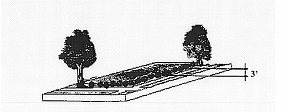
C.
High Screen Landscaping Standard.
1.
Intent. The high screen landscaping standard is a landscape treatment that relies primarily on screening to separate uses or developments. It is intended to be applied in situations where visual separation is required. High screen treatments are at least six feet in height. A high screen landscaped buffer may not be less than five feet in width.
2.
Required Materials.
a.
The high screen landscaping standard requires sufficient high shrubs to form a continuous screen at least six at maturity, feet high and sight-obscuring, year-round.
b.
Ground cover plants or other approved landscaping treatments must fully cover the landscaped area.
c.
A six-foot high masonry wall or a berm may be substituted for the shrubs, but the trees and ground cover plants are still required.
d.
When applied along street lot lines, the screen or wall is to be placed along the interior side of the landscaped area (see Figure 16.15.030-3: High Screen Landscaping).
Figure 16.15.030-3: High Screen Landscaping
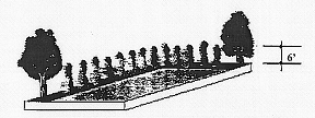
D.
High Wall Standard.
1.
Intent. The high wall standard is intended to be applied in situations where extensive screening to reduce both visual and noise impacts is needed to protect abutting uses or developments from one-another. This screening is most important where either, or both, of the abutting uses or developments can be expected to be particularly sensitive to noise or visual impacts, or where there is little space for physical separation.
2.
Required Materials.
a.
The high wall standard requires a masonry wall at least six, but not more than eight, feet high along the interior side of the landscaped area (see Figure 16.15.030-4: High Wall Landscaping).
b.
In addition, one tree is required for every thirty linear feet of wall. Ground cover plants or other approved landscaping treatments must fully cover the remainder of the landscaped area.
Figure 16.15.030-4: High Wall Landscaping

E.
High Berm Standard.
1.
Intent. The high berm standard is intended to be applied in situations where extensive screening to reduce both visual and noise impacts is needed to protect abutting uses or developments from one-another, and where it is desirable and practical to provide separation by both distance and sight-obscuring materials. This screening is most important where either, or both, of the abutting uses or developments can be expected to be particularly sensitive to noise or visual impacts.
2.
Required Materials.
a.
The high berm standard requires a berm at least four feet high along the interior side of the landscaped area (see Figure 16.15.030-5: High Berm Landscaping).
b.
If the berm is less than six feet high, low shrubs meeting the low screen landscaping standard, above, are to be planted along the top of the berm, assuring that the screen is at least six feet in height.
c.
In addition, one tree planted on the top of the berm is required for every thirty linear feet of berm. Ground cover plants or other approved landscaping treatments must fully cover the remainder of the landscaped area.
Figure 16.15.030-5: High Berm Landscaping
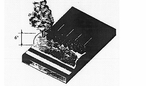
F.
Partially Sight-Obscuring Fence Standard
1.
Intent. The partially sight-obscuring fence standard is intended to provide a tall, but not totally blocked, visual separation. The standard is applied where a low level of screening is adequate to soften the impact of one use or development on another, and where some visibility between abutting areas is preferred over a total visual screen. It can be applied in conjunction with landscape plantings or applied in areas where landscape plantings are not necessary and where nonresidential uses are involved.
2.
Required Materials.
a.
Partially sight-obscuring fence standards are to be at least six feet high and at least fifty percent sight-obscuring.
b.
Fences may be made of wood (other than plywood or particle-board), metal, bricks, masonry or other permanent materials (see Figure 16.15.030-6: Partially Sight-Obscuring Fence).
Figure 16.15.030-6: Partially Sight-Obscuring Fence
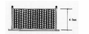
G.
Fully Sight-Obscuring Fence Standard.
1.
Intent. The fully sight-obscuring fence standard is intended to provide a totally blocked visual separation. The standard is applied where full visual screening is needed to reduce the impact of one use or development on another. It can be applied in conjunction with landscape plantings or applied in areas where landscape plantings are not necessary.
2.
Required Materials.
a.
Fully sight-obscuring fences are to be at least six feet high and one hundred percent sight-obscuring.
b.
Fences may be made of wood (other than plywood or particle-board), metal, bricks, masonry or other permanent materials (see Figure 16.15.030-7: Totally Sight-Obscuring Fence).
Figure 16.15.030-7: Totally Sight-Obscuring Fence
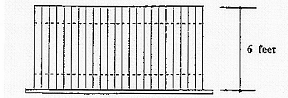
H.
Occupancy and Obscuring Fencing or Buffering.
1.
The use for which a sight-obscuring fence or planting is required shall not begin operation until the fence or planting is erected or in place and approved by the city.
2.
A temporary occupancy permit may be issued upon a posting of a bond or other security equal to one hundred twenty-five percent of the cost of such fence or planting and its installation.
(Ord. 2766 § 1 (part), 2008; Ord. No. 3036, § 3(Exh. A), 6-11-2025)
16.15.040 - Composition and maintenance of landscaping and screening.
A.
Plant Materials.
1.
Shrubs and Ground Cover. Nonhorticultural plastic sheeting or other impermeable surface shall not be placed under mulch. Areas exhibiting only surface mulch, compost or barkdust are not to be used as substitutes for plant areas.
a.
Shrubs. All shrubs shall be well branched and typical of their type as described in current American Association of Nurserymen (AAN) Standards and shall be equal to or better than two-gallon containers and ten-inch to twelve-inch spread.
b.
Ground Cover.
i.
Shall be equal to or better than the following depending on the type of plant materials used: gallon containers spaced at four feet on center minimum, four inches pot spaced two feet on center minimum, two and one-quarter inch pots spaced at eighteen inch on center minimum.
ii.
No bare root planting shall be permitted.
iii.
Where wildflower seeds are designated for use as a ground cover, the city may require annual reseeding as necessary.
2.
Nonstreet Trees. All nonstreet trees should be well-branched and typical of their type as described in current American Association of Nurserymen (AAN) Standards and preferably be balled and burlapped. Nonstreet trees may be categorized as follows:
a.
Primary Trees. Primary trees that define, outline or enclose major spaces, such as oak, maple, linden, and seedless ash, shall be a minimum of two-inch caliper.
b.
Secondary Trees. Secondary trees that define, outline or enclose interior areas, such as columnar red maple, flowering pear, flame ash, and honeylocust, shall be a minimum of one and three-quarter-inch to two-inch caliper.
c.
Accent Trees. Accent trees are used to add color, variation and accent to architectural features, such as flowering-pear and kousa dogwood, shall be one and three-quarter-inch minimum caliper.
d.
Large Conifers. Large conifer trees such as douglas-fir, deodar cedar, shore pine, western red cedar, or mountain hemlock shall be installed at a minimum height of six feet.
3.
Street Trees. For references to the city's policies and standards regarding street trees, please see the following section in this chapter (Section 16.15.050, Street trees).
4.
Tree Credits (Reduction in Required New Trees).
a.
Existing trees in required landscaped areas that are in good health, as certified by an arborist at the end of construction, may count for landscaping tree credit as follows in Table 16.15.040-1 (measured at four and one-half feet above grade and rounded to the nearest inch):
Table 16.15.040-1: Tree Credits
b.
It is the responsibility of the owner to use reasonable care to maintain preserved trees. Trees preserved under this section may only be removed if approved by the planning official. Required mitigation for removal shall be replacement with the number of trees credited to the preserved and removed tree.
6.
Compliance with Standards. The burden of proof is on the applicant to show that proposed landscaping materials will comply with the purposes and standards of this chapter. Landscape materials that exceed the minimum standards of this section are encouraged, provided that height and vision clearance requirements are met.
B.
Installation and Maintenance.
1.
Installation. Plant materials shall be installed to current industry standards and shall be properly staked to assure survival. Support devices (guy wires, etc.) may not interfere with normal pedestrian or vehicular movement.
2.
Maintenance. Maintenance of landscaped areas is the on-going responsibility of the property owner. Any landscaping installed to meet the requirements of this code, or any condition of approval established by a city decision-making body acting on an application, shall be continuously maintained in a healthy, vital and acceptable manner. Required landscaping that dies is to be replaced in kind, within one growing season, unless appropriate substitute species are approved by the city. Failure to maintain landscaping as required in this chapter constitutes a violation of this code for which appropriate legal remedies, including the revocation of any applicable land development permits, may result (see Chapter 16.02, Section 16.02.030, Enforcement).
3.
Irrigation. Irrigation is required of all new development, except single-unit dwellings, duplexes and cottage clusters. The intent of this standard is to assure that plants will survive the critical establishment period when they are most vulnerable due to a lack of watering and also to assure that water is not wasted through unnecessary or inefficient irrigation. Approved irrigation system plans shall specify one of the following:
a.
A permanent, built-in, irrigation system with an automatic controller. Either a spray or drip irrigation system, or a combination of the two, may be specified.
b.
A permanent or temporary system designed by a licensed professional in the field of landscape architecture or irrigation system design, sufficient to assure that the plants will become established and drought-tolerant.
c.
Other irrigation system approved by the planning official.
C.
Protection of Landscaped Areas. All required landscape areas, including all trees and shrubs, shall be protected from potential damage by conflicting uses or activities including vehicle parking and the storage of materials.
D.
Landscaping on Corner Lots. All landscaping on corner lots shall meet the vision clearance standards of Section 16.12.030.H in Chapter 16.12 (Transportation access, access management, and circulation). If high screening would ordinarily be required by this code, low screening shall be substituted within vision clearance areas. Taller screening may be required outside of the vision clearance area to mitigate for the reduced height within it.
E.
Landscape Plans. Except for a single-unit dwelling on a single lot (but not excluding subdivisions), duplexes, and cottage clusters, landscape plans shall be submitted showing all existing and proposed landscape areas. Plans must be drawn to scale and show the type, installation size, number and placement of materials. Plans shall include a plant material list. Plants are to be identified by both their scientific and common names. The condition of any existing plants and the proposed method of irrigation are also to be indicated.
F.
Completion of Landscaping.
1.
The installation of plant materials may be deferred for a period of time specified by the review authority acting on an application, in order to avoid hot summer or cold winter periods, or in response to water shortages.
2.
Except for a single-unit dwelling on a single lot (but not excluding subdivisions), duplexes, and cottage clusters, a final certificate of occupancy shall not be granted until either landscaping is completed or an adequate bond or other security is posted for the completion of the landscaping, and the city is given written authorization to enter the property.
G.
Street Trees Not Typically Part of Site Landscaping. Street trees are not subject to the requirements of this section and are not counted toward the required standards of this section. However, the review authority may, by granting a waiver or variance, allow for special landscaping within the right-of-way to compensate for a lack of appropriate on-site locations for landscaping.
(Ord. 2766 § 1 (part), 2008; Ord. No. 2957, § 3(Exh. A), 5-12-2021; Ord. No. 3036, § 3(Exh. A), 6-11-2025)
16.15.050 - Street trees.
For the city's provisions regarding street trees, please refer to the following:
A.
Lebanon Municipal Code Chapter 12.16, Street trees.
B.
City of Lebanon (public works department).
1.
Street tree policy and potential street tree guide.
2.
Acceptable Street Tree List, Including. Trees for use under power lines, and pruning guide.
(Ord. 2766 § 1 (part), 2008; Ord. No. 3036, § 3(Exh. A), 6-11-2025)
16.15.060 - Fences and walls.
A.
General Standards. Construction of fences and walls shall conform to all of the following requirements:
1.
General Requirements. All fences, walls, and boundary landscaping shall comply with the height limitations of the respective land use zones (Chapters 16.05 through 16.10) and the standards of this section. The city may require installation of walls and/or fences as a condition of development in a land use approval. When so conditioned by a land use action, no further land use review is required for the fence or wall. For fences or walls greater than six feet in height, a building permit is also required (see also, Section 16.15.020 of this chapter for additional landscape screening wall requirements).
2.
Dimensions.
a.
Except as provided under subsections b and c and Table 16.15.060-1, below, the height of fences and walls within a required front yard or street side yard setback shall not exceed three feet as measured from the grade closest to the street right-of-way.
b.
One arbor, gate, or similar garden structures not exceeding eight feet in height and four feet in width is allowed within the front yard, provided that it is not within a clear vision triangle. Such structures in Excess of eight feet in height require a review of the site plan.
c.
Walls and fences to be built for required buffers shall comply with Section 16.15.020.C.
d.
Fences, walls, and boundary vegetation shall comply with the vision clearance standards of Section 16.13.030.H in Chapter 16.13 (Access, access management, and circulation).
3.
Maintenance. For safety and for compliance with the purpose of this chapter, walls and fences required as a condition of development approval shall be maintained in good condition, or otherwise replaced by the property owner.
4.
Materials.
a.
Permitted Fence and Wall Materials. Wood; metal; chain-link; bricks, concrete blocks stone; stucco, or similar masonry, and nonprohibited evergreen plants.
b.
Prohibited Fence and Wall Materials, Except Where Explicitly Allowed Under Other Provisions of the Lebanon Municipal Code. Straw bales; barbed or razor wire; and scrap materials.
c.
Prohibited Fence and Wall Materials. Hedges over eight feet in required yards.
d.
Fences or walls constructed of brick or masonry exceeding four feet in height shall be subject to review and approval by the city engineer. Those that are taller than six feet also require a building permit.
B.
Specific Standards. Fences and walls are considered accessory uses. An accessory use shall comply with all requirements for a principal use, except where specifically modified by this section. As accessory uses, fences, walls, and landscaping shall comply with the following standards:
1.
Height Requirements for Fences, Walls and Hedges in Residential Zones.
Table 16.15.060-1: Height Requirements for Fences, Walls and Hedges in Required Yards in Residential Zones
2.
Fences and Walls in Other Land Use Zones. Fences and walls in other land use zones are subject to the standards, if any, found in Chapters 16.05 through 16.10.
3.
Placement of Fences, Walls and Public Fire Hydrants. Fences and walls may not be placed closer than three of an existing public fire hydrant.
(Ord. 2766 § 1 (part), 2008; Ord. No. 3036, § 3(Exh. A), 6-11-2025)
16.16.010 - Introduction.
This chapter provides facility standards and general procedures for the review of public improvement plans (excluding transportation issues covered in previous chapters). This chapter implements and cross-references the city's public facility master plans (e.g., water, sanitary sewer, storm drainage, parks), and engineering design criteria and standards.
A.
Purpose. The purpose of this chapter is to provide planning and design standards for public and private utilities.
B.
When Standards Apply.
1.
Unless otherwise provided, the standard specifications for construction, reconstruction, or repair of utilities, and other public improvements within the city shall be in accordance with the standards of this chapter.
2.
No development shall occur unless the facilities related to development comply with the requirements established in this chapter, and adopted documents and guidelines designed to assure conformance of facilities to the city's standards.
C.
Engineering Design Criteria, Standard Specifications and Details.
1.
The design criteria, standard construction specifications and details maintained by the city engineer, shall supplement the general design standards of this development code.
2.
Accordingly, the city's specifications, standards, and details (e.g., the city's public improvement standards, the city's adopted standards and specifications for construction, and relevant sections of the Lebanon Municipal Code) shall supplement the general design standards of this development code.
D.
Conditions of Development Approval.
1.
No development may occur unless required public and/or private facilities are in place or guaranteed, in conformance with the provisions of this code, and/or supplemental standards as per subsection C of this section.
2.
Improvements required as a condition of development approval that involve the dedication of an interest in real property shall be roughly proportional to the impact of the development.
3.
The findings in the development approval shall describe how the required improvements are related to the development and roughly proportional to the impact of the development.
(Ord. 2766 § 1 (part), 2008)
16.16.020 - Dedication of public use areas.
A.
Where a proposed park, playground, or other public use or facility shown in a facility or special area plan adopted by the city is located in a site or area proposed for a subdivision or other land use action, the city may require the dedication or reservation of an area to implement the plan and to mitigate the impact of the proposed development.
B.
The city may purchase or accept dedication or reservation of land within a proposed subdivision or other land use that are suitable for the development of parks, public facilities, and other public uses as noted above. However, the city is under no obligation to accept such areas offered for dedication or sale, and will determine the suitability of the proposed dedication in its sole discretion.
C.
Adequacy of utility and infrastructure facilities is based on the standards established in the city's adopted master facility plans (e.g., stormwater and drainage, parks, wastewater).
(Ord. 2766 § 1 (part), 2008)
16.16.030 - Sanitary sewer and water service improvements.
A.
Sewers and Water Mains Required.
1.
Adequate sanitary sewers and water infrastructure and service shall be made available to serve each new development or redevelopment. The facilities and services must comply with the city's sanitary sewer facility plan and water system facility plan, and shall comply with applicable construction specifications.
2.
When streets are required to be stubbed to the edge of a development, sewer and water system improvements shall also be extended with those streets.
B.
Over-Sizing. The city may require as a condition of development approval that sewer, water, and other infrastructure improvements serving new development be appropriately sized to serve neighboring properties or the designated service area according to the applicable facility plans. Consistent with the provisions of the city's SDC ordinance, the city may partially reimburse the developer for incremental costs incurred in construction of improvements greater in capacity than required to serve the proposed development (oversizing).
C.
Inadequate Facilities. Development permits and land use approval may be restricted by the city where a deficiency exists in the existing water or sewer system that cannot be rectified by proposed infrastructure enhancements and that, if not rectified, will result in a threat to public health or safety.
(Ord. 2766 § 1 (part), 2008)
16.16.040 - Storm drainage improvements.
A.
General Provisions. The city may grant land use approval and issue a development permit when adequate provisions for stormwater and floodwater runoff are or will be made available in compliance with the city's storm drainage master plan and all applicable local, state and federal standards.
B.
Accommodation of Upstream Drainage. Culverts and other drainage facilities shall be large enough to accommodate existing and potential future runoff from the entire upstream drainage area, whether inside or outside the development. Such facilities shall be subject to review and approval by the city engineer.
C.
Effect on Downstream Drainage. Where there exists a known or suspected downstream drainage deficiency and the applicant cannot demonstrate that the additional runoff resulting from the development is within the capacity of an existing drainage facility, the city shall withhold approval of the development until provisions have been made for the mitigation of the deficient condition caused by the development in accordance with city standards.
D.
Over-Sizing. The city may require as a condition of development approval that storm drainage systems serving new development be sized to accommodate future development within the area as projected by the applicable storm drainage master plan or special area plan. Consistent with the provisions of the city's SDC ordinance, the city may partially reimburse the developer for incremental costs involved in oversizing.
E.
Existing Watercourse.
1.
Where a proposed development is traversed by a watercourse, drainage way, channel, or stream that is proposed or required to remain in its current condition and/or function, there shall be provided to the city a stormwater easement or drainage right-of-way (ROW). The easement or ROW shall include provisions for access and maintenance.
2.
The easement or ROW shall conform substantially with the lines of the watercourse and additional width adequate for stormwater conveyance and maintenance of the stormwater conveyance to protect the public health and safety, and adjacent properties, as determined by the city engineer.
F.
Stormwater Release Rate. All new site development shall maintain pre-development peak historic stormwater discharge rates as per city standards. The applicant for a development proposal shall demonstrate through calculations acceptable to the city engineer that this standard will be met by the proposed development.
G.
Impacts of Site Development. Site development may not adversely impact historic surface drainage patterns of surrounding properties. The city may require, as conditions of approval, specific mitigation measures and/or performance guarantees to ensure compliance with this provision.
(Ord. 2766 § 1 (part), 2008)
16.16.050 - Utilities.
A.
Placement and Installation of Utilities.
1.
Underground Placement. Unless otherwise exempted by subsection B of this section, all new utility lines including, but not limited to, those required for natural gas, electric, communication, lighting, and cable television services and related facilities shall be placed underground, except for surface-mounted transformers, surface-mounted connection boxes and meter cabinets (which may be placed above ground). Temporary utility service facilities, during construction, may also be placed above ground.
2.
Installation. The following additional standards apply to all new utility installation, in order to facilitate underground placement of utilities.
a.
The developer shall coordinate site improvements with the serving utility to provide the underground services. Above ground utility service facilities and equipment shall not obstruct vision clearance areas for vehicular traffic (See Section 16.12.030(H) in Chapter 16.12 of this code).
b.
All underground utilities, including sanitary sewers, storm drains and water lines installed in streets by the developer, shall be constructed prior to the surfacing of the streets.
c.
Stubs for service connections shall be long enough to avoid disturbing the street improvements when service connections are made.
3.
City Approval for any Surface-Mounted Utility Support Facilities. The city reserves the right to approve the location of all surface-mounted utility support facilities, subject to department of public works permit.
B.
Exception to Underground Placement Requirement.
1.
An exception to the underground placement requirement may be granted by the city engineer due to physical constraints, such as steep topography, or existing development conditions.
2.
High capacity electrical transmission lines that are infeasible to site underground are exempted from the underground placement requirement.
C.
Provision of Utility Services to All New Residential Subdivisions. All lots in residential subdivisions shall be provided with access to natural gas, electrical power, cable TV, and landline phone facilities provided such utilities can reasonably be made available to the site, in addition to the public utilities provided for in this chapter.
(Ord. 2766 § 1 (part), 2008)
16.16.060 - Easements.
A.
Provision.
1.
The developer or applicant shall make arrangements with the city, the applicable service district, and each utility service provider for the granting and/or dedication of utility easements and/or ROWs necessary to provide full utility services to the development.
2.
The city's standard width for public utility easements shall be determined by the city engineer, considering utility line size, depth and access among other factors.
B.
Recordation on Plat. As determined by the city engineer and approved by the Linn County surveyor, all easements for sewers, storm drainage and water quality facilities, water mains, electric lines, or other public utilities associated with a subdivision or partition shall be recorded on the final plat. See Chapters 16.21 through 16.23 of this code for related provisions, especially Chapter 16.22: Land Divisions (Subdivisions, Partitions), Property Line Adjustments and Vacations.
(Ord. 2766 § 1 (part), 2008)
16.16.070 - Construction plan approval and assurances.
A.
Prior Plan Approval and Permit Issuance. No public improvements, including, but not limited to, sanitary sewers, water lines, storm sewers, streets, sidewalks, curbs, lighting, parks, or other requirements shall be undertaken until the plans have been approved by the city, permit fees paid, and a permit issued.
B.
Performance Guarantee. The city may require the developer or subdivider to provide bonding or other performance guarantees to ensure completion of required public improvements. See Chapters 16.21 through 16.24 of this code for related provisions, especially Chapter 16.22: Land Divisions (Subdivisions, Partitions), Property Line Adjustments and Vacations.
C.
Bonding and Assurances.
1.
Performance Bonds for Public Improvements. On all projects where public improvements are required, the city shall require a bond in an amount not less than one hundred twenty-five percent or other adequate assurances as a condition of plat approval in order to guarantee the public improvements.
2.
Release of Performance Bonds. The bond or assurance shall be released when the city engineer finds the completed project conforms to the conditions of approval and applicable standards, and approves the release in writing.
3.
Improvements and Bonding.
a.
Improvements. Before approval is certified on final plats or prior to issuance of a public improvement permit within existing right-of-way, the subdivider or developer shall either install required improvements and repair existing streets and other public facilities damaged in the development of the subdivision; or execute and file with the city an agreement between the city and the subdivider/developer specifying the period of time within which required improvements and repairs shall be completed.
b.
Bonding. The subdivider shall file with the city a bond or an assurance agreement in a form approved by the city attorney to assure installation of the necessary improvements. The agreement shall provide that if the work is not completed within the period specified, the city may complete the work and recover the full cost and expense thereof from the subdivider. The agreement may provide for the construction of the improvements in units and for an extension of time under specified conditions. The amount shall be for a sum determined by the city engineer as sufficient to cover the cost of the improvements and repairs, including related city expenses. The financial instrument shall include one of the following:
i.
A surety bond executed by a surety company authorized to transact business in the state of Oregon;
ii.
An agreement in a form approved by the city attorney together with evidence of financial responsibility and resources of those signing the agreement sufficient to provide reasonable assurance of ability to proceed in accordance with the agreement.
c.
Liability. If the subdivider fails to carry out provisions of the agreement and the city has un-reimbursed costs or expenses resulting from such failure, the city is authorized to call on the bond or agreement for reimbursement. If the amount of the bond or agreement exceeds the cost and expenses incurred by the city, the city shall authorize release of the remainder. If the amount of the bond is less than the cost and expense incurred by the city, the subdivider shall be liable to the city for the difference.
(Ord. 2766 § 1 (part), 2008)
16.16.080 - Infrastructure installation.
A.
Conformance Required. Public and private infrastructure and site improvements installed by the developer, either as a requirement of land use approval, city regulations or at his/her own option, shall conform to the requirements of this chapter, approved construction plans, and to the city's specifications, and standards (e.g., the city's public improvement standards, the city's adopted standards and specifications for construction, and relevant sections of the Lebanon Municipal Code).
B.
Commencement of Work. Work on public facilities shall not begin until the city has issued a construction permit.
C.
City Inspection.
1.
Public improvements shall be constructed under the inspection of the developer's engineer and observation of the city to the established specifications and standards of the city, and to the satisfaction of the city.
2.
The city may require changes in typical sections and details if unusual conditions arising during construction warrant such changes. Modifications to the approved public improvements design requested by the developer may be subject to review under Chapter 16.24: Modifications to Approved Plans and Conditions of Approval, in the discretion of the city engineer.
3.
Any monuments that are disturbed before all improvements are completed by the subdivider shall be replaced prior to final acceptance of the improvements.
D.
Engineer's Certification and Record Drawings.
1.
A registered civil engineer shall provide written certification in a form approved by the city that all public improvements, workmanship, and materials comply with current and standard engineering and construction practices, conform to approved plans and conditions of approval prior to city acceptance of the public improvements, or any portion thereof, for operation and maintenance.
2.
The developer shall provide required record drawings to the city as per the city's specified format(s) and number of copies.
(Ord. 2766 § 1 (part), 2008)
16.17.010 - Introduction.
A.
Wireless Communication Facilities (WCFs). This chapter provides the standards and regulations for wireless communication facilities (WCFs), including antennas and all the structures associated with the receiving or capturing of incoming and/or transmitting outgoing communications transmitted from, or to be received by, other antennas. Wireless communications facilities will often be referred to as "WCFs" and/or "facilities" within this chapter.
B.
Antennas to which this Chapter has No Application. The provisions of this chapter do not apply to radio or television reception antennas, satellite or microwave parabolic antennas not used by wireless communications service providers, to any antenna support structure or antenna lawfully in existence within the city on the effective date of this chapter, receiving antennas for direct broadcast service (DBS) thirty-nine inches or less in diameter, or commercial radio or television broadcasting facilities.
(Ord. 2766 § 1 (part), 2008)
16.17.020 - Purpose.
The purposes of this chapter include the following:
A.
To establish standards that regulate the placement, appearance and impact of wireless communication facilities (WCFs), while providing residents with the ability to access and adequately utilize the services that these facilities support. Because of the physical characteristics of wireless communication facilities, the impact imposed by these facilities may affect not only the neighboring residents, but the community as a whole. The standards are intended to ensure that the visual and aesthetic impacts of wireless communication facilities are mitigated to the greatest extent possible, especially in or near sensitive areas and environments, including residential areas.
B.
To minimize potential adverse health, safety, public welfare, or visual impacts of WCFs, through careful design, siting, construction, landscaping, and innovative visual compatibility techniques.
C.
To encourage shared use/co-location of WCFs as a primary option rather than construction of additional single-use towers.
D.
To encourage utilization of technology and business practices that will either eliminate or reduce the need for construction of new tower facilities.
E.
To protect the health, safety, public welfare, and property of the community, by ensuring that WCFs are sound and carefully designed, constructed, modified, maintained, and removed when no longer used or are determined to be structurally unsound.
F.
To protect the public interest and existing public and private investment in infrastructure for wireless communications services. For example, the introduction of new non-regulated WCFs may not adversely affect (e.g., interfere with signal transmitted by) a previously existing use.
G.
To promote investment in new WCFs and technology that will benefit local end users (consumers) of wireless communications services.
(Ord. 2766 § 1 (part), 2008)
16.17.030 - Technical definitions and terminology for wireless communications.
A.
Antenna. "Antenna" for wireless communications means a specific device used to receive or capture incoming and/or to transmit outgoing communications transmitted from, or to be received by, other antennas. Antennas regulated by this chapter include omni-directional (or "whip") antennas, directional (or "panel") antennas, parabolic (or "dish") antennas, and any other devices designed for the reception and/or transmission of radio-frequency (RF) signals or other communication technologies, except as otherwise limited in this chapter.
B.
Attached Wireless Communications Facility. "Attached wireless communications facility" means a wireless communications facility that is affixed to an existing structure, other than a wireless communications tower.
C.
Co-Location. "Co-location" means a wireless communications facility comprised of a single communications tower or building supporting one or more antennas, dishes, or similar devices owned or used by more than one provider.
D.
Lattice Tower. "Lattice tower" means a support structure constructed of vertical metal struts and cross braces forming a triangular or square structure which often tapers from the foundation to the top.
E.
Monopole. "Monopole" means a support structure constructed of a single, self-supporting hollow tube securely anchored to a foundation.
F.
Provider. "Provider" means a company, which may or may not hold a Federal Communications Commission (FCC) license, that is in business to provide wireless communications services.
G.
Wireless Communications. "Wireless communications" means the transmission, via radio frequency electromagnetic waves, between or among points specified by the user, of information of the user's choosing, without change in the form or content of the information as sent and received.
H.
Wireless Communications Accessory Structure/Equipment. "Wireless communications accessory structure/equipment" means equipment shelters or radio equipment necessary for the operation of wireless communications in addition to the antenna and tower.
I.
Wireless Communications Facility (WCF). "Wireless communications facility (WCF)" means a facility consisting of the equipment and structures involved in receiving and or transmitting communications or radio signals.
J.
Wireless Communications Equipment Shelter. "Wireless communications equipment shelter" means the structure in which the electronic radio equipment, electronic equipment, relay equipment and other supporting equipment for a wireless communications facility is housed.
K.
Wireless Communications Tower (WCT)/ Support Facility. "Wireless communications tower (WCT)/Support Facility" means a structure intended to support equipment used to transmit and/or receive communications signals including monopoles, guyed and lattice towers, but not excluding any other approved structure.
L.
Visual Compatibility Characteristics. "Visual compatibility characteristics" means characteristics that minimize the visual impact of a tower or antennas.
(Ord. 2766 § 1 (part), 2008)
16.17.040 - Review procedures: Use permits and review processes.
As noted in Table 16.17.040-1, Wireless Communications Facilities are permitted by a variety of use permits and review processes, depending on the type or scope of development activity.
Table 16.17.040-1: Types of Use Permits and Review Process(es) Required for WCFs According to Type or Scope of Development Activity
Notes:
• Height standards for zones can be found in Chapters 16.05 through 16.10.
• The maximum permissible height (even through the variance process) is 150 feet for a WCF in any zone.
• In the industrial zone (Z-IND), the maximum permissible height for a WCF is 150 feet, and does not require a variance.
• Use Permits: Wireless Communications Facilities shall be permitted as per the requirements of the "Other Land Use" Tables in the Land Use Chapters (16.05 — 16.10): Tables 16.05-5, 16.06-5, 16.07-5, 16.08-5, 16.09-5, 16.10-5.
Review Processes
1.
Outright Permitted Uses with Site Review and Building Permit: "OP" means the use is permitted outright and a Building Permit is issued after a site review determines that all setbacks and other lot and building site requirements are satisfied.
2.
Permitted with Administrative Review: "AR" means the use is permitted through an Administrative Review process that takes into account all applicable requirements (see Chapter 16.20).
3.
Permitted with Conditional Use Approval: "CU" means the use is permitted with a Conditional Use approval (Chapter 21).
4.
Site Reviews: The processing of a variety of land use applications may also include detailed site reviews. These requirements are addressed in LDC Chapters 16.20 — 16.23 (Article Four).
(Ord. 2766 § 1 (part), 2008)
16.17.050 - Siting preferences.
WCFs shall be sited in accordance with the following priorities, in order of their preference. If the applicant proposes a facility of lower priority, the applicant shall demonstrate that each of the higher priorities has been considered and found to be not feasible.
A.
Priority #1. Co-location on an existing WCF.
B.
Priority #2. Use of an attached WCF.
C.
Priority #3. Siting of a new wireless communications tower (WCT), in a visually obscure location, using design techniques maximizing "Visual Compatibility Characteristics."
D.
Priority #4. Siting of a new WCT in a visually prominent location (e.g., along arterials and collectors, on hills and ridges), using design techniques maximizing "Visual Compatibility Characteristics."
E.
Priority #5. Siting of a tower in a visually prominent location (e.g., along arterials and collectors, on hills and ridges), not employing design techniques maximizing "Visual Compatibility Characteristics."
F.
Exemptions. Wireless communications facilities for emergency services (police, fire, and emergency management) are exempt from the above requirements if the siting agency can demonstrate the need for an exemption based on public safety and welfare issues. The review authority may also exempt local, state, and federal facilities, as well as facilities owned and operated by federally-licensed amateur radio station operators (i.e., "ham" radio operations).
(Ord. 2766 § 1 (part), 2008)
16.17.060 - Standards and requirements.
A.
Code Compliance Requirements. All WCFs shall meet all requirements established by the provisions of this code, the LMC, and other applicable city codes, and other applicable standards.
B.
State and Federal Requirements. All WCFs shall comply with all applicable federal (e.g., Federal Communication Commission and Federal Aviation Administration) and state standards.
C.
Height.
1.
A WCF may not exceed the height standards of a zone, except where permitted through the variance process.
2.
Except in the industrial zone (Z-IND), the maximum permissible height (even through the variance process) is one hundred fifty feet for a WCF in any zone.
3.
In the industrial zone (Z-IND), the maximum permissible height for a WCF is one hundred fifty feet, and does not require a variance.
4.
The height of a WCF shall be measured as per building code standard procedures from the center of the base of the proposed facility to the topmost portion of the WCF (e.g., the tip of the highest antenna or other transmission or reception device).
5.
Airport Overlay Zones. All lands within the airport overlay zones (e.g., approach surface, transitional zone) shall be subject to additional height restrictions and development standards (see Chapter 16.12).
D.
Co-Location.
1.
New WCFs, if technically feasible, will be designed and constructed for at least three antennas/providers to co-locate on the facility and to allow antennas mounted at varying heights. At a minimum, WCFs up to one hundred twenty feet in height shall accommodate at least two facilities/providers.
2.
A facility may be attached to any existing structure as long as the height of that structure is not increased by more than ten feet and so long as it meets all relevant requirements of this chapter, consistent with applicable building codes.
3.
A freestanding WCF shall be approved only if the applicant demonstrates that it is not feasible to site the facility on an existing structure. The application shall contain documentation that alternative sites within a radius of at least two thousand feet have been considered and are technologically unfeasible or unavailable. The application also must document why co-location is impractical on existing structures for one or more of the following reasons: structural support limitations; safety considerations; lack of available space; failure to meet service coverage area needs; or unreasonable economic constraints.
E.
Construction.
1.
All facilities must meet the requirements of the Uniform Building Code (UBC), the International Building Code (IBC) and/or the Oregon Structural Specialty Code, and all other relevant and applicable building codes.
2.
Noise-generating equipment shall be sound-buffered by means of baffling, barriers or other suitable means to reduce the sound level measured at the property line to no more than thirty dBA above the level of ambient background noise when adjacent to residential uses and forty-five dBA above the level of ambient background noise in other areas.
3.
It is prohibited to attach any communications facility or portion thereof to a tree.
4.
WCFs shall be set back at least twenty-five percent of the tower height from all property lines or shall meet the setbacks of the underlying zone, which ever is greater.
F.
Design. Where possible new facilities will be located in such a manner that they blend in with the background around them, using techniques to ensure visual compatibility characteristics.
1.
All new WCF towers shall be a monopole or lattice tower structure constructed out of metal or other nonflammable material. The height and mass of the structure shall not exceed that which is essential for its intended use and public safety.
2.
All accessory structures (i.e., vaults, equipment rooms, utilities, and equipment enclosures) shall be concealed, buffered or screened with mature vegetation and/or sight obscuring fencing (see Chapter 16.15), shall be consistent with the underlying zone, or may be placed underground. Underground placement of equipment shelters is encouraged and should be considered in each case.
3.
WCFs shall be painted in a non-reflective color to match the existing or attached structure and/or to blend into the surrounding environment to the greatest extent possible as seen from abutting uses, roadways or other public ways. Alternative colors or treatments of the external surfaces of any and all components of a WCF may be approved by the Review Authority to minimize the visual impact of the facilities, and such approved alternatives shall become part of the conditions of approval.
G.
Landscaping/Screening. All ground-level facilities associated with a WCF shall be landscaped and/or screened in accordance with the provisions of Chapter 16.15 of this code. The facilities must be fully screened before operations can begin.
H.
Lighting. No lighting shall be permitted on a WCF except as required for security and as required by the Federal Aviation Administration. (See Section 16.19.050, Exterior lighting, in Chapter 16.19.)
I.
Location. No communications facility shall be installed on an exposed ridge line unless it blends with the surrounding existing natural and man-made environment in such a manner as to be visually compatible with the environment.
J.
Signs. Signs shall comply with the requirements set forth in this code.
K.
Twenty-four Hour Emergency Contact Information. As part of the submittal requirements, all owners of WCFs shall provide twenty-four hour contact information to the city so as to facilitate emergency response. Such information must be kept current and on file with the city (police chief) and the Lebanon fire district.
L.
Facilities on City-Owned Property. When a proposed WCF would be sited on property owned by the city of Lebanon, the city shall exercise its zoning authority under this code independently from and without regard to the terms and conditions of any agreement allowing the facility.
(Ord. 2766 § 1 (part), 2008)
16.17.070 - Attached communications facilities.
All attached facilities shall be located and designed to appear an integral part of the structure.
A.
Roof-mounted antennas and all building mounted accessory equipment shall be located no closer to the nearest edge of the roof than the height of the antenna or accessory equipment, whichever is greater.
B.
Wall-mounted antennas shall be architecturally integrated into the building.
C.
Wall-mounted antennas shall protrude no more than four feet from the face of the wall.
D.
Accessory structures for attached facilities, such as equipment shelters, cabinets or other enclosed structures containing electronic equipment, shall be camouflaged or otherwise constructed using visual compatibility techniques, as defined in this chapter to the greatest extent possible.
E.
All proposals shall demonstrate adequate structural strength to support the additional weight and stress of a proposed antenna attachment in compliance with all applicable building code provisions.
(Ord. 2766 § 1 (part), 2008)
16.17.080 - Abandonment of facilities.
A.
When a WCF ceases to operate, the owner or service provider shall provide notice to the city within thirty days. Failure to notify the city within thirty days, may result in removal of such a facility ninety days following the cessation of operations or thereafter.
B.
An antenna support structure that has not had an antenna or antenna array mounted upon it for a period of one hundred seventy successive days, or if the antenna or antenna array mounted thereon are not operated for a period of one hundred seventy successive days, shall be considered abandoned, and the owner thereof shall remove such structure and any accompanying equipment enclosure to a depth of four feet below the surface of the ground within ninety days from the date of written notice from the city. During this ninety-day period, the owner may apply, and, for good reason, be granted an extension of time on such terms as the city planner or building official shall determine.
C.
If such structure and equipment enclosure are not so removed, the city may seek and obtain a court order directing such removal and imposing a lien upon the real property upon which the structure(s) are situated in an amount equal to the city's cost of removal.
D.
The city may also declare such an abandoned facility a nuisance and pursue enforcement and all available remedies under the appropriate provisions of the LMC (see Chapter 16.08).
(Ord. 2766 § 1 (part), 2008)
16.17.090 - Application.
A.
Application Requirements. The applicable submittal requirements for the type of land use review process that is necessitated by the specific proposal submitted, and the requirements of the zone of the subject property, apply to applications for the siting of communications facilities.
B.
Development Plan Required. All applications shall be accompanied by a development plan drawn to scale showing the following:
1.
Use or uses;
2.
Location of the proposed facility and relevant dimensions;
3.
Height of the proposed facility;
4.
Setbacks for the proposed facility;
5.
A photo simulation of the proposed WCF for the maximum number of providers;
6.
Dimensions and location of areas to be reserved for vehicular and pedestrian access and circulation;
7.
A landscaping plan that indicates how the facility will be screened from adjoining uses;
8.
A fencing plan that indicates the location, height and design of any proposed fencing;
9.
A lighting plan that indicates the type and location of any proposed lighting;
10.
A sign plan that indicates the size, location, and design of any proposed signage;
11.
Drawings demonstrating the materials, color and design of the proposed facility;
12.
A map showing all existing wireless communication facility sites operated by the provider within two miles of the Lebanon boundary, or the top of the nearby ridges, whichever is greater, including a description of the facility at each location;
13.
A propagation study indicting proposed facility and the adjacent hand-off sites;
14.
If provider proposes to construct a new facility (tower), the application shall include findings that demonstrate that it is not legally or technically feasible to co-locate.
C.
Additional Documentation.
1.
Documentation of the efforts that have been made to co-locate on existing or previously approved towers, as required by the siting standards in Section 16.17.060 above.
2.
Each provider shall make a good faith effort to contact the owner(s) of all existing or approved towers and shall provide a list of all owners contacted in the area, including the date, form of contact and the result of contact.
3.
Documentation as to why co-locating on an existing or proposed tower or attachment to existing structures within two thousand feet of the proposed site is not feasible.
D.
Narrative Required. A written statement shall include the following information:
1.
The name and contact information for the provider;
2.
Twenty-four hour emergency contact information (during construction, and after the WCF becomes operational) to facilitate emergency response;
3.
A description of the character of the proposed facility;
4.
Analysis of how the application meets the review criteria;
5.
Applicants/providers shall provide evidence of legal access to the proposed WCF;
6.
The applicant/provider shall provide evidence that legal access to the facility site will be maintained for the duration of the facility's operation;
7.
Where a proposed WCF is located on a property not owned by the provider, the applicant/provider shall present documentation that the owner of the property has granted an easement or entered into a lease or other authorization for the proposed facility and that vehicular access is provided to the facility;
8.
For new freestanding towers, the applicant shall provide evidence that describes the WCF's structural capacity to carry the antennas of at least three wireless communications providers;
9.
The applicant shall provide evidence of steps the provider will take to avoid interference with normal radio and television reception in the surrounding area, with other communications service providers' signals, and communications of any public safety agency or organization, per FCC requirements;
10.
The applicant shall demonstrate that the WCF will provide service within the city;
11.
If the applicant/provider proposes a new tower or co-located facility, the applicant shall provide evidence that the facility's height is the lowest height at which the gap in coverage can be filled;
12.
All applications shall include evidence that at least one provider will use the proposed facility to provide wireless communications service to city residents immediately upon construction completion of the facility;
13.
All applications shall include a statement recognizing the grounds for denial of permits and removal of facilities listed below:
a.
Applications shall include a written agreement that wireless communications facilities owned by the provider, that do not have operating antennas for a period of six months, shall be considered abandoned and shall be removed by the operator within sixty days thereafter;
b.
Applications shall include a written agreement from the property owner that if the provider fails to remove an abandoned WCF, the property owner has full legal and fiscal responsibility for the WCF removal.
(Ord. 2766 § 1 (part), 2008)
16.18.010 - Introduction.
A.
Purpose. The city of Lebanon regulates the construction, installation, maintenance, electrification, illumination, type, size, number, and location of signs in order to:
1.
Protect the health, safety, property, and welfare of the public;
2.
Maintain and enhance the neat, clean, orderly and attractive appearance of the city;
3.
Provide for the safe installation and maintenance of signs;
4.
Preserve the safe flow of traffic in Lebanon;
5.
Preserve and enhance the unique scenic beauty of Lebanon.
B.
Definitions. The following words and phrases, where used in this chapter shall, for the purposes of this chapter, have the meanings given of them in this section.
1.
"Area" or "area of a sign" means the area to and within an established sign edge, frame, or perimeter which encloses the limits of any writing, representation, emblem, figure or character. The area of a sign having no such perimeter, or the area of a sign having an irregular shape, shall be computed by enclosing the surface area within a polygon. Where a sign is of a three-dimensional or round or irregular shape, the largest cross section shall be used, as though it were a flat surface, to determine sign area.
2.
"Awning or canopy" means either a permanent or retractable structural extension off or of a building, sometimes intended for the purpose of pedestrian cover.
3.
"Building official" means the officer or other designated authority charged with the administration and enforcement of this code or his/her duly authorized representative.
4.
"Building face" means the single wall surface of a building facing a given direction.
5.
Changing Image Sign. "Changing image sign" means a sign designed to accommodate routine changes of copy, images or patterns of lights. Such signs include, but are not limited to, electronic signs incorporating LED, LCD, plasma, or projected light displays; and, mechanical or manual changeable copy signs.
6.
"Clearance" is measured from the highest point of the grade below the sign to the lowermost point of the sign.
7.
"Commercial zones" means the Z-CCM, Z-HCM and Z-NCM zones, as defined in this code (see LDC Chapter 16.08).
8.
"Display surface" means the area made available by the sign structure for the purpose of displaying the message.
9.
"Flag" means flags of nations, an organization of nations, states and cities, fraternal, religious, military, veteran and civic organizations.
10.
"Frontage" means the length of the property line of any one premise along each public street it borders. Each portion of the premises abutting a separate street shall be considered as a separate frontage.
11.
"Height" is measured from the highest point of the grade below the sign to the topmost point of the sign.
12.
"Historical markers" are signs installed or maintained by public authority or by a recognized historical society or organization identifying sites, buildings, districts, or structures of recognized historical value.
13.
"Industrial zone" means the Z-IND zone as defined in this code (see LDC Chapter 16.09).
14.
"Install" means to build, construct, attach, place, suspend, or affix and shall also include the painting of wall signs.
15.
"Maintain" means to allow a sign, sign structure, or part thereof to continue; or to repair or refurbish a sign, sign structure, or part thereof.
16.
"Marquee" means a permanent roof-like structure attached to and supported by a building and projected therefrom.
17.
"Mixed-use zone" means the Z-MU zone that possess potential for several types of land use or combinations of different land uses. The intent of this designation is to achieve an environment in which different land uses can co-exist. Mixed development lands are open to all types of development including residential, commercial, and light (Class I and II Impacts) industrial land uses (see LDC Chapter 16.06).
18.
"Murals" are coverings of the surface area of a wall with paint or other artistic medium, that creates a pictorial or abstract design and usually without advertising or commercial symbolism — such as logos or trademarks — or any representation of a product or business, except to identify the artist.
19.
"Parapet or parapet wall" means that part of any exterior wall which extends above the eave of the roof.
20.
"Permittee" means a person who has applied for a city of Lebanon sign application to allow placement or installation of a sign covered by this chapter.
21.
"Premises" means a tract of land occupied, by a building or unit or group of buildings and its accessory buildings. If more than one business activity is located on the tract of land, each separate business shall be considered as separate premises.
22.
"Projection" means the distance by which a sign extends from its supporting structure.
23.
"Residential zones" means the Z-RL, Z-RM, and Z-RH residential zones as defined in this code (see LDC Chapter 16.05).
24.
"Roof line" means either the eave of the roof or the top of the parapet, at the exterior wall. In the event that the structure lacks a parapet or cave, the "roof line" means a profile of the roof of the structure.
25.
"Sign" means any device or medium affixed to the property (including its structure, lighting, materials, and component parts) which by reason of its form, color, wording, logo, design, and/or illumination visually communicates, identifies, advertises, informs, announces, or attracts attention to the subject thereof (i.e., advertises or promotes any specific business, interest or cause). For the purposes of this code, street address information shall not be considered a sign.
26.
"Sign, awning, canopy or marquee sign" means a sign which is painted onto, attached, or affixed to the surface of an awning or marquee, or is suspended underneath an awning or marquee. For purposes of calculating sign area, the entire exposed face of the canopy or awning or marquee shall be designated the sign area. Canopy, awning and marquee signs shall be considered to be wall signs for purposes of determining size allowances.
27.
"Sign, Banner" means a sign of lightweight fabric or similar material that can be mounted both on a permanent or temporary basis. Flags as defined by this chapter shall not be considered banners.
28.
Sign, Changing (Automatic). "Changing sign (automatic)" means an electronically or electrically controlled sign such as; public service, time, temperature and date sign, message center, or reader board, where different copy changes are shown on the same lamp bank.
29.
Sign, Daily Display. "Daily display sign" (known also as sandwich board) means a non-permanent sign normally associated with business activity which is placed out-of-doors during business hours for display and returned indoors off-hours. Daily display signs may be constructed in a sandwich board (A-frame) style, mounted on a single pedestal or other similar construction, and are intended to be unlit and easily moved. These signs are not lighted.
30.
Sign, Externally Illuminated. "Externally illuminated sign" means a sign illuminated by an exterior light source or luminous tubing which is primarily designed to illuminate only the sign.
31.
Sign, Fence. "Fence sign" means a sign attached or painted to the side of a fence on a permanent basis.
32.
Sign, Fin. "Fin sign" means a sign which is supported by a pole or poles and partly by a building.
33.
Sign, Flashing. "Flashing sign" means any sign which contains an intermittent or flashing light source, or which includes the illusion of intermittent or flashing light by means of animation, or an externally mounted intermittent light source. Automatic changing signs such as public service, time, temperature, and date signs or electronically controlled message centers are classed as "changing signs," not "flashing signs."
34.
Sign, Freestanding. "Freestanding sign" means a sign wholly supported by a sign structure in the ground. Freestanding signs include pole signs and monument signs.
35.
Sign, Internally Illuminated. "Internally illuminated sign" means a sign which is wholly or partially illuminated by an internal light source from which source light passes through the display surface to the exterior of the sign.
36.
Sign, Monument. "Monument sign" means a low profile freestanding sign which has a solid base at ground level that is equal to or greater than the width of the sign face, and which has no separation between the base and the sign.
37.
Sign, Nonconforming. "Nonconforming sign" means a sign in existence or under construction on the effective date of the ordinance codified in this chapter which does not conform to the provisions of the ordinance, but which was or is being constructed, installed, or maintained in compliance with regulations in effect at the time the sign was constructed or installed.
38.
Sign, Notice. "Notice sign" means a sign posted by either a public agency or private individuals intended to convey information of a legal nature pertaining to specific properties. Examples of notice signs include building permits, no trespassing notices, public hearing notices and similar signs.
39.
Sign, Pennant. "Pennant sign" means a shaped, lightweight sign, made of plastic, fabric, or other material (whether or not containing a message of any kind) suspended from a rope, wire, or string, usually in a series, and designed to move in the wind.
40.
Sign, Pole. "Pole sign" means a freestanding sign connected to the ground by one or more supports, where any portion of the lower edge of the sign device is separated vertically from the ground by air.
41.
Sign, Portable. "Portable sign" means a sign which is not permanently attached to the ground or other permanent structure and is intended to be transported to a site for purposes of display. A portable sign may or may not be mounted on wheels and may or may not include flashing or moving lights and removable lettering or display surface. Portable signs are not daily display signs.
42.
Sign, Projecting. "Projecting sign" means and includes any sign which is attached to a building and extends more than twelve inches beyond the line of the building or more than twelve inches beyond the surface of that portion of the building to which it is attached.
43.
Sign, Roof. "Roof sign" means a sign or any portion of which is displayed above the roof line.
44.
"Sign, Sidewalk Banner" means a daily display sign consisting of a pole with a horizontal arm, or arms, and designed to hold one or two vertical banners.
45.
Sign, Temporary. "Temporary sign" means any sign, regardless of construction materials, which is not permanently mounted and is intended to be displayed on an irregular basis for a limited period of time and does not require a building permit to be placed or installed.
46.
Sign, Time, Date and Temperature. "Time, date and temperature sign" means a sign providing only time, date and/or temperature information. May be a component of a larger sign.
47.
Sign, Under-marquee. "Under-marquee sign" means a sign which is installed or maintained under, and supported or partially supported by, a marquee.
48.
Sign, Unsafe. "Unsafe sign" means any sign determined to be a safety hazard to the public by the building official or duly authorized representative.
49.
Sign, Wall-Mounted. "Wall-mounted sign" means any sign, attached to, or installed against the wall of a building. Wall-mounted signs may not project more than twelve inches from the wall to which they are attached.
50.
Sign, Wall-Painted. "Wall-painted sign" means a sign painted directly onto a wall of a building which is located in a commercial or industrial zone.
51.
Sign, Window. "Window sign" means a sign, pictures, symbols, neon tubing, or combination thereof, designed to communicate information that is placed on or within a window and directed towards the outside of the window.
52.
"Structural alteration" means any change in a sign or sign structure other than advertising message or normal maintenance.
53.
"Temporary" means for a limited duration of time usually not to exceed ninety days, unless otherwise modified by provisions of this chapter.
54.
"Wall sign" means a sign attached to, erected against or painted on a wall of a building or structure, with the exposed face of the sign in a plane approximately parallel to the face of said wall and not projecting more than twelve inches. Wall signs can be a wall-mounted sign or a wall-painted sign.
55.
"Written message" means the lettering, wording, numbers, and/or other symbols on a sign intended to convey a message. Written message does not include notation of the sign identity the sign installer or artist, provided such identification is less than one square foot in area.
(Ord. 2766 § 1 (part), 2008)
(Ord. No. 2780, Exh. A, 8-12-2009; Ord. No. 2862, § 2(Exh. A, § I), 9-9-2015)
16.18.020 - Administration procedure and enforcement.
A.
Permit Required. All signs installed after the effective date of this code, other than exempt signs, shall require a sign permit. All applications for sign permits shall be submitted to, and in such form as may be required by, the planning and/or building department.
1.
Planning review and building permit issuance for signage are a combined procedure. A decision on the sign permit shall be issued first, followed by issuance of the building permit.
2.
A sign permit application shall be made available by the planning official. Sign permit applications that are incomplete or do not provide the required information may be deemed incomplete by the planning official and returned to the applicant for the addition of the missing required information.
3.
An application fee as established by resolution of the city council shall be paid to the city of Lebanon upon filing of an application. The application fee is not refundable.
4.
The sign permit shall be approved, approved with conditions, or denied by the planning official.
Figure 16.18.020-1: Sign Permit Review
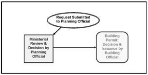
B.
Interpretation. The provisions of this chapter supersede any provision dealing with signs in any previously adopted ordinance, resolution, or regulation, except any regulations required under the city adopted building code and the Oregon Fire Code.
C.
Authority. The planning official shall have the power and duty to interpret and enforce the provisions of this chapter. The building official shall have the power and duty to enforce the building code provisions of this chapter.
D.
Permit Expiration. Every sign permit issued under the provisions of this chapter shall expire by limitation and become null and void if the building or work authorized by such permit is not commenced with one year from the date of such permit, or if the building or work authorized by such permit is suspended or abandoned at any time after the work is commenced for a period of one hundred eighty days. Before such work can be recommenced, a new permit shall be first obtained, and the fee shall be one-half of the amount required for a new permit for such work, provided no changes have been made or will be made in the original plans specifications for such work and, further, that such suspension or abandonment has not exceeded one year.
E.
Permit Suspension or Revocation. The planning official and/or building official may, in writing, suspend or revoke a permit issued under provisions of this chapter whenever the permit is issued on the basis of incorrect information supplied, or is in violation of any applicable ordinance or regulation or any of the provisions of this chapter.
F.
Pre-Existing Signs. Signs legally constructed or placed prior to the adoption of these chapter provisions and do not conform to these provisions shall be considered nonconforming. If the sign is to be relocated or replaced, the replacement or relocated sign shall comply with the provisions of this chapter.
(Ord. 2766 § 1 (part), 2008)
16.18.030 - Signs exempted or prohibited, and nonconforming signs.
A.
Exempted Signs. The following signs do not require a sign permit but shall conform to all other applicable provisions of this code and shall be permitted in all zones, except as otherwise noted.
1.
Signs not exceeding a total of three square feet in area, non-illuminated, and not exceeding three feet in height if ground-mounted (or thirty inches in required front and street side yards).
2.
Temporary signs which are non-illuminated, have an overall face area not exceeding thirty-two square feet in a residential, commercial, or industrial zone, are not permanently installed, and are intended to be located on property for short durations of time (generally not to exceed one hundred eighty days). Such signs typically include, but are not limited to, real estate lease and sales, political signs, construction signs, and garage sale, open house, special event, and similar signs. Such signs shall only be posted for the duration of the activity. No sign shall be extended into or extend over a street right-of-way.
3.
Temporary display of lights or other decorations associated with holidays.
4.
Banners, lights, and pennants not exceeding a total display area of forty square feet per face used on premises in conjunction with temporary events and not in place longer than a period of thirty days.
5.
Signs placed for purposes of public direction and safety. Such signs typically include, but are not limited to, traffic and municipal signs, directional signs for emergency services (such as hospitals, police stations and fire stations), legal notices, railroad crossing signs, danger signals, and similar signs. Such signs may be placed within the public right-of-way subject to right-of way permit requirements.
6.
Flags as defined in this chapter are permitted outright in all zones.
7.
Signs carved into a building or which are a part of materials which are an integral part of the building such as cornerstones, building names and similar signs.
8.
Signs of public or legal notice.
9.
Window signs in commercial and industrial zones, provided materials subject to Section 16.18.040(B)(1) below are not used.
10.
Promotional displays and temporary signage for special commercial and other events, provided such displays shall be in place for a period not to exceed thirty days. This includes limited temporary event signage (e.g., Strawberry Festival, Music in the Park, National Holidays).
11.
Fence signs which are located on the inside of a fence and are used in conjunction with athletic events.
12.
Historical site plaques or markers.
13.
Signs with display surfaces that are not visible from the public right-of-way (e.g., are located in an interior court yard).
14.
Murals for commercial and industrial uses. Murals shall be allowed provided that the entire mural regardless of content shall be included in the sign area calculation for a wall sign. The calculation shall be in accordance with provisions in the "sign area" definition.
15.
One banner, mounted on a pole attached to the wall of a building and not more than fifteen-square feet in area, may be displayed during business hours. If the banner is located above a sidewalk, public or private, there shall be a minimum nine-foot separation between the lowest part of the banner and the sidewalk.
B.
Prohibited Signs. It is unlawful for any person to install, display or maintain, and a permit shall not be issued for the installation, display, or maintenance of, any sign or advertising structure falling within any of the following descriptions.
1.
Rotating and revolving signs, whether mechanical or by means of normal wind currents; and, flashing signs by electrical pulsations, illumination or comparable means.
2.
Signs installed within the right-of-way of any street, along any driveway, or in any other location which do not meet the requirements of section or by reason of the location, shape, color, animation, or message are likely to be confused with any traffic control device; or create a distracting or hazardous condition for motorists.
3.
Fin signs.
4.
Roof signs.
5.
A sign, or any portion thereof, may not be placed so that it obstructs any fire escape, stairway, or standpipe; interferes with human exit through any window or any room located above the first floor of the building; obstructs any door or required exit from any building; or obstructs any required light or ventilation.
6.
Portable signs, except as defined in subsection (A)(2) of this section.
7.
Fence signs, except internal fence signs as described in subsection (A)(11) of this section.
8.
Signs affixed to power, utility, or traffic control poles other than city-approved traffic control signs and pole identification placards.
9.
Signs affixed to or painted on natural features, such as rocks or trees.
C.
Nonconforming Signs. Notwithstanding provisions found elsewhere in this code, pre-existing, nonconforming uses may replace existing signs with signs that conform to the requirements of the applicable zone. For example, a commercial building in a residential zone may install signs that comply with provisions in Section 16.18.050(B).
D.
Placement of Signs and Public Fire Hydrants. Freestanding monument signs, and freestanding pole signs may not be placed within ten feet of an existing public fire hydrant.
(Ord. 2766 § 1 (part), 2008)
(Ord. No. 2780, Exh. A, 8-12-2009; Ord. No. 2801, Exh. A, 7-14-2010; Ord. No. 2862, § 2(Exh. A, § II), 9-9-2015)
16.18.040 - Sign districts.
A.
Signage in Residential Zones and Residential Development in the Mixed-Use Zone. No sign shall be installed or maintained in an Z-RL, Z-RM, and Z-RH or Z-MU zone, except as allowed under this section, or as otherwise noted in this section.
Table 16.18.040-1: Permitted Uses that may have Signage under the Standards of this Code in Residential Zones and Residential Development in the Mixed-Use Zone
Zones: Residential Low Density (Z-RL); Residential Mixed-Density (Z-RM); Residential High Density (Z-RH); Mixed-Use (Z-MU)
Table 16.18.040-2: Signage Standards for Residential Zones and Residential Uses in the Mixed-Use Zone (Z-RL, Z-RM, and Z-RH or Z-MU zones)
B.
Signage in Commercial, Mixed-Use, Industrial and Public Use Zones. No sign shall be installed or maintained in the Z-CCM, Z-HCM, Z-NCM, Z-MU, Z-IND, Z-PU zones, except as allowed under Section 16.18.030(A), Chapter 16.24 (Planned Development), or as otherwise noted in this section. See Chapters 16.06 through 16.10 in this code for the permitted uses in these zones.
Table 16.18.040-3: Signage Standards for Commercial, Mixed Use, Industrial, and Public Uses in the Z-CCM, Z-HCM, Z-NCM, Z-MU, Z-IND and Z-PU Zones
(Ord. 2766 § 1 (part), 2008; Ord. No. 2801, Exh. A, 7-14-2010; Ord. No. 2980, § 2(Exh. A), 4-13-2022; Ord. No. 3041, § 2(Exh. A), 11-12-2025)
16.18.050 - Signs in public rights-of-way.
A.
Signs Prohibited. Signs are prohibited within public rights-of-way, except as allowed below.
1.
Directional Signs. Signs for purposes of public direction and safety may be allowed within the public right-of-way, subject to right-of-way permit requirements and the following standards. Requests for placement of directional signs within the public right-of-way shall apply to the director of public works.
2.
Daily Display Signs. In sign districts that permit display signs, a daily display sign may be allowed within the public right-of-way only adjacent to and in front of the premises with which it is associated, provided all of the following conditions are met:
a.
A city right-of-way permit is required. The applicant shall identity the specific location, size and construction materials of the sign. A daily display sign must conform to the conditions of the permit.
b.
The sign is to be set back behind the curb so as not to interfere with on-street parking, or a minimum of ten feet from the edge of the nearest street travel lane where curbs are not in place.
c.
The sign is to be placed so as to allow at least five feet of unimpeded pedestrian sidewalk maneuvering space.
d.
The sign is to meet the clear vision requirements of Subsection 16.12.030.H of this Code.
e.
The sign is properly maintained as per requirements of Section 16.18.060.
f.
The applicant shall be responsible for any physical or property damage injury caused by the sign located upon the right-of-way adjacent to the applicant's property.
g.
Sign dimensions shall comply with one of the following:
i.
"A" Frame Signs — The sign shall not exceed thirty-inches in width, four feet in height, with a maximum sign area (one-side) of ten-square feet.
ii.
Pole Banner Signs — The sign structure shall not exceed thirty-six-inches in width, eighty-inches in height as measured to the top of the banner and shall not contain a base greater than thirty-inches in width. The structure may contain one or two banners, provided the total sign area shall not exceed eight-square feet (one-side).
h.
No more than one sign per business is allowed.
i.
A daily display sign may be displayed on the public right-of-way as described above only during business hours.
j.
Failure to comply with these standards may result in the removal of the sign by the city and revocation of the sign permit. If the removed sign is not claimed by its owner within ten business days, it shall be deemed abandoned property and thereafter disposed of consistent with state law.
B.
Gateway or City Entrance Signs.
1.
City entrance signs in public ROWs may be permitted by the city manager, planning official, and/or public works director, provided the signs do not cause a visual impairment or otherwise conflict with the public health, safety and welfare. Otherwise there are no restrictions to height, sign area and location.
2.
The placement of such signage along state highways must also comply with the regulations and requirements of ODOT, Highway Division.
(Ord. 2766 § 1 (part), 2008)
(Ord. No. 2780, Exh. A, 8-12-2009)
16.18.060 - Sign construction and maintenance.
A.
Construction Requirements. Except as otherwise provided in the sign code, the construction of all signs or sign structures shall conform to applicable provisions of the Uniform Sign Code, state of Oregon Building Code, fire code, electrical code, and all other applicable city codes.
B.
Maintenance Requirements. All signs, conforming and nonconforming, together with their supports, braces, guys, and anchors, shall be constructed of materials that are durable and weather resistant.
1.
The sign owner shall be responsible for regularly maintaining all signs so that they exist at all times in a state of good repair as determined by the building official.
2.
All primary residential and commercial structures and business locations shall display, to be easily legible from the street, the correct and current address (as issued by the city).
C.
Replacement or Repair of Nonconforming Signs. Upon obtaining a building permit, a nonconforming sign may be removed, repaired, upgraded or replaced with different materials, provided that the repaired or replaced sign is not any more nonconforming than the original sign and the sign is replaced within sixty days from the date of the issuance of the permit.
(Ord. 2766 § 1 (part), 2008)
16.18.070 - Changing image signs.
A.
Area Limitation. No more than fifty percent of a permitted sign area shall contain a changing image sign.
B.
Transition Time. Where a changing image sign changes from one display to another display there shall be a transition time of not more than two seconds but shall not violate provisions prohibiting flashing signs. The display shall thereafter remain static for the at least the following intervals:
1.
Nonresidential activities in the following zones — residential, public use, mixed use zone, neighborhood mixed use, neighborhood commercial: Twelve seconds.
2.
Central business commercial zone: Ten seconds.
3.
Highway commercial zone and industrial zone: Eight seconds.
C.
Brightness. A changing image sign shall be constructed with a photocell to compensate for all conditions, day or nighttime hours, and shall adjust the display's brightness to a level that is not in excess of 0.3 foot candles above ambient light levels.
D.
Required Equipment. Upon installation, the sign owner shall provide written certification from the sign manufacturer that the light intensity has been factory preset not to exceed the levels specified in subsection (C) above. Submittal of such evidence shall be required to obtain a sign and/or building permit.
E.
Prohibited Applications. In addition to prohibitions in Section 16.18.030(B), changing image signs shall be prohibited for any residential-related activity in the RL, RM and RH zones; the neighborhood mixed use and neighborhood commercial zones; and, residential uses in the mixed use zone.
(Ord. No. 2862, § 2(Exh. A, § III), 9-9-2015)
Editor's note— Ord. No. 2682, § 2(Exh. A, § III), adopted Sept. 9, 2015, renumbered the former §§ 16.18.070—16.18.090 as 16.18.080—16.18.100 and enacted a new § 16.18.070 as set out herein. The historical notation has been retained with the amended provisions for reference purposes.
16.18.080 - Removal of signs in violation.
A.
Unsafe Sign.
1.
Time Limit. The building official may cause any sign and/or sign support structure which is determined to be a hazard to persons or property — by reason of it or its support structure being or becoming of unsound and unsafe; i.e., weakened or broken support, broken parts, including tubing, wiring, plastic, etc. — to be evaluated by an Oregon licensed structural engineer for repair, replacement or removal. The cost of the evaluation shall be the responsibility of the sign owner.
2.
Notice Given. Notice shall be given to the sign owner or owner of the property on which the sign is located, at the discretion of the building official, except notice is not required if a determination is made that the sign and/or sign support structure poses an immediate health, safety, or welfare risk to persons or property. If the sign or property owner fails to respond to a notice of an unsafe sign within any time limit specified in the notice, the city may remove the sign at the property owner's expense.
B.
Removal and Remediation.
1.
Removal. Unless otherwise specified, signs found to be in violation of this code will be given a thirty-day removal notice. The violating sign may be removed by the city at cost to the property owner after time limit of notice to remove sign has expired.
2.
Remediation. In the case of removal by the city, no occupancy or building permit will be issued for the property involved until all fines and fees due the city are paid in full.
(Ord. 2766 § 1 (part), 2008)
(Ord. No. 2862, § 2(Exh. A, § III), 9-9-2015)
Note— See the editor's note to § 16.18.070.
16.18.090 - Sign variances.
Signs may exceed the limits imposed by this chapter through application for and approval of a variance as per the provisions of Chapter 16.29 (Variances). The sign variance process shall conform to provisions in Chapter 16.29, except that the decision shall be subject to the following criteria:
A.
There are unique circumstances of conditions of the lot, building or traffic pattern such that the existing sign regulations create an undue hardship;
B.
The requested variance is consistent with the purpose of this chapter as stated in Section 16.18.010;
C.
The granting of the variance compensates for those circumstances in a manner equitable with other property owners and is thus not a special privilege to any particular business. The variance requested shall be the minimum necessary to compensate for those conditions and achieve the purpose of this chapter;
D.
The granting of the variance shall not decrease traffic safety nor detrimentally affect any other identified items of public welfare;
E.
The desire to match standard sign sizes (for example, chain store signs) is not considered a valid reason for a variance;
F.
The variance request shall not be the result of a self-imposed condition or hardship.
(Ord. 2766 § 1 (part), 2008)
(Ord. No. 2862, § 2(Exh. A, § III), 9-9-2015)
Note— See the editor's note to § 16.18.070.
16.18.100 - Appeals.
Appeals from a ruling of the planning official or from the planning commission shall be taken and administered pursuant to the provisions of Chapter 16.20 of this code.
(Ord. 2766 § 1 (part), 2008)
(Ord. No. 2862, § 2(Exh. A, § III), 9-9-2015)
Note— See the editor's note to § 16.18.070.
16.19.010 - General provisions regarding accessory uses.
An accessory use shall comply with all requirements for a principal use, except where specifically modified by this section. The standards for accessory dwellings are found in Chapter 16.05. Accessory structures shall not be used for human habitation or prohibited accessory uses except as specified in this section. Accessory uses shall comply with the following standards:
A.
An accessory structure is not to be used for human habitation.
B.
An accessory structure and use are subordinate to the primary use. Accessory structures and uses are not permitted without an established primary structure and use (e.g., a dwelling in a residential zone). Accessory structures and uses are subject to the development standards of the zone in which they are located (Chapters 16.05 through 16.10).
C.
Placement and construction of an accessory structure shall comply with all applicable building standards and site development standards.
D.
Garages (detached) are accessory structures.
E.
Boats, trailers, detached campers, motorized dwellings, recreational vehicles (RVs), and similar recreation equipment may be stored, but not used for human habitation, on a lot as an accessory use to a dwelling provided that storage is not permitted in a front or street side yard, and further provided that street access is approved, and the vehicles are stored on an approved improved surface.
(Ord. 2766 § 1 (part), 2008; Ord. No. 3036, § 3(Exh. A), 6-11-2025)
16.19.020 - Distance from property line.
In commercial or industrial zones where a side or rear yard is not required and a structure is not to be erected at the property line, an accessory use shall be set back at least three feet from the property line.
(Ord. 2766 § 1 (part), 2008; Ord. No. 3036, § 3(Exh. A), 6-11-2025)
16.19.030 - Use of residential structures in commercial and industrial zones.
In commercial and industrial zones, pre-existing residential structures may be occupied by uses permitted in the zone provided the structure meets minimum building and safety standards as outlined in the applicable building code, fire and life safety codes, and provided further that required planning applications have been submitted and approved, including a development plan for vehicular, pedestrian and ADA access, parking, as well as landscaping, signing, and exterior lighting if applicable.
(Ord. 2766 § 1 (part), 2008; Ord. No. 3036, § 3(Exh. A), 6-11-2025)
16.19.040 - Single-unit detached dwelling placement standards.
The following standards apply to the placement of single-unit detached on individual lots in residential zones be multi-sectional (double-wide or wider) and enclose a floor area of not less than one thousand square feet.
A.
All dwellings must be on a foundation that meets the city's construction code and design requirements or the Oregon Manufactured Dwelling Installation Specialty Code as applicable and that does not exceed 12-inches above the finished grade.
B.
The primary dwelling must be a minimum of twenty feet in width at its narrowest dimension or include three or more of the design elements listed below (B.1 through B.15).
1.
Minimum twenty percent window coverage on every side of the building.
2.
Dormer(s) at least three feet wide.
3.
Covered porch entry with a minimum of forty square foot covered front porch and a minimum five feet deep.
4.
Second story balcony that projects from the wall of the building a minimum of four feet and enclosed by a railing or parapet wall.
5.
Building face containing two or more off-sets of sixteen inches or greater from one exterior wall to the other.
6.
Roof overhang of sixteen inches or greater.
7.
Columns, pillars, or posts at least four inches wide and containing base materials for a total width of at least eight inches.
8.
Decorative gables with cross or diagonal bracing, shingles, trim, corbels, exposed rafter ends, or brackets (does not include a garage gable if the garage projects beyond the remaining portion of the primary street facing façade).
9.
Molding above windows and doors that is at least six inches wide.
10.
Pilasters at least eight inches wide or chimneys.
11.
Shakes, shingles, brick, or stone occupying at least sixty square feet of the street façade.
12.
Bay or bow window(s) that extend a minimum of twelve inches outward from the main wall of a building and form a bay or alcove in a room within the building.
13.
Sidelight and/or transom windows associated with the front door or windows in the front door.
14.
Pitched roof with a slope not less than three feet in height for each twelve feet in width (fourteen degrees).
C.
For manufactured dwelling units, the dwelling must be certified by the manufacturer to have an exterior thermal envelope meeting the performance standards specified by state law for single-unit dwellings constructed under the state building code.
(Ord. 2766 § 1 (part), 2008; Ord. No. 2957, § 3(Exh. A), 5-12-2021; Ord. No. 3036, § 3(Exh. A), 6-11-2025)
Editor's note— Ord. No. 3036, § 3(Exh. A), adopted June 11, 2025, amended the title of § 16.19.040 to read as herein set out. The former § 16.19.040 title pertained to manufactured dwelling placement standards.
16.19.050 - Exterior lighting.
Exterior lighting shall be designed, constructed, located, shielded, and directed in such a manner so as to not face directly, shine, reflect, or glare onto an adjacent residences, streets, and other land uses (i.e., lumens should not exceed 0.1 at all property lines). Also see airport overlay zones (in Chapter 16.11) for additional lighting standards for that zone.
(Ord. 2766 § 1 (part), 2008; Ord. No. 3036, § 3(Exh. A), 6-11-2025)
16.19.060 - General provisions regarding home occupations.
A home occupation, when conducted in a residential zone, shall be subject to the following standards:
A.
The home occupation shall be secondary to the main use of the dwelling as a residence.
B.
All aspects of the home occupation shall be contained and conducted within a completely enclosed building.
C.
The home occupation shall be limited to either a pre-existing garage or accessory structure, or not over twenty-five percent of the floor area of the main floor of a dwelling. If located within an accessory structure or a garage, the home occupation shall not utilize over five hundred square feet of floor area. No structural alteration, including the provision of an additional entrance, shall be permitted to accommodate the home occupation, except when otherwise required by law. Such structural alterations shall not detract from the outward appearance of the property as a residential use.
D.
No persons other than those residing within the dwelling shall be engaged in the home occupation.
E.
No window display and no sample commodities displayed outside the dwelling are allowed.
F.
No materials or mechanical equipment shall be used which are detrimental to the residential use of the dwelling or any nearby dwellings because of vibration, noise, dust, smoke, odor, interference with radio or television reception, or any other factor.
G.
No parking of customers' vehicles in a manner or frequency so as to cause disturbance or inconvenience to nearby residents or so as to necessitate off-street parking shall be allowed. A maximum of two customers' vehicles shall be permitted at one time.
H.
No sign shall be permitted except for a single name plate not to exceed six square feet in area, located inside the dwelling or flat against the exterior of the building (see Chapter 16.18, Table 16.18.040-2, subsection 9).
I.
See Table 16.05-2 (Chapter 16.05) for review and permitting requirements.
(Ord. 2766 § 1 (part), 2008; Ord. No. 3036, § 3(Exh. A), 6-11-2025)
16.19.070 - Exceptions to yard requirements on arterial and collector streets.
In order to protect arterial and collector streets and to permit the eventual widening of these streets, every yard abutting a portion of a street hereinafter named shall be increased over the required yard dimension specified in the zone so that the minimum distance from the center line of the right-of-way to the front of any structure shall be as listed below in residential zones. Other zones allowing for a lesser setback than required in a residential zone may reduce the required setback of the section by the difference between the required setback in the residential zone and the zone in which the building is to be located.
Table 16.19.070-1: Exceptions to Yard
Requirements on Arterial and Collector Streets
(Ord. 2766 § 1 (part), 2008; Ord. No. 3036, § 3(Exh. A), 6-11-2025)
16.19.080 - Exceptions to building height limitations.
Vertical projections such as chimneys, spires, domes, elevator shaft housing, tower aerials, flag poles, solar system apparatus and similar objects not used for human occupancy shall not exceed the building height by more than ten feet providing that the abutting properties' solar access will not be impaired. The applicant proposing the vertical projection is required to submit a shadow projection demonstrating that solar access will be protected. Vertical projections that cast a shadow of less than three feet in width and are less than ten feet in height do not require a shadow projection.
(Ord. 2766 § 1 (part), 2008; Ord. No. 3036, § 3(Exh. A), 6-11-2025)
16.19.090 - Projections from buildings.
A.
Front Yard Projections. The following features, when not more than one story high, may project into the front yard setback area, provided the projection shall be no closer than ten feet from the property line: Planter boxes, chimneys and flues, steps, cornices, eaves, gutters, belt courses, leaders, sills, pilasters, lintels, and other ornamental features, uncovered porches, covered but unenclosed porches.
B.
Side Yard Projections.
1.
Cornices, eaves, gutters and fire escapes may project into a required side yard not more than one-third of the width of the side yard, with a maximum projection of four-feet.
2.
Chimneys, flues, belt courses, leaders, sills, pilasters, lintels and ornamental features may project not more than one and one-half feet into a required side yard, provided the chimneys and flues shall not exceed six feet in width.
3.
Uncovered decks and patios attached to the main building, and no more than three feet in height when measured directly beneath the outside edge of the deck or patio, may be extended to the side yard property line.
C.
Rear Yard Projections.
1.
Chimneys, flues, belt courses, leaders, sills, pilasters, lintels, gutters and other ornamental features, may project not more than one and one-half feet into a required rear yard, provided the chimneys and flues shall not exceed six feet in width.
2.
A fire escape, balcony, outside stairway, cornice or other unenclosed, unroofed projections may project not more than five feet into a required rear yard, provided it is set back at least six feet from any property line.
3.
The following features, when not more than one story high, may project into the rear yard setback area: Planter boxes, chimneys and flues, steps, cornices, eaves, gutters, belt courses, leaders, sills, pilasters, lintels, and other ornamental features, uncovered porches, covered but unenclosed porches.
4.
No permitted projection into a required rear yard shall extend within ten feet of the center line of an alley or within five feet of a rear lot line if no alley exists.
(Ord. 2766 § 1 (part), 2008; Ord. No. 3036, § 3(Exh. A), 6-11-2025)
16.19.100 - Solar energy use.
The use of solar energy systems, both active and passive, including solar collectors, storage facilities, and other necessary components for space heating and cooling, swimming pool heating, and water heating is a permitted use in accordance with the provisions of each zone.
(Ord. 2766 § 1 (part), 2008; Ord. No. 3036, § 3(Exh. A), 6-11-2025)
16.19.110 - Temporary uses.
A.
Purpose. The purpose of these regulations is to provide standards for the establishment of temporary businesses and similar uses within the City.
B.
Permitted Uses. Where allowed, the following temporary uses shall be permitted subject to the following limitations and requirements:
1.
Tree and Fireworks. Christmas tree or fireworks sales are permitted subject to the following:
a.
The sales shall be allowed in Commercial zones and those properties containing public or semi-public uses, such as schools, churches, regardless of the underlying zone.
b.
Such uses located within residential zones shall not operate beyond nine p.m.
c.
The specific activity is located within the city for no more than ninety days in a calendar year.
d.
The operator of a temporary use shall obtain all permits required by other agencies.
e.
The required parking for the primary uses on the same lot is not reduced below ordinance requirements and the use does not block driveways, driveway entrances, or parking aisles.
f.
The activity conforms to all signage requirements in Chapter 16.18.
g.
The activity conforms to all setback requirements of the zone.
h.
The operator of a temporary use shall provide the required information, pay the applicable fee, obtain and display the required temporary business permit.
2.
Commercial Activities. Amusement and recreational services and retail sales and services are permitted in all commercial zones, subject to the following:
a.
The business may be operated from a vehicle or temporary structure.
b.
A site and/or address shall not contain more than one vendor at a time. For the purpose of this section a "site and/or address" may contain several tax lots under the same or similar ownership, or contain one or more permanent business on a single or multiple parcels (e.g., a shopping center).
c.
The business may occupy no more than three hundred square feet of an area on a given site and/or address. An exemption to this limitation shall be permitted for amusement and carnival types of activities, provided, the use complies with the remaining provisions in this subsection.
d.
The specific activity is located within the city for no more than ninety days in a calendar year.
e.
The operator of a temporary use shall obtain all permits required by other agencies.
f.
The required parking for the primary uses on the same lot is not reduced below ordinance requirements and the use does not block driveways, driveway entrances or parking aisles.
g.
The activity conforms to all signage requirements in Chapter 16.18.
h.
The activity conforms to all setback requirements applicable to zone.
i.
The operator of a temporary use shall provide the required information, pay the applicable fee, obtain and display the required temporary business permit.
3.
Mobile Food Preparation Units. Mobile food preparation units are permitted in all commercial zones, subject to the following:
a.
Through a temporary use permit, a maximum of one mobile food preparation unit may be permitted on a fully improved site and/or address defined in item 2.b of this subsection. If more than one mobile food preparation unit operates on a site and/or address, the use shall be subject to the regulation and permitting requirements for food pods in Section 16.08.100.E of the Lebanon Development Code.
b.
The business may be operated from a vehicle, cart or trailer with wheels, or temporary structure. Except for electrical service, the vehicle or structure shall be self-contained. This requirement specifically prohibits connections to the city water and/or sewer system.
c.
The mobile food preparation unit may occupy no more than three hundred square feet of area and shall be kept in good repair and maintained in a safe and clean condition.
d.
The mobile food preparation unit is limited to three hundred sixty-five days at a given site and/or address with an unlimited number of three hundred sixty-five-day extensions. Each extension shall require a new permit.
e.
The required parking for the primary uses on the same lot shall not be reduced below ordinance requirements and the use does not block driveways, driveway entrances, parking aisles, walkways or sidewalks.
f.
The activity conforms to all signage requirements in Chapter 16.18.
g.
The activity conforms to all setback requirements applicable to the zone.
h.
Prior to obtaining a temporary use permit, the applicant shall show evidence of obtaining the necessary permits from Linn County Department of Health Services for the operation of a mobile food preparation unit. In addition, the operator shall obtain all permits and required inspections by other agencies, including the Lebanon Fire District.
i.
The mobile food preparation unit operator shall provide the required information, pay the applicable fee, and obtain and display the required temporary business permit.
4.
Recreational Vehicle Caretaker Dwelling Associated with Certain Self-Service Storage Facilities. A recreational vehicle may be used as a caretaker dwelling associated with certain self-serve storage facilities, subject to the following:
a.
Eligible Facilities. A recreational vehicle may be utilized as a caretaker dwelling for open air facilities with no permanent structure intended for occupancy, subject to a temporary use permit.
b.
A maximum of one recreational vehicle may be utilized as a caretaker dwelling per site.
c.
The recreational vehicle may only be used as a dwelling for the caretaker. No business activities associated with the self-service storage facility may occur within the vehicle.
d.
Temporary use permit would be issued to the owner of the recreational vehicle with application submittal approval by the property owner.
e.
Sewer and Water Service. The caretaker recreational vehicle shall be able to connect to a sewer system to appropriately discharge the grey and black water from the vehicle in a manner that would not result in site contamination. Water service shall also be available for the recreational vehicle to connect for service while residing on the site.
f.
Site Inspection. Prior to approval of a temporary use permit, the building official shall inspect the site to ensure appropriate utility connections are available, and the recreational vehicle for the caretake can appropriately connect to the sewer system as required.
C.
Other Temporary Uses.
1.
Temporary Construction Facilities. Mobile offices, temporary power equipment and temporary structures used by personnel and to store equipment during construction, provided the structures are located on the construction site and not used as dwellings. There is no restriction as to the zoning.
2.
Yard Sales and Auctions. Yard sales or auctions in any zone, provided there are not more than four sales in a calendar year, with each sale not to exceed three consecutive days. Merchandise and signs shall remain on private property. This section does not limit the number of times, or duration, that public agencies may conduct sales or auctions regard agency land, equipment, supplies or other materials.
D.
Temporary Use Permit.
1.
Permit Required. With the exception of temporary construction facilities, yard sales and auctions, each temporary use allowed under this section of the code shall be required to obtain a permit from city hall to operate within the city.
2.
Procedure.
a.
Requests.
i.
Requests for a temporary use shall be made in writing to the planning official.
ii.
Decisions on temporary use requests shall be made utilizing a ministerial review process (see Section 16.20.030 in Chapter 16.20 of this code).
iii.
Applicants may request that their ministerial review be heard by the planning commission.
iv.
Mailed notices shall include summary of temporary use ruling.
b.
Decision to Approve a Temporary Use.
i.
The planning official shall have the authority to decisions on temporary use requests using the ministerial review process; or
ii.
Refer the ministerial review request to the planning commission for its interpretation in a public hearing.
iii.
The review process, either by the planning official or on referral to the planning commission, shall follow all the applicable provisions of Chapter 16.20 of this code.
c.
Appeal. A decision by the planning official may be appealed to the planning commission.
3.
Application Requirements. A request for a temporary use permit shall submit the following information:
a.
A signed statement from the property owner or lessee of the primary use on said property:
i.
Granting permission for the property to be used by the permit applicant;
ii.
Copy of a property deed, ground lease or similar evidence of ownership for subject property;
iii.
Specifying the day(s) for which permission is granted;
iv.
Containing the name, mailing address and telephone number of the owner or lessee; and
v.
Acknowledging responsibility to ensure all litter, trash and materials on the property associated with the temporary use are removed within two days after the temporary use ceases.
b.
A signed statement from the permit applicant:
i.
Specifying the permit applicant's name, permanent home or business address (not P.O. Box), home or business telephone number;
ii.
Specifying the type of use proposed by the applicant;
iii.
Attaching proof that any applicable state or federal licenses or other requirements to engage in the temporary use proposed by the applicant have been granted by the appropriate governmental agencies; and
iv.
Acknowledging responsibility to ensure that all litter, trash and materials on the property associated with the temporary use are removed within two days after the temporary use ceases.
c.
Each application shall be accompanied by a site plan to demonstrate compliance with these provisions. The site plan shall be to an approximate scale, preferably on an eight and one-half inches by eleven inches sheet of paper. The site plan shall include the following:
i.
Locations of all existing structures;
ii.
Preoposed location of temporary use;
iii.
Parking spaces and aisles within the parking lot;
iv.
Driveways; and
v.
Streets.
4.
Decision Criteria. The decision criteria are established in this section of the code in conjunction with any applicable criteria from the land use zone in which the temporary use is proposed.
5.
Issuance of Permit. After approval by the decision making authority, the permit shall be issued by the city, upon payment of the applicable fee, and evidence the intended use conforms to the applicable requirements set forth in this section of the code.
6.
Length of Operation. In determining the length of operation of a temporary use, the use will be deemed continuous from the first day that the permit was issued. The use will be deemed discontinued upon cessation of the temporary use, restoration of the premises as set forth herein, and surrender of the permit to the city, whichever occurs last. The applicant may apply and be granted approval up to six months in advance of the effective issuance of the permit.
7.
Revocation. The temporary business permit may be revoked in the event that the operating business does not conform to the requirements specified in this section of the code, or if any of the information in the above noted application is false.
(Ord. 2766 § 1 (part), 2008; Ord. No. 2875, § 2, Exh. A., 4-13-2016; Ord. No. 2936, §§ 2, 3(Exh. A), 11-13-2019; Ord. No. 3016, § 2(Exh. A), 12-13-2023; Ord. No. 3036, § 3(Exh. A), 6-11-2025)
16.19.120 - Affordable housing on nonresidential or public land.
Senate Bill 8 (2021) requires local governments to allow affordable housing without requiring a zone change or conditional use permit if certain criteria and standards are met. These requirements are implemented by this subsection.
A.
Applicability.
1.
Affordability. The affordability of the units is enforceable, including as described in ORS 456.270 to 456.295, for a duration of no less than thirty years; and either
a.
Each unit on the property is made available to own or rent to families with incomes of sixty percent or less of the area median income as determined by the Oregon Housing Stability Council based on information from the United States Department of Housing and Urban Development; or
b.
The average cost among all units on the property is made available to families with incomes of sixty percent or less of the area median income.
2.
Ownership. The housing will be owned by:
a.
A public body, as defined in ORS 174.109, which includes state government bodies, local government bodies, and special government bodies; or
b.
A nonprofit corporation that is organized as a religious corporation.
3.
Zoning. The property is zoned to allow the following uses outright:
a.
Commercial uses, including the mixed-use zone (MU), neighborhood mixed-use (NMU), neighborhood commercial zone (NCM), the central business commercial zone (CCM), and the highway commercial zone (HCM).
b.
Public land, which includes lands in the public use zone (PU).
B.
Standards. Only affordable housing developed pursuant to Section 16.19.120.A is subject to the following standards.
1.
Site Suitability. The site shall be suitable for development of affordable housing. Affordable housing shall not be located on lands where the city determines that:
a.
The development on the property cannot be adequately served by water, sewer, storm water drainage or streets, or will not be adequately served at the time that development on the lot is complete;
b.
The property contains a slope of twenty-five percent or greater;
c.
The property is within the flood plain overlay zone (FP-OZ);
d.
The development of the property is constrained by land use regulations based on statewide land use planning goals relating to:
i.
Natural disasters and hazards (SSD-OZ).
ii.
Natural resources, including air, water, coastal, land or natural areas, but not including open spaces or historic resources (RIP-OZ).
e.
The property is zoned for industrial use (IND).
2.
Density and Height. In zones that don't allow housing:
a.
Commercial Zones. The maximum density shall be based on the maximum allowable density applicable to the contiguous/adjacent property with a residential zoning designation. If there is more than one contiguous/adjacent residential property, the zoning of the property with the greatest allowable density applies. If the site is not contiguous/adjacent to a residentially zoned site, then the density standards of the RH zone shall apply. The height standard of the base zone shall apply.
b.
Public Use Zone. The maximum density shall be based on the maximum allowable density applicable to the contiguous/adjacent property with a residential zoning designation. If there is more than one contiguous/adjacent residential property, the zoning of the property with the greatest allowable density applies. If the site is not contiguous/adjacent to a residentially zoned site, then the density standards of the RH zone shall apply. The height standard of the base zone shall apply.
3.
Development and Design Standards.
a.
Affordable housing projects allowed pursuant to this section are subject to the multifamily development standards of the underlying or adjacent residential zone. If the property does not border a residential zone, or if the underlying or adjacent residential zone does not allow multifamily development, then the affordable housing must follow the multihousehold development standards of the residential high density zone (RH).
b.
Affordable housing projects allowed pursuant to this section are subject to the open space and site design requirements for multifamily housing (Section 16.05.170) and are eligible for affordable housing open space bonuses in Section 16.05.160.
(Ord. No. 3036, § 3(Exh. A), 6-11-2025)
16.19.130 - Emergency shelter conversions and affordable housing.
A.
Definitions. The definitions of "affordable housing," "conversion" and "lawful use" applicable to this section are specified below.
1.
"Affordable housing" means housing in which all units are affordable to households with incomes equal to or less than sixty percent of the area median income as defined in ORS 458.610 and whose affordability is enforceable by an affordable housing covenant, as described in ORS 456.270 to 456.295, for a duration of no less than thirty years.
2.
"Conversion" includes an alteration to a building that changes a building's intended use as a hotel or motel to an emergency shelter and/or changes the number of units but does not expand the building footprint. A conversion under this section is not a land use decision as defined in ORS 197.015.
3.
"Lawful use" includes a nonconforming use as described in ORS 215.130(6) or any other local land use regulation allowing for the continuation of a use that was lawful when first enacted.
B.
Applicability Criteria. The proposal is for a conversion which meets one of the following.
1.
The proposed conversion is from use as a hotel or motel, to use as an emergency shelter; or,
2.
The proposed conversion is from use as a hotel or motel to use as affordable housing; or
3.
The proposed conversion is from an emergency shelter to use as affordable housing.
C.
Standards.
1.
Site Suitability. The conversion of a hotel or motel to an emergency shelter or affordable housing pursuant to this section is not permitted on sites where the city determines that:
a.
There is inadequate transportation access to commercial and medical services;
b.
The site is zoned specifically for industrial uses (IND); or
c.
The site is designated for a statewide land use planning goal relating to natural disasters or hazards, including flood plains (Sections 16.11.040 and 16.11.070) or mapped environmental health hazards unless the converted use complies with regulations directly related to the disasters or hazards.
2.
Emergency Shelters. Conversion of a hotel or motel to an emergency shelter if no site alterations are proposed is subject only to the following standards:
a.
Applicable building codes; and
b.
Occupancy limits.
3.
Affordable Housing. Conversion of a hotel or motel to affordable housing, or conversion of a hotel or motel that was previously converted to an emergency shelter to affordable housing are subject to the following standards:
a.
Applicable building codes.
b.
Occupancy limits.
c.
Standards applicable to multifamily uses in the high density residential zone (RH).
d.
Site alteration. Site alterations, including, but not limited to alterations to parking areas and landscaping, are subject to the applicable standard in Chapter 16.05.
(Ord. No. 3036, § 3(Exh. A), 6-11-2025)