
Lebanon City Zoning Code
ARTICLE 4
- Land Use and Development Reviews, Decision Requirements and Procedures
Chapter 16.25 - CODE INTERPRETATIONS[2]
Editor's note— Ord. No. 3041, § 2(Exh. A), adopted Nov. 12, 2025, amended Ch. 16.25 in its entirety, in effect repealing and reenacting said Ch. 16.25 to read as set out herein. The former Ch. 16.25, §§ 16.25.010—16.25.050, pertained to similar subject matter and derived from Ord. 2766 § 1 (part), adopted 2008.
16.20.010 - Introduction.
A.
Background. This chapter provides the decision-making requirements and procedures for obtaining land use approvals required by this code. For any particular type of land use application, please refer to Table 16.20.020-1 in this chapter to see which land use land use reviews and procedures are required, and which decision-making body will be utilized. The following procedures are established for the various types of decision-making procedures where such procedures are required by the provisions of this code. In the event that this code and a specific provision of state law address the same subject, then the requirement of state law shall be fulfilled in lieu of the procedure provided by this code.
B.
Purposes. The purposes of this chapter are to:
1.
Establish standard decision-making procedures that will enable the city, the applicant, and the public to reasonably review applications and participate in the local decision-making process in a timely and effective way.
2.
Describe rules of conduct, notice requirements, order of proceedings, and action required for the various types of decision-making procedures; and
3.
Provide clear and consistent rules for land use decision-making.
C.
Exemptions. Except as noted in this section, land use applications, reviews and approvals are not required for a change in use within an existing building or portion thereof. For the purpose of this exemption, Class I and Class II activities shall be considered interchangeable. Class III activities may be replaced with Class I, Class II or Class III activities; however, no Class III activity shall replace a Class I or Class II activity without being subject to the applicable land use review process.
D.
Completeness, Acceptance and Review of Applications. Except as otherwise noted, the city shall take final action on an application for a permit, limited land use decision or zone change, including resolution of all local appeals, within one hundred twenty days after the application is deemed complete.
1.
Review and Written Findings. The planning official shall review applications as soon as possible after they are filed to verify their completeness. Within thirty days of the original filing, each application shall be formally accepted as complete or rejected as being incomplete. The applicant shall be notified in writing 1 of the acceptance or rejection of the application. If the application is rejected, the applicant shall be advised what information is needed to make the application complete.
2.
Incomplete Applications. If an application for a permit, limited land use decision or zone change is incomplete, the city council or its designee shall notify the applicant in writing of exactly what information is missing within thirty days of receipt of the application and allow the applicant to submit the missing information. The application shall be deemed complete for the purpose of subsection 1 (immediately preceding) upon receipt by the governing body or its designee of:
a.
All of the missing information;
b.
Some of the missing information and written notice from the applicant that no other information will be provided; or
c.
Written notice from the applicant that none of the missing information will be provided.
3.
Failure to Comply with Submittal Requirements. On the one hundred eighty-first day after first being submitted, the application is void if the applicant has been notified of the missing information as required immediately above and has not submitted:
a.
All of the missing information;
b.
Some of the missing information and written notice that no other information will be provided; or
c.
Written notice that none of the missing information will be provided.
4.
Applicable Decision Criteria and Standards.
a.
If the application was complete when first submitted or the applicant submits the requested additional information within one hundred eighty days of the date the application was first submitted, approval or denial of the application shall be based upon the standards and decision criteria that were applicable at the time the application was first submitted.
b.
If the application is for industrial or trade sector development of a site identified under applicable state law, and proposes an amendment to the comprehensive plan, approval or denial of the application must be based upon the standards and decision criteria that were applicable at the time the application was first submitted, provided the application complies with Section 16.20.010.D.2 above.
5.
One Hundred Twenty-Day Rule.
a.
The one hundred twenty-day period set in Section 16.20.010.D may be extended for a specified period of time at the written request of the applicant. The total of all extensions may not exceed two hundred forty-five days.
b.
The one hundred twenty-day period set in Section 16.20.010.D applies:
i.
Only to decisions wholly within the authority and control of the governing body of the city; and
ii.
Unless the parties have agreed to mediation as described in applicable state law.
c.
The one hundred twenty-day period described in Section 16.20.010.D above does not apply to an amendment to an acknowledged comprehensive plan or land use regulation, or adoption of a new land use regulation, that was forwarded to the director of the department of land conservation and development.
d.
Except when an applicant requests an extension under Section 16.20.010.D.5.a above, if the city council or its designee does not take final action on an application for a permit, limited land use decision or zone change within one hundred twenty days after the application is deemed complete, the city shall refund to the applicant, subject to the provisions of Section 16.20.010.D.6 of this code, either the unexpended portion of any application fees or deposits previously paid or fifty percent of the total amount of such fees or deposits, whichever is greater. The applicant is not liable for additional governmental fees incurred subsequent to the payment of such fees or deposits. However, the applicant is responsible for the costs of providing sufficient additional information to address relevant issues identified in the consideration of the application.
e.
The city may not compel an applicant to waive the one hundred twenty-day period set in subsection 1 of this section or to waive the provisions of subsection 8 of this section as a condition for taking any action on an application for a permit, limited land use decision or zone change except when such applications are filed concurrently and considered jointly with a comprehensive plan map amendment.
6.
Permit Timeline for Qualifying Affordable Housing. The city shall render a final decision, including resolution of all local appeals, within ten days after the application is deemed complete for qualified affordable housing projects. A qualified affordable housing project contains five or more dwelling units of which at least fifty percent must be affordable to households with income at or below sixty percent of the median family income for a period of at least sixty-years. Except for the one hundred-day timeline, all remaining provisions in Section 16.20.10.D apply.
(Ord. 2766 § 1 (part), 2008; Ord. No. 2801, Exh. A, 7-14-2010; Ord. No. 2919, § 2(Exh. A, I), 8-8-2018; Ord. No. 3036, § 3(Exh. A), 6-11-2025)
1 Completeness notifications may be made electronically.
16.20.020 - Overview of types of applications, reviews and decision-making procedures.
A.
Description of Land Use Decision-Making Procedures. All land use applications and reviews shall be decided by using the procedures contained in this chapter. General procedures for all reviews and reviews are contained in this chapter. Specific procedures for certain types of land use reviews are contained in the remainder of Article 4 (Chapters 16.21 through 16.29) of this code. The procedure "type" assigned to each type of land use application governs the decision-making process for that application. There are four types of land use reviews and decision-making procedures: Ministerial, administrative, quasi-judicial and legislative. These procedures are summarized in subsections below.
1.
Ministerial Procedure.
a.
A routine governmental action or decision that involves little or no discretion. Ministerial decisions are not land use decisions.
b.
Ministerial decisions are made by the planning official (or designee) without public notice and without a public hearing. The ministerial procedure is used when there are clear and objective review criteria, and applying city standards and criteria requires no use of discretion.
2.
Administrative Procedure.
a.
An administrative decisions is a discretionary action or permit decision made without a public hearing, but requiring public notification and an opportunity for appeal. Such decisions include limited land use decisions.
b.
Administrative decisions are made by the planning official (or the planning commission by referral or appeal) with public notice but without a public hearing. The planning official may refer the application to the planning commission for a public hearing, or the applicant may request referral to the planning commission for a public hearing. The appeal of an administrative decision by the planning official is heard by the planning commission, and an appeal of a decision by the planning commission is heard by the city council.
3.
Quasi-Judicial Procedure.
a.
A decision by the planning commission or city council that requires notice and a public hearing and requires the city to apply specific criteria in the development code and the comprehensive plan to a land use application. A quasi-judicial decision must be based on substantial evidence in the record.
b.
Quasi-Judicial decisions are made by the planning commission after a public hearing. Quasi-judicial decisions generally include the use of discretionary criteria applied to specific lands identified in an application. A decision by the planning commission decisions may be appealed to the city council. At the appeal hearing before the city council, no new evidence may be submitted into the planning commission record. The city council's decision shall be based solely upon a review of the record before the planning commission. The city council may affirm, reverse or amend the planning commission's decision or remand the decision back to the planning commission for additional information or process.
4.
Legislative Procedure.
a.
A decision made by city elected officials based on policy considerations and the official's perception of the best course of action. No evidence must be present in the record to support the decision and specific findings of fact based on the record are not required. Legislative decisions typically occur when the city is adopting an ordinance or resolution, or establishing a basic principle or policies, such as during adoption of a comprehensive plan.
b.
Legislative procedures apply to legislative matters. Legislative matters involve the creation, revision, or large-scale implementation of public policy (e.g., annexations, adoption of land use regulations, zoning map amendments, and comprehensive plan text and map amendments). Land use legislative matters are considered initially by the planning commission which makes recommendations for action by the city council. Final decisions are made by the city council.
B.
Summary of Development Decisions and Land Use by Type of Decision-Making Procedure. Table 16.20.020-1 lists all of the city's land use and development applications and their required land use decision procedure(s).
Table 16.20.020-1: Summary of Development Decisions and Procedures
a. Legislative items are first reviewed by the planning commission, which makes a recommendation to the city council, the final decision authority.
b. City council decisions may be appealed to the Oregon Land Use Board of Appeals (LUBA).
c. The LDC chapters referenced above in the right-hand column describe the types of land uses and development activity that require land use reviews under each type of decision-making procedure.
An applicant may be required to obtain approvals from other agencies, such as a road authority for some types of reviews. The city notifies agencies of applications that may affect their facilities or services.
(Ord. 2766 § 1 (part), 2008; Ord. No. 3036, § 3(Exh. A), 6-11-2025)
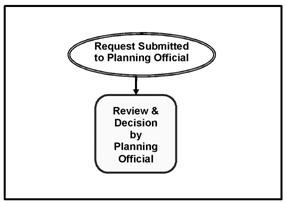
16.20.030 - Ministerial decision-making procedure.
A.
Introduction.
1.
With one exception, ministerial decisions are made by the planning official (or designee) without public notice and without a public hearing.
2.
The ministerial procedure is used when there are clear and objective review criteria, and applying City standards and criteria requires no use of discretion.
Figure 16.20.030-1: Ministerial Review
B.
Pre-Application Conference. A pre-application conference is not required for ministerial applications, but is recommended. The applicant may request additional meetings after an initial pre-application conference (fees may be assessed for these additional meetings).
C.
Application Requirements.
1.
Application Forms. Ministerial applications shall be made on forms provided by the planning official or designee.
2.
Application Requirements. Ministerial applications shall:
a.
Include the information requested on the application form.
b.
Address the criteria in sufficient detail for review and action.
c.
Be filed with the required fee.
D.
Ministerial Decision Requirements. The planning official's (or designee's) decision shall address all of the relevant decision criteria. Based on the criteria and the facts contained within the record, the planning official shall approve, approve with conditions, or deny the requested land use decision or action. A written record of the decision shall be provided to the applicant and kept on file in the city's community development office.
E.
Final Decision and Appeals.
1.
A ministerial decision shall be final on the date it is mailed or otherwise provided to the applicant, whichever occurs first.
2.
A decision by the planning official may be appealed to the planning commission.
F.
Effective Date. The decision is effective the day it is issued in writing.
(Ord. 2766 § 1 (part), 2008; Ord. No. 2801, Exh. A, 7-14-2010; Ord. No. 3036, § 3(Exh. A), 6-11-2025)
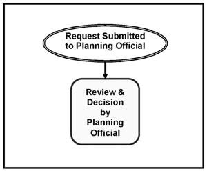
16.20.040 - Administrative decision-making procedure.
Administrative decisions are made by the planning official (or the planning commission by referral from the planning official or appeal by a person with standing) with public notice. The planning official may refer an administrative review application to the planning commission for a public hearing, or the applicant may request referral to the planning commission for a public hearing. The appeal of an administrative decision by the planning official is heard by the planning commission, and an appeal of a decision by the planning commission is heard by the city council.
Figure 16.20.040-1: Administrative Review
A.
Pre-Application Conference. A pre-application conference is not required for administrative applications, but is recommended. The applicant may request additional meetings after an initial pre-application conference (fees may be assessed for these additional meetings).
B.
Application Requirements.
1.
Application Forms. Administrative applications shall be made on forms provided by the planning official or designee.
2.
Submittal Information. The application shall:
a.
Include the information requested on the application form.
b.
Be filed with six hard copies and one electronic copy (in a form specified by the city) of a narrative statement that explains how the application satisfies each and all of the relevant criteria and standards in sufficient detail for review and decision-making. Note: additional information may be required under the specific application requirements for each decision, (e.g., land use review, land divisions, modifications, code interpretations, and so on).
c.
Be accompanied by the required fee.
C.
Notice of Application for Administrative Decision.
1.
Before making an administrative decision, the planning official shall mail notice to:
a.
All owners of record of real property within one hundred feet of the subject site.
b.
All city-recognized neighborhood groups or associations whose boundaries include the site.
c.
Any person who submits a written request to receive a notice.
d.
Any governmental agency that is entitled to notice under an intergovernmental agreement entered into with the city, or required by state statute.
e.
The city shall notify the road authority, owners of airports and rail authority and owner of all applications for administrative decisions.
f.
Other affected agencies, as appropriate, for review of the application.
2.
The purpose of the notice is to give nearby property owners and other interested people the opportunity to submit written comments about the application, before the administrative decision is made. The goal of this notice is to invite people to participate early in the decision-making process.
3.
Notice of a pending administrative decision shall:
a.
Provide a fourteen-day period for submitting written comments before a decision is made on the land use application.
b.
Identify the specific land use decisions or decisions requested.
c.
Describe the street address or other easily understandable reference to the location of the site.
d.
List the relevant decision criteria by name and number of code sections and subsections.
e.
State the place, date and time the comments are due, and the person to whom the comments should be addressed.
f.
Include the name and telephone number of a contact person regarding the administrative decision.
g.
State that if any person fails to address the relevant decision criteria with enough detail, they may not be able to appeal to the land use board of appeals or circuit court on that issue. Only comments on the relevant decision criteria are considered relevant evidence.
h.
State that all evidence relied upon by the planning official (or planning commission) to make this decision is in the public record, available for public review. Copies of this evidence can be obtained at a reasonable cost from the city.
i.
State that after the comment period closes, the planning official shall issue an administrative decision. The decision shall be mailed to the applicant and to anyone else who submitted written comments or who is otherwise legally entitled to notice.
D.
Administrative Decision Requirements.
1.
The applicable decision authority shall make written decisions addressing all of the relevant decision criteria and standards. Based upon the criteria and standards, and the facts contained within the record, the applicable decision authority shall approve, approve with conditions, or deny the requested land use decision application or action.
2.
Unless otherwise required by provisions in the development code, administrative reviews involving the establishment of a new structure or facility, or the expansion of an existing structure or facility, shall be subject to the following specific criteria:
a.
The proposal shall conform to use, height limits, setbacks and similar development requirements of the underlying zone.
b.
The proposal shall comply with applicable access and street improvement requirements in Chapters 16.12 and 16.13, respectively.
c.
The proposal shall comply with applicable parking requirements in Chapter 16.14
d.
The proposal shall comply with applicable screening and landscaping provisions in Chapter 16.15.
e.
Any required public facility improvements shall comply with provisions in Chapter 16.16.
f.
Where applicable, the proposal shall comply with development requirements within identified hazard areas and/or overlay zones.
g.
The proposal shall comply with the supplementary zone regulations contained in Chapter 16.19 or elsewhere in the development code.
E.
Notice of Decision.
1.
Within five working days after the planning official signs the decision, a notice of decision shall be sent by mail to:
a.
The applicant and all owners or contract purchasers of record of the site that is the subject of the application.
b.
Any person who submits a written request to receive notice, or provides comments during the application review period.
c.
Any city-recognized neighborhood group or association whose boundaries include the site.
d.
Any governmental agency that is entitled to notice under an intergovernmental agreement entered into with the city, and other agencies that were notified or provided comments during the application review period.
2.
The planning official shall cause an affidavit of mailing and posting of the notice to be prepared and made a part of the file. The affidavit shall show the date the notice was mailed and posted, and shall demonstrate that the notice was mailed to the people and within the time required by law.
3.
The administrative (notice) of decision shall contain:
a.
A description of the applicant's proposal and the city's decision on the proposal.
b.
The address or other geographic description of the property proposed for development.
c.
A statement of where the city's case file and record can be reviewed.
d.
The date the decision shall become final, unless appealed.
e.
A statement briefly explaining how a participant in the process can file an appeal based on their testimony, the deadline for filing an appeal, and where further information can be obtained concerning the appeal process.
f.
A statement that unless appellant (the person who files the appeal) is the applicant, the hearing on the appeal shall be limited to the specific issues identified in the written comments submitted during the comment period.
g.
The applicant shall provide the following notice to the mortgagee, lien holder, vendor, or seller: "The City of Lebanon Development Code requires that if you receive this notice of decision it shall be promptly forwarded to the purchaser."
F.
Final Decision and Effective Date. An administrative decision is final for purposes of appeal, when it is mailed by the city. An administrative decision is effective on the day after the appeal period expires (fourteen days after the date the notice of decision was mailed) if there is no appeal. If an appeal is filed, the decision is effective when the appeal is decided.
G.
Appeal. An administrative decision may be appealed to the planning commission as follows:
1.
Who May Appeal. The following people have legal standing to appeal an administrative decision:
a.
The applicant.
b.
A person who participated in the proceeding by submitting written comments or who requested a copy of the decision.
2.
Notice of Appeal. A person described in Section 16.20.040.G.1 above, may appeal an administrative decision by filing a notice of appeal according to the following procedures;
a.
Time for Filing. A notice of appeal shall be filed with the planning official within fourteen days of the date the notice of decision was mailed;
b.
Content of Notice of Appeal. The notice of appeal shall contain:
i.
An identification of the decision being appealed, including the date of the decision.
ii.
A statement demonstrating the person filing the notice of appeal has standing to appeal.
iii.
A statement explaining the specific criteria the person believes the planning official applied incorrectly or failed to apply.
iv.
Filing fee.
3.
Scope of Appeal. The appeal of an administrative decision by a person with standing shall be a hearing de novo before the planning commission. The appeal shall not be limited to the application materials, evidence and other documentation, and specific issues raised in the administrative review. The planning commission may allow additional evidence, testimony or argument concerning any relevant standard, criterion, condition, or issue.
4.
Appeal Procedures. If appealed to the planning commission, quasi-judicial notice, hearing procedures and decision-making process shall also be used for all administrative appeals. All such appeals shall be reviewed under the provisions, requirements and procedures of Section 16.20.050.
5.
Further Appeal to City Council.
a.
The decision of the planning commission regarding an appeal of an administrative decision is the final decision of the city unless appealed to city council.
b.
An appeal to city council shall follow the same notification procedures as for the planning commission hearing. The city council hearing shall be conducted based on the record compiled by the planning commission and is limited to those issues raised before the planning commission.
c.
The decision of the city council on an appeal is final and effective on the date it is mailed by the city.
d.
The city council's decision may be appealed to the state land use board of appeals (LUBA) pursuant to the provisions of applicable state law.
(Ord. 2766 § 1 (part), 2008; Ord. No. 2801, Exh. A, 7-14-2010; Ord. No. 3036, § 3(Exh. A), 6-11-2025)
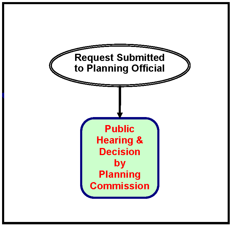
16.20.050 - Quasi-judicial decision-making procedure.
Quasi-judicial decisions are made by the planning commission after a public hearing, with appeals reviewed by the city council. Quasi-judicial decisions generally use discretionary decision criteria.
Figure 16.20.050-1: Quasi-Judicial Review
A.
Pre-Application Conference. A pre-application conference with planning staff and/or the city's development review team (DRT) is required for all quasi-judicial applications. The applicant may request additional meetings after an initial pre-application conference (fees may be assessed for these additional meetings).
B.
Application Requirements.
1.
Application forms. Quasi-judicial applications shall be made on forms provided by the city planning official or designee. If an administrative application is referred to a quasi-judicial hearing, either voluntarily by the applicant or staff, or upon appeal, no new application is required.
2.
Submittal Information. The quasi-judicial application shall:
a.
Include the information requested on the application form.
b.
Be filed with six hard copies and one electronic copy (in a form specified by the city) of a narrative statement that explains how the application satisfies each and all of the relevant criteria and standards in sufficient detail for review and decision-making. Note: additional information may be required under the specific application requirements for each decision, (e.g., land use review, land divisions, modifications, code interpretations).
c.
Be accompanied by the required fee.
C.
Notice of Hearing.
1.
Mailed Notice. The city shall mail the notice of the quasi-judicial action. The records of the Linn County Assessor's Office are the official records for determining ownership. Notice of a quasi-judicial application hearing or administrative appeal hearing shall be given by the city planning official or designee in the following manner:
a.
At least twenty days before the hearing date, notice shall be mailed to:
i.
The applicant and all owners or contract purchasers of record of the property that is the subject of the application.
ii.
All property owners of record within two hundred fifty feet of the site.
iii.
Any governmental agency that is entitled to notice under an intergovernmental agreement entered into with the city. The city may notify other affected agencies.
iv.
The city shall notify the road authority, owners of airports, and rail authority and owner, when there is a proposed development abutting or affecting their transportation facility.
v.
Any neighborhood or community organization recognized by the city council and whose boundaries include the property proposed for development.
vi.
Any person who submits a written request to receive notice.
vii.
For appeals of administrative reviews, the appellant and all persons who were entitled to receive notice.
viii.
For a land use zoning map change affecting a manufactured dwelling or mobile dwelling park, all mailing addresses within the park, in accordance with the provisions of applicable state law.
b.
The city planning official or designee shall have an affidavit of notice prepared and made a part of the file. The affidavit shall state the date that the notice was mailed to the persons who must receive notice.
2.
Content of Notice for Quasi-Judicial Hearing. Notice of appeal of an administrative decision or notice of a quasi-judicial hearing to be mailed and published per Section 16.20.050.C.1 above shall contain the following information:
a.
The nature of the application and the proposed land use or uses that could be authorized for the property.
b.
The applicable criteria and standards from the development code(s) that apply to the application.
c.
The street address or other easily understood geographical reference to the subject property.
d.
The date, time, and location of the public hearing.
e.
A statement that the failure to raise an issue in person, or by letter at the hearing, or failure to provide statements or evidence sufficient to afford the decision-maker an opportunity to respond to the issue, means that an appeal based on that issue cannot be filed with the state land use board of appeals.
f.
The name of a city representative to contact and the telephone number where additional information on the application may be obtained.
g.
A statement that a copy of the application, all documents and evidence submitted by or for the applicant, and the applicable criteria and standards can be reviewed at City of Lebanon Community Development Office at no cost and that copies shall be provided at a reasonable cost.
h.
A statement that a copy of the city's staff report and recommendation to the hearings body shall be available for review at no cost at least seven days before the hearing, and that a copy shall be provided on request at a reasonable cost.
i.
A general explanation of the requirements to submit testimony, and the procedure for conducting public hearings.
j.
The applicant shall provide the following notice to the mortgagee, lien holder, vendor, or seller: "The City of Lebanon Development Code requires that if you receive this notice of decision it shall be promptly forwarded to the purchaser."
3.
Notification of Transportation Authorities and Owners. The city shall notify the road authority, owners of airports and rail authority and owner of all land use applications that require public hearings, all subdivision and partition applications, and other applications which affect private access to roads. Owners of airports also shall be notified of any application within airport noise corridors and imaginary surfaces.
D.
Conduct of the Public Hearing.
1.
At the commencement of the hearing, the hearings body shall state to those in attendance:
a.
The applicable decision criteria and standards that apply to the application or appeal.
b.
A statement that testimony and evidence shall concern the decision criteria described in the staff report, or other criteria in the land use regulations that a person testifying believes to apply to the decision.
c.
A statement that failure to raise an issue with sufficient detail to give the hearings body and the parties an opportunity to respond to the issue, means that no appeal may be made to city council, the state land use board of appeals or the circuit court on that issue.
d.
A statement to the applicant that the failure of the applicant to raise constitutional or other issues relating to proposed conditions of approval with sufficient specificity to allow the local government or its designee to respond to the issue precludes an action for damages in circuit court.
e.
Before the conclusion of the initial evidentiary hearing, any participant may ask the planning commission for an opportunity to present additional relevant evidence or testimony that is within the scope of the hearing. The hearings body shall grant the request by scheduling a date to finish the hearing (a "continuance") per Section 16.20.050.D.2 below, or by leaving the record open for additional written evidence/testimony per Section 16.20.050.D.3 below.
2.
If the planning commission grants a continuance, the completion of the hearing shall be continued to a date, time, and place at least seven days after the date of the first evidentiary hearing. An opportunity shall be provided at the continued hearing for persons to present and respond to new written evidence and verbal testimony. If new written evidence is submitted at the continued hearing, any person may request, before the conclusion of the continued hearing, that the record be left open for at least seven days, so that they can submit additional written evidence/testimony in response to the new written evidence.
3.
If the planning commission leaves the record open for additional written evidence/testimony, the record shall be left open for at least seven days after the hearing. The planning commission shall leave a record open only after the public testimony portion of the hearing as been closed. During the public testimony portion of the hearing any participant may ask the city verbally or in writing to leave the record open to submit new written testimony. If such a request is filed, the planning commission shall leave the record open for at least seven days, and an equivalent amount of time for the submittal of a written rebuttal by the other side.
4.
Unless waived by the applicant, the city shall allow the applicant at least seven days after the record is closed to all other persons to submit final written arguments in support of the application, unless the applicant expressly waives this right. The applicant's final submittal shall be part of the record but shall not include any new evidence.
5.
In making its decision, the hearings body may take notice of facts not in the hearing record (e.g., local, state, or federal regulations; previous city decisions; case law; staff reports). The review authority must announce its intention to take notice of such facts in its deliberations, and allow persons who previously participated in the hearing to request the hearing record be reopened, if necessary, to present evidence concerning the noticed facts.
E.
The Record.
1.
The record shall contain all testimony and evidence that is submitted to the city and the hearings body.
2.
The review authority shall retain custody of the record according to state mandated public record retention laws.
F.
Order of Proceedings.
1.
The presiding officer will state the case and call the public hearing to order, informing those present that testimony and evidence is to be directed towards the applicable criteria for the case and making all other introductory statements required by law. The presiding officer may establish the time allowed for the presentation of information.
2.
Any objections to the notice and on jurisdictional grounds shall be noted in the record.
3.
Any abstentions or disqualifications shall be determined. Members shall announce all bias, conflicts of interest and shall disclose the time, place, and nature of any ex parte contacts they have had. Parties to the case shall have the opportunity to rebut any information contained in the ex parte contact.
4.
A staff report shall be presented including a list of the criteria applying to the case. City staff may also present additional information whenever allowed by the presiding officer during the proceedings.
5.
The hearing authority may view the subject property for purposes of evaluating the proposal, but shall state in the record the place, time, manner, and circumstances of such viewing, including any evidence not otherwise included in the record that was obtained during the site visit.
6.
During the public testimony portion of the hearing, the applicant or those persons representing the applicant may present information.
7.
During the public testimony portion of the hearing, those persons who support the proposal may present evidence or make inquiries. If additional documents or evidence are provided in support of an application at the initial evidentiary hearing, any party shall, upon request, be entitled to a continuance of the hearing to allow for adequate preparation of rebuttal.
8.
During the public testimony portion of the hearing, those persons who oppose the proposal may present evidence or offer inquiries.
9.
During the public testimony portion of the hearing, those persons who do not necessarily support or oppose the proposal may present evidence or offer inquiries.
10.
During the public testimony portion of the hearing, rebuttal testimony may be presented by persons who have testified supporting the proposal. The scope of material presented during rebuttal shall be limited to matters raised during the course of the hearing.
11.
At the end of the public testimony portion of the hearing (including the presentation of information, rebuttal, and written argument):
a.
Closing Public Testimony. the presiding officer shall declare that the public testimony portion of the hearing is closed.
b.
Motion to Continue. However, the public testimony portion of the hearing may be continued if there is a motion to continue the public testimony portion of the hearing.
c.
Leaving the Record Open. If the public hearing is the initial evidentiary hearing and the public testimony portion of the hearing is not to be continued, any participant may request that the record remain open for submittal of additional written testimony. If such a request is made, the planning commission shall leave the record open for at least seven days, and an equivalent amount of time for the submittal of a written rebuttal by the other side. The record may be left open longer than seven days at the discretion of the hearing authority. If an opponent of the proposal requests that the record be left open, the applicant shall have an equal amount of time to respond in writing to materials submitted by the opponent. Likewise, if the applicant of the proposal requests that the record be left open, the opponent(s) shall have an equal amount of time to respond in writing to materials submitted by the applicant.
12.
Once the public testimony portion of a hearing has been closed, no further evidence shall be received, unless the public testimony portion of a hearing is re-opened by the planning commission. If so, persons who do not necessarily support or oppose the proposal may comment on any new evidence submitted by the applicant, and rebuttal testimony may be presented by the applicant or persons who have testified supporting the proposal.
13.
The quasi-judicial public hearing process is summarized in Table 16.20.050-1 following:
Table 16.20.050-1: Summary of Quasi-Judicial Public
Hearing Process
(For planning commission or city council)
G.
Impartial Review Authority and Ex Parte Communications. Participants in the appeal of an administrative decision or participants in a quasi-judicial hearing are entitled to an impartial review authority as free from bias, conflicts of interest and ex parte contacts (see below) as reasonably possible. Furthermore, the public has a countervailing right of free access to public officials. Therefore:
1.
At the beginning of the public hearing, hearings body members shall disclose the substance of any ex parte contacts (as defined in Section 16.20.050.G.6 below) concerning the application or appeal. He or she shall state whether the contact has impaired their impartiality or their ability to vote on the matter and shall participate or abstain accordingly.
2.
A member of the hearings body shall not participate in any proceeding in which the member or a relative of the member, as defined in ORS 244.020, has a direct or substantial financial interest. Any actual or potential interest shall be disclosed at the hearing where the action is being taken.
3.
Disqualification of a member of the hearings body due to bias, ex parte contacts or conflict of interest may be ordered by a majority of the members present and voting. The person who is the subject of the motion may not vote on the motion to disqualify.
4.
If enough members of the planning commission abstain or are disqualified such that there is not a quorum, the city council shall be the hearing body. If all members of the city council abstain or are disqualified, a quorum of those members present who declare their reasons for abstention or disqualification shall be re-qualified to make a decision.
5.
Any member of the public may raise bias or conflict of interest issues at the public hearing, to which the member of the hearings body shall respond in accordance with this section.
6.
Ex Parte Communications.
a.
Members of the hearings body shall not:
i.
Communicate directly or indirectly with any applicant, appellant, other party to the proceedings, or representative of a party about any issue involved in a hearing without giving notice as noted above in the preceding subsections.
ii.
Make use of any communication, report, or other materials outside the record prepared by the proponents or opponents in connection with the particular case, unless all participants are given the opportunity to respond to the noticed materials.
b.
A decision or action of the hearings body is not invalid due to ex parte contacts if the person receiving contact:
i.
Places in the record the substance of any written or verbal ex parte communications concerning the decision or action; and
ii.
Makes a public announcement of the content of the communication and of all participants' right to dispute the substance of the communication made. This announcement shall be made at the first hearing following the communication during which action shall be considered or taken on the subject of the communication.
c.
A communication between city staff and the hearings body is not considered an ex parte contact.
H.
Presenting and Receiving Evidence.
1.
The hearings body may set reasonable time limits for presentations and may limit or exclude cumulative, repetitious, irrelevant or personally derogatory testimony or evidence.
2.
No verbal testimony shall be accepted after the close of the public hearing. Written testimony may be received after the close of the public hearing only as provided in when the record is left open.
3.
Members of the hearings body may visit the property and the surrounding area, and may use information obtained during the site visit to support their decision, if the information relied upon is disclosed at the beginning of the hearing and an opportunity is provided to dispute the evidence.
I.
The Decision Process and Appeals.
1.
Basis for Decision. Approval or denial of an appeal of an administrative decision or of a quasi-judicial application shall be based on standards and criteria in the development code. The standards and criteria shall relate approval or denial of a discretionary development permit application to the applicable development regulations and, when appropriate, to any neighborhood refinement plan for the area in which the development would occur and to the development regulations for the city as a whole.
2.
Findings and Conclusions. Approval or denial shall be based upon the criteria and standards considered relevant to the decision. The written decision shall explain the relevant criteria and standards, state the facts relied upon in rendering the decision, and justify the decision according to the criteria, standards, and facts.
3.
Form of Decision. The planning commission shall issue a final written order containing the findings and conclusions stated in Section 16.20.050.I.2 above, which either approves, denies, or approves with specific conditions. The planning commission may also issue appropriate intermediate rulings when more than one permit or decision is required.
J.
Decision-Making Time Limits. The city planning official or designee shall prepare an order for the signature of the planning commission chair within ten business days after the commission's decision. This order shall reflect the decision, criteria and findings made by the planning commission, and shall constitute the final written order as set forth in Section 16.20.050.I.3 above.
K.
Notice of Decision.
1.
Written notice of an administrative appeal decision or a quasi-judicial decision shall be mailed to the applicant and to all participants of record within ten business days after the hearings body decision. For purposes of appeal, the decision is effective on the date that the final written order, as defined in Section 16.20.050.I.3 above, is mailed to the applicant and to all participants of record. The mailing shall be made by regular mail, with sufficient postage affixed and addressed to the last known address of the parties as reflected by the record of the proceedings. The planning official shall cause an affidavit of mailing and posting of the notice to be prepared and made a part of the file. The affidavit shall show the date the notice was mailed and posted, and shall demonstrate that the notice was mailed to the people and within the time required by law.
2.
Failure of any person to receive mailed notice shall not invalidate the decision or extend the appeal period for any decision or final written order.
3.
An affidavit of mailing shall be made and placed in the official case file for the land use action.
L.
Final Decision, Effective Date, and Appeals.
1.
If an appeal is not filed within fifteen days following the date the planning commission's final written decision is mailed, the decision of the commission shall be final.
2.
A Decision of the planning commission may be appealed to the city council by filing a written appeal notice with the city recorder during the fifteen day appeal period after the planning commission's final written decision was mailed as provided in Section 16.20.050.K.1 above.
3.
The written appeal notice shall be on a form required by the city, accompanied by a required filing fee that shall be set by the city.
4.
If an appeal is filed, the council shall receive record of the proceedings from the planning commission and a public hearing shall be held on the appeal pursuant to the procedures set forth in this chapter.
5.
If an appeal is filed, the decision becomes effective on the day after the appeal is decided by the city council.
6.
The notification and hearings procedures for quasi-judicial applications on appeal to the city council shall be the same as for the initial hearing.
7.
An appeal of a land use decision to the state land use board of appeals (LUBA) must be filed within twenty-one days of the city council's written decision.
M.
City Council Actions on Issues First Reviewed by the Planning Commission.
1.
Overview. With the exception of legislative actions, a city council public hearing on a land use application first heard by the planning commission shall be based on the record established before the planning commission. In such cases, the city council's decision shall be based solely upon a review of the planning commission record and the testimony and other evidence in that record.
2.
Scope of Review.
a.
Upon appeal, the city council shall not re-examine issues of fact and shall limit its review to determining whether there is substantial evidence to support the findings of the planning commission, or to determine if errors in law were committed by the planning commission.
b.
Review shall in any event be limited to those issues set forth in the notice of appeal.
c.
The appellant is also precluded from raising an issue on appeal to the council if the appellant could have raised the issue before the planning commission but failed to do so.
d.
Review shall be based on the record of the initial proceedings. The record shall consist of the application and all materials submitted with it; documentary evidence, exhibits and materials submitted at the initial hearing; recorded testimony; the decision of the approving authority, including the findings and conclusions; and the notice of appeal.
e.
Only the appellant and other parties who appeared in person or who submitted evidence in the initial proceedings may participate in the appeal hearing.
f.
Appellant shall make the initial presentation and shall be allowed rebuttal.
g.
Each participant in the appeal hearing shall present to the council those portions of the record which the participant deems relevant to the appeal.
h.
If a party wishes the council to review recorded testimony, the party shall present a written summary or transcript of such testimony to be read by the council in lieu of actually listening to the recording.
i.
If the city council determines that additional evidence is necessary in order to make a decision, it shall remand the decision back to the planning commission for further proceedings.
3.
Council Options.
a.
The council may, in its decision on the appeal, amend, rescind, or affirm the action appealed from, or may remand the matter for further proceedings or fact finding by the planning commission.
b.
The council shall not be bound by any finding, conclusion or other ruling of the planning commission.
N.
Continuation of the Public Hearing. The planning commission or the city council may continue any hearing, and no additional notice of hearing is required if the matter is continued to a specified place, date, and time.
(Ord. 2766 § 1 (part), 2008; Ord. No. 2942, § 3(Exh. A), 1-8-2020; Ord. No. 3036, § 3(Exh. A), 6-11-2025)
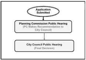
16.20.060 - Legislative decision-making procedure.
Legislative procedures apply to legislative matters. Legislative matters involve the creation, revision, or large-scale implementation of public policy (e.g., annexations, adoption of land use regulations, zoning map amendments, and comprehensive plan text and map amendments). Such legislative matters are considered initially by the planning commission which makes "recommendations" for action by the city council. Final decisions are made by the city council.
Figure 16.20.060-1: The legislative Review Process
A.
Pre-Application Conference. A pre-application conference is required for all legislative applications initiated by a party other than the city. The applicant may request additional meetings after an initial pre-application conference (fees may be assessed for these additional meetings).
B.
De Novo Hearings. City council public hearings on legislative matters, including those first heard by the planning commission shall be de novo hearings. In other words, the city council shall admit new verbal and written evidence into the record. In such cases, the city council decision shall be based upon the new evidence and the planning commission record, including the testimony and other evidence in that record.
C.
Application Requirements.
1.
Application Forms. Legislative applications shall be made on forms provided by the city planning official or designee.
2.
Submittal Information. The application shall contain:
a.
The information requested on the application form.
b.
A map and/or plan addressing the appropriate criteria and standards in sufficient detail for review and decision (as applicable).
c.
The required fee.
d.
One copy of a letter or narrative statement that explains how the application satisfies each and all of the relevant decision criteria and standards.
D.
Notice of Hearing.
1.
Required Hearings. A minimum of two hearings, one before the planning commission and one before the city council, are required for all legislative applications.
2.
Notification Requirements. Notice of public hearings for the request shall be given by the city planning official or designee in the following manner:
a.
At least twenty days, but not more than forty days, before the date of the first hearing on an ordinance that proposes to amend the comprehensive plan or any element thereof, or to adopt an ordinance that proposes to rezone property, a notice shall be prepared in conformance with the provisions of applicable state law and mailed to:
i.
Each owner whose property would be rezoned in order to implement the ordinance (including owners of property subject to a comprehensive plan amendment shall be notified if a zone change would be required to implement the proposed comprehensive plan amendment).
ii.
Any affected governmental agency.
iii.
Any person who requests notice in writing.
iv.
For a zone change affecting a manufactured dwelling or mobile dwelling park, all mailing addresses within the park.
v.
Owners of airports shall be notified of a proposed zone change in accordance with the applicable provisions of Chapter 16.11 of this development code.
b.
At least ten days before the scheduled planning commission public hearing date, and fourteen days before the city council hearing date, public notice shall be published in a newspaper of general circulation in the city, if the legislative action requires newspaper publication as required by the Oregon Revised Statutes.
c.
The city planning official or designee shall:
i.
For each mailing of notice, file an affidavit of mailing in the record as provided by Section 16.20.060.D.2.a above.
ii.
For each published notice, file in the record the affidavit of publication in a newspaper that is required in Section 16.20.060.D.2.b above.
d.
The Oregon Department of Land Conservation and Development (DLCD) shall be notified in writing of proposed comprehensive plan and development code amendments as per the provisions of state requirements. The notice to DLCD shall include a DLCD certificate of mailing.
e.
Notifications for annexation shall follow the provisions of this chapter.
3.
Content of Notices. The mailed and published notices shall include the following information:
a.
The number and title of the file containing the application, and the address and telephone number of the city planning official or designee's office where additional information about the application can be obtained.
b.
The proposed site location.
c.
A description of the proposed site and the proposal in enough detail for people to determine what change is proposed, and the place where all relevant materials and information may be obtained or reviewed.
d.
The time(s), place(s), and date(s) of the public hearing(s); a statement that public verbal or written testimony is invited; and a statement that the hearing will be held under this title and rules of procedure adopted by the council and available at city hall.
e.
The applicant shall provide the following notice to the mortgagee, lien holder, vendor, or seller: "The City of Lebanon Development Code requires that if you receive this notice of decision it shall be promptly forwarded to the purchaser."
4.
Failure to Receive Notice. The failure of any person to receive notice shall not invalidate the action, providing:
a.
Personal notice is deemed given where the notice is deposited with the United States Postal Service.
b.
Published notice is deemed given on the date it is published.
5.
Affidavit of Mailing. An affidavit of mailing shall be made and placed in the official case file for the land use action.
E.
Hearing Process and Procedure. Same as for quasi-judicial hearings (see Section 16.20.050 above).
F.
Continuation of the Public Hearing. The planning commission or the city council may continue any hearing, and no additional notice of hearing shall be required if the matter is continued to a specified place, date, and time.
G.
Decision Process and Authority.
1.
The Planning Commission.
a.
After notice and a public hearing, the planning commission shall vote on and prepare a recommendation to the city council to approve, approve with modifications, approve with conditions, deny the proposed change, or adopt an alternative.
b.
Within fourteen business days of determining a recommendation, the presiding officer shall sign the written recommendation, and it shall be filed with the city planning official or designee.
2.
If the planning commission fails to adopt a recommendation to approve, approve with modifications, approve with conditions, deny the proposed change, or adopt an alternative proposal within sixty days of its first public hearing on the proposed change, the city planning official or designee shall:
a.
Report the failure together with the proposed change to the city council.
b.
Provide notice and put the matter on the city council's agenda for the city council to hold a public hearing make a decision. No further action shall be taken by the commission.
3.
The City Council. After notice and a public hearing:
a.
The city council shall consider the recommendation of the planning commission. However, the city council is not bound by the commission's recommendation.
b.
The city council shall approve, approve with modifications, deny, or adopt an alternative to an application for legislative change, or remand the application to the planning commission for rehearing and reconsideration on all or part of the application.
c.
The city council shall act by ordinance, that shall be signed by the mayor after the council's adoption of the ordinance.
H.
Vote Required for a Legislative Change.
1.
A vote by a majority of the qualified voting members of the planning commission present is required for a recommendation for decision, decision with conditions, denial or adoption of an alternative.
2.
A vote by a majority of the qualified members of the city council present is required to decide any motion made on the proposal.
I.
Notice of Decision. Notice of a legislative decision shall be mailed to the applicant, all participants of record, and the department of land conservation and development (as per the provisions of state requirements), within five business days after the city council decision is filed with the city planning official or designee. The city shall also provide notice to all persons as required by other applicable laws.
J.
Final Decision, Effective Date and Appeals. A legislative decision, if approved, shall take effect and shall become final as specified in the enacting ordinance, or if not approved, upon mailing of the notice of decision to the applicant.
(Ord. 2766 § 1 (part), 2008; Ord. No. 2942, § 3(Exh. A), 1-8-2020; Ord. No. 3036, § 3(Exh. A), 6-11-2025)
16.20.070 - General provisions.
A.
Hearing Process and Procedure for Planning Commission and City Council.
1.
Unless otherwise provided in the rules of procedure adopted by the review body:
a.
The presiding officer of the planning commission and of the city council shall have the authority to:
i.
Regulate the course, sequence, and decorum of the hearing;
ii.
Direct procedural requirements or similar matters; and
iii.
Impose reasonable time limits for verbal presentations.
b.
A person may not address the commission or the council without:
i.
Receiving recognition from the presiding officer; and
ii.
Stating their full name and address.
c.
Disruptive conduct such as applause, cheering, or display of signs shall be cause for expulsion of a person or persons from the hearing, termination or continuation of the hearing, or other appropriate action determined by the presiding officer.
2.
Unless otherwise provided in the rules of procedures adopted by the council, the presiding officer of the commission and of the council shall conduct the hearing as follows:
a.
The presiding officer shall begin the hearing with a statement of the nature of the matter before the body, a general summary of the procedures, a summary of the standards for decision-making, and whether the decision which will be made is a recommendation to the city council or the final decision of the council.
b.
The city planning official or designee's report and other applicable staff reports shall be presented.
c.
The public shall be invited to testify.
d.
The public hearing may be continued to allow additional testimony or it may be closed.
e.
The body's deliberation may include questions to the staff, comments from the staff, and inquiries directed to any person present.
B.
Burden of Proof and Demonstration of Compliance. It is the responsibility of an applicant to demonstrate compliance or the ability to comply with decision criteria. In short, the burden of proof is upon the applicant.
C.
Time Computation. In computing any period of time prescribed or allowed by this chapter, the day of the act or event from which the designated period of time begins to run shall not be included. The last day of the period so computed shall be included, unless it is a Saturday, Sunday or legal holiday, in which event, the period runs until the end of the following business day.
D.
Pre-Application Conferences.
1.
Participants. When a pre-application conference is required, the applicant shall meet with the city planning official or his/her designee(s) and other parties as appropriate.
2.
Additional Meetings and Fees. The applicant may request additional meetings after an initial pre-application conference (fees may be assessed for these additional meetings).
3.
Information Provided. At such conference, the city planning official or designee shall:
a.
Cite the comprehensive plan policies and map designations applicable to the proposal;
b.
Cite the ordinance provisions, including substantive and procedural requirements applicable to the proposal;
c.
Provide available technical data and assistance that will aid the applicant;
d.
Identify other governmental policies and regulations that relate to the application; and
e.
Reasonably identify other opportunities or constraints concerning the application.
4.
Disclaimer. Failure of the city planning official or his/her designee to provide any of the information required by this section shall not constitute a waiver of any of the standards, criteria or requirements for the application;
5.
Changes in the Law. Due to possible changes in federal, state, regional, and local law, the applicant is responsible for ensuring that the application complies with all applicable laws on the day the application is deemed complete.
6.
Not Public Meetings. Pre-application conferences are not public meetings, and are not open to the public.
7.
Confidentiality. To the extent allowable by state law, pre-application conferences will remain confidential.
F.
Acceptance and Review of Applications.
1.
Initiation of Applications.
a.
Applications for decision under this chapter may be initiated by (and qualified by provisions in other chapters in Article 4 of this development code):
i.
Order of city council.
ii.
Resolution of the planning commission.
iii.
The city planning official or designee.
iv.
A record owner of property (person(s) whose name is on the most recently recorded deed), or contract purchaser with written permission from the record owner.
b.
A person authorized to submit an application under this section may be represented by an agent authorized in writing to make the application on the person's behalf.
2.
Consolidation of Proceedings. When an applicant applies for more than one type of land use or development permit (e.g., administrative and quasi-judicial) for the same one or more parcels of land, the proceedings may be consolidated for review and decision.
a.
If more than one decision authority would be required to decide on the applications if submitted separately, then the decision may be made by the decision authority having original jurisdiction over one of the applications in the following order of preference: The council, the commission, or the city planning official or designee.
b.
When proceedings are consolidated:
i.
The notice may identify each application to be decided.
ii.
The decision on a plan map amendment may precede the decision on a proposed land use district change and other decisions on a proposed development. Similarly, the decision on a zone map amendment may precede the decision on a proposed development and other actions.
iii.
Separate findings and decisions may be made on each application.
3.
Coordinated Review. The city may also submit the application for review and comment to the city engineer, road authority, and other applicable county, state, and federal review agencies.
4.
Changes or Additions to the Application During the Review Period.
a.
Process. Once an application is deemed complete:
i.
All documents and other evidence relied upon by the applicant shall be submitted to the city planning official or designee at least seven days before the notice of action or hearing is mailed, if possible. Documents or other evidence submitted after that date shall be received by city planning official or designee, and transmitted to the hearings body, but may be too late to include with the staff report and evaluation.
ii.
When documents or other evidence are submitted by the applicant during the review period but after the application is deemed complete, the assigned review person or body shall determine whether or not the new documents or other evidence submitted by the applicant significantly change the application.
b.
Determination of Significant Change.
i.
If the assigned reviewer determines that the new documents or other evidence significantly change the application, the reviewer shall include a written determination that a significant change in the application has occurred as part of the decision. In the alternative, the reviewer may inform the applicant either in writing, or verbally at a public hearing, that such changes may constitute a significant change, and allow the applicant to withdraw the new materials submitted, in order to avoid a determination of significant change.
ii.
If the applicant's new materials are determined to constitute a significant change in an application that was previously deemed complete, the city shall take one of the following actions:
(A)
Suspend the existing application and allow the applicant to submit a new application with the proposed significant changes. Before the existing application can be suspended, the applicant must consent in writing to waive the one hundred twenty-day rule on the existing application. If the applicant does not consent, the city may not select this option.
(B)
Reject the new documents or other evidence that has been determined to constitute a significant change, and continue to process the existing application without considering the materials that would constitute a significant change. The city will complete its decision-making process without considering the new evidence.
c.
New Application. If a new application is submitted by the applicant, that application shall be subject to a separate check for acceptance and completeness and will be subject to the standards and criteria in effect at the time the new application is accepted.
5.
Acceptance of Only One Development Proposal Package at a Time for the Same Property. Requests for different development proposals for the same property shall not be considered by any review authority of the city (planning official, planning commission, city council) at the same time. If an application has been filed and accepted by the city for a given property, additional different development applications for that same property cannot be accepted, until a final determination was made on the original proposal or the original proposal was withdrawn. This limitation does not prevent an applicant from submitting and the city accepting and acting simultaneously upon multiple applications for the same development on the same property (e.g., a planned development or conditional use application that might also involve a subdivision, a variance, or a zone amendment).
G.
Record of the Public Hearing.
1.
A verbatim record of the proceeding shall be made by stenographic, mechanical, or electronic means. It is not necessary to transcribe an electronic record. The minutes and other evidence presented as a part of the hearing shall be part of the record.
2.
All exhibits received and displayed shall be marked to provide identification and shall be part of the record.
3.
The official record shall include:
a.
All materials considered by the hearings body.
b.
All materials submitted by the city planning official or designee to the hearings body regarding the application.
c.
The verbatim record made by the stenographic, mechanical, or electronic means; the minutes of the hearing; and other documents considered.
d.
The final ordinance.
e.
All correspondence.
f.
A copy of the notices that were given as required by this chapter.
H.
City Planning Official's Duties. The city planning official or designee shall:
1.
Prepare application forms based on the criteria and standards in applicable state law, the city's comprehensive plan, and implementing ordinance provisions.
2.
Accept all development applications that comply with application requirements.
3.
Prepare a staff report that summarizes the application(s) and applicable decision criteria, and provides findings of conformance and/or nonconformance with the criteria. The staff report may also provide a recommended decision of: Decision; denial; or decision with specific conditions that ensure conformance with the decision criteria.
4.
Prepare a notice of the proposal decision:
a.
In the case of an application subject to a ministerial or administrative review process, the city planning official or designee shall make the staff report and all case-file materials available at the time that the notice of the decision is issued.
b.
In the case of an application subject to a quasi-judicial or legislative hearing, the city planning official or designee shall make the staff report available to the public at least seven days prior to the scheduled hearing date, and make the case-file materials available when notice of the hearing is mailed, as provided by the previous subsections of this chapter.
5.
Administer the hearings process.
6.
File notice of the final decision in the city's records and mail a copy of the notice of the final decision to the applicant; all persons who provided comments or testimony; persons who requested copies of the notice; and any other persons entitled to notice by law.
7.
Maintain and preserve the file for each application for the time period required by law. The file shall include, as applicable, a list of persons required to be given notice and a copy of the notice given; the affidavits of notice; the application and all supporting information; the staff report; the final decision including the findings, conclusions and conditions, if any; all correspondence; minutes of any meeting at which the application was considered; and any other exhibit, information or documentation which was considered by the decision-maker(s) on the application.
8.
Administer the appeals and review process.
I.
Amended Decision Process.
1.
The purpose of an amended decision process is to allow the city planning official or designee to correct typographical errors, rectify inadvertent omissions and/or make other minor changes that do not materially alter the decision.
2.
The city planning official or designee may issue an amended decision after the notice of final decision has been issued but before the appeal period has expired. If such a decision is amended, the decision shall be issued within fourteen business days after the original decision would have become final, but in no event beyond the period for a final decision allowed by state law. A new fourteen-day appeal period shall begin on the day the amended decision is issued.
3.
Notice of an amended decision shall be given using the same mailing and distribution list as for the original decision notice.
4.
Modifications to approved plans or conditions of decision requested by the applicant shall follow the procedures in Chapter 16.24. All other changes to decisions that are not modifications under Chapter 16.24 follow the appeal process.
J.
Expiration of Planning Approval and Re-Application. Unless the decision authority otherwise stipulates, planning approval for all types of land use applications, except for subdivisions, are valid for two years. Subdivision approvals are valid for three years. Expiration of land use approval occurs when applicants do not "exercise" their land use approval (see Section 16.20.080 immediately below) within the approved time period 2 . Preliminary plats for subdivisions must be recorded within the approved time period. The city shall not grant a renewal or extension if planning approval has expired. Applicants must resubmit if their approval has expired.
(Ord. 2766 § 1 (part), 2008; Ord. No. 3036, § 3(Exh. A), 6-11-2025)
2 Pursuant to the provisions of other chapters in this code, the decision authority may grant approval of a land use request that has a time frame greater than the above noted two- or three-year period of time.
16.20.080 - Exercising a land use approval.
Unless otherwise specifically stated, exercising a land use decision shall be subject to the following regulations.
A.
When Building Permits are Required as Part of an Approved Land Use.
1.
Except for manufactured dwelling parks, when a building permit is required as part of an approved land use, the decision shall be considered exercised with the first placement or permanent construction of a structure on a site. This may include the pouring of slabs or footings, any work beyond the stage of excavation, including the first permanent framing or assembly of the structure or any part thereof on its piling or foundation.
2.
Permanent construction does not include land preparation, such as clearing, grading, and filling; the installation of driveways or walkways; the excavation for a basement, footings, piers or foundations or the erection of temporary forms; the construction of accessory buildings, such as garages or sheds not occupied as dwelling units or not used as part of the main structure.
B.
Approval of Manufactured Dwelling Parks. The decision shall be considered exercised with the beginning of construction of facilities for servicing the site on which the manufactured dwellings are to be placed. This shall include, at a minimum, the construction of streets with final site grading or the pouring of concrete pads, or the extension or installation of utilities.
C.
When Building Permits are Not Required as Part of an Approved Land Use. If the approval does not require a building permit, the decision shall be considered exercised if the use or activity which was approved is in operation within the approved time frame.
(Ord. 2766 § 1 (part), 2008; Ord. No. 3036, § 3(Exh. A), 6-11-2025)
16.20.090 - Expedited land divisions.
An expedited land division ("ELD") shall be defined and may be used as provided under the provisions of applicable state law.
A.
Selection. An applicant who wishes to use an ELD procedure for a partition, subdivision or planned development instead of the regular procedure type assigned to it, must request the use of the ELD in writing at the time the application is filed, or forfeit his/her right to use it.
B.
Review Procedure. All applications for expedited land divisions shall comply with the provisions of applicable state law and the city's comprehensive plan. The provisions of applicable state law detail the criteria, application and notice requirements, and action and appeal procedures for expedited land divisions.
C.
Appeal Procedure. An appeal of an ELD shall follow the procedures in the provisions of applicable state law. Where the city has not otherwise appointed a hearings officer (referee) for such appeals, and the city attorney is a contractor (not a city employee), the city attorney shall serve as the referee for ELD appeals.
(Ord. 2766 § 1 (part), 2008; Ord. No. 3036, § 3(Exh. A), 6-11-2025)
16.20.100 - Neighborhood meetings.
Applicants are encouraged to meet with adjacent property owners and neighborhood representatives prior to submitting their application to the City in order to solicit input and exchange information about the proposed development.
(Ord. 2766 § 1 (part), 2008; Ord. No. 3036, § 3(Exh. A), 6-11-2025)
16.20.110 - Traffic impact studies.
A.
The purpose of this section of the code is to assist in determining which road authorities participate in land use decisions, and to implement the state's transportation planning rule that requires the city to adopt a process to apply conditions to development proposals in order to minimize impacts and protect transportation facilities. This section establishes the standards for when a proposal must be reviewed for potential traffic impacts; when a traffic impact study must be submitted with a development application in order to determine whether conditions are needed to minimize impacts to and protect transportation facilities; what must be in a traffic impact study; and who is qualified to prepare the study.
B.
When a Traffic Impact Study Is Required. The city or other road authority with jurisdiction may require a traffic impact study (TIS) as part of an application for development, a change in use, or a change in access. A TIS may be required when a land use application involves one or more of the following actions:
1.
A change in zoning or a plan amendment designation.
2.
Any proposed development or land use action that a road authority states may have operational or safety concerns along its facility(ies).
3.
An increase in site traffic volume generation by three hundred average daily trips (ADT) or more.
4.
An increase in peak hour volume of a particular movement to and from the state highway by twenty percent or more.
5.
An increase in use of adjacent streets by vehicles exceeding the twenty thousand pound gross vehicle weights by ten vehicles or more per day.
6.
The location of the access driveway does not meet minimum sight distance requirements, or is located where vehicles entering or leaving the property are restricted, or such vehicles queue or hesitate on the state highway, creating a safety hazard.
7.
A change in internal traffic patterns that may cause safety problems, such as back up onto a street or greater potential for traffic accidents.
C.
Traffic Impact Study Preparation. A traffic impact study shall be prepared by an Oregon licensed professional engineer in accordance with the requirements of the road authority. If the road authority is the Oregon Department of Transportation (ODOT), the study shall conform to ODOT's regulations.
(See Section 16.12.010.B of Chapter 16.12 for further details on traffic studies.)
(Ord. 2766 § 1 (part), 2008; Ord. No. 3036, § 3(Exh. A), 6-11-2025)
16.21.010 - Introduction.
The conditional use review process, as set forth in this chapter, can result in the approval of a "land use" and/or "site plan," and attach a wide range of conditions of approval to either or both.
A.
Conditional Use Review. A conditional use review is a quasi-judicial review conducted by the planning commission with a public hearing (See Chapter 16.20 for review procedure). It applies to all development in the city, as identified for such review in this code. A conditional use review ensures compliance with the land use and development standards in Chapters 16.05 through 16.11 (e.g., lot area, building setbacks and orientation, lot coverage, maximum building height), and the development standards and public improvement requirements in Chapters 16.12 through 16.19 (Community Development Standards).
B.
Background.
1.
There are certain uses which, due to the nature of their potential impacts on surrounding land uses and public facilities, require a public hearing and decision process. These are identified as "Conditional Uses" in LDC Chapters 16.05 through 16.11. A conditional use is a use of land or a structure that is normally appropriate in the district where it is permitted, but due to the specifics of the use could cause a potential nuisance, health, or safety problem.
2.
This chapter provides the framework to assure that proposed development of land is in conformance with applicable land use requirements, and is designed in a manner to provide an appropriate level of architectural design and environmental quality, and which will not be detrimental to the public health, safety and general welfare, or detrimental to adjacent properties.
3.
The planning commission must approve a site plan for each new building, structure, open land use or addition to an existing development prior to issuance of a building permit in all instances where a conditional use approval is required.
4.
This chapter provides standards and procedures under which a conditional use may be permitted, enlarged or altered if the site is appropriate and if other appropriate conditions of approval can be met (see Chapter 16.20 for decision criteria and procedures).
C.
Purposes. The purposes of this chapter are to:
1.
Provide standards and procedures so that uses that are classified as conditional uses can fit into a particular zone in a manner so that the best interests of surrounding property, the neighborhood, and the city are safeguarded;
2.
Provide rules, regulations and standards for efficient and effective administration of land use and conditional use approval;
3.
Implement the city's comprehensive plan goals and policies;
4.
Promote the public health, safety and general welfare;
5.
Provide adequate light and air, prevent overcrowding of land, and provide for adequate transportation, water supply, sewage, fire protection, pollution control, surface water management, and protection against natural hazards;
6.
Encourage the conservation of energy resources;
7.
Encourage efficient use of land resources, full utilization of urban services, mixed uses, transportation options, and detailed, human-scaled design.
(Ord. 2766 § 1 (part), 2008)
16.21.020 - Application process.
A.
Initial Application. An application for a conditional use approval shall be processed as a quasi-judicial procedure. The application shall meet submittal requirements and the decision criteria noted below (also see Chapter 16.20).
B.
Modification of an Approved or Existing Conditional Use Approval. Modifications to an approved or existing conditional use approval shall be processed in accordance with Chapter 16.24 (Modifications).
C.
Concurrent Variance Application(s). Approval of a conditional use approval shall not grant variances to regulations otherwise prescribed by this development code. A variance application(s) may be filed in conjunction with the conditional use application, and both applications may be reviewed at the same hearing. See LDC Chapter 16.29 for variances.
(Ord. 2766 § 1 (part), 2008)
16.21.030 - Applicability.
A.
Basic Land Uses Requiring Conditional Use Approvals. Conditional use reviews are indicated as the required decision process for many types of land uses in the various tables in LDC Chapters 16.05 through 16.11. Such reviews are indicated in the tables by a "CU" indicating that a proposed development may be approved if it complies with the identified applicable decision criteria, as determined by the planning commission in a quasi-judicial hearing (See Chapter 16.20).
B.
New Development, Redevelopment, and Changes in Use. The planning commission must approve a site plan for each new building, structure, open land use or addition to an existing development prior to issuance of a building permit in all instances where conditional use approval is required.
C.
Natural Features and Cultural/Historical Resources. The planning official shall require a conditional use review in the following cases:
1.
When the site contains a local, state or federally inventoried or identified unique cultural, natural or historic resource, or has been included in a Statewide Planning Goal 5 natural or cultural resource inventory;
2.
The site is located on a hillside area having a slope of greater than fifteen percent.
D.
Other Site Characteristics. The planning official may also require a conditional use review in the following cases:
1.
The site is traversed by a natural drainage way;
2.
The site is located in a riparian or airport overlay zone;
3.
The site is located in a natural hazard area, or a regulated floodplain or flood hazard area.
E.
Significant Impacts on Transportation Facilities. Site plans must be prepared and reviewed for all development, redevelopment, and changes in use when it is likely that review under this chapter indicates the proposed actions will cause significant impacts or affects on transportation facilities as defined in the Glossary (Definitions) of this code.
F.
Consistency with Transportation System Plan. If review under this chapter indicates that the use or activity is inconsistent with the transportation system plan, this code, or any combination of the preceding, the procedures for plan and zoning amendments, as applicable, may be undertaken prior to or in conjunction with the conditional use hearing.
(Ord. 2766 § 1 (part), 2008)
16.21.040 - Review procedures.
A.
Filing of Conditional Use Application. The applicant for a conditional use approval shall file an application with the city on a form provided by the planning division. The application shall then be referred to the planning official for appropriate action (See Chapter 16.20 for complete details).
B.
Action by the Planning Official. Within thirty days following the filing of the application, the planning official shall make a determination of completeness regarding the application, and if deemed complete shall schedule a planning commission hearing. (See Chapter 16.20 for complete details.)
(Ord. 2766 § 1 (part), 2008)
Figure 16.21-1: Conditional Use Review
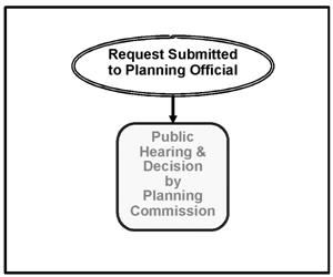
16.21.050 - Application submittal requirements.
All of the following information is, or may be, required for conditional use application submittal:
A.
General Submittal Requirements. An application for a conditional use approval shall contain all of the information required for a quasi-judicial hearing as per the requirements of Chapter 16.20, and provide additional information as noted in the following subsections.
1.
Public Facilities and Services Impact Study. The public facilities and services impact study shall quantify and assess the effect of the development on public facilities and services. The applicant shall consult with the city regarding the scope of the study, including impacts to the transportation system, including pedestrian ways and bikeways, the drainage system, the parks system, the water system, and the sewer system. For each evaluated public facility system and type of impact, the study shall propose mitigation measures necessary to maintain city standards and to minimize the impact of the development on the public at large, public facilities systems, and affected private property.
2.
Traffic Impact Study. If required by the city engineer, in consultation with the planning official and/or appropriate road authority, traffic impact studies shall conform to the standards and procedures of this code (Chapter 16.12, Section 16.12.010(B)).
3.
Dedication of Real Property. In situations where this code requires the dedication of real property to the city, the city's decision shall include written findings that the dedication is related to the nature of the development and is roughly proportional to the projected impacts of the development.
B.
Specific Submittal Information Requirements for a Conditional Use Hearing. In addition to the general submittal requirements noted above (subsection A), an applicant for conditional use hearing shall provide the following additional information, as deemed applicable by the planning official. Redevelopment may trigger requirements similar to but proportional in scope to any and all of those listed below.
1.
Site Analysis Map (Existing Conditions). The professional quality scaled map shall contain at least the following:
a.
The subject property and the surrounding property to a distance (at least three hundred feet) sufficient to determine the location of the development in the city, and the relationship between the subject property and adjacent properties and development. The subject property boundaries, dimensions and gross area shall be identified;
b.
Topographic contour lines at two-foot intervals for slopes of less than ten percent, and five-foot intervals for steeper slopes;
c.
Identification of slopes greater than fifteen percent;
d.
The location and width of all public utilities, public and private streets, drives, sidewalks, pathways, rights-of-way, and easements on the subject property and adjoining the subject property;
e.
Existing land uses;
f.
Identified or potential natural hazard areas, including any areas identified as subject to a one hundred-year flood, areas subject to high water table, ponding, unstable soils, and areas mapped by the city, county, or state as having a potential for geologic hazards;
g.
Mapped, identified, or known natural resource areas, including marsh and wetland areas, streams, designated and/or functioning riparian areas, and wildlife habitat identified by the city or any natural resource regulatory agencies as requiring protection;
h.
Site features, including existing structures, pavement, large rock outcroppings, canals and ditches;
i.
Locally, state or federally designated historic and cultural resources on the subject property and adjacent parcels or lots;
j.
The location, size and species of trees and other vegetation having a caliper (diameter) of twelve inches for deciduous trees, and eighteen inches for evergreens or greater at four feet above existing grade;
k.
North arrow, scale, names and addresses of all persons listed as owners of record of the subject property;
l.
Name and address and professional certification (stamp) of project designer, engineer, surveyor, and/or planner, if applicable;
m.
Any other relevant and essential information or site details that support and enhance the decision making process of the review body.
2.
Proposed Development Site Plan. The site plan shall contain the following information:
a.
The proposed development site, including boundaries, dimensions, and gross area.
b.
Features identified on the existing site analysis maps that are proposed to remain on the site.
c.
Features identified on the existing site map, if any, which are proposed to be removed or modified by the development.
d.
The location and dimensions of all proposed public and private streets, drives, rights-of-way, and easements, including proposed fire lanes.
e.
The location and dimensions of all existing and proposed structures, utilities, pavement and other improvements on the site. Setback dimensions for all existing and proposed buildings shall be provided on the site plan.
f.
Transportation Elements.
i.
Off-street parking facilities design for both motor vehicles and bicycles. Such required plans shall, include ingress and egress points, striping plan, number of spaces, and type of bicycle parking facilities, and proper drainage.
ii.
Internal circulation plans for motor vehicles, bicycles and pedestrians for new commercial, industrial, office, and multifamily residential developments. Such required plans shall include:
(A)
Techniques for achieving efficient access and circulation such as the clustering of buildings, construction of hard surface walk and bike ways, landscaping, accessways, and/or similar techniques;
(B)
Connections of the site's internal pedestrian and bicycle circulation system with those of existing or planned external pedestrian and bicycle circulation systems.
iii.
The location and dimensions of entrances and exits to the site for vehicular, pedestrian and bicycle access.
iv.
The location and dimensions of all parking and vehicle circulation areas (show striping for parking stalls and wheel stops).
v.
Locations and dimensions of all ADA accessible parking and circulation routes.
vi.
Pedestrian and bicycle circulation areas, including sidewalks, internal pathways, pathway connections to adjacent properties, and any bicycle lanes or trails.
vii.
Any vehicle access support facilities, such as reader boards, speakers, key entries, or other interactive points.
g.
Access to loading and service areas for waste disposal, recycling, loading and delivery.
h.
Outdoor recreation spaces, common areas, plazas, outdoor seating, street furniture and similar improvements.
i.
Location, type, height, and illumination area (extent) of outdoor lighting.
j.
Location of mail boxes.
k.
Name and address of project designer, if applicable.
l.
Locations of bus stops and other public or private transportation facilities.
m.
Locations, sizes, and types of signs.
n.
Locations of existing and proposed fire hydrants.
3.
Architectural Drawings. Architectural drawings showing one or all of the following shall be required for new buildings and major remodels:
a.
Building elevations (as determined by the planning official) with building height and width dimensions;
b.
Roof pitches;
c.
Building materials, colors and type;
d.
Floor plans;
e.
The name of the architect or designer.
4.
Preliminary Grading Plan.
a.
A preliminary grading plan prepared by an Oregon licensed engineer shall be required for development sites one-half acre or larger.
b.
The preliminary grading plan shall show the location and extent to which grading will take place, indicating general changes to contour lines, slope ratios, slope stabilization proposals, and location and height of retaining walls, if proposed.
c.
The development of a site is not permitted to adversely impact the historic surface drainage patterns of adjacent properties.
d.
Surface water detention and treatment plans may also be required, in accordance with Sections 16.16.040(F) and 16.16.040(G) of this code.
5.
Landscape Plan. A landscape plan shall be required and shall include at least the following:
a.
The location, size, and species of the existing and proposed plant materials (at time of planting and at time of maturity);
b.
The location and height of existing and proposed fences, buffering or screening materials;
c.
The location of existing and proposed terraces, retaining walls, decks, patios, shelters and play-areas;
d.
Existing and proposed building and pavement outlines;
e.
Specifications for soil at time of planting, irrigation if plantings are not drought-tolerant (may be automatic or other approved method of irrigation) and anticipated planting schedule;
f.
An arborist's report may be required for sites with mature trees that are to be protected and retained under the provisions of Chapter 16.15 (Landscape, Street Trees, Fences and Walls) of this code;
g.
Other information as deemed appropriate by the planning official.
6.
Signage Detail Drawings. Detailed signage drawings shall be required in conformance with the city's sign standards (LDC Chapter 16.18), and shall include design features, methods of construction, as well as proposed illumination.
7.
Deed and Use Restrictions and Other Encumbrances. Copies of all existing and proposed restrictions or covenants, including those for access control.
8.
Traffic Impact Analysis Study. When required, shall be prepared in accordance with the provisions of this code (Chapter 16.12, Section 16.12.010(B)).
9.
Narrative. Letter or narrative report documenting compliance with the applicable decision criteria contained in Section 16.21.060 of this chapter.
10.
Phasing Plan. A phasing plan shall be submitted when development is proposed to take place in phases, and shall include appropriate staging plans.
11.
Other Information. As determined by the planning official, the city may require studies or exhibits prepared by qualified professionals to address specific site features or project impacts (e.g., noise, environmental features, natural hazards, etc.), in conformance with this code.
(Ord. 2766 § 1 (part), 2008)
16.21.060 - Approval of a conditional use request.
Uses listed in this code as requiring conditional use approval may be permitted, altered or expanded when in conformance with the standards and procedures set forth in this chapter and other relevant sections of this code.
A.
Decision Criteria. The city shall approve, approve with conditions, or deny an application for a conditional use or to enlarge or alter a conditional use approval based on findings of fact with respect to each of the decision criteria (standards and use criteria) listed below.
1.
Use Criteria.
a.
The application complies with all of the applicable provisions of the underlying land use zones (LDC Chapters 16.05 through 16.11), including: building and yard setbacks, lot area and dimensions, density and floor area, lot coverage, building height, building orientation, architecture, and other special standards as may be required for certain land uses.
b.
The site size, dimensions, location, topography and access are adequate for the needs of the proposed use, considering the proposed building mass, parking, traffic, noise, vibration, exhaust/emissions, light, glare, erosion, odor, dust, visibility, safety, and aesthetic considerations.
c.
The negative impacts of the proposed use on adjacent properties and on the public can be mitigated through application of other code standards, or other reasonable conditions of approval.
d.
All required public facilities have adequate capacity to serve the proposal.
e.
Existing conditions of approval required as part of a prior land use decision shall be met.
f.
The applicant shall be required to upgrade any existing development that does not comply with the applicable land use district standards, in conformance with Chapter 16.30, Nonconforming Uses and Development.
g.
Existing Uses. In the case of a use existing prior to the effective date of this ordinance and classified in this code as requiring a conditional use hearing, a change in use, or in lot area or an alteration or enlargement of a structure shall conform to the requirements for conditional use review.
2.
Community Development Standards. The application complies with all of the community development standards in LDC Chapters 16.12 through 16.19.
B.
Conditions of Approval. In approving a conditional use application, the planning commission may impose, in addition to those standards and requirements expressly specified by this code, additional conditions that are determined to be necessary to assure that the proposed development meets the decision criteria established in Section 16.21.060(A), as well as the best interests of the surrounding properties, the neighborhood, and the city as a whole. These conditions may include, but are not limited, to the following:
1.
Requiring larger setback areas, lot area, and/or lot depth or width;
2.
Regulating time periods for the conduct of certain activities. Limiting the hours, days, place and/or manner of operation;
3.
Limiting the building or structure height, size or lot coverage, and/or location on the site;
4.
Regulating yard dimensions and the height of buildings to protect solar access;
5.
Controlling the location and number of vehicle access points. Designating the size, number, location and/or design of vehicle access points or parking areas;
6.
Requiring dedication of additional street right-of-way or increasing the street width. Requiring street right-of-way to be dedicated and street(s), sidewalks, curbs, planting strips, pathways, or trails to be improved;
7.
Increasing the number of required off-street parking or off-street loading spaces;
8.
Requiring landscaping, screening, drainage, water quality facilities, and/or improvement of parking and loading areas;
9.
Requiring fencing, screening, landscaping or other facilities to protect adjacent or nearby property;
10.
Requiring and designating the size, height, location and/or materials for fences;
11.
Limiting the number, size, location and lighting of signs;
12.
Limiting or setting standards for the location, design, and/or intensity of outdoor lighting;
13.
Designating sites for open space or outdoor recreation areas;
14.
Requiring ongoing maintenance of buildings and grounds, including the provision of an irrigation system;
15.
Regulating noise, vibration, odors and similar factors that may have a substantial negative effect on the development of the surrounding area;
16.
Requiring site, and architectural or building design features that minimize environmental impacts such as noise, vibration, exhaust/emissions, light, glare, erosion, odor and/or dust;
17.
Providing internal property improvements such as utilities, drainage facilities, streets, curbs, gutters, walkways, parking areas, landscaping, fencing, screening, or recreation areas in order to enhance the area and to protect adjacent or nearby property;
18.
Requiring berms, screening or landscaping and the establishment of standards for their installation and maintenance;
19.
Requiring the protection and preservation of existing trees, soils, vegetation, riparian zones, watercourses, habitat areas, drainage areas, historic resources, cultural resources; (Site development incentives may be developed by the city to protect significant trees.)
20.
Establishing a limited duration for which the conditional use is approved;
21.
Requiring the providing of public improvements such as streets, sidewalks, public utility facilities, drainage facilities and other basic services that are directly benefiting the proposed development or, requiring participation in an improvement district to insure provision of basic services, parks, or streets and sidewalks directly benefiting the proposed development;
22.
Requiring the staggering of units to avoid a barrack-like effect;
23.
Requiring the placement of buildings in a manner, that would fully utilize the solar potential of the site or protect the solar access of an adjacent site;
24.
Requiring the installation of fire and intrusive alarm systems;
25.
Requiring the dedication or granting of an easement (maintenance and access) adjacent to any drainage ways and over existing or proposed public utilities;
26.
Requiring the dedication of sufficient land to the public, and/or construction of pedestrian/bicycle pathways in accordance with the adopted plans, or requiring the recording of a local improvement district non-remonstrance agreement for the same.
C.
Additional Transportation Access-Related Issues. If applicable, proposed conditional use development impacting transportation facilities, requires that the applicant shall address the following access criteria:
1.
Access Placement Criteria. Access shall be properly placed in relation to sight distance, driveway spacing, and other related considerations, including opportunities for joint and cross access;
2.
Road/Street System and Building Access. The road/street system shall provide adequate access to the buildings for the appropriate users, such as residents, visitors, patrons, employees, service and delivery vehicles, and emergency vehicles;
3.
Pedestrian and Bicycle Facilities. An internal system of sidewalks and/or pathways for pedestrians and bicyclists shall provide connections to both motor vehicle and bicycle parking areas, and entrances to the development and its buildings, as well as open space, recreational and other community facilities associated with the development. Streets shall have sidewalks on both sides, unless other configurations have been approved. Pedestrian and bicycle linkages shall be provided to the peripheral street system.
4.
Consistency with Transportation System Plan. All access shall be consistent with the access management standards of this code (see Chapter 16.12), which are in turn consistent with those of the city's transportation system plan.
(Ord. 2766 § 1 (part), 2008)
16.21.070 - Building permits for approved conditional use requests.
Building permits for all or any portion of a conditional use shall be issued only on the basis of the approved conditional use. A building permit may not be issued until the applicant has signed a form stating that they are aware of any and all conditions placed upon the proposed development.
(Ord. 2766 § 1 (part), 2008)
16.21.080 - Development in accordance with permit approval.
A.
Construction of public improvements shall not commence until the city has approved all required public improvement plans and issued public improvement permits (e.g., utilities, streets, public land dedication, etc.).
B.
Development shall not commence until the applicant has received all of the appropriate land use and development approvals (i.e., conditional use approval), building permits, and other agency approvals.
C.
The city may require the applicant to enter into a development agreement (e.g., for phased developments and developments with required off-site public improvements), and may require bonding or other assurances for improvements, in accordance with the provisions of this code (see Chapter 16.16).
(Ord. 2766 § 1 (part), 2008)
16.21.090 - Modifications to approved plans and developments.
Minor modifications of an approved plan or existing development, as defined in Chapter 16.24, shall be processed as an administrative review procedure. Major modifications, as defined in Chapter 16.24, shall be processed as an administrative or quasi-judicial review procedure and shall require a conditional use hearing (see Chapter 16.20 for details regarding review procedures). For modification decision criteria, please refer to Chapter 16.24.
(Ord. 2766 § 1 (part), 2008)
16.21.100 - Expiration of an approved conditional use.
See Section 16.20.070(J) (Chapter 16.20).
(Ord. 2766 § 1 (part), 2008)
16.21.110 - Phased development.
Conditional use approval may also include approval of phasing for a development, subject to the following standards and procedures:
A phasing plan shall be submitted with the conditional use application.
A.
The planning commission may approve a time schedule for developing a site in phases, but in no case shall the total time period for all phases be greater than five years without reapplying for conditional use approval.
B.
Approval of a phased conditional use requires that the public facilities required to serve each phase are constructed in conjunction with or prior to each phase.
C.
An application for phasing may be approved after conditional use approval as a modification to the approved plan, in accordance with the procedures for modifications (Chapter 16.24).
(Ord. 2766 § 1 (part), 2008)
16.21.120 - Termination of a conditional use approval.
A conditional use approval may be revoked or modified by the planning commission, after a public hearing initiated by the city, on any one or more of the following grounds:
A.
Approval of the conditional use was obtained by fraud or misrepresentation;
B.
The use for which approval was granted has ceased to exist;
C.
The use does not meet the conditions specifically established in the conditional use approval;
D.
The use is in violation of any provision of this code or of any other applicable statute, ordinance, or regulation.
(Ord. 2766 § 1 (part), 2008)
16.22.010 - Introduction.
A.
This chapter establishes standards and procedures for the division and development of land within the jurisdiction of the City of Lebanon. These regulations are necessary in order to provide uniform procedures and standards for the division and development of land; to provide for the proper width and arrangement of streets and blocks; to provide for utilities and other public facilities; to avoid undue congestion of population; to assure adequate sanitation and water supply; to provide for the protection, conservation, and proper use of land; to protect solar access; and in general to protect the public health, safety and welfare.
B.
As used throughout this chapter and the whole LDC:
1.
Subdivisions are the creation of four or more lots from one parent lot, parcel or tract, within one calendar year.
2.
Partitions are the creation of two or three parcels within one calendar year.
3.
Property line adjustments are modifications to lot lines or parcel boundaries that do not result in the creation of new lots or parcels.
4.
Property line adjustments can also result in the consolidation of existing lots or parcels through the elimination of a boundary.
C.
The creation of a lot or parcel through the subdivision, partitioning, or property line adjustment process may be processed as part of a planned development review.
D.
The creation of a lot or parcel through the subdivision, partitioning, or property line adjustment process is an outright permitted action in any land use zone, subject to the provisions of this chapter and any other applicable requirements in this code (e.g., community development standards, Chapters 16.12 through 16.19).
E.
The creation of a lot or parcel through the subdivision or partitioning process may be approved only after it is demonstrated that the proposed lot or parcel is buildable under the applicable standards noted in this code.
(Ord. 2766 § 1 (part), 2008; Ord. No. 3036, § 3(Exh. A), 6-11-2025)
16.22.020 - Purpose.
The purpose of this chapter is to:
A.
Provide rules, regulations and standards governing the approval of subdivisions, partitions and lot line adjustments.
B.
Implement the city's development goals as envisioned by the comprehensive plan.
C.
Encourage efficient use of land resources and full utilization of urban services, infrastructure, and transportation options.
D.
Promote the public health, safety and general welfare through orderly and efficient urbanization.
E.
Provide adequate light and air, prevent overcrowding of land, and provide for adequate transportation, water supply, sewage, fire protection, pollution control, surface water management, and protection against natural hazards.
F.
Encourage the conservation of energy resources.
(Ord. 2766 § 1 (part), 2008; Ord. No. 3036, § 3(Exh. A), 6-11-2025)
16.22.030 - General requirements for partitions and subdivisions.
A.
Partition and Subdivision Review Through Two-Step Process. Applications for subdivisions or partitions shall be processed by means of a preliminary plat evaluation and a final plat evaluation, according to the following two steps:
1.
The preliminary plat must be approved before the final plat can be submitted for review.
2.
The final plat must include and/or satisfy all conditions of approval of the preliminary plat.
B.
Compliance With Other Regulations. In addition to the regulations contained herein, all land divisions within the city shall comply with the following regulations:
1.
The city's public improvement standards, the city's adopted standards and specifications for construction, and relevant sections of the Lebanon Municipal Code.
2.
Chapter 92 of the Oregon Revised Statutes (ORS Chapter 92).
3.
Official maps or development plans.
4.
Development code.
5.
Recording requirements of Linn County.
6.
Oregon State Fire Code as adopted by the Lebanon Fire District.
7.
All other applicable regulations provided by law.
C.
Future Residential Re-Division Plan. When subdividing or partitioning tracts in a residential zone into large lots (i.e., greater than four times or four hundred percent the minimum lot size allowed by the underlying land use zone), the city may require that the lots be of such size, shape, and orientation as to facilitate future re-division in accordance with the requirements of the land use district and this code. A re-division plan shall be submitted for large lots identifying:
1.
Potential future lot division(s), consistent with the density and lot size standards of LDC Chapters 16.5 through 16.11.
2.
Potential street right-of-way alignments to serve future development of the property and connect to adjacent properties, including existing or planned rights-of-way.
3.
It will include an acknowledgement that the plan is a conceptual plan intended to show potential future urban density development. It may not be binding on the city or property owners, except as may be required through conditions of approval to achieve future urban density. For example, the granting of easements and/or dedication and improvement of rights-of-way within the future plan area may be required at initial land division to provide needed secondary access and circulation.
D.
Flood Plain Overlay Zone Requirements. All land development by partition and subdivision (including those that are included in a planned development) within a flood plain shall comply with all flood protection regulations (see Section 16.11.070 in Chapter 16.11).
(Ord. 2766 § 1 (part), 2008; Ord. No. 2957, § 3(Exh. A), 5-12-2021; Ord. No. 3036, § 3(Exh. A), 6-11-2025)
16.22.040 - Pre-application conference for partitions and subdivisions.
Prior to the acceptance of a partition or subdivision application, the applicant may request a pre-application conference with the planning official and representatives of the city and other affected public and private agencies to further clarify the submittal requirements necessary for the acceptance of the application and tentative plan. The applicant may request additional meetings with affected agencies either jointly or individually as may be necessary to clarify evaluation criteria, regulations, and policies that may affect the proposed land division. (Fees may be assessed for these additional meetings.)
(Ord. 2766 § 1 (part), 2008; Ord. No. 3036, § 3(Exh. A), 6-11-2025)
16.22.050 - Special transportation provisions and decision criteria for partitions and subdivisions.
A.
Referral to Oregon Department of Transportation (ODOT). Notice, including copies of all site plans, shall be given to ODOT of all proposed subdivisions and partitions likely to have significant impacts or effects on the use of or access to state highways within the Lebanon City limits. ODOT has permitting authority in all situations involving access to state highway facilities.
B.
Additional Transportation Access-Related Decision Criteria. Approval of plans for subdivisions and partitions shall address the following access related decision criteria:
1.
Driveway Access Placement. Driveway access shall be properly placed in relation to sight distance, driveway spacing, and other related considerations, including opportunities for joint and cross access.
2.
Road/Street System and Building Access. The road/street system shall provide adequate access to the buildings for the appropriate users, such as residents, visitors, patrons, employees, service and delivery vehicles, and emergency vehicles.
3.
Pedestrian and Bicycle Facilities. An internal system of sidewalks and/or pathways for pedestrians and bicyclists shall provide connections to both motor vehicle and bicycle parking areas, and entrances to the development and its buildings, as well as open space, recreational and other community facilities associated with the development. Streets shall have sidewalks on both sides, unless other configurations have been approved. Pedestrian and bicycle linkages shall connect to the peripheral street system.
4.
Consistency with Transportation System Plan. All access shall be consistent with the access management standards of this code, the city's transportation system plan, and the Lebanon/Linn County Urban Growth Management Agreement.
5.
Conditions of Approval to Mitigate Significant Impacts or Effects on Transportation Facilities. In situations in which proposed land use actions may cause a significant negative impact or effect on a transportation facility, the planning commission may impose additional conditions for approval, such as:
a.
A traffic impact analysis (or other traffic studies) if the city engineer finds that the proposed development will have a significant negative impact or effect on the surrounding transportation network (see Chapter 16.12, Section 16.12.010.B).
b.
The operator of the affected transportation facility shall receive notice of the proposed land use. Such operators may include, but are not limited to, the city, Linn County, the state (e.g., ODOT, Oregon Department of Aviation), and rail road companies. This notice shall include the applicant's full site plan submitted to the city and any traffic impact study or traffic counts, as well as the information noted in paragraph "a" immediately above.
c.
The determination of transportation impacts or effects and the scope of any impact study shall be coordinated with the planning official, the city engineer and the operator of the affected transportation facility.
d.
Dedication of land for streets, transit facilities, sidewalks, bikeways, paths, or accessways where the existing transportation system will be impacted by or is inadequate to handle the additional burden caused by the proposed land use.
e.
Transportation-related improvements where the existing transportation system may be burdened by the proposed land use.
(Ord. 2766 § 1 (part), 2008; Ord. No. 3036, § 3(Exh. A), 6-11-2025)
16.22.060 - Submittal procedure for partitions and subdivisions.
Following preliminary consultation and a pre-application conference, where applicable, the applicant shall prepare an application and a tentative plan with other supplementary data required to describe the general program and objectives of the proposed land division. The form of application shall be as prescribed by the city and shall be submitted to the planning official who shall coordinate the process of review and action. The submittal and informational requirements and review procedures shall be as specified for each land division classification contained in this code.
(Ord. 2766 § 1 (part), 2008; Ord. No. 3036, § 3(Exh. A), 6-11-2025)
16.22.070 - Preliminary plat review process for partitions and subdivisions.
A.
Review of Preliminary Plat.
1.
Review of a preliminary plat with two or three parcels (partition) shall be processed with an administrative review procedure, under the provisions of Chapter 16.20 (see Section 16.20.040).
2.
Preliminary plats with four or more lots (subdivision) shall be processed with a quasi-judicial procedure under the provisions of Chapter 16.20 (see Section 16.20.050).
3.
An application for a subdivision may be reviewed concurrently with an application for a planned development 1 under the provisions of Chapter 16.23.
B.
Review of Final Plat. Review of a final plat for a subdivision or partition shall be processed as a ministerial procedure under provisions of Chapter 16.20 (see Sections 16.20.030 and 16.20.030) using the decision criteria in Section 16.22.110 below.
C.
Preliminary Plat Approval Period. Preliminary plat approval shall be effective for a period of three years from the date of approval. The preliminary plat approval shall expire if a final plat has not been submitted within the three-year period.
D.
Phased Development.
1.
The city may approve a time schedule for developing a subdivision in phases, but in no case shall the final plat for the final phase be recorded more than ten years from the date of initial approval.
2.
All subdivision phases must comply with all applicable city requirements and conditions of approval.
E.
Expiration of Preliminary Plat Approval. See Section 16.20.070.J (Chapter 16.20).
F.
Modifications. The applicant may request minor changes to the approved preliminary plat (see Chapter 16.24).
1.
Such proposed modifications do not change or modify the adopted findings and/or conditions of approval.
2.
The proposed changes may not increase the number of lots or represent a net increase or impact on supporting infrastructure;
3.
Any changes to the preliminary plat follow the procedures in Chapter 16.24.
(Ord. 2766 § 1 (part), 2008; Ord. No. 3036, § 3(Exh. A), 6-11-2025)
1 Planned development applications and reviews are required for specific types of development proposals, including subdivisions. See Section 16.23.010.E in Chapter 16.23 (Planned developments), and the following in LDC Chapters 16.05 through 16.10: Table 16.05-1, Table 16.06-1, Table 16.07-1, Table 16.08-1, Table 16.09-1, and Table 16.10-1.
16.22.080 - Preliminary plat submittal requirements for partitions and subdivisions.
A.
General Submittal Requirements. For all partitions the application shall contain all of the information required for an Administrative Review procedure (see Section 16.20.040, Chapter 16.20). For all subdivisions the application shall contain all of the information required for a quasi-judicial procedure (see Section 16.20.050, Chapter 16.20), and the information in subsections 1 through 3, below:
1.
Public Facilities and Services Impact Study. The public facilities and services impact study shall quantify and assess the effect of the development on public facilities and services. The city shall advise as to the scope of the study during the pre-application conference (Section 16.22.040 above). The study shall address, at a minimum, the transportation system, including pedestrian ways and bikeways, the drainage system, the parks system, the water system, and the sewer system. For each public facility system and type of impact, the study shall propose improvements necessary to meet and maintain city standards as per the adopted facility plan, and to minimize the impact of the development on the public at large, public facilities systems, and affected private property users.
2.
Traffic impact studies, if required by the road authority. Traffic impact studies shall conform to the standards and procedures in Chapter 16.12, Section 16.12.010.B.
3.
Additional submittal requirements if applicable and warranted:
a.
Correspondence from appropriate and applicable state and federal wetland regulatory agencies.
b.
Correspondence from the county or ODOT if access is proposed to any facility (storm drainage, roads, etc.) under their jurisdiction.
c.
Correspondence from Oregon Department of Aviation if the proposed development is within the approach or noise impact overlay zones of the Lebanon State Airport.
d.
Documentation prepared by a licensed and qualified professional demonstrating that development proposed within a one hundred-year floodplain or floodway complies with appropriate FEMA, NFIP and city's floodplain regulations (see Section 16.11.070 in Chapter 16.11 of this code).
e.
Documentation showing compliance with applicable special area plans.
f.
Documentation showing compliance with the all applicable codes and requirements of the Lebanon Fire District.
g.
Documentation showing that the proposed land division will not violate any existing property restrictions of record including easements.
h.
Documentation prepared by a licensed and qualified professional demonstrating that areas of soil cut and fill will comply with erosion control and building code requirements.
i.
Documentation prepared by a licensed and qualified professional demonstrating that areas of geologic and/or of soils instability can be developed according to applicable city, state and federal environmental standards.
j.
Other information determined by the planning official and/or city engineer. Upon the receipt or presentation of credible evidence, the city may require studies or exhibits prepared by qualified and/or licensed professionals to address specific site features or project impacts (e.g. noise, natural resources, environmental features, natural hazards, cultural/archeological, site stability, wetlands, hazmat assessments, etc.), in conformance with this code, other state and/or federal regulatory requirements.
B.
Preliminary Plat Information. In addition to the general information described in Section 16.22.080.A above, the preliminary plat application shall consist of ten copies of scaled drawings and supplementary written material (i.e., on forms and/or in a written narrative) all of which shall be submitted in hard copies (including at least one photo-reproducible copy) and electronic format (specified by the city) in order to adequately provide the following information:
1.
General Information.
a.
Name of subdivision (not required for partitions). This name must not duplicate the name of another subdivision in Linn County (please check with county surveyor).
b.
Date, north arrow, and scale of drawing.
c.
Location of the development sufficient to define its location in the city, boundaries, and a legal description of the site.
d.
A title block including the names, addresses and telephone numbers of the owners of the subject property and, as applicable, the designer, and engineer and surveyor if any, and the date of the survey if submitted.
e.
Identification of the drawing as a "preliminary plat."
2.
Existing Site Analysis Map.
a.
Streets. Location, name, site access, present width of all streets, alleys and rights-of-way on and abutting the site.
b.
Easements. Width, location and purpose of all existing easements of record on and abutting the site.
c.
Utilities. Location and identity of all utilities on and abutting the site. If water mains, fire hydrants, and sewers are not on or abutting the site, indicate the direction and distance to the nearest one and show how utilities will be brought to standards.
d.
For subdivisions, ground elevations of the entire subject property and the topographically influenced areas of adjacent properties shown by contour lines at five-foot vertical intervals for ground slopes exceeding ten percent and at two-foot intervals for ground slopes of less than ten percent or as required by the city. Such ground elevations shall be related to some established benchmark or other datum approved by the city engineer.
e.
The location and elevation of the closest benchmark(s) within or adjacent to the site (i.e., for surveying purposes).
f.
Potential natural hazard areas, including any flood plains, areas subject to high water table, landslide areas, and areas having a high erosion potential.
g.
Wetland areas, streams, riparian areas, wildlife habitat, and other areas identified by the city or natural resource regulatory agencies as requiring protection (see relevant portions of the comprehensive plan).
h.
Site features, including existing structures, septic systems, wells, pavement, large rock outcroppings, and drainage ways, canals and ditches.
i.
Designated historic and cultural resources on the site and adjacent parcels or lots.
j.
The location, size and species of trees having a caliper (diameter) of twelve inches for deciduous trees, and eighteen inches for evergreens or larger at four and one-half feet above grade in conformance with Chapter 16.15.
k.
Other information, as deemed appropriate by the city engineer and/or planning official. The city may require studies or exhibits prepared by qualified professionals to address specific site features and code requirements.
l.
Areas of identified, known or suspected environmental constraints and/or encumbrances.
3.
Proposed Site Improvements Plan (Including Drawings and Map).
a.
Public and private streets, tracts, access to site, driveways, open space and park land; location, names (as approved by the city and Linn County 911 Dispatch), access to all lots and parcels especially corner lots and parcels, right-of-way dimensions, approximate radius of street curves; and approximate finished street center line grades (on grades of ten percent or greater). All streets and tracts that are being held for private use and all reservations and restrictions relating to such private tracts shall be identified.
b.
Proposed grading plan.
c.
Easements. Location, width and purpose of all proposed easements.
d.
Lots, parcels and private tracts (e.g., private open space, common area, or street): Approximate dimensions, area calculation (e.g., in square feet), and identification numbers for all proposed lots and parcels, and identification letters for tracts.
e.
For flag lots, show the total area and the developable area (total area minus the driveway/access area—often referred to as the "flag pole" or "pan handle").
f.
Proposed uses of the property, including all areas proposed to be dedicated to the public or reserved as open space for the purpose of surface water management, recreation, or other use; potential location of future buildings.
g.
Proposed improvements, as required by part three of this code (community development and use standards), and timing of improvements (e.g., in the case of streets, sidewalks, street trees, utilities, etc.).
h.
For proposed lots and parcels with identified, known or suspected development constraints or encumbrances, demonstrate that those lots and parcels are buildable according to appropriate lot development standards, requirements and regulations.
i.
The proposed source of domestic water.
j.
The proposed method of sewage disposal.
k.
Proposed method of surface water drainage and treatment if required.
l.
The approximate location and identity of other utilities, including the locations of fire hydrants and street lighting fixtures.
m.
Proposed railroad crossing or modifications to an existing crossing, if any, and correspondence discussing the feasibility of the proposal from the affected railroad and the Oregon Department of Transportation Rail Division.
n.
Changes or modifications to intermittent or perennial streams, navigable streams, or other watercourses. Status of public access to these areas shall be shown on the preliminary plat, as applicable.
o.
Development in Area of Special Flood Hazard and Locally Identified or Federally Regulated One Hundred-Year Flood Plain. All land development by partition and subdivision (including those that are included in a planned development) within a flood plain shall comply with all flood protection regulations (see Section 16.11.070 in Chapter 16.11).
p.
Evidence of correspondence from the road authority for any development requiring access to facility(ies) under their authority.
(Ord. 2766 § 1 (part), 2008; Ord. No. 3036, § 3(Exh. A), 6-11-2025)
16.22.090 - Decision criteria—Preliminary plat for partitions and subdivisions.
A.
General Decision Criteria. The city may approve, approve with conditions or deny a preliminary plat based on the following decision criteria:
1.
The proposed preliminary plat complies with the applicable development code sections and adopted master plans. At a minimum, the provisions of this chapter, and the applicable chapters and sections of Article 2 (Land use and land use/development zones) and Article 3 (Community development and use standards) of this code shall apply. Where a variance is necessary to receive preliminary plat approval, the application shall also comply with the relevant sections of Chapter 16.29.
2.
The proposed plat name is not already recorded for another subdivision, and satisfies the provisions of ORS Chapter 92 and the county surveyor.
3.
The proposed streets, roads, sidewalks, bicycle lanes, pathways, utilities, and surface water management facilities are laid out so as to conform or transition to the plats of subdivisions and of partitions already approved for adjoining property as to width, general direction and in all other respects. All proposed public improvements and dedications are identified on the preliminary plat.
4.
All proposed private common areas and improvements (e.g., homeowner association property) are identified on the preliminary plat.
5.
Evidence that all city, county, state and federal regulatory agency identified or mapped special management areas have been accurately and effectively identified on the appropriate maps and plans submitted to the city for review.
6.
Evidence that improvements or conditions required by the city, road authority, Linn County, special districts, utilities, and/or other service providers, as applicable to the project, have been or can be met.
7.
If any part of the site is located within a special area plan or district, overlay zone, or previously approved planned development, it shall conform to the applicable regulations and/or conditions.
B.
Layout and Design of Streets, Blocks and Lots. All proposed blocks (i.e., one or more lots bound by public streets), lots and parcels conform to the specific requirements below:
1.
All lots shall comply with the lot area, setback, and dimensional requirements of the applicable land use zone (Chapters 16.05 through 16.10), and the standards of Chapter 16.12 (Section 16.12.030.K, Street connectivity and formation of blocks).
2.
Setbacks shall be as required by the applicable land use zone (Chapters 16.05 through 16.10).
3.
Each lot shall conform to the standards of Chapter 16.12 (Access and circulation).
4.
Landscape or other screening may be required to maintain privacy for abutting uses. See Chapters 16.05 through 16.10 (Land use zones), and Chapter 16.15 (Landscaping, street trees, etc.).
5.
In conformance with the Oregon Fire Code, a twenty-foot width fire apparatus access drive shall be provided to serve all portions of a building that are located more than one hundred fifty feet from a public or private road or approved access drive. See Chapter 16.12 (Access and circulation).
6.
Where a common drive is to be provided to serve more than one lot, a reciprocating access easement and maintenance agreement shall be recorded with the approved subdivision or partition plat.
7.
All applicable engineering design standards for streets, utilities, surface water management, and easements shall be met.
C.
Conditions of Decision. The city may attach such conditions as are necessary to carry out provisions of this code and other applicable ordinances and regulations and for the purpose of controlling access to adjoining undeveloped properties. Also, see Chapter 16.16 (Public facilities).
(Ord. 2766 § 1 (part), 2008; Ord. No. 3036, § 3(Exh. A), 6-11-2025)
16.22.100 - Variances authorized for partitions and subdivisions.
Variances to the standards of this chapter may be processed in accordance with Chapter 16.29 (Variances). Applications for variances shall be submitted at the same time an application for land division or lot line adjustment is submitted, and the applications may be reviewed together.
(Ord. 2766 § 1 (part), 2008; Ord. No. 3036, § 3(Exh. A), 6-11-2025)
16.22.110 - Final plat submittal requirements and decision criteria for partitions and subdivisions.
A.
Submittal Requirements. Final plats shall be reviewed and approved by the city prior to recording with Linn County. The applicant shall obtain city approval of the final plat within three years of the approval of the preliminary plat. Specific information about the format and size of the plat, number of copies and other detailed information must comply with the standards of the Linn County Surveyor's office and the city.
B.
Decision Criteria. By means of a ministerial review procedure (see Chapter 16.20), the planning official and city engineer shall review the final plat and may approve or deny the final plat based on findings regarding compliance with the following decision criteria:
1.
The final plat is consistent in design (e.g., number, area, dimensions of lots, easements, tracts, right-of-way) with the approved preliminary plat, and all conditions of approval have been satisfied.
2.
All public improvements required by the preliminary plat have been installed and approved and accepted by the city engineer or appropriate service provider (e.g., road authority). Alternatively, the developer has provided a performance guarantee in accordance with Section 16.16.070.C (Chapter 16.16).
3.
The streets and roads for public use are dedicated without reservation or restriction other than reversionary rights upon vacation of any such street or road and easements for public utilities.
4.
The private streets and roads held for private uses have been approved by the city as conforming to the preliminary plat.
5.
The plat and deed contain a dedication to the public of all public improvements, including, but not limited to streets, public pathways and trails, parks, sewage disposal, storm drainage and water supply systems.
6.
The applicant has provided copies of all recorded homeowners association covenants, conditions and restrictions (CC&R's), deed restrictions, private easements and agreements (e.g., for access, common areas, parking, etc.), and other recorded documents pertaining to common improvements recorded and referenced on the plat.
7.
Certification by the city, county or service district, as applicable, that water and sanitary sewer service is available to every lot depicted on the plat; or bond, contract or other assurance has been provided by the applicant to the city that such services will be installed in accordance with Chapter 16.16 (Public facilities), and the bond requirements of Section 16.16.070.C (Chapter 16.16). The amount of the bond, contract or other assurance by the applicant shall be determined by a registered professional engineer, subject to review and approval by the City.
(Ord. 2766 § 1 (part), 2008; Ord. No. 3036, § 3(Exh. A), 6-11-2025)
16.22.120 - Public improvements required for partitions and subdivisions.
Before city approval is certified on the final plat, all required public improvements shall be installed, inspected, and approved, or the applicant shall provide a performance guarantee, in accordance with Section 16.16.070.B (Chapter 16.16, Public facilities), and Section 16.22.130 below.
(Ord. 2766 § 1 (part), 2008; Ord. No. 3036, § 3(Exh. A), 6-11-2025)
16.22.130 - Performance guarantee for partitions and subdivisions.
A.
Performance Guarantee Required.
1.
The subdivider shall file a performance guarantee with the city to ensure installation of the required public improvements. The guarantee shall include a financial instrument sufficient to ensure performance. The guarantee shall provide that if the work is not completed within the period specified, the city may complete the work and recover the full cost and expense thereof from the subdivider. The guarantee may provide for the construction of the improvements in units and for an extension of time under specified conditions. The amount shall be for a sum determined by the city engineer as sufficient to cover the cost of the improvements and repairs, including related city expenses.
2.
The financial instrument may include one of the following:
a.
A surety bond executed by a surety company authorized to transact business in the State of Oregon in a form approved by the city attorney.
b.
An irrevocable standby letter of credit issued by a financial institution authorized to transact business in Oregon.
c.
Such other instrument as may be approved by the city manager and city attorney.
3.
All public improvements shall be installed and accepted by the city engineer prior to the recording of the final plat. The city engineer may allow the subdivider to defer minor improvements, or repairs to existing improvements, to after the final plat is recorded; provided, the improvements or repairs do not exceed five percent of the total construction costs of the subdivision as determined by the city engineer. Bonding shall be required for these minor improvements and repairs in conformance with provisions in items 1 and 2 of this subsection.
B.
Determination of Sum. The assurance of performance shall be for a sum determined by the city as necessary to cover the cost of the improvements and repairs, including related engineering and administrative expenses such as city administrative and legal fees.
C.
Itemized Improvement Estimate. The developer shall furnish to the city an itemized improvement estimate, certified by a registered civil engineer, to assist the city in calculating the amount of the performance assurance.
D.
Public Improvement Agreement. In the event public improvements are bonded but not completed before approval of the final plat, an agreement between the city and developer shall be recorded with the final plat. The agreement may be prepared by the city or prepared by the applicant as a letter. It shall not be valid until it is signed and dated by both the applicant and city engineer. The agreement shall contain all of the following:
1.
The period within which all required improvements and repairs shall be completed.
2.
A provision that if work is not completed within the period specified, the city may complete the work and recover the full cost and expenses from the developer.
3.
The improvement fees and deposits that are required.
4.
A provision for the construction of the improvements in stages and for the extension of time under specific conditions stated in the contract.
E.
When Subdivider Fails to Perform. In the event the developer fails to carry out all provisions of the agreement and the city has un-reimbursed costs or expenses resulting from such failure, the city shall call on the bond, or letter of credit for reimbursement, and may exercise any other remedies provided by law.
F.
Termination of Performance Guarantee. The developer shall not cause termination of nor allow expiration of the guarantee without having first secured written authorization from the city.
(Ord. 2766 § 1 (part), 2008; Ord. No. 3036, § 3(Exh. A), 6-11-2025)
16.22.140 - Filing and recording for partitions and subdivisions.
A.
Filing Plat with County. Within sixty days of the city approval of the final plat, the applicant shall submit the final plat to Linn County for signatures of county officials as required by ORS Chapter 92.
B.
Proof of Recording. Upon final recording with Linn County, the applicant shall submit to the city evidence of the recorded final plat. This shall occur prior to the issuance of building permits for the newly created lots.
(Ord. 2766 § 1 (part), 2008; Ord. No. 3036, § 3(Exh. A), 6-11-2025)
16.22.150 - Re-platting and vacation of plats and rights-of-way.
A.
Re-Platting and Vacations. Any plat or portion thereof may be re-platted or vacated upon receiving an application signed by all of the owners as appearing on the deed.
B.
Procedure. All applications for a re-plat or plat vacation shall be processed in accordance with the procedures and standards for a subdivision or partition (i.e., the same process used to create the plat shall be used to re-plat or vacate the plat). The same appeal rights provided through the subdivision and partition process shall be afforded to the plat vacation process (see Chapter 16.20). Any road authority(ies), utility companies or public agencies affected by the re-plat or plat vacation shall be notified of the application. All right-of-way vacations shall conform to the requirements of state law.
C.
Recording of Vacations. All approved plat vacations shall be recorded in accordance with Section 16.22.140 above. The recording of a re-plat or plat vacation shall be submitted to Linn County concurrently with the recording of any necessary right-of-way vacations.
D.
Street Requirement. Except as prohibited by law, in approving a vacation or re-plat, the city may require dedication of access ways, paths or trails as a condition of the vacation of any public easement or right-of-way, in order to establish or maintain a safe, convenient and direct pedestrian and bicycle circulation system. Such requirements shall be coordinated with the applicable road authority.
(Ord. 2766 § 1 (part), 2008; Ord. No. 3036, § 3(Exh. A), 6-11-2025)
16.22.160 - Property line adjustments.
A property line adjustment is the relocation or elimination of a common property line between abutting properties. A property line adjustment shall not result in the creation of any new parcel(s). The application submittal and decision process is as follows:
A.
Submittal Requirements. All applications for property line adjustment shall be made on forms provided by the city and shall include information required for administrative review, as governed by the provisions of Chapter 16.20. The application shall include a preliminary map drawn to scale identifying all existing and proposed:
1.
Lot lines and dimensions and resulting setbacks;
2.
Footprints and dimensions of existing structures (including accessory structures);
3.
Location and dimensions of driveways and public and private streets within or abutting the subject lots;
4.
Location of significant vegetation (see Chapter 16.15);
5.
Existing fences and walls;
6.
Public and private utility connections;
7.
On-site services (septic and well if any);
8.
Existing and proposed easements; and
9.
Any other information deemed necessary by the planning official or designee for ensuring compliance with city codes.
B.
Decision Process.
1.
Decision-Making Process. Property line adjustments shall be reviewed by ministerial procedure, as governed by the provisions of Chapter 16.20, using decision criteria contained in subsection C below. The road authority(ies) shall be notified of property line adjustments that may affect property access, traffic volumes or operations of their facilities.
2.
Lapsing of Preliminary Approval. The property line adjustment preliminary approval shall lapse if any of the following transpire:
a.
The property line adjustment has not been recorded within one year from the date of preliminary approval.
b.
The property line adjustment has been improperly recorded with Linn County without the satisfactory completion of all conditions attached to the approval.
c.
The final recording is a departure from the approved plan.
C.
Decision Criteria. The planning official or designee may approve or deny a request for a property line adjustment in writing based on all of the following decision criteria:
1.
Parcel Creation. No additional parcel is created by the lot line adjustment.
2.
Parcel and Lot Standards. All parcels and lots conform to the applicable standards of the land use zone.
3.
Access and Road Authority Standards. All lots and parcels conform to the standards or requirements of Chapter 16.12 (Access and circulation), and all applicable road authority requirements are met.
4.
Nonconforming. If a lot or parcel is nonconforming to any city standard, it shall not be made less conforming by a property line adjustment.
D.
Recording Property Line Adjustments.
1.
Recording. Upon the city's approval of the proposed property line adjustment, the applicant shall record the property line adjustment with Linn County within one year of approval (or the decision expires).
2.
Proof of Recording. Upon final recording with Linn County, the applicant shall submit to the city evidence of the recorded property line adjustment survey. This shall occur prior to the issuance of building permits for the reconfigured lot(s).
(Ord. 2766 § 1 (part), 2008; Ord. No. 2801, Exh. A, 7-14-2010; Ord. No. 3036, § 3(Exh. A), 6-11-2025)
16.23.010 - Introduction to planned developments.
A.
Purpose of the Planned Development. The purpose of the planned development (PD) is to provide opportunities to create more desirable environments through the application of flexible and diversified land development standards under a professionally prepared comprehensive development plan (overall site design, maps and drawings) and program (narrative and explanatory documents). The purpose of the planned development process is to:
1.
Encourage the application of new techniques, new technology, and development that will result in sustainable living or development arrangements;
2.
Achieve efficiency in land development, maintenance, street systems and utility net works while providing building groupings for privacy, useable and attractive open spaces, safe circulation and the general well being of the inhabitants;
3.
Implement the comprehensive plan and applicable land use zone(s) by providing a means for planning large development sites;
4.
Encourage innovative planning that results in projects that benefit the community;
5.
Encourage developments that recognize the relationship between buildings, their use, open space, and transportation options, providing varied opportunities for innovative and diversified employment environments;
6.
Facilitate the efficient use of land;
7.
Promote an efficient arrangement of land use, buildings, circulation systems, open space and utilities;
8.
Preserve to the greatest extent possible the existing landscape features and natural features that may not otherwise be protected through conventional development;
9.
Encourage energy conservation and improved air and water quality; and
10.
Assist the city in planning infrastructure improvements.
B.
Establishment of a PD in Combination with a Base Zone. A planned development may be established in combination with any underlying base zone. In cases of conflict between standards of the base zone and the PD, the standards of the PD may apply, provided the planning commission finds that an exception from the standard of the underlying zone is warranted by the design and amenity provisions in the planned development design and program, and there are no identified negative impacts to the surrounding neighborhood or the community as a whole after mitigation.
C.
Phased Development. Phasing of development may be approved with the PD application, subject to the following standards and procedures.
A phasing plan shall be submitted with the PD application.
1.
The planning commission may approve a time schedule for developing a site in phases, but in no case shall the total time period for all phases be greater than ten years without reapplying for PD approval.
2.
Approval of a phased PD proposal requires that the public facilities required to serve each phase are constructed in conjunction with or prior to each phase.
3.
An application for phasing may be approved after PD approval as a modification to the approved plan, in accordance with the procedures for modifications (Chapter 16.24).
D.
Expiration of an Approved Planned Development. See Section 16.20.070(J) (Chapter 16.20).
E.
Applicability. A planned development may be approved in any of the city's land use zones.
1.
An applicant may elect to develop a project as a planned development in compliance with the requirements of this chapter.
2.
Planned development applies to all development in the city identified for such review in this code (see the following in LDC Chapters 16.05 through 16.10: Table 16.05-1, Table 16.06-1 Table 16.07-1, Table 16.08-1, Table 16.09-1 and Table 16.10-1).
3.
In addition, the city may require that the following types of development be processed as planned developments using the provisions of this chapter:
a.
Mixed development, integrated either horizontally or vertically (e.g., a mix of land uses such as residential and commercial on one site);
b.
Any development proposal that includes a site that had been subject to a zoning map amendment in the two years prior to the submittal date of the development proposal application;
c.
Any development proposal that requires an exception to or amendment of an adopted facility master plan, including the transportation system plan;
d.
Any development proposal potentially causing adverse impacts to land in public ownership or developed for a public use that could result in the loss of public use, the loss of some public opportunity, or the conversion of a previous public facility;
e.
Any development proposal of one acre or more in size that is in a one hundred-year floodplain or is on a steep slope (i.e., fifteen percent or greater).
F.
Benefits, Advantages and Opportunities.
1.
Flexibility and Efficiency. The planned development (PD) review provides a process that is flexible and responsive to development proposals that may be unique, innovative, and/or complex. The PD review is designed to be an extremely efficient review process even when projects may be unusually challenging in scope and vision.
2.
Modifications of Zoning Standards and Community Development and Use Standards. Development standards (such as lot size and width, heights) in LDC Article 2 (LDC Chapters 16.05 through 16.11) and the community development and use standards of Article 3 (LDC Chapters 16.12 through 16.19) may be modified (up to twenty-five percent of the standard) through the planned development review process without the need for a variance. However, industrial and commercial uses, if not otherwise allowed in a residential zone, shall not be allowed as part of a planned development in a residential zone.
3.
Reasons for Selecting the PD Process. There are a number of reasons why the PD process may be desirable and applicable, such as: (1) the large area of the development; (2) sensitivity of the development area (e.g., steep slopes); (3) atypical ownership and/or management considerations; (4) magnitude of project impacts; (5) a need for greater procedural flexibility and diversity; and, (6) to permit development proposals not explicitly listed in this code. A PD review can be voluntarily selected by an applicant, may be mandated by the provisions of this code, or determined by the city as the most appropriate review process.
4.
A PD may occur in any zone.
5.
Two Step Process. The PD process is a two step process, in which there are three options or alternative paths for the second step.
a.
The first option or path includes an initial public hearing and a subsequent ministerial review. If sufficient detail and sophistication of design are included in the initial or preliminary design and program, a PD application may be approved with a public hearing before the planning commission, followed by a ministerial review by the planning official of the final design and program that checks for compliance with conditions of approval established by the planning commission.
b.
Second Option. Other PD applications that need further work and modification after the initial public hearing in order to meet the planning commission's conditions of approval may have their final design and program reviewed for compliance by the planning official in an administrative review.
c.
Third Option. Some PD applications may need major or extensive additional work and modification after the initial public hearing in order to meet the planning commission's conditions of approval; the final design and program of such applications may be reviewed for compliance in a second public hearing before the planning commission.
G.
PD Terminology.
1.
Basic Land Use Request. The essential elements of the development request, such as a subdivision layout, the siting of a large commercial or industrial building, or a complex of mixed development buildings (residential and commercial), or a multifamily complex.
2.
Planned Development Design. The overall PD site design, maps and drawings.
3.
Planned Development Program. The PD narratives, explanatory documents, technical studies and mitigation plan.
4.
Preliminary Design and Program. The initial PD proposal reviewed by the planning commission in a public hearing ("Step 1").
5.
Final Design and Program. The revised or modified PD proposal submitted by the applicant to meet the planning commission's conditions of approval established in "Step 1."
6.
Adverse Project Impacts. Adverse project impacts are effects that are detrimental to the health, safety, and general welfare of local residents, the neighborhood, the community and natural environment. Adverse project impacts may include, but are not limited to: operating and/or traffic noise, vibration, glare, heat, electromagnetic interference, smoke, waterborne contaminates, airborne particulates, or atmospheric contaminants (e.g., hazardous or toxic levels of airborne substances or chemicals). Determinations may be based on degradation of such measures as service levels, volumes/capacities (e.g., pre- versus post-development runoff rates) in city's adopted master plans. (Also see Glossary for "Negative Impacts.")
7.
Mitigation (or to Mitigate). To avoid, rectify, repair, or compensate for negative impacts that result from other actions, such as land use development.
8.
Mitigation Plans (and Measures). The plans and measures developed by an applicant to effectively and proportionately mitigate those adverse impacts (attributable to the planned development) experienced by surrounding properties and residents, the neighborhood, and in some cases the city as a whole.
9.
Preliminary Mitigation Plans (and Measures). The mitigation plans and measures submitted as part of the planned development preliminary design and program that are reviewed in "Step 1" of the process, a public hearing before the planning commission.
10.
Final Mitigation Plans (and Measures). The mitigation plans and measures submitted as part of the planned development final design and program that are reviewed in "Step 2" of the process, and that must address all applicable issues and concerns established as conditions of approval for the planned development by the planning commission in "Step 1."
H.
Overview of the Two Step Process. As shown in Figure 16.23-1, a planned development review is a two step process. "Step 1" is a public hearing conducted by the planning commission that reviews the preliminary PD design and program involved in the basic land use request. The preliminary PD design and program includes the overall design elements and mitigation plan, as well as all narratives, explanatory documents, and technical studies. "Step 2" may result in the approval of the final PD design and program (overall design elements and mitigation plan, as well as all narratives, explanatory documents, and technical studies). This second step assesses compliance with the conditions of approval established by the planning commission in "Step 1." An overview of this two-step process follows below.
1.
Step 1: Public Hearing—Review of Preliminary PD Design and Program.
a.
The first step in the planned development process begins with a quasi-judicial public hearing conducted by the planning commission. This step reviews the preliminary PD design and program, including the overall design elements and mitigation plan, as well as all narratives, explanatory documents, and technical studies (See Chapter 16.20 for review procedure). An approval at this level establishes the general validity of the proposed design and program, and grants approval of the basic land use request involved in the planned development application.
b.
During the review of the preliminary PD design and program, the planning commission establishes the conditions of approval that the final PD design and program must meet to merit final approval in Step 2. The planning commission may take the following actions regarding the preliminary PD design and program:
i.
Accept and approve the preliminary PD design and program as submitted, or with very minor refinements;
ii.
Approve the preliminary PD design and program with modifications;
iii.
Direct the applicant to revise the preliminary PD design and program to satisfy the requirements of the code;
iv.
The planning commission may deny a PD application based on the decision criteria.
c.
The planning commission shall also determine the type of review in "Step 2" of the final PD design and program, from the following options (see Chapter 16.20 for relevant review procedures):
i.
Review by the planning official as a ministerial review (Option 2A);
ii.
Review by the planning official as an administrative review (Option 2B);
iii.
Review by the planning commission in a subsequent public hearing (Option 2C).
2.
Step 2: Review of Final PD Design and Program — Three Options.
a.
After planning commission review and action on a preliminary PD design and program (in Step 1), the applicant submits a final design and program that is then reviewed by the designated review process and authority established by the planning commission in Step 1.
b.
"Step 2" may result in the approval of the final PD design and program (overall design elements and mitigation plan, as well as all narratives, explanatory documents, and technical studies). This second step assesses compliance with the conditions of approval established by the planning commission in "Step 1." Successful compliance will result in approval of the PD application.
c.
The review of the applicant's final design and program requires a separate submittal, fee and process.
d.
The review of the final PD design and program shall follow the appropriate procedural provisions of Chapter 16.20. As noted previously, the designated review process and authority shall be one of the following:
i.
Option 2A: Review by the planning official as a ministerial review;
ii.
Option 2B: Review by the planning official as an administrative review;
iii.
Option 2C: Review by the planning commission in a subsequent public hearing.
Figure 16.23-1: The Planned Development (PD) Review Process
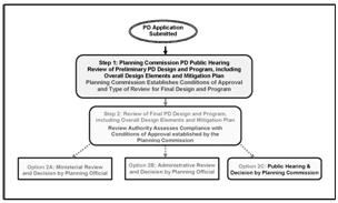
I.
Overview of Mitigation Plans.
1.
Introduction.
a.
Many, if not most, land development projects have some adverse impacts. The standards and requirements in this code are intended to buffer and minimize the adverse impacts that can normally be expected to result from most development activity.
b.
Planned developments may have adverse impacts that are not typically associated with activities routinely permitted in a land use zone, or are extensive or unique, and/or exceed current facility specifications anticipated in city facility plans, and thus require a more rigorous review process and mitigation of the impacts.
c.
The mitigation review procedures in this chapter are directed at these types of developments with unique, excessive and/or extensive adverse project impacts. Such adverse project impacts require correspondingly more rigorous and unique mitigation measures and strategies.
2.
Purpose. The mitigation review process, as an integral part of the planned development review, has several key purposes:
a.
To assure that adverse impacts associated with a land use permitted by a planned development review will be effectively addressed through the overall review process;
b.
Protecting the health, safety, and general welfare of the community and its natural environment;
c.
Providing a clear path for land use review that is not encumbered by unnecessary obstacles;
d.
Providing clear and ample opportunities for citizen participation.
3.
Project Impacts.
a.
If the proposed land use can reasonably be expected to generate adverse project impacts, the applicant must demonstrate effective mitigation measures proposed to be implemented to mitigate or nullify the adverse project impacts and to achieve compliance with applicable local, state, or federal regulations, and specific conditions of land use approval.
b.
Adverse project impacts may include, but are not limited to, the following examples: operating and/or traffic noise, vibration, glare, heat, electromagnetic interference, smoke, waterborne contaminates, airborne particulates, or atmospheric contaminants (e.g., hazardous or toxic levels of airborne substances or chemicals).
c.
Such typical adverse project impacts represent nuisance characteristics or effects that might potentially be detrimental to the health, safety, and general welfare of local residents, the neighborhood, the community and natural environment.
d.
Effective and complete implementation of the approved mitigation measures, plans, and strategies is a fundamental condition of basic land use approval.
e.
If the proposed land use can reasonably be expected to generate adverse project impacts, a planned development must have an approved mitigation plan in order to be approved.
4.
When Mitigation is Not Required. If in Step 1 the planning commission determines, after weighing all the evidence, materials, and testimony presented by staff, the applicant, and other interested parties, that a proposed PD can reasonably be expected to not generate adverse project impacts that need to be addressed by a formal mitigation plan, and the planning commission establishes as a condition of approval that the submittal of a formal mitigation plan is not required, the applicant need not submit such a plan as part of the final design and program.
5.
Requirements for Mitigation Measures and Plans. A fundamental part of the planned development program is a mitigation plan or plans, in addition to narratives, explanatory documents, and technical studies. It may also be the case that certain elements of the overall proposed PD design function as part of the mitigation strategy.
In order to achieve final approval of the proposed development, the applicant is required to submit mitigation measures and plans that:
a.
Effectively address all applicable issues and concerns established as conditions of approval for the planned development by the planning commission;
b.
Effectively and proportionately mitigate those adverse impacts (attributable to the planned development) experienced by surrounding properties and residents, the neighborhood, and the city as a whole;
c.
Are prepared by and stamped by appropriate experts and/or licensed professionals in Oregon (e.g., traffic engineers, acoustical engineers, environmental engineers, geotechnical engineer, civil engineering geologist, wetland specialists, landscape architects);
d.
Demonstrate in detail that all applicable standards can be met by the proposed measures;
e.
Document efforts to achieve compliance with appropriate regulatory agency or agencies (e.g., the Oregon Departments of Transportation (ODOT), Aviation (DOA), Environmental Quality (DEQ) and State Lands (DSL) and federal agencies such as the Army Corps of Engineers, Federal Emergency Management Agency (FEMA), Federal Aviation Administration (FAA), National Oceanic and Atmospheric Administration (NOAA), Environmental Protection Agency (EPA); and the Lebanon Municipal Code provisions such as regulation of hours of operation and noise).
J.
Overview of the Decision Options During "Step 1." Based on all applicable decision criteria, the planning commission may take the following actions regarding the preliminary planned development design and program, and all of their components collectively or individually:
1.
Accept and approve the preliminary planned development design and program as submitted, or with very minor refinements to satisfy the stipulated conditions of approval. The approved planned development design and program then essentially become the final PD design and program subsequently submitted for a final review by the planning official in a ministerial review (Step 2 — Option 2A).
2.
Approve with modifications the preliminary PD design and program so as to satisfy the stipulated conditions of approval. This approved modified PD design and program may become part of the final PD design and program subsequently submitted for a final review by the planning official in an administrative review (Step 2 — Option 2B).
3.
Approve with Revisions. Direct the applicant to revise the preliminary PD design and program to satisfy the stipulated conditions of approval. This revised PD design and program may then be submitted as the final PD design and program subsequently submitted for a final review by the planning official in an administrative review (Step 2 — Option 2B), or by the planning commission in a second public hearing.
4.
Denial. The planning commission may deny a PD application based on the decision criteria.
(Ord. 2766 § 1 (part), 2008)
16.23.020 - Step 1: Review of preliminary planned development design and program.

A.
General Submittal Requirements. PD applications shall contain all of the general information required for a public hearing, as governed by the provisions of Chapter 16.20 (Section 16.20.050). Applicants for planned developments are required to have at least one pre-submittal conference with the planning official. Additional meetings may be necessary. The proposed planned development design (overall site design, maps and drawings) and program (narratives, explanatory documents, technical studies, and mitigation plan) must be prepared by two or more persons with professional qualifications in such design related fields as architecture, landscape architecture, urban planning and civil engineering. The applicant shall submit the following:
1.
A statement detailing the development proposal;
2.
A development schedule indicating the approximate dates when construction of the planned development and its various phases are expected to be initiated and completed;
3.
A statement of the applicant's intentions regarding the long-term ownership and management of the proposed development, including any potential future sale or lease of all or portions of the planned development;
4.
Special studies prepared by qualified professionals necessary to determine potential adverse project impacts (e.g., traffic, geologic, noise, environmental, natural resource, etc.) and required mitigation; (See Preliminary Mitigation Plan.)
5.
Preliminary mitigation plan that addresses all known, foreseen, and expected adverse project impacts (see Section 16.23.010(I)(4) and Section 16.23.030 of this chapter);
6.
Additional Detailed Information. The applicant's submittal shall include all of the materials listed in Section 16.21.050 (Application Submittal Requirements) of Chapter 16.21 (Conditional Uses);
7.
Additional Design and Program Elements. The PD submittal shall include (where determined applicable by the planning official) any or all of the additional materials listed below.
a.
Additional Elements of the Plan.
i.
Parks, playgrounds, recreational facilities, trails and open spaces.
ii.
Proposed method of solid waste disposal.
iii.
Proposed method for provisions of water and sewage disposal.
iv.
Proposed method for the handling of surface water drainage.
v.
Proposed grading patterns.
vi.
A shadow projection, for developers incorporating solar design features.
b.
Additional Elements of the Program (Narrative and Explanatory Documents).
i.
Proposed ownership patterns.
ii.
Operation and maintenance proposal, such as condominium, co-op, or homeowners association.
iii.
Commercial facilities such as shopping, community facilities such as schools or parks.
iv.
A statement regarding the energy impacts of the proposed development.
v.
A statement regarding the noise impacts of the proposed development (and proposed mitigation as part of the preliminary mitigation plan).
vi.
Tables showing the total number of acres and the percentage of the total area that is designated for each type of use including each dwelling type, off-street parking, streets, parks, playgrounds, schools, open spaces, and so on as shown on the proposed development plan.
vii.
Tables showing the overall density of the proposed residential development and showing density by dwelling types and any proposals for the limitation of density.
viii.
Drafts of appropriate restrictive covenants, including those regarding the maintenance of landscape and drafts of documents providing for the maintenance of any common open space, or required dedications or reservations of public open spaces and of any dedications of development rights.
ix.
A timetable indicating when utility and drainage facilities intended to serve the development are to be installed. If the development is to be constructed in stages, the timetable shall reflect this.
x.
Time table of the development, including expected starting dates, projection of completion time and project phasing, if anticipated.
xi.
Method of public improvements financing, if any.
B.
Special PD Development Standards.
1.
Minimum Site Size. The minimum size for a planned development is one acre.
2.
Compliance with Applicable Criteria. The development plan (maps and drawings) and program (narrative and explanatory documents) shall present an organized arrangement of buildings, service facilities, open spaces and improvements such as recreation facilities and fencing to insure compliance with all applicable criteria (e.g., see requirements of underlying zone, and other applicable development requirements, such as parking and access from "Community Design Standards," Article 3 of this development code).
3.
Depth of Periphery Yards. Periphery yards of a PD shall be at least as deep as those required by the yard requirements of the underlying zone, unless the planning commission finds that specific features of the proposed development would mitigate as well as the specified yard requirements vis-a-vis identified "negative impacts" to the surrounding neighborhood and/or the community as a whole after mitigation.
4.
Lot Coverage and Building Height. Lot coverage and building height shall be no greater than for the underlying zone unless the planning commission finds that an exception is warranted in terms of the design and amenities proposed in the total development, and there are no identified "negative impacts" to the surrounding neighborhood and/or the community as a whole after mitigation.
5.
Open Space. Open space in a planned development means the land area to be used for scenic or open space recreational purposes within the development.
a.
Open space does not include street right-of-way, driveways, parking areas, required setbacks, or public service easements unless these areas have some special recreational design or purpose.
b.
Open space shall be adequately designed for the recreational and leisure use of the population occupying the planned development.
c.
Designated open space must be accessible and usable year-around.
d.
Before an area can be considered a designated open space it shall have the following required minimum dimensions and minimum area: (1) length: twenty feet; (2) width: twenty feet; and, (3) shall have a minimum area of four hundred square feet.
e.
To the maximum extent possible, the open space plan shall demonstrate that natural features of the open space are preserved and complimentary landscaping is provided.
f.
The ongoing provision and maintenance of designated and approved open space areas are a permanent obligation of the basic land use approval of the planned development.
6.
Subdivision Lot Sizes. The planning commission may approve a reduction in the minimum area, width, depth and frontage requirements for subdivision lots in a PD, if the overall design and amenities of the proposed project outweigh any adverse impacts that may result from reduction in the minimum area, width, depth and frontage requirements for the lots.
7.
Required Phasing.
a.
As noted in Section 16.23.010(C), the applicant may elect to develop the site in successive phases in a manner indicated in the development design and program.
b.
In addition, the planning commission may require that development be done in stages if public facilities are not adequate to service the entire development initially.
(Ord. 2766 § 1 (part), 2008)
16.23.030 - Step 1: Review of preliminary mitigation plan during the preliminary planned development hearing.
A.
Overview of the Process.
1.
Step 1 of the planned development review process, the public hearing conducted by the planning commission, establishes the general validity of the proposed design and program, and may grant approval of the basic land use request involved in the planned development application 2 .
2.
In this public hearing (Step 1), the planning commission also:
a.
Reviews the proposed preliminary mitigation plan and establishes conditions for the mitigation of any adverse project impacts resulting from the planned development — such conditions are also conditions of approval for the basic land use itself;
b.
Determines the venue of the subsequent mitigation review from the following options:
i.
Option 2A: Review by the planning official as a ministerial review,
ii.
Option 2B: Review by the planning official as an administrative review,
iii.
Option 2C: Review by the planning commission in a subsequent public hearing.
B.
Submittal Requirements.
1.
The original submittal package (see Section 16.23.020(A)) for review of the preliminary PD design and program involved in the basic land use request must include a detailed initial narrative that explains all adverse project impacts that the proposed development can reasonably be expected to generate.
2.
Applications must include their preliminary mitigation plans along with their original submittal package for the review of the preliminary PD design and program. Such mitigation plans must meet the requirements set forth in Section 16.23.010(I)(4) and Section 16.23.030.
3.
Applications may, at this stage of the review process, also include the proposed final detailed technical studies and/or plans (e.g., traffic impact analysis, wetland mitigation plan) that would be necessary for mitigating the adverse project impacts.
4.
The initial narrative and preliminary mitigation plan are not required to include final detailed technical studies and/or plans that would be necessary for a final mitigation review. However, in order to expedite the overall process, applicants may elect to include such detailed narratives, technical studies and/or plans along with their preliminary planned development submittal package. Such materials may be approved (with or without modifications), or may need subsequent revision or additional elements after the planned development review by the planning commission in Step 1 of the process.
5.
The proposed mitigation plans must include accurate accounts of quantitative and qualitative descriptions of the adverse project impacts that the proposed development can reasonably be expected to generate.
6.
The preliminary mitigation plan submittal package is not intended to duplicate the submittal requirement for review of the preliminary PD design and program (see Section 16.23.020(A) above).
C.
Planning Commission Review and Decision. During the public hearing review of the preliminary PD design and program, the planning commission also reviews the preliminary mitigation plan and establishes conditions of approval for the mitigation of adverse project impacts. Based on all applicable decision criteria, the planning commission may then take the following actions regarding the preliminary mitigation plan:
1.
Accept and approve the preliminary mitigation plan as submitted, or with very minor refinements to satisfy the stipulated conditions of approval;
2.
Approve with modifications the preliminary mitigation plan to satisfy the conditions of approval;
3.
Approve with Revisions. Direct the applicant to revise the preliminary mitigation plan to satisfy the stipulated conditions of approval;
4.
Denial. The planning commission may deny a preliminary mitigation plan application based on the decision criteria.
D.
Decision Criteria for Mitigation Plans for Planned Developments.
1.
Compliance with Conditions of Approval.
a.
Mitigation plans for planned developments shall demonstrate compliance with the conditions of approval for the planned development design and program involved in the basic land use request.
b.
Mitigation plans must meet the requirements set forth in Section 16.23.010(I)(5) and in this section.
2.
Site Specific Conditions of Approval Set by the Planning Commission.
a.
In reviewing and approving mitigation plans for planned developments, the planning commission may impose, in addition to those conditions expressly authorized by this chapter and this code, additional conditions that it considers necessary to protect the appropriate development and best interest of the surrounding properties and residents, the neighborhood, and the city as a whole from the foreseen adverse impacts of the development.
b.
These conditions may include any of those listed in Section 16.21.060(B) (Chapter 16.21).
c.
Such additional conditions shall be established as part of the conditions of approval for the planned development design and program involved in the basic land use request.
3.
Required Monitoring of Mitigation Measures.
a.
Effective implementation of the approved mitigation measures, plans, and strategies is an ongoing obligation of the basic land use approval.
b.
Conditions of approval may include ongoing monitoring programs approved by the city (at the owner/operator's expense) after a project is constructed and is operational.
c.
Monitoring may be required following full occupancy and operation of the approved planned development.
4.
Additional Development Requirements. In addition to the regulations contained in the Lebanon Development Code, and the established conditions of approval, mitigation measures and plans for planned developments may be required to comply with other requirements, such as the following:
a.
The Lebanon Municipal Code;
b.
The city's public improvement standards, adopted standards and specifications for construction;
c.
Oregon State Fire Code as adopted by the Lebanon fire district;
d.
All other applicable regulations provided by law.
(Ord. 2766 § 1 (part), 2008)
2 As noted in Section 16.23.010(J), the planning commission decision shall be to approve the application, with or without modifications and conditions, or deny it.
16.23.040 - Step 1: Preliminary PD decision criteria, findings and conditions of approval by the planning commission.
A.
Decision Criteria and Findings. The planning commission, after the public hearing on the proposed planned development design and program, shall either approve the application, with or without modifications and conditions, or deny it. A decision to approve a PD shall be based on findings to the following decision criteria.
1.
The proposed planned development is in conformance with:
a.
Basic decision criteria in this chapter (e.g., Section 16.23.020(B)),
b.
Standards for development in the underlying zones noted Chapters 16.05 through 16.11, or as modified pursuant to the provisions Section 16.23.010(F)(2),
c.
Other applicable development requirements, such as parking, and access (see community design standards, Article 3 of this development code);
2.
Exceptions from the standards of the underlying zone may be warranted by the design and amenities incorporated into the development design and program, and provided there are no identified "negative impacts" or "hardships" to the surrounding neighborhood and/or the community as a whole after mitigation;
3.
The proposed planned development, or a unit thereof, can be substantially completed within the approved timeline;
4.
The streets are adequate to support the anticipated traffic and that the planned development will not overload the streets within or outside the planned development area; (See Mitigation Plan)
5.
The proposed utility and drainage facilities are adequate for the population densities and type of development proposed and will not create a drainage or pollution problem within or outside the planned development area. (See Mitigation Plan)
B.
Conditions of Approval. The planning commission may require conditions of approval that may include, but are not limited to, the following:
1.
Increasing the required setbacks;
2.
Limiting the height of buildings;
3.
Controlling the location and number of vehicular access points;
4.
Establishing new streets, increasing the right-of-way or roadway width of existing streets, requiring curbs and sidewalks, and, in general, improving the traffic circulation system;
5.
Requiring additional improvements for utilities or storm drainage facilities;
6.
Increasing the number of parking spaces and improving design standards for parking areas;
7.
Limiting the number, size, location, and lighting of signs;
8.
Designating sites for open space and recreation;
9.
Requiring additional view obscuring screening or fencing;
10.
Establishing any special time limits for completion of all or any portion of the project, including, but not limited to utilities, drainage facilities, streets, curbs, gutters, sidewalks, parking areas, landscaping, fencing, screening, recreation areas or community buildings;
11.
Requiring assurance that the development of streets, sidewalks, drainage facilities, utilities, and other improvements to standards that are acceptable to the city;
12.
Requiring the placement of building and roadways in such a manner that would provide for utilization of the solar potential of the site and protect the solar access of adjacent sites, and, would buffer and minimize any adverse noise impacts;
13.
All conditions specified by the planning commission shall be incorporated into the final PD design and program;
14.
The planning commission may require additional conditions for approval, such as those listed in Section 16.21.060(B) of LDC Chapter 16.21 (Conditional Uses).
(Ord. 2766 § 1 (part), 2008)
16.23.050 - Step 2: Review of final PD design and program, including the final mitigation plan.

A.
Subsequent to planning commission approval of the planned development request ("Step 1"), the applicant prepares and submits a final PD design and program, including the final mitigation plan.
B.
The review of the final design and program and mitigation plan requires a separate submittal, fee and process.
C.
The review of the final design and program (including the final mitigation plan) is conducted by the designated authority established by the planning commission in Step 1. The review of the final PD design and program shall follow the appropriate procedural provisions of Chapter 16.20. As noted previously, the designated review process and authority shall be one of the following:
1.
Option 2A: Review by the planning official as a ministerial review;
2.
Option 2B: Review by the planning official as an administrative review;
3.
Option 2C: Review by the planning commission in a subsequent public hearing.
D.
"Step 2" may result in the approval 3 of the final PD design and program (including the final mitigation plan).
E.
"Step 2" assesses compliance with the conditions of approval established by the planning commission in "Step 1." Successful compliance will result in approval of the final PD application.
F.
Burden of Proof and Demonstration of Compliance. Applicants must demonstrate compliance or the ability to comply with all applicable PD decision criteria from "Step 1" and conditions of approval established by the planning commission in "Step 1."
G.
Approved mitigation plans, and their effective implementation, become fundamental conditions of approval for the basic land use involved in the planned development design and program.
H.
Administrative review decisions and planning commission decisions may be appealed, as per the provisions of Chapter 16.20, Section 16.20.040(G) and subsection I of this section.
(Ord. 2766 § 1 (part), 2008)
3 The decision of the review authority shall be to approve the application, with or without modifications and conditions, or deny it.
16.24.010 - Purpose.
The purpose of this chapter is to provide an efficient process for modifying land use decisions and approved development plans.
(Ord. 2766 § 1 (part), 2008)
16.24.020 - Applicability.
A.
This chapter applies to all development applications approved through the provisions of Chapters 16.21 through 16.23 and 16.31 of this code, including: conditional uses; subdivisions, partitions, and property line adjustments; planned developments; historic preservation reviews, and conditions of approval on any of the above permit types, as well as applications approved by an "OP," "MR" or "AR" review process (see Chapters 16.05 through 16.11 and 16.20).
B.
This chapter does not apply to comprehensive plan and/or map amendments, zoning map amendments, land development code text amendments, annexations, urban growth boundary amendments, or other permits not listed in Section 16.24.020(A) immediately above.
(Ord. 2766 § 1 (part), 2008)
16.24.030 - Acceptable modification requests—Initial review.
A.
The planning official reviews the initial request for a modification to an approved plan and/or and condition of approval, and using the criteria listed in Section 16.24.030(B) immediately below, determines if it is an acceptable modification request, or if it warrants a full re-application.
B.
The modifications to approved plans and conditions of approval process may be used only if the following threshold criteria are met:
1.
The proposed change is not a change in land use;
2.
The proposed change does not result in an increase in the overall impacts to adjacent properties, nor in an increase in the amount of operational activity on the subject property;
3.
The proposed change does not violate the applicable development standards in the land use zone (see LDC Chapters 16.05 through 16.11 and 16.12 through 16.19).
4.
The proposed change does not result in a change to lot or parcel boundary lines in an approved subdivision, partition, or property line adjustment.
C.
Proposed changes that do not meet the above conditions require a resubmittal as an entirely new land use application under the applicable provisions of Chapters 16.20 through 16.24 and 16.29 through 16.31 of this code.
(Ord. 2766 § 1 (part), 2008)
16.24.040 - Modification applications and approval criteria.
A.
Following a determination by the planning official that the proposed modification is an acceptable modification request (see Section 16.24.030), the applicant shall submit an appropriate application form, filing fee, narrative, and a site plan using the same plan format as in the original approval. The request must clearly and unequivocally describe the proposed change or modification in its entirety. The planning official may require other relevant information, as necessary, to evaluate the request.
B.
As shown in Figure 16.24-1, the modification application shall be subject to the same review procedure (ministerial review, administrative review or a public hearing), decision-making authority, and approval criteria used for the initial project approval.
C.
The scope of review shall be limited to the specifics of the modification request. For example, a request to modify a parking lot shall require a review only of the proposed parking lot and any changes to associated access, circulation, pathways, lighting, trees, and landscaping, and so on.
D.
Notice and public testimony shall be provided in accordance with the provisions of Chapter 16.20.
E.
The decision-making authority shall approve, deny, or approve with conditions an application for a modification based on written findings on the decision criteria and any additional information submitted by the applicant in support of the modification. Upon approval, the modified plan and/or conditions of approval immediately supersedes the previous approval.
Figure 16.24-1: Modifications to Approved Plans and Conditions of Approval
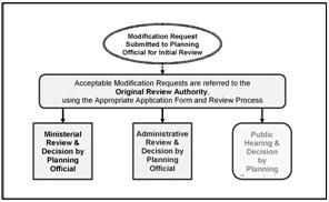
(Ord. 2766 § 1 (part), 2008)
16.25.010 - Intent.
Intent. A formal code interpretation intends to provide property owners or developers with an interpretation of the Lebanon Development Code and/or the Lebanon Comprehensive Plan (collectively "the code") for the following purposes:
A.
Reconcile potential conflicts in the code where terms or phrases may have multiple meanings, create an ambiguity, or result in conflicting or inconsistent results;
B.
Assure uniform application of the code; and
C.
Provide a reasonable appeal procedure.
An interpretation of use type pursuant to Section 16.03.010(C)(4) is not a formal interpretation subject to this section.
(Ord. No. 3041, § 2(Exh. A), 11-12-2025)
16.25.020 - Procedure.
A.
Procedure. In lieu of the procedures outlined in Chapter 16.20, formal interpretations shall follow the procedures outlined in this section.
B.
Review Authority. The planning administrator is authorized to issue formal interpretations of the code.
C.
Submittal Requirements. Requests for formal interpretations shall be submitted on a form provided by the planning administrator and shall be accompanied by the following:
1.
A written statement:
a.
Identifying the provision(s) of the code for which the formal interpretation is being requested; and
b.
Describing the applicant's understanding of the provisions and/or how they are intended to be applied;
2.
Any additional supporting information the applicant deems necessary to provide evidence in support of the requested formal interpretation;
3.
For formal interpretations specific to a particular property that is subject to an active and duly incorporated Homeowner's Association (HOA) registered with the Oregon Secretary of State, which includes an identified registered agent, the name and mailing address for the registered agent of the HOA; and
4.
Payment of the applicable application fee as adopted by council resolution.
D.
Decision. Subsequent to the application being deemed complete, the planning administrator shall review the request and issue a formal interpretation of the specific provision(s) of the code for which the formal interpretation has been requested. The interpretation shall:
1.
Be based on the facts contained within the record and the rules of construction for interpreting the code included under Section 16.25.040; and
2.
Be in the form of a written order containing findings stating the facts relied upon in rendering the interpretation and explaining the justification for the decision.
E.
Notice of Decision. Notice of the decision for a formal interpretation shall be mailed. An affidavit of mailing shall be prepared and made part of the file.
1.
The notice of decision shall be mailed to:
a.
The applicant(s) and/or authorized representative(s);
b.
Anyone who has submitted a written request to receive notification of formal interpretations; and
c.
The following, when the formal interpretation is specific to a particular property:
i.
The owner of record of the subject property;
ii.
The address of the subject property, based on the city's current addressing records;
iii.
Property owners of record, as shown on the most recent property tax assessment roll, of properties located within two hundred fifty feet of the subject property; and
iv.
Addresses, based on the city's current addressing records, within two hundred fifty feet of the subject property; and
2.
The notice of decision shall include:
a.
A brief description of the application;
b.
A brief summary of the decision;
c.
A statement of the facts relied upon;
d.
The date the decision becomes effective, unless appealed;
e.
The date, time, and place by which an appeal must be filed, a brief statement explaining how to file an appeal, and where further information may be obtained concerning the appeal process;
f.
A statement that only those persons with standing may appeal the decision; and
g.
A statement that the complete case file is available for review. The notice shall state where the case file is available and the name and telephone number of the staff case manager to contact about reviewing the case file.
(Ord. No. 3041, § 2(Exh. A), 11-12-2025)
16.25.030 - Appeals.
A.
Appeal.
1.
Generally. Unless appealed, the formal interpretation of the planning administrator shall be the final decision of the city.
2.
Standing to Appeal. Only the applicant and anyone entitled to notice of the decision have standing to appeal the formal interpretation.
3.
Procedure. Except as otherwise provided in this section, appeals of formal interpretations shall be subject to the procedures set forth under Section 16.20.050(L) of the LDC.
4.
Review Authority. The review authority for an appeal of a formal interpretation shall be the city council.
5.
Public Notice. Public notice for an appeal shall be provided as set forth under Section 16.20.050(C) of the code, except that issuing notice to property within a two hundred fifty-foot radius is only required for an appeal of a formal interpretation that is specific to a particular property.
6.
Decision. The city council may affirm or modify the decision. If the city council modifies the decision, it shall issue an interpretation of the provision(s) of the code for which the formal interpretation has been requested. The decision of the city council shall be in the form of a written order containing findings stating the facts relied upon in rendering the interpretation and explaining the justification for the decision. The written order shall be mailed to:
a.
The appellant;
b.
The applicant(s) and/or authorized representative(s), if other than the appellant;
c.
The owner of record of the subject property, when the formal interpretation is specific to a particular property;
d.
Anyone who appeared either orally or in writing before the close of the public record on the appeal; and
e.
Anyone who requested to receive notice of the decision.
7.
The decision of the city council on appeal shall be the final decision of the city. Appeal of the city's final decision is to the Oregon Land Use Board of Appeals.
B.
Effect of Formal Code Interpretation. Formal code interpretations which have become final shall control future application and enforcement of the code, unless superseded by subsequent formal interpretations. When a formal interpretation has been made in reference to a specific particular property, the interpretation shall apply generally throughout the city and not just to that property.
C.
Record of Formal Code Interpretations. The planning administrator shall keep a permanent file of all formal code interpretations.
(Ord. No. 3041, § 2(Exh. A), 11-12-2025)
16.25.040 - Rules of construction.
The following rules of construction shall be used in interpreting the Code:
A.
An interpretation shall be consistent with generally accepted principles of statutory construction as recognized by the Oregon courts, and shall not, by way of interpretation, add new restrictions, standards, or policies that are not apparent or necessarily implied within the text or context of the provision.
B.
In making an interpretation, the duty is to simply ascertain and declare what is, in terms or in substance, contained in the provision.
C.
No interpretation shall insert what has been omitted or omit what has been inserted.
D.
Where there are several provisions relating to the same subject, a construction shall be given where, if possible, all provisions will be given effect.
E.
As used in the code, words used in the present tense include the future, the singular number includes the plural, and the word "shall" is mandatory and not directory.
F.
All interpretations shall be consistent with the policies set forth in the Lebanon Comprehensive Plan.
G.
In construing an ambiguous provision, the legislative history of the provision may be considered.
H.
In making interpretations, great weight shall be given to prior interpretations of the same or any related provision.
I.
Chapters in the code contain purpose statements that provide general explanatory information concerning the chapter. The content of these sections does not constitute approval criteria.
(Ord. No. 3041, § 2(Exh. A), 11-12-2025)
16.26.010 - Purpose.
A.
Prior to annexation, land inside the urban growth area (UGA) has a city of Lebanon comprehensive plan (LCP) map designation, but is under Linn County's jurisdiction and has a county land use zone designation that is intended to facilitate the ultimate LCP map designated urban zoning assignment.
B.
The act of annexation, in and of itself, has two primary purposes and two primary consequences, both of which occur simultaneously when the city approves an annexation. The first purpose/consequence is that jurisdiction over the annexation territory transfers from Linn County to the city of Lebanon. The second purpose/consequence is that a predetermined city of Lebanon land use zoning map designation that is consistent with the city's comprehensive plan map designation is assigned for the first time to the annexation territory as it is incorporated into the city limits.
(Ord. 2766 § 1 (part), 2008)
16.26.020 - Annexation and first assignment of city zoning.
A.
Unannexed property in the urban growth area does not have a city zoning classification or designation, but does have a city comprehensive plan map designation that indicates the long-term planned use for the property.
B.
The city's comprehensive plan and comprehensive plan map direct all long range land use planning in the urban growth area.
C.
All areas annexed to the city shall be placed in a city zoning classification in accordance with the adopted comprehensive plan. Accordingly, upon annexation, an annexation territory will automatically be assigned city zoning classifications in accordance with the adopted comprehensive plan map, as shown in the city's annexation zoning matrix (see Table 16.26-1).
D.
Upon approval of an annexation, the placement of a property in a city zoning classification in accordance with the adopted comprehensive plan map is also formalized by an accompanying zoning map amendment (adopted by city council ordinance). This process shall occur concurrently with an annexation hearing before the city council. The only decision criterion in this process of first assignment of city zoning is that the zone classification shall be consistent with the adopted comprehensive plan map.
E.
Annexation of property must be accompanied by placement of that property in a city zoning classification in accordance with the adopted comprehensive plan map. Property annexed into the city may not retain previous county designations.
F.
At the time of annexation, if an applicant requests a city zoning classification that is not consistent with the comprehensive plan map, the zoning requested shall not be granted until the comprehensive plan map is first appropriately amended to reflect concurrence. (See the Annexation Zoning Matrix, Table 16.26-1.) Such an amendment requires a separate application, hearing and decision; this process may occur concurrently with an annexation hearing.
(Ord. 2766 § 1 (part), 2008)
16.26.030 - Annexations and zoning map amendments.
A.
Annexations involve the first application of city zoning to property that already has a city comprehensive plan map designation, but has never had a City Zoning Map designation.
1.
When the city annexes property into the city limits it will assign the city zoning map classification that corresponds to the comprehensive plan map designation (see Table 16.26-1: Annexation Zoning Matrix).
2.
The city's facility plans, including the 2007 Transportation System Plan (TSP), are based on the future site service demands according to the comprehensive plan map designation and associated zoning assignment upon annexation.
B.
The provisions of LDC Section 16.26.020 require the city to amend the zoning map in order to incorporate newly annexed properties.
C.
Prior to annexation there is simply no city zone on a property to change or amend.
D.
LDC Section 16.26.020(F) requires a comprehensive plan map amendment at the time of annexation if the territory annexed will be assigned a zoning classification that is not consistent with the comprehensive plan designation. (". . . if an applicant requests a zoning designation that is not consistent with the comprehensive plan map, the zoning requested shall not be granted until the comprehensive plan map is first appropriately amended to reflect concurrence.")
E.
Chapter 16.27 of this code (Comprehensive Plan Map and Zoning Map Amendments) provides the parameters for amending the zoning map.
(Ord. 2766 § 1 (part), 2008)
16.26.040 - City facility plans and annexation.
A.
Anticipated urban densities (according to the automatic city zoning assignment/placement upon annexation) within the urban growth area (UGA) are already accounted for in the city's facilities plans, including the transportation system plan.
B.
The comprehensive plan and comprehensive plan map designations are utilized as the basis for the city's facility planning in the UGA.
C.
The city's facility planning is based on the understanding that the classifications of the zoning map will be consistent with the corresponding comprehensive plan map designations and that zoning map classifications will be assigned when a property is annexed.
D.
Annexation of the land in the UGA is already factored into the city's facility plans (including the transportation system plan), and no revisions of those facility plans are necessitated when, following annexation, an area is assigned the zoning classification that is in accordance with the adopted comprehensive plan map designation as noted above (Sections 16.26.020 and 16.26.030).
Table 16.26-1: Annexation Zoning Matrix — Determining the Proper Zone for Property Annexed into the City
(Adapted from Annexation Zoning Matrix, Table 4-2 in LCP Chapter 4: Land Use)
Key
* Based upon the description in this development code of these two zones (Z-RH & Z-CCM), there are no un-annexed properties in the UGB eligible to be assigned to these zone designations.
** Z-NCM is for small neighborhood shopping clusters in any residential zone. Such designations would require a zone change and an administrative review process.
(Ord. 2766 § 1 (part), 2008)
16.26.050 - Application process and submittal requirements.
A.
Legislative Procedure. An application for an annexation shall be processed as a legislative decision (see Figure 16.26-1), as per the provisions of Section 16.20.060 in Chapter 16.20 of this code.
1.
Legislative land use decisions (including annexations) are considered initially in a public hearing by the planning commission with final decisions made by the city council, also in a public hearing.
2.
In the legislative process, the planning commission does not make final decisions, and may only make recommendations to the city council.
3.
City council shall hold a public hearing, and in reaching a decision shall take into account the recommendations of the planning commission, and testimony provided in the public hearings on the annexation application (see Chapter 16.20 of this code).
B.
Submittal Requirements. The application shall meet submittal requirements listed in Section 16.20.060 (Chapter 16.20) of this code, as well as those listed below:
1.
All items required by the city of Lebanon's petition for annexation and annexation application;
2.
A narrative describing how the annexation proposal satisfies the provisions of the city's annexation ordinance as well as the annexation policies of the Lebanon comprehensive plan, and any other special site specific criteria identified by the city.
Figure 16.26-1: The Annexation Process (Legislative)
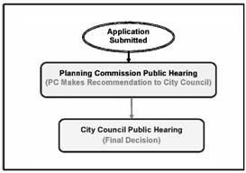
(Ord. 2766 § 1 (part), 2008)
16.26.060 - Decision criteria for an annexation request.
The city shall approve an annexation request if it satisfies all of the relevant basic decision criteria.
A.
Basic Decision Criteria. The basic decision criteria for all annexation requests are found in the following:
1.
Annexation ordinance.
2.
Lebanon comprehensive plan, Chapter 3 Urbanization.
B.
Abatement of Nonconforming Uses or Structures. The city may require the abatement of non-conforming uses and/or structures prior to hearing an annexation request. Other provisions of this code and the Lebanon Municipal Code may require abatement of certain kinds of situations before an annexation request can be approved.
C.
Site Specific Evaluation Criteria. At the time it reviews an annexation request, the city may identify additional site specific evaluation criteria based on the Lebanon Comprehensive Plan, the provisions of this code, and the Lebanon Municipal Code. Such site specific criteria could include, but not be limited to, the following issues:
1.
Steep slopes;
2.
Natural hazard areas (e.g., flood plains, landslides);
3.
Riparian zones;
4.
Wetlands;
5.
Water bodies;
6.
Aircraft or other overlay zones;
7.
Proposals for specific infrastructure development in the city's facility plans, including the transportation system plan;
8.
Existing nuisance and/or hazardous conditions;
9.
Failing on site services (e.g., potable water and septic).
Such site specific criteria do not affect the eligibility of properties for annexation, but serve as an advisory to applicants of factors that may affect future development. The annexation process does not set conditions of approval for future development proposals and applications.
(Ord. 2766 § 1 (part), 2008)
16.27.010 - Purpose.
The Lebanon comprehensive plan map and the Lebanon zoning map may be amended whenever the public necessity, convenience, and general welfare require such amendment and where it conforms to the city of Lebanon's comprehensive plan and transportation system plan, other adopted facility plans, as well as any other applicable and adopted policies plans, and studies. The city's urban growth boundary may be expanded or amended, according to state regulations to accommodate the city's need for land within its urban area.
(Ord. 2766 § 1 (part), 2008)
16.27.020 - Authorization to initiate map amendments.
An amendment to the Lebanon comprehensive plan (LCP) map, the city's zoning map, or UGB boundary may be initiated as follows:
Table 16.27-1: Initiation of Map Amendments
1. The city council or planning commission may initiate map amendments if a majority of the body endorses such a proceeding. A vote to proceed with such an application does not obligate the body to approve the final proposed map amendment. It is only an agreement that the matter is worth proceeding to formal application and a public hearing.
2. City staff may initiate map amendments if the city manager agrees that the matter is worth proceeding to formal application and a public hearing.
3. A property owner may initiate (submit an application) for comprehensive plan map and/or zoning map amendments on property that they own. If more than one property or owner is involved, all of the property owners must demonstrate in writing that they support the application.
(Ord. 2766 § 1 (part), 2008)
16.27.030 - Record of amendments.
The city recorder shall maintain records of amendments to the text of this code and to the zoning map.
(Ord. 2766 § 1 (part), 2008)
16.27.040 - Limitation.
An application by a property owner for a map amendment shall not be considered by the planning commission within the one-year period immediately following a previous denial of such request, except the planning commission may permit a new application, if in the opinion of the planning commission, new evidence of a change of circumstances warrants it.
(Ord. 2766 § 1 (part), 2008)
16.27.050 - Decision criteria.
A.
Compliance with Comprehensive Plan and Facility Plans.
1.
All proposed amendments to the comprehensive plan map or to the zoning map shall be consistent with the city of Lebanon's adopted comprehensive plan and facility plans. The city's facility plans, including the 2007 Transportation System Plan (TSP), are based on the future site service demands according to the comprehensive plan map designation and associated zoning.
2.
Facility plans need to be consistent with the comprehensive plan map as well as the text, and changes to the map may necessitate changes to a facility plan. For example, changing a comprehensive plan map designation to a higher intensity use may require an amendment to the TSP, sanitary sewer or potable water master plans.
3.
Applicants proposing amendments to the zoning map must request a city zoning classification that is consistent with the comprehensive plan map designation for a subject property. If an applicant requests a city zoning classification that is not consistent with the comprehensive plan map, the zoning requested shall not be granted until the comprehensive plan map is first appropriately amended to reflect concurrence. (See the Annexation Zoning Matrix, Table 16.26-1.) Such an amendment requires a separate application, hearing and decision; this process may occur concurrently with the zoning map amendment hearing.
B.
Amending the Comprehensive Plan. If proposed amendments to the comprehensive plan map or zoning map do not comply with the comprehensive plan, the comprehensive plan must first be amended so that the proposed map amendment will be consistent with and accurately implement the comprehensive plan.
(Ord. 2766 § 1 (part), 2008)
16.27.060 - Application process and submittal requirements.
A.
Legislative Procedure. An application for a comprehensive plan map or zoning map amendment shall be processed as a legislative decision (see Figure 16.27-1), as per the provisions of Section 16.20.060 in Chapter 16.20 of this code.
1.
Land use legislative matters (including comprehensive plan map or zoning map amendment) are considered initially in a public hearing by the planning commission with final decisions made by the city council, also in a public hearing.
2.
In the legislative process, the planning commission does not make final decisions, and may only make recommendations to the city council.
3.
City council shall hold a public hearing, and in reaching a decision shall take into account the recommendations of the planning commission, and testimony provided in the public hearings on the application (see Chapter 16.20 of this code).
Figure 16.27-1: The Process (Legislative) for Comprehensive Plan Map and Zoning Map Amendments
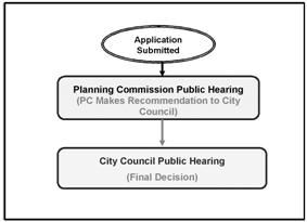
B.
Submittal Requirements. The application shall meet submittal requirements listed in Section 16.20.060 (Chapter 16.20) of this code, as well as those listed below:
1.
All items required by the city of comprehensive plan map or zoning map amendment application.
2.
A narrative describing how the proposal satisfies the provisions of the Lebanon comprehensive plan, and the decision criteria listed above in Section 16.27.050.
3.
For amendments initiated by a property owner or a citizen, a filing fee in accordance with the provisions of city regulations shall accompany an application for an amendment.
(Ord. 2766 § 1 (part), 2008)
16.27.080 - Approval of a comprehensive plan map or zoning map amendment request.
The city may approve a comprehensive plan map or zoning map amendment request if it satisfies all of the relevant decision criteria cited above in Section 16.27.050.
(Ord. 2766 § 1 (part), 2008)
16.27.090 - Urban growth boundary amendments.
A.
Purpose.
1.
Urban Growth Boundaries.
a.
Urban growth boundaries identify and separate urbanizable land from rural land. An urban growth boundary (UGB) is a boundary line that encompasses the area surrounding a city that is intended for future urban development related to the city. An urban growth boundary contains urbanizable lands that:
i.
Are determined to be necessary and suitable for future urban uses;
ii.
Can be served by urban services and facilities;
iii.
Are needed for the expansion of an urban area.
b.
Lands outside the urban growth boundary are reserved for rural uses including agriculture, forestry, open space or sparse, non-urban development such as rural home-sites or farms where few urban services are needed.
2.
Urban Growth Boundary Amendments. In general, the establishment and change of urban growth boundaries are based on the following:
a.
Demonstrated need to accommodate long range urban population, consistent with a twenty-year population forecast coordinated with affected local governments;
b.
Demonstrated need for housing, employment opportunities, livability or uses such as public facilities, streets and roads, schools, parks or open space, or any combination of these needs.
B.
Criteria for Determining the Need for Urban Growth Boundary Amendments and the Location of Boundaries. Statewide Planning Goal 14 and local adopted goals and plans set the criteria for determining the need for urban growth boundary amendments.
C.
Authorization to Initiate UGB Map Amendments. As shown in Table 16.27-1, an amendment to the Lebanon's urban growth boundary may be initiated as follows:
1. The city council or planning commission may initiate UGB amendments if a majority of the body endorses such a proceeding. A vote to proceed with such an application does not obligate the body to approve the final proposed UGB amendment.
2. City staff may initiate UGB amendments if the city manager agrees that the matter is worth proceeding to formal application and a public hearing.
3. A property owner may submit an application for a UGB amendment on property that they own. If more than one property or owner is involved, all of the property owners must demonstrate in writing that they support the application. A UGB amendment request not only has an application fee, but also includes the costs of studies (e.g., buildable lands inventory) that must be conducted in order to comply with state regulations for a UGB amendment. The property owner(s) who initiate the process are responsible for all costs of the process.
D.
Record of Amendments. The city recorder shall maintain records of amendments to the city of Lebanon's urban growth boundary.
E.
Consistency with Statewide Planning Goals. All proposed amendments to Lebanon's Urban Growth Boundary shall be consistent with all applicable Statewide Planning Goals, including Goal 14.
F.
Consistency with City's Adopted Facility Plans. All adopted facility plans, including the transportation system plan, must be consistent with the text and map of Lebanon's comprehensive plan, and urban growth boundary. Amendments to the urban growth boundary may necessitate corresponding changes in the city's adopted facility plans. Such changes to facility plans may be adopted concurrent with or prior to a UGB amendment.
G.
Consistency with City's Adopted City Goals and Special Plans. All adopted city goals and special plans, must be consistent with the text and map of Lebanon's comprehensive plan, and urban growth boundary. Amendments to the urban growth boundary may necessitate corresponding changes in the city's adopted goals and special plans. Such changes to city goals and special plans may be adopted concurrent with or prior to a UGB amendment.
H.
Application Process and Submittal Requirements. The application shall meet submittal requirements listed in Section 16.20.060 (Chapter 20) of this code, as well as those listed below:
1.
All items required by the city of Lebanon's urban growth boundary amendment application;
2.
A narrative describing how the proposal satisfies the applicable provisions of the Lebanon comprehensive plan and Oregon's Statewide Planning Goals, including Goal 14.
I.
Legislative Procedure.
1.
An application for an urban growth boundary amendment shall be processed as a legislative decision (see Figure 16.27-2), as per the provisions of Section 16.20.060 in Chapter 16.20 of this code.
2.
Land use legislative matters (including an urban growth boundary amendment) are considered initially in a public hearing by the planning commission with final decisions made by the city council, also in a public hearing.
3.
In the legislative process, the planning commission makes a recommendation to the city council.
4.
City council shall hold a public hearing, and in reaching a decision shall take into account the recommendations of the planning commission, and testimony provided in the public hearings (see Chapter 16.20 of this code).
Figure 16.27-2: The Process (Legislative) for Urban Growth Boundary Amendments
J.
Decision Criteria for an Urban Growth Boundary Amendment Request. The city may approve an urban growth boundary amendment request if it satisfies the relevant Criteria: Oregon Department of Land Conservation and Development (DLCD) requirements, applicable Statewide Planning Goals (including Goal 14), and the applicable provisions of the Lebanon comprehensive plan as well as any other applicable and relevant facility or special area plans, specific projects or city-wide goals adopted by the city. An amendment request that has not evaluated the transportation impacts of the amendments as required by applicable provisions in OAR may not be rezoned until these requirements have been met.
K.
Effective Date of UGB Amendment. A final decision by the city to amend the urban growth boundary does not become effective until a corresponding decision is adopted by Linn County that recognizes the new location of the boundary.
(Ord. 2766 § 1 (part), 2008)
16.28.010 - Purpose.
A.
Comprehensive Plan. The comprehensive plan is a fundamental part of the community's planning process. Ensuring that the comprehensive plan is a viable and user-friendly policy document is an ongoing and active responsibility of city government. The comprehensive plan needs to be updated occasionally for a variety of reasons, including the following:
1.
To accurately reflect changes in the community;
2.
To reflect changes in statewide planning goals and guidelines as well as changes in state statutes and rules;
3.
To ensure integration with other policies, development codes, and other adopted plans.
B.
Development Code. The development code implements the comprehensive plan. It may be amended whenever the public necessity, convenience, and general welfare require such amendment and where it conforms to the city of Lebanon's comprehensive plan and transportation system plan, other adopted facility plans, as well as any other applicable and adopted policies plans, and studies. The development code will be amended as necessary to be consistent with the comprehensive plan as it is amended over time.
(Ord. 2766 § 1 (part), 2008)
16.28.020 - Types of comprehensive plan text amendment processes.
A.
Periodic Review. State law requires the city to update the comprehensive plan through a process known as periodic review. The department of land conservation and development initiates periodic review to ensure that comprehensive plans and land use regulations remain in compliance with the state law. Periodic review requires a cooperative process between the state, the local government, the citizens of Lebanon and other interested persons, agencies and organizations.
B.
Post Acknowledgment Plan Amendment (PAPA). The post acknowledgment plan amendment process provides an alternative way (to periodic review) to change or update the comprehensive plan (and/or map). Cities must comply with state law and statewide planning goals when amending the comprehensive plan through the PAPA process.
C.
Major Revisions and Minor Changes.
1.
Citizen Participation and Coordinating Land Use Planning.
a.
As noted in Statewide Planning Goal 2, the citizens in the planning area and any affected governmental unit should be given an opportunity to review and comment prior to any changes in the comprehensive plan and implementation ordinances. There should be at least thirty days notice of the public hearing on the proposed change.
b.
Statewide Planning Goal 2 also provides the framework to assure that the established land use process and decision-making is informed by an adequate factual base for such decisions and actions, and for coordinating land use planning with other affected governmental units.
2.
Major Revisions.
a.
Major revisions include land use changes that have widespread and significant impact beyond the immediate area, such as quantitative changes producing large volumes of traffic; a qualitative change in the character of the land use itself, such as conversion of residential to industrial use; or a spatial change that affects large areas or many different ownerships.
b.
The plan and implementation measures should be revised when public needs and desires change and when development occurs at a different rate than contemplated by the plan. Areas experiencing rapid growth and development should provide for a frequent review so needed revisions can be made to keep the plan up to date.
c.
Major revisions should not be made more frequently than every two years, if at all possible.
3.
Minor Changes.
a.
Minor changes do not have significant effect beyond the immediate area of the change.
b.
Such changes should be based on special studies or other information that will serve as the factual basis to support the change.
c.
The public need and justification for the particular change should be established.
d.
Minor changes should not be made more frequently than once a year, if at all possible.
(Ord. 2766 § 1 (part), 2008)
16.28.030 - Authorization to initiate text amendments.
An amendment to the Lebanon's comprehensive plan text and/or development code text may be initiated by the entities or individuals noted in Table 16.28-1.
Table 16.28-1: Initiation of Text Amendments
1. The city council or planning commission may initiate a comprehensive plan text and/or development code text amendment if a majority of the body endorses such a proceeding. A vote to proceed with such an application does not obligate the body to approve the final proposed text amendment. It is only an agreement that the matter is worth proceeding to formal application and a public hearing.
2. City staff may initiate comprehensive plan text and/or development code text amendments if the city administrator agrees that the matter is worth proceeding to formal application and a public hearing.
3. A property owner may request a comprehensive plan text and/or development code text amendment. Such requests may be made to the city council, planning commission, or city staff (see references #1 and #2 directly above).
(Ord. 2766 § 1 (part), 2008)
16.28.040 - Record of amendments.
The city recorder shall maintain records of amendments to the city of Lebanon's comprehensive plan and development code.
(Ord. 2766 § 1 (part), 2008)
16.28.050 - Consistency with statewide planning goals.
All proposed amendments to Lebanon's comprehensive plan text shall be consistent with Oregon's Statewide Planning Goals.
(Ord. 2766 § 1 (part), 2008)
16.28.060 - Consistency with city's adopted facility plans.
All adopted facility plans, including the transportation system plan, must be consistent with Lebanon's comprehensive plan. Amendments to the comprehensive plan may necessitate corresponding changes in the city's adopted facility plans.
(Ord. 2766 § 1 (part), 2008)
16.28.070 - Consistency with transportation system plan.
A.
Transportation System Plan (TSP). All amendments to the comprehensive plan and development code shall be consistent with the city of Lebanon's adopted transportation system plan.
B.
Identified Function, Capacity, and Performance Standards of Transportation Facilities.
1.
Applicability. All amendments to the comprehensive plan and development code that significantly impact or affect a transportation facility shall demonstrate that the proposed and allowed land uses are consistent with the identified function, capacity, and performance standards (e.g., level of service, volume to capacity ratio, etc.) of the facility.
a.
Significant Impacts. An amendment to the comprehensive plan and/or development code significantly affects a transportation facility if it:
i.
Changes the functional classification of an existing or planned transportation facility;
ii.
Changes standards implementing a functional classification system;
iii.
Allows types or levels of land uses that would result in levels of travel or access that are inconsistent with the functional classification of a transportation facility;
iv.
Would reduce the performance standards of the facility below the minimum acceptable level identified in the TSP.
b.
Achieving Consistency. This shall be accomplished by any of the following actions:
i.
Limiting allowed land uses to be consistent with the planned function, capacity, and performance standards of the transportation facility;
ii.
Amending the TSP to provide transportation facilities adequate to support the proposed land uses consistent with the requirements of this division;
iii.
Altering land use designations, densities, or design requirements to reduce demand for automobile travel and meet travel needs through other modes;
iv.
Amending the TSP to modify the planned function, capacity and performance standards, as needed, to accept greater motor vehicle congestion to promote mixed use, pedestrian friendly development where multimodal travel choices are provided.
2.
Coordination. Determinations under provisions listed immediately above shall be coordinated with affected transportation facility and service providers and other affected state, regional and local governments.
(Ord. 2766 § 1 (part), 2008)
16.28.080 - Application process and submittal requirements.
A.
Legislative Procedure.
1.
An application for a comprehensive plan amendment and/or development code amendment shall be processed as a legislative decision (see Figure 16.28-1), as per the provisions of Section 16.20.060 in Chapter 16.20 of this code.
2.
Land use legislative matters (including comprehensive plan and/or development code amendments) are considered initially in a public hearing by the planning commission with final decisions made by the city council, also in a public hearing.
3.
In the legislative process, the planning commission does not make final decisions, and may only make recommendations to the city council.
4.
City council shall hold a public hearing, and in reaching a decision shall take into account the recommendations of the planning commission, and testimony provided in the public hearings (see Chapter 16.20 of this code).
Figure 16.28-1: The Process (Legislative) for Comprehensive Plan Amendments and Development Code Amendments
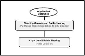
B.
Submittal Requirements. The application shall meet submittal requirements listed in Section 16.20.060 (Chapter 16.20) of this code, as well as those listed below:
1.
All items required by the city of Lebanon's comprehensive plan and/or development code amendment application.
2.
A narrative describing how the proposal satisfies the applicable provisions of the Lebanon comprehensive plan and Oregon's Statewide Planning Goals.
3.
For an amendment initiated by a property owner, a filing fee in accordance with the provisions of city shall accompany an application for a LCP or LDC amendment.
(Ord. 2766 § 1 (part), 2008)
16.28.090 - Decision criteria for a comprehensive plan text and/or map amendment request.
The city may approve a comprehensive plan and/or development code amendment application if it satisfies all of the relevant decision criteria: Oregon Department of Land Conservation and Development (DLCD) administrative rules, the applicable statewide planning goals, the applicable provisions of the Lebanon comprehensive plan, and any other applicable and relevant facility or special area plans, specific projects or city-wide goals adopted by the city.
(Ord. 2766 § 1 (part), 2008)