
Lee County Unincorporated
City Zoning Code
City Zoning Code
Appendix L
COMMUNITY PARK IMPACT FEE BENEFIT DISTRICT DESCRIPTIONS1
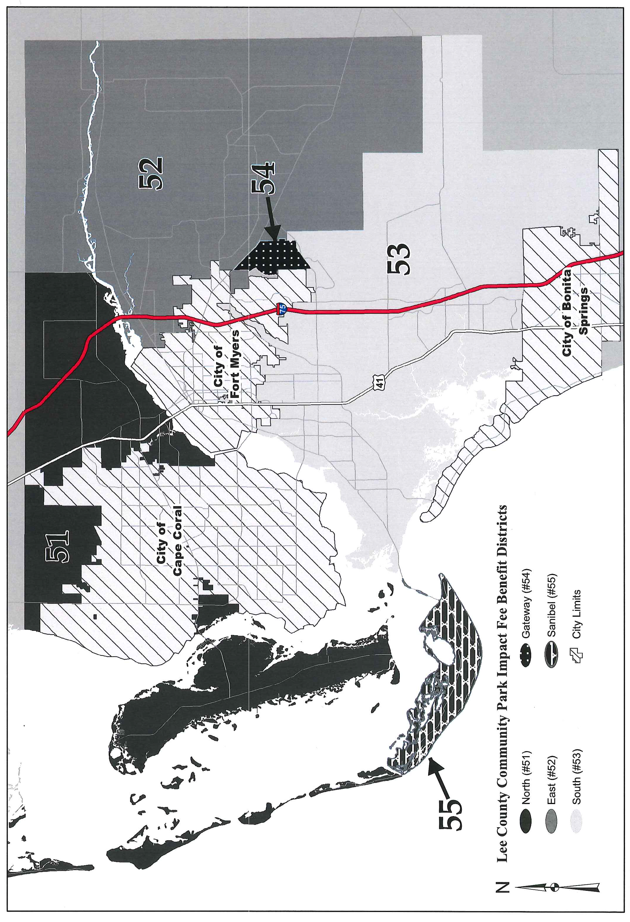
North (#51).
Bounded on the North by Charlotte County Line. Bounded on the East by the Eastern Boundary of Range 25. Bounded on the South by Okeechobee Waterway (Caloosahatchee River), then from section 21, Township 44 South, Range 24 East follow Cape Coral City Limits to the North and West ending at Charlotte Harbor. Continue South along the Cape Coral City Limits to the West Boundary of South (#53). Continue along said West Boundary to the South Boundary of the Intracoastal Waterway (ICW). Continue along said South Boundary and the North and West City Limits of Sanibel to the Gulf of Mexico at the South end of Captiva. Continue North along the Gulf of Mexico, along the West side of Captiva Island, North Captiva Island, Cayo Costa Island and Gasparilla Island to the Charlotte County Line. Also included are enclaves within Cape Coral City Limits East of the East Boundary of Range 24.
East (#52).
Bounded on the North by Charlotte County Line. Bounded on the East by Hendry County and Collier County Lines. Bounded on the West by SR 31 from the Charlotte/Lee Line South to Okeechobee Waterway (Caloosahatchee River). Continuing to follow the City Limits of Fort Myers to the Southeast Corner of section 36, Township 44 South, Range 25 East. Continue following the boundary of the Gateway Services District to the South Line of section 8, Township 45 South, Range 26 East. Continue along the South Line of said section to the Southeast corner of said section. Continue South along the section Lines to the Southwest corner of section 33, Township 45 South, Range 26 East. Continue East on the South Boundary of Township 45 South, Range 26 East to the Southeast Corner of section 36, Township 45 South, Range 26 East. Continue South along the West Boundary of Township 46 South, Range 27 East to the Southwest Corner of section 18, Township 46 South, Range 27 East. Continue East to the County Line.
South (#53).
Bounded on the North by the City of Fort Myers City Limits and the Southerly Boundary of Gateway Services District to the North Line of section 17, Township 45, Range 26. Continue East along said section Line to the Northeast corner of said section. Continue South along the section Lines to the Southwest Corner of section 33, Township 45 South, Range 26 East. Continue East on the South Boundary of the Township 45 South, Range 26 East to the Southeast Corner of section 36, Township 45 South, Range 26 East. Continue South along the West Boundary of Township 46 South, Range 27 East to the Southwest Corner of section 18, Township 46 South, Range 27 East. Continue East to the County Line. Continue along said County Line to the Southeast Corner of section 36, Township 46 South, Range 27 East. Continue West along said County Line to the Southwest Corner of section 36, Township 46 South, Range 27 East. Continue South along said County Line to the Southeast Corner of section 36, Township 47 South, Range 26 East. Continue West and North along the City of Bonita Springs City Limits and the City of Fort Myers Beach City Limits and then bounded by San Carlos Bay. Western Boundary San Carlos Bay, the Intracoastal Waterway (ICW), and Cape Coral City Limits. South (#53) also includes enclaves in City of Fort Myers City Limits and Six Mile Cypress Slough.
Gateway (#54).
This district represents the Gateway Services District outside the City of Fort Myers City Limits.
Sanibel (#55).
All the area within the Sanibel City Limits.
(Ord. No. 05-07, § 2, 5-24-2005; Ord. No. 11-08, § 13, 8-9-2011; Ord. No. 14-19, § 2(exhs. A, B), 9-16-2014)
Editor's note— Printed herein is Appendix L to the Land Development Code, being Ordinance No. 98-11, § 7, adopted June 23, 1998. Amendments are indicated by parenthetical history notes following amended provisions. The absence of a history note indicates that the provision remains unchanged from the original. Obvious misspellings and punctuation errors have been corrected without notation. For stylistic purposes, a uniform system of headings, catchlines and expression of numbers in text has been used. Additions made for clarity are indicated by brackets.