Levan City Zoning Code
16.40 ANNEXATION
OF REAL PROPERTY
16.40.010 CEMETERY ANNEXATION
- The real property described on the attached annexation plat, and description of property referenced as Exhibit A is hereby annexed to Levan Town and the corporate limits of Levan Town are hereby amended and extended to incorporate the real property described herein.
- The land described in Exhibit A is hereby zoned for residential use (R-1).
- A certified copy of this ordinance and an original plat describing the property so annexed shall be filed with the Juab County Recorder within thirty (30) days after the date this ordinance is adopted.
- Amended Articles of Incorporation shall be filed with the Utah Lieutenant Governor’s office as required by law.
- A certified copy of this ordinance, and original plat describing the property annexed and a Notice of Annexation pursuant to Utah Code Ann. § 10-1-116, shall be filed with the Utah State Tax Commission within forty-five (45) days after the date this ordinance is adopted.
- This ordinance shall be effective on the date of its first publication.
- The Mayor or the designee of the Mayor is authorized to notify and implement this annexation with respect to local, county and state governmental entities.
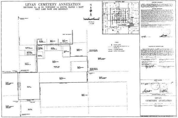
EXHIBIT A
Legal Description of Annexed Parcels: Levan Cemetery Annexation Description
Beginning at the West Quarter corner of Section 32, Township 14 South, Range 1 East, Salt Lake Base and Meridian; thence N 89°22'30" E 346.50 feet along the existing City Boundary; thence N 00°54'30" W 529.84 feet along the existing City Boundary; thence N 89°04'23" E 647.43 feet to the West boundary line of tax parcel XD 3490 described in Book 405 Page 105 in the Juab County Recorder’s Office; thence S 00°50'51" E 237.54 feet to the Southwest corner of said parcel XD 3490; thence N 89°09'09" E 333.00 feet to the Southeast corner of said parcel XD 3490 and the East line of the West Half of the Northwest Quarter of said Section 32; thence S 00°50'51" E 297.00 feet to the Southeast corner of the West Half of the Northwest Quarter of said Section 32; thence S 89°22'30" W 16.37 feet along the South line of said Quarter to the East boundary of tax parcel XD 3474-1 described in Book 417 Page 190 in the Juab County Recorder’s Office; thence S 00°54'30" E 200.00 feet to the Southeast corner of said tax parcel XD 3474-1; thence S 89°22'30" W 925.00 feet along the South line of said tax parcel XD 3474-1 to the East line of Tax parcel XD 3473 described in Book 141 Page 445 in the Juab County Recorder’s Office; thence S 00°54'30" E 311.50 feet to the Southeast corner of said tax parcel XD 3473; thence S 89°22'30" W 385.00 feet to the Southwest corner of said tax parcel XD 3473; thence S 89°22'30" W 33.00 feet; thence N 00°54'30" W 511.33 feet to the North line of the Southeast Quarter of Section 31 and the Existing City Boundary; thence N 89°04'23" E 33.00 feet to the point of beginning.
Containing 19.32 acres.