
Lillington City Zoning Code
ARTICLE V
SUBDIVISIONS AND INFRASTRUCTURE
Section 5.01 Purpose and Intent
The purpose of this chapter is to establish criteria for the development and subdivision of real property within the jurisdiction of the Town of Lillington. These standards are set forth to:
∙ Provide for the protection of the public health, safety and welfare; and
∙ Promote the orderly growth and development of the town; and
∙ Provide for suitable residential and nonresidential development with adequate streets, utilities and appropriate building sites; and
∙ Coordinate streets within proposed subdivisions with existing or planned streets and with other public facilities.
(Ord. passed 2-14-2017; Ord. passed 2-15-2022)
Section 5.02 Scope and Applicability
5.02.1 SCOPE
According to the provisions of G.S. § 160D-801, the Town of Lillington has the authority to regulate the subdivision of land within its jurisdiction.
5.02.2 SITE PLAN & SUBDIVISION APPLICABILITY
A. Subdivision Defined
All divisions of a tract or parcel of land into two or more lots, building sites, or other divisions for the purpose of sale, or building development (whether immediate or future) and shall include all divisions of land involving the dedications of a new street or a change in existing streets.
B. Statutory Exemptions
The following are not included within the definition above, nor are they subject to the regulations of this ordinance, provided however, that any document or plat to be recorded pursuant to any such exclusion shall bear the notation: "Exempt pursuant to the Town of Lillington Unified Development Ordinance," and the signature of the Administrator before being presented for recordation.
1. The combination or recombination of portions of previously subdivided and recorded lots where the total number of lots is not increased and the resultant lots are equal to or exceed the Unified Development Ordinance requirements of the town.
2. The division of land into parcels greater than ten acres in size where no street right-of-way dedication is involved.
3. The public acquisition by purchase of strips of land for the widening or opening of streets.
4. The division of a tract in single ownership whose entire area is no greater than two acres into not more than three lots, where no street right-of-way dedication is involved, and where the resultant lots are equal to or exceed the Unified Development Ordinance requirements of the Town of Lillington.
5. The division of a tract into parcels in accordance with the terms of a probated will or in accordance with intestate succession under G.S. Chapter 29.
6. Only a plat for recordation for the division of a tract or parcel of land in single ownership is required if all of the following criteria are met:
a. The tract or parcel to be divided is not otherwise exempted by Section 5.02.2.B.
b. No part of the tract or parcel to be divided has been divided under Section 5.02.2.B. in the ten years prior to division.
c. The entire area of the tract or parcel to be divided is greater than five acres.
d. After division, no more than three lots result from the division.
e. After division, all resultant lots comply with all of the following:
i. Any lot dimension size requirements of the UDO.
ii. The use of the lots is in conformity with the applicable zoning requirements.
iii. A permanent means of ingress and egress is recorded for each lot.
C. Site Plans Defined
A plan, to scale, showing uses and structures proposed for a parcel of land as required by the regulations involved. It includes lot lines, streets, building sites, reserved open space, buildings, major landscape features, both natural and human-made, and, depending on requirements, the location of proposed utility lines.
D. Conformity Required
From and after the adoption of this ordinance, no real property lying within the jurisdiction of the Town of Lillington shall be developed or subdivided except in conformance with all applicable provisions of this ordinance. In addition, after the effective date of this ordinance, no plat for subdivision of land within the jurisdiction of this ordinance shall be certified for recording by the Administrator until it has been submitted and approved in accordance with the provisions of this article.
E. Permits Subsequent to Plat Approval and Recording
1. Building Permits
The Administrator shall not issue permits for any structure on a lot in a subdivision for which a plat has not been approved and recorded in the manner prescribed herein.
2. Well and Septic Tank Permits
The Administrator shall not issue a permit for the installation of wells and septic tanks upon any lot in a subdivision for which a plat has not been approved and recorded in the manner prescribed herein.
(Ord. passed 2-14-2017; Ord. passed 2-15-2022)
Section 5.03 Required Improvements for All Development
All development which does not qualify as a minor subdivision according to the criteria in Article VII shall be required to install or construct the improvements specified in the table below. The developer shall be responsible for the installation and construction of required improvements according to the provisions of this ordinance and the Lillington Specifications Manual, except as may otherwise be specifically provided herein or by town policy or agreement.
Required Improvement | RR | RS-20 | RS-15 | RS-10 | RM F | RM X | NM X | O/S | CB | NB | GB | LI | HI | FRO |
Required Improvement | RR | RS-20 | RS-15 | RS-10 | RM F | RM X | NM X | O/S | CB | NB | GB | LI | HI | FRO |
Underground Drainage [1] | • | • | • | • | • | • | • | • | • | • | ||||
Curb & Gutter [1] | • | • | • | • | • | • | • | • | • | • | • | |||
Public Water & Hydrants [3] | • | • | • | • | • | • | • | • | • | • | • | • | • | |
Public Sewer [3] | • | • | • | • | • | • | • | • | • | • | • | • | • | |
Street Lights | • | • | • | • | • | • | • | • | • | • | • | • | • | |
Paved Streets | • | • | • | • | • | • | • | • | • | • | • | • | • | • |
Street Trees | • | • | • | • | • | • | • | • | • | • | • | • | • | |
Street Signs | • | • | • | • | • | • | • | • | • | • | • | • | • | • |
Underground Wiring | • | • | • | • | • | • | • | • | • | • | • | • | • | • |
Park/Open Space | • | • | • | • | • | • | • | • | • | • | • | |||
Sidewalks [2] | • | • | • | • | • | • | • | • | • | |||||
[1] The Administrator may waive or alter requirements for underground drainage and curb and gutter according to the watershed standards in Article VI - Environmental and Natural Resource Protection.
[2] See Section 5.11.6
[3] The Administrator may waive connection to public water and sewer utilities if the proposed development is within 500 feet of the nearest adequate line of a public system, provided that no geographic or topographic factors would make such connection infeasible.
5.03.1 CONNECTION TO PUBLIC WATER SUPPLY AND SANITARY SEWER SYSTEMS
Connection of each lot to public water and sewer utilities shall be required if the proposed development is within 500 feet of the nearest adequate line of a public system, provided that no geographic or topographic factors would make such connection infeasible. Where public water and/or sewer is not available, lots shall meet applicable Harnett County Health Department regulations. The final plat shall show the appropriate certificate(s) of approval from the Environmental Health Division if such approval is required.
5.03.2 STREET TREES
The location and specification of trees to use in the public right-of-way or public street tree easement is provided in Article IV.
5.03.3 STREET NAMES & SIGNAGE
A. Appropriate street name signs which meet standard municipal specifications shall be placed at all street intersections. The developer shall bear the expense.
B. Proposed street names shall be submitted and subject to the approval of the Town of Lillington and/or Harnett County as appropriate. New names shall not duplicate or be similar to existing street names. Existing street names, however, shall be extended where appropriate.
5.03.4 WASTE MANAGEMENT
The developer shall provide for adequate waste collection and disposal as outlined in the Town of Lillington Code of Ordinances.
5.03.5 CLUSTER MAIL BOX UNITS
Cluster mail box units shall be provided in accordance with the United States Postal Service regulations. Units may not encroach into the public right-of-way and shall be placed in an easement on private property.
(Ord. passed 2-14-2017; Ord. passed 2-15-2022)
Section 5.04 Land Suitability
Land subject to flooding, improper drainage, and/or erosion; land that has been used for the disposal of solid waste and not adequately mitigated; and any other land deemed by the Administrator to be uninhabitable shall not be platted for residential or commercial occupancy, nor for such other uses as may increase danger to health, life or property or aggravate the flood hazard. Such land shall be set aside for such uses as shall not be endangered by periodic or occasional inundation or shall not produce unsatisfactory living conditions.
(Ord. passed 2-14-2017; Ord. passed 2-15-2022)
Section 5.05 Required Conformance to Lillington Specification Manual
The Town of Lillington Specifications Manual (SM) is herein incorporated by reference. Conformance to the SM is required in addition to the standards in this ordinance.
(Ord. passed 2-14-2017; Ord. passed 2-15-2022)
Section 5.06 Other Relevant Standards for Site Plans and Subdivisions
In addition to the standards found in this article, standards in the following may also apply:
Article IV - Parks and Open Space
Article IV - Landscaping and Buffers
Article IV - Parking, Driveways & Loading
Article IV - Lighting
Article IV - Signs
Article IV - Flood Damage Prevention, Stormwater and Watershed Standards
(Ord. passed 2-14-2017; Ord. passed 2-15-2022)
Section 5.07 Placement of Monuments
The Standards of Practice for Land Surveying in North Carolina, as adopted by the North Carolina State Board of Registration for Professional Engineers and Land Surveyors, shall apply when installing permanent monuments.
(Ord. passed 2-14-2017; Ord. passed 2-15-2022)
Section 5.08 Site for Public Use
In subdividing property, due consideration shall be given by the subdivider to the reservation of suitable sites for schools and other public uses in accordance with G.S. § 160D-804.
(Ord. passed 2-14-2017; Ord. passed 2-15-2022)
Section 5.09 Property Owner's Association
A. CREATION
An owners' association shall be established to fulfill requirements of the NC Condominium Act, NC Planned Community Act, or to accept conveyance and maintenance of all common elements (common areas) within a development. The owners' association shall be in legal existence prior to the conveyance, lease-option, or other long-term transfer of control of any unit or lot in the development.
B. CONVEYANCE
Where developments have common elements serving more than one dwelling unit, these areas shall be conveyed to the owners' association, in which all owners of lots in the development shall be members. All areas other than public street rights-of-way, other areas dedicated to the town, and lots shall be designated as common elements. In a condominium development the common elements shall be platted in accordance with the NC Condominium Act. In other developments, the fee-simple title shall be conveyed by the subdivider or developer to the owners' association prior to the sale of the first lot.
C. SUBDIVISION OR CONVEYANCE OF COMMON ELEMENTS
Common elements shall not subsequently be subdivided or conveyed by the property owners' association unless a revised final plat showing such subdivision or conveyance have been submitted and approved.
D. MINIMIZE NUMBER OF ASSOCIATIONS
Developments, whether including different land uses, different types of housing, or simply different sections, shall hold the number of owners' associations to a minimum. An association may establish different categories of membership, different budgets for the categories, and different rates of assessment when different kinds of services are provided to different categories. Smaller associations under an umbrella (master) association are permitted.
E. EXEMPTION FROM OWNERS' ASSOCIATION REQUIREMENT
A development involving only two units attached by a party wall (or two separate walls back-to-back) shall not be required to have common elements or an owners' association. Such developments without an owners' association shall establish a binding agreement between owners to govern any party walls and to ensure reciprocal easement rights needed for maintenance.
(Ord. passed 2-14-2017; Ord. passed 2-15-2022)
Section 5.10 Lot Standards
The size, shape, and orientation of lots shall be appropriate for the location of the proposed development or subdivision and for the type of development contemplated and shall conform to the following:
5.10.1 CONFORMANCE WITH OTHER REGULATIONS
Every lot shall have sufficient area, dimensions, and street access to permit a principal building to be erected thereon in compliance with all zoning and other requirements of this ordinance.
5.10.2 SIDE LOT LINE CONFIGURATION
Side lines of lots should be at or near right angles or radial to street lines.
5.10.3 LOT LINES AND DRAINAGE
Lot boundaries shall coincide with natural and pre-existing manmade drainageways to the extent practicable to avoid lots that can be built upon only by altering such drainageways.
5.10.4 LOTS ON ARTERIAL OR MAJOR STREETS
Major subdivisions shall not be approved that permit individual residential lots to directly access on to arterial or major streets.
5.10.5 STREET ACCESS
All lots shall front upon, and have access to, a public street built in accordance with town and/or NCDOT standards.
5.10.6 FLAG LOTS PROHIBITED
Flag lots shall be prohibited except where required due to extreme topographic circumstances or site conditions. A flag lot shall contain only one single-family dwelling with a flagpole maximum length of 300 feet. The minimum width of the flagpole shall be 25 feet.
5.10.7 BUFFERS AND ENVIRONMENTAL FEATURES
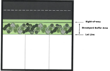
A. When a major subdivision abuts an arterial or major street, a Type A buffer shall be required between the property lines of the newly subdivided lots and the right-of-way. Existing vegetation may be used as approved on a case by case basis by the Administrator. See the illustration below for a typical streetyard buffer.
B. Streetyard, land use and environmental buffer areas (such as stream buffers, drainageways, special flood hazard areas, wetlands, etc.) may be included within residential lots only when all of the following conditions are met:
1. The subdivision is limited in size and has no property owners' association; and
2. The buffer is placed within a permanent conservation easement.
C. Any required buffer yard, including those required as a zoning condition, for a residential development shall not be credited toward meeting the minimum lot size requirements.
(Ord. passed 2-14-2017; Ord. 2022-06, passed 7-13-2021; Ord. passed 2-15-2022)
Section 5.11 Streets and Connectivity
5.11.1 GENERAL
The arrangement, character, extent, width, grade and location of all streets shall be considered in their relation to existing and planned streets, to topographical conditions, to public convenience and safety, and in their appropriate relation to the proposed use of the land to be served by such streets.
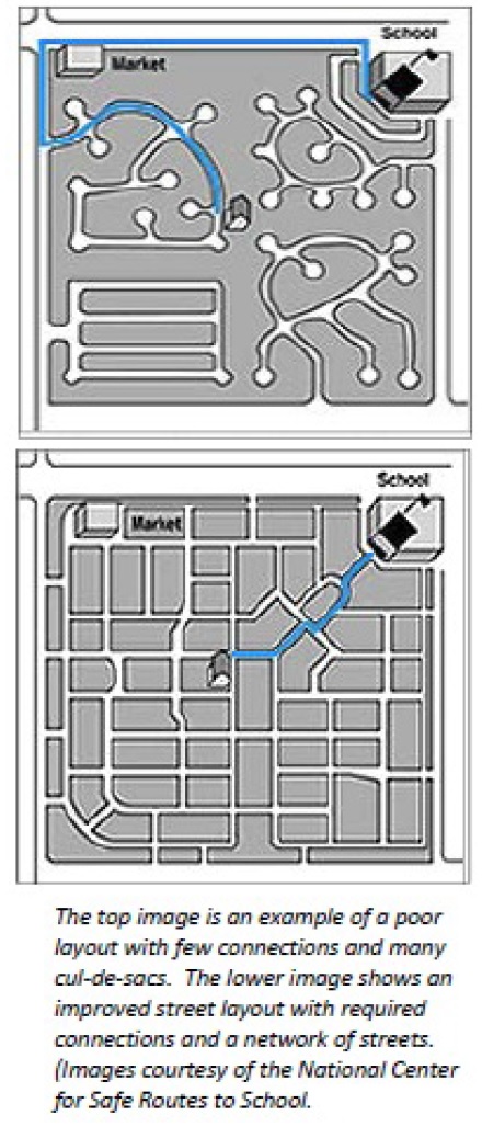
The proposed street system shall be designed to provide vehicular interconnections in order to facilitate internal and external traffic movements in the area, improve access/egress for city neighborhoods, provide faster response time for emergency vehicles, and improve the connections between neighborhoods.
Street arrangements shall not be such as to cause hardship to the owner of adjoining property in platting their own land and providing convenient access to it.
5.11.2 DEDICATION OF RIGHT-OF-WAY
Right-of-way for public streets shall be dedicated to the town pursuant to G.S. § 160D-804 and other applicable NC State laws. When dedication cannot be required, any future street right-of-way indicated on adopted transportation plan shall be shown on the plat.
5.11.3 CONFORMANCE WITH TRANSPORTATION PLAN
The location and design of streets shall be in conformance with any adopted transportation plan(s). Where conditions warrant, right-of-way widths and pavement widths in excess of the minimum street standards may be required to ensure conformance with these plans.
5.11.4 CONFORMANCE WITH ADJOINING STREET SYSTEMS
The planned street layout of a proposed development or subdivision shall be compatible with existing or proposed streets and their classifications on adjoining or nearby tracts.
5.11.5 INTERNAL STREET NETWORK CONNECTIVITY
A. An interconnected street system is necessary in order to protect the public health, safety and welfare in order to ensure that streets will function in an interdependent manner, to provide adequate access for emergency and service vehicles, to enhance non-vehicular travel such as pedestrians and bicycles, and to provide continuous and comprehensible traffic routes.
B. All proposed streets shall be continuous and connect to existing or streets without offset with the exception of cul-de-sacs as permitted and except as provided below. Whenever practicable, provisions shall be made for the continuation of planned streets and utilities into adjoining areas.
C. Streets in residential subdivisions shall be designed so as to minimize the length of local streets, to provide safe access to residences with minimal need for steep driveways and to maintain connectivity between and through residential neighborhoods for autos and pedestrians.
D. Where necessary to provide access or to permit the reasonable future subdivision of adjacent land, rights-of-way and improvements shall be extended to the boundary of the development.
E. A turnaround is required on any dead end per the NC Fire Prevention Code.
F. The platting of partial width rights-of-way shall be prohibited except where the remainder of the necessary right-of-way has already been platted, dedicated or established by other means.
G. Exemptions
New subdivisions that intend to provide one new cul-de-sac street shall be exempt from the connectivity ratio standard as set forth in this section, provided the Administrator determines that there is:
1. No options for providing stub streets due to topographic conditions, adjacent developed sites or other limiting factors; and
2. Interconnectivity (use of a looped road) within the development cannot be achieved or is unreasonable based on the constraints of the property to be developed.
5.11.6 MINIMUM NUMBER OF ACCESS POINTS TO EXTERNAL STREET NETWORK
The minimum number of points of external street access shall be based on the number of dwelling units in the proposed development as set forth below.
A. Residential developments with 50 or more lots or dwelling units shall have at least two separate points of public road access.
B. Residential developments with 100 or more lots or dwelling units shall have at least three separate points of public road access.
5.11.7 RESERVE STRIPS
Reserve strips adjoining street rights-of-way for the purpose of preventing access to adjacent property shall not be permitted under any condition.
5.11.8 STREET DESIGN CRITERIA
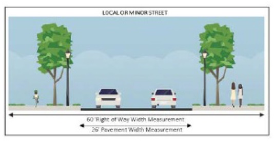
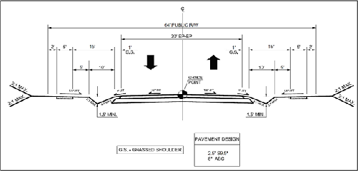
All streets shall be constructed in accordance with any local standards or the standards contained in the most recent version of the NCDOT Roadway Design Manual or NCDOT Subdivision Roads Minimum Construction Standards as appropriate. The illustration below is a sample cross-section of a local or minor street.
A. Right-of-way widths. Right-of-way widths shall not be less than the following:
Street Type | Right-of-Way Width |
Street Type | Right-of-Way Width |
Arterial or Major | 80-100 feet |
Collector | 66-80 feet |
Local or Minor | 50-64 feet [1] |
Cul-de-sac | 50 feet (100 feet diameter turnaround) |
Marginal Access | 66 feet |
Alley | 20 feet |
[1] See subsection B.1-2 below for cross-sections for optional rural single-family residential subdivision developments without curb and gutter. | |
B. Pavement widths. Pavement widths or graded widths shall be as follows:
Street Type | Streets with Curb & Gutter (measured face to face of curb) | Streets without Curb and Gutter [1] |
Street Type | Streets with Curb & Gutter (measured face to face of curb) | Streets without Curb and Gutter [1] |
Arterial or Major | 48 feet | 44 feet |
Collector | 40 feet | 36 feet |
Local or Minor | 26 feet | 20-24 feet [1] |
Cul-de-sac | 26 feet | 20-24 feet [1] |
Marginal Access | 26 feet | 24 feet |
Alley | 18 feet | 16 feet |
[1] For rural single-family residential subdivision developments without curb and gutter the optional cross-sections in Subsections B.1-2 shall apply. | ||
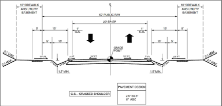
1. Local or Minor Street Cross-Section - 52-foot Right-of-Way:
2. Local or Minor Street Cross-Section - 64-foot Right-of-Way:
C. Roads and street surfaces. All public and private streets and roads shall be constructed and paved to meet all town or NCDOT standards for maintenance.
D. Street intersections. Street intersections shall be laid out as follows:
1. Streets shall intersect as nearly as possible at right angles and no street shall intersect at less than 60 degrees;
2. Intersections with an arterial or major street shall not be less than 600 feet apart, measured from centerline to centerline;
3. Property lines at street intersections shall be rounded with a minimum radius of 20 feet.
4. At an angle of intersection of less than 90 degrees, a greater radius may be required by the Administrator; and
5. No planting, fence or other obstruction to visibility of vehicles shall be erected, planted, maintained or allowed to exist in any district within the range of three feet to ten feet above the centerline grades of the intersecting streets in the triangular area bounded by the street right-of-way lines of such corner lots and a line joining points along these street lines 25 feet from the point of intersection.
E. Horizontal curves.
1. Where a centerline deflection angle of more than ten degrees occurs, a circular curve shall be introduced having a centerline radius of not less than the following:
Arterial or Major Street | 300 feet |
Collector Street | 200 feet |
Local or Minor Street | 100 feet |
2. Proper super-elevation shall be provided for curves on arterial or major streets to comply with town and/or NCDOT design standards.
F. Vertical curves. All vertical curves shall have such length as necessary to provide safe sight distance to comply with town and/or NCDOT design standards.
G. Cul-de-sac.
1. The maximum distance from an intersecting street to the end of a cul-de-sac shall be 500 feet. In cases where extreme topography or other unique site features necessitate a longer street, a cul-de-sac with a maximum length of 800 feet may be approved by the Board of Commissioners.
2. In general, streets with one end permanently closed shall be avoided unless the design of the subdivision and the existing or proposed street system in the surrounding area clearly indicates that a through street is not essential at the location of the proposed cul-de-sac.
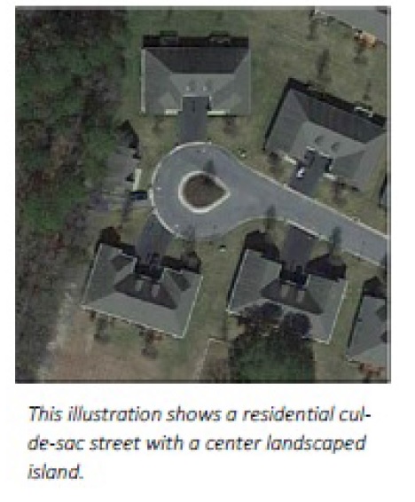
3. Cul-de-sacs should only be permitted with center islands larger enough to contain landscaping as illustrated in the image on the right.
H. Blocks. The maximum and minimum length and width of blocks shall be as follows:
1. Block lengths shall not exceed 1,000 feet nor be less than 400 feet. Where deemed necessary by the Administrator, a pedestrian crosswalk of at least five feet minimum in width shall be provided.
2. Blocks shall have a sufficient width to allow two tiers of lots of minimum depth. Blocks may consist of single tier lots where such are required to separate residential development from through vehicular traffic or nonresidential uses.
3. Subject to the approval of the Administrator, block lengths may be varied when, in the opinion of the Administrator, such alternative is necessary due to extreme topography or other unique site features.
I. Minimum sight distances. Shall comply with current town and/or NCDOT design standards.
J. Design speeds. Shall comply with current town and/or NCDOT design standards.
5.11.9 STREETS CROSSING NATURAL AREAS
A. All streets crossing natural areas, wetlands, or streams shall cross at or as near to 90 degrees as possible within topographic limits.
B. Where a required street stub necessitates the crossing of a stream or designated drainageway at the property line to make the required connection to an adjacent parcel, the owner or applicant shall provide a payment in lieu of building the stream crossing equal to half the total cost of the construction based on an engineer certified estimate. Such payment shall be set aside to offset the cost of constructing the stream crossing for future development.
5.11.10 SPACING BETWEEN INTERSECTIONS
A minimum spacing of 150 feet between intersections of collector or local/minor streets shall be maintained. In no case shall a pair of intersecting streets be approved with an offset that does not meet this minimum distance standard.
5.11.11 CURB AND GUTTER
A. Except as permitted in Article VI
, concrete curb and gutter shall be installed along all newly created streets within and adjoining subdivisions.
B. Where improvements, such as widening or turn lanes are required on town maintained streets adjoining subdivisions, concrete curb and gutter shall be installed in conjunction with the related improvements.
5.11.12 TEMPORARY TURNAROUNDS AND STUBS
A. Streets stubbed to adjoining property or to phase lines shall be required to have temporary turnarounds at the end of the street which are of a sufficient size to permit sanitation and emergency vehicles to turn around.
B. Stub streets and streets intended for extension during future phases shall be designed and constructed to the property line or as close to the line, vertically and horizontally, as practical. It shall be the responsibility of the second development to construct the connection to an existing stub street.
C. Stub streets shall not exceed 150 feet in length without a paved turnaround (permanent or temporary).
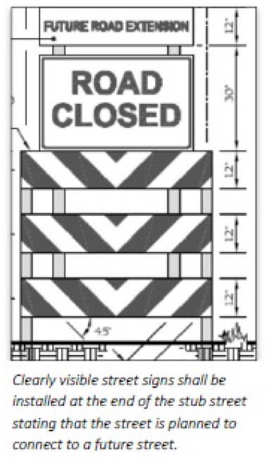
D. A clearly visible street sign shall be erected at the end of the stub street stating that the street is planned to connect to a future street.
5.11.13 GRADES AT INTERSECTIONS
The grade on stop streets approaching an intersection shall not exceed 5% for a distance of 100 feet from the centerline of the intersection.
5.11.14 STREET NAMES
Street names, prefixes, suffixes and addresses shall conform to the guidelines and policies set forth by the Harnett County street naming and addressing standards.
5.11.15 STREET AND TRAFFIC CONTROL SIGNS
A. Street Signs. At each intersection, the developer shall be required to install street name signage in accordance with town standards for the design of such signage.
B. Traffic Control Signs. The developer/subdivider shall provide traffic control signs that meet the Manual on Uniform Traffic Control Devices (MUTCD) standards in locations designated by the town and/or NCDOT.
C. Maintenance. Maintenance of signs on private streets or drives shall be the responsibility of the owner or property owners' association, as appropriate.
5.11.16 SIDEWALKS
Sidewalks shall be installed along in accordance with the following standards:
A. Required Locations. Sidewalks shall be installed along both sides of all streets located within the proposed subdivision and along all existing streets located within the proposed subdivision.
B. Alternative Compliance. Alternative provisions for pedestrian movement meeting the intent of this ordinance may be used where unreasonable or impractical situations would result from application of these requirements. Such situations may result from significant street trees, impending road widening, topography, utility easements, lot configuration or other unusual site conditions. In such instances, the Administrator may approve an alternate plan that proposes different pedestrian amenities provided that the intent of this section is fulfilled.
C. Payments in Lieu. In lieu of alternative compliance in B. above, the Administrator may approve a payment in lieu (in accordance with an adopted annual fee schedule) where any one or a combination of factors render compliance impractical:
1. Steep slopes;
2. Absence of existing sidewalks along the corridor and in the general neighborhood;
3. Where sidewalks are not shown on applicable town plans.
D. Construction Standards. All sidewalks, whether required by this ordinance or installed voluntarily, shall be constructed to town and/or NCDOT standard specifications for sidewalks and have a minimum width of five feet and a minimum thickness of six inches of concrete.
(Ord. passed 2-14-2017; Ord. 2022-06, passed 7-13-2021; Ord. passed 2-15-2022)
Section 5.12 Utilities and Easements
5.12.1 PUBLIC WATER AND SEWER CONSTRUCTION REQUIREMENTS
Water and sewer lines, connections, and equipment shall be constructed in accordance with the standard specifications for utility line construction as set forth by the utility provider for the proposed development.
5.12.2 WATER AND SEWER CONNECTIONS
Connection of each lot to public water and sewer utilities shall be required if the proposed development is within 500 feet of the nearest adequate line of a public system, provided that no geographic or topographic factors would make such connection infeasible. Where public water and/or sewer is not available, lots shall meet applicable Harnett County Health Department regulations. The final plat shall show the appropriate certificate(s) of approval from the Environmental Health Division if such approval is required.
5.12.3 UNDERGROUND UTILITIES
Electrical, telecommunication, cable television and other utility lines installed within and along streets abutting major subdivisions shall be underground unless the approving body determines underground installation is inappropriate.
5.12.4 EASEMENTS
A. Widths. To provide for electric, telecommunication, television/internet, gas service conduits, greenways and water and sewer lines within a subdivision, adequately sized utility easements shall be a minimum of 30 feet in width. The location of such easements shall be reviewed and approved by the approving body, with advice from utility providers, before final plat approval. The Administrator or utility provider may require wider easements and shall be determined on a case-by-case basis.
B. Restrictions on Improvements. Utility easements shall be kept free and clear of any buildings or other improvements that would interfere with the proper maintenance or replacement of utilities. The town shall not be liable for damages to any improvement located within the utility easement area caused by maintenance or replacement of utilities located therein.
5.12.5 STREET LIGHTS
Street lights shall be required to be installed along all public streets within the town’s corporate limits in accordance with the town’s current policy. The Board of Commissioners of the town hereby establishes the following:
A. The owner, developer or subdivider of a site plan or subdivision shall be required to install street lighting via underground distribution along all proposed streets and along all adjoining existing streets and thoroughfares in accordance with this section. The developer shall be responsible for all installation cost and any utility pole fees.
B. Through the site plan and subdivision plan approval process, the Administrator may approve street lighting which exceeds the standard town requirements for residential streets so as to reduce the length of sag vertical curves provided the street lights are operational prior to the issuance of any certificates of occupancy on such street. In any case, the minimum allowable length of sag vertical curves shall be 15A for cul-de-sacs and loop roads and 20A for residential streets.
C. All underground electrical distribution systems for street lighting within the corporate limits of the town and its extraterritorial planning jurisdiction shall be installed according to the following standards.
1. Underground service for light fixtures shall be installed by the developer in conformance with town standards at the developer's expense.
2. The placement of street lighting fixtures in residential areas shall be at 400-foot intervals unless:
a. The roadway length is less than 400 feet but more than 200 feet in which case a street light will be provided at the end of the street;
b. Where the roadway length is less than 200 feet and a street light is placed at the intersection and no natural features create a problem, no street light will be placed at the end of the roadway; or
c. The vertical and horizontal street alignment or natural features necessitate shorter spacing intervals.
3. The placement of street lighting along thoroughfares, marginal access streets and collector streets and in nonresidential areas shall be in accordance with the latest revision of the Illuminating Engineering Society's American National Standards for Roadway Lighting.
4. A street light shall be provided at all street intersections.
D. Street light fixtures shall conform to the following:
1. All fixtures in residential areas shall be either 7,000 or 9,500 lumen enclosed high pressure sodium lamps on standard poles 25 feet in height. The 7,000 lumen fixture shall be placed only at the "neck" of cul-de-sacs.
2. All fixtures along thoroughfares shall be 28,500 lumen enclosed high pressure sodium lamps on standard fiberglass poles 30 feet in height or 50,000 lumen enclosed high pressure sodium lamps on standard fiberglass poles 35 feet in height. The 28,500 lumen fixtures shall be placed in residential areas when spillover from the 50,000 lumen fixtures would be excessive.
E. Authorization for street light installations shall occur at such time as:
1. A developer, through the town, requests the installation of streetlights prior to the issuance of any certificates of occupancy. The developer shall incur a monthly electrical expense billed equal to the monthly electrical expense incurred by the town, for each street light installed. The developer will be billed for the period beginning with installation of the street light and ending with notification to the town, by the developer, of issuance of a certificate of occupancy in the immediate area of each street light location;
2. A certificate of occupancy is issued in the immediate area of the proposed street light location; or
3. An arterial/major street, marginal access street or collector street is constructed or widened as a part of development. Arterial/major streets, marginal access streets and collector streets that are constructed or widened by the town shall be lighted immediately after construction, dependent on the availability of funds.
F. Street lighting facilities and street lights shall be installed by the developer on any roadway, portion of roadway or widening prior to the town's acceptance of that roadway for routine maintenance unless otherwise approved by the Administrator.
G. Residents along a street may request the relocation of a street light provided that the proposed street light location meets town standards and the relocation is approved by the Administrator. Residents living at the cul-de-sac end of a street may request the replacement of an existing 9,500 lumen semi-enclosed light fixture with a 7,000 lumen semi-enclosed light fixture. A petition, signed by all persons owning property fronting on the street within the boundaries of the next closest installed or proposed street lights, shall be required. Also, the relocation or replacement cost and all facilities abandonment costs must be paid in full in advance by the resident(s) requesting the relocation or replacement.
H. A developer may request to use decorative or "private" street lighting within a development provided:
1. Street light fixture types and locations must meet the minimum criteria set forth in this policy and must be approved by the Administrator;
2. The developer and/or property owner's association shall be responsible for all installation costs and monthly operating costs associated with the private streetlights;
3. The developer and/or property owner's association shall be responsible for any costs associated with deletion of the private street lights and any costs associated with installing the town's standard street lights prior to the expiration of the ten-year contract; and
4. The developer shall include all responsibilities of the homeowner's association pertaining to the street lighting in the development covenants. The developer shall inform all purchasers of property in the development of these same responsibilities.
5.12.6 FIRE PROTECTION EQUIPMENT
Fire protection equipment shall be installed at locations determined by the Lillington Fire Department or other fire service agency which will have primary response responsibility within the proposed development.
(Ord. passed 2-14-2017; Ord. passed 2-15-2022)
Section 5.13 Cluster Subdivision Provisions
5.13.1 PURPOSE
The purpose of this section is to provide greater flexibility in the design and creation of residential subdivisions while preserving significant amounts of open space and environmentally sensitive areas. This is achieved by allowing the clustering of residential lots, with reduced area, frontage and setback standards in relation to the underlying district, on areas of the proposed site which are best suited for development and leaving the remaining land as permanently protected open space.
5.13.2 MINIMUM AREA FOR A CLUSTER SUBDIVISION
The minimum area for a cluster subdivision is 25 acres.
5.13.3 MINIMUM OPEN SPACE DEDICATION
The minimum amount of preserved open space that must be dedicated and permanently protected within a cluster subdivision is 20% of the gross acreage of the proposed subdivision.
5.13.4 MAXIMUM NUMBER OF LOTS & LOT SIZES
A. The maximum number of lots shall not exceed that of the base zoning and/or the maximum density for properties located in the critical area of the Cape Fear Water Supply Watershed as outlined in Article VI
, Section 6.03.6 of this ordinance.
B. Minimum lot sizes are not applicable to single- family cluster subdivision projects.
5.13.5 MINIMUM LOT FRONTAGE AND BUILDING SETBACKS
The minimum lot frontage and building setback requirements of the underlying zoning district may be reduced by up to 25% within a cluster subdivision. In exchange for the dedication of additional land for open space preservation, the lot width and building setback requirements may be reduced by an additional 1% for each additional 2% of the gross acreage of the project that is dedicated for open space preservation. In no case shall the lot width or building setback requirements be reduced below 40% of the requirements of the underlying zoning district.
5.13.6 OPEN SPACE STANDARDS
See Article IV for cluster subdivision open space standards.
5.13.7 PHASED DEVELOPMENTS
A cluster subdivision may be developed in phases provided that all required open space for the entire project be recorded and deeded to the designated receiving entity with to the development of the first phase.
(Ord. passed 2-14-2017; Ord. passed 2-15-2022)
Section 5.14 Transportation Impact Analysis
A transportation impact analysis (TIA) is a specialized study that evaluates the effects of a development’s traffic on the surrounding transportation infrastructure. It is an essential part of the development review process to assist developers and government agencies in making land use decisions involving various development reviews. The TIA helps identify where the development may have a significant impact on safety, traffic and transportation operations, and provides a means for the developer and government agencies to mitigate these impacts. Ultimately, the TIA can be used to evaluate whether the scale of development is appropriate for a particular site and what improvements may be necessary, on and off the site, to provide safe and efficient access and traffic flow.
A. Scoping Meeting: A mandatory scoping meeting is required prior to beginning the TIA to discuss the requirements and strategies for a TIA specific to the site and the proposed development.
B. Memorandum of Understanding (MOU): An MOU, documenting the understood scope of the project, shall be prepared by the transportation consultant. The MOU shall be signed by the applicant and the town, and agreed upon by the NCDOT District Engineer if access to a state road is involved, before the consultant can begin work on the TIA.
5.14.1 APPLICABILITY
A. TIAs may be required as part of a conditional zoning or master plan approval as determined by the Administrator.
B. The following table identified the level of analysis required, if any, for different types of development proposals:
Level of Study Required by Development Type: | Residenti al | Office | Hotel | Industrial | Commerci al Center | Other |
None | Under 50 lots/units | Under 50,000 sf | Under 100 room | Under 150 employees | N/A | Under 100 peak hour trips |
Standard TIA | 50-500 lots/units | 50,000 – 350,000 sf | 100-500 rooms | 150-1,000 employees | Under 100,000 total sf | 100-500 peak hour trips |
Enhanced TIA | Over 500 lots/units | Over 350,000 sf | Over 500 rooms | Over 1,000 employees | Over 100,000 total sf | Over 500 peak hour trips |
Because of the limited arterial roadway network in Lillington, all developments proposed along NC Highway 210, US Highway 421 and US Highway 401 are required, at minimum, to complete a standard TIA when expected gross trip generation of 500 total trips or more both entering and exiting the site in a 24-hour period, and/or 50 total trips both entering and exiting the site during either the AM or PM peak. | ||||||
5.14.2 STANDARD TIA REQUIREMENTS
A standard TIA includes the following elements:
A. Abstract or Summary: Summarize description of proposed development, location, traffic generation, existing and future conditions (level of service), and recommended improvements. The report should not exceed two pages and preferably limited to one page.
B. Description of Development: Describe acreage included in development, existing and proposed land use, existing and proposed zoning, proposed density (number of houses, square feet of development, etc.)
C. Study Area: Generally, ¼ mile to ½ mile from each proposed site access along roads accessed by the site. This area may, in a few cases, be greater if the site is on a road with no intersections within that distance.
D. Site Location: Include location map showing site in relation to major streets and at least one-mile radius from site.
E. Traffic Generation: Indicate number of trips generated by site daily, AM peak hour, PM peak hour (AM peak hour may be omitted for retail uses which are not expected to generate significant traffic volumes during this period). Indicate internal or pass-by traffic generation if appropriate. For rezoning, indicate traffic generation under existing zoning as well as proposed zoning. Indicate source of trip generation rate, land use code, and units used to derive generation.
F. Trip Distribution: Indicate percentage distribution of trips, by direction, within study area and method used to obtain.
G. Access Location(s): Location of planned streets or driveways and access to existing streets. Indicate other streets or driveways within study area, including those across the street. Indicate coordination with NCDOT where appropriate.
H. Existing Road and Traffic Conditions: Street laneage and classification, traffic control devices, existing daily traffic volumes within study area. Show traffic volumes and level of service of signalized intersections and proposed site access points within study area during AM and PM peak hour (PM only for retail). Include work sheets or computer printouts showing counted traffic volumes and level-of-service. Illustrate in figure(s) showing peak hour volumes, lanes, and level of service. For unsignalized intersections, show level-of-service for individual movements. Discuss transit service if applicable. Discuss accident history, if appropriate.
I. Planned Improvements: Discuss and describe any planned road improvements in the study area which could affect future traffic. Note whether project is shown on any applicable transportation plan, or NCDOT TIP.
J. Future Conditions: Same as for existing conditions, plus site traffic assigned to driveways or access points, for condition with full build-out of project, at build-out year. Include growth in background traffic due to other approved developments or to general growth in area. May show more than one phase, if project is to be phased. Discuss any conflict with other driveways or streets, queuing problems, potential safety problems.
K. Pedestrian Facilities: Indicate location of existing and proposed sidewalks and crosswalks, internal pedestrian paths.
L. Recommended Improvements: Indicate improvements required for access points and signalized intersections within study area to operate at acceptable level of service (D or better). These may include site access, internal site circulation, signalization, signal modification (retiming, additional phases), lane modifications or additions, or street widening. A signal warrant study is not required but may be included as supporting documentation where a traffic signal is requested. Note: showing recommended improvements does not necessarily indicate responsibility for improvement. Report may indicate which improvements are due to development and which are due to existing problems or other growth in traffic, and may suggest responsibility of developer or of other parties for improvements. Proposed improvements should be shown schematically on figure.
M. Engineer's Seal: All TIAs are to be prepared and sealed by an engineer registered in the State of North Carolina and specializing in traffic or transportation, with experience in preparing TIAs.
5.14.3 ENHANCED TIA REQUIREMENTS
An enhanced TIA includes all of the elements of a standard TIA plus the following:
A. Study Area: Generally, from one to three miles from each proposed site access along roads accessed by the site. The extent of the study area should be discussed with town staff prior to initiating the TIA.
B. Internal Circulation: Review internal circulation patterns and note recommended changes.
C. Trip Distribution: Use of a computer model for distribution may be desirable for major projects.
D. Future Conditions: Projects in this category, other than perhaps shopping centers, are likely to be phased. It is desirable to show conditions at end of planning period (generally 20-year or horizon used in transportation plan).
E. Recommended Improvements: For major projects, these may involve changes to the transportation plan. The project may include the construction of portions of streets within or adjacent to the site.
5.14.4 IMPROVEMENTS MAY BE REQUIRED
Based on the findings of the analysis, if a proposed development does not meet the applicable service level standards, the applicant shall be required to upgrade the facilities in accordance with the adopted level of service program. Mitigation measures may involve strategies other than roadway construction or other physical improvements such as changes to traffic signal timing or phasing, and transportation management strategies.
5.14.5 PAYMENTS-IN-LIEU OF IMPROVEMENTS
The town may, at its discretion, accept either mitigation measures to be completed by the developer or a fee paid to the town in lieu of mitigation. The fee shall be equal to the costs of the required mitigation measures, as determined by the Administrator. A combination of mitigation measures and payments-in-lieu of dedication may be permitted. Payments-in-lieu of dedication shall be approved as part of the subdivision or site plan.
(Ord. passed 2-14-2017; Ord. passed 2-15-2022)
Section 5.15 Improvements Guarantees & Performance Securities
5.15.1 IMPROVEMENT GUARANTEES
A. Applicability: In lieu of construction of the permanent improvements required by this ordinance, the developer shall guarantee that such improvements will be carried out according to the Town of Lillington specifications at his/her expense. At minimum, improvements such as public utilities and initial surface of street right-of-way shall be installed and inspected by the Administrator for compliance. The remaining improvements shall be built or bonded prior to the recording of the final plat.
B. Amount of Improvement Guarantees: Such guarantees shall be in an amount of not less than 125% of the estimated cost of the construction of the required improvements. The amount of guarantee shall be approved by the Administrator based on a professional engineers certified cost estimate and shall be provided in the manner outlined in Section 5.15.2.
C. Release of Improvement Guarantees: The Administrator shall authorize the release of all or a portion of any guarantee posted as the improvements are completed. Such funds shall be released within 30 days after submittal of an improvements completion certification from a professional engineer and approval of applicable improvements by the Administrator.
D. Warranty Against Defects
1. Upon completion of construction of new streets, stormwater controls or other required utilities, the developer shall request a warranty inspection. Once all the improvements are deemed acceptable by the Administrator and pass the warranty inspection, the developer shall submit the following to the Administrator:
a. A set of acceptable as-built drawings;
b. A written warranty against defects which shall guarantee the material and workmanship of required improvements for a period of not less than one year from the date of such acceptance;
c. A financial guarantee payable to the town equal to at least 25% of the cost of the installation of such improvements as determined by the Administrator. Such financial guarantee shall be in a form as provided for in Section 5.15.2.
2. Upon approval of these materials and acceptance of the improvements by the town, a one-year warranty period shall commence. During the one-year warranty period, the developer shall repair any latent defects that occur. For the purposes of this section, the term "defects" refers to any condition in publicly dedicated facilities, utilities or streets that requires the town to make repairs to such improvements over and above the normal amount of maintenance that they would require. If such defects appear, the warranty may be enforced regardless of whether the facilities, utilities or streets were constructed in accordance with the requirements of this ordinance. At the end of the one-year warranty period, the developer shall request a final inspection. Upon successful completion of all warranty items, the developer shall be released from maintenance responsibilities for the warranted construction.
3. Warranty repairs shall be corrected in accordance with the recommendations of the Administrator.
4. If a developer fails to complete warranty items, future projects of the developer may not be reviewed by the town. In addition, the town shall take appropriate legal action against the developer.
5.15.2 TYPES OF GUARANTEES/SECURITIES
Improvements guarantees and performance securities shall be made in one or more of the following forms:
A. The deposit of a certified check;
B. A letter of credit duly executed by a local bank and payable to the town; or
C. A surety bond made by a surety company licensed to do business in North Carolina.
5.15.3 FORFEITURE AND DEFAULT
A. Forfeiture Provisions: All improvement guarantees and performance securities shall contain forfeiture provisions for failure, after proper notice, to complete work within the time specified, or to initiate or maintain any actions which may be required of the applicant or owner in accordance with this ordinance, approvals issued pursuant to this ordinance, or an operation and maintenance agreement established pursuant to this ordinance.
B. Default by Developer:
1. Upon default, meaning failure on the part of the developer or surety to make timely completion of the required improvements, or to maintain privately owned improvements in accordance with an approved operations and maintenance agreement, the town may require the developer, the surety, or the financial institution holding the escrow account to pay all or any portion of the bond or escrow account fund to the town.
2. Upon payment, the town, at its discretion, may expend such portion of the funds as it deems necessary to complete all or any portion of the required improvements.
3. Such expenditure of funds shall only be made after requesting the owner to comply with the permit or maintenance agreement.
5.15.4 ALL IMPROVEMENTS TO BE COMPLETED
Upon recordation of 75% of the total lots approved within a subdivision, the developer shall be required to complete all remaining public improvements. Exceptions may be provided on a case-by-case basis as approved by the Administrator.
5.15.5 PROVISION OF SERVICES AND ACCEPTANCE BY TOWN
The following shall not occur upon any land for which a final plat is required to be approved, unless and until the requirements set forth in this ordinance have been complied with and the final plat has been approved and recorded with the Harnett County Register of Deeds:
A. No street shall be maintained or accepted by the town, and
B. No water or sewer shall be extended to or connected with any subdivision of land, and
C. No permit shall be issued by the Town of Lillington for the construction of any building or other improvement requiring a permit.
(Ord. passed 2-14-2017; Ord. passed 2-15-2022)
Section 5.16 Ownership & Maintenance of Common Areas
All developments containing land, amenities or other facilities under private common ownership shall provide for the ownership & maintenance of such areas. Multi-family developments that are subject to fee-simple lot/unit ownership shall convey all such common areas to a non-profit corporate property owner's association with a membership of 100% of the lots/units in the development. The developer shall file with the Harnett County Register of Deeds a "dedication of covenants" and must meet the following criteria:
A. The property owners' association must be established before the units are sold;
B. The property owners' association is established as the responsible entity for the liability insurance, pertinent local taxes, and maintenance of all recreation and other facilities;
C. Sums levied by the property owners' association that remain unpaid shall become a lien on the delinquent property;
D. For condominium development, documents must meet the requirements of G.S. Ch. 47A Unit Ownership;
E. All easements over common areas for access, ingress, egress and parking shall be shown and recorded on a final plat with the Harnett County Register of Deeds.
*See Article IV for ownership & maintenance requirements specific to open space.
(Ord. passed 2-14-2017; Ord. passed 2-15-2022)